Embed Size (px)
Citation preview
Page 2 of 21
The Assimilation, Analysis and Dissemination of Pacific Rain Gauge Data: PACRAIN
Mark L. Morrissey1, Susan E. Postawko1, J. Scott Greene2
1School of Meteorology, University of Oklahoma, Norman
2Department of Geography and Environmental Sustainability, University of Oklahoma, Norman Table of Contents 1. Project Summary ...................................................................................................................... 2 2. Scientific and Observing System Accomplishments ............................................................... 3
2.1. Summary of Deliverables ................................................................................................. 3 2.2. Primary Institutional Data Users of PACRAIN ................................................................ 4 2.3. Specific Deliverables in 2014 ........................................................................................... 5
3. Outreach and Education ......................................................................................................... 15 3.1. 2014 Progress Related to the SPARCE Program ............. Error! Bookmark not defined.
4. Publications and Reports........................................................................................................ 16 4.1. Publications by Principal Investigators ........................................................................... 16 4.2. Other Relevant Publications ........................................................................................... 17
5. Slides
1. Project Summary
Tropical rainfall data taken over both land and ocean are particularly important to the understanding of the climate system. Not only is it a tracer of latent heat, it is vital to the understanding of ocean properties as well, including latent and sensible heat flux, salinity changes and concomitant local ocean circulation changes. In addition, rain gauge observations from low-lying atolls are required to conduct verification exercises of the TAO/TRITON buoy-mounted rain gauges, which are funded by NOAA’s Ocean Climate Observing Program (OCO). Tropical island rainfall is also required for verification work by satellite rainfall algorithm programs funded by NASA, NOAA and various international programs. This project supports the NOAA objective to “build and sustain the global climate observing system that is needed to satisfy the long-term observational requirements of the operational forecast centers, international research programs, and major scientific assessments”. Our current and future efforts include expanding our mission to collect, analyze, verify and disseminate global rainfall data sets and products deemed useful for Operational Forecast Centers, International Research Programs and individual researchers in their scientific endeavors. Housed in the School of Meteorology at the University of Oklahoma, the Comprehensive Pacific rainfall Database (PACRAIN) and the Schools of the Pacific Rainfall Climate Experiment (SPaRCE) have built upon work from past NOAA-supported projects to become a unique database for
Page 3 of 21
scientists to obtain scarce rain gauge data and to conduct research into verification and other research activities. These data are continually analyzed to produce error-assessed rainfall products and are easily assessable via our web page (http://pacrain.evac.ou.edu). We’re also actively involved using PACRAIN data in assessing the quality of other NOAA OCO supported projects (e.g. Morrissey et al. 2012, and others).
2. Scientific and Observing System Accomplishments Due to the importance of tropical Pacific rainfall data to climate research and operational and climate forecasting we work collaboratively with the other US and foreign Pacific climate observing programs to effectively and efficiently match the areas of commonality among both OCO’s and these program objectives. One of these common areas is the strengthening of the existing Pacific observation climate network for both atmosphere and ocean.
Specifically, we seek to support all programs that require rainfall data to assess vulnerability to weather and climates extremes (OCO objective #1). Given the vastness of the Pacific basin it is critical to collect all available rain gauge data 1) in environmentally sensitive areas, 2) where dense rain gauge networks exist but are not assimilated into a single database, and 3) where agreements can be made to help construct and upgrade rain gauge networks in these critical locations. These data are assimilated, homogenized, and error-checked and then made available to the general research community through a single web site (https//www.pacrain.evac.ou.edu). To create the most comprehensive Pacific raingauge database possible it is necessary to continue to work closely with the Pacific Islands meteorological services (PIMS) to help them sustain their quality gauge networks. See for example, the recent report from the PMIS climate services workshop: (http://www.gfcs-climate.org/sites/default/files/events/Regional%20Consultation%20on%20GFCS%20for%20Small%20Island%20Developing%20States%20in%20the%20Pacific//Final%20report%20formatted%205.9.2014.pdf) One of our most interesting ongoing efforts this year is a detailed comparison of the Pacific raingauge data held in the National Climatic Center (NCDC)’s Global Historical Climatology Network (GHCN) data base with PACRAIN data (Klatt, Morrissey and Greene, 2014). The PACRAIN data set is used by many researchers for a variety of climate research purposes (e.g. Delcroix et. al, 1996, Xie et al., 2007, etc.). The uses include incorporation into climate models, climate studies, and the verification of satellite rainfall algorithms and the enhancement of satellite algorithms and products (e.g. CMAP, Xie and Arkin, 1997). The data set is also referenced by many institutional programs (e.g., the International Precipitation Working Group, (IPWG), the Global Energy and Water Cycle Experiment (GEWEX), etc.) and is included in NASA’s Global Change Master Directory.
It is our belief that by working directly with the PIMS, we bring tangible benefits to the global climate research community through data base development and enhancement. In turn, the local
2.1. Summary of Deliverables
Page 4 of 21
meteorological services also benefit directly through enhanced forecast products developed by the scientific community using these critical data sets. Our Pacific educational program, the Schools of the Pacific Rainfall Climate Experiment (SPaRCE; http://sparce.evac.ou.edu/) directly enhances the PACRAIN database through the contribution of Pacific schools taking manual read daily rain gauge measurements while learning about the importance of weather and climate. Underlying these projects is the long-term effort to help build the stakeholder outreach capacity of the all the PIMS. We continue to contribute to this effort by providing what we can in terms of needed supplies, education and communication infrastructure and collaboration (e.g. The Australian Bureau of Meteorology’s Climate and Ocean Monitoring and Prediction (COMP) project) until the PIMS become completely self-sustainable.
Scientists need only to access the PACRAIN web site to obtain the most comprehensive Pacific rainfall data set anywhere in the world. Many of these regional data sets within PACRAIN are impossible or impractical to obtain elsewhere. The PACRAIN project serves the research community by actively working with individual countries in environmentally important locations to help provide them with infrastructure, education and other short and long-term support. One example is our collaboration with the International Precipitation Working Group (IPWG) in conducting satellite rainfall algorithm verification studies. We continually contribute to the National Climatic Data Center (NCDC)’s Global Historical Climatology Network (GHCN) raingauge data not found on the GTS. The return on this investment by NOAA has been significant in terms of enabling PACRAIN to provide the scientific community with critical, one-of-a-kind rain gauge data sets and to have established ongoing mutually beneficial relationships that should lead to future collaborations. Past successes with this strategy have proven very worthwhile on a cost-benefit basis.
• NCDC National Historical Climate Network (NHCN): Data are merged with the GHCN. Individual ocean/Atmosphere researchers investigating both climate- and shorter-term physical relationships at the ocean-atmosphere interface.
• Pacific Island GCOS Program (PI-GCOS, A regional component of GCOS): Data are integrated into this database for climate research.
• Global Precipitation Climatology Project (GPCP): Data are used in satellite rainfall algorithm verification exercises.
• NASA’s Tropical Rainfall Measuring Mission (TRMM) and Global Precipitation Measuring Mission (GPM) programs: Data are used by NASA researchers primarily for satellite rainfall verification research.
2.2. Primary Institutional Data Users of PACRAIN
Page 5 of 21
• University of Melbourne, AUS. Primarily conducts TRMM research using PACRAIN
• The Vanuatu Meterological Service has strong collaborative ties with the PACRAIN/SPaRCE program
• The International Precipitation Working Group. The primary mission of the IPWG is to build upon the expertise of scientists who are currently involved in precipitation measurements from satellites with emphasis on derivation of products. The IPWG is established to foster the:
• Development of better measurements, and improvement of their utilization; • Improvement of scientific understanding; • Development of international partnerships.
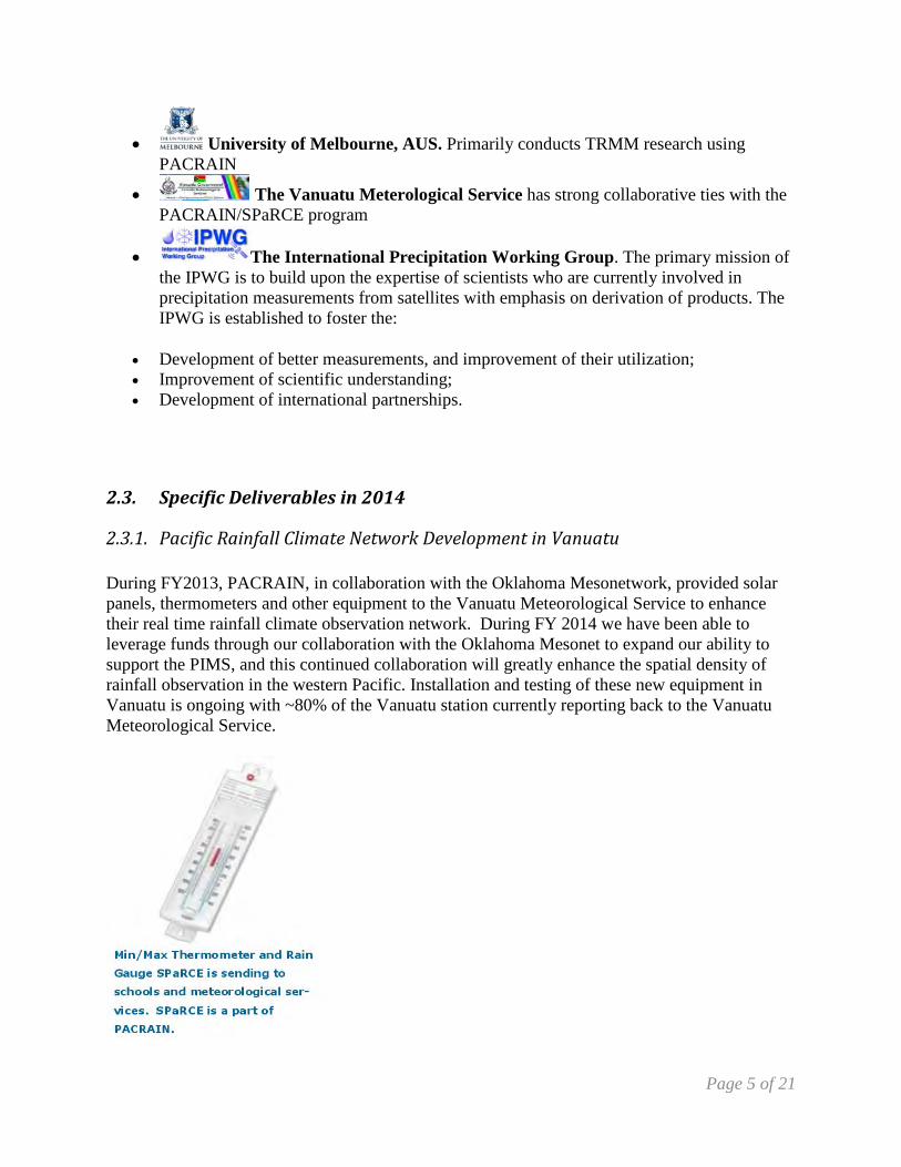
During FY2013, PACRAIN, in collaboration with the Oklahoma Mesonetwork, provided solar panels, thermometers and other equipment to the Vanuatu Meteorological Service to enhance their real time rainfall climate observation network. During FY 2014 we have been able to leverage funds through our collaboration with the Oklahoma Mesonet to expand our ability to support the PIMS, and this continued collaboration will greatly enhance the spatial density of rainfall observation in the western Pacific. Installation and testing of these new equipment in Vanuatu is ongoing with ~80% of the Vanuatu station currently reporting back to the Vanuatu Meteorological Service.
2.3. Specific Deliverables in 2014
2.3.1. Pacific Rainfall Climate Network Development in Vanuatu
Page 6 of 21
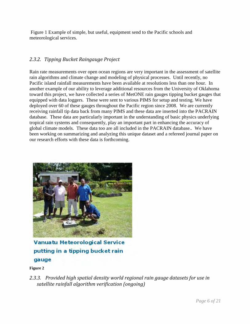
Figure 1 Example of simple, but useful, equipment send to the Pacific schools and meteorological services.
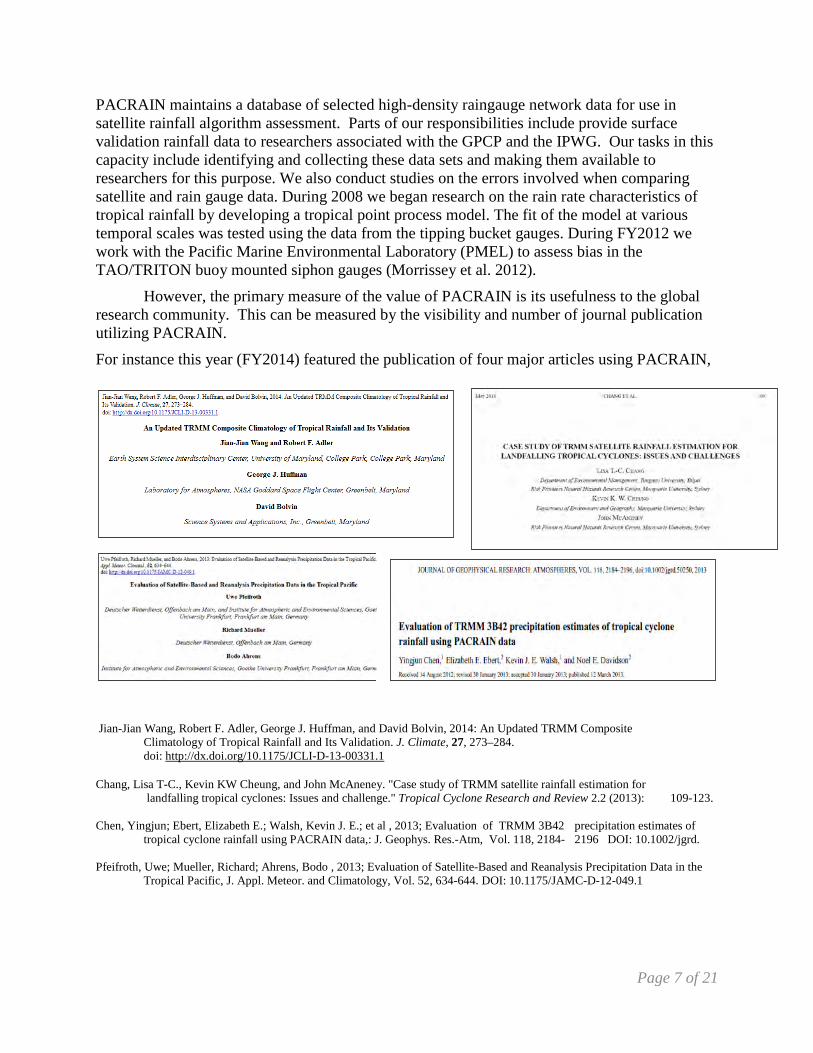
Rain rate measurements over open ocean regions are very important in the assessment of satellite rain algorithms and climate change and modeling of physical processes. Until recently, no Pacific island rainfall measurements have been available at resolutions less than one hour. In another example of our ability to leverage additional resources from the University of Oklahoma toward this project, we have collected a series of MetONE rain gauges tipping bucket gauges that equipped with data loggers. These were sent to various PIMS for setup and testing. We have deployed over 60 of these gauges throughout the Pacific region since 2008. We are currently receiving rainfall tip data back from many PIMS and these data are inserted into the PACRAIN database. These data are particularly important in the understanding of basic physics underlying tropical rain systems and consequently, play an important part in enhancing the accuracy of global climate models. These data too are all included in the PACRAIN database.. We have been working on summarizing and analyzing this unique dataset and a refereed journal paper on our research efforts with these data is forthcoming.
Figure 2
2.3.2. Tipping Bucket Raingauge Project
2.3.3. Provided high spatial density world regional rain gauge datasets for use in satellite rainfall algorithm verification (ongoing)
Page 7 of 21
PACRAIN maintains a database of selected high-density raingauge network data for use in satellite rainfall algorithm assessment. Parts of our responsibilities include provide surface validation rainfall data to researchers associated with the GPCP and the IPWG. Our tasks in this capacity include identifying and collecting these data sets and making them available to researchers for this purpose. We also conduct studies on the errors involved when comparing satellite and rain gauge data. During 2008 we began research on the rain rate characteristics of tropical rainfall by developing a tropical point process model. The fit of the model at various temporal scales was tested using the data from the tipping bucket gauges. During FY2012 we work with the Pacific Marine Environmental Laboratory (PMEL) to assess bias in the TAO/TRITON buoy mounted siphon gauges (Morrissey et al. 2012).
However, the primary measure of the value of PACRAIN is its usefulness to the global research community. This can be measured by the visibility and number of journal publication utilizing PACRAIN.
For instance this year (FY2014) featured the publication of four major articles using PACRAIN,
Jian-Jian Wang, Robert F. Adler, George J. Huffman, and David Bolvin, 2014: An Updated TRMM Composite Climatology of Tropical Rainfall and Its Validation. J. Climate, 27, 273–284. doi: http://dx.doi.org/10.1175/JCLI-D-13-00331.1 Chang, Lisa T-C., Kevin KW Cheung, and John McAneney. "Case study of TRMM satellite rainfall estimation for landfalling tropical cyclones: Issues and challenge." Tropical Cyclone Research and Review 2.2 (2013): 109-123. Chen, Yingjun; Ebert, Elizabeth E.; Walsh, Kevin J. E.; et al , 2013; Evaluation of TRMM 3B42 precipitation estimates of tropical cyclone rainfall using PACRAIN data,: J. Geophys. Res.-Atm, Vol. 118, 2184- 2196 DOI: 10.1002/jgrd. Pfeifroth, Uwe; Mueller, Richard; Ahrens, Bodo , 2013; Evaluation of Satellite-Based and Reanalysis Precipitation Data in the Tropical Pacific, J. Appl. Meteor. and Climatology, Vol. 52, 634-644. DOI: 10.1175/JAMC-D-12-049.1
Page 8 of 21
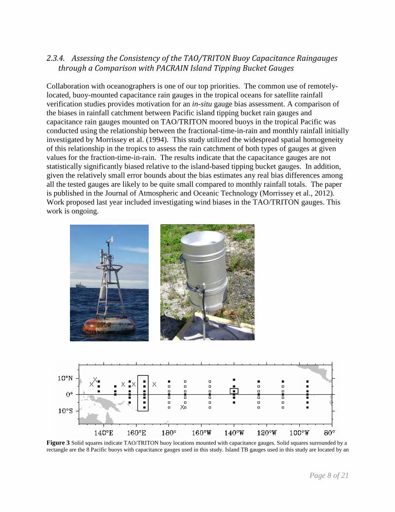
Collaboration with oceanographers is one of our top priorities. The common use of remotely-located, buoy-mounted capacitance rain gauges in the tropical oceans for satellite rainfall verification studies provides motivation for an in-situ gauge bias assessment. A comparison of the biases in rainfall catchment between Pacific island tipping bucket rain gauges and capacitance rain gauges mounted on TAO/TRITON moored buoys in the tropical Pacific was conducted using the relationship between the fractional-time-in-rain and monthly rainfall initially investigated by Morrissey et al. (1994). This study utilized the widespread spatial homogeneity of this relationship in the tropics to assess the rain catchment of both types of gauges at given values for the fraction-time-in-rain. The results indicate that the capacitance gauges are not statistically significantly biased relative to the island-based tipping bucket gauges. In addition, given the relatively small error bounds about the bias estimates any real bias differences among all the tested gauges are likely to be quite small compared to monthly rainfall totals. The paper is published in the Journal of Atmospheric and Oceanic Technology (Morrissey et al., 2012). Work proposed last year included investigating wind biases in the TAO/TRITON gauges. This work is ongoing.
Figure 3 Solid squares indicate TAO/TRITON buoy locations mounted with capacitance gauges. Solid squares surrounded by a rectangle are the 8 Pacific buoys with capacitance gauges used in this study. Island TB gauges used in this study are located by an
2.3.4. Assessing the Consistency of the TAO/TRITON Buoy Capacitance Raingauges through a Comparison with PACRAIN Island Tipping Bucket Gauges
Page 9 of 21
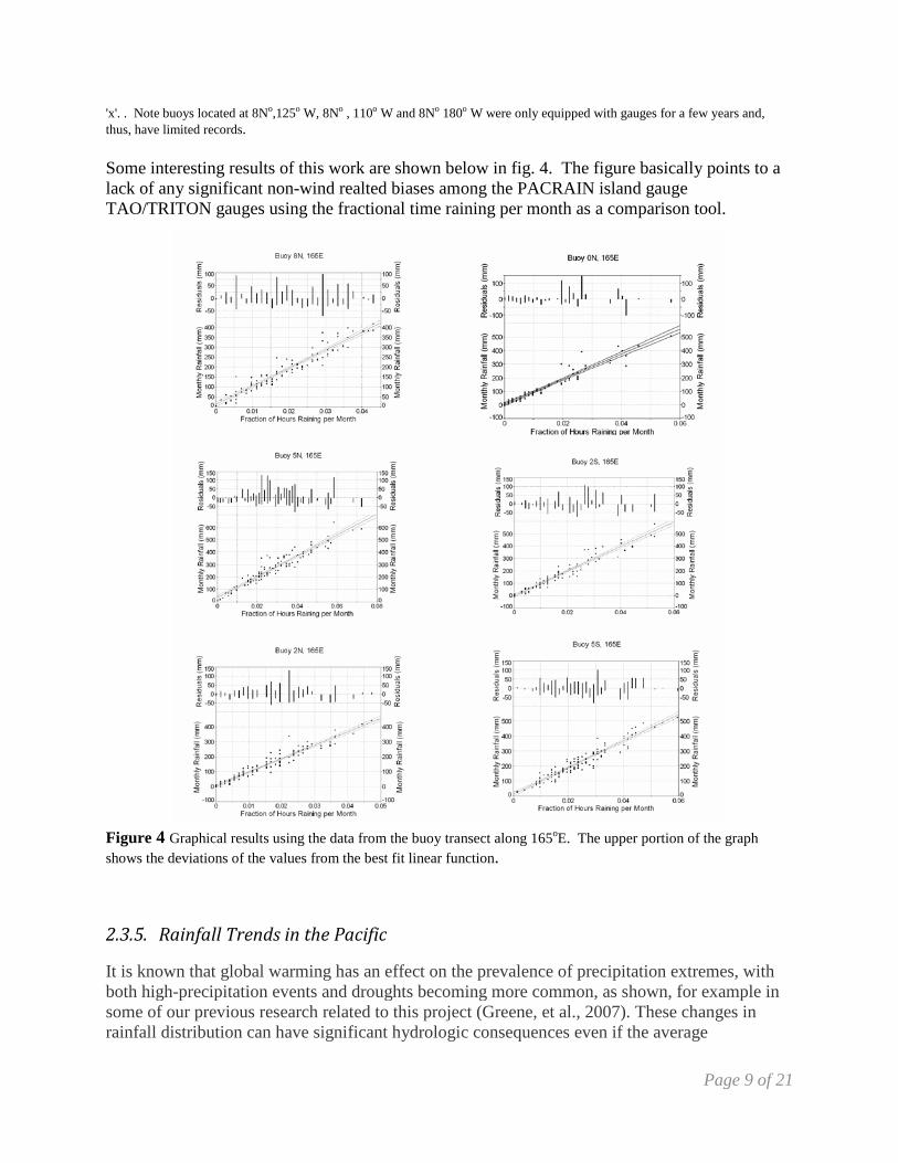
'x'. . Note buoys located at 8No,125o W, 8No , 110o W and 8No 180o W were only equipped with gauges for a few years and, thus, have limited records. Some interesting results of this work are shown below in fig. 4. The figure basically points to a lack of any significant non-wind realted biases among the PACRAIN island gauge TAO/TRITON gauges using the fractional time raining per month as a comparison tool. Figure 4 Graphical results using the data from the buoy transect along 165oE. The upper portion of the graph shows the deviations of the values from the best fit linear function.
It is known that global warming has an effect on the prevalence of precipitation extremes, with both high-precipitation events and droughts becoming more common, as shown, for example in some of our previous research related to this project (Greene, et al., 2007). These changes in rainfall distribution can have significant hydrologic consequences even if the average
2.3.5. Rainfall Trends in the Pacific
Page 10 of 21
precipitation in an area does not change. Areas with limited groundwater and surface water capacity will face the greatest consequences, which describes most of the islands in the central Pacific Ocean. Research presented at the AMS 93rd Annual Meeting focused on the geographic distribution of trends in extreme rainfall associated with three of the models used in the Coupled Model Intercomparison Project. Some of the key results, in this case focused on the Australian CSIRO Mk 3.5 model, concluded that:
• Trends are consistent with an increase in total rainfall and extreme rainfall events across the northwest tropical Pacific (i.e. Micronesia) during the Northern Hemisphere (NH) cool season; no large-scale spatial trends were evident outside of this region.
• At the individual analysis sites across the Tropical Pacific, wet trends outnumbered dry trends by 7:1 during the NH cool season and 2:1 during the NH warm season.
• Most of the statistically significant trends were observed during the NH cool season. .
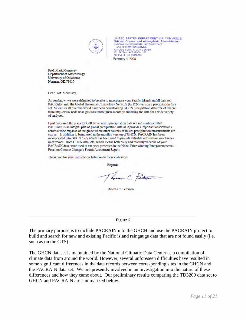
During FY2008 the PACRAIN database, through collaboration with NCDC, was incorporated into the Global Historical Climatology Network (GHCN). The letter, shown in fig. 5 is from Thomas Peterson, NCDC, GHCH director.
2.3.6. Investigation into differences observed between the PACRAIN data and the Global Historical Climate Network
Page 11 of 21
Figure 5
The primary purpose is to include PACRAIN into the GHCH and use the PACRAIN project to build and search for new and existing Pacific island raingauge data that are not found easily (i.e. such as on the GTS). The GHCN dataset is maintained by the National Climatic Data Center as a compilation of climate data from around the world. However, several unforeseen difficulties have resulted in some significant differences in the data records between corresponding sites in the GHCN and the PACRAIN data set. We are presently involved in an investigation into the nature of these differences and how they came about. Our preliminary results comparing the TD3200 data set to GHCN and PACRAIN are summarized below.
Page 12 of 21
FY2014 Results: Comparison of the PACRAIN Database to the Global Historical Climatology Network Data Set (Klatt, Morrissey, and Greene 2014) The GHCN data set is NCDC’s data set of record of global daily climate observations of many different variables. Starting with the 2011 data year, PACRAIN incorporated GHCN data for sites in the United States and its Pacific affiliates. Prior to 2011, PACRAIN used the original TD3200 Cooperative Summary of the Day data for US sites. PACRAIN does not currently use any GHCN data for non-US sites. Thus, the PACRAIN database contains data that did not originate with GHCN, providing an opportunity to compare overlapping data and identify discrepancies between the datasets. Within the PACRAIN domain there are 812 GHCN sites, compared 842 PACRAIN sites that have daily data. GHCN has greater coverage north of the Equator, primarily from CoCoRaHS sites in Hawaii and post-war US cooperative observer data from the Ryuku Islands in Japan. PACRAIN has much greater coverage south of the equator where GHCN data is limited mostly to ICAO aviation observation sites. Notably, there is GHCN rainfall data for Cook Islands, Niue, Pitcairn Islands, Samoa, or Wallis and Futuna. GHCN also does not include data from SPaRCE sites, although they could if needed.
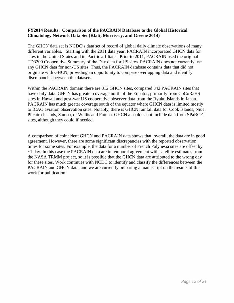
A comparison of coincident GHCN and PACRAIN data shows that, overall, the data are in good agreement. However, there are some significant discrepancies with the reported observation times for some sites. For example, the data for a number of French Polynesia sites are offset by ~1 day. In this case the PACRAIN data are in temporal agreement with satellite estimates from the NASA TRMM project, so it is possible that the GHCN data are attributed to the wrong day for these sites. Work continues with NCDC to identify and classify the differences between the PACRAIN and GHCN data, and we are currently preparing a manuscript on the results of this work for publication.
Page 13 of 21
Figure 6 Temporal comparison of PACRAIN and GHCN gauge data to the TRMM 3B-42 satellite estimates.
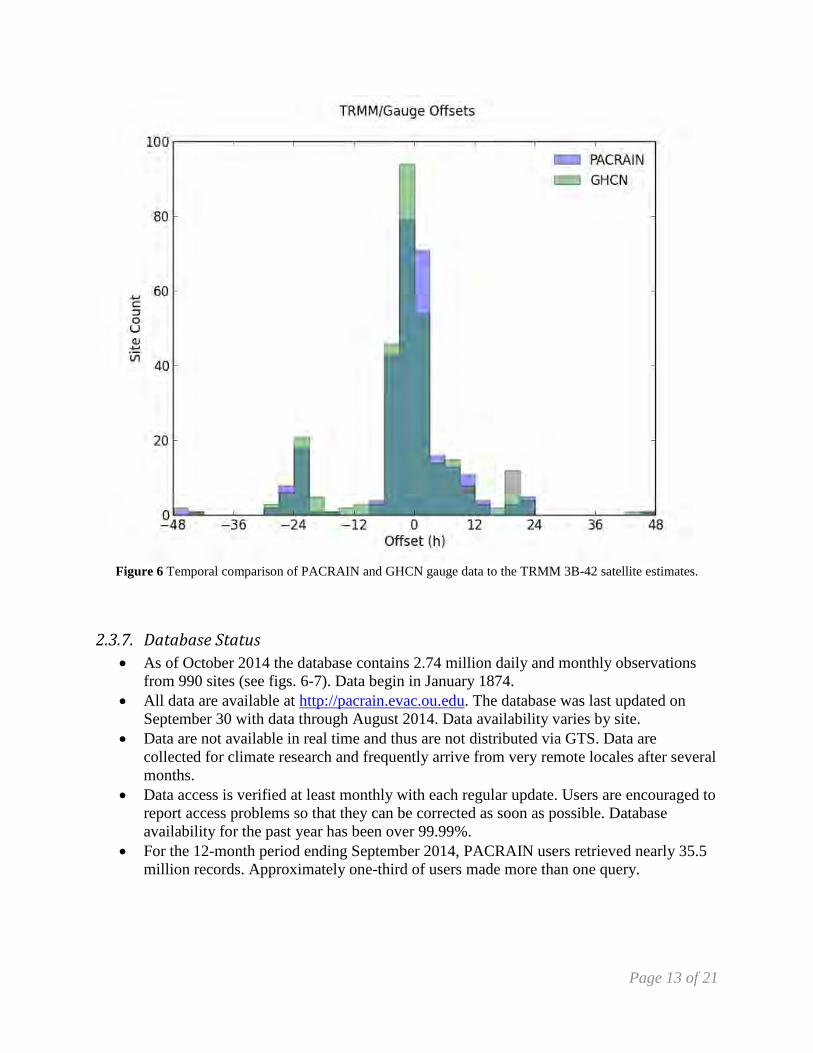
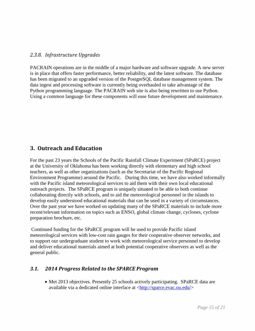
• As of October 2014 the database contains 2.74 million daily and monthly observations from 990 sites (see figs. 6-7). Data begin in January 1874.
• All data are available at http://pacrain.evac.ou.edu. The database was last updated on September 30 with data through August 2014. Data availability varies by site.
• Data are not available in real time and thus are not distributed via GTS. Data are collected for climate research and frequently arrive from very remote locales after several months.
• Data access is verified at least monthly with each regular update. Users are encouraged to report access problems so that they can be corrected as soon as possible. Database availability for the past year has been over 99.99%.
• For the 12-month period ending September 2014, PACRAIN users retrieved nearly 35.5 million records. Approximately one-third of users made more than one query.
2.3.7. Database Status
Page 14 of 21
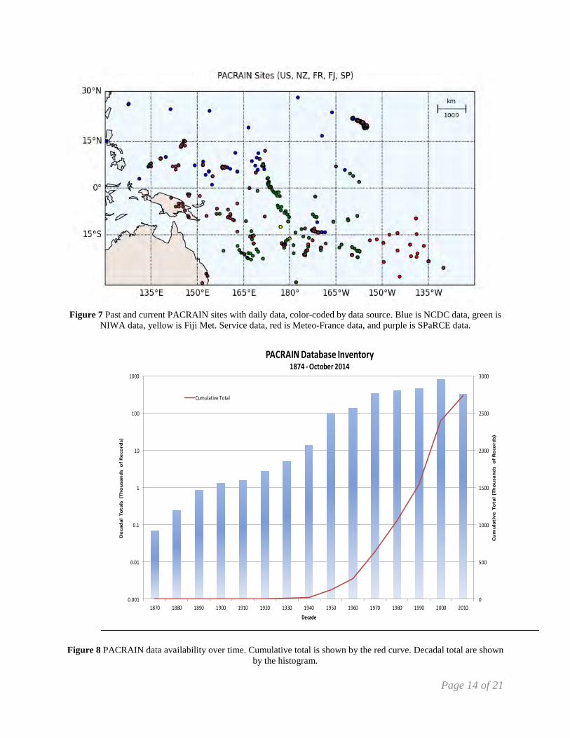
Figure 7 Past and current PACRAIN sites with daily data, color-coded by data source. Blue is NCDC data, green is
NIWA data, yellow is Fiji Met. Service data, red is Meteo-France data, and purple is SPaRCE data.
0
500
1000
1500
2000
2500
3000
0.001
0.01
0.1
1
10
100
1000
1870 1880 1890 1900 1910 1920 1930 1940 1950 1960 1970 1980 1990 2000 2010
Cu
mu
lati
ve T
ota
l (T
ho
usa
nd
s o
f R
eco
rds)
De
cad
al T
ota
ls (
Tho
usa
nd
s o
f R
eco
rds)
Decade
PACRAIN Database Inventory1874 - October 2014
Cumulative Total
Figure 8 PACRAIN data availability over time. Cumulative total is shown by the red curve. Decadal total are shown
by the histogram.
Page 15 of 21
PACRAIN operations are in the middle of a major hardware and software upgrade. A new server is in place that offers faster performance, better reliability, and the latest software. The database has been migrated to an upgraded version of the PostgreSQL database management system. The data ingest and processing software is currently being overhauled to take advantage of the Python programming language. The PACRAIN web site is also being rewritten to use Python. Using a common language for these components will ease future development and maintenance.
3. Outreach and Education For the past 23 years the Schools of the Pacific Rainfall Climate Experiment (SPaRCE) project at the University of Oklahoma has been working directly with elementary and high school teachers, as well as other organizations (such as the Secretariat of the Pacific Regional Environment Programme) around the Pacific. During this time, we have also worked informally with the Pacific island meteorological services to aid them with their own local educational outreach projects. The SPaRCE program is uniquely situated to be able to both continue collaborating directly with schools, and to aid the meteorological personnel in the islands to develop easily understood educational materials that can be used in a variety of circumstances. Over the past year we have worked on updating many of the SPaRCE materials to include more recent/relevant information on topics such as ENSO, global climate change, cyclones, cyclone preparation brochure, etc. Continued funding for the SPaRCE program will be used to provide Pacific island meteorological services with low-cost rain gauges for their cooperative observer networks, and to support our undergraduate student to work with meteorological service personnel to develop and deliver educational materials aimed at both potential cooperative observers as well as the general public.
• Met 2013 objectives. Presently 25 schools actively participating. SPaRCE data are
available via a dedicated online interface at <http://sparce.evac.ou.edu/>
2.3.8. Infrastructure Upgrades
3.1. 2014 Progress Related to the SPARCE Program
Page 16 of 21
• We have recently hired an undergraduate meteorology student to help with promoting the SPaRCE program and encouraging interaction among SPaRCE participants via various social media (in addition to Facebook)
• A quarterly SPaRCE newsletter is published and distributed to participants and other interested parties.
• Are developing a strategy to have at least bi-weekly contact with all SPaRCE participants
• Additional recruitment packets to over 100 Pacific Island schools and organizations are being prepared to send out at the end of this year
• We continue to work with Pacific meteorological services to enroll more schools • Created 2014 SPaRCE calendar for participants • We continue with our updating of the SPaRCE Workbooks
4. Publications and Reports All PACRAIN researchers’ publications acknowledge NOAA OCO’s funding contribution to the project.
Klatt, M. D., M. L. Morrissey and J. S. Greene, 2015: Using Python as an Integrated Software Platform for the PACRAIN Program, accepted for presentation at the 95th AMS Annual Meeting, Phoenix, 4–8 January 2015. Klatt, M. D., M. L. Morrissey and J. S. Greene, 2014: Comparison of the PACRAIN Database to the Global Historical Climatology Network Data Set, presented at the 94th AMS Annual Meeting, Atlanta, 2–6 February 2014. Klatt, M. D., M.L. Morrissey, and J. S. Greene 2014: Comparison of the PACRAIN Database to the Global Historical Climatology Network Data Set, 26th Conference on Climate Variability and Change, AMS, Jan. 2014. Klatt, M. D., M. L. Morrissey and J. S. Greene, 2013: Future Trends in Tropical Pacific Rainfall Extremes, presented at the 25th Conference on Climate Variability and Change, Austin, 6-10 January 2013. Morrissey, M. L., H. Diamond, M. J. McPhaden, H. P. Frietag and J. S. Greene, 2012: An Investigation of the Consistency of TAO Buoy-mounted Capacitance Rain Gauges along the Equatorial Tropical Pacific, J. Atm. Ocean. Tech., 29, 834-845.
4.1. Recent Publications by Principal Investigators
Page 17 of 21
Klatt, M. D., M. L. Morrissey and J. S. Greene, 2012: Trends in Tropical Pacific Rainfall Extremes. Presented at the 28th Conference on Interactive Information Processing Systems, New Orleans, January 23-26, 2012. Past Relevant Publications (a sample): Morrissey M.L., 2009: Superposition of the Neyman-Scott Rectangular Pulses Model and the Poisson White Noise Model for the Representation of Tropical Rain Rates. Journal of Hydrometeorology, 10, 395-412. Morrissey, M. L. and J. S. Greene 2007: “‘Ground Validation for the Global Precipitation Climatology Project” in "Measuring Precipitation from Space - EURAINSAT and the future" Levizzani, Vincenzo; Bauer, Peter; Turk, F. Joseph (editors), 2007, Approx. 745 p., Hardcover ISBN: 978-1-4020-5834-9.. p. 381-392. Greene, JS, M Klatt M Morrissey, and S Postawko, 2008: “The Comprehensive Pacific Rainfall Database: An enhanced tool for research and education”, Journal of Atmospheric and Oceanic Technology, 25(1), 71-82. Greene, JS, B Paris, and M Morrissey, 2007, “Analysis of Historical Changes in Extreme Precipitation Events in the Tropical Pacific”, Climate Research, 34, 1-14. Morrissey, M.L., W.F. Krajewski and M.J. McPhaden, 1994: Estimating rainfall in the tropics using the fractional time raining, Journal of Applied Meteorology, 33, No. 3, 387-393.
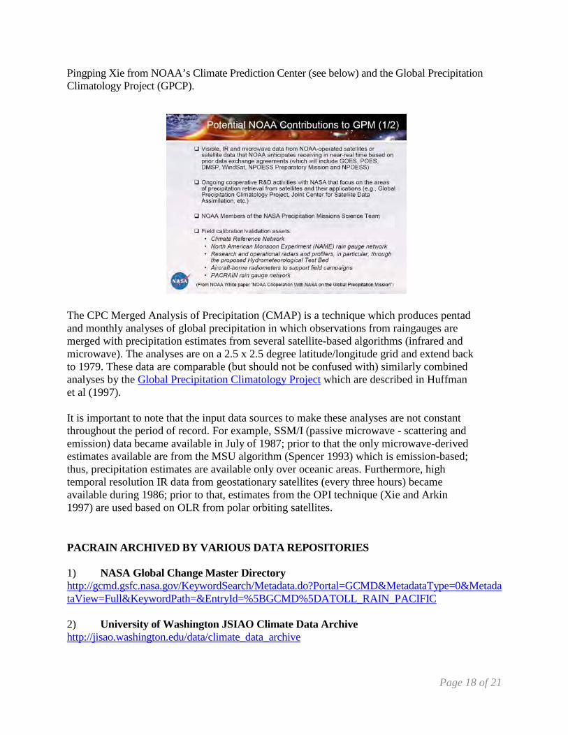
The PACRAIN database is hosted on NASA Goddard’s Global Change Master Directory (http://gcmd.nasa.gov/records/GCMD_ATOLL_RAIN_PACIFIC.html) and linked from a number of project web sites such as PI-GCOS: http://www.pi-gcos.org/data_access.htm, UCAR’s CISL Research Data Archive (http://rda.ucar.edu/datasets/ds484.0/), the U.S. Global Change Research Information Office (http://www.gcrio.org/datainfo/index.html). The PACRAIN dataset also makes up part of the Global Historical Climate Network (GHCN) (http://www.ncdc.noaa.gov/oa/climate/ghcn-monthly/index.php) developed and maintained by NOAA’s National Climatic Data Center (NCDC). The dataset forms an integral part of many international projects such as the Global Precipitation Climatology Project (GPCP) and the International Precipitation Working Group (IPWG). There are also many international organizations which link to our server (SOPAC, http://www.pacificwaterefficiency.com/links.html,. The PACRAIN dataset forms a critical component of NASA Global Precipitation Measurement Program (GPM) (see below). One of the most important operational uses of the PACRAIN dataset is its inclusion in the CMAP satellite/raingauge merged global precipitation estimates, managed by
4.2. Other Relevant Publications
4.2.1. Institutional Usage and Citations
Page 18 of 21
Pingping Xie from NOAA’s Climate Prediction Center (see below) and the Global Precipitation Climatology Project (GPCP).
The CPC Merged Analysis of Precipitation (CMAP) is a technique which produces pentad and monthly analyses of global precipitation in which observations from raingauges are merged with precipitation estimates from several satellite-based algorithms (infrared and microwave). The analyses are on a 2.5 x 2.5 degree latitude/longitude grid and extend back to 1979. These data are comparable (but should not be confused with) similarly combined analyses by the Global Precipitation Climatology Project which are described in Huffman et al (1997). It is important to note that the input data sources to make these analyses are not constant throughout the period of record. For example, SSM/I (passive microwave - scattering and emission) data became available in July of 1987; prior to that the only microwave-derived estimates available are from the MSU algorithm (Spencer 1993) which is emission-based; thus, precipitation estimates are available only over oceanic areas. Furthermore, high temporal resolution IR data from geostationary satellites (every three hours) became available during 1986; prior to that, estimates from the OPI technique (Xie and Arkin 1997) are used based on OLR from polar orbiting satellites. PACRAIN ARCHIVED BY VARIOUS DATA REPOSITORIES 1) NASA Global Change Master Directory http://gcmd.gsfc.nasa.gov/KeywordSearch/Metadata.do?Portal=GCMD&MetadataType=0&MetadataView=Full&KeywordPath=&EntryId=%5BGCMD%5DATOLL_RAIN_PACIFIC 2) University of Washington JSIAO Climate Data Archive http://jisao.washington.edu/data/climate_data_archive

Page 19 of 21
3) Asia Pacific Data Research Center http://apdrc.soest.hawaii.edu/new/additions.php 4) NCAR CISL Research Data Archive http://rda.ucar.edu/datasets/ds484.0/
One Notable Funded Project using PACRAIN A.M.G. Klein Tank, EURO4M ,European Reanalysis and Observations for Monitoring Royal Netherlands Meteorological Institute , EU funded. http://www.euro4m.eu/downloads/EURO4M_periodic_report_YR1.pdf The following list is an abbreviated list of recently sampled refereed journal articles citing use of the PACRAIN database: Jian-Jian Wang, Robert F. Adler, George J. Huffman, and David Bolvin, 2014: An Updated TRMM Composite Climatology of Tropical Rainfall and Its Validation. J. Climate, 27, 273–284. doi: http://dx.doi.org/10.1175/JCLI-D-13-00331.1 Chang, Lisa T-C., Kevin KW Cheung, and John McAneney. "Case study of TRMM satellite rainfall estimation for landfalling tropical cyclones: Issues and challenge." Tropical Cyclone Research and Review 2.2 (2013): 109-123. Chen, Yingjun; Ebert, Elizabeth E.; Walsh, Kevin J. E.; et al , 2013; Evaluation of TRMM 3B42 precipitation estimates of tropical cyclone rainfall using PACRAIN data,: J. Geophys. Res.-Atm, Vol. 118, 2184- 2196 DOI: 10.1002/jgrd. . http://www.cawcr.gov.au/events/verif2011/posters/55_Chen_Y.pdf Pfeifroth, Uwe; Mueller, Richard; Ahrens, Bodo , 2013; Evaluation of Satellite-Based and Reanalysis Precipitation Data in the Tropical Pacific, J. Appl. Meteor. and Climatology, Vol. 52, 634-644 DOI: 10.1175/JAMC-D-12-049.1 M. Niaz Arifin, 2013: A Spatial Agent-based Model and A Multi-dimensional Data Warehouse for Malaria Research S. Advisor: Dr. Gregory R. Madey Department of Computer Science and Engineering University of Notre Dame, Ph.D. June 18, 2013 Chen et al. 2013:, “Evaluation of TRMM 3B42 estimates of tropical cyclone daily rainfall over the Pacific and Australia.”, 4th Asia-Oceania Meteorological Satellite Users Conference Oct9-11,2013, NAVY Research Grant Report, 2013: “Initialization, Prediction and Diagnosis of the Rapid Intensification of Tropical Cyclones using the Australian Community Climate and Earth System Simulator”, Michael J. Reeder*, et al Award Number: N000141010139 P00003 http://www.onr.navy.mil/reports/FY12/mmreeder.pdf 2014 Tech Report: Regional Consultation on Climate Services for Pacific Small Island States , 2014, http://www.gfcs-climate.org/sites/default/files/events/Regional%20Consultation%20on%20GFCS%20for%20Small%20Island%20Developing%20States%20in%20the%20Pacific//Final%20report%20formatted%205.9.2014.pdf
4.2.2. Research Usage
Page 20 of 21
Wu, H. C., B. K. Linsley, E. P. Dassié, B. Schiraldi Jr., and P. B. deMenocal , 2013, Oceanographic variability in the South Pacific Convergence Zone region over the last 210 years from multi-site coral Sr/Ca records, Geochem. Geophys. Geosyst., 14, 1435–1453, doi:10.1029/2012GC004293. http://www.ldeo.columbia.edu/~peter/site/Papers_files/Wu.etal.2013.pdf Other Journal articles, Technical Reports and funded Proposals incorporating PACRAIN Chen et al. 2013:, “Evaluation of TRMM 3B42 estimates of tropical cyclone daily rainfall over the Pacific and Australia.”, 4th Asia-Oceania Meteorological Satellite Users Conference Oct9-11,2013, NAVY Research Grant Report, 2013: “Initialization, Prediction and Diagnosis of the Rapid Intensification of Tropical Cyclones using the Australian Community Climate and Earth System Simulator”, Michael J. Reeder*, et al Award Number: N000141010139 P00003 http://www.onr.navy.mil/reports/FY12/mmreeder.pdf 2014 Tech Report: Regional Consultation on Climate Services for Pacific Small Island States , 2014, http://www.gfcs-climate.org/sites/default/files/events/Regional%20Consultation%20on%20GFCS%20for%20Small%20Island%20Developing%20States%20in%20the%20Pacific//Final%20report%20formatted%205.9.2014.pdf Diamond, H. J., Lorrey, A. M., Knapp, K. R. and Levinson, D. H. 2011: Development of an
enhanced tropical cyclone tracks database for the southwest Pacific from 1840 to 2010. Inter. J. Climat., doi: 10.1002/joc.2412
Greene, J. S., M. Klatt, M. Morrissey, and S. Postawko, 2008: The Comprehensive Pacific Rainfall Database. J. Atmos. Oceanic Technol., 25, 71-82. Greene, J. S., B. Paris, M. Morrissey, 2007: Historical changes in extreme precipitation events in the tropical Pacific
region. Climate Res., 34, 1-14. Xie, P. P., A. Yatagi, M. Y. Chen, et al., 2007: A gauge-based analysis of daily precipitation over East Asia. J.
Hydromet., 8, 607-626. Huffman, G.J., R.F. Adler, D.T. Bolvin, G. Gu, E.J. Nelkin, K.P. Bowman, Y. Hong, E.F. Stocker, D.B. Wolff,
2007: The TRMM Multi-satellite Precipitation Analysis: Quasi-Global, Multi-Year, Combined-Sensor Precipitation Estimates at Fine Scale. J. Hydrometeor., 8(1), 38-55.
Islam, M. N. and H. Uyeda, 2007: Use of TRMM in determining the climatic characteristics of rainfall over
Bangladesh. Remote Sens. Environ., 108, 264-276. Kidd, C. and G. McGregor, 2007: Observation and characterization of rainfall over Hawaii and surrounding region
from the Tropical Rainfall Measuring Mission. Int. J. Climatol., 27, 541-553. Delcroix, T., C. Henin, V. Porte and P. Arkin, 2007: Precipitation and sea-surface salinity in the tropical Pacific Ocean, Deep Sea Research I, Vol. 43, No. 7. pp. 1123-1141. 2006. Brown, J. E. M., 2006: An analysis of the performance of hybrid infrared and microwave satellite precipitation
estimates over India and adjacent regions. Remote Sens. Environ., 101, 63-81. Matthews, A. J. and H. Y. Y. Li, 2005: Modulation of station rainfall over the western Pacific by the Madden-Julian
oscillation. Geophys. Res. Letters, 14. Nicholson, S. E., B. Some, J. McCollum, et al., 2003: Validation of TRMM and other rainfall estimates with a high-
density gauge dataset for West Africa. Part I: Validation of GPCC rainfall product and pre-TRMM satellite and blended products. J. Appl. Meteor., 42, 1337-1354.
Page 21 of 21
Nicholson, S. E., B. Some, J. McCollum, et al., 2003: Validation of TRMM and other rainfall estimates with a high-
density gauge dataset for West Africa. Part II: Validation of TRMM rainfall products. J. Appl. Meteor., 42, 1355-1368.
Xie, P. P., J. E. Janowiak, P. A. Arkin, et al., 2003: GPCP Pentad precipitation analyses: An experimental dataset
based on gauge observations and satellite estimates. J. Climate, 16, 2197-2214. Xie, P. P., and P. A. Arkin, 1997: Global Precipitation: A 17-year monthly analysis based on gauge observations,
satellite estimates, and numerical model outputs, Bulletin of the American Meteorological Society, 78, 2539-2558.
Kummerow, C., Y. Hong, W. S. Olson, et al., 2001: The evolution of the Goddard profiling algorithm (GPROF) for
rainfall estimation from passive microwave sensors. J. Appl. Meteor., 40, 1801-1820. Adler, R. F., C. Kidd, G. Petty, et al., 2001: Intercomparison of global precipitation products: The third Precipitation
Intercomparison Project (PIP-3). Bull. Am. Meteor. Soc., 82, 1377-1396. Kummerow, C., J. Simpson, O. Thiele, et al., 2000: The status of the Tropical Rainfall Measuring Mission (TRMM)
after two years in orbit. J. Appl. Meteor., 39, 1965-1982. Adler, R. F., G. J. Huffman, D. T. Bolvin, et al., 2000: Tropical rainfall distributions determined using TRMM
combined with other satellite and rain gauge information. J. Appl. Meteor., 39, 2007-2023. Todd, M. , R. Washington, 1999: A Simple Method to Retrieve 3-Hourly Estimates
of Global Tropical and Subtropical Precipitation from International Satellite Cloud Climatology Program (ISCCP) D1 Data. J. Atmos. Oceanic Technol., 16, 146–155. doi: http://dx.doi.org/10.1175/1520-0426(1999)016<0146:ASMTRH>2.0.CO;2
Zeng, X. B., 1999: The relationship among precipitation, cloud-top temperature, and precipitable water over the
tropics. J. Climate, 12, 2503-2514. Chapman, T., 1998: Stochastic modeling of daily rainfall: the impact of joining wet days on the distribution of
rainfall amounts. Environ. Model. Softw., 13, 317-324. Morrissey, M. L. and J. S. Greene, 1998: Uncertainty analysis of rainfall algorithms over the tropical Pacific. J.
Geophys. Res. Atmos., 103, 19569-19576. Waliser, D. E. and W. F. Zhou, 1997: Removing the satellite equatorial crossing time biases from the OLR and HRC
datasets. J. Climate, 10, 2125-2146. Huffman, G. J., 1997: Estimates of root-mean-square random error for finite samples of estimated precipitation. J.
Appl. Meteor., 36, 1191-1201 Ferraro, R. R., 1997: Special sensor microwave imager derived global rainfall estimates for climatological
applications. J. Geophys. Res. Atmos., 102, 16715-16735. Lin, B. and W. B. Rossow, 1997: Precipitation water path and rainfall estimates over ocean using special sensor
microwave imager and International Satellite Cloud Climatology Project data. J. Geophys. Res. Atmos., 102, 9359-9374.
Maliekal, J. A. and T. J. Petroski, 1996: Evidence of secular changes in rainfall data from the tropical western and
central Pacific over a 20-year period. Geophys. Res. Letters, 23, 2621-2624.