Embed Size (px)
Citation preview

www.elsevier.com/locate/earscirev
Earth-Science Reviews 7
The Black Mountains turtlebacks:
Rosetta stones of Death Valley tectonics
Marli B. Miller a,*, Terry L. Pavlis b
a Department of Geological Sciences, University of Oregon, Eugene, OR 97403-1272, United Statesb Department of Geology and Geophysics, University of New Orleans, New Orleans, LA 70148, United States
Accepted 1 April 2005
Abstract
The Black Mountains turtlebacks expose mid-crustal rock along the western front of the Black Mountains. As such, they
provide keys to understanding the Tertiary structural evolution of Death Valley, and because of the outstanding rock
exposure, they also provide valuable natural laboratories for observing structural processes. There are three turtlebacks: the
Badwater turtleback in the north, the Copper Canyon turtleback, and the Mormon Point turtleback in the south. Although
important differences exist among them, each turtleback displays a doubly plunging antiformal core of metamorphic and
igneous rock and a brittle fault contact to the northwest that is structurally overlain by Miocene–Pleistocene volcanic and/or
sedimentary rock.
The turtleback cores contain mylonitic rocks that record an early period of top-southeastward directed shear followed by top-
northwestward directed shear. The earlier formed mylonites are cut by, and locally appear concurrent with, 55–61 Ma pegmatite.
We interpret these fabrics as related to large-scale, basement-involved thrust faults at the turtlebacks, now preserved as areally-
extensive, metamorphosed, basement over younger-cover contacts.
The younger, and far more pervasive, mylonites record late Tertiary extensional unroofing of the turtleback footwalls from
mid-crustal depths. Available geochronology suggests that they cooled through 300 8C at different times: 13 Ma at Badwater; 6
Ma at Copper Canyon; 8 Ma at Mormon Point. At Mormon Point and Copper Canyon turtlebacks these dates record cooling of
the metamorphic assemblages from beneath the floor of an ~11 Ma Tertiary plutonic complex. Collectively these relationships
suggest that the turtlebacks record initiation of ductile extension before ~14 Ma followed by injection of a large plutonic
complex along the ductile shear zone. Ductile deformation continued during extensional uplift until the rocks cooled below
temperatures for crystal plastic deformation by 6–8 Ma. Subsequent low-angle brittle fault slip led to final exposure of the
igneous and metamorphic complex.
The turtleback shear zones can constrain models for crustal extension from map-view as well as cross-sectional perspectives.
In map view, the presence of basement-involved thrust faults in the turtlebacks suggest the Black Mountains were a basement
0012-8252/$ - s
doi:10.1016/j.ea
* Correspondi
E-mail addre
3 (2005) 115–138
ee front matter D 2005 Elsevier B.V. All rights reserved.
rscirev.2005.04.007
ng author.
sses: [email protected] (M.B. Miller), [email protected] (T.L. Pavlis).
M.B. Miller, T.L. Pavlis / Earth-Science Reviews 73 (2005) 115–138116
high prior to late Tertiary extension. In cross-section, the turtleback geometries and histories are most compatible with models
that call on multiple faults rather than a single detachment to drive post-11 Ma extension.
D 2005 Elsevier B.V. All rights reserved.
Keywords: turtlebacks; Death Valley; extension; ductile shear zones; basin; range
1. Introduction
The three Black Mountains turtlebacks have long
been considered important but enigmatic features of
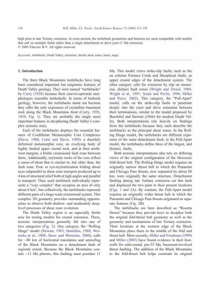
Death Valley geology. They were named bturtlebacksQby Curry (1938) because their convex-upwards mor-
phologies resemble turtleshells. In terms of bedrock
geology, however, the turtlebacks stand out because
they offer the only exposures of crystalline basement
rock along the Black Mountains front (Curry, 1938,
1954; Fig. 1). They are probably the single most
important features in deciphering Death Valley’s com-
plex tectonic story.
Each of the turtlebacks displays the essential fea-
tures of Cordilleran Metamorphic Core Complexes
(Davis, 1980; Lister and Davis, 1989): a ductilely
deformed metamorphic core, an overlying body of
highly faulted upper crustal rock, and at their north-
west margins, a brittle extensional fault zone between
them. Additionally, mylonitic rocks of the core reflect
a sense-of-shear that is similar to, but older than, the
fault zone. Post- to syn-mylonitization folding about
axes subparallel to shear zone transport produced up to
4 km of structural relief both at high angles and parallel
to transport. Thus, each turtleback individually repre-
sents a bcore complexQ that occupies an area of only
about 6 km2, but collectively, the turtlebacks represent
different parts of a large-scale extensional system. This
complex 3D geometry provides outstanding opportu-
nities to observe both shallow- and moderately deep-
level processes of shear zone evolution.
The Death Valley region is an especially fertile
area for testing models for crustal extension. There,
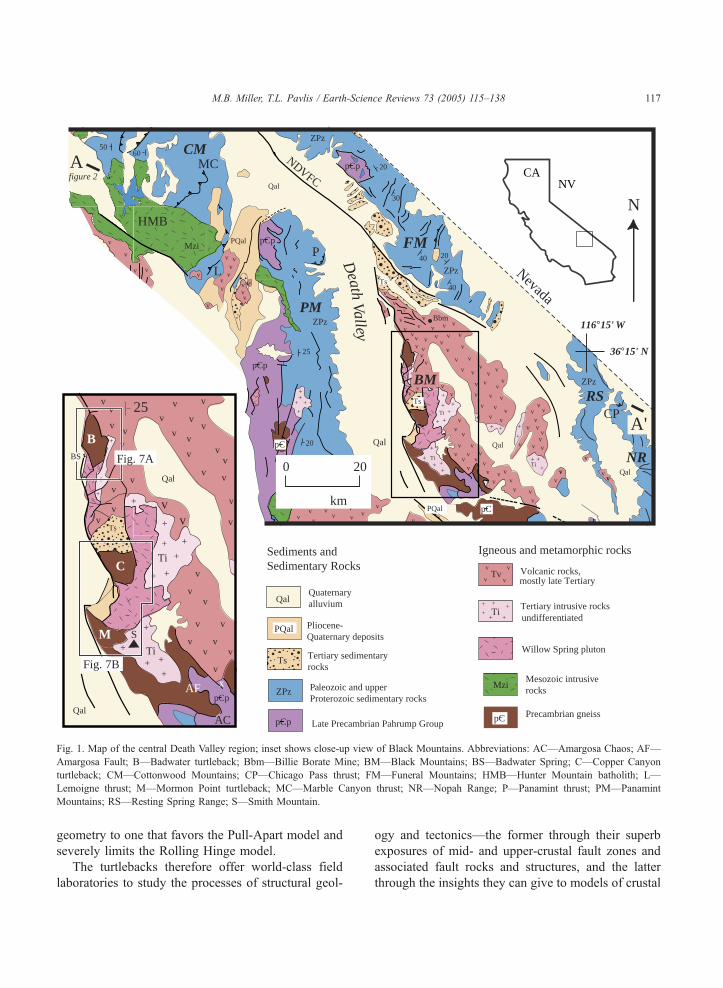
tectonic interpretations generally fall into one of
two categories (Fig. 2). One category, the bRollingHingeQ model (Stewart, 1983; Hamilton, 1988; Wer-
nicke et al., 1988; Snow and Wernicke, 2000), calls
for ~80 km of horizontal translation and unroofing
of the Black Mountains on a detachment fault of
regional extent. Because the Black Mountains con-
tain ~11 Ma plutons, this faulting must postdate 11
Ma. This model views strike-slip faults, such as the
en echelon Furnace Creek and Sheephead faults, as
upper crustal edges of the detachment system. The
other category calls for extension by slip on numer-
ous, distinct fault zones (Wright and Troxel, 1984;
Wright et al., 1991; Serpa and Pavlis, 1996; Miller
and Prave, 2002). This category, the bPull-ApartQmodel, calls on the strike-slip faults to penetrate
deeply into the crust and drive extension between
their terminations, similar to the model proposed by
Burchfiel and Stewart (1966) for modern Death Val-
ley. Both interpretations rely heavily on findings
from the turtlebacks because they each describe the
turtlebacks as the principal shear zones. In the Roll-
ing Hinge model, the turtlebacks are different expo-
sures of the same detachment fault; in the Pull-Apart
model, the turtlebacks define three of the largest, and
distinct, faults.
Both tectonic interpretations also rely on differing
views of the original configuration of the Mesozoic
fold-thrust belt. The Rolling Hinge model requires an
originally narrow thrust belt in which the Panamint
and Chicago Pass thrusts, now separated by about 80
km, were originally the same structure. Detachment
faulting during late Tertiary extension cut this fault
and displaced the two parts to their present locations
(Figs. 1 and 2A). By contrast, the Pull-Apart model
requires an originally wider thrust belt in which the
Panamint and Chicago Pass thrusts originated as sepa-
rate features (Fig. 2B).
The turtlebacks are here described as bRosettaStonesQ because they provide keys to decipher both
the original fold-thrust belt geometry as well as the
geometry and mechanisms of late Tertiary extension.
Their locations at the western edge of the Black
Mountains place them in the middle of the fold and
thrust belt. Most recently, Miller and Friedman (1999)
and Miller (2003) have found evidence in their foot-
walls for mid-crustal, pre-55 Ma, basement-involved
thrust faulting. The addition of the Black Mountains
to the fold-thrust belt helps constrain its original
vv
v
vv
vv
v
vv
vv v
vv v
v v
v
vv
v
v
vv v v
vvv
vv
vv
v
vv
vv
vv
vvvvv
vv
v
v
v
vv
vv
v
v
v
v
vv
v
v
v
v
v
vv
v
v
v
vv
v
vv
vvv
vv
vv
v
v
v
v
v
v
v
v
vv
v
v
v
vv
v v
vv
v
v vv
v
v
vv
v
v
vv
Mv
Mv
Mv
v
v
v
v
v
vv
v
v
v
v v
vv
v
v
v
vv
v
v
v
vv
vvv
vv
v
v
v
v
v
v
v
v
+
++
+
++
++
++
+++
+
+++
+++
++
+
+
+
++++
+
+
++
+
+
+++
+
+
++
++
+
+
+
QalQuaternary alluvium
PQal Pliocene-Quaternary deposits
Ts Tertiary sedimentaryrocks
ZPz Paleozoic and upper Proterozoic sedimentary rocks
pCp Late Precambrian Pahrump Group
Sediments and Sedimentary Rocks
Igneous and metamorphic rocks
Tvv v
v v Volcanic rocks,
Ti+ ++
+ ++
Tertiary intrusive rocks
Mzi Mesozoic intrusive rocks
pC Precambrian gneiss
mostly late Tertiary
undifferentiated
Willow Spring pluton
CANVQal
Qal
Qal
Qal
PQal
PQal
Ts
Bbm
Ts
ZPz
ZPz
ZPz
ZPz
Ti
Mzi
TiTi
km
0 20
N
pCp
pC
pC
pCp
pCp
5060
20
30
40
40
25
20
20
Nevada
L
MC
HMB
CP
P
AC
PM
CM
BM
FM
NR
RSD
eathValley 116°15' W
36°15' N
A
A'
figure 2
Qal
Qal
BS
Ts
Ti
Ti
S
pCp
25
B
C
M
NDVFC
Fig. 7A
Fig. 7B
AF x
Fig. 1. Map of the central Death Valley region; inset shows close-up view of Black Mountains. Abbreviations: AC—Amargosa Chaos; AF—
Amargosa Fault; B—Badwater turtleback; Bbm—Billie Borate Mine; BM—Black Mountains; BS—Badwater Spring; C—Copper Canyon
turtleback; CM—Cottonwood Mountains; CP—Chicago Pass thrust; FM—Funeral Mountains; HMB—Hunter Mountain batholith; L—
Lemoigne thrust; M—Mormon Point turtleback; MC—Marble Canyon thrust; NR—Nopah Range; P—Panamint thrust; PM—Panamint
Mountains; RS—Resting Spring Range; S—Smith Mountain.
M.B. Miller, T.L. Pavlis / Earth-Science Reviews 73 (2005) 115–138 117
geometry to one that favors the Pull-Apart model and
severely limits the Rolling Hinge model.
The turtlebacks therefore offer world-class field
laboratories to study the processes of structural geol-
ogy and tectonics—the former through their superb
exposures of mid- and upper-crustal fault zones and
associated fault rocks and structures, and the latter
through the insights they can give to models of crustal
+
+
++
+
+
+
++
++
+
++
+ ++
++
++
++
+ ++
++
+
+
+
+
+++
+
+
20 km
Approx. basement-sed unconformity
HMB
HMB
P
P
L
L
MC
MC
CP
CP
TB
TB
5 km
Panamint Mtns.
Panamint Mtns.
Black Mtns.
Black Mtns.
Nopah R.
Nopah R.
A
B
Detachment fault
A A'
A A'
Fig. 2. Schematic cross-sections from A to AV of Fig. 1 that compare interpretations of present-day structure of Death Valley region.
Abbreviations: CP—Chicago Pass thrust; HMB—Hunter Mountain batholith; L—Legmoigne thrust; MC—Marble Canyon thrust; P—Panamint
thrust; TB—Turtlebacks. BMT and TB are both projected into line of section. A: Present-day structure as interpreted in context of the Rolling
Hinge model by Wernicke et al. (1988) and Snow and Wernicke (2000). Note that extensional turtleback faults (TB) are part of a regional
detachment. Stars mark correlative structures offset by the detachment. Dashed line beneath Nopah range indicates that part of the detachment
system underlies the Nopah Range as well. B: Present-day structure as interpreted in context of Pull-Apart model. Note that extensional
turtleback faults are deep-seated faults.
M.B. Miller, T.L. Pavlis / Earth-Science Reviews 73 (2005) 115–138118
extension. This paper reviews contributions made by
researchers on the turtlebacks and concludes with our
preferred interpretation of the turtlebacks as being
long-lived shear zones that probably reactivated base-
ment-involved thrust faults.
2. Research on the turtlebacks
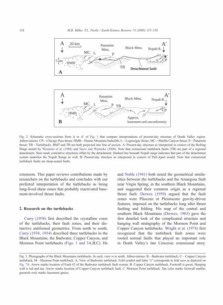
Curry (1938) first described the crystalline cores
of the turtlebacks, their fault zones, and their dis-
tinctive antiformal geometries. From north to south,
Curry (1938, 1954) described three turtlebacks in the
Black Mountains, the Badwater, Copper Canyon, and
Mormon Point turtlebacks (Figs. 1 and 3A,B,C). He
Fig. 3. Photographs of the Black Mountains turtlebacks. In each, view is to
turtleback; M—Mormon Point turtleback. A: View of Badwater turtleback
Fig. 7A. Arrow marks location of Fault #2 of the Badwater turtleback fau
wall is red and tan. Arrow marks location of Copper Canyon turtleback fa
greenish rock marks basement gneiss.
and Noble (1941) both noted the geometrical simila-
rities between the turtlebacks and the Amargosa fault
near Virgin Spring, in the southern Black Mountains,
and suggested their common origin as a regional
thrust fault. Drewes (1959) argued that the fault
zones were Pliocene or Pleistocene gravity-driven
features, imposed on the turtlebacks long after thrust
faulting and folding. His map of the central and
southern Black Mountains (Drewes, 1963) gave the
first detailed look of the complicated structure and
hanging wall stratigraphy of the Mormon Point and
Copper Canyon turtlebacks. Wright et al. (1974) first
recognized that the turtleback fault zones were
rooted normal faults that played an important role
in Death Valley’s late Cenozoic extensional story.
north. Abbreviations: B—Badwater turtleback; C—Copper Canyon
. Fold symbol and letter bcQ corresponds to fold axes as depicted on
lt system. B: Copper Canyon turtleback. Footwall is green; Hanging
ult. C: Mormon Point turtleback. Tan color marks footwall marble;
M.B. Miller, T.L. Pavlis / Earth-Science Reviews 73 (2005) 115–138 119
M.B. Miller, T.L. Pavlis / Earth-Science Reviews 73 (2005) 115–138120
Otton (1976, 1977) mapped the Mormon Point and
Copper Canyon turtlebacks at 1:24,000 and de-
scribed most of the relations that are key to inter-
pretations today.
A common theme of this early research is the
importance of pre-Cenozoic deformation in shaping
the turtlebacks. Wright et al. (1974) and Otton (1976),
for example, recognized the relevance of the turtle-
backs to crustal extension, but called on Mesozoic
shortening to form their antiformal geometries. How-
ever, with the recognition of the extensional nature of
metamorphic core complexes and their associated
ductilely deformed rocks elsewhere (e.g. Davis et
al., 1982, 1986; Miller et al., 1983) as well as the
recognition that the Willow Spring pluton in the Black
Mountains was only 11 Ma (Asmerom et al., 1990),
most later workers emphasized the extensional fea-
tures in the turtlebacks (e.g. Miller in Wright et al.,
1991; Pavlis in Wright et al., 1991; Miller, 1992a,b;
Holm et al., 1992). By the mid-1990s, most workers
accepted that Tertiary extension, not Mesozoic short-
ening, was the primary cause of the turtleback geo-
metries (Mancktelow and Pavlis, 1994; Holm et al.,
1994a,b).
Otton (1976), however, mapped older-over-younger
contacts at the Mormon Point and Copper Canyon
turtlebacks, which Holm (1992) interpreted as minor
thrust faults related to the Mesozoic contraction. Using
U–Pb dating of zircons, Miller and Friedman (1999)
found pegmatite at the Badwater turtleback that locally
cross-cut mylonitic fabrics to be 55 Ma; they inter-
preted the older fabrics as related to the Mesozoic
Sevier Orogeny. Miller (2003) later reported more
structural data to propose that a significant basement
thrust existed at the Badwater turtleback in addition to
the thrust faults at the Mormon Point and Copper
Canyon turtlebacks, and concluded that the thrusts
were probably early Tertiary in age. This paper further
develops that argument to show the relevance of these
structures to the pre-extension geometry of the fold-
thrust belt.
Several recent studies of the turtleback fault
zones and their hanging walls have clarified impor-
tant aspects of the northern Black Mountains strati-
graphy, turtleback fault geometries and timing of
slip. Miller (1991) and Keener et al. (1993) found
evidence for successive generations of turtleback
fault zones, and interpreted that they were cut by
present-day faults in front of the range. This inter-
pretation is questioned by Hayman et al. (2003).
Pavlis et al. (1993) and Burchfiel et al. (1995)
interpreted the kinematic framework of the embayed
mountain front at Mormon Point. Greene (1997)
mapped stratigraphy and structures of the hanging
wall of the Badwater turtleback north of Natural
Bridge canyon. Knott (1998) documented Pleisto-
cene slip on the Badwater and Mormon Point turtle-
backs and described fault segmentation along the
length of the Black Mountains front. Nemser (2001)
and Hayman et al. (2003) modeled faulting in the
upper plates of the Badwater and Mormon Point
turtlebacks. Most recently, Dee et al. (2004) found
evidence for two stages of ductile deformation at
the Mormon Point turtleback, the most significant of
which predated 9.5 Ma.
3. Features of the turtlebacks
The lower plate, brittle fault zone, and upper plate
define the three principal components of each turtle-
back (Figs. 3 and 4). As suggested by studies of
metamorphic core complexes elsewhere (e.g. Lister
and Davis, 1989) and documented by Miller
(1992a,b), Holm (1992), Pavlis et al. (1993), Keener
et al. (1993), Nemser (2001), and Hayman et al.
(2003), brittle deformation of the hanging walls fit
into the same extensional kinematic picture as that of
the fault zones, which in turn have approximately the
same sense of shear as the footwall mylonites. Each
component also exhibits to varying degrees the anti-
formal geometries characteristic of the turtlebacks.
The footwalls, however, include Proterozoic and
both Neogene and Paleogene intrusive rock and so
have geologic histories that predate Neogene exten-
sion. Here, each component of the turtlebacks, as well
as their antiformal shapes, will be reviewed separately.
3.1. Turtleback footwalls
Each turtleback footwall consists of quartz-feldspar
gneiss and marble with minor amounts of pelitic
schist. They are intruded by a host of igneous rocks
that date from the early to late Tertiary. Most footwall
rocks, except for the youngest intrusions, exhibit a
range of tectonite fabrics. Consequently, the igneous
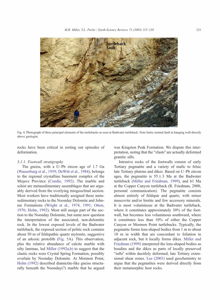
turtlebackfault
Fig. 4. Photograph of three principal elements of the turtlebacks as seen at Badwater turtleback. Note listric normal fault in hanging wall directly
above geologist.
M.B. Miller, T.L. Pavlis / Earth-Science Reviews 73 (2005) 115–138 121
rocks have been critical in sorting out episodes of
deformation.
3.1.1. Footwall stratigraphy
The gneiss, with a U–Pb zircon age of 1.7 Ga
(Wasserburg et al., 1959; DeWitt et al., 1984), belongs
to the regional crystalline basement complex of the
Mojave Province (Condie, 1992). The marble and
schist are metasedimentary assemblages that are argu-
ably derived from the overlying miogeoclinal section.
Most workers have traditionally assigned these meta-
sedimentary rocks to the Noonday Dolomite and John-
nie Formations (Wright et al., 1974, 1991; Otton,
1976; Holm, 1992). Most still assign part of the sec-
tion to the Noonday Dolomite, but some now question
the interpretation of the associated, non-dolomitic
rock. In the lowest exposed levels of the Badwater
turtleback, the exposed section of pelitic rock contains
about 50 m of feldspathic quartz mylonite, suggestive
of an arkosic protolith (Fig. 5A). This observation,
plus the relative abundance of calcite marble with
silty laminae, led Miller (1992a,b) to suggest that the
clastic rocks were Crystal Spring Formation, possibly
overlain by Noonday Dolomite. At Mormon Point,
Holm (1992) described diamictite-like gneiss structu-
rally beneath the Noonday(?) marble that he argued
was Kingston Peak Formation. We dispute this inter-
pretation, noting that the bclastsQ are actually deformed
granitic sills.
Intrusive rocks of the footwalls consist of early
Tertiary pegmatite and a variety of mafic to felsic
late Tertiary plutons and dikes. Based on U–Pb zircon
ages, the pegmatite is 55F3 Ma at the Badwater
turtleback (Miller and Friedman, 1999), and 61 Ma
at the Copper Canyon turtleback (R. Friedman, 2000,
personal communication). The pegmatite consists
almost entirely of feldspar and quartz, with minor
muscovite and/or biotite and few accessory minerals.
It is most voluminous at the Badwater turtleback,
where it constitutes approximately 30% of the foot-
wall, but becomes less voluminous southward, where
it constitutes less than 10% of either the Copper
Canyon or Mormon Point turtlebacks. Typically, the
pegmatite forms lens-shaped bodies from 1 m to about
10 m in width that are concordant to foliation in
adjacent rock, but it locally forms dikes. Miller and
Friedman (1999) interpreted the lens-shaped bodies as
boudins and the dikes as parts of locally preserved
braftsQ within ductilely deformed, late Tertiary exten-
sional shear zones. Lee (2003) used geochemistry to
argue that the pegmatites were derived directly from
their metamorphic host rocks.
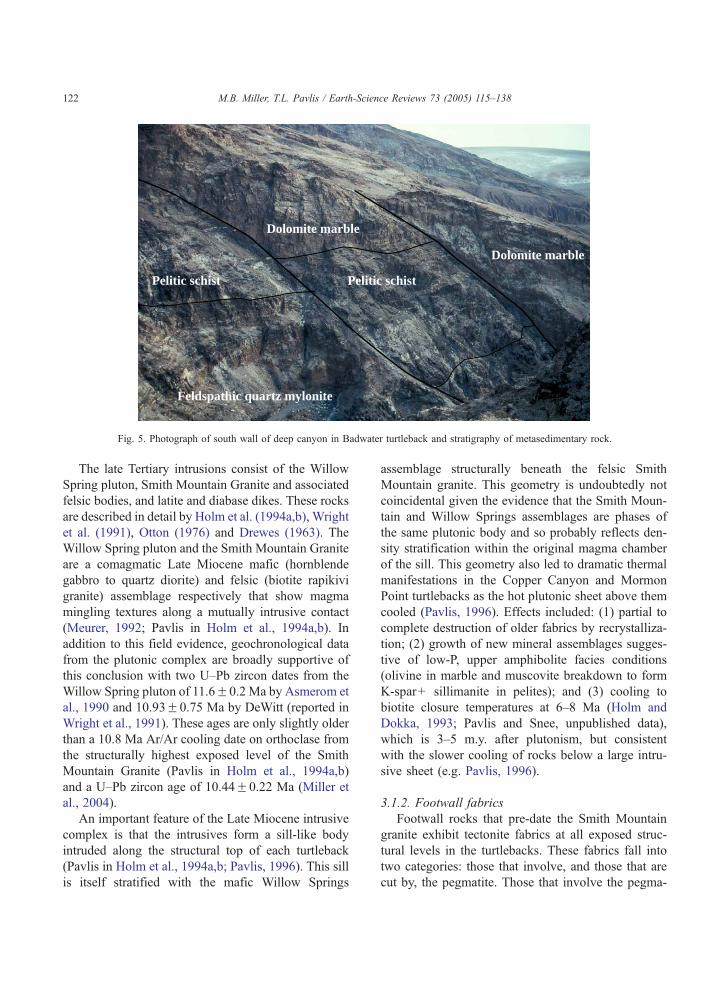
Feldspathic quartz mylonite
Pelitic schist Pelitic schist
Dolomite marble
Dolomite marble
Fig. 5. Photograph of south wall of deep canyon in Badwater turtleback and stratigraphy of metasedimentary rock.
M.B. Miller, T.L. Pavlis / Earth-Science Reviews 73 (2005) 115–138122
The late Tertiary intrusions consist of the Willow
Spring pluton, Smith Mountain Granite and associated
felsic bodies, and latite and diabase dikes. These rocks
are described in detail by Holm et al. (1994a,b), Wright
et al. (1991), Otton (1976) and Drewes (1963). The
Willow Spring pluton and the Smith Mountain Granite
are a comagmatic Late Miocene mafic (hornblende
gabbro to quartz diorite) and felsic (biotite rapikivi
granite) assemblage respectively that show magma
mingling textures along a mutually intrusive contact
(Meurer, 1992; Pavlis in Holm et al., 1994a,b). In
addition to this field evidence, geochronological data
from the plutonic complex are broadly supportive of
this conclusion with two U–Pb zircon dates from the
Willow Spring pluton of 11.6F0.2 Ma by Asmerom et
al., 1990 and 10.93F0.75 Ma by DeWitt (reported in
Wright et al., 1991). These ages are only slightly older
than a 10.8 Ma Ar/Ar cooling date on orthoclase from
the structurally highest exposed level of the Smith
Mountain Granite (Pavlis in Holm et al., 1994a,b)
and a U–Pb zircon age of 10.44F0.22 Ma (Miller et
al., 2004).
An important feature of the Late Miocene intrusive
complex is that the intrusives form a sill-like body
intruded along the structural top of each turtleback
(Pavlis in Holm et al., 1994a,b; Pavlis, 1996). This sill
is itself stratified with the mafic Willow Springs
assemblage structurally beneath the felsic Smith
Mountain granite. This geometry is undoubtedly not
coincidental given the evidence that the Smith Moun-
tain and Willow Springs assemblages are phases of
the same plutonic body and so probably reflects den-
sity stratification within the original magma chamber
of the sill. This geometry also led to dramatic thermal
manifestations in the Copper Canyon and Mormon
Point turtlebacks as the hot plutonic sheet above them
cooled (Pavlis, 1996). Effects included: (1) partial to
complete destruction of older fabrics by recrystalliza-
tion; (2) growth of new mineral assemblages sugges-
tive of low-P, upper amphibolite facies conditions
(olivine in marble and muscovite breakdown to form
K-spar+ sillimanite in pelites); and (3) cooling to
biotite closure temperatures at 6–8 Ma (Holm and
Dokka, 1993; Pavlis and Snee, unpublished data),
which is 3–5 m.y. after plutonism, but consistent
with the slower cooling of rocks below a large intru-
sive sheet (e.g. Pavlis, 1996).
3.1.2. Footwall fabrics
Footwall rocks that pre-date the Smith Mountain
granite exhibit tectonite fabrics at all exposed struc-
tural levels in the turtlebacks. These fabrics fall into
two categories: those that involve, and those that are
cut by, the pegmatite. Those that involve the pegma-
M.B. Miller, T.L. Pavlis / Earth-Science Reviews 73 (2005) 115–138 123
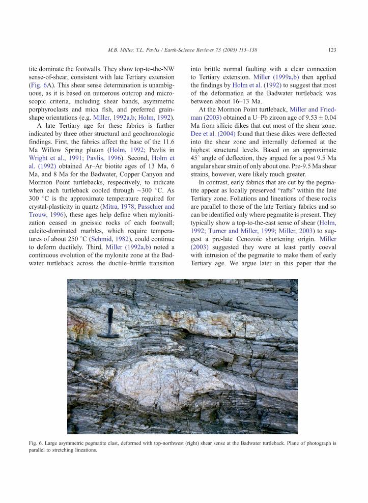
tite dominate the footwalls. They show top-to-the-NW
sense-of-shear, consistent with late Tertiary extension
(Fig. 6A). This shear sense determination is unambig-
uous, as it is based on numerous outcrop and micro-
scopic criteria, including shear bands, asymmetric
porphyroclasts and mica fish, and preferred grain-
shape orientations (e.g. Miller, 1992a,b; Holm, 1992).
A late Tertiary age for these fabrics is further
indicated by three other structural and geochronologic
findings. First, the fabrics affect the base of the 11.6
Ma Willow Spring pluton (Holm, 1992; Pavlis in
Wright et al., 1991; Pavlis, 1996). Second, Holm et
al. (1992) obtained Ar–Ar biotite ages of 13 Ma, 6
Ma, and 8 Ma for the Badwater, Copper Canyon and
Mormon Point turtlebacks, respectively, to indicate
when each turtleback cooled through ~300 8C. As300 8C is the approximate temperature required for
crystal-plasticity in quartz (Mitra, 1978; Passchier and
Trouw, 1996), these ages help define when myloniti-
zation ceased in gneissic rocks of each footwall;
calcite-dominated marbles, which require tempera-
tures of about 250 8C (Schmid, 1982), could continue
to deform ductilely. Third, Miller (1992a,b) noted a
continuous evolution of the mylonite zone at the Bad-
water turtleback across the ductile–brittle transition
Fig. 6. Large asymmetric pegmatite clast, deformed with top-northwest (ri
parallel to stretching lineations.
into brittle normal faulting with a clear connection
to Tertiary extension. Miller (1999a,b) then applied
the findings by Holm et al. (1992) to suggest that most
of the deformation at the Badwater turtleback was
between about 16–13 Ma.
At the Mormon Point turtleback, Miller and Fried-
man (2003) obtained a U–Pb zircon age of 9.53F0.04
Ma from silicic dikes that cut most of the shear zone.
Dee et al. (2004) found that these dikes were deflected
into the shear zone and internally deformed at the
highest structural levels. Based on an approximate
458 angle of deflection, they argued for a post 9.5 Ma
angular shear strain of only about one. Pre-9.5Ma shear
strains, however, were likely much greater.
In contrast, early fabrics that are cut by the pegma-
tite appear as locally preserved braftsQ within the late
Tertiary zone. Foliations and lineations of these rocks
are parallel to those of the late Tertiary fabrics and so
can be identified only where pegmatite is present. They
typically show a top-to-the-east sense of shear (Holm,
1992; Turner and Miller, 1999; Miller, 2003) to sug-
gest a pre-late Cenozoic shortening origin. Miller
(2003) suggested they were at least partly coeval
with intrusion of the pegmatite to make them of early
Tertiary age. We argue later in this paper that the
ght) shear sense at the Badwater turtleback. Plane of photograph is
M.B. Miller, T.L. Pavlis / Earth-Science Reviews 73 (2005) 115–138124
parallelism of both sets of fabrics suggests the turtle-
back shear zones are in fact reactivated thrust faults.
3.1.3. Metamorphism
Each turtleback footwall experienced amphibolite-
to upper amphibolite facies metamorphism prior to
+
5089
5739
VolcanicHangingwall
Felsicintrusiverocks
WillowSpring Pluton
N
1 km
??
? ?
1 km
500 m
B
A
B'
A'
1000m
Gneiss
Gneiss
Gneiss
Metased. Rx
Metasedimentary rock
a
b
c
+
+
+
++
+
+
+
+
+
+
++
+
+
+
+
+
+
+
+
+
+
+
++
+
+
++
+
+
+
+
+
+
+ +
+
+
v
v
v
v
v
v
v v
vvv v
v
v
v
v
v
v
v
v
v
v
v
v
v
v
v
vv
vv
v
v
v
v
v
vv
v
v
v
v
vv
v
v
v
v
v
v
+
v
v
v
v
v
v
v
+
v
v
v
vv
v
v
vv
v v
v
A
116°43' W
36°15' N
26
45
54
46
48
48
22
35
32
2419
16
25
35
8A
5A
60
68
71
42
30
20
40
40 28
18
36
16
21
37
26
54
Footwall (undifferentiated)Fault #3
Fault #2
Fault #1
B
B'
A A'
1a
BS
1a
N
B
unroofing by late Tertiary extension. This grade is
evident by the presence of crystal-plastically strained
feldspar, indicative of temperatures greater than
about 450 8C (Tullis and Yund, 1980; Pryer, 1993),
as well as the metamorphic mineral assemblages in
pelitic and carbonate rocks. At the Badwater Turtle-
+
+
+
+
+
+
+
+ ++
+
++
+
+
+
+
+
+ + ++
+
+
1 km
Gneiss
Gneiss
C
M
A
B
WillowSpring pluton
Z
Z
PQal
Ts
116°45' W
36°5' N
de
f
18
35
18
28 26
46
33
29
36
24
30
25
28
25
17
5875
55
512 45
7225
40 7
8B
M.B. Miller, T.L. Pavlis / Earth-Science Reviews 73 (2005) 115–138 125
back, kyanite-bearing schists, in association with
garnet, rutile, ilmenite, and quartz (GRAIL) yielded
a pressure of 700F100 MPa for an approximate
depth of 20 km and temperature between 500 8Cand 675 8C (Whitney et al., 1993). At Mormon
Point, Pavlis (1996) described k-spar and sillima-
nite-bearing schists to indicate much higher tempera-
ture second-sillimanite conditions. These high grade
fabrics at Mormon Point are closely associated with
the Miocene plutonic assemblage, which suggests
that they formed during the Late Miocene (Pavlis,
1996). Furthermore, amphibolite samples collected
from both the Copper Canyon and Mormon Point
turtlebacks contain embayed garnets overgrown by a
rim of plagioclase, a texture that suggests a higher
pressure garnet amphibolite assemblage was over-
printed by a lower pressure, hornblende-plagioclase
assemblage.
To date no samples have been collected at either
Mormon Point or Copper Canyon that contain low-
variance mineral assemblages useful for thermobaro-
metry. However, hornblende geobarometry of the Wil-
low Spring pluton (Holm and Dokka, 1993) and
Smith Mountain Granite (Meurer, 1992) indicates
pressures no greater than 300 MPa in the Copper
Canyon and Mormon Point turtlebacks during the
Late Miocene. These pressures correspond to intru-
sion depths of 10–11 km in the turtleback footwalls
(Holm and Wernicke, 1990; Holm and Dokka, 1993).
Furthermore, Meurer (1992) found that intrusion
depths increased northward in the Willow Spring
pluton, consistent with exhumation along an initially
more steeply dipping fault.
3.1.4. Footwall folds
Each turtleback footwall is the structural culmina-
tion of a northwest–southeast trending, doubly plun-
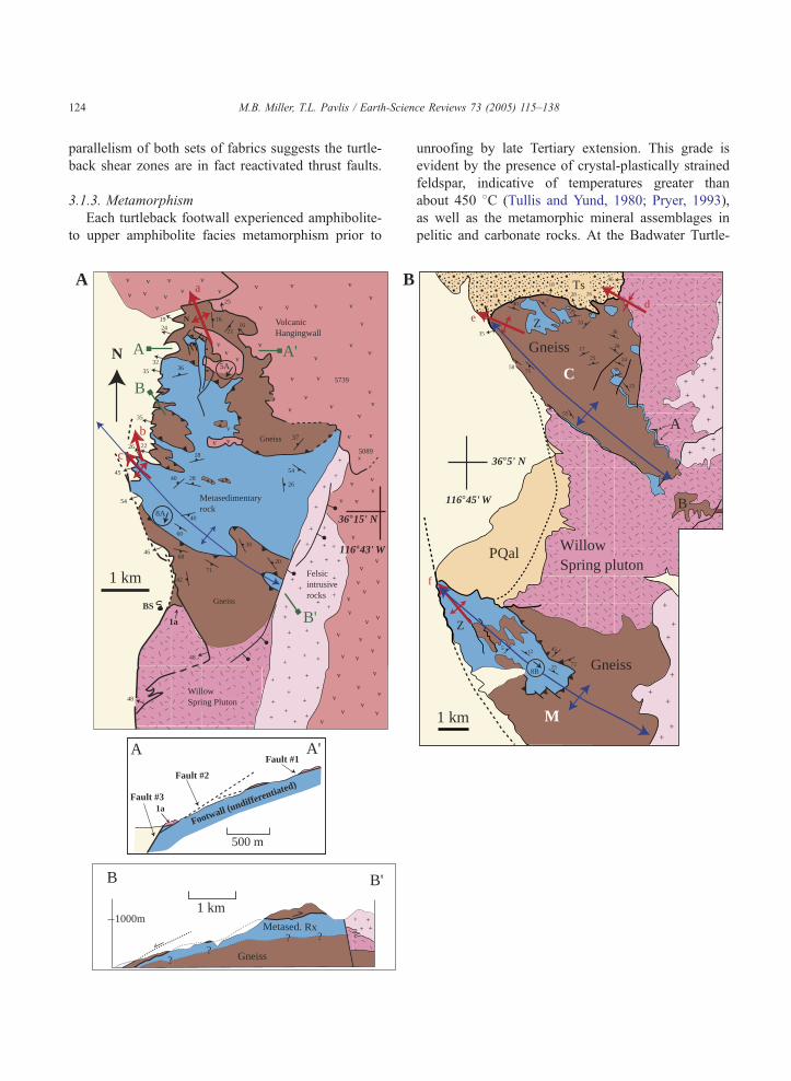
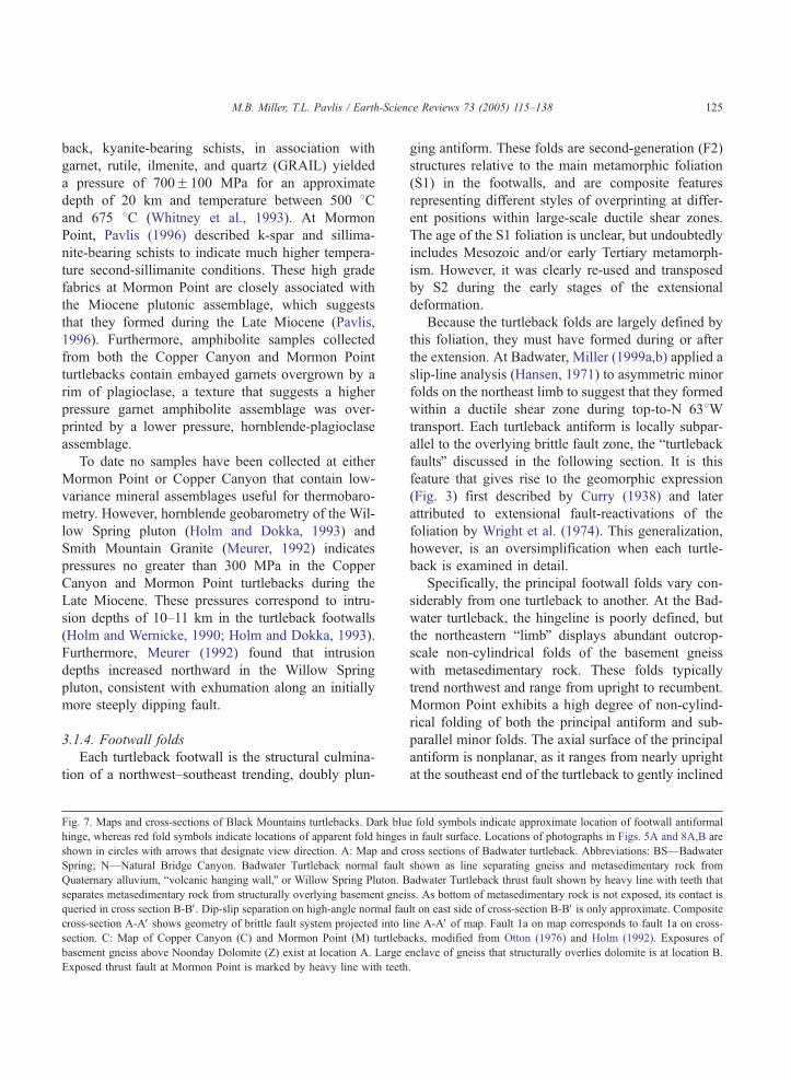
Fig. 7. Maps and cross-sections of Black Mountains turtlebacks. Dark blu
hinge, whereas red fold symbols indicate locations of apparent fold hinges
shown in circles with arrows that designate view direction. A: Map and c
Spring; N—Natural Bridge Canyon. Badwater Turtleback normal fault
Quaternary alluvium, bvolcanic hanging wall,Q or Willow Spring Pluton. B
separates metasedimentary rock from structurally overlying basement gnei
queried in cross section B-BV. Dip-slip separation on high-angle normal fau
cross-section A-AV shows geometry of brittle fault system projected into li
section. C: Map of Copper Canyon (C) and Mormon Point (M) turtleba
basement gneiss above Noonday Dolomite (Z) exist at location A. Large e
Exposed thrust fault at Mormon Point is marked by heavy line with teeth
ging antiform. These folds are second-generation (F2)
structures relative to the main metamorphic foliation
(S1) in the footwalls, and are composite features
representing different styles of overprinting at differ-
ent positions within large-scale ductile shear zones.
The age of the S1 foliation is unclear, but undoubtedly
includes Mesozoic and/or early Tertiary metamorph-
ism. However, it was clearly re-used and transposed
by S2 during the early stages of the extensional
deformation.
Because the turtleback folds are largely defined by
this foliation, they must have formed during or after
the extension. At Badwater, Miller (1999a,b) applied a
slip-line analysis (Hansen, 1971) to asymmetric minor
folds on the northeast limb to suggest that they formed
within a ductile shear zone during top-to-N 638Wtransport. Each turtleback antiform is locally subpar-
allel to the overlying brittle fault zone, the bturtlebackfaultsQ discussed in the following section. It is this
feature that gives rise to the geomorphic expression
(Fig. 3) first described by Curry (1938) and later
attributed to extensional fault-reactivations of the
foliation by Wright et al. (1974). This generalization,
however, is an oversimplification when each turtle-
back is examined in detail.
Specifically, the principal footwall folds vary con-
siderably from one turtleback to another. At the Bad-
water turtleback, the hingeline is poorly defined, but
the northeastern blimbQ displays abundant outcrop-
scale non-cylindrical folds of the basement gneiss
with metasedimentary rock. These folds typically
trend northwest and range from upright to recumbent.
Mormon Point exhibits a high degree of non-cylind-
rical folding of both the principal antiform and sub-
parallel minor folds. The axial surface of the principal
antiform is nonplanar, as it ranges from nearly upright
at the southeast end of the turtleback to gently inclined
e fold symbols indicate approximate location of footwall antiformal
in fault surface. Locations of photographs in Figs. 5A and 8A,B are
ross sections of Badwater turtleback. Abbreviations: BS—Badwater
shown as line separating gneiss and metasedimentary rock from
adwater Turtleback thrust fault shown by heavy line with teeth that
ss. As bottom of metasedimentary rock is not exposed, its contact is
lt on east side of cross-section B-BV is only approximate. Composite
ne A-AV of map. Fault 1a on map corresponds to fault 1a on cross-
cks, modified from Otton (1976) and Holm (1992). Exposures of
nclave of gneiss that structurally overlies dolomite is at location B.
.
M.B. Miller, T.L. Pavlis / Earth-Science Reviews 73 (2005) 115–138126
towards the northwest. By contrast, the Copper Can-
yon turtleback only locally displays complex infold-
ing of basement and metasedimentary rock, and
overall exhibits a macroscopic upright to steeply
inclined geometry with a gentle northeast limb and a
steep southwest limb.
To varying degrees, the footwall folds of each
turtleback also display doubly-plunging geometries
(e.g. Miller, 1992b; Mancktelow and Pavlis, 1994;
Pavlis in Holm et al., 1994a,b). As a result, the
relationship between the folds and structurally over-
lying faults varies across each turtleback. To the
southeast, fold hinges plunge southeastward beneath
the structurally overlying Miocene plutonic complex
and/or Precambrian basement (Fig. 7A,B). As re-
ported by Mancktelow and Pavlis (1994), this con-
tact is itself deformed, with ductile fabrics in the
floor of the plutons that are parallel to the those in
the turtleback footwalls. Northwestward, fold hinges
become horizontal and then plunge moderately
northwestward, typically steeper than the structurally
overlying brittle fault. The structurally overlying
brittle faults, in turn, display less structural relief
than the folds. Therefore, at both Copper Canyon
and Mormon Point, the brittle faults cut across struc-
tural section on both limbs of the antiforms to
expose the structurally overlying Miocene plutonic
complex in the core of the synclinoria between them
(Fig. 7B). At the Badwater turtleback, the structu-
rally deepest part of the turtleback is exposed near its
center.
This general form of the turtleback anticlinoria
suggested to Mancktelow and Pavlis (1994) and Pav-
lis (1996) that the folds formed as part of a continuous
deformational sequence related to distributed transten-
sional shear, after intrusion of the plutonic complex.
In this scenario, the transtension created localized
shortening that buckled low- to moderate-angle exten-
sional shear zones (S2), superimposed on the turtle-
back main-phase foliation (S1). This buckling gene-
rated large-scale structural relief in the shear zones,
which ultimately were transected by brittle faults.
Serpa and Pavlis (1996) extended this concept to the
broader regional scale. They noted that the F2 folds in
the turtleback footwalls trend more northerly than
younger folds and so probably reflect greater amounts
of finite clockwise vertical axis rotation. Similarly,
Miller (1999a,b) found that lineations in mylonitic
gneiss trended more northerly than those in calcite
marble at the Badwater turtleback. As the gneiss
reflected earlier, higher temperatures than the marble,
these data may also reflect clockwise rotation during
transtension.
3.1.5. Basement thrust faults
Each turtleback exhibits areally extensive non-pla-
nar contacts where basement gneiss overlies younger,
metasedimentary rock. Miller (2003) interpreted these
contacts as SE-directed, basement-involved thrust
faults that were re-deformed during late Tertiary
extension. At the Badwater turtleback, several hun-
dred meters to approximately 1 km of gneiss overlies
the carbonate at its northern and southern edges
respectively (Figs. 7A and 8A). Near the center of
the Badwater turtleback, thin bodies of gneiss struc-
turally overlie, and are infolded with, carbonate rock.
As the exposed trace of the gneiss-over-carbonate
contact is approximately 4.5 km long in the direction
of transport, Miller (2003) concluded that the thrust
fault had at least that much displacement. At the
Copper Canyon turtleback, small bodies of gneiss
structurally overlie carbonate rock at the contact
with the Willow Spring pluton, and as an enclave
within the pluton (Fig. 7B; Otton, 1976; Holm,
1992). At Mormon Point, ~300 m of gneiss structu-
rally overlies the metasedimentary rock northwest of
Smith Mountain (Figs. 7B and 8B; Otton, 1976;
Holm, 1992).
Miller (2003) further noted exposures of pre- and
syn-pegmatite mylonitic rocks that display top-to-the-
east and -southeast fabrics. These exposures, although
relatively rare, are most abundant at deep structural
levels within each turtleback. As the pegmatite is early
Tertiary in age (Miller and Friedman, 1999) and some
of the mylonitic fabrics appeared to be concurrent
with its intrusion, Miller (2003) argued that both
mylonitization and basement thrusting were probably
early Tertiary.
Except for the presence of cross-cutting pegmatite
and the sense-of-shear, the early mylonitic foliation is
indistinguishable from the late Tertiary, extension-
related foliation. Both sets of foliations are concordant
and both display similarly oriented stretching linea-
tions. In some localities where both foliatons are
preserved together, the later foliation appears to
merge with the older one (Fig. 9). We therefore sug-
A
B
pCg
pCg
Fig. 8. Photographs of exposed older-over-younger contacts at Badwater and Mormon Point turtlebacks. Photograph locations are shown as
b8AQ and b48BQ in Fig. 7A and B, respectively. A: At south side of Badwater turtleback; view toward south. B: On Mormon Point turtleback;
view toward east.
M.B. Miller, T.L. Pavlis / Earth-Science Reviews 73 (2005) 115–138 127
gest that the extensional turtleback shear zones origi-
nated as basement thrust faults, possibly as late as
early Tertiary, but were reactivated and almost com-
pletely transposed during late Tertiary extension.
3.2. Turtleback hanging walls
The delineation of the bhanging wallQ of each
turtleback is somewhat subjective, as the footwalls
NW SE
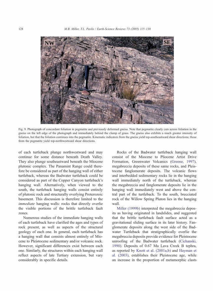
Fig. 9. Photograph of concordant foliation in pegmatite and previously deformed gneiss. Note that pegmatite clearly cuts across foliation in the
gneiss on the left edge of the photograph and immediately behind the clump of grass. The gneiss also exhibits a much greater intensity of
foliation, but that the foliation continues into the pegmatite. Kinematic indicators from the gneiss yield top-southeastward shear directions; those
from the pegmatite yield top-northwestward shear directions.
M.B. Miller, T.L. Pavlis / Earth-Science Reviews 73 (2005) 115–138128
of each turtleback plunge northwestward and may
continue for some distance beneath Death Valley.
They also plunge southeastward beneath the Miocene
plutonic complex. The Panamint Range could there-
fore be considered as part of the hanging wall of either
turtleback, whereas the Badwater turtleback could be
considered as part of the Copper Canyon turtleback’s
hanging wall. Alternatively, when viewed to the
south, the turtleback hanging walls consist entirely
of plutonic rock and structurally overlying Proterozoic
basement. This discussion is therefore limited to the
immediate hanging walls: rocks that directly overlie
the visible portions of the brittle turtleback fault
zones.
Numerous studies of the immediate hanging walls
of each turtleback have clarified the ages and types of
rock present, as well as aspects of the structural
geology of each one. In general, each turtleback has
a hanging wall that consists almost entirely of Mio-
cene to Pleistocene sedimentary and/or volcanic rock.
However, significant differences exist between each
one. Similarly, the structures within each hanging wall
reflect aspects of late Tertiary extension, but vary
considerably in specific details.
Rocks of the Badwater turtleback hanging wall
consist of the Miocene to Pliocene Artist Drive
Formation, Greenwater Volcanics (Greene, 1997),
megabreccia deposits of these same rocks, and Pleis-
tocene fanglomerate deposits. The volcanic flows
and interbedded sedimentary rocks lie in the hanging
wall immediately north of the turtleback, whereas
the megabreccia and fanglomerate deposits lie in the
hanging wall immediately west and above the cen-
tral part of the turtleback. To the south, brecciated
rock of the Willow Spring Pluton lies in the hanging
wall.
Miller (1999b) interpreted the megabreccia depos-
its as having originated in landslides, and suggested
that the brittle turtleback fault surface acted as a
gravitational sliding surface in its later history. Fan-
glomerate deposits along the west side of the Bad-
water Turtleback that stratigraphically overlie the
megabreccia deposits provide evidence for Pleistocene
unroofing of the Badwater turtleback (Cichanski,
1990). Deposits of 0.67 Ma Lava Creek B tephra,
as reported by Knott et al. (2001a,b) and Hayman et
al. (2003), establishes their Pleistocene age, while
an increase in the proportion of metamorphic clasts
M.B. Miller, T.L. Pavlis / Earth-Science Reviews 73 (2005) 115–138 129
upwards documents exposure of the footwall to
erosion.
Hanging wall rocks of the Copper Canyon turtle-
back consist, in upwards succession, of Late Miocene
Willow Springs diorite, Tertiary volcanic rocks and
Copper Canyon Formation, and fanglomerate and
megabreccia deposits (Drewes, 1963). The Copper
Canyon Formation dominates the hanging wall. It
consists of approximately 3000 m of alluvial fan
deposits, in fault contact with the turtleback, that
grade laterally (northward) into playa and freshwater
lake deposits, and basalt flows. Holm et al.
(1994a,b), using Ar/Ar, obtained an age of ~6 Ma
to ~3 Ma for its deposition. The Copper Canyon
Formation is significant because it records local
basin development in a transtensional setting, pre-
sumably an early phase of the formation of modern
Death Valley (Ellis and Trexler, 1991). Its fine-
grained deposits also display abundant well-pre-
served Neogene mammal and bird tracks (Curry,
1938; Scrivner and Bottjer, 1986).
At the Mormon Point turtleback, hanging wall
rocks consist of two distinct assemblages (Otton,
1977; Knott et al., 2001a,b): a Pleistocene section
and older Pliocene (?) section. The older Pliocene
(?) rocks dip much more steeply than the Pleistocene
rocks and are limited to a prism of rock bounded by
the turtleback fault and the Willow Wash fault, a
major hanging-wall fault above the turtleback fault.
Pleistocene rocks occur locally as nearly flat lying
deposits atop an angular unconformity on the older
rocks but are primarily exposed as variably tilted,
faulted and exhumed rocks in the hanging wall of
the Willow Wash fault. Burchfiel et al. (1995) made
a detailed structural/stratigraphic map of the area in
which they defined 11 separate units, marked by rapid
facies changes and much interfingering. They argued
that the sediments were deposited along the margin of
modern Death Valley and later uplifted as the range-
bounding normal fault stepped out into the playa.
Knott et al. (2001a,b) and Hayman et al. (2003)
reported the presence of the 0.76 Ma Bishop Ash
and 0.67 Ma Lava Creek B Ash within the younger
deposits providing the first clear evidence of a Pleis-
tocene depositional age.
Structures in the turtleback hanging walls consist
predominantly of high-angle brittle faults that termi-
nate downward at the turtleback detachments in both
listric and planar geometries (Fig. 4). This relation is
visible in the many small canyons that cut into the
footwalls of the Badwater and Mormon Point turtle-
backs and in the cliffs of Copper Canyon Formation
immediately north of the Copper Canyon turtleback.
Knott et al. (1997) argued that the multiple stran-
dlines at Mormon Point actually consisted only of
one strandline that had been offset by multiple nor-
mal faults. Hayman et al. (2003) found that, at Bad-
water and Mormon Point, these faults defined a
conjugate set with an approximately vertical maxi-
mum compressive stress. They estimated that these
faults accounted for approximately 600 m of Pleis-
tocene and younger horizontal extension at Mormon
Point. This interpretation contrasts with Keener et al.
(1993) who inferred that the Mormon Point turtle-
back fault was not active and was cut by a high-
angle fault at depth.
Each turtleback also displays some degree of
folding in its hanging wall. The most intensely
folded hanging wall exists at Copper Canyon,
where Drewes (1963) mapped a series of southeast-
plunging asymmetric folds over an area of approxi-
mately 10 km2. The most prominent anticline has a
mapped length of more than 3 km and verges north-
northeastward. At Mormon Point, Hayman et al.
(2003) reported a roll-over anticline adjacent to the
detachment fault. Immediately north of Badwater,
several kilometer-scale folds are visible in the Artist
Drive Formation.
3.3. Turtleback fault zones
The turtleback fault zones are the discrete brittle
surfaces that separate the ductilely deformed mid-
crustal rock of the footwalls from the upper crustal
rock of the hanging walls. Superb exposures of these
fault zones exist along the west front of each turtle-
back (Fig. 3A,B,C). In general, the turtleback faults
dip westward or northwestward at shallow angles
(b358), show evidence for a latest episode of predo-
minantly normal slip, and display a wide variety of
cataclastic fault rocks. Moreover, they each appear to
have been active as recently as the late Pleistocene
(Knott, 1999; Hayman et al., 2003). Outstanding
questions persist regarding their specific geometries
and their relations to the rest of the Black Mountains
frontal fault zone.

M.B. Miller, T.L. Pavlis / Earth-Science Reviews 73 (2005) 115–138130
3.3.1. Fault geometries and relation to frontal fault
zone
The classic interpretation of the turtleback fault
geometries holds that they are antiformal and broadly
coincident with the antiforms in the footwalls (Curry,
1954; Wright et al., 1974; Otton, 1976; Holm and
Dokka, 1993). The turtlebacks do display geometries
suggestive of both antiforms and synforms, the
hinges of which are shown on Fig. 7A,B, but it is
not yet clear if these features actually represent
single, curved fault surfaces. Instead, several of the
larger bfoldsQ are probably the poorly exposed inter-
sections of two or more differently oriented, subpla-
nar fault surfaces. Miller (1991) argued this case at
Badwater (hinge a on Fig. 7A), as did Pavlis et al.
(1993) for Mormon Point (hinge f on Fig. 7B).
Additionally, the apparent folds at Copper Canyon
(hinges d and e on Fig. 7B) remain ambiguous, as
they could be interpreted as either intersecting faults
or kink-like folds in a single fault. Two minor folds
at Badwater (hinges b and c on Fig. 7A) do appear
to reflect true undulations in the fault, as the fault
trace is continuous across the fold hinges. The anti-
formal hinge (hinge c) coincides with the antiformal
hinge of the footwall.
The turtleback fault geometries are also important
to understanding the structural evolution of the fault
systems, as well as their genetic relation to the Black
Mountains frontal fault zone. At Badwater, the turtle-
back fault consists of at least three distinct fault
surfaces, which decrease in age but increase in dip
towards the west. Fig. 7A shows these surfaces as
faults #1, #2, #3. Miller (1991) attributed these rela-
tions to progressive rotation and abandonment of fault
surfaces through time, with fault #3, the range-bound-
ing fault, cutting fault #2. While the Miocene–Plio-
cene volcanic rocks of the hanging wall dip 20–308eastward to support this interpretation, Knott (1998)
and Hayman et al. (2003) noted that the Pleistocene
material of the hanging wall has not rotated. There-
fore, significant rotation of the turtleback fault and
footwall must have taken place prior to deposition of
the Pleistocene material, possibly before initiation of
slip on fault #2.
At Mormon Point, a gravity and magnetic study by
Keener et al. (1993) suggested a similar geometry to
Badwater in that the principal turtleback fault
appeared to be cut by a later, range-bounding fault.
Hayman et al. (2003), however, argued an alternative
geometry, where the exposed detachment fault (fault
#2 at Badwater) is the active, controlling structure,
and the present, high-angle, range-frontal fault termi-
nates downward at the detachment. To support their
interpretation, they noted that, at Mormon Point, the
hanging wall has been extended by approximately 600
m by minor normal faults that terminate downward
onto the detachment. We note, however, that 600 m of
slip is only about one third of the total likely slip
predicted across the Black Mountains frontal faults
during the time interval considered by Hayman et al.
(2003). Geodetic data and Quaternary offsets in north-
ern Death Valley (Williams et al., 1999) indicate the
Death Valley fault system should be extending the
region ~2.9 km/m.y.; i.e. since deposition of the
Bishop Ash (~600 ka) approximately 1.8 km of hor-
izontal motion should have occurred across the frontal
faults. Therefore, more slip has presumably accumu-
lated across buried faults, including the frontal faults,
than the exposed fault array at Mormon Point. Alter-
natively, the cumulative slip on hanging wall faults
reflects only a portion of the slip on the main detach-
ment fault (D. Cowan, personal communication,
2003).
We consider the relation between the turtleback
faults and the frontal fault zone of the Black Moun-
tains to be an open question. Hayman et al. (2003)
document features that require the turtleback faults to
be recently active. This activity makes it difficult to
envision the turtleback faults as cut by the frontal
fault zones, unless there is cycling back and forth
between gravitationally driven slip on the turtleback
faults and rooted slip on the frontal fault zones as
suggested by Miller (1999b) for Badwater. Miller
(1992a,b, 1999a,b) also showed that fault 2 of the
Badwater turtleback fault system coincides with the
Black Mountains range front about 2 km south of
Badwater, and cuts structurally upwards into volcanic
rocks immediately north of Natural Bridge Canyon
(Fig. 7A). In this way, the fault appears to be more of
an abandoned range front fault than a true detach-
ment. The Badwater turtleback detachment, if there is
one, is most likely fault #1 on Fig. 7A.
3.3.2. Kinematics and fault rocks
As inferred from slickenline orientations, the most
recent episode of slip on the turtleback faults has been
M.B. Miller, T.L. Pavlis / Earth-Science Reviews 73 (2005) 115–138 131
normal (Pavlis et al., 1993; Miller, 1999b; Hayman et
al., 2003). However, the faults likely had an earlier
history of right-lateral oblique motion, consistent with
the slip direction on the rest of the Black Mountains
fault zone (Struthers, 1990; Brogan et al., 1991; Slem-
mons and Brogan, 1999). The most recent, normal
slip therefore appears to be a departure from a more
long-standing norm.
At Badwater, evidence for earlier oblique motion
comes from the fault geometry, folded fault rocks,
slickenlines, and high-angle faults in the footwall
(Miller, 1999b). Hinge c in Figs. 3A and 7A, marks a
true fold in the fault plane that plunges about N 608W.
Miller (1999b) argued that for the hanging wall to
remain intact, slip had to parallel the hinge. Addition-
ally, a Hansen slip line analysis of mesoscopic folds in
the fault zone yielded a northwest-directed, oblique
vector, and slickenlines on crystalline rocks south of
hinge C indicated oblique motion. Miller (1999b) sug-
gested that because these slickenlines were on crystal-
line rock, they were more durable and therefore
reflected an earlier episode of slip than the dip-parallel
ones that are preserved solely on the underside of the
relatively soft hanging wall. Finally, the footwall is cut
by numerous, demonstrably oblique high-angle faults.
At Mormon Point and Copper Canyon, Pavlis et al.
(1993) used large-scale fault geometry and the distri-
bution of fault rocks to infer oblique motion. There,
calcite-rich implosion breccias exist within right-step-
ping planar sections of the turtleback faults. These
breccias form through episodes of sudden dilatancy
(Sibson, 1986), which would most likely occur
through seismic right-lateral oblique motions on the
fault zone. Additionally, Pavlis et al. (1993) and
Keener et al. (1993) documented oblique slip in sev-
eral localities along southwest dipping segments of
both the Mormon Point and Copper Canyon turtle-
back fault based on complex slickenline arrays in
fault-rocks below the fault surface. As at Badwater,
the footwalls in both Mormon Point and Copper
Canyon turtleback are cut by more steeply dipping,
oblique-slip faults that do not appear to cut into the
hanging walls (Pavlis et al., 1993).
Besides the implosion breccias near Mormon Point,
each turtleback fault displays spectacular exposures of
fault gouge, foliated and non-foliated cataclasite, and
microbreccia. These fault rocks have been the subject
of several studies, including those of fault behavior
(Miller, 1996), kinematics (Cladouhos, 1999a,b), and
fault rock evolution (Hayman, 2002). Fault rocks are
best developed below the discrete sliding surface of the
turtleback fault. They typically show a downward
structural progression from clay-rich gouge into
foliated cataclasite and then into a variable damage
zone of cataclasis and hydrothermal alteration that
extends up to several tens of meters into the footwall.
Cowan et al. (1997, 2003) showed that these zones
correlated with decreasing shear strains away from
the fault zone. Miller (1996) documented mesoscopi-
cally ductile flow in the fault gouge, and Cowan and
Miller (1999) showed that episodes of ductile flow in
gouge appear to alternate with episodes of discrete
sliding. Alternating localized and non-localized
events conflict with other studies of fault rock devel-
opment that argue for continuous localization of slip
on developing fault zones (e.g. Chester and Logan,
1986; Logan et al., 1992).
3.3.3. Estimates of slip
Because the brittle turtleback faults separate such
disparate rock types, slip estimates tend to be based on
indirect evidence. Several observations, however, sug-
gest that the amount of slip for each brittle fault is
limited to only a few kilometers at most. To a first
approximation, the most relevant feature is the Willow
Springs pluton, as visible portions of it exist in the
hanging walls and footwalls of the both the Badwater
and Copper Canyon turtlebacks (Figs. 1 and 7A).
At the Badwater turtleback, a small fault-bounded
exposure of mylonitic basement rock exists in the
hanging wall of Fault #2 near Badwater spring (Fig.
7A). Based on this exposure, Miller (1991) inferred
approximately 2 km of slip on Fault #2. As indirect
support of this estimate, we note that north of Natural
Bridge canyon, Fault #2 cuts upwards into the volca-
nic hanging wall, with rocks of the Artist Drive For-
mation in both its hanging wall and footwall (Fig.
7A). At Mormon Point, Knott et al. (2001a,b) esti-
mated 438 m of Pleistocene heave on the turtleback
fault based on an offset bed of Bishop Ash.
4. Discussion and conclusions
Among the structural features of Death Valley, the
turtlebacks contain some of the most critical informa-
M.B. Miller, T.L. Pavlis / Earth-Science Reviews 73 (2005) 115–138132
tion relevant to testing models of crustal extension. In
particular, models are constrained by two types of
information from within the turtlebacks: (1) observa-
tions of the turtleback shear zones themselves, and (2)
implications of the basement-involved thrust faults of
the turtlebacks for the pre-extensional geometry of the
fold-thrust belt in Death Valley. This information has
implications that extend far beyond Death Valley, as
the region is frequently cited as a type example for
continental extensional tectonics.
Tectonic models for the Death Valley region
include both regional map-view reconstructions that
attempt to constrain the regional strains (e.g. Serpa
and Pavlis, 1996; Snow and Wernicke, 2000) and
models of the extensional process in cross-sectional
views (e.g. Holm et al., 1992; Miller, 1999a). Al-
though these approaches provide important illustra-
tions of the extensional process, they are limited to
two dimensions. In fact, the turtlebacks are complex
three-dimensional entities that formed over ~14 m.y.
of extensional overprinting on an older Mesozoic
framework. We submit that many of the controversies
regarding the Death Valley region in general, and the
turtleback systems in particular, stem largely from the
inability to communicate observations of these multi-
ple dimensions. Even the coauthors of this paper are
not in complete agreement on several details, but our
approach here is to clarify our view of the four-
dimensional history. Following previous presenta-
tions, we consider the problem in the context of
two-dimensional map and cross-sectional views, but
we acknowledge that these views are oversimplifica-
tions of the geometric evolution.
4.1. Map-view reconstructions of regional deformation
Several tectonic models for the Death Valley region
emphasize large-scale, map-view reconstructions
based on the correlation of regional structures and
stratigraphic assemblages within the Death Valley
region. These controversies were initiated by the cor-
relation of the Panamint thrust in the northern Panamint
Mountains with the Chicago Pass thrust system in the
Nopah and Resting Spring ranges (Wernicke et al.,
1988). Other workers, however, have challenged this
correlation on different lines of evidence (e.g. Wright et
al., 1991; Serpa and Pavlis, 1996; Miller and Prave,
2002). The resolution of this question is critical because
extensional magnitudes vary radically in different ver-
sions of these reconstructions.
As described byMiller (2003), the presence of base-
ment-involved thrust faults in the turtlebacks help
define the pre-extension configuration of the fold-
thrust belt in Death Valley, and therefore provide
keys to interpreting the crustal extension. As argued
below, their presence suggests that the Black Moun-
tains were a structural high prior to Tertiary extension.
It further suggests that restoration of the Cottonwood
Mountains above the Black Mountains is unlikely, yet
this configuration is required if the Panamint and Chi-
cago Pass thrusts were the same thrust displaced by a
master detachment system.
Evidence for a pre-extensional structural high in
the Black Mountains is supported by the general
absence of Paleozoic sedimentary rocks and the
deep stratigraphic level of the pre-Tertiary unconfor-
mity in the Black Mountains. In the Amargosa
Chaos, ~12 Ma sedimentary and volcanic rocks lie
depositionally on late Proterozoic to early Cambrian
sedimentary rocks (location bxQ on Fig. 1 inset;
Wright and Troxel, 1984; Topping, 1993). At the
Billie Mine in the northern Black Mountains, ~14
Ma sedimentary rocks of the early Furnace Creek
basin depositionally overlie early Cambrian rock
(Fig. 1; Cemen et al., 1985; Wright et al., 1999;
Miller and Prave, 2002). These contacts contrast
markedly with the northern Panamint Mountains
where late Paleozoic rocks lie directly beneath the
Tertiary unconformity. It is therefore likely that the
thrust systems now exposed in the turtlebacks pro-
duced significant structural relief above what is now
the Black Mountains and that the late Paleozoic
cover was largely stripped from the Black Mountains
prior to Tertiary extension. Correlation of the Pana-
mint thrust with the Chicago Pass thrust across this
structural high is suspect because structural relief
created by the thrust structures would disturb the
simple thrust belt geometries required by the correla-
tion. The correlation also places Late Paleozoic rocks
and thrust belt structures of the Cottonwood Moun-
tains structurally above and east of the turtleback
basement thrusts. This restoration conflicts with the
observed rocks below the Tertiary unconformity or
anywhere within the Black Mountains.
An alternative explanation, that the exposed Black
Mountains cover rocks are entirely allochthonous and
M.B. Miller, T.L. Pavlis / Earth-Science Reviews 73 (2005) 115–138 133
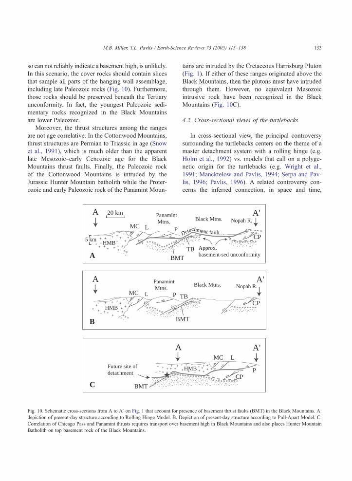
so can not reliably indicate a basement high, is unlikely.
In this scenario, the cover rocks should contain slices
that sample all parts of the hanging wall assemblage,
including late Paleozoic rocks (Fig. 10). Furthermore,
those rocks should be preserved beneath the Tertiary
unconformity. In fact, the youngest Paleozoic sedi-
mentary rocks recognized in the Black Mountains
are lower Paleozoic.
Moreover, the thrust structures among the ranges
are not age correlative. In the Cottonwood Mountains,
thrust structures are Permian to Triassic in age (Snow
et al., 1991), which is much older than the apparent
late Mesozoic–early Cenozoic age for the Black
Mountains thrust faults. Finally, the Paleozoic rock
of the Cottonwood Mountains is intruded by the
Jurassic Hunter Mountain batholith while the Proter-
ozoic and early Paleozoic rock of the Panamint Moun-
+
+
++
+
+
+
++
++
+
++
+ ++
++
++
++
+ ++
++
+
+
+
+
+++
+
+
+
+++
+++
++
+++
20 km
HMB
HMB
P
P
L
L
MC
MC
T
5 km
Panamint Mtns.
Panamint Mtns.
A
C
B
BMT
BMT
BM
Future site ofdetachment
A
A
A
Fig. 10. Schematic cross-sections from A to AV on Fig. 1 that account for p
depiction of present-day structure according to Rolling Hinge Model. B. D
Correlation of Chicago Pass and Panamint thrusts requires transport over b
Batholith on top basement rock of the Black Mountains.
tains are intruded by the Cretaceous Harrisburg Pluton
(Fig. 1). If either of these ranges originated above the
Black Mountains, then the plutons must have intruded
through them. However, no equivalent Mesozoic
intrusive rock have been recognized in the Black
Mountains (Fig. 10C).
4.2. Cross-sectional views of the turtlebacks
In cross-sectional view, the principal controversy
surrounding the turtlebacks centers on the theme of a
master detachment system with a rolling hinge (e.g.
Holm et al., 1992) vs. models that call on a polyge-
netic origin for the turtlebacks (e.g. Wright et al.,
1991; Mancktelow and Pavlis, 1994; Serpa and Pav-
lis, 1996; Pavlis, 1996). A related controversy con-
cerns the inferred connection, in space and time,
+ ++
++++
+
+ ++
+
Approx. basement-sed unconformity
Detachment fault
HMB P
LMC
CP
CP
CP
B
TB
Black Mtns.
Black Mtns.
Nopah R.
Nopah R.
T
A'
A'
A'
resence of basement thrust faults (BMT) in the Black Mountains. A:
epiction of present-day structure according to Pull-Apart Model. C:
asement high in Black Mountains and also places Hunter Mountain
M.B. Miller, T.L. Pavlis / Earth-Science Reviews 73 (2005) 115–138134
between the turtleback systems and structurally
higher-level structures in the Black Mountains.
These structures include those in the Amargosa
Chaos area to the south (Wright and Troxel, 1984;
Topping, 1993; Topping in Holm et al., 1994a,b) and
low-angle normal fault systems that frame the Black
Mountains to the east. The structural relationships
between the Badwater and the other turtlebacks also
represent an important detail because the Badwater
turtleback is geochronologically distinct and lies in the
hanging wall of the Copper Canyon turtleback.
Existing Ar–Ar geochronology for the turtlebacks
can be interpreted to satisfy both models. Holm et
al. (1992) found that, from south to north, the
Mormon Point, Copper Canyon, and Badwater tur-
tlebacks cooled through 300 8C at about 8 Ma, 6
Ma and 13 Ma, respectively. They interpreted the
cooling ages at Mormon Point and Copper Canyon
as evidence of the hinge rolling northwestward from
Mormon Point to Copper Canyon and the much
older age at Badwater as an earlier, deep-seated
A
B
CB
++ + +
++ +++ +
++ ++ + +
++
+++
+++ +
+ +
+
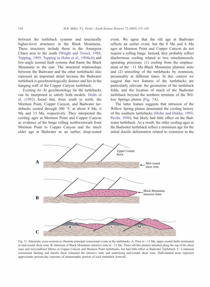
Fig. 11. Schematic cross-sections to illustrate principal extensional events a
at mid-crustal shear zone. B: Intrusion of Black Mountains intrusive suite a
zone and recrystallized fabrics at Copper Canyon and Mormon Point tur
extensional faulting and ductile shear exhumed the intrusive suite and
approximate present-day exposure of metamorphic portion of each turtleb
event. We agree that the old age at Badwater
reflects an earlier event, but the 8 Ma and 6 Ma
ages at Mormon Point and Copper Canyon do not
require a rolling hinge. Instead, they probably reflect
diachronous cooling related to two simultaneously
operating processes: (1) cooling from the emplace-
ment of the ~11 Ma Black Mountains plutonic suite
and (2) unroofing of the turtlebacks by extension,
presumably at different times. In this context we
suggest that two features of the turtlebacks are
particularly relevant: the geometries of the turtleback
folds, and the location of much of the Badwater
turtleback beyond the northern terminus of the Wil-
low Springs pluton (Fig. 7A).
The latter feature suggests that intrusion of the
Willow Spring pluton dominated the cooling history
of the southern turtlebacks (Holm and Dokka, 1993;
Pavlis, 1996), but likely had little effect on the Bad-
water turtleback. As a result, the older cooling ages in
the Badwater turtleback reflect a minimum age for the
initial ductile deformation related to extension in the
Upper CrustalRock
C M
++
++
+ ++
++++ +
+ +
+
+
++
+ ++
++
++
+
+ + +++ +
+
Black Mountains Intrusive Suite
Mid-crustalshear zone.
t the turtlebacks. A: Prior to ~11 Ma, upper crustal faults terminated
t ~11 Ma. These sill-like plutons intruded along the top of the shear
tlebacks, but had little effect at Badwater Turtleback. C: Continued
underlying mid-crustal shear zone. Dark-shaded areas represent
ack footwall.
M.B. Miller, T.L. Pavlis / Earth-Science Reviews 73 (2005) 115–138 135
region. This early history was also present in the other
turtlebacks, but was largely obliterated at ~11 Ma
when the Black Mountains intrusive suite was
emplaced above them, completely recrystallizing
pre-existing microstructures and resetting all low-T
geochronometers. This conclusion is consistent with
onset of volcanism and incipient extensional basin
development prior to ~14 Ma (Wright et al., 1999).
For example, Miller and Prave (2002) found that
activity on the pre-13 Ma Badwater Turtleback fault
likely influenced sedimentation in the early Furnace
Creek Basin.
Similarly, the variability of fold geometries of the
turtlebacks, especially between the highly non-cylind-
rical Mormon Point turtleback and the nearly upright
Copper Canyon turtleback, are difficult to reconcile
with the concept of a single, master rolling hinge.
Moreover, their doubly plunging geometries are also
inconsistent, because a migrating hinge should leave
behind a single low-angle shear zone.
Our conceptual view of the turtleback evolution
is that they all share a common, early history as
parts of a mid-crustal shear zone at ~12–16 Ma that
at least in part reactivated a pre-existing basement
thrust fault (Fig. 11A). This shear zone locally
reached upwards to connect with supracrustal fault
zones as described by Miller (1992a,b, 1999a,b) at
the Badwater turtleback. When the Black Mountains
intrusive suite was emplaced at ~11 Ma, however, it
cut across many of these faults and recrystallized
fabrics in the subjacent ductile shear zone (Fig.
11B). Consequently, the thermally unmodified
older shear zone is only preserved at the Badwater
turtleback. At the Mormon Point and Copper Can-
yon turtlebacks, the older shear zone is now repre-
sented only by the thermally overprinted tectonite
fabrics of the southeastward plunging segments of
the turtleback antiforms. Continued crustal extension
caused the exhumation of the intrusive suite and
eventual formation of the brittle turtleback faults,
shown in Fig. 11C as dismembering the intrusive
suite. This view of the turtlebacks, in which much of
the ductile deformation occurred before emplacement
of the Miocene intrusives, and most brittle deforma-
tion occurred after their emplacement, differs signifi-
cantly from the rolling hinge model which requires that
most of the brittle and ductile deformation post-dated
intrusion.
Acknowledgements
Our views of the turtlebacks have benefited from
discussions with Darrel Cowan, Richard Friedman,
Nick Hayman, Dan Holm, Jeff Knott, Laura Serpa,
Bennie Troxel, Brian Wernicke, and Lauren Wright.
This manuscript was greatly improved through detailed
reviews by Darrel Cowan and Greg Davis.
References
Asmerom, Y., Snow, J.K., Holm, D.K., Jacobsen, S.B., Wernicke,
B.P., Lux, D.R., 1990. Rapid uplift and crustal growth in
extensional environments: An isotopic study from the Death
Valley region, California. Geology 18, 227–230.
Brogan, G.E., Kellogg, K.S., Slemmons, D.B., Terhune, C.L., 1991.
Late Quaternary faulting along the Death Valley-Furnace Creek
fault system, California and Nevada. U.S. Geological Survey
Bulletin, 23 pp.
Burchfiel, B.C., Molnar, P., Zhang, P., Deng, Q., Zhang, W., Wang,
Y., 1995. Example of a supradetachment basin within a pull-
apart tectonic setting: Mormon Point, Death Valley, California.
Basin Research 7, 199–214.
Cemen, I., Wright, L.A., Drake, R.E., Johnson, F.C., 1995. Cenozoic
sedimentation and sequence of deformational events at the south-
eastern end of the Furnace Creek strike-slip fault zone, Death
Valley, California. In: Biddle, K.T., Christie-Blick, N. (Eds.),
Strike-slip Deformation, Basin Formation, and Sedimentation.
Society of Economic Paleontologists and Mineralogists Special
Publication, vol. 37, pp. 127–141.
Chester, F.M., Logan, J.M., 1986. Implications for mechanical prop-
erties of brittle faults from observations of the Punchbowl fault
zone, California. Pure and Applied Geophyics 124, 79–106.
Cichanski, M.A., 1990. Stratigraphy and structure of the upper plate
of the Badwater Turtleback, Death Valey, California. B.S. thesis,
University of Washington, Seattle, WA, 23 pp.
Cladouhos, T.T., 1999a. Shape preferred orientations of sur-
vivor grains in fault gouge. Journal of Structural Geology
21, 419–436.
Cladouhos, T.T., 1999b. A kinematic model for deformation within
brittle shear zones. Journal of Structural Geology 21, 437–449.
Condie, K.C., 1992. Proterozoic terranes and continental accretion
in southwestern North America. In: Condie, K. (Ed.), Protero-
zoic Crustal Evolution. Developments in Precambrian Geology,
vol. 10, pp. 447–480.
Cowan, D.S., Miller, M., 1999. Distributed flow vs. localized slip in
Late Cenozoic low-angle fault zones, Death Valley, California.
Seismological Research Letters 70, 247.
Cowan, D.S., Cladouhos, T.T., Morgan, J.K., 1997. Kinematic
evolution of fault rocks in brittle shear zones, Death Valley,
California. Abstracts with Programs, Geological Society of
America 29 (6), 200.
Cowan, D.S., Cladouhos, T.T., Morgan, J.K., 2003. Structural geol-
ogy and kinematic history of rocks formed along low-angle

M.B. Miller, T.L. Pavlis / Earth-Science Reviews 73 (2005) 115–138136
normal faults, Death Valley, California. Geological Society of
America Bulletin 115, 1230–1248.
Curry, H.D., 1938. Turtleback fault surfaces in Death Valley, Cali-
fornia. Geological Society of America Bulletin 49, 1875.
Curry, H.D., 1954. Turtlebacks in the central Black Mountains,
Death Valley, California. Bulletin, California Division of
Mines and Geology 170, 53–59.
Davis, G.H., 1980. Structural characteristics of meta-
morphic core complexes, southern Arizona. In: Crittenden
Jr., M.D., Coney, P.J., Davis, G.H. (Eds.), Cordilleran Meta-
morphic Core Complexes. Geological Society of America Mem-
oir, 153, 35–78.
Davis, G.A., Anderson, J.L., Martin, D.L., Krummenacher, E.G.,
Armstrong, R.L., 1982. Geologic and geochronologic relations
in the lower plate of the Whipple detachment fault, Whipple
Mountains, southeast California: a progress report. In: Frost, E.,
Martin, D. (Eds.), Mesozoic–Cenozoic Tectonic Evolution of
the Colorado River Region, California, Arizona and Nevada.
Cordilleran Publishers, San Diego, pp. 408–432.
Davis, G.A., Lister, G.S., Reynolds, S.J., 1986. Structural evolution
of the Whipple and South Mountains shear zones, southwestern
United States. Geology 14, 7–10.
Dee, S., Miller, M., Friedman, R.M., 2004. Pre- and post 9.5 Ma
shear zone activity at the Mormon Point turtleback, Death
Valley, California. Abstracts with Programs, Geological Society
of America 36 (5).
DeWitt, E.H., Armstrong, R.L., Sutter, J.F., Zartman, R.E., 1984.
U–Th–Pb, Rb–Sr, and Ar–Ar mineral and whole-rock iso-
topic systematics in a metamorphosed granitic terrane, south-
eastern California. Geological Society of America Bulletin 95,
723–739.
Drewes, H., 1959. Turtleback faults of Death Valley, California, a
reinterpretation. Geological Society of America Bulletin 70,
1497–1508.
Drewes, H., 1963. Geology of the Funeral Peak Quadrangle, Cali-
fornia, on the eastern flank of Death Valley. U.S. Geological
Survey Professional Paper 413, 78 pp.
Ellis, M.A., Trexler, J.H., 1991. Basin-margin development in pull-
apart settings; an example fromDeath Valley, California. Abstracts
with Programs, Geological Society of America 23 (5), 82.
Greene, R.C., 1997. Geology of the northern Black Mountains,
Death Valley, California. U.S. Geological Survey Open-File
Report, OFR 97-79, 110 pp.
Hamilton, W.D., 1988. Detachment faulting in the Death Valley
region, California and Nevada. U.S. Geological Survey Bulletin
1790, 51–85.
Hansen, E., 1971. Strain Facies. Springer-Verlag, New York,
207 pp.
Hayman, N.W., 2002. A textural progression of brittle fault
rocks along the strikes of the Death Valley detachments.
Abstracts with Programs, Geological Society of America 34
(6), 249.
Hayman, N.W., Knott, J.R., Cowan, D.S., Nemser, E., Sarna-Woj-
cicki, A., 2003. Quaternary low-angle slip on detachment faults
in Death Valley, California. Geology 31, 343–346.
Holm, D.K., 1992. Structural, thermal and paleomagnetic con-
straints on the tectonic evolution of the Black Mountains crys-
talline terrain, Death Valley region, California, and implications
for extensional tectonism. PhD thesis, Harvard University, Cam-
bridge, Massachusetts, 237 pp.
Holm, D.K., Dokka, R.K., 1993. Interpretation and tectonic impli-
cations of cooling histories: An example from the Black Moun-
tains, Death Valley extended terrane, California. Earth and
Planetary Science Letters 116, 63–80.
Holm, D.K., Wernicke, B.P., 1990. Black Mountains crustal sec-
tions, Death Valley extended terrain, California. Geology 18,
520–523.
Holm, D.K., Snow, J.K., Lux, D.R., 1992. Thermal and barometric
constraints on the intrusion and unroofing history of the Black
Mountains, Death Valley, CA. Tectonics 11, 507–522.
Holm, D.K., Fleck, R.J., Lux, D.R., 1994a. The Death Valley
turtlebacks reinterpreted as Miocene–Pliocene folds of a major
detachment surface. Journal of Geology 102, 718–727.
Holm, D.K., Pavlis, T.L., Topping, D.J., 1994b. Black Mountains
crustal section, Death Valley region, California: Geological
investigations of an active margin. In: McGill, S.F., Ross,
T.M. (Eds.), Geological Society of America, Cordilleran Sec-
tion, Annual Meeting: Guidebook, pp. 31–54.
Keener, C., Serpa, L.F., Pavlis, T.L., 1993. Faulting at Mormon
Point, Death Valley, California: a low-angle fault cut by high-
angle faults. Geology 21, 327–330.
Knott, J.R., 1998. Late Cenozoic Terphrochronology, Stratigraphy,
geomorphology, and neotectonics of the western Black Moun-
tains piedmont, Death Valley, California: implications for the
spatial and temporal evolution of the Death Valley fault zone.
PhD thesis, University of California, Riverside, Riverside, Cali-
fornia, 407 pp.
Knott, J.R., 1999. Quaternary displacement on the Badwater and
Mormon Point turtleback (low-angle normal) faults, Death Val-
ley, California. Abstracts with Programs, Geological Society of
America 31 (7), 301.
Knott, J.R., Tinsley, J.C., Wells, S.G., 1997. Quaternary faulting
across the 180 Ka abrasion platform at Mormon Point, Death
Valley, California: scarps vs. strandlines. Abstracts with Pro-
grams, Geological Society of America 29 (6), 437.
Knott, J.R., Sarna-Wojcicki, A.M., Meyer, C.E., Tinsley III, J.C.,
Wells, S.G., Wan, E., 2001a. Late Cenozoic stratigraphy and
tephrochronology of the western Black Mountains piedmont,
Death Valley, California: Implications for the tectonic develop-
ment of Death Valley. In: Wright, L.A., Troxel, B.W. (Eds.),
Tertiary basins in the Death Valley Region, California. Special
Paper, Geological Society of America, 333, 345–366.
Knott, J.R., Sarna-Wojcicki, A.M., Tinsley III, J.C., Wells, S.G.,
2001b. Late Quaternary tectonic-geomorphic development and
pluvial lakes at Mormon Point. In: Machette, M.N., Johnson,
M.L., Slate, J.L. (Eds.), Quaternary and late Pliocene geology of
the Death Valley region: Recent observations on tectonics, strati-
graphy and lake cycles (Guidebook for the 2001 Pacific Cell -
Friends of the Pleistocene fieldtrip). Denver, CO, U.S. Geological
Survey Open File Report 01-51: 92–103.
Lee, K.F., 2003. Geology of granitic pegmatites in the Badwater,
Copper Canyon, and Mormon Point turtlebacks, Black Moun-
tains, Death Valley, California. M.S. thesis, University of Ore-
gon, Eugene, Oregon, 68 pp.
M.B. Miller, T.L. Pavlis / Earth-Science Reviews 73 (2005) 115–138 137
Lister, G.S., Davis, G.A., 1989. The origin of metamorphic core
complexes and detachment faults formed during Tertiary con-
tinental extension in the northern Colorado River region, USA.
Journal of Structural Geology 11, 65–94.
Logan, J.M., Dengo, C.A., Higgs, N.G., Wang, Z.Z., 1992. Fabrics
of experimental fault zones: their development and relationship
to mechanical behavior. Fault Mechanics and Transport Proper-
ties of Rocks. Academic Press, pp. 33–67.
Mancktelow, N.S., Pavlis, T.L., 1994. Fold-fault relationships in
low-angle detachment systems. Tectonics 13, 668–685.
Meurer, K.J., 1992. Tectonic evolution of Smith Mountain—Gold
Valley region, Death Valley, California. M.S. thesis, University
of New Orleans, New Orleans, LA.
Miller, M., 1991. High-angle origin of the currently low-angle
Badwater turtleback fault, Death Valley, California. Geology
19, 372–375.
Miller, M., 1992a. Brittle faulting induced by ductile deformation of
a rheologically stratified rock sequence, Badwater Turtleback,
Death Valley, California. Geological Society of America Bulle-
tin 104, 1376–1385.
Miller, M., 1992b. Structural and kinematic evolution of the Bad-
water Turtleback, Death Valley, California. PhD thesis, Univer-
sity of Washington, Seattle, Washington, 155 pp.
Miller, M., 1996. Ductility in fault gouge from a normal fault
system, Death Valley, California: a mechanism for fault-zone
strengthening and relevance to paleoseismicity. Geology 24,
603–606.
Miller, M., 1999a. Implications of ductile strain on the Badwater
Turtleback for pre-14 Ma extension in the Death Valley region,
California. In: Wright, L.A., Troxel, B.W. (Eds.), Tertiary Basins
in the Death Valley Region, California. Special Paper Geologi-
cal Society of America, vol. 333, pp. 115–126.
Miller, M., 1999b. Gravitational reactivation of an extensional fault
system, Badwater turtleback, Death Valley, California. In:
Wright, L.A., Troxel, B.W. (Eds.), Tertiary Basins in the
Death Valley Region, California. Special Paper Geological
Society of America, vol. 333, pp. 367–376.
Miller, M., 2003. Basement-involved thrust faulting in a thin-
skinned fold and thrust belt, Death Valley, California, USA.
Geology 31, 31–34.
Miller, M., Friedman, R.M., 1999. Early Tertiary magmatism and
probable Mesozoic fabrics in the Black Mountains, Death Val-
ley, California. Geology 27, 19–22.
Miller, M., Friedman, R.M., 2003. New U–Pb zircon ages indicate
major extension in Death Valley, CA predated 10 Ma: implica-
tions for models of crustal extension. Abstracts with Programs,
Geological Society of America 35 (6), 26.
Miller, M., Prave, A.R., 2002. Rolling hinge or fixed basin?: A test
of continental extensional models in Death Valley, California,
United States. Geology 30, 847–850.
Miller, E.L., Gans, P.B., Garing, J., 1983. The Snake Range decol-
lement: an exhumed mid-Tertiary brittle–ductile transition. Tec-
tonics 2, 239–263.
Miller, M., Friedman, R.M., Dee, S., 2004. Pre-10 Ma TIMS U–Pb
zircon age for the Smith Mountain Granite, Death Valley, Cali-
fornia: implications for timing of major extension. Abstracts with
Programs, Geological Society of America 36 (5).
Mitra, G., 1978. Microscopic deformation mechanisms and flow
laws in quartzites within the South Mountain Anticline. Journal
of Geology 86, 129–152.
Nemser, E.S., 2001. Kinematic development of upper plate faults
above low-angle normal faults in Death Valley, CA. M.S. thesis,
University of Washington, Seattle, Washington, 102 pp.
Noble, L.F., 1941. Structural features of the Virgin Spring area,
Death Valley, California. Geological Society of America Bulle-
tin 52, 941–1000.
Otton, J.K., 1976. Geologic features of the Central Black Mountains,
Death Valley, California. In: Troxel, B.W., Wright, L.A. (Eds.),
Geologic Features of Death Valley. California Division of
Mines and Geology Special Report, vol. 106, pp. 27–33.
Otton, J.K., 1977. Geology of the central Black Mountains,
Death Valley, California: the turtleback terrane. PhD thesis,
Pennsylvania State University, University Park, Pennsylvania.
155 pp.
Passchier, C.W., Trouw, R.A.A., 1996. Microtectonics. Springer,
Berlin, 289 pp.
Pavlis, T.L., 1996. Fabric development in syn-tectonic sheets as a
consequence of melt- dominated flow and thermal softening of
the crust. Tectonophysics 253, 1–31.
Pavlis, T.L., Serpa, L.F., Keener, C., 1993. Role of seismogenic
processes in fault-rock development: an example from Death
Valley, California. Geology 21, 267–270.
Pryer, L.L., 1993. Microstructures in feldspars from a major crustal
thrust zone: the Grenville Front, Ontario, Canada. Journal of
Structural Geology 15, 21–36.
Schmid, S.M., 1982. Microfabric studies as indicators of deforma-
tion mechanisms and flow laws operative in mountain building.
In: Hsu, K.J. (Ed.), Mountain Building Processes. Academic
Press, London, pp. 95–110.
Scrivner, P.J., Bottjer, D.J., 1986. Neogene Avian and Mammalian
tracks from Death Valley National Monument, California:
their context, classification, and preservation. Palaeogeography,
Palaeoclimatology, Palaeoecology 57, 285–331.
Serpa, L.F., Pavlis, T.L., 1996. Three-dimensional model of the
Cenozoic history of the Death Valley region, southeastern Cali-
fornia. Tectonics 15, 1113–1128.
Sibson, R.H., 1986. Brecciation processes in fault zones: inferences
from earthquake rupturing. Pure and Applied Geophysics 124,
159–175.
Slemmons, D.B., Brogan, G.E., 1999. Quaternary strike-slip com-
ponents of the Death Valley fault between the Furnace Creek
and southern Death Valley fault zones. In: Slate, J.L., (Ed.),
Proceedings of conference on status of geologic research and
mapping in Death Valley National Park. U.S. Geologic Survey
Open File Report 99-153, pp. 152–153.
Snow, J.K., Wernicke, B.W., 2000. Cenozoic tectonism in the central
Basin and Range: Magnitude, rate, and distribution of upper
crustal strain. American Journal of Science 300, 659–719.
Snow, J.K., Asmerom, Y., Lux, D.R., 1991. Permian–Triassic plu-
tonism and tectonics, Death Valley region, California and
Nevada. Geology 19, 629–632.
Stewart, J.H., 1983. Extensional tectonics in the Death Valley area,
California: transport of the Panamint Range structural block 80
km northwestward. Geology 11, 153–157.
M.B. Miller, T.L. Pavlis / Earth-Science Reviews 73 (2005) 115–138138
Struthers, J., 1990. Evidence for right-lateral oblique slip on the
Black Mountains range front: Desolation Canyon, Death Valley,
California. B.S. thesis, University of Washington, Seattle,
Washington, 24 pp.
Topping, D.J., 1993. Paleogeographic reconstruction of the Death
Valley extended region: evidence from Miocene large rock-
avalanche deposits in the Amargosa Chaos Basin, California.
Geological Society of America Bulletin 105, 1190–1213.
Tullis, J., Yund, R.A., 1980. Hydrolytic weakening of experimen-
tally deformed Westerly granite and Hale albite rock. Journal of
Structural Geology 2, 439–451.
Turner, H., Miller, M., 1999. Kinematic indicators in a pre-55 Ma
ductile shear zone, Death Valley, California. Abstracts with
Programs, Geological Society of America 31 (7), 369.
Wasserburg, G.J.F., Wetherill, G.W., Wright, L.A., 1959. Ages in
the Precambrian terrane of Death Valley, California. Journal of
Geology 67, 702–708.
Wernicke, B.P., Axen, G.J., Snow, J.K., 1988. Basin and Range
extensional tectonics at the latitude of Las Vegas, Nevada.
Geological Society of America Bulletin 100, 1738–1757.
Whitney, D.L., Hirschmann, M., Miller, M.G., 1993. Zincian ilme-
nite-ecandrewsite from a pelitic schist, Death Valley, California,
and the paragenesis of (Zn,Fe)TiO3 solid solution in meta-
morphic rocks. Canadian Mineralogist 31, 425–436.
Williams, T.B., Johnson, D.J.,Miller,M.M., Dixon, T.H., 1999. GPS-
determined constraints on interseismic deformation along active
fault zones within the Death Valley region, southeastern Califor-
nia. In: Slate, J.L., (Ed.), Proceedings of conference on status of
geologic research and mapping in Death Valley National Park.
United States Geologic Survey Open File Report 99-153, p. 149.
Wright, L.A., Troxel, B.W., 1984. Geology of the north 1/2 Con-
fidence Hills 158 quadrangle, Inyo County, California. Califor-
nia Division of Mines and Geology Map Sheet 34, scale
1:24,000.
Wright, L.A., Otton, J.K., Troxel, B.W., 1974. Turtleback surfaces
of Death Valley viewed as phenomena of extensional tectonics.
Geology 2, 53–54.
Wright, L.A., Thompson, R.A., Troxel, B.W., Pavlis, T.L., DeWitt,
E.H., Otton, J.K., Ellis, M.A., Miller, M., Serpa, L.F., 1991.
Cenozoic magmatic and tectonic evolution of the east-central
Death Valley region, California. In: Walawender, M.J., Hanan,
B.B. (Eds.), Geologic Excursions in Southern California and
Mexico. Department of Geological Sciences, San Diego State
University, San Diego, pp. 93–127.
Wright, L.A., Green, R., Cemen, I., Johnson, R., Prave, A., 1999.
Tectonostratigraphic development of the Miocene–Pliocene Fur-
nace Creek Basin, Death Valley, California. In: Wright, L.A.,
Troxel (Eds.), Tertiary basins in the Death Valley Region,
California. Special Paper Geological Society of America, 333,
87–114.