Embed Size (px)
Citation preview

The Bølling-age Blomv�ag Beds, western Norway: implications for theOlder Dryas glacial re-advance and the age of the deglaciation
JAN MANGERUD, JASON P. BRINER, TOMASZ GOSLAR AND JOHN INGE SVENDSEN
Mangerud, J., Briner, J. P., Goslar, T. & Svendsen, J. I. 2017 (April): The Bølling-age Blomv�ag Beds, westernNorway: implications for the Older Dryas glacial re-advance and the age of the deglaciation. Boreas, Vol. 46,pp. 162–184. 10.1111/bor.12208. ISSN 0300-9483.
Blomv�ag, on the western coast of Norway north of Bergen, is a classical site in Norwegian Quaternary science.Foreshore marine sediments, named the Blomv�ag Beds and now dated to the Bølling-Allerød from 14.8 to13.3 cal. ka BP, contain the richest Lateglacial bone fauna in Norway, numerous mollusc shells, driftwood, andflint that some archaeologists consider as the oldest traces of humans in Norway. The main theme of this paper isthat the Blomv�ag Beds are overlain by a compact diamicton, named the Ulvøy Diamicton, which was interpretedpreviously as a basal till deposited during a glacial re-advance into the ocean during the Older Dryas (c. 14 cal.ka BP). Sediment sections of the Blomv�ag Beds and the Ulvøy Diamicton were exposed in ditches in a cemeterythat was constructed in 1941–42 and have subsequently not been accessible. A number of radiocarbon and cosmo-genic 10Be exposure ages demonstrate that the diamicton is not likely to be a till because minimum deglaciationages (14.8–14.5 cal. ka BP) from the vicinity pre-date the Ulvøy Diamicton. We now consider that sea ice and ice-bergs formed the Ulvøy Diamicton during the Younger Dryas. The Scandinavian Ice Sheet margin was located onthe outermost coastal islands between at least c. 18.5 and 14.8 cal. ka BP; however, no ice-marginal deposits havebeen found offshore from this long period. The Older Dryas ice margin in this area was located slightly inside theYounger Dryas margin, whereas farther south it was located slightly beyond the Younger Dryas margin.
Jan Mangerud ([email protected]) and John Inge Svendsen, Department of Earth Science, University of Bergen,PO Box 7803, Bergen 5020, Norway and Bjerknes Centre for Climate Research, All�egt. 70, 5007, Bergen, Norway;Jason P. Briner, Department of Geology, University at Buffalo, Buffalo, NY 14260, USA; Tomasz Goslar, Faculty ofPhysics, Adam Mickiewicz University, Umultowska 85, Pozna�n 61-614, Poland, and Pozna�n Radiocarbon Labora-tory, Foundation of the A. Mickiewicz University, Rubie_z 46, Pozna�n 61-612, Poland; received 21st June 2016,accepted 23rd August 2016.
It was almost a sensation amongst Norwegian scien-tists when in 1941 numerous bones were un-earthedbelow a compact diamicton, interpreted as a basal till,in the village of Blomv�ag, ~30 km northwest of Bergen(Figs 1, 2; Und�as 1942). Some bones were identified asdeer and some wood as spruce, both suggesting a cli-mate similar to the present and it was thereforethought that the fossils originated from a full inter-glacial – in which case the sediments would have beenthe first interglacial beds found in Norway. The boneswere discovered during digging of drainage ditches fora new cemetery and they became known to scientistswhen the workers to their great surprise dug up largewhale bones ~16 m a.s.l. and 2–3 m below the groundsurface (Fig. 3C). They therefore alerted the BergenMuseum (presently the Bergen University Museum)and the geologist Isak Und�as went out to study thesite. He initiated a scientific excavation that alsoinvolved the botanist Knut Fægri and the geologistAstrid Monsen. Several other scientists visited the siteduring the excavations. It soon became clear that the‘deer’ bones had been misidentified and in factstemmed from reindeer. However, wood that was iden-tified as Alnus, Taxus and Picea still suggested an inter-glacial age (Holtedahl 1953).
When the radiocarbon-dating method became avail-able the subtill sediments, later named the Blomv�agBeds (Mangerud 1977), were dated to about 14.5 cal.
ka BP, i.e. during the Bølling (Table 1; Holtedahl 1960;Nydal 1960). Even though it became clear that thestrata were much younger than previously thought, theinterest in the site did not abate for four main reasons:(i) the radiocarbon ages were hitherto the oldest forthe deglaciation of Norway (Holtedahl 1960), (ii) theinferred till capping the Blomv�ag Beds suggested thatthe site had been overrun by a glacial re-advance dur-ing the Older Dryas (Mangerud 1970; Mangerud et al.2011), (iii) the fossil-bearing Blomv�ag Beds contain therichest Lateglacial fauna found in Norway (Lie 1986;Hufthammer 2001), and (iv) it has been argued thatthe flint pieces and bones represent traces of humanoccupation (Lie 1990; Johansen & Und�as 1992), whichwould be 3000 years older than the earliest well-docu-mented human sites in Norway (Breivik 2014).
Surprisingly enough, a full scientific description ofthe site was never published, only a description in apopular science journal (Und�as 1942). Here, wedescribe the site based on available field notes anddrawings of the strata and a number of new radiocar-bon ages as well as 10Be ages of glacially transportederratics. The main theme of this paper is the interpreta-tion of the Ulvøy Diamicton capping the Blomv�agBeds and the implications for the glacial history ofwestern Norway. Mangerud (1970) produced a pollendiagram, supported by several 14C ages, from an adja-cent palaeolake (Dale Bog, Fig. 2) that showed a full
DOI 10.1111/bor.12208 © 2016 Collegium Boreas. Published by John Wiley & Sons Ltd
bs_bs_banner

and undisturbed Allerød-Younger Dryas sequence oflacustrine sediments. Thus, it became clear that if theUlvøy Diamicton was a till, it had to pre-date the
Allerød, and as the diamicton overlies Bølling-agesediments, the age of the diamicton and the postu-lated re-advance was bracketed to the Older Dryas.Later, Mangerud (1977) considered the interpretationof the diamicton as a till to be so well founded thathe even named it the Ulvøy Till (Fig. 4), againststratigraphical rules that do not accept genetic con-notations to lithostratigraphical units. We thereforenow re-name this unit the Ulvøy Diamicton. Man-gerud (1977) noticed that several radiocarbon agesfrom other sites that post-date final deglaciationyielded similar ages as the youngest ages from belowthe Ulvøy Diamicton, but this was explained by ashort duration of the glacial re-advance and/or dat-ing uncertainties.
The interpretation that the Ulvøy Diamicton is a till,and thus that the ice sheet overran the site during theOlder Dryas, has been generally accepted, but wasquestioned by Krzywinski & Stabell (1984). The ageconsiderations for the Blomv�ag Beds were changedwhen the archaeologist Elisabeth Eriksen (pers. comm.2008) obtained radiocarbon ages on reindeer and otheranimal bones (also cited in Hufthammer 2001) ofwhich the youngest is 13.3 cal. ka BP (Table 1). Thisyoung age was incompatible with the prevailing viewthat the Ulvøy Diamicton is a basal till dating to theOlder Dryas, because the stratigraphy at the adjacentDale Bog demonstrated that this area had been ice free
Fig. 1. A. Map of southern Norway and the northern North Sea, showing the Last Glacial Maximum (LGM) and Younger Dryas (YD) icelimits (white lines) and general ice-flow directions (arrows). Modified from Mangerud et al. (2013). B. The area around Bergen and Blomøy.The line shows the Herdla Moraine of late Younger Dryas age; dashed where assumed. Other sites mentioned in the text are marked:�A = �Agotnes; Lia = Liat�arnet; B = Bjorøy; H = Hamravatn; S = Storum. Near Bergen, 14.1 marks the site where shell fragments are datedto 14.1 cal. ka BP. [Colour figure can be viewed at www.boreas.dk]
Fig. 2. Blomøy Island showing the locations of Blomv�ag Cemetery,Dale Bog and Sele Bog. The areas where 10Be exposure dating sam-ples were collected are marked with the last digits of sample numbers.Contour interval is 20 m. Some summits are marked with altitudes.Modified from www.norgeskart.no. [Colour figure can be viewed atwww.boreas.dk]
BOREAS The Bølling-age Blomv�ag Beds, W Norway 163
since 13.9 cal. ka (Table 2). These new ages triggeredthe present investigations aiming to determine whetherthe Ulvøy Diamicton is a till or not; if the UlvøyDiamicton is a till, then all organic remains below thediamicton must pre-date the age of the final deglacia-tion of the site.
Material
The Blomv�ag site is a cemetery that has been impossi-ble to re-excavate. A number of samples from the exca-vations in 1941–1942 are stored, mainly in open boxes,in the Bergen University Museum. The boxes havepieces of paper with a short description of the strati-graphical position of the sample and we were able torelate some of these descriptions to field notes or draw-ings by scientists who participated in the excavations.The samples have been moved several times, and withthe open boxes we cannot exclude the possibility thatsome have been interchanged, but we do not believethat this will influence our conclusions. Some of thefield notes of Isak Und�as, who was the main geologist,are unfortunately lost, but some notes exist. The fieldnotes of Knut Fægri have been crucial for establishing
the stratigraphical position of the samples. One of us(J.M.) also had long talks in the 1960–70s with bothUnd�as and Fægri about the site. A notebook fromAstrid Karlsen who identified wood samples is alsoavailable. We also use 14C ages from sediment sectionsand cores retrieved from adjacent lake basins with theaim of constraining the timing of the final deglaciationfrom the Blomv�ag area and thus to determine if theUlvøy Diamicton is a till. Finally, we collected a seriesof samples from erratic boulders deposited by theretreating ice sheet for 10Be dating.
Dating methods
Radiocarbon dating
The samples previously obtained from the Blomv�agsite were either dated with the conventional method(T-) at the Trondheim Laboratory, or prepared inTrondheim and measured with an accelerator in Upp-sala (Tua-) (Tables 1, 2). These samples were preparedaccording to standard procedures in Trondheim(Nydal et al. 1972), except one of the whale bone sam-ples (T-1899/1). This sample was prepared with the old
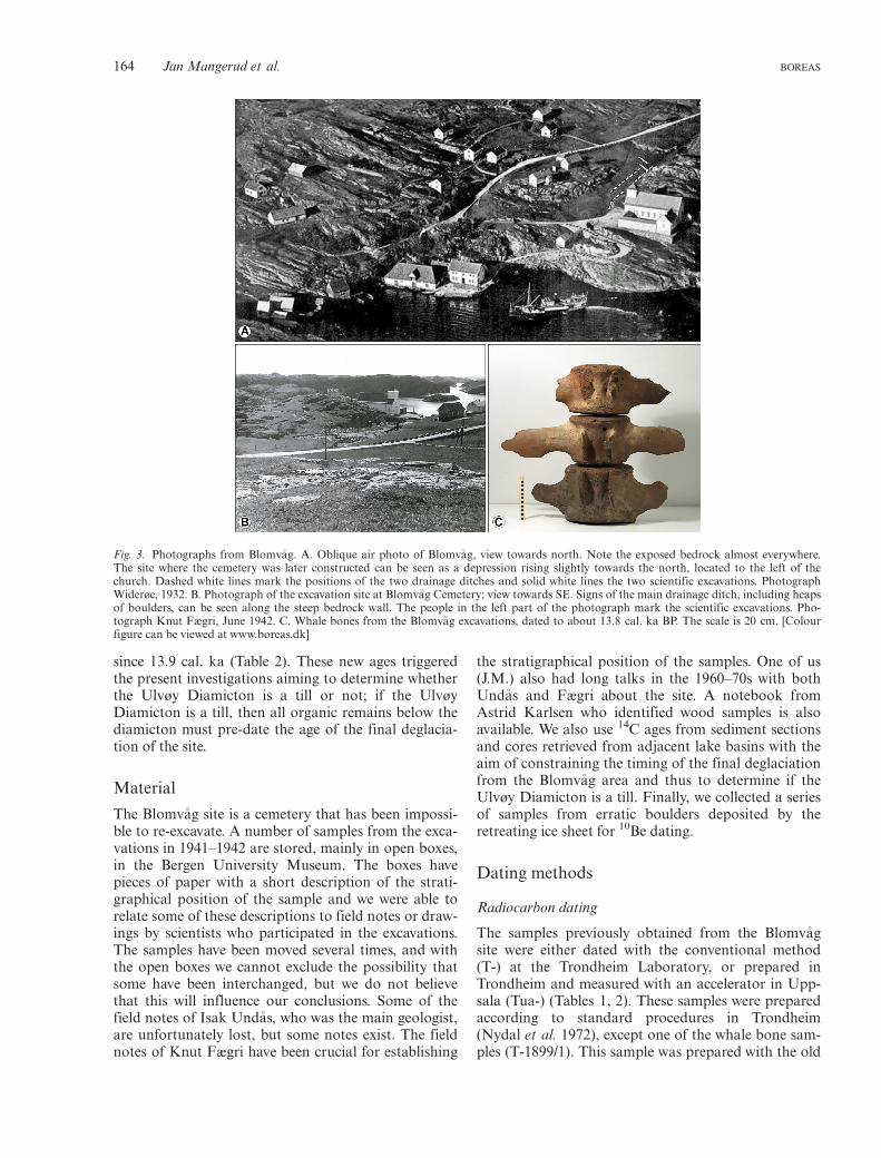
Fig. 3. Photographs from Blomv�ag. A. Oblique air photo of Blomv�ag, view towards north. Note the exposed bedrock almost everywhere.The site where the cemetery was later constructed can be seen as a depression rising slightly towards the north, located to the left of thechurch. Dashed white lines mark the positions of the two drainage ditches and solid white lines the two scientific excavations. PhotographWiderøe, 1932. B. Photograph of the excavation site at Blomv�ag Cemetery; view towards SE. Signs of the main drainage ditch, including heapsof boulders, can be seen along the steep bedrock wall. The people in the left part of the photograph mark the scientific excavations. Pho-tograph Knut Fægri, June 1942. C. Whale bones from the Blomv�ag excavations, dated to about 13.8 cal. ka BP. The scale is 20 cm. [Colourfigure can be viewed at www.boreas.dk]
164 Jan Mangerud et al. BOREAS

Table
1.Rad
iocarbon
datesfrom
theBlomv� a
gCem
eterysite,located
at60.5304°N,4
.878°E
.
Lab.ID
Con
v.14C
age1
�1r
DR
Calibratedages
(IntCal13)B19
50Sa
mpleID
givenwhen
dated
Dated
material
Sediment/
Stratigrap
hyd1
3 CReferences
Com
ments
Median3
68%
confidence
interval
From
ToMidpo
int
Half
rang
e
Dates
from
marinemolluscs
Poz-65
953
1270
070
100
1409
013
985
1418
014
083
98Blomv� ag
2014-7
Three
pieces
ofshells,the
largestbeing
8mm
IntheUlvøy
Diamicton
Museum
box
marked‘From
apo
cket
inthetill
atica.
2m
depth
inthemiddle
ditch,
abou
t4m
from
thecorner.
Und� as19
42’.
014
258
1408
214
406
1424
416
2Po
z-65
879
1292
070
100
1451
514
271
1469
914
485
214
Blomv� ag
2014-6
Thick
piece
ofashell,
prob
ably
Mya
orHiatella
Shortlybelow
theUlvøy
Diamicton
Museum
box
marked‘C
layey
tran
sition
albed
(ca.
20cm
)directlybelowthe
till.
I.Und� as
19-10-41’
T-139
13110
350
100
14860
14191
15350
14770
580
H.H
olteda
hl;
Sample2
Mytilu
sedulis
Nyd
al(196
0)The
repo
rted
age
(1270
014C
years)ha
sabu
ilt-
incorrection
for
marinereservoir
ageof
410years
(Man
gerud
1972
).
T-188
212
840
9010
014
377
1412
714
565
1434
621
9Man
gerud;
Blomv� ag
shells
Mytilu
sedulis
Plant-bearing
bed,
3–4m
depthin
large
cross-ditch
�1.1
Gullik
sen
etal.(19
78)
Man
gerud
(197
7)
The
repo
rted
age
(1243
014C
years)ha
sabu
ilt-
incorrection
for
marinereservoir
ageof
410years.
Poz-65
878
1299
070
100
1467
714
450
1493
014
690
240
Blomv� ag
2014-5
Twoshell
fragments,
thelargestis
a1-cm
piece
ofMytilu
s
Low
ermost
sampleat
the
easternendof
theup
per
(northern)
ditch
Museum
box
marked‘Sam
ple
12.2
95–300
cm’.
K.F
ægrifield
notes14
/6/194
2.
014
915
1477
315
103
1493
816
5
(con
tinu
ed)
BOREAS The Bølling-age Blomv�ag Beds, W Norway 165

Table1.
(con
tinu
ed)
Lab.ID
Con
v.14C
age1
�1r
DR
Calibratedages
(IntCal13)B1950
SampleID
givenwhen
dated
Dated
material
Sediment/
Stratigrap
hyd1
3 CReferences
Com
ments
Median3
68%
confidence
interval
From
ToMidpo
int
Half
rang
e
The
follo
wingsixmollusc
samples
from
‘the
southern
cross-ditch’
aredescribedin
Fægri’sfieldno
tes11
/7/194
2an
dmarkedwithdepths
andthus
therelative
stratigrap
hicalo
rder
shou
ldbe
clear
Poz-65
858
1267
070
100
1405
513
960
1414
414
052
92Blomv� ag
2014-4
Shell
fragments2–
8mm.
Con
tainsat
leaston
eMytilu
s
175–18
0cm
.Justbelowthe
diam
icton
Museum
box
marked
‘Blomv� ag7’.
014
197
1404
014
314
1417
713
7Po
z-65
857
1300
070
100
1470
514
488
1496
314
725
238
Blomv� ag
2014-3
Piece
ofMytilu
sedulis
190–19
5cm
Museum
box
marked
‘Blomv� ag6’.
T-169
712
980
150
100
1430
814
961
1463
432
7Man
gerud;
Blomv� ag4
Fragm
entsof
Mod
iolus
mod
iolus
245–25
0cm
�1.4
Gullik
sen
etal.(19
78)
Man
gerud
(197
7)
Museum
box
marked
‘Blomv� ag4’.T
herepo
rted
age
(1257
014C
years)ha
sabu
ilt-
incorrection
for
marinereservoir
ageof
410years.
Poz-65
855
1302
070
100
1475
814
570
1502
414
797
227
Blomv� ag
2014-2
Piece
ofMytilu
sedulis
260–27
0cm
Museum
box
marked
‘Blomv� ag3’.
T-169
612
980
180
100
1464
514
282
1499
314
637
356
Man
gerud;
Blomv� ag2
Fragm
ents
ofMod
iolus
mod
iolus
295–30
5cm
.Low
ermost
shell-bearing
samplein
this
series
�1.7
Gullik
sen
etal.(19
78)
Man
gerud
(197
7)
Museum
box
marked
‘Blomv� ag2’.T
herepo
rted
age
(1257
014C
years)ha
sabu
ilt-
incorrection
for
marinereservoir
ageof
410years.
Poz-65
854
1302
070
014
972
1483
115
137
1498
415
3Blomv� ag
2014-1
Shell
fragments
2–4mm.
Con
tains
Mytilu
s
295–30
5cm
.Low
ermost
shell-bearing
samplein
this
series
Museum
box
marked
‘Blomv� ag2’,i.e.
samebo
xas
sampleT-169
610
014
758
1457
015
024
1479
722
720
014
515
1427
114
699
1448
521
4
(con
tinu
ed)
166 Jan Mangerud et al. BOREAS

Table1.
(con
tinu
ed)
Lab.ID
Con
v.14C
age1
�1r
DR
Calibratedages
(IntCal13)B19
50Sa
mpleID
givenwhen
dated
Dated
material
Sediment/
Stratigrap
hyd1
3 CReferences
Com
ments
Median3
68%
confidence
interval
From
ToMidpo
int
Half
rang
e
Dates
from
wha
lebo
nes,prob
ably
thesameindividu
alof
Balaena
mysticetus,Eng
lish:
Bow
head
wha
le,N
orwegian:
Grønlan
dshv
alT-189
9/1
1255
010
010
013
931
1381
414
049
1393
111
8Man
gerud;
Blomv� a
gwha
le
Bow
head
wha
leMud
dysand
�16.6
Gullik
sen
etal.(19
78)
Man
gerud
(197
7)
Dessolved
inHCl;i.e.the
bone
apatiteisda
ted.
Thispreparation
metho
disno
long
erused.A
geom
ittedfrom
the
discussion
.
T-189
9/2
1236
080
100
1371
913
610
1382
913
719
110
Man
gerud;
Blomv� a
gwha
le
Bow
head
wha
leMud
dysand
�17.4
Gullik
sen
etal.(19
78)
Man
gerud
(197
7)
Prepa
redwiththe
EDTA
metho
d,i.e.the
colla
genis
dated.
Tua
-534
812
465
110
100
1383
813
709
1398
713
848
139
Bow
head
wha
leMud
dysand
Ø.W
iig,
pers.com
m.
2015.
Collagenda
te.
The
repo
rted
age
(1202
514C
years)is
correctedfor
440yearsmarine
reservoirage.
Poz-69
682
1251
060
100
1389
013
805
1397
213
888
84Blomv� a
g20
14-15
Bow
head
wha
leMud
dysand
Collagenda
te.A
differentbo
nefrom
theother
wha
lebo
neda
tes.
9.4%
colla
gen(C
/N
at=3.27
).Meanfor
3lastsamples
100
13818
13716
13925
13820
105
Other
bone
samples
Tua
-902
1187
580
100
1325
413
188
1331
813
253
65Eider,
Som
ateria
mollissima.
Norw.:
Ærfug
l
Proba
bly
from
the
mud
dysand
�14.4
Elisab
eth
Eriksen,
pers.com
m.
2008.
Reportedage
(1143
514C
years)is
correctedfor
440yearsmarine
reservoirage
(Steinar
Gullik
sen,
pers.
com.2
008).
(con
tinu
ed)
BOREAS The Bølling-age Blomv�ag Beds, W Norway 167

Table1.
(con
tinu
ed)
Lab.ID
Con
v.14C
age1
�1r
DR
Calibratedages
(IntCal13)B19
50Sa
mpleID
givenwhen
dated
Dated
material
Sediment/
Stratigrap
hyd1
3 CReferences
Com
ments
Median3
68%
confidence
interval
From
ToMidpo
int
Half
rang
e
Tua
-1152
12240
75100
13591
13486
13686
13586
100
Com
mon
guillem
ot,
Uriaaa
lge.
Norw.:
Lom
vi
Proba
bly
from
the
mud
dysand
�16.1
Elisab
eth
Eriksen,
pers.com
m.
2008
.
Reportedage
(1224
014C
years)isno
tcorrectedfor
marinereservoir
age(Steinar
Gullik
sen,
pers.
comm.2
008),b
utaccordingto
A.
K.H
uftham
mer
(pers.comm.
2008)thisbird
feedson
lyon
marinefood
.
Tua
-1153
12645
95100
14033
13905
14142
14023
119
Com
mon
scho
ter,
Melanitta
nigra.
Norw.:
Svartand
Proba
bly
from
the
mud
dysand
�13.7
Elisab
eth
Eriksen,
pers.com
m.
2008
.
Reportedage
(1264
514C
years)isno
tcorrectedfor
marinereservoir
age(Steinar
Gullik
sen,
pers.
comm.2
008).
Thisbird
also
lives
infreshw
ater,
butat
that
timeit
prob
ablyon
lyha
dmarinefood
(A.K
.Huftham
mer,p
ers.
comm.2
008).
Tua
-115
111
605
8513
432
1333
413
539
1343
610
3Bon
eof
reindeer,
Ran
gifer
tarand
us
Proba
bly
from
the
mud
dysand
�17.1
Elisab
eth
Eriksen,
pers.com
m.
2008
.
Poz-69
681
1171
060
1352
813
462
1365
213
557
95Blomv� ag
2014-13
Bon
eof
reindeer,
Ran
gifer
tarand
us.
Norw.
Reinsdy
r
Proba
bly
from
the
mud
dysand
Adifferentbo
nefrom
Tua
-115
1.2.6%
colla
gen
(C/N
at=3.36
).
Meanfor
reindeer
1166
075
1349
013
424
1356
313
493
70
(con
tinu
ed)
168 Jan Mangerud et al. BOREAS

Table1.
(con
tinu
ed)
Lab.ID
Con
v.14C
age1
�1r
DR
Calibratedages
(IntCal13)B19
50Sa
mpleID
givenwhen
dated
Dated
material
Sediment/
Stratigrap
hyd1
3 CReferences
Com
ments
Median3
68%
confidence
interval
From
ToMidpo
int
Half
rang
e
Woo
dsamples
T-138
12200
350
14287
13731
14821
14276
545
H.H
olteda
hl;
Sample1
Woo
dNyd
al(196
0)Origina
llyrepo
rted
as12
10014Cyears,
butrecalculated
to12
200(R
.Nyd
alpers.
comm.1
976)
Stored
inspirit.
Poz-67
670
1160
060
1342
913
352
1348
213
417
65Blomv� ag
2014-10
Woo
d.Identified
byA.M
onsen
asPop
ulus
orpo
ssibly
Salix
Mud
dysand
Stored
inun
know
npreservativesin
asm
allg
lass
tube
marked‘33a
’.Pap
erin
theglass
says:‘Woo
dfrom
thebed
immediately
belowthetillin
thelower
cross-
ditch.
Und� as2/7-
42’.
Poz-67
671
1212
060
1398
413
856
1408
513
970
115
Blomv� ag
2014-11
Woo
d.Identified
byA.M
onsen
asSalix
Proba
bly
from
the
mud
dysand
Stored
inun
know
npreservativesin
asm
allg
lass
tube
marked‘34b
’.
Poz-67
672
1137
060
1321
213
148
1327
213
210
62Blomv� ag
2014-12
Woo
dSp
ecies
unkn
own
Proba
bly
from
the
mud
dysand
Stored
inun
know
npreservativesin
alarge,un
marked
glasstube.T
helargestpieceof
woo
din
the
collection.
Mean3last
woo
dda
tes
1170
038
513
608
1312
114
005
1356
344
2
1 Con
ventiona
l14 C
ageisun
correctedformarinereservoirage.
2 DRvalueused
inCalib
7.1forcorrection
formarinereservoirages.
3 Medianforthefullprob
ability
distribu
tion
.
BOREAS The Bølling-age Blomv�ag Beds, W Norway 169

method, namely dissolving the bone in HCl, and it isomitted from the discussion in the present paper,although the age overlaps within a standard deviationwith the parallel sample (T-1899/2) that was preparedwith the Longin (1971) method.
When we started with the new series of radiocarbonages (the Poz- samples) it was clear that we neededhigh accuracy and precision to test the differenthypotheses. An additional problem was that some ofthe samples had been treated with preservatives ofunknown chemical composition. Therefore, specialcare was taken to select and prepare samples in orderto avoid possible contamination. The preparationmethods in the Poznan laboratory generally followedthose described by Brock et al. (2010). From molluscshells, before collecting carbon for 14C, the possiblyrecrystallized outer layer (20–30% of the mass) wasremoved with HCl, and organic coating was removedwith H2O2. From bones, extraction of collagen withthe Longin (1971) protocol was preceded by removalof humic acids, and followed by ultrafiltration of thecollagen (Bronk Ramsey et al. 2004). Quality of thecollagens was indicated by high extraction yields andconfirmed by atomic C/N ratios that appeared(Table 1) well inside the acceptance interval of 2.9–3.5(e.g. Brock et al. 2012). Knowing that the reindeer
bones had been stored in preservatives, before extract-ing collagen, we treated this sample several times withacetone to remove PVA and resistol, alcohol to removeshellac, and water. The issue of preservatives in woodsamples was addressed similarly as with bones, includ-ing additional treatment with gasoline to removepetroleum-descending compounds, and – after thecommon AAA treatment – by extracting alpha-cellu-lose according to the method described by Nemecet al. (2010), thus removing the potentially mobilefraction such as lignins, waxes and resins.
Conventional radiocarbon ages were calibrated vs.the IntCal13 or Marine13 calibration curves (Reimeret al. 2013) for samples of terrestrial or marine origin,respectively, using the CALIB calibration program,version 7.1 (http://calib.qub.ac.uk/calib/). Calibratedradiocarbon ages are referred to 1950 using the desig-nation BP, as for conventional radiocarbon ages. Themarine reservoir correction is significant for the preci-sion sought, especially because there is a plateau in themarine calibration curve at 14.3–14.6 cal. ka BP. Bon-devik et al. (2006) found that that the ΔR value for thiscoast of Norway fluctuated during the Lateglacial, butwas around 100 for much of the period from 14 to13 cal. ka BP. Theoretically, it should be possible todetermine the marine reservoir ages at the site as the
Fig. 4. A time-distance diagram from Mangerud (1977) that shows the glacial-geological interpretation of the succession at Blomv�ag Ceme-tery that has been accepted up to now. The diamicton, on this diagram called the Ulvøy Till, covering the fossil-bearing Blomv�ag Beds, wasconsidered to represent an Older Dryas glacial advance.
170 Jan Mangerud et al. BOREAS

Table
2.Rad
iocarbon
datesfrom
Blomøy,� A
gotnes,B
jorøyan
dOs.
Sites
Lat.°N
Lon
g.°E
SampleID
Lab.ID
Con
v.14C
age
�1r
DR
Calibratedages
(IntCal13)B1950
Dated
material
Sediment/
Stratigrap
hyReferences
Median
68%
confidence
interval
From
ToMidpo
int
Half
rang
e
Dalebo
g,Blomøy
60.536
64.87
8T-672
1207
018
013
961
1365
114
192
1392
127
1Gyttjaclay
Low
est
orga
nic
inpa
laeolake
Man
gerud
(197
0)
Dalebo
g,Blomøy
60.536
64.87
826
5–27
2cm
Beta-51
465
1203
011
013
891
1375
814
018
1388
813
0Mosses
Assample
abov
eH.H
.Birks,
pers.com
m.
(201
4)Dalebo
g,Blomøy
60.536
64.87
826
0–26
4cm
Beta-51
464
1211
011
013
973
1380
714
092
1395
014
3Mosses
Slightly
high
erH.H
.Birks,
pers.com
m.
(201
4)Meanfor
3Dale
bogsamples
1392
031
Ham
revatn,
Sotra
60.206
85.08
5513
12–14cm
Poz-48
1712
090
6013
940
1383
314
033
1393
310
0Rhacomitrium
,Polytrichum
,twig
Next
lowermost
sample
Loh
neet
al.
(200
7)
Ham
revatn,
Sotra
60.206
85.08
5513
48–50cm
Poz-48
1812
270
7014
207
1404
914
325
1418
713
8Leaffragm
ents,
mosses
Low
ermost
sample
Loh
neet
al.
(200
7)SeleBog
,Blomøy
60.528
84.89
4289
7–90
0cm
Poz-75
514
1280
070
100
1425
814
082
1440
614
244
162
Shellfragm
ents
Low
ermost
sample
SeleBog
,Blomøy
60.528
84.89
4288
1–88
4cm
Poz-75
515
1269
070
100
1407
813
977
1416
714
072
95Sh
ellfragm
ents
Nextlowest
sample
� Ago
tnes
60.410
5.01
0Sa
mple20
T-102
312
660
150
100
1409
013
819
1428
014
050
230
Shellfragm
ents
Man
gerud
(197
7)� Ago
tnes
60.410
5.01
0Sa
mple20
Poz-67
900
1269
060
100
1407
613
990
1415
614
073
83Sh
ellfragm
ents
Man
gerud
etal.(20
16)
� Ago
tnes
60.410
5.01
0Sa
mple22
Poz-67
901
1281
060
100
1426
414
101
1439
714
249
148
Shellfragm
ents
Man
gerud
etal.(20
16)
Store
Hellervatn,
Bjorøy
60.319
65.16
92Po
z-44
184
1275
070
100
1416
214
025
1426
514
145
120
Shellfragm
ents
Intill
Sk� ar(201
2)
Storum
,Os
60.161
95.41
37Storum
-1Po
z-79
831
1291
060
100
1448
714
271
1466
514
468
197
Hiatella
arctica
Baseof
glaciomarine
clay
Storum
,Os
60.161
95.41
37Storum
-2Po
z-79
870
1295
070
100
1457
814
311
1476
914
540
229
PairedHiatella
arctica
5cm
abov
eStorum
-1Storum
,Os
60.161
95.41
37Storum
-3Po
z-79
871
1290
060
100
1446
614
255
1464
514
450
195
Chlam
ysisland
ica
Greysilt
BOREAS The Bølling-age Blomv�ag Beds, W Norway 171

Table
3.10Besamples
from
Blomv� agan
dLiat� arnet.A
llsamples
witharock
densityof
2.65
gcm
�3 ;zero
rock
surfaceerosion.
Agesaregivenas
conv
ention
al10Beages,i.e.calculatedrelative
totheyear
ofcollection(B2014).For
aprecisecompa
risonwithcalib
rated
14Cages
(i.e.B
1950
)64
yearsshou
ldbe
subtracted.
Sample
Sampletype
Bou
lder
height
(m)
Bou
lder
width
(m)
Lat.(°N
)Lon
g.(°E)
Elevation
(ma.s.l.)
Sample
thick.
(cm)
Topo
.shield.
factor
10Beconcentr.
(atomsg�
1 )
10Beage1
10Beage2
Blomv� ag
14NOR-62
Bou
lder
1.5
1.89
2.3
60.5395
4.88
1635
1.0
1.00
063
600�
2020
1423
1�45
414
707�
469
14NOR-66
Bou
lder
0.6
1.09
1.0
60.5468
4.86
6939
2.0
1.00
065
400�
1400
1468
7�31
615
180�
326
14NOR-69
Bou
lder
11.09
1.5
60.5451
4.86
5641
2.0
1.00
067
000�
1650
1501
6�37
115
519�
384
14NOR-67
Bou
lder
0.8
1.29
1.0
60.5463
4.86
7043
2.5
1.00
048
100�
989
1078
8�22
211
149�
230
14NOR-64
Bedrock
NA
NA
60.5477
4.86
7035
3.0
1.00
072
300�
1390
1644
4�31
716
995�
328
14NOR-61
Bou
lder
1.3
3.09
3.0
60.5380
4.88
1040
1.0
0.99
767
500�
1560
1506
9�35
015
574�
361
14NOR-65
Bou
lder
0.5
1.39
1.0
60.5470
4.86
7056
1.0
1.00
063
100�
1360
1380
2�29
814
264�
309
15NOR-1
Bou
lder
0.5
1.59
1.7
60.54356
4.86
6637
2.0
1.00
063
090�
3053
1420
0�68
914
676�
712
MeanBlomv� ag,
exclud
ingou
tlier(sam
ple-67)
andbedrocksample(-64
)14
501�
505
1498
7�52
2Weigh
tedmeanBlomv� ag,
exclud
ingou
tlier(sam
ple-67)
andbedrocksample(-64)
1451
1�15
114
998�
156
Liat� arnet
14NOR-73
Bou
lder
2.5
4.09
2.0
60.3190
5.11
7031
31.0
0.99
0382
900�
2120
1413
8�36
314
615�
375
14NOR-70
Bou
lder
0.5
1.09
0.7
60.3191
5.11
6232
82.0
197
100�
1880
1630
8�31
716
859�
328
14NOR-71
Bou
lder
10.59
2.0
60.3196
5.11
6031
91.5
194
300�
2460
1591
0�41
716
448�
431
14NOR-72
Bou
lder
1.8
3.09
2.0
60.3193
5.11
7231
01.0
187
000�
1730
1474
3�29
415
241�
304
MeanLiat� arnet
1527
5�10
08Weigh
tedmeanLiat� arnet
1525
0�16
9
1 Western
Norway
prod
uction
rate
(Goehringet
al.2
012a,b
);calculated
usingCRONUSEarth;h
ttp://h
ess.ess.washing
ton.edu/math/al_b
e_v2
2/alt_cal/a
lt_cal.htm
l.2 A
rcticprod
uction
rate
(You
nget
al.2
013);calculatedusingCRONUSEarth;h
ttp://h
ess.ess.washing
ton.edu/math/al_b
e_v2
2/alt_cal/a
lt_cal.htm
l.
172 Jan Mangerud et al. BOREAS

Blomv�ag Beds contain both terrestrial and marine fos-sils; this was done by Mangerud (1972). However, thestratigraphical positions of the samples within theBlomv�ag Beds are too poorly known to obtain preciseresults. Because the development of ΔR through theperiod of focus is not precisely known, we calibratedall samples using ΔR = 100. However, Table 1 showssome samples calibrated with other ΔR values. As anexample of the impact of the ΔR value, we consider theage 13 020�70 14C years BP for the basal shell sample.When using ΔR = 0, 100 and 200, the median cali-brated age would be 15.0, 14.8 and 14.5 cal. ka BP,respectively.
In order to cite only one age in the text, and not aninterval, we use the midpoint of the 68% confidenceinterval of the calibrated age and uncertainty as � halfof that interval (Tables 1, 2). We note that the maxi-mum difference between this midpoint and the medianfor the full probability distribution is 39 years and formost samples the difference is <10 years.
Cosmogenic 10Be exposure dating
Eleven erratics and one bedrock sample for 10Be expo-sure dating were collected in 2014 and 2015 from sites1–2 km north of Blomv�ag (n = 8) and from the sum-mit of Liat�arnet (= Lia in Fig. 1B), ~25 km south ofBlomv�ag. Sampled boulders were perched on exposedbedrock, on either mounds or flat surfaces, in positionswhere it is unlikely that they had been moved or over-topped. We sampled the top 2–3 cm of surfaces usinga diamond saw, a method that yields pieces of similarthickness. We sampled mostly flat surfaces and avoidededges, and used a clinometer to measure topographicshielding and a hand-held GPS receiver to record sam-ple location and elevation. The altitude of the varioussample locations north of Blomv�ag ranges from ~35 to~56 m a.s.l. and we are confident that all samples werecollected from above the local marine limit. The sam-ples were prepared for 10Be analysis at the Universityat Buffalo Cosmogenic Nuclide Laboratory. Followingcrushing, sieving and quartz isolation, samples weredigested and beryllium isolated following proceduresdescribed in Young et al. (2013). 10Be/9Be ratios weremeasured at the Center for Mass Spectrometry, Lawr-ence Livermore National Laboratory and normalizedto standard 07KNSTD3110 with a reported ratio of2.85910�12 (Nishiizumi et al. 2007; Rood et al. 2010).Procedural blank ratios range from 1.1910�15 to3.9910�15, equating to background corrections of 1 to4% of the sample total.
The 10Be ages were calculated using the CRONUS-Earth online exposure age calculator (Balco et al.2008; version 2.2 constants 2.2). We adopted a region-ally constrained production rate from southwesternNorway of 4.15�0.15 at g�1a�1 (Goehring et al.2012a, b) with Lm scaling (Balco et al. 2008).
However, for comparison, in Table 3 we have alsoincluded ages calculated with the often-used Arcticproduction rate of 3.96�0.15 at g�1a�1 (Young et al.2013). Snow shielding is not important at these eleva-tions, certainly not at present and we consider neitherduring deglaciation. Some outcrops retain glacial pol-ish; thus, postdepositional bedrock surface erosion isnegligible. The field area has undergone <30 m iso-static-driven emergence since deglaciation (Lohneet al. 2007), and the minor influence this has on the10Be ages may be offset by effects of atmospheric pres-sure changes related to ice-sheet proximity and glacial-world atmospheric compression (Staiger et al. 2007)and the ages that we report are therefore not adjustedfor isostatic uplift.
In the exposure dating community the convention isto report the age in years before the sampling year.Our 10Be samples were collected in 2014 and we usethe designation ‘B2014’ for such calculated ages, but inorder to compare them with radiocarbon ages we con-vert them to refer to 1950, and then use the designation‘B1950’.
The Blomv�ag site
Location and lithostratigraphy
The Blomv�ag site is located about 5 km to the west ofthe Younger Dryas ice-sheet limit (Fig. 1B). The areaaround the cemetery is characterized by exposed gneis-sic bedrock; Quaternary sediments are found only indepressions (Fig. 3A). West of the Blomv�ag church(the building to the right in Fig. 3A) there is a shallowdepression gently rising towards the north, from about13 to 17 m a.s.l. where a cemetery was planned in1941. Most of the descriptions and samples are fromthe upper part where the original surface was at16–17 m a.s.l. The depression to is bounded the eastby an NS–trending bedrock cliff and to the west by agently rising bedrock slope (Fig. 3B). Also to the norththere is a small cliff (Fig. 3A). In order to improve thedrainage for the planned cemetery, a ditch was dugalong the bedrock cliff and a parallel ditch on the otherside of the depression; approximate positions aremarked in Fig. 3A. Two cross ditches, numbered 1 and2, were excavated for scientific purposes, both in theupper part of the area; the deepest was about 5 m deep(Fig. 5A). Scientific ditch no. 2 connected the northernpart of the two drainage ditches whereas no. 1 was anisolated ditch north of no. 2 (Fig. 3A).
Detailed descriptions of the sediments and thestratigraphy are not available and apparently therewere some differences between the ditches. However, aprofile drawing made by Fægri seems to be representa-tive of the stratigraphy (Fig. 6). The excavationsreached bedrock, which in at least some places wascovered by a thin diamicton interpreted as basal till. In
BOREAS The Bølling-age Blomv�ag Beds, W Norway 173
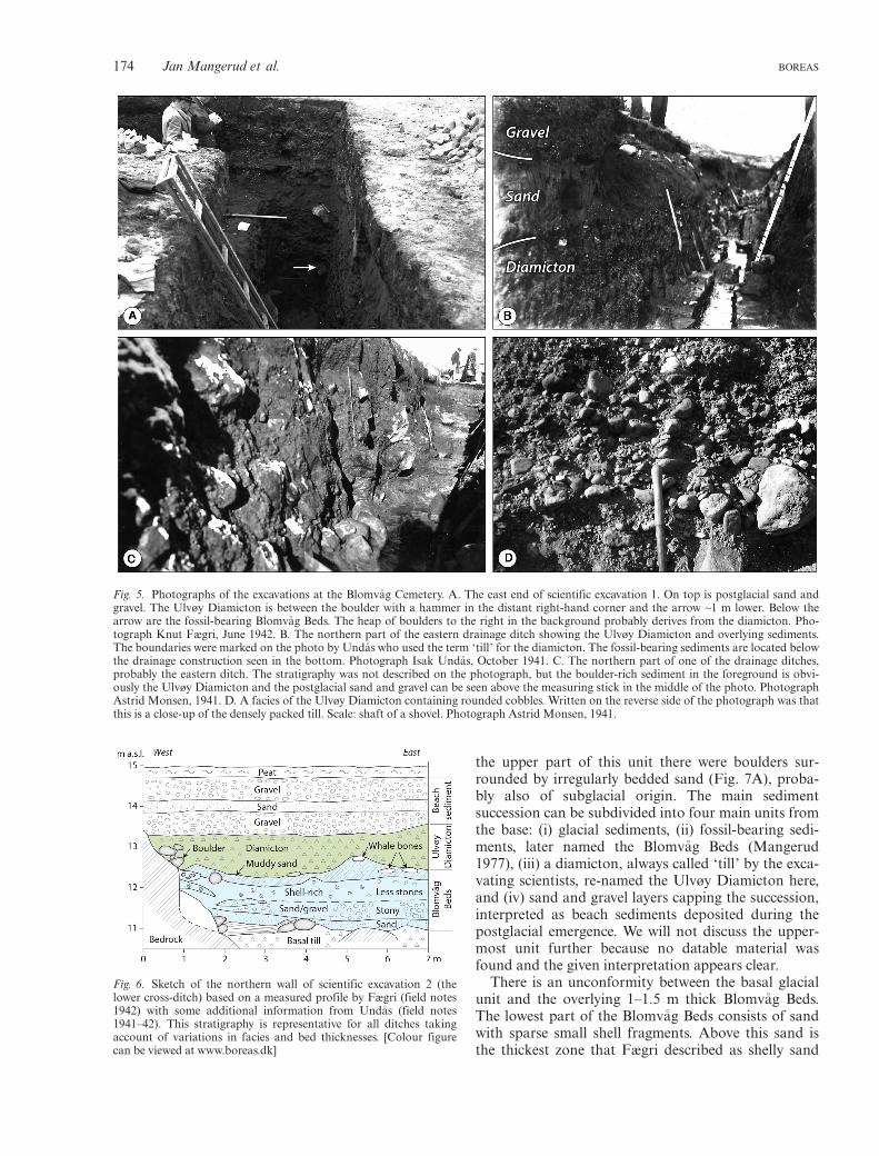
the upper part of this unit there were boulders sur-rounded by irregularly bedded sand (Fig. 7A), proba-bly also of subglacial origin. The main sedimentsuccession can be subdivided into four main units fromthe base: (i) glacial sediments, (ii) fossil-bearing sedi-ments, later named the Blomv�ag Beds (Mangerud1977), (iii) a diamicton, always called ‘till’ by the exca-vating scientists, re-named the Ulvøy Diamicton here,and (iv) sand and gravel layers capping the succession,interpreted as beach sediments deposited during thepostglacial emergence. We will not discuss the upper-most unit further because no datable material wasfound and the given interpretation appears clear.
There is an unconformity between the basal glacialunit and the overlying 1–1.5 m thick Blomv�ag Beds.The lowest part of the Blomv�ag Beds consists of sandwith sparse small shell fragments. Above this sand isthe thickest zone that Fægri described as shelly sand
Fig. 5. Photographs of the excavations at the Blomv�ag Cemetery. A. The east end of scientific excavation 1. On top is postglacial sand andgravel. The Ulvøy Diamicton is between the boulder with a hammer in the distant right-hand corner and the arrow ~1 m lower. Below thearrow are the fossil-bearing Blomv�ag Beds. The heap of boulders to the right in the background probably derives from the diamicton. Pho-tograph Knut Fægri, June 1942. B. The northern part of the eastern drainage ditch showing the Ulvøy Diamicton and overlying sediments.The boundaries were marked on the photo by Und�as who used the term ‘till’ for the diamicton. The fossil-bearing sediments are located belowthe drainage construction seen in the bottom. Photograph Isak Und�as, October 1941. C. The northern part of one of the drainage ditches,probably the eastern ditch. The stratigraphy was not described on the photograph, but the boulder-rich sediment in the foreground is obvi-ously the Ulvøy Diamicton and the postglacial sand and gravel can be seen above the measuring stick in the middle of the photo. PhotographAstrid Monsen, 1941. D. A facies of the Ulvøy Diamicton containing rounded cobbles. Written on the reverse side of the photograph was thatthis is a close-up of the densely packed till. Scale: shaft of a shovel. Photograph Astrid Monsen, 1941.
Fig. 6. Sketch of the northern wall of scientific excavation 2 (thelower cross-ditch) based on a measured profile by Fægri (field notes1942) with some additional information from Und�as (field notes1941–42). This stratigraphy is representative for all ditches takingaccount of variations in facies and bed thicknesses. [Colour figurecan be viewed at www.boreas.dk]
174 Jan Mangerud et al. BOREAS

that contains many pebbles in the lower part, but fewerin the upper half (Fig. 6). Und�as described this unit asgravel with shells, but on a sketch he also drew thinbeds of sand, more shell-rich zones and a horizon withmore seaweed. Thus, it seems clear that this unit con-sists of a mixture of sand and gravel, partly as thinbeds or lenses with many shells and especially shellfragments. A few bones were found in this unit, and itcontains organic matter, probably mainly from marineorganisms.
The uppermost zone in the Blomv�ag Beds is brown-ish muddy sand, often termed a mud layer in the fieldnotes. It contains fewer pebbles than the rest of theBlomv�ag Beds. In some field sketches (Fig. 6), thiszone was marked as a separate bed, but it wasdescribed as flames or lenses (Fig. 7B) and was dis-turbed by boulders in the overlying diamicton. Theterm ‘mud’ was ascribed to a high content of organicmatter. The whale bones and most other bones werefound in this upper zone of the Blomv�ag Beds,although several whale bones penetrated into the over-lying Ulvøy Diamicton. Most, and possibly all, piecesof wood also came from this zone, whereas Und�as(1942) mentioned that it contained many fewer shellfragments than the underlying strata.
The Blomv�ag Beds were always interpreted as shal-low-water or beach sediments (Und�as 1942), an inter-pretation that we support. Based on the presentknowledge of sea-level change, it is now possible toestimate the water depth at the site. Figure 8 shows arelative sea-level curve for Blomv�ag, constructed fromdata in Lohne et al. (2007). Following deglaciation,the high tide fell to a level around 18 m a.s.l. duringthe Allerød. The highest area excavated at the Blomv�agCemetery site is located about 17 m a.s.l., suggesting
that the upper part of the Blomv�ag Beds accumulatedin very shallow water and some possibly even in thebeach zone. The presence of driftwood in this unit sup-ports the interpretation that the sediments represent aformer beach. The age of the reindeer bones (13.5 cal.ka BP) corresponds with the start of the sea-level low-stand (Fig. 8), and most other bones and wood mayalso have been deposited during the lowstand period.The youngest 14C ages in the Blomv�ag Beds are 13.4–13.2 cal. ka BP (Table 1). Fossils and sediments datingfrom the last few hundred years of the Allerød aremissing, probably because of non-deposition when the
Fig. 7. Photographs from the excavations at Blomv�ag Cemetery. A. Boulders and bedded sand, interpreted as glacial sediments at the base ofthe excavation. Northern wall of scientific excavation 2. Photograph Knut Fægri, July 1942. B. The southern wall of scientific excavation 2.Boundaries of units are marked by us, following descriptions on the reverse side of the photograph. In the lower right-hand corner, the glacialsediments overlain by the fossil-bearing Blomvag Beds are delimited by dashed white lines. Arrow points to a lens of mud. The upper unit isthe Ulvøy Diamicton. Photograph Knut Fægri, July 1942.
Fig. 8. A relative sea-level curve for Blomv�ag constructed from datain Lohne et al. (2007). The curve represents the high tide level andlow tide should be ~2 m lower. Maximum errors are estimated as 3–5 m in elevation. Note that sea level following deglaciation was at, orclose to, the level of the Blomv�ag Cemetery during the Allerød beforerising 10 m in the Younger Dryas. The age of the upper parts of theBlomv�ag Beds are marked UBB.
BOREAS The Bølling-age Blomv�ag Beds, W Norway 175

water depth became too shallow and/or there waserosion when the overlying Ulvøy Diamicton wasemplaced.
Two observations were especially important for theinterpretation of the Ulvøy Diamicton as a till. Firstly,it was described as a compacted non-sorted sedimentunit that was difficult to dig by spades and picks. Sec-ondly, the Ulvøy Diamicton contains numerous boul-ders. Johansen & Und�as (1992) mentioned a largeerratic at the site, about 20 m long and 4 m high, eventhough it is not evident from the description whether itoverlaid the Blomv�ag Beds or not. The photos showthat the Ulvøy Diamicton contains a range of sedimentfacies. Figure 5A shows a 1-m-thick matrix-supporteddiamicton, apparently somewhat similar to the diamic-ton in Fig. 5B, whereas the diamicton in Fig. 5C con-tains more large boulders. A very different facies isseen in Fig. 5D (and some other photos) where theso-called till consists of rounded gravel, which almostcertainly is re-deposited beach gravel. The diamictoncontained some boulders of rock types originatingfrom the bedrock in Oslofjorden and Danish areas,which were interpreted as iceberg-transported materiallater picked up and deposited on the site by the icesheet. Such rock types are often found below marinelimit along the coast of western Norway and are com-monly considered to have been transported by icebergsor sea ice. Fægri mentioned that shells could be seen inthe diamicton and in places he even refers to thediamicton as a ‘fossil-bearing till’.
Radiocarbon ages
Twenty-four radiocarbon ages are presently availablefrom the Blomv�ag cemetery site (including the whale-bone age we omit); 23 from the Blomv�ag Beds and onefrom the Ulvøy Diamicton (Table 1); 11 are new agesobtained for the present paper. It should be noted thatthe relative stratigraphical position within the Blomv�agBeds is known only for one series of shells (Fig. 9). Forthese samples, the sediment depths were given on thesample boxes. It was mentioned in the field notes thatmost bones were found in the upper parts of theBlomv�ag Beds. Therefore, we have plotted all suchsamples in the upper part (Fig. 9), but emphasize thattheir relative position to each other is unknown.
The mollusc shells yielded the oldest ages; the twooldest yielded identical ages of 14.8�0.2 cal. ka BP(Table 1), and the ages are surprisingly similarthroughout the lowest 1 m of the sediments (Fig. 9).The fact that the dated shells did not yield youngerages upwards in the succession could be explainedeither by rapid deposition or by the re-deposition ofshell fragments. According to the field notes, therewere few shell fragments in the upper part of theBlomv�ag Beds. It is striking that all shell ages are olderthan the whale bones and two of the three marine birdbones. This suggests that molluscs may not have livedat the site during deposition of the upper part of theBlomv�ag Beds when water depths were very shallow.Alternatively, shells could have been dissolved due to
Fig. 9. Radiocarbon and 10Be exposure ages. Samples from the Blomv�ag Beds with known depths (mainly those marked as ‘Molluscs in strat.order’) are plotted correctly relative to each other, assuming that the unit was 1.3 m thick. Most other samples from the Blomv�ag Beds were,however, only described as from ‘the upper part’ and they are here plotted in a random order for efficient use of space. The sample from theUlvøy Diamicton is plotted above the Blomv�ag Beds. Radiocarbon samples from �Agotnes, Sele Bog and Dale Bog, which all should provideminimum ages for deglaciation, are plotted in random vertical positions. All radiocarbon ages as plotted as midpoint and 68% confidenceinterval. Exposure ages from Blomv�ag are shown at the top, including a mean. [Colour figure can be viewed at www.boreas.dk]
176 Jan Mangerud et al. BOREAS

more acidic conditions produced by the organic mat-ter, but we find that less probable. The size and compo-sition of the whale bones suggest that they stem fromone individual, and the ages overlap within one stan-dard deviation; the mean age is 13.8�0.1 cal. ka BP(n = 3). The ages of the marine birds range from 13.3to 14.0 cal. ka BP (n = 3).
It is highly probable that the reindeer bones comefrom one individual and the ages also overlap; the aver-age is 13.5�0.07 cal. ka BP (n = 2). Reindeer in Nor-way and Svalbard do not eat seaweed (E. Reimers &N. Tyler, pers. comm. 2015) and even at South Geor-gia, which is sparsely vegetated, the content of seaweedin reindeer rumens was found to be minimal (Leader-Williams et al. 1981). Thus, we consider the reindeerages as secure terrestrial radiocarbon ages. Two of thedated wood pieces yielded ages as young as 13.2�0.1and 13.4�0.1 cal. ka BP (Fig. 9). Finally, we obtainedan age of 14.0�0.2 cal. ka BP on shell fragments froma sample marked ‘from a pocket in the till’, an age sim-ilar to the youngest shell fragments below the diamic-ton.
We conclude that the Blomv�ag Beds accumulatedfrom about 14.8 cal. ka until about 13.3 cal. ka BP(Fig. 9) and that the shell fragments in the UlvøyDiamicton are re-deposited from the Blomv�ag Bedsbelow.
The origin of the Ulvøy Diamicton
In view of the original descriptions and some of thephotographs (Fig. 5B, C), the interpretation of theUlvøy Diamicton as a basal till appears to be plausible.It is also noteworthy that all scientists who worked orvisited the site confidently concluded that it was abasal till. However, the available radiocarbon ages con-tradict this interpretation. If the Ulvøy Diamicton is atill then all fossils below the diamicton have to pre-datethe final deglaciation of the site. Radiocarbon agesfrom three sites located close to the Blomv�ag Cemeteryand described below have provided independent mini-mum ages for the final deglaciation of the area. Due touncertainties surrounding the magnitude of marinereservoir errors, age differences are compared eitherbetween terrestrial samples only, or independentlybetween marine samples.
Dale Bog is a palaeolake, located about 600 m northof the cemetery (Fig. 2). It contains a well-dated fullAllerød-Younger Dryas pollen sequence without anydisturbances, demonstrating that the final deglaciationmust pre-date the Allerød. This led Mangerud (1970)to conclude that the Ulvøy Diamicton, at that timeconsidered to be a till, was deposited by an OlderDryas re-advance of the Scandinavian Ice Sheet(Fig. 4). A sample taken at the base of brownishorganic silt yielded an age of 13.9�0.2 cal. BP on bulkorganic matter (Table 2). There is a 10-cm-thick layer
of bluish-grey silt below the dated level. Later, plantmacrofossils from the same level in a new core weredated to 13.9�0.1 and 13.9�0.1 (H.H. Birks, pers.comm. 2014; Mangerud et al. 2016), yielding a meanage of 13.9�0.1 cal. ka BP for all three samples. Thismean age is 430�80 and 710�70 years older than themean ages of the reindeer bones (13.5�0.07 cal. BP;n = 2) and the youngest wood sample (13.2�0.06 cal.ka BP) from levels below the Ulvøy Diamicton, respec-tively (Fig. 9).
At the �Agotnes site, located on Sotra island(Fig. 1B), an exposure of Allerød-Younger Dryas mar-ine sediments showed no traces of being overridden byglacier ice (Mangerud 1977). The oldest shell samplesfrom this section yielded ages of 14.2 and 14.1 ca kaBP (Table 2). The oldest age is 250�130 and1000�180 cal. years older than the mean value for thewhale bones and the youngest age of marine birdremains below the Ulvøy Diamicton, respectively(Fig. 9).
Sele Bog is located 1.0 km east of the cemetery(Fig. 2) at about 20 m a.s.l. and thus it was locatedbelow sea level during the deglaciation and also duringthe Younger Dryas (Fig. 8). We cored it with a hand-driven ‘Russian’ corer in 2015 in order to obtain ageson marine fossils that would yield minimum ages forlocal deglaciation. During coring we hit bedrockunderneath a 900-cm-thick sediment succession ofmarine and lacustrine sediments. On the bedrock sur-face in the deepest part of the basin, between 900–772 cm, is massive, olive-grey marine silt that containnumerous marine shell fragments, with Mytilus frag-ments at the very base of the core. Radiocarbon datesfrom small shell fragments yielded the ages 14.2 and14.1 cal. ka BP from 900 to 897 and 884 to 881 cmdepth, respectively (Table 2), i.e. up to 420�200 yearsolder than the whale bones and up to 990�180 yearsolder than the marine bird bones below the UlvøyDiamicton at the cemetery (Fig. 9).
At all three sites described above (Dale Bog, �Agot-nes and Sele Bog), we obtained minimum ages for thedeglaciation that are significantly older than severalages from below the Ulvøy Diamicton. Thus, it seemsclear that the earlier conclusion that the Blomv�ag Bedshave been overrun by glacial ice depositing the UlvøyDiamicton (Und�as 1942; Mangerud 1970, 1977; Man-gerud et al. 2011) is incorrect.
The site Storum, in Os, is located south of andslightly farther inland than Blomv�ag, but in a similarposition just outside the Younger Dryas moraine(Fig. 1B). Here, a several-metre-deep excavation downto bedrock was investigated in late autumn 2015. Atthe base was a 10-cm-thick unit of sterile sand proba-bly of glaciomarine origin resting on striated bedrock.The basal sand layer is overlain by a 10-cm-thick bedof bluish-grey silty clay with a few mollusc shells of thespecies Hiatella arctica, above which is a grey silt with
BOREAS The Bølling-age Blomv�ag Beds, W Norway 177

frequent occurrences of the mollusc species Chlamysislandica. These units were in turn covered by severalmetres of marine silt and clay containing, amongstother species, Mytilus edulis and Littorina littorea. Thetwo lowermost Hiatella shells that were collected fromthe silty clay a few cm above the basal sand yieldedsimilar ages of c. 14.5 cal. ka BP and a Chlamys shellfrom a level slightly higher up in the sequence yieldedan age of c. 14.4 cal. ka BP (Table 2). These ages arevery similar to the basal ages from the Blomv�ag Bedsand substantiate our conclusion based on the datafrom the Blomv�ag area that there was no Older Dryasglacial advance that reached beyond the position ofthe Younger Dryas ice margin.
Our alternative interpretation of the sediment suc-cession at the Blomv�ag cemetery is that the UlvøyDiamicton was formed by sea ice and/or icebergs dur-ing the Younger Dryas. It is well known that sea icealong Arctic shores can push and mix shallow-watersediments onto beaches (Kovacs & Sodhi 1980). Ice-berg ploughing is extensively described from high-lati-tude continental shelves, but smaller icebergs havecertainly also drifted into shallow water. During theYounger Dryas, the margin of the Scandinavian IceSheet was calving in the fjord a few km east ofBlomv�ag (Fig. 1B) and it is known that sea ice occu-pied the coastal waters at this time (Kristiansen et al.1988; Svendsen & Mangerud 1990). Relative sea level(Fig. 8) during the Allerød must have been very closeto the highest excavated field on the Blomv�ag cemetery.Subsequently, relative sea level rose ~10 m, culminat-ing during the late Younger Dryas when seasonal seaice would have been common, with icebergs driftingalong the coast in front of the calving ice sheet. As wedo not have access to the diamictic layer that wasdescribed from the cemetery it was impossible for us totest this interpretation against primary observations,but we note that the rounded gravel in Fig. 5D sug-gests that at least some of the diamicton consisted ofre-deposited beach gravel.
Deglaciation history
The oldest radiocarbon ages that we obtained fordeglaciation are from two dated molluscs in theBlomv�ag Beds that both yielded radiocarbon ages of14.8�0.2 cal. ka BP. We generally assume that basalages from lacustrine and marine sequences shouldyield similar ages and that both should be close to thetiming of deglaciation. However, the terrestrial plant-based ages from Dale Bog (13.9 cal. ka) are about900 years younger than the basal shells from theadjacent Blomv�ag Beds (Fig. 9). One explanationmight be that relative sea level was 20–30 m higherthan today during deglaciation (Fig. 8) and thereforeBlomøy was a small island and the vegetation covermay have been very sparse and fragmentary. Another
possible explanation is that marine reservoir agesduring deglaciation were considerably higher thanassumed above. The Sotra Island to the south(Fig. 1B) is much larger than Blomøy but we assumethat they were both deglaciated at approximately thesame time. Radiocarbon ages of plant macrofossilsfrom basal lake sediments in Hamravatn on Sotra(Fig. 1B) yielded 14.2�0.14 cal. ka BP (Table 2)(Lohne et al. 2007). Using the basal macrofossil agesfrom Dale Bog and Hamravatn to calculate ΔR valuesfor shells at Blomv�ag would yield ΔR = 600 years and350 years, respectively. These values are much higherthan those found by Bondevik et al. (2006), but thevalue of the marine reservoir age should be investi-gated further before any firm conclusions can bedrawn.
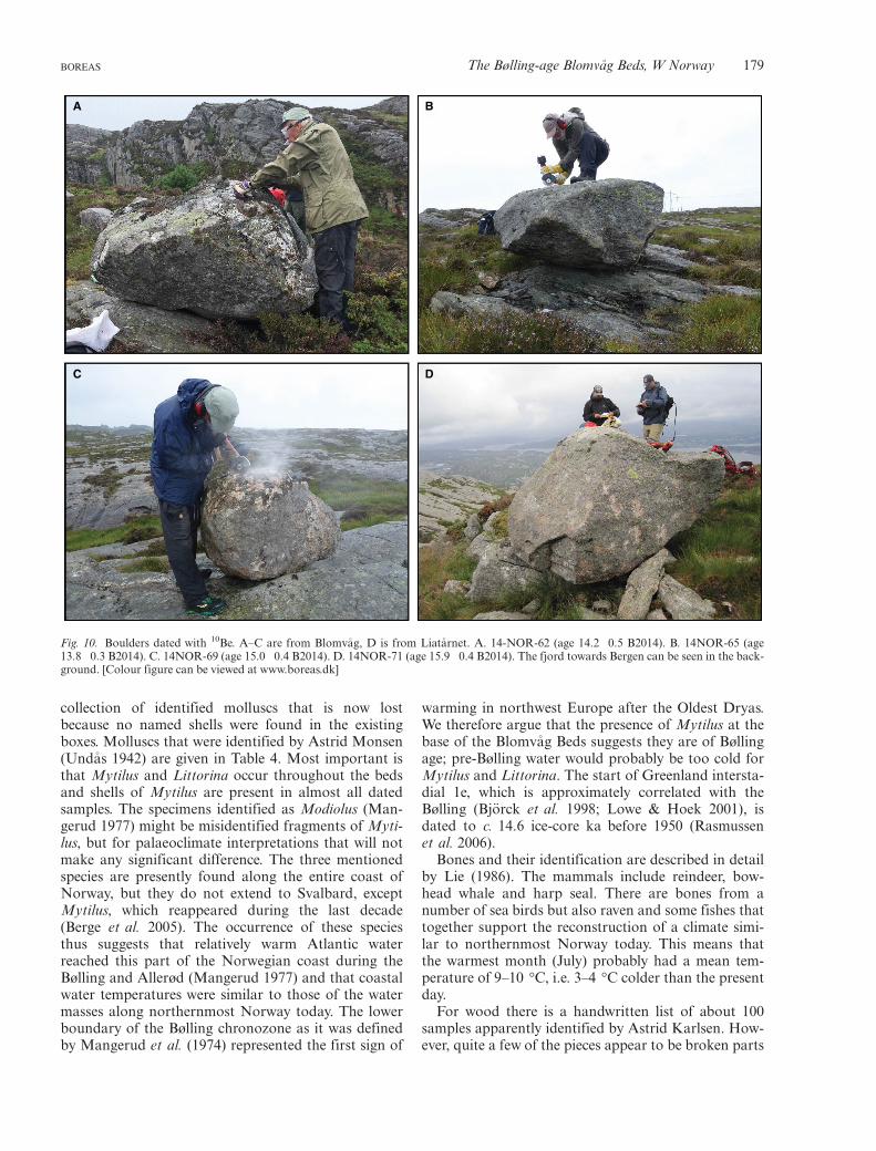
In contrast to radiocarbon ages that provide mini-mum-limiting age estimates, cosmogenic 10Be exposureages from erratic boulders will in ideal circumstancesprovide the direct timing of deglaciation. Note that inTable 3, we have listed conventional 10Be ages, i.e. cal-culated relative to the year of sample collection(B2014), whereas below, we cite ages relative to 1950(B1950). The 10Be age for seven boulders fromBlomv�ag (Figs 2, 10) range from 15.1�0.4 to10.8�0.2 ka; one 10Be age from ice-sculpted bedrock is16.4�0.3 ka. When one young erratic outlier (10.8 ka)and the old bedrock outlier (16.4 ka) are excluded, themean 10Be age is 14.5�0.5 ka B1950; this mean agewould be 500 years older (14.9�0.5 ka B1950) whenusing the Arctic production rate (Young et al. 2013).
Although we presently cannot achieve a precisionfor the age of deglaciation better than a few hundredyears, mainly limited by the marine reservoir age forradiocarbon and production rate for exposure ages, wenote that both 10Be and 14C ages yield a similar timingof deglaciation. Here, we conclude that the deglacia-tion occurred between 14.8 and 14.5 cal. ka BP(Fig. 12).
The erratic boulders from Liat�arnet, the highestmountain (340 m a.s.l.) 27 km south of Blomv�ag(Fig. 1B), were dated to test if the summit had pro-truded through the ice surface before the lower partsof the islands became ice free. The 10Be ages of the foursamples range from 16.3�0.3 to 14.1�0.4 ka. Themean age of 15.2�1.0 ka B1950 (Table 3) isc. 600 years older than the ages for the Blomv�ag erra-tic boulders and thus may suggest that Liat�arnet was anunatak for a period of a few centuries during the ini-tial deglaciation of the islands, although the ages over-lap within one standard deviation.
Palaeoenvironment and possible humanoccupation
We have not made any new identifications of the fossilsin the Blomv�ag Beds. We assume that there was a
178 Jan Mangerud et al. BOREAS
collection of identified molluscs that is now lostbecause no named shells were found in the existingboxes. Molluscs that were identified by Astrid Monsen(Und�as 1942) are given in Table 4. Most important isthat Mytilus and Littorina occur throughout the bedsand shells of Mytilus are present in almost all datedsamples. The specimens identified as Modiolus (Man-gerud 1977) might be misidentified fragments of Myti-lus, but for palaeoclimate interpretations that will notmake any significant difference. The three mentionedspecies are presently found along the entire coast ofNorway, but they do not extend to Svalbard, exceptMytilus, which reappeared during the last decade(Berge et al. 2005). The occurrence of these speciesthus suggests that relatively warm Atlantic waterreached this part of the Norwegian coast during theBølling and Allerød (Mangerud 1977) and that coastalwater temperatures were similar to those of the watermasses along northernmost Norway today. The lowerboundary of the Bølling chronozone as it was definedby Mangerud et al. (1974) represented the first sign of
warming in northwest Europe after the Oldest Dryas.We therefore argue that the presence of Mytilus at thebase of the Blomv�ag Beds suggests they are of Bøllingage; pre-Bølling water would probably be too cold forMytilus and Littorina. The start of Greenland intersta-dial 1e, which is approximately correlated with theBølling (Bj€orck et al. 1998; Lowe & Hoek 2001), isdated to c. 14.6 ice-core ka before 1950 (Rasmussenet al. 2006).
Bones and their identification are described in detailby Lie (1986). The mammals include reindeer, bow-head whale and harp seal. There are bones from anumber of sea birds but also raven and some fishes thattogether support the reconstruction of a climate simi-lar to northernmost Norway today. This means thatthe warmest month (July) probably had a mean tem-perature of 9–10 °C, i.e. 3–4 °C colder than the presentday.
For wood there is a handwritten list of about 100samples apparently identified by Astrid Karlsen. How-ever, quite a few of the pieces appear to be broken parts
A B
C D
Fig. 10. Boulders dated with 10Be. A–C are from Blomv�ag, D is from Liat�arnet. A. 14-NOR-62 (age 14.2�0.5 B2014). B. 14NOR-65 (age13.8�0.3 B2014). C. 14NOR-69 (age 15.0�0.4 B2014). D. 14NOR-71 (age 15.9�0.4 B2014). The fjord towards Bergen can be seen in the back-ground. [Colour figure can be viewed at www.boreas.dk]
BOREAS The Bølling-age Blomv�ag Beds, W Norway 179
from a larger piece. Almost all are identified as Salixor Populus. Four were identified as Betula; two asJuniperus and one as Picea. We cannot judge the qual-ity of the identifications but Salix is an early immi-grant and pieces of Salix as well as Juniperus might befrom local vegetation. Picea is probably driftwoodfrom rivers in Siberia. The frequent occurrence oflong-transported wood, and of bird bones, may pro-vide explanations for transport of seeds and thus theimmigration of plants to coastal Norway after the LastGlacial Maximum.
When he still believed that the Blomv�ag Beds wereof interglacial age, Und�as (1942) mentioned the possi-ble presence of humans, saying: ‘The findings areunique in Scandinavia and it is indeed strange thatsuch a richness of bones and wood have been depositedhere. It is almost only human remains that are missing,but so far nothing is found to indicate that humansplayed a role. The few pieces of flint do not look likehuman tools and I have not seen any small flakes thatfor example are common in the Fosna Culture flintsites’ (translated from Norwegian by us). Rolfsen(1972) and (Mangerud 1973) pointed out that groupsof reindeer hunters lived in Denmark and Germany atthe time the Blomv�ag Beds were deposited and as rein-deer had reached Blomv�ag they said it was reasonable
that some humans had followed the reindeer herdsnorthwards to western Norway. Lie (1986, 1990)argued that the composition of the fauna strongly sug-gests that the bones were remnants of human activityand concluded that ‘the material from Blomv�ag mustbe regarded as the earliest traces so far of human activ-ity in Norway’ (Lie 1990). However, this argument isnow weakened as the new radiocarbon dates indicatethat the Blomv�ag Beds were deposited during severalcenturies and not just during a single human dwellingperiod. Johansen & Und�as (1992) maintained thatsome of the flint pieces from Blomv�ag are human arte-facts. If Lie (1990) and Johansen & Und�as (1992) werecorrect, then humans immigrated to western Norwayabout 3000 years earlier than generally accepted (Brei-vik 2014). This view entered popular books on the his-tory of Norway (Alnæs 1996; Indrelid 1997). However,later the flint material was examined by three archaeol-ogists independently of one another, all concludingthat there is no sign of human work (Bjerck 1994; Eige-land 2012; Fischer 2012), a conclusion repeated inEigeland & Solheim (2012). We follow Bjerck (1994) instating that no findings at Blomv�ag represent reliabletraces of humans. An obstacle for early immigration tosouthern Norway was that the ice-sheet marginblocked the land-connection from Sweden and aroundOslofjorden until about 11 cal. ka BP (Hughes et al.2016).
Position of the Older Dryas ice margin
We concluded above that the interpretation of anOlder Dryas ice advance across Blomv�ag is incorrect,and thus, the Older Dryas ice margin was situated far-ther inland. At the Storum site, described above,located outside but close to the Younger Dryas mor-aine, basal radiocarbon ages are 14.5 cal. ka BP(Table 2, Fig. 11). From Bjorøy (Fig. 1B; Sk�ar 2012)and Bergen (Mangerud et al. 2016), the reported agesof c. 14.1 cal. ka BP from shell fragments included inYounger Dryas tills reveal that these sites were ice freeat 14.1 cal. ka BP prior to being overrun by a re-advance during the Younger Dryas (Fig. 1B).
These ages show that the western coast of Norwayfrom Bjørnefjorden to Fensfjorden and at least as farinland as the Younger Dryas moraine (Fig. 1B)became ice-free during the Bølling. If we accept an ageof about 14 cal. ka BP for the Older Dryas, then theposition of the Older Dryas ice margin must have beeninside, but probably not far inside, the Younger Dryasmargin.
Around the mouth of Hardangerfjorden (Fig. 1A)to the south, the interpretation is the opposite. Here,the Older Dryas margin was slightly beyond theYounger Dryas margin (Fig. 12; Mangerud et al.2016). Furthermore, near Lysefjorden (Fig. 1A), evenfarther south, a dated segment of an Older Dryas end
Table 4. Molluscs in the Blomv�ag Beds. Identified by Astrid Mon-sen, cited from Und�as (1942). Comments translated from Norwe-gian. For some species the presently used names are given below thetable.
Species Comments
Anomia ephippium L. RareAstarte banksii Leach1 Very rareBuccinum undatum L. RareBoreochiton marmoreus Fabr RareBoreochiton ruber Lowe RareCyamium minutum Fabr. RareKellia suborbicularis Mont. RareLittorina littorea L. NumerousLittorina rudis Maton ManyLittorina obtusata L. RareLacuna divaricata Fabr. CommonMacoma calcaria Chemn. ManyMargarita groenlandica Chemn. ManyMargarita helicina Fabr. ManyMya truncata L. Very rareMytilus edulis L. NumerousPecten islandicusM€ull.2 CommonPuncturella noachina L. ManyTectura virginiaM€ull. CommonThracia papyracea Poli Very rareTrophon truncatus Strøm Very rareSaxicava arctica L.3 Very rareBalanus porcatus da Costa4 CommonBalanus crenatus Brug Common
1Astarte montaquiDilwyn.2Chlamys islandicaM€ull.3Hiatella arctica L.4Balanus balanus L.
180 Jan Mangerud et al. BOREAS
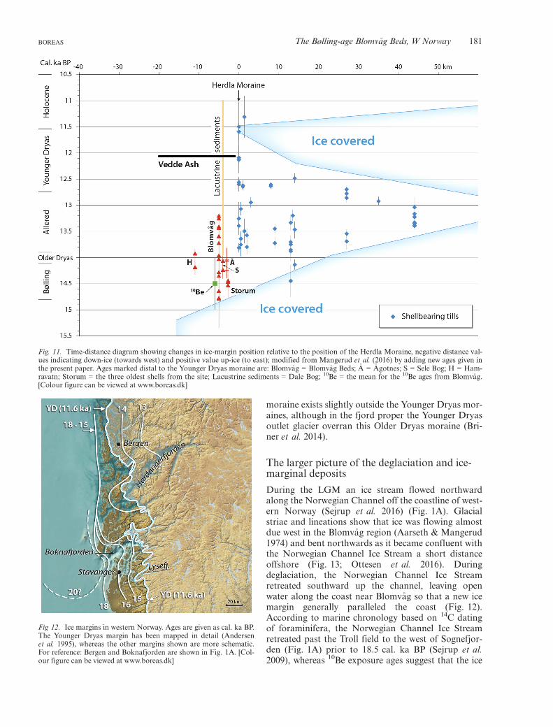
moraine exists slightly outside the Younger Dryas mor-aines, although in the fjord proper the Younger Dryasoutlet glacier overran this Older Dryas moraine (Bri-ner et al. 2014).
The larger picture of the deglaciation and ice-marginal deposits
During the LGM an ice stream flowed northwardalong the Norwegian Channel off the coastline of west-ern Norway (Sejrup et al. 2016) (Fig. 1A). Glacialstriae and lineations show that ice was flowing almostdue west in the Blomv�ag region (Aarseth & Mangerud1974) and bent northwards as it became confluent withthe Norwegian Channel Ice Stream a short distanceoffshore (Fig. 13; Ottesen et al. 2016). Duringdeglaciation, the Norwegian Channel Ice Streamretreated southward up the channel, leaving openwater along the coast near Blomv�ag so that a new icemargin generally paralleled the coast (Fig. 12).According to marine chronology based on 14C datingof foraminifera, the Norwegian Channel Ice Streamretreated past the Troll field to the west of Sognefjor-den (Fig. 1A) prior to 18.5 cal. ka BP (Sejrup et al.2009), whereas 10Be exposure ages suggest that the ice
Fig. 11. Time-distance diagram showing changes in ice-margin position relative to the position of the Herdla Moraine, negative distance val-ues indicating down-ice (towards west) and positive value up-ice (to east); modified from Mangerud et al. (2016) by adding new ages given inthe present paper. Ages marked distal to the Younger Dryas moraine are: Blomv�ag = Blomv�ag Beds; �A = �Agotnes; S = Sele Bog; H = Ham-ravatn; Storum = the three oldest shells from the site; Lacustrine sediments = Dale Bog; 10Be = the mean for the 10Be ages from Blomv�ag.[Colour figure can be viewed at www.boreas.dk]
Fig 12. Ice margins in western Norway. Ages are given as cal. ka BP.The Younger Dryas margin has been mapped in detail (Andersenet al. 1995), whereas the other margins shown are more schematic.For reference: Bergen and Boknafjorden are shown in Fig. 1A. [Col-our figure can be viewed at www.boreas.dk]
BOREAS The Bølling-age Blomv�ag Beds, W Norway 181
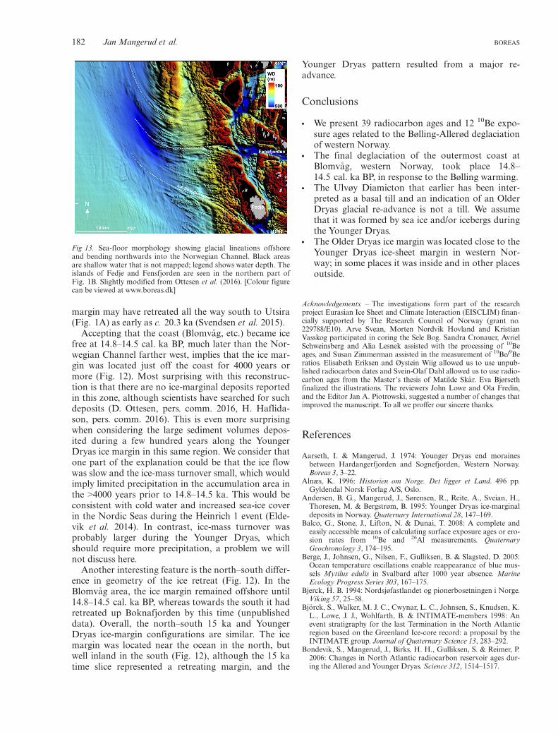
margin may have retreated all the way south to Utsira(Fig. 1A) as early as c. 20.3 ka (Svendsen et al. 2015).
Accepting that the coast (Blomv�ag, etc.) became icefree at 14.8–14.5 cal. ka BP, much later than the Nor-wegian Channel farther west, implies that the ice mar-gin was located just off the coast for 4000 years ormore (Fig. 12). Most surprising with this reconstruc-tion is that there are no ice-marginal deposits reportedin this zone, although scientists have searched for suchdeposits (D. Ottesen, pers. comm. 2016, H. Haflida-son, pers. comm. 2016). This is even more surprisingwhen considering the large sediment volumes depos-ited during a few hundred years along the YoungerDryas ice margin in this same region. We consider thatone part of the explanation could be that the ice flowwas slow and the ice-mass turnover small, which wouldimply limited precipitation in the accumulation area inthe >4000 years prior to 14.8–14.5 ka. This would beconsistent with cold water and increased sea-ice coverin the Nordic Seas during the Heinrich 1 event (Elde-vik et al. 2014). In contrast, ice-mass turnover wasprobably larger during the Younger Dryas, whichshould require more precipitation, a problem we willnot discuss here.
Another interesting feature is the north–south differ-ence in geometry of the ice retreat (Fig. 12). In theBlomv�ag area, the ice margin remained offshore until14.8–14.5 cal. ka BP, whereas towards the south it hadretreated up Boknafjorden by this time (unpublisheddata). Overall, the north–south 15 ka and YoungerDryas ice-margin configurations are similar. The icemargin was located near the ocean in the north, butwell inland in the south (Fig. 12), although the 15 katime slice represented a retreating margin, and the
Younger Dryas pattern resulted from a major re-advance.
Conclusions
• We present 39 radiocarbon ages and 12 10Be expo-sure ages related to the Bølling-Allerød deglaciationof western Norway.
• The final deglaciation of the outermost coast atBlomv�ag, western Norway, took place 14.8–14.5 cal. ka BP, in response to the Bølling warming.
• The Ulvøy Diamicton that earlier has been inter-preted as a basal till and an indication of an OlderDryas glacial re-advance is not a till. We assumethat it was formed by sea ice and/or icebergs duringthe Younger Dryas.
• The Older Dryas ice margin was located close to theYounger Dryas ice-sheet margin in western Nor-way; in some places it was inside and in other placesoutside.
Acknowledgements. – The investigations form part of the researchproject Eurasian Ice Sheet and Climate Interaction (EISCLIM) finan-cially supported by The Research Council of Norway (grant no.229788/E10). Arve Svean, Morten Nordvik Hovland and KristianVasskog participated in coring the Sele Bog. Sandra Cronauer, AvrielSchweinsberg and Alia Lesnek assisted with the processing of 10Beages, and Susan Zimmerman assisted in the measurement of 10Be/9Beratios. Elisabeth Eriksen and Øystein Wiig allowed us to use unpub-lished radiocarbon dates and Svein-Olaf Dahl allowed us to use radio-carbon ages from the Master’s thesis of Matilde Sk�ar. Eva Bjørsethfinalized the illustrations. The reviewers John Lowe and Ola Fredin,and the Editor Jan A. Piotrowski, suggested a number of changes thatimproved the manuscript. To all we proffer our sincere thanks.
References
Aarseth, I. & Mangerud, J. 1974: Younger Dryas end morainesbetween Hardangerfjorden and Sognefjorden, Western Norway.Boreas 3, 3–22.
Alnæs, K. 1996: Historien om Norge. Det ligger et Land. 496 pp.Gyldendal Norsk Forlag A/S, Oslo.
Andersen, B. G., Mangerud, J., Sørensen, R., Reite, A., Sveian, H.,Thoresen, M. & Bergstrøm, B. 1995: Younger Dryas ice-marginaldeposits in Norway. Quaternary International 28, 147–169.
Balco, G., Stone, J., Lifton, N. & Dunai, T. 2008: A complete andeasily accessible means of calculating surface exposure ages or ero-sion rates from 10Be and 26Al measurements. QuaternaryGeochronology 3, 174–195.
Berge, J., Johnsen, G., Nilsen, F., Gulliksen, B. & Slagsted, D. 2005:Ocean temperature oscillations enable reappearance of blue mus-sels Mytilus edulis in Svalbard after 1000 year absence. MarineEcology Progress Series 303, 167–175.
Bjerck, H. B. 1994: Nordsjøfastlandet og pionerbosetningen i Norge.Viking 57, 25–58.
Bj€orck, S., Walker, M. J. C., Cwynar, L. C., Johnsen, S., Knudsen, K.L., Lowe, J. J., Wohlfarth, B. & INTIMATE-members 1998: Anevent stratigraphy for the last Termination in the North Atlanticregion based on the Greenland Ice-core record: a proposal by theINTIMATE group. Journal of Quaternary Science 13, 283–292.
Bondevik, S., Mangerud, J., Birks, H. H., Gulliksen, S. & Reimer, P.2006: Changes in North Atlantic radiocarbon reservoir ages dur-ing the Allerød and Younger Dryas. Science 312, 1514–1517.
Fig 13. Sea-floor morphology showing glacial lineations offshoreand bending northwards into the Norwegian Channel. Black areasare shallow water that is not mapped; legend shows water depth. Theislands of Fedje and Fensfjorden are seen in the northern part ofFig. 1B. Slightly modified from Ottesen et al. (2016). [Colour figurecan be viewed at www.boreas.dk]
182 Jan Mangerud et al. BOREAS

Breivik, H. M. 2014: Palaeo-oceanographic development and humanadaptive strategies in the Pleistocene-Holocene transition: a studyfrom the Norwegian coast. The Holocene 24, 1478–1490.
Briner, J. P., Svendsen, J. I., Mangerud, J., Lohne, Ø. S. & Young, N.E. 2014: A 10Be chronology of south-western Scandinavian IceSheet history during the Lateglacial period. Journal of QuaternaryScience 29, 370–380.
Brock, F., Higham, T., Ditchfield, P. & Bronk Ramsey, C. 2010: Cur-rent pretreatment methods for AMS radiocarbon dating at theOxford Radiocarbon Accelerator Unit (ORAU). Radiocarbon 52,103–112.
Brock, F., Wood, R., Higham, T. F. G., Ditchfield, P., Bayliss, A. &Bronk Ramsey, C. 2012: Reliability of nitrogen content (%N) andcarbon: nitrogen atomic ratios (C:N) as indicators of collagenpreservation suitable for radiocarbon dating. Radiocarbon 54,879–886.
Bronk Ramsey, C., Higham, T., Bowles, A. & Hedges, R. 2004:Improvements to the pretreatment of bone at Oxford. Radiocarbon46, 155–163.
Eigeland, L. 2012: En teknologisk vurdering av mulige senglasialefunn i Norge. Norsk Maritimt Museum, Arkeologisk Rapport 12,57–69.
Eigeland, L. & Solheim, S. 2012: Blomv�agfunnet - veid og funnet forlett. Viking 75, 7–26.
Eldevik, T., Risebrobakken, B., Bjune, A. E., Andersson, C., Birks,H. J. B., Dokken, T. M., Drange, H., Glessmer, M. S., Li, C., Nil-sen, J. E. Ø., Otter�a, O. H., Richter, K. & Skagseth, Ø. 2014: Abrief history of climate – the northern seas from the Last GlacialMaximum to global warming. Quaternary Science Reviews 106,225–246.
Fischer, A. 2012: Vurdering af Vestnorske fund, som kandiderertil palæolitisk datering. Norsk Maritimt Museum, ArkeologiskRapport 12, 50–56.
Goehring, B. M., Lohne, Ø. S., Mangerud, J., Svendsen, J. I., Gyllen-creutz, R., Schaefer, J. & Finkel, R. 2012a: Late glacial and Holo-cene 10Be production rates for western Norway. Journal ofQuaternary Science 27, 89–96.
Goehring, B. M., Lohne, Ø. S., Mangerud, J., Svendsen, J. I., Gyllen-creutz, R., Schaefer, J. & Finkel, R. 2012b: Erratum: late glacialand Holocene 10Be production rates for western Norway. Journalof Quaternary Science 27, 544–544.
Gulliksen, S., Nydal, R. & Skogseth, F. 1978: Trondheim naturalradiocarbon measurements VIII. Radiocarbon 20, 105–133.
Holtedahl, O. 1953: Norges Geologi, Bind II. 1118 pp. H. Aschehoug& Co., Oslo.
Holtedahl, O. 1960: Geology of Norway. Norges Geologiske Under-søkelse 208, 1–540.
Hufthammer, A. 2001: The Weichselian (c. 115,000–10,000 B.P.) ver-tebrate fauna of Norway. Bollettino della Societ�a PaleontologicaItaliana 40, 201–208.
Hughes, A. L. C., Gyllencreutz, R., Lohne, Ø. S., Mangerud, J. &Svendsen, J. I. 2016: The last Eurasian ice sheets – a chronologicaldatabase and time-slice reconstruction, DATED-1. Boreas 45, 1–45.
Indrelid, S. 1997: Fr�a Steinalder Til Vikingtid, Strilesoga Band 1. 255pp. Eide Forlag, Bergen.
Johansen, A. B. & Und�as, I. 1992: Er Blomv�agmaterialet et boplass-funn? Viking 55, 9–26.
Kovacs, A. & Sodhi, D. S. 1980: Shore ice pile-up and ride-up: fieldobservations, models, theoretical analyses. Cold Regions Scienceand Technology 2, 210–288.
Kristiansen, I. L., Mangerud, J. & Lømo, L. 1988: Late Weichselian/Early Holocene pollen-and lithostratigraphy in lakes in the �Ale-sund area, western Norway. Review of Palaeobotany and Palynol-ogy 53, 185–231.
Krzywinski, K. & Stabell, B. 1984: Late Weichselian sea level changesat Sotra, Hordaland, western Norway. Boreas 13, 159–202.
Leader-Williams, N., Scott, T. A. & Pratt, R. M. 1981: Forage selec-tion by introduced reindeer on South Georgia, and its conse-quences for the flora. Journal of Applied Ecology 18, 83–106.
Lie, R. 1986: Animal bones from the Late Weichselian in Norway.Fauna Norwegica, Serie A 7, 41–46.
Lie, R. 1990: Blomv�agfunnet, de eldste spor etter mennesker i Norge?Viking 1990, 7–20.
Lohne, Ø. S., Bondevik, S., Mangerud, J. & Svendsen, J. I. 2007: Sea-level fluctuations imply that the Younger Dryas ice-sheet expan-sion in western Norway commenced during the Allerød. Quater-nary Science Reviews 26, 2128–2151.
Longin, R. 1971: New method of collagen extraction for radiocarbondating. Nature 230, 241–242.
Lowe, J. J., Hoek, W. Z. & INTIMATE-group 2001: Inter-regionalcorrelation of palaeoclimatic records for the Last Glacial-Intergla-cial Transition: a protocol for improved precision recommendedby the INTIMATE project group. Quaternary Science Reviews 20,1175–1187.
Mangerud, J. 1970: Late Weichselian vegetation and ice-front oscilla-tions in the Bergen district, western Norway. Norsk GeografiskTidsskrift 24, 121–148.
Mangerud, J. 1972: Radiocarbon dating of marine shells, including adiscussion of apparent age of Recent shells from Norway. Boreas1, 143–172.
Mangerud, J. 1973: Hordalands natur, under og like etter istiden. Fr�aFjon til Fusa 26, 7–43.
Mangerud, J. 1977: Late Weichselian marine sediments containingshells, foraminifera, and pollen, at �Agotnes, western Norway.Norsk Geologisk Tidsskrift 57, 23–54.
Mangerud, J., Aarseth, I., Hughes, A. L. C., Lohne, Ø. S., Sk�ar, K.,Sønstegaard, E. & Svendsen, J. I. 2016: A major re-growthof the Scandinavian Ice Sheet in western Norway dur-ing Allerød-Younger Dryas. Quaternary Science Reviews 132, 175–205.
Mangerud, J., Andersen, S. T., Berglund, B. E. & Donner, J. J. 1974:Quaternary stratigraphy of Norden, a proposal for terminologyand classification. Boreas 3, 109–128.
Mangerud, J., Goehring, B. M., Lohne, Ø., Svendsen, J. I. & Gyllen-creutz, R. 2013: Collapse of marine-based outlet glaciers from theScandinavian Ice Sheet. Quaternary Science Reviews, 67, 8–16.
Mangerud, J., Gyllencreutz, R., Lohne, Ø. & Svendsen, J. I. 2011:Glacial history of Norway. In Ehlers, J., Gibbard, P. & Hughes, P.(eds.): Quaternary Glaciations - Extent and Chronology, 279–292.Developments in Quaternary Science 15, Elsevier, Amsterdam.
Nemec, M., Wacker, L., Hajdas, I. & Gaggeler, H. 2010: Alternativemethods for cellulose preparation for AMS measurement. Radio-carbon 52, 1358–1370.
Nishiizumi, K., Imamura, M., Caffee, M., Southon, J., Finkel, R. &McAninch, J. 2007: Absolute calibration of 10Be AMS standards.Nuclear Instrument Methods 258, 403–413.
Nydal, R. 1960: Trondheim natural radiocarbon measurements II.American Journal of Science, Radiocarbon Supplement 2, 82–96.
Nydal, R., Gulliksen, S. & Løvseth, K. 1972: Trondheim naturaalradiocarbon measurements VI. Radiocarbon 14, 418–451.
Ottesen, D., Stokes, C. R., Bøe, R., Rise, L., Longva, O., Thorsnes,T., Olesen, O., Bugge, T., Lepland, A. & Hestvik, O. B. 2016: Land-form assemblages and sedimentary processes along the NorwegianChannel Ice Stream. Sedimentary Geology 338, 115–137.
Rasmussen, S. O., Andersen, K. K., Svensson, A. M., Steffensen, J.P., Vinther, B. M., Clausen, H. B., Siggaard-Andersen, M. L.,Johnsen, S. J., Larsen, L. B., Dahl-Jensen, D., Bigler, M., Rothlis-berger, R., Fischer, H., Goto-Azuma, K., Hansson, M. E. & Ruth,U. 2006: A new Greenland ice core chronology for the last glacialtermination. Journal of Geophysical Research, 111, D06102,doi:10.1029/2005JD006079.
Reimer, P. J., Bard, E., Bayliss, A., Beck, J. W., Blackwell, P. G.,Bronk Ramsey, C., Buck, C. E., Cheng, H., Edwards, R. L., Frie-drich, M., Grootes, P. M., Guilderson, T. P., Haflidason, H., Haj-das, I., Hatt�e, C., Heaton, T. J., Hoffmann, D. L., Hogg, A. G.,Hughen, K. A., Kaiser, K. F., Kromer, B., Manning, S. W., Niu,M., Reimer, R. W., Richards, D. A., Scott, E. M., Southon, J. R.,Staff, R. A., Turney, C. S. M. & van der Plicht, J. 2013: IntCal13and Marine13 radiocarbon age calibration curves 0–50,000 yearscal BP. Radiocarbon 55, 1869–1887.
Rolfsen, P. 1972: Kvartærgeologiske og botaniske betingelser formennesker i Sør-Norge i seinglasial og tidlig postglasial tid. Viking36, 131–153.
BOREAS The Bølling-age Blomv�ag Beds, W Norway 183

Rood, D., Hall, S., Guilderson, T., Finkel, R. C. & Brown, T. 2010:Challenges and opportunities in high precision Be-19 measure-ments at CAMS. Nuclear Instruments and Methods B: Beam Inter-actions with Material and Atoms 268, 730–732.
Sejrup, H. P., Clark, C. D. & Hjelstuen, B. O. 2016: Rapid ice sheetretreat triggered by ice stream debuttressing: evidence from theNorth Sea. Geology 44, 355–358.
Sejrup, H. P., Nyg�ard, A., Hall, A. M. & Haflidason, H. 2009: Mid-dle and Late Weichselian (Devensian) glaciation history of south-western Norway, North Sea and eastern UK. Quaternary ScienceReviews 28, 370–380.
Sk�ar, M. 2012: Kvartærgeologisk kartlegging og rekonstruksjon avis-marginale avsetninger pa Bjorøy, Tyssøy og H�akonshella, sørvestfor Bergen. Master’s thesis, University of Bergen, 142 pp.
Staiger, J., Gosse, J., Toracinta, R., Oglesby, B., Fastook, J. & John-son, J. V. 2007: Atmospheric scaling of cosmogenic nuclide produc-tion: climate effect. Journal of Geophysical Research: Solid Earth112, B02205, doi:10.1029/2005JB003811.
Svendsen, J. I. & Mangerud, J. 1990: Sea-level changes and pollenstratigraphy on the outer coast of Sunnmøre, western Norway.Norsk Geologisk Tidsskrift 70, 111–134.
Svendsen, J. I., Briner, J. P., Mangerud, J. & Young, N. E. 2015: Earlybreak-up of the Norwegian Channel Ice Stream during the LastGlacial Maximum. Quaternary Science Reviews 107, 231–242.
Und�as, I. 1942: Fossilfunnet i Blomv�ag. Naturen 1942, 97–107.Young, N. E., Schaefer, J. M., Briner, J. P. & Goehring, B. M. 2013:A 10Be production-rate calibration for the Arctic. Journal ofQuaternary Science 28, 515–526.
184 Jan Mangerud et al. BOREAS