Embed Size (px)
Citation preview

IInntteerrnnaattiioonnaall IInnssttiittuuttee ffoorr GGeeoo--IInnffoorrmmaattiioonn SScciieennccee aanndd EEaarrtthh OObbsseerrvvaattiioonn
Enschede, The Netherlands
CCuussttoommaarryy tteennuurree:: ‘‘ooppppoorrttuunniittyy’’ oorr ‘‘oobbssttaaccllee’’ ttoo uurrbbaann llaanndd ddeevveellooppmmeenntt??
The case of Kisumu city, Kenya
EEddwwiinn WWaammuukkaayyaa OOkkoonnyyoo March, 2008

CCuussttoommaarryy tteennuurree:: ‘‘ooppppoorrttuunniittyy’’ oorr ‘‘oobbssttaaccllee’’ ttoo uurrbbaann llaanndd ddeevveellooppmmeenntt??
The case of Kisumu city, Kenya
By
EEddwwiinn WWaammuukkaayyaa OOkkoonnyyoo
Thesis submitted to the International Institute for Geo-information Science and Earth Observation in partial fulfilment of requirements for award of the degree of
Master of Science in Urban Planning and Management
Thesis Assessment Board:
Chairman: Prof. Ir. P. van der Molen External Examiner: Prof. Dr. E. Schmidt-Kallert First Supervisor: Dr. R. V. Sliuzas Second Supervisor: Drs. E. J. M. Dopheide
IInntteerrnnaattiioonnaall IInnssttiittuuttee ffoorr GGeeoo--IInnffoorrmmaattiioonn SScciieennccee aanndd EEaarrtthh OObbsseerrvvaattiioonn Enschede, The Netherlands

Disclaimer
This document describes work undertaken as part of a programme of study at the International Institute for Geo-information Science and Earth Observation. All views and opinions expressed therein remain the sole responsibility of the author, and do
not necessarily represent those of the institute.

Life is about not knowing; having to change, taking the moment and making the best of it, without knowing what’s going to happen next.
Delicious ambiguity.
Gilda Radner (1946 – 1989)
Dedicated to my parents,
Who taught me to always look beyond the horizon.

i
Abstract
In Kisumu, the expansion of urban areas into agricultural hinterlands; due to demographic pressures is
forcing customary land tenure practices which have existed for centuries in these areas to adapt and adjust
to new situations. Despite the abundance of land in the expanding urban areas, its availability is critically
constrained due to protracted and complex land tenure arrangements. In the peri-urban areas, for instance,
successive local authorities have shown an apparent weakness in controlling or guiding urban land use
development; Property owners can do as they wish with their lands, subject to family and communal
obligations that may apply depending on the prevailing land tenure. Municipal officials have found it
nearly impossible to achieve harmony, delight and efficiency in the planning process when ownership of
large parcels of land adjacent to the city is held under customary tenure.
Based on a case study survey of three settlements at varying stages of development (incipient, intermediate
and consolidated) in peri-urban Kisumu, this study sought to investigate how the customary tenure system
in peri-urban Kisumu adapts and adjusts amidst rapid urbanization; as well as its opportunities and
challenges to the spatial planning of the peri-urban zone.
The study findings indicate a progressive shift from communal to individual landownership patterns and
related rights to land in the case study areas due to land market pressures; although chiefs and village
elders still continued to exercise their mediating roles. The findings also revealed considerable weaknesses
in the capacity of the state to intervene and foster planned land development in peri-urban areas. Indeed,
given the bureaucratic hurdles that have to be overcome at each stage of the land development process, and
the likelihood that considerable time will pass before development approvals are finalised; it is not
surprising that property owners in the case study areas are developing their land outside official planning
norms.
On a positive note, the role of traditional authorities in urban land management was especially strong in the
incipient phase of settlement development. However, the consolidation of settlements due to demographic
pressures and overheated land markets appears to curtail the efforts of traditional authorities’ in wider land
management aspects such as encouraging community mobilization and local participation in community
development projects.
Given the strengths and weaknesses inherent in both public and customary land management approaches,
the study concludes that there is a need to integrate both customary and public authority’s efforts towards
orderly urban development. The incipient phase of settlement development serves as a possible entry point
to such initiatives before settlement densities build up and the ensuing consequences - the lack of apparent
planning and sense of order - are often too ghastly to contemplate.
Keywords: customary land tenure; urbanization; land development

ii
Acknowledgements
Many individuals and organisations immensely contributed; directly and indirectly, in various aspects of
this study. Special thanks go to NUFFIC and ITC for the financial support extended to me. My utmost
gratitude goes to Dr. Richard V. Sliuzas and Drs. Emile J. M. Dopheide; my supervisors. They not only
provided their support and guidance but also their opinions, comments and suggestions that helped a great
deal in shaping the focus of this study as well as the challenging research that lies behind it.
I am greatly indebted to the staff in the Urban and Regional Planning and Geo-Information Management
Department for introducing me to the dynamic field of urban planning and management.
I also appreciate the time and effort of the following individuals: Mr. Charles Angira and Mr. Stephen Sule
(Town planning department – Municipal council of Kisumu); Mr. George Waggah, Ms. Leah Onyango and
Mr. Kola (Maseno University); Ms. Olando, Ms. Njenga, Mr. Ogutu, Mr. Hussein and Mr. Kagema
(Ministry of Lands and Settlements); Mr. Sunday Ericson and Ms. Irene Karanja (Pamoja Trust). Their
cooperation was of immense use to the findings, conclusion and recommendations of this study. I am
equally grateful to the residents and community leaders of Manyatta ‘A’, Nyalenda ‘B’ and Nyamasaria
settlements; who volunteered information and participated in this research with great interest and
enthusiasm.
I acknowledge the academic and moral support from Mr. Emmanuel Midheme; who gave insightful
comments and reviewed my work on very short notice. He has been a great friend and mentor.
Mr. Renson K. Mbwagwa and Mr. Musyimi Mbathi deserve special mention for their role in seeing me
started on this long journey. My studies in ITC have brought me great satisfaction in my professional life.
But also these years scared me since I did not want to disappoint the persons who believed in me.
Thanks to friends and colleagues in the UPM programme (2006 – 2008), who inspired my final effort
despite the enormous work pressures we were facing together. Let me also say ‘Asante’ to the Kenyan
friends and colleagues in ITC and Enschede, whose company served to re-create home away from home.
This list is by no means exhaustive; but nonetheless, I am grateful to everyone else who helped out in one
way or another. To them, I am most appreciative.
Finally, but most importantly, special word of thanks go to: my parents (Mr. & Mrs. Okonyo) and family,
who have always supported, encouraged and believed in me in all my endeavours and Ms. Bilha
Khaminwa, whose constant encouragement helped to mould my resolve to work much harder.
The highest praise is God’s for making this and all other things possible in life. Edwin Wamukaya Enschede, March 2008

iii
Table of contents
1. Introduction .................................................................................................................................................. 1 1.1. Urbanization and urban growth ................................................................................................ 1 1.2. Why the focus on cities, towns and urban centres? .................................................................. 1 1.3. Guided land use development in the peripheries: the elusive challenge? ................................ 2 1.4. Defining the research problem ................................................................................................. 3 1.5. Objectives of the research ........................................................................................................ 4 1.6. Research questions ................................................................................................................... 4 1.7. Significance of the study .......................................................................................................... 5 1.8. Definition of terms ................................................................................................................... 5 1.9. Limitations of the study ............................................................................................................ 6 1.10. Outline of the thesis .............................................................................................................. 6
2. Land use and tenure systems in developing countries ............................................................................... 8 2.1. Defining land tenure and property rights ................................................................................. 8 2.2. Customary tenure and property rights ..................................................................................... 9 2.3. Private land tenure and property rights .................................................................................... 9 2.4. Customary and private tenure concepts: a comparison .......................................................... 10 2.5. Customary land tenure reforms .............................................................................................. 11 2.6. Neo-customary tenure system ................................................................................................ 12 2.7. The relationship between land tenure, property rights and urban land use ............................ 13 2.8. Phases of Informal settlement development ........................................................................... 13 2.9. Conceptual framework ........................................................................................................... 14
3. Research methodology................................................................................................................................ 15 3.1. Research process .................................................................................................................... 15 3.2. Operationalizing the research problem: research design ........................................................ 16 3.3. Case study approach ............................................................................................................... 16
3.3.1. Rationale for selecting a case study approach ................................................................ 16 3.3.2. Quality control ................................................................................................................ 17
3.4. Background to case study selection ........................................................................................ 18 3.5. Data collection techniques ...................................................................................................... 25 3.6. Limitations of data collection ................................................................................................. 30 3.7. Data analysis........................................................................................................................... 31 3.8. Conclusion to the research methodology ............................................................................... 32
4. Background to the study area .................................................................................................................... 33 4.1. The city of Kisumu: changing physical development and urban growth ............................... 33 4.2. Existing land tenure systems .................................................................................................. 35 4.3. Adjudication of customary land rights ................................................................................... 36
4.3.1. Introduction .................................................................................................................... 36 4.3.2. The land adjudication process in Kisumu ...................................................................... 36 4.3.3. Conclusion ...................................................................................................................... 39
5. The nature and dynamics of customary landholding .............................................................................. 40 5.1. The evolution of customary tenure ......................................................................................... 40
5.1.1. Communal control stage ................................................................................................. 40 5.1.2. Family control stage ....................................................................................................... 42 5.1.3. Stage of individual titles and land dealings .................................................................... 43

iv
5.2. Concluding remarks ............................................................................................................... 47 6. Existing land markets in peri-urban Kisumu ........................................................................................... 48
6.1. Structure of the land market .................................................................................................. 48 6.2. Operation of the formal land market ..................................................................................... 48
6.2.1. Formal allocation systems ............................................................................................. 48 6.2.2. Compulsory acquisition ................................................................................................. 50 6.2.3. Formal land purchase ..................................................................................................... 50
6.3. Operation of the informal land market .................................................................................. 51 6.3.1. Customary land markets ................................................................................................ 53 6.3.2. Neo-customary land markets ......................................................................................... 53 6.3.3. Characteristics of the informal land markets ................................................................. 55
6.4. Concluding remarks ............................................................................................................... 60 7. Impact of the customary tenure system on urban land development processes ................................... 61
7.1. Nature and type of development on land held under customary tenure ................................ 61 7.2. Roles of traditional authorities in urban land management ................................................... 69 7.3. Concluding remarks ............................................................................................................... 72
8. Summary of findings, conclusions and recommendations ...................................................................... 73 8.1. Summary of research findings ............................................................................................... 73 8.2. Conclusions ........................................................................................................................... 76 8.3. Recommendations ................................................................................................................. 77
References ............................................................................................................................................................ 78 Appendices ........................................................................................................................................................... 82
3-1: Key informant interview schedule ............................................................................................. 82 3-2: In-depth interview schedule ....................................................................................................... 83 3-3: Focus group discussion schedule ............................................................................................... 84 3-4: Property owner questionnaire .................................................................................................... 85 4-1: Adjudication map of Kenya ....................................................................................................... 87 4-2: Registry Index Maps (RIMs) ..................................................................................................... 88 4-3: Adjudication of customary rights in former British territories – similarities and differences ... 89 6-1: Certificate of payment of rates and other charges ...................................................................... 90

v
List of figures
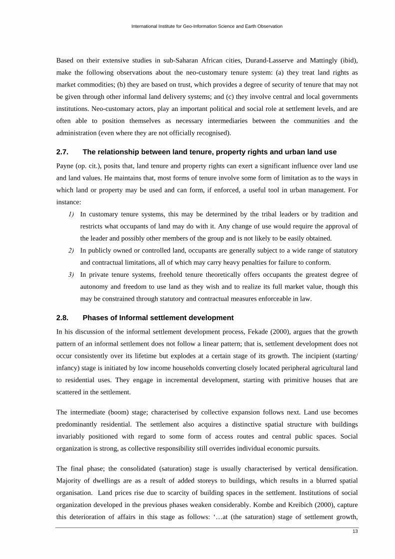
Figure 2-1: A perfect property right ........................................................................................................................ 8 Figure 2-2: The urbanization process and resultant changes in land tenure and land use practices ...................... 14 Figure 3-1: The research process ........................................................................................................................... 15 Figure 3-2: Location of peri-urban settlements in Kisumu ................................................................................... 20 Figure 3-3: Nyamasaria settlement (Incipient) ...................................................................................................... 22 Figure 3-4: 2003 Quick Bird satellite image of Nyamasaria (0.6m resolution) .................................................... 22 Figure 3-5: Nyalenda 'B' settlement (Intermediate) ............................................................................................... 23 Figure 3-6: 2003 Quick Bird satellite image of Nyalenda 'B' (0.6m resolution) ................................................... 23 Figure 3-7: Manyatta 'A' settlement (Consolidated) .............................................................................................. 24 Figure 3-8: 2003 Quick Bird satellite image of Manyatta 'A' (0.6m resolution) ................................................... 24 Figure 3-9: Focus group discussion session in Manyatta A .................................................................................. 26 Figure 3-10: Sampling procedure for household survey ....................................................................................... 28 Figure 3-11: Spatial distribution of sampled property owners .............................................................................. 30 Figure 3-12: Analytical approach for within-case and cross-case analysis ........................................................... 31 Figure 3-13: The ladder of analytical abstraction .................................................................................................. 32 Figure 4-1: Location of Kisumu in the national context........................................................................................ 33 Figure 4-2: Kisumu urban structure changes ......................................................................................................... 34 Figure 4-3: Distinct forms of land tenure in Kisumu municipality ....................................................................... 36 Figure 5-1: The evolution of customary land tenure ............................................................................................. 40 Figure 5-2: Mode of land access per case study area and acquisition period ........................................................ 44 Figure 5-3: Customary tenure individualization process ....................................................................................... 46 Figure 5-4: Land sale caution notice ..................................................................................................................... 47 Figure 6-1: Sample sale agreement ....................................................................................................................... 51 Figure 6-2: Channels of land access per case study area ....................................................................................... 51 Figure 6-3: Neo-customary land market transaction process ................................................................................ 54 Figure 6-4: Difficult stages in the informal land market transaction ..................................................................... 58 Figure 6-5: Evidence of land ownership ............................................................................................................... 59 Figure 6-6: Sources of finance .............................................................................................................................. 60 Figure 7-1: Sample change of user notice ............................................................................................................. 62 Figure 7-2: Nature and type of housing development in the case study areas ....................................................... 64 Figure 7-3: Land development approval status ..................................................................................................... 64 Figure 7-4: Land rent payment notices .................................................................................................................. 65 Figure 7-5: Land use categories in the case study areas ........................................................................................ 66 Figure 7-6: Existing infrastructure on occupied land ............................................................................................ 67 Figure 7-7: Incremental housing development in Manyatta 'A' ............................................................................. 67 Figure 7-8: An incomplete house in Nyalenda 'B' ................................................................................................. 67 Figure 7-9: Water sources in the case study areas ................................................................................................. 68 Figure 7-10: A house located on a flood plain in Manyatta 'A' ............................................................................. 68 Figure 7-11: Average household plot size distribution ......................................................................................... 69 Figure 7-12: Awareness of roles played by customary authorities in local land development ............................. 70 Figure 7-13: Roles of customary authorities ......................................................................................................... 71 Figure 8-1: The evolution of customary land tenure in the case study areas ......................................................... 74

vi
List of tables
Table 1-1: Distribution of urban population in Kenya by size of urban centres, 1948 - 1999 ................................ 1 Table 1-2: Extent of urban and peri-urban areas ..................................................................................................... 5 Table 2-1: Summary of reforms undertaken on customary tenured land .............................................................. 12 Table 3-1: Measured variables and data collection techniques ............................................................................. 16 Table 3-2: Advantages and inconveniences of case study as a research strategy .................................................. 17 Table 3-3: Peri-urban settlements in Kisumu ........................................................................................................ 19 Table 3-4: List of persons interviewed .................................................................................................................. 25 Table 3-5: Sampling frame for each case study area ............................................................................................. 27 Table 4-1: Steps involved in the land adjudication process................................................................................... 37 Table 4-2: Status of land adjudication in the case study areas. ............................................................................. 38 Table 5-1: Nature of land rights at the communal control stage ............................................................................ 41 Table 5-2: Nature of land rights at the family control stage .................................................................................. 43 Table 5-3: Nature of land rights at the stage of individual titles and land dealings............................................... 43 Table 5-4: Mode of land access per case study area and acquisition period ......................................................... 44 Table 6-1: Typical steps followed when land for allocation is available in urban areas ....................................... 48 Table 6-2: Channels of land access per case study area ........................................................................................ 51 Table 6-3: Actors and roles played in the informal land market ........................................................................... 55 Table 6-4: Time taken (weeks) to conclude land transactions ............................................................................... 55 Table 6-5: Difficult stages in the informal land market transaction ...................................................................... 58 Table 6-6: Evidence of land ownership ................................................................................................................. 59 Table 6-7: Sources of finance ................................................................................................................................ 60 Table 7-1: Land development approval status ....................................................................................................... 64 Table 7-2: Land use categories in the case study areas ......................................................................................... 66 Table 7-3: Existing infrastructure on occupied land .............................................................................................. 67 Table 7-4: Recommended minimum plot sizes for different housing schemes ..................................................... 69 Table 7-5: Awareness of roles played by customary authorities in local land development ................................. 70 Table 7-6: Roles of customary authorities ............................................................................................................. 70 Table 7-7: Institutions governing urban land management and development in the study areas .......................... 71 Table 8-1: SWOT summary of the customary tenure system ................................................................................ 76

International Institute for Geo-Information Science and Earth Observation
1
1. Introduction
1.1. Urbanization and urban growth
Cities and their environments are constantly changing. Projections recently issued by the United Nations
Centre for Human Settlements (2006), suggest that the proportion of people living in concentrated
settlements designated as cities, towns and urban areas in the world is increasing at an alarming rate.
Today, close to 3.6 billion people live in cities, towns and other urban areas compared to 1.5 billion in
1975; just 3 decades ago. Further estimates indicate that by 2020 over 50 percent of the people in the world
will live in areas defined as urban. Undeniably, such growth patterns are expected to affect the balance
between population and land.
Kenya’s urban population; like many other developing countries, has grown tremendously over the past
four decades. In 1962, for instance, only one Kenyan out of every 12 lived in urban centers. However by
1999, the proportion of the urban population had increased to 34.5 percent, attesting that one out of every 3
Kenyans resided in urban areas. Likewise, this is expected to increase to 50 percent by the year 2015.
Strikingly, during the 1989 – 1999 inter-censual period, the country’s urban population had more than
doubled; from 3.88 million to 9.9 million, representing an increase of 155 percent. At that same period, the
number of urban centers had also increased from 139 to 194, representing a 40 percent increase (see, table
1-1).
Table 1-1: Distribution of urban population in Kenya by size of urban centres, 1948 - 1999
Size of urban pop. (000) 1948 1962 1969 1979 1989 1999
No. % No. % No. % No. % No. % No. %
Over 100,000 1 6 2 6 2 4 3 3 6 4 20 10
20,000 – 99,999 1 6 2 6 2 4 13 15 21 15 82 42
10,000 – 19,999 2 12 7 9 7 15 11 12 19 14 18 9
5,000 – 9,999 3 18 11 32 11 24 22 24 32 23 23 12
2,000 – 4,999 10 58 16 47 25 53 42 46 61 44 51 27
Total no. of urban centres 17 100 38 100 47 100 91 100 139 100 194 100
Total urban pop. (millions) 0.28 0.75 1.08 2.31 3.88 9.9
Total country pop. (millions) 5.4 8.6 10.9 15.3 21.4 28.7
Urban pop. as a percentage
(%) of country pop. 5.18 8.72 9.91 15.09 18.13 34.49
Source: Kenya National Bureau of Statistics (1999)
1.2. Why the focus on cities, towns and urban centres?
Urbanization; understood as the concentration of high proportions of people in cities and towns, is now
defining global economic thinking, development planning & interventions. This is because cities, towns
International Institute for Geo-Information Science and Earth Observation
2
and urban centers: (a) are now home to more than half of humanity; (b) provide a ready market for rural
goods; (c) are the loci for technological innovations; (d) are key engines for socio-political change; (e)
offer significant economies of scale in providing infrastructural services; (f) are engines of global trade and
services; (g) provide a solid basis for socio-economic development, higher productivity, wealth and
employment creation; and (h) are pivotal in meeting the Millennium Development Goals (Farvacque et al.,
1999; Goater and Tsuji, 1996; UN-Habitat, 2006; UNCHS, 2001; UNCHS, 2004; Yue-man, 1993).
Cohen (2006), observes that, urbanization and city growth are caused by a number of factors: (a) rural-
urban migration; (b) natural population increase; and (c) annexation. He maintains that, since rates of
natural increase are generally slightly lower in urban than in rural areas, the main reasons for rising levels
of urbanization are: rural-urban migration; the geographic expansion of urban areas through annexation;
and the transformation and reclassification of rural villages into small urban settlements. Similarly, Pacione
(2005), observes that, the expansion of the metropolitan periphery can be caused by both the arrival of new
migrants and by the sub-urbanization of the middle class out of the central city.
As cities grow in population and extent the task of managing them becomes ever more complex. Various
studies have shown that, rapid urban growth throughout the developing world has seriously outstripped the
capacity of most cities to provide adequate basic services for their citizens (Dowall, 2003; Farvacque et al.,
1992; Fekade, 2000; Kironde, 2006; Kombe, 2005; Lupala, 2002; Mabongunje, 1992; Olima and Obala,
1998; Rakodi, 2002; Sliuzas, 2004). Yet each year cities continue to attract new migrants. Cohen (ibid),
concurs that this ‘rush of people from the countryside to cities’ frustrates local authorities’ attempts to pro-
actively improve basic infrastructure and deliver essential services; especially in the newly developed areas
of the city.
1.3. Guided land use development in the peripheries: the elusive challenge?
Firman (2004), acknowledges that, recent urban development in cities of developing countries has been
characterised by rapid changes in the use of land in urban centres, as well as by the conversion of prime
agricultural lands to residential areas and other urban land use on the peripheries.
Land is essential for all urban development, yet in most cities there have been no effective measures to
control land development. One consequence of this is that, the urban morphology in most developing cities
and towns is characterised by ‘leap-frog’ development pattern. Kaitilla (1993) maintains that, leap-frog
planning does not proceed in an orderly manner making planning objectives of convenience and efficiency
obsolete. He also explains that, due to obvious difficulties in acquiring land, only those lands that are easily
acquired are developed leaving large tracks of land un-developed in between. Nonetheless, there are
obvious benefits to property owners in expanding urban areas as urban development (for instance, utilities
and infrastructural facilities) encroaches upon such land. Property owners stand to benefit from improved
land values through the transfer of it to urban land uses.

International Institute for Geo-Information Science and Earth Observation
3
Olima (1997), in his study of the urban land management system in Kenya, points out that, the expansion
of town boundaries often resulted in land which was previously held on freehold tenure by individuals and
(or) trust land (not registered in individual or group titles but occupied by a given community and governed
by customary law) being brought into the jurisdiction of local authorities. For that reason, Olima and Obala
(1998), referring to their study of secondary towns in Kenya, note that the provision of facilities and
utilities in the urban fringe has gradually fallen short of need. They found that the inability to control or
guide land use development added to the rising costs of land and made it virtually impossible for the local
authority to find adequate and appropriate sites for low income housing, schools, health services and other
infrastructural facilities and utilities.
A number of studies reviewed here point out that, due to limited capacities, local authorities often fail to
pro-actively contain at an early stage the growth and consolidation of informal settlements. The entry point
in most cases is re-active to existing situations. Intervention takes place when development has already
taken shape. Thus, people in urban areas wallow not only in abject poverty, but they also do not live in
planned urban areas, which are ‘orderly, safe, convenient and healthy living environment’ that is promised
as the gains of land use planning (Falade, 2003). This undermines the efforts to achieve patterned
development and increases the misery of unplanned settlements; a setback to meeting the Millennium
Development Goal No. 7 - ‘To achieve significant improvement in lives of at least 100 million slum
dwellers, by 2020’.
To address this challenge, Rivkin (1978) proposes the following actions to assist local governments to
guide physical development of secondary cities before they grow in ways that are economically and
socially detrimental to further expansion: (a) infrastructure provision; (b) land use regulation and controls1;
(c) building permission requirements2; (d) land banking3; (e) urban renewal; (f) value freezing and taxation
to discourage speculation; and (g) public-private development instruments4.
1.4. Defining the research problem
Recently released population figures estimate Kisumu’s urban population at 375,000 people, representing
an average annual growth of 2.8 percent (Millennium Cities Initiative, 2007). This growth puts Kisumu
amongst urban centres with the highest population growth rate in the country; bringing with it associated
complexities in urban planning. For instance, considerable pressure on land demand for urban development
in general and housing in particular (Olima, 1993). The problem is further compounded by the fact that
1 Zoning, sub-division and building ordinances that guide or restrict use of private land. 2 Government controls or regulations over building types and locations, land coverage and structural standards. 3 Involves acquisition and reservation of land for later use or to control the density of development 4 Acquisition of land by the government and re-parcelling to private developers for controlled uses.
International Institute for Geo-Information Science and Earth Observation
4
government-alienated5 land in the urban area is either unsuitable or too small and scattered to be of any
substantial and adequate use for urban development.
Logically, a major requirement for all urban development is land. Baross and van der Linden (1990),
Kaitilla (1993), among others, emphasize that, no land should be brought forward into use for urban
development without proper advance integrated planning to take care of infrastructure provisions. At
present, the form and structure of Kisumu’s urban fringe is far from the traditional development sequence
(Planning – Servicing – Building – Occupation); it is apparent that there is no rhyme or reason as to the
locations of different land use developments and activities.
Despite the abundance of land in Kisumu’s expanding urban area, its availability is critically constrained
due to protracted and complex land tenure arrangements (Olima and Obala, 1998). In the peri-urban areas,
for instance, successive local authorities have shown an apparent weakness in controlling or guiding urban
land use development; Property owners can do as they wish with their lands, subject to family and
communal obligations that may apply depending on the prevailing land tenure. Municipal officials have
found it nearly impossible to achieve harmony, delight and efficiency in the planning process when
ownership of large parcels of land adjacent to the city is held under customary tenure.
Against this background, the present study is motivated by a desire to understand how the customary
system of landholding in Kisumu adapts and adjusts to the needs of rapid urbanization; as well as its
opportunities and challenges to the spatial planning of the peri-urban zone.
1.5. Objectives of the research
The main objective of this study is to investigate how the customary tenure system in peri-urban Kisumu
adapts and adjusts amidst rapid urbanization. The sub-objectives are outlined as follows:
1) To establish the nature and dynamics of customary landholding;
2) To identify the existing land markets; and
3) To determine the impact of the customary tenure system on urban land development processes in
the study areas.
The present study will also be guided by the expectation that: As urban development proceeds, the informal
institutions that govern land transactions and use change over time, vary between residential areas and
sometimes break down (Rakodi and Leduka, 2004).
1.6. Research questions
The questions that need to be addressed include:
5 Alienated land is that which has been acquired from customary land owners by government, either for its use or private development. Alienated government land represents a mere 7 percent in Kenya.

International Institute for Geo-Information Science and Earth Observation
5
a) Sub-objective 1
• What is the nature of customary land access in the case study areas?
• What are the corresponding land rights and how do these change over time?
b) Sub-objective 2
• What is the existing land market structure?
• How do peri-urban land markets operate?
c) Sub-objective 3
• What is the nature and type of development carried out on land held under customary tenure?
• What are the roles of traditional authorities in controlling and managing urban land development?
1.7. Significance of the study
Managing urban growth has become one of the most important challenges of the 21st century. In this
regard, there has been growing interest in examining the role of the customary landholding system in
developing countries; especially in relation to the overall development process of the peri-urban scene.
Therefore, the present study provides a window of opportunity to ensure that the adverse effects of urban
growth are dealt with and managed in an orderly manner; since high growth patterns tend to affect the
balance between population and land.
1.8. Definition of terms
It is important to define the terms customary tenure, urban, peri-urban and urban land development, in
order to place this study into a proper perspective. In this study, we shall adopt Obala and Kinyungu’s
(2002) definition of customary tenure - referring to land held under customary laws, and governed by
traditional rules and regulations. In the case study areas, such land is usually brought within the area of
jurisdiction of the municipal authority as a result of expansion of boundaries. It is also referred to as the
extended zone.
An urban area is that whose land use has changed from rural (agricultural) to urban (non-agricultural),
normally seen in terms of greater population concentration. On the other hand, the term peri-urban is used
in this study to refer to land around the edges of an urban area, either just within or beyond urban
boundaries, where land use patterns are often in the process of changing from more rural (agriculture) to
more urban (non-agricultural). Table 1-2 illustrates the criteria used to delineate peri-urban areas in the
Kenyan context.
Table 1-2: Extent of urban and peri-urban areas
Type of centre Radius of the peri-urban area*
Major centres (e.g. Nairobi) 20 Km.
Other urban centres (e.g. Kisumu) 3 - 7 Km.
* taken from the centre of planned areas Source: Ministry of Lands (2005)

International Institute for Geo-Information Science and Earth Observation
6
In Kisumu, the peri-urban areas are also considered to be those areas that were formerly outside the
municipality but have been included in the municipality following the boundary extension of 1972. In such
areas, the influence of urban development is visible and often involves the conversion of land to urban
uses.
Lastly, we shall also adopt Olima and Obala’s (1998) and Firman’s (2004) definitions of the term urban
land development – referring to the following aspects: controlled land use; ownership; land transfers
(including extension and change of user); as well as the preservation and enhancement of the natural
environment.
1.9. Limitations of the study
The major setbacks to this study were largely from data sources and data quality problems. For instance,
out of necessity, the present study relied on Pamoja Trust’s6 socio-economic survey7 data because it was
the only comprehensive source of information with regards to informal settlements in Kisumu’s periphery.
Although this was an invaluable resource, there was some degree of incompleteness in the data. By
estimation, 25 percent of the data is incomplete; pending verification and updating by the agency.
The scope of this study required geographical data to illustrate the spatio-temporal change of the urban
extent of Kisumu. Such data was available from different agencies: the Municipal council of Kisumu;
Kenya National Bureau of Statistics; Survey of Kenya; and other government departments. While
comparing data from different sources in ArcGIS, for instance, it was found that some built up areas
mapped in the Municipal council of Kisumu data package was inconsistent to the 2003 Quick Bird satellite
image of Kisumu. Due to data inconsistencies and low reliability issues, this study relied on data sourced
from various data providers in an effort to minimize errors. Besides this, there is also a lack of up to date
maps of the case study settlements.
1.10. Outline of the thesis
This thesis is organised into eight chapters. The present chapter; the introduction, presents the specific
study objectives, questions, as well as the significance and limitations of the study.
Chapter two provides a systematic review of relevant literature. This is intended to establish the theoretical
background and framework for the present study.
Chapter three; research methodology explains and justifies the approach adopted in order to answer the
research questions posed. The section also details: the case study selection criteria; a justification of the
purposive sampling method used; techniques used in data gathering; as well as the approach that was used
6 A local NGO active in upgrading of informal settlements in Kisumu 7 The socio-economic survey commissioned by the UN-Habitat was undertaken between April 2005 and March 2006. The data included: land ownership details; land use; household characteristics and service provision.

International Institute for Geo-Information Science and Earth Observation
7
to analyse the data with regards to the research questions. Data analysis took place in two stages: within-
case analysis and cross-case analysis.
Chapter four draws attention to the study area. The main points of concern being three-fold: the changing
physical development and urban growth of the city of Kisumu; its prevailing tenure situation; and the
process of adjudication of customary land rights – a process that begins with boundary demarcation and
ends with a final adjudication of rights over individual parcels. The discussion shows that some of the
challenges now being encountered in the management of customary land are very much connected to the
original misinterpretations of the land tenure reform programme then.
Chapters five, six and seven, demonstrate the results of the application of the research methodology in
analysis of the case study data.
Last, but not least, drawing on the findings of this study, chapter eight presents a concise yet precise
summary of major findings and conclusions, followed by recommendations considered important and
meaningful.

International Institute for Geo-Information Science and Earth Observation
8
0
0.2
0.4
0.6
0.8
1Exclusivity
Inheritability
Transferability
Security
2. Land use and tenure systems in developing countries
This chapter establishes the theoretical background and framework for the present study.
2.1. Defining land tenure and property rights
Simply stated, land tenure is the mode (legal or communal) of holding rights to land. Property rights, then
are a bundle of characteristics; (exclusivity – ‘who’, inheritability – ‘how’, transferability – ‘where’, and
security – ‘when’), that define the use of land (Alchian and Demsetz, 1973; Owusu and Agyei, 2007).
Figure 2-1, illustrates the characteristics of property rights as measured along the axes in four dimensional
space.
*The higher the numerical value (on a scale from 0 to 1), the more perfect the property right. Thus, a measure of 1 implies complete certainty in the respective property right. Zero implies lack of certainty.
Figure 2-1: A perfect property right Source: Adapted from Arnason (1999) Briefly, the content of these characteristics are as follows:
1) Security/ quality of title refers to the ability of the owner to withstand challenges by other
individuals and maintain his/ her property right.
2) Exclusivity refers to the ability of the property rights holder to utilize and manage the resource in
question without outside interference. Enforcement is an important aspect of exclusivity.
3) Inheritability refers to the time span of the property right.
4) Transferability refers to the ability to transfer the property right to someone else. The ability to
sub-divide (divisibility) the property into smaller parts for the purpose of transfer is an important
aspect here.
According to Payne (1997), any rights that a person holds in/ on land may be considered as property. He
maintains that rights exist in parallel with ownership, for instance:
1) Use rights – rights to use land for grazing, farming, and hunting.
International Institute for Geo-Information Science and Earth Observation
9
2) Access rights – the ease by which communities, households and individuals acquire land for
livelihood activities and shelter needs.
3) Control rights – rights to make decisions on how the land should be used (developed) including
decisions on what activities will happen, and who is to benefit.
4) Transfer rights – rights to sell or mortgage the land and convey it to others.
Since there can be a multiple of property rights associated with land and the resources on/ under it, we
often refer to a ‘bundle of rights’. In a broad sense, rules of tenure define how property rights to land and
natural resources are to be allocated within societies.
2.2. Customary tenure and property rights
Customary tenure is the mode of holding rights in land that exists through customs and traditions
(Kalabamu, 2000). It is also referred to as traditional, indigenous or communal land tenure. A wide range
of customary tenure concepts prevail in sub-Saharan Africa; often accounting for a large proportion of the
total land area. Distinctive features of this system as noted by various scholars include:
1) Customary land is not subject to personal ownership, although use rights are alienable (capable of
being sold or transferred) within and between members of the community (Agbosu, 2000);
2) There is an individual right of occupation and use of land - the ‘right of avail’ - and is uniformly
applied to all and automatically shared by all people belonging to a particular community, tribe or
clan. It is from this ‘right of avail’ that all other rights (individual or common) are derived
(Kalabamu, 2000)
3) The rules governing the acquisition and transmission of property rights are usually explicitly and
generally known, though not normally recorded in writing (Bentsi-Enchill, 1964); and
4) Authority over the allocation of rights may be vested in a group of elders, tribal chief or king
(Ogolla and Mugabe J, 1996).
Recent studies on land related issues in sub-Saharan Africa, reveal that lands held under customary tenure
are coming under pressure from expanding rural populations or the growth of urban areas (Kombe, 2005;
Mends, 2006).
2.3. Private land tenure and property rights
Private land tenure is also referred to as individualized, modern or statutory land tenure (which includes
freehold and leasehold tenure). Private land ownership and the registration of individual property rights is
largely an imported concept within developing countries. Through a series of proclamations, decrees,
orders in councils, etc. tracts of land were expropriated from Africans by European settlers and colonial
administrators and, subsequently, territories divided into native reserves and European land. While
customary land tenure provisions remained operative in areas reserved for natives, private land tenure
systems were imposed on expropriated land. Settler populations were later issued with various forms of
ownership titles by colonial governments. The remaining expropriated land was vested in governments of
the colonizing power as crown land for allocation to future settler populations (Shivji, 1998).
International Institute for Geo-Information Science and Earth Observation
10
Kalabamu (op. cit.), points out that, in private land tenure systems, land rights are defined by law and
supported by documentary evidence; the title deed, unlike under customary law where active occupation or
usage is the main evidence of ownership, entitlement or existing interest. Thus, the private land tenure
systems imported with them the concept of ‘land ownership’, which he notes, has two meanings:
1) “A bundle of rights to own, control, use, abuse, and dispose of land” under Roman law. This is
closely related to freehold tenure under which land ownership is exclusive and perpetual.
2) “Ownership of certain interests (bundle of rights) in land which are defined, secure, guaranteed
and, most important of all, can be transferred on the market at the will of the owner” under
market capitalism.
Payne (op. cit.), posits that, private land ownership permits the unrestricted exchange of land and property
markets in which the balance between supply and demand is achieved through the pricing mechanism. It is
also intended to ensure the most efficient and flexible use of land and normally produces the easy
transformation of rural land into urban use, subject to statutory controls and their enforcement. In many
countries however, a common issue of concern with this concept is its inability to ensure equitable access
to land or property by lower income groups.
2.4. Customary and private tenure concepts: a comparison
Opinions are divided as to whether private land tenure and management systems are better than customary
ones or vice versa. Chome and McCall (2005), report the following benefits of the private tenure system:
1) It provides security to owners and other persons who have an interest in the land, and thus
stimulates investments in the land.
2) It enables owners to use registered land as security for formal housing or other loans.
3) It reduces disputes and litigation over land.
4) It facilitates all transactions concerning land and make dealing in land easier, cheaper and safer.
5) It enables the recording of transfers, ownership, sub-divisions and land use.
6) A land register can be the basis for other public registers, for instance, land taxation purposes.
7) Documentation of land units permits better land use planning and environmental management.
8) It transforms public perception of neighbourhoods from being undesirable to being attractive.
9) It increases the accountability of public authorities.
In response, Kalabamu (op. cit.), argues that, those in favour of the customary tenure systems have
acknowledged them on three major counts. First, by upholding the right of avail to every household within
the community, the system prevents concentration of land ownership among a few people and avoids
landlessness. Secondly, the fact that communal land rights supersede individual land rights ensures equal
and unlimited access to land resources by all community members. Thirdly, and emanating from the above
two, customary tenure systems guarantee peace and stability among community members as well as
efficient use of natural resources. Hence, it is claimed that customary land tenure systems, promote
peaceful co-existence for everyone.

International Institute for Geo-Information Science and Earth Observation
11
Other scholars argue that, customary tenure and management systems do not fit well with present-day
socio-economic realities. They cite the following reasons:
1) It hinders agricultural development (Boydell and Holzknecht, 2003; Rakodi, 2002).
2) Individuals are unable to use land as collateral and are, therefore, unable to access credit finance
(Kwadwo, 2006).
3) It is unwritten; thus complicates land administration systems (Rakodi, 2002).
4) It does not necessarily offer women equal rights and security; mainly due to the traditional male
dominated cultural structures which pervade most countries (Payne, 2004).
5) The right of avail and inheritance by all siblings encourages widespread land fragmentation which
leads to un-economic landholdings, decreased land productivity and an impediment to an active
land market (Abdulai and Ndekugri, 2007).
6) It encourages litigation; hence perpetuates clan rivalries and tribal divisions (Boydell and
Holzknecht, 2003).
7) Decision-making is controlled by conservative elderly people who are not receptive to
modernisation or the introduction of new ideas and techniques in the use of land (Kalabamu,
2000).
8) Chiefs, headmen and other land administrators tend to abuse their responsibilities by allocating
large tracts of land to themselves or their associates; resulting in unequal distribution of land. They
are also accused of favouring individuals who provide them with money, beasts, alcohol or other
material goods and/or services (Kalabamu, 2000).
Noteworthy, is that, while some of the above misgivings are based on western perceptions and societal
values (rooted on the need for documented, transferable and legally binding forms of land rights); the
criticisms levelled at customary land tenure are more relevant to methods of land use rather than land
tenure as such.
2.5. Customary land tenure reforms
As earlier noted, prior to the onset of colonisation, traditional African settlements were structured
according to local customs and practice. Communal land was vested in traditional rulers. The development
and control of the total environment, on the other hand was the joint administrative responsibility of the
entire community.
The advent of colonisation, however, found the overlapping rights of several parties to one tract of land
intolerable and immediately set about regularizing what they saw as a chaotic state of affairs. In the
process, existing communal land ownership systems were disrupted and replaced with the western model of
private ownership. Table 2-1 provides a summary of the reforms undertaken during and after colonisation
on customary tenured land.

International Institute for Geo-Information Science and Earth Observation
12
Table 2-1: Summary of reforms undertaken on customary tenured land Dispensation Response Outcomes/ limitations
Colonial Conferring freehold titles on most foreign
land concessionaries Creation of dual or multiple systems of land tenure.
Occupancy permits, occupancy certificates
and state leases for the natives
Post-colonial Government acquisition and development
(implemented in Nigeria, Botswana, Kenya)
• Places considerable strain on the institutions
responsible for policy implementation
• Fierce and protracted wrangling over amounts
of compensation
Development by customary landowners
(implemented in Papua New Guinea)
• Unlikely to succeed in areas where there is any
suspicion, or history of conflict, between clans
• In the absence of profits, this approach may fail
• Conflicts may arise when it comes to deciding
the type of tenure ‘would-be’ settlers and
customary owners receive.
Development by private developers
(implemented in several sub-Saharan
African countries)
• Cumbersome and fraught with risks which
discourage efficient development, especially
when land registers are not well maintained
Public and private sector joint ventures.
• Lease-lease back8
• Guided land development9
• The advantage of these approaches is that
customary groups would retain some, or all, of
their primary rights
Source: Compiled from Coldham (1979); Deobele (1983); Farvacque et. al. (1992); Mifsud (1967); Glazier (1976); Payne (1997); and Rakodi (2002).
2.6. Neo-customary tenure system
In urban and peri-urban areas, the customary tenure system does not operate essentially as described in
section 2.2. Instead we have a mixture of reinterpreted customary practices with other informal and formal
practices in operation; referred to as the neo-customary tenure system (Durand-Lasserve and Mattingly,
2003). Cleaver’s (2002), concept of ‘institutional bricolage’ (a process by which current and traditional
social and cultural relationships are reshaped into new institutional arrangements – either consciously or
unconsciously), provides a striking comparison to the neo-customary system.
8 Under this arrangement, a clan agrees to lease land to the government, which then leases it back under statutory laws, so that the clan can then lease through government to private individuals. This overcomes the problem that clans are not allowed to alienate land to outsiders directly 9 In this approach, the government leaves land under customary control and assists traditional owners to prepare a development plan which the authorities can then formalize with the provision of planning permission and public services
International Institute for Geo-Information Science and Earth Observation
13
Based on their extensive studies in sub-Saharan African cities, Durand-Lasserve and Mattingly (ibid),
make the following observations about the neo-customary tenure system: (a) they treat land rights as
market commodities; (b) they are based on trust, which provides a degree of security of tenure that may not
be given through other informal land delivery systems; and (c) they involve central and local governments
institutions. Neo-customary actors, play an important political and social role at settlement levels, and are
often able to position themselves as necessary intermediaries between the communities and the
administration (even where they are not officially recognised).
2.7. The relationship between land tenure, property rights and urban land use
Payne (op. cit.), posits that, land tenure and property rights can exert a significant influence over land use
and land values. He maintains that, most forms of tenure involve some form of limitation as to the ways in
which land or property may be used and can form, if enforced, a useful tool in urban management. For
instance:
1) In customary tenure systems, this may be determined by the tribal leaders or by tradition and
restricts what occupants of land may do with it. Any change of use would require the approval of
the leader and possibly other members of the group and is not likely to be easily obtained.
2) In publicly owned or controlled land, occupants are generally subject to a wide range of statutory
and contractual limitations, all of which may carry heavy penalties for failure to conform.
3) In private tenure systems, freehold tenure theoretically offers occupants the greatest degree of
autonomy and freedom to use land as they wish and to realize its full market value, though this
may be constrained through statutory and contractual measures enforceable in law.
2.8. Phases of Informal settlement development
In his discussion of the informal settlement development process, Fekade (2000), argues that the growth
pattern of an informal settlement does not follow a linear pattern; that is, settlement development does not
occur consistently over its lifetime but explodes at a certain stage of its growth. The incipient (starting/
infancy) stage is initiated by low income households converting closely located peripheral agricultural land
to residential uses. They engage in incremental development, starting with primitive houses that are
scattered in the settlement.
The intermediate (boom) stage; characterised by collective expansion follows next. Land use becomes
predominantly residential. The settlement also acquires a distinctive spatial structure with buildings
invariably positioned with regard to some form of access routes and central public spaces. Social
organization is strong, as collective responsibility still overrides individual economic pursuits.
The final phase; the consolidated (saturation) stage is usually characterised by vertical densification.
Majority of dwellings are as a result of added storeys to buildings, which results in a blurred spatial
organisation. Land prices rise due to scarcity of building spaces in the settlement. Institutions of social
organization developed in the previous phases weaken considerably. Kombe and Kreibich (2000), capture
this deterioration of affairs in this stage as follows: ‘…at (the saturation) stage of settlement growth,

International Institute for Geo-Information Science and Earth Observation
14
informal sector institutions at the grassroots are no longer efficient tools for adjudicating interests and
rights in land and ensuring tenure security… This is the stage where the need for public intervention
becomes critical. Beyond a certain level of settlement density, which corresponds to a high competition for
building land, contentious issues or open conflicts between private or market interests and communal needs
become so frequent and intensive and the local informal institutions so weak that in the absence of public
intervention, the communal interests have to yield to the power of the market. …Over time the market, in
reaction to changes in the socio-economic environment generates new demands, values and forces which
not only challenge, but may erode the old structures (of social organization)’.
2.9. Conceptual framework
Figure 2-2, illustrates the urbanization process and resultant changes in land tenure and urban land use
practices. Due to push and pull factors, migrants seek a foothold in the city to exploit opportunities for a
meaningful and better life. This ignites the process of urbanization and its consequences for land access
and rights. For instance, the acute shortage of land and high rents in the city, facilitated by an overheated
urban land market, lack of employment opportunities, and weakening of socio-cultural networks and ties.
The deepening of this situation leads to a rush for peri-urban land, as well as land speculation. The lack of
or inadequate institutional framework results in both legal and illegal land development processes by
developers, driven by the desire to exploit the opportunities for survival in an urban setting.
Process Driving forces Visible outcomes
• The ‘push’ of rural areas and ‘pull’
of the urban centres
• Demographic change
• Overheated urban land market
• Breakdown of socio-cultural
networks and ties
• Increased land values - mainly fuelled
by speculative pressure
• Land use changes
• Leap-frog development
• Opportunities for survival in an
urban setting
• Absence of clear regulations and
administrative authority over land use.
• Proliferation of informal settlements.
• Lack of infrastructural facilities and
utilities.
* according to Werhmann (2001); illegality – implies violation of both land tenure and planning laws Figure 2-2: The urbanization process and resultant changes in land tenure and land use practices Source: Adapted from Nkwae (2006) and Owusu and Agyei (2007)
Rural urban migrants and urban natural population increase
Opportunities in the city
Acquisition of peri-urban land
Engage in legal/ illegal* Peri-urban land development
processes
Acute shortage of urban land and housing

International Institute for Geo-Information Science and Earth Observation
15
3. Research methodology
3.1. Research process
Figure 3-1 summarizes the steps involved in the present research endeavour. Figure 3-1: The research process
Development of a detailed plan (research proposal) for data collection, processing and analysis: Appropriate research instruments, resource-effective sampling plan
Statement of the problem that motivates the study
Identification of the study goal: Statement of study objectives, questions and guiding assumption
Identification of data and sources of information to answer the study questions
Conduct data analysis and presentation of findings: Within-case analysis and Cross-case analysis
PRE
-FIE
LD
WO
RK
P
HA
SE
FIE
LD
WO
RK
P
HA
SE
POST
-FIE
LD
WO
RK
PH
ASE
Definition of the sampling units
Data visualisation: Maps, flow charts, summary tables, graphs
Drawing conclusions and relating them back to the initial problem
Empirical data collection:
Qualitative techniques: Key informant interviews; in-depth interviews; focus group discussions; field observations; and document reviews
Incipient Settlement
• Property owners Intermediate Settlement
• Property owners Consolidated Settlement
• Property owners
Quantitative techniques: household surveys
Literature review focussed on: Research strategies
Literature review focussed on: Land tenure and urban land development

International Institute for Geo-Information Science and Earth Observation
16
3.2. Operationalizing the research problem: research design
For a precise understanding of the issues under investigation, a brief examination of the research objectives
in chapter one is in order; to highlight the variables that were measured and interpreted. This is
demonstrated in table 3-1, below.
Table 3-1: Measured variables and data collection techniques
Research objectives Measured variables Data collection techniques
To establish the nature
and dynamics of
customary landholding
• Nature of customary land access over time
• Nature of customary land rights over time
• Household survey
• Key informant interviews
• Focus group discussions
• In-depth interviews
• Field observations
To identify the existing
land markets
• Types of land markets
• Actors: roles and motives
• Characteristics of observed land markets
• Household survey
• Key informant interviews
• Focus group discussions
• In-depth interviews
To determine the impact
of the customary tenure
system on urban land
development processes
• Nature and type of development carried out on land
held under customary tenure
• Roles of traditional authorities in urban land
development
• Household survey
• In-depth interviews
• Focus group discussions
• Key informant interviews
• Field observations
• Documentary reviews
3.3. Case study approach
3.3.1. Rationale for selecting a case study approach
This study largely employed a case study approach as a research strategy. Yin (1994), notes that case study
is a viable research strategy when the following matched the research environment:
1) the research questions are explanatory;
2) the focus of the research is on contemporary events; and
3) behavioural events within the research environment occur within a real world context and are
outside control of the researcher.
The present study fulfils these conditions. Since the researcher was keen in investigating how the
customary land tenure system in peri-urban Kisumu has adapted and adjusted itself over time and why
present spatial development trends existed; it was deemed necessary to select multiple cases. In this context
three settlements in different stages of formation were selected, namely; incipient, intermediate and
consolidated.

International Institute for Geo-Information Science and Earth Observation
17
Using this approach, empirical data was gathered through quantitative and qualitative methods. Local land
owners were mainly targeted in household surveys; their viewpoints and experiences regarding how land is
made accessible and acquired within their respective settlements being the main focus. These were
supplemented by qualitative methods comprising of: key informant interviews; in-depth interviews; focus
group discussions; and field observations. Use of multiple data types (data triangulation) to investigate the
research questions was necessary in validation of claims and strengthening of empirical data. It also offered
ways to enrich the data analysis.
3.3.2. Quality control
Every methodology has weaknesses and involves trade-offs, and the case study approach is no exception.
Yin (1994) and Kingsley and Bozeman (1997), summarized main advantages and inconveniences of case
study as a research method; shown on table 3-2.
Table 3-2: Advantages and inconveniences of case study as a research strategy Advantages Inconveniences
• Level of data collection (richness) • Problems of generalisation
• Useful for unknown phenomenon • Difficulties in analysis of causal relationships
• Good learning tool • Resource intensive (human and financial)
• Flexibility
Source: Adapted from Yin (1994); and Kingsley and Bozeman (1997) In view of this, conscious attempts were made to enhance reliability and validity of the findings. The
following control checks were used:
1) While ideally, the presence of two researchers at each interview may have been the most suitable
method of obtaining descriptive validity, cost considerations made this unfeasible. Each interview
was recorded and later transcribed verbatim, except in one case where an interviewee would not
give consent. This ensured that the notes compiled during the interview were an accurate reflection
of the information being provided by the interviewee;
2) Given the sensitive nature of the information sought by the interviewer; care was taken to establish
a relationship of trust with interviewees. Interviewees were fully informed of the nature and
importance of the study, as well as how and why they had to be chosen for inclusion;
3) Triangulation – use of multiple methods for collecting and analyzing data so that all sources
converge on the facts of a case (Kohn, 1997) – was employed. This meant that multiple kinds of
data sources and multiple respondents were built into the design of the study. As noted earlier, use
of a variety of data sources as opposed to relying solely upon one avenue of observation was
essential in validation of claims and strengthening of empirical data. It also offered ways to enrich
data analysis; and
4) Interviewers were adequately trained in administration of the household survey questionnaire thus
minimising the potential for the misinterpretation of the household survey questionnaire.
Generally, this ensured consistency in data collection.

International Institute for Geo-Information Science and Earth Observation
18
3.4. Background to case study selection
Case study selection was guided by two criteria: (a) cases were selected to represent contrasting phases of
settlement formation (incipient, intermediate and consolidated). In brief, this would provide insights into
the nature and dynamics of the customary system of landholding; and (b) cases selected were former rural
villages which were incorporated into the municipal area following the extension of their administrative
boundaries. These settlements are often referred to as ‘informal’ by municipal officials apparently because
they have been developed without approval from the municipal authorities. Likewise, land development in
these areas does not conform to the town planning standards. Table 3-3 and figure 3-2, provides a summary
of the peri-urban settlements in Kisumu and their locations respectively.
Out of the seven potential cases, Manyatta ‘A’, Nyalenda ‘B’ and Nyamasaria settlements were favoured
for a number of reasons: (a) all settlements manifest the three contrasting development phases; (b) one can
find varieties of land tenure systems (freehold and customary) existing; (c) the settlements varied history of
land occupation gave contrasts and comparisons hardly found in the other settlements; and (d) the
settlements are inhabited by diverse people, with different land uses and developments.

International Institute for Geo-Inform
ation Science and E
arth Observation
19
Table 3-3: Peri-urban settlem
ents in Kisum
u
Settlement
Population* A
rea (Km
. 2) D
ensity** L
and tenure D
evelopment
phase
Adm
inistrative
location***
Obunga
8,576 8.5
1,009 Freehold
Consolidated
Kanyakw
ar
Manyatta A
rab and Kaloleni
13,515 2.1
6,436 Leasehold
Consolidated
Kibuye
Bandani
13,961 13.1
1,066 Freehold
Consolidated
Kogony
Manyatta B
21,027
3.3 6,372
Freehold C
onsolidated M
anyatta B
Nyalenda B
21,644
6.1 3,548
Freehold/
Custom
ary Interm
ediate N
yalenda B
Nyalenda A
(including Nyam
asaria) 23,731
2.8 8,475
Freehold/
Custom
ary
Intermediate/
Incipient
Nyalenda A
/
Kasule
Manyatta A
41,910
2 20,955
Freehold C
onsolidated M
anyatta A
*1999 population census ** Persons per K
m. 2 (1 square km
= 100 Ha)
*** Based on sub-location
Source: Adapted from
UN
-Habitat (2005)

Inte
rnat
iona
l Ins
titut
e fo
r Geo
-Info
rmat
ion
Sci
ence
and
Ear
th O
bser
vatio
n
20
Fi
gure
3-2
: Loc
atio
n of
per
i-urb
an se
ttle
men
ts in
Kis
umu
Sour
ce: A
dapt
ed fr
om U
N-H
abita
t (20
05)

International Institute for Geo-Information Science and Earth Observation
21
a) Case 1: Nyamasaria (incipient phase)
Nyamasaria, located to the south-east of Kisumu city along Nairobi road is the furthest settlement;
characterised by dispersed development. Active conversion of rural agricultural land to urban uses is
presently occurring. The settlement is undergoing rapid land sub-division and urbanising devoid of
sufficient infrastructure and utilities. See, figures 3-3 and 3-4.
b) Case 2: Nyalenda ‘B’ (intermediate phase)
Nyalenda ‘B’ is a settlement in rapid transition. The original inhabitants of the area are selling land to new
developers who have been putting up quality residential houses (UN-Habitat, 2005). Thus, the area is
characterised by a chaotic mix of new and older but expanding pockets of housing. Most of the buildings
have no approval by the municipal authorities.
Most of the land is held on freehold tenure. Although officially abolished and replaced by freehold tenure,
it is common to find pockets of land where tenure relations are regulated by customary law. Families hand
down land to successive generations as is typical in a rural set up.
UN-Habitat (ibid), reports that, internal road access is sub-standard; access is only possible by cycling or
walking. For a long time, the planning standards used were for rural areas, implying that access roads were
6 metres wide. Under urban settings, such roads would only serve access to one plot. In the rural case, even
the 6 metres criteria was not fully adhered to, hence we find most access roads squeezed to as little as 4
metres. See, figures 3-5 and 3-6.
c) Case 3: Manyatta ‘A’ (consolidated phase)
Manyatta ‘A’ is a fully consolidated and cosmopolitan settlement, exhibiting a sense of order. Most
residents have land title deeds as a result of the previous government’s slum improvement efforts; with the
World Bank’s assistance in the late 1970s.
UN-Habitat (ibid), reports that, the area’s internal access roads are well designed and the network
improved to increase the accessibility to more than 60 percent. In addition, land ownership has steadily
changed from individual ownership by indigenous populations to small plots bought by people from
outside the area who have invested in residential and commercial properties. See, figure 3-7 and 3-8.

Inte
rnat
iona
l Ins
titut
e fo
r Geo
-Info
rmat
ion
Sci
ence
and
Ear
th O
bser
vatio
n
22
Figu
re 3
-3: N
yam
asar
ia se
ttle
men
t (In
cipi
ent)
Figu
re 3
-4: 2
003
Qui
ck B
ird
sate
llite
imag
e of
Nya
mas
aria
(0.6
m r
esol
utio
n)
Sour
ce: M
unic
ipal
cou
ncil
of K
isum
u, T
own
Plan
ning
Dep
artm
ent

International Institute for Geo-Information Science and Earth Observation
23
Figure 3-5: Nyalenda 'B' settlement (Intermediate)
Figure 3-6: 2003 Quick Bird satellite image of Nyalenda 'B' (0.6m resolution) Source: Municipal council of Kisumu, Town Planning Department
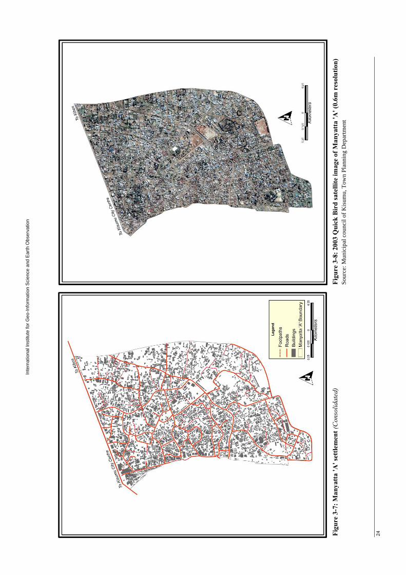
Inte
rnat
iona
l Ins
titut
e fo
r Geo
-Info
rmat
ion
Sci
ence
and
Ear
th O
bser
vatio
n
24
Figu
re 3
-7: M
anya
tta
'A' s
ettle
men
t (C
onso
lidat
ed)
Figu
re 3
-8: 2
003
Qui
ck B
ird
sate
llite
imag
e of
Man
yatt
a 'A
' (0.
6m r
esol
utio
n)
Sour
ce: M
unic
ipal
cou
ncil
of K
isum
u, T
own
Plan
ning
Dep
artm
ent
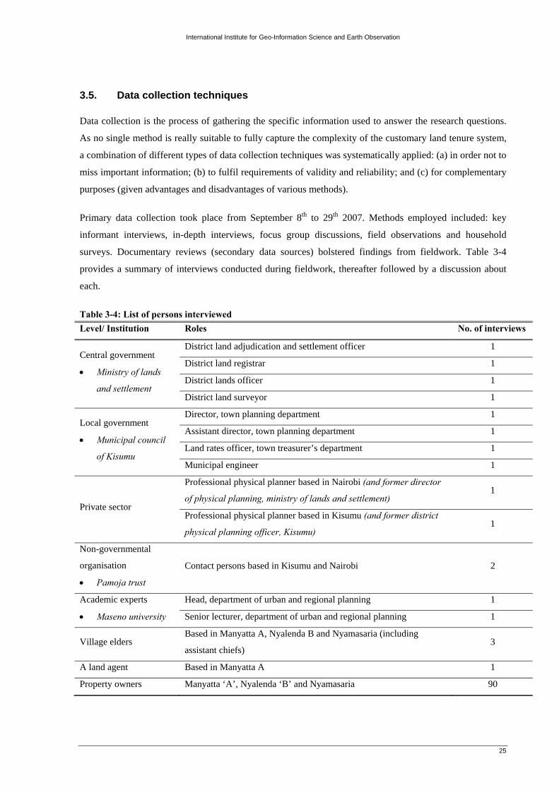
International Institute for Geo-Information Science and Earth Observation
25
3.5. Data collection techniques
Data collection is the process of gathering the specific information used to answer the research questions.
As no single method is really suitable to fully capture the complexity of the customary land tenure system,
a combination of different types of data collection techniques was systematically applied: (a) in order not to
miss important information; (b) to fulfil requirements of validity and reliability; and (c) for complementary
purposes (given advantages and disadvantages of various methods).
Primary data collection took place from September 8th to 29th 2007. Methods employed included: key
informant interviews, in-depth interviews, focus group discussions, field observations and household
surveys. Documentary reviews (secondary data sources) bolstered findings from fieldwork. Table 3-4
provides a summary of interviews conducted during fieldwork, thereafter followed by a discussion about
each.
Table 3-4: List of persons interviewed Level/ Institution Roles No. of interviews
Central government
• Ministry of lands
and settlement
District land adjudication and settlement officer 1
District land registrar 1
District lands officer 1
District land surveyor 1
Local government
• Municipal council
of Kisumu
Director, town planning department 1
Assistant director, town planning department 1
Land rates officer, town treasurer’s department 1
Municipal engineer 1
Private sector
Professional physical planner based in Nairobi (and former director
of physical planning, ministry of lands and settlement) 1
Professional physical planner based in Kisumu (and former district
physical planning officer, Kisumu) 1
Non-governmental
organisation
• Pamoja trust
Contact persons based in Kisumu and Nairobi 2
Academic experts
• Maseno university
Head, department of urban and regional planning 1
Senior lecturer, department of urban and regional planning 1
Village elders Based in Manyatta A, Nyalenda B and Nyamasaria (including
assistant chiefs) 3
A land agent Based in Manyatta A 1
Property owners Manyatta ‘A’, Nyalenda ‘B’ and Nyamasaria 90

International Institute for Geo-Information Science and Earth Observation
26
a) Key informant interviews
Key informants comprised of: relevant central government officials; local government officials at Kisumu
municipal council; private sector professionals involved in urban planning and management; a local NGO
active in upgrading of informal settlements in Kisumu; and urban planning and management professionals
at Maseno University. They were selected due to the presumption that they were considerably qualified to
provide answers to questions on state land policies in Kisumu’s context. Case study protocols were
developed to provide for a systematic process in the interviews. (See, appendix 3-1).
b) In-depth interviews
In depth interviews were carried out with informants purposively selected on the basis of their outstanding
knowledge of issues at stake. These included; a land agent based in Manyatta A settlement as well as a well
renowned customary land owning family residing in Manyatta A settlement. (See, appendix 3-2).
c) Focus group discussions
Focus group discussions with village elders were useful in validation of findings which were generated
much earlier in key informant interviews. Suitable venues within each settlement were identified for focus
group discussions. A total of three focus group discussions were conducted comprising of four to eight
persons. Recruitment of participants for each focus group discussion was facilitated by local assistant
chiefs. (See, appendix 3-3).
Figure 3-9: Focus group discussion session in Manyatta A Source: Field survey
d) Field observations
Field observations played a key role in data collection during the case study areas transect survey and
actual survey. To facilitate interpretation of observed features, the observations were aided by 2003 Quick
Bird satellite images of the case study settlements with 0.6 metre resolution. Where appropriate, the
observed phenomena were recorded by taking photographs and illustrations.
e) Household surveys
In order to collect quantitative data on the nature and dynamics of the customary land tenure system, it was
necessary to conduct a household survey on a selected number of households drawn from the study areas.
Such interviews employed structured questionnaires and targeted property owners.

International Institute for Geo-Information Science and Earth Observation
27
While undertaking socio-economic mapping survey in Kisumu’s informal settlements; commissioned by
UN-Habitat (2005), Pamoja Trust managed to assemble a comprehensive database comprising of several
variables: (a) land ownership details; (b) land use; (c) household characteristics; and (d) level of services,
amongst others. Since the database realized from this survey was made accessible to the researcher, the
household survey sought to supplement it, by focusing on issues not adequately addressed then. Survey
questions were generally of two types: open-ended and closed-ended. The complete questionnaire is
enclosed as appendix 3-4.
Household survey questionnaires were administered with the help of research assistants, who were directly
involved during the previous socio-economic mapping exercise. Interviewers were adequately trained in
administration of the household survey questionnaire prior to the exercise. By virtue of being natives of the
case study areas, interviewers were essential in delineation of case study area boundaries and provision of
feed-backs on questionnaire design. Small changes were made through the questionnaire; for instance,
translation to the local dialect, as well as rephrasing some of the questions before actual survey
commenced.
Sampling procedure for household survey
According to Reid (1987), sample size is determined by two factors; resources available for the study and
degree of precision required. The first factor predestines study duration and number of persons who can be
interviewed. The second is important since the greater the sample size, the more accurate will be the
estimated mean (Kumar, 2005).
A total of 90 respondents were interviewed, and these consisted of customary and private property owners.
To realize this, a spatial database obtained from Pamoja Trust was used in sample selection. At first
systematic sampling was used to obtain the required respondents. This was followed by simple random
sampling combined with purposive/ judgemental sampling; because of the inability of the systematic
sampling method to provide the targeted groups. Admittedly, the sample is quite small. However, it is
important to keep in mind that statistical rigour was not the main emphasis of the present study. The
approach employed is based on collecting facts and developing insights about the customary tenure system
through structured interviews, focus group discussions and field observation. Table 3-5 illustrates the
sampling frame for each
case study area.
Whereas, figure 3-10
depicts the sampling
procedure employed.
Table 3-5: Sampling frame for each case study area Source: Compiled from the Pamoja Trust socio-economic database, 2005
Nyamasaria (incipient)
Nyalenda ‘B’ (intermediate)
Manyatta ‘A’ (consolidated)
Total property owners (N) 113 4178 1091 Sampled property owners (n) 30 30 30

International Institute for Geo-Information Science and Earth Observation
28
Figure 3-10: Sampling procedure for household survey
Select by query case study areas and their respective property
owners’ details
Sampling frame - record of property owners (N)
Systematic random sampling Interval width = N/ n
Decide on sample size
(n=90)
Combination of simple random sampling and purposive/ judgemental sampling (customary and private property owners)
Socio-economic mapping database
Export the sample spreadsheet as a dBase
file and join the two attribute tables using plot
number as the primary field
Visualize the sampling distribution of the property owners in ArcGIS (shown on figure 3-11)
Questionnaire administration
Questionnaire checking and editing: • Completion of all sections • Answered by respondents
qualified for participation • Unsatisfactorily answered
questionnaires verified
Coding and data entry: • Sorting, categorizing and
assigning codes to each possible response for each question.
• Efforts made to retain as much detail as possible during data entry
Cleaning the data: • Consistency checks to identify
out of range values • Extreme values closely
examined
Data analysis

International Institute for Geo-Inform
ation Science and E
arth Observation
29
(a) Sampled property ow
ners in Nyam
asaria (incipient)
(b) Sampled property ow
ners in Nyalenda ‘B
’ (intermediate)

International Institute for Geo-Information Science and Earth Observation
30
(c) Sampled property owners in Manyatta ‘A’ (consolidated)
Figure 3-11: Spatial distribution of sampled property owners
3.6. Limitations of data collection
In view of the primary and secondary data that had to be collected, time allocated for the study was modest.
Considerable time was also spent in securing authorization for conducting fieldwork. This had a bearing on
the household interviews schedule. Therefore, in order to get enough information as possible within this
time, six interviewers residing in respective case study areas were recruited and adequately trained to help
in administering household survey questionnaires.
Some property owners resided in other formal areas of the city (absentee property owners). In such a
situation, we sampled the adjoining property and interviewed the owner. Moreover, several respondents
were impassive during household interviews, citing that they had witnessed similar kinds of studies in the
past but had realized no benefits from them. This trend necessitated the researcher to cross check responses
with results of the recently concluded socio-economic mapping data. Unsatisfactorily answered
questionnaires were verified with the help of village elders.

International Institute for Geo-Information Science and Earth Observation
31
At the time of undertaking this study, the district physical planning officer – a key informant – had just
been transferred. Understandably, the incoming district physical planning officer was not at ease in
addressing local issues as far as urban planning and management of Kisumu was concerned. In such a case
the researcher sought to interview a professional planner who had recently held the role of district physical
planning officer and was well versed with the local situation.
Inevitably, the sampling frame obtained from Pamoja Trust exhibited missing and duplicated entries. Thus,
in drawing the samples care was taken not to include deficient entries. Finally, I would also say that there is
a lack of relevant data in Kisumu, especially when one is looking at a problem that has not been given
much emphasis in the past.
3.7. Data analysis
Having established and justified the methodological framework and data collection techniques adopted for
conducting the present study, this final section describes the approach that was used to analyse the data
with regards to the research questions. Data analysis took place in two stages: within-case analysis and
cross-case analysis. Figure 3-12 illustrates the analytical approach for within-case and cross-case analysis.
Figure 3-12: Analytical approach for within-case and cross-case analysis Source: Adapted from Yin (2003) a) Within-case analysis
In within-case analysis; the findings in relation to the research sub-objectives for each single case were
explained using the process of data reduction, data display and drawing of conclusions and verifications
Case 1: Nyamasaria (Incipient phase)
Case 2: Nyalenda ‘B’ (Intermediate phase)
Case 3: Manyatta ‘A’ (Consolidated phase)
Findings of case 1 Findings of case 2 Findings of case 3
Introduction
Conclusion
Sub-objective 1 Sub-objective 2 Sub-objective 3
Main objective
Within-Case Analysis
Cross-Case Analysis

International Institute for Geo-Information Science and Earth Observation
32
(Miles and Huberman, 1994). The qualitative data analysis process began with the coding of collected data
into categories based on emerging themes and patterns (Figure 3-13). In addition, the findings of each case
study were comprehensively and individually presented, since each case study represented an independent
information rich experiment (Yin, 1994).
Illustrative quotations of the key informant interviews, in-depth interviews, and focus group discussions
were provided verbatim; not just to illustrate the theme being described and to support the findings of each
case, but to provide the voice and experience of the persons interviewed candidly.
Figure 3-13: The ladder of analytical abstraction Source: Adapted from Carney (1990) in Miles and Huberman (1994)
b) Cross-case analysis
As a final stage of data analysis, the findings of the within-case analysis; in the form of summary tables,
were used in performing the cross-case analysis. Cross-case analysis involved identifying and summarising
similarities and differences amongst the three cases in relation to the research sub-objectives. Thereafter,
the case findings were combined in an effort to address the main objective of the study.
3.8. Conclusion to the research methodology
This chapter describes various data gathering techniques and data analysis strategies utilized. Arguably, the
selected approach befits the study’s main objective; which is to investigate how the customary tenure
system in peri-urban Kisumu adapts and adjusts amidst rapid urbanization. Chapters five, six and seven are
devoted to the analysis of the case study data.
But first, before delving right into the analysis, chapter four considers the background to the study area,
next.
1) Summarizing and coding of data
2) Identifying themes, patterns and relationships in the data overall
3) Integrating the data into one explanatory framework

International Institute for Geo-Information Science and Earth Observation
33
4. Background to the study area
4.1. The city of Kisumu: changing physical development and urban growth
Kisumu, Kenya’s third largest urban
agglomeration is situated on the Kavirondo gulf;
an arm of Lake Victoria (figure 4-1). Kisumu’s
origin dates back to 1898, as a railway terminus.
In 1901, Port Florence; later re-named Kisumu
was established after the completion of the
Kenya-Uganda railway. In 1903, Kisumu was
gazetted as a township occupying an area of
about 4.025 km2. A grid structure largely
determined the shape of the colonial town (Figure
4-2 (a)). The development of the town between
1902 and 1914 was accelerated by development
of several stations along Kisumu and its
hinterland.
Figure 4-1: Location of Kisumu in the national context Source: University of Texas map collection, 2007
Between 1915 and 1930, Kisumu continued to grow within the grid structure and culture specific sector
frameworks as defined in the first period. This phase was conspicuously characterised by a more
concentrated development as opposed to the scattered and far-flung developments with enormous open
spaces in between (Figure 4-2 (b)). Additional development included a 1923 boundary amendment to
include the aerodrome areas which were later reverted to native reserve in 1930.
In 1930, the town boundary was reduced to make it more manageable (UN-Habitat, 2005). Land was
allocated along ethnic grounds; hence racial segregation divided the town and greatly influenced further
planning and policy (Figure 4-2 (c)). In 1941, Kisumu town was granted the status of a municipal board.
The urban structure and development in this period was characterized by demarcation of new outlying
areas. Colonial power relations became more pronounced and there was development of race specific
neighbourhoods and segregation on environmental health basis (Figure 4-2 (d)).

International Institute for Geo-Information Science and Earth Observation
34
(a) 1908 (b) 1910 - 1929
(c) 1930 – 1939 (d) 1940 - 1962 Figure 4-2: Kisumu urban structure changes Source: Municipal council of Kisumu, Town Planning Department

International Institute for Geo-Information Science and Earth Observation
35
In 1960, Kisumu was elevated from a municipal board to a municipal council. Notably, Kisumu was
witnessing increased development of villages which were growing in its periphery with particular focus to
Nyalenda and Manyatta (Mwamburi and Adolwa, 2006).
The UN-Habitat (ibid), notes that, in 1972, based on recommendations of the Ogutu commission in 1968,
the boundaries of Kisumu municipality were extended to include a total area of 53 km2. This process
caused the division of the town into two distinct land tenure zones, namely land under leasehold in the old
boundary, and land on freehold in the extensions. Up until 1972, when the boundary of the municipality
was extended, unplanned settlements fell under the jurisdiction of the Kisumu county council and the
district administration of the rural Kisumu district. This meant that any planning that was applied in this
peri-urban region was of rural type, and therefore was less demanding of developers and urban planning. In
2000, following the elevation of the town to city status, the municipal boundaries were further extended to
include approximately 65 percent of Kisumu district. At present, the city covers an area of 417 km2. (157
km2. of water and 260 km2 of land) and a population estimated at 500,000 people.
4.2. Existing land tenure systems
Kenya; like other sub-Saharan African countries, manifests a dual land tenure system, carried over from the
colonial era. Ng’ong’ola (1992) reports that, the bulk of the land falls within the category of ‘tribal land’;
predominantly held and occupied by indigenous people under customary notions of land tenure. The state
also holds as ‘state land’ a fairly significant proportion which fell under the category of ‘crown lands’
during the colonial era. A tiny proportion falls within the category of ‘freehold land’; predominantly held
and occupied in conformity with common law conceptions imported into African countries with colonial
rule. To some extent both state land and freehold land are held under or governed by ‘received law’, in
contrast to tribal land which is largely held under customary law.
Shipton (1984) and many others, have argued strenuously, that Kenya has had the most dramatic land
tenure reforms in Africa in recent decades. Way back in 1954, concerns over the modernization of
customary land tenure prompted the introduction and implementation of an ambitious customary land
adjudication, transformation and registration programme; which has since, profoundly altered the social
dimensions of land tenure.
A previous study in Kisumu by Olima and Obala (1998), established the existence of four distinct forms of
land tenure: (a) customary/ trust land, mainly found in the peri-urban areas which are still vested in the
hands of county councils; (b) private leasehold/ freehold land in the hands of individuals, companies and
corporations; (c) un-alienated public/ government land, referring to land where a government agency is the
owner. For instance, forest reserves and special areas such as parks, roadways, and public institutions; and
(d) non-formal de-facto tenure, referring to land acquired, occupied and used without permission from its
owner, whether by a public body or a private person. Figure 4-3 illustrates this.

International Institute for Geo-Information Science and Earth Observation
36
Figure 4-3: Distinct forms of land tenure in Kisumu municipality Source: Adapted from Olima and Obala (1998)
4.3. Adjudication of customary land rights
4.3.1. Introduction
Dale and McLaughlin (1988), define land adjudication as the process whereby existing rights in a
particular parcel of land are finally and authoritatively ascertained. The adjudication of land rights has been
identified as one of the key cadastral processes; the other being land transfer and mutation (sub-division
and consolidation) (UN-FIG, 1996; Williamson, 1997). These are considered vital in ensuring an efficient,
secure and effective land market.
As earlier mentioned, since attaining independence in 1963, the Government of Kenya has vigorously
implemented the land adjudication programme, which has seen more land been brought within the land
registration system, governed by the Registered Land Act (Cap 300) (see, appendix 4-1). The arguments
advanced in favour of the programme are many and varied. For instance, Coldham (1979), points out that,
at the very least, it is designed to put an end to boundary disputes, to make titles secure, and to introduce a
safe, simple and cheap system of conveyance (transfer of property title from one person to another). In
addition, it was anticipated that, this would encourage farmers to invest labour and profits in their holdings,
and enable them to offer registered titles as security for credit. For this reason, the process is sometimes
seen as the cornerstone of the government’s policy for rural development.
4.3.2. The land adjudication process in Kisumu
Table 4-1, outlines the adjudication procedure10 adopted in Kisumu, which is fairly typical of procedures
adopted elsewhere in Kenya.
10 Governed by the Land Adjudication Act (Cap 284)

International Institute for Geo-Information Science and Earth Observation
37
Table 4-1: Steps involved in the land adjudication process. Action Time
(weeks) Costs* (Kshs.)
1. Declaration of an adjudication area (sub-location) and appointment of
Adjudication Officer(s) by the Minister of Lands and Settlement.
-
2. The Adjudication Officer, after consulting the District Commissioner of the
district within which the adjudication section lies, appoints an adjudicating team.
In practice this team consists of the Demarcation Officer, the Survey Officer, the
Recording Officer, the Adjudication Committee chairman (usually the area chief
or assistant chief) and a handful of committee members residing in a particular
section.
-
3. The Adjudication Officer divides the adjudication area into sections, publishes
separate notices defining the limits of each section, and specifies the period
within which claims to interests in land within the section will be entertained.
From the date of notice, the powers of customary authorities over land cease.
-
4. The Demarcation Officer entertains claims to interests in land, ascertains the
boundaries thereof, plans a fresh layout, and re-arranges (consolidates) the
holdings accordingly.
-
5. The Survey Officer surveys all ascertained pieces and prepares a demarcation
map. Registry maps are then compiled. The registry map provides an index to the
land register, whereby the boundaries, location, and distinctive number of each
land parcel on the register can be ascertained. (See, appendix 4-2).
-
6. The Recording Officer prepares a record of existing rights for every parcel shown
on the demarcation map. The record contains the following:
a) Property section – showing the number and approximate area of the parcel;
b) Proprietorship section – the holder’s name, whose right is recognized as
ownership;
c) Encumbrance section – the designated land category and any conditions and
restrictions on the power of the holder to deal with the land or his interest, if
any;
d) The date on which it was completed.
72** -
6. Resolution of outstanding disputes by the Arbitration Committee. 32 300
7. Completion of the adjudication record, signified by signatures of the Recording
Officer and persons recorded as having an interest in private land.
-
8. The Adjudication Officer signs a certificate of completion and publishes a notice
indicating the place at which the record and map can be inspected.
12 -
9. Dissatisfied individuals lodge objections to the Adjudication Officer (in some
instances, beyond him, the Minister of Lands and Settlement); who determines
the objections ‘in any manner he thinks just’. After which the adjudication record
becomes final.
8 500

International Institute for Geo-Information Science and Earth Observation
38
10. The Adjudication Officer is obliged to sign a certificate to the effect and deliver
the record and demarcation map to the Land Registrar for preparation of land
registers and certificate of title.
2 -
11. When the land register is completed, the registered proprietor is vested with
‘absolute ownership’ (freehold tenure) of that land together with all rights and
privileges belonging or appurtenant thereto’
- 345
Total 12611 1, 145 * Minimum costs accruing to an individual landholder. Variations depend on whether one is aggrieved by the exercise or otherwise. ** Represents the sum for steps 1 to 6. Source: Compiled from discussion with the District Land Adjudication and Settlement Officer Although the procedure outlined appears to be straightforward, substantial difficulties may arise especially
in relation with the adjudication register preparation. In some sections, as pointed out by the District Land
Adjudication and Settlement Officer, the process is reported to have taken much longer. See, table 4-2.
Table 4-2: Status of land adjudication in the case study areas.
Adjudication section
(sub-location) Date declared Date registered Duration (yrs.) Area (Ha) No. of parcels
Manyatta ‘B’ 24/4/1978 31/12/1982 4.7 330 876
Manyatta ‘A’ 4/5/1978 1994 15.7 200 3,529
Nyalenda ‘A’ 14/6/1978 13/12/1982 4.5 280 1,300
Nyalenda ‘B’ 14/6/1978 13/12/1983 5.5 610 1,047
Kasule* 14/4/1979 1984 4.7 820 1,772
* Nyamasaria falls within this administrative area, occupying an area of approximately 54 Ha Source: Department of Land adjudication and Settlement, Ministry of Lands and Settlement – Kisumu. Delays in completion of the land adjudication process were mainly attributed to: (a) administrative and
technical bottlenecks; and (b) disputes stemming from boundaries and ownership of land between and
among family members. In some cases it appears that, not all villagers were present when the land
adjudication and registration process was underway. Upon returning to their respective settlements, the
villagers discovered that land which used to be theirs was now registered in someone else’s name; typically
that of a member of the extended family.
In accordance with the Land Adjudication Act (Cap 284), processing of title deeds cannot commence, until
the adjudication register is declared complete and final. Thus, all pending objection cases have to be
resolved by the respective arbitration boards. As elsewhere in Kenya, dispute resolution occurs at different
levels, typically starting within the family and then, if not resolved, proceeding to higher and higher
authorities (village elders, land adjudication committee and land arbitration board).
11 This is equivalent to 2.4 years.

International Institute for Geo-Information Science and Earth Observation
39
Mifsud (1967), points out that, several features of the Kenyan land adjudication process deserve notice, and
distinguish it from other processes of adjudication of customary land rights elsewhere in other former
British colonies (see, appendix 4-3): (a) the process is systematically applied area by area, and does not
give the landholder an option of whether to utilize the machinery provided by the law or not; (b) other than
provide for the clarification of existing rights, the land adjudication law, introduces the concept of
ownership and the purpose of the procedures it prescribes is the conversion of the old title into a new non-
customary one, defined in western legal terms; and (c) the adjudication committee determines the person
whose right, according to the native law and custom, is to be recognized as ownership; the adjudication,
however, turns out to be nothing else than a preliminary to reallocation, resettlement or consolidation – a
principal aim of the legislation being to deal with the problem of fragmentation of holdings.
4.3.3. Conclusion
The foregoing analysis aptly captures the Government of Kenya’s relentless efforts at the extinguishment
of customary tenure through systematic adjudication of customary land rights, registration of title, and its
replacement with a system similar to the English freehold. Despite all this, experience from Kenya; and to a
considerable extent as the fieldwork analysis reveals, customary land tenure systems have remained very
vibrant, adapting to changing conditions.
An insight into the nature and dynamics of customary landholding in the case study areas is presented,
next.

International Institute for Geo-Information Science and Earth Observation
40
5. The nature and dynamics of customary landholding
5.1. The evolution of customary tenure
This section considers two aspects of customary landholding: (a) land access; and (b) land rights. Land
access refers to the ease by which communities, households and individuals acquire land. On the other
hand, land rights refer to the rules, laws, policies and processes governing access (Owusu and Agyei,
2007). Land rights may be based on national legislation, on customary law or on combination of both
(Durand-Lasserve and Mattingly, 2004).
Ng’ong’ola (1982), citing Lord Lugard, posits that, customary land tenure in every society evolves from a
communal control stage, through a family control stage, to the stage of individual titles and land dealings,
as depicted in figure 5-1.
Figure 5-1: The evolution of customary land tenure Source: Adapted from Ngóngóla (1982)
5.1.1. Communal control stage
The main features of customary landholding during this stage were: (a) its collective aspect; (b) its
hierarchical character, according to which, rights at different levels were exercised over the same piece of
land by different persons; and (c) social identity, in the sense that, membership in a community qualified
access to land.
Okoth-Ogendo (2004), notes that, the amount of land held by community members then, was dependent on
their user needs. Thus, land was allocated on the basis of need. Within the native Luo community; like
many other descent-based systems in Kenya, the chief was the central figure around whom day to day life
revolved. The chief had the power to: (a) allocate and distribute land; (b) to regulate its actual use; and (c)
to resolve disputes. He could not alienate any part of tribal land to members of a different clan (non-
members) without the approval of his people.
Land was essentially categorized as residential and arable land. When the community originally moved to a
new settlement area, the chief was the first to select a site for communal meetings and his quarters. He then
proceeded to allocate land to the respective headmen, who after selecting their residential sites, in turn
proceeded to allocate portions to household heads. As far as possible every person was expected to build
and reside within his family group.
Communal control Family control Individual titles and land dealings

International Institute for Geo-Information Science and Earth Observation
41
After the allocation and distribution of residential land, arable land in the vicinity was identified and
distributed in a similar manner. At each stage, the allocation had to be sufficiently generous to allow for
future expansion. Here too, the expectation was that cultivation rights would be exercisable within the
locality assigned to the family. In the event that the land allocated to the family was inadequate or
otherwise unsuitable, cultivation rights could be sought elsewhere. Beyond the areas designated for
residence and cultivation, the rest of the territory became potential grazing land. All unallocated areas
remained under the control of the chief and was available for allocation to any other member of the
community. This ensured both inter- and intra-generational equity among members of the community who
were bound together through common descent.
Land rights of the community members, therefore, depended on the category of land and the use to which it
was put (see, table 5-1). Grazing rights were the least localized or particularized. Cultivation rights were
fairly exclusive and inheritable. On the other hand, rights to residential land were exclusive to the
respective household. Residential land was inheritable and could be transferred to other members of the
family group, but it was not readily transferred to non-members and it could not be sold. The rigid
insistence on family segregation militated against such transfers.
Table 5-1: Nature of land rights at the communal control stage
Property rights User Characteristic of property right
Exclusive Inheritable Transferable Security
Residential Member √ √ √ √
Non-member × × × ×
Cultivation Member √ √ √ √
Non-member × × × ×
Grazing Member × × × ×
Non-member × × × ×
*Where √ - implies existence of a property right and × - implies non-existence Community membership formed the basis for acquiring communal rights (usufruct rights) to land and loss
of membership entailed loss of those rights. For men, this was not a problem as they were more or less
assured of life membership in their communities. However, it was a major problem for women whose
access and use rights were pegged to their membership of communities through their relationships with
male members of those communities. When a woman got married, she lost membership in her birth
community and became a member of her marriage community; her membership, therefore, was pegged to
the sustainability of the marriage. She effectively lost the membership if her marriage collapsed, although
traditionally she would have been assured of access to land as long as she had borne male children.
At present, communal landholding does not exist in the case study areas. However, as one village elder
observed, communal landholding is restricted to farmlands in the rural interiors.

International Institute for Geo-Information Science and Earth Observation
42
5.1.2. Family control stage
Urbanisation and colonialism ushered in a situation where family interests in land gained prominence;
leading to a gradual transformation of land from communal into family landholding. At this stage, the
position of family heads as sources of land supply became more significant than that of clan heads or
village chiefs; although clan heads or village chiefs continued to exercise their mediating roles.
a) Land allocation to members of the indigenous land owning community
The typical native Luo household consisted of the head of the family, his wives, his unmarried children and
perhaps some other relatives. Each of his wives would be given her own plot of land to cultivate with the
help of her unmarried children. As soon as one of his daughters got married, she had to live on her
husband’s land. On the other hand, as soon as one of his sons was considered mature and married, he
would be allocated some land by his father. The boundary of the land allocated to him was demarcated by a
traditionally recognized plant; an indication to all indigenes that the land was now occupied. His land
usually comprised part of the land previously cultivated by his mother. It would lie to the front of his
father’s compound and he was expected to build and cultivate in much the same direction as his father
(Coldham, 1978). The ease of land access is attributed to the fact that, money never featured in this type of
allocation of land. The main principle was that no male member of the community was without land. The
land so given was inheritable down the family line.
With time, it became impossible to continue expanding in a certain direction, because, for instance, the
land adjacent was already occupied by a different household. Thus, it became necessary to move away and
resettle on vacant land nearby. Where this happened, members of different families and sub-clans became
scattered and fragmentation of landholdings was now inevitable. Several scholars point out that, it is this
increasing pressure on the land that brought the question of boundaries into prominence – which required
certain adaptations of the customary system of landholding. It is hardly surprising therefore, that in the later
colonial years, the natives were most receptive to the customary land tenure reform process.
b) Land allocation to members outside the indigenous land owning community
A cross-section of village elders interviewed held the view that, in the past, when the availability of land
was not a problem, a non-member of a particular community was considered for land allocation on two
accounts: (a) only after he had lived there peacefully for a reasonable length of time; and (b) identified with
the host community. However, in order to maintain the rights in the land, non-indigenes had to cultivate
(use) it continuously, and could not pass on these rights in inheritance without the host’s consent. This was
extremely precarious in the sense that his rights could never materialize into ownership, no matter how
long he had used and occupied the land – the only option then was to move away. See, table 5-2.

International Institute for Geo-Information Science and Earth Observation
43
Table 5-2: Nature of land rights at the family control stage
Property rights User Characteristic of property right
Exclusive Inheritable Transferable Security
Residential Member √ √ √ √
Non-member √ × × ×
Cultivation Member √ √ √ √
Non-member √ × × ×
Grazing Member √ √ √ √
Non-member × × × ×
*Where √ - implies existence of a property right and × - implies non-existence
5.1.3. Stage of individual titles and land dealings
This stage was marked by the presence of: (a) a high degree of population density; (b) the contraction in
supply of land in the urban centres; (c) frequent and increasing litigation in land matters, indicating
uncertainty in customary law; and (d) prevalence in land sales. The commodification of land and
individualization of titles to land provided the major turning point in this stage.
According to native custom, individual ownership is understood as the unrestrained and exclusive right of
the individual to use and dispose of the land. The existence of such a customary right in the case study
areas was confirmed and recognized by the village elders. The individual rights were manifested in several
ways, such as: (a) use rights, for instance building on the land, burying the dead, felling natural trees; (b)
transfer rights, that is selling the land (or part of it) to another person; and (c) exclusion rights, that is
keeping anyone else from the land in question (see, table 5-3). Notably, the village elders lamented that, the
absence of family or clan controls on the exercise of such individual rights (except possibly in the matter of
disposal on death) indicated the high degree of individualization that customary tenure had reached in the
study areas.
Table 5-3: Nature of land rights at the stage of individual titles and land dealings
Property rights User Characteristic of property right
Exclusive Inheritable Transferable Security
Residential Member √ √ √ √
Non-member √ √ √ √
Cultivation Member √ √ √ √
Non-member √ √ √ √
*Where √ - implies existence of a property right and × - implies non-existence Table 5-4, depicts the mode of land access per case study area. The period before 1963 (pre-independence)
represents the communal control stage. At this stage, the control over land was kept centralized in the
hands of communal leaders. The period 1963 to 1979 represents the family landholding stage. At this stage,

International Institute for Geo-Information Science and Earth Observation
44
0
2
4
6
8
10
12
14
16
Before 1963
1963 ‐1978
1979 ‐to date
Before 1963
1963 ‐1978
1979 ‐to date
Before 1963
1963 ‐1978
1979 ‐to date
Nyamasaria (incipient) Nyalenda 'B' (intermediate)
Manyatta 'A' (consolidated)
no. of sam
pled
prope
rty ow
ners
Case study area and Acquisition period
Purchased
Inherited
the government had embarked on the land adjudication programme12 which resulted in communal leaders
rapidly losing their control over land allocation. Lastly, the stage of individual titles and land dealings is
represented by the time period 1979 to date. At this stage, outright purchases of land were rapidly
becoming embedded in social relations. Most of the customary land rights were being transferred either to
new residents (non-indigenes) or to land speculators.
Table 5-4: Mode of land access per case study area and acquisition period
Nyamasaria Nyalenda ‘B’ Manyatta ‘A’ Before
1963
(n=12)
1963 –
1978
(n=10)
1979 – to
date
(n=8)
Before
1963
(n=6)
1963 –
1978
(n=11)
1979 – to
date
(n=13)
Before
1963
(n=10)
1963 –
1978
(n=6)
1979 – to
date
(n=14)
Inherited 91.7 80 37.5 83.3 36.4 23.1 90 50 7.1
Purchased 8.3 20 62.5 16.7 63.6 76.9 10 50 92.9
Total (%) 100 100 100 100 100 100 100 100 100
*inherited implies land that is still held under the customary tenure system
**purchased implies land that is individually owned and not anymore under the customary tenure system
Source: Compiled from the household survey
*inherited implies land that is still held under the customary tenure system
**purchased implies land that is individually owned and not anymore under the customary tenure system
Figure 5-2: Mode of land access per case study area and acquisition period Source: Compiled from the household survey
12 Coldham (1979) argues that, registered land owners regarded the land adjudication programme as simply a means of
securing boundaries and putting an end to the sort of disputes that formerly prevailed in many areas.

International Institute for Geo-Information Science and Earth Observation
45
Figure 5-2, indicates that a relationship exists between the source of land and acquisition period. The
inference to be drawn is clear; the concept of individualization of customary land is highly established in
Manyatta ‘A’ and Nyalenda ‘B’. Outright sales of land in these settlements have increasingly become
common, while the power of the traditional authorities to control such sales has withered away. In
Nyamasaria, the emergence of a market in land was a fairly recent development. Migrants drawn from the
neighbouring towns such as Kisii have been rapidly acquiring land in this settlement. The migrant
respondents here commonly held the view that, it was still recommendable for aspiring property owners to
ensure the involvement of the assistant chief and village elders’ in any land deals: “The local leaders’
awareness of, who owns what locally strengthens our (the migrant’s) position in this settlement. Besides,
their testimonies have always proved useful in settling land disputes”.
But when migrants from Manyatta ‘A’ and Nyalenda ‘B’ were asked whether they accepted customary
authority, they responded in the negative. A lot of them asked the researcher why such a question was put
to them. Individual households in these settlements operated independently from communal control as far
as urban land development was concerned. Durand-Lasserve and Mattingly (2003), corroborate this view
by observing that as soon as customary land is subject to a monetary transaction, it enters within neo-
customary logic.
Customary tenure individualization process: the case of Osawo13
My grandfather - the late Mzee Osawo was among the first people to settle in Manyatta ‘A’. This was in
the year 1890. In 1901, when the Kenya-Uganda railway line was completed, Mzee Osawo became the first
African to be recruited by Kenya Railways. You see, my grandfather was a well respected man in this
settlement. When it came to land, he owned a lot of it.....about 25 acres to be precise. Things apparently
went on well until during the land adjudication process in the 1960s. A large chunk of Mzee Osawo’s land
was lost at this time when government officials unfairly allocated it for public use. You see, all this land
where Manyatta primary school, Kosawo primary school, the assistant chief’s office, and Kosawo
community hall are currently located belonged to my grandfather.
However, not all land was taken by the government. There was also time when our fathers (Osawo’s sons)
began sub-dividing and selling our ancestral land to other people. What you see now is the only remaining
piece of land belonging to Osawo – just 1 acre (see, figure 5-3). Up to date, people still come around
inquiring whether we would be willing to offer our land for sale. It is so annoying...There is no land for
sale here anymore – that’s the reason why we put this sign on that tree (see, figure 5-4). You see our
ancestral land has been sub-divided to such an extent that it can no longer provide a reasonable living to
the respective patrilineal heirs and their families. Our grandfather was buried here, and so we as his
grandchildren (4 sons and their respective families) feel obliged to preserve the remaining ancestral land
in his honour.
13 Compiled from in-depth discussion held with Mzee Osawo’s grandson

Inte
rnat
iona
l Ins
titut
e fo
r Geo
-Info
rmat
ion
Sci
ence
and
Ear
th O
bser
vatio
n
46
(a)
orig
inal
anc
estra
l lan
d at
t1 (1
890)
(b
) an
cest
ral l
and
at t2
(196
0s)
(c)
ance
stra
l lan
d at
t3 (2
007)
*bui
ldin
g fo
otpr
ints
ext
ract
ed fr
om th
e 20
03 q
uick
bird
sate
llite
imag
e (0
.6m
reso
lutio
n)
Figu
re 5
-3: C
usto
mar
y te
nure
indi
vidu
aliz
atio
n pr
oces
s So
urce
: Com
pile
d fr
om in
-dep
th d
iscu
ssio
n he
ld w
ith M
zee
Osa
wo’
s gra
ndso
n an
d M
anya
tta ‘A
’ vill
age
elde
rs

International Institute for Geo-Information Science and Earth Observation
47
This case provides a vivid example of how, with time
customary interests in land yield to the power of the
urban land market. The findings corroborate Amanor’s
(2006) view that, due to increasing commodification of
customary land rights, inheritance rights over land
under customary tenure regimes are no longer
guaranteed as many people belonging to customary
land owning families are left to compete for less land.
Figure 5-4: Land sale caution notice Source: Field survey
5.2. Concluding remarks
The findings reported in this chapter indicate a progressive shift from communal to individual
landownership and related rights to land in the case study areas. Despite the fact that, the power of the
traditional authorities to control land dealings is gradually disappearing, the survival of other aspects of
customary land tenure are still evident. To appreciate this we need to look at the existing land markets in
peri-urban Kisumu, next.

International Institute for Geo-Information Science and Earth Observation
48
6. Existing land markets in peri-urban Kisumu This section examines the structure and operation of the land markets in the case study areas.
6.1. Structure of the land market
Svivam (2002), defines the land market as the institution that deals with the transfer of ownership rights
concerning land. Thus, land markets are driven by both demand14 and supply15 factors (Farvacque et al.,
1992). According to the district lands officer, land markets in Kenya and particular in Kisumu, tend to
manifest a dual-type structure; that is formal and informal.
Under the formal land market, the state and local government supplies land for urban development through:
(a) formal allocation systems namely the lottery system, direct application and administrative approval, and
reservations; (b) compulsory acquisition of agricultural land from private property owners; and (c) formal
land purchase.
On the other hand, under the informal land market, land for urban development is mainly supplied by: (a)
customary actors such as clan heads, family heads, relatives; and (b) neo-customary actors who are mainly
individuals, land speculators and land agents/ brokers who had previously acquired land directly from
customary property owners. This by far was the most widespread means of access to land in the case study
areas.
6.2. Operation of the formal land market
Field observations indicated that the role of the formal land market in the case study areas was quite limited
partly due to its inefficiencies. However, it is interesting to note how it operates.
6.2.1. Formal allocation systems
a) The lottery system
This system was used before the 1980s to allocate land to individuals for residential purposes; and has been
accredited with a number of settlement schemes. When and if land was available for allocation, access to it
was through a number of steps, as documented in table 6-1.
Table 6-1: Typical steps followed when land for allocation is available in urban areas
Action Time*
1. Director of Physical Planning prepares a development plan or part development plan showing
various land uses (such as industrial, residential, commercial, educational, e.t.c.) 6**
2. Valuation of the plots to establish their market value by the Chief Valuer 1
14 Determined by demographic pressure, household income, cultural/ social factors, and economic factors (such as the capacity for mobilizing household savings and access to credit) 15 Determined by topography and physical conditions, patterns of land ownership, availability of infrastructure, and government regulations

International Institute for Geo-Information Science and Earth Observation
49
3.
The Commissioner of Lands advertises available plots in the Kenya Gazette16. The
requirements of the advertisement include closing date and place where application forms can
be obtained at a non- refundable fee
1
4. Interested individuals collection and fill in application forms from the respective local
authorities 1
5. Submission of completed applications and payment of a refundable deposit -
6. Recording and listing of all applications received before the closing date 3
7. Consideration of applications by the respective DPAC17 and actual balloting for allocation 1
8. Successful applicants are notified to the Commissioner of Lands 1
9. The Commissioner of Lands issues letters of allotment to the beneficiaries, normally with
some development conditions attached indicating terms and conditions of allocation 1
10. Payment of stamp duty and other fees (such as ground rent, road charges e.t.c.) -
11. The Director of Surveys initiates the plot survey, deed plan preparation and approval process 24
12. Preparation of the certificate of title and submission to Commissioner of Lands for signing
and sealing 12
13. Registration of certificate of title by the Chief Land Registrar 6
14. Notification of owner to collect certificate of title 1
Total 58
*time in months **3 months for plan preparation and 3 months for plan inspection Source: Ministry of Lands (2005) Clearly, close to five years elapsed between the availability of land for allocation and the issuance of the
certificate of title. Other than, the cumbersome and time consuming nature of this system, Musyoka (2004),
also noted the following shortcomings: (a) publicity on available public land for allocation was inadequate;
(b) high poverty and illiteracy levels excluded others from being reached; and (c) often plots for allocation
were hardly advertised, raising doubts about transparency of the process. After the 1980s, this system was
abandoned in favour of other approaches (Ministry of Lands, 2005).
b) Direct application and administrative approval system
This system was commonly used in the late 1980s and 1990s. Under it, an applicant applied directly to the
Commissioner of Lands (or a county council). The successful applicant received a letter of allotment;
which was a non-negotiable offer by the state or the county council, to take a leasehold interest in certain
land. Within 30 days after receiving the letter, the individual was required to pay the standing premium;
which was about 20 percent of the market value of the plot and other associated costs. Failure to do so
16 In the absence of advertised plots individuals may still apply to the chairman of the District Plot Allocation Committee (DPAC); which comprises of the District Physical Planner (DPPO), District Land Officer (DLO), District Land Registrar (DLR), District Surveyor (DSO) and the Town Clerk. 17 The DPAC has to verify with the respective DLO and DPPO whether the land applied for is available and whether it is government or trust land according to the official records.

International Institute for Geo-Information Science and Earth Observation
50
resulted in a lapse of the offer (Ministry of Lands, 2005). Unfortunately, this system was prone to the
following limitations: (a) plots were allocated without necessarily being advertised as required by law; (b)
applications were screened and approved without a clearly established set of criteria and procedures; and
(c) whoever needed a plot could apply, hence making it difficult to distinguish between a genuine
developer and a land speculator.
c) Reservations
Mainly entails the direct allocation of government or trust land to public agencies by the Commissioner of
Lands. In Kisumu, this is limited to railway and road reserves.
6.2.2. Compulsory acquisition
The Land Acquisition Act (Cap 295) empowers the government to acquire privately owned land for public
purposes such as for development of schools, health facilities or open spaces. First, the land is valued by
the chief valuer, and then the affected owners are compensated by the government at the market rate.
Inevitably, this process also has had its fair share of setbacks such as: (a) lack of funds for compensation;
(b) political interference; and (c) fierce and protracted wrangling over amounts of compensation.
6.2.3. Formal land purchase
Unlike the formal allocation system, formal land purchase is not cumbersome and time consuming; since
all the necessary documents are ready at the time of transaction. The process starts when the vendor (seller)
and purchaser (buyer) enter into a legally binding sale agreement before a lawyer. Both parties usually
bear the transaction costs involved; a lawyer’s fee and transfer fee payable to the Commissioner of Lands.
Once the purchaser has paid the negotiated price, the plot is registered and transferred in the land registry.
Figure 6-1 illustrates a sample sale agreement. However, empirical evidence from studies carried out in
other Kenyan towns, strongly suggest that, those who have access to land in the formal market are
individuals with formal and reliable sources of income.
REPUBLIC OF KENYA SALE AGREEMENT*
AN AGREEMENT made on [date] BETWEEN [name] of [I.D. number] and of [sub-location] within [district] of
the Republic of Kenya (hereinafter referred to as the “Vendor” which expression shall where the context so admits
include his heirs, personal representatives assigns and successors in title) on the first part AND [name] of [I.D.
number] and of [sub-location] within [district] of the Republic of Kenya (hereinafter referred to as the “Purchaser”
which expression shall where the context so admits include his heirs, personal representatives assigns and successors
in title) of the second part.
W H E R E A S
1) The Vendor is the owner of all that piece of unregistered land situated in [sub-location] within [district] and
bordering.......................... road on the right and containing by measurement [plot area in Hectares] or
thereabouts (hereinafter referred to as “the Plot”) more particularly described on the annexed plan herein;
and

International Institute for Geo-Information Science and Earth Observation
51
0% 20% 40% 60% 80% 100%
Nyamasaria (incipient)
Nyalenda 'B' (intermediate)
Manyatta 'A' (consolidated)
Customary Neo‐customary Government
2) The said Vendor having sold the said plot to the Purchaser in the [year] for a consideration of Kenya shillings
[amount] only now past paid; and
NOW THIS AGREEEMNT WITNESSES as follows:
In pursuance of the aforesaid and in consideration of the sum of Kenya Shillings [amount] paid by the purchaser to the
vendor before execution hereof in the [year] – now past (receipt whereof the vendor hereby acknowledges), the
Vendor hereby AGREES TO TRANSFER ALL his right title and interest in the said property to the purchaser.
* Information pertaining to this particular sale agreement has been withheld to protect the identity of the parties involved Figure 6-1: Sample sale agreement Source: Department of Lands – Ministry of Lands and Settlement, Kisumu
6.3. Operation of the informal land market
As already indicated above, informal land transactions are by far the most widespread means of access to
land in the case study areas. The reasons for informality, according to the district lands officer were: (a) the
lack of title deed certificates – “most households in the peri-urban areas do not have their title deeds, but
they do have the registration numbers that were issued when land registration first took place in the
1960s”; and (b) the parties involved
opt for informal transactions so that
they do not have to pay taxes (stamp
duty18) for land transfers. Table 6-2
shows the channels of land access in
the case study areas.
Table 6-2: Channels of land access per case study area Source: Compiled from the Pamoja Trust socio-economic survey
Figure 6-2: Channels of land access per case study area Source: Compiled from the Pamoja Trust socio-economic survey
18 This is the fee for administrative procedures applied for each land transaction
Nyamasaria (n=113)
Nyalenda ‘B’ (n=4178)
Manyatta ‘A’ (n=1091)
Customary 29.2 26.7 14.2 Neo-customary 70.8 73.3 85.2
Government 0 0 0.6 Total (%) 100 100 100

International Institute for Geo-Information Science and Earth Observation
52
The Pamoja Trust socio-economic survey database indicates that 29 percent of the sampled properties in
Nyamasaria were sourced from customary actors through inheritance, whereas 71 percent were sourced
through neo-customary actors. Focus group discussants drawn from Nyamasaria recounted that: “due to the
expansion of the city boundaries in the recent past, land sales had become an extremely profitable income-
generating activity. Individuals (land speculators), mostly outsiders managed to obtain land from
customary sources, sub-divide it and then resold it instead of developing it.”
Out of the sampled properties in Nyalenda ‘B’ settlement, 73 percent had been sourced through land
agents/ brokers. Land agents/ brokers were private individuals who sourced and kept records of land
available for sale. They advertised themselves informally, and when they got clients they introduced them
to the property owners where transactions were concluded and they got their commission. Field
observations indicated that, due to the fear of infuriating traditional landowning individuals (who neither
supported nor encouraged the sale of land by their own people to outsiders), the day to day operations of
land agents/ brokers in this settlement were carried out undercover. Those who benefited from customary
land inheritance in this settlement accounted for the remaining 27 percent. The following statement by a
village elder aptly illustrates the attachment of the locals towards the customary inheritance practice:
“Land shortage encourages sons to stay, after marriage, on or near the land of their fathers. Staying on
and inheriting part of a paternal holding has always been viewed as a much easier way of obtaining land.”
In Manyatta ‘A’; the consolidated case, the database indicates that, 86 percent of the sampled properties
were accessed through land agents/ brokers. It is interesting to note that, their operations were quite
different from their Nyalenda ‘B’ counterparts in that they operated from designated points (rented
premises); a clear indication of the confidence and recognition they enjoyed at the neighbourhood level.
Focus group discussants drawn from this settlement confirmed that land agents/ brokers played an integral
part in the settlement’s land market chain. Local property owners often involved them in land transactions.
Discussion with one land agent based in this settlement yielded that: “On a good day, about ten people
would visit our office to inquire about local real estate.” Land agents received a commission in
transactions concluded with their assistance. There was no fixed commission value as it all depended on
whether the property at stake was situated in an attractive location and whether it had the appropriate paper
work (for instance, a land title deed and certificate of payment of rates and other charges – see, appendix 6-
1).
The socio-economic database indicates that 14 percent of the properties in this settlement were acquired
through customary actors. However it should be noted that this was an outcome of inheritance practices in
the last decades. The focus group discussion with the village elders and the local assistant chief attributed
the weakening of the customary tenure system to the socio-economic changes taking place in the
settlement.

International Institute for Geo-Information Science and Earth Observation
53
Public land, under government ownership accounts for less than 1 percent of property in Manyatta ‘A’.
This comprises of four major markets, a community hall and two primary schools in the area.
The next sub-sections take an incisive look at the customary and neo-customary land markets and their
operation.
6.3.1. Customary land markets
As shown above, customary actors accounted for 29 percent, 27 percent and 14 percent of the land market
in Nyamasaria, Nyalenda ‘B’ and Manyatta ‘A’ settlements respectively. However, it is very likely that
these may not have been market transactions in the real sense; because traditionally land transactions of all
sorts were strictly controlled. According to the older community members interviewed, “Ancestral land
was usually sub-divided and shared amongst sons from generation to generation. Land was the most
important asset; land supported a wide network of kinship relationships and functioned as a status symbol.
Selling it was considered equivalent to selling one’s life.”
The colonial and post-colonial period, however, severely distorted the local checks and balances and
accountability structures of the customary tenure system. Gradually, land sales gained prominence with the
approval of the clan. The buyer’s identity would be most important in the decision to allow a sale, as
outsiders in particular were typically forbidden or at least frowned upon. This partly explains why at first
most sales were to close family relatives.
The expansion of Kisumu’s urban area and growth of peri-urban areas over time, has transformed what
were initially customary-owned agricultural farms into peri-urban residential areas. According to the
younger community members interviewed, “The little effective customary control over land sales has been
diminishing. Nowadays, a buyer’s origin is of little importance. Besides, selling land to outsiders brought
development and availability of social services in the area.” This difference of mindset reflects the gradual
decline over time in the extent to which customary norms govern land transactions.
The study findings revealed that, the sale of customary land was motivated by emergency situations
(distress sales), such as: (a) payment for children’s education; (b) meeting unexpected medical expenses in
the absence of alternative income sources; and (c) family land disputes. Market forces, rather than social
considerations usually determined the selling price in transactions involving outsiders.
6.3.2. Neo-customary land markets
In the case study areas, neo-customary land markets usually operate within a monetary and commercial
framework; which was totally foreign to the customary land norms. In principle, the land control board19;
19 Established by the Land Control Act (Cap 302); it stemmed from the desire to protect citizens from the potential threats of the system of formal land registration introduced by the colonial government. It was felt that formal legal rules should not be the only determinant of how the land market should operate. LCBs were expected to continue to uphold customary norms relating to land ownership where it was judged that they were appropriate.
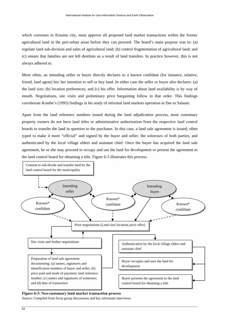
International Institute for Geo-Information Science and Earth Observation
54
which convenes in Kisumu city, must approve all proposed land market transactions within the former
agricultural land in the peri-urban areas before they can proceed. The board’s main purpose was to: (a)
regulate land sub-division and sales of agricultural land; (b) control fragmentation of agricultural land; and
(c) ensure that families are not left destitute as a result of land transfers. In practice however, this is not
always adhered to.
More often, an intending seller or buyer directly declares to a known confidant (for instance, relative,
friend, land agent) his/ her intention to sell or buy land. In either case the seller or buyer also declares: (a)
the land size; (b) location preferences; and (c) his offer. Information about land availability is by way of
mouth. Negotiations, site visits and preliminary price bargaining follow in that order. This findings
corroborate Kombe’s (1995) findings in his study of informal land markets operation in Dar es Salaam.
Apart from the land reference numbers issued during the land adjudication process, most customary
property owners do not have land titles or administrative authorisation from the respective land control
boards to transfer the land in question to the purchaser. In this case, a land sale agreement is issued; often
typed to make it more “official” and signed by the buyer and seller, the witnesses of both parties, and
authenticated by the local village elders and assistant chief. Once the buyer has acquired the land sale
agreement, he or she may proceed to occupy and use the land for development or present the agreement to
the land control board for obtaining a title. Figure 6-3 illustrates this process.
Figure 6-3: Neo-customary land market transaction process Source: Compiled from focus group discussions and key informant interviews
Intending seller
Intending buyer
Known* confidant
Prior negotiations (Land size| location| price offer)
Site visits and further negotiations
Preparation of land sale agreement documenting: (a) names, signatures and identification numbers of buyer and seller; (b) price paid and mode of payment; land reference number; (c) names and signatures of witnesses; and (d) date of transaction
Authentication by the local village elders and assistant chief
Consent to sub-divide and transfer land by the land control board for the municipality
Known* confidant
Known* confidant
Buyer occupies and uses the land for development
Buyer presents the agreement to the land control board for obtaining a title

International Institute for Geo-Information Science and Earth Observation
55
Table 6-3 summarizes actors and roles they played in the informal land market chain.
Table 6-3: Actors and roles played in the informal land market Actors Roles/ motivation Customary property
owners • Land suppliers (distress sales)
Land buyers (land
speculators)
• Buy undeveloped customary land and hold it without making improvements,
hoping to resale it at a much higher price in future
• Desire to own land
Land agents/ brokers • Source and keep records of land available for sale at a commission
• Acts as one of the witnesses where a deal is concluded
Village elders
• Acts as one of the witnesses where a deal is concluded for a fee (‘token of
appreciation’)
• Arbitration in case of land disputes
Assistant chief • Preparation of a letter of claim which authenticates (formalises) the new
ownership of land for a fee (‘token of appreciation’)
Neighbours • Witnesses to the land transactions
Land control board
• Approve all land market transactions within the former agricultural land in
the extended (peri-urban) municipal areas
• Processing of the land title deeds
Source: Compiled from focus group discussions and key informant interviews
6.3.3. Characteristics of the informal land markets
a) Ease of land access
On the basis of fieldwork, neo-customary actors provided the bulk of land in the case study areas. Table 6-
4 shows the time taken (in weeks) to conclude a land transaction (from land seeking to actual land
occupation) by property owners who had acquired land through the neo-customary actors. The length of
time taken to acquire land in the case study areas is determined by: (a) the price of land; (b) the mode of
payment; and (c) other factors such as land disputes and land availability. Thus, it took less time to acquire
land in Nyamasaria (2.4 weeks) than
Nyalenda ‘B’ (3.6 weeks) and Manyatta ‘A’
(3.7 weeks).
Table 6-4: Time taken (weeks) to conclude land transactions
Source: Compiled from the household survey To ascertain whether the time taken in weeks to conclude land transactions (dependent variable) differs
significantly between the case study areas (independent variables), a one way independent ANOVA test
would be beneficial.
Nyamasaria (n=8)
Nyalenda ‘B’ (n=18)
Manyatta ‘A’ (n=20)
Mean 2.38 3.56 3.7 Std. dev. 1.302 1.723 1.418

International Institute for Geo-Information Science and Earth Observation
56
Descriptives
length of land acquisition (weeks)
8 2.38 1.302 .460 1.29 3.46 1 418 3.56 1.723 .406 2.70 4.41 1 620 3.70 1.418 .317 3.04 4.36 1 646 3.41 1.572 .232 2.95 3.88 1 6
NyamasariaNyalenda_BManyatta_ATotal
N Mean Std. Deviation Std. Error Lower Bound Upper Bound
95% Confidence Interval forMean
Minimum Maximum
Test of Homogeneity of Variances
length of land acquisition (weeks)
1.326 2 43 .276
LeveneStatistic df1 df2 Sig.
Null hypothesis H0: there is no significant difference between the land transaction times for the case study areas.
(µ1 =µ2 = µ3) and Alternative hypothesis H1: there is a significant difference between the land transaction times
for the case study areas. (µ1 ≠µ2 ≠ µ3)
Where µ1 = population mean for Nyamasaria; µ2 = population mean for Nyalenda ‘B’; and µ3 =
population mean for Manyatta ‘A’
α = .05
*If these bars overlap, then we don’t expect
to find significant differences in land
transaction time (because it indicates that the
population mean across samples are likely to
lie within the same limits).
For this data Levene’s test has come out as highly insignificant (because pc = .276 which is greater than pα =
.05). The assumption of homogeneity of variance has been broken. This indicates that there is no significant
difference in land acquisition times between the three case study areas (µ1 =µ2 = µ3).

International Institute for Geo-Information Science and Earth Observation
57
ANOVA
length of land acquisition (weeks)
10.633 2 5.316 2.274 .115100.519 43 2.338111.152 45
Between GroupsWithin GroupsTotal
Sum ofSquares df Mean Square F Sig.
Robust Tests of Equality of Means
length of land acquisition (weeks)
2.886 2 20.684 .0782.448 2 34.917 .101
WelchBrown-Forsythe
Statistica df1 df2 Sig.
Asymptotically F distributed.a.
Multiple Comparisons
Dependent Variable: length of land acquisition (weeks)Bonferroni
-1.181 .650 .229 -2.80 .44-1.325 .640 .133 -2.92 .271.181 .650 .229 -.44 2.80-.144 .497 1.000 -1.38 1.091.325 .640 .133 -.27 2.92.144 .497 1.000 -1.09 1.38
(J) case study areaNyalenda_BManyatta_ANyamasariaManyatta_ANyamasariaNyalenda_B
(I) case study areaNyamasaria
Nyalenda_B
Manyatta_A
MeanDifference
(I-J) Std. Error Sig. Lower Bound Upper Bound95% Confidence Interval
There was no significant difference in land acquisition times in the case study areas; F (2, 43) = 2.274, p > .05.
However, we saw earlier that the assumption of homogeneity of variance was broken. Therefore we shall inspect
the Welch and Brown-Forsythe versions of the F-ratio. Both test statistics are still insignificant (the value of sig.
in the table is greater than .05). Therefore we can say that there is no significant difference in land acquisition
times in the case study areas.
Welch F-ratio; F (2, 20.684) = .078, p > .05
Brown-Forsythe F-ratio; F (2, 34.917) = .101, p > .05
However to find out where the differences between the three case study areas lie, further comparisons were
carried out using post hoc tests20. In this case Bonferroni’s test was employed. According to Field (2005) the test
has more statistical power when the number of comparisons is small. The results are as follows.
It is clear from these significance values that the groups in subsets have non-significant means as indicated by
values of sig. that are greater than .05. Thus we accept the null hypothesis H0: there is no significant difference
between the land transaction times for the case study areas. (µ1 =µ2 = µ3).
20 Post hoc tests are used if three or more means were compared
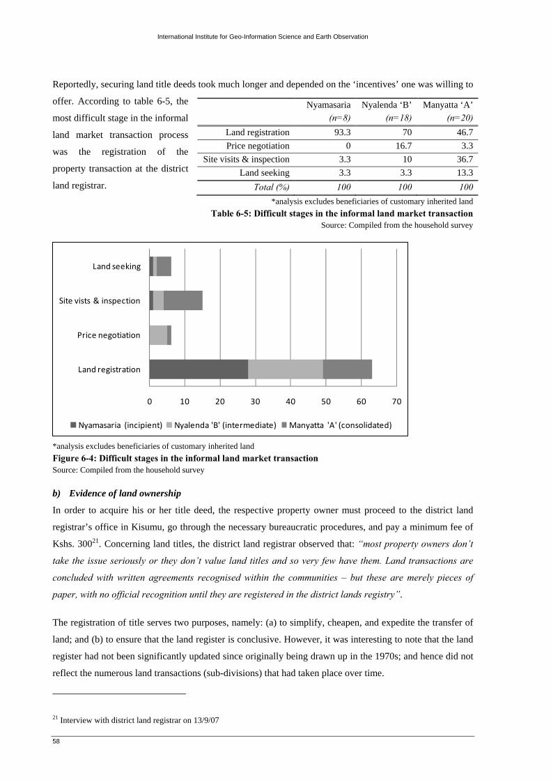
International Institute for Geo-Information Science and Earth Observation
58
0 10 20 30 40 50 60 70
Land registration
Price negotiation
Site vists & inspection
Land seeking
Nyamasaria (incipient) Nyalenda 'B' (intermediate) Manyatta 'A' (consolidated)
Reportedly, securing land title deeds took much longer and depended on the ‘incentives’ one was willing to
offer. According to table 6-5, the
most difficult stage in the informal
land market transaction process
was the registration of the
property transaction at the district
land registrar. *analysis excludes beneficiaries of customary inherited land
Table 6-5: Difficult stages in the informal land market transaction Source: Compiled from the household survey
*analysis excludes beneficiaries of customary inherited land Figure 6-4: Difficult stages in the informal land market transaction Source: Compiled from the household survey b) Evidence of land ownership
In order to acquire his or her title deed, the respective property owner must proceed to the district land
registrar’s office in Kisumu, go through the necessary bureaucratic procedures, and pay a minimum fee of
Kshs. 30021. Concerning land titles, the district land registrar observed that: “most property owners don’t
take the issue seriously or they don’t value land titles and so very few have them. Land transactions are
concluded with written agreements recognised within the communities – but these are merely pieces of
paper, with no official recognition until they are registered in the district lands registry”.
The registration of title serves two purposes, namely: (a) to simplify, cheapen, and expedite the transfer of
land; and (b) to ensure that the land register is conclusive. However, it was interesting to note that the land
register had not been significantly updated since originally being drawn up in the 1970s; and hence did not
reflect the numerous land transactions (sub-divisions) that had taken place over time.
21 Interview with district land registrar on 13/9/07
Nyamasaria (n=8)
Nyalenda ‘B’ (n=18)
Manyatta ‘A’ (n=20)
Land registration 93.3 70 46.7 Price negotiation 0 16.7 3.3
Site visits & inspection 3.3 10 36.7 Land seeking 3.3 3.3 13.3
Total (%) 100 100 100
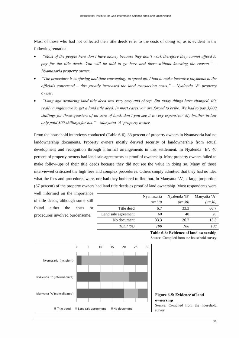
International Institute for Geo-Information Science and Earth Observation
59
0 5 10 15 20 25 30
Nyamasaria (incipient)
Nyalenda 'B' (intermediate)
Manyatta 'A' (consolidated)
Title deed Land sale agreement No document
Most of those who had not collected their title deeds refer to the costs of doing so, as is evident in the
following remarks:
• “Most of the people here don’t have money because they don’t work therefore they cannot afford to
pay for the title deeds. You will be told to go here and there without knowing the reason.” –
Nyamasaria property owner.
• “The procedure is confusing and time consuming; to speed up, I had to make incentive payments to the
officials concerned – this greatly increased the land transaction costs.” – Nyalenda ‘B’ property
owner.
• “Long ago acquiring land title deed was very easy and cheap. But today things have changed. It’s
really a nightmare to get a land title deed. In most cases you are forced to bribe. We had to pay 3,000
shillings for three-quarters of an acre of land; don’t you see it is very expensive? My brother-in-law
only paid 300 shillings for his.” – Manyatta ‘A’ property owner.
From the household interviews conducted (Table 6-6), 33 percent of property owners in Nyamasaria had no
landownership documents. Property owners mostly derived security of landownership from actual
development and recognition through informal arrangements in this settlement. In Nyalenda ‘B’, 40
percent of property owners had land sale agreements as proof of ownership. Most property owners failed to
make follow-ups of their title deeds because they did not see the value in doing so. Many of those
interviewed criticized the high fees and complex procedures. Others simply admitted that they had no idea
what the fees and procedures were, nor had they bothered to find out. In Manyatta ‘A’, a large proportion
(67 percent) of the property owners had land title deeds as proof of land ownership. Most respondents were
well informed on the importance
of title deeds, although some still
found either the costs or
procedures involved burdensome.
Table 6-6: Evidence of land ownership Source: Compiled from the household survey
Figure 6-5: Evidence of land ownership Source: Compiled from the household survey
Nyamasaria (n=30)
Nyalenda ‘B’ (n=30)
Manyatta ‘A’ (n=30)
Title deed 6.7 33.3 66.7 Land sale agreement 60 40 20
No document 33.3 26.7 13.3 Total (%) 100 100 100
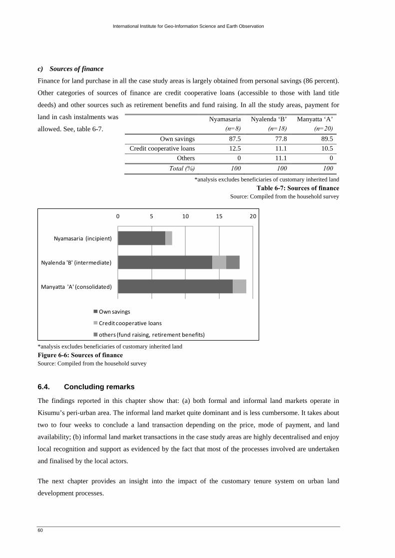
International Institute for Geo-Information Science and Earth Observation
60
0 5 10 15 20
Nyamasaria (incipient)
Nyalenda 'B' (intermediate)
Manyatta 'A' (consolidated)
Own savings
Credit cooperative loans
others (fund raising, retirement benefits)
c) Sources of finance
Finance for land purchase in all the case study areas is largely obtained from personal savings (86 percent).
Other categories of sources of finance are credit cooperative loans (accessible to those with land title
deeds) and other sources such as retirement benefits and fund raising. In all the study areas, payment for
land in cash instalments was
allowed. See, table 6-7.
*analysis excludes beneficiaries of customary inherited land Table 6-7: Sources of finance
Source: Compiled from the household survey
*analysis excludes beneficiaries of customary inherited land Figure 6-6: Sources of finance Source: Compiled from the household survey
6.4. Concluding remarks
The findings reported in this chapter show that: (a) both formal and informal land markets operate in
Kisumu’s peri-urban area. The informal land market quite dominant and is less cumbersome. It takes about
two to four weeks to conclude a land transaction depending on the price, mode of payment, and land
availability; (b) informal land market transactions in the case study areas are highly decentralised and enjoy
local recognition and support as evidenced by the fact that most of the processes involved are undertaken
and finalised by the local actors.
The next chapter provides an insight into the impact of the customary tenure system on urban land
development processes.
Nyamasaria (n=8)
Nyalenda ‘B’ (n=18)
Manyatta ‘A’ (n=20)
Own savings 87.5 77.8 89.5 Credit cooperative loans 12.5 11.1 10.5
Others 0 11.1 0 Total (%) 100 100 100

International Institute for Geo-Information Science and Earth Observation
61
7. Impact of the customary tenure system on urban land development processes
For many people in the case study areas, customary land development norms form the lived reality whereas
the official land development norms are remote, strange, expensive and difficult to comply with. The
present section discusses two main aspects: (a) the nature and type of development carried out on land held
under customary tenure; and (b) the roles of traditional authorities in controlling and managing urban land
development.
7.1. Nature and type of development on land held under customary tenure
According to the Planning professionals22 interviewed; the enactment of the Physical Planning Act (Cap
286) as well as the Physical Planners Registration Act No. 3 of 1996, signified official recognition of the
importance of planning and provided the requisite legal framework for orderly planning of human
settlements – urban and rural - in Kenya. Other functions of the Acts included: (a) harmonisation of
planning procedures and requirements provided for in other pieces of legislation; (b) provision of the
necessary institutional framework for approval and regulation of the planning practice; (c) provision of a
framework for public participation in planning and plan implementation; and (d) provision of a legal
framework for protection of all planned public utilities countrywide.
“Before its introduction, the situation was rather chaotic...anybody could plan!”, as the professionals put
it. “Unfortunately, the Act is relatively new and has not been fully implemented. Often, plots have been
allocated without following planning procedures specified in the Act; at times using repealed Acts! - Such
as the Town Planning Act and the Land Planning Act. In addition, development applications have been
processed without the input of professional planners”.
Although sections 30 and 33 of the Physical Planning Act empowers local authorities to control the use and
development of land and buildings in the interest of proper and orderly development in their areas of
jurisdiction, land under customary and freehold interest makes planning and development control
extremely difficult and problematic. Olima and Obala (1998), argue that this happens because physical
planners have got no express authority to plan, guide and control all developments on such private lands.
They also note that, the proposals including land zoning and sub-divisions falling on such land are only
advisory and not committal. This increases the problems of land development in such pieces of land.
The study findings indicate that, when it comes to land development in peri-urban areas, the techniques and
procedures adopted by property owners often conflict, and are sometimes incompatible with the
government’s urban development policies. Thus, it’s not surprising that local authorities commonly hold
22 Comprising of planning professionals drawn from Maseno university and the private sector

International Institute for Geo-Information Science and Earth Observation
62
the view that customary and freehold interest in land gravely inhibits orderly urban development due to the
following reasons:
a) Disregard of official land development procedures
The formal land development norms in Kenya, dictate that all new buildings, extensions and alterations on
existing buildings, repairs, or installation of any fittings and demolitions should be submitted to the
respective local authority for approval. The process ensures that buildings and structures conform to the
local authority by-laws.
The first and most important step towards this is that the property owner should be in possession of proper
ownership documents – the title deed – and ensure that there are provisions that allow for the proposed
development. The title deed may allow for the construction of a residential property but the owner actually
wanted to put up a commercial building or a building to accommodate social amenities such as a school or
a hospital. The change could also be from single dwelling units (low density) to multi-dwellings (high
density). Such changes are usually referred to as change of user.
Change of user legalises the construction of the proposed buildings and ensures provision of adequate
facilities. Such changes are usually necessitated by the change of population densities. For change of user,
to be undertaken, the property owner is required to submit a written application. Attachments required for
the change of user include: (a) a planning brief, prepared by a registered planner; (b) preliminary
architectural drawing plans (complete with all details including site plans, floor plans, elevations, and
sections), prepared by a registered architect; (c) survey plan; (d) a copy of the title deed; (e) a copy of the
land rates clearance certificate, indicating that all rates to the land have been paid (see, appendix 6-1). The
application is usually accompanied by a fee pre-determined by the area local authority and it often depends
on the total area of the proposed development. Figure 7-1 illustrates a sample change of user notice.
PHYSICAL PLANNING ACT Cap 286
Public Notice CHANGE OF USER
The owner of plot number L.R. NB/025 located in Nyalenda ‘B’ area of Kisumu intends to change the use of the plot
from AGRICULTURE to RESIDENTIAL subject to approval of the plans by the Municipal Council of Kisumu. Any
person or parties with objections regarding the proposal should forward their comments within 14 days from the date
of this notice stating the grounds on which such objections have been made to:
THE CLERK Municipal Council of Kisumu PO BOX 105 KISUMU Figure 7-1: Sample change of user notice Source: Municipal council of Kisumu, physical planning department

International Institute for Geo-Information Science and Earth Observation
63
A technical team at the local authority then evaluates the submitted drawings with emphasis on the plot
coverage, plot frontage (in metres), plot areas (sizes), space allocated per dwelling (in metres squared),
drainage and sewerage, building lines, parking, way leaves, among other issues to ensure they meet the
local authority’s regulations and standards. Depending on the particulars of a given application, the local
authority is required to notify the applicant, within 30 days, whether or not the application has been
approved and award an approval letter duly signed by the director of planning. Usually the grounds of
disapproval are limited only to lack of sufficient drawings, improper ownership documents, over-density
and lack of change of user.
This situation however, does not hold true in view of the case study areas. The general agreement amongst
the municipal council of Kisumu officials is that despite the numerous plans prepared and approved by the
council, orderly development of the same in reality has remained a dream. The official procedures were
constantly evaded by private property owners because of: (a) high professional, surveying, architectural
and planning fees; (b) lengthy and costly bureaucracy in the submission and approval of building plans;
and (c) most of the property owners were woefully ignorant of the planning standards and administrative
procedures for urban areas.
One municipal planner, observed that, “There has been a downward trend in formally approved plans in
the peri-urban zone. Things are not done the way they should be done – property owners are contented
with shortcuts. In most cases, what happens is that as soon as a land purchase is made, the property owner
begins to develop the land. Soon after, the municipal council’s (development control) officials visit the site
with an order to stop the work. Thereafter the property owner visits the municipal council offices and pays
the required levies before resuming the development. Regrettably, many property owners continue to
develop their land without approval from the municipal council’s authority, occasionally easing official
confrontation with payment of bribes. It’s a nuisance trying to convince such property owners to
understand and appreciate the benefits that may accrue from planned land development.”
It is significant to note that under the existing planning legislation, unless an individual has a registered
title to his land, he cannot obtain approval to develop his land. The present study indicates that in practice,
a large proportion of sampled property owners did not acquire permission from the municipal council of
Kisumu before developing their land. Technically any development on their land is considered illegal.
Nevertheless, the type of buildings in these areas, are not generally different from those on official land
(see, figure 7-2). A number of property owners have put up expensive property; a clear reflection of the
similarity between planned areas and those areas under customary land tenure systems.

International Institute for Geo-Information Science and Earth Observation
64
0% 20% 40% 60% 80% 100%
Nyamasaria (incipient)
Nyalenda 'B' (intermediate)
Manyatta 'A' (consolidated)
Approved Not approved
(a) A recently completed house in Manyatta ‘A’ (b) Building under construction in Nyalenda ‘B’
Figure 7-2: Nature and type of housing development in the case study areas Source: Field survey
Table 7-1 indicates the land development approval status in the case study areas. All sampled
developments in Nyamasaria had not been approved by the municipal authority. Given that this particular
settlement was still at the early stages of growth, respondents held the view that it was not the
government’s concern what they did with their land. The picture was different in Nyalenda ‘B’ and
Manyatta ‘A’. Respectively, 73 percent and 57 percent of the sampled respondents had not secured
development approvals, mainly due to
the inefficiency of the city planning
authorities and their inability to grant
permits in a timely way.
Table 7-1: Land development approval status
Source: Compiled from the household survey
Figure 7-3: Land development approval status Source: Compiled from the household survey
Apart from the fees payable to the municipal council of Kisumu for development approval, property
owners were required to make annual payments referred as ‘land rent’, to the Ministry of lands through the
Kenya Revenue Authority. Both payments are made by all those who purchase land, whether from the
government, customary or other private sources. Figure 7-4, indicates the failure of property owners to pay
land rates is quite common. In fact the municipal council and the government loses a lot of revenue in this
manner.
Nyamasaria (n=30)
Nyalenda ‘B’ (n=30)
Manyatta ‘A’ (n=30)
Approved 0 26.7 43.3 Not approved 100 73.3 56.7
Total (%) 100 100 100

International Institute for Geo-Inform
ation Science and E
arth Observation
65
(a) Source: Daily N
ation, (Monday 10th Septem
ber 2007) (b) Source: D
aily Nation, (Sunday 16th Septem
ber 2007)
Figure 7-4: Land rent paym
ent notices

International Institute for Geo-Information Science and Earth Observation
66
0% 20% 40% 60% 80% 100%
Nyamasaria (incipient)
Nyalenda 'B' (intermediate)
Manyatta 'A' (consolidated)
Urban Mixed Agricultural
b) Retarded development of infrastructural services and facilities
As the competition for land increases more customary land previously demarcated as agricultural land in
the peri-urban zone is being converted into urban land use (Table 7-2 and figure 7-5). In most cases this
results to land use conflicts
(incompatibility) between the planned
and new land uses.
*urban land use category includes residential, commercial, public purpose
**mixed land use category implies areas where urban agriculture takes place Table 7-2: Land use categories in the case study areas
Source: Compiled from the Pamoja Trust socio-economic survey
*urban land use category includes residential, commercial, public purpose **mixed land use category implies areas where urban agriculture takes place
Figure 7-5: Land use categories in the case study areas Source: Compiled from the Pamoja Trust socio-economic survey The dilemma that accompanies such urban expansion is that property owners usually commence with
informal sub-divisions prior to planning and servicing. This according to the municipal engineer “makes it
difficult, expensive and uneconomical for the local authority to extend services to such properties. Thus,
when in time infrastructure networks are installed, leap-frog development forces costs up for both existing
and future land sub-divisions, because trunk lines have to be extended through patches of undeveloped
land as well as installed in inadequate or non-existent rights of way.”
Table 7-3 shows the existing infrastructure on occupied land in the case study areas. In all the settlements,
water supply and electrification seem to be the easiest improvements. But, they only take place after
several years of occupation since people build incrementally, provided they have security of tenure in the
form of title deeds, land transfer documents (sale agreements) and recognition at the local level (Figure 7-
7). Most property owners estimate that by the time they complete their buildings, services would have been
provided
Nyamasaria (n=113)
Nyalenda ‘B’ (n=4178)
Manyatta ‘A’ (n=1091)
Agricultural 65 21 0 Mixed 0 1302 47 Urban 48 2655 1044

International Institute for Geo-Information Science and Earth Observation
67
84% 86% 88% 90% 92% 94% 96% 98% 100%
Nyamasaria (incipient)
Nyalenda 'B' (intermediate)
Manyatta 'A' (consolidated)
None Piped water Electricity
to the area by the municipal council.
The reality, however is that many
houses are left incomplete in peri-urban
areas because of the absence of
services (Figure 7-8).
Table 7-3: Existing infrastructure on occupied land Source: Compiled from the household survey
Figure 7-6: Existing infrastructure on occupied land Source: Compiled from the household survey
Figure 7-7: Incremental housing development in Manyatta 'A' Source: Field survey
Figure 7-8: An incomplete house in Nyalenda 'B' Source: Field survey
Water sources remain limited to a few communal water points and boreholes as indicated in figure 7-9.
Nyamasaria (n=30)
Nyalenda ‘B’ (n=30)
Manyatta ‘A’ (n=30)
None 29 28 27 Piped water 1 1 2
Electricity 0 1 1 Total 30 30 30

International Institute for Geo-Information Science and Earth Observation
68
(a) Communal water point in Manyatta ‘A’ (b) Residents buying water from a communal water
point in Nyalenda ‘B’
(c) A bore hole in Nyamasaria
Figure 7-9: Water sources in the case study areas Source: Field survey Low coverage and quality of infrastructure in turn negatively affects (reduces) the value of land. In
addition to the low level of serviced land, the location of Nyamasaria, Nyalenda ‘B’ and Manyatta ‘A’ is
also presenting some challenges. Often, people
settle in unsafe areas, such as flood-plains and
either relocate on their own when the land gets
flooded or are moved by the municipal council
(Figure 7-10). The same land however, may be
invaded again after the rains.
Figure 7-10: A house located on a flood plain in Manyatta 'A' Source: Field survey
1) Sizes of plots owned by households
As a guide, table 7-4 gives the recommended minimum plot sizes in the different cases of types of
residential development applicable in urban centres in Kenya.

International Institute for Geo-Information Science and Earth Observation
69
Table 7-4: Recommended minimum plot sizes for different housing schemes Type of housing Detached (m2) Semi-detached (m2) Row housing (m2)
Slum rehabilitation and upgrading schemes 223.2 148.8 111.6
Low cost housing 334.8 223.2 167.4
Normal housing development 465 309.7 232.5
*minimum plot sizes determined by the user, type of waste disposal, availability of water, level of building technology and recommended plot coverage Source: Ministry of Lands (2005) Figure 7-11 shows the average household plot size distribution in the case study areas. The error bars
indicate that average household plot sizes in Nyamasaria (446 m2) are significantly larger in than in
Nyalenda ‘B’ (266 m2). The average household plot size in Manyatta ‘A’, on the other hand is 325 m2. It is
also evident that most of the plots in Nyalenda ‘B’ are below the minimum recommended plot size of 465
m2 for detached housing development.
This is partly attributed to the vibrant
informal land market transactions
taking place in this settlement. Land
sub-divisions have created intrinsically
small parcels, some of which can
hardly sustain a family unit. This
underscores why the municipal council
of Kisumu has been finding it difficult
to readily approve development plans
from Nyalenda ‘B’ and Manyatta ‘A’
because they usually do not conform to
the requirements set down in official
planning standards in a variety of ways
including the shape and size of land
parcels.
Figure 7-11: Average household plot size distribution Source: Compiled from the household survey
7.2. Roles of traditional authorities in urban land management
Table 7-5 indicates that customary authorities still play a significant role in wider land management aspects
in Nyamasaria (91 percent) and Nyalenda ‘B’ (65 percent). In Manyatta ‘A’, however, the role of
customary authorities is distantly recognized by local residents and public authorities. The focus group
discussants were clear that, “The settlement was no longer under the influence of customary authorities.
Individuals who bought land from customary property owners no longer operated within the parameters of
the customary system.”

International Institute for Geo-Information Science and Earth Observation
70
0% 20% 40% 60% 80% 100%
Nyamasaria (incipient)
Nyalenda 'B' (intermediate)
Manyatta 'A' (consolidated)
Yes No
Moreover, the roles of customary authorities in Manyatta ‘A’ had been taken over officially by Community
development committees acting in partnership with the municipal council of Kisumu. These committees are
made up of various stakeholders, including
representatives from neo-customary actors.
They are responsible for policy decisions
such as settlement planning and development.
Table 7-5: Awareness of roles played by customary authorities in local land development Source: Compiled from the household survey
Figure 7-12: Awareness of roles played by customary authorities in local land development Source: Compiled from the household survey The respondents, who accepted the fact that customary authorities had a role to play in local land
development issues, offered a variety of explanations and justifications. The most cited reasons were that
customary authorities were involved in land transfers (mainly in terms of witnessing land sales), land
access, and land dispute resolution informally. Most of the land disputes in Nyalenda ‘B’ and Nyamasaria
arise out of land transactions and occupation not being properly registered unlike Manyatta ‘A’, where it
was reported that majority of the
land disputes were as a result of
double land sales by unscrupulous
land agents/ brokers. See, table 7-6.
*Not applicable represents the respondents who chose ‘No’, previously.
Table 7-6: Roles of customary authorities Source: Compiled from the household survey
Nyamasaria (n=30)
Nyalenda ‘B’ (n=30)
Manyatta ‘A’ (n=30)
Yes 91 65 0 No 9 35 100
Total (%) 100 100 100
Nyamasaria (n=30)
Nyalenda ‘B’ (n=30)
Manyatta ‘A’ (n=30)
Land access 35 20 0 Land transfer 30 25 0
Dispute resolution 26 20 0 Not applicable 9 35 100
Total (%) 100 100 100

International Institute for Geo-Information Science and Earth Observation
71
0 20 40 60 80 100
Land access
Land transfer
Dispute resolution
Not applicable
Nyamasaria (incipient)
Nyalenda 'B' (intermediate)
Manyatta 'A' (consolidated)
*Not applicable represents the respondents who chose ‘No’, previously. Figure 7-13: Roles of customary authorities Source: Compiled from the household survey Community mobilization and local participation
It was also noted that, when it came to community mobilization and local participation; for instance
building of storm water drainage channels and ensuring that land developers did not block rights of way,
customary authorities in Nyamasaria settlement played a pivotal role. The strong social cohesion among the
residents formed an important factor that ensured compliance with community agreed land development
norms.
The picture is quite different in Nyalenda ‘B’ and Manyatta ‘A’. High levels of settlement density, have
acted as a stimulus for the weakening of the traditional land management institutions. Since most residents
in these settlements are drawn from the migrant communities, they are not much integrated in the local
community, and therefore participate less in community activities. A former customary leader lamented
that, “They had little say as far as land management was concerned; land matters were no longer in their
jurisdiction. Individual households operated independently as far as urban land use development was
concerned.”
Table 7-7 provides a summary of the institutions governing urban land management and development in
the study areas.
Table 7-7: Institutions governing urban land management and development in the study areas
Nyamasaria
(incipient)
Nyalenda ‘B’
(intermediate)
Manyatta ‘A’
(consolidated)
Customary tenure systems Mix of customary, neo-customary and
‘Individualistic’ tenure systems
Mix of neo-customary and
‘Individualistic’ tenure systems
Source: Based on focus group discussions and field observations

International Institute for Geo-Information Science and Earth Observation
72
7.3. Concluding remarks
The foregoing analysis clearly reveals considerable weaknesses in the capacity of the state to intervene and
foster planned land development in peri-urban areas. Indeed, given the bureaucratic hurdles that have to be
overcome at each stage of the land development process, and the likelihood that considerable time will pass
before development approvals are finalised; it is not surprising that property owners in the case study areas
are developing their land outside official planning norms.
The findings also indicate that the role of traditional authorities in urban land management is especially
strong in the incipient phase of settlement development. However, the consolidation of settlements due to
demographic pressures and overheated land markets appears to curtail the efforts of traditional authorities’
in wider land management aspects such as encouraging community mobilization and local participation in
community development projects.
International Institute for Geo-Information Science and Earth Observation
73
8. Summary of findings, conclusions and recommendations
The main objective of the present study was to investigate how the customary system of landholding in
Kisumu adapts and adjusts to the needs of rapid urbanization; as well as its opportunities and challenges to
the spatial planning of such areas. This section draws attention to the major findings of the empirical
component of this study in line with the objectives of the study; followed by conclusions and
recommendations.
8.1. Summary of research findings
a) Reflections on sub-objective 1
The first sub-objective sought to establish the nature and dynamics of customary landholding in the study
areas. The rationale behind this was to find out how customary land access and rights have evolved over
time under the pressure of market forces. The findings reveal that the customary tenure system in the case
study areas is not static but has adjusted and adapted itself over time through several stages; that is the
communal control stage, through to the family control stage, and lastly to the stage of individual titles and
land dealings, as depicted in figure 8-1.
The case study findings indicate a progressive shift from communal to individual landownership and
related rights to land; hence corroborating Payne’s (1997) view that with urban land markets rapidly
becoming more commercialized, land has a potential of being transformed from a resource with a use value
to a commodity with a market value.

Inte
rnat
iona
l Ins
titut
e fo
r Geo
-Info
rmat
ion
Sci
ence
and
Ear
th O
bser
vatio
n
74
Nat
ure
of la
nd a
cces
s •
The
chie
f allo
cate
s, di
strib
utes
, and
regu
late
s
the
use
of la
nd. I
n ad
ditio
n th
ey a
lso
reso
lved
land
dis
pute
s.
• La
nd sa
les n
ot p
erm
issi
ble.
• La
nd a
lloca
ted
by fa
mily
hea
ds a
lthou
gh
chie
fs a
nd v
illag
e el
ders
con
tinue
d to
exer
cise
thei
r med
iatin
g ro
les.
• La
nd sa
les p
erm
issi
ble
with
ackn
owle
dgem
ent o
f fam
ily m
embe
rs
• La
nd a
lloca
tion
thro
ugh
the
land
mar
ket.
• La
nd sa
les p
erm
issi
ble.
Nat
ure
of la
nd ri
ghts
•
Com
mun
al ri
ghts
(usu
fruc
t rig
hts)
to la
nd
held
in p
erpe
tuity
.
• St
rang
ers (
non-
indi
gene
s) li
mite
d to
use
right
s. Th
eir r
ight
s cou
ld n
ever
mat
eria
lize
into
ow
ners
hip
no m
atte
r how
long
he
had
used
and
occ
upie
d th
e la
nd
• U
nres
train
ed a
nd e
xclu
sive
righ
t of t
he
indi
vidu
al to
use
and
dis
pose
of t
he la
nd
man
ifest
ed in
seve
ral w
ays,
such
as:
(a) u
se
right
s, fo
r ins
tanc
e bu
ildin
g on
the
land
,
bury
ing
the
dead
, fel
ling
natu
ral t
rees
; (b)
trans
fer r
ight
s, th
at is
selli
ng th
e la
nd (o
r par
t
of it
) to
anot
her p
erso
n; a
nd (c
) exc
lusi
on
right
s, th
at is
kee
ping
any
one
else
from
the
land
in q
uest
ion.
Tem
pora
l
char
acte
rizat
ion
• Sl
ow
• V
arie
d •
Rap
id
Cas
e st
udy
area
•
---
• N
yam
asar
ia
• M
anya
tta ‘A
’ and
Nya
lend
a ‘B
’
*eac
h st
age
is n
ot n
eces
saril
y ex
clus
ive
of o
ther
stag
es. I
t is o
nly
the
dom
inan
t one
at a
giv
en ti
me
Figu
re 8
-1: T
he e
volu
tion
of c
usto
mar
y la
nd te
nure
in th
e ca
se st
udy
area
s So
urce
: Com
pile
d fr
om K
ey in
form
ant i
nter
view
s, in
-dep
th in
terv
iew
s and
focu
s gro
up d
iscu
ssio
ns
Com
mun
al c
ontro
l Fa
mily
con
trol
Indi
vidu
al ti
tles
and
land
dea
lings
Tim
e

International Institute for Geo-Information Science and Earth Observation
75
b) Reflections on sub-objective 2
The second sub-objective sought to identify the existing land markets in peri-urban Kisumu. The rationale
behind this was to find out how customary property rights are made accessible and acquired within the
study areas. In order to achieve this, the structure and operation of the peri-urban land market was
examined. The study findings corroborate similar findings by other scholars (Kombe, 1995; Lupala, 2002;
Olima and Obala, 1998; Rakodi and Leduka, 2004), that: (a) both formal and informal land markets operate
in Kisumu’s peri-urban area. Shortcomings of the state land management mostly in regard to land
allocation have led to the development of informal land markets; (b) informal land market transactions in
the case study areas are highly decentralised and enjoy local recognition and support as evidenced by the
fact that most of the processes involved are undertaken and finalised by the local actors.
c) Reflections on sub-objective 3
The third sub-objective sought to determine the impact of the customary tenure system on land
development processes in the study areas. The rationale behind this was to find out how urban land
development proceeds on land held under customary tenure. In order to achieve this, two aspects were
examined: (a) the nature and type of development carried out on customary tenured land; and (b) the roles
of traditional authorities in controlling and managing urban land development.
In relation to the nature and type of development carried out on customary tenured land, the study findings
indicate: (a) the techniques and procedures adopted by property owners often conflict, and are sometimes
incompatible with the formal land development norms. The sequence of development follows what Baross
and van der Linden (1990) term as the OBSP (Occupation – Building- Servicing - Planning) model; (b)
Under the existing planning legislation, unless an individual has a registered title to his land, he cannot
obtain approval to develop his land. This then becomes a major hurdle since, most land transactions (land
sub-divisions) in the study areas are never registered at the district land registry as required by law. The
respective property owners mostly derived security of landownership from actual development and local
recognition in the respective settlements.
Technically speaking, any development on their land is considered illegal due to lack of approval from the
municipal council of Kisumu. Nevertheless, the type of buildings in these areas, are not generally different
from those on official land. Perhaps, a clear reflection of the confidence that the property owners have in
the customary land tenure system and also a general reflection of the similarity between planned areas and
those areas under the customary land tenure systems. Other transgressions were commonly found in the
areas of low coverage and quality of infrastructure; habitation of hazardous land and uneconomical
household land sizes.
In relation to the role traditional authorities in controlling and managing urban land use development, the
study findings indicate that customary authorities still play a significant role in wider land management
aspects such as encouraging community mobilization and local participation in community development
projects (for instance building of storm water drainage channels and ensuring that land developers did not

International Institute for Geo-Information Science and Earth Observation
76
block rights of way). In Nyamasaria (incipient) and Nyalenda ‘B’ (intermediate) settlements, they were
also involved informally in land transfers (mainly in terms of witnessing land sales), land access, and land
dispute resolution. The picture was quite different in Manyatta ‘A’ (consolidated) settlement, where the
role of customary authorities was distantly recognized by local residents and public authorities. Community
development committees acting in partnership with the municipal council of Kisumu had officially taken
up the roles of customary authorities. These committees are made up of various stakeholders, including
representatives from neo-customary actors; who were responsible for policy decisions such as settlement
planning and development.
8.2. Conclusions
The motivation of the present study was two-fold: (a) to investigate how the customary system of
landholding in Kisumu adapts and adjusts to the needs of rapid urbanization; as well as (b) its opportunities
and challenges to the spatial planning of the peri-urban zone.
First, to comprehend how the customary landholding system adapts and adjusts to the needs of rapid
urbanization, the present study was guided by the expectation that: As urban development proceeds, the
informal institutions that govern land transactions and use change over time, vary between residential
areas and sometimes break down (Ikejiofor, 2006; Rakodi and Leduka, 2004). On the basis of the study
findings; one observes that as settlements consolidate and the density of development increases (due to the
pressures of the urban land markets and increased land demand), the ties between the customary authorities
and the urban population weakens considerably with time and may eventually breakdown. Thus the current
trend with regard to landholding in the case study areas was a gradual shift from community control to
individualisation.
Table 8-1, outlines the strengths and deficiencies exhibited by the customary land tenure system.
Table 8-1: SWOT summary of the customary tenure system Strengths Weaknesses
• Main source of land access adapted to the affordability of
potential buyers
• Resolution of land disputes
• Written evidence of land transactions
• The patriarchal nature denies women direct access to land
• Inefficient urban land patterns (inadequate infrastructure
provision, extensive leapfrog development, complex sub-
division layouts, uneconomical size of landholdings)
Opportunities Threats
• Community mobilization and local participation • Has a tendency of breeding tribalism, rivalry, suspicion and
tension between ethnic group; a situation which is adverse to
nation building
Taken as a whole, the results of this study show that the role of traditional authorities in urban land
management is especially strong in the incipient phase of settlement development. However, the
consolidation of settlements due to demographic pressures and overheated land markets has curtailed the
efforts of traditional authorities to intensify further urban land management.

International Institute for Geo-Information Science and Earth Observation
77
Given the strengths and weaknesses inherent in both public and customary land management approaches,
the study concludes that there is a need to integrate both customary and public authority’s efforts towards
orderly urban development. The incipient phase of settlement development serves as a possible entry point
to such initiatives before settlement densities build up and the ensuing consequences - the lack of apparent
planning and sense of order - are often too ghastly to contemplate.
8.3. Recommendations
In view of the study findings and conclusions, the following measures regarding the management and
development of urban land are necessary:
• Past studies have clearly shown that the capacity of the state to intervene and foster planned land use
development has been declining year after another. Thus the study advocates for partnerships between
the municipal authority and neo-customary/ customary actors and where appropriate uses their
creativity in solving problems to adapt municipal by-laws and procedures.
• Planning policy should recognize the danger posed by peri-urban areas, the current practice of
confining development plans to urban areas should be discouraged. A comprehensive policy statement
for the development of these peri-urban areas is long overdue and should be effected soon to go hand
in hand with rapid urbanisation process in the country.
International Institute for Geo-Information Science and Earth Observation
78
References Abdulai, R.T. and Ndekugri, I.E., 2007. Customary landholding institutions and housing development in urban centres of
Ghana: Case Studies of Kumasi and Wa. Habitat International, 31(2): 257-267.
Agbosu, L.K., 2000. Land Law in Ghana: Contradiction between Anglo-American and customary conceptions of tenure and practices. Working paper no. 33. Land Tenure Center, University of Wisconsin, Madison.
Alchian, A.A. and Demsetz, H., 1973. The property right paradigm. Journal of Economic History, 33: 16-27.
Amanor, K., 2006. Land registration, Security of access and Ownership in Ghana.
Arnason, R., 1999. Property rights as a means of economic organization, Use of property rights in fisheries management, 11-19th November, 1999, Fremantle.
Baross, P.e. and van der Linden, J.e., 1990. Transformation of land supply systems in third world cities. Avebury Gower, Aldershot etc., 340 pp.
Bentsi-Enchill, K., 1964. Ghana land law: an exposition, analysis and critique. Sweet & Maxwell, London.
Boydell, S. and Holzknecht, H., 2003. Land--caught in the conflict between custom and commercialism. Land Use Policy, 20(3): 203-207.
Chome, J. and McCall, M.K., 2005. Neo - customary title registration in informal settlements: the case of Blantyre. International development planning review, 27(4).
Cleaver, F., 2002. 'Reinventing institutions: bricolage and the social embeddedness of natural resource management' in European Journal of Development Research, 14: 11–30.
Cohen, B., 2006. Urbanization in developing countries: Current trends, future projections, and key challenges for sustainability. Technology in Society, 28(1-2): 63-80.
Coldham, S., 1978. Land Control in Kenya. Journal of African Law, 22(1): 63-77.
Coldham, S.F.R., 1979. Land-Tenure Reform in Kenya: The Limits of Law. The Journal of Modern African Studies, 17(4): 615-627.
Daily Nation, Monday 10th September 2007. Land Rent Collection.
Daily Nation, Sunday 16th September 2007. Land Rent Payment.
Dale, P.F. and McLaughlin, J.D., 1988. Land Information Management: An Introduction with Special Reference to Cadastral Problems in Third World Countries. Oxford University Press, New York, USA.
Deobele, W., 1983. Concepts of urban land tenure. In: Urban Policy Issues and Opportunities Oxford University Press, Oxford
Dowall, D.E., 2003. Land into cities: urban land management issues and opportunities in developing countries. In: Urban Land Markets in Transition. Lincoln Institute of Land Policy, Cambridge.
Durand-Lasserve, A. and Mattingly, M., 2003. Land for housing the poor in African cities: Are neo-customary processes an effective alternative to formal systems?, Research syposium on 'Urban Development for Economic Growth and Poverty Reduction'. World Bank, Washington, DC.
Durand-Lasserve, A. and Mattingly, M., 2004. Current changes in customary land delivery systems in sub-Saharan African countries: Preliminary findings, PRUD (France) and DFID (UK), Paris, France.
Falade, J.B., 2003. The Urban and Regional Planning Process, the Old order and the New Paradigm, Mandatory Continuing Professional Development Programme (MCPDP) of the Nigerian Institute of Town Planners (NITP), Calabar, Asaba and Kaduna.

International Institute for Geo-Information Science and Earth Observation
79
Farvacque, C., Godin, L. and The World Bank, 1999. Future of African cities: challenges and priorities for urban development. Directions in development 1. The World Bank, Washington, D.C., 176 pp.
Farvacque, C., McAuslan, P. and The World, B., 1992. Reforming urban land policies and institutions in developing countries. Urban Management Program UMP: policy paper;5. The World Bank, Washington, D.C., 114 pp.
Fekade, W., 2000. Deficits of formal urban land management and informal responses under rapid urban growth, an international perspective. Habitat International, 24(2): 127-150.
Field, A., 2005. Discovering statistics using SPSS, second edition. SAGE publications, London.
Firman, T., 2004. Major issues in Indonesia's urban land development. Land Use Policy, 21(4): 347-355.
Glazier, J., 1976. Land Law and the Transformation of Customary Tenure: The Mbeere Case. Journal of African Law, 20(1): 39-50.
Goater, J.F.e. and Tsuji, L.K.e., 1996. How cities will look in the 21st century: proceedings of Habitat II, Dialogue 1. 4 June 1996, Istanbul, Turkey. UNCRD proceedings series 14. United Nations Centre for Regional Development (UNCRD), Nagono, 176 pp.
Ikejiofor, U., 2006. Equity in informal land delivery: Insights from Enugu, Nigeria. Land Use Policy, 23(4): 448-459.
Kaitilla, S., 1993. Urban land release and development in Papua New Guinea. Journal of Asian and African studies, 28(3-4): 253-258.
Kalabamu, F.T., 2000. Land tenure and management reforms in East and Southern Africa - the case of Botswana. Land Use Policy, 17(4): 305-319.
Kenya National Bureau of Statistics, 1999. 1999 Population and Housing Census Report; Vol. 1, Government printer, Nairobi.
Kingsley G. and Bozeman B., 1997. R & D value mapping: a new approach to case study based evaluation. Journal of technology transfer, 22(2): 33-42.
Kironde, J.M., 2006. The regulatory framework, unplanned development and urban poverty: Findings from Dar es Salaam, Tanzania. Land Use Policy, 23(4): 460-472.
Kohn, L.T., 1997. Methods in case study analysis, Centre for studying health system change. Technical publication No. 2.
Kombe, W.J., 1995. Formal and informal land management in Tanzania: The case of Dar es Salaam city. PhD Thesis, University of Dortmund, Dortmund;SPRING.
Kombe, W.J., 2005. Land use dynamics in peri-urban areas and their implications on the urban growth and form: the case of Dar es Salaam, Tanzania. Habitat International, 29(1): 113-135.
Kombe, W.J. and Kreibich, V., 2000. Informal land management in Tanzania. SPRING, Dortmund.
Kumar, R., 2005. Research methodology: a step - by - step guide for beginners. Sage, London, 332 pp.
Kwadwo, G., 2006. Land Reform in Ghana, A paper presented at the 22nd Annual Conference of American Real Estate Society, Key West, Florida, USA.
Lupala, A., 2002. Peri-urban land management for rapid urbanisation: The case of Dar es Salaam. PhD Thesis, University of Dortmund, Dortmund; SPRING.
Mabongunje, A.L., 1992. Perspective on urban land and urban management policies in sub-saharan Africa. In: World Bank technical paper No. 196. The World Bank, Washington DC.
Mends, T.M., 2006. Customary land tenure and urbanization with a case study on the Peri urban area of Accra, Ghana, ITC, Enschede, 73 pp.
Mifsud, F.M., 1967. Customary land law in Africa. FAO, Rome, 94 pp.

International Institute for Geo-Information Science and Earth Observation
80
Miles, M. and Huberman, A.M., 1994. Qualitative data analysis. Sage publications, Beverly hills, CA.
Millennium Cities Initiative, 2007. Invest in Kenya: Focus Kisumu, Earth Institute, Columbia University, Columbia.
Ministry of Lands, 2005. Physical Planning Handbook (Draft). Physical Planning Department, Nairobi.
Musyoka, R., 2004. Informal land delivery processes in Eldoret, Kenya: summary of findings and policy implications. Informal land delivery processes in African cities: policy briefs no.3. University of Birmingham, International Development Department, Birmingham, 49 pp.
Mwamburi, W.K. and Adolwa, P.S., 2006. Case study on how urbanization has impacted on Kisumu and how related challenges are being addressed by the municipal council and other stakeholders, Regional urbanization seminar on 'Nurturing East African Cities and Towns into Viable and Sustainable Human Settlements and Economic Bases', Kisumu, Kenya.
Ng'ong'ola, C., 1982. The Design and Implementation of Customary Land Reforms in Central Malawi. Journal of African Law, 26(2): 115-132.
Ng'ong'ola, C., 1992. Land Problems in Some Peri-Urban Villages in Botswana and Problems of Conception, Description and Transformation of "Tribal" Land Tenure. Journal of African Law, 36(2): 140-167.
Nkwae, B., 2006. Conceptual Framework for Modelling and Analysing Peri-urban Land Problems in Southern Africa, University of New Brunswick, Canada, 363 pp.
Obala, L.M. and Kinyungu, N., 2002. Current changes in customary/ traditional land delivery systems in sub-Saharan African cities: case study of Nairobi, University of Nairobi, Nairobi.
Ogolla, B. and Mugabe J, 1996. Land Tenure Systems, In Land We Trust. Initiative Publishers, Nairobi.
Okoth-Ogendo, H.W.O., 2004. Securing the African commons: policy and legislative challenges, Keynote address delivered at the International Workshop on Securing African Commons in an Era of Privatisation. , Nakuru, Kenya, October 24-29.
Olima, W.H.A., 1993. The land use Planning in Provincial towns of Kenya: A Case Study of Kisumu and Eldoret towns. Project Verlag, Dortmund, Germany.
Olima, W.H.A., 1997. The conflicts, shortcomings, and implications of the urban land management system in Kenya. Habitat International, 21(3): 319-331.
Olima, W.H.A. and Obala, L.M., 1998. The effect of existing land tenure systems on urban land development: A case study of Kenya's secondary towns, with emphasis on Kisumu. Habitat International, 23(1): 113-124.
Owusu, G. and Agyei, J., 2007. Changes in land access, rights and livelihoods in peri-urban Ghana: The case of Accra, Kumasi and Tamale metropolis, Princeton.
Pacione, M., 2005. Urban geography: a global perspective. Routledge, London etc., 686 pp.
Payne, G., 1997. Urban land tenure and property rights in developing countries: a review. Intermediate Technology, London, 73 pp.
Payne, G., 2004. Land tenure and property rights: an introduction. Habitat International, 28(2): 167-179.
Rakodi, C. (Editor), 2002. Urban land management in Africa. SPRING, Dortmund.
Rakodi, C. and Leduka, C.R., 2004. Informal land delivery processes and access to land for the poor: a comparative study of six African cities. Informal land delivery processes in African cities: policy briefs 6. University of Birmingham, International Development Department, Birmingham, 44 pp.
Reid, S., 1987. Working with statistics. Polity press, Cambridge.
Rivkin, M.D., 1978. "Some perspectives on urban land use regulation and control" in Urban land policy issues and opportunities. Working paper 283. World Bank, Washington, DC.
International Institute for Geo-Information Science and Earth Observation
81
Shipton, P.M., 1984. Strips and Patches: A Demographic Dimension in Some African Land-Holding and Political Systems. Man, 19(4): 613-634.
Shivji, I.G., 1998. Not Yet Democracy: Reforming Land Tenure in Tanzania. IIED, London.
Sivam, A., 2002. Constraints affecting the efficiency of the urban residential land market in developing countries: a case study of India. Habitat International, 26(4): 523-537.
Sliuzas, R.V., 2004. Managing informal settlements: a study using geo-information in Dar es Salaam, Tanzania, ITC, Enschede, 309 pp.
UN-FIG, 1996. The Bogor Declaration, United Nations Interregional Meeting of Experts on the Cadastre, 18th – 22nd March, Bogor, Indonesia.
UN-Habitat, 2005. Situation analysis of informal settlements in Kisumu. United Nations Human Settlement Programme (UN-HABITAT), Nairobi.
UN-Habitat, 2006. State of the world's cities report 2006/2007: the millennium development goals and urban sustainability: 30 years of shaping the habitat agenda. Earthscan, United Nations Human Settlements Programme (UN-HABITAT), London, 204 pp.
UNCHS, 2001. Cities in a globalizing world: global report on human settlements. Earthscan, London, 344 pp.
UNCHS, 2004. state of the world's cities 2004 - 2005: globalization and urban culture. United Nations Centre for Human Settlements (Habitat), Nairobi, 198 pp.
Werhmann, B., 2001. Coping with Informal Land Management In Human Settlements: An Overview of the Status Quo, ESF/N-AERUS Workshop.
Williamson, I.P., 1997. The Justification of Cadastral Systems in Developing Countries Geomatica, 51(1): 21-36.
Yin, R., 1994. Case Study Research; Design and Methods. SAGE Publications, Newbury Park, CA.
Yin, R., 2003. Case study research design and methods, 3rd edition. Sage publications, California, US.
Yue-man, Y., 1993. Globalization and world cities in developing countries. Occasional Paper 119. Chinese University, Department of Geography, Hong Kong, 51 pp.

International Institute for Geo-Information Science and Earth Observation
82
Appendices
3-1: Key informant interview schedule
Dear participants, We are writing to ask for your help with an important and interesting study being conducted by the
International Institute for Geo-Information Science and Earth Observation, in the Netherlands.
Your valuable response will contribute to a better understanding of how the customary system of
landholding adapts and adjusts to the needs of rapid urbanization, as well as the opportunities and
challenges it presents on the spatial planning of Kisumu city.
We would like you to know that your efforts are very much appreciated. It is only with the responses of
individuals/ professionals like you, that knowledge in this field can be advanced. Please note that any
information that you provide will be treated as confidential and the findings will be reported in the
aggregate only, so that information provided about you/ your organisation cannot be ascertained or
deduced by the readers of the report.
Thank you very much for your kind assistance in this study. a) Nature and dynamics of customary landholding
• What is the extent of customary practices in the urban areas of Kisumu?
• How are the customary systems changing and adapting?
b) Existing peri-urban land markets in Kisumu
• What types of land access modes exist in Kisumu?
• What are the characteristics of these modes?
• How do they work/ operate?
• Who are the actors involved and what roles do they play?
c) Impacts of customary tenure on land use development processes
• What policies and procedures are in place to ensure compliance to orderly development in peri-
urban areas?
• What challenges/ obstacles do you face in ensuring compliance to such policies and procedures?
What measures should be put in place to address such challenges/ obstacles?
• Are techniques and procedures of customary land development compatible with local government
urban management policies?
• What is the relationship between public authorities and customary authorities? Are customary
authorities involved in land management and development issues?
• What are the potentials and constraints of the customary land tenure system as far as land
management and development is concerned?

International Institute for Geo-Information Science and Earth Observation
83
3-2: In-depth interview schedule
Dear participants, We are writing to ask for your help with an important and interesting study being conducted by the
International Institute for Geo-Information Science and Earth Observation, in the Netherlands.
Your valuable response will contribute to a better understanding of how the customary system of
landholding adapts and adjusts to the needs of rapid urbanization, as well as the opportunities and
challenges it presents on the spatial planning of Kisumu city.
We would like you to know that your efforts are very much appreciated. It is only with the responses of
individuals/ professionals like you, that knowledge in this field can be advanced. Please note that any
information that you provide will be treated as confidential and the findings will be reported in the
aggregate only, so that information provided about you/ your organisation cannot be ascertained or
deduced by the readers of the report.
Thank you very much for your kind assistance in this study Land agent based in Manyatta ‘A’
a) What roles do land brokers/ agents play in this settlement?
b) Has the number of persons seeking access to land through land agents been increasing or decreasing
over time?
c) How long would it take me to conclude a land transaction?
d) What costs are involved?
e) What factors are put into consideration when determining land prices?
International Institute for Geo-Information Science and Earth Observation
84
3-3: Focus group discussion schedule
Dear participants, We are writing to ask for your help with an important and interesting study being conducted by the
International Institute for Geo-Information Science and Earth Observation, in the Netherlands.
Your valuable response will contribute to a better understanding of how the customary system of
landholding adapts and adjusts to the needs of rapid urbanization, as well as the opportunities and
challenges it presents on the spatial planning of Kisumu city.
We would like you to know that your efforts are very much appreciated. It is only with the responses of
individuals/ professionals like you, that knowledge in this field can be advanced. Please note that any
information that you provide will be treated as confidential and the findings will be reported in the
aggregate only, so that information provided about you/ your organisation cannot be ascertained or
deduced by the readers of the report.
Thank you very much for your kind assistance in this study Village elders
a) When and how was this settlement established?
b) What are the main principles underlying traditional land management?
c) How have procedures used to acquire land been changing over time?
d) What are the causes of such changes?
e) What motives induce you to supply land to the land market?
f) Do you help in any way to initiate planning layouts prior to land development?
g) What other roles do you play as far as urban land management is concerned?
h) Are you happy with changes in land use development in this community?
i) What problems if any do you face?
j) What relations do you have with public authorities?
k) How can public authorities be made more responsive to the needs of the community?
l) What do you expect to be the status of customary land tenure system 10 years from now?

International Institute for Geo-Information Science and Earth Observation
85
3-4: Property owner questionnaire
Dear participants, We are writing to ask for your help with an important and interesting study being conducted by the
International Institute for Geo-Information Science and Earth Observation, in the Netherlands.
Your valuable response will contribute to a better understanding of how the customary system of
landholding adapts and adjusts to the needs of rapid urbanization, as well as the opportunities and
challenges it presents on the spatial planning of Kisumu city.
We would like you to know that your efforts are very much appreciated. It is only with the responses of
individuals/ professionals like you, that knowledge in this field can be advanced. Please note that any
information that you provide will be treated as confidential and the findings will be reported in the
aggregate only, so that information provided about you/ your organisation cannot be ascertained or
deduced by the readers of the report.
Thank you very much for your kind assistance in this study.
Interviewer’s Name Date Case Study Area Ref. No.
Section A: Land access (Tick the appropriate box)
1) Respondent’s name ……………………………
2) Gender Male Female
3) Land use?
Residential Commercial Residential/ Commercial
Religious Hospital/ Clinic Educational
Light industrial (Jua kali) other (specify)………………………
4) Mode of land acquisition/ access?
Traditional authorities (clan heads; village heads; family heads; lineage heads)
Government agencies (e.g. chiefs)
Non indigenous land sub-dividers/ speculators
Other (specify)……………………
5) What is the size of the land now? ……………………m2
6) Initial cost of purchase of land (Kshs)? ………………………………. Not applicable
7) What was the mode of payment?
Full payment (lump sum) Instalments Not applicable
8) How did you raise money to pay for this land?
Own savings Bank loan Loan from friends/ Relatives
Loan from credit cooperatives Other (specify) ……………………………
9) In which year was this land acquired?

International Institute for Geo-Information Science and Earth Observation
86
Before 1963 1963 – 1978 1979 – 2002 2003 – To date
10) What was the development status of this plot at the time of acquisition? (land improvement)
Vacant Half built Built
11) What infrastructure/ services existed on this land at the time of acquisition?
Piped water Electricity Septic tank
Graded road None Other (specify)…………………
12) Why did you choose to acquire land in this area?
Plot availability
Cheaper land
Proximity to town/ workplace
Able to pay in instalments
Other (specify) ……………………………
Section B: Processes and actors involved in urban land development (Tick the appropriate box)
13) How did you know that this plot was being sold?( Not applicable for inherited land owners)
Assistant chief Village elder Relatives Land agent
Property owner Friend Other (specify) ……………………………
14) How long did the land acquisition process take (weeks)? ( Not applicable for inherited land owners)
One 2 – 4 5 – 12
13 – 24 25 – 52 Above 52
15) What was the most difficult stage during land transfer/ transaction?
Land seeking
Site visits and inspection
Price negotiation
Registration of plot sale at the land registrar’s office
16) What documentary proof did you get upon transfer to show that the property belongs to you?
Title deed land sale agreement No document
Other document (specify) ……………………………
17) Do the customary leaders have a role with regard to the land use development in this settlement?
Yes If yes, in what issues do you need their help?
Land access Land transfer other (specify) ……………………
No if no, why? ……………………
18) Has the current development been approved by the municipal council?
Yes (when)…………………………
No (why)…………………………
<< Once again, thank you very much for your participation in this study >>
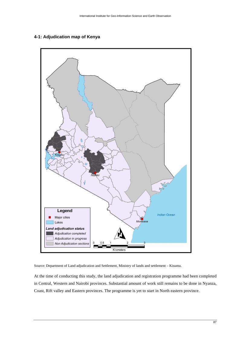
International Institute for Geo-Information Science and Earth Observation
87
4-1: Adjudication map of Kenya
Source: Department of Land adjudication and Settlement, Ministry of lands and settlement – Kisumu. At the time of conducting this study, the land adjudication and registration programme had been completed
in Central, Western and Nairobi provinces. Substantial amount of work still remains to be done in Nyanza,
Coast, Rift valley and Eastern provinces. The programme is yet to start in North eastern province.

International Institute for Geo-Information Science and Earth Observation
88
4-2: Registry Index Maps (RIMs)
Manyatta ‘A’ RIM Part of diagram No. 25 Scale 1:1,500 (approx.)
Nyalenda ‘B’ RIM Part of diagram No. 1 Scale 1:2,500 (approx.) Nyamasaria RIM Part of diagram No. 13 Scale 1:2,500 (approx.)
Source: Survey Department, MoLS – Kisumu.
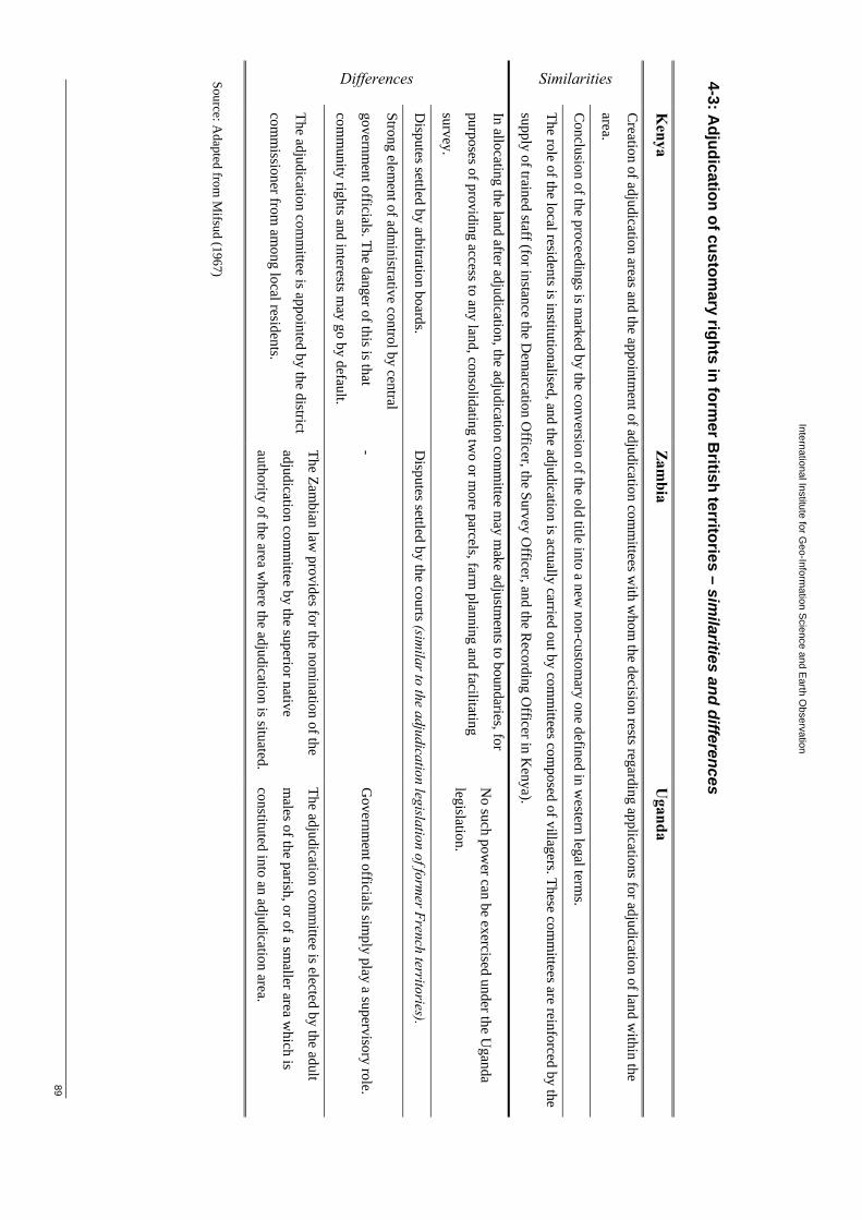
International Institute for Geo-Inform
ation Science and E
arth Observation
89
4-3: Adjudication of custom
ary rights in former B
ritish territories – similarities and differences
Kenya
Zambia
Uganda
Similarities
Creation of adjudication areas and the appointm
ent of adjudication comm
ittees with w
hom the decision rests regarding applications for adjudication of land w
ithin the
area.
Conclusion of the proceedings is m
arked by the conversion of the old title into a new non-custom
ary one defined in western legal term
s.
The role of the local residents is institutionalised, and the adjudication is actually carried out by comm
ittees composed of villagers. These com
mittees are reinforced by the
supply of trained staff (for instance the Dem
arcation Officer, the Survey O
fficer, and the Recording O
fficer in Kenya).
Differences
In allocating the land after adjudication, the adjudication comm
ittee may m
ake adjustments to boundaries, for
purposes of providing access to any land, consolidating two or m
ore parcels, farm planning and facilitating
survey.
No such pow
er can be exercised under the Uganda
legislation.
Disputes settled by arbitration boards.
Disputes settled by the courts (sim
ilar to the adjudication legislation of former French territories).
Strong element of adm
inistrative control by central
government officials. The danger of this is that
comm
unity rights and interests may go by default.
- G
overnment officials sim
ply play a supervisory role.
The adjudication comm
ittee is appointed by the district
comm
issioner from am
ong local residents.
The Zambian law
provides for the nomination of the
adjudication comm
ittee by the superior native
authority of the area where the adjudication is situated.
The adjudication comm
ittee is elected by the adult
males of the parish, or of a sm
aller area which is
constituted into an adjudication area.
Source: Adapted from
Mifsud (1967)

International Institute for Geo-Information Science and Earth Observation
90
6-1: Certificate of payment of rates and other charges
Source: Municipal council of Kisumu, Town Treasurer’s Department