Embed Size (px)
Citation preview
13
Chapter II
The Causes of Mangrove Death on Yap, Palau, Pohnpei, and Kosrae
By: Phil G. Cannon, Margie Falanruw, Francis Ruegorong, Rich MacKenzie, Katie Friday, Amy L. Ross-
Davis, Sara M. Ashiglar, Ned B. Klopfenstein; with Zhangfeng Liu, Mohammad Golabi, and Chancy
Thomas Iyekar.
Abstract: The area of a massive mangrove dieback in Yinuf Mn Island, Yap, was selected as the first
location to study mangrove dieback problems. Seawater and soil samples were collected from plots
where the mangrove trees were dead/dying and these samples were analyzed for eight different
seawater and soil floor properties. Seawater and soil properties from dead/dying/missing mangrove
samples were then compared with these same eight properties for seawater and soil samples collected
in nearby plots where mangrove trees appeared healthy. For these eight properties, no apparent
differences were found that might help explain why mangroves had died or stayed healthy.
Consequently, other possible explanations for mangrove dieback were sought, based on current stand
conditions and a consideration of extenuating circumstances in the recent history of this site. At this
Yinuf Mn island site, a plausible explanation for the massive mangrove dieback was that Typhoon Sudal,
which had struck 9 years earlier (in April, 2004) with both strong winds and a powerful storm surge, had
pushed over about 100 acres (40.5 ha) of trees on the seaward edge of this mangrove stand. These trees
may also have been heavily butt rotted or impacted by an oil spill, factors which could have rendered
trees more prone to toppling during Typhoon Sudal. In a separate incident, Typhoon Bopha (December,
2012), caused minor but still measurable damage to a mature mangrove stand in Babeldaob, Palau.
Other potential contributors to mangrove-stand dieback in this region include girdling of trees along
channels to improve boat navigation through mangroves (in Airai, Palau), the undercutting of coastlines
by wave action and rising seas (in Yap, Saipan, and Kosrae), and, of course, some harvesting of mangrove
trees for poles and timber (in Pohnpei and Palau). Extensive butt rot was observed in many older
mangrove stands, especially in stands with high proportions of Sonneratia alba and Xylocarpus
granatum.
Introduction
Death of trees in the mangroves has been reported for many islands in Micronesia. In some
cases, tree mortality has been attributed to excessive harvesting or improper selection of the mangrove
trees for harvesting, based on their position in a stand; however, no clear explanation has been provided

14
for other cases. After reviewing recent satellite images of Yap in 2012, Zhangfeng (Leo) Liu found that
approximately 10% of Yap’s very extensive mangroves had died since the previous images had been
released in 2006. In some locations on Yap, nearly 50% of the mangroves had been killed. One area
where dieback was exceptionally high was near the Yinuf Mn Island, as shown in Figure 1. Initially,
scientists in the Regional Office of the US Forest Service postulated that a few causal factors that may
have contributed to mangrove mortality included the following: 1) influence of sea level rise; 2) effect of
erosion occurring in the watersheds above these mangroves, which filled the coastline with sediments in
a manner that may have suffocated the mangrove roots; or 3) unfavorable changes in the salinity,
temperature, and/or pH of the mangrove. Differences in water salinity between and within mangrove
stands has been documented previously by Ewel et al. (1998).
In early conversations with Margie Falanruw (USFS, Yap), four other factors that may also have
contributed to mangrove death were also discussed and considered: 1) the construction of a second
airstrip running parallel to the new airstrip upslope from the Yinuf Mn (this new airstrip had damaged
taro patches just upslope from this mangrove); 2) the building of the main road that apparently had
resulted in an earlier conversion of the mangrove on the island-side of the road into a marsh; 3) an oil
spill that had occurred after a ship hit the reef in the main harbor (mangroves in the area of Yinuf and
Luech had been coated in oil, but did not die at least within a year following the spill); and 4) impacts of
Typhoon Sudal which had inflicted extensive damage to the mangrove in 2004.
Methods
During this visit, three approaches were used to investigate the death of mangroves in Yap and
elsewhere in the Federated States of Micronesia (FSM): 1) A measurements approach at Yinuf Mn
Island, Yap; 2) A “common-sense” approach at Yinuf Mn Island, Yap; and 3) a “common-sense” approach
at other mangrove stands in FSM. The methodologies and information gained by these approaches are
presented separately in the Methods, Results, and Discussion sections of this report.

15
Figure 1. The mangrove forests of the biggest islands of Yap are shown in green in this transformed satellite image taken in 2012. The red areas depict mangrove areas where trees had largely disappeared since a similar image was taken in 2006 (image analyses by Zhangfeng Liu, USFS contractor). The greatest damage is shown along the southeastern coast of Yap and especially on the island of Yinuf Mn, shown in the northeastern (upper right) corner of the inset image. This report includes a concentrated, on-site effort to determine why the mangroves in the island of Yinuf Mn disappeared from satellite view between 2006 and 2012.
I) A measurements approach at Yinuf Mn Island, Yap
Towards determining potential changes in the sea floor or seawater properties in the vicinity of
the mangroves that might be influencing mangrove health in the Yinuf Mn area of Yap, the following
pieces of equipment were purchased (or borrowed or made) and used on site: salinity meter, pH meter,
turbidity meter, thermometer, and yardstick (0.91-m, depth-measuring device).
16
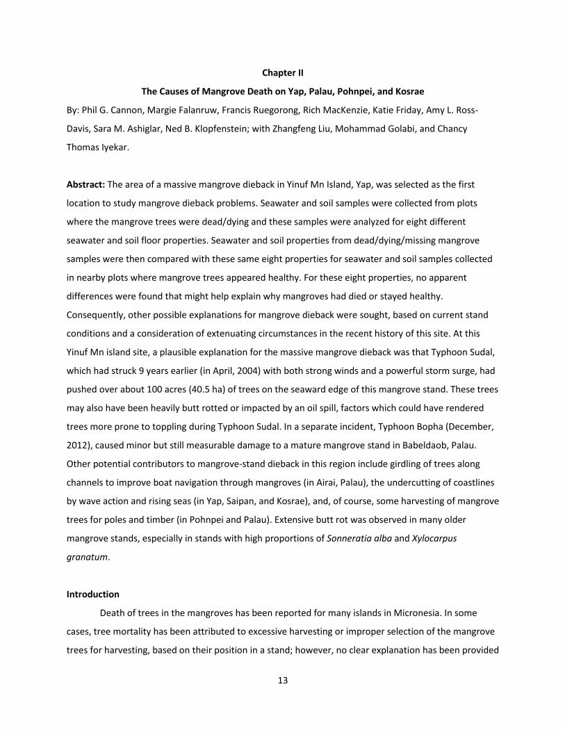
Figure 2. Because this study required plots that represented both high and low tree survival, we used a “mobile laboratory platform”, comprised of two double kayaks carrying the equipment set, to move ~1 mile (1.6 km) during the course of this examination.
Figure 3. A green yardstick (0.91-m, depth-measuring device) was used to measure the depth of seawater to the mangrove muck.

17
Figure 4. The use of a turbidity meter is straightforward, although calibration of this instrument is more involved. Water samples are collected in a cuvette (a 3-cm-long glass vial with a plastic, screw-on top, shown at the right in the photo above) and then inserted in the meter. (Photo by M. Falanruw).
Figure 5. Seawater salinity, pH, and temperature were all measured with this device. In all cases, the probe of the sensor was positioned at 1 inch (2.54 cm) below the water line.

18
Figure 6. Relics of fallen mangrove trees provided testament to the fierce wind and storm surge-generated forces that pounded this area during Typhoon Sudal (April, 2004). Margie Falenruw reported that the leaves of many of these trees turned tan as soon as Typhoon Sudal passed through. It was readily apparent that the exposed root systems had become progressively more damaged by sunscald and a brown cubical rot.
Figure 7. This Rhizophora sp. mangrove tree survived Typhoon Sudal (April, 2004), but it is still suffering from damage. Its crown is leaning towards land, suggesting that it was pushed by the typhoon (wind and/or storm surge), and the neighboring trees are missing entirely. Since then, many exposed stilt roots have become badly cankered (sunscalded) because they are exposed to direct sunshine. The wood beneath these cankers had become colonized by wood-rotting pathogens (largely Ganoderma and Phellinus species). Over the next few years, this wood rot will likely weaken these roots to the point where they fail structurally, and the tree will fall over completely.

19
Figure 8. Soil samples were also collected from a mangrove area that appeared to be in good health. At each setting, one sample was collected for analysis of soil physical and chemical properties, and another sample was collected for a potential soil metagenomics study.
Figure 9. The collection of a mangrove floor sample sometimes includes both mangrove muck (dark material) and reef rubble (white material).The sample was drained in a small sieve for 2 minutes prior to being stored in a preservation solution to prevent degradation of microbial DNA and/or RNA.

20
Figure 10. Two cm3 (ml) of seafloor (the mix of mangrove muck and reef rubble shown in Figure 9) was added to a screw-topped centrifuge tube containing 2.0 ml of the preservation solution. These tubes were then sealed with Parafilm® and stored in refrigerators, freezers, and/or ice boxes, as practical, for the trip from Yap to the Rocky Mountain Research Station Laboratory, where they can be analyzed.
Figure 11. Margi Falanruw, Natural Resource Technology Transfer Specialist, with the USDA Forest Service, Institute of Pacific Islands Forestry, recorded plot notes.

21
In the mangrove sites, this equipment was used to carefully sample and measure seawater pH, salinity,
turbidity, temperature, and depth. These measurements and samples were collected at four locations
where mangrove trees were dead/dying/missing and for four nearby locations (paired plots) where
mangrove trees appeared to be healthy. Similarly, soil samples were collected from the sea-floor surface
at each of these sites and subsequently transported to the Golabi Soils Laboratory at the University of
Guam for analysis of the mechanical and chemical properties. In this laboratory, soil mechanical
properties were analyzed for percent sand, silt, and clay. In addition, soil chemical properties were
analyzed for pH, percent organic matter content, and percent P, Ca, and K. A tactile analysis was also
performed on site with these soil samples to obtain a very rough estimate of their mechanical properties
and organic matter content. To examine any significant differences that might provide a plausible
explanation as to why some mangrove trees had died, results were contrasted for all of these
parameters between mangrove plots that appeared healthy and plots that contained
dead/dying/missing trees.
For potential soil-metagenomics analyses, a tea-cup-sized (~175 ml) scoop was made of the surface soil
right at each plot center, and this sample was then placed in a strainer and allowed to drain for 1
minute. Then, a 2.35-cm3 (ml) soil sub-sample was collected from this strainer and placed in a screw-
capped test tube which contained a solution to prevent degradation of microbial RNA (LifeGuard Soil
Preservation Solution™, MoBio, Carlsbad, CA) and shaken so that the soil sample was well mixed. This
would stymie any future biological reactions as long as the sample was kept below freezing. To ensure
that the samples were kept as cool as possible, the samples were kept in a refrigerator in Yap.
Subsequently, samples were transported on a short flight to Guam, where they were stored in a freezer.
Samples were sent on dry ice to the Forest Pathology Lab of the Rocky Mountain Forest Research
Station, where they will be stored at -80°C until they can be processed. Dependent on funding, amplicon
sequencing of DNA is planned to profile the bacteria and manglicolous fungi (fungi found in mangroves)
present in the samples via the Illumina MiSeq system using 2 x 300 bp-end processing. Sequences will be
associated with specific sediment samples via DNA barcodes, and will be grouped into discrete taxa
based on percent similarity. Soil samples can also be used for metatranscriptomics, in which mRNA is
sequenced to determine which microbial genes were being expressed at that particular seafloor at the
time of sample collection.

22
II) A “common-sense” approach at Yinuf Mn Island, Yap
Of course, it is especially important to consider whether other factors might also be influencing
mangrove dieback in these stands. No special equipment was required for these assessments, which
only required strong communication with well-informed professionals (especially Margie Falanruw and
Francis Ruegorong) and other local inhabitants who were familiar with the mangroves, an open mind,
and a basic understanding of ocean dynamics and tree physiology within mangroves.
III) 3) A “common-sense” approach at other mangrove stands in the Federated State of Micronesia
(FSM).
Similar “common sense” assessments occurred in 11 other “dying” mangrove stands during this
trip. Three more mangrove plots were examined in Yap (with Margie and Pius); five more in Palau (with
Rich, Ome, Larry, and Rayban); one more in Pohnpei (with Kevin Eckert); and two more in Kosrae (with
Maxson and Katie). Nine of these 11 mangrove stands were selected because local foresters suspected
they had health problems. The other two stands were inadvertent finds.
Results
I) A measurements approach at Yinuf Mn Island, Yap
The results from the measurements of seawater properties and the tactile assessments of soil
properties in healthy and dead/dying mangrove plots at Yinuf Mn Island, Yap are shown in Table 1.
The seawater measurements showed only very slight differences between healthy stands and stands
with dead/dying mangrove trees. The average water depth was slightly more than 1 inch (2.54 cm)
deeper where the mangroves have died; the seawater temperature was 1oC warmer in plots where the
mangroves have died compared to apparently healthy mangrove plots; and the water turbidity of the
dead/dying mangrove plots was 2.98 Nephelometric Turbidity Units (NTU) vs. 3.8 NTU in healthy-
appearing plots (excluding plot 10, which was in very shallow water). The salinity was exactly the same
(2.27 %) in the dead/dying/missing and apparently healthy mangrove plots.
The soil samples that were collected from the surface soils in the healthy and dead/dying mangrove
plots were transported to Guam, where they were received by the Mohammad Golabi Soils Laboratory.
These samples were analyzed by Chancy Thomas Iyekar, and the results are shown in Table 2. As shown

23
in Table 2, no consistent differences in the measured soil properties of the ocean floor were observed
between the healthy and dead/dying/missing mangrove plots.

24
Table 1. Properties of seawater and soil in healthy and dead/dying mangrove stands near Yinuf Min Island, Yap. The amount of organic matter is proportional to the number of + signs (+ almost none, +++++ approximately 25%).
Plot
#
Mangrove
health status
Water
depth
(inches)
Water
Temp.
°C
Salinity
%
Turbidity
(NTU)
Soil
texture
Amount
organic
matter
Time
of
day**
4 healthy/young
Rhizophora sp.
3
(7.6 cm)
32.4 2.20 2.00 sandy +++
5 missing/seagrass 4
(10.2 cm)
32. 8 2.27 1.96 sandy + 12:30
6 healthy/young
Rhizophora sp.
2
(5 cm)
33.0 2.28 3.13 sandy + 12:45
7 missing/dead
trees
2
(5 cm)
34.0 2.27 3.16 sandy +++
8 missing/dead
trees
2
(5 cm)
33.7 2.21 4.10 sandy +++
9 missing/dead
trees
2
(5 cm)
35.2 2.19 2.63
____ +++++
13:15
10 healthy/young
Rhizophora sp.
0
(0 cm)
33.5 2.21 10.54*** sandy +++++
11 healthy/young
Rhizophora sp.
2.5
(6.4cm)
32.4 2.28 6.35 sandy +
14:25
** Low tide occurred at about 13:30 this day.

25
*** water depth was too shallow
Table 2. Properties of soils from Yinuf Mn where samples were collected from healthy appearing mangrove stands (H) and from mangrove stands which are currently dead/dying/missing trees (M).
Sample ID pH
Salinity
(EC)
µS/cm
%
O.M.
Available
P (ppm)
Available
K (ppm)
Available
Ca (ppm)
Available
Mg (ppm)
S-1H 7.14 36 21.90 2.84 2806 11288 7195
S-2M 7.55 25 14.50 2.18 1506 9127 5626
S-3 7.65 72 18.60 6.37 3005 7911 7069
S-4H 7.73 21 9.70 6.76 1563 7572 3453
S-5M 8.18 15 1.60 5.99 532 6448 832
S-6H 8.20 13 1.40 7.80 375 6380 1109
S-7M 7.68 63 20.20 3.99 2625 8444 7435
S-8M 7.82 53 13.00 5.99 1603 7761 4896
S-9M 7.34 62 20.90 4.45 2891 8250 7932
S-10H 7.60 71 18.80 6.18 3958 10850 7665
S-11H 8.03 16 3.00 6.56 6883 6548 1415
The tactile assessments indicated that the mangrove “soil” of all plots was largely composed of a coarse,
sandy textured matrix or rubble (actually this is a mixture of degraded and ground-up reef and coralline

26
algae). These results indicate soils from both healthy and dead/dying (or missing) mangroves were
associated with variable organic matter content (soil organic matter varied from 3% to 21.9%).
II) A “common-sense approach at Yinuf Mn Island, Yap
Upon inquiry, Dr. Margie Falanruw (USFS, Yap) suggested that four incidents may have played a
role in the massive demise of mangroves at Yinuf Mn Island. The first was that sea level rise had been
reported in this part of the Pacific. Margie had since discounted this as sea level has remained constant
for a number of years, now. The second was the construction of two airfields in areas south and west of
this mangrove. She had considered it possible that massive amounts of sediment could have washed
down the watershed and ended up in this mangrove area. The first airport had been constructed by the
Japanese during World War II, the second about 20 years ago. The sediment from this construction may
have had some adverse impacts on mangrove trees at Yinuf Mn, but the damage at Yinuf Mn is
extensive and much of it seems to have occurred at one time between 2000 and 2012 (between the
times when Yinuf Mn was photographed remotely with full vegetation in 2002 and the time when
remote photography showed the massive mangrove loss in 2012). Thus, construction of the airports
seems to have occurred too long ago to be a major contributor to the extensive mangrove death that is
currently evident. A third potential incident involved the collision of a ship with the reef near the
entrance to Yap’s main harbor. Some possible repercussions were anticipated, but a post-spill
monitoring program did not find any dieback or death in mangrove trees up to 1 year after the spill.
Because this incident took place 2 decades ago, it also seems to have occurred too long ago to have
been the primary cause of this present problem with mangrove health.
A fourth potential incident is an apparent correlation between the path of Typhoon Sudal and the
location of the massive mangrove dieback at Yinuf Mn. Typhoon Sudal was traveling west and
southwestward on April 11th, 2004 when it struck the east coast of Yap with a wind force estimated at
115 mph (185 km per hour). Additional evidence also indicates that much of the mangrove damage at
Yinuf Mn was due to Typhoon Sudal:
1) At least two-thirds of the tree trunks were laying with their tops pointing in a westerly direction;
in other words, in the direction that the typhoon winds and storm surge might have pushed them;
2) Most of the fallen tree trunks were in a similar state of decomposition, suggesting that they had
fallen over at about the same time (same year);

27
3) The amount of decomposition that had occurred on the outside portions of the dead and tipped
trees appeared to have been accumulating for about a decade; and
4) Most of the trees that had tipped over were about 8 to 20 inches (20 to 51 cm) in diameter; in
other words, the fallen trees were much larger and older than trees in the current stands, which
consisted of rather small, 4- to 6-inch (10- to 15-cm) diameter Rhizophora mangroves that were
found in the nearby plots of healthy mangroves.
Figure 13. Eye of Typhoon Sudal as it passed 12 miles (19 km) to the south of Yap on April 11, 2004, moving at about 20 mph (32 km per hour). The winds from this storm were estimated at 115 mph (185 km per hour) and the storm surge is estimated to have been at between 8 - 12 feet (2.4 – 3.7 m) in height when it hit the coast (from: Wikipedia.org/wiki/Typhoon _Sudal).
Figure 14. Photo was taken in the same mangrove area in Yap as Figures 1-12, but about 0.5 mile (0.8 km) from the devastated area and much closer to the land. This section of the mangrove was buffered

28
from both the powerful wind and the storm surge that was experienced by the outermost mangroves, because more mangrove trees were present between this section of mangrove forest and the open sea. In this section, the mangrove trees here are fairly large, with many in the 10- to 14-inch (25.4 – 35.6 cm) diameter range, and many of them were quite rotten. The range in rot varied widely by tree species. Multiple conks were present on over 50 % of the trees of some species; whereas, conks were present on less than 10% of the trees of other mangrove species. The conk in the hand is a member of the Phellinus genus. The exact species identification of this conk (and eighty other conks collected during this trip) is currently being conducted using DNA-sequence and morphology-based techniques by forest research laboratories in the USA and Japan (see Chapter III of this report for more details on the fungal identification process). 3) A “common-sense” approach at other mangrove stands in the Federated State of Micronesia (FSM).
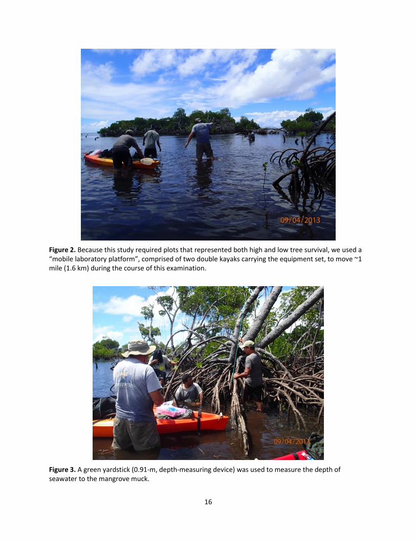
The locations, causes of death, and approximate percentage of dead trees found in all 12 of
these mangrove areas are summarized in Table 3.
Table 3. Summary of apparent contributors to mangrove death found during the September 2013 foray to the Federal States of Micronesia.
Island
and # of
stand
Location on the island
Principle causes of
death
Approximate %
dead trees
Yap
1
Yinuf Mn Island,
southeast of the college,
YAP
Typhoon Sudal and
over-mature stand
100% in about 10 acres (4 ha)
10% in remaining 90 acres (36
ha)
2 Yinuf Mn Rock island
Typhoon Sudal and
mature stand
80% in 0.5 acre (0.2 ha) 1% in
remaining 2 acres (0.8 ha)
3 Channel west of Yinuf
Mn Island
Basidiomycete conks
in overmature stand
2% in 300 acres (121 ha)
4 Shoreline mangroves
near S. seawall
Undercutting of coast
by waves at high tide
15% in 400m of coast
Palau
5
Southeastern shore
Babeldaob
Girdling of trees along
500m of channel
99% within 5m of channel
29
2% at > 5m from channel
6 Carbon Sequestration
plot, southeastern
Babeldaob
Basidiomycete conks
in overmature stand
4% of all trees infected
50% of all large Xylocarpus
7 Growth plot in
northeastern Babeldaob
fungal conks & minor
typhoon breakage
6% dead & with substantial
stem breakage
8 Overmature coastline
stand near capitol
fungal conks and wave
undercutting
5% of trees dying recently;
trees fall from waves; rotten
limbs fall off quickly
9 Mature stand in mid-
Babeldaob near bridge
Clearcutting of about
10 acres (4 ha)
100% of trees were cut in this
stand; neighboring stands OK
Pohnpei
10
Nan Medal mangrove
Heavy selective
cutting
about 50% of all mangrove
basal area
Kosrae
11
Yela River Conservation
Area (Forest Legacy)
Basidiomycete conks
2% in the mangrove section of
this conservation area
12 Coastline near Kosrae
Village Resort
Severe wave under-
cutting at high tide*
70% in mature section
1% in regenerating section
*Berm position on Kosrae was being adversely influenced by nearby road construction.

30
Figure 15. Track of Typhoon Bopha as it passed by Palau, 51 km to the south, on Dec 3, 2012 (from http://en.wikipedia.org/wiki/Typhoon_Bopha).
Discussion
A measurements approach on Yinuf Mn Island, Yap
Although slight differences were apparent in three of the four seawater properties between
healthy and dieback mangrove plots (Table 1), it is likely that two of these differences in seawater
properties might be reflecting the absence or presence of mangrove overstory, rather than a
contributing cause of the absence or presence of the mangrove. The sunlight was very intense on the
day these measurements were recorded, and it seems reasonable to assume that the temperature of
seawater shaded by a mangrove canopy would be cooler than seawater in open sunlight. Furthermore,
the 1°C temperature difference for water in the shade versus water in the open is exactly the same as
that found by Ewel et al. (1998). In addition, deeper seawater would undoubtedly require more calories
to heat up than shallower seawater. And, again, the 1°C difference in temperatures due to depth
(comparing samples in shady plots) and the 1.7°C difference due to depth (comparing samples in sunny
plots) seem to approximate differences that would be expected. The relationship between seawater
depth and soil turbidity was not clear from the measurements that were recorded. Such inconsistencies
are perhaps attributable to slight disturbances of the seafloor that occurred in locations where seawater
Palau

31
depth was quite shallow, such as, < 1 inch (2.54 cm). Thus, these studies did not provide strong basis to
suggest that water temperature, turbidity, or salinity had exerted any influence on mangrove health.
These preliminary measurement did, however, provide some reason to further investigate whether
seawater depth has an influence on regeneration success of mangroves. A potential role of seawater
depth is discussed later in this chapter.
The chemical and physical analyses of the seafloor samples also showed no significant variation between
the healthy mangrove plots and the plots with missing/dead/dying mangrove trees (Table 2). Thus, the
dieback of the mangroves at Yinuf Mn, Yap could not be directly attributed to variation in measured
properties of the seawater or ocean floor. Nevertheless, three additional points must be considered.
First, sampling was not exhaustive in terms of the numbers of samples that were collected. Second, the
organic muck was relatively deep in some apparently healthy mangrove stands, but the organic muck
appeared very shallow or nonexistent in other healthy mangrove stands. Thus, a deep muck layer does
not seem to be essential for supporting healthy mangroves. Finally, it was also observed that the muck
layer was thin and sometimes nonexistent in dead/dying mangrove stands that were surveyed. This last
point could have important repercussions in terms of carbon sequestration. It was observed on multiple
occasions during this trip, and has been well documented by Donato et al. (2011), that the presence of
mangrove forest is strongly related with the ability to collect and maintain what is known as mangrove
muck. Indeed, during this foray to the Yinuf Mn area where the mangroves had disappeared, both
Margie Falanruw and Francis Ruegoroug observed that considerable mangrove muck had been lost since
a previous trip to this same area 3 years earlier. This carbon loss situation is discussed in more detail in
Chapter VII of this report.
II) A “common-sense” approach at Yinuf Mn Island, Yap
After examining the evidence, it was concluded that much of the mangrove dieback problem at
Yinuf Mn Island in Yap was likely attributable to Typhoon Sudal. It is difficult to reconstruct everything
that happened during and after this typhoon, but perhaps some conjecture will provide potential
insight. Yinuf Mn Island that is conspicuously void of trees, many trunks remain from the big trees that
that were pushed over. It appears this area formerly contained a relatively mature mangrove stand.
Almost certainly, the wind was not the only significant lateral force that impacted these trees. The storm
surge, storm tide, and breaking waves that came through this area were also quite forceful, as currently

32
evidenced by plastic chairs and other debris that were deposited 8 feet (2.4 m) high in the crowns of the
smaller, more flexible, mangroves that had survived. (Note: some this debris was probably deposited by
backwash, which is discussed later).
There are no eyewitness accounts as to what exactly happened when Typhoon Sudal made landfall in
the Yinuf Mn Island area, and any witnesses would likely not survive such forces. However, some
information is available. According to the Wikipedia account of Typhoon Sudal (Wikipedia.org), winds hit
Yap at 105 mph (169 km per hour) over 10-minute periods, with occasional gusts of up to 140 mph (225
km per hour). Over more sustained periods, the winds were 45 mph (72 km per hour).
As the eye wall of this typhoon passed over the southern tip of Yap, 6-9 inches (15-23 cm) of rain fell,
accompanied by a storm surge of 8-12 feet (2.4-3.7 m) and a pounding surf of 22 feet (6.7 m) (NOAA
2010).
The reason that a storm surge occurs is based on simple physics. The strong winds of the typhoon push
on the surface of the ocean. The water cannot move as fast as the wind because of friction from the
relatively stationary ocean so it becomes heaped up into a section of ocean that is now several feet (>2
m) higher than the ocean level would normally be in the absence of the storm. As such, this mass, or
surge of water may be several feet (>2 m) higher than the normal ocean level and moving at a velocity
of 10 to 15 mph (16-24 km per hour) (www.wunderground.com). The exact force with which these
storm surges exert when they strike land can vary considerably but are generally proportional to the
strength of those winds generated by the typhoon and the directness with which they hit the island. The
National Oceanic and Atmospheric Administration (NOAA) provides an interesting summary on the
factors that influence the force of a storm surge when it makes landfall: “The size of a storm surge for a
particular location depends on a number of factors. Storm surge is very sensitive to the shape of the
coast, and to changes in storm track, intensity, forward speed, and size. Tidal height at the time of
maximum storm surge is an important factor, too. (The combined effect of the storm surge and the
astronomical tide is called the storm tide.) The slope of the sea floor also influences the level of surge in
a particular area. Areas with a shallow slope of the sea floor off the coast will allow a greater surge.
Areas with a steeper slope will not see as much surge, but will generally have large breaking waves that
can destroy lower elevation buildings near the coast and open bays” (http:www.noah watch.gov).

33
From these indications and the fact that Yap is surrounded by a reef on most sides, one could conjecture
that some very large breaking waves accompanied this storm surge and that these breaking waves
would have been most powerful where the storm surge blasted into the reef at a perpendicular angle. In
the case of Typhoon Sudal, these breaking waves would have been directed almost precisely at the Yinuf
Mn island location on the reef. Another key factor is that coastal configuration can also influence the
power of the surge received at a given point on the coast. This was graphically demonstrated in
Tacloban, Philippines when the storm surge from Typhoon Haiyan (=Typhoon Yolanda) was forced into a
bay whereupon the shoreline acted as a funnel to create an exceptionally powerful force. Perhaps
something similar occurred when the storm surge from Typhoon Sudal approached Yinuf Mn.
Regardless of the combined forces that toppled these big trees, it appears that some of these fallen
trees continued to maintain at least partial anchorage of their root systems in the sea floor and green
leaves on part of their crowns subsequent to this event. This condition would also have given the
appearance that these stands were alive and healthy for several years after the typhoon, especially
when viewed from satellite imagery. The effect of a storm surge in a mangrove area differs from that of
most forests established in coastal areas. Mangroves necessarily have a very shallow root system,
whereas trees in other coastal forests typically possess deeper root systems. Because of the shallow
root system, mangroves are more prone to being pushed over instead of broken off. This is consistent
with the type of damage observed at Yinuf Mn, except for those trees that had advanced butt-rot.
Finally, although all of the aforementioned, typhoon forces (high winds, high tide, storm surge, and high
waves) come from a seaward direction, the forces arising from a powerful backwash must also be
considered. Backwash occurs after a storm surge has passed, when all of that surge-displaced water
returns back to sea level. In some places, the land topography can channel these returning waters in a
manner that creates tremendous force. A powerful backwash could have contributed additional damage
to standing trees, and almost certainly cause some reorienting of the fallen trees.
34
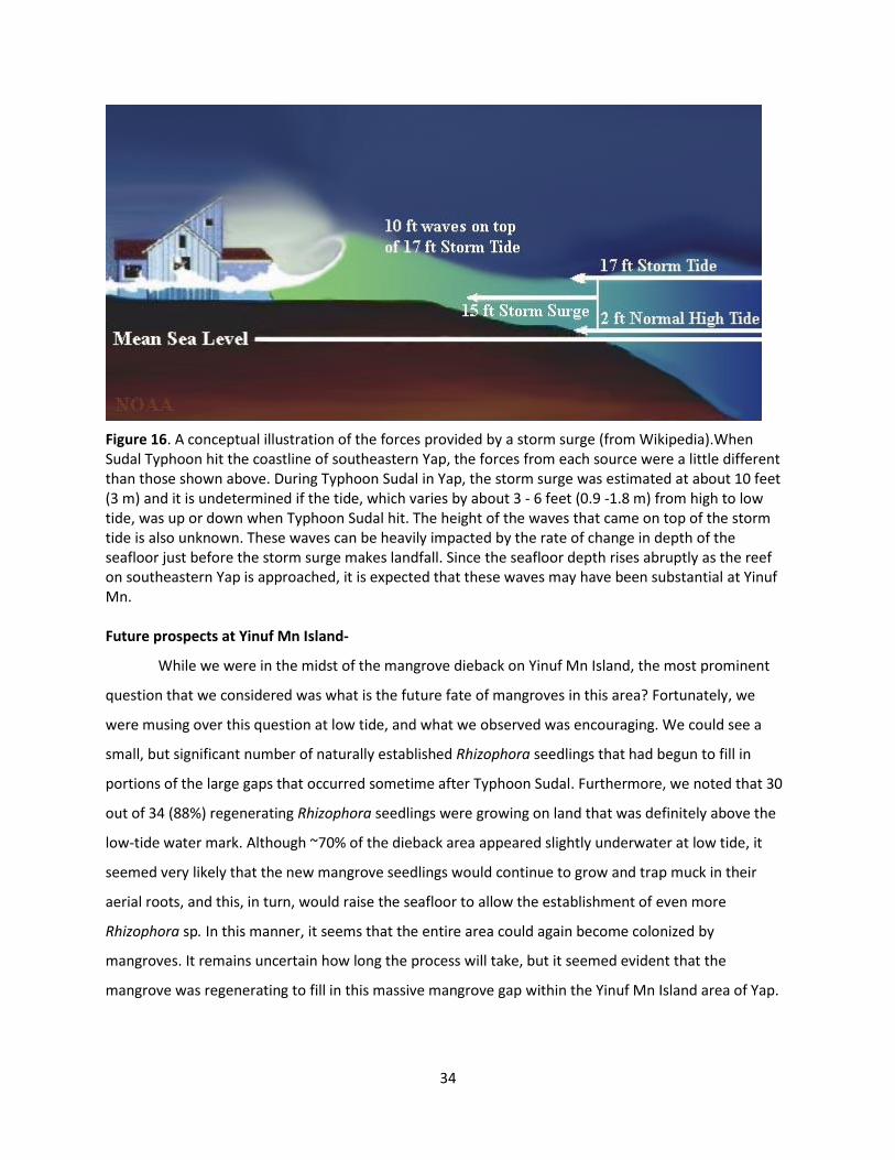
Figure 16. A conceptual illustration of the forces provided by a storm surge (from Wikipedia).When Sudal Typhoon hit the coastline of southeastern Yap, the forces from each source were a little different than those shown above. During Typhoon Sudal in Yap, the storm surge was estimated at about 10 feet (3 m) and it is undetermined if the tide, which varies by about 3 - 6 feet (0.9 -1.8 m) from high to low tide, was up or down when Typhoon Sudal hit. The height of the waves that came on top of the storm tide is also unknown. These waves can be heavily impacted by the rate of change in depth of the seafloor just before the storm surge makes landfall. Since the seafloor depth rises abruptly as the reef on southeastern Yap is approached, it is expected that these waves may have been substantial at Yinuf Mn. Future prospects at Yinuf Mn Island-
While we were in the midst of the mangrove dieback on Yinuf Mn Island, the most prominent
question that we considered was what is the future fate of mangroves in this area? Fortunately, we
were musing over this question at low tide, and what we observed was encouraging. We could see a
small, but significant number of naturally established Rhizophora seedlings that had begun to fill in
portions of the large gaps that occurred sometime after Typhoon Sudal. Furthermore, we noted that 30
out of 34 (88%) regenerating Rhizophora seedlings were growing on land that was definitely above the
low-tide water mark. Although ~70% of the dieback area appeared slightly underwater at low tide, it
seemed very likely that the new mangrove seedlings would continue to grow and trap muck in their
aerial roots, and this, in turn, would raise the seafloor to allow the establishment of even more
Rhizophora sp. In this manner, it seems that the entire area could again become colonized by
mangroves. It remains uncertain how long the process will take, but it seemed evident that the
mangrove was regenerating to fill in this massive mangrove gap within the Yinuf Mn Island area of Yap.

35
Of course, chances remain that this same area will get impacted again by a future typhoon. Discussion
about which part of a mangrove might be most impacted by future typhoons is presented later in this
chapter.
III) A “common-sense” approach to understanding mangrove dieback throughout the Federated States
of Micronesia.
From the summary provided in Table 1, six factors are apparent that potentially play significant
roles in limiting or reducing the size of mangrove stands in Micronesia: 1) a sea water depth that is too
high at low tide, e.g., > 1 inch (2.54 cm) of depth; 2) typhoons; 3) conk-forming basidiomycetes; 4)
harvesting for wood products; 5) girdling to open boat transportation channels; and 6) high-tide wave
action. In some cases, potential interactions between two or more of these factors were apparent, and
sometimes other anthropogenic activities also appeared to be acerbating these problems.
Considerations of potential effects of future typhoons on a mangrove trees are especially interesting.
The winds from typhoons would likely have their greatest impacts on large mangrove trees because of
the large area of their crowns. If these older trees also had butt rot, they would be even more
vulnerable. In contrast, the trunks and the aerial roots of the trees would likely be more vulnerable to
the forces from the storm surge itself. Mangrove trees that are more distant from the exposed
(seaward) edge of the mangrove stands are likely less vulnerable to breakage or pushover by high winds
and storm surge.
The amount of damage can vary with each typhoon. For instance, the influence of Typhoon Bopha
(2012) on Palau (Table 3, Stand 7) produced only a small fraction of the damage that Typhoon Sudal
(2004) wrought on the Yinuf Mn island of Yap (Table 3, Stand 1). This difference in damage is largely
because the center of Typhoon Sudal was much closer and remained longer (including time when the
tide was at its peak) when it passed by Yap than the center of Typhoon Bopha when it passed by Palau.
Therefore, wind speeds and the accompanying storm surge from Typhoon Bopha on Palau would have
been lower than those from Typhoon Sudal on Yap.
Of course, a typhoon center could also pass even closer to an island than Typhoon Sudal did on Yap. If
this were to happen, even heavier levels of damage than occurred at Yinuf Mn could also be expected.
For example when this report was being written, radio announcements indicated that Typhoon Haiyan

36
(= Typhoon Yolanda) was pounding down on the Philippine, accompanied by the wind gusts of 170 mph
(270 km per hour) and the storm surge was registered at 20 feet (6 m) and moving at 25 mph (40 km per
hour) (Samenow 2013). In addition, the analyses of Typhoon Haiyan showed that certain topographic
features of the coastline, such as the inlet at Tacloban, acted as a funnel and caused the storm surge to
be even higher. Although Typhoon Haiyan was one of the most powerful typhoons on record, many
other typhoons have been powerful and very damaging (e.g., Typhoon Bopha as it passed directly over
Mindanao, Philippines). From this perspective, it seems that living in Yap, Palau, Guam, or Saipan (either
as a person or as a mangrove forest on the windward side of the typhoon’s path) can seem like a risky
proposition, especially about twice a year during typhoon seasons. People, of course, can vacate to
higher ground when NOAA issues a typhoon warning. Trees, and especially mangroves, are not so lucky.
It might be noted that the loss of overmature mangrove stands by typhoons is not necessarily a negative
consequence. Indeed, as long as the intervals between typhoons are not too short, typhoons provide
mangroves with an opportunity to regenerate in a manner that replaces older, senescing stands with
younger, more vigorous stands. According to Margie Falanruw, some meteorologists predicted a few
years ago that climate change would greatly increase the number of typhoons coming to Micronesia.
Subsequently, the interim period between typhoons appeared to follow the historical norm; however,
several huge typhoons have pounded Micronesia and the Philippines between late September and late
October of 2013, when these island nations endured some of their worst typhoons ever.
Not all of the typhoon damage occurs during the time of the typhoon. For example, stem or limb
breakage can produce large wounds on the affected tree, which exposes decay susceptible-heartwood
to spores of decay fungi, such as species of the genera Phellinus and Ganoderma. In the decades
following a typhoon, it might be expected that a mangrove of a certain age that had suffered wind
damage would be have substantially more wood decay than a similarly aged mangrove that had not
suffered wind damage.
Although so far this report is largely focused the near-term effects of typhoons on coastal mangroves,
typhoons have also had another very important effect on island formation for many Pacific islands,
because typhoon can influence the formation and location of islands berms. For example, Kosrae, an
island that currently gets few powerful typhoons, experienced two very powerful typhoons in 1891 and
1905. These typhoons were, in fact, so strong that they moved a substantial amount of reef rubble

37
around and formed a 5-foot (1.5 m) high, 30-foot (9.1 m) wide berm that runs parallel to the Kosrae
coast for miles (>3.2 km). Since 1905, these berms have separated low lying sections of Kosrae from the
ocean (Chaoxiong 2001). Today, many Kosraeans live in this flat area between this temporary berm and
the main road surrounding the island at the base of the hills.
If this berm line is ever breached at high tide, thousands of acres would be inundated with seawater. No
breaching occurred during this visit, but it was evident that such breaching does happen occasionally.
Areas prone to inundation in this manner cannot be farmed except with plants that are very salt-
tolerant (e.g., coconut). Most houses in this area have been built on stilt risers of about 2-3 feet (0.6-0.9
m), which is high enough to keep the floorboards above this water. In areas where the flat area between
the island road and the berm is under water much of the day, mangroves predominate. Mangroves and
slightly less manglicolous species (e.g., palms, Thespesia populnea, and Barringtonia spp.) tend to grow
on the margins of the berms and the top of the berms, respectively.
Apparently, these flat areas between the berm and the road are most susceptible to inundation when a
“King tide” (unusually high tide) occurs. Of course, if a typhoon hit as it did in Yap, a wall of water up to 8
feet (2.4 m) high might come over the berm during the storm surge. (Note: a tsunami might also
produce a major problem of similar ilk). Fortunately for the people of Kosrae and Pohnpei, typhoons
tend to originate in these island areas and reach dangerous force levels only by the time they reach
Guam, Yap, Palau, Saipan, or other areas to the west (and there are is no recent history of tsunamis in
Pohnpei or Kosrae).
The damage to mangroves that are located right on the coastline (Table 3, stands 4 and 8) or on these
temporary berms (Table 3, stand 11) was only partially surveyed during this visit. Although there was
local concern that sea-level rise might increase wave undercutting on berms, several inhabitants had
observed no evidence that the sea level had been rising. Regardless of whether a rising sea level is
occurring, it was quite evident that strips along some coastlines, where a large number of mangrove and
other tree species (e.g., palms, Thespesia populnea, and Barringtonia spp.) occur, are being undercut by
waves at high tide.
Although the majority of this report has focused on the impact of typhoon damage, or damage from
waves at high tide, this survey also noted several other agents were contributing to death and health

38
declines of mangroves. In the case of the girdling at Babeldaob, Palau (Table 3, stand 5) and the
harvesting in Kosrae (Table 3, stands 10 and 11), the reasons for tree mortality were obvious (i.e.,
opening the channel and harvesting for wood products, respectively) and local communities should
determine if these kinds of tree losses are acceptable. However, because so many mangrove species are
vulnerable to colonization by Phellinus and other conk-forming fungal species after even minor damage
to their bark, tree harvesters should be educated on methods to limit damage on the residual trees.
Conveniently, some very insightful harvesting plans have been developed for some large mangrove
areas, which show how sections of the mangrove can be harvested while still having expectations for
speedy stand recoveries (Macintosh and Ashton 2003). Such plans should be shared among villages that
plan to continue harvesting mangroves. Approximately half of the 12 mangrove stands visited during
this trip had forest disease problems (biotic and/or abiotic), which may represent additional concern.
However, these twelve mangrove areas that were surveyed during this visit, represent less than 2% of all
mangroves in Micronesia and most of the remaining mangrove stands that were only casually observed
appeared to be in good health
Conclusions
Six different factors appeared to be the major contributors to damage on surveyed mangroves
in Micronesia. In mangroves surveyed on this trip, Typhoon Sudal seemed to be the major factor for the
largest single dieback, which included several hundred acres of mangroves on the eastern coast of Yap.
Older mangrove trees near the eastern seaside edge of Yap were apparently impacted the most by
Typhoon Sudal. Butt-rotting fungi (largely in the genus Phellinus) also appeared to render infected
mangroves more vulnerable to wind and storm surge damage.
In a number of locations in the Micronesian shoreline, mangroves and other tree species are being
undercut by wave action at high tide; this causes the toppling of many thousands of trees, and, in some
cases, increases the vulnerability of land inside the coastal ridgelines to inundation by seawater.
Harvesting for wood products and girdling to increase channel width were two other causes of
mangrove demise.
In spite of all of the setbacks to mangroves documented in this report (both from natural and
anthropogenic causes), the mangroves of Micronesia are generally vibrant with life, and they even seem
to be expanding in many parts of these island nations.

39
References
Chaoxiong, H. 2001. Coastal erosion assessment Malem Village, Kosrae State Federated States of
Micronesia. SOPAC Technical Rept. 341
Donato, D.C.; Kauffman, J.B.; MacKenzie, R.A.; Ainsworth, A.; Pfleeger, A.Z. 2011. Whole-island carbon
stocks in the tropical Pacific: implications for mangrove conservation and upland reforestation. J.
Environ. Manag. 30 (97): 89-96.
Ewel, K.G.; Zheng, S.; Pinzon, Z.S.; Bourgeois, J.A. 1998. Environmental effects of canopy gap formation
in high-rainfall mangrove forests. Biotropica 30(4):510-518.
http://www.noaawatch.gov/themes/coastal_inundation.php
Macintosh, D.J.; Ashton, E.C. 2003. Draft code of conduct for the sustainable management of mangrove
ecosystems. World Bank, ISME, center Aarhus.
http://www.mangroverestoration.com/MBC_Code_AAA_WB070803_TN.pdf
Masters, J. Storm surge survival misconceptions. Weather Underground.
www.wunderground.com/hurricane/surge_misconceptions.asp
NOAA. 2010. http://www4.ncdc.noaa.gov/cg/-win/walogl.dll/wwevent~shoevent~563701
Samenow, J. 2013. Storm surge science: the funneling effect in Tacloban from typhoon Haiyan.
http://www.washingtonpost.com/blogs/capital-weather-gang/wp/2013/12/02/storm-surge-science-
the-funneling-effect-in-typhoon-haiyan-and-tacloban-video/
Wikipedia.org/wiki/Typhoon _Sudal
http://en.wikipedia.org/wiki/Typhoon_Bopha
Chapter source: Cannon, P.G.; Falanruw, M.; Ruegorong, F.; MacKenzie, R.; Friday, K.; Ross-Davis, A.L.; Ashiglar, S.M.; Klopfenstein, N.B.; Liu, Z.; Golabi, M.; Iyekar, C.T. 2014. Chapter II. The causes of mangrove death on Yap, Palau, Pohnpei and Kosrae. pp. 13-37 in: Cannon, P.G.; Forest Pathology in Yap, Palau, Pohnpei, Kosrae, Guam and Saipan, Sept. 2013; Trip Report, USDA Forest Service, Region 5, Forest Health Protection, Vallejo, CA, USA. 114p.