Embed Size (px)
Citation preview
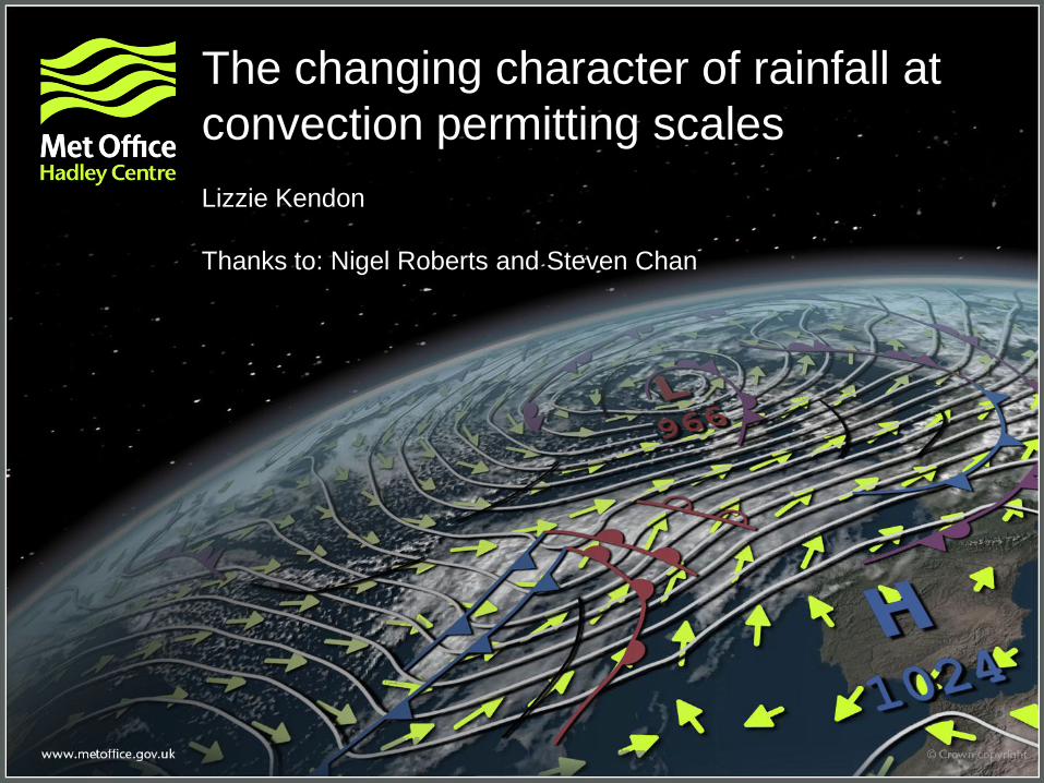
The changing character of rainfall at
convection permitting scales
Lizzie Kendon
Thanks to: Nigel Roberts and Steven Chan
© Crown copyright Met Office
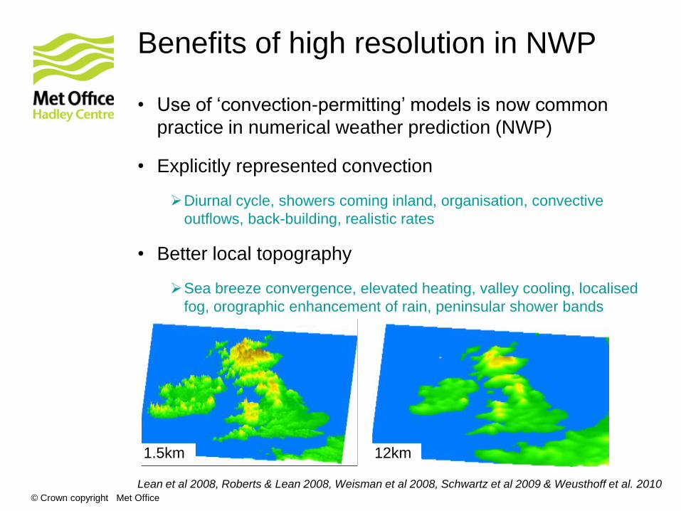
• Use of ‘convection-permitting’ models is now common
practice in numerical weather prediction (NWP)
• Explicitly represented convection
Diurnal cycle, showers coming inland, organisation, convective
outflows, back-building, realistic rates
• Better local topography
Sea breeze convergence, elevated heating, valley cooling, localised
fog, orographic enhancement of rain, peninsular shower bands
Lean et al 2008, Roberts & Lean 2008, Weisman et al 2008, Schwartz et al 2009 & Weusthoff et al. 2010
Benefits of high resolution in NWP
1.5km 12km
© Crown copyright Met Office
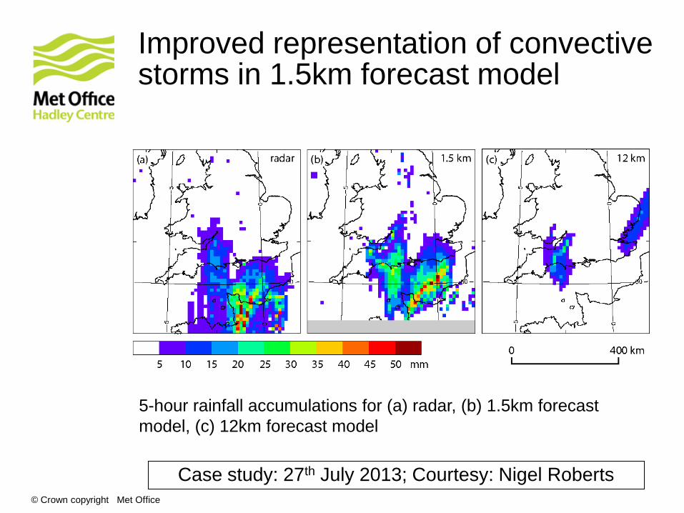
Improved representation of convective storms in 1.5km forecast model
5-hour rainfall accumulations for (a) radar, (b) 1.5km forecast
model, (c) 12km forecast model
Case study: 27th July 2013; Courtesy: Nigel Roberts
© Crown copyright Met Office © Crown copyright Met Office
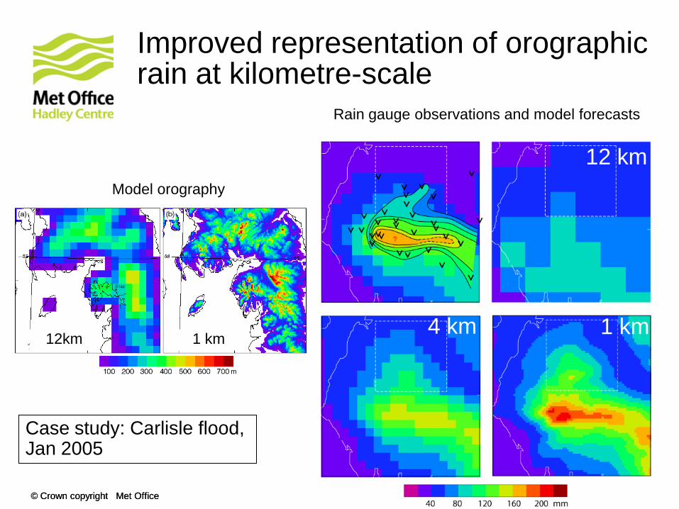
Improved representation of orographic rain at kilometre-scale
12 km
4 km 1 km
Rain gauge observations and model forecasts
Model orography
12km 1 km
Case study: Carlisle flood, Jan 2005
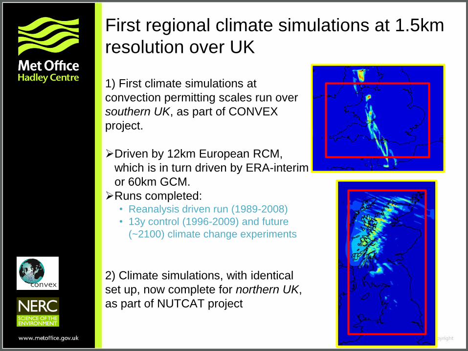
First regional climate simulations at 1.5km
resolution over UK
1) First climate simulations at
convection permitting scales run over
southern UK, as part of CONVEX
project.
Driven by 12km European RCM,
which is in turn driven by ERA-interim
or 60km GCM.
Runs completed: • Reanalysis driven run (1989-2008)
• 13y control (1996-2009) and future
(~2100) climate change experiments
2) Climate simulations, with identical
set up, now complete for northern UK,
as part of NUTCAT project
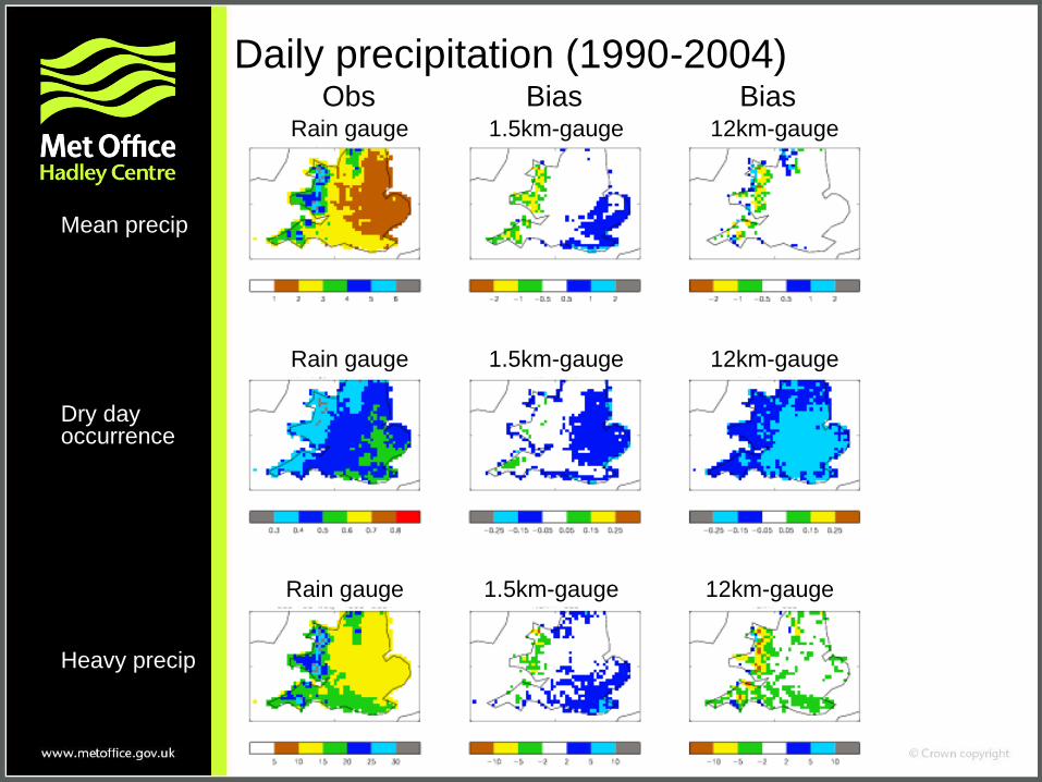
Daily precipitation (1990-2004)
Mean precip
Dry day occurrence
Heavy precip
Rain gauge 1.5km-gauge 12km-gauge
Rain gauge 1.5km-gauge 12km-gauge
Rain gauge 1.5km-gauge 12km-gauge
Obs Bias Bias
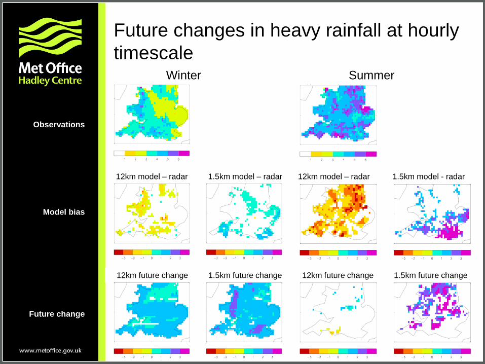
Future changes in heavy rainfall at hourly
timescale
Observations
Model bias
Future change
Winter Summer
12km model – radar 1.5km model – radar 12km model – radar 1.5km model - radar
12km future change 1.5km future change 12km future change 1.5km future change
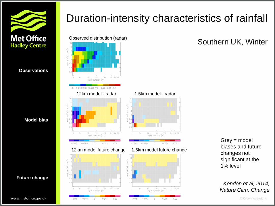
Duration-intensity characteristics of rainfall
Southern UK, Winter
Observed distribution (radar)
12km model - radar 1.5km model - radar
12km model future change 1.5km model future change
Grey = model
biases and future
changes not
significant at the
1% level
Kendon et al, 2014,
Nature Clim. Change
Observations
Model bias
Future change

Observed distribution (radar)
12km model - radar 1.5km model - radar
12km model future change 1.5km model future change
Grey = model
biases and future
changes not
significant at the
1% level
Kendon et al, 2014,
Nature Clim. Change
Duration-intensity characteristics of rainfall
Southern UK, Summer
Observations
Model bias
Future change
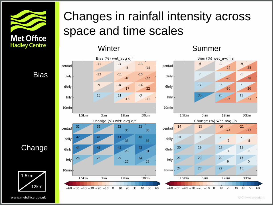
Changes in rainfall intensity across
space and time scales
Winter Summer
Bias
Change
1.5km
12km
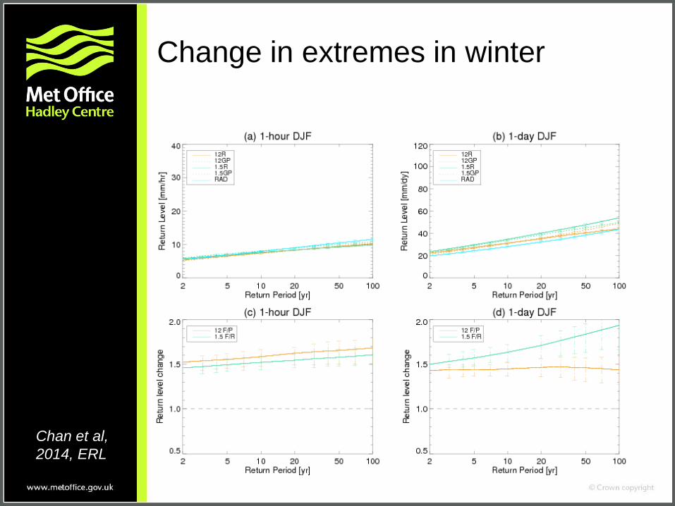
Change in extremes in winter
Chan et al,
2014, ERL
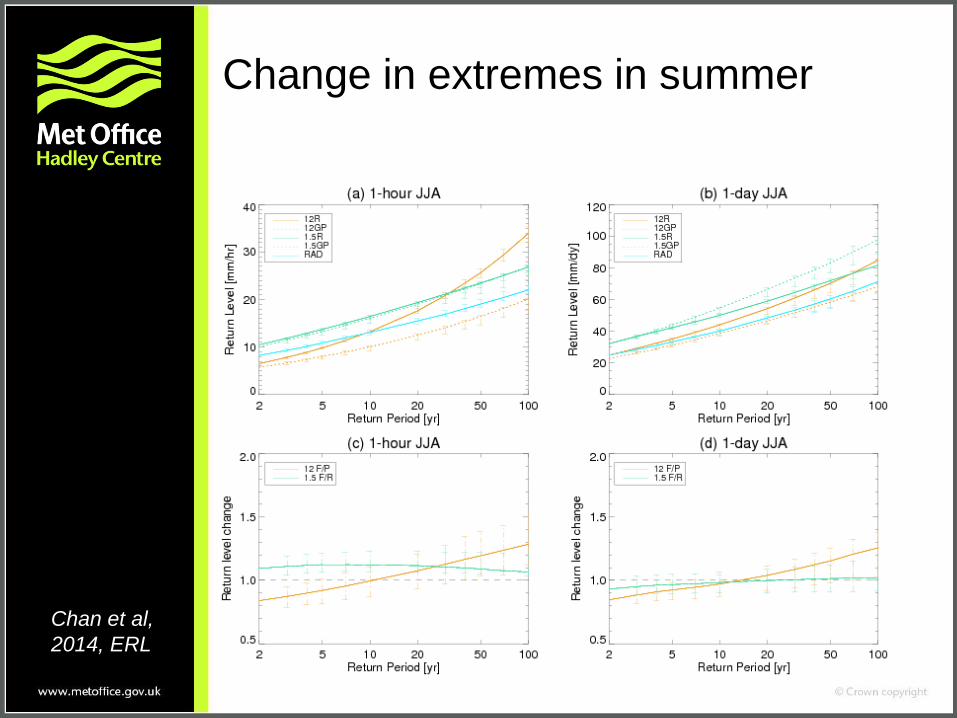
Change in extremes in summer
Chan et al,
2014, ERL
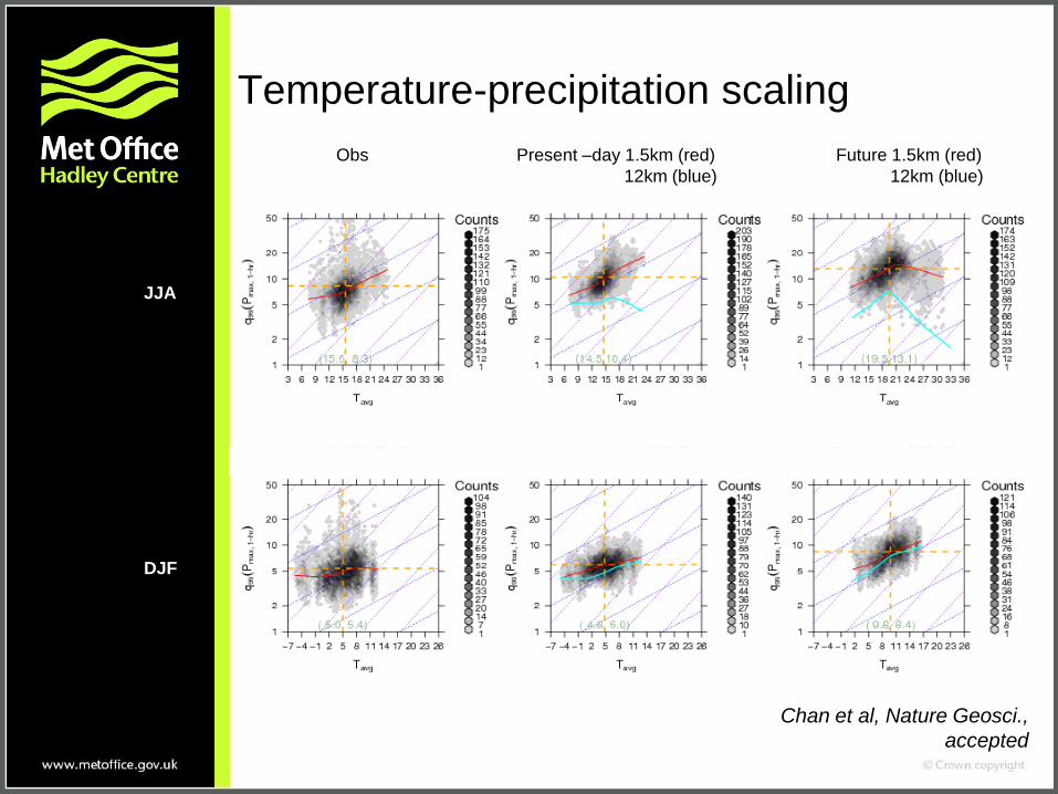
Temperature-precipitation scaling
Obs Present –day 1.5km (red) Future 1.5km (red)
12km (blue) 12km (blue)
JJA
DJF
Chan et al, Nature Geosci.,
accepted
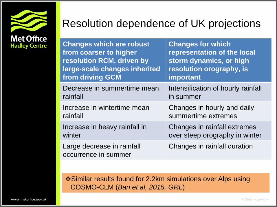
Resolution dependence of UK projections
Changes which are robust
from coarser to higher
resolution RCM, driven by
large-scale changes inherited
from driving GCM
Changes for which
representation of the local
storm dynamics, or high
resolution orography, is
important
Decrease in summertime mean
rainfall
Intensification of hourly rainfall
in summer
Increase in wintertime mean
rainfall
Changes in hourly and daily
summertime extremes
Increase in heavy rainfall in
winter
Changes in rainfall extremes
over steep orography in winter
Large decrease in rainfall
occurrence in summer
Changes in rainfall duration
Similar results found for 2.2km simulations over Alps using
COSMO-CLM (Ban et al, 2015, GRL)
Summary
• Convection-permitting models simulate realistic hourly rainfall
characteristics, unlike coarser RCMs, giving us confidence in
their ability to project future changes
• Future projections of increases in UK winter rainfall are robust
from coarser to higher resolution models.
• Convection-permitting model shows an intensification of hourly
rainfall in summer not seen at coarser resolution
Significantly more events exceeding high thresholds (30mm/h)
indicative of flash flooding
• Convection-permitting model captures present-day scaling
between temperature and precipitation intensity, and indicates
this cannot simply be extrapolated into the future
• Accurate representation of the local storm dynamics is essential
for predicting changes to convective extremes
• Similar results obtained for 2.2km COSMO-CLM over Alps
compared to 1.5km MetUM over southern UK
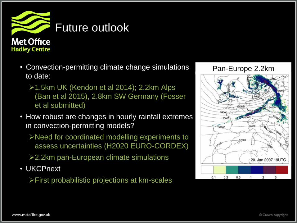
Future outlook
• Convection-permitting climate change simulations
to date:
1.5km UK (Kendon et al 2014); 2.2km Alps
(Ban et al 2015), 2.8km SW Germany (Fosser
et al submitted)
• How robust are changes in hourly rainfall extremes
in convection-permitting models?
Need for coordinated modelling experiments to
assess uncertainties (H2020 EURO-CORDEX)
2.2km pan-European climate simulations
• UKCPnext
First probabilistic projections at km-scales
Pan-Europe 2.2km