Embed Size (px)
Citation preview

PORT HURONTHE CITY OF
A CASE STUDY {
Michigan Coastal Community Working Waterfronts
Alpena CharlevoixManisteeManistique
MarquetteMonroeMuskegonOntonagon
SaugatuckSault Ste. Marie
PREPARED BYElizabeth Durfee 2011-2013 National Oceanic and Atmospheric Administration Coastal Zone Management Fellowship with the Michigan Coastal Zone Management Program and Michigan Sea Grant.
Cover photos: S. B. F. from Boatnerd Archives, Elizabeth Durfee, National Oceanic and Atmospheric Administration, U.S. Army Corps of Engineers.
June 2013 | MICHU-13-725
ACKNOWLEDGEMENTSFELLOWSHIP MENTORS
Mark Breederland, Michigan Sea Grant Extension Emily Finnell, Office of the Great Lakes
Jon Allan Dave Knight Carol Linteau Lynelle Marolf
Richard Norton Chuck Pistis Jennifer Read Frank Ruswick
John Warbach Ronda Wuycheck
OFFICE OF THE GREAT LAKES AND SEA GRANT STAFF
NOAA FELLOWSHIP ADVISORY COMMITTEE
PORT HURONTHE CITY OF
Michigan Coastal Community Working Waterfronts
A CASE STUDY
This case study was compiled as part of a set of 11 working waterfront case studies in coastal communities. For more information on the series, please see the Introduction, Value and Context, Waterfront Land Use, Best Practices, and Recommendations and Next Steps sections.
OTHER CASE STUDIES IN THIS SERIES:
TABLE OF CONTENTS Introduction .............................................................. 4
Summary ................................................................. 5
Context ................................................................... 7
Community Profile ................................................... 8
Community Overview .............................................. 9
Waterfront History .................................................. 10
Waterfront Summary ............................................. 11
Zoning.................................................................... 13
Parcel Classification .............................................. 17
Infrastructure and Access ...................................... 19
Working Waterfront SWOT Analysis ..................... 20
Tools, Strategies and Best Practices for Maintaining Working Waterfronts........................... 21
Guiding Principles.................................................. 22
References and Resources ................................... 23
FIGURES AND TABLESFigure 1. State of Michigan and St. Clair County and aerial image of the city of Port Huron with Lake Huron and the St. Clair and Black Rivers ....... 6
Table 1. Intent, permitted uses and special uses of zoning districts that accommodate water-dependent uses and/or public access ......... 13
Figure 2. City of Port Huron 2010 zoning districts ....................................................... 14
Figure 3. Map of zoning adjacent to waterfront and frontage by zoning category ........................... 15
Figure 4. Map of zoning and location of water-dependent uses within a 1000-foot buffer of water bodies and waterfront land area by zoning category ................................................ 16
Figure 5. Classification of parcels within a 1000-foot buffer of water bodies by water dependency ................................................. 17
Figure 6. Parcel frontage and area within 1000-foot buffer by water dependency classification .......................................................... 18
Figure 7. Water-dependent and enhanced uses, docks and waterfront parks along the waterfront and within 1000 feet of bodies of water ................. 19
Table 2. Strengths, weaknesses, opportunities and threats related to maintaining Port Huron’s working waterfront ................................................. 20
4Michigan Coastal Community Working Waterfronts Case StudyPORT HURON
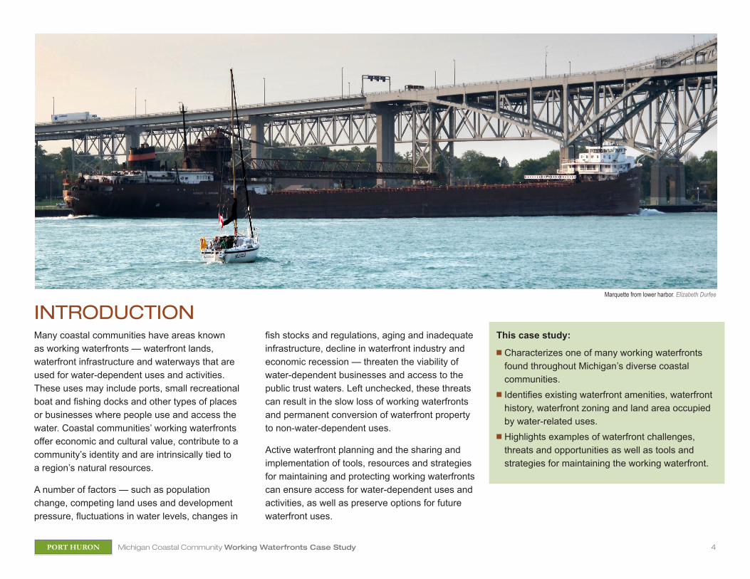
Many coastal communities have areas known as working waterfronts — waterfront lands, waterfront infrastructure and waterways that are used for water-dependent uses and activities. These uses may include ports, small recreational boat and fishing docks and other types of places or businesses where people use and access the water. Coastal communities’ working waterfronts offer economic and cultural value, contribute to a community’s identity and are intrinsically tied to a region’s natural resources.
A number of factors — such as population change, competing land uses and development pressure, fluctuations in water levels, changes in
fish stocks and regulations, aging and inadequate infrastructure, decline in waterfront industry and economic recession — threaten the viability of water-dependent businesses and access to the public trust waters. Left unchecked, these threats can result in the slow loss of working waterfronts and permanent conversion of waterfront property to non-water-dependent uses.
Active waterfront planning and the sharing and implementation of tools, resources and strategies for maintaining and protecting working waterfronts can ensure access for water-dependent uses and activities, as well as preserve options for future waterfront uses.
This case study:
n Characterizes one of many working waterfronts found throughout Michigan’s diverse coastal communities.
n Identifies existing waterfront amenities, waterfront history, waterfront zoning and land area occupied by water-related uses.
n Highlights examples of waterfront challenges, threats and opportunities as well as tools and strategies for maintaining the working waterfront.
INTRODUCTIONMarquette from lower harbor. Elizabeth Durfee
5Michigan Coastal Community Working Waterfronts Case StudyPORT HURON
SUMMARY
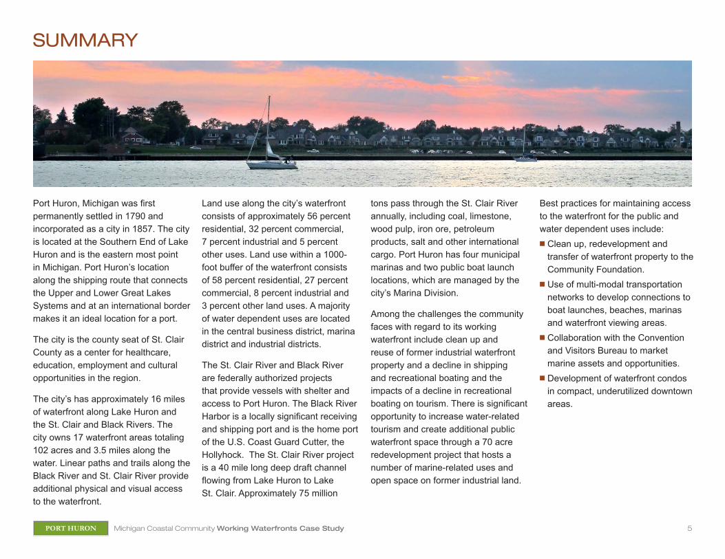
Port Huron, Michigan was first permanently settled in 1790 and incorporated as a city in 1857. The city is located at the Southern End of Lake Huron and is the eastern most point in Michigan. Port Huron’s location along the shipping route that connects the Upper and Lower Great Lakes Systems and at an international border makes it an ideal location for a port.
The city is the county seat of St. Clair County as a center for healthcare, education, employment and cultural opportunities in the region.
The city’s has approximately 16 miles of waterfront along Lake Huron and the St. Clair and Black Rivers. The city owns 17 waterfront areas totaling 102 acres and 3.5 miles along the water. Linear paths and trails along the Black River and St. Clair River provide additional physical and visual access to the waterfront.
Land use along the city’s waterfront consists of approximately 56 percent residential, 32 percent commercial, 7 percent industrial and 5 percent other uses. Land use within a 1000-foot buffer of the waterfront consists of 58 percent residential, 27 percent commercial, 8 percent industrial and 3 percent other land uses. A majority of water dependent uses are located in the central business district, marina district and industrial districts.
The St. Clair River and Black River are federally authorized projects that provide vessels with shelter and access to Port Huron. The Black River Harbor is a locally significant receiving and shipping port and is the home port of the U.S. Coast Guard Cutter, the Hollyhock. The St. Clair River project is a 40 mile long deep draft channel flowing from Lake Huron to Lake St. Clair. Approximately 75 million
tons pass through the St. Clair River annually, including coal, limestone, wood pulp, iron ore, petroleum products, salt and other international cargo. Port Huron has four municipal marinas and two public boat launch locations, which are managed by the city’s Marina Division.
Among the challenges the community faces with regard to its working waterfront include clean up and reuse of former industrial waterfront property and a decline in shipping and recreational boating and the impacts of a decline in recreational boating on tourism. There is significant opportunity to increase water-related tourism and create additional public waterfront space through a 70 acre redevelopment project that hosts a number of marine-related uses and open space on former industrial land.
Best practices for maintaining access to the waterfront for the public and water dependent uses include:n Clean up, redevelopment and
transfer of waterfront property to the Community Foundation.
n Use of multi-modal transportation networks to develop connections to boat launches, beaches, marinas and waterfront viewing areas.
n Collaboration with the Convention and Visitors Bureau to market marine assets and opportunities.
n Development of waterfront condos in compact, underutilized downtown areas.

6Michigan Coastal Community Working Waterfronts Case StudyPORT HURON
PORT HURON, MI
Lake Huron
Black River
St. C
lair R
iver
N 100 milesSt. Clair CountyCity of Port Huron
Michigan
FIGURE 1. STATE OF MICHIGAN AND ST. CLAIR COUNTY (ABOVE) AND AERIAL IMAGE OF THE CITY OF PORT HURON WITH LAKE HURON AND THE ST. CLAIR AND BLACK RIVERS.
N 1 mile
7Michigan Coastal Community Working Waterfronts Case StudyPORT HURON
Jurisdiction / Government
Region
County
Metropolitan Statistical Area
Land Area
Watershed/Subwatershed
Dominant Land Use of St. Clair River Subwatershed
Adjacent Bodies of Water
Type of Water Body
Percent of Land Area within the CZM
Population (2010)
Percent of County’s Population
Percent of County’s Land Area
Urban / Suburban / Rural
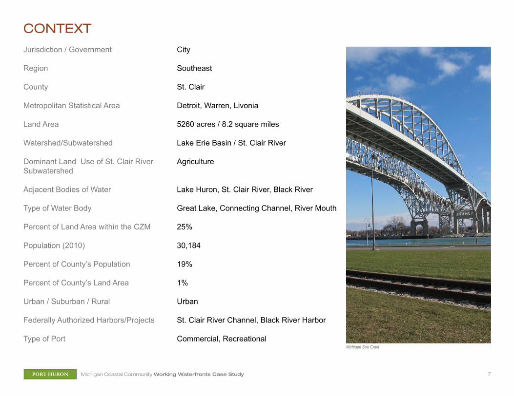
Federally Authorized Harbors/Projects
Type of Port
City
Southeast
St. Clair
Detroit, Warren, Livonia
5260 acres / 8.2 square miles
Lake Erie Basin / St. Clair River
Agriculture
Lake Huron, St. Clair River, Black River
Great Lake, Connecting Channel, River Mouth
25%
30,184
19%
1%
Urban
St. Clair River Channel, Black River Harbor
Commercial, Recreational
CONTEXT
Michigan Sea Grant
8Michigan Coastal Community Working Waterfronts Case StudyPORT HURON
POPULATIONn The population of Port Huron
declined 7 percent from 2000 to 2010. In 2010, the city’s population density was 3,681 persons/square mile.
n The population of St. Clair County decreased by 1 percent from 2000 to 2010.
n The median age in Port Huron increased from 34 in 2000 to 35 in 2010.
EDUCATIONn Of the city’s population age 25
and older (66% of the city’s total population), 84 percent have a high school degree or higher and 14 percent have a bachelor’s degree or higher.
n Of the county’s population age 25 and older (69% of the county’s total population), 88 percent have a high school degree or higher and 15 percent have a bachelors degree or higher.
INCOME n The median household income
between 2006 and 2010 in the city of Port Huron was $33,493, compared to the median household income in St. Clair County of $49,120.
EMPLOYMENTOf the city’s population over age 16:
n 53 percent are in the labor force and employed and 17 percent are unemployed.
n 71 percent are employed in the top 4 (of 13 total) industries classified in the American Community Survey: educational services and health care and social assistance (22%); manufacturing (21%); retail trade (15%); and arts, entertainment and recreation and accommodation and food services (13%).
n 26 percent are in service occupations, 25 percent in sales and office occupations, 21 percent in production, transportation and material moving occupations, 7 percent in natural resources, construction and maintenance.
St. Clair County Great Lakes Jobs Snapshot (NOAA)
n In 2009, Great Lakes related jobs accounted for 8.2 percent of total jobs in St. Clair County, representing a decrease of 8 percent since 2005.
n Great Lakes related jobs provide employment for 3,567 people, provide $41 million in wages and provide $80 million in goods and services.
HOUSINGn From 2000 to 2010, the total number
of housing units in St. Clair County decreased by 1 percent and the percent occupancy of housing units decreased by 5.2 percent.
n Owner occupied housing units decreased by 11 percent and renter occupied housing units increased by 1 percent from 2000 to 2010.
n Residential construction in St. Clair County increased from 277 buildings in 1990 to 1,817 buildings in 2000 and then decreased to 89 buildings in 2010.
COMMUNITY PROFILE
Michigan Sea Grant
9Michigan Coastal Community Working Waterfronts Case StudyPORT HURON
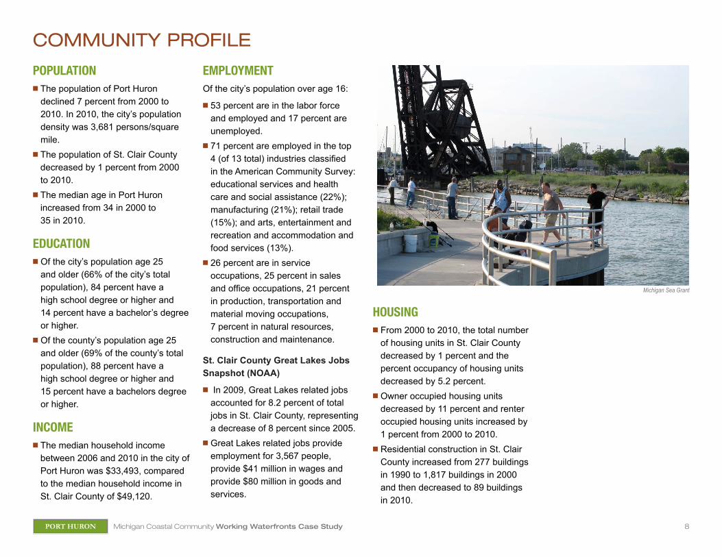
COMMUNITY OVERVIEWPort Huron is the eastern most point in Michigan. The city is located at the southern end of Lake Huron at its outflow into the St. Clair River. Port Huron is the county seat of St. Clair County and is the principal city in the Blue Water Area. Port Huron is a developed, urban community characterized by residential, commercial and industrial land uses. The community’s extensive waterfront along Lake Huron, the Black River and the St. Clair River is dominated by parks and single family residential and commercial uses.
Port Huron’s diverse waterfronts provide the city with significant opportunities for recreation, shipping, charter fishing, transportation and tourism. The city is a center for healthcare, education, employment and cultural opportunities in the region.
With its adjacency to Canada, Lake Huron and the St. Clair River and access to the Upper and Lower Great Lakes, Port Huron is a transportation hub and an ideal location for a port. The Blue Water Bridge in Port Huron is an important international border connecting Interstate 69 and Interstate 94 in Michigan with Highway 402 in Ontario. Approximately 14,000 vehicles cross this bridge daily and it is the second busiest border crossing between the US and Canada. Port Huron’s location along the shipping route that connects the Upper and Lower Great Lakes systems and at an international border is a significant asset for the State of Michigan. The community is home to a growing number of maritime assets and resources and investment in the waterfront has increased opportunities for the public to access and enjoy the waterfront.
Port Huron’s proximity to Detroit and accessibility from Chicago via Amtrak makes it a frequent tourist destination. The city’s recreational and cultural opportunities help draw visitors to the region.
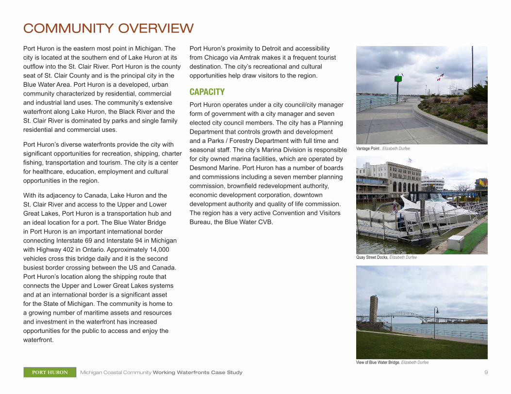
CAPACITY Port Huron operates under a city council/city manager form of government with a city manager and seven elected city council members. The city has a Planning Department that controls growth and development and a Parks / Forestry Department with full time and seasonal staff. The city’s Marina Division is responsible for city owned marina facilities, which are operated by Desmond Marine. Port Huron has a number of boards and commissions including a seven member planning commission, brownfield redevelopment authority, economic development corporation, downtown development authority and quality of life commission. The region has a very active Convention and Visitors Bureau, the Blue Water CVB.
Quay Street Docks. Elizabeth Durfee
View of Blue Water Bridge. Elizabeth Durfee
Vantage Point . Elizabeth Durfee

10Michigan Coastal Community Working Waterfronts Case StudyPORT HURON
WATERFRONT HISTORYPort Huron’s rich waterfront history dates back to mid-1600s when the first fort, the French Fort St. Joseph, was built to protect the fur trade. Port Huron’s first permanent settlement was developed in 1790. Port Huron was incorporated as a city in 1857.
Port Huron was a battle site of the War of 1812. In 1814 the U.S. Government built Fort Gratiot along the St. Clair River. The Fort Gratiot Lighthouse, constructed in 1823, was the first lighthouse constructed on Michigan shores. The lighthouse collapsed in 1825 and was replaced with a new structure in a new location in 1929. This structure is the oldest surviving Lighthouse in Michigan and was named a historic site by the Michigan Historical Commission in 1971.
Yacht racing in Port Huron dates back to 1925 when the first Port Huron to Mackinac Island race was held. Port Huron has been the home of an official Coast Guard Station since 1932. The Huron lightship, which is now permanently moored as the Huron Lightship Museum and a designated National Historic Landmark, was stationed in nearby shoals in Lake Huron from 1935 to 1971 to guide mariners from Lake Huron to The St. Clair River.
Since its construction in the 1930s, the site now known at the Port Huron Terminal Company has served a number of owners and uses as the Wolverine Dry Dock, Tunnel Fuel Dock and Port Huron Coal Dock.
Historically, salt water ships carrying pulp stopped in Port Huron prior to traveling up the Black River to the Port Huron Sulfite & Paper Company (formerly E B Eddy, now Domtar). Port Huron’s coal dock was operated by the Cleveland Cliffs Iron Company and served as a bunkering station for the company’s fleet until the 1950s, when ships converted from coal to diesel fuel. After purchasing the dock, the city leased it to the newly formed Seaway Terminal Company. It was used for exporting agricultural commodities, including soybeans and became known as the Bean Dock. With the opening of the St. Lawrence Seaway in the mid-50s, bigger ships passed through the St. Clair River to and from Detroit and the economic feasibility of using Port Huron’s dock for importing or exporting diminished. After a fire destroyed the Seaway Terminal Company’s storage shed, local investor, maritime enthusiast and longtime Port Huron resident Jim Acheson purchased the property with visions of the dock hosting vessels such as cruise ships and tall ships. The terminal is now part of a mile long waterfront redevelopment extending north to the Black River. This area was home to rail and scrap yards, factories, a cement plant and industrial shipping and facilities from around 1907 through the late 1990s.
Today Port Huron is known as the Maritime Capital of the Great Lakes.
Huron Lightship Museum. Elizabeth Durfee
Freighter on the St. Clair River. Elizabeth Durfee
Fort Gratiot Lighthouse. Elizabeth Durfee

11Michigan Coastal Community Working Waterfronts Case StudyPORT HURON
WATERFRONT SUMMARY Land use along Port Huron’s Lake Huron shoreline is characterized by residential development and sandy beaches. The banks of the St. Clair River consist primarily of a hardened shoreline with parks and public trails, vacant parcels and numerous private docks to the south. Land use along the Black River consists of residential development to the north and mixed use downtown development to the south.
The downtown Black River waterfront and the St. Clair River waterfront have linear parks and paths that provide physical and visual public access to the water. The city owns and operates 17 waterfront areas that have a total of 3.5 miles of waterfront and land area of 102 acres. The Bridge to Bay Trail follows the waterfront through Port Huron and is part of a paved trail that will eventually stretch 54 miles from Lakeport State Park to New Baltimore. The Huron Lightship, which was stationed at Corsica Shoals for 36 years and was the last operating lightship on the Great Lakes, is now permanently moored along the St. Clair River in Pine Grove Park. The Lightship houses an extensive collection of artifacts and a live camera set on the river.
The St. Clair River and Black River are federally authorized projects that provide vessels with shelter and access to Port Huron. The Black River recreational harbor is a deep and shallow draft project with depths ranging from 20 feet in the main portion of the channel to six feet in the upper river. The total maintained area of the channel is approximately 12,000 feet. The Black River Harbor is a locally significant receiving and shipping port and is the home port of the U.S. Coast Guard cutter, the Hollyhock. Dredging of the Black
River occurs on a 5-10 year cycle. The consequences of not maintaining the Black River Channel include loss of local jobs, reduced loading and increased vessel transportation costs.
The St. Clair River project is a 40 mile long, deep draft channel that flows from Lake Huron to Lake St. Clair. In addition to its significant role as a connecting channel between the Great Lakes, the river also serves the ports of Marysville, Marine City and St. Clair. Approximately 70 to 80 million tons pass through the St. Clair River annually, including commodities such coal, limestone, wood pulp, iron ore, petroleum products, salt and other international cargo.
Port Huron’s deep water port, the Port Huron Terminal Company (the Bean Dock) is home to the decommissioned U.S. Cutter Bramble. Port upgrades made in 2003 include a new docking facility for cruise boats and working ships.
Port Huron has the largest municipal marina system in the state and provides four separate locations for boat mooring. City owned marina facilities include the Quay Street Docks, River Street Marina, Fort Street Docks and Southside Docks. Total capacity of the city’s four docking facilities is 146 slips. The Bridge Harbour Marina and Port Huron Yacht Club also provide docking locations within the city. The city accommodates over 200 additional watercraft during the annual Chicago to Mackinac sailboat race. The City operates and maintains two public boat launch locations at 12th street and on Riverside Drive. The Great Lakes Maritime Center, Vantage Point and three water trails, or Blueways of St. Clair, provide access to the waterfront and opportunities for recreation.
Beach at Lighthouse Park. Elizabeth Durfee
Public space and St. Clair Blueway trail. Elizabeth Durfee
Fort Street docks. Elizabeth Durfee
12Michigan Coastal Community Working Waterfronts Case StudyPORT HURON
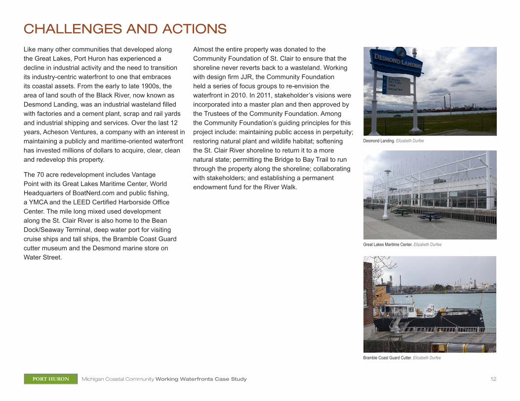
CHALLENGES AND ACTIONSLike many other communities that developed along the Great Lakes, Port Huron has experienced a decline in industrial activity and the need to transition its industry-centric waterfront to one that embraces its coastal assets. From the early to late 1900s, the area of land south of the Black River, now known as Desmond Landing, was an industrial wasteland filled with factories and a cement plant, scrap and rail yards and industrial shipping and services. Over the last 12 years, Acheson Ventures, a company with an interest in maintaining a publicly and maritime-oriented waterfront has invested millions of dollars to acquire, clear, clean and redevelop this property.
The 70 acre redevelopment includes Vantage Point with its Great Lakes Maritime Center, World Headquarters of BoatNerd.com and public fishing, a YMCA and the LEED Certified Harborside Office Center. The mile long mixed used development along the St. Clair River is also home to the Bean Dock/Seaway Terminal, deep water port for visiting cruise ships and tall ships, the Bramble Coast Guard cutter museum and the Desmond marine store on Water Street.
Almost the entire property was donated to the Community Foundation of St. Clair to ensure that the shoreline never reverts back to a wasteland. Working with design firm JJR, the Community Foundation held a series of focus groups to re-envision the waterfront in 2010. In 2011, stakeholder’s visions were incorporated into a master plan and then approved by the Trustees of the Community Foundation. Among the Community Foundation’s guiding principles for this project include: maintaining public access in perpetuity; restoring natural plant and wildlife habitat; softening the St. Clair River shoreline to return it to a more natural state; permitting the Bridge to Bay Trail to run through the property along the shoreline; collaborating with stakeholders; and establishing a permanent endowment fund for the River Walk.
Desmond Landing. Elizabeth Durfee
Great Lakes Maritime Center. Elizabeth Durfee
Bramble Coast Guard Cutter. Elizabeth Durfee
13Michigan Coastal Community Working Waterfronts Case StudyPORT HURON
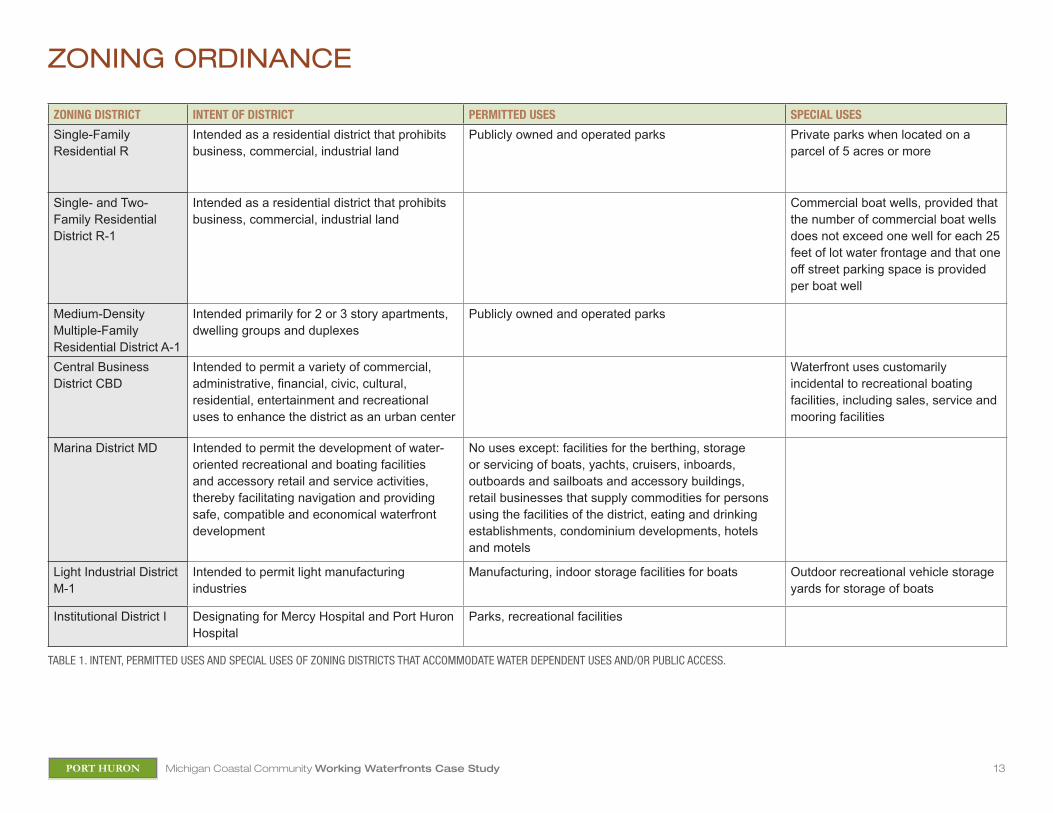
ZONING ORDINANCE
ZONING DISTRICT INTENT OF DISTRICT PERMITTED USES SPECIAL USES
Single-Family Residential R
Intended as a residential district that prohibits business, commercial, industrial land
Publicly owned and operated parks Private parks when located on a parcel of 5 acres or more
Single- and Two-Family Residential District R-1
Intended as a residential district that prohibits business, commercial, industrial land
Commercial boat wells, provided that the number of commercial boat wells does not exceed one well for each 25 feet of lot water frontage and that one off street parking space is provided per boat well
Medium-Density Multiple-Family Residential District A-1
Intended primarily for 2 or 3 story apartments, dwelling groups and duplexes
Publicly owned and operated parks
Central Business District CBD
Intended to permit a variety of commercial, administrative, financial, civic, cultural, residential, entertainment and recreational uses to enhance the district as an urban center
Waterfront uses customarily incidental to recreational boating facilities, including sales, service and mooring facilities
Marina District MD Intended to permit the development of water-oriented recreational and boating facilities and accessory retail and service activities, thereby facilitating navigation and providing safe, compatible and economical waterfront development
No uses except: facilities for the berthing, storage or servicing of boats, yachts, cruisers, inboards, outboards and sailboats and accessory buildings, retail businesses that supply commodities for persons using the facilities of the district, eating and drinking establishments, condominium developments, hotels and motels
Light Industrial District M-1
Intended to permit light manufacturing industries
Manufacturing, indoor storage facilities for boats Outdoor recreational vehicle storage yards for storage of boats
Institutional District I Designating for Mercy Hospital and Port Huron Hospital
Parks, recreational facilities
TABLE 1. INTENT, PERMITTED USES AND SPECIAL USES OF ZONING DISTRICTS THAT ACCOMMODATE WATER DEPENDENT USES AND/OR PUBLIC ACCESS.
14Michigan Coastal Community Working Waterfronts Case StudyPORT HURON
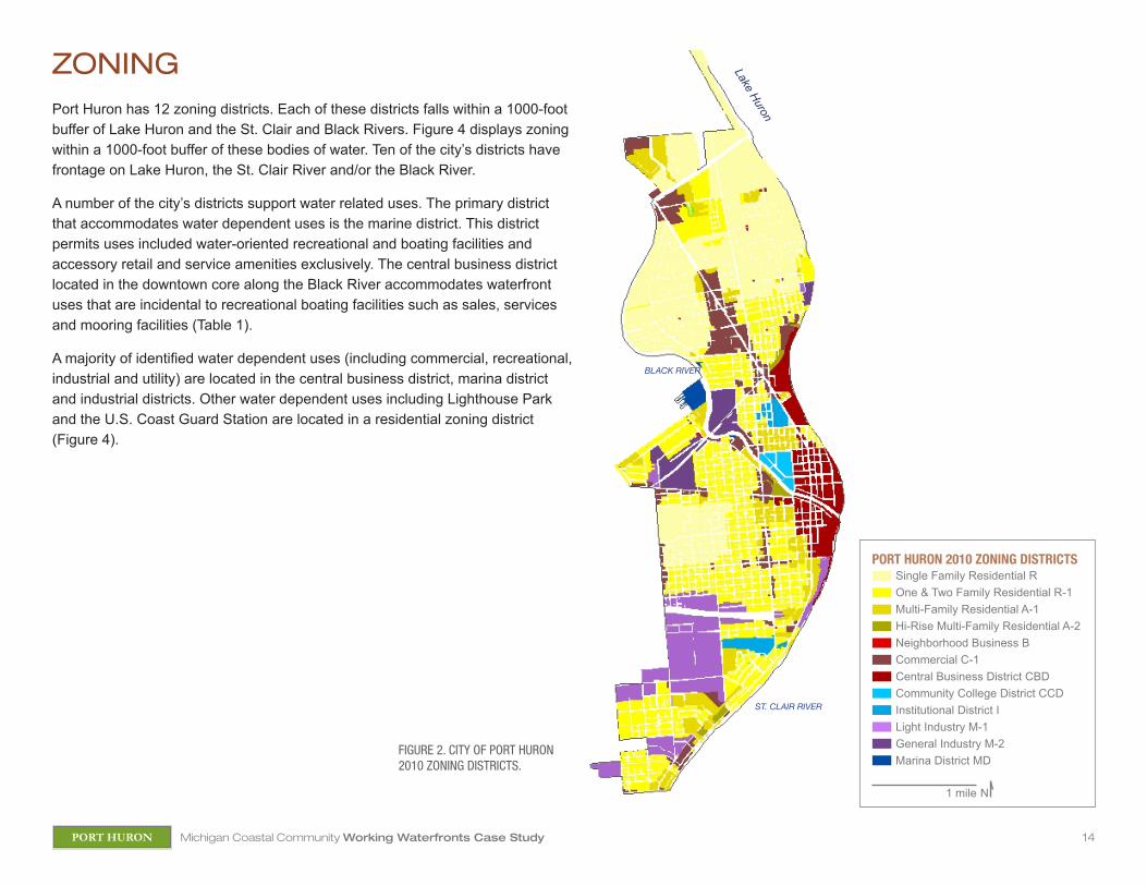
ZONING Port Huron has 12 zoning districts. Each of these districts falls within a 1000-foot buffer of Lake Huron and the St. Clair and Black Rivers. Figure 4 displays zoning within a 1000-foot buffer of these bodies of water. Ten of the city’s districts have frontage on Lake Huron, the St. Clair River and/or the Black River.
A number of the city’s districts support water related uses. The primary district that accommodates water dependent uses is the marine district. This district permits uses included water-oriented recreational and boating facilities and accessory retail and service amenities exclusively. The central business district located in the downtown core along the Black River accommodates waterfront uses that are incidental to recreational boating facilities such as sales, services and mooring facilities (Table 1).
A majority of identified water dependent uses (including commercial, recreational, industrial and utility) are located in the central business district, marina district and industrial districts. Other water dependent uses including Lighthouse Park and the U.S. Coast Guard Station are located in a residential zoning district (Figure 4).
Lake Huron
FIGURE 2. CITY OF PORT HURON 2010 ZONING DISTRICTS.
ST. CLAIR RIVER
BLACK RIVER
Single Family Residential ROne & Two Family Residential R-1Multi-Family Residential A-1Hi-Rise Multi-Family Residential A-2Neighborhood Business BCommercial C-1Central Business District CBDCommunity College District CCDInstitutional District ILight Industry M-1General Industry M-2Marina District MD
1 mile N
PORT HURON 2010 ZONING DISTRICTS
15Michigan Coastal Community Working Waterfronts Case StudyPORT HURON
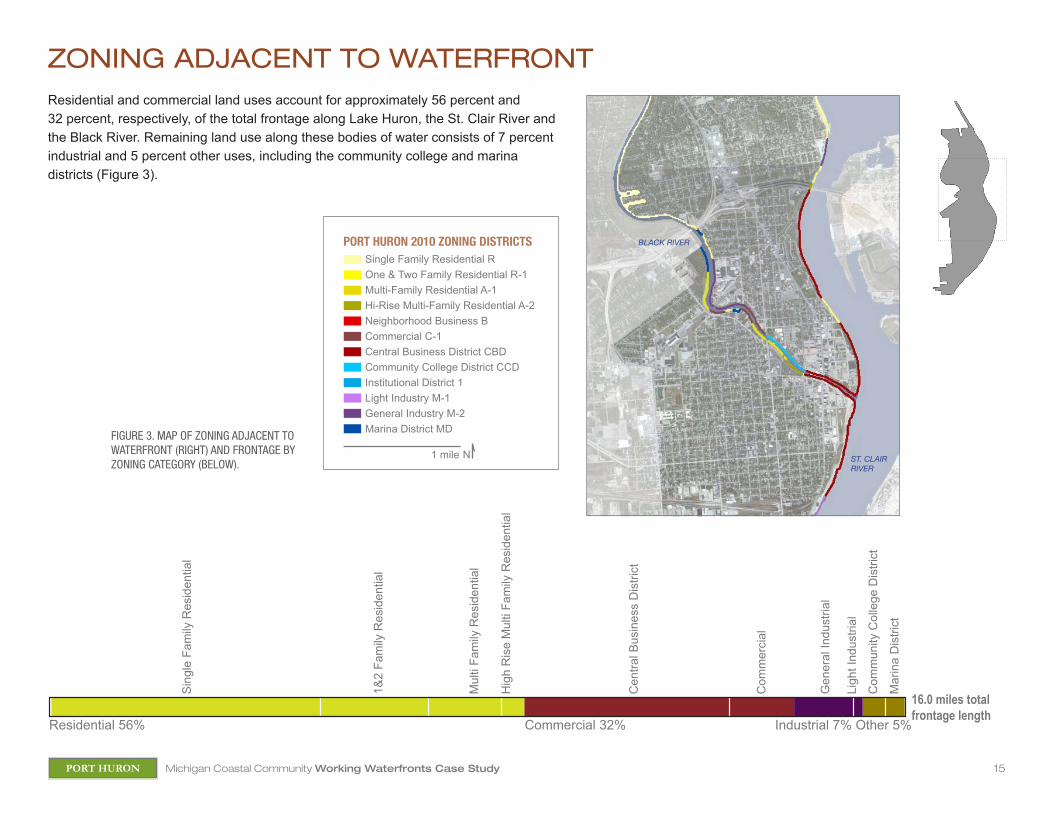
ZONING ADJACENT TO WATERFRONTResidential and commercial land uses account for approximately 56 percent and 32 percent, respectively, of the total frontage along Lake Huron, the St. Clair River and the Black River. Remaining land use along these bodies of water consists of 7 percent industrial and 5 percent other uses, including the community college and marina districts (Figure 3).
FIGURE 3. MAP OF ZONING ADJACENT TO WATERFRONT (RIGHT) AND FRONTAGE BY ZONING CATEGORY (BELOW).
Sin
gle
Fam
ily R
esid
entia
l
1&2
Fam
ily R
esid
entia
l
Mul
ti Fa
mily
Res
iden
tial
Hi-R
ise
Mul
ti Fa
mily
Res
iden
tail
Cen
tral B
usin
ess
Dis
trict
Com
mer
cial
Gen
eral
Indu
stria
l
Ligh
t Ind
ustri
alC
omm
unity
Col
lege
Dis
trict
Mar
ina
Dis
trict
Residential 56% Commercial 32% Other 5%Industrial 7%84618 feet
Sin
gle
Fam
ily R
esid
entia
l
1&2
Fam
ily R
esid
entia
l
Mul
ti Fa
mily
Res
iden
tial
Hig
h R
ise
Mul
ti Fa
mily
Res
iden
tial
Cen
tral B
usin
ess
Dis
trict
Com
mer
cial
Gen
eral
Indu
stria
l Li
ght I
ndus
trial
Com
mun
ity C
olle
ge D
istri
ct
Mar
ina
Dis
trict
Residential 56% Commercial 32% Industrial 7% Other 5%
16.0 miles total frontage length
ST. CLAIR RIVER
BLACK RIVER
Single Family Residential ROne & Two Family Residential R-1Multi-Family Residential A-1Hi-Rise Multi-Family Residential A-2Neighborhood Business BCommercial C-1Central Business District CBDCommunity College District CCDInstitutional District 1Light Industry M-1General Industry M-2Marina District MD
1 mile N
PORT HURON 2010 ZONING DISTRICTS

16Michigan Coastal Community Working Waterfronts Case StudyPORT HURON
ZONING WITHIN 1000 FEET OF WATERFRONTLand use within a 1000-foot buffer of Lake Huron, the St. Clair River and the Black River consists of 58 percent residential, 27 percent commercial, 8 percent industrial and 3 percent other land uses (Figure 4).
Single Family Residential ROne & Two Family Residential R-1Multi-Family Residential A-1Hi-Rise Multi-Family Residential A-2Neighborhood Business BCommercial C-1Central Business District CBDCommunity College District CCDInstitutional District ILight Industry M-1General Industry M-2Marina District MDBuilding Footprint of Water Dependent Use
1 mile N
PORT HURON 2010 ZONING DISTRICTS
Residential 58% Commercial 27% Other 6%
1321 acres
Industrial 8%
Sin
gle
Fam
ily R
esid
entia
l
1&2
Fam
ily R
esid
entia
l
Mul
ti Fa
mily
Res
iden
tial
Hi-R
ise
Mul
ti Fa
mily
Res
iden
tail
Cen
tral B
usin
ess
Dis
trict
Com
mer
cial
Nei
ghbo
rhoo
d B
usin
ess
Gen
eral
Indu
stria
l
Ligh
t Ind
ustri
alC
omm
unity
Col
lege
Dis
trict
Mar
ina
Dis
trict
Inst
itutio
nal D
istri
ct
1,321 acres in 1000-ft buffer
Sin
gle
Fam
ily R
esid
entia
l
1&2
Fam
ily R
esid
entia
l
Mul
ti Fa
mily
Res
iden
tial
Hig
h R
ise
Mul
ti Fa
mily
Res
iden
tial
Cen
tral B
usin
ess
Dis
trict
Com
mer
cial
Nei
ghbo
rhoo
d B
usin
ess
Gen
eral
Indu
stria
l Li
ght I
ndus
trial
Com
mun
ity C
olle
ge D
istri
ct
Mar
ina
Dis
trict
In
stitu
tiona
l Dis
trict
Residential 58% Commercial 27% Industrial 8% Other 6%
FIGURE 4. MAP OF ZONING AND LOCATION OF WATER-DEPENDENT USES WITHIN A 1000-FOOT BUFFER OF WATER BODIES (RIGHT) AND WATERFRONT LAND AREA BY ZONING CATEGORY (BELOW).
ST. CLAIR RIVER
BLACK RIVER

17Michigan Coastal Community Working Waterfronts Case StudyPORT HURON
PARCEL CLASSIFICATION AND INVENTORY
Riverside Park
Quay Street DockSouthside Marina + ParkEast Southside ParkFort Street MarinaPort Huron Yacht Club
Wastewater Treatment Plant
Desmond Landing Vantage PointBoatnerd.com
Seaway Terminal (Bean Dock)
Lincoln Park Turnout
Lakeside Park
Lighthouse ParkU.S. Coast Guard
Dunn Paper Company
Thomas Edison Park
Pine Grove Park
Kiefer Park
Riverside Boat RampMitch’s Landing Marina
Former Water Street Marina
Port Huron Yacht Club12th Street Ramp
River Street MarinaPort Huron Marine Services
Harbor Master Office
FIGURE 5. WATER DEPENDENT CLASSIFICATION OF PARCELS WITHIN A 1000-FOOT BUFFER OF WATER BODIES AND INVENTORY OF IDENTIFIED WATER DEPENDENT USES.
1 mile N
PARCEL WATER DEPENDENT USE CLASSIFICATION
Public Access (waterfront park)Water Dependent Water Dependent-IndustryWater Dependent-UtilityWater Enhanced (hotel and restaurant)Building Footprint of Water Dependent Use
1
1
2
2
Domtar, Former E B Eddy Paper Plant

18Michigan Coastal Community Working Waterfronts Case StudyPORT HURON
PARCEL CLASSIFICATIONParcels that provide public access to the waterfront account for 19 percent of the total frontage along Lake Huron and the St. Clair and Black Rivers (approximately 16 miles) and approximately 7 percent of the area (approximately 1,322 acres) within a 1000-foot buffer of these bodies of water. Parcels that have identified water dependent uses account for 11 percent of frontage and 5 percent of the area within a 1000-foot buffer of Lake Huron and the St. Clair and Black Rivers. Industries and utilities along the waterfront account for 4 percent and 1 percent of frontage, respectively. These uses account for 3 percent and 1 percent of the area within a 1000-foot buffer of bodies of water (Figure 6). Figure 5 displays an inventory of identified water related uses along with classification of associated parcels of land as public access or water dependent, enhanced or non-water dependent.
FIGURE 6. PARCEL FRONTAGE (A) AND AREA WITHIN 1000-FOOT BUFFER BY WATER DEPENDENCY CLASSIFICATION (B).
Non
Wat
er D
epen
dent
66%
Pub
lic A
cces
s 20
%
Wat
er D
epen
dent
12%
Wat
er D
epen
dent
-Util
ity 1
%W
ater
Dep
ende
nt-In
dust
ry 1
%
Wat
er E
nhan
ced
0.3%
84228 feet16.0 miles total frontage length
19% 11% 4% 1% .3% 64%
Non
Wat
er D
epen
dent
48%
Pub
lic A
cces
s 7%
Wat
er D
epen
dent
5%
Wat
er D
epen
dent
-Util
ity 1
%W
ater
Dep
ende
nt-In
dust
ry 1
%
Wat
er E
nhan
ced
0.1%
1322 acres1322 acres in 1000-ft buffer
7% 5% 3% 1% .1% 84%
(A)
(B)
PARCEL WATER DEPENDENT USE CLASSIFICATION
Public Access (waterfront park)Water DependentWater Dependent-IndustryWater Dependent-UtilityWater Enhanced (hotel and restaurant)Non Water Dependent
19Michigan Coastal Community Working Waterfronts Case StudyPORT HURON
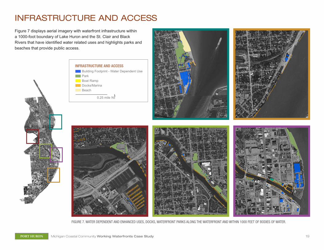
FIGURE 7. WATER DEPENDENT AND ENHANCED USES, DOCKS, WATERFRONT PARKS ALONG THE WATERFRONT AND WITHIN 1000 FEET OF BODIES OF WATER.
INFRASTRUCTURE AND ACCESS
0.25 mile N
Building Footprint - Water Dependent UseParkBoat RampDocks/MarinaBeach
INFRASTRUCTURE AND ACCESS
Figure 7 displays aerial imagery with waterfront infrastructure within a 1000-foot boundary of Lake Huron and the St. Clair and Black Rivers that have identified water related uses and highlights parks and beaches that provide public access.
20Michigan Coastal Community Working Waterfronts Case StudyPORT HURON
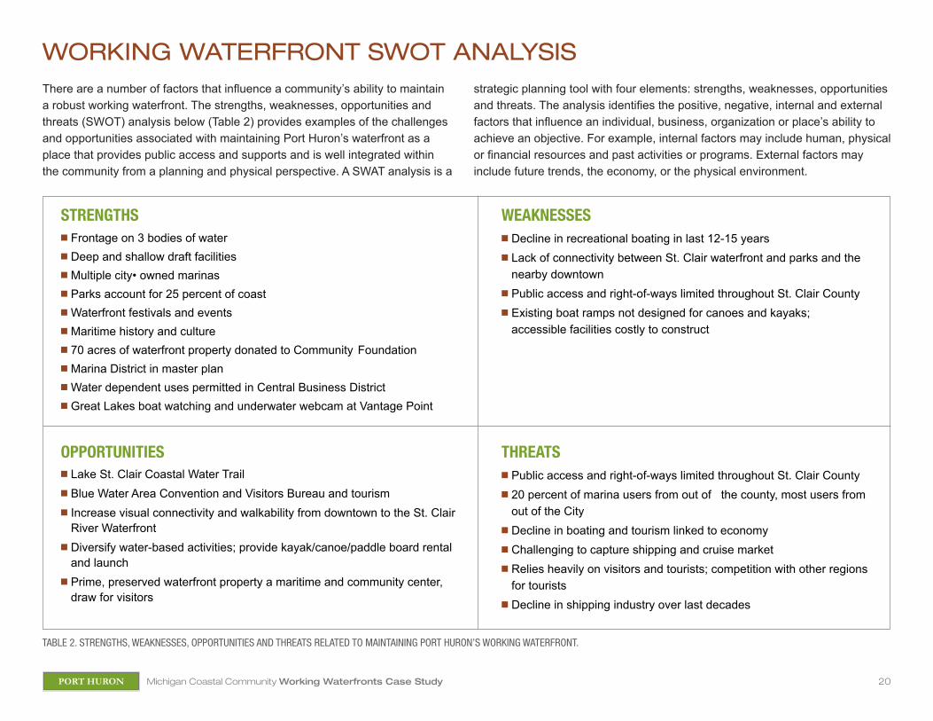
WORKING WATERFRONT SWOT ANALYSIS
TABLE 2. STRENGTHS, WEAKNESSES, OPPORTUNITIES AND THREATS RELATED TO MAINTAINING PORT HURON’S WORKING WATERFRONT.
There are a number of factors that influence a community’s ability to maintain a robust working waterfront. The strengths, weaknesses, opportunities and threats (SWOT) analysis below (Table 2) provides examples of the challenges and opportunities associated with maintaining Port Huron’s waterfront as a place that provides public access and supports and is well integrated within the community from a planning and physical perspective. A SWAT analysis is a
strategic planning tool with four elements: strengths, weaknesses, opportunities and threats. The analysis identifies the positive, negative, internal and external factors that influence an individual, business, organization or place’s ability to achieve an objective. For example, internal factors may include human, physical or financial resources and past activities or programs. External factors may include future trends, the economy, or the physical environment.
STRENGTHSn Frontage on 3 bodies of watern Deep and shallow draft facilitiesn Multiple city• owned marinasn Parks account for 25 percent of coastn Waterfront festivals and eventsn Maritime history and culturen 70 acres of waterfront property donated to Community Foundation n Marina District in master plann Water dependent uses permitted in Central Business Districtn Great Lakes boat watching and underwater webcam at Vantage Point
WEAKNESSESn Decline in recreational boating in last 12-15 yearsn Lack of connectivity between St. Clair waterfront and parks and the
nearby downtownn Public access and right-of-ways limited throughout St. Clair Countyn Existing boat ramps not designed for canoes and kayaks;
accessible facilities costly to construct
THREATSn Public access and right-of-ways limited throughout St. Clair Countyn 20 percent of marina users from out of the county, most users from
out of the Cityn Decline in boating and tourism linked to economyn Challenging to capture shipping and cruise market n Relies heavily on visitors and tourists; competition with other regions
for touristsn Decline in shipping industry over last decades
OPPORTUNITIESn Lake St. Clair Coastal Water Trailn Blue Water Area Convention and Visitors Bureau and tourismn Increase visual connectivity and walkability from downtown to the St. Clair
River Waterfront n Diversify water-based activities; provide kayak/canoe/paddle board rental
and launchn Prime, preserved waterfront property a maritime and community center,
draw for visitors
21Michigan Coastal Community Working Waterfronts Case StudyPORT HURON
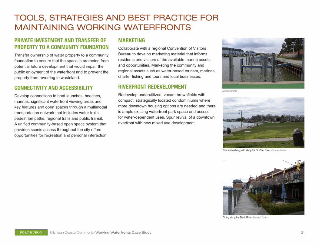
TOOLS, STRATEGIES AND BEST PRACTICE FOR MAINTAINING WORKING WATERFRONTS
PRIVATE INVESTMENT AND TRANSFER OF PROPERTY TO A COMMUNITY FOUNDATIONTransfer ownership of water property to a community foundation to ensure that the space is protected from potential future development that would impair the public enjoyment of the waterfront and to prevent the property from reverting to wasteland.
CONNECTIVITY AND ACCESSIBILITYDevelop connections to boat launches, beaches, marinas, significant waterfront viewing areas and key features and open spaces through a multimodal transportation network that includes water trails, pedestrian paths, regional trails and public transit. A unified community-based open space system that provides scenic access throughout the city offers opportunities for recreation and personal interaction.
MARKETINGCollaborate with a regional Convention of Visitors Bureau to develop marketing material that informs residents and visitors of the available marine assets and opportunities. Marketing the community and regional assets such as water-based tourism, marinas, charter fishing and tours and local businesses.
RIVERFRONT REDEVELOPMENTRedevelop underutilized, vacant brownfields with compact, strategically located condominiums where more downtown housing options are needed and there is ample existing waterfront park space and access for water-dependent uses. Spur revival of a downtown riverfront with new mixed use development.
Elizabeth Durfee
Bike and walking path along the St. Clair River. Elizabeth Durfee
Dining along the Black River. Elizabeth Durfee
22Michigan Coastal Community Working Waterfronts Case StudyPORT HURON
PROCESS-BASEDn Engage diverse stakeholders and local, regional and state partners in waterfront planning.n Integrate waterfront planning with local and regional master and comprehensive planning.n Incorporate adaptation planning into waterfront planning. n Articulate the community’s vision for future of the waterfront.
OUTCOME-BASEDn Protect the natural resources that working waterfronts uses are intrinsically tied to and dependent upon.n Maximize the public benefit of working waterfronts through visual and physical access and amenities.n Permit compatible mixed uses along the waterfront.n Emphasize the economic and cultural value of local water-dependent uses.n Preserve visual and physical access to water resources.n Balance waterfront land uses to meet the needs of residents, visitors, water-dependent uses and ecological communities.n Increase resiliency by promoting diverse and flexible water-dependent uses. n Preserve visual and physical access to water resources.n Balance waterfront land uses to meet the needs of residents, visitors, water-dependent uses and ecological communities.n Increase resiliency by promoting diverse and flexible water-dependent uses.
How does your community stand up?
MANAGING WATERFRONTS AND WATER-DEPENDENT USES AS AN IMPORTANT ELEMENT OF A SUSTAINABLE COASTAL COMMUNITY
CITY OF PORT HURON
Integrate waterfront planning with local and regional planning.
Articulate the community’s vision for the future of the waterfront.
Permit compatible mixed uses along the waterfront.
GUIDING PRINCIPLES
23Michigan Coastal Community Working Waterfronts Case StudyPORT HURON
REFERENCES AND RESOURCESAcheson Ventures (2012) Great Lakes Maritime Center. Re-
trieved from http://www.achesonventures.com/MaritimeCen-ter.aspx
Acheson, Captain James C. (2012) Recollections of the River. Retrieved from http://www.achesonventures.com/LinkClick.aspx?fileticket=wEvfGkRgD04%3D&tabid=81
Block, Jim (2012) Port Huron’s Blue Water River Walk Edges Closer to Reality. The Voice. Retrieved from http://www.voicenews.com/articles/2012/04/20/news/doc4f8ed-c92d6328983259554.txt
City of Port Huron (2012) Marina Division. Retrieved from http://www.porthuron.org/content.aspx?Pageid=24
City of Port Huron (2012) Zoning Ordinance. Retrieved from http://www.porthuron.org/pdfs/planning_rental_insp/Zon-ing%20Ordinance.pdf
Community Foundation of St. Clair County (2012) Blue Water River Walk. Retrieved from http://stclairfoundation.org/up-loads/main/RiverWalk-sm.pdf
Community Foundation of St. Clair County (2012) Blue Water River Walk, The History. Retrieved from http://stclairfounda-tion.org/riverwalk
Community Foundation of St. Clair County (2012) Blue Water River Walk, The Vision. Retrieved from http://stclairfounda-tion.org/riverwalk
Community Foundation of St. Clair County (2012) Final Progress Report/2012 Annual Report Upper St. Clair River Habitat Restoration Project. Retrieved from http://stclairfoundation.org/uploads/main/USFWS_Final_Report.pdf
Community Foundation of St. Clair County (2012) Port Huron South Riverfront Master Plan Summary Report. Retrieved from http://stclairfoundation.org/uploads/main/Port_Huron_South_Waterfront_Master_Plan%28email%29.pdf
Department of Natural Resources (2012) Lake Erie Basin. Retrieved from http://michigan.gov/dnr/0,1607,7-153-10370_30909_31053-153455--,00.html
Digital Coast NOAA Coastal Services Center (2010) St. Clair, Michigan Snapshot. Retrieved from http://www.csc.noaa.gov/snapshots/#ocean%2626147
Friends of the Fort Gratiot Light (2012) History. Retrieved from http://www.fortgratiotlighthouse.org/FortGratiotLight_History.html
LSL and The Chesapeake Group, Inc. (2002) City of Port Huron Comprehensive. Retrieved from http://www.porthuron.org/pdfs/planning_rental_insp/Port%20Huron%20Plan.pdf
Michigan Lighthouse Conservancy (2003) Fort Gratiot Light-house. Retrieved from http://www.michiganlights.com/fort-gratiotlh.htm
Personal Conversation, Dan Collins, Harbormaster, May 11, 2012.
Personal Conversation James Ribbron, MSU Extension, May 11, 2012
Personal Conversation Lori Eschenburg, St. Clair County Metro Planning, May 11, 2012
Port Huron Museum (2012) Huron Lightship. http://www.phmuse-um.org/drupal/about/lightship
Sea Grant, UofM, MSU, Extension (2012) Charting the Course – Southern Lake Huron Assessment Final Project Meeting.
U.S. Census Bureau (2000). Profile of General Population and Housing Characteristics, City of Port Huron. Retrieved July 2012 from http://factfinder2.census.gov/faces/nav/jsf/pages/searchresults.xhtml?refresh=t
U.S. Census Bureau (2010). Educational Attainment 2006-2010 American Community Survey 5-year Estimates, City of Port Huron. Marie. Retrieved from http://factfinder2.census.gov/faces/nav/jsf/pages/searchresults.xhtml?refresh=t
U.S. Census Bureau (2010). Educational Attainment 2006-2010 American Community Survey 5-year Estimates, St. Clair County. Retrieved from http://factfinder2.census.gov/faces/nav/jsf/pages/searchresults.xhtml?refresh=t
U.S. Census Bureau (2010). Profile of General Population and Housing Characteristics, City of Port Huron. Retrieved July 2012 from http://factfinder2.census.gov/faces/nav/jsf/pages/searchresults.xhtml?refresh=t
U.S. Census Bureau (2010). Profile of General Population and Housing Characteristics, St. Clair County. Retrieved July 2012 from http://factfinder2.census.gov/faces/nav/jsf/pages/searchresults.xhtml?refresh=t
U.S. Census Bureau (2010). Profile of General Population and Housing Characteristics, St. Clair County. Retrieved July 2012 from http://factfinder2.census.gov/faces/nav/jsf/pages/searchresults.xhtml?refresh=t
U.S. Census Bureau (2010). Selected Economic Characteristics 2006-2010 American Community Survey 5-year Estimates, St. Clair County. Retrieved from http://factfinder2.census.gov/faces/nav/jsf/pages/searchresults.xhtml?refresh=t
U.S. Census Bureau (2010). Selected Economic Characteristics 2006-2010 American Community Survey 5-year Estimates, City of Port Huron. Retrieved from http://factfinder2.census.gov/faces/nav/jsf/pages/searchresults.xhtml?refresh=t
US Army Corps of Engineers (2012). Black River, Michigan. Re-trieved from http://www.lre.usace.army.mil/_kd/go.cfm?desti-nation=Page&pge_id=2142&dialog=0
US Army Corps of Engineers (2012). St. Clair River, Michigan. Retrieved from http://www.lre.usace.army.mil/who/opera-tionsofficehomepage/project_overview/st_clair_river/