Embed Size (px)
Citation preview
THE CITY OF BLANCHARD, OKLAHOMA
2020 COMPREHENSIVE PLAN UPDATE
City Council: Planning Commission:
Eddie Odle Jeff Tompkins - Chair
Michael Scalf Gale Gendron – Co-Chair
Joe Davis George Faulkner
Yvonne Lackey D. Smith
Jim Cloud
Robert Floyd – City Manager
Prepared by: Ruth Walters, City Planner & Daniel Ofsthun, Special Projects Coordinator – June 2013
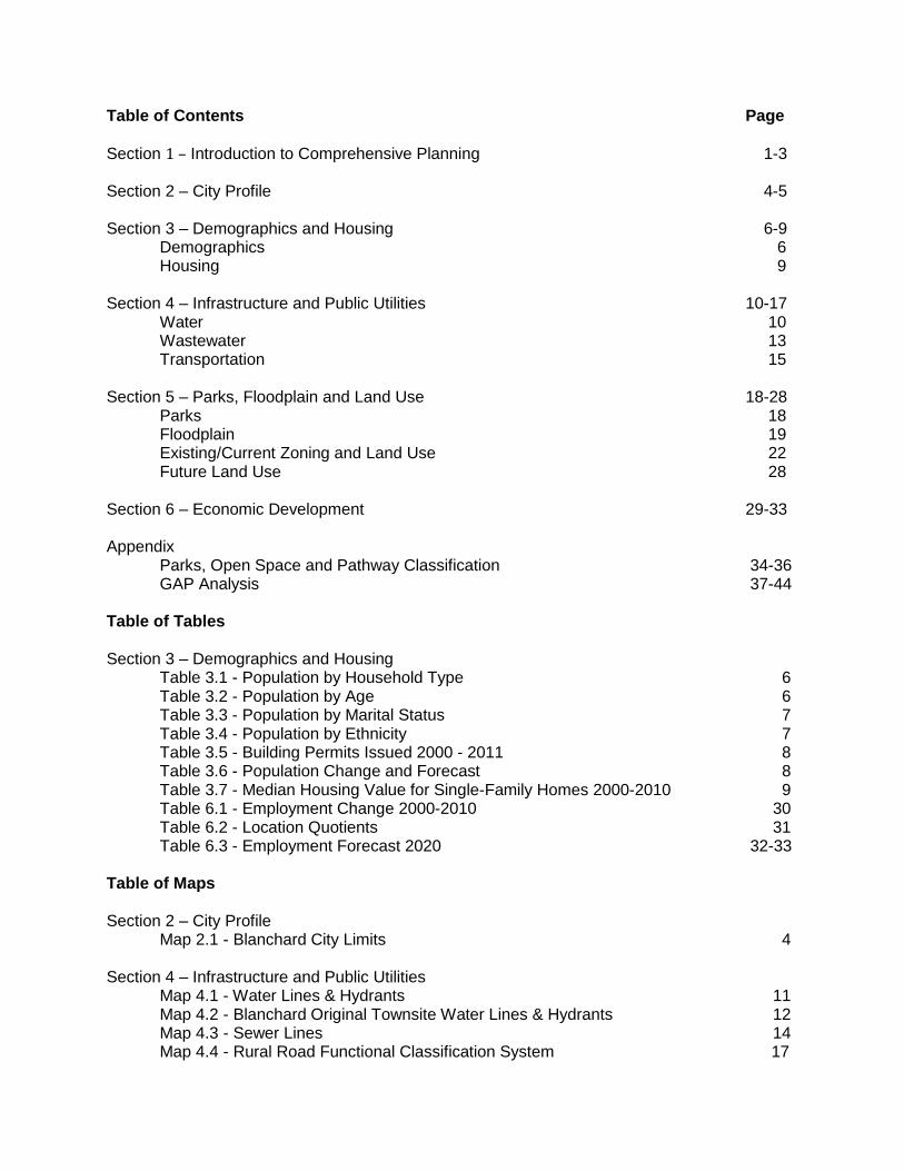
Table of Contents Page
Section 1 – Introduction to Comprehensive Planning 1-3 Section 2 – City Profile 4-5 Section 3 – Demographics and Housing 6-9 Demographics 6 Housing 9 Section 4 – Infrastructure and Public Utilities 10-17 Water 10 Wastewater 13 Transportation 15 Section 5 – Parks, Floodplain and Land Use 18-28 Parks 18 Floodplain 19 Existing/Current Zoning and Land Use 22 Future Land Use 28 Section 6 – Economic Development 29-33 Appendix Parks, Open Space and Pathway Classification 34-36 GAP Analysis 37-44 Table of Tables Section 3 – Demographics and Housing Table 3.1 - Population by Household Type 6 Table 3.2 - Population by Age 6 Table 3.3 - Population by Marital Status 7 Table 3.4 - Population by Ethnicity 7 Table 3.5 - Building Permits Issued 2000 - 2011 8 Table 3.6 - Population Change and Forecast 8
Table 3.7 - Median Housing Value for Single-Family Homes 2000-2010 9 Table 6.1 - Employment Change 2000-2010 30 Table 6.2 - Location Quotients 31 Table 6.3 - Employment Forecast 2020 32-33
Table of Maps Section 2 – City Profile Map 2.1 - Blanchard City Limits 4 Section 4 – Infrastructure and Public Utilities
Map 4.1 - Water Lines & Hydrants 11 Map 4.2 - Blanchard Original Townsite Water Lines & Hydrants 12 Map 4.3 - Sewer Lines 14
Map 4.4 - Rural Road Functional Classification System 17
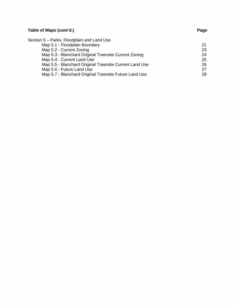
Table of Maps (cont’d.) Page Section 5 – Parks, Floodplain and Land Use Map 5.1 - Floodplain Boundary 21 Map 5.2 - Current Zoning 23 Map 5.3 - Blanchard Original Townsite Current Zoning 24 Map 5.4 - Current Land Use 25 Map 5.5 - Blanchard Original Townsite Current Land Use 26 Map 5.6 - Future Land Use 27 Map 5.7 - Blanchard Original Townsite Future Land Use 28
1
Section 1 – Introduction to Comprehensive Planning In 1923 the Oklahoma Legislature enacted legislation providing for the establishment of comprehensive planning in cities and towns. This legislation is located in the Oklahoma Municipal Code, Chapter 11 of the Oklahoma State Statutes. The comprehensive plan provides the foundation and basis for the zoning, subdivision and other development regulations. The City of Blanchard adopted a Comprehensive Plan in 2000. A comprehensive plan should be reviewed and updated a minimum of every five years. In 2007, the city adopted the 2020 Comprehensive Plan. This document serves as the 2020 Comprehensive Plan Update (Plan Update). The 2020 Comprehensive Plan Update will serve as the official policy document for the Planning Commission and City Council when addressing growth and development issues. It includes a: Physical Development Plan: Provides the Planning Commission and the City Council a framework to make informed decisions concerning future land development. Policy Document: Provides vision and direction by establishing specific development goals, objectives and policy statements for various land uses and development issues. Educational Tool: Has educational value for citizens, land owners, developers, and elected officials. The plan offers factual information about the city and insight into future development trends. The comprehensive planning process is a beginning point for discussions and decisions concerning how the City of Blanchard should be developed. The Plan Update will help serve as a guide or tool for appointed and elected officials for future land use and assist in the efficient use of funds for new infrastructure related to growth. Comprehensive planning is an approach to problem solving and a process for making informed decisions about the future. The comprehensive plan is the officially adopted advisory document that outlines the general direction for growth management. It provides a framework for decision making and provides vision and direction by establishing development goals, objectives and action statements concerning growth and development issues. Additionally, as stated above, the plan establishes the foundation for zoning, subdivision and other regulatory documents; it serves as the basis upon which development decisions are evaluated; and it serves as the basis for planning for future infrastructure and other community needs. The comprehensive plan includes a Future Land Use Map. This map serves as a guide to encourage the most appropriate uses of land throughout the City of Blanchard. It is not necessarily viewed as a direct indication of the appropriate zoning district to apply to a specific parcel of land in the immediate future. The Future Land Use Map provides direction for staff and elected officials, as well as land owners and developers. This Plan is not to dramatically redefine the character of Blanchard, but to preserve existing character while laying out the foundation for future development opportunities that complement and enhance the physical, social and economic vitality of the City. Summary of Plan Goals As stated previously, the goal of the Plan Update is not to dramatically redefine the character of Blanchard, but to preserve existing character while laying the foundation for future development
2
opportunities that complement the character. In broad terms, the goal of the plan is to further the welfare of the citizens by helping to create an increasingly more healthful, convenient, efficient and attractive city in which to live, work and recreate - - to achieve the highest possible quality of life in the City of Blanchard. Overall Plan Goals Growth Management – Guide growth in a responsible manner that is beneficial to the City of Blanchard as a whole. Residential – Strengthen the city’s urban and rural neighborhoods. Commercial – Provide opportunity for quality commercial (or non-residential) development to serve residents of Blanchard. Industrial – Encourage quality industrial development. Transportation – Promote and encourage the development of a safe and efficient transportation system. Infrastructure – Provide for sufficient infrastructure to meet the growing demands of increased development.
Comprehensive Plan Organization
The Plan Update will include 2010 US Census data which will be analyzed and used to evaluate
and amend certain portions of the Plan, including demographics, housing, land use and
economic development. Overall the Plan Update will include the following categories:
Demographics – Used to determine current population and forecast population growth.
Housing – Provides an idea of residential and non-residential land development and
construction value.
Infrastructure and Public Facilities – Used to determine existing condition of
infrastructure and project future infrastructure needs.
Land Use – Used to determine current and future land use needs.
Economic Development
Goals, Objectives and Policy Statements, based upon public participation during the 2020 Comprehensive Plan process and using analysis of 2010 Census data, will be included in each section. Additionally, the following is a list of Goals and Objectives achieved since the 2020 Plan was adopted:
- New library was constructed
- City Hall relocated to 122 N Main St.
- New High School constructed
- New Senior Living Center constructed
3
- Splash Pad at Lions Park constructed
- Two new baseball fields constructed at South Park
The widening of US Highway 62 from Newcastle through Blanchard has been a major change to the city. With the widening of the highway, came increased traffic; the impacts of this will be discussed in the Public Facilities/Infrastructure section of this document.
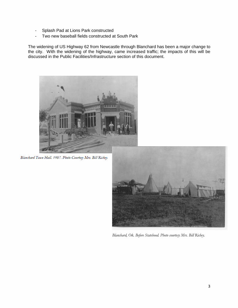
Blanchard, Ok. Before Statehood. Photo courtesy Mrs. Bill Richey.
4
Section 2 – City Profile
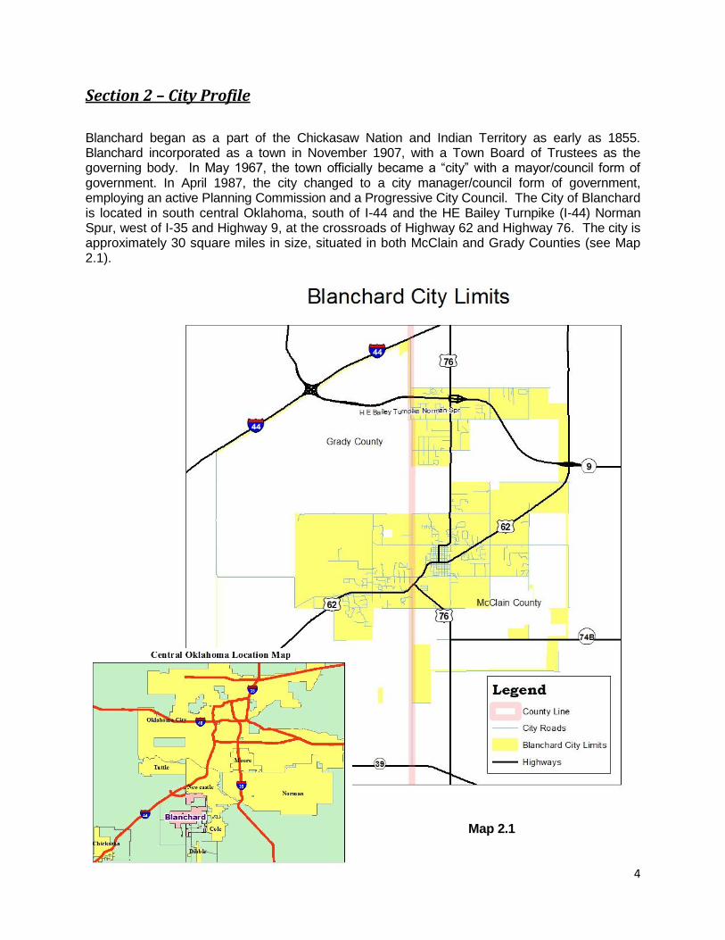
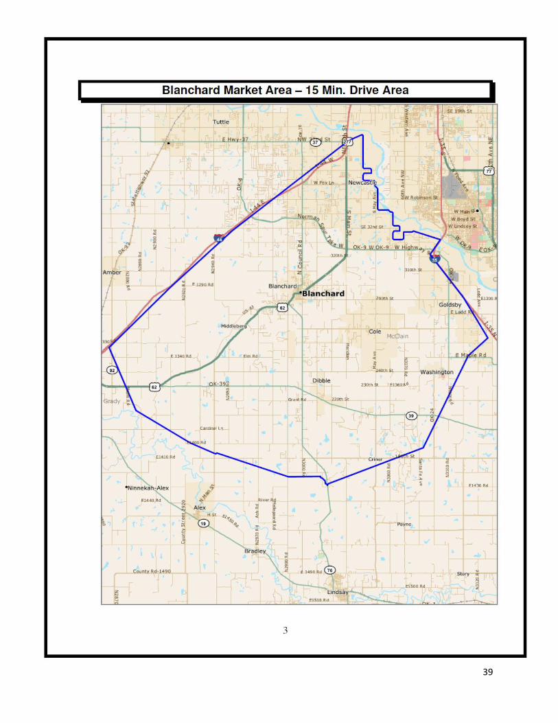
Blanchard began as a part of the Chickasaw Nation and Indian Territory as early as 1855. Blanchard incorporated as a town in November 1907, with a Town Board of Trustees as the governing body. In May 1967, the town officially became a “city” with a mayor/council form of government. In April 1987, the city changed to a city manager/council form of government, employing an active Planning Commission and a Progressive City Council. The City of Blanchard is located in south central Oklahoma, south of I-44 and the HE Bailey Turnpike (I-44) Norman Spur, west of I-35 and Highway 9, at the crossroads of Highway 62 and Highway 76. The city is approximately 30 square miles in size, situated in both McClain and Grady Counties (see Map 2.1).
Map 2.1
5
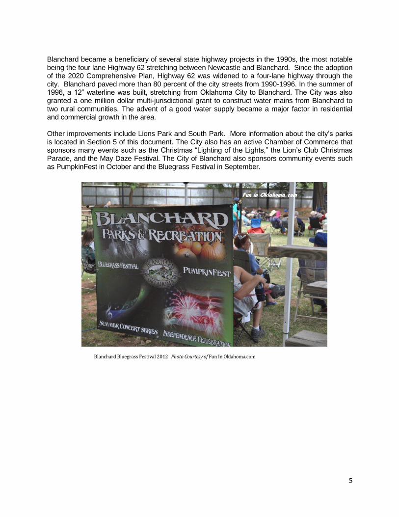
Blanchard became a beneficiary of several state highway projects in the 1990s, the most notable being the four lane Highway 62 stretching between Newcastle and Blanchard. Since the adoption of the 2020 Comprehensive Plan, Highway 62 was widened to a four-lane highway through the city. Blanchard paved more than 80 percent of the city streets from 1990-1996. In the summer of 1996, a 12” waterline was built, stretching from Oklahoma City to Blanchard. The City was also granted a one million dollar multi-jurisdictional grant to construct water mains from Blanchard to two rural communities. The advent of a good water supply became a major factor in residential and commercial growth in the area. Other improvements include Lions Park and South Park. More information about the city’s parks is located in Section 5 of this document. The City also has an active Chamber of Commerce that sponsors many events such as the Christmas “Lighting of the Lights,” the Lion’s Club Christmas Parade, and the May Daze Festival. The City of Blanchard also sponsors community events such as PumpkinFest in October and the Bluegrass Festival in September.
Blanchard Bluegrass Festival 2012 Photo Courtesy of Fun In Oklahoma.com
6
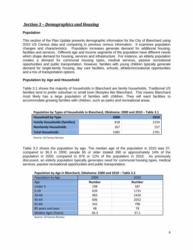
Section 3 – Demographics and Housing Population This section of the Plan Update presents demographic information for the City of Blanchard using 2010 US Census data and comparing to previous census information. It examines population changes and characteristics. Population increases generate demand for additional housing, facilities and services. Different age and income segments of the population have different needs which shape demand for housing, services and infrastructure. For instance, an elderly population creates a demand for communal housing types, medical services, passive recreational opportunities and public transportation. However, families with young children typically generate demand for single-family housing, day care facilities, schools, athletic/recreational opportunities and a mix of transportation options. Population by Age and Household
Table 3.1 shows the majority of households in Blanchard are family households. Traditional US families tend to prefer suburban or small town lifestyles like Blanchard. This means Blanchard most likely has a large population of families with children. They will want facilities to accommodate growing families with children, such as parks and recreational areas. Table 3.2 shows the population by age. The median age of the population in 2010 was 37, compared to 36.3 in 2000; people 65 or older totaled 390 or approximately 14% of the population in 2000, compared to 876 or 11% of the population in 2010. As previously discussed, an elderly population typically generates need for communal housing types, medical services, passive recreational opportunities and public transportation.
Population by Age in Blanchard, Oklahoma: 2000 and 2010 – Table 3.2
Population by Age 2000 2010
Age Number Number
Under 5 198 587
5-19 639 1735
20-44 983 2420
45-64 606 2052
65-84 342 798
85 years and over 48 78
Median Ages (Years) 36.3 37.1 Source: US Census Bureau
Population by Types of Households in Blanchard, Oklahoma: 2000 and 2010 – Table 3.1
Household by Type 2000 2010
Family Households (families) 818 2234
Nonfamily Households 267 557
Total Households 1085 2791
Source: US Census Bureau
7
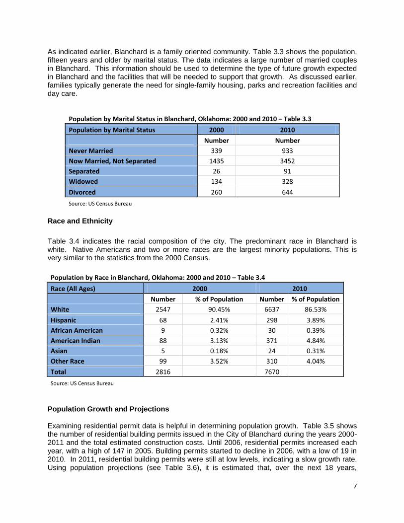
As indicated earlier, Blanchard is a family oriented community. Table 3.3 shows the population, fifteen years and older by marital status. The data indicates a large number of married couples in Blanchard. This information should be used to determine the type of future growth expected in Blanchard and the facilities that will be needed to support that growth. As discussed earlier, families typically generate the need for single-family housing, parks and recreation facilities and day care.
Race and Ethnicity
Table 3.4 indicates the racial composition of the city. The predominant race in Blanchard is white. Native Americans and two or more races are the largest minority populations. This is very similar to the statistics from the 2000 Census.
Population by Race in Blanchard, Oklahoma: 2000 and 2010 – Table 3.4
Race (All Ages) 2000 2010
Number % of Population Number % of Population
White 2547 90.45% 6637 86.53%
Hispanic 68 2.41% 298 3.89%
African American 9 0.32% 30 0.39%
American Indian 88 3.13% 371 4.84%
Asian 5 0.18% 24 0.31%
Other Race 99 3.52% 310 4.04%
Total 2816 7670
Source: US Census Bureau
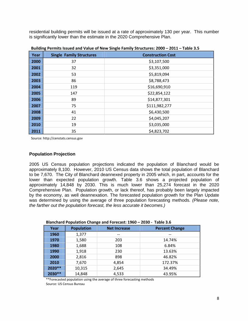
Population Growth and Projections Examining residential permit data is helpful in determining population growth. Table 3.5 shows the number of residential building permits issued in the City of Blanchard during the years 2000-2011 and the total estimated construction costs. Until 2006, residential permits increased each year, with a high of 147 in 2005. Building permits started to decline in 2006, with a low of 19 in 2010. In 2011, residential building permits were still at low levels, indicating a slow growth rate. Using population projections (see Table 3.6), it is estimated that, over the next 18 years,
Population by Marital Status in Blanchard, Oklahoma: 2000 and 2010 – Table 3.3
Population by Marital Status 2000 2010
Number Number
Never Married 339 933
Now Married, Not Separated 1435 3452
Separated 26 91
Widowed 134 328
Divorced 260 644
Source: US Census Bureau
8
residential building permits will be issued at a rate of approximately 130 per year. This number is significantly lower than the estimate in the 2020 Comprehensive Plan.
Building Permits Issued and Value of New Single Family Structures: 2000 – 2011 – Table 3.5
Year Single Family Structures Construction Cost
2000 37 $3,107,500
2001 32 $3,351,000
2002 53 $5,819,094
2003 86 $8,788,473
2004 119 $16,690,910
2005 147 $22,854,122
2006 89 $14,877,301
2007 75 $111,982,277
2008 41 $6,430,500
2009 22 $4,045,207
2010 19 $3,035,000
2011 35 $4,823,702
Source: http://censtats.census.gov
Population Projection 2005 US Census population projections indicated the population of Blanchard would be approximately 8,100. However, 2010 US Census data shows the total population of Blanchard to be 7,670. The City of Blanchard deannexed property in 2005 which, in part, accounts for the lower than expected population growth. Table 3.6 shows a projected population of approximately 14,848 by 2030. This is much lower than 25,274 forecast in the 2020 Comprehensive Plan. Population growth, or lack thereof, has probably been largely impacted by the economy, as well deannexation. The forecasted population growth for the Plan Update was determined by using the average of three population forecasting methods. (Please note, the farther out the population forecast, the less accurate it becomes.)
Blanchard Population Change and Forecast: 1960 – 2030 - Table 3.6
Year Population Net Increase Percent Change
1960 1,377 -- --
1970 1,580 203 14.74%
1980 1,688 108 6.84%
1990 1,918 230 13.63%
2000 2,816 898 46.82%
2010 7,670 4,854 172.37%
2020** 10,315 2,645 34.49%
2030** 14,848 4,533 43.95% **Forecasted population using the average of three forecasting methods Source: US Census Bureau
9
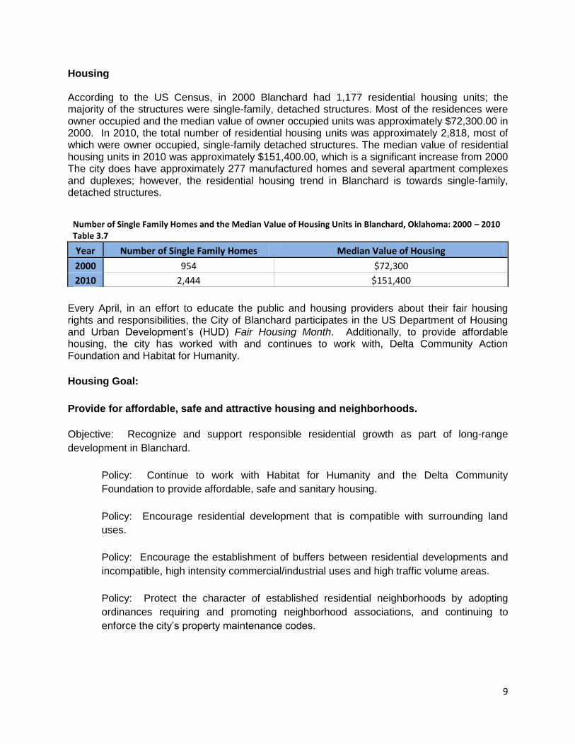
Housing According to the US Census, in 2000 Blanchard had 1,177 residential housing units; the majority of the structures were single-family, detached structures. Most of the residences were owner occupied and the median value of owner occupied units was approximately $72,300.00 in 2000. In 2010, the total number of residential housing units was approximately 2,818, most of which were owner occupied, single-family detached structures. The median value of residential housing units in 2010 was approximately $151,400.00, which is a significant increase from 2000 The city does have approximately 277 manufactured homes and several apartment complexes and duplexes; however, the residential housing trend in Blanchard is towards single-family, detached structures.
Every April, in an effort to educate the public and housing providers about their fair housing rights and responsibilities, the City of Blanchard participates in the US Department of Housing and Urban Development’s (HUD) Fair Housing Month. Additionally, to provide affordable housing, the city has worked with and continues to work with, Delta Community Action Foundation and Habitat for Humanity.
Housing Goal:
Provide for affordable, safe and attractive housing and neighborhoods.
Objective: Recognize and support responsible residential growth as part of long-range
development in Blanchard.
Policy: Continue to work with Habitat for Humanity and the Delta Community
Foundation to provide affordable, safe and sanitary housing.
Policy: Encourage residential development that is compatible with surrounding land
uses.
Policy: Encourage the establishment of buffers between residential developments and
incompatible, high intensity commercial/industrial uses and high traffic volume areas.
Policy: Protect the character of established residential neighborhoods by adopting
ordinances requiring and promoting neighborhood associations, and continuing to
enforce the city’s property maintenance codes.
Number of Single Family Homes and the Median Value of Housing Units in Blanchard, Oklahoma: 2000 – 2010 Table 3.7
Year Number of Single Family Homes Median Value of Housing
2000 954 $72,300
2010 2,444 $151,400

10
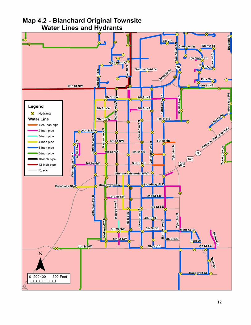
Section 4 - Infrastructure and Public Utilities Water System
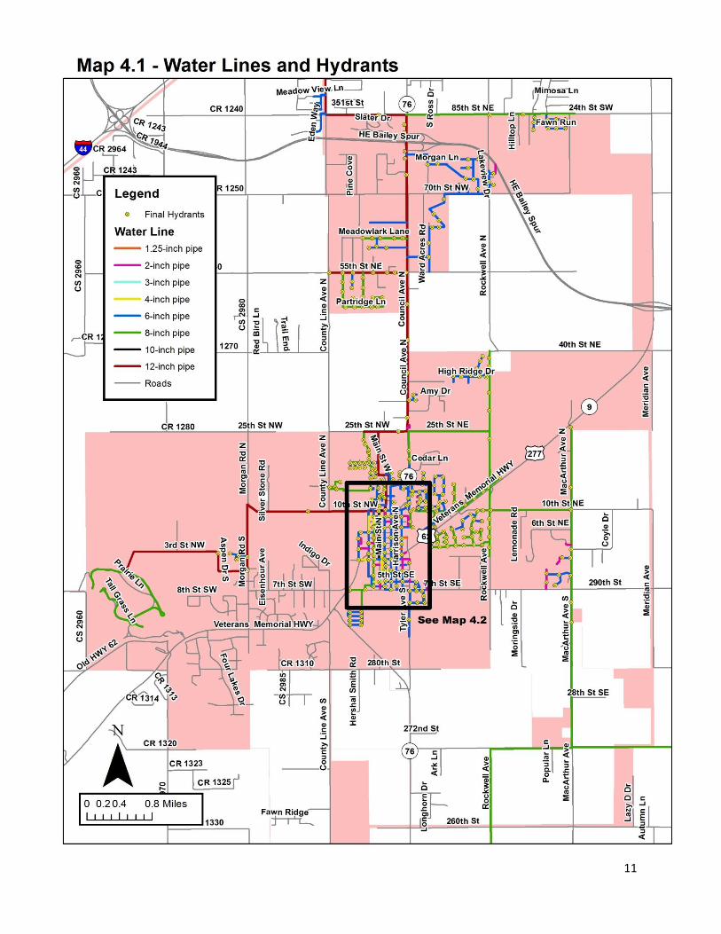
Due to the lack of aquifers in and around Blanchard, there is a shortage of well water. Because of this, the city receives its water from Oklahoma City. Blanchard, in turn, sells water to the cities of Dibble and Cole. There is only one 12-inch water line connecting Oklahoma City to Blanchard. If this line were to go out of service, even for a short period of time, the ramifications to Blanchard, Dibble and Cole could be catastrophic. The city should consider a secondary water supply sufficient water to serve the current population and future population growth. Other issues include old water lines in the original town site of Blanchard in need of replacement, undersized water lines resulting in low water pressure in some areas and individual water wells going dry. New development should be required, in accordance with Oklahoma State Statute Title 11 Section 45-104, to connect to Blanchard’s water system. Water System Goal: Maintain a quality water system to ensure an adequate water supply for existing and future development. Objective: New developments in Blanchard should be required to connect to the city’s water system, in accordance with Oklahoma State Statute Title 11 Section 45-104 and city ordinance.
Policy: Ensure the city has the capacity to extend service to future development, before the development is approved by the city.
Policy: Consider having a study done by a professional civil engineering firm to
determine the most appropriate place to locate a secondary water supply to the city and to locate and size future water lines and fire hydrants.
Policy: Consider funding sources to replace aging water lines in the downtown area and
to update undersized lines to improve water pressure, where needed. Policy: Keep water map updated as new lines are constructed or existing lines are
replaced with larger lines.
11
12
13
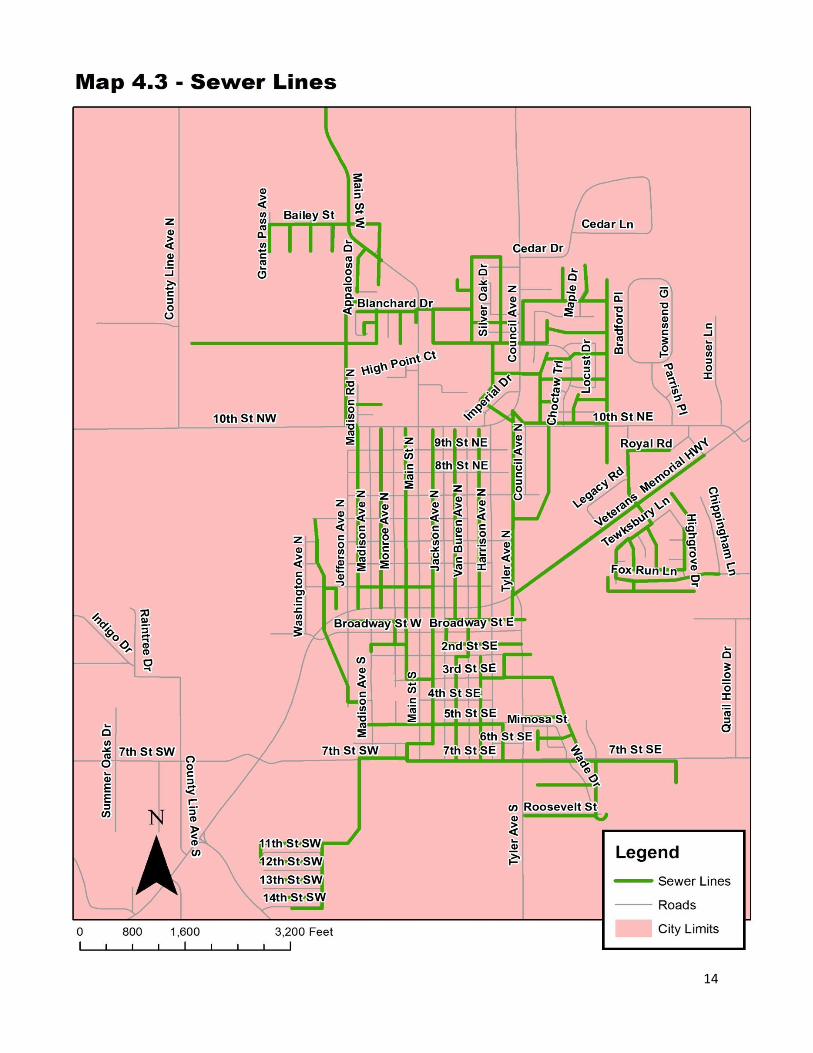
Wastewater System
Blanchard’s current wastewater system consists of three lagoons, constructed in 1976. In 2010, two of the lagoons were enlarged and aerated, per Oklahoma Department of Environmental Quality (DEQ) specifications and went online in 2011. According to DEQ, to accommodate future development, more property will need to be acquired for irrigation to accommodate increased flow of gray water. In order to implement this, DEQ is requiring the city to develop a 20-year plan. The city is currently in the process of developing the 20-year plan and searching for property suitable for the location of an aeration system. In addition, new development should be required, in accordance with Oklahoma State Statute Title 11 Section 45-104 and city ordinance, to connect to Blanchard’s wastewater system. There are a numerous homes, and some businesses, with individual sewer systems; either septic or aerobic. DEQ is the regulatory authority for the placement of individual septic systems. However, if not properly maintained, they can become an environmental problem for property owners and the general public. Connection to the city’s wastewater system would help prevent issues arising from improperly maintained or failing individual sewer systems. Wastewater System Goal: Maintain current sanitary sewer infrastructure and update sanitary sewer system in accordance with DEQ requirements, to provide for future growth. Objective: New developments in Blanchard should be required to connect to the city’s wastewater system, in accordance with Oklahoma State Statute Title 11 Section 45-104.
Policy: Ensure the city has the capacity to extend service to future development before the development is approved by the city.
Policy: Complete DEQ required 20-year plan for the city’s wastewater treatment facility.
Policy: Acquire land appropriate for the location of an aeration system, as required by the 20-year plan.
Policy: Consider having a study done by a professional civil engineering firm to determine the most appropriate size/place to locate future sewer services.
Policy: Keep sewer line map updated as new lines are constructed and/or existing lines
are replaced.
14
15
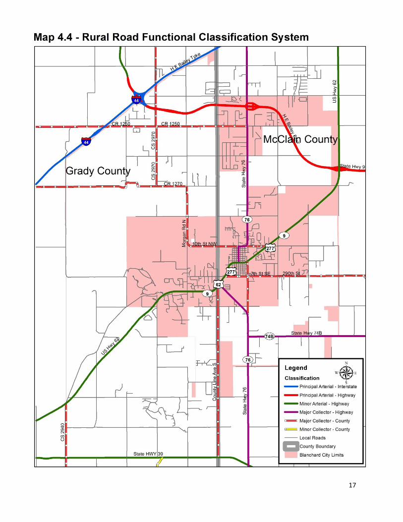
Transportation The thoroughfare map in the 2020 Comprehensive Plan has been changed because it did not use the Oklahoma Department of Transportation (ODOT) Rural Road Functional Classification System. Map 4.3 uses ODOT’s Rural Road Functional Classification System and is from ODOT’s website, as of 2010. The City will use this classification system, as it is the basis for possible future funding through the Association of Central Oklahoma Governments (ACOG), the Federal Highway Administration (FHWA) and ODOT. ACOG administers funding for ODOT and FHWA for Central Oklahoma local government and works with Central Oklahoma local governments regarding transportation issues. ACOG has indicated the map may change, based upon 2010 US Census data. The City of Blanchard will work closely with ACOG during the map update process. The following are ODOT’s definitions for the Rural Road Functional Classification System: Rural Principal Arterial 1. Highways having high density of intrastate and interstate travel 2. Highways that serve urbanized areas and a large majority of small urban areas. The rural
principal arterial system may serve an urban area if the system either penetrates the urban boundary or comes within 10 miles.
3. Provide an integrated network without stub connections except where unusual geographic or traffic flow conditions dictate otherwise.
The principal arterial system is classified into the following two subsystems: 1. Interstate Systems: All designated Interstate routes. 2. Other Principal Arterials: All non-Interstate principal arterial highways.
Rural Minor Arterial System
1. Link cities and larger towns and other traffic generators, such as major resort areas, that are capable of attracting travel over similarly long distances and from an integrated network providing interstate and intercounty service. Minor Arterial systems serves and urban area if the system either penetrates or comes within 2 miles of the urban boundary.
2. Be spaced at such intervals, consistent with population density to that all developed areas of the State are within a reasonable distance of an arterial highway.
3. Provide service to roads with top length and travel density greater than those predominantly served by rural collectors or local systems. Minor arterial routes have relatively high overall travel speeds and minimum interference to through traffic.
Rural Collector System The characteristics of a rural collector system is subclassified according to the following criteria: Major Collector Highways and Roads:
1. Provide service to any county seat not on an arterial route; to the larger towns not directly served by the higher systems; and to other traffic generators of equivalent intracounty importance, such as consolidated schools, shipping points, county parks, important mining and agricultural areas, etc.
2. Link these places with nearby larger towns or cities or with routes of higher classification.
16
3. Serves the more important intracounty travel. Minor Collector Roads:
1. Be spaced at intervals, consistent with population density, to collect traffic from local roads and bring all developed areas within a reasonable distance of a collector road.
2. Provides service to the remaining small communities. Rural Local Roads System
1. Serves primarily to provide access to adjacent land. 2. Provides service to travel over relatively short distances as compared to collectors and
other higher systems. Local roads will, of course, constitute the rural mileage not classified as part of the principal arterial, minor arterial, or collector systems.
The widening of US Highway 62 (Veteran’s Memorial Highway) has caused increased traffic on Highway 62 through Blanchard. ODOT installed curb cuts for pedestrian use and signalization at Main St. Signalization was also installed at Tyler Ave. and NE 10th St. Crosswalks were installed at Highway 62 and Van Buren and Harrison Avenues. No other changes were made to the transportation section of the 2020 Comprehensive Plan.
17
18
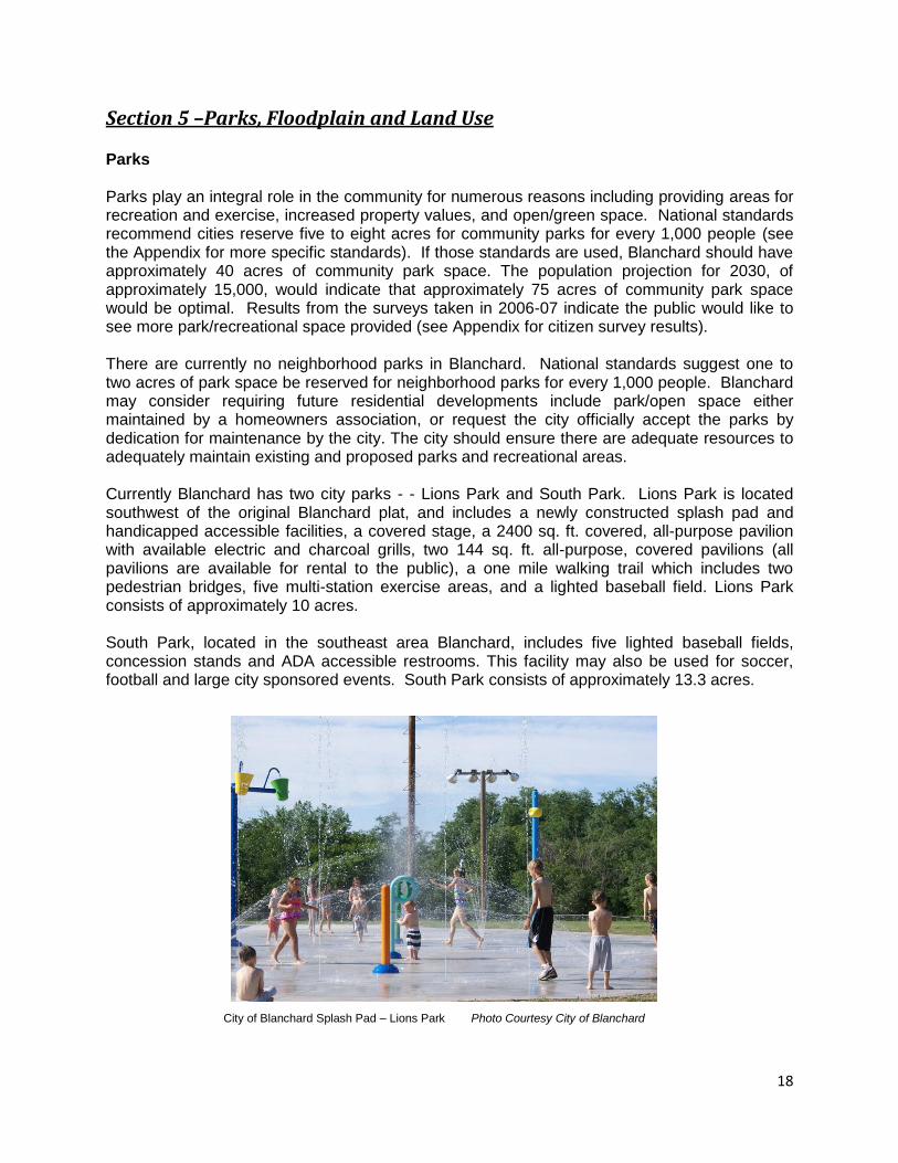
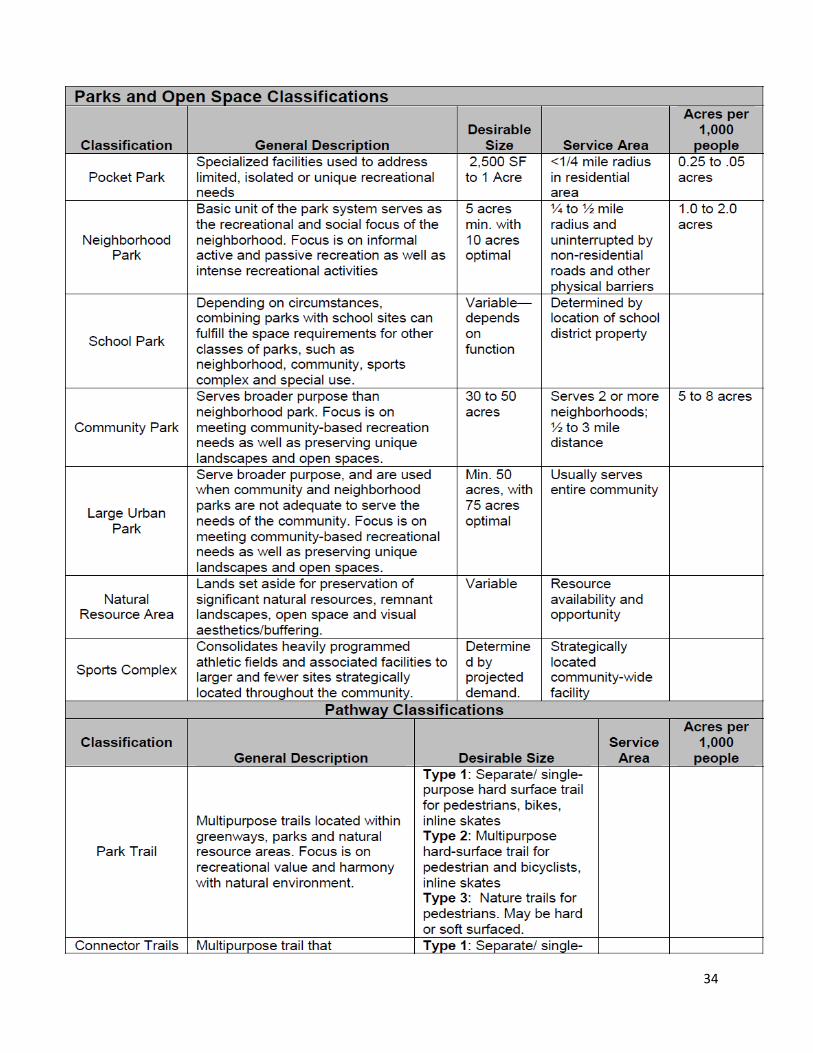
Section 5 –Parks, Floodplain and Land Use Parks Parks play an integral role in the community for numerous reasons including providing areas for recreation and exercise, increased property values, and open/green space. National standards recommend cities reserve five to eight acres for community parks for every 1,000 people (see the Appendix for more specific standards). If those standards are used, Blanchard should have approximately 40 acres of community park space. The population projection for 2030, of approximately 15,000, would indicate that approximately 75 acres of community park space would be optimal. Results from the surveys taken in 2006-07 indicate the public would like to see more park/recreational space provided (see Appendix for citizen survey results). There are currently no neighborhood parks in Blanchard. National standards suggest one to two acres of park space be reserved for neighborhood parks for every 1,000 people. Blanchard may consider requiring future residential developments include park/open space either maintained by a homeowners association, or request the city officially accept the parks by dedication for maintenance by the city. The city should ensure there are adequate resources to adequately maintain existing and proposed parks and recreational areas. Currently Blanchard has two city parks - - Lions Park and South Park. Lions Park is located southwest of the original Blanchard plat, and includes a newly constructed splash pad and handicapped accessible facilities, a covered stage, a 2400 sq. ft. covered, all-purpose pavilion with available electric and charcoal grills, two 144 sq. ft. all-purpose, covered pavilions (all pavilions are available for rental to the public), a one mile walking trail which includes two pedestrian bridges, five multi-station exercise areas, and a lighted baseball field. Lions Park consists of approximately 10 acres. South Park, located in the southeast area Blanchard, includes five lighted baseball fields, concession stands and ADA accessible restrooms. This facility may also be used for soccer, football and large city sponsored events. South Park consists of approximately 13.3 acres.
City of Blanchard Splash Pad – Lions Park Photo Courtesy City of Blanchard
19
Parks System Goal:
Maintain existing parks and provide for additional city parks, open space and trails, as well as neighborhood parks. Objective: Ensure adequate funding to build and maintain additional parks and open space as the community grows, and require future residential developments provide neighborhood parks and open space.
Policy: Revise subdivision regulations to require dedicated park/open space and sidewalks based upon zoning/density. Policy: Provide for a “fee-in-lieu-of” in the subdivision regulations for park/open space dedications. Policy: Have a feasibility study performed by a skilled park planning professional to determine the location, types and sizes of parks, trails and open spaces adequate to meet the community’s current and future needs; include linking existing parks, trails and sidewalks, as well as proposed future parks, trails and sidewalks.
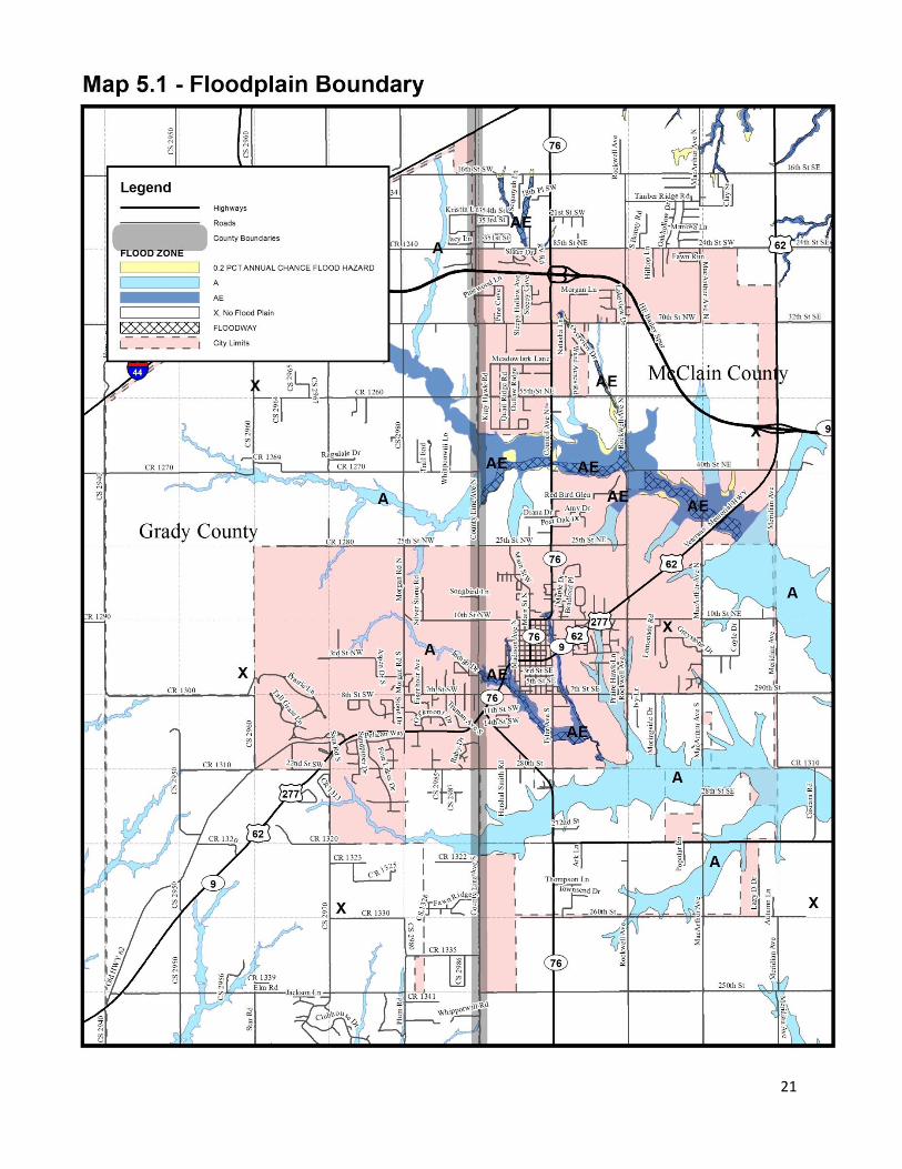
Floodplain Creeks, riparian areas and floodplains are environmentally sensitive areas and are beneficial to the community. They serve to store and convey flood waters, and are natural drainage areas. Additionally, if regulated properly, floodplains should help reduce property damage due to flooding and, most importantly, reduce deaths or injuries in the event of a flood. Any development or encroachment into the floodplain should be limited by the community. Development of any type should not be allowed in the floodway, which is the part of the floodplain FEMA considers the most hazardous. There are several creeks traversing Blanchard containing designated floodplain areas. They include Walnut Creek in the northern part of the city, with tributaries in the southern area of Blanchard; Buffalo Creek in the southeast; and Bridge Creek in Grady County. Walnut Creek contains the largest floodplain (see Map 5.1). The Federal Emergency Management Agency (FEMA) defines the floodplains as flood hazard areas identified on the Flood Insurance Rate Map (FIRM) and identified as a Special Flood Hazard Area (SFHA). SFHAs are defined as the areas that will be inundated by the flood event having a 1-percent chance of being equaled or exceeded in any given year. The 1-percent annual chance flood is also referred to as the base flood or 100-year flood. Because the City of Blanchard participates in the National Flood Insurance Program (NFIP), they are required to adopt and enforce the minimum NFIP floodplain regulations. Blanchard has adopted a floodplain ordinance which meets the requirements of the NFIP and FEMA. Floodplain Goal: Regulate the floodplain to eliminate deaths and injuries, reduce property damage and protect the environment and wildlife habitat. Objective: Protect creeks, riparian areas and floodplains from encroachment and incompatible land uses.

20
Policy: Continue to restrict construction in the 100-year (1%) floodplain to adhere to the requirements of FEMA and the NFIP, as well as the city’s floodplain ordinance. Policy: In order to protect water quality and wildlife habitat, consider prohibiting building by establishing a minimum buffer from the banks of creeks and streams. Policy: Consider locating low-impact, environmentally compatible, passive recreation areas, such as trails and open space, in the floodplain (not floodways).
21
22
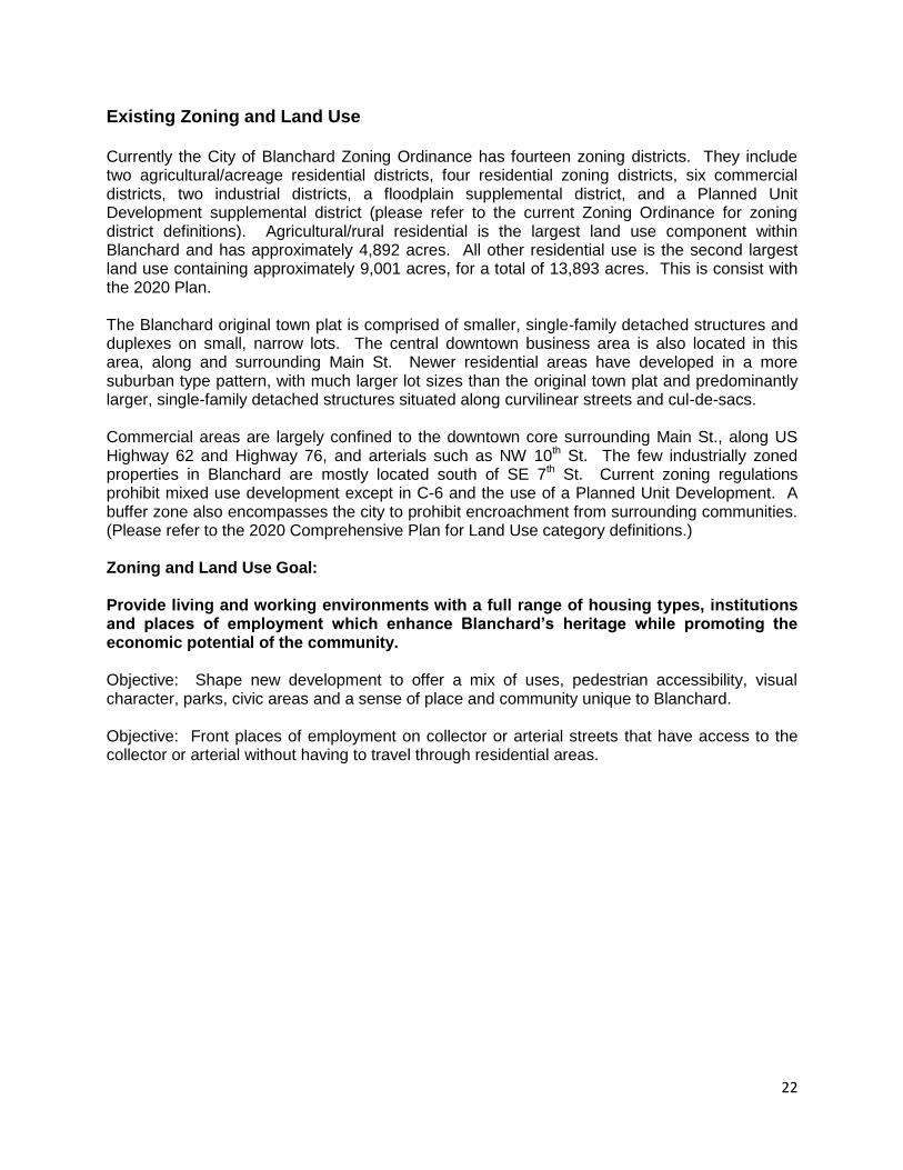
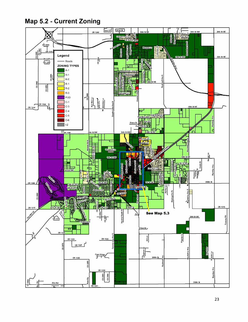
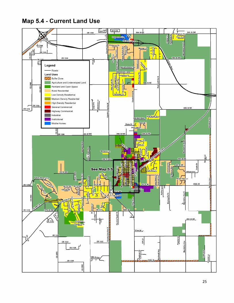
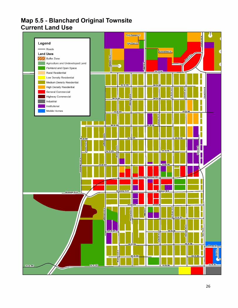
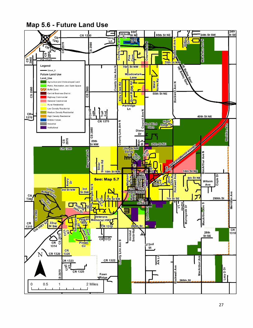
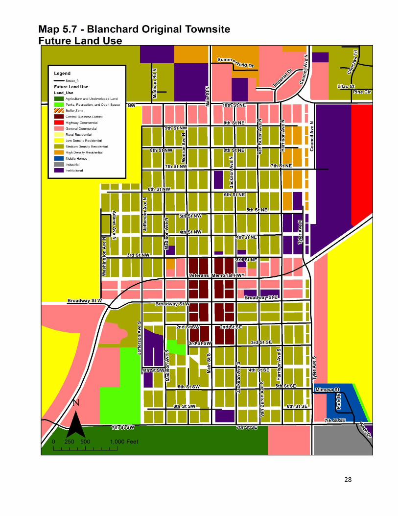
Existing Zoning and Land Use Currently the City of Blanchard Zoning Ordinance has fourteen zoning districts. They include two agricultural/acreage residential districts, four residential zoning districts, six commercial districts, two industrial districts, a floodplain supplemental district, and a Planned Unit Development supplemental district (please refer to the current Zoning Ordinance for zoning district definitions). Agricultural/rural residential is the largest land use component within Blanchard and has approximately 4,892 acres. All other residential use is the second largest land use containing approximately 9,001 acres, for a total of 13,893 acres. This is consist with the 2020 Plan. The Blanchard original town plat is comprised of smaller, single-family detached structures and duplexes on small, narrow lots. The central downtown business area is also located in this area, along and surrounding Main St. Newer residential areas have developed in a more suburban type pattern, with much larger lot sizes than the original town plat and predominantly larger, single-family detached structures situated along curvilinear streets and cul-de-sacs. Commercial areas are largely confined to the downtown core surrounding Main St., along US Highway 62 and Highway 76, and arterials such as NW 10th St. The few industrially zoned properties in Blanchard are mostly located south of SE 7th St. Current zoning regulations prohibit mixed use development except in C-6 and the use of a Planned Unit Development. A buffer zone also encompasses the city to prohibit encroachment from surrounding communities. (Please refer to the 2020 Comprehensive Plan for Land Use category definitions.) Zoning and Land Use Goal: Provide living and working environments with a full range of housing types, institutions and places of employment which enhance Blanchard’s heritage while promoting the economic potential of the community. Objective: Shape new development to offer a mix of uses, pedestrian accessibility, visual character, parks, civic areas and a sense of place and community unique to Blanchard. Objective: Front places of employment on collector or arterial streets that have access to the collector or arterial without having to travel through residential areas.
23
24
25
26
27
28
29
Section 6 – Economic Development
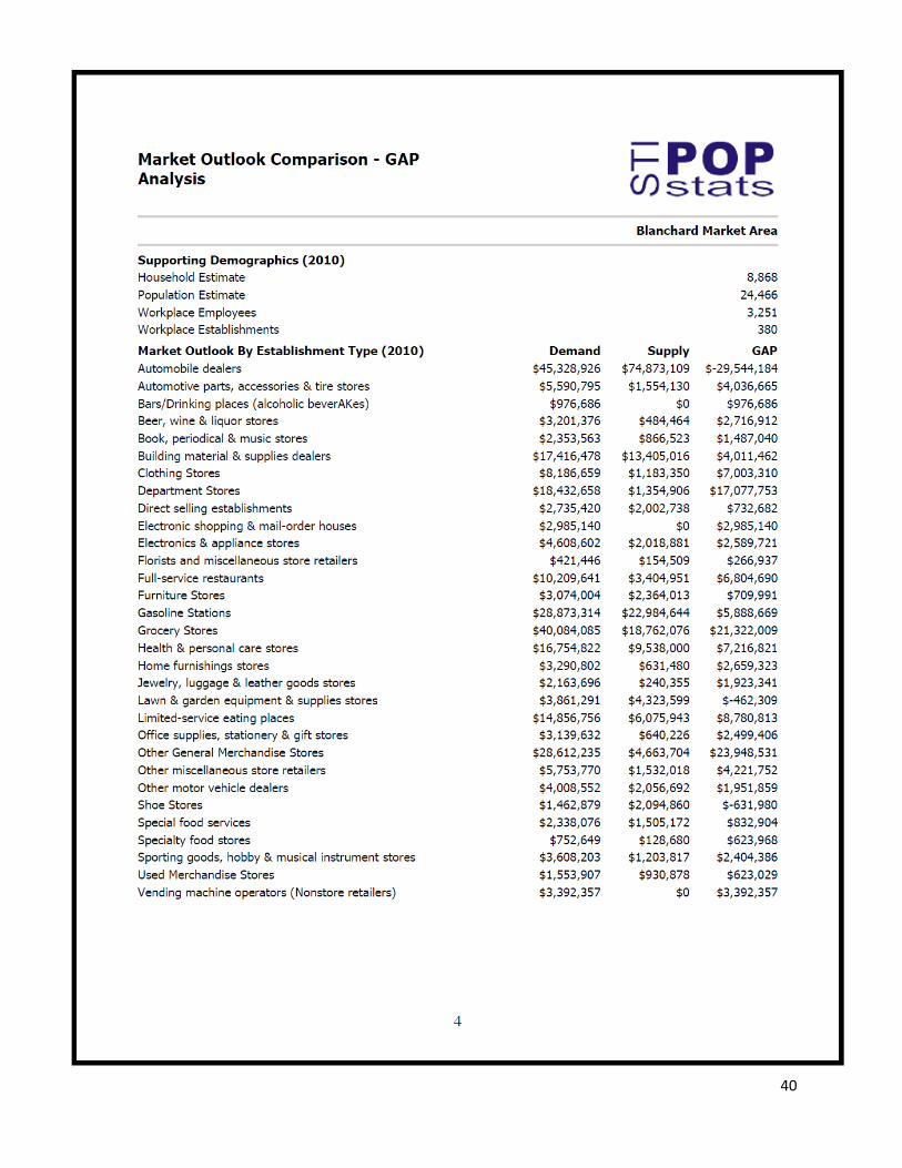
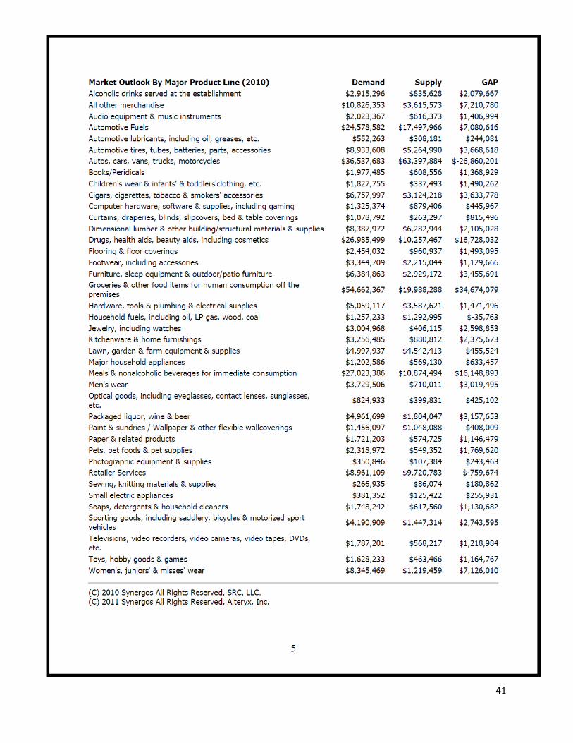
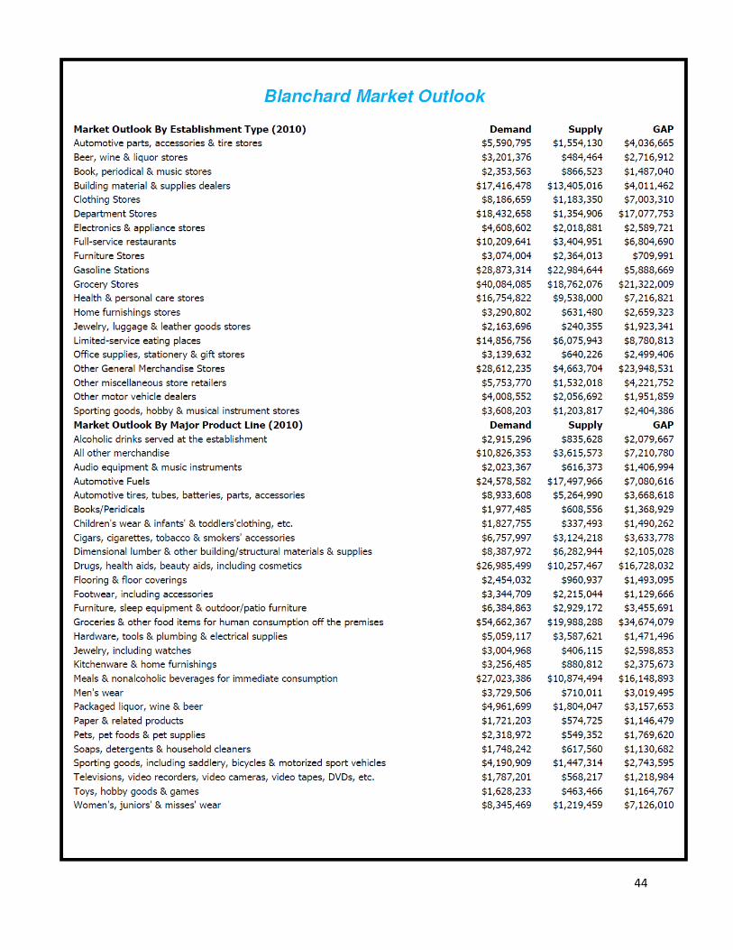
Introduction A healthy economy is essential to the continued growth of Blanchard. A healthy economy means more than just news jobs; it means increased incomes for Blanchard residents, a welcome environment for existing and new businesses, and increased fiscal capacity and financial stability. One of the principal purposes of economic development is to provide sufficient tax base for the city’s continued growth and prosperity. Revenues generated from sales tax and various permits and user fees contribute substantially to funding infrastructure and public service investments. Blanchard should implement an effective economic development policy integrating existing economic and cultural resources with new economic investments, thus creating a sustainable business climate and employment opportunities. Economic development involves marketing, promoting, and developing land in four specific areas. These areas include: the corridor along Highway 62, the intersections along Highway 76 (Council Ave) north of the original Blanchard townsite, within the Central Business District, and in the undeveloped lands south of the original Blanchard townsite. The city should market, promote, and develop businesses that are appropriate to Blanchard’s character and needs. Business recruitment within Blanchard is focused on retail, commercial, and small industry. Therefore, it is essential that the Comprehensive Plan Update designate sufficient land for economic expansion and ensure that such land is strategically located to maximize the potential for meeting market demands. Further, the Comprehensive Plan Update should provide assurances to the existing Main Street business community of continued investment necessary to promote the economic vitality within the commercial core. In order to accomplish this, the city should maintain support for the Blanchard Economic Trust Authority (BETA) and the Chamber of Commerce. BETA, founded in 2009 and revived in 2012, is an economic development team whose mission is to foster growth and expansion for new and existing businesses. They have a unique ability to secure financial and investment funding that is vital to the city’s economic development. The Chamber of Commerce is an organization designed to help develop, promote and support the community and its economic opportunities. Through a membership system, they have the ability to plan events and create a positive business atmosphere and attract new businesses. The City, the Chamber, and BETA should conduct continual analysis to identify strong economic sectors given prevailing market factors. There have been a number of studies done, specifically for Blanchard, to understand market factors and make positive economic decisions. The studies include: a 2006 survey conducted by the Blanchard Planning Department that determined the community’s business climate through public input, a market outlook – GAP (Gap Analysis Program) prepared by Northeastern State University (see Appendix), a survey conducted by a Chamber committee seeking community input regarding economic development and retail leakage, and a Retail Attraction GAP Analysis, which is currently being prepared.
30
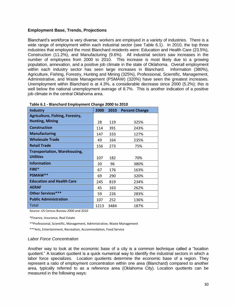
Employment Base, Trends, Projections Blanchard’s workforce is very diverse; workers are employed in a variety of industries. There is a wide range of employment within each industrial sector (see Table 6.1). In 2010, the top three industries that employed the most Blanchard residents were: Education and Health Care (23.5%), Construction (11.2%), and Manufacturing (9.6%). All industrial sectors saw increases in the number of employees from 2000 to 2010. This increase is most likely due to a growing population, annexation, and a positive job climate in the state of Oklahoma. Overall employment within each industry sector has seen large increases in Blanchard. Information (380%), Agriculture, Fishing, Forestry, Hunting and Mining (325%), Professional, Scientific, Management, Administrative, and Waste Management (PSMAW) (320%) have seen the greatest increases. Unemployment within Blanchard is at 4.3%, a considerable decrease since 2000 (5.2%); this is well below the national unemployment average of 8.7%. This is another indication of a positive job climate in the central Oklahoma area.
Table 6.1 - Blanchard Employment Change 2000 to 2010
Industry 2000 2010 Percent Change
Agriculture, Fishing, Forestry, Hunting, Mining 28 119 325%
Construction 114 391 243%
Manufacturing 147 333 127%
Wholesale Trade 49 164 235%
Retail Trade 156 273 75%
Transportation, Warehousing, Utilities 107 182 70%
Information 20 96 380%
FIRE* 67 176 163%
PSMAW** 69 290 320%
Education and Health Care 245 819 234%
AERAF 45 163 262%
Other Services*** 59 226 283%
Public Administration 107 252 136%
Total 1213 3484 187% Source: US Census Bureau 2000 and 2010
*Finance, Insurance, Real Estate
**Professional, Scientific, Management, Administrative, Waste Management
***Arts, Entertainment, Recreation, Accommodation, Food Service
Labor Force Concentration Another way to look at the economic base of a city is a common technique called a “location quotient.” A location quotient is a quick numerical way to identify the industrial sectors in which a labor force specializes. Location quotients determine the economic base of a region. They represent a ratio of employment concentration within one area (Blanchard) compared to another area, typically referred to as a reference area (Oklahoma City). Location quotients can be measured in the following ways:
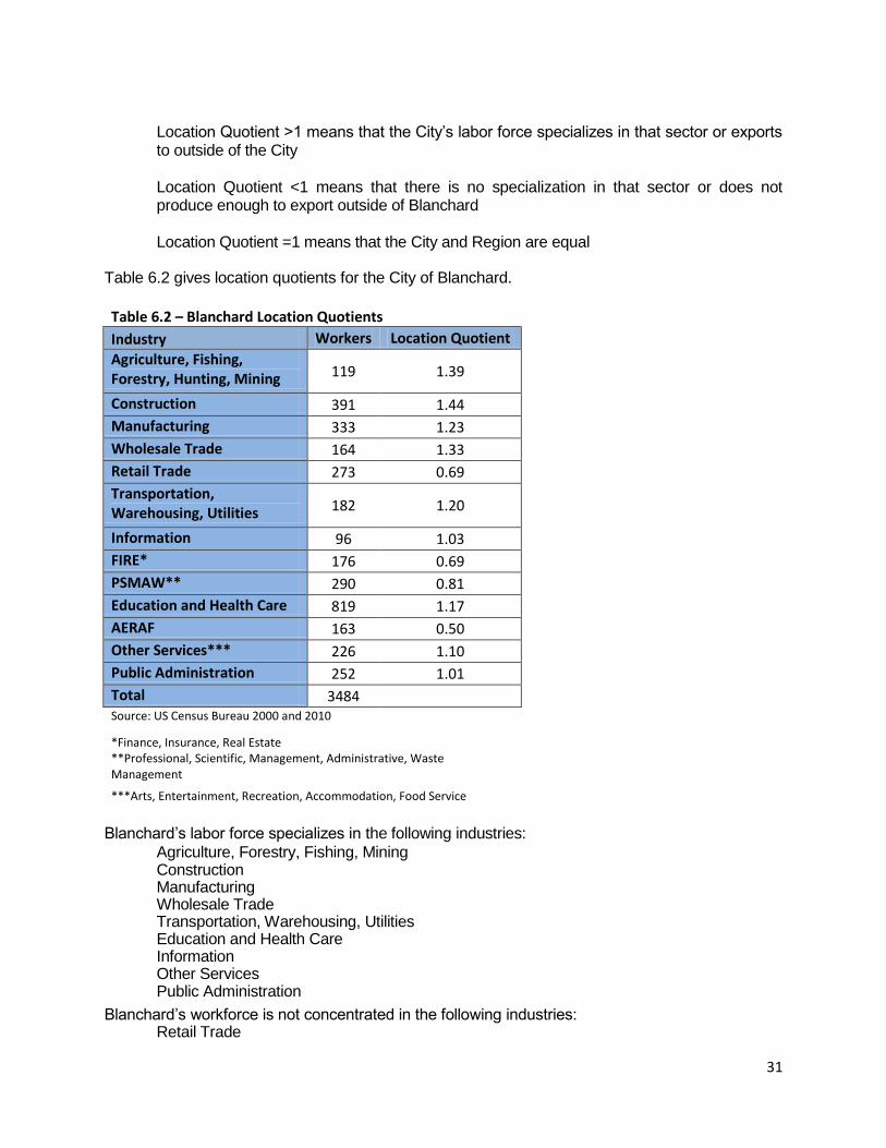
31
Location Quotient >1 means that the City’s labor force specializes in that sector or exports
to outside of the City Location Quotient <1 means that there is no specialization in that sector or does not
produce enough to export outside of Blanchard Location Quotient =1 means that the City and Region are equal
Table 6.2 gives location quotients for the City of Blanchard.
Table 6.2 – Blanchard Location Quotients
Industry Workers Location Quotient
Agriculture, Fishing, Forestry, Hunting, Mining 119 1.39
Construction 391 1.44
Manufacturing 333 1.23
Wholesale Trade 164 1.33
Retail Trade 273 0.69
Transportation, Warehousing, Utilities 182 1.20
Information 96 1.03
FIRE* 176 0.69
PSMAW** 290 0.81
Education and Health Care 819 1.17
AERAF 163 0.50
Other Services*** 226 1.10
Public Administration 252 1.01
Total 3484
Source: US Census Bureau 2000 and 2010
*Finance, Insurance, Real Estate **Professional, Scientific, Management, Administrative, Waste Management
***Arts, Entertainment, Recreation, Accommodation, Food Service
Blanchard’s labor force specializes in the following industries:
Agriculture, Forestry, Fishing, Mining Construction Manufacturing Wholesale Trade Transportation, Warehousing, Utilities Education and Health Care Information Other Services Public Administration
Blanchard’s workforce is not concentrated in the following industries: Retail Trade

32
Finance, Insurance, Real Estate Professional, Scientific, Management, Administrative and Waste Management
Health, Education and Social Services Arts, Entertainment, Recreation, Accommodation and Food Service
Blanchard’s employment characteristics are unique because of its location. As a bedroom community of Oklahoma City, most people commute to work in Oklahoma City or a surrounding city but live in Blanchard. In 2010, the median journey to work commute was 28 minutes. Out of the entire workforce, an estimated 15.3% of the population worked within Blanchard or worked from home. It is assumed that the rest of the population commuted from Blanchard to work. To break it down further, 33.5% of the population worked in either Grady or McClain County, while 64.9% of the population worked outside Grady or McClain County. The remaining 1.6% of the population, in 2010, worked out of state. Overall, Blanchard’s population works largely outside the city. Therefore, if the majority of the population works outside the city, Blanchard does not benefit from the economic opportunities within its boundary. Blanchard, BETA, and the Chamber should encourage and retain businesses in the following sectors in which the labor force is specialized: retail, restaurants, and other service oriented industries. In order to retain these industries, Blanchard needs to continue efforts to attract them. Employment Forecast
Forecasting workforce population is important in the decision making process for economic development. The 2020 Comprehensive Plan estimated that there would be 15,412 jobs by one estimate and 11,015 jobs by another estimate. Although there was large increase of population between 1990 and 2005, deannexation and other economic conditions were not considered in that analysis. A shift share analysis was done for the updated forecast for Blanchard taking into account factors such as the deannexation that occurred in 2009 and 2010, as well as an economic recession variable for the state of Oklahoma. Therefore, the updated forecast shows an increase of 814 new employees living in Blanchard (see Table 10.3). However, this forecast does not mean that all of the jobs will be in Blanchard. If the current trend of living in Blanchard and commuting outside the City continues, only 30 new jobs will have been added to the city by 2020. The actual job increases will occur all over the central Oklahoma region. The forecast simply gives an insight into the strengths and weaknesses of the employment base in the region.
Table 6.3 - Blanchard Employment Forecast 2020 Industry 2010 2020 Change
Agriculture, Fishing, Forestry, Hunting, Mining 119 133 14
Construction 391 338 -53
Maufacturing 333 264 -69
Wholesale Trade 164 208 44
Retail Trade 273 346 73
Transportation, Warehousing, Utilities 182 269 87
Information 96 165 69
FIRE* 176 213 37
PSMAW** 290 445 155
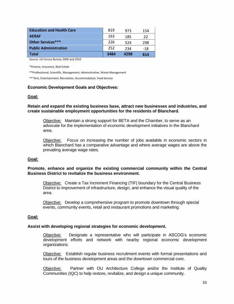
33
Education and Health Care 819 973 154
AERAF 163 185 22
Other Services*** 226 524 298
Public Administration 252 234 -18
Total 3484 4298 814 Source: US Census Bureau 2000 and 2010
*Finance, Insurance, Real Estate
**Professtional, Scientific, Management, Adminsitrative, Waste Management
***Arts, Entertainment, Recreation, Accommodation, Food Service
Economic Development Goals and Objectives:
Goal:
Retain and expand the existing business base, attract new businesses and industries, and create sustainable employment opportunities for the residents of Blanchard.
Objective: Maintain a strong support for BETA and the Chamber, to serve as an advocate for the implementation of economic development initiatives in the Blanchard area.
Objective: Focus on increasing the number of jobs available in economic sectors in which Blanchard has a comparative advantage and where average wages are above the prevailing average wage rates.
Goal:
Promote, enhance and organize the existing commercial community within the Central
Business District to revitalize the business environment.
Objective: Create a Tax Increment Financing (TIF) boundary for the Central Business District to improvement of infrastructure, design, and enhance the visual quality of the area.
Objective: Develop a comprehensive program to promote downtown through special events, community events, retail and restaurant promotions and marketing.
Goal: Assist with developing regional strategies for economic development.
Objective: Designate a representative who will participate in ASCOG’s economic development efforts and network with nearby regional economic development organizations.
Objective: Establish regular business recruitment events with formal presentations and
tours of the business development areas and the downtown commercial core.
Objective: Partner with OU Architecture College and/or the Institute of Quality
Communities (IQC) to help restore, revitalize, and design a unique community.
34
35

36

37
38
39
40
41
42
43
44