Embed Size (px)
Citation preview
The City of San Diego Water Department 2005
Watershed Sanitary Survey
Otay/Cottonwood Watersheds Volume 3 of 5
Data Collected Between 01/01/01– 12/31/05
ABBREVIATIONS ACOE Army Corps of Engineers ADT Average daily traffic
ADWF Average dry weather flow
AF/Y Acre-Feet per Year
AWWA American Water Works Association
BLM Bureau of Land Management – U.S. Federal
BMPs Best Management Practices
CDF California Department of Forestry
CDFA California Department of Food and Agriculture
CDFG California Department of Fish and Game
CDMG California Division of Mines and Geology
CEQA California Environmental Quality Act
CFR California Federal Regulation
cfs Cubic feet per second
City City of San Diego
CNDDB California Natural Diversity Database
CNF Cleveland National Forest
CNPS California Native Plant Society
County County of San Diego
CWA San Diego County Water Authority
D/DBP Disinfection/Disinfection By-Product
DHS Department of Health Services
DMG Division of Mines and Geology – State of California
dS/M Decisiemens per meter
DSOD Division of Safety of Dams
EPA Environmental Protection Agency
ESWTR Enhanced Surface Water Treatment Rule
GIS Geographic Information System
gpd Gallons per day
Gpm Gallons per minute
HAAs Haloacetic Acids
Volume 3, Chapter 5 - 276 -Revised 3-1-06
ABBREVIATIONS
Helix Helix Water District
HPC Heterotrophic Plate Count
HSU Hydrographic Subunit
HU Hydrographic Unit
HUMAN CON Human Consumption
IOCs Inorganic Chemicals
LPG Liquid Propane Gas
LSE LF Loose Leaf
MCL Maximum Contaminant Level
MCLG Maximum Contaminant Level Goal
MG Million Gallons
mg/L Milligrams per liter (parts per million)
mgd Million gallons per day
mgy Million gallons per year
MHCP Multiple Species Conservation Program
MSL Mean Sea Level
MWD Metropolitan Water District
N-GRNHS Nursery Greenhouse
N-OUTDR Nursery Outdoor
NEPA National Environmental Protection Act
NOI Notice of Intent
NPDES National Pollutant Discharge Elimination System
NRCS Natural Resources Conservation Service
NTU Nephelometric Turbidity Unit
OTC Olympic Training Center
PAHs Polyaromatic Hydrocarbons
PCBs Polychlorinated Biphenyls
RCA Resource Conservation Area
RMWD Ramona Municipal Water District
RO Reverse Osmosis
RUIS Regional Urban Information System
Volume 3, Chapter 5 - 277 -Revised 3-1-06
ABBREVIATIONS
RWQCB California Regional Water Quality Board
SANDAG San Diego Association of Governments
SCS Soil Conservation Service – U.S.
SDWA Safe Drinking Water Act - Federal
SMCL Secondary Maximum Contaminant Level
SOCs Synthetic Organic Chemicals
SP Soluble Powder
SUB Subtropical
SWPPPs Storm Water Pollution Prevention Plans
TCR Total Coliform Rule – Federal
TDH Total Dynamic Head
TDS Total Dissolved Solids
THMs Trihalomethanes
TTHMs Total Trihalomethanes
TOC Total Organic Carbon
TRANSPL Transplants
ug/L Micrograms per liter (parts per billion)
UNCUL Uncultivated
UNSP Unspecified
USDA United States Department of Agriculture
USEPA United States Environmental Protection Agency
USFS United States Forest Service
USFWS United States Fish and Wildlife Service
USGS United States Geological Society
VOCs Volatile Organic Compounds
WDRs Waste Discharge Requirements
WPCF Water Pollution Control Facility
WRF Water Reclamation Facility
WSS Watershed Sanitary Survey
WTP Water Treatment Plant
WWTP Wastewater Treatment Plant
Volume 3, Chapter 5 - 278 -Revised 3-1-06
VOLUME 3
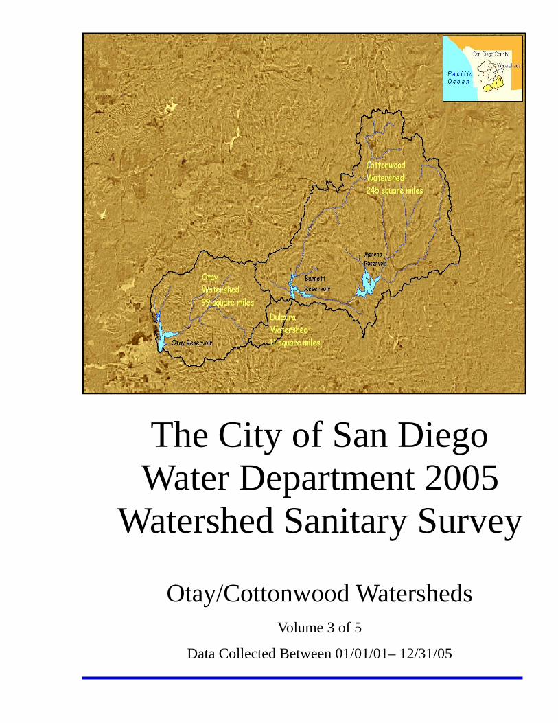
THE COTTONWOOD-OTAY SYSTEM
CHAPTER 1: SYNOPSIS
Introduction
This volume is the second five-year update of the 1996 Watershed Sanitary Survey
(WSS) for the Otay and Cottonwood Watersheds. The Otay/Cottonwood System is
comprised of four reservoirs, their watersheds, the Dulzura Conduit, and the Otay
Water Treatment Plant (Figure 3-1.1). The system covers a combined area of
226,245 acres, or about 354 square miles.
The Otay Watershed is made up of the Upper Otay Reservoir and the Lower Otay
Reservoir. The primary function of Lower Otay Reservoir is to store imported water
from the San Diego County Water Authority, local runoff water, and water transferred
from Barrett and Morena Reservoirs located in the Cottonwood Watershed via the
Dulzura Conduit. The Upper Otay Reservoir is no longer used for surface water
storage.
The Cottonwood Watershed consists of the Morena and Barrett Reservoirs, which
are impoundments along Cottonwood Creek. The primary function of these
reservoirs is to store local runoff water. Below Barrett Dam, Cottonwood Creek flows
into Mexico and joins the Tijuana River. Water from Barrett Reservoir is diverted by
the Dulzura Conduit, which discharges into Dulzura Creek at the headwaters of the
Otay River. The water ultimately reaches the Otay Reservoir. Essentially, this
system transfers water from the Tijuana River Basin to the Otay River Basin.
Volume 3, Chapter 1 - 165 -Revised 3-1-06
Natural runoff from a small area upslope of the Dulzura Conduit can be captured into
the conduit via a series of diverting structures. This area is known as the Dulzura
Watershed. Since it contributes directly to Otay Reservoir, it is considered part of
the Otay/Cottonwood System.
Watershed Sanitary Survey Requirements The California Surface Water Treatment Rule (SWTR), in Title 22, Article 7, Section
64665 of the State Code of Regulations, requires every public water system using
surface water to conduct a comprehensive sanitary survey of its watersheds every
five years. The purpose of such a survey is to identify actual or potential sources of
contamination, or any other watershed-related factor, which might adversely affect
the quality of water used for domestic drinking water. The initial WSS was
completed January 1, 1996 and is to be updated every five years thereafter.
The City of San Diego Water Department and its oversight agencies will use the
Watershed Sanitary Survey Update (WSS Update) to evaluate water quality
problems which might result from contaminants in the watersheds. The WSS
Update will also serve as a basis for future watershed management and planning
efforts.
Objectives The main objectives of this WSS Update are to:
• Satisfy the regulatory requirement for a watershed sanitary survey.
• Identify and assess existing and potential future sources of contamination in the
watersheds.
• Provide a general description of existing watershed control and management
practices.
• Provide general recommendations for improving watershed management
practices in order to protect the quality of the surface waters entering the
reservoirs.
Volume 3, Chapter 1 - 166 -Revised 3-1-06
Conduct of the Study This update of the WSS for the Otay/Cottonwood Watersheds was produced by the
staff of the City of San Diego Water Department, Water Quality Laboratory. The
survey covers the water supply system from the most remote points of the San
Diego River System Watersheds to the treatment facility. It was conducted by
reviewing existing aerial photographs, GIS data, reports, water quality data and
other record documents, and was supplemented by field surveys and personal
knowledge of Water Department staff.
Report Organization The organization of this volume has changed since the 2001 WSS Update. The
executive summary, formerly Chapter 1, has been removed from the individual
volumes. The remaining chapters have been rearranged as follows:
Chapter 1: Synopsis
Chapter 2: Description of Watersheds/Source Water System and Review of
2001 Watershed Sanitary Survey Recommendations
Chapter 3: Existing Conditions in the Watersheds
Chapter 4: Water Quality Assessment
Chapter 5: Conclusions and Recommendations
Volume 3, Chapter 1 - 167 -Revised 3-1-06
CHAPTER 2: DESCRIPTION OF WATERSHEDS/SOURCE WATER SYSTEM AND REVIEW OF 2001 WSS RECOMMENDATIONS
Introduction
The following is a summary of the findings of the 2001 Cottonwood-Otay System
Watershed Sanitary Survey Update. It covers Potential Contaminant sources, Water
Quality, Watershed Management and Control Practices, and Conclusions and
Recommendations for management of the watershed.
Cottonwood Watershed—Barrett Reservoir
Potential Contaminant Sources -
Recreation
Potential sources of contamination from recreational use of the Barrett
Reservoir are soil erosion from off-trail hiking; excretions of hunting dogs; and
gasoline spillage from fishing boats.
Runoff
There is not sufficient data from which to infer a relationship between
seasonal runoff and microorganism counts.
Significant Events
There have been two small brushfires since 1996, in the far northeastern part
of the watershed, which were not considered a significant threat to water
quality. There have been no significant earthquakes from 1996 to 2000.
Agriculture
All of the agriculture in the Cottonwood Watershed consists of extensive
activity. Some fields along Cottonwood Creek are being developed for
intensive cultivation.
Volume 3, Chapter 2 - 168 -Revised 3-1-06
Animal Grazing
Animal grazing occurs on much of the watershed, mostly within the Cleveland
National Forest. Loss of vegetation from grazing may increase soil erosion
and sedimentation of streams and rivers.
Concentrated Animals Facilities
There are no concentrated animals facilities within the Cottonwood
Watershed.
Wastewater Facilities & Reclaimed Water
The Pine Valley Water Pollution Control Facility has a permit to discharge up
to 40,000 gallons per day, to percolation ponds. There have been no plant
spills recorded in the past five years.
Septic Systems and Sewer Overflows
There are very few septic systems in the watershed, mostly located in Morena
Village, Mount Empire High School, Barrett Honor Camp, and the Pine Valley
community. Occasional problems occur during high rainfalls. A small
commercial area in Pine Valley is served by a sewer system.
Mines
There are twenty-one mines located in the Cottonwood Watershed, many of
which are inactive. There have been no recorded incidents at the mine sites.
Hazardous Materials
Solid and liquid hazardous wastes are mostly oil based. Liquid waste is
typically hauled away by licensed haulers. There is also capacity for storing
267960 gallons of hazardous liquid, most of which is gasoline. There are no
hazardous waste disposal facilities in the watershed.
Water Quality –
Monitoring
Samples were taken from the reservoir surface at the outlet tower, and from
eighteen sites within the watershed. Data was provided by the City of San
Volume 3, Chapter 2 - 169 -Revised 3-1-06
Diego Water Quality Laboratory. The source water was analyzed for organic
and inorganic constituents, and general physical characteristics. Results
were compared to the MCL and/or SMCL standards for drinking water.
Raw Water Quality
Results of surface water samples at times exceeded limits for turbidity, pH,
color, aluminum, and manganese. Microbiological parameters were not
monitored at Barrett Reservoir.
Treated Water Quality
The raw water at times exceeded MCL/SMCL for drinking water for turbidity,
color, pH, aluminum, and manganese. Barrett Reservoir feeds into Lower
Otay Reservoir, and these constituents were adequately treated at the Otay
WTP, with occasional exceptions for odor, turbidity, pH, and TTHM. The Otay
WTP consistently meets federal and state drinking water regulations.
The Otay WTP is currently in compliance with the IESWTR and Stage 1
D/DBP Rule. The Otay WTP would also meet the requirements of the Phase
I standards of the Stage 2 D/DBP. For Phase II, a study must be conducted
to determine the monitoring sites with the highest DBP. The Otay WTP
apparently will also comply with the LT2ESWTR for Cryptosporidium, as well
as upcoming regulations for Arsenic and Sulfate.
Watershed Management and Control Practices -
Most of the land is owned by the Cleveland National Forest and the City of
San Diego Water Department. The City of San Diego monitors the watershed
at Morena Reservoir by limiting access to the reservoir, patrolling and
observation, and water quality monitoring. Other federal, state, and local
agencies also exercise control over land use and activities within the
watershed.
Volume 3, Chapter 2 - 170 -Revised 3-1-06
Conclusions -
Potential Contaminant Sources
Potential contaminant sources include corrals and animal boarding facilities,
fires, animal grazing, accidental wastewater discharge, unauthorized waste
disposal, and recreational use.
Watershed Management
No formal watershed management program exists. Land ownership patterns
affect control measures in the watershed; therefore, the focus is on
cooperation between agencies. However, the City of San Diego exercises a
number of management practices. On City-owned land, the City directly
controls land use activity. On land not owned by the City, controls include
monitoring land use, permits and other regulatory actions, and coordinating
with other agencies. A Watershed/ Water Quality Protection Committee was
established by the City in September, 1994.
Water Quality Conditions
Raw water monitoring at the Barrett Reservoir has detected several water
quality constituents at levels that may be of concern, including turbidity,
coliforms, MTBE, and TOC. Barrett Reservoir feeds into Lower Otay
Reservoir, and all of these constituents are effectively treated at the Otay
WTP.
Cottonwood Watershed—Morena Reservoir
Potential Contaminant Sources -
Recreation
Potential sources of contamination from recreational use of the Morena
Reservoir soil erosion from off-trail hiking and horseback riding; discarded
trash from picnicking and camping; excretions of horses and personal pets;
and gasoline spillage from fishing boats and other personal craft. Incidental
Volume 3, Chapter 2 - 171 -Revised 3-1-06
personal contact occurs; however, microorganism contamination from such
contact is minimal.
Runoff
Microorganisms are not currently monitored at Morena Reservoir, therefore,
there is no existing data from which to infer a relationship between seasonal
runoff and microorganism counts.
Significant Events
There have been two small brushfires since 1996, in the far northeastern part
of the watershed, which were not considered a significant threat to water
quality. There have been no significant earthquakes from 1996 to 2000.
Agriculture
All of the agriculture in the watershed consists of extensive activity. Some
fields along Cottonwood Creek are being developed for intensive cultivation.
Animal Grazing
Animal grazing occurs on much of the watershed, mostly within the Cleveland
National Forest. Loss of vegetation from grazing may increase soil erosion
and sedimentation of streams and rivers.
Concentrated Animals Facilities
There are no concentrated animals facilities within the Cottonwood
Watershed.
Wastewater Facilities & Reclaimed Water
The Pine Valley Water Pollution Control Facility has a permit to discharge up
to 40,000 gallons per day, to percolation ponds. There have been no plant
spills recorded in the past five years.
Septic Systems and Sewer Overflows
There are very few septic systems in the watershed, mostly located in Morena
Village and the Pine Valley community. Occasional problems occur during
high rainfalls. A small commercial area is served by a sewer system.
Volume 3, Chapter 2 - 172 -Revised 3-1-06
Mines
There are twenty-one mines located in the Cottonwood Watershed, many of
which are inactive. There have been no recorded incidents at the mine sites.
Hazardous Materials
Solid and liquid hazardous wastes are mostly oil based. Liquid waste is
typically hauled away by licensed haulers. There is also capacity for storing
267960 gallons of hazardous liquid, most of which is gasoline. There are no
hazardous waste disposal facilities in the watershed.
Water Quality -
Monitoring
Samples were taken from the reservoir surface at the outlet tower, and from
eighteen sites within the watershed. Data was provided by the City of San
Diego Water Quality Laboratory. The source water was analyzed for organic
and inorganic constituents, and general physical characteristics. Results
were compared to the MCL and/or SMCL standards for drinking water.
Raw Water Quality
Results of surface water samples at times exceeded limits for turbidity, pH,
color, manganese, and MTBE. Microbiological parameters were not
monitored at Morena Reservoir.
Treated Water Quality
The raw water at times exceeded MCL/SMCL for drinking water for turbidity,
color, odor, pH, manganese, and MTBE. Morena Reservoir feeds into Barrett
Reservoir and ultimately to Lower Otay Reservoir, and these constituents
were adequately treated at the Otay WTP, with occasional exceptions for
odor, turbidity, pH, and TTHM. The Otay WTP consistently meets federal
and state drinking water regulations.
Volume 3, Chapter 2 - 173 -Revised 3-1-06
The Otay WTP is currently in compliance with the IESWTR and Stage 1
D/DBP Rule. The Otay WTP would also meet the requirements of the
Phase I standards of the Stage 2 D/DBP. For Phase II, a study must be
conducted to determine the monitoring sites with the highest DBP. The Otay
WTP apparently will also comply with the LT2ESWTR for Cryptosporidium, as
well as upcoming regulations for Arsenic and Sulfate.
Watershed Management and Control Practices -
Most of the land is publicly owned or national forest land, with a small
percentage of rural community. The City of San Diego monitors the
watershed at Morena Reservoir by limiting access to the reservoir, patrolling
and observation, and water quality monitoring. Other federal, state, and local
agencies also exercise control over land use and activities within the
watershed.
Conclusions -
Potential Contaminant Sources
Potential contaminant sources include corrals and animal boarding facilities,
fires, animal grazing, accidental wastewater discharge, unauthorized waste
disposal, and recreational use.
Watershed management
No formal watershed management program exists. Land ownership patterns
affect control measures in the watershed; therefore, the focus is on
cooperation between agencies. However, the City of San Diego exercises a
number of management practices. On City-owned land, the City directly
controls land use activity. On land not owned by the City, controls include
monitoring land use, permits and other regulatory actions, and coordinating
with other agencies. A Watershed/ Water Quality Protection Committee was
established by the City in September, 1994.
Volume 3, Chapter 2 - 174 -Revised 3-1-06
Water Quality Conditions
Raw water monitoring at the Morena Reservoir has detected several water
quality constituents at levels that may be of concern, including turbidity, pH,
color, MTBE, and TOC. Morena Reservoir feeds via Barrett Reservoir into
Lower Otay Reservoir, and all of these constituents are effectively treated at
the Otay WTP.
Lower Otay-Dulzura Conduit Watershed
Potential Contaminant Sources -
Recreation
Potential sources of contamination from recreational use of the Lower Otay
Reservoir include hunting, off-trail hiking and horseback riding; discarded
trash from picnicking; excretions of horses and personal pets; and gasoline
spillage from fishing boats and other personal craft. Incidental personal
contact occurs due to water sport training; however, microorganism
contamination from such contact is minimal.
Runoff
Coliform data suggest that microorganism counts correlate to seasonal
rainfall runoff in the Lower Otay Reservoir.
Significant Events
There have been three fairly large brushfires since 1996, all of which were
considered a significant threat to water quality. Another small fire in the
Dulzura Conduit watershed had little impact on water quality. Consequences
of burning include soil erosion, stream sediment, ash and debris, and
chemical fire retardants. There have been no significant earthquakes from
1996 to 2000.
Volume 3, Chapter 2 - 175 -Revised 3-1-06
Agriculture
Most agriculture consists of extensive activity, especially near Dulzura and
Jamul Creeks. Less than ten percent of the watershed is given to intensive
farming, vineyards, and orchards. Orchards and intensive plots rely more
heavily upon fertilizers and pesticides.
Animal Grazing
Animal grazing is permitted on Federal lands. There is also grazing on
privately owned lands; however, the grazing lease has expired and will not be
renewed. Loss of vegetation from grazing may increase soil erosion and
sedimentation of streams and rivers. The City of San Diego plans to fence
the area around the reservoir against livestock
Concentrated Animals Facilities
There are no concentrated animal facilities within the Lower Otay-Dulzura
Conduit Watershed.
Wastewater Facilities & Reclaimed Water
There are no wastewater facilities in the Otay-Dulzura Conduit Watershed.
Reclaimed water from the Otay Water District is delivered to two locations
near the Lower Otay Reservoir, but not within the watershed.
Septic Systems and Sewer Overflows
There are very few septic systems in the watershed. There have been no
reported septic problems or sewer overflows.
Mines
There are three mines located in the Otay Watershed. There have been no
recorded incidents at the mine sites.
Hazardous Materials
Solid and liquid hazardous wastes are mostly oil waste and used oil filters.
There is also capacity for storing 42700 gallons of hazardous liquid, all of
which is gasoline or diesel fuel. There are no hazardous waste disposal
facilities in the watershed.
Volume 3, Chapter 2 - 176 -Revised 3-1-06
Water Quality -
Monitoring
Samples were taken from the surface, from four outlet gauges, and the
influent and effluent of the Otay Water Treatment Plant. Data was provided
by the City of San Diego Water Quality Laboratory. The source water was
analyzed for organic and inorganic constituents, microorganisms, and general
physical characteristics. Results were compared to the MCL and/or SMCL
standards for drinking water.
Raw Water Quality
Results of surface water samples at times exceeded limits for turbidity, pH,
color, aluminum, manganese, and MTBE. Microbiological studies indicated
the presence of microorganisms, including Cryptosporidium and Giardia, in all
samples. Of the four outlets sampled, gauge 84 had the poorest general
physical characteristics. Gauge 95 had the highest TOC levels.
Treated Water Quality
The raw water at times exceeded MCL/SMCL for drinking water for turbidity,
color, odor, pH, aluminum, iron, manganese, zinc,and TTHM. These
constituents were adequately treated at the Otay WTP, with occasional
exceptions for odor, turbidity, pH, and TTHM. While microorganisms were
present in all raw water samples, they were removed by the treatment
process. The Otay WTP consistently meets federal and state drinking water
regulations.
The Otay WTP is currently in compliance with the IESWTR and Stage 1
D/DBP Rule. The Otay WTP would also meet the requirements of the Phase
I standards of the Stage 2 D/DBP. For Phase II, a study must be conducted
to determine the monitoring sites with the highest DBP. The Otay WTP
apparently will also comply with the LT2ESWTR for Cryptosporidium, as well
as upcoming regulations for Arsenic and Sulfate.
Volume 3, Chapter 2 - 177 -Revised 3-1-06
Watershed Management and Control Practices -
Much of the land is rural and privately owned, or is unincorporated County
land. The City of San Diego monitors the watershed at Lower Otay Reservoir
by limiting access to the reservoir, patrolling and observation, and water
quality monitoring. Other federal, state, and local agencies also exercise
control over land use and activities within the watershed.
Conclusions -
Potential Contaminant Sources
Potential contaminant sources include corrals and boarding facilities, fires,
animal grazing, accidental wastewater discharge, unauthorized waste
disposal, filter backwash from Otay WTP, and recreational use.
Watershed Management
No formal watershed management program exists. Land ownership patterns
limit control measures in the watershed; therefore, the focus is on cooperation
between agencies. However, the City of San Diego exercises a number of
management practices. On City-owned land, the City directly controls land
use activity. On land not owned by the City, controls include monitoring land
use, permits and other regulatory actions, and coordinating with other
agencies. A Watershed/ Water Quality Protection Committee was
established by the City in September, 1994.
Water Quality Conditions
Raw water monitoring at the Lower Otay Reservoir has detected several
water quality constituents at levels that may be of concern, including turbidity,
coliforms, MTBE, and TOC. All of these constituents are effectively treated at
the Otay WTP.
Volume 3, Chapter 2 - 178 -Revised 3-1-06
Recommendations & Review-
The underlying theme of all recommendations is protection of the watershed
and source water quality. The recommendations fall into four categories:
• Water Quality Monitoring,
• Interjurisdictional Coordination,
• Watershed Management and Control Practices,
• Public Education.
Following each recommendation will be a review of the actions taken and/or
current status of the recommendation.
Water Quality Monitoring –
Recommendations
1) Continue to develop and evaluate the long-term monitoring program for
the watershed; and, in the final monitoring program, identify how the goals
and objectives can be met with the monitoring plan.
2) Augment the existing City monitoring program with additional parameters.
3) Find and test alternative methods for algal control while continuing to
minimize the use of copper sulfate.
Review
1) The City has instituted a program to measure flow, solids, pathogens and
nutrients on a monthly basis and to measure metals and a suite of
organics on a quarterly basis at 13 creeks that flow directly into the three
reservoirs of this watershed system. The City has also collected
bioassessment samples at four sites in the watershed system.
2) As noted above, the City has begun to test for total nitrogen and total
phosphorus on a monthly basis at tributaries. Also we sample for these
parameters on a monthly basis from the reservoir.
3) No change in status.
Volume 3, Chapter 2 - 179 -Revised 3-1-06
Interjurisdictional Coordination –
Recommendations
1) Establish lines of communication with neighboring agencies and
overlapping jurisdictions by developing written City policies, developing
workgroups, and setting up a City Control Review Committee.
2) Coordinate with Jurisdictional Agencies such as San Diego County and
the USFS.
Review
1) The City contracted with Brown & Caldwell to produce a document
providing guidelines for new development in our watersheds. This
document has been completed and is being used by the City Water
Department in its review of projects. The City Water Dept has also
established a Watershed Manager and a Watershed Project Officer and
the City has established contacts with other agencies by participating on
watershed plan committees. The City is reviewing more projects than it
has in the past; however, no formal clearinghouse has been established.
There has been no change in status regarding the development of
workgroups.
2) A Joint Exercise of Powers Agreement (JEPA) was entered into during
2004 by the County of San Diego, City of Chula Vista, City Of Imperial
Beach, and City of San Diego to produce a watershed management plan
for the Otay River Watershed.
Watershed Management and Control –
Recommendations
1) Develop a land acquisition strategy to gain control of lands proximate to
water.
2) Work with landowners and regulatory agencies to reduce the potential
impact of cattle grazing and other agricultural practices.
3) Monitor creeks near wastewater storage ponds and facilities where there
is a history of spills.
Volume 3, Chapter 2 - 180 -Revised 3-1-06
Review
1) The City has not adopted a strategy to acquire parcels, easements, or
development rights; however, the City has worked with other agencies to
purchase some privately owned lands that are proximate to water bodies
for conservation purposes.
2) No Change in status.
3) No Change in status.
Public Education –
Recommendations
1) Develop and distribute educational materials to landowners, businesses,
residents, and recreational users of the land about the importance of
protecting the watershed. Establish a telephone number for reporting
spills and illegal dumping.
2) Conduct public information sessions about the impact of various activities
on water quality and supply.
3) Encourage a ‘Friends of the Watershed’ type of volunteer organization.
4) Launch a public awareness and signage campaign along transportation
corridors.
Review
1) Everyone who purchases a lake permit receives a brochure that details
the importance of keeping the reservoir clean because it is a source of our
drinking water. In addition, posters are placed on kiosks at the reservoirs,
asking people to recycle and help protect water quality.
2) See answer #1.
3) The “Friends of the Otay Valley Regional Park” has been encouraged to
pursue cleanup efforts in the Otay River Valley. The City has provided free
trash pickup for volunteer efforts on different occasions.
4) Signs have been developed for placement on major corridors that let
travelers know they are entering a watershed. The City is working with
CalTrans on locations to place the signs.
Volume 3, Chapter 2 - 181 -Revised 3-1-06