Embed Size (px)
Citation preview
1© (§fe§Q@ SfiOoDoteD S
®@®Q©^^D G3@Qd] WO[p 48 ^xrffl g^ H§H
ILLINOIS STATE GEOLOGICAL SURVEYChampaign, Illinois
ISGS Guidebook 29
33rd Annual Meeting, April 1999
North-Central Section
Geological Society of America
Meeting Organizers
Dennis R. Kolata, ChairArdith K. Hansel, Vice Chair
Field Trip Coordinators
Janis D. TreworgyMyrna M. Killey
Scientific Editors
Janis D. TreworgyMyrna M. Killey
Jonathan H. Goodwin
Publications Coordinator
Ellen M. Wolf
Graphics
Cynthia A. Briedis
Pamella K. Carrillo
Jacquelyn L. HannahMichael W. Knapp
Photography
Joel M. Dexter
Editors
Thomas N. McGearyR. Stuart Tarr
William W. Shilts, ChiefIllinois State Geological Survey615 East Peabody Drive
Champaign, IL 61820-6964(217)333-4747http://www.isgs.uiuc.edu
This guidebook was previously published by WesternMichigan University for the 27th Annual Meeting, North-
Central Section, Geological Society of America, April
1994, Kalamazoo, Michigan. Reprinted with permission.
ILLIWOIS
DEPAfflMENTOf
NATURALRESOURCES
© printed with soybean ink on recycled paper
Printed by authority of the State of Illinois/1999/600
The Classic Silurian Reefs
of the Chicago Area
Donald G. Mikulic
Illinois State Geological Survey
Joanne KluessendorfDepartment of Geology, University of Illinois
ISGS Guidebook 29
Geological Field Trip 4: April 24, 1999North-Central Section, Geological Society of America33
rdAnnual Meeting, Champaign-Urbana, Illinois
April 22-23, 1999
sponsored by
Illinois State Geological Survey615 East Peabody Drive
Champaign, IL 61820-6964
University of Illinois, Department of Geology1301 West Green Street
Urbana.IL 61801-2999
U.S. Geological Survey, Water Resources Division221 North Broadway AvenueUrbana,IL61801
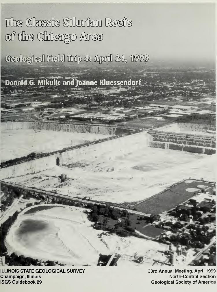
Cover photo Aerial view of the Material Service Corp. at Thornton Illinois
Dedication
This guidebook is dedicated to the memory of Heinz A. Lowenstam and Robert R.
Shrock, both of whom made outstanding contributions to the study of ancient reefs,
and especially the Silurian reefs of the Great Lakes region. Their work, which inte-
grated sedimentology, paleoecology and paleontology, was comprehensive and in-
novative, and has stood the test of time. Although their reef studies were conducted
many years ago, Heinz and Bob were still keenly interested in hearing what new in-
sight the latest exposures revealed or what new controversy they sparked. Both
men were true friends who encouraged and inspired us, and we miss them greatly.
CONTENTS
INTRODUCTION 1
General Geology 1
Chicago Stone Industry 2
History of Geologic Research 4
Paleontology 4
Stratigraphy and Reef Structure 5
Reef Paleoecology 5
Reef Localities 6
Bridgeport 6
Location 6
Geology and Research History 6
Economic History 8
Stony Island 9
Location 9
Geology 9
Economic History 13
Thornton 1
3
Location 13
Economic History 13
Geology and Research History 16
Interstate Roadcut and Trolley (Interurban) Quarry 17
Material Service Quarry 17
South Pit 18
Middle Pit-Main Level 22Northwest Pit-Upper Reef Core 30Middle Pit-Lower Level 31
Northwest Pit-Lower Reef Core 33Depositional Model 35
Acknowledgments 39
REFERENCES 39
FIGURES
1 Silurian and Ordovician post-Ancell Group strata of northeastern Illinois 1
2 Map of Chicago Lake Plain in central and southern Cook County, Illinois, showing
location of quarries, Silurian reefs and other locations 3
3 Map of Bridgeport (Stearns) quarry and vicinity 6
4 Eastern half of the 260 foot-high (78 m) north wall at the Bridgeport quarry, as it
appeared in 1 985 7
5 Section of Ordovician and Silurian rocks one and one-half blocks south of the
Bridgeport quarry 8
6 East wall of Stearns Lime and Stone Company quarry 9
7 Reef flank strata dipping 42° northwest at the water-filled West quarry,
Stony Island . 10
8 Map of Stony Island showing topography and location of the now-covered West,
South and East quarries 1
1
9 Map of Thornton quarry area showing approximate edge of the reef and
individual quarry pits. 14
10 Topographic map of the reef-controlled hill at Thornton, showing the outlines of
quarries 15
1
1
South wall of Brownell Improvement Company quarry showing hoist to steel
lime kilns in 1907 16
12 Steeply dipping distal flank strata in the east half of the north wall of the Trolley
(Interurban) quarry 18
1
3
Truncated domed beds overlying a small "reef" in the South Pit at Thornton quarry 1
9
14 Section of Racine Dolomite interreef strata near center of south wall, South Pit,
Thornton quarry 19
15 Megaclast of proximal reef flank rock overlain by nodular argillaceous interreef
strata near southwest corner of west wall, South Pit, Thornton quarry 21
16 Photo and diagram of Bretz's reef in the west wall of the South Pit,
Thornton quarry 23
17 Bretz's block diagram of Thornton Reef 24
1
8
Lowenstam's diagram showing succession of "Niagaran" reef faunas 25
19 Ingels' biosome distribution map of the Thornton Reef 26
20 Ingels' paleoecologic map showing a restoration of Thornton Reef 300 feet
above its base 27
21 Ingels' form line map showing configuration of Thornton Reef based on strike
and dip data. 28
22 Base of slab of a localized accumulation of the trilobite Bumastus (Cybantyx)
insignis at Middle Pit, Thornton quarry 29
23 Dip reversal at south edge of upper reef core located below old ramp just west
of the main tunnel, main level, Northwest Pit, Thornton quarry 31
24 Block containing abundant, densely packed, disarticulated valves of the
pentameriid brachiopod Kirkidium in the southwest corner of the Northwest Pit,
Thornton quarry 32
25 Map showing position of core ridge in the lower level of the Northwest Pit,
Thornton quarry 34
26 Photo of cross-section through the lower core ridge in the south wall, lower level,
Northwest Pit, Thornton quarry, as it appeared in 1987 35
27 Diagram of the south wall, lower level, Northwestern Pit, Thornton quary 36
28 Photo (1988) of the south wall, lower level, Northwest Pit, Thornton quarry 37
INTRODUCTION
Silurian reefs of the Chicago area have maintained both economic and scientific importance for morethan 150 years. The high-purity dolomite from these reefs was a major source of lime throughout
the nineteenth century. Today it is quarried extensively for crushed stone and forms the foundation
of a $100 million-a-year stone and lime industry in the Chicago area. Scientifically, Chicago reefs
are important models not only for Silurian reefs, but for Paleozoic reefs in general. This field trip
guide, which is a revision of the guidebook by Mikulic and Kluessendorf (1985), features the three
localities (Bridgeport, Stony Island, Thornton) that figured most prominently in the history of thesereef studies.
General Geology
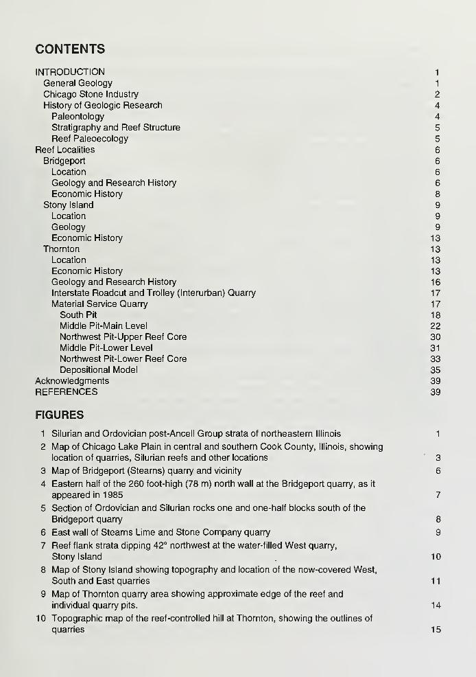
The Silurian geology of the Chicago region is sum-marized in Willman (1973), Mikulic, era/. (1985),
and Mikulic (1990). In general, all Paleozoic rocks
in northeastern Illinois dip eastward toward the
Michigan Basin, and the thickest section of Silurian
rocks lies along the Lake Michigan shore in CookCounty. The lowermost Silurian unit, the Wilhelmi
Formation, varies considerably in thickness as it fills
depressions and thins over high areas on the eroded
Upper Ordovician Maquoketa surface (Fig. 1). TheWilhelmi is highly argillaceous, comprising, in part,
reworked Maquoketa shale. As the Maquoketa sur-
face was gradually covered and the supply of elas-
tics diminished, purer carbonate sediments weredeposited during deposition of the overlying Elwoodand Kankakee Dolomites. These units also thin andthicken in the same manner as the Wilhelmi, although
to a lesser extent.
The disconformable boundary between the
Kankakee and the overlying Joliet Dolomite is the
most prominent stratigraphic marker within the Silu-
rian rocks of northeastern Illinois and signifies a type
2 sequence boundary, the most pronounced within
the Silurian of the Midwest (Kluessendorf and Miku-
lic, 1992, in press). The Joliet Dolomite is divided
into three members: Brandon Bridge, Markgraf andRomeo. Throughout most of northeastern Illinois
the Sugar Run Dolomite succeeds the Joliet, but it is
indistinguishable at many reef localities.
The Racine Dolomite, the uppermost Silurian unit in
the Chicago area, constitutes more than half the
thickness of the Silurian section in eastern CookCounty (Fig. 1). It is considered late Wenlockian-
Ludlovian in age (Berry and Boucot, 1970), andcomprises both reef and interreef facies. The reef
facies consists of high-purity dolomite, whereas the
lithology of the interreef facies varies widely from
Figure 1 Silurian and Ordovician post-Ancell Group strata
of northeastern Illinois, (after Mikulic, et al., 1985)
very pure to highly argillaceous dolomite, with or without chert. Although the interreef facies domi-nates the Racine volumetrically in the Chicago area, it is poorly exposed because the reef facies is
quarried preferentially. However, interreef strata are exposed at Thornton, McCook, Lemont, andalong the Calumet-Sag Channel near Blue Island where the famous Lecthaylus soft-bodied biota
occurs (Lowenstam, 1948).
Racine reefs throughout most of Cook County occur as individual structures or in small groups sur-
rounded by interreef strata. Reefs range in size from less than 10 feet (3 m) to more than 1.5 miles
(2.4 km) in diameter, and from three feet (1 m) to at least 300 feet (92 m) in thickness. Original
thickness of the larger reefs is equivocal because they have been planed off by post-Silurian erosion
and Quaternary glaciation. Some reefs, especially many of the largest such as Thornton and StonyIsland, started to develop during deposition of the basal Racine or older strata; other reefs (e.g.,
McCook, Lyons) originated during later Racine deposition. Because the reefs are erosion resistant,
they occur as hills at the bedrock surface and some formed islands or shoals in Quaternary lakes.
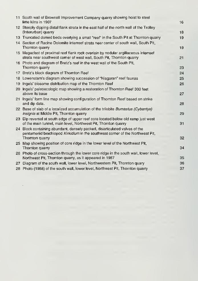
During the Silurian, these reefs were located on a shallow carbonate platform between the proto-
Michigan and the proto-lllinois basins. A carbonate bank that existed at the edge of the proto-
Michigan Basin extends into east-central Cook County, indicated by a thick section of massive- to
thick-bedded pure Racine Dolomite exposed at Bridgeport, the Addison Street roadcut, and formerly
at the Chicago Union Lime Works and Artesian quarries (Fig. 2). Dipping flank strata and the di-
verse biota characteristic of other Chicago reefs are present only in the upper 20-30 feet (6-9 m) of
the Racine at Bridgeport, and were reported only from that interval at the Chicago Union LimeWorks quarry (Bannister, 1868; Bretz, 1939). With the exception of these upper strata, the Racineat these localities is characterized by pelmatozoan debris, with robust stem sections of the crinoid
Crotalocrinus are especially conspicuous at the Addison Street roadcut.
Previously, Devonian rocks in the Chicago area were known only from the Des Plaines Disturbance
and fissure fills (Kluessendorf, etal., 1988). Recently, however, they have been found in the sub-
surface of southeastern Cook County, where as much as 30 ft (9 m) of Middle Devonian hypersaline
carbonates succeed the Racine Dolomite unconformably (Mikulic, 1990). These strata lie at a lower
elevation than nearby Silurian reef-controlled bedrock hills, indicating that the reefs remained topo-
graphic highs following pre-Middle Devonian erosion.
Chicago Stone Industry
Silurian rocks, and Racine reefs in particular, have been an important source of essential construc-
tion materials in the Chicago area for more than 150 years (Mikulic, 1989). The production of lime
and other stone products derived from these reefs was one of the first industries in Chicago, with
some quarries opening as early as the 1830s. The early history of these quarries is poorly docu-
mented, but most were probably small operations run on an intermittent basis. Demand for stone
increased as the city grew and, after 1850, Stearns Lime and Stone Company, the Chicago Union
Lime Works, and other firms operated larger quarries on a more regular basis. Following the open-
ing of the Illinois and Michigan Canal in 1848 and subsequent establishment of the Lemont-Joliet
building stone industry, the already limited production of building stone in Chicago diminished further
still (Mikulic, 1989). Asphalt-stained reef rock from the Artesian quarries, which was used in a few
landmark buildings, such as the Chicago Coliseum (Libby Prison Museum) and the Second Presby-
terian Church, was the only Chicago building stone quarried after this date. Lime was the chief
product of most Chicago quarries throughout the latter half of the nineteenth century, but macadam-ized street-paving, which was increasing in popularity, generated an increased demand for crushed
stone. This great demand for paving materials gave rise to some of the largest quarrying compa-nies, including the Dolese and Shepard Company (now part of Vulcan Materials) which began busi-
ness as a paving contractor in 1868 and would expand to operate as many as eight quarries during
the later 1800s.
Figure 2 Map of the Chicago Lake Plain in
central and southern Cook County, Illinois,
showing location of quarries, Silurian reefs
and other locations mentioned in the text.
Stippling marks morainal deposits bordering
the lake plain on the west and north.
1
.
Bridgeport reef and quarry (see text)
2. Stony Island reef and quarries (see text)
3. Thornton reef and quarries (see text)
4. Chicago Heights reef and quarries; two
small nineteenth century stone pits were lo-
cated near the intersection of Cottage Grove
Avenue and U. S. Highway 30 at East Chi-
cago Heights (now Ford Heights).
5. Torrence Avenue reef in subsurface
(see Stony Island description for details)
6. Cheltenham reef and quarries; an out-
crop was present at the site of the South
District Filtration Plant (formerly Rocky
Ledge Park) (Bretz, 1939) and small late
nineteenth century quarries operated by
Dolese and Shepard Company were located
northwest of the intersection of East 75th
Street and South Exchange Avenue and
north of the intersection of East 82nd Street
and South Houston Avenue.
7. Calumet Sag Channel spoilbanks west
of Blue Island, containing Lecthaylus biota
in Racine Dolomite interreef strata
8. McCook quarry, operated by Vulcan Ma-
terials (see Mikulic, era/., 1985, for details)
9. Federal quarry at McCook, operated by
Material Service Corporation (see Mikulic, et
al., 1985, for details)
10. Riverside (Lyons) quarry, operated by
Material Service Corporation (see Mikulic, et
al., 1 985, for details)
11. Cermak Park reef and small nineteenth
century quarry (see Mikulic, et al., 1985, for
details)
12. Hawthorne (Cicero) reef and quarry,
just east of the intersection of West 32nd
Street and Cicero Avenue (State Highway 50) in Cicero. Large nineteenth century quarry operated by Dolese
and Shepard Company, closed in 1915, and filled with garbage.
13. City of Chicago House of Corrections (Bridewell) quarry, east of West 27th Street and South Sacramento
Avenue; quarry operated by convict labor from the 1904 until the early 1940s, when it was abandoned and
filled.
14. Chicago Union Lime Works reef and quarries; quarries at present site of Harrison Park, southeast of South
Damen and West 18th Street were operated from the mid- 1800s until 1929, when they were abandoned and
filled with garbage.
15. Artesian reef and quarries; two large and several small quarries in the vicinity of the intersection of WestGrand Avenue and North Western Avenue and south through Smith Field Park were operated from the early
1800s by Artesian Lime and Stone Company, and J. Rice and Son, among others, until the last was filled with
garbage in the 1930s.
16. Addison Street- Interstate 94 roadcut
17. Hillside quarry; large quarry operated from 1800s to the late 1970s; now a landfill site
In the early 1900s, urban expansion and a drop in the demand for lime brought about the demise of
most Chicago quarries. By then, many sites were surrounded by residential or industrial neighborsand, having reached their property boundaries, operators were forced to quarry deeper non-reef re-
serves. For example, the Chicago Union Lime Works quarry, was mined through the entire Silurian
section to a depth of 380 feet (117 m) before being abandoned in 1929. The value of these mined-out quarries did not decline immediately, however, as most were converted into much-needed gar-
bage dumps for the ever-growing city.
While local supply was dwindling, the need for crushed stone, particularly for Racine reef rock, in
tum-of-the-century Chicago, was rising dramatically with the increased use of two important newconstruction materials, concrete and asphalt. Because crushed stone could then be transported
economically into the city by rail, rural quarries surrounded by undeveloped land, such as Thorntonand McCook, became prime stone-producing sites. Several Chicago quarrying companies openednew pits in these outlying regions to replace their exhausted city sites. Most, however, were eventu-
ally incorporated into larger corporations such as the Consumer Company (the forerunner to VulcanMaterials) and Material Service Corporation founded by the Crown family in 1919.
Unfortunately, urban expansion now threatens even these outlying quarries, jeopardizing the future
of the entire Chicago area stone industry (Mikulic and Goodwin, 1986). Although stone reserves are
adequate to meet Chicago's immediate needs, additional sources of crushed stone must be found
as potential new quarry sites near the city are nonexistent. Underground mining of Ordovician car-
bonate rocks at existing quarries, as had been done for a time at the Elmhurst-Chicago Stone Com-pany's quarry in Elmhurst, may provide a solution to this problem (Mikulic, 1990).
History of Geologic Research
Research on the geology and paleontology of the Silurian rocks in northeastern Illinois has beenrather sporadic. Following a brief burst of activity in the 1860s, research lagged far behind that of
surrounding states until the 1920s. Despite this slow start, however, the Racine Dolomite reefs of
the Chicago region came to figure prominently in studies of midwestern Silurian geology and Paleo-
zoic reefs.
Paleontology The abundance and diversity of fossils in these reefs initially drew the attention of
both amateur and professional geologists to the Silurian rocks of the area in the mid-1 800s. Theage of these rocks and their correlation with the North American reference section described in NewYork were soon determined (Worthen, 1862). Formal description of local fossils got underway in the
1860s at a time when few other midwestern fossils had been described, and the race to name newfossils from this virgin territory pitted the eminent paleontologist James Hall of New York against two
"local boys," Oliver Marcy and Alexander Winchell, in a dispute over taxonomic priority (Hall, 1865;
Winchell and Marcy, 1865).
Interest in Chicago fossils remained high throughout the late nineteenth century as a result of the
large collections assembled by wealthy businessmen, or "gentlemen naturalists," with the money to
buy fossils and the leisure time to collect specimens. The small, hand-operated quarries of those
days were ideal fossil collecting sites, and the low-paid quarry workers were quickly transformed into
enthusiastic "paleontologists" when they realized the lucrative market for fossils. Thomas Greene, a
Milwaukee druggist, assembled the largest collection of Chicago Silurian reef fossils (Mikulic, 1983),
which is now housed in the Greene Memorial Museum on the University of Wisconsin-Milwaukee
campus. In 1993, the museum and collection together were named a National Historic Landmark in
the History of Science because they are the only remaining intact example of the once-commonplaceamateur naturalist collections that played an important role in nineteenth-century American science.
For ten years, Greene bought Chicago fossils from one A. G. Warner, who apparently earned all or
part of his income by purchasing fossils from quarry men and selling them to wealthy collectors.
Among other prominent collectors of the day were William Egan, whose collection is now housed at
the Chicago Academy of Science (Ball and Greacen, 1946), Sir William Van Home, W. R. Head,
G. H. Harris (collections in the Field Museum), and H. H. Hindshaw. Specimens from Chicago reefs
also are located in many other museums in North America and Europe. Among the many renownedpaleontologists who studied the prolific Chicago fossils were James Hall, S. A. Miller, J. M. Clarke,
Stuart Weller, A. F. Foerste, F. A. Meek, A. H. Worthen, P. E. Raymond, Frank Springer, and Char-
les Wachsmuth. In spite of this early attention, however, the entire reef biota has not yet been de-
scribed formally, and few taxonomic descriptions have been published since the 1930s. Most fossil
groups are in need of revision but only the trilobites and cephalopods are presently under study.
Stratigraphy and Reef Structure While the fossils received intensive study during the late 1800s,
little advancement in knowledge about the general geology of the Silurian rocks was made until the
1920s. As the quarries were deepened, a better understanding of regional Silurian stratigraphy
emerged and, in 1926, Savage was able to subdivide the rocks into the basic units still recognized
today. His classification was refined by Willman in 1973.
The interpretation of Chicago area reefs has changed dramatically through time. Although these
highly fossiliferous rocks had been quarried and collected extensively, they were not recognized asreefs until more than 50 years after Hall (1862) first identified reefs in the Silurian rocks of Wiscon-sin. Apparently a flank-to-core transition was nowhere exposed in the Chicago area, and the steep
dips of the flank strata were attributed to tectonism. Although T. C. Chamberlin had inspired re-
newed interest in the Quaternary and Silurian geology of the Chicago region around the turn-of-the-
century, the reefs were studied mainly in their role as islands and shoals in Quaternary lakes. It wasnot until the 1920s that the true reefal nature of these structures was finally recognized.
Reef Paleoecology Perhaps the most widely known of Chicago Silurian investigations are the
paleoecologic studies of the Racine Dolomite reef and interreef strata by Heinz Lowenstam (1942,
1948, 1950, 1957). Because of this work, Lowenstam (1942, 1948) was able to explain the seem-ingly anomalous presence of supposed Silurian southern faunal elements in a northern faunal prov-
ince of the Midwest, concluding that it reflected ecologic, not geographic, distribution. He discovered
that taxa of the presumed northern province were actually found only in the well-studied reefs,
whereas the supposed southern fauna was confined to the poorly exposed interreef strata that sur-
round, and are penecontemporaneous with, the reefs.
Lowenstam's studies of Thornton and other reef exposures coincided with his discovery of subsur-
face Silurian reefs in the Illinois Basin. Integrating both surface and subsurface data, Lowenstam(1949, 1950, 1957) formulated a model of fossil reef development and paleoecology. In so doing,
he was able to relate a variety of separate, superficially unrelated, reef exposures within his three-
stage succession of reef development. Lowenstam's paleoecologic work encouraged the study of
Silurian and other fossil reefs, and Thornton reef remained the focus for many of these studies
(Ingels, 1963; Pray, 1976; McGovney, 1978). Although many Chicago Silurian exposures have dis-
appeared over the years, expansion of the Thornton quarry and the availability of new subsurface
data secure the importance of Chicago reefs in future research.
REEF LOCALITIES
Bridgeport
Location NE1/4, SE1/4, Section 29, T. 39 N., R. 14 E., Englewood 7.5-minute quadrangle,
Chicago, Cook County, Illinois. The quarry is bounded by South Halsted Street on the east, West29th Street on the south, South Poplar Avenue on the west, and West 27th Street on the north (Fig. 3).
Bedrock elevation is 590 feet (181 m).
Geology and Research History The Bridgeport quarry was excavated to a depth of about 350feet (107 m), exposing nearly the entire Silurian section. The west, south and east walls have since
been covered with landfill, and the lower half of the quarry has been buried (Fig. 4). In the early
1970s, the Metropolitan Water Reclamation District of Greater Chicago (MWRDGC) drilled two .
cores in the area as part of geotechnical studies for the Tunnel and Reservoir Plan (TARP). CoreDH74-53 was located about one and one-half blocks south of the quarry and DH74-26 about three
blocks north (Figs. 3, 5). Both cores show the same section that was exposed in the quarry; how-ever, the bedrock surface at the cores sites is at a lower elevation than in the quarry, and the Wil-
helmi Formation appears to thicken from north
to south.
At present, the top of Brandon Bridge Memberof the Joliet Dolomite is the lowest unit still
visible in the Bridgeport quarry. Before filling
began, a normal sequence of Wilhelmi, El-
wood, Kankakee, and Brandon Bridge was ex-
posed, including a prominent bentonite near
the middle of the Kankakee. The BrandonBridge is overlain by 19 feet (6 m) of typical
light gray, well-bedded Markgraf Member of
the Joliet Dolomite. Overlying the Markgraf
and composing the rest of the quarry wall is
about 220 feet (68 m) of porous, crystalline,
rough-textured, massive- to thick-bedded,
reef-like dolomite. Although the Romeo Mem-ber of the Joliet and the Sugar Run Dolomite
may be present at the base of this interval,
they cannot be distinguished lithologically from
overlying Racine Dolomite and are therefore
included within the Racine here.
At Bridgeport, no typical Racine Dolomite in-
terreef strata (well-bedded, argillaceous, lo-
cally cherty) occur. Moreover, distinct reef
bodies and associated steeply dipping reef
flank strata, prominent at other locations, are
insignificant here. Most of the Racine at
Bridgeport consists of massive, fossiliferous,
Figure 3 Map of Bridgeport (Stearns) quarry and
vicinity. Stippling shows approximate area of
quarry filled to ground level as of 1985. Landfill
slopes down from this area, filling the bottom 100
feet (31 m) of the entire quarry. Filled circles mark
location of MWRDGC cores. Note change in
quarry-related street names (e.g., Stearns to 29th
Street, Lime to Green Street, Quarry to Senour St.).
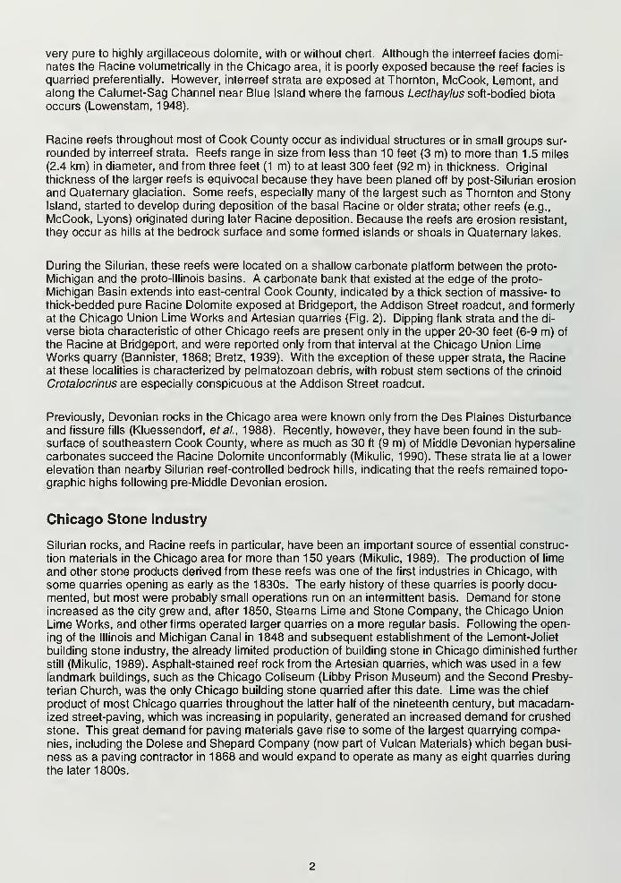
Figure 4 Eastern half of the
260 foot-high (78 m) north wall
at the Bridgeport quarry, as it
appeared in 1985. At base of
the visible section is 22 feet (7
m) of the Brandon Bridge Mem-ber of the Joliet Dolomite, the
top of which is marked by a thin
dark bed. Nineteen feet (6 m) of
lighter colored, well-bedded
Markgraf Member succeeds
this. The remainder of the sec-
tion is reef-like rock, predomi-
nantly Racine Dolomite. Slightly
dipping flank strata are visible in
about the upper 30 feet (9 m) of
the wall. Sears tower (in center
background) is located about
2.5 miles (4 km) to the north in
downtown Chicago.
reef-like dolomite with only a few obscure horizontal bedding planes or weakly defined beds that
may be traced around the quarry. Minor flank development can be seen only in the uppermost 30feet (9 m) or so of the north wall and the center of the east wall (Fig. 4). It is likely that the Racine
Dolomite exposed at Bridgeport represents part of a carbonate bank that was situated along the
western edge of the proto-Michigan basin, and only minor local reef growth occurred.
Throughout much of the Racine at Bridgeport, the biota is of limited diversity, comprising primarily
pelmatozoan skeletal elements within massive packstones and grainstones. In contrast, the upper
30 feet (9 m) of the Racine here contains a highly prolific and diverse biota. The high diversity pel-
matozoan fauna at Bridgeport differs from the limited pelmatozoan fauna at Thornton and Stony
Island reefs. In addition, some of the trilobite species, including Bumastus transversalis, B. (Cybantyx)
harrisi, and B. (Litotyx) armata, may be endemic to the reef at Bridgeport. On the other hand,
Bumastus (Cybantyx) insignis and B. (Cybantyx) chicagoensis, two related trilobites that are commonin all other northeastern Illinois reefs, are absent or rare at Bridgeport.
With the exception of the Hawthorne quarry (Fig. 2), few other Chicago area sites have yielded as
many fossils as Bridgeport, and the great abundance and diversity of fossils attracted many amateurand professional geologists here during the late 1800s. The three largest collections of Bridgeport
fossils are the Greene collection (Greene Memorial Museum, University of Wisconsin-Milwaukee),
the Egan collection (Chicago Academy of Science), andthe Head collection (Field Museum). Worthen (1862)
was the first to describe the geology and paleontology of
Bridgeport, correlating the strata here with outcrops at
Port Byron in western Illinois and assigning them to the
Niagara Group of New York. Winchell and Marcy (1865)
recorded 82 fossil taxa from this quarry, mostly collected
by Marcy, a professor at Northwestern University. Taxo-nomic fossil descriptions continued to be published until
the 1930s, but very little was written about the geology at
Bridgeport. Bannister (1868) observed that the rock was"massive concretionary limestone showing little appear-
ance of stratification," and noted that it was very fossilif-
erous, and Bretz (1 939) mentioned the reef structure
near the top of the east wall.
Economic History The community of Bridgeport is
one of Chicago's oldest neighborhoods, settled in the
1830s by Irish laborers who came to work on the con-
struction of the Illinois and Michigan Canal (Holt andPacyga, 1979). This site was name "Bridgeport" be-
cause cargo had to be unloaded from vessels so they
could pass beneath a low bridge that formerly spannedthe Chicago River here. As the home of the late Richard
J. Daley and several other Chicago mayors (including
the present one until very recently), Bridgeport has hadconsiderable impact on Chicago politics.
The quarry at Bridgeport was the first opened in the Chi-
cago area, and it continued to operate long after all other
city quarries had closed. Stone production at this site
was one of the city's earliest and most prominent pio-
neer industries. Initial construction of the piers at the
mouth of the Chicago River required a large amount of
stone which, according to early plans, was to be shipped
from Wisconsin's Door Peninsula. Discovery of stone at
Bridgeport adjacent to the South Branch of the ChicagoRiver, however, provided a cheaper local source of this
material. In 1833, a contract was awarded to Bayer andSpence to quarry stone here and ship it by barge four
miles down-river to the site of pier construction. Thegovernment provided the barges and eventually built a
wooden tramway from the quarry to the river. Thequarry site was on land that was to be sold to generate
funds for construction of the Illinois and Michigan Canal,
but anyone could quarry stone there for pier construction
as far as the federal government was concerned. A fewyears later, however, the State of Illinois protested the
exploitation of any natural resource on its canal land
without receiving compensation, and the free use of
stone ended.
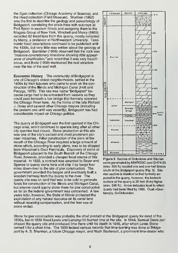
Figure 5 Section of Ordovician and Silurian
rocks penetrated by MWRDGC core DH74-53
(elev. 594 ft.) located one and one-half blocks
south of the Bridgeport quarry (Fig. 3). Silu-
rian section is identical to that formerly ex-
posed in the quarry, however, the bedrock
surface at the quarry is 20 feet (6 m) higher
(elev. 590 ft.). Arrow indicates level to which
quarry had been filled by 1985. Quat.=Qua-
ternary, 0=Ordovician.
Stone for pier construction was probably the chief product at the Bridgeport quarry for most of the
1830s, but in 1839 Reed Lewis and Lansing Hill burned lime at the site. In 1844, Samuel Davis pur-
chased the quarry site and produced lime there until his death in 1848, after which Lewis Stoneowned it for a short time. The 1850 federal census records that lime-burning was done at Bridge-
port by A. S. Sherman, a future Chicago mayor, and Noah Sturtevant, a prominent lime-dealer who

also operated the Hawthorne quarry and lime works in the 1850s-60s. The Bridgeport quarry andlime kiln and the Sherman building stone quarry at Lemont were combined into the Illinois Stone andLime Company, which was formed in December, 1853, with W. S. Gurnee as president (another fu-
ture Chicago mayor), Marcus Cicero Stearns as secretary and treasurer, and Oren and Alson Sher-
man as superintendents (Andreas, 1886). In 1854, the company's assets were divided; the Lemontquarry became the Illinois Stone Company, whereas Stearns became the sole proprietor of the
Bridgeport quarry, naming it the Stearns Lime and Stone Company (Fig. 6).
In 1936, the Crown family purchased the company, and merged it with the Material Service Corpora-
tion in 1947. By the 1960s, the quarry was surrounded by residential neighborhoods and had beenexcavated as deep as possible. Among the uses proposed for the mined-out quarry were several
creative ones, including an atomic bomb shelter (Chicago American, Nov. 10, 1961), cliff-hanging
apartments a la Mesa Verde(Esquire, June, 1968), a sports complex with ample underground park-
ing, and a sewerage system overflow reservoir for the MWRDGC. The quarry was finally sold to the
City of Chicago for $9 million on December31, 1970, for use as a landfill site, the ultimate
fate of most other area quarries.
Stony Island
Location S1/2, Section 1.T.37N., R. 14 E.,
andW1/2, Section 6, T 37 N., R. 15 E., LakeCalumet 7.5-minute quadrangle, Chicago,
Cook County, Illinois. Located north of LakeCalumet in southeastern Chicago, Stony Is-
land is bounded by South Stony Island Ave-
nue on the west, by East 91st Street on the
north, by South Kingston Avenue on the east,
and by East 94th Street on the south. Maxi-
mum bedrock elevation is 605 feet (182 m).
Geology Stony Island was a prominent,
pre-settlement, physiographic landmark. The"island" portion of its name undoubtedly refers
to the fact that this heavily wooded, large
reef-controlled bedrock hill once stood con-
spicuously above the surrounding low swampyland. It actually was an island in glacial LakeNipissing, however. "Stony" alludes to either
the extensive bedrock exposures or the promi-
nent glacial erratics that were once present.
The surrounding neighborhood is now knownas Calumet Heights in reference to the prox-
imity of this hill to the Lake Calumet area.
More recently, the hill has also been called
"Pill Hill" because South Chicago CommunityHospital is situated on its eastern edge.
At one time, Stony Island was one of the mostimportant and well known geologic sites in
Cook County. Displaying a unique combina-tion of reef, glacial and lake erosion features,
it was used for both research and education
by the University of Chicago and many other
institutions in the early 1900s. By that time,
the eastern half of the hill had been largely
built over and all the trees had long been cut
Figure 6 East wall of Stearns Lime and Stone Companyquarry. Rock was loaded by hand into quarry cars, which
were then pushed along tracks to the base of the incline
in the lower left corner of photo. Cars were then pulled
by cable up the incline to the kilns. (Photo taken in 1907
by E. F. Burchard, No. 436; Courtesy of the U. S. Geo-
logical Survey)
down, but unique biologic features remained and small abandoned quarries and natural outcrops
provided excellent bedrock exposures. In 1917, Zonia Baber of the University of Chicago School of
Education wrote a guide to the natural features of Stony Island. She proposed that at least the
western portion of the hill be preserved for both its geological and botanical features. Later, a bill to
preserve the West quarry (Fig. 7) and the surrounding 15 acres as a state park failed in the Illinois
State Legislature. Since then, most of the exposures have been destroyed by urban expansion, but
a few important geologic features of Stony Island can still be seen.
Although now obscured by residential development, Stony Island still exhibits topographic relief, ris-
ing about 25 feet (8 m) above the surrounding Chicago Lake Plain (Fig. 8). The hill has an elongate
outline with an east-west length of 1 .2 miles (1 .9 km) and a north-south width of 0.4 mile (0.6 km).
Prior to urbanization, the top of the hill was partly covered by thin glacial and lake sediments, andbedrock was exposed nearly continuously around its periphery (Alden 1902; Bretz, 1943). Theseoutcrops were supplemented by three small nineteenth-century quarries (Fig. 8).
The unique geological features of Stony Island received little attention until the 1890s. At that time,
T C. Chamberlin, then head of the University of Chicago Geology Department and the U. S. Geo-logical Survey Glacial Division, supervised several studies on the Quaternary geology of the Chi-
cago area, including Stony Island (Leverett, 1897; Salisbury and Alden, 1899; Alden, 1902). Owingto its superior erosion resistance, Stony Island almost certainly was a bedrock hill during the final
glacial advance through the area. At this time, the top of the hill was planed, with striations on the
bedrock surface indicating that the ice flowed around and over the hill from the northeast. Examplesof ice flow around small-scale irregularities on the bedrock surface were once visible in the South
quarry where a 6 foot-high (2 m) escarpment showed striations at its top, face and under a slight
overhang (Leverett, 1897; Alden, 1902). When glacial lake waters were atToleston level, Stony
Island formed a low island (Alden, 1902). Prior shoaling had removed most unconsolidated sedi-
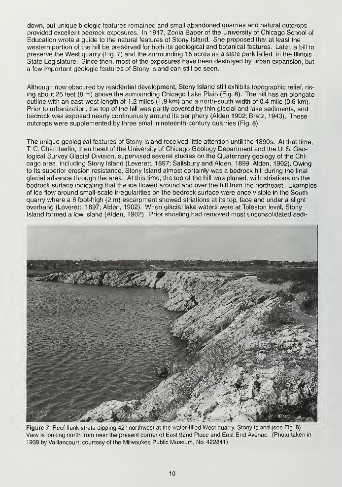
Figure 7 Reef flank strata dipping 42° northwest at the water-filled West quarry, Stony Island (see Fig. 8).
View is looking north from near the present corner of East 92nd Place and East End Avenue. (Photo taken in
1 939 by Vaillancourt; courtesy of the Milwaukee Public Museum, No. 422841
)
10
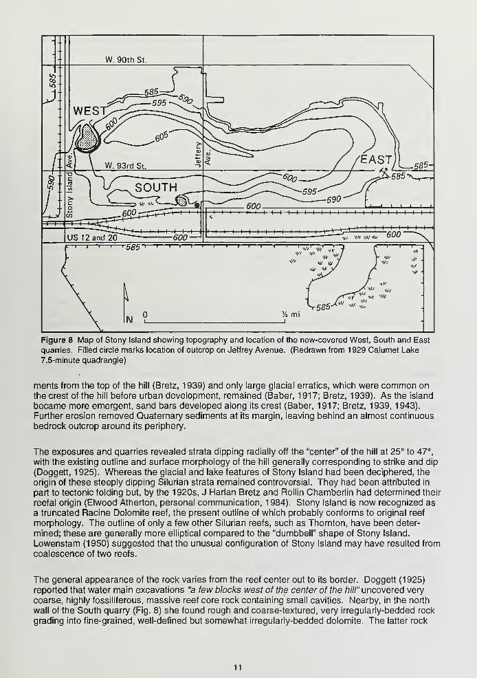
Figure 8 Map of Stony Island showing topography and location of the now-covered West, South and East
quarries. Filled circle marks location of outcrop on Jeffrey Avenue. (Redrawn from 1 929 Calumet Lake
7.5-minute quadrangle)
merits from the top of the hill (Bretz, 1939) and only large glacial erratics, which were common onthe crest of the hill before urban development, remained (Baber, 1917; Bretz, 1939). As the island
became more emergent, sand bars developed along its crest (Baber, 1917; Bretz, 1939, 1943).
Further erosion removed Quaternary sediments at its margin, leaving behind an almost continuous
bedrock outcrop around its periphery.
The exposures and quarries revealed strata dipping radially off the "center" of the hill at 25° to 47°,
with the existing outline and surface morphology of the hill generally corresponding to strike and dip
(Doggett, 1925). Whereas the glacial and lake features of Stony Island had been deciphered, the
origin of these steeply dipping Silurian strata remained controversial. They had been attributed in
part to tectonic folding but, by the 1920s, J Harlan Bretz and Rollin Chamberlin had determined their
reefal origin (Elwood Atherton, personal communication, 1984). Stony Island is now recognized as
a truncated Racine Dolomite reef, the present outline of which probably conforms to original reef
morphology. The outline of only a few other Silurian reefs, such as Thornton, have been deter-
mined; these are generally more elliptical compared to the "dumbbell" shape of Stony Island.
Lowenstam (1950) suggested that the unusual configuration of Stony Island may have resulted from
coalescence of two reefs.
The general appearance of the rock varies from the reef center out to its border. Doggett (1925)
reported that water main excavations "a few blocks west of the center of the hill" uncovered very
coarse, highly fossiliferous, massive reef core rock containing small cavities. Nearby, in the north
wall of the South quarry (Fig. 8) she found rough and coarse-textured, very irregularly-bedded rock
grading into fine-grained, well-defined but somewhat irregularly-bedded dolomite. The latter rock
11
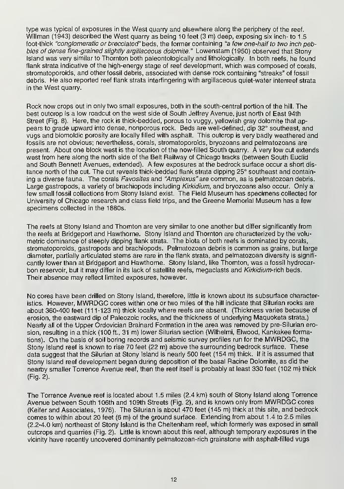
type was typical of exposures in the West quarry and elsewhere along the periphery of the reef.
Willman (1943) described the West quarry as being 10 feet (3 m) deep, exposing six inch- to 1.5
foot-thick "conglomeratic or brecciated" beds, the former containing "a few one-half to two inch peb-bles of dense fine-grained slightly argillaceous dolomite." Lowenstam (1950) observed that StonyIsland was very similar to Thornton both paleontologically and lithologically. In both reefs, he foundflank strata indicative of the high-energy stage of reef development, which was composed of corals,
stromatoporoids, and other fossil debris, associated with dense rock containing "streaks" of fossil
debris. He also reported reef flank strata interfingering with argillaceous quiet-water interreef strata
in the West quarry.
Rock now crops out in only two small exposures, both in the south-central portion of the hill. Thebest outcrop is a low roadcut on the west side of South Jeffrey Avenue, just north of East 94th
Street (Fig. 8). Here, the rock is thick-bedded, porous to vuggy, yellowish gray dolomite that ap-
pears to grade upward into dense, nonporous rock. Beds are well-defined, dip 32° southeast, andvugs and biomoldic porosity are locally filled with asphalt. This outcrop is very badly weathered andfossils are not obvious; nevertheless, corals, stromatoporoids, bryozoans and pelmatozoans are
present. About one block west is the location of the now-filled South quarry. A very low cut extends
west from here along the north side of the Belt Railway of Chicago tracks (between South Euclid
and South Bennett Avenues, extended). A few exposures at the bedrock surface occur a short dis-
tance north of the cut. The cut reveals thick-bedded flank strata dipping 25° southeast and contain-
ing a diverse fauna. The corals Favosites and "Amplexus" are common, as is pelmatozoan debris.
Large gastropods, a variety of brachiopods including Kirkidium, and bryozoans also occur. Only a
few small fossil collections from Stony Island exist. The Field Museum has specimens collected for
University of Chicago research and class field trips, and the Greene Memorial Museum has a few
specimens collected in the 1880s.
The reefs at Stony Island and Thornton are very similar to one another but differ significantly from
the reefs at Bridgeport and Hawthorne. Stony Island and Thornton are characterized by the volu-
metric dominance of steeply dipping flank strata. The biota of both reefs is dominated by corals,
stromatoporoids, gastropods and brachiopods. Pelmatozoan debris is common as grains, but large
diameter, partially articulated stems are rare in the flank strata, and pelmatozoan diversity is signifi-
cantly lower than at Bridgeport and Hawthorne. Stony Island, like Thornton, was a fossil hydrocar-
bon reservoir, but it may differ in its lack of satellite reefs, megaclasts and Kirkidium-rich beds.
Their absence may reflect limited exposures, however.
No cores have been drilled on Stony Island, therefore, little is known about its subsurface character-
istics. However, MWRDGC cores within one or two miles of the hill indicate that Silurian rocks are
about 360-400 feet (1 1 1-123 m) thick locally where reefs are absent. (Thickness varies because of
erosion, the eastward dip of Paleozoic rocks, and the thickness of underlying Maquoketa strata.)
Nearly all of the Upper Ordovician Brainard Formation in the area was removed by pre-Silurian ero-
sion, resulting in a thick (100 ft., 31 m) lower Silurian section (Wilhelmi, Elwood, Kankakee forma-
tions). On the basis of soil boring records and seismic survey profiles run for the MWRDGC, the
Stony Island reef is known to rise 70 feet (22 m) above the surrounding bedrock surface. These
data suggest that the Silurian at Stony Island is nearly 500 feet (154 m) thick. If it is assumed that
Stony Island reef development began during deposition of the basal Racine Dolomite, as did the
nearby smaller Torrence Avenue reef, then the reef itself is probably at least 330 feet (102 m) thick
(Fig. 2).
The Torrence Avenue reef is located about 1.5 miles (2.4 km) south of Stony Island along Torrence
Avenue between South 106th and 109th Streets (Fig. 2), and is known only from MWRDGC cores
(Keifer and Associates, 1976). The Silurian is about 470 feet (145 m) thick at this site, and bedrock
comes to within about 20 feet (6 m) of the ground surface. Extending from about 1 .4 to 2.5 miles
(2.2-4.0 km) northeast of Stony Island is the Cheltenham reef, which formerly was exposed in small
outcrops and quarries (Fig. 2). Little is known about this reef, although temporary exposures in the
vicinity have recently uncovered dominantly pelmatozoan-rich grainstone with asphalt-filled vugs
12
and pores. A few fossils collected from this reef during the 1880s are preserved in the GreeneMuseum. Other reefs occur as shoals farther east in Lake Michigan (Bretz, 1939).
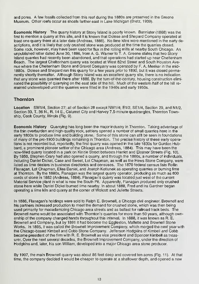
Economic History The quarry history at Stony Island is poorly known. Bannister (1868) was the
first to mention a quarry at this site, and it is known that Dolese and Shepard Company operated at
least one quarry there at a later date (Andreas, 1886). No lime kilns were mentioned in the early de-
scriptions, and it is likely that only crushed stone was produced at the time the quarries closed.
Some rock, however, may have been used for flux in the rolling mills at nearby South Chicago. Anunpublished letter dated June 30, 1886, from A. G. Warner to T. A. Greene states that two Stony
Island quarries had recently been abandoned, and that operations had started up near CheltenhamBeach. The largest Cheltenham quarry was located at West 82nd Street and South Houston Ave-
nue where the Cheltenham Stone and Gravel Company was operated by F. A. Meeker in the mid-
18803. Dolese and Shepard ran this quarry for a few years prior to 1890, but it was closed perma-nently shortly thereafter. Although Stony Island was an excellent quarry site, there is no indication
that any stone was quarried there after 1886. By the turn-of-the-century, housing construction elimi-
nated the possibility of quarrying on the east side of the hill. Much of the western half of the hill re-
mained undeveloped until the quarries were filled in the 1940s and early 1950s.
Thornton
Location SW1/4, Section 27; all of Section 28 except NW1/4; E1/2, SE1/4, Section 29, and N1/2,
Section 33, T. 36 N., R. 14 E., Calumet City and Harvey 7.5-minute quadrangles, Thornton Town-ship, Cook County, Illinois (Fig. 9).
Economic History Quarrying has long been the major industry in Thornton. Taking advantage of
the thin overburden and high-quality rock, settlers opened a number of small quarries here in the
early 1800s to produce lime and building stone. Some of this stone can still be seen in foundations
of many of the pre-1900 buildings remaining in Thornton. The precise history of these early opera-
tions is not recorded but, reportedly, the first quarry was opened in the late 1830s for Gurdon Hub-bard, a prominent pioneer settler of the Chicago area (Andreas, 1884). This may have been the
now-filled quarry located in a park on Kinzie Street between Harriet and Eleanor Streets (Fig. 10).
By 1850, Stephen Crary had also opened a quarry, and through the 1860s, a number of individuals,
including Daniel Dickel, Case and Sweet, Lot Chapman, as well as the Hews Stone Company, werelisted as lime dealers in business directories and censuses. The 1870 federal census lists Rollin
Flanagan, Lot Chapman, Elias Daniel, and Joseph Kotlunek as operating quarries or burning lime
at Thornton. By the 1880s, Flanagan was the largest quarry operator, producing as much as 800cords of stone in 1882 (Andreas, 1884). Flanagan's quarry was located just west of the current
Material Service plant in what is now the South Pit. Apparently, Flanagan produced only crushed
stone here while Daniel Dickel burned lime nearby. In about 1888, Fred and Ira Gardner beganoperating a lime kiln and quarry at the corner of Wolcott and Juliette Streets.
In 1886, Flanagan's holdings were sold to Ralph E. Brownell, a Chicago civil engineer. Brownell andhis partners increased production to meet the demand for crushed stone, which was then being
used primarily for macadamizing Chicago area streets and as ballast for railroad track beds. TheBrownell name would be associated with Thornton's quarries for more than 50 years, although own-ership of the company changed hands throughout this interval. In 1888, it was known as R. E.
Brownell and Company, but by 1891 it had become the Eggleston, Mallette and Brownell Stone
Works. In 1895, it was called the Brownell Improvement Company, which merged the next year with
the Chicago-based Kimbell and Cobb Stone Company. Jefferson Hodgkins of Kimbell and Cobbbecame president of the firm with R. E. Brownell as vice president and Spencer Kimbell as treas-
urer. Over the next several decades, the Brownell Improvement Company, under the direction of
Hodgkins and, later, his son William, developed into a major Chicago area stone producer.
By 1907, the main Brownell quarry was about 85 feet deep and covered ten acres (Fig. 11). At that
time, the company decided it would be cheaper to operate at a shallower depth, and opened a new
13
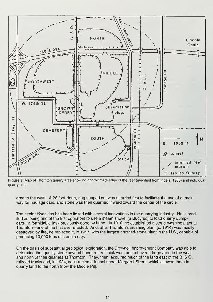
Lincoln
Oasis
H
1000 ft.
N
$ tunnel
inferred reef/ margin
J Trolley Quarry
Figure 9 Map of Thornton quarry area showing approximate edge of the reef (modified from Ingels, 1963) and individual
quarry pits.
area to the west. A 26 foot-deep, ring-shaped cut was quarried first to facilitate the use of a track-
way for haulage cars, and stone was then quarried inward toward the center of the circle.
The senior Hodgkins has been linked with several innovations in the quarrying industry. He is cred-
ited as being one of the first operators to use a steam shovel (a Bucyrus) to load quarry dump-cars—a formidable task previously done by hand. In 1910, he established a stone-washing plant at
Thornton—one of the first ever erected. And, after Thornton's crushing plant (c. 1914) was mostly
destroyed by fire, he replaced it, in 1917, with the largest crushed-stone plant in the U.S., capable of
producing 10,000 tons of stone a day.
On the basis of substantial geological exploration, the Brownell Improvement Company was able to
determine that quality stone several hundred feet thick was present over a large area to the west
and north of their quarries at Thornton. They, then, acquired much of the land east of the B. & O.
railroad tracks and, in 1924, constructed a tunnel under Margaret Street, which allowed them to
quarry land to the north (now the Middle Pit).
14
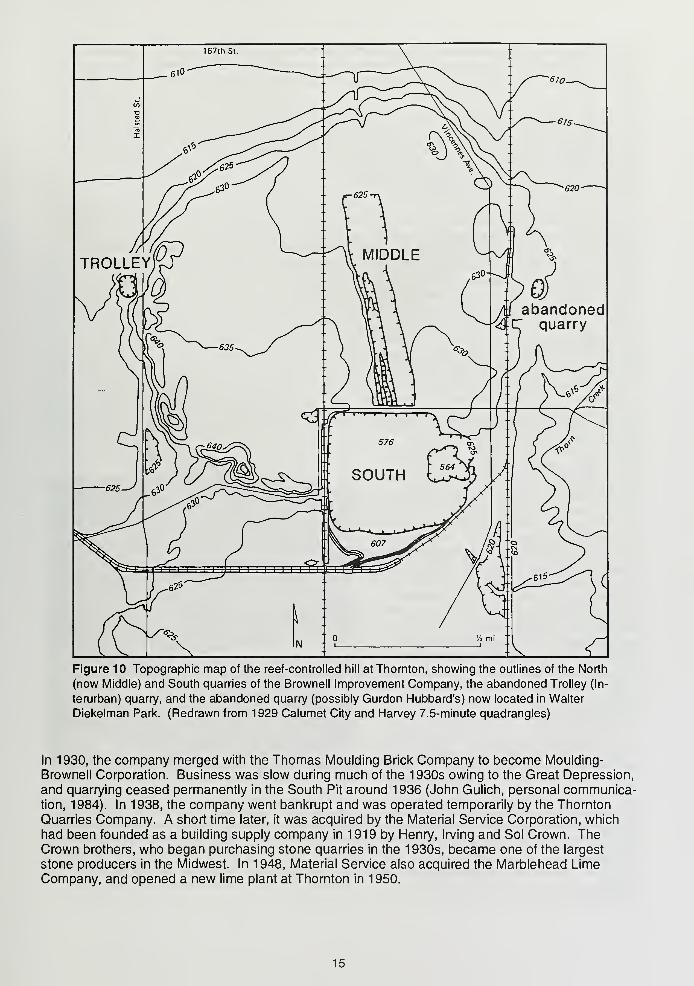
Figure 10 Topographic map of the reef-controlled hill at Thornton, showing the outlines of the North
(now Middle) and South quarries of the Brownell Improvement Company, the abandoned Trolley (In-
terurban) quarry, and the abandoned quarry (possibly Gurdon Hubbard's) now located in Walter
Diekelman Park. (Redrawn from 1929 Calumet City and Harvey 7.5-minute quadrangles)
In 1930, the company merged with the Thomas Moulding Brick Company to become Moulding-
Brownell Corporation. Business was slow during much of the 1930s owing to the Great Depression,
and quarrying ceased permanently in the South Pit around 1936 (John Gulich, personal communica-tion, 1984). In 1938, the company went bankrupt and was operated temporarily by the Thornton
Quarries Company. A short time later, it was acquired by the Material Service Corporation, which
had been founded as a building supply company in 1919 by Henry, Irving and Sol Crown. TheCrown brothers, who began purchasing stone quarries in the 1930s, became one of the largest
stone producers in the Midwest. In 1948, Material Service also acquired the Marblehead LimeCompany, and opened a new lime plant at Thornton in 1950.
15
The Crowns maintained the modern quarrying standards established by Hodgkins. In the early
1940s, the old Bucyrus steam shovels at Thornton were replaced by electric shovels, which wereused until the 1970s when front-end loaders took their place. During 1957-58, the entire Thorntonplant was rebuilt. At this time, the trackways, quarry cars and steam locomotives were replaced bytrucks and the long conveyor extending from the Middle Pit to the main plant. The Crowns also im-
plemented a program of expansion and, in the late 1960s, a tunnel was constructed beneath the
B. & O. railroad tracks in order to open the Northwest Pit. The Brown Derby Pit was first quarried in
1975, and the Cemetery Pit, which was quarried mainly to serve as a settling pond, operated from
1981 to 1984. For the last several decades, the Thornton quarry has remained one of the ten larg-
est commercial aggregate quarries in the country.
Geology and Research History Thornton Reef forms a low (25 ft., 8 m) hill with a maximum ele-
vation of 635 feet (195 m) above sea level (Alden, 1902; Bretz, 1943) (Fig. 9). For a time, the reef
was a shoal in glacial Lake Chicago, rimmed by beach ridges and flanked by sand dunes on its west
and south sides (Bretz, 1939). The extant reef, which is elliptical in outline along a northeast-
southwest axis, has a maximum length of 1 .5
miles (2.4 km). It is thickest (340 feet; 105 m)at its center, reflecting its convex-downwardbowl shape (McGovney, 1978). Although the
exposed portion of the reef lies entirely within
the Racine Dolomite, subsurface data indicate
that reef growth began earlier, possibly dur-
ing deposition of the Joliet Dolomite (Fig. 1).
The reef apparently had little effect on mostof the Silurian section beneath the Racine
Dolomite. The only exception is the SugarRun Dolomite as well as the Romeo andMarkgraf members of the Joliet Dolomite
which, although typical in character lateral to
the reef, become indistinct near its center
probably as a result of early reef develop-
ment. The underlying Brandon Bridge Mem-ber of the Joliet Dolomite is consistent in its
character and thickness (30 feet; 9 m), and is
not absent anywhere in the area as indicated
by McGovney (1978, 1988). The BrandonBridge overlies 110 feet (33 m) of a normal
succession of Kankakee, Elwood and Wil-
helmi formations. The underlying UpperOrdovician Maquoketa Group was deeply
eroded throughout most of southeastern
Cook County prior to Silurian deposition,
and is only about 150 feet (46 m) thick here
(Mikulic, 1990).
Thornton Reef has been important in Silurian
reef studies for more than 50 years. Classic
works by Bretz (1939), Lowenstam (1948,
1950, 1957), Willman, era/. (1950), Lowen-stam, etal. (1956), and Ingels (1963) werebased entirely or in part on Thornton reef,
and it continues to be the subject of study asnew exposures and subsurface data becomeavailable. This research mainly concerns the
depositional history of the reef, which hasbeen the focus of much controversy (Pray,
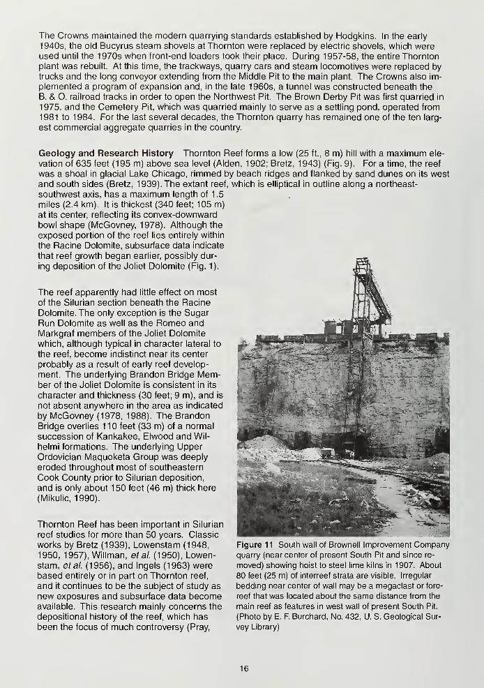
Figure 11 South wall of Brownell Improvement Companyquarry (near center of present South Pit and since re-
moved) showing hoist to steel lime kilns in 1907. About
80 feet (25 m) of interreef strata are visible. Irregular
bedding near center of wall may be a megaclast or fore-
reef that was located about the same distance from the
main reef as features in west wall of present South Pit.
(Photo by E. F. Burchard, No. 432, U. S. Geological Sur-
vey Library)
16
1976; McGovney, 1978, 1988; Mikulic, etal., 1983; Mikulic and Kluessendorf, 1985; Mikulic, 1987).
The history of Thornton reef studies and changes in interpretation are tied closely to the progressive
development of the quarry. Within the quarry, the order of field trip stops follows this development.
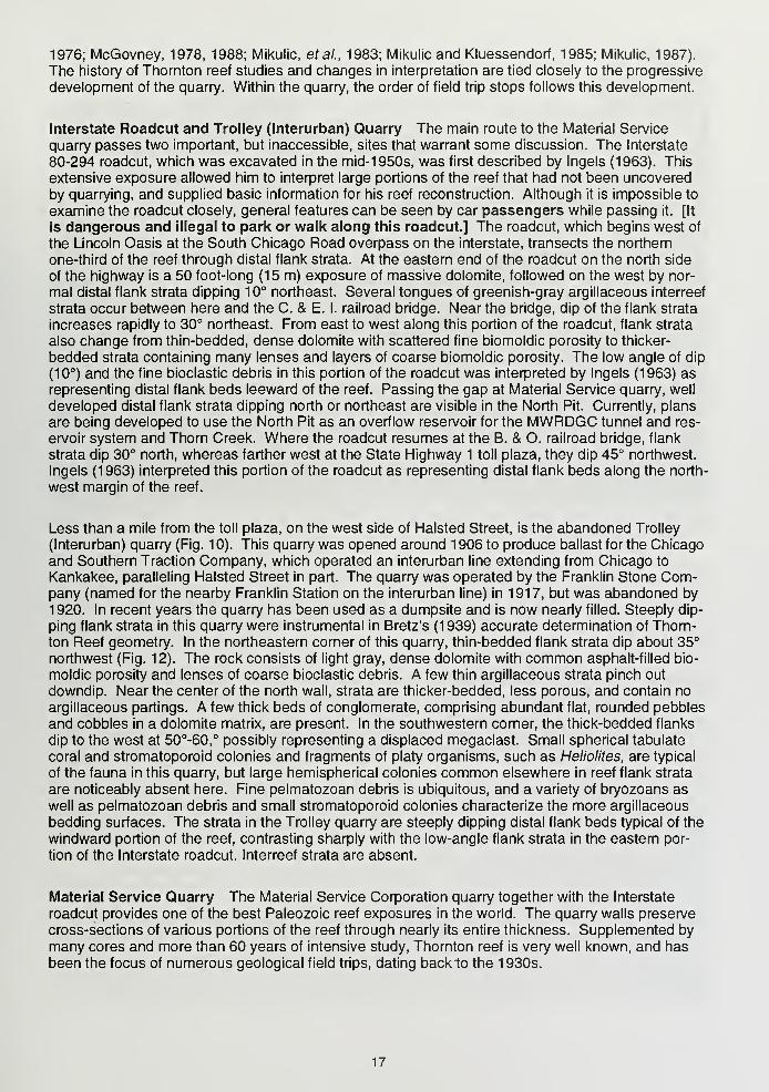
Interstate Roadcut and Trolley (Interurban) Quarry The main route to the Material Service
quarry passes two important, but inaccessible, sites that warrant some discussion. The Interstate
80-294 roadcut, which was excavated in the mid-1950s, was first described by Ingels (1963). This
extensive exposure allowed him to interpret large portions of the reef that had not been uncovered
by quarrying, and supplied basic information for his reef reconstruction. Although it is impossible to
examine the roadcut closely, general features can be seen by car passengers while passing it. [It
is dangerous and illegal to park or walk along this roadcut.] The roadcut, which begins west of
the Lincoln Oasis at the South Chicago Road overpass on the interstate, transects the northern
one-third of the reef through distal flank strata. At the eastern end of the roadcut on the north side
of the highway is a 50 foot-long (15 m) exposure of massive dolomite, followed on the west by nor-
mal distal flank strata dipping 10° northeast. Several tongues of greenish-gray argillaceous interreef
strata occur between here and the C. & E. I. railroad bridge. Near the bridge, dip of the flank strata
increases rapidly to 30° northeast. From east to west along this portion of the roadcut, flank strata
also change from thin-bedded, dense dolomite with scattered fine biomoldic porosity to thicker-
bedded strata containing many lenses and layers of coarse biomoldic porosity. The low angle of dip
(10°) and the fine bioclastic debris in this portion of the roadcut was interpreted by Ingels (1963) as
representing distal flank beds leeward of the reef. Passing the gap at Material Service quarry, well
developed distal flank strata dipping north or northeast are visible in the North Pit. Currently, plans
are being developed to use the North Pit as an overflow reservoir for the MWRDGC tunnel and res-
ervoir system and Thorn Creek. Where the roadcut resumes at the B. & O. railroad bridge, flank
strata dip 30° north, whereas farther west at the State Highway 1 toll plaza, they dip 45° northwest.
Ingels (1963) interpreted this portion of the roadcut as representing distal flank beds along the north-
west margin of the reef.
Less than a mile from the toll plaza, on the west side of Halsted Street, is the abandoned Trolley
(Interurban) quarry (Fig. 10). This quarry was opened around 1906 to produce ballast for the Chicagoand Southern Traction Company, which operated an interurban line extending from Chicago to
Kankakee, paralleling Halsted Street in part. The quarry was operated by the Franklin Stone Com-pany (named for the nearby Franklin Station on the interurban line) in 1917, but was abandoned by
1920. In recent years the quarry has been used as a dumpsite and is now nearly filled. Steeply dip-
ping flank strata in this quarry were instrumental in Bretz's (1939) accurate determination of Thorn-
ton Reef geometry. In the northeastern corner of this quarry, thin-bedded flank strata dip about 35°
northwest (Fig. 12). The rock consists of light gray, dense dolomite with common asphalt-filled bio-
moldic porosity and lenses of coarse bioclastic debris. A few thin argillaceous strata pinch out
downdip. Near the center of the north wall, strata are thicker-bedded, less porous, and contain no
argillaceous partings. A few thick beds of conglomerate, comprising abundant flat, rounded pebbles
and cobbles in a dolomite matrix, are present. In the southwestern corner, the thick-bedded flanks
dip to the west at 50°-60,° possibly representing a displaced megaclast. Small spherical tabulate
coral and stromatoporoid colonies and fragments of platy organisms, such as Heliolites, are typical
of the fauna in this quarry, but large hemispherical colonies common elsewhere in reef flank strata
are noticeably absent here. Fine pelmatozoan debris is ubiquitous, and a variety of bryozoans as
well as pelmatozoan debris and small stromatoporoid colonies characterize the more argillaceous
bedding surfaces. The strata in the Trolley quarry are steeply dipping distal flank beds typical of the
windward portion of the reef, contrasting sharply with the low-angle flank strata in the eastern por-
tion of the Interstate roadcut. Interreef strata are absent.
Material Service Quarry The Material Service Corporation quarry together with the Interstate
roadcut provides one of the best Paleozoic reef exposures in the world. The quarry walls preserve
cross-sections of various portions of the reef through nearly its entire thickness. Supplemented by
many cores and more than 60 years of intensive study, Thornton reef is very well known, and has
been the focus of numerous geological field trips, dating backlo the 1930s.
17
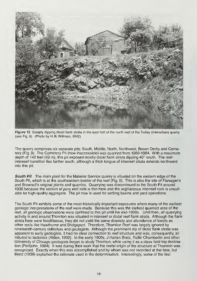
Figure 12 Steeply clipping distal flank strata in the east half of the north wall of the Trolley (Interurban) quarry
(see Fig. 9). (Photo by H. B. Willman, 1942)
The quarry comprises six separate pits: South, Middle, North, Northwest, Brown Derby and Ceme-tery (Fig. 9). The Cemetery Pit (now inaccessible) was quarried from 1980-1984. With a maximumdepth of 140 feet (43 m), this pit exposed mostly distal flank strata dipping 40° south. The reef-
interreef transition lies farther south, although a thick tongue of interreef strata extends northward
into this pit.
South Pit The main plant for the Material Service quarry is situated on the eastern edge of the
South Pit, which is at the southeastern border of the reef (Fig. 9). This is also the site of Flanagan's
and Brownell's original plants and quarries. Quarrying was discontinued in the South Pit around
1936 because the section of pure reef rock is thin here and the argillaceous interreef rock is unsuit-
able for high-quality aggregate. The pit now is used for settling basins and yard operations.
The South Pit exhibits some of the most historically important exposures where many of the earliest
geologic interpretations of the reef were made. Because this was the earliest quarried area of the
reef, all geologic observations were confined to this pit until the mid-1 920s. Until then, all quarrying
activity in and around Thornton was situated in interreef or distal reef flank strata. Although the flank
strata here were fossiliferous, they did not yield the same diversity and abundance of fossils as
other reefs like Hawthorne and Bridgeport. Therefore, Thornton Reef was largely ignored by
nineteenth-century collectors and geologists. Although the prominent dip of distal flank strata wasapparent to early geologists, it had no clear connection to reef structure and was, consequently, at-
tributed to tectonics (Alden, 1902). In the early 1900s, J Harlan Bretz, Rollin Chamberlin and other
University of Chicago geologists began to study Thornton, while using it as a class field trip destina-
tion (Pettijohn, 1984). It was during their work that the reefal origin of the structure at Thornton wasrecognized. Exactly when this was accomplished and by whom was not recorded at the time, but
Bretz (1939) explained the rationale used in the determination. Interestingly, some of the first
18
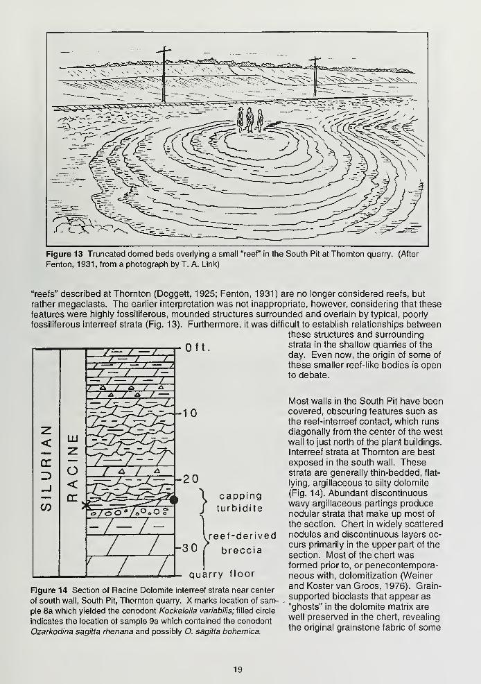
Figure 13 Truncated domed beds overlying a small "reef" in the South Pit at Thornton quarry. (After
Fenton, 1931, from a photograph by T. A. Link)
"reefs" described at Thornton (Doggett, 1925; Fenton, 1931) are no longer considered reefs, but
rather megaclasts. The earlier interpretation was not inappropriate, however, considering that these
features were highly fossiliferous, mounded structures surrounded and overlain by typical, poorly
fossiliferous interreef strata (Fig. 13). Furthermore, it was difficult to establish relationships betweenthese structures and surrounding
q f { strata in the shallow quarries of the
day. Even now, the origin of some of
these smaller reef-like bodies is opento debate.
Most walls in the South Pit have beencovered, obscuring features such as
the reef-interreef contact, which runs
diagonally from the center of the westwall to just north of the plant buildings.
Interreef strata at Thornton are best
exposed in the south wall. Thesestrata are generally thin-bedded, flat-
lying, argillaceous to silty dolomite
(Fig. 14). Abundant discontinuous
wavy argillaceous partings producenodular strata that make up most of
the section. Chert in widely scattered
nodules and discontinuous layers oc-
curs primarily in the upper part of the
section. Most of the chert wasformed prior to, or penecontempora-neous with, dolomitization (Weiner
and Kostervan Groos, 1976). Grain-
supported bioclasts that appear as
"ghosts" in the dolomite matrix are
well preserved in the chert, revealing
the original grainstone fabric of some
appingbidite
reef-derived
breccia
quarry floor
Figure 14 Section of Racine Dolomite interreef strata near center
of south wall, South Pit, Thornton quarry. X marks location of sam-
ple 8a which yielded the conodont Kockelella variabilis; filled circle
indicates the location of sample 9a which contained the conodont
Ozarkodina sagitta rhenana and possibly O. sagitta bohemica.
19
of the sediments. Patches of fine silicified bioclastic debris and larger coral and stromatoporoid
colonies occur locally. Silica for chertification probably was derived from siliceous sponges (Lowen-stam, 1948; Weinerand Koster van Gross, 1976).
Bioclasts in the interreef fades are dominated by fine (1 mm) pelmatozoan debris. Less commonare fragments of bryozoans, brachiopods, ?ostracodes, trilobites, stromatoporoids, tabulate corals,
and sponge spicules. Lowenstam (1948) identified the tabulates Favosites and Halysites, rare com-plete siliceous sponges, and the crinoids Pisocrinus, Myleodactylus, and Gissocrinus. Micrite enve-
lopes enclose some pelmatozoans preserved in the chert, and peloids in the chert may be completely
micritized bioclasts. Weiner and Koster van Groos (1976) discovered microscopic spherical algal
bodies in the chert. Orthoconic nautiloid cephalopods and calymenid and enchnurine trilobites are
also present. Interreef fossils, in general, exhibit a significantly different style of preservation com-pared to specimens from the reef proper. For example, the interreef cephalopods are compressedand preserve very little ornamentation, whereas in the reef, specimens exhibit little or no compres-sion and external molds commonly preserve fine details (Hewitt, era/., 1987). Planolites, which oc-
curs on some bedding surfaces, is the only common ichnotaxon, but bioturbation is ubiquitous in
interreef sediments, commonly yielding a mottled or swirled texture and poor sorting of bioclasts, in-
dicating little sediment disruption by physical agents. The argillaceous composition of the sediment,
the nature of the biota, the fine size of the bioclasts and the presence of in situ organisms further
suggest that the interreef strata were deposited under quiet water conditions.
Throughout much of the South Pit, interreef strata overlie a reef-detritus breccia that was first
described by Willman, etal. (1950). They reported that the breccia ranges from four to ten feet
(1.2-3 m) in thickness and is underlain by argillaceous dolomite at least 12 feet (4 m) thick. Thebreccia consists of granule- to boulder-sized lithoclasts in an argillaceous dolomite matrix. Reef-
derived megaclasts as much as 40 feet (12 m) long occur. Smaller clasts are not typical reef lithol-
ogy, but are dominantly chert or fine-grained dolomite. Bioclasts, particularly pelmatozoan, coral
and stromatoporoid fragments, are common in the granule- to pebble-sized fraction.
Although he failed to recognize the brecciated nature of this interval, Bretz (1939) was the first to
identify large clasts in the west wall as "displaced fragments of reef rock" based on their composition
and orientation. Just north of the southwest corner of the South Pit is the most conspicuous reef-
derived megaclast, which is 40 feet (12 m) long and 8 feet (3 m) high in its exposed portion and dis-
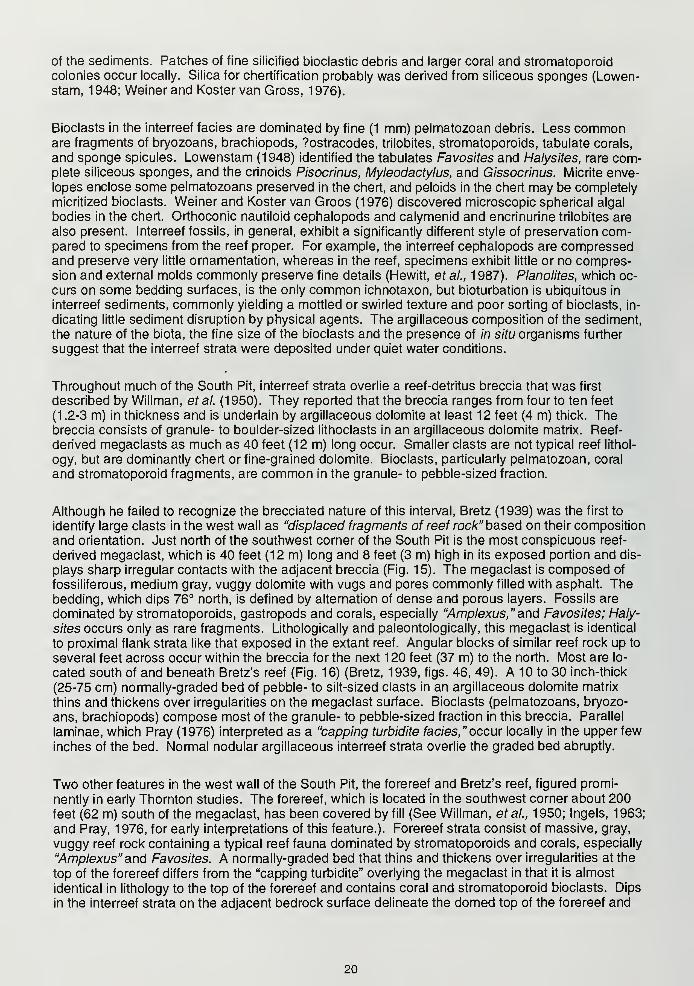
plays sharp irregular contacts with the adjacent breccia (Fig. 15). The megaclast is composed of
fossiliferous, medium gray, vuggy dolomite with vugs and pores commonly filled with asphalt. Thebedding, which dips 76° north, is defined by alternation of dense and porous layers. Fossils are
dominated by stromatoporoids, gastropods and corals, especially "Amplexus," and Favosites; Haly-
sites occurs only as rare fragments. Lithologically and paleontologically, this megaclast is identical
to proximal flank strata like that exposed in the extant reef. Angular blocks of similar reef rock up to
several feet across occur within the breccia for the next 120 feet (37 m) to the north. Most are lo-
cated south of and beneath Bretz's reef (Fig. 16) (Bretz, 1939, figs. 46, 49). A 10 to 30 inch-thick
(25-75 cm) normally-graded bed of pebble- to silt-sized clasts in an argillaceous dolomite matrix
thins and thickens over irregularities on the megaclast surface. Bioclasts (pelmatozoans, bryozo-
ans, brachiopods) compose most of the granule- to pebble-sized fraction in this breccia. Parallel
laminae, which Pray (1976) interpreted as a "capping turbidite fades," occur locally in the upper few
inches of the bed. Normal nodular argillaceous interreef strata overlie the graded bed abruptly.
Two other features in the west wall of the South Pit, the forereef and Bretz's reef, figured promi-
nently in early Thornton studies. The forereef, which is located in the southwest corner about 200feet (62 m) south of the megaclast, has been covered by fill (See Willman, etal., 1950; Ingels, 1963;
and Pray, 1976, for early interpretations of this feature.). Forereef strata consist of massive, gray,
vuggy reef rock containing a typical reef fauna dominated by stromatoporoids and corals, especially
"Amplexus" and Favosites. A normally-graded bed that thins and thickens over irregularities at the
top of the forereef differs from the "capping turbidite" overlying the megaclast in that it is almost
identical in lithology to the top of the forereef and contains coral and stromatoporoid bioclasts. Dips
in the interreef strata on the adjacent bedrock surface delineate the domed top of the forereef and
20
i*~
/
Figure 15 Megaclast of proximal reef flank rock overlain by nodular argillaceous interreef strata near south-
west corner of west wall, South Pit, Thornton quarry. "Capping turbidite" occurs at shoulder level of figures in
photo (1984).
suggest that it extends farther west. West of the forereef, interreef strata on the bedrock surface de-
fine a circular pattern suggesting the presence of another domed structure possibly related to the
forereef (see Fig.1 3 for a similar feature). It is unknown how far east the forereef extended; how-ever, Willman, et al. (1 950) considered it to be "a linear feature parallel to the edge of the main reef"
based on "numerous exposures of massive reef-rock in the quarry floor on a line slightly north of
east from the exposure in the west face."
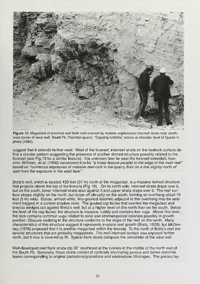
Bretz's reef, which is located 120 feet (37 m) north of the megaclast, is a massive domed structure
that projects above the top of the breccia (Fig. 16). On its north side, interreef strata drape over it,
but on the south, lower interreef strata abut against it and upper strata drape over it. The reef sur-
face slopes slightly on the north, but drops off abruptly on the south, forming an overhang about 15
feet (5 m) wide. Dense, almost white, fine-grained dolomite adjacent to this overhang may be sedi-
ment trapped in a current shadow zone. The graded cap facies that overlies the megaclast andbreccia wedges out against Bretz's reef, but at a higher level on the north than on the south. Below
the level of the cap facies, the structure is massive, rubbly and contains few vugs. Above this level,
the rock contains common vugs related to coral and stromatoporoid colonies possibly in growth
position. Obscure bedding in the structure conforms to the slope of the reef on the north. Manycharacteristics of this structure suggest it represents in-place reef growth (Bretz, 1939), but McGov-ney (1978) proposed that it is another megaclast within the breccia. To the north of Bretz's reef are
several structures that are probably megaclasts. The reef-interreef contact was exposed farther
north, but it now is covered by fill. Typical flank strata compose the remainder of the west wall.
Well-developed reef flank strata dip 35° southeast at the tunnels in the middle of the north wall of
the South Pit. Generally, these strata consist of cyclically alternating porous and dense dolomite
layers corresponding to original packstone/grainstone and wackestone lithologies. The porous lay-
21
ers apparently grade upward into the dense layers. Bioclasts, which are abundant and poorly sorted
in the porous layers, are dominated by corals, stromatoporoids, gastropods and brachiopods; locally
some colonies appear to be in situ. Isopachous rim cement lines interparticle porosity in the grain-
stone.
The exposure at the tunnels conveys the problems faced by nineteenth- and early twentieth century
geologists in recognizing the reefal nature of such dipping strata in Illinois and Indiana. The small
quarries of the time, which were generally only a few tens of feet deep and a few hundred feet
across, exposed even less rock than is visible here. All that could be seen was a predominance of
uniformly dipping strata, showing no transition to either reef core or interreef strata. Consequently, astructural explanation for these strata was reasonable, especially when taking into account the lim-
ited overall knowledge of the general geology of the region. Moreover, the undoubted structural ori-
gin of deformed strata in the Kentland Disturbance, which is located so near Indiana and Illinois
flank bed exposures, added weight to a possible structural derivation for the dipping reef flanks (see
discussion in Gorby, 1886). It was not until the 1920s that Robert Shrock (Cumings and Shrock,
1928) demonstrated that Kentland (now known to be an impact site; Gutschick, 1987) was unrelated
to any of the Silurian features, which he correctly identified as reefs (R. R. Shrock, personal commu-nication, 1991).
Because no biostratigraphic data were available previously, Thornton Reef was assigned the as-
sumed age of the Racine Dolomite (Wenlockian through Ludlovian) (Mikulic, etal., 1983). Cono-donts, including Kockelella variabilis, Ozarkodina sagitta rhenana and O. sagitta bohemica (R. D.
Norby and T. L. Adams, personal communication, 1985), have since been collected from the south
wall of this pit. Kockelella variabilis was found in sample 8a from a shaley horizon about 23 feet (7
m) below the top of the south wall (Fig. 14). This species ranges from mid-Wenlockian to late Lud-
lovian. Ozarkodina sagitta rhenana and a possible specimen of O. sagitta bohemica were found in
a bioclastic dolomite ("capping turbidite") (sample 9a, just below 8a stratigraphically). The first sub-
species has a known range of early Wenlockian to possibly earliest Ludlovian, whereas the secondsubspecies is more restricted to the later Wenlockian through earliest Ludlovian. These interreef
strata were deposited later than most of the extant reef, which, therefore, is no younger than earliest
Ludlovian.
Middle Pit-Main Level The Middle Pit, largest of the six pits, is the location of the primary crusher.
Rock quarried from all pits is brought here in 85-ton haulage trucks. The crusher operates like a gi-
ant mortar and pestle, reducing rocks to diameters of nine inches (23 cm) or less, which are then
transported via conveyor belt to secondary and tertiary crushers in the South Pit.
Opened in 1924, the Middle Pit (referred to as the North Quarry until the mid-1950s) initially con-
sisted of a shallow, narrow, north-south cut that was eventually extended to about the present posi-
tion of the interstate (Fig. 10). The opening of this pit verified that the entire rock hill was reef-
controlled, as demonstrated by the radially-oriented dip which changes direction from southeast
to east and then northeast through the exposure. This cut, in conjunction with the Trolley quarry,
allowed Bretz (1939) to produce a block diagram of the entire reef (Fig. 17). By 1950, much of the
Middle Pit had been excavated to a depth of about 50 feet (15 m). These new exposures, in con-
junction with those in the South Pit, formed the basis for much of Heinz Lowenstam's classic workon the biologic and sedimentologic succession in Silurian reefs, serving as the model for his rough-
water stage of reef development (Fig. 18).
One recent controversy centered on the Middle Pit involves the location and volume of the reef core.
In his block diagram, Bretz (1939) (Fig. 17) suggested that the reef core may be bisected by the
B. & O. railroad tracks, and Willman, etal. (1950) believed they saw substantial core rock along the
west wall of the Middle Pit in the approximate location predicted earlier by Bretz. By the time Ingels
began his study of Thornton in the late 1950s, massive reef core could no longer be seen in this
area, but he did report a much smaller patch of reef core (part of his Stromatoporoid Biosome) a
short distance to the north (Ingels, 1963) (Fig. 19, 20). There are two possible explanations for this
difference between the earlier and later observations: 1) No core rock ever existed in the area of
22
Figure 16 Top: Bretz's reef 120 feet (36 m) north of megaclast in Figure 15 in the west wall of the South Pit,
Thornton quarry. "Capping turbidite" appears as light-colored bed in left center of photo. Wall is 45 feet (14 m)high (Photo taken August, 1976). Bottom: Bretz's diagram of this reef showing displaced blocks of reef rockwithin breccia. (After Bretz, 1939).
23
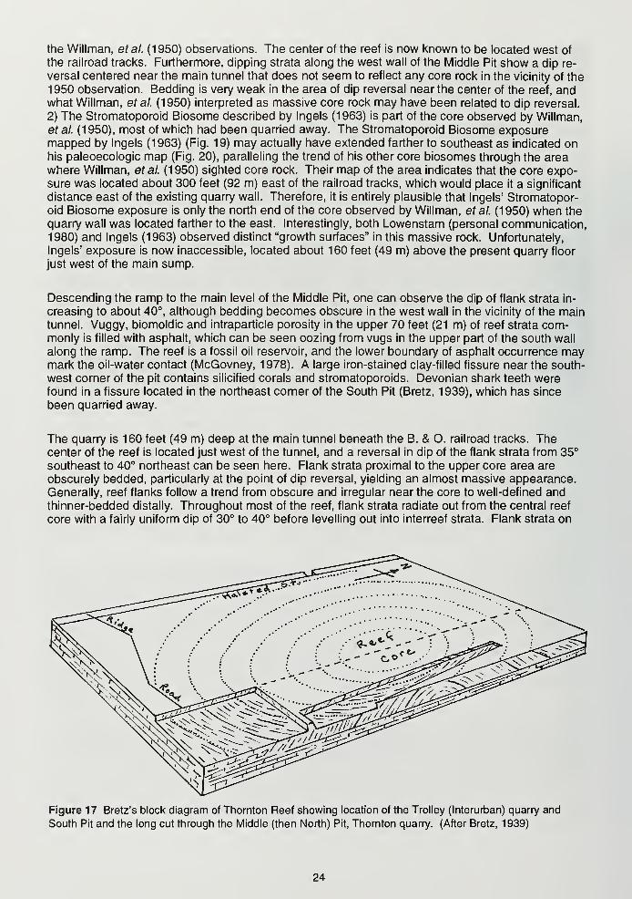
the Willman, et al. (1 950) observations. The center of the reef is now known to be located west of
the railroad tracks. Furthermore, dipping strata along the west wall of the Middle Pit show a dip re-
versal centered near the main tunnel that does not seem to reflect any core rock in the vicinity of the
1 950 observation. Bedding is very weak in the area of dip reversal near the center of the reef, andwhat Willman, et al. (1950) interpreted as massive core rock may have been related to dip reversal.
2) The Stromatoporoid Biosome described by Ingels (1963) is part of the core observed by Willman,
etal. (1950), most of which had been quarried away. The Stromatoporoid Biosome exposuremapped by Ingels (1963) (Fig. 19) may actually have extended farther to southeast as indicated onhis paleoecologic map (Fig. 20), paralleling the trend of his other core biosomes through the areawhere Willman, et al. (1 950) sighted core rock. Their map of the area indicates that the core expo-sure was located about 300 feet (92 m) east of the railroad tracks, which would place it a significant
distance east of the existing quarry wall. Therefore, it is entirely plausible that Ingels' Stromatopor-
oid Biosome exposure is only the north end of the core observed by Willman, etal. (1950) when the
quarry wall was located farther to the east. Interestingly, both Lowenstam (personal communication,1980) and Ingels (1963) observed distinct "growth surfaces" in this massive rock. Unfortunately,
Ingels' exposure is now inaccessible, located about 160 feet (49 m) above the present quarry floor
just west of the main sump.
Descending the ramp to the main level of the Middle Pit, one can observe the dip of flank strata in-
creasing to about 40°, although bedding becomes obscure in the west wall in the vicinity of the maintunnel. Vuggy, biomoldic and intraparticle porosity in the upper 70 feet (21 m) of reef strata com-monly is filled with asphalt, which can be seen oozing from vugs in the upper part of the south wall
along the ramp. The reef is a fossil oil reservoir, and the lower boundary of asphalt occurrence maymark the oil-water contact (McGovney, 1978). A large iron-stained clay-filled fissure near the south-
west corner of the pit contains silicified corals and stromatoporoids. Devonian shark teeth werefound in a fissure located in the northeast corner of the South Pit (Bretz, 1939), which has since
been quarried away.
The quarry is 160 feet (49 m) deep at the main tunnel beneath the B. & O. railroad tracks. Thecenter of the reef is located just west of the tunnel, and a reversal in dip of the flank strata from 35°
southeast to 40° northeast can be seen here. Flank strata proximal to the upper core area are
obscurely bedded, particularly at the point of dip reversal, yielding an almost massive appearance.
Generally, reef flanks follow a trend from obscure and irregular near the core to well-defined andthinner-bedded distally. Throughout most of the reef, flank strata radiate out from the central reef
core with a fairly uniform dip of 30° to 40° before levelling out into interreef strata. Flank strata on
Figure 17 Bretz's block diagram of Thornton Reef showing location of the Trolley (Interurban) quarry and
South Pit and the long cut through the Middle (then North) Pit, Thornton quarry. (After Bretz, 1939)
24
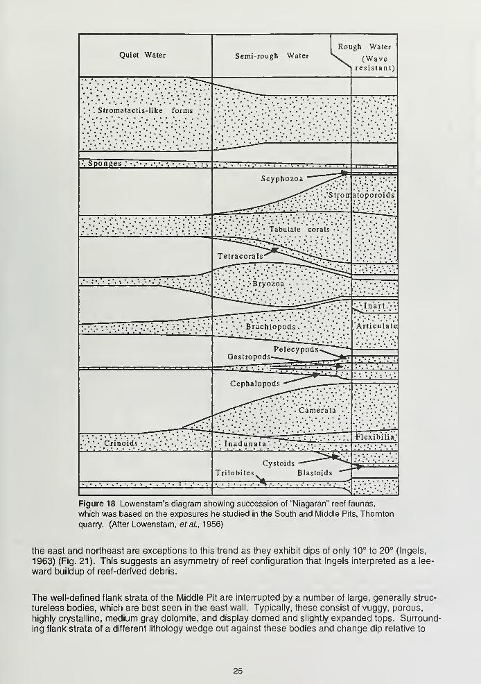
Figure 18 Lowenstam's diagram showing succession of "Niagaran" reef faunas,
which was based on the exposures he studied in the South and Middle Pits, Thornton
quarry. (After Lowenstam, et al., 1956)
the east and northeast are exceptions to this trend as they exhibit dips of only 10° to 20° (Ingels,
1963) (Fig. 21). This suggests an asymmetry of reef configuration that Ingels interpreted as a lee-
ward buildup of reef-derived debris.
The well-defined flank strata of the Middle Pit are interrupted by a number of large, generally struc-
tureless bodies, which are best seen in the east wall. Typically, these consist of vuggy, porous,
highly crystalline, medium gray dolomite, and display domed and slightly expanded tops. Surround-
ing flank strata of a different lithology wedge out against these bodies and change dip relative to
25
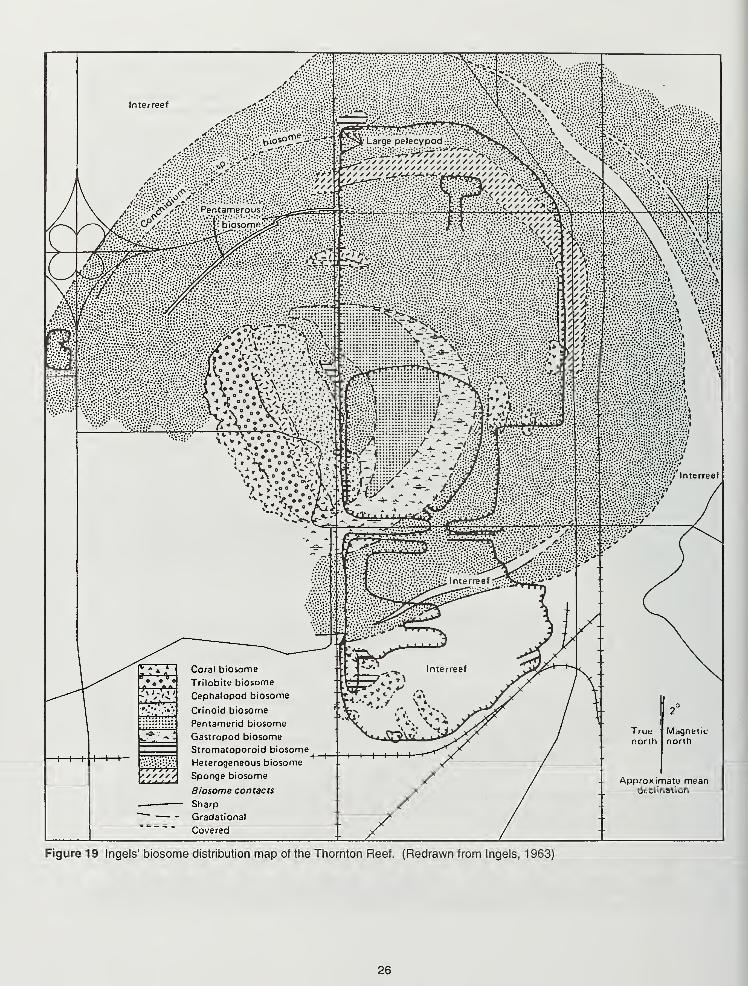
Figure 19 Ingels' biosome distribution map of the Thornton Reef. (Redrawn from Ingels, 1963)
26
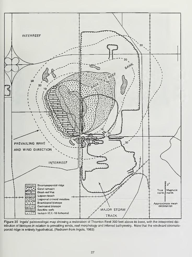
INTERREEF
Magneticnorth
Approximate meandeclination
Figure 20 Ingels' paleoecologic map showing a restoration of Thornton Reef 300 feet above its base, with the interpreted dis-
tribution of biotopes in relation to prevailing winds, reef morphology and inferred bathymetry. Note that the windward stromato-
poroid ridge in entirely hypothetical. (Redrawn from Ingels, 1963)
27
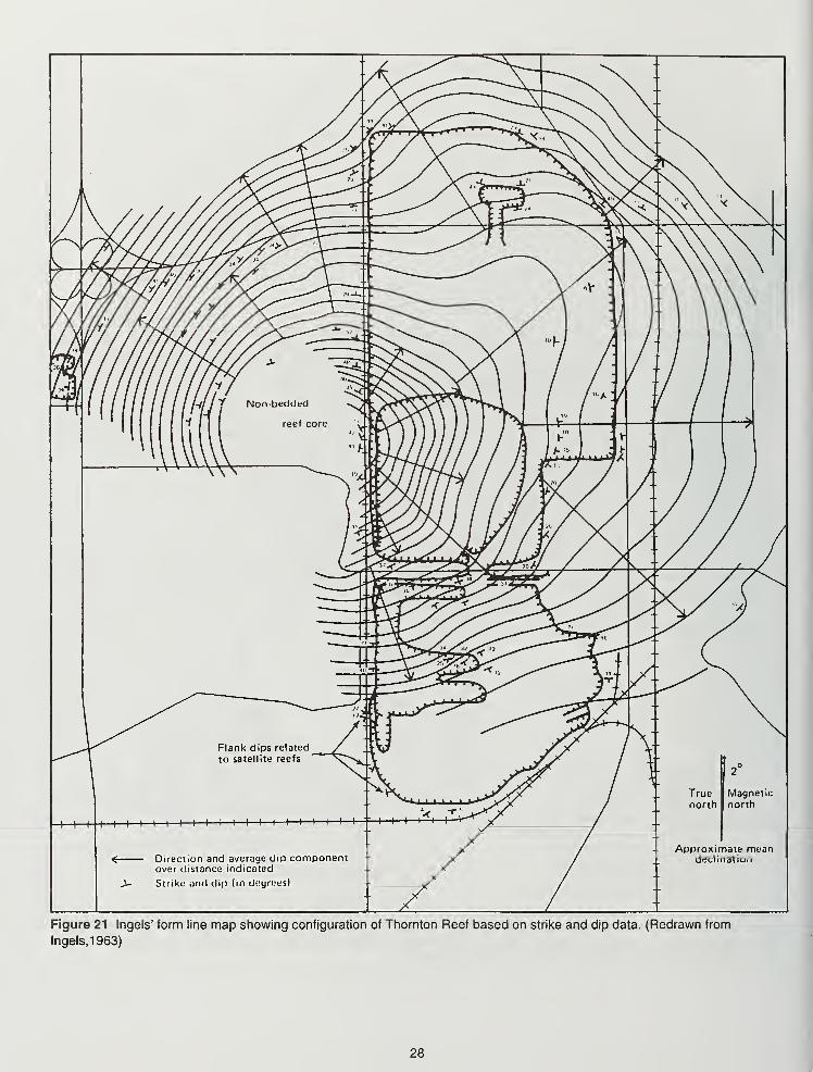
Figure 21 Ingels' form line map showing configuration of Thornton Reef based on strike and dip data. (Redrawn from
lngels,1963)
28
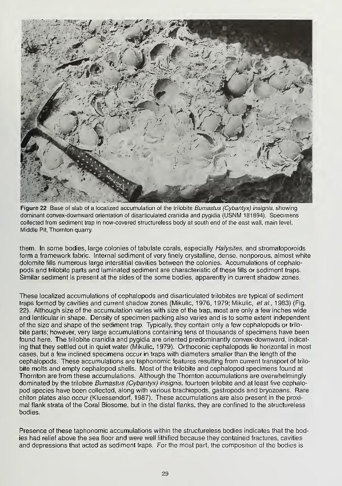
"*.'• ~?W '.**':
^ .' „ Ij'l —ri/ im^ ' -~
h ...x'r v ' -IE <*t
;>r.-
Figure 22 Base of slab of a localized accumulation of the trilobite Bumastus (Cybantyx) insignis, showing
dominant convex-downward orientation of disarticulated cranidia and pygidia (USNM 181894). Specimens
collected from sediment trap in now-covered structureless body at south end of the east wall, main level,
Middle Pit, Thornton quarry.
them. In some bodies, large colonies of tabulate corals, especially Halysites, and stromatoporoids
form a framework fabric. Internal sediment of very finely crystalline, dense, nonporous, almost white
dolomite fills numerous large interstitial cavities between the colonies. Accumulations of cephalo-
pods and trilobite parts and laminated sediment are characteristic of these fills or sediment traps.
Similar sediment is present at the sides of the some bodies, apparently in current shadow zones.
These localized accumulations of cephalopods and disarticulated trilobites are typical of sediment
traps formed by cavities and current shadow zones (Mikulic, 1976, 1979; Mikulic, et al., 1983) (Fig.
22). Although size of the accumulation varies with size of the trap, most are only a few inches wide
and lenticular in shape. Density of specimen packing also varies and is to some extent independent
of the size and shape of the sediment trap. Typically, they contain only a few cephalopods or trilo-
bite parts; however, very large accumulations containing tens of thousands of specimens have beenfound here. The trilobite cranidia and pygidia are oriented predominantly convex-downward, indicat-
ing that they settled out in quiet water (Mikulic, 1979). Orthoconic cephalopods lie horizontal in most
cases, but a few inclined specimens occur in traps with diameters smaller than the length of the
cephalopods. These accumulations are taphonomic features resulting from current transport of trilo-
bite molts and empty cephalopod shells. Most of the trilobite and cephalopod specimens found at
Thornton are from these accumulations. Although the Thornton accumulations are overwhelmingly
dominated by the trilobite Bumastus (Cybantyx) insignis, fourteen trilobite and at least five cephalo-
pod species have been collected, along with various brachiopods, gastropods and bryozoans. Rare
chiton plates also occur (Kluessendorf, 1987). These accumulations are also present in the proxi-
mal flank strata of the Coral Biosome, but in the distal flanks, they are confined to the structureless
bodies.
Presence of these taphonomic accumulations within the structureless bodies indicates that the bod-
ies had relief above the sea floor and were well lithified because they contained fractures, cavities
and depressions that acted as sediment traps. For the most part, the composition of the bodies is
29
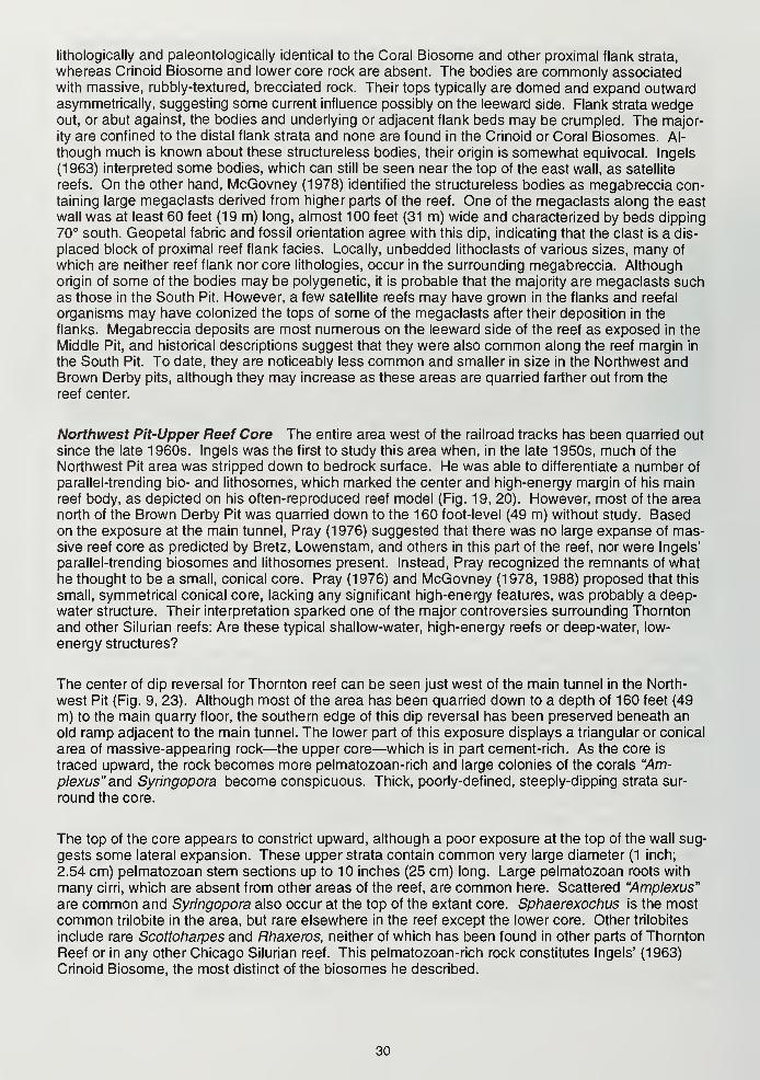
lithologically and paleontologically identical to the Coral Biosome and other proximal flank strata,
whereas Crinoid Biosome and lower core rock are absent. The bodies are commonly associatedwith massive, rubbly-textured, brecciated rock. Their tops typically are domed and expand outwardasymmetrically, suggesting some current influence possibly on the leeward side. Flank strata wedgeout, or abut against, the bodies and underlying or adjacent flank beds may be crumpled. The major-
ity are confined to the distal flank strata and none are found in the Crinoid or Coral Biosomes. Al-
though much is known about these structureless bodies, their origin is somewhat equivocal. Ingels
(1963) interpreted some bodies, which can still be seen near the top of the east wall, as satellite
reefs. On the other hand, McGovney (1978) identified the structureless bodies as megabreccia con-taining large megaclasts derived from higher parts of the reef. One of the megaclasts along the east
wall was at least 60 feet (19 m) long, almost 100 feet (31 m) wide and characterized by beds dipping70° south. Geopetal fabric and fossil orientation agree with this dip, indicating that the clast is a dis-
placed block of proximal reef flank facies. Locally, unbedded lithoclasts of various sizes, many of
which are neither reef flank nor core lithologies, occur in the surrounding megabreccia. Although
origin of some of the bodies may be polygenetic, it is probable that the majority are megaclasts suchas those in the South Pit. However, a few satellite reefs may have grown in the flanks and reefal
organisms may have colonized the tops of some of the megaclasts after their deposition in the
flanks. Megabreccia deposits are most numerous on the leeward side of the reef as exposed in the
Middle Pit, and historical descriptions suggest that they were also common along the reef margin in
the South Pit. To date, they are noticeably less common and smaller in size in the Northwest andBrown Derby pits, although they may increase as these areas are quarried farther out from the
reef center.
Northwest Pit-Upper Reef Core The entire area west of the railroad tracks has been quarried out
since the late 1 960s. Ingels was the first to study this area when, in the late 1 950s, much of the
Northwest Pit area was stripped down to bedrock surface. He was able to differentiate a number of
parallel-trending bio- and lithosomes, which marked the center and high-energy margin of his mainreef body, as depicted on his often-reproduced reef model (Fig. 19, 20). However, most of the areanorth of the Brown Derby Pit was quarried down to the 160 foot-level (49 m) without study. Basedon the exposure at the main tunnel, Pray (1976) suggested that there was no large expanse of mas-sive reef core as predicted by Bretz, Lowenstam, and others in this part of the reef, nor were Ingels'
parallel-trending biosomes and lithosomes present. Instead, Pray recognized the remnants of whathe thought to be a small, conical core. Pray (1 976) and McGovney (1 978, 1 988) proposed that this
small, symmetrical conical core, lacking any significant high-energy features, was probably a deep-
water structure. Their interpretation sparked one of the major controversies surrounding Thornton
and other Silurian reefs: Are these typical shallow-water, high-energy reefs or deep-water, low-
energy structures?
The center of dip reversal for Thornton reef can be seen just west of the main tunnel in the North-
west Pit (Fig. 9, 23). Although most of the area has been quarried down to a depth of 160 feet (49
m) to the main quarry floor, the southern edge of this dip reversal has been preserved beneath an
old ramp adjacent to the main tunnel. The lower part of this exposure displays a triangular or conical
area of massive-appearing rock—the upper core—which is in part cement-rich. As the core is
traced upward, the rock becomes more pelmatozoan-rich and large colonies of the corals "Am-
plexus" and Syringopora become conspicuous. Thick, poorly-defined, steeply-dipping strata sur-
round the core.
The top of the core appears to constrict upward, although a poor exposure at the top of the wall sug-
gests some lateral expansion. These upper strata contain common very large diameter (1 inch;
2.54 cm) pelmatozoan stem sections up to 10 inches (25 cm) long. Large pelmatozoan roots with
many cirri, which are absent from other areas of the reef, are common here. Scattered "Amplexus"
are common and Syringopora also occur at the top of the extant core. Sphaerexochus is the mostcommon trilobite in the area, but rare elsewhere in the reef except the lower core. Other trilobites
include rare Scottoharpes and Rhaxeros, neither of which has been found in other parts of Thornton
Reef or in any other Chicago Silurian reef. This pelmatozoan-rich rock constitutes Ingels' (1963)
Crinoid Biosome, the most distinct of the biosomes he described.
30
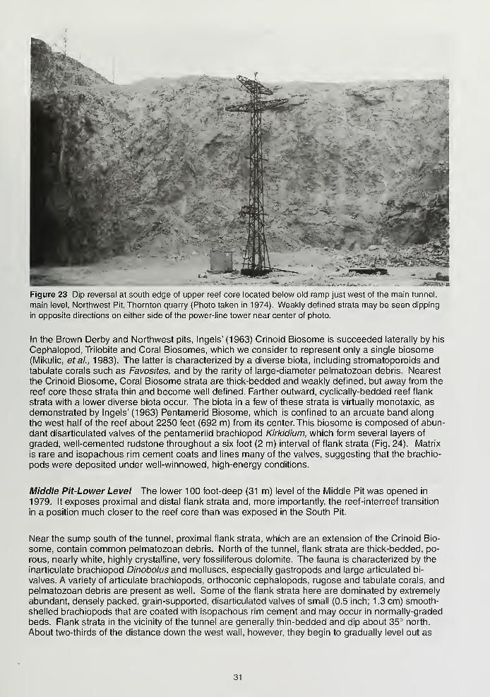
Figure 23 Dip reversal at south edge of upper reef core located below old ramp just west of the main tunnel,
main level, Northwest Pit, Thornton quarry (Photo taken in 1974). Weakly defined strata may be seen dipping
in opposite directions on either side of the power-line tower near center of photo.
In the Brown Derby and Northwest pits, Ingels' (1963) Crinoid Biosome is succeeded laterally by his
Cephalopod, Trilobite and Coral Biosomes, which we consider to represent only a single biosome(Mikulic, etal., 1983). The latter is characterized by a diverse biota, including stromatoporoids andtabulate corals such as Favosites, and by the rarity of large-diameter pelmatozoan debris. Nearest
the Crinoid Biosome, Coral Biosome strata are thick-bedded and weakly defined, but away from the
reef core these strata thin and become well defined. Farther outward, cyclically-bedded reef flank
strata with a lower diverse biota occur. The biota in a few of these strata is virtually monotaxic, as
demonstrated by Ingels' (1963) Pentamerid Biosome, which is confined to an arcuate band along
the west half of the reef about 2250 feet (692 m) from its center. This biosome is composed of abun-
dant disarticulated valves of the pentameriid brachiopod Kirkidium, which form several layers of
graded, well-cemented rudstone throughout a six foot (2 m) interval of flank strata (Fig. 24). Matrix
is rare and isopachous rim cement coats and lines many of the valves, suggesting that the brachio-
pods were deposited under well-winnowed, high-energy conditions.
Middle Pit-Lower Level The lower 100 foot-deep (31 m) level of the Middle Pit was opened in
1979. It exposes proximal and distal flank strata and, more importantly, the reef-interreef transition
in a position much closer to the reef core than was exposed in the South Pit.
Near the sump south of the tunnel, proximal flank strata, which are an extension of the Crinoid Bio-
some, contain common pelmatozoan debris. North of the tunnel, flank strata are thick-bedded, po-
rous, nearly white, highly crystalline, very fossiliferous dolomite. The fauna is characterized by the
inarticulate brachiopod Dinobolus and molluscs, especially gastropods and large articulated bi-
valves. A variety of articulate brachiopods, orthoconic cephalopods, rugose and tabulate corals, andpelmatozoan debris are present as well. Some of the flank strata here are dominated by extremely
abundant, densely packed, grain-supported, disarticulated valves of small (0.5 inch; 1.3 cm) smooth-
shelled brachiopods that are coated with isopachous rim cement and may occur in normally-graded
beds. Flank strata in the vicinity of the tunnel are generally thin-bedded and dip about 35° north.
About two-thirds of the distance down the west wall, however, they begin to gradually level out as
31
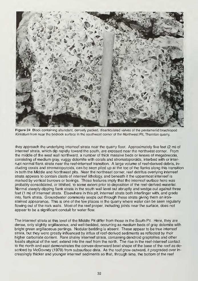
I
A'* /iJ^t'*. i rr,'
»v
.'/sv*. -,i
ic'
>'m-(M
•»
Figure 24 Block containing abundant, densely packed, disarticulated valves of the pentameriid brachiopod
Kirkidium from near the bedrock surface in the southwest corner of the Northwest Pit, Thornton quarry.
they approach the underlying interreef strata near the quarry floor. Approximately five feet (2 m) of
interreef strata, which dip rapidly toward the south, are exposed near the northwest corner. Fromthe middle of the west wall northward, a number of thick massive beds or lenses of megabreccia,
consisting of medium gray, vuggy dolomite with corals and stromatoporoids, interbed with or inter-
rupt normal flank strata near the reef-interreef transition. A large volume of reef-derived debris, in-
cluding corals and stromatoporoids, can be seen piled up at the toe of the flanks along this transition
in both the Middle and Northwest pits. Near the northeast corner, reef detritus overlying interreef
strata appears to contain clasts of interreef lithology, and beneath it the uppermost interreef is
marked by vertical burrows or borings. These features imply that the interreef surface here wasprobably consolidated, or lithified, to some extent prior to deposition of the reef-derived material.
Normal steeply-dipping flank strata in the south wall level out abruptly and wedge out against three
feet (1 m) of interreef strata. Elsewhere in this pit, interreef strata both interfinger with, and grade
into, flank strata. Groundwater commonly seeps out through these strata giving them an iron-
stained appearance. This is one of the few places in the quarry where water can be seen regularly
flowing out of the rock walls. Most of the reef proper, including joints near the surface, does not
appear to be a significant conduit for water flow.
The interreef strata at this level of the Middle Pit differ from those in the South Pit. Here, they are
dense, only slightly argillaceous, and well-bedded, occurring as medium beds of gray dolomite with
bright green argillaceous partings. Nodular bedding is absent. These appear to be true interreef
strata, but they were greatly influenced by influx of reef-derived sediments as reflected by their
higher carbonate content. Rare shaley interreef strata, containing dendroid graptolites and other
fossils atypical of the reef, extend into the reef from the north. The rise in the reef-interreef contact
to the north and east demonstrates the convex-downward bowl shape of the base of the reef as de-
scribed by McGovney (1978) from subsurface data. As the reef grew outward, itprograded over in-
creasingly thicker and younger interreef sediments so that, through time, the bottom of the reef
32
margin occurred at ever-higher levels. This also indicates that reef sediments were being deposited
more quickly than surrounding interreef sediments. As this lower level is expanded eastward, the
reef-interreef contact should rise higher still.
Northwest Pit-Lower Reef Core The lower level of the Northwest Pit, which was opened in 1 983,
is presently 100 feet (31 m) deep. As quarrying progressed westward from the tunnel, an elongate
(1400 feet, 430 m) core ridge was quarried through (Fig. 25). Presence of core rock at this location
contrasts with the steeply-dipping proximal flank beds that are predicted in this portion of the reef bythe conical core model of Pray (1976) and McGovney (1978, 1988). Rather, the northwest-
southeast trend of this lower core ridge follows precisely the trend of the inner core biosomes that
Ingels (1963) observed on the stripped bedrock surface 260 feet above the quarry floor here.
Throughout most of the lower level, this core ridge has since been quarried away, but a cross-
section through it is preserved in the eastern portion of the south wall (Fig. 26). From 1985 until
1989, this wall was not quarried, which allowed significant weathering to take place, enhancing the
exposure and permitting detailed study of this critical feature. This cross-section revealed that the
core ridge, which is delineated by a conspicuous dip reversal from northeast to southwest, is about
180 feet (55 m) wide at the present quarry floor, and narrows upward to a peak near the top of the
wall. Near the center of the lower core was an inner "mound" marked by a broad dip reversal from
east to west, as defined by orientation of corals and cement patches. In general, the fauna of the
lower core is of low diversity. The inner mound was composed predominantly of the fasciculate co-
lonial rugose coral "Pycnostylus," characterized by abundant thin, tubular corallites, and the tabulate
Halysites, here occurring as ribbon-like colonies. Abundant isopachous and botryoidal cementcoats corallites, fills void space within and between them, and lines cavities such as shelter porosity
beneath platy corals. Much of the rest of the lower core displayed well-cemented, steep, westward-
dipping beds composed of huge masses oV'Pycnostylus," long, cylindrical solitary rugose corals andribbon-like Halysites colonies, apparently interbedded and in growth position. The corals grew pref-
erentially toward the southwest as evidenced by successive layers of in situ colonies, giving the core
a prominent asymmetry (Mikulic and Kluessendorf, 1992). [Coincidentally, Ingels' (1963) postulated
paleowind direction was also from the southwest.] The corals within the inner mound and in these
dipping beds impart a conspicuous bindstone-framestone framework to the core, one of the mostpronounced of any reef in the area. A drill-core revealed that "Pycnostylus" extends at least 40 feet
(12 m) below the quarry floor. The eastern portion of the lower core comprises beds of bioclastic
debris, including "Pycnostylus" and Halysites fragments, that dip less steeply than the coral beds onthe west.
Features within the lower core changed in prominence and position as the wall was subsequently
quarried farther south. The inner mound shifted to the west, and now is situated nearly at the west-
ern edge of the lower core. Abundant, heavily cemented, bands of platy corals, such as Heliolites
and sheet-like Favosites, dominated the inner mound in later exposures. The in situ "Pycnostylus"
masses continue to characterize the western edge of the core. It appears that the core ridge is
reaching its southern edge in the present exposure as the predominance and location of the coral
framework have shifted toward its western edge and the bioclastic beds to the east have increased
in volume dramatically.
The outer boundary of the lower core is a mineralized, corroded, irregular, scalloped surface. Thefauna changes abruptly across this boundary from the coral-dominated fauna within the core to the
pelmatozoan-dominated flank strata that bury it but do not interbed with core rock (Figs. 26 to 28).
Pelmatozoan debris in these proximal grainstone and packstone flank beds consists mostly of large
diameter (0.5 inch; 1.25 cm), short stem sections, generally lying parallel to bedding. These flank
strata occur in two sets: the lower set, which dips more steeply than the upper, wedges out against
the core and is truncated by the upper set, but the dip of both sets reflects the configuration of the
lower core ridge.
These pelmatozoan-rich flanks extend about 400 feet (123 m) to the west along the south wall. Their
dip decreases from about 37° to 24° near a massive light-colored flank bed (Fig. 27C). A dramatic
faunal change takes place to the west. Here the pelmatozoan flanks and "Pycnostylus" dominated
33
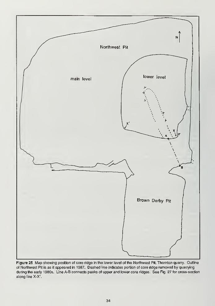
Northwest Pit
main level
Figure 25 Map showing position of core ridge in the lower level of the Northwest Pit, Thornton quarry. Outline
of Northwest Pit is as it appeared in 1987. Dashed line indicates portion of core ridge removed by quarrying
during the early 1980s. Line A-B connects peaks of upper and lower core ridges. See Fig. 27 for cross-section
along line X-X'.
34
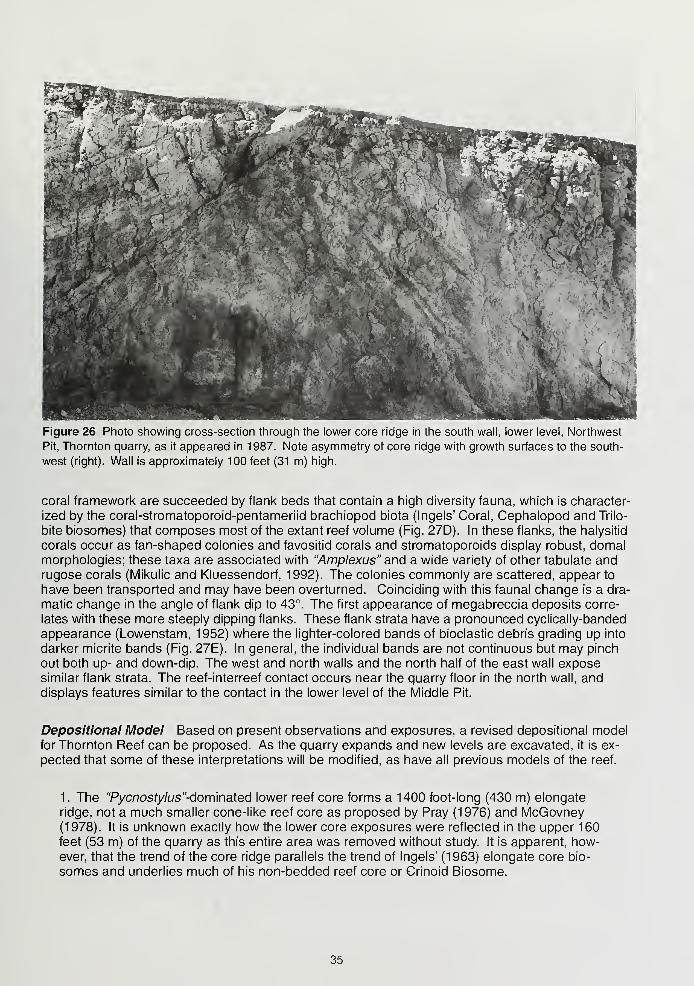
Figure 26 Photo showing cross-section through the lower core ridge in the south wall, lower level, Northwest
Pit, Thornton quarry, as it appeared in 1987. Note asymmetry of core ridge with growth surfaces to the south-
west (right). Wall is approximately 100 feet (31 m) high.
coral framework are succeeded by flank beds that contain a high diversity fauna, which is character-
ized by the coral-stromatoporoid-pentameriid brachiopod biota (Ingels' Coral, Cephalopod and Trilo-
bite biosomes) that composes most of the extant reef volume (Fig. 27D). In these flanks, the halysitid
corals occur as fan-shaped colonies and favositid corals and stromatoporoids display robust, domalmorphologies; these taxa are associated with "Amplexus" and a wide variety of other tabulate andrugose corals (Mikulic and Kluessendorf, 1992). The colonies commonly are scattered, appear to
have been transported and may have been overturned. Coinciding with this faunal change is a dra-
matic change in the angle of flank dip to 43°. The first appearance of megabreccia deposits corre-
lates with these more steeply dipping flanks. These flank strata have a pronounced cyclically-banded
appearance (Lowenstam, 1952) where the lighter-colored bands of bioclastic debris grading up into
darker micrite bands (Fig. 27E). In general, the individual bands are not continuous but may pinch
out both up- and down-dip. The west and north walls and the north half of the east wall exposesimilar flank strata. The reef-interreef contact occurs near the quarry floor in the north wall, anddisplays features similar to the contact in the lower level of the Middle Pit.
Depositional Model Based on present observations and exposures, a revised depositional modelfor Thornton Reef can be proposed. As the quarry expands and new levels are excavated, it is ex-
pected that some of these interpretations will be modified, as have all previous models of the reef.
1. The "Pycnosry/us"-dominated lower reef core forms a 1400 foot-long (430 m) elongate
ridge, not a much smaller cone-like reef core as proposed by Pray (1976) and McGovney(1978). It is unknown exactly how the lower core exposures were reflected in the upper 160feet (53 m) of the quarry as this entire area was removed without study. It is apparent, how-ever, that the trend of the core ridge parallels the trend of Ingels' (1963) elongate core bio-
somes and underlies much of his non-bedded reef core or Crinoid Biosome.
35
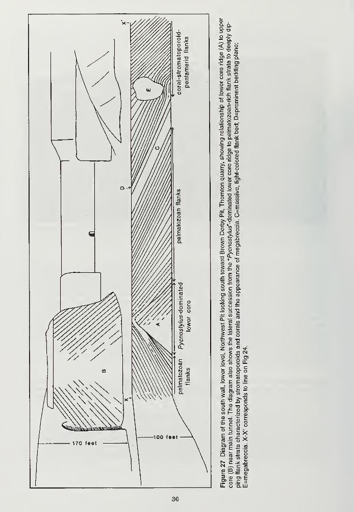
05,
§=5o >-** Q.
< CD CD^"° £en 2 q.
£ « O)
£ i: -Oo « -a
$1e<DCEoQ.
— oo ">=
Q. Clc «« 8§ o Q
2 |S£ § -°
= o «
o 8,
5
"IS^ cd ofc o V
°"CD .5>
c 5 —
L
£ O CD
«" 'p II
Q- o O£? .a
«^ 81=1 ^ £
5 o «i- CJ CD
C° CD „»> ^ CD
j_ E co
~ 2 co
W O Q.o>-55 co
^ CD ^O O ±=O O -D
= IS
^ co jn
$22> co o5 — o
Z. <f>to -*
___ 5 w cvj
CD Q 12 O)> -C O jt
- 2 °^i_ O £> C
| « "CO g-2 E E == S2oj= -o £ c
W I- N £CD —
:
*- t-r o £ o*! £ o oo 5 £ -° 5 io ><
.a ^ T3 5
CM _ C CO
a> co co o>C ^5Z CD
3CD
- CD D) E
U. O Q.LLI
36
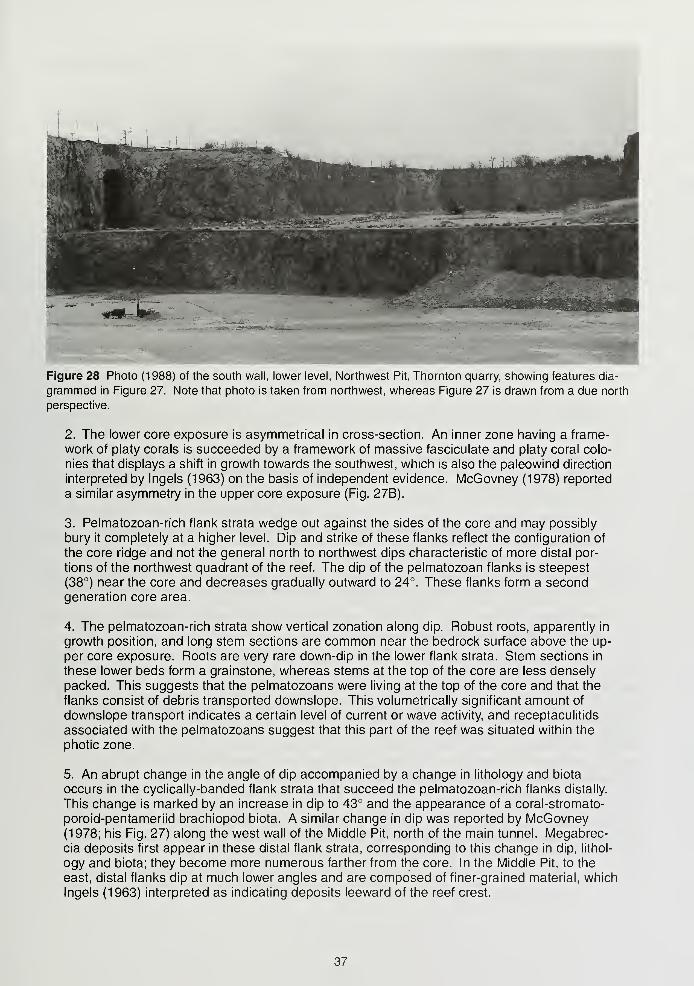
Figure 28 Photo (1988) of the south wall, lower level, Northwest Pit, Thornton quarry, showing features dia-
grammed in Figure 27. Note that photo is taken from northwest, whereas Figure 27 is drawn from a due north
perspective.
2. The lower core exposure is asymmetrical in cross-section. An inner zone having a frame-
work of platy corals is succeeded by a framework of massive fasciculate and platy coral colo-
nies that displays a shift in growth towards the southwest, which is also the paleowind direction
interpreted by Ingels (1963) on the basis of independent evidence. McGovney (1978) reported
a similar asymmetry in the upper core exposure (Fig. 27B).
3. Pelmatozoan-rich flank strata wedge out against the sides of the core and may possibly
bury it completely at a higher level. Dip and strike of these flanks reflect the configuration of
the core ridge and not the general north to northwest dips characteristic of more distal por-
tions of the northwest quadrant of the reef. The dip of the pelmatozoan flanks is steepest
(38°) near the core and decreases gradually outward to 24°. These flanks form a secondgeneration core area.
4. The pelmatozoan-rich strata show vertical zonation along dip. Robust roots, apparently in
growth position, and long stem sections are common near the bedrock surface above the up-
per core exposure. Roots are very rare down-dip in the lower flank strata. Stem sections in
these lower beds form a grainstone, whereas stems at the top of the core are less densely
packed. This suggests that the pelmatozoans were living at the top of the core and that the
flanks consist of debris transported downslope. This volumetrically significant amount of
downslope transport indicates a certain level of current or wave activity, and receptaculitids
associated with the pelmatozoans suggest that this part of the reef was situated within the
photic zone.
5. An abrupt change in the angle of dip accompanied by a change in lithology and biota
occurs in the cyclically-banded flank strata that succeed the pelmatozoan-rich flanks distally.
This change is marked by an increase in dip to 43° and the appearance of a coral-stromato-
poroid-pentameriid brachiopod biota. A similar change in dip was reported by McGovney(1978; his Fig. 27) along the west wall of the Middle Pit, north of the main tunnel. Megabrec-cia deposits first appear in these distal flank strata, corresponding to this change in dip, lithol-
ogy and biota; they become more numerous farther from the core. In the Middle Pit, to the
east, distal flanks dip at much lower angles and are composed of finer-grained material, which
Ingels (1963) interpreted as indicating deposits leeward of the reef crest.
37
6. This shift in the type of flank strata marks a different stage of reef development, probably
into a higher energy environment, which was inhabited by a different biota. Intensified energyrelated to storms and waves may have increased sedimentation rate, generating lateral
growth of the reef and producing steeper flank strata which inundated the underlying, moregently-dipping, pelmatozoan-rich proximal flanks. The appearance of megabreccia deposits,
possibly resulting from intense storms, supports the higher energy interpretation.
7. The surrounding interreef, or open platform, strata are typically argillaceous and contain alow-diversity biota unlike that found within the reef. Reef-derived debris interfingers with, andmay influence, characteristics of proximal interreef strata in places.
8. The exposures at Thornton reveal a three-part succession of reef development:
a. The earliest stage comprises an elongate core ridge characterized by a coral frame-
work dominated by massive fasciculate colonies of "Pycnostylus" in association with
platy corals. Many of the organisms in this part of the reef appear to be in situ. This
stage may have developed below normal wave base, but pronounced lateral zonation
and preferential growth of the corals indicates some directional influence of waves or
currents. This "Pycnostylus-" dominated framework has been found in the earliest de-
velopmental stage of some other Silurian reefs regardless of their size (Mikulic andKluessendorf, 1992).
b. The pelmatozoan-rich grainstone proximal flanks compose the second stage.
These appear to be dominantly downslope gravity deposits of pelmatozoan debris,
some of which was generated at or near the top of the extant upper core. The pel-
matozoan flanks sharply overlie the truncated surface of the core ridge. This abrupt
change in biota and depositional style suggests an increase in energy, likely coinciding
with growth of the reef into storm wave base.
c. The coral-stromatoproid-pentameriid brachiopod flank strata represent the third
stage. The site of reef growth during this stage is not preserved in the truncated extant
reef; only the materials derived from it are represented. A change in coral morphologyfrom fasciculate masses or platy colonies in the earliest stage to robust and domal in
this stage suggests an increase in wave energy, as does the frequency of colony over-
turn. The increased angle of flank dip suggests that the reef was prograding outwardover underlying flanks, and the abundance of these reef-derived bioclastic flanks im-
plies that erosion was vigorous. The appearance of megabreccia deposits at this level
further indicates that available energy was capable of dislodging large amounts andhuge chucks of lithified material and transporting it downslope and even leeward of the
reef. This stage probably indicates that the reef had reached sea level and higher
wave energy, including intense storms, capable of producing increased sediment,
bioclastic debris, and even megaclasts.
This model depicts a generally shallowing-upward sequence that reflects changes in sea level, waveenergy, reef growth, nutrient flux or a combination thereof. These stages are also found in other Si-
lurian reefs to varying extent. The coral colonies show a bathymetric morphological zonation (platy
to fasciculate to domal) related to decreasing water depth and increasing energy. This zonation is
similar to the coral zonation displayed by modern reefs located entirely within the photic zone (see
Hallock and Schlager, 1986). Although absolute depths are unknown, even the lower core ridge ex-
hibits some directional influence as indicated by the asymmetric growth of the coral framework.
Also, receptaculitids in the pelmatozoan flanks imply that some of these were located within the
photic zone. The abundance and fabric (dominantly isopachous and botryoidal) of cement through
all of the developmental stages are indicative of fairly shallow, well-circulating water like that found
in modern reef margins (Harris, era/., 1985). Progradation of the final stage of reef developmentrepresented suggests that by then sea level had become static, that sea level fluctuations weresmall, and/or that reef growth had outpaced changes in water depth.
38
ACKNOWLEDGMENTS
We would like to thank the City of Chicago Department of Streets and Sanitation for permission to
visit the Bridgeport Quarry site and for assistance in our research. We would also like to thank the
Crown family for allowing research and field trips in the Thornton quarry over the last fifty years. In
addition, we appreciate the assistance provided by the following past and present Material Service
employees: Don Stewart, Arnold Sobel, Lyndon Dean, John Halloran, Peter Gaich, Don Wilson,
Phil Peters, Brian Rice, Nancy Doyle, Ron Hartman, Morris Lawereins, Brenda Garcia, Gus Nare,
John Gulich, Leslie Sonnabend, and John Peltz. Elwood Atherton, Francis Pettijohn, George Otto,
Mildred Fenton, and Ruth Doggett Terzaghi provided information about the University of Chicagofield trips to Stony Island and the early research there.
REFERENCES
Alden, W. C. 1902. Description of the Chicago district: Chicago Folio, No. 81 , Geologic Atlas of the
United States. U. S. Geological Survey, 14 p.
Andreas, A. T. 1884. History of Cook County, Illinois. A. T. Andreas, Publisher, Chicago, 888 pp.
Andreas, A. T. 1886. History of Chicago, Illinois. A. T. Andreas, Publisher, Chicago, 876 pp.
Baber, Zonia. 1917. Stony Island: A plea for its conservation. The Geographical Society of Chi-
cago, Excursion Guide No. 3, 16 pp.
Ball, J. R., and K. F. Greacen. 1946. Catalog of the Egan collection of Silurian invertebrate fossils
at the Chicago Academy of Science. Chicago Academy of Science Special Publication 7, 55 pp.
Bannister, H. M. 1868. Geology of Cook County. In A. H. Worthen, Geological Survey of Illinois,
v. III. Geological Survey of Illinois, p. 239-256.
Berry, W. B. N., and A. J. Boucot. 1970. Correlation of the North American Silurian rocks. Geologi-
cal Society of America Special Paper 102, 289 p.
Bretz, J Harlan. 1939. Geology of the Chicago region—general. Illinois State Geological Survey
Bulletin 65, pt. I, 118 pp.
Bretz, J Harlan. 1943. Chicago area geological maps. Illinois State Geological Survey; reissued as
Illinois State Geological Survey Bulletin 65, pt II (supplement).
Cumings, E. R., and R. R. Shrock. 1928. Niagaran coral reefs of Indiana and adjacent states and
their stratigraphic relations. Geological Society of America Bulletin 39: 579-619.
Doggett, R. A. 1925. Origin of the abnormally steep dips in the Niagaran reefs of the Chicago re-
gion. M. S. thesis, University of Chicago, 27 pp.
Fenton, C. L. 1931. Niagaran stromatoporoid reefs of the Chicago region. American Midland
Naturalist 12 (7): 203-212.
Gorby, S. S. 1886. The Wabash Arch. Indiana Department of Geology and Natural History 15th
Annual Report: 228-241
.
Gutschick, R. C. 1987. The Kentland Dome, Indiana: A structural anomaly. In D. L. Biggs (ed.),
North-Central Section of the Geological Society of America Centennial Field Guide Volume 3:
337-342.
Hall, James. 1862. Physical geography and general geology. In James Hall and J. D. Whitney,
Report of the Geological Survey of the State of Wisconsin, Madison, 1 : 1-72.
Hall, James. 1865. Account of some new or little known species of fossils from rocks the age of the
Niagara group. 18th Report of the New York State Cabinet of Natural History, 1-48.
39
Hallock, P., and W. Schlager. 1986. Nutrient excess and the demise of coral reefs and carbonate
platforms. Palaios 1 : 389-398.
Harris, P. M., C.G. St. C. Kendall, and I. Lerche. 1985. Carbonate cementation—a brief review. In
N. Schneidermann and P. M. Harris (eds), Carbonate Cements. Society of Economic Paleon-
tologists and Mineralogists Special Publication No. 36: 79-95.
Hewitt, R., J. Kluessendorf, and D.G. Mikulic. 1987. Taphonomic control of Silurian nautiloid
cephalopods in reef and nonreef environments. Geological Society of America Abstracts with
Programs 19(7).
Holt, G. E., and D. A. Pacyga. 1979. Chicago: a historical guide to the neighborhoods: The Loopand South Side. Chicago Historical Society, 174 pp.
Ingels, J. J. C. 1963. Geometry, paleontology, and petrography of Thornton reef complex, Silurian
of northeastern Illinois. American Association of Petroleum Geologists Bulletin 47: 405-440.
Keifer and Associates, Inc. 1976. Geotechnical design report for the Calumet system of the tunnel
and reservoir plan. Metropolitan Sanitary District of Greater Chicago, 78 pp.
Kluessendorf, J. 1987. First report of Polyplacophora (Mollusca) from the Silurian of North Amer-ica. Canadian Journal of Earth Science 24 (3): 435-441.
Kluessendorf, J., and Mikulic, D. G. 1992. A Silurian (late Llandovery) sequence boundary in Illi-
nois and Wisconsin: Geological Society of America Abstracts with Programs, v. 24.
Kluessendorf, J., and Mikulic, D. G. An early Silurian sequence boundary in Illinois and Wisconsin.
In B.J. Witzke, G.A. Ludvigsen and J. Day (eds), Paleozoic Sequence Stratigraphy: Views from
the North American Craton. Geological Society of America Paper 306: 177-186.
Kluessendorf, J., D. G. Mikulic, and M. R. Carman. 1988. Distribution and depositional environ-
ments of the westernmost Devonian rocks in the Michigan Basin. In H. J. McMillan, A. F.
Embry, and D. J. Glass (eds.), Devonian of the world, Canadian Society of Petroleum Geolo-
gists Memoir 13, 1: 251-263.
Leverett, Frank. 1897. The Pleistocene features and deposits of the Chicago area. Chicago
Academy of Science Bulletin 2, 87 pp.
Lowenstam, H. A. 1942. A Niagaran fauna from the Chicago area with Brownsport and Bainbridge
affinities. Buffalo Society of Natural Sciences Bulletin 17(3): 36-39.
Lowenstam, H. A. 1948. Biostratigraphic studies of the Niagaran interreef formations in northeast-
ern Illinois. Illinois State Museum Scientific Papers 4, 146 pp.
Lowenstam, H. A. 1949. Niagaran reefs in Illinois and their relation to oil accumulation. Illinois
State Geological Survey Report of Investigations 145, 36 pp.
Lowenstam, H. A. 1950. Niagaran reefs of the Great Lakes area. Journal of Geology 58: 430-487.
Lowenstam, H. A. 1952. Some new observations on Niagaran reefs in Illinois. Illinois Academy of
Science Transactions 45: 100-107.
Lowenstam, H. A. 1 957. Niagaran reefs of the Great Lakes area. Geological Society of America
Memoir 67 (2): 215-248.~
Lowenstam, H. A., H. B. Willman, and D. H. Swann. 1956. The Niagaran reef at Thornton, Illinois.
Illinois State Geological Survey Guidebook No. 4, 19 pp.
McGovney, J. E. E. 1978. Deposition, porosity evolution, and diagenesis of the Thornton reef (Silu-
rian), northeastern Illinois. Ph. D. dissertation, University of Wisconsin-Madison, 447 pp.
40
McGovney, J. E. E. 1988. Thornton Reef, Silurian, northeastern Illinois. In H. H. J. Geldsetzer,
N. P. James and G. E. Tebbutt (eds), Reefs, Canada and adjacent area. Canadian Society of
Petroleum Geologists Memoir 13: 330-338.
Mikulic, D. G. 1976. Distribution and community succession of trilobites (Thornton reef, Illinois) In
L. C. Pray, The Thornton reef (Silurian), northeastern Illinois, 1976 revisitation. In Silurian reefs,
interreef facies and faunal zones of northern Indiana and northeastern Illinois. North Central
Section of Geological Society of America Guidebook, Western Michigan State University,
Kalamazoo, 70 pp.
Mikulic, D. G. 1979. The paleoecology of Silurian trilobites, with a section on the Silurian stratigra-
phy of southeastern Wisconsin. Ph. D. dissertation, Oregon State University, Corvallis, 867 pp.
Mikulic, D. G. 1983. Milwaukee's gentlemen paleontologists. Transaction of the Wisconsin
Academy of Sciences, Arts & Letters 71(1): 5-20.
Mikulic, D. G. 1987. The Silurian reef at Thornton, Illinois. In D. L Biggs (ed.), North-Central
Section of the Geological Society of America Centennial Field Guide Volume 3: 209-212.
Mikulic, D. G. 1989. The Chicago stone industry: A historical perspective. In R. E. Hughes and
J. C. Bradbury (eds.), Proceedings of the 23rd Forum on the Geology of Industrial Minerals,
Illinois State Geological Survey Industrial Mineral Note 102: 83-88.
Mikulic, D. G. 1990. Cross section of the Paleozoic rocks of northeastern Illinois: Implications for
subsurface aggregate mining. Illinois State Geological Survey Illinois Minerals 106, 14 pp.
Mikulic, D. G., and J. Goodwin. 1986. Urban encroachment on dolomite resources of the Chicago,
Illinois, area. In J. D. Glaser and J. Edwards (eds.), Proceedings of the 20th Forum on the
Geology of Industrial Minerals: 125-131.
Mikulic, D. G., and J. Kluessendorf. 1985. Classic Silurian reefs of the Chicago area. 49th Annual
Tri-State Geological Field Conference guidebook, University of Illinois-Chicago, 45 pp. (reprinted
with revisions for Michigan Basin Geological Society Field Excursion, 1988; Field Trip #5, 34th
Annual Meeting of the Association of Engineering Geologists, 1991; and Field Trip, Part 1, 1992
American Association of Petroleum Geologists Eastern Section Meeting).
Mikulic, D. G., and J. Kluessendorf. 1992. "Pycnosry/us"-dominated coral framework in Silurian
reefs of the central U. S. Geological Society of America Abstracts with Programs 24.
Mikulic, D. G., and J. Kluessendorf, J. E. E. McGovney, and L. C. Pray. 1983. The classic reef at
Thornton, Illinois. In R. H. Shaver and J. A. Sunderman (eds.), Field trips in midwestern geol-
ogy, vol. 1, Indiana Geological Survey and Geological Society of America: 180-190.
Mikulic, D. G., M. L. Sargent, R. D. Norby, and D. R. Kolata. 1985. Silurian geology of the Des
Plaines River Valley, northeastern Illinois. Illinois State Geological Survey Guidebook 17, 56 pp.
Pettijohn, F. J. 1984. Memoirs of an unrepentant field geologist: A candid profile of some geolo-
gists and their science 1 921 -1 981 . University of Chicago Press, 260 pp.
Pray, L. C. 1976. The Thornton reef (Silurian), northeastern Illinois, 1976 revisitation. In Silurian
reefs, interreef facies and faunal zones of northern Indiana and northeastern Illinois. North
Central Section of Geological Society of America Guidebook, Western Michigan State Univer-
sity, Kalamazoo, 70 pp.
Salisbury, R. D., and W. C. Alden. 1899. The geography of Chicago and its environs. The Geo-
graphical Society of Chicago Bulletin 1, 64 pp.
Savage, T. E. 1926. Silurian rocks in Illinois. Geological Society of America Bulletin 37(4): 513-533.
Weiner, W. F., and A. F. Koster van Groos. 1976. Petrographic and geochemical study of the for-
mation of chert around the Thornton reef complex, Illinois. Geological Society of America Bulle-
tin 87: 310-318.
41
Willman, H. B. 1943. High-purity dolomite in Illinois. Illinois State Geological Survey Report of
Investigations 90, 87 pp.
Willman, H. B. 1973. Rock stratigraphy of the Silurian System in northeastern and northwestern
Illinois. Illinois State Geological Survey Circular 479, 55 pp.
Willman, H. B., H. A. Lowenstam, and L. E. Workman. 1950. Field conference on Niagaran reefs
in the Chicago region. Illinois State Geological Survey Guidebook 1 , 23 pp.
Winchell, A. N., and O. Marcy. 1865. Enumeration of fossils collected in the Niagara limestone at
Chicago, Illinois, with descriptions of several new species. Boston Society of Natural History
Memoir 1:81 -11 3.
Worthen, A. H. 1862. Remarks on the age of the so-called "Leclare Limestone" and "Onondaga
Salt-Group" of the Iowa report. American Journal of Science, series 2, no. 97, article VI: 46-48.
42
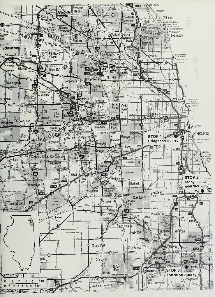
Kenitworth
DYCHE \ HAnOHAHOWS
i^lilA^Evanston
fMMSTONHOSP.
<EMMUCOi£G£•ji G4AAF7T-£VAW»fi.>'C«.* THEOLOGICAL SEW4^-WTTWWESTEfiK
OFCMCAQQI
MtAMDa£WCat£G£
JU.YHC G WE
on tvw scwouCOLLEGE Of
CHICAGO