Embed Size (px)
Citation preview
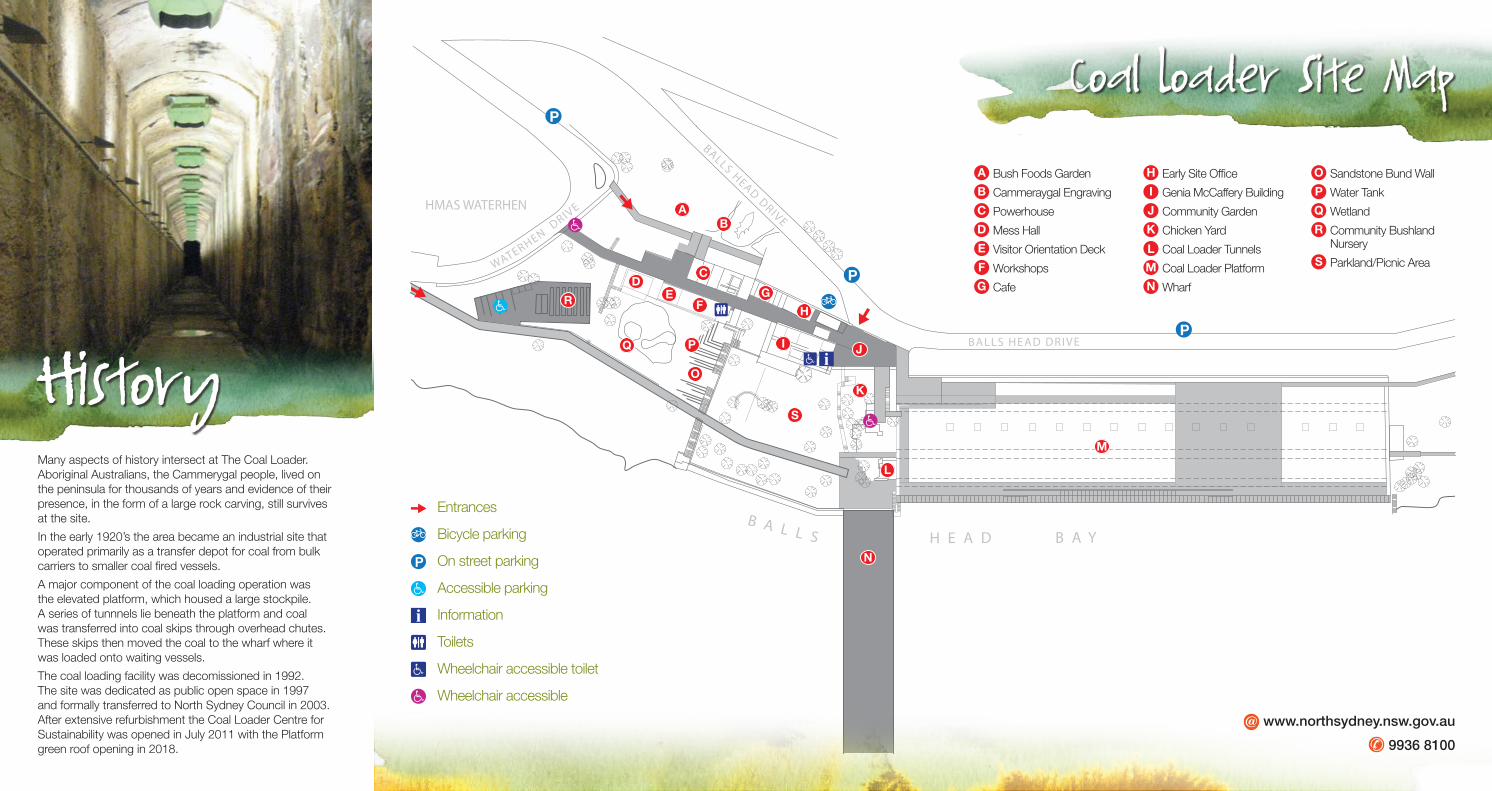
A Bush Foods Garden Following removal of a road a bush foods garden was planted that features a variety of edible and useful native plants.
B Cammeraygal Engraving
Before white settlement this area was home to the Cammeraygal people. The engravings were buried under a road in the early 1900s, and excavated a century later. The larger engraving of a whale or shark is part of a group of engravings including fish, turtles and spirit figures.
C Powerhouse Built in 1926 to provide electrical power for the Coal Loader, and now home to the North Sydney SES. The timber panels on the bottom of the windows, and the round windows at the top, provided ventilation to dissipate heat from the electrical transformers.
D Mess Hall Constructed in the 1920s to provide eating and showering facilities for workers. Since closure of coal-loading operations in 1992, the building has been used as accommodation, a recreational room, music recording studio and now a meeting room.
E Visitor Orientation DeckOverlooking the man-made wetland, the deck showcases site maps and information on the site’s history.
F Workshops A small team of tradespeople including blacksmiths, carpenters and welders maintained machinery and infrastructure here.
G CafeNow a café, this was originally a workshop used for maintenance of electrical equipment and combustion engines. The original sandstone wall and steel railway track framing remain.
H Early Site OfficeThis building was one of the first buildings on the site and initially operated as the site/pay office. The cage on the southern wall contained the Bundy clock and equipment, for workers to sign in and out.
I Genia McCaffery Building
Constructed in the mid 1920s, this building was the administration office and then site caretaker’s cottage. Renamed in 2012 in honour of North Sydney’s long term Mayor, the building is now being used as a sustainability learning centre.
J Community GardenOriginally a vehicle parking area and then caretakers courtyard garden between 1992 and 2006, this area is now one of the community gardens on site. The garden was established in 2007.
K Chicken YardOriginally an old shed, even the chook yard follows adaptive reuse principles. The chickens are maintained by volunteers from the community garden group who are rewarded daily with fresh eggs.
L Coal Loader TunnelsThese tunnels feature remnants of the different coal loading systems. In the 1920s coal was unloaded from large ships (colliers) and dumped on the platform above by cranes that moved along the seawall. Chutes in the tunnel roof released the coal into elevated travelling ‘feeders’ which directed coal into skips below. When full, the skips travelled onto the adjacent wharf to discharge their coal onto waiting ships. A conveyor system was introduced in the ‘70s. Tunnel 1, closest to the harbour’s edge, retains the travelling feeder and a coal-loading skip. This is the last of 33 working skips on the site.Tunnel 2 is open 24/7 and links through to the adjacent Balls Head Reserve walking track. It is lit by automatic sensor lighting.Tunnel 3 has been lined with 50 rainwater tanks capturing 275,000L of water that is used for irrigation of the green roof above.Tunnel 4 provides an important seasonal roosting site for a threatened species of micro-bat called Eastern Bent-wing Bat (Miniopterus schreibersii).
M Coal Loader PlatformBuilt on the old coal loading platform, this green roof consists of community garden plots irrigated by recycled stormwater, aquaculture beds, an urban fruit tree forest, performance space, seating and viewing areas, heritage
interpretation of the original coal loading operations, a 50kw solar PV system, and a native garden demonstration area.
N WharfFrom 1921 to 1976 coal skips transported coal out along the wharf. Two large gantry moved along the wharf depositing the coal into the bunkers of the docked ship. A conveyor system was used from 1976.
O Sandstone Bund WallThe original stone wall separated two oil tanks and acted as a bund for spills. It was reconstructed in 2010.
P Water TankLocated underneath these terraces is a 65,000 litre tank. Rain water is captured on the roofs of nearby buildings and is used for toilet flushing, garden and nursery irrigation.
Q WetlandThis thriving wetland now occupies the former site of one of two Union Steam Shipping Co. fuel tanks, which were removed in the 1980s. A wetland was developed in the 1990s on the sandstone bedrock as part of site remediation works, by the then site caretaker.
R Community Bushland Nursery
Community volunteers work with Council to propagate local native plants that are used for local vegetation restoration and green corridor projects.
S Parkland/Picnic Area
The Coal Loader demonstrates the layering of human history, from the ancient culture of the Cammeraygal people, to an industrial coal bunkering facility, to a showcase for sustainability.
Be inspired by innovative sustainable design and technology, community gardens, native plant nursery, regenerated parklands and much more.
the Coal Loader Centre for SuStainability
the Coal Loader Centre for SuStainability
Printed on ecoStar – a Carbon Neutral, FSC 100% post consumer recycled paper product using vegetable oil-based inks and an environmentally friendly alcohol-free printing process. ecoDesign ecoPrint FSC chain of custody No. QMI-COC-001113
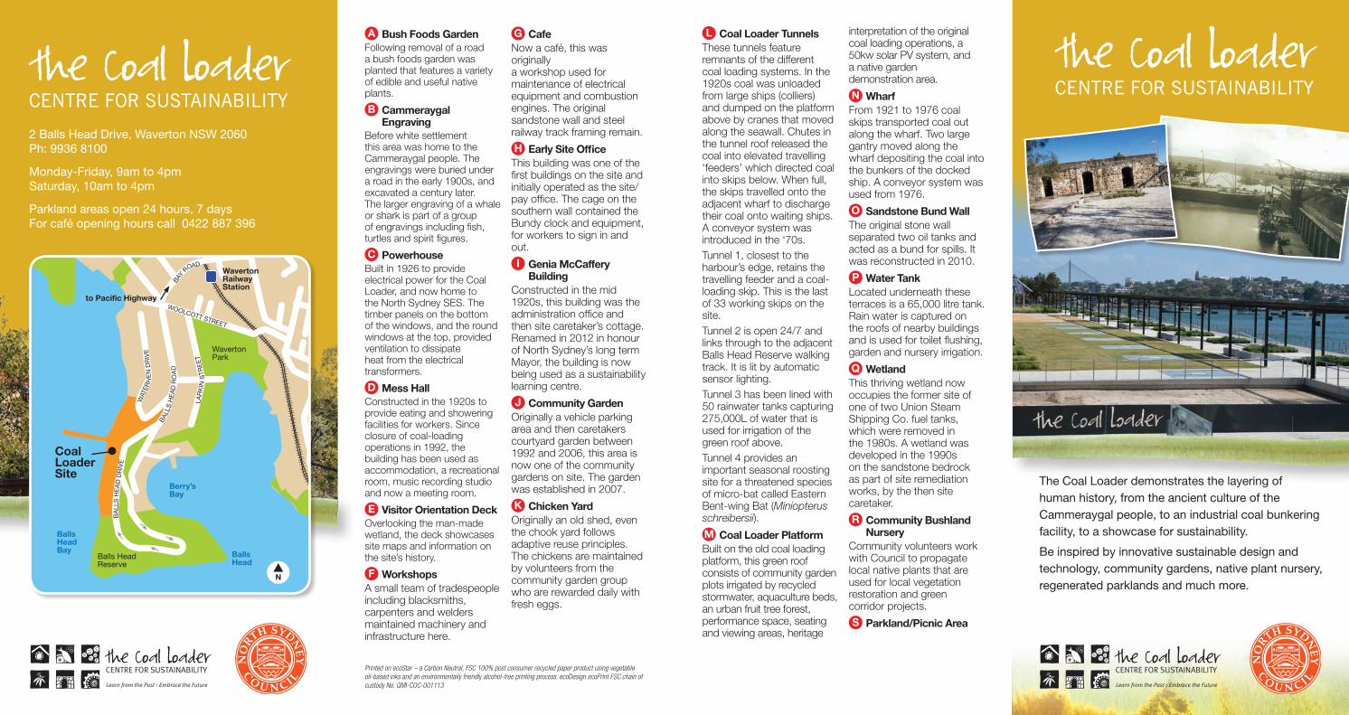
Coal Loader Site
Waverton RailwayStation
to Pacific Highway
BA
LLS
HE
AD
DR
IVE
BA
LLS
HE
AD
RO
AD
BAY R
OAD
WAT
ERH
EN
DR
IVE
LAR
KIN
STR
EE
T
WOOLCOTT STREET
N
Balls Head
Balls Head Reserve
WavertonPark
Balls HeadBay
Berry’sBay
2 Balls Head Drive, Waverton NSW 2060 Ph: 9936 8100
Monday-Friday, 9am to 4pm Saturday, 10am to 4pm
Parkland areas open 24 hours, 7 daysFor café opening hours call 0422 887 396
CENTRE FOR SUSTAINABILITY
Learn from the Past : Embrace the Future
CENTRE FOR SUSTAINABILITY
Learn from the Past : Embrace the Future
HMAS WATERHEN
WATERHEN DRIV
E
BALLS HEAD DRIVE
BALLS HEAD DRIVE
H E A D B A YB A L L S
P
P
P
A
DE
F
B
C
G
H
K
L
M
N
S
O
PQ
R
JI
Entrances
Bicycle parking
On street parking
Accessible parking
Information
Toilets
Wheelchair accessible toilet
Wheelchair accessible
www.northsydney.nsw.gov.au
9936 8100
HistoryMany aspects of history intersect at The Coal Loader. Aboriginal Australians, the Cammerygal people, lived on the peninsula for thousands of years and evidence of their presence, in the form of a large rock carving, still survives at the site.
In the early 1920’s the area became an industrial site that operated primarily as a transfer depot for coal from bulk carriers to smaller coal fired vessels.
A major component of the coal loading operation was the elevated platform, which housed a large stockpile. A series of tunnnels lie beneath the platform and coal was transferred into coal skips through overhead chutes. These skips then moved the coal to the wharf where it was loaded onto waiting vessels.
The coal loading facility was decomissioned in 1992. The site was dedicated as public open space in 1997 and formally transferred to North Sydney Council in 2003. After extensive refurbishment the Coal Loader Centre for Sustainability was opened in July 2011 with the Platform green roof opening in 2018.
Coal Loader Site Map
A Bush Foods Garden
B Cammeraygal Engraving
C Powerhouse
D Mess Hall
E Visitor Orientation Deck
F Workshops
G Cafe
H Early Site Office
I Genia McCaffery Building
J Community Garden
K Chicken Yard
L Coal Loader Tunnels
M Coal Loader Platform
N Wharf
O Sandstone Bund Wall
P Water Tank
Q Wetland
R Community Bushland Nursery
S Parkland/Picnic Area