Embed Size (px)
Citation preview
The coastal handbook A guide for all those working on the coast
A collaborative project between the Environment Agency and Maritime Local Authorities June 2010
GEHO0610BSUE-E-E

2
Foreword
The coast is a dynamic and exciting place that engenders strong feelings in all
those that live, work and play there. It’s a complex environment and our
decisions can have lasting impacts spanning hundreds of years so it’s
important that those of us who manage the coast seek to understand it and
work together to ensure that the legacy we leave for future generations is a
good one.
This handbook brings together the information most relevant to coastal
practitioners planning or undertaking work on the coast. This is the second edition of the Coastal handbook and it has been updated
and expanded as part of a collaborative project between the Environment
Agency and Local Authorities.
We hope that you will find it an essential companion to your work on the
coast.
David Rooke
Acting Director Flood & Coastal Risk Management
Environment Agency
Bryan Curtis
Chair of Coastal Group Chairs

3
Outline Contents
Chapter 1: Introduction 12
Chapter 2: The Environment Agency’s Role on the Coast 13
Chapter 3: Roles and Responsibilities 23
Chapter 4: Coastal Groups 45
Chapter 5: Legislation 50
Chapter 6: Climate Change 69
Chapter 7: Shoreline Management Plans, Coastal Strategies and Schemes
78
Chapter 8: Funding Guidance 102
Chapter 9: Approval Process for Studies, Strategies and Projects 117
Chapter 10: Asset Management 128
Chapter 11: Coastal Mapping 136
Chapter 12: Coastal Monitoring 142
Chapter 13: Coastal Change, Adaptation, Resilience and Land Management
154
Chapter 14: Planning Policy 165
Chapter 15: Communications and Engagement 171
Chapter 16: The Marine Environment 182
Chapter 17: Evidence: Research and Development 189
Chapter 18: Further Coastal Guidance and Tools 194
Appendix: Commentary on the Coast Protection Act 211

4
Detailed Contents Page Chapter 1: Introduction 12 1.1 Purpose of this Coastal Handbook and intended
audience 12
1.2 Authors and ownership 12 Chapter 2: The Environment Agency’s Role on the Coast 13 2.1 Purpose of this chapter 13 2.2 The strategic overview 13 2.2.1 Timeline and drivers for change in England 14 2.2.2 The development of the coastal strategic overview role in
England 15
2.2.3 The inland strategic overview role in England 16 2.3 Delivering the coastal strategic overview role in England 17 2.3.1 Outcomes of the strategic overview on the coast 19 2.3.2 Differences between the old and new approach 19 2.3.3 Activities involved in delivering the coastal strategic
overview 20
2.4 Vision and strategy for the coast 22 Chapter 3: Roles and Responsibilities 23 3.1 Purpose of this chapter 23 3.2 Government level 23 3.2.1 Defra roles and responsibilities 23 3.2.2 Communities and Local Government roles and
responsibilities 24
3.2.2.1 Planning policy in England 24 3.2.2.2 Planning policy in Wales 24 3.2.2.3 Building regulations 25 3.2.2.4 Flood recovery 25 3.2.2.5 Revenue support grant 26 3.2.3 Regional Government offices in England 26 3.2.4 Welsh Assembly Government 26 3.2.4.1 Environment Strategy for Wales 27 3.2.4.2 New Approaches Programme 27 3.2.4.3 The Welsh Language Act 1993 27 3.2.5 The Scottish Executive 27 3.2.6 Scottish Environment Protection Agency 28 3.3 Operating Authorities 28 3.3.1 Environment Agency roles and responsibilities 28 3.3.1.1 Environment Agency corporate strategy 28 3.3.1.2 Environment Agency structure 28 3.3.1.3 Environment Agency’s roles and responsibilities on the
coast 30
3.3.1.4 Resources to deliver the strategic overview role in England
31
3.3.1.5 Environment Agency staff with specific coastal roles 31 3.3.1.6 Environment Agency Coastal Area Contacts 34

5
3.3.2 Local Authority roles and responsibilities 36 3.3.2.1 Local Government structure 36 3.3.2.2 Local Authority roles and responsibilities on the coast 36 3.3.2.3 Planning responsibilities 37 3.3.3 Internal Drainage Board roles and responsibilities 38 3.4 Executive and advisory bodies 38 3.4.1 Regional Flood Defence/Flood and Coastal Committees 38 3.4.1.1 Extension of Regional Committee roles (RFDC to RFCC) 39 3.4.1.2 Regional Flood Defence Committee membership and
boundaries 39
3.4.2 Coastal Groups 41 3.5 Other key groups, bodies and organisations 41 Chapter 4: Coastal Groups 45 4.1 Purpose of this chapter 45 4.2 Coastal Groups 45 4.3 Coastal Group details 46 4.4 Coastal Group boundaries 46 4.5 Annual reporting 48 4.6 National Coastal Forum 48 4.7 Wales Coastal Forum 49 Chapter 5: Legislation 50 5.1 Purpose of this chapter 50 5.2 National Legislation 50 5.2.1 Flood and Water Management Act 2010 50 5.2.2 Flood and Water Management Act 2010 and the coast 51 5.2.3 Coast Protection Act 1949 52 5.2.4 Water Resources Act 1991 54 5.2.5 Land Drainage Act 1991 55 5.2.6 Environment Act 1995 55 5.2.7 Town and Country Planning Act 1990 56 5.2.8 Harbours Act 1964 57 5.2.9 The Food and Environment Protection Act 1985 – FEPA
licences 58
5.2.10 Marine and Coastal Access Act 2009 58 5.2.11 Bye laws 59 5.3 International Legislation 60 5.3.1 Floods Directive 60 5.3.2 Water Framework Directive 60 5.3.3 Habitats and Birds Directives 61 5.3.3.1 Regional Habitat Creation Programmes 62 5.3.4 Strategic Environmental Assessment Directive 64 5.3.5 Environmental Assessment Directive 65 5.3.6 Marine Strategy Framework Directive 68 Chapter 6: Climate Change 69 6.1 Purpose of this chapter 69 6.2 UK Climate Projections Programme (UKCP09) 69 6.3 Climate trends and projections 69

6
6.4 Climate change impacts on flood and coastal erosion risk
72
6.5 UK Government’s response to managing coastal climate change risks
73
Chapter 7: Shoreline Management Plans, Coastal Strategies and
Schemes 78
7.1 Purpose of this chapter 78 7.2 Background and context 78 7.2.1 What is a Shoreline Management Plan 79 7.2.2 Why have Shoreline Management Plans 79 7.2.3 Shoreline Management Plan policy options 80 7.2.4 Shoreline Management Plans, coastal defence
strategies and schemes 81
7.2.5 First generation Shoreline Management Plans 81 7.2.6 Pilot second generation Shoreline Management Plans 85 7.2.7 Second generation Shoreline Management Plans 85 7.3 Shoreline Management Plan guidance 86 7.3.1 Shoreline Management Plans and the Water Framework
Directive and Floods Directive 87
7.3.2 Shoreline Management Plans and Strategic Environmental Assessments
88
7.3.3 Appropriate Assessments 88 7.3.4 Cases of overriding public interest (IROPI) 89 7.3.5 Coastal Habitat Management Plans 90 7.3.6 Catchment Flood Management Plans and estuaries 90 7.3.7 Outcome Measure for Shoreline Management Plans in
England 91
7.4 Shoreline Management Plan development, Action Plans and review
91
7.4.1 Shoreline Management Plan programme and location map
91
7.4.2 Shoreline Management Plan Action Plans 92 7.4.3 Strategic Environmental Assessment Post Adoption
Statements 93
7.4.4 Approval route for Shoreline Management Plans 94 7.4.5 Shoreline Management Plan Quality Review Group 95 7.4.6 Quality Review Group Terms of Reference 95 7.4.7 Quality Review Group process 96 7.4.8 Shoreline Management Plan query log and lessons
learnt 98
7.4.9 Change process for amending Shoreline Management Plans
98
7.5 Wider Shoreline Management Plan links 98 7.5.1 Improving ‘dialogue’ between Shoreline Management
Plans and spatial planning 99
7.5.2 Shoreline Management Plans and PPS25 Supplement – Development and Coastal Change
100
7.5.3 Shoreline Management Plans and the National Coastal Erosion Risk Information Project
100

7
7.5.4 Shoreline Management Plans and coastal defence assets
101
7.5.5 Landfill sites and coastal erosion 1017.5.6 Funding of land instability 101 Chapter 8: Funding Guidance 1028.1 Purpose of this chapter 1028.2 Funding responsibilities under the strategic overview 1028.3 Grant Memoranda 1038.3.1 Grant Memorandum for Coastal Erosion 1038.3.2 Grant Memorandum for Flood Risk Management 1038.3.3 Arrangements for using Coast Protection Act 1949 or
Land Drainage Act 1991 104
8.4 How projects are funded 1048.4.1 Local Authority funding 1048.4.2 Internal Drainage Board funding 1058.4.3 External contributions 1058.4.4 Long Term Investment Strategy 1058.4.5 Proposed changes as a result of the Flood and Water
Management Act 2010 105
8.5 How funding is allocated 1068.5.1 Outcome Measures 1068.5.2 Medium Term Plan (MTP) 1088.6 Application for funding 1108.6.1 Guidance for Local Authorities and Internal Drainage
Boards 110
8.6.2 Guidance for Maritime Local Authorities 1108.7 Quality assurance 1128.8 Objections to coastal projects 1128.9 Local government finance 1138.10 Funding arrangements in Wales 1148.10.1 Current funding arrangements 1148.10 2 Environment Agency Grant-in-Aid 1158.10.3 Local Authority Funding 1158.10 4 European Union funding 1168.10.5 Future funding 116 Chapter 9: Approval Process for Studies, Strategies and
Projects 117
9.1 Purpose of this chapter 1179.2 Project appraisal policy and guidance 1179.2.1 Environmental assessment 1189.2.2 The appraisal report 1189.3 Applying for grant 1199.3.1 Flood defence schemes promoted under the Land
Drainage Act 1991 119
9.3.2 Maritime authorities applying for grant under the Coast Protection Act 1949
119
9.3.3 Grant approval 1209.4 Studies and strategies 120

8
9.5 Emergency works 1209.6 Process to gain approval of application 1219.6.1 National Review Group (NRG) 1229.6.2 Project Assessment Board (PAB) 1229.6.3 From approval to funding 1229.7 Payment of grant aid 1229.8 Project start and completion 1239.9 Approval of financial variations 1249.10 Monitoring expenditure 1249.11 Environment Agency and Local Authority procurement
frameworks 124
9.12 Guidance for Environment Agency staff 1259.13 Funding allocation in Wales 1269.13.1 Project Appraisal Guidance 1269.13.2 Studies and strategies 1269.13.3 Emergency works in Wales 1279.13.4 Process to gain approval of application 1279.13.5 Payment of grant aid 1279.13.6 Approval of financial variations 1279.13.7 Monitoring expenditure 1279.13.8 Guidance for Environment Agency Wales staff 127 Chapter 10: Asset Management 12810.1 Purpose of the chapter 12810.2 The role of asset management 12810.2.1 Coast protection and sea defence assets 12810.2.2 Asset management and the Flood and Water
Management Act 2010 129
10.3 Asset inspections, recording and maintenance 13010.3.1 Aid to navigation assets 13010.3.2 Asset data recording 13110.3.3 Risk based coastal maintenance 13210.3.4 System Asset Management Plans 13210.3.5 Maintenance of uneconomic sea defences 13310.4 Asset management research and development 13410.4.1 Beach Management Manual 13410.4.2 Scoping the R&D requirements for coastal asset
management 135
Chapter 11: Coastal Mapping 13611.1 Purpose of this chapter 13611.2 Flood risk map 13611.3 Coastal erosion risk information 13611.3.1 Publication of erosion risk information 13711.4 Coastal overview map for England 13811.4.1 Legislation definition GIS base layer 13811.4.2 Coastal operational GIS layer 13811.4.3 Access to data 13911.5 Planning maps and coastal change management areas
in England 140

9
Chapter 12: Coastal Monitoring 14212.1 Purpose of the chapter 14212.2 Role of coastal monitoring 14212.2.1 What is coastal monitoring 14212.2.2 Why coastal monitoring is important 14312.2.3 Background to coastal monitoring programmes 14312.3 Regional coastal monitoring programmes 14312.3.1 North East (cell 1) regional coastal monitoring
programme 146
12.3.2 East Riding of Yorkshire (cell 2A) regional coastal monitoring programme
146
12.3.3 Anglian (cells 2 and 3) regional coastal monitoring programme
147
12.3.4 South East (cells 4 and 5) regional coastal monitoring programme
147
12.3.5 South West (cells 6 and 7) regional coastal monitoring programme
148
12.3.6 North West (cell 11) regional coastal monitoring programme
148
12.4 Wales coastal monitoring programme 14912.5 The future of coastal monitoring in England 14912.5.1 Benefits of coastal monitoring 15012.5.2 Channel Coastal Observatory 15012.5.3 Wales coastal monitoring centre 15112.6 Other coastal monitoring programmes and services 15112.6.1 UK Coastal Monitoring and Forecasting (UKCMF) 15112.6.2 Flood Forecasting Centre 15212.6.3 Marine Monitoring Service 15212.6.4 Biodiversity Action Plan (BAP) monitoring 153 Chapter 13: Coastal Change, Adaptation, Resilience and Land
Management 154
13.1 Purpose of this chapter 15413.2 Coastal change and adaptation 15413.2.1 Developing the adaptation agenda in England 15413.2.2 Adaptation to coastal change 15513.2.3 Adapting to coastal change: developing a policy
framework 156
13.2.4 Coastal change pathfinders 15613.2.5 Guidance for community adaptation planning and
engagement 157
13.3 Flood protection and resilience 15713.3.1 Property level flood protection grant scheme in England 15713.3.2 Property level flood protection grants in Wales 15813.3.3 Improving access to advice 15813.3.4 Code for Sustainable Homes 15913.3.5 Guidance for new buildings 15913.4 Land management 15913.4.1 Managed re-alignment and possible changes in the
maintenance of existing but uneconomic defences 160

10
13.4.2 Coastal Futures – A case study for supporting communities through coastal change on the Humber Estuary
161
13.4.3 Valuing non-monetary benefits 16213.5 Examples of adapting to coastal change 162 Chapter 14: Planning Policy 16514.1 Purpose of this chapter 16514.2 Governments approach to coastal planning in England 16514.3 Planning policy for coastal change in England – the new
PPS25 supplement ‘Development and Coastal Change’ 165
14.3.1 Coastal Change Management Areas 16614.4 PPS25 and coastal planning 16714.5 Planning Policy in Wales 16814.5.1 TAN14 – Coastal Planning 16914.5.2 TAN15 – Development and Flood Risk 16914.6 Environment Agency’s role in development and coastal
change 170
Chapter 15: Communications and Engagement 17115.1 Purpose of this chapter 17115.2 Importance of communication and engagement 17115.2.1 Coastal Engagement Officers 17115.2.2 Better Engagement and Risk Communication 17215.2.3 Flood Awareness Wales 17315.3 The DAD and EDD approach 17315.4 Engagement and communication tools 17515.4.1 Building Trust with Communities Toolkit 17615.4.2 The ABC decision making tool 17615.4.3 ‘How to’ guides 17815.4.4 Community adaptation planning and engagement tools 17815.4.5 Coastal landowner engagement pack 17915.4.6 Mentoring 18015.4.7 Engagement training courses 18015.4.8 Stakeholder engagement contract 18015.4.9 Coastal engagement case studies 181 Chapter 16: The Marine Environment 18216.1 Purpose of this chapter 18216.2 Implications of the Marine and Coastal Access Act 2009
for flood and coastal risk management 182
16.2.1 The Marine Management Organisation 18316.2.2 Marine Planning – Marine Policy Statements and Marine
Plans 183
16.2.3 Marine Licensing 18416.2.4 Marine Conservation Zones 18516.2.5 Inshore Fisheries 18616.2.6 Freshwater Fisheries 18716.3 Requirements of the Marine Strategy Framework
Directive 187
11
Chapter 17: Evidence: Research and Development 18917.1 Purpose of this chapter 18917.2 Environment Agency Evidence Directorate 18917.3 Joint Defra/EA Flood and Coastal Erosion Risk
Management R&D Programme 189
17.3.1 Objective of the programme 19017.3.2 Programme research areas 19117.3.3 Programme communications 19217.4 Project summaries catalogue 19217.5 Coastal science framework 193 Chapter 18: Further Coastal Guidance and Tools 19418.1 Purpose of this chapter 19418.2 Skills capacity and training 19418.2.1 Environment Agency training 19418.2.2 Graduate and foundation degree programmes 19518.2.3 Flood and Coastal Risk Management Conference 19618.2.4 Local Authority clusters 19618.2.5 Flood and coastal risk management portal 19718.3 Coastal case studies 19718.4 Coastal risk management non-technical guide 19718.5 Futurecoast 19718.6 CoastRanger 19818.7 Integrated coastal zone management 19818.8 Coastal access 19918.9 Managed Realignment Electronic Platform 20018.10 Regional Habitat Creation Programme 20118.11 Land purchase 20218.12 Coastal squeeze 20318.13 Estuary Edges: ecological design guidance 20418.14 Marine sediments from capital and maintenance
dredging 204
18.15 Coastal regeneration handbook 20418.16 National Indicators for English Local Authorities 20418.17 Local Area Agreements 20618.18 Local Strategic Partnerships 20718.19 Local Development Frameworks and Plans 20718.20 Guidance on Parliamentary Questions 20818.21 Purdah period 20818.22 Key Environment Agency coastal policies and guidance
notes 208
Appendix: Commentary on the Coast Protection Act 211

12
CHAPTER 1: Introduction 1.1 Purpose of this Coastal Handbook and intended
audience This is your coastal library. It is a single reference point for information that currently exists on the coast. Its aim is to help and guide practitioners in managing the coast. The Coastal Handbook is a technical guide for all operating authorities on the coast. It is intended to act as a reference point so each chapter starts with a short summary and three key ‘must remember’ points to help the reader. This second edition has been developed in partnership with Local Authorities and has been written for, and by, Local Authority and Environment Agency practitioners working on the coast in England and Wales. It will help Local Authority and Environment Agency staff have a common understanding of how each other operates. Coastal management is a rapidly developing field so some information within this document will become out of date. Wherever possible weblinks have been provided which should be used to find the latest information. Some information is specific to Environment Agency staff and only available through the Environment Agency’s intranet. Should a Local Authority officer require further information on these topic areas they should contact their local area office. The Environment Agency takes no responsibility for the content of external websites. This handbook is applicable across England and Wales; where differences exist in the arrangements in England and Wales these have been explained. 1.2 Authors and ownership The Environment Agency’s National Coastal Team has written this handbook with input from Environment Agency Area and Regional staff, Environment Agency Wales, and Local Authorities. The author would like to thank all those who have contributed to its development. Version Author(s) Comments
1 Nick Lyness and Jennifer Hines Published May 2008 (Environment Agency internal only)
2 Jennifer Hines Published June 2010 (on Environment Agency website)

13
CHAPTER 2: The Environment Agency’s Role on the Coast 2.1 Purpose of this chapter This chapter describes the Environment Agency’s strategic overview role on the coast in England and the oversight role in Wales, what it means in practice and the links to the inland overview role. The top three things to remember are:
Understanding the past helps to understand where we are today Both Local Authorities and the Environment Agency have important
roles to play Partnership working is key to the successful delivery of the coastal
strategic overview 2.2 The strategic overview The coastal overview joins up coastal management activities on the coast to ensure flooding and erosion risk is managed effectively. This section outlines the key aspects of the overview. The strategic overview:
1. Sets the direction for how flood and coastal risk is managed (through the Shoreline Management Plans)
2. Ensures the strategic direction is delivered (through approving investment schemes and allocating grant)
3. Facilitates joined–up working with all those working on the coast 4. Responds to the needs of communities
The overview encourages operating authorities work together in partnership to achieve effective management of coastal flooding and erosion risks. To do this it is important that each have a clear understanding of their respective roles. The Environment Agency has the overview role in England. In Wales the Welsh Assembly Government (WAG) has retained a leadership role for strategic flood and coastal risk management delivery. The existing supervisory role the Environment Agency held in relation to flooding has been extended to include coastal erosion and the Environment Agency will have a key role in supporting WAG in the day to day delivery of its policy objectives and coordinating their implementation. Central to this will be joining up coastal management activities around the Welsh coast, and ensuring all risks, whether flooding of erosion based, are managed effectively. To do this the Environment Agency will lead on the coordination and implementation of

14
Welsh Assembly Government strategies and policies, representing the Welsh Ministers. Over time this role may evolve further, taking on additional aspects of the overview role in England. Similar to England the Welsh Assembly Government wishes to see:
A management approach that is risk driven Partnership working between all operating authorities Clarity on roles and responsibilities Greater engagement with those at risk so they understand the risks
they face and the options available to them The Welsh Assembly Government has retained control over flood and coastal risk funding allocations which will help them drive this approach into practice. Under these arrangements, the Environment Agency will continue to lead on coastal flooding while Local Authorities will continue to lead on erosion, under the Welsh Assembly Government’s leadership. The Environment Agency in Wales will:
Engage with coastal partners to promote partnership working and a strategic approach to risk management on the coast
Quality review and approve all SMPs, ensuring the strategic direction of the coast is consistent, sound and sustainable
Monitor and report to Welsh Assembly Government on the delivery of its strategic objectives for the coast
Provide technical support to Welsh Assembly Government and coastal erosion risk management authorities in delivery of the risk management approach
Allocate all flood risk management capital funding The following section gives a timeline and summaries the drivers and events that led to the Environment Agency’s strategic overview role in England. 2.2.1 Timeline and drivers for change in England Timeline for change:
2004 Foresight Future Flooding Report was published March 2005 UK Government stated in Making Space for Water First
Government Response that the Environment Agency would have a “strategic overview for all flood and coastal erosion risk management” in England
Summer 2006 public consultation on this role June 2007 Defra announced the approach the strategic overview on
the coast would take June 2007, Defra, Environment Agency and Local Government
Association (LGA) developed a detailed implementation plan April 2008 Environment Agency took on the new strategic overview role
on the coast in England

15
The Foresight Future Flooding Report (2004) explored the risks of flooding and coastal erosion, how they may change in the UK over the next 100 years and the options for UK to take in responding to these challenges. The report estimated that annual average flood damages could increase by between 2 and 20 times by the end of the century. The findings highlighted the pressing need for a “comprehensive, integrated and forward-thinking strategy for managing future flood and coastal erosion risks in England” – Making Space for Water. The Foresight Future Flooding Report, reinforced by a number of serious flooding events, became a key driver for the development of Making Space for Water, and consequently the Environment Agency’s strategic overview role.
Foresight Future Flooding Report In 2004 Defra consulted on a new cross-Government strategy for the future management of flood and coastal erosion risks: Making space for Water. The Government’s Response (2005) stated that our understanding of risk would increasingly drive our activities and that a holistic, whole catchment and whole shoreline approach should be taken to managing those risks. To support this the Environment Agency would take an overarching strategic overview across all flooding and coastal erosion risks.
Making Space for Water First Government Response Document 2.2.2 The development of the coastal strategic overview role in England A Project Board comprising Defra, the Environment Agency and the LGA considered different proposals for the overview, reviewed legislative and institutional arrangements and considered the impacts of Integrated Coastal Zone Management (ICZM), the Water Framework Directive (WFD) and Shoreline Management Plans (SMPs) when developing proposals for the overview. To inform the debate and the options available, Defra commissioned Keith Cole of Coast and Country Projects Limited to conduct a short review of the skills and capacity of Coast Protection Authorities. The report presented a ‘snap shot in time’ of the views of Coast Protection Authorities, on their current and anticipated future capacity together with their general views on the impact of changes on management arrangements. This report was published in 2006 and updated in 2009.
Coast Protection Authority skills and capacity review (2006 edition) Coast Protection Authority skills and capacity review (2009 edition)
Defra consulted on the proposals for implementing the Environment Agency’s coastal strategic overview in 2006.
16
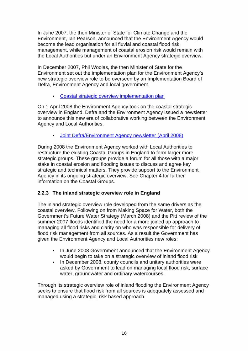
In June 2007, the then Minister of State for Climate Change and the Environment, Ian Pearson, announced that the Environment Agency would become the lead organisation for all fluvial and coastal flood risk management, while management of coastal erosion risk would remain with the Local Authorities but under an Environment Agency strategic overview. In December 2007, Phil Woolas, the then Minister of State for the Environment set out the implementation plan for the Environment Agency’s new strategic overview role to be overseen by an Implementation Board of Defra, Environment Agency and local government.
Coastal strategic overview implementation plan On 1 April 2008 the Environment Agency took on the coastal strategic overview in England. Defra and the Environment Agency issued a newsletter to announce this new era of collaborative working between the Environment Agency and Local Authorities.
Joint Defra/Environment Agency newsletter (April 2008) During 2008 the Environment Agency worked with Local Authorities to restructure the existing Coastal Groups in England to form larger more strategic groups. These groups provide a forum for all those with a major stake in coastal erosion and flooding issues to discuss and agree key strategic and technical matters. They provide support to the Environment Agency in its ongoing strategic overview. See Chapter 4 for further information on the Coastal Groups. 2.2.3 The inland strategic overview role in England The inland strategic overview role developed from the same drivers as the coastal overview. Following on from Making Space for Water, both the Government’s Future Water Strategy (March 2008) and the Pitt review of the summer 2007 floods identified the need for a more joined up approach to managing all flood risks and clarity on who was responsible for delivery of flood risk management from all sources. As a result the Government has given the Environment Agency and Local Authorities new roles:
In June 2008 Government announced that the Environment Agency would begin to take on a strategic overview of inland flood risk
In December 2008, county councils and unitary authorities were asked by Government to lead on managing local flood risk, surface water, groundwater and ordinary watercourses.
Through its strategic overview role of inland flooding the Environment Agency seeks to ensure that flood risk from all sources is adequately assessed and managed using a strategic, risk based approach.

17
The Environment Agency continues to lead on the delivery of flood risk management from main rivers and the sea and oversight of reservoir safety
Local authorities lead on flood risk from surface water, groundwater and ordinary watercourses
The Environment Agency will support Lead Local Flood Authorities by providing national guidance, data and tools and local support. Working in partnership will be crucial to achieving the desired outcome. As part of the lead role on local flood risk Lead Local Flood Authorities have established local partnerships that bring all relevant organisations together including the Environment Agency. 2.3 Delivering the coastal strategic overview role in England The Flood and Water Management Act 2010 and the Flood Risk Regulations 2009 set out the roles to deliver the strategic overview. In practice this means that the Environment Agency:
Quality reviews and approves all Shoreline Management Plans (SMPs), ensuring the strategic direction of the coast is consistent, sound and sustainable
Allocates all flood and coastal risk management capital funding to ensure that all money spent is on schemes that contribute towards delivering the strategic management of the coast as set out in the strategic plans (SMPs)
Ensures that the whole strategic direction for the coast is right The development of the strategic overview promotes a new way of working between Government, the Environment Agency, Local Authorities and Coastal Groups which aims to improve sustainability, prioritisation and management of all works on the coast. In the past there has been a complex and confusing mix of responsibilities. Giving the Environment Agency the strategic overview role helps to ensure there is:
Greater consistency in the approach to flood and erosion risk management on the coast, allowing for a more sustainable approach which is able to take appropriate account of climate change
Greater clarity for the public and Government on the roles, responsibilities and accountabilities of those involved in coastal management
More efficient targeting of resources at areas where there is greatest risk
A management approach that is risk driven The Environment Agency is not seeking to take on operational work from Local Authorities. The strategic overview provides opportunities for procurement and delivery efficiencies, and improved partnership working.

18
Where Local Authorities are currently delivering sea flooding work in an effective and efficient way it is expected that they will continue to do so. The following diagram helps explain the Environment Agency’s strategic overview role on the coast in England: Figure 1: Environment Agency strategic overview role on the coast (source: Defra)
EA manages SMP programme, quality assures & approves them. SMPs led by
Coastal Groups.
EA assesses risk and priorities nationally, drawing on SMPs
EA produces 3 year work plans, and
allocates funding, based on priorities, outcome measures
etcEA funds and
oversees works including applying
conditions relating to procurement, delivery
and future asset management
EA works with LAs in timetabling etc the works programme
Environment Agency lead organisation for sea flooding risk management
LAs remain lead organisations for coastal erosion risk management
Coastal Groups (CGs) become fewer, bigger and more strategic with stronger Environment Agency representation
RFDCs’ role widened to include coastal erosion with representation
Works Programme
Other Strategic Overview Role
EA given powers to prevent new coastal erosion works, or to build or remove defences, to achieve consistency with the Water Framework Directive objectives in the River Basin Management Plan

19
2.3.1 Outcomes of the strategic overview on the coast The strategic overview is expected to deliver the following benefits:
A clear link between flood and coastal erosion risk management policy, operational activities, and the agreed Outcome Measures
Clear accountability for all flood and coastal erosion risk management activities on the coast
Maximised investment in flood and coastal erosion risk management assets
Optimised recreational and environmental benefit, and compliance with the Water Framework Directive and Habitats Regulations.
It will also ensure the risks taken are in accordance with Environment Agency corporate policy, reducing the overall risk to the Environment Agency, the economy and the public. 2.3.2 Differences between the old and new approach The following table summarises the key differences between the old approach to coastal management and the advantages of the new: The old system The aim of the strategic overview Over 90 different authorities
manage the coast in England Management is very fragmented
and is difficult to ensure a consistent and sustainable approach that takes account of climate change
Separate funding streams and prioritisation for coastal erosion and flood defence means investment may not be targeted where there is greatest risk
Defra agree the Shoreline Management Plans
Environment Agency’s RFDCs only cover flood defence
Coastal erosion is governed by Defra with informal Local Authority led coastal groups. Technical knowledge within these groups is varied around the coast.
Different project management and procurement approaches from different authorities involved can reduce value for money
A holistic and sustainable approach to risk allows for robust and evidence-based long-term decision making
Approach to management is truly risk driven
Clear roles and accountabilities Achieve consistency and
conformity with Water Framework Directive (WFD) objectives
WFD public participation objectives are delivered and effective engagement with partners & local neighbourhoods takes place.
Financial planning and management arrangements provide best value for money from the investment programme, including reducing the risk of project cost overruns
Best use of technical expertise and engineering resources

20
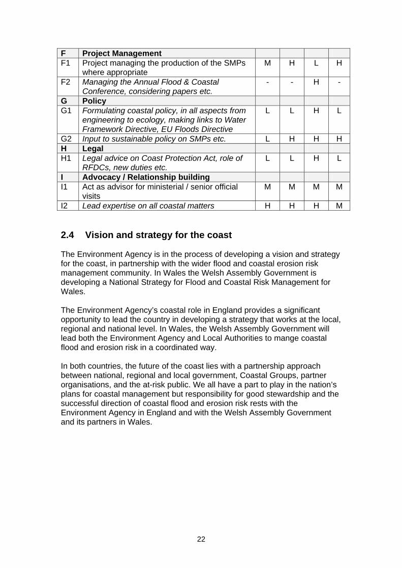
2.3.3 Activities involved in delivering the coastal strategic overview The Environment Agency and Local Authorities have the biggest role in managing the coast. At the time of taking on the strategic overview role, the following table was compiled by the ex-Defra Regional Engineers and Environment Agency head office and operational staff to identify the activities involved in delivering and managing the new role on the coast. It summaries both the activities for the Environment Agency and Local Authorities. The tasks were colour coded to reflect whether the activity was a new duty, or whether it was an enhancement of a duty which was already being undertaken by the Environment Agency. The coding (H = high; M = medium; L = low) gives a basic indication of the level of the activity, which may be different in some Environment Agency Regions and Areas. The table has been included for information and to act as a guide only. The table does not quantify the activity but gives an indication of where the main accountability lies. Summary of Environment Agency and Local Authority activities involved in delivering the strategic overview: Key: Italic text = New Environment Agency duty Normal text = Enhanced Environment Agency duty Ref Activity
EA A
rea
EA
Reg
ion
EA H
ead
Offi
ce
Loca
l A
utho
rity
A Liaison A1 Liaison with Local Authorities to coordinate
plans and works along the coast; Medium Term Plan, Asset Management Plans etc.
H M M H
A2 Influencing the Regional and Local Authorities Planners to ensure plans are in accordance with the Shoreline Management Plan
H H L H
A3 Resolving disagreements between ourselves, Local Authorities, Natural England etc on policies within the SMP
M M - M
A4 Liaison with 3rd party asset owners on management of their assets (in accordance with EA Policy 185-07)
M L - M
A5 Liaison with key partners on strategies and policies affecting the coast, including Regional Government Office, Local Authorities, Natural England, English Heritage, Port Authorities, Welsh Assembly Government, Scottish Executive other Government Departments etc.
L H L M
A6 Attend Coastal Groups to lead and challenge discussions on coastal management and ensure national policy matters are
H H L H

21
disseminated and understood A7 Influencing Regional Spatial Strategies, Local
Development Frameworks etc. M H L M
B Technical advice B1 Advice to all Operating Authorities on SMP
guidance, Project Appraisal Guidance, approval process, grant memorandum etc.
H L M L
B2 NCPMS, NEAS advice to Local Authorities on investment schemes
M H M -
B3 Technical input to, and review of, SMPs H H H H B4 Identifying and sharing of good practice M M H M B5 Response to Parliamentary Questions & MP’s
correspondence, preparation of parliamentary briefings
H L M M
B6 Technical input to other strategies affecting the coast, such as Regional Spatial Strategies, Local Development Frameworks, Natural England strategies etc.
M M M L
C Appraisal and approval C1 Approval of SMPs M M H M C2 Appraise flood and coastal projects for
compliance with Government policy and make recommendations for grant aid funding
H
H
(PAB)
H
(NRG)
H
C3 Sponsor projects through PAB, NRG etc for SoD approval
H M - H
D Planning & Monitoring D1 Planning and managing the contracts of
coastal monitoring and mapping L H L H
D2 Compiling the Medium Term Plan to include all Environment Agency and Local Authority investment projects
H H H M
D3 Reviewing the MTP for realism and reporting to HO Finance
M M H -
D4 Monitoring scheme progress against the Medium Term Plan for funding allocation
H M M H
D5 Strategic Asset Management Planning, capital expenditure, planned and reactive maintenance
H M H M
E Inspection, Data & Mapping E1 Coastal monitoring, data management and
analysis for inclusion in Asset Management Plans
M H L M
E2 Managing the data for the maintenance of maps of governance boundaries, erosion risk etc.
L H M L
E3 Providing information on coastal erosion etc on request
M L L M
E4 Managing all additional data in the MTP, mapping, partners etc.
M H H M
22
F Project Management F1 Project managing the production of the SMPs
where appropriate M H L H
F2 Managing the Annual Flood & Coastal Conference, considering papers etc.
- - H -
G Policy G1 Formulating coastal policy, in all aspects from
engineering to ecology, making links to Water Framework Directive, EU Floods Directive
L L H L
G2 Input to sustainable policy on SMPs etc. L H H H H Legal H1 Legal advice on Coast Protection Act, role of
RFDCs, new duties etc. L L H L
I Advocacy / Relationship building I1 Act as advisor for ministerial / senior official
visits M M M M
I2 Lead expertise on all coastal matters H H H M 2.4 Vision and strategy for the coast The Environment Agency is in the process of developing a vision and strategy for the coast, in partnership with the wider flood and coastal erosion risk management community. In Wales the Welsh Assembly Government is developing a National Strategy for Flood and Coastal Risk Management for Wales. The Environment Agency’s coastal role in England provides a significant opportunity to lead the country in developing a strategy that works at the local, regional and national level. In Wales, the Welsh Assembly Government will lead both the Environment Agency and Local Authorities to mange coastal flood and erosion risk in a coordinated way. In both countries, the future of the coast lies with a partnership approach between national, regional and local government, Coastal Groups, partner organisations, and the at-risk public. We all have a part to play in the nation’s plans for coastal management but responsibility for good stewardship and the successful direction of coastal flood and erosion risk rests with the Environment Agency in England and with the Welsh Assembly Government and its partners in Wales.

23
CHAPTER 3: Roles and Responsibilities 3.1 Purpose of this chapter This chapter tells you about the key organisations operating on the coast and who does what. It explains what each organisation does and how we all fit into the flood and coastal risk management community. The top three things to remember are:
We can only manage the coast in a sustainable way if we work together
We will be able to work together more effectively if we know who does what and what the different agendas are
The list of partners and organisations is not exhaustive This chapter has been broken down into the following key layers of organisations:
Government – Defra, Department for Communities and Local Government, Regional Government offices, Welsh Assembly Government, Scottish Executive
Operating Authorities – Environment Agency, Local Authorities, internal drainage boards
Executive and advisory bodies – Regional Flood Defence Committees, Coastal Groups
Other key groups, bodies and organisations – Natural England, Countryside Council for Wales, National Trust, Network Rail, etc
For the benefit of those unfamiliar with the workings of the Environment Agency details have been provided on its structure and the roles of some of the key staff working on the coast. In terms of managing the coast, from a day to day operational level to a strategic level, the Environment Agency and Local Authorities have the biggest roles to play. 3.2 Government level 3.2.1 Defra roles and responsibilities Prior to the Environment Agency having an overarching strategic overview role for the coast, the responsibility for funding allocation and the approval of high level strategic management plans (Shoreline Management Plans) lay with the Department for Environment, Food and Rural Affairs (Defra). Separate funding streams and prioritisation existed for coastal erosion and flood defence. In terms of governance the Environment Agency’s Regional Flood Defence Committees (RFDCs) covered flood defence, meaning Defra was responsible for governing all coastal erosion activities with the support of informal, Local Authority led Coastal Groups.

24
Over recent years Defra’s Flood Management Division has undergone significant changes with the loss of the regional offices and regional engineer roles, and the reduction of head office staff to a small core policy team. Most of the key work areas of the regional engineers, such as policy advice, ministerial correspondence, project approval, guidance and agreement of Shoreline Management Plans (SMPs) and Catchment Flood Management Plans (CFMPs) have now been transferred to the Environment Agency. Defra remains the lead Government body and continues to set and have overall national policy responsibility for flood and coastal erosion risk management in England. Defra continues to provide funding through grant-in-aid to the Environment Agency and the Minister continues to confirm the “sanctioned list” of projects for the forthcoming year. Defra does not build or manage flood or coastal erosion defences and does not direct any authorities on which specific projects should be undertaken. See section 3.2.4 for the roles and responsibilities of the Welsh Assembly Government. 3.2.2 Communities and Local Government roles and responsibilities Communities and Local Government (CLG) sets the policy on local government, housing, urban regeneration, planning and fire and rescue. It provides funding to Local Authorities through the revenue support grant. It is responsible for the creation of development planning policies and building regulations. It is also the lead government department on helping communities to recover from flooding. 3.2.2.1 Planning policy in England National planning policies are set out in Planning Policy Guidance Notes (PPG) and new-style Planning Policy Statements (PPS), which are gradually replacing the Planning Policy Guidance Notes. These documents explain the statutory provisions and provide guidance to Local Authorities and others on planning policy and the operation of the planning system. Planning policy is key to reducing risk from flooding and erosion through discouraging inappropriate development in areas of flood risk. Planning Policy Statement 25 (PPS25) Development and Flood Risk and its supplement Development and Coastal Change is of most relevance to those involved in flood and coastal erosion risk management. These documents are covered in more detail in chapter 14. Further information on the planning policies produced by CLG can be found on the following website:
CLG Planning Policy 3.2.2.2 Planning policy in Wales Welsh Assembly Government Planning Policy is set out in Planning Policy Wales (PPW) and Minerals Planning Policy Wales (MPPW). They are each supplemented by a series of Technical Advice Notes (TANs) and Minerals

25
Technical Advice Notes (MTANs). Planning Policy and Advice Notes are material planning considerations and are therefore taken into account in the preparation of planning authorities' development plans and in the determination of planning applications and planning appeals. Two Technical Advice Notes provide specific advice on flood and coastal erosion risk management – TAN 14 (coast) and TAN15 (flood). Further information on the planning policies of the Welsh Assembly Government and the supporting Technical Advice Notes can be found at:
Planning Policy and Guidance 3.2.2.3 Building regulations CLG is responsible for national policy on building regulations. These will apply to most new buildings and many alternations of existing buildings in England and Wales, whether for domestic, commercial or industrial use. More can be found on the following website:
CLG Building Regulations Responsibility for building regulations in Wales is due to be devolved to the Welsh Assembly Government in 2011. 3.2.2.4 Flood recovery There is a commitment to ensure that areas affected by major flooding events recover as soon as possible. The following financial support is available to Local Authorities in England: Bellwin Scheme – Local Authorities can apply to CLG for financial
assistance in dealing with emergencies. Flood Recovery Grant – is a special grant scheme for Local Authorities
(under section 31 of the Local Government Act 2003) which is intended to support local flood recovery work, particularly with those on greatest and most immediate need. It was set up as part of a wider package of government financial support to areas affected by the exceptional national flooding of June and July 2007.
Restoration Fund – provides financial help to Local Authorities to support their continued efforts to rebuild their communities, following the summer 2007 floods.
Further details on the financial support available can be found on the following website:
CLG Flood Recovery Support In Wales, the Emergency Financial Assistance Scheme (formerly known as the ‘Bellwin Scheme’) is a discretionary scheme administered by the Welsh

26
Assembly Government, which exists to give special financial assistance to Local Authorities who would otherwise be faced with undue financial burden as a result of providing relief and carrying out immediate work due to large scale emergencies. Further details on this support can be found on the following website:
Emergency Financial Assistance Scheme 3.2.2.5 Revenue support grant The overseeing of Local Authority business in England is undertaken by CLG. The revenue support grant (RSG) is an amount of money given by central government to Local Authorities each year for revenue expenditure.
Local Government Finance Revenue Support Grant In Wales the revenue support grant is administered by the Welsh Assembly Government to Local Authorities. 3.2.3 Regional Government offices in England In England there are nine regional Government Offices. Government Offices are well positioned to understand and address the particular needs of their region. Reflecting a number of government departments, they aim to work in partnership with local people and organisations within their area. They are the primary means by which a wide range of government policies and programmes are delivered in the English regions. Further information on each Government Office can be found on the following website:
Government Offices for the English Regions 3.2.4 Welsh Assembly Government In Wales, the Welsh Assembly Government is responsible for developing flood and coastal risk management policy. It funds the majority of flood and coastal erosion activities which are undertaken by risk management operating authorities across Wales. The Welsh Government has not adopted the same delivery model as Defra and has not given Environment Agency Wales a strategic overview of all coastal matters. More information can be found on the following website:
Flood and coastal risk management in Wales In Wales, work on environmental protection and quality is divided between:
Local Authorities – for local environmental quality issues Environment Agency Wales – for environmental regulation and
improvements, particularly to rivers and major industry

27
The Welsh Assembly Government – for funding, policy and legislative based improvements
3.2.4.1 Environment Strategy for Wales In 2006 the Environment Strategy for Wales was published which sets out the Government’s long term vision for the environment in Wales and explains how the challenges being faced over the next 20 years will be addressed. Further information can be found on the following website:
Environment Strategy for Wales
3.2.4.2 New Approaches Programme Flood and coastal risk management is an important part of the Environment Strategy for Wales. The need for a new approach to managing risk arose from the strategy consultation and, as a result, in 2007 the New Approaches Programme (NAP) was launched. The programme was intended to help change the way Wales manages flood and coastal risk by moving to a more holistic risk management approach. In light of the changes contained within the Pitt Review and the EU Directive on the assessment and management of flood risks a review of the New Approaches Programme will be carried out in 2010. The findings of the review will be built into the National Strategy for flood an coastal erosion risk management in Wales. More information can be found on the following website:
New Approaches Programme 3.2.4.3 The Welsh Language Act 1993 This Act requires public bodies operating in Wales to provide an equal service to the public in both English and Welsh. The Welsh Language Board is the statutory body that promotes the use of Welsh and monitors compliance. As an Assembly Government Sponsored Body the Environment Agency must consider the Welsh language in its policy-making and service delivery. Making specific decisions on language issues for each policy area is an integral part of implementing policy in Wales and for Wales. 3.2.5 The Scottish Executive Historically Scotland has not faced the same degree of river and coastal flooding as England, mainly due to its topography. However, climate change is expected to increase flood risk, potentially doubling it in some areas in Scotland before the end of the century. Through the Flood Risk Management (Scotland) Act 2009, the Scottish Government has introduced a more sustainable and modern approach to flood risk management.

28
More information can be found on the following website:
Scottish approaches to flood and coastal risk management 3.2.6 Scottish Environment Protection Agency In Scotland, the Scottish Environment Protection Agency (SEPA) is the environmental regulator, taking on similar roles to the Environment Agency in England, and the Environment Agency Wales in Wales. SEPA is a non-departmental public body, accountable through Scottish Ministers to the Scottish Parliament. SEPA’s main role is to protect and improve the environment. SEPA is Scotland’s flood warning authority, and is also responsible for providing advice to Local Authorities on flood risk for planning purposes and advice on flood prevention. 3.3 Operating Authorities 3.3.1 Environment Agency roles and responsibilities The Environment Agency was established by the Environment Act 1995 and became fully operational on 1 April 1996. It is an Executive Non-departmental Public Body responsible to the Secretary of State for Environment, Food and Rural Affairs (Defra) and an Assembly Sponsored Public Body responsible to the National Assembly for Wales. The principal aims of the Environment Agency are to protect and improve the environment, and to promote sustainable development. It plays a central role in delivering the environmental priorities of central government and the Welsh Assembly Government through its functions and roles. The Environment Agency is the principal flood risk management operating authority in England and Wales. It has a broad range of functions which also include pollution prevention and control, waste management, water quality, land quality, air quality, water resources, navigation, conservation, recreation and fisheries. 3.3.1.1 Environment Agency corporate strategy The Environment Agency’s new corporate strategy for England and Wales sets out what will be achieved for the environment between 2010 and 2015. Further details of this strategy can be found on the following website:
Environment Agency Corporate Strategy 3.3.1.2 Environment Agency structure The Environment Agency is a large organisation and a summary of its structure is as follows:

29
The Board: Legally, the Board constitutes the Environment Agency and is directly responsible to Government Ministers for all aspects of the organisation and performance. The Board consists of 14 members, including the Chairman and Chief Executive. All are appointed by the Secretary of State, except for the Board Member for Wales who is appointed by the National Assembly for Wales. The Board ensures that the Environment Agency fulfils its statutory duties and that the organisation operates with propriety, regularity, economic efficiency and effectiveness. The Board delegates the Environment Agency’s day-to-day management to the Chief Executive and staff.
The Directors:
A team of directors chaired by the Chief Executive are responsible for overseeing and coordinating the formulation of national policies. In addition each Environment Agency region has a Regional Director and Environment Agency Wales has Director Wales.
Committees:
In each region there are committees which exist to advise on the operational performance of the Environment Agency’s functions, regional issues, and regional implications of national policy proposals. Committee members are appointed under statutory membership schemes designed to achieve representation from a wide range of partners and the public. The three Committees are:
o Regional Fisheries, Ecology and Recreation Advisory Committee (RFERAC)
o Regional Environment Protection Advisory Committee (REPAC) o Regional Flood Defence Committee (RFDC) known as Flood
Risk Management Wales Committee in Wales. (These are due to be renamed Regional Flood & Coastal Committees)
Head Office:
This is where the Chief Executive and Directors are based and where national policy is set. Head office is responsible for the corporate management of the Environment Agency, including policy development, strategic and operational objective setting and performance management. Head office ensures that all policies are carried out consistently across the country, taking into account the environmental, social and economic differences in each region and Environment Agency Wales.
Regional Offices:
The Environment Agency is divided into seven regions – Southern, Thames, South West, Midlands, Anglian, North West and North East, and Environment Agency Wales. Each region has a regional office which is managed by the Regional Director or Director Wales. The regional offices support the area offices through helping co-ordinate their activities, and provide the link to head office. Together with the area offices, regions ensure national priorities are delivered at a local level whilst taking account of the needs of partners, the public and local neighbourhoods. In

30
addition, the Strategic Unit in Wales liaise directly with the Welsh Assembly Government on national issues for Wales.
Area Offices:
There are offices in each of the Areas in England and Wales. Staff who work in these offices are responsible for the day-to-day management of the Area and for making sure the needs to the local community are met. Responses to emergencies and incidents are carried out from area offices as this is where the local knowledge is held.
National Services:
The Environment Agency has a number of national services, such as the National Capital Programme Management Service (NCPMS) and National Environmental Assessment Service (NEAS), to enable it to work more effectively and consistently across the country.
The following websites provide more information on the Environment Agency’s structure, information on each of the eight regions, how to contact the different offices and an organisation chart showing the departments within the organisation.
Environment Agency organisation 3.3.1.3 Environment Agency’s roles and responsibilities on the coast The Environment Agency is the lead authority for all matters relating to flooding from the sea and is accountable to Government and the public for all sea flooding risk management decisions. Since the 1 April 2008 the Environment Agency has a number of responsibilities for managing both flood and erosion risk on the coast in England. In summary:
The Environment Agency assesses risk, prioritises works and allocates all flood and coastal erosion risk management capital funding, based on Outcome Measures and following Ministerial confirmation of the “sanctioned list”. This makes it possible for one organisation to ensure that all funding provided is allocated and spent on schemes which contribute towards delivering effective management of the coast, as set out in the strategic planning documents – Shoreline Management Plans (SMPs).
Shoreline Management Plans (SMPs) are reviewed, quality assured
and approved by the Environment Agency on behalf of Defra. Environment Agency Regional Directors approve SMPs on behalf of the Minister. In Wales there is a similar process but Plans will also be signed-off by Welsh Assembly Government Ministers. This enables one organisation to ensure the strategic direction of the coast is consistent, sound and sustainable. It is also responsible for managing any disputes with SMPs.
31
The Environment Agency ensures effective procurement, delivery and future management, operation and maintenance of all capital works. Local Authorities continue to propose and deliver work on the ground, where they have the skill and expertise to do so effectively, but under the Environment Agency’s strategic overview. Effective procurement approaches can deliver greater value for money.
The Environment Agency in England and Wales has a responsibility to
ensure third party defences are sustainable, considering their impact on coastal processes and whether these assets are durable.
In Wales the Welsh Assembly Government fund coastal flooding and erosion investment works. Environment Agency Wales supports the preparation of Shoreline Management Plans by the Coastal Groups. The SMPs are approved by the Environment Agency and the Welsh Assembly Government. 3.3.1.4 Resources to deliver the strategic overview role in England It was recognised that internally additional resources were going to be needed to take on the coastal strategic overview role and to take account of new responsibilities and subsequent increases in workload. As a result a number of new posts were created, and former posts amended at area, regional and national level. The internal Strengthening Flood and Coastal Risk Management Programme (SFCRM) looked at how the Environment Agency could adapt its operational business to respond to new challenges. It looked at how leadership and decision making could be strengthened, how to ensure sufficient resources are available to implement the new coastal duties and strengthen asset management capacity, and how to encourage closer working relationships with partner organisations. This work replaced the internal Flood and Coastal Risk Management Handbook, but did not cover the Head Office Directorate changes. More information on this programme is available on the following website:
Strengthening Flood and Coastal Risk Management Programme [Environment Agency internal]
During 2008/9 there was a review of the Environment Agency’s head office structure and its ability to deliver its needs. As a result, a new dedicated Flood and Coastal Risk Management Directorate was created. 3.3.1.5 Environment Agency staff with specific coastal roles The following summarises the main roles and activities of staff within the Environment Agency who have coastal responsibilities.
32
Area staff: Area Flood and Coastal Risk Managers (AFCRMs):
The remit and name of the Flood Risk Managers was extended to cover the coast. The Area Flood and Coastal Risk Managers are the key link and first point of contact locally for Local Authorities, third party asset owners, and the public, a role previously undertaken by the Defra Regional Engineer. Area Flood and Coastal Risk Managers ensure that coastal erosion projects promoted by Operating Authorities are submitted and approved in line with the Grant Memorandum and built to time and quality. They liaise with the FCRM Finance Team over capital grant matters for Local Authorities in their Area. They should also attend their local Coastal Group(s) meetings. This coastal role is not exercised by AFCRMs in Wales.
Area Flood and Coastal Risk Management Teams:
This includes Data and Mapping, Incident Management, and Asset System Management Teams. The teams now work more closely with Local Authorities, Network Rail, ports and harbours and others to develop our existing asset information for all sea flooding. They support the SMP process, coastal monitoring activities, and investment submissions from Local Authorities. Apart from the role of supporting Local Authority investment submissions these teams fulfil the same roles in Wales.
Area Coastal Engineers:
These were new posts created under the coastal strategic overview in England. Along with the Area Flood and Coastal Risk Managers they provide the first point of contact for Local Authorities. There are currently no Area Coastal Engineer posts in Wales.
Area Coastal Technical Specialists, Advisors, and Managers:
Coastal technical specialists are based in Areas in England which have a coastline and provide specific help to Areas and Regions on coastal processes and activities. Area Coastal Advisors and Area Coastal Managers only exist in Anglian Region due to the nature and complexities of managing this stretch of coast.
Area Managers: Their influence with Local Authorities, Chief Executives and Members of Parliament has extended to cover all local coastal issues in England.
Regional staff: Regional Flood and Coastal Risk Management Executive Managers
(RFCRMs): They are the key strategic contact for coastal matters for regional partners and Local Authorities in England. They lead the RFDCs, attend their local Coastal Group(s) meetings and make administrative support available. They are responsible for the submission of the Medium Term Plan, which now includes all flood and coastal erosion risk management works in the

33
region. They are also the Environment Agency lead for regional coastal monitoring. In Wales, the RFCRM’s role does not cover coastal erosion risk management.
Regional Flood and Coastal Risk Management Teams:
This generally includes Incident and Emergency Planning, Flood Forecasting, Strategic and Development Planning, Assets, Improvements, and Programme Management posts. The teams compile and review the Medium Term Plan for all investment in flood and coastal erosion risk management in England with information provided by the Areas. They are responsible for coastal monitoring and for ensuring data is included in asset management plans. They sit on SMP steering groups and in some instances are the delivery lead for the SMPs. They also assist with the national monitoring of SMP production and help implement all SMP Action Plans to ensure we have a sustainable coastline. In Wales, Environment Agency Wales, with the Welsh Local Government Association (WLGA) and an independent advisor, sit on a Board chaired by the Welsh Assembly Government to allocate European Convergence and Competitiveness funding to flood and coastal risk management projects. They also prepare the Medium Term Plan (MTP) for investment in flood risk management projects and sit on Coastal Groups that are preparing SMPs.
Defra funded Coastal Engagement Officers:
These are short-term posts in England to help facilitate good communication and engagement with the public and other key partners in the roll out of the first publication of coastal erosion risk information and to help support the consultation phase for the second generation Shoreline Management Plans. There are no specific Coastal Engagement Officer posts in Wales.
Regional Strategy Managers:
Their role as the key contact for regional government and regional partners has been extended in England to influence all issues relating to flood and coastal erosion risk management.
Regional Directors and Director Wales:
Regional Directors have overall management of Environment Agency functions in their region. Director Wales has overall management for Environment Agency functions in Wales. In England Regional Directors now have a key role in the approval of SMPs.
Head Office staff: Head Office Flood and Coastal Risk Management Teams:
This includes Strategy and Engagement, Incident Management, Asset Management, and Investment Planning Teams. These teams remain the key link with Government and national partners, leading future thinking and developing clear policies on the coast, asset and investment planning.

34
Head Office Flood and Coastal Risk Management Finance Team:
This team provides the link with Local Authorities for financial and planning matters in England. They receive the medium term plan submissions, and are responsible for scheduling and paying capital grant, including final audit sign-off.
Head Office Coastal Team:
This team leads on coastal policy issues across England and Wales and sets the direction of the coastal strategic overview in England. The team leads on developing approaches to common issues raised by operations, communicating Government policy and new developments on coast management, bringing together knowledge and good practice, building relationships with key partners and facilitating the development of skills and capacity with all operators on the coast.
Other groups: National Capital Programme Management Service (NCPMS) and the
National Environmental Assessment Service (NEAS): These teams form part of the Environment Agency’s national services and are now responsible for quality reviewing Local Authority schemes in England and aim to develop closer links with key partners through the Area teams.
Coastal Business User Group (CBUGs):
This group has a representative from each Environment Agency Region with a coastline and Environment Agency Wales and has been set up to provide the link between the head office coastal team and operational teams in the regions and areas. The objectives of this group are to provide operational input to national discussions on policy development, national projects, key issues and to help develop capacity and share good practice.
3.3.1.6 Environment Agency Coastal Area Contacts The following map provides details of Area contacts within each Environment Agency Region and Environment Agency Wales. Area Flood and Coastal Risk Managers and Area Coastal Engineers (England only) are the first point of contact for Local Authority officers. Note in Anglian Region there are additional Area Coastal Advisor and Area Coastal Manager posts which are not shown on this map. Given this map will become out of date in the future as staff changes occur, it is advised that queries are directed to the Environment Agency’s National Customer Contact Centre (NCCC) if you are unsure who to contact in the first instance. NCCC telephone number: 08708 506 506 (Mon-Fri, 8am-6pm) NCCC email address: [email protected]

35
Figure 2: Map of Environment Agency Flood and Coastal Risk Management Area coastal contacts (June 2010).

36
3.3.2 Local Authority roles and responsibilities Local Authorities provide local services to people living or working in their areas. There are a number of different types and layers of local government. 3.3.2.1 Local Government structure The structure of local government will vary from area to area in England. Councils can also be run in different ways. In some areas there will be two layers of governance – a district council and a county council, where responsibilities are shared between them. In other areas there will be just one layer – a unitary authority that is responsible for all local services. In addition, in some areas there will also be a town and parish council covering a much smaller area. Local Government layers are as follows:
County Councils Unitary Authorities District Councils
Parish Councils or Town/Community Councils In Wales all Local Authorities are unitary and are responsible for all local services. Town or Community Councils are collectively represented by One Voice Wales. A map identifying all the Local Authority districts, counties and unitary authorities in the UK is available from the following website:
Local Authority Districts, Counties and Unitary Authorities Map The administrative area of a Local Authority is further split into smaller areas known as ‘wards’ (district and unitary councils) or ‘divisions’ (county councils). Each ward/division has Elected Members/Councillors to represent the Local Authority, and who in general, give local input to inform the decisions of the Council. People are elected as councillors to represent everyone in their area and to serve the council as a whole. There is often more than one councillor for each council ward/division. 3.3.2.2 Local Authority roles and responsibilities on the coast The Coast Protection Act 1949 introduced the concept of a ‘coast protection authority’, being those districts or unitary councils that are next to the sea. Local Authorities in both England and Wales have important powers on the coast and play a fundamental role in the management and protection of our coastline. Effective partnership working between the Environment Agency and Local Authorities is critical to successful coastal management.

37
On the coast, Local Authorities:
Lead on coastal erosion risk management activities under the Coast Protection Act 1949
Do works on sea flooding and coastal erosion where they are best placed to do so, under the Environment Agency’s overview and approval in England and the Welsh Assembly Government in Wales
Lead and support Coastal Groups Produce Shoreline Management Plans where agreed by the
Coastal Group Work closely with the Environment Agency for the best outcomes in
managing flooding and erosion risks on the coast. Local Authorities have powers to protect land against coastal erosion under the Coast Protection Act 1949. They also have powers under the Act to control third party activities on the coast, such as the construction of private defences or the removal of beach material. They also have powers to undertake flood defence works under the Land Drainage Act 1991 on watercourses which are not designated as “main river” and which are not within the areas of an internal drainage board. 3.3.2.3 Planning responsibilities The planning system plays an important role in helping to protect the environment in towns, cities and the countryside. Communities and Local Government (CLG) and Welsh Assembly Government set the national planning policy, but the main responsibility rests with the local planning authorities, and National Park Authorities where appropriate (for all planning permissions within a National Park the National Park Authority is the relevant planning authority). Each Local Authority is responsible for producing a Development ‘Plan’. In England this is called the Local Development Framework (LDF) and in Wales the Local Development Plan (LDP). The local planning authority is responsible for deciding whether a development should go ahead or not and therefore plays a key role coastal planning developments. The planning system in England and Wales follows a plan-led system. In England there are two main levels of plans. Each Regional Planning Body should have a Regional Spatial Strategy setting out a broad strategy for how a region should look in 15-20 years time. It will cover such things as what planning is required, such as numbers of houses, etc. Each district or unitary local planning authority should have a Local Development Framework which is a folder of Local Development Documents outlining the spatial planning strategy for the local area, and explains how the local area may change over the coming years and how planning will be managed. In Wales the Local Development Plan must have regard to the Wales Spatial Plan.

38
It is essential that the links between Local Development Frameworks or Plans and Shoreline Management Plans are made. (see chapter 7 for further information) Further information on the planning process is available from the following website:
Planning Portal 3.3.3 Internal Drainage Board roles and responsibilities Internal Drainage Boards (IDBs) are independent bodies responsible for land drainage in areas of special drainage need. They are long established bodies operating predominantly under the Land Drainage Act 1991 and have permissive powers to undertake works to secure drainage and water level management in their districts. They may also undertake flood defence works on ordinary watercourses within their district. Although the boundaries of some internal drainage boards will be on the coast they do not usually play an active role in managing the coast. 3.4 Executive and advisory bodies 3.4.1 Regional Flood Defence/Flood and Coastal Committees Under section 106 of the Water Resources Act 1991, the Environment Agency is required to arrange for all its flood risk management functions to be carried out by Regional Flood Defence Committees, except for certain financial ones. RFDCs are mainly concerned with the regulation and improvement of watercourses to alleviate flooding of land or property, the maintenance or improvement of sea and tidal defences, and the provision of flood warning systems. In order to carry out these functions the Environment Agency, through the RFDCs, had various statutory powers including the following:
To maintain or improve any watercourses which are designated as main rivers
To maintain or improve any sea of tidal defences To install and operate flood warning equipment To control actions by riparian owners and occupiers which might
interfere with the free flow of watercourses The ability to raise a local levy on Local Authorities To supervise internal drainage boards.
RFDCs take an interest in all flood matters in their area and take decisions about the annual programmes of improvement and maintenance work to be carried out. They decide on such matters as the extension of main rivers, the making and operation of land drainage byelaws and various issues affecting any internal drainage boards in their area. They are also annually required to

39
approve statements of expenditure and to determine the amounts which may be levied by the Environment Agency on constituent councils. When reviewing the annual programme of works in their area, RFDCs recognise that there are funding restraints and that not all flooding can be avoided. Committee members are responsible for scrutinising plans proposed by the Environment Agency and challenge and debate any issues that arise. 3.4.1.1 Extension of Regional Committee roles (RFDC to RFCC) As part of the Environment Agency’s strategic overview, the role of RFDCs is being extended to cover coastal erosion in England and RFDCs will be renamed Regional Flood and Coastal Committees when the Flood and Water Management Act 2010 is enacted. RFDCs now also oversee all sea flooding, including that originally undertaken by Local Authorities and their levy raising powers have been extended to include coastal erosion. To account for the increase in coastal responsibilities, representatives from the relevant Coastal Groups are invited to attend Committee meetings. 3.4.1.2 Regional Flood Defence Committee membership and boundaries The membership and boundaries of RFDCs are set out in the Environment Act 1995. It states that each RFDC must consist of the following, none of which can be a member of the Environment Agency:
A chair and a number of other members appointed by the Secretary of State in England and the Minister in Wales
Two members appointed by the Environment Agency A number of members appointed by or on behalf of constituent
councils who must be in an overall majority of one on the Committee
There are 12 Committees covering the following areas:
North West Northumbria Midlands Yorkshire Anglian Northern Region Anglian Central Region Anglian Eastern Region Thames Southern Wessex South West Wales
Details of who is the Chair of each of these groups is available from the following website:
Regional Flood Defences Committees The following map details where the boundaries exist for the Regional Flood Defence Committees:

40
Figure 3: Regional Flood Defence Committees location map

41
Further information on the role of RFDCs, their terms of reference and their members is covered within the Committee Handbook which can be obtained from the Regional Committee Contacts. Information on who to contact in each region is available from the following website:
Regional Committees 3.4.2 Coastal Groups Coastal Groups are technical groups principally comprising of coastal managers from maritime District Councils, County Councils, Ports Authorities and the Environment Agency. See chapter 4 for further information on the Coastal Groups. 3.5 Other key groups, bodies and organisations There are numerous organisations with interests on the coast. The following section details the key organisations operating on the coast, provides a very brief description of their aims and what they do, and details of their websites where more information can be found. This list is not exhaustive. Local Government Association (LGA)
A voluntary lobbying organisation, acting as the voice of the local government sector in England. It represents the interests of all local government. Within the LGA there are a number of special interest groups, such as the Coastal Special Interest Group (SIG).
Welsh Local Government Association (WLGA)
A voluntary lobbying organisation, acting as the voice of the local government sector in Wales. It represents the interests of all local government. Within the WLGA there are a number of special interest groups.
Local Government Association Coastal Issues Special Interest Group (Coastal SIG)
Aims to establish improved governance, management and community well-being to ensure the UK has the best managed coast in Europe. The group is comprised of elected members from coastal Local Authorities.
Local Government Technical Advisors Groups (TAG)
Aims to provide coordinated and comprehensive advice and support to technical professionals employed by Local Authorities directly and indirectly to manage and advise on their services.
Natural England (NE) An independent public body whose

42
purpose is to protect and improve England’s natural environment, covering all urban, country and coastal landscapes and the animals, plants and other organisms that live there.
Countryside Council for Wales (CCW)
The Welsh Assembly Government’s statutory advisor on sustaining natural beauty, wildlife and the opportunity for outdoor enjoyment in Wales and its inshore waters.
Joint Nature Conservation Committee (JNCC)
Statutory advisor to the government on UK and international nature conservation. It contributes to maintaining and enriching biological diversity, conserving geological features and sustaining natural systems.
English Heritage (EH)
The English Government’s statutory advisor on the historic environment. It is an Executive, Non-departmental Public Body which works in partnership with central government, Local Authorities, voluntary bodies and the private sector to conserve and enhance the historic environment.
Cadw
The historic environment service of the Welsh Assembly Government. It aims to protect and sustain, encourage community engagement in, and improve access to the historic environment of Wales.
The Crown Estate
One of the largest property owners in the UK, both of the land and the foreshore. It owns almost all of the seabed within the 12 nautical mile limit, including rights to all minerals (except hydrocarbons).
Ministry of Defence (MoD)
Government department responsible for the implementation of government defence policy. Important landowner on the coast.
Network Rail
Owner of Great Britain’s rail infrastructure and licensed to provide and operate the rail network. Rail networks in some locations also act as coastal defences.
National Trust An independent charity working to
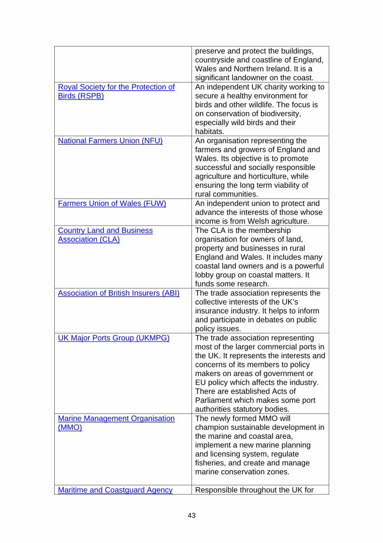
43
preserve and protect the buildings, countryside and coastline of England, Wales and Northern Ireland. It is a significant landowner on the coast.
Royal Society for the Protection of Birds (RSPB)
An independent UK charity working to secure a healthy environment for birds and other wildlife. The focus is on conservation of biodiversity, especially wild birds and their habitats.
National Farmers Union (NFU)
An organisation representing the farmers and growers of England and Wales. Its objective is to promote successful and socially responsible agriculture and horticulture, while ensuring the long term viability of rural communities.
Farmers Union of Wales (FUW)
An independent union to protect and advance the interests of those whose income is from Welsh agriculture.
Country Land and Business Association (CLA)
The CLA is the membership organisation for owners of land, property and businesses in rural England and Wales. It includes many coastal land owners and is a powerful lobby group on coastal matters. It funds some research.
Association of British Insurers (ABI)
The trade association represents the collective interests of the UK’s insurance industry. It helps to inform and participate in debates on public policy issues.
UK Major Ports Group (UKMPG)
The trade association representing most of the larger commercial ports in the UK. It represents the interests and concerns of its members to policy makers on areas of government or EU policy which affects the industry. There are established Acts of Parliament which makes some port authorities statutory bodies.
Marine Management Organisation (MMO)
The newly formed MMO will champion sustainable development in the marine and coastal area, implement a new marine planning and licensing system, regulate fisheries, and create and manage marine conservation zones.
Maritime and Coastguard Agency Responsible throughout the UK for
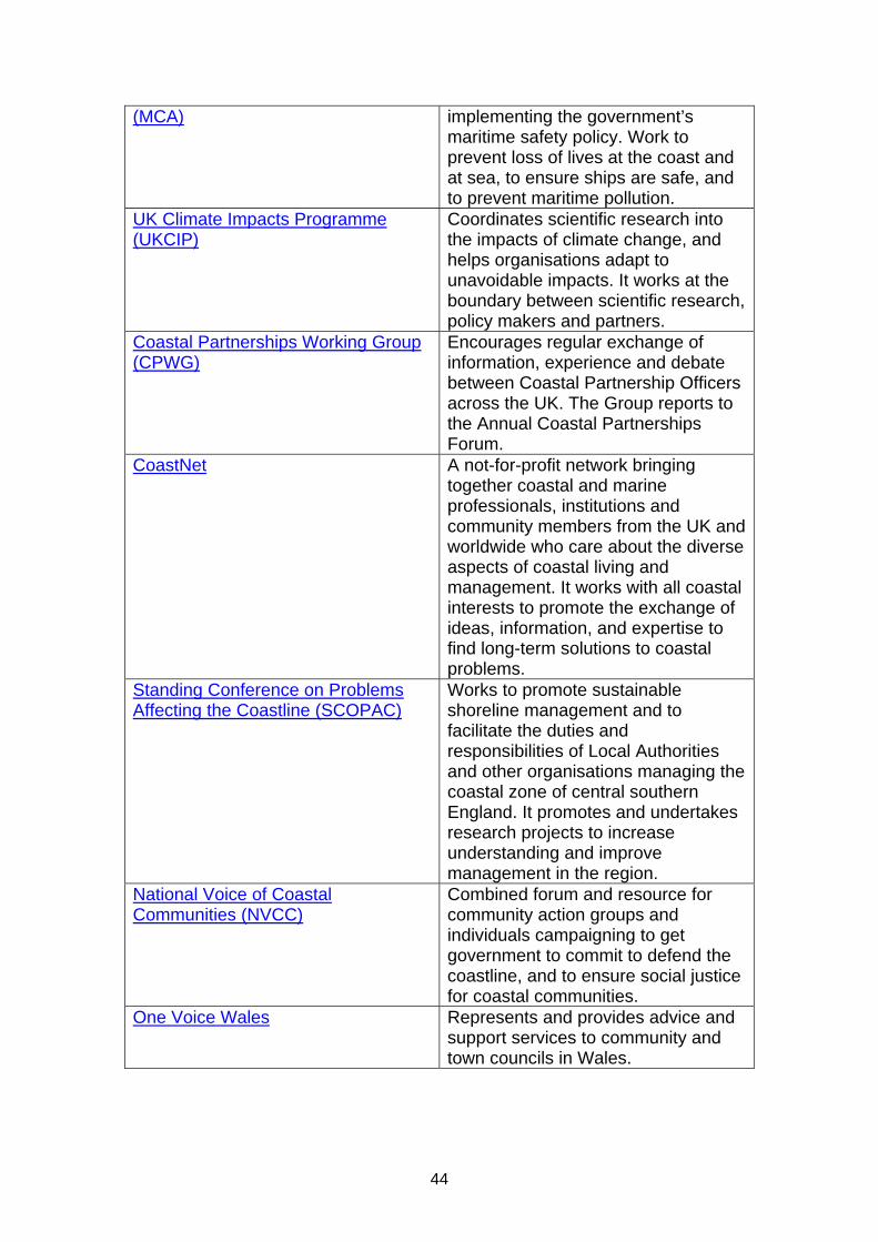
44
(MCA)
implementing the government’s maritime safety policy. Work to prevent loss of lives at the coast and at sea, to ensure ships are safe, and to prevent maritime pollution.
UK Climate Impacts Programme (UKCIP)
Coordinates scientific research into the impacts of climate change, and helps organisations adapt to unavoidable impacts. It works at the boundary between scientific research, policy makers and partners.
Coastal Partnerships Working Group (CPWG)
Encourages regular exchange of information, experience and debate between Coastal Partnership Officers across the UK. The Group reports to the Annual Coastal Partnerships Forum.
CoastNet
A not-for-profit network bringing together coastal and marine professionals, institutions and community members from the UK and worldwide who care about the diverse aspects of coastal living and management. It works with all coastal interests to promote the exchange of ideas, information, and expertise to find long-term solutions to coastal problems.
Standing Conference on Problems Affecting the Coastline (SCOPAC)
Works to promote sustainable shoreline management and to facilitate the duties and responsibilities of Local Authorities and other organisations managing the coastal zone of central southern England. It promotes and undertakes research projects to increase understanding and improve management in the region.
National Voice of Coastal Communities (NVCC)
Combined forum and resource for community action groups and individuals campaigning to get government to commit to defend the coastline, and to ensure social justice for coastal communities.
One Voice Wales
Represents and provides advice and support services to community and town councils in Wales.

45
CHAPTER 4: Coastal Groups 4.1 Purpose of this chapter This chapter tells you about the Coastal Groups in England and Wales. It covers their key roles and responsibilities, their location and their membership. Coastal Groups are a key player in coastal management. The top three things to remember are:
Coastal Groups comprise all the key partners in coastal management and have significant influence
The four key areas of work are: Shoreline Management Plans, coastal monitoring, investment and planning (MTP) and sharing good practice
In England Coastal Groups have merged to form 7 larger more strategic groups. The Coastal Groups in Wales have remained unchanged
4.2 Coastal Groups Coastal Groups are technical groups principally comprising of coastal managers from maritime Local Authorities, Ports Authorities and the Environment Agency. Other interested bodies and organisations, such as Natural England/Countryside Council for Wales, English Heritage/Cadw will also sit on these groups. Coastal Groups are voluntary groups who do not receive funding from central government but are resourced through a range of mechanisms generally involving membership contributions. As part of the Environment Agency’s strategic overview, English coastal groups were restructured so they are now larger, fewer in number and more strategic. Before this restructuring their boundaries were based on a mix of political and administrative boundaries and coastal process sub-cells with occasional overlaps. Coastal Groups provide a source of expertise on the coast and play a key role in advising and influencing the Environment Agency and the Regional Flood Defence Committees (RFDCs) on all matters relating to the coast. The aims of the Coastal Groups are:
To provide sound advice on coastal issues and to be a strong influencer in optimising strategic and sustainable policies, plans and programmes to best manage the risk from sea flooding and coastal erosion
To be a natural and chosen forum for coastal practitioners to discuss problems and share best practice
To be efficient in operation and provide best value for the public purse

46
4.3 Coastal Group details A brief overview of the physical nature and characteristics of the coastal environment within each Coastal Group area can be found in section 12.3. The following table provides details on each of the groups and the Chair. The websites should be consulted for further information: Coastal Group Website Chair
North East John Riby, Scarborough Borough Council
East Anglia Peter Frew, North Norfolk District Council
South East Bryan Curtis, Worthing Borough Council
Southern Andy Bradbury, New Forest District Council
South West Philip Rees, unaffiliated
Bristol Channel Strategic Group: North Devon and Somerset Coastal Advisory Group Humphrey Temperley
Severn Estuary Coastal Group Dave Harris, Monmouthshire County Council
Swansea Carmarthen Bay Coastal Engineering Group
Philip Williams Carmarthenshire County Council
North West and North Wales Graham Lymbery, Sefton Borough Council
Ynys Enlli to Llandudno Geraint Edwards, Conwy Council
Cardigan Bay Emyr Williams, Pembrokeshire Council
4.4 Coastal Group boundaries The concept of coastal cells and the importance of longshore sediment transport have been long recognised by coastal managers as a basis for appropriate coastal management. . Littoral drift divides usually occur at a point where the orientation of the coast changes abruptly. Actions one side of a drift divide will generally not cause problems on the other. Sediment sinks occur at points where sediment transport paths meet such as sheltered areas and are often located in tidal inlets and estuaries. The coastal group boundaries are not coincident with national boundaries and consider issues beyond the borders of England, Wales and Scotland. The Groups which go across boundaries have a shared oversight by Defra, the Welsh Assembly Government and the Scottish

47
Government. A map detailed where the littoral cells are around the coast of England and Wales can be found in chapter 7. The map below identifies where each Group is located:
Figure 4: Coastal Groups location map

48
Each Coastal Group has its own Terms of Reference which cover:
Aims Principal and secondary objectives Membership Operating guidelines
4.5 Annual reporting Coastal Groups produce an annual report each year. The following list identifies the items that may be included in the annual report:
Terms of Reference Membership Business Plan (including key business objectives for the year and
results) Meetings (including any key issues arising) Funding and expenditure Engagement (including key partners, Ministerial visits, any
successes and areas for improvements, and events) Joint working (including Local Authority shared resources, centres
of excellence/clusters, examples of innovative working) Shoreline Management Plans (including implementation of action
plan, any links with other plans such as Local Development Frameworks/Plans, Marine Plans, etc)
Projects (strategies, schemes and studies) (including forward planning, Medium Term Plan submissions, progress against programme, approvals, expenditure against allocation, tender lists outside procurement framework, significant issues, delays)
Regional monitoring (including report on survey progress, data management)
Updating erosion risk information Habitats (including gains and losses) National Indicator 189 reporting (issues and any follow up required) Any other notable activities (such as R&D, workshops, publications)
4.6 National Coastal Forum Twice a year the Coastal Group Chairs meet other key partners such as the RFCC Chairs, Defra, Communities and Local Government (CLG), Natural England, Countryside Council for Wales, English Heritage, Network Rail, Ministry of Defence, and Welsh Assembly Government to discuss national coastal issues. The aim of the forum is to promote an integrated, strategic and sustainable approach to shoreline management. The forum is chaired by the Environment Agency.

49
4.7 Wales Coastal Forum The Welsh Coastal Forum also meets twice a year and its members include the Welsh Coastal Group Chairs, Countryside Council for Wales, Network Rail, and the Welsh Local Government Association. The forum is chaired by the Welsh Assembly Government.
50
CHAPTER 5: Legislation 5.1 Purpose of this chapter This chapter provides an overview of the key legislation relevant to the coast. It lists the Acts and explains what powers they provide to operating authorities. Details of new and emerging legislation are also provided. The top three things to remember are:
The Coast Protection Act 1949 is the key legislation for matters relating to coastal erosion risk on the open coast
The Flood and Water Management Act 2010 updates previous legislation, including the Coast Protection Act 1949, and clarifies responsibilities on the coast for both flooding and erosion
Further help and guidance is available from legal teams, and is particularly recommended in Wales as devolution may have resulted in divergence between English and Welsh legislation
Note: Links are provided to the complete Acts, but it is recommended that you consult your legal team for detailed guidance. 5.2 National Legislation 5.2.1 Flood and Water Management Act 2010 The Flood and Water Management Act aims to provide better, more sustainable management of flood and coastal risks for people, homes and businesses, and the environment. Among its other provisions, the Act also aims to help safeguard community groups from unaffordable rises in surface water drainage charges and protect water supplies to the consumer. The Act creates a more comprehensive and risk based regime for managing the risk of flood and coastal erosion, which for the first time embraces all sources of flooding. The key differences that will be brought about by the Flood and Water Management Act (FWMA), compared to previous legislation, are as follows:
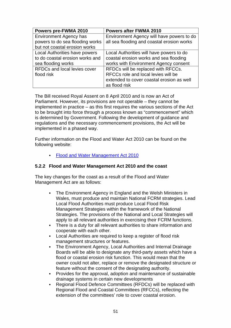
51
Powers pre-FWMA 2010 Powers after FWMA 2010 Environment Agency has powers to do sea flooding works but not coastal erosion works
Environment Agency will have powers to do all sea flooding and coastal erosion works
Local Authorities have powers to do coastal erosion works and sea flooding works
Local Authorities will have powers to do coastal erosion works and sea flooding works with Environment Agency consent
RFDCs and local levies cover flood risk
RFDCs will be replaced with RFCCs. RFCCs role and local levies will be extended to cover coastal erosion as well as flood risk
The Bill received Royal Assent on 8 April 2010 and is now an Act of Parliament. However, its provisions are not operable – they cannot be implemented in practice – as this first requires the various sections of the Act to be brought into force through a process known as “commencement” which is determined by Government. Following the development of guidance and regulations and the necessary commencement provisions, the Act will be implemented in a phased way. Further information on the Flood and Water Act 2010 can be found on the following website:
Flood and Water Management Act 2010 5.2.2 Flood and Water Management Act 2010 and the coast The key changes for the coast as a result of the Flood and Water Management Act are as follows:
The Environment Agency in England and the Welsh Ministers in Wales, must produce and maintain National FCRM strategies. Lead Local Flood Authorities must produce Local Flood Risk Management Strategies within the framework of the National Strategies. The provisions of the National and Local Strategies will apply to all relevant authorities in exercising their FCRM functions.
There is a duty for all relevant authorities to share information and cooperate with each other.
Local Authorities are required to keep a register of flood risk management structures or features.
The Environment Agency, Local Authorities and Internal Drainage Boards will be able to designate any third-party assets which have a flood or coastal erosion risk function. This would mean that the owner could not alter, replace or remove the designated structure or feature without the consent of the designating authority.
Provides for the approval, adoption and maintenance of sustainable drainage systems in certain new developments
Regional Flood Defence Committees (RFDCs) will be replaced with Regional Flood and Coastal Committees (RFCCs), reflecting the extension of the committees’ role to cover coastal erosion.

52
RFCCs’ power to raise a levy is likewise extended to cover coastal erosion, compared to the current levy raising power of the RFDCs.
The Environment Agency considers any objections to proposals by Coast Protection Authorities to carry out coast protection works and determines whether or not the works should proceed. This role was delegated from the Minister to the Environment Agency in April 2008 and the Act formalises this.
The Environment Agency will have a new power to make grants in respect of expenditure incurred or expected to be incurred in connection with flood or coastal erosion risk management in England.
The Act gives new powers to coastal erosion risk management authorities, who are coast protection authorities (any maritime Local Authorities who adjoin the sea) and the Environment Agency, such as:
Consent to carry out coastal erosion risk management works inside or outside the authorities district if it is in line with the national strategy and manages coastal erosion risk.
The Environment Agency also has concurrent powers to undertake the same works as Local Authorities as long as the same conditions are satisfied.
The Act also makes the Environment Agency a relevant authority for the Coast Protection Act along with coastal protection authorities. This means the Environment Agency has discretionary powers when exercising its coastal functions such as:
Publish notice of proposals to carry out coast protection works along with costs to give the public notice to object
Carry out emergency coast protection works in any area it thinks necessary
Direct an owner or occupier of land to undertake coast protection works where they have a historical obligation to maintain defences
Compulsory purchase land if ordered by the Minister for England or Wales
5.2.3 Coast Protection Act 1949 The Coast Protection Act 1949 is one of the most important pieces of legislation with regard to managing the coast. All those dealing with coast protection matters need to have an appreciation of this Act which is available on the following website:
Coast Protection Act 1949 The Coast Protection Act 1949 provides the legal framework for the protection of the coast against erosion and encroachment by the sea within the boundaries set out in Schedule 4 of the Act. It gives Local Authorities permissive powers to undertake coast protection works on their frontage. The

53
Schedule 4 boundary is often at the estuary mouth and where this is the case the Coast Protection Act cannot be applied to erosion within the estuary. A coast protection authority has the power to carry out any necessary or expedient coast protection work for the protection of any land in its area from erosion or encroachment by the sea. The authority may enter into an agreement with any other person for the carrying out of the work and may also buy any land required for the carrying out of coast protection work or land which is to be protected by new coast protection work. They also have powers to compulsorily acquire land in accordance with the Acquisition of Land 1961. The powers also enable work to be undertaken involving construction, alteration, improvement, repair, maintenance, demolition or removal but must be for the purpose of protecting land from erosion and encroachment and not for any other purpose. Provision is made for charges to be levied on land which is benefited by a coastal protection scheme, but not for maintenance. See Appendix 1 for further details. Section 34 of the Coast Protection Act 1949 restricts works detrimental to navigation. Ministerial consent is required for the construction, alteration or improvement of works on/under/over any part of the seashore lying below the level or mean high water springs. Consent is also required for depositing or removing any object or materials from any of that part of the seashore (see section 5.2.9 for more information). The Coast Protection Act 1949 is devolved to Wales except for:
(a) Sections 2, 5(4), 8(4), 17, 46, and Schedules 1 and 2 where the Wales Minister retains the functions,
(b) Section 18(2) and Part II, and (c) The Treasury function under section 32(5)
The fourth schedule in the Act defines waters (rivers) excluded from the definition of sea and sea shore. These boundaries are know as the Schedule 4 boundaries. The Coast Protection Act extends to England, Wales and Scotland, but the Environment Agency only gives grants to English Local Authorities. The devolved administrations in Wales and Scotland have their own arrangements under the Coast Protection Act 1949. In Wales, grant aid is allocated by the Welsh Assembly Government. It is important to note that Defra and the Welsh Assembly Government will continue to be responsible for:

54
Section 5(5): Objections to proposals where the Environment Agency proposes to carry out coast protection work
Section 14: Compulsory acquisition of land Section 18: Prohibition of excavation, etc, of materials on or under the
seashore Section 29: Default powers of Minister Schedule 4: Changes to boundaries. The Flood and Water Management Act 2010 has made some changes to the Coast Protection Act. See for more information. A commentary on the Coast Protection Act can be found in Appendix 1. Further insight into the Coast Protection Act can be found in Chapter 5 of William Howarth’s Flood Defence Law book. 5.2.4 Water Resources Act 1991 S165: The Water Resources Act 1991 gives the Environment Agency permissive powers to provide sea defences. S105: Surveys & levies: The Environment Agency retains the overall duty to carry out surveys of the areas in relation to which it carries out its flood defence functions and responsibility for the issuing of levies or the making of drainage charges. S165: Outfalls: In the sea or estuaries the Environment Agency may construct all such works and do all such things in the sea or in any estuary as maybe necessary to secure an adequate outfall for a main river. S166: Flood Warning: The Environment Agency has the power to provide and operate flood warning systems. “Flood defence” means the drainage of land and the provisions of flood warning systems. “Drainage” includes defence against water including sea water. The Environment Agency may carry out works, (maintenance and improvement of existing works and/or construction of new works) for the purpose of defence against sea water or tidal water. Local Acts of Parliament may provide powers in relation to specific flood prevention works, for example construction of tidal barrages which may in certain circumstances override the provisions of the Water Resources Act 1991. S172: Powers of entry: Although the Environment Agency has the powers to undertake flood defence works it must still have powers to enable entry onto the land. If entry cannot be secured by agreement Section 172 provides the power of entry for the Environment Agency. Section 64 of Land Drainage Act 1991 provides similar powers for Local Authorities.
55
S154 Land purchase: Provides that the Environment Agency maybe authorised by the Secretary of State to compulsorily acquire any land required. The Land Drainage Act 1991, the Water Resources Act 1991 and the Environment Act 1995 continue to provide the legislative framework for managing flood risk on the coast, with the elaboration of the Environment Agency’s Supervisory Duty still applying. Whilst Local Authorities have the same permissive powers as the Environment Agency, the Environment Agency is the lead authority for all flood defence matters. The Water Resources Act 1991is available on the following website:
Water Resources Act 1991
5.2.5 Land Drainage Act 1991 The Land Drainage Act 1991 gives powers to Local Authorities to do works on watercourses which are not designated as ‘main river’ and not within the area of an Internal Drainage Board. It gives power to Internal Drainage Boards to do works in their area. It also provides the legislative framework for Internal Drainage Boards, and other functions of these Boards and Local Authorities in relation to land drainage. The Act is available on the following website:
Land Drainage Act 1991 5.2.6 Environment Act 1995 The Environment Act 1995 provided for the formation of the Environment Agency in England and Wales, and the Scottish Environment Protection Agency in Scotland and the functions that they have. Section 6(4) Environment Act 1995: The Environment Agency shall exercise general supervision over all matters relating to flood defence. Supervisory duty - the role of planning liaison: by virtue of its general supervisory duty over all matters relating to flood defence, the Environment Agency advises planning authorities on development and flood risk matters. The Environment Agency is a statutory consultee in relation to certain development (for example development involving the carrying out of work or operations in the bed or on the banks of a watercourse) and is informally consulted in relation to other development. Section 30 – Cost/Benefit Duty: The Environment Agency shall in considering whether or not to exercise any power or how to exercise the power taking into account the likely costs and benefits of the exercise or non-exercise of the power but this doesn’t affect the need to discharge its duties.

56
In Wales the Minister has directed that if the benefit cost is less than one, the Environment Agency may consider the weight of other non-monetary factors in discussion with the Welsh Assembly Government, and it may not necessarily be a bar to the progression of the scheme. Sustainable development duty: The Environment Agency must make a contribution towards attaining the objective of achieving sustainable development indicated in ministerial guidance. Conservation duty: The Environment Agency has a duty generally to promote:
The conservation and enhancement of the natural beauty and amenity of inland and coastal waters and of land associated with such waters
The conservation of flora and fauna which are dependent on an aquatic environment
The use of such waters and land for recreation purposes taking into account the needs of chronically sick or disabled people
The Act is available on the following website:
Environment Act 1995 5.2.7 Town and Country Planning Act 1990 Section 57 of the Town and Country Planning Act 1990 creates a general requirement that development of land should not be carried out except with planning permission. Section 55 defines “development,” as the carrying out of building, engineering, mining or other operations in, on, over or under land, or the making of any material change in the use of any buildings or other land. In certain cases, developments do not require planning permission because of the provisions of the Town and Country Planning (General Permitted Development) Order 1995 (SI No 418) [“the Order”]. Land drainage works are dealt with above (section 3.9). The Environment Agency has other potentially relevant permitted development rights (PDRs) under the Order: Development by the Environment Agency, for the purposes of their functions, consisting of— (a) development not above ground level required in connection with conserving, redistributing or augmenting water resources, (b) development in, on or under any watercourse or land drainage works and required in connection with the improvement, maintenance or repair of that watercourse or those works, (c) the provision of a building, plant, machinery or apparatus in, on, over or under land for the purpose of survey or investigation, (d) the maintenance, improvement or repair of works for measuring the flow in any watercourse or channel,

57
(e) any works authorised by or required in connection with an order made under section 73 of the Water Resources Act 1991 (power to make ordinary and emergency drought orders), (f) any other development in, on, over or under their operational land, other than the provision of a building Permitted Development Rights are removed however if the development is subject to Environmental Impact Assessment requirements. Schedule 1 projects cannot be “permitted development”, and will require the submission of a planning application and an environmental statement. PDRs for Schedule 2 projects which either exceed or meet the applicable threshold or criterion, or are wholly or partly in a sensitive area, are also withdrawn, unless the local planning authority has adopted a screening opinion (or the Secretary of State (or, in Wales, the National Assembly for Wales) has directed) to the effect that an Environmental Impact Assessment is not required. The extent of local planning authorities' jurisdiction in relation to the coast depends on two factors: the administrative boundary of the particular authority, and the seaward limits to “land” in respect of which development can be controlled. The line of county jurisdiction is commonly drawn at the high water mark of medium tides, although in some cases it is fixed by local Act, such as the Isle of Wight Act 1980, s.45, which extends planning jurisdiction to include the various piers of the Island. Section 72 of The Local Government 1972 automatically annexes to the parish (and hence to the district and county within which it lies) “every accretion from the sea, whether natural or artificial, and any part of the sea-shore to the low water-mark.” The approach taken by the Secretary of State is that the mean low-water mark is the limit of local planning authority jurisdiction, although there are a number of exceptions, such as enclosed bays, and harbours for which the local authority is the harbour authority. The Government's traditional view is that this provides a sensible boundary in terms of policy as well as law. Even where the coastal administrative boundary extends beyond the mean low-water mark, doubts persist as to whether planning control is exercisable beyond that point. Planning permission is required only in respect of development in, on, over or under land. “Land” in the case of a river includes the river bed and banks, and development undertaken over a river is clearly subject to development control. The Scottish Court of Session has held that “land” in this context did not include the sea bed below low water mark. 5.2.8 Harbours Act 1964 Harbours in general sit outside of the lengths of coast covered in the Coast Protection Act. These areas are covered under the Harbours Act 1964 which is available on the following website:
Harbours Act 1964
58
5.2.9 The Food and Environment Protection Act 1985 – FEPA licences The Food and Environmental Protection Act 1985 (FEPA) covers the issue of licences for dredging and the disposal of material at sea. The Secretary of State for Environment, Food and Rural Affairs, as the licensing authority (or the Welsh Assembly Government for activities within waters around Wales), has a statutory duty to control the deposit of articles or materials in the sea or tidal waters. The licence is to ensure that prior to works commencing they do not impact on the living resources of the marine environment, human health, legitimate uses of the sea, and that any nuisance, noise and odours are minimised. Under the Act the ‘sea’ includes any area submerged at mean high water springs (MHWS), i.e. tidal waters. It is likely that flood risk and coastal erosion management works in the coastal zone will require prior approval and consent. The Act is devolved to Wales except for:
Any functions under Part II so far as exercisable in relation to matters concerning or arising from the exploration for, or production of, petroleum
The functions of the Minister of Agriculture, Fisheries and Food under sections 16 and 18 and paragraphs 1 to 3 of Schedule 5. It is directed that the functions under sections 1(1), 3(1) and (2), 13, 14(2) and (3), 17 and paragraphs 4 to 6 of Schedule 5 shall be exercisable by the Assembly (now WAG) concurrently with any Minister of the Crown by whom they are exercisable.
The Marine Management Organisation, or the Welsh Assembly Marine Consents Unit, advise on FEPA licences. In April 2011, FEPA licensing will be replaced in England and Wales by the Marine Act licence. More information on these changes can be found in the Marine Environment chapter (chapter 16). Further information on what activities require a FEPA licence, what is exempt, and how to apply for a licence can be found on the following website:
FEPA licensing Further information on licensing in Wales can be found on the following website:
Marine Licensing 5.2.10 Marine and Coastal Access Act 2009 The Marine and Coastal Access Act (Marine Act) received Royal Assent on 12 November 2009. It sets out a new way of managing our coasts and seas. It’s a comprehensive Act covering several topics. The Act:

59
Creates a new Marine Management Organisation (MMO) that is responsible for managing the seas around England. In Wales this will be the responsibility of the Welsh Assembly Government.
Establishes a new system of marine planning that for the first time will forward plan for all the UK’s seas. This will consist of a UK marine policy statement and a series of marine plans.
Streamlines marine licensing for developments by reducing the number of licences required for a marine project.
Creates a network of Marine Conservation Zones to safeguard some of the UK’s most important marine species and habitats.
Modernises the management of inshore fisheries and replaces Sea Fisheries Committees (SFCs) with Inshore Fisheries and Conservation Authorities (IFCAs) in England. In Wales, responsibility for inshore fisheries management will pass to the Welsh Assembly Government.
Takes forward many of the recommendations of the 2000 Salmon and Freshwater Fisheries Review. In particular, it widens our statutory fisheries duty to cover several other species and gives us a range of better powers to manage migratory and freshwater fisheries, especially in the face of climate change.
Gives Natural England the ability to create a walking route around the coast of England, and also provides for this to be done in Wales if it is considered appropriate in the future. (see section 18.8 for further information)
Power to raise local levies for coastal erosion works. The area covered by the Marine and Coastal Access Act starts at high water and extends to the edge of the UK’s Exclusive Economic Zone (out to 200 nautical miles). This means that there is an overlap with the shoreline management area. More detail on this Act can be found in the Marine Environment chapter (chapter 16). Further information on the Marine and Coastal Access Act can be found on the following website:
Marine and Coastal Access Act 2009 5.2.11 Bye laws Bye laws can be made by Local Authorities and certain other public corporations and companies concerning issues within the scope of their geographic or other areas of responsibility. Bye laws are usually created when there is no general legislation that deals with an issue that concerns people in a local area. The Secretary of State is responsible for approving bye laws. The bye vary around the country. Sea Defence byelaws provide for such things as:

60
Enabling the Environment Agency to serve notice requiring buildings or structures on sea defences to be repaired to prevent damage to sea defences
Prohibiting the removal of any material from the sea bed in the immediate neighbourhood of any groyne or work in the sea
Prohibiting the erection of buildings/structures within a certain distance of any sea defence without prior consent of the Environment Agency
Prohibiting the excavation of land or cliffs so as to damage or endanger the stability of sea defences
Prohibiting the driving of vehicles or animals over or along sea defences
Prohibiting the stacking or storage of materials on sea defences 5.3 International Legislation 5.3.1 Floods Directive The European Directive on the Assessment and Management of Flood Risks, known as the Floods Directive came into force in November 2007. The Directive requires Member States to assess whether water courses and coastal waters are at risk from flooding, to map the flood extent and the assets and humans at risk in these areas, and to take adequate and coordinated measures to reduce this flood risk. This Directive also reinforces the rights of the public to access this information and to have a say in the planning process. The Floods Directive will be implemented in coordination with the Water Framework Directive, primarily through the coordination of the flood risk management and river basin management plans. The requirements of the Floods Directive are implemented in England and Wales through the Flood Risk Regulations 2009 and the Flood Risk (Cross Border Areas) Regulations 2010. These require the production of preliminary assessment maps and reports (by December 2011), the identification of significant flood risk areas, and for these areas, the development of flood hazard and flood risk maps (by December 2013) and flood risk management plans (by December 2015). The Environment Agency is responsible for developing these for areas at risk from flooding from main rivers, reservoirs and the sea. Local Authorities are responsible for doing this for all other sources of flooding. Further information on the EU Floods Directive can be found on the following website:
EU Floods Directive 5.3.2 Water Framework Directive The European Directive on establishing a framework for community action in the field of water policy, known as the EU Water Framework Directive, or WFD, came into force in December 2000. It became part of UK law in

61
December 2003, implemented through the Water Environment (Water Framework Directive) (England and Wales) Regulations 2003. The Water Framework Directive requires that all inland and coastal waters (water bodies), within defined river basin districts, must reach good ecological status (or good ecological potential for those which are classed as being heavily modified) by 2015 and defines how this should be achieved through environmental objectives and ecological targets for surface water. The Environment Agency is the competent authority for carrying out the Directive in England and Wales. The Water Framework Directive is the major driver for achieving sustainable management of water in the UK and other Member States. It helps to protect and enhance the quality of:
Coastal waters out to one mile from low-water Estuaries Surface freshwater (including lakes, streams and rivers) Groundwater Groundwater dependent ecosystems
The Water Framework Directive is based on a six-yearly cycle of planning, action and review. This process is called River Basin Management Planning. A River Basin Management Plan will be produced for each river basin district every six years, and will result in improved water in rivers, estuaries, coasts and aquifers. In December 2009 the first of these plans was adopted by the Secretary of State and Welsh Ministers. The plans can be found on the following website:
River Basin Management Plans More information on the Water Framework Directive can be found on the following website:
EU Water Framework Directive Information Centre An Environment Agency internal operational instruction exists covering the requirements of the Water Framework Directive with regard to Shoreline Management Plans. See section 18.22 for further information. 5.3.3 Habitats and Birds Directives The Habitats Directive (together with the Birds Directive) forms the basis for Europe’s nature conservation policy. The EU Habitats Directive aims to protect wild plants, animals and habitats. The Directive has created a network of protected areas around Europe which are of international (EU) importance. These are known as Natura 2000 sites, and include:
Special Areas of Conservation (SACs) – these support rare, endangered or vulnerable natural habitats, plants and animals (other than birds)

62
Special Protection Areas (SPAs) – supporting significant numbers of wild birds or important populations of very rare birds and their habitats
In the UK, the Habitats Directive is implemented by the Conservation of Habitats and Species Regulations 2010. The Birds Directive not only requires the designation of Special Protection Areas, it also requires the protection of all wild birds. This aspect is principally implemented in England and Wales by Part 1 of the Wildlife and Countryside Act 1981. It also requires the Environment Agency to ensure that there is sufficient area and diversity of habitat for all wild birds. This goes beyond simply maintaining a network of designated sites. Closely linked to the Habitats and Birds Directives is the Convention on Wetlands of International Importance, especially as Waterfowl Habitat (commonly known as the Ramsar Convention). Rasmar Sites must be treated as if they were designated SPAs or SCAs. Further information on the Ramsar Convention can be found on the following website:
The Ramsar Convention on Wetlands The Environment Agency, along with Natural England and the Countryside Council for Wales, has produced an EU Habitats and Birds Directive Handbook giving guidance on the implementation of the Habitats Directive regulations. A copy of this Handbook is available by emailing [email protected]. More information on the Habitats and Birds Directive is available on the following website:
Habitats Directive Further information and guidance on the requirements of the EU Birds and Habitats Directives and the implications for flood and coastal risk management can be found on the following website (titled ‘Coastal Squeeze’):
Defra policy guidance: Coastal Squeeze – implications for flood risk management. The requirements of the European Birds and Habitats Directive
A number of Environment Agency internal operational instructions exist covering the requirements of the Habitats Directive. See section 18.22 for further information. 5.3.3.1 Regional Habitat Creation Programmes If European designated sites (SACs and SPAs) are damaged or experience loss due to flood risk management works or coastal squeeze then compensatory habitat must be found. The Regional Habitat Creation

63
Programmes (RHCP) have been developed to provide a strategic and proactive approach for the provision and delivery of compensatory habitats. Regional Habitat Creation Programmes can deliver the compensatory habitat required for the approval of Shoreline Management Plans (SMPs) and flood and coastal risk management (FCRM) strategies. All programmes need a clear system of recording, reporting and accounting for habitat created which can be audited and transparent to clarify the links with the statutory drivers and outcomes. Defra and WAG are responsible for signing off any compensatory habitat delivered through the Regional Habitat Creation Programme. Delivery of the Habitat Creation Programme will involve partnership working between Local Authorities, the Environment Agency, Natural England, Countryside Council for Wales, private landowners, and other partner organisations to ensure that habitat creation sites are secured and developed as efficiently as possible to enable timely delivery of flood and coastal erosion risk management projects for the benefit of all parties. The Environment Agency is responsible for the development and ongoing management of the RHCPs however specific compensatory habitat requirements arising from the SMPs or FCRM strategies are the responsibility of operating authorities to deliver. Local Authorities are responsible for the development of most SMPs and they should liaise with the relevant regional Environment Agency RHCP coordinator to ensure that the habitat requirements (i.e. from coast protection works) are included in the RHCPs. The Environment Agency is responsible for consulting with Natural England and the Countryside Council for Wales to establish and agree what type of habitat must be created and its geographical position in relation to the losses. Consultation with Natural England and the Countryside Council for Wales must also occur once the site has been decided upon to establish the validity of the selected site. Coastal Groups have a role in coordinating the successful completion of sustainable SMPs and the ongoing SMP Action Plans. These Groups will therefore play a role in ensuring that the RHCPs annual updates are carried out with the annual Action Plan review. Further information on delivering compensation habitat through the RHCP will shortly be published by the Environment Agency in an updated RHCP policy. Current guidance can be found on pages 56-58 of Planning Policy Statement 25 Supplement: Development and Coastal Change – Practice Guide (see chapter 14) for details.

64
5.3.4 Strategic Environmental Assessment Directive The Strategic Environmental Assessment (SEA) EU Directive ‘on the assessment of the effects of certain plans and programmes on the environment’ (Directive 2001/42) requires a formal environmental assessment of certain plans and programmes which are likely to have significant effects on the environment. Authorities which prepare and/or adopt such a plan or programme must prepare a report on its likely significant environmental effects, consult environmental authorities and the public, and take the report and the results of the consultation into account during the preparation process and before the plan or programme is adopted. The SEA Directive was transposed into UK law by the Environmental Assessment of Plans and Programmes Regulations 2004. Further information on the Strategic Environmental Assessment Directive can be found on the following website:
Strategic Environmental Assessment Directive A practical guide to the SEA Directive can be found on the following website:
Strategic Environmental Assessment An Environment Agency internal operational instruction exists covering the requirements of the SEA Directive with regard to Shoreline Management Plans. See section 18.22 for further information. Defra has provided some guidance for operating authorities on the application of strategic environmental assessments for flood management plans and programmes:
There is no legal requirement to apply this Directive to Shoreline Management Plans (SMPs), Catchment Flood Management Plans (CFMPs),Strategies, or any documented plan for medium to long-term river or coastal management.
However, SMPs, CFMPs and Strategies clearly help to set the framework for future planning and have significant environmental implications so require extensive consultation. It would therefore be appropriate to adopt an SEA approach.
It is strongly encouraged that operating authorities undertake SEAs for these plans.
Coastal Habitat Management Plans (CHaMPs) are technical documents produced to inform the SMP process and do not themselves set a framework for future decisions. Production of a CHaMP does not include formal consultation and would therefore be difficult to follow the SEA approach. It is not recommended that an SEA approach is followed in preparing CHaMPs.
Further information on Defra’s guidance for operating authorities on Strategic Environmental Assessments can be found on the following website:

65
Guidance for operating authorities: Strategic Environmental
Assessment Wales has its own Statutory Instrument – the Environmental Assessment of Plans and Programmes (Wales) Regulations 2004. Further information on Welsh Assembly Government’s guidance on how to comply with the Directive can be found on the following website:
Strategic Environmental Assessment in Wales 5.3.5 Environmental Assessment Directive Environmental impact assessment (EIA) is an important procedure for ensuring that the likely effects of new development on the environment are fully understood and taken into account before the development is allowed to go ahead. The requirements come from Directive 97/11/EC (which amends the original Directive 85/337/EEC on 'The assessment of the effects of certain public and private projects on the environment') and are implemented principally by the Town and Country Planning (Environmental Impact Assessment) (England and Wales) Regulations 1999 (SI No 293). The effect of the Directive is to require environmental impact assessment to be carried out, before development consent is granted, for certain types of major project which are judged likely to have significant environmental effects. A Government guide “Environmental Impact Assessment: A guide to procedures” explains how the Directive’s requirements for the environmental impact assessment of major projects have been incorporated into consent procedures in the UK and can be found on the following website:
Environmental Impact Assessment
The Directive's main aim is to ensure that the authority giving the primary consent (the 'competent authority') for a particular project makes its decision in the knowledge of any likely significant effects on the environment. The Directive, therefore, sets out a procedure that must be followed for certain types of project before they can be given 'development consent'. This procedure, known as Environmental Impact Assessment (EIA), is a means of drawing together, in a systematic way, an assessment of a project's likely significant environmental effects. This helps to ensure that the importance of the predicted effects, and the scope for reducing them, are properly understood by the public and the relevant competent authority before it makes its decision. Projects of the types listed in Annex I to the Directive must always be subject to EIA. Projects of the types listed in Annex II must be subject to EIA whenever they are likely to have significant effects on the environment. A

66
determination of whether or not EIA is required must be made for all projects of a type listed in Annex II. Schedule 2 projects include:
water management projects for agriculture, including irrigation and land drainage projects;
canalisation and flood-relief works; and coastal work to combat erosion and maritime works capable of
altering the coast through the construction, for example, of dykes, moles, jetties and other sea defence works, excluding the maintenance and reconstruction of such works;
Changes or extensions to Schedule 1 or Schedule 2 development which may have significant adverse effects on the environment also fall within the scope of the Regulations. Government Guidance [DETR Circular 02/99; Welsh office Circular 11/99] lists criteria and/or thresholds which indicate the types of case in which, in the Government’s view, EIA is more likely to be required. It should not be presumed that developments falling below these thresholds could never give rise to significant effects, especially where the development is in an environmentally sensitive location as defined in the Regulations. Such areas include Sites of Special Scientific Interest (SSSIs), National Parks, Areas of Outstanding Natural Beauty, the Broads, World Heritage Sites and scheduled monuments Equally, developments which exceed the thresholds will not in every case require assessment The fundamental test to be applied in each case is whether that particular type of development and its specific impacts are likely, in that particular location, to result in significant effects on the environment. Potentially relevant criteria/thresholds are: Reclamation of land from the sea: In assessing the significance of any development, regard should be had to the likely wider impacts on natural coastal processes beyond the site itself, as well as to the scale of reclamation works themselves. EIA is more likely to be required where work is proposed on a site which exceeds one hectare. Construction of inland waterways and canalisation: The likelihood of significant impacts is likely to depend primarily on the potential wider impacts on the surrounding hydrology and ecology. EIA is more likely to be required for development of over 2 km of canal. Flood relief works: The impact of flood relief works is especially dependent upon the nature of the location and the potential effects on the surrounding ecology and hydrology. Schemes for which the area of the works would exceed 5 hectares or which are more than 2 km in length would normally require EIA.

67
Coastal works to combat erosion and maritime works capable of altering the coast: The impact of such works will depend largely on the nature of the particular site and the likely wider impacts on natural coastal processes outside of the site. EIA will be more likely where the area of the works would exceed one hectare.
Where EIA is required there are three broad stages to the procedure:
1. The developer must compile detailed information about the likely main environmental effects. The information compiled by the developer is known as an 'Environmental Statement' (ES).
2. The ES (and the application to which it relates) must be publicised to give public authorities with relevant environmental responsibilities and the public an opportunity to give their views about the project and ES.
3. The ES, together with any other information, comments and representations made on it, must be taken into account by the competent authority in deciding whether or not to give consent for the development. The public must be informed of the decision and the main reasons for it.
Land drainage improvements: Land drainage improvement works undertaken by drainage bodies are permitted development under the Town and Country Planning (General Permitted Development) Order 1995 and are therefore exempt from planning permission. As such works might have significant effects on the environment, the principles of EIA need to be applied to them. This is done through the Environmental Impact Assessment (Land Drainage Improvement Works) Regulations 1999 (SI No 1783) which apply to England and Wales . The Regulations require a drainage body to consider whether proposed improvement works are likely to have significant effects on the environment. Where the drainage body considers that there are unlikely to be such effects, it must publicise its intention to carry out the works. If the drainage body receives representations that there are likely to be significant effects but it still thinks otherwise, it must apply for a determination to the appropriate authority (Secretary of State for the Environment, Food and Rural Affairs or, in Wales, the National Assembly for Wales). Where the drainage body concludes that the works are likely to have significant environmental effects, it must publicise its intention to prepare an environmental statement and notify specified consultation bodies (English Nature, the Countryside Agency and any other authority or organisation which might have an interest). The environmental effects of the improvement works must be assessed in the light, in particular, of the environmental statement and any representations received. If there are no objections, the drainage body may determine that it will proceed with the works. If there are objections, the proposal must be referred to the appropriate authority for a determination giving or refusing consent to the works. The determination must be publicised.

68
5.5.6 Marine Strategy Framework Directive The EU Marine Strategy Framework Directive (MSFD) requires “good environmental status” to be achieved in the marine environment by 2020. It came into force in July 2008 and transposed in July 2010. It overlaps geographically with the Water Framework Directive (WFD) in coastal waters (i.e. to 1 nautical mile), however WFD objectives take precedent here. The Marine and Coastal Access Act will provide the management tools with which to implement the Marine Strategy Directive. More detail on this can be found in the Marine Environment chapter (chapter 16). The Marine Strategic Directive can be found on the following website:
EU Marine Strategy Directive
69
CHAPTER 6: Climate Change 6.1 Purpose of this chapter The climate is changing and with it brings a likely increase in flood and coastal erosion risk. The recently published 2009 UK climate change projections (UKCP09) represent a considerable advance in our understanding of climate change. We need to understand these projections to plan for and manage the future risks we face. The top three things to remember are:
The UKCP09 climate projections suggest that mean sea level could rise by between 12cm and 76cm by 2095. If ice sheet loss from Greenland and Antarctica is factored in, mean sea level could rise by 1m, with a highly unlikely, but possible extreme scenario of 1.9m by the end of the century
The Foresight Future Flooding report (see chapter 2) suggested that that the greatest increase in risk will be at the coast
There is uncertainty in the climate change projections when considering changes over the longer term. However consideration of the range of direct and indirect impacts and their uncertainty must be given in all decisions made
6.2 UK Climate Projections Programme (UKCP09) The UK Climate Projections (UKCP09) uses cutting-edge science to help us understand how the UK’s climate may change over this century. Based on climate models, projections of the future climate change can be made to enable the UK to plan for a changing climate. More information on these projections can be found on the following website:
UK 2009 Climate Projections 6.3 Climate trends and projections Processes driving coastal risk: There are five key processes that drive flood risk at the coast: Relative sea level rise – the local change of sea level relative to the land Surges – the temporary change in sea level resulting from meteorological
(wind and atmospheric pressure) forcing of the ocean surface Waves – the wind induced disturbance of the sea that propagates across
the surface Coastal morphology and sediment supply – change in the form of the
seabed, shoreline and adjacent coastal land, and estuaries

70
Socio-economic change – changes to population, demographics and asset value will affect the impact of flooding as well as our ability to recover
Coastal morphology can be an important buffer against the first three of these drivers, but sediment starvation, in part a result of coastal defences, and climate change means erosion is dominant along many parts of the UK coast. These drivers also influence the rate of coastal erosion, together with the geology of the coast, longshore sediment transport and linkages between coastal systems. There have been changes in some, but not all, climate drivers over the last century. Sea level changes: Sea level around the UK, relative to the land, is changing for a number of reasons:
The volumes of the oceans are changing as they expand in response to global warming
The amount of water stored on land as ice is decreasing as it melts in response to rising temperatures
The UK land mass is moving in response to the melting of the ice-sheet following the end of the last ice age
The land movement is generally upwards in northern Britain and downwards in southern England, leading to greater increases in relative mean sea level. Global mean sea level did not change significantly from 2000 years ago until the 19th century. The UKCP09 Trends Report (see below) states that global sea-level rise has accelerated between the mid-19th and mid-20th century, and is now at a rate of about 3mm per year. It is highly likely that human activities have contributed to at least some of the rise. Sea level around the UK rose by about 1mm per year in the 20th century, corrected for the land movement explained above. The UKCP09 Trends Report can be found on the following website:
The climate of the UK and recent trends report The UK national network of tide gauges, the instruments by which sea level is monitored, is maintained by the Proudman Oceanographic Laboratory. Stations with particularly long records include Aberdeen, North Shields (Tyne and Wear), Sheerness (Kent), Newlyn (Cornwall) and Liverpool. Extreme sea level change: Extreme sea levels around the UK arise from a combination of high tide, extreme waves and storm surge. In a global study of tide gauge data since 1975, Woodworth and Blackman (2004) concluded that almost all trends in extreme high water levels are dominated by changes to mean sea level.

71
For the UK over recent decades there is no compelling observational evidence for trends in either storm surge frequency or magnitude. Changes in wave climate: Changes in coastal wave climate may have an effect on susceptible coastal regions, especially in conjunction with the effects of storm surges and sea level rise. Wind waves and swell can damage the coastline, including natural and man-made sea defences. It is, therefore, important to understand the natural variability of wave climate, and also to estimate how it might alter in climate change scenarios for the 21st century. The primary variable for waves is wave height, represented by the significant wave height, which is defined as the average value of the highest one-third of the recorded wave heights. Other wave parameters may also be important, for example the overtopping of coastal structures is sensitive to wave period, as is the erosive or accumulative behaviour of beaches. Wave direction will have an impact on the alongshore transport of sediment. Trends in extreme wave heights for the North Atlantic have been the subject of much study (for example Wolf and Woolf, 2006). The last 20 years of the 20th century saw rises in extreme wave heights of up to 0.5m to the west of the UK. However, detailed cataloguing and analysis of storm patterns over the British Isles (Allen et al., 2008) concludes that changes in storm frequency over the last several decades of the 20th century is likely to be natural. Sea level rise: The latest UK Climate Projections (UKCP09) suggest that sea levels could rise by between 12cm and 76cm by 2095 around the UK. The UKCP09 projections of sea level rise have been derived from the Intergovernmental Panel on Climate Change (IPCC) Fourth Assessment Report on global mean projections. These are regionalised to consider changes in the geographical pattern of sea level around the UK, relative to the global mean. More information on the IPCC and the Assessment Report can be found on the following website:
Intergovernmental Panel on Climate Change Further details on the projections of future sea level for locations around the UK can be found on the following website:
UKCP09 UK Climate Projections
72
Storm surges: UKCP09 provides a thorough investigation into the potential changes to storm surges for UK waters for the 21st century. It reports that around the UK the size of surge expected to occur on average about once in 50 years is projected to increase by less than 0.9 mm per year (not including relative mean sea level change). In most locations this trend cannot be clearly distinguished from natural variability. The assessment therefore suggests that this component of extreme sea level will be much less important than was implied by the UKCIP02 (2002 climate change data projections), where corresponding values exceeded 5 mm per year in places. The largest trends are found in the Bristol Channel and Severn Estuary, where the trend is for an increase in the 50-year skew surge* return level of around 0.8 mm per year, not including relative mean sea level change. Since the method does not sample the full range of known uncertainties, the uncertainty range quoted for surge from Met Office models should be regarded as a minimum range. *Skew storm surge is the height difference between a predicted astronomical high tide, and the nearest (in time) observed or modelling high tide. Further information can be found on the following website:
Skew storm surge Changes to wind and wave climate: The UKCP09 marine report also provides projections of change to wind climate for UK waters. When the climate models are run into the future (to the 2070-2100 period) the change in winter mean significant wave height shows a distinctive north-south pattern. To the south of the UK, there is generally a small increase (this includes the English Channel and the southern North Sea). To the north, there is a larger reduction in significant wave height. This information is in line with the latest UKCP09 projections. This spatial pattern may suggest an intensification of westerly winds and a reduction in northerly winds, which could be related to a change in storm tracks (Wolf and Woolf, 2006). The autumn pattern is quite different with an increase in wave height to the north west of Scotland. In spring, any increase is limited mainly to the west coast. 6.4 Climate change impacts on flood and coastal erosion
risk The best analyses of changes in wave climate and storm surge climate point to mean sea level change being the most important driver for extreme water

73
levels and therefore coastal flooding. This is a very important observation. Keeping careful track of the rate of sea level rise will allow a prediction of when trigger points for taking adaptive action are likely to occur, and to plan accordingly. We can expect mean sea level to rise at an accelerating rate through the 21st century, and without adaptation this will lead to ever more significant losses to economic, social and environmental assets by the end of this century. Rising sea levels elevates all coastal sources of flooding, such as storm surge and extreme waves. For example, a 70cm increase in relative sea level for East Anglia would see the current 1:100 extreme water level reduce to between 1:2 to 1:8, depending on local conditions. Therefore the most immediate effect is to increase the probability of inundation. It will also effect coastal morphology particularly beach erosion and salt-marsh decline, and have an impact on our ability to deliver habitat creation and coastal asset maintenance costs. Such changes to erosion would exacerbate the increased probability of flooding by increasing the risk of coastal defence failure among other mechanisms. Changes in the direction of major storm events also has the potential to alter coastal morphology and hence alter the pattern of erosion and accretion around the coast further affecting locations that are presently protected from offshore conditions. At many coastal sites (including major industrial and infrastructure facilities) there is limited scope to retreat inland without major economic and/or social implications. The increased frequency and severity of extreme coastal water levels and waves on defences by the sea, means that they will be more costly to repair or replace. A reduction in sediment supply to the coast will be reflected in a narrowing of beaches and deterioration in amenity and ecological value. Avoidance of these losses requires a long-term strategic approach to coastal zone management. 6.5 UK Government’s response to managing coastal climate
change risks Climate change guidance: The primary guidance on climate change for operating authorities and others involved in managing flood and coastal erosion risk is Defra’s Supplementary Guidance Note on the Treatment of Climate Change Impacts, published in October 2006, part of the flood and coastal risk management appraisal guidance. Further information can be found on the following website:
Supporting guidance for FCERM-AG

74
The guidance provides recommended allowances (see below). These figures are also used in guidance for planners set out by Communities and Local Government’s (CLG) Planning Policy Statement 25 Development and Flood Risk (PPS25) and in Wales by the Welsh Assembly Government’s (WAG) Technical Note 15 Development and Flood Risk (TAN15). These documents can be found on the following websites:
Defra’s Flood and Coastal Defence Project Appraisal Guidance 3 Economic Appraisal – Supplementary Guidance Note on Climate Change Impacts
CLG’s Planning Policy Statement 25: Development and Flood Risk
WAG’s Technical Advice Note 15: Development and Flood Risk All strategies, schemes and management plans should use this guidance. The recommended allowances (see below) and sensitivity ranges, should be used to make provision for future changes in a consistent way and provide a basis for comparing investments. Regional net sea level rise allowances
Net sea level rise (mm/yr) Administrative or Devolved Region
Assumed vertical land movement (mm/yr)
1990-2025
2025-2055
2055-2085
2085-2115
Previous allowances
East of England, East Midlands, London, SE England (south of Flamborough Head)
-0.8 4.0 8.5 12.0 15.0 6mm/yr constant
South West and Wales -0.5 3.5 8.0 11.5 14.5 5mm/yr constant
NW England, NE England, Scotland (north of Flamborough Head)
+0.8 2.5 7.0 10.0 13.0 4mm/yr constant
Source: Defra’s FCDPAG3 Supplementary Guidance Note on Climate Change Impacts Following the release of UKCP09, the Environment Agency is working with Defra to revise the current guidance. Work undertaken to date on translating the UKCP09 projections into flood and coastal guidance suggests that:
Sea level rise projections are broadly comparable to existing guidance, but there is still deep uncertainty in the estimates.
There is now considerable recognition that there is a very low probability but plausible risk of sea levels rising by up to 2m by 2100.
For very vulnerable developments this worst case should be considered for contingency planning. The Environment Agency has recommended this approach for the nuclear new build programme and this has been referenced

75
by the Department for Energy and Climate Change’s National Planning Statement for Nuclear Power Generation. It is suggested that applicants for development consent should identify the potential effects of the credible maximum scenario in the most recent projections of marine and coastal flooding. The applicants must then be able to demonstrate that they could achieve future measures for adaptation and flood management at the site where necessary. New guidance, replacing the Supplementary Guidance Note on Treatment of Climate Change Impacts, will be released, supported by clear instructions for the management of any change in approach or allowances. This will be available on Defra’s website. Managing coastal climate change risks needs to be seen in the context of Government’s overall programme for adapting to climate change. Adaptation Reporting Power and Statutory Guidance: The Climate Change Act 2008 introduces a new power for the Secretary of State to direct “reporting authorities” to prepare reports covering how the organisation is assessing and acting on the risks and opportunities from a changing climate. Reporting authorities are organisations with functions of a public nature and statutory undertakers. The Climate Change Act gives the Government in England and Wales the power to produce Statutory Guidance on adaptation for organisations who are required to report under the Climate Change Act. The Environment Agency has produced guidance for organisations in England and Wales who have received a UK Government Direction or invitation to report under the Adaptation Reporting Power. It is designed to help reporting authorities produce a high-quality report that meets the Government’s criteria and is available on the following website:
Adapting Reporting Power: supplementary guidance for Reporting Authorities
The guidance is structured according to the following key areas of climate change risk: flooding, coastal change, and water resources. Further information on the guidance can be found on the following website:
Coastal processes and climate change Case studies: Every organisation should be taking seriously the part it needs to play in adapting society, infrastructure and the economy to the impacts of climate change. The following website provides some case study examples where the

76
Environment Agency has joined with partner organisations to plan for adaptation and protect people and places at the coast.
Environment Agency case studies: Sea level rise and the coast The UK Climate Impact Programme (UKCIP) has produced a searchable database of case studies from Local Authorities that have taken action on climate change adaptation. The case studies cover a range of service areas, include risk management, spatial planning and partnership working. Further information on these case studies can be found on the following website:
Local Authority Case Studies Key knowledge gaps: When considering long term change at the coast, there are a number of key knowledge gaps in our understanding and predictions. These gaps could be addressed by the following research:
A more complete examination of the future wave climate using a fuller set of climate models.
The location of new infrastructure and the required level of protection
Places where communities, businesses and infrastructure could be relocated to
An integrated assessment of the potential flood losses arising from these projections
Detailed scientific understanding of sediment transport processes and coastal morphology over long (decadal-centennial) timescales.
Environment Agency actions: The Environment Agency has, and is continuing to undertake a number of key actions to adapt to and limit climate change. These are as follows:
Developed a long term investment strategy for flood risk management. This sets out investment options and benefits for the next 25 years looking forward over the whole of the century and considers future sea level rise
Working with Local Authorities to produce Shoreline Management Plans (SMPs) for the coastline of England and Wales. These provide the latest information on coastal change and future management policies
Developing strategies for estuaries to reduce flood risk and foster the sustainable functioning of estuaries
Testing the design and performance of all new flood defences against increased river flows and coastal extreme water levels to allow for climate change
Trying to prevent inappropriate developments in areas at risk of flooding and future flooding

77
Publishing coastal erosion risk information to complement existing flood map. Maps will contain the best data available which means incorporating the latest climate change scenarios from UKCP09, and the second iteration of Shoreline Management Plans
Managing the impact of sea level rise and the impact coastal management has on inter-tidal habitats to comply with the obligations imposed by the Habitats Regulations. Compensating for the loss of these habitats by supporting many saltmarsh and mudflat creation partnership projects over the past five years (at a cost of over £3 million) including:
Turning 80 hectares of arable land into intertidal habitat at Paull Holme Strays on the Humber.
Futurecoast project – assessing trends for shoreline evolution around England and Wales over the next 100 years.
Abbotts Hall, Blackwater Estuary, Suffolk — five breaches of the sea wall has created 60 hectares of saltmarsh habitat
Actively monitoring sea level rise and coastal extremes as well as land movement to understand the changing risks around our coasts
Using a carbon calculator to optimise flood schemes for the reduction of carbon emissions during construction
The Environment Agency has also worked with the Local Government Association to produce guidance for climate change adaptation that presents more ideas and is available from the following website:
How to integrate climate change adaptation strategies into local government
References: Woodworth, P. L. and Blackman, D.L. (2004) Evidence for systematic changes in extreme high waters since the mid-1970s, Journal of Climate, 17, 1190-1197 Allan, R., Tett, S. and Alexander, L. (2008) Fluctuations in autumn-winter storms over the British Isles: 1920 to present, International Journal of Climatology, 29, 357-371. Wolf, J. & Woolf, D. K. (2006). Waves and climate change in the north-east Atlantic. Geophysical Research Letters, 33, L06604. (doi:10.1029/2005GL025113).

78
CHAPTER 7: Shoreline Management Plans, Coastal Strategies and Schemes 7.1 Purpose of this chapter Shoreline Management Plans (SMP) set the strategic direction for how we want to manage the coast over the next 100 years. They identify the most sustainable approaches to managing coastal erosion and flooding risks in the short, medium, and long term. This chapter provides a summary of the guidance and use of Shoreline Management Plans (SMPs). It does not replicate the guidance that currently exists for SMPs, available on Defra’s website. The top three things to remember are:
The 18 second generation SMPs for England, and 2 cross border plans are due for completion in December 2010, to achieve Outcome Measure 9. The 2 Welsh SMPs are due for completion by December 2011
Any scheme or coastal works are expected to be in accordance with the relevant SMP in order to be considered for approval and funding. SMP policies and policy options set the direction of travel for a more sustainable coast but do not guarantee delivery
The SMP Action Plan is the key SMP implementation document. It is reviewed on a regular basis and reported on by the Coastal Groups
7.2 Background and context Shoreline Management Plans (SMPs) are non-statutory, high level planning documents that provide a ‘route map’ for managing coastal flooding and erosion risks. They provide the latest information on coastal changes, including social, economic and environmental data and balance these to set sustainable sea flooding and erosion risk management policies for the future. Policy options are broken down into three time epochs – the short term (0-20 years), the medium term (20-50 years), and the long term (50 to 100 years). The development of Shoreline Management Plans is managed by Coastal Groups (see chapter 4 for more information on Coastal Groups). Further information on Shoreline Management Plans can be found on the following websites:
Shoreline Management Plans (Defra) Shoreline Management Plans (Environment Agency)
79
7.2.1 What is a Shoreline Management Plan A Shoreline Management Plan sets out how the coast should best be managed in the future. It is:
A large scale assessment of the risks associated with coastal processes
A policy framework to reduce these risks to people and the developed, historic and natural environment in a sustainable manner.
SMPs set out the approach to achieve long term balanced sustainability of sea flooding and coastal risk management for a specific stretch of coast. Their aim is to provide the basis for sustainable shoreline management policies over the next 100 years within a natural process unit (sediment sell or sub-cell). The stretch of coast that an SMP covers includes one or more sediment cells and will typically include a number of communities and land uses, and a series of different physical features and coastal defences. Managed by Coastal Groups, the plans set out how maritime Local Authorities and the Environment Agency (the operating authorities), work together with other foreshore owners to reduce the risks to people, property and land from sea flooding and coastal erosion. In developing SMPs a range of partners and the public are extensively consulted and involved in the decision making processes. 7.2.2 Why have Shoreline Management Plans The main purpose of Shoreline Management Plans is to identify long-term policy options to manage the shoreline in a sustainable way. This is achieved through an assessment of the risks, opportunities, constraints and uncertainties, using the latest data on the coastal processes in the area, and the environmental and human needs and issues involved. Where appropriate, a requirement for subsequent strategy plans is identified in SMPs. These strategy plans explore options and identify the preferred long term sustainable approach to managing the identified risks taking full account of environmental, social and economic issues. It may be that no method of defending can be justified in the longer term either for technical, economical or environmental reasons. In such cases there may be a need to adapt to coastal change and for communities to learn to live with the risk. The Environment Agency, Local Authorities and other Government Departments are currently working with Defra and the Welsh Assembly Government (WAG) to look at ways in which communities can adapt and become more resilient to coastal change where defences cannot be provided. Further information on this is available in Chapter 13.

80
The objectives of a Shoreline Management Plan are:
To define, in general terms, the risks to people and the developed, historic and natural environment within the SMP area
To identify the preferred policies for managing these risks over the next 100 years
To identify the consequences of implementing the preferred policies To ensure that future land use and the development of the shoreline
takes due account of the risks and the preferred SMP policies To comply with international and national conservation legislation
and biodiversity obligations To set out a series of actions for Coastal Group partners to allow
SMP policies to be implemented 7.2.3 Shoreline Management Plan policy options All Shoreline Management Plans consider four standard policy options. Generally the SMP is broken down into policy units, and the most appropriate management approach is identified for each policy unit. The policy options are:
Hold the existing line of defence – by maintaining or changing the standard of protection. Used to cover situations where works or operations are undertaken to existing defences, in order to improve or maintain the standard of protection provided by the existing defence line.
Advance the existing defence line – by constructing new
defences seaward of the original defences. Option limited to those frontages where significant land reclamation is under consideration and there are no major environmental or engineering constraints.
Managed realignment – by allowing the shoreline to move
backwards or forwards, with management to control or limit its movement. Identifying a new line for coastal defence and, where appropriate, constructing new defences on a different line to the original defences.
No active intervention – where there is to be no national
investment in coastal defence assets or operations. However, monitoring and inspections of the shoreline will still be required.
It is important to note the SMP does not guarantee funding and approval of flood or coast protection schemes or other management activities and land ownership, technical ability to deliver, climate change implications and local acceptability may all affect the deliverability. The affordability of SMP policy options will always pose a significant issue, especially during the current economic climate and restrictions in public spending and budgets. Where there is scope and opportunities for external funding contributions in
81
implementing the SMP, it is important these be explored. (see section 8.4.3 for further information on external contributions) 7.2.4 Shoreline Management Plans, coastal defence strategies and
schemes It is important to distinguish between the different types of plans and initiatives used in shoreline management. The SMP will suggest in broad terms how the coast should be sustainably managed in the future. Coastal defence strategies may be recommended from SMPs and cover shorter lengths of coast identified within the SMP. From these more detailed strategies, individual coastal defence schemes or projects are developed for works at specific locations. [It should however be noted that not every scheme will be dependant upon the preparation of a strategy. There may be some cases where a stand-alone scheme can be considered on its own, supported by the SMP outputs]. Coastal defence strategies provide an in-depth appreciation of the risks and requirements for coastal defence. The key objective of a coastal defence strategy is to examine the coastal processes in detail, confirm or re-assess the SMP policy option and identify appropriate schemes that meet the economic, environmental and social criteria. The strategy will identify the preferred approach to coastal risk management proposing the best type of engineering scheme, taking account of economic and environmental issues, and any compensatory habitat requirements. It is the coastal defence scheme that actually provides the level of protection required to minimise risk. A scheme study will refine the assessment made in the coastal defence strategy and will identify precisely how any necessary engineering works or beach management will be undertaken. It will produce the ‘preferred technical solution’ which informs an application for funding. At the present time, all flood and coastal risk management plans and strategies in England are appraised at the National Review Group (NRG) and schemes considered at either NRG, the Regional Project Approval Board (PAB), or by the Area Flood and Coastal Risk Manager. In Wales all coastal flood risk management strategies and schemes follow the same approach, but for coastal erosion projects Local Authorities apply directly to WAG. The decision as to which Board considers the scheme depends on the scale of the project and the current financial scheme of delegation limits. This is reviewed on a regular basis. (see chapter 9 for further information on NRG and PAB) 7.2.5 First generation Shoreline Management Plans Shoreline Management Plans were conceived by Defra (formerly MAFF) in 1993, when a report was published setting out the advantages of considering the coast in a holistic and strategic way across England and Wales. The first generation SMPs were both innovative and a big step forward towards a better understanding of our coast and the need for strategic planning.

82
A principal driver in the development of Shoreline Management Plan Guidance was the assessment of the coast on the basis of coastal process/littoral sediment cells and sub-cells as set out by Motyka and Brampton in 1993 (Coastal Management: Mapping of littoral cells; HR Wallingford Report). In 1995, the first formal Guidance Note was published suggesting that the cell approach should be used. These sediment cells have also been used to determine the boundaries of the strategic Coastal Groups. The map below identifies the littoral cells around England and Wales:

83
Figure 5: Littoral cells map The first generation of Shoreline Management Plans were prepared by Coastal Groups in England and Wales. Nearly 40 plans were published on a sub-cell basis. The following map shows the location of each of these:

84
Figure 6: First generation Shoreline Management Plans location map Following a review of the first generation SMPs and full consultation with the industry, updated guidance was published in 2001. The guidance concluded that the first generation plans were very good high level strategic documents that represented a major improvement in managing risks holistically, but there were a number of areas which could be developed.

85
The review highlighted that the plans did not take full account of the natural environment, especially international designations, the links to the statutory planning process needed to be improved, and there was considerable inconsistencies in the data outputs around the coast. This lack of consideration for international conservation designations led to the production of Coastal Habitat Management Plans (CHaMPs) in key coastal locations. A further significant issue arising from the first generation SMPs (SMP1s) is the inappropriateness of policy options in certain locations which, when tested in more detail have been found to be unacceptable, unaffordable, uneconomical or too difficult to put into practice. Since these plans were put in place there have been several major studies, such as Futurecoast, Foresight, and UK Climate Impacts Programme, which have provided new information and demonstrate that some of the SMP1 policy options in some locations may no longer be practical or acceptable in the longer term. The Environment Agency has a digitised copy of all the first generation SMPs to provide a consistent record. A copy of these individual SMPs can be obtained from the NRG Technical Manager. 7.2.6 Pilot second generation Shoreline Management Plans The latest Shoreline Management Plan Guidance was trialled on three very different areas of coast. A subsequent guidance note was produced to clarify a number of issues that were raised through this process. The three pilot sites were: Kelling to Lowestoft Ness SMP, South Foreland to Beachy Head SMP, and Beachy Head to Selsey Bill SMP. Further information on these SMPs can be found on the following website:
Pilot SMP2s The Norfolk pilot (Kelling to Lowestoft Ness SMP) in particular highlighted the fact that to meet a long term (100 year) sustainable shoreline, some coastal communities would need to adapt to a changing coast. Some areas of the coast may not change much until 2050 or beyond, but others will change significantly over the next 5 to 20 years. Coastal change needs to be built into future planning policy, and adequate funding streams will need to be made available to accommodate necessary changes to infrastructure as the sea encroaches. A number of Pathfinder Projects to help assess the potential and options available is underway and due to report back to Defra in 2011. Further information on these Pathfinder Projects can be found in section 13.2.4. 7.2.7 Second generation Shoreline Management Plans Using the findings from the pilot plans, updated Guidance to inform the second generation of SMPs was issued by Defra in 2006, supported by WAG. The new guidance includes the lessons learnt from the first round of plans and emphasises the need to make the connection between SMPs (that remain a non-statutory plan) and the statutory planning system (Regional

86
Spatial Strategies and Local Development Frameworks). SMPs should also be considered during any local planning applications. The latest guidance emphasises the importance of preparing a Strategic Environmental Assessment (SEA) and an Appropriate Assessment in meeting the environmental opportunities and constraints, considering the affordability of any preferred policy option, and the need to comply with the three pillars of sustainability in economic, environmental and social terms. The updated guidance allows Coastal Groups to review their first generation SMPs to produce SMP2s. It recommends for example that options should be appraised over a 100 year timeframe, rather than the 50 years previously used, allowing for a more sustainable ‘vision’ for the coast. SMPs also need to incorporate the latest research such as Foresight and the Futurecoast project, as well as any local research findings. The guidance helps to ensure that partners, the public and wider neighbourhoods are engaged in an efficient and focused way so that future risk is communicated clearly and local views are fully considered in developing the Plans, and that the decision making processes is should also be transparent and auditable. Given known legislation and constraints, SMPs should not advocate policy options that cannot be delivered. It is recognised that due to present day challenges and restraints, wholesale changes to existing flood and coastal defence management practices may not be appropriate in the very short term. As such SMPs will need to provide a ‘route map’ for decision-makers to move from the present situation towards more sustainable options for the coast. The SMP will need to explain how the coast will evolve from the immediate position through the 3 epochs (short, medium, and long term) to the 100 year time horizon. 7.3 Shoreline Management Plan guidance Guidance on Shoreline Management Plans consists of two volumes, a number of appendices and a clarification note produced following three pilot SMP reviews. The guidance is as follows:
Volume 1: Aims and requirements – this defines an SMP and what it should include
Volume 2: Procedures – this provides guidance on how to produce an SMP in line with the requirements in volume 1
Appendix A – Stakeholder engagement strategies Appendix B – Data access and management Appendix C – Socio-economic appraisal and sensitivity testing Appendix D – Shoreline interactions and response Appendix E – Open coast SMP management boundaries Appendix F – Integration of estuaries Appendix G – Definition of issues and objectives Appendix H – Policy appraisal methodology Appendix I – SMP standard output formats

87
Clarification note on points raised during three pilot SMP reviews on the purpose of an SMP, long term investment programme, plan adoption, engagement, guidance on economic appraisal, and Appropriate Assessments.
All the above guidance can be found on the following website:
Guidance on preparing SMPs In addition, a Lessons Learnt report and Query Log have been produced to pick up ongoing issues and queries, and to supplement the guidance noted above and is available from the NRG Technical Manager. 7.3.1 Shoreline Management Plans and the Water Framework Directive
and Floods Directive The EU Water Framework Directive (WFD) promotes a new approach to water management through River Basin Management Planning (RBMPs) to help improve and protect inland and coastal waters. Decision making in SMPs needs to take account of the objectives of River Basin Management Plans. The Environment Agency has a key role in advising on compliance. Projects and plans that fall out of SMPs also need to be assessed according to legal obligations set out in the Water Framework Directive and defended under Article 4.7 of the Directive. To facilitate this, a separate but associated WFD baseline assessment report should accompany each SMP as it is prepared, using the same data that is gathered for use on the Strategic Environmental Assessment. An Environment Agency internal operational instruction exists covering the requirements of the Water Framework Directive with regard to Shoreline Management Plans and can be found on the following website:
Operational instruction: Assessing shoreline management plans
against the requirements of the Water Framework Directive [EA internal]
SMPs and the Floods Directive: SMPs will be key documents in order to address the requirement to produce flood risk management plans that address areas at significant risk from tidal flooding. Such flood risk plans are required by the Flood Risk Regulations 2009 (and the related cross border area Regulations). Such flood risk plans compliant with the requirements of the regulations will need to be completed by December 2015. This should not require the development of all new or further updated SMPs. Rather, the existing SMPs should be sufficient to be used to include all aspects of the Regulations where they do not already.
88
7.3.2 Shoreline Management Plans and Strategic Environmental Assessments
Strategic Environmental Assessment (SEA) is a process of assessing the environmental opportunities and constraints of a plan, and identifying and managing its implications. Whilst Strategic Environmental Assessments are not a statutory requirement on SMPs, their preparation is recommended by the Environment Agency as good practice and an SEA is currently being prepared for each of the SMPs in England and Wales. As they are utilising the same information as is gathered for Appropriate Assessments and the Water Framework Directive reports, their preparation is a relatively straightforward exercise, but very important within the suite of environmental reporting within an SMP. An Environment Agency internal operational instruction exists covering the requirements of the SEA Directive with regard to Shoreline Management Plans. See section 18.22 for further information. 7.3.3 Appropriate Assessments SMPs are considered as ‘plans’ for the purposes of Regulation 61 of the Habitats and Species Regulations 2010. Therefore, an Appropriate Assessment will be required if there is a probability or risk that it will have a significant effect on the site concerned. Such a risk will exist where it “cannot be excluded on the basis of objective information that a plan which still requires further permissions in order to be put into effect, will have significant effects on the site concerned.” If the Appropriate Assessment is ‘negative’, then the obligations set out in Regulation 62 of the Habitats and Species Regulations 2010 will need to be addressed (i.e. that there are no alternative solutions and that imperative reasons of overriding public interest exist). If the requirements of Regulation 62 are met, then compensation habitat will need to be secured before the plan can be adopted and implemented. Furthermore damage to a site should not occur until compensation provides a functional replacement. This is consistent with European Commission guidance. Guidance agreed between Defra and the Environment Agency’s legal advisors was issued to all operating authorities when the new updated SMP Guidance was launched in 2006. Further information on this ruling can be found on the following website:
Supplementary note on European Court of Justice Case ruling on land use plans and appropriate assessments
The Appropriate Assessment is one part of the SMP suite of reports. It is managed by the SMP Client Steering Group (CSG) and is relevant to all operating authorities in the SMP area. However, for the purposes of obtaining
89
approval in England from Natural England, a single operating authority is nominated as the ‘lead’ authority. Approval in Wales is granted by Welsh Assembly Government. The adverse effects on areas of conservation must be assessed at every relevant stage of the planning procedure to the extent possible on the basis of the precision of the plan. The assessment should be updated with increasing specificity in subsequent stages of the procedure (e.g. at the strategy stage and scheme development stage). Similarly, the assessment of the potential need for compensatory measures should be a developing process, which parallels the developing process of refining the Appropriate Assessment. As the Appropriate Assessment becomes firmer and more specific at each stage of analysis (SMP, strategy, scheme/project), and the identification of any adverse effect becomes more definite, so the identification of a need for compensatory measures can be consolidated. The scheme detailing what they should comprise can then be developed more specifically. Regional Habitat Creation Programmes are Defra’s recommended vehicle for delivering strategic habitat compensation (see section 18.10 for further information). The Welsh Assembly Government is also supporting the development of a Regional Habitat Creation Programme. However, it is essential that any compensation habitat requirement is a functional replacement for the designated habitat before it is lost (see paragraph 30 of Circular 1/2005). An Environment Agency policy exists covering the requirements of the Appropriate Assessment with regard to Shoreline Management Plans. See section 18.22 for further information. 7.3.4 Cases of overriding public interest (IROPI) Where SMP policy options are shown to have a damaging effect on the shoreline, and there are no viable alternative policy options, there may be good reasons for those policy options to remain where it can be shown to have over riding public reasons to do so. In such cases, a Statement of Case under Regulation 62 of the Habitats Regulations Assessment will be need to be prepared and submitted to the Secretary of State for approval. The decision as to the need for such a report rests with Natural England and Countryside Council for Wales and they will assist in the preparation of this report. In England, Natural England has already agreed that 12 of the 20 SMPs [including the 2 cross border plans] will need to be submitted to the Secretary of State. However, it has already been agreed with Defra that the need for compensatory habitats in any plan can be supported by Regional Habitat Creation Plans, and where these exist should be submitted with the Statement of Consent. Defra has stated that the report prepared for the Medway and Swale SMP is considered “Best Practice”.

90
7.3.5 Coastal Habitat Management Plans Coastal Habitat Management Plans (CHaMPs) quantify habitat change (loss and gain) and recommend measures to prevent future losses. They should be used to inform SMPs. Where these are out of date, SMPs should update. Guidance on Coastal Habitat Management Plans can be found on the following websites:
What we are doing to protect coastal wildlife and habitats Living with the Sea – Coastal Habitat Management Plans
7.3.6 Catchment Flood Management Plans and estuaries Catchment Flood Management Plans (CFMPs) provide an overview of the flood risk across each river catchment and estuary. They are the inland flooding equivalent of Shoreline Management Plans. They set out policies for managing those risks over the next 50-100 years. CFMPs consider all types of inland flooding, from rivers, groundwater, surface water and may include tidal flooding, but not directly from the sea (coastal flooding). CFMPs are used to plan and agree the most effective approach to manage flood risk in the future. Further information on CFMPs and copies of the Plans can be found on the following website:
Catchment Flood Management Plans Catchment Flood Management Plans and Shoreline Management Plans should have common boundaries so that within estuaries, for example, there are no gaps. In some cases, SMPs have included stretches of estuaries that may have been more appropriate for CFMPs. It is important that there should be no conflicts between the CFMP and SMP in relation to future actions in estuaries. This includes identifying the most appropriate location for the boundary between these high level plans for any future studies. Both plans should be in agreement on where the most appropriate boundary should be for any SMP/CFMP revisions in the future. In addition, there should be no conflicts between the policies and actions established within the CFMPs and the SMP. In developing the shoreline policies within the SMP, account must be taken of the interaction between the SMP policy and actions, and those proposed in the CFMP. Consideration should be given to the physical implications in relation to the sources, pathways and receptors of risk (for example, possible increased tide-locking). Where necessary, as a minimum, an action should be assigned in the SMP Action Plan to ensure any implications are drawn into the CFMP. Each CFMP policy includes a ‘vision’ and an action plan, and the implications of the shoreline policy should be coupled with this documentation. Opportunities and constraints should be highlighted and optimised to deliver broader benefits where possible. For example, SMPs may look to CFMPs to identify potential areas for habitat recreation, or there may be efficiencies in simply coordinating the timing of actions between the plans. The Environment

91
Agency expects these issues to be highlighted during the development of the SMPs, and has a process in place to ensure CFMP policies and action plans can be receptive to issued raised. 7.3.7 Outcome Measure for Shoreline Management Plans in England In order to improve management of the overall flood and coastal erosion risk management programme a suite of Outcome Measures has been established by Defra. (Further information on these can be found in section 8.5.1). Shoreline Management Plans and Catchment Flood Management Plans are important in steering decisions at operational level through the identification of risk exposure and broad policy options for risk management. The current suite of Outcome Measures includes a measure specifically to record the satisfactory preparation of Shoreline Management Plans and Catchment Flood Management Plans (Outcome Measure 9), signified by approval of the plans by Environment Agency Regional Directors and all SMPs for England are complete by December 2010. Outcome Measure 9 or its successor may be extended into the next Comprehensive Spending Review (CSR) period to consider the implementation of SMPs and CFMPs. 7.4 Shoreline Management Plan development, Action Plans
and review 7.4.1 Shoreline Management Plan programme and location map There are 22 second generation SMPs. This is almost half the number developed as SMP1s on a sub-cell basis as it was assessed to be more cost effective to merge some of the less complicated plans. The 18 SMPs for England and 2 cross border plans with Wales are due for completion in December 2010 and the two Welsh SMPs in December 2011. The following map shows the second generation Shoreline Management and the lead organisations. Further information on each of the second generation SMPs can be found on the following website:
Shoreline Management Plans – the second generation (SMPs)

92
Figure 7: Second generation Shoreline Management Plans (Note: they maybe referred to locally by different names) 7.4.2 Shoreline Management Plan Action Plans A key output from the SMPs will be the associated Action Plans. These plans should identify all actions required to deliver the policy options set out in the SMP. Actions may include further work by some or all of the partners in any
93
SMP, and include such things as contingency plans for the coast, capital and revenue proposals and new or updated strategies as well other issues. All actions should be prioritised along the frontage and set a timeframe both for the review and preparation of any strategies or schemes, together with an indication for any review of the Plan itself (SMP3). This is particularly important where there is a change in preferred policy option between the first and second epoch (short and medium term) and should at least set out an affordable and costed plan that deals with all studies needed in the first epoch (0-20 years). The Action Plan should also set out how this will be managed and how it will be dealt with in the planning process. In addition to identifying the timing and outline costs of strategy production and ongoing coastal monitoring, the Action Plan can be used as the basis for monitoring the linkages with the planning process, recording the number and location of any decisions taken against the Plan’s recommendations and sets out how the plan might best link to other coastal plans, such as those prepared for third party defences, etc. It has also been suggested that the Medium Term Plan (MTP) (and the equivalent in Wales), which also covers a 20/25 year period and hence ties in with the principles of the first epoch in an SMP, should sit as an annex to the Action Plan. This requires further discussion with the relevant operators and coastal groups. Action Plans can also set out future R&D requirements and other specific coastal studies. Coastal Groups will monitor and review SMP Action Plans on an annual basis. Achievement of the actions within the Action Plans by Local Authorities (both for SMPs and CFMPs) in England is included as part of reporting on National Indicators (NI189). Further information on these indicators can be found in section 18.16. A summary Action Plan template has been prepared and circulated to Coastal Groups for guidance, however its use is not mandatory. Although the Action Plan itself will be reviewed along with the rest of the SMP reports by the SMP Quality Review Group, it remains a matter for the SMP Client Steering Group to agree the final format and all the actions in the plan, including any implementation programme and lead body. Early feedback on monitoring the Action Plans indicates that most plans are overly ambitious in setting out the actions in the SMP, especially where they are not adequately resourced or funded. Coastal Group Chairs will need to work closely with SMP Client Steering Groups in looking carefully at all the Action Plans in their area to prioritise all the actions with adequate staff resources and funding. 7.4.3 Strategic Environmental Assessment Post Adoption Statements The Strategic Environmental Assessment (SEA) regulations (reg. 16) require the responsible authority to take appropriate steps to bring to the attention of the public the title of the plan, the date on which it was adopted, the location at which it can be inspected (along with the Environmental Report and the statement of environmental particulars), the times at which it can be inspected, and that inspection is free of charge. In practice this means

94
advertising the above. The Environment Agency’s National Environmental Assessment Service (NEAS) has a template for such an advert. The statutory consultees, public consultees, the Secretary of State and the Welsh Assembly Government must also be informed of the same information. The 'environmental particulars' referred to above comprise:
How environmental considerations have been integrated into the plan or programme
How the environmental report has been taken into account How consultation responses have been taken into account How any trans-boundary consultations have been taken into
account The reasons for choosing the plan or programme as adopted, in the
light of the other reasonable alternatives dealt with The measures that are to be taken to monitor the significant
environmental effects of the implementation of the plan or programme
These requirements are not onerous as Client Steering Groups should be able to reference the work already undertaken in the SMP, e.g. responses to consultation and actions taken should be published along with the adopted plan and can be referenced. There should, nevertheless, be an identifiable statement of particulars document which can also be used to inform the likely environmental effects resulting from any changes in the plan from the draft to that which has been adopted. However, to ensure that the Post Adoption Statement, the statement of environmental particulars and the planned process for advertising (for example, publication on the web) are fit for purpose it is recommended that Client Steering Groups confirm requirements themselves. Liaison with NEAS is recommended in the first instance. 7.4.4 Approval route for Shoreline Management Plans Engagement with partners and interest groups and the public is a critical element in the SMP preparation process. In particular, the early and ongoing involvement of Local Authority elected members and Regional Flood Defence Committee (RFDC) members in the process brings significant benefits, namely ‘buy in’ to the process and understanding policy options and preferred policies , which they will ultimately be asked to adopt. All maritime Local Authorities in the SMP area will have to adopt the SMP before it can be taken forward. The Guidance Note sets out that each Shoreline Management Plan has an:
Elected Members Forum (EMF) – which includes Councillors and Local Authority officers
SMP Client Steering Group (CSG) – which consists of Local Authority officers, the Environment Agency and other key players, such as Natural England and the Countryside Council for Wales.

95
The Coastal Group nominates a lead authority to prepare the SMP (see figure 7) and lead in project managing the procurement and plan production process. In England the Environment Agency Regional Directors approve the Plans on behalf on Defra and in Wales, the Welsh Assembly Government (WAG) funds, reviews and approves the SMPs. In order to quality assure these high level plans, and to provide an element of consistency around the country, the Environment Agency is involved in the development of all Plans as part of the “Client Steering Group”. To assist in the approval and quality review process a SMP Quality Review Group, led and managed by the Environment Agency, has been established comprising a wide range of coastal partners. Where there is a major dispute on an issue in an SMP, it will be for the Environment Agency to resolve it in the first instance, with help from the Quality Review Group. If the dispute cannot be resolved, the issue will be referred to the relevant Minister for determination. It is not expected that this will occur often, if at all. 7.4.5 Shoreline Management Plan Quality Review Group The SMP Quality Review Group (QRG) ensures all SMPs and Action Plans are nationally consistent in how flood and coastal erosion risk is managed so it is sustainable and affordable, and that Plans are “fit for purpose”. The QRG is managed by the Environment Agency and involves national partners including CLG, Local Authorities, Natural England, CCW, WAG and consultants involved with preparing these plans. Those who sit on the QRG have the necessary knowledge, understanding and experience to ensure that a quality product is obtained in all cases. Although membership of the group may change in the future, the core Group members will remain the same where possible to ensure continuity. The Group will review all SMPs until they are complete in December 2010 (England) and December 2011 (Wales). The Welsh Assembly Government (WAG) and Environment Agency Wales will assist the QRG in reviewing the two cross border Plans. The QRG will then support the Welsh Assembly Government who will lead the reviews of the two plans that are wholly located in Wales. As such all 22 plans that cover England and Wales will be reviewed by the same review group of expert assessors to ensure a full set of compliant SMPs for England and Wales. 7.4.6 Quality Review Group Terms of Reference The Group will assess each plan against set criteria to ensure it meets the principles laid out in the Guidance Note and offers both a vision for the coast and a set of appropriate actions to achieve the long term management of the flood and erosion risks.

96
The Quality Review Group has objectives and accountabilities, set out in the Terms of Reference which include the success criteria for reviewing SMPs. This is based on series of technical, social, economic, environmental, and administrative points. The Action Plans also have their own success criteria. 7.4.7 Quality Review Group process Five plans were substantially completed before the QRG was set up. In these cases, any issues raised by the QRG will be addressed through the Action Plan process. For the remainder of the Plans the QRG assesses both the consultation draft plan version (during the 3 month public consultation period) and the finished adopted plan, noting that this may be different in some cases, for example where local considerations have driven a specific policy option. Once the QRG is content that the Plan meets the principles set out in the SMP Guidance Note, it will recommend that the Environment Agency Regional Director and/or Welsh Assembly Government give formal approval. To ensure continuity between strategies and SMPs, there will be representation on the SMP QRG from the Environment Agency’s National Review Group (NRG), which reviews all strategies and high value/risk projects. This will provide a degree of comfort that a truly strategic approach is being taken on the coast. Further information on the National Review Group can be found in section 9.6.1. For each SMP there is an established process for review. The QRG review process flow chart is available in annex 4 of the Groups Terms of Reference. This sets out the timeframe that should be allowed for each step in the review process, from review of the draft (end of SMP stage 3) through to recommendation for approval. The preferred timing of the main review is during the 3 month public consultation period in order to ensure that all the issues on the plan are reported back to the Client Steering Group (CSG) at the same time. It also avoids any unnecessary delays in plan production. The key documents examined by the QRG are the SMP main report and all associated appendices, including the Strategic Environmental Assessment, the Appropriate Assessment, the Water Framework Directive Report and the Action Plan. In some cases not all these documents are prepared at the same time and the QRG has to undertake some iterative assessment to ensure all the documents are truly consistent and compliant. The SMP review process is managed by the Environment Agency’s NRG Technical Manager, who also acts as a gateway for all SMP reviews. All requests and notifications should be submitted via Jenny Buffrey. Jenny will also hold the latest SMP schedule for production and review of the SMPs. It is important that representatives on the Client Steering Groups maintain contact with the Quality Review Group and alert the Group to any significant changes to delivery dates and delays as soon as possible. The following diagram summarises the SMP approval process:

97
Figure 8: Shoreline Management Plan process diagram from draft to signoff
Public consultation and assess responses – task 4.4
Formal Consultation with
NE/CCW
Amendments
Formulate Action Plan – task 5.2
Final plan
Adopted by all Operating
Authorities
Final QRP
Draft to QRP
Wholly English/Welsh plans to EA or
WAG for signoff
No objections final AA Approved
To Minister
for IROPI
OR
Ministerial Announcement
Publish Final Plan
Milestone 3 – Final signoff
Milestone 2 – Allow 4 weeks for final QRP
Milestone 1 - QRP and formal SEA/AA consultation can run concurrently with 3 month public consultation
Draft - task 3.5 Draft SEA and AA
Coastal Group’s recommendation
Cross-boundary plans to WAG and
relevant English EA RDs for signoff
Note: “recommendation” is when coastal operating authorities have adopted and agreed actions from all LA adoptions and QRP
Amendments
Supported by FCRM and Regional
Director/EAW Director
Abbreviations AA – Appropriate Assessment CCW – Countryside Council for Wales EA – Environment Agency EAW – Environment Agency Wales FCRW – Flood & Coastal Risk Management IROPI – Imperative Reason for Overriding Public Interest (Habitats Directive) LA – Local Authority NE – Natural England QRP – Quality Review Panel RD – Regional Director SEA – Strategic Environmental Assessment SMP – Shoreline Management Plan WAG – Welsh Assembly Government

98
7.4.8 Shoreline Management Plan query log and lessons learnt The SMP QRG is maintaining a query log of issues raised by the SMP Client Steering Groups (CSGs) during plan production, as well as a lessons learned report. Both these documents are useful for all those involved in preparing SMPs. Copies of the latest query log and lessons learnt report are regularly issued to the Client Steering Groups and Coastal Group Chairs to keep them updated on the latest issues and to ensure consistency on the plans. The documents cover common issues such as interpretation of the policy options, dealing with private defences, funding, use of emerging erosion mapping and addressing updated climate change data. On completion of all the plans, it is envisaged that a review of the successes of the preparation and implementation of the second generation plans will be carried out, and some consolidation of existing guidance undertaken. 7.4.9 Change process for amending Shoreline Management Plans It is envisaged that at some point in the future there may be better information available that may alter a preferred policy option that has been approved in any given SMP. Examples may include a third party defence owner deciding to invest funding to reduce risks or a more detailed coastal defence strategy providing better data. In such cases the SMP will need to be amended to accommodate any necessary changes. A change process has been developed to record where, why and how an SMP policy option has been changed, and this document will be an important part of the plan reports. It is important that the latest preferred policy options are communicated clearly, especially on the associated SMP website, in a manner that is transparent for all users. It should be noted that there may also be a change required to other associated databases, for example the erosion risk information for the area. 7.5 Wider Shoreline Management Plan links In many cases SMP1 policy options were not implemented. However, due to important coastal initiatives that are already in progress, the implementation of SMPs will be much more focussed. When considering a strategic approach at the coast, there are a number of other ongoing processes that will need to be considered as the SMP is taken forward. The diagram below is provided to illustrate the range of linked processes and to act as an “aide memoir” for coastal partners when liaising on future coastal needs and when discussing SMP Action Plans.

99
Figure 9: Shoreline Management Plan and the wider links 7.5.1 Improving ‘dialogue’ between Shoreline Management Plans and
spatial planning For SMPs to be effectively implemented the management policies they contain and the approach set out in the Action Plan needs to be understood by spatial planners in Local Planning Authorities (LPAs). SMPs are a material consideration for Local Planning Authorities when preparing statutory plans. This is particularly important where strategic decisions are made in SMPs to re-align a sea defence or move to a policy of ‘no active intervention’ where defences currently exist. Defra’s review of the first SMPs in 2006 highlighted a need for more emphasis to be placed on improving links with the planning system. In March 2010 CLG released a supplement to PPS25 (Development and Flood Risk) to cover coastal change. It places SMPs among the key documents that maritime Local Planning Authorities are required to consider as material considerations to planning processes. In Wales TAN 14 (Coastal Planning) already identifies SMPs as key documents. See chapter 14 for further information. The lack of dialogue between spatial planners and Coastal Groups in developing the first SMPs identified in Defra’s review prompted the Environment Agency to commission a research project to assess why SMPs were not ‘dovetailed’ with other spatial planning documents and to recommend how better linkage could be achieved. The report by The Planning Co-operative ‘Translating Shoreline Management Plans into Spatial Plans’ published in 2009 made 25 recommendations relating to process,
Adaptation &
Resilience Habitat
Creation Strategic approach
SMPs
R&D
Skills & capacity
LTIS
CFMPs RBMPs
NRG/PAB
MTP
Planning eg. LDFs/LDPs
Asset management
Monitoring OMs & NI 189
Project Appraisal
Policy
Funding Comms
Contingency Planning
Inland overview
Coastal Groups
WFD
PPS 25 & Tan 14/15
Strategies &
Schemes
LAs & IDBs
Mapping: flood, erosion & overview
ICZM
Change Process
Marine planning

100
practice, government policy, personnel and publicity in England. The report summarised that:
Local Planning Authorities involvement in the development of SMPs needs to be much stronger in order to better communicate local priorities and strategic direction (for example those set out by Local Strategic Partnerships in Sustainable Community Strategies)
Policies agreed in SMPs need to be material considerations in the spatial planning process in order to avoid development in unsuitable locations and include adaptation to coastal change in Regional Strategies and Local Development Frameworks.
As a result, accessible summaries of the SMP outputs for spatial planners in each SMP constituent LPA are being produced alongside the SMPs from 2010, as per the report’s recommendation no.11. The full reports by The Planning Co-operative can be found on the following website
Translating Shoreline Management Plans into Spatial Plans Volume 1 and 2
7.5.2 Shoreline Management Plans and PPS25 Supplement –
Development and Coastal Change In March 2010 CLG released a supplement to PPS25 (Development and Flood Risk) to cover coastal change in England. It places SMPs among the key documents that maritime LPAs are required to consider as material considerations to planning process. Adaptation needs, such as land designated for relocation or ‘roll-back’ of assets at risk from coastal change, must be accommodated at a regional level in Regional Strategies (with a similar approach for habitat relocation where necessary, drawing upon Regional Habitat Creation Strategies). A copy of CLG’s supplement on Development and Coastal Change, along with its Practice Guide (which has the same legal status as the supplement itself) can be found on the following website:
Planning Policy Statement 25 Supplement: Development and Coastal Change
Further information on coastal planning policy can be found in chapter 14. 7.5.3 Shoreline Management Plans and the National Coastal Erosion
Risk Information Project SMPs are key documents in the production of the Environment Agency’s new online information tool on coastal erosion risk. This information has essentially collated the best available science on coastal erosion from Local Authority monitoring, existing SMPs and other high level studies such as Futurecoast

101
(Defra, 2002) and modelled it in a consistent way in order to display it to the public in an accessible format across England and Wales. The website will display erosion information and the management policies agreed in the updated SMPs. The erosion information will be communicated in the context of these policies, such that erosion rates are not applicable where a policy unit shows ‘hold the line’ or ‘managed re-alignment’. However, SMPs and the policies they include is complex and are non-statutory, so users of the web tool will also be directed to pages with more detailed local information. Where any differences between SMP and erosion mapping data do occur, for example due to the use of UKCP09 data in the erosion mapping not used in some SMPs, or because of differences in modelling approach, these will be highlighted in a specific ‘Comparison Note’ to accompany the final SMP document. It is important that all Client Steering Groups add the “comparison notes” to the SMP websites. 7.5.4 Shoreline Management Plans and coastal defence assets Good quality asset data is vital to get a baseline understanding of the current condition and management of the coast. To date, the use of NFCDD in preparing SMPs has not been consistent, but there are many advantages to improving this data and having a common approach to asset inspections, both Environment Agency and Maritime Authorities. Further information on current inspection practices and data recording can be found in Chapter 9.4. 7.5.5 Landfill sites and coastal erosion A project is underway to determine the scale of the possible problem with landfill sites becoming vulnerable to coastal erosion. To give an indication of the scale of the problem, the existing Environment Agency database on historic and authorised landfills will be overlaid on to the national coastal erosion risk mapping data to determine the extent of landfill susceptible for each of the three time epochs used in the Shoreline Management Plans (0-20, 20-50, and 50-100 years). For further information on this project please contact Neil Watson ([email protected]). 7.5.6 Funding of land instability A project is underway to investigate funding streams in connection with coastal landslides and to see whether there is any benefit in dealing with erosion and stability issues at the same time through, for example, combing funding streams. The outputs of the project will include a guide on how projects and project components should be assessed for eligibility under the Coast Protection Act (CPA) 1949 and to establish if a scheme would be liable for CPA funding. For further information on this project please contact Neil Watson ([email protected]).

102
CHAPTER 8: Funding Guidance 8.1 Purpose of this chapter This chapter tells you about the funding process, the sources of funding and how money is allocated and prioritised. It explains how to apply for funding for flood and coastal protection works on the coast. The websites provided in this chapter will provide information on any updates. The top three things to remember are:
The Environment Agency is responsible for the approval and allocation of all coastal capital funding in England. Welsh Assembly Government is responsible for the allocation of all coastal capital funding in Wales.
To be considered for funding schemes should be in line with the strategic direction set out in the SMP or strategy. In England they must also contribute to outcome measures and be on the sanctioned list
Full funding allocations for the Environment Agency should be used each year. Any unused funds return to the Treasury or Welsh Assembly Government and is effectively ‘lost’ to the flood and coastal risk management community
Note: Funding arrangements are different in England and Wales, see section 8.2 to 8.9 for arrangements in England and 8.10 for arrangements in Wales. 8.2 Funding responsibilities under the strategic overview Before the Environment Agency was given the strategic overview role, Defra allocated the funds through separate funding streams and prioritisation routes for coastal erosion and flood defence. This meant that investment was not necessarily always targeted where there was greatest risk. As part of the strategic overview the transfer of fund allocation to the Environment Agency a revised prioritisation process was implemented to make the approach more transparent and consistent. The following points summarise the new arrangements for grant allocation which came into force on 1 April 2008:
Local Authorities no longer apply to Defra for grant funding for coastal erosion capital works. The Environment Agency allocates all capital funds for flood and coastal erosion capital works.
All capital investment schemes (whether led by the Environment Agency or Local Authorities) go through the Environment Agency’s approval process both on technical and financial grounds to secure grant funding.
Approval will be on the condition that:

103
Works are consistent with Shoreline Management Plan policies and Water Framework Directive objectives
Suitable Asset Management Plans are in place to maintain the asset once constructed
Suitable procurement procedures are in place for efficient delivery
Outcome Measures have replaced the old priority scoring system for investment decisions. Information on Outcome Measures can be found in section 8.5.1.
The Environment Agency has delegated responsibilities for the approval process and payment of grant. Responsibility for the appointment of a consultant/contractor and the design, delivery and performance of the project will remain with the sponsoring authority This funding guidance applies to England, the Welsh Assembly Government allocates funding for flood and coastal erosion schemes in Wales. The following website gives guidance on the new funding arrangements:
Local Authority and internal drainage board funding guidance 8.3 Grant Memoranda Two Grant Memoranda set out the legislative terms and conditions that apply to grant aid. 8.3.1 Grant Memorandum for Coastal Erosion The “Memorandum relating to scheme approvals and grants to Local Authorities under the Coast Protection Act 1949” sets out the conditions for approval of grant for works and preliminary studies specifically to reduce risks from coastal erosion. It explains the procedure for applying for approval of projects under section 5(5), notifying works under section 5(6) and applying for grants under section 21(1) of the Coast Protection Act 1949. It also states what is and is not eligible for grant, and sets out the terms and conditions. It is available on the following website:
Grant Memorandum for Coastal Erosion 8.3.2 Grant Memorandum for Flood Risk Management The “Memorandum relating to flood risk management grants to Local Authorities and internal drainage boards under the Water Resources Act 1991 and the Land Drainage Act 1991” sets out the conditions for projects specifically to reduce risks from all forms of flooding including those from the sea. It explains the procedure for applying for flood risk management grants under the two acts. It also states what is and is not eligible for grant, and sets out the terms and conditions. It is available on the following website:
104
Grant Memorandum for Flood Risk Management
Within both documents mentioned above, it states that the Environment Agency will be responsible for drawing up an annual Medium Term Plan, inviting Local Authorities and internal drainage boards to submit projects for grant allocation. Following the prioritisation process, a list of projects sanctioned (the sanctioned list ) is published showing that grant has been allocated for these projects subject to the necessary approvals being in place. Local Authorities and internal drainage boards can then apply for grant for listed projects once they have the approvals in place. Further information on this process is available later in this chapter. 8.3.3 Arrangements for using Coast Protection Act 1949 or Land
Drainage Act 1991 In the past, some projects have been promoted for convenience under the Coast Protection Act 1949 that relate mainly to sea flooding issues. Defra has clarified that a project dealing wholly or mainly with sea flooding problems should always be promoted under the Land Drainage Act 1991. If a project has both sea flooding and coastal erosion elements the element with the highest benefit should be used to determine the approval route for a multi benefit scheme. 8.4 How projects are funded The Treasury determines the level of Government funding for managing risks from flooding and coastal erosion. Funding is then transferred to the Environment Agency to allocate to new and improved coastal and flood risk management projects and defences, whether these are delivered by the Environment Agency, Local Authorities or internal drainage boards. Current funding allocation figures are available on the following website:
Investment allocation (Defra) 8.4.1 Local Authority funding Local Authority expenditure is supported by general Government grant and is not ring-fenced for flood and coastal risk management. Local Authorities decide how to use the grant depending on the need for investment on other priorities. A brief insight into how Local Authorities are funded and their funding allocation process can be found in section 8.9. Maintenance of maritime Local Authority coast protection defences is funded from Local Authority resources, which in turn is supported from the Formula Grant (formerly the Revenue Support Grant (RSG)) from the Department for Communities and Local Government (CLG). Coastal protection expenditure comes under the Environmental, Protective and Cultural Services and is based on averaged actual expenditure in the previous years. This amount of

105
funding is fixed for the three year period of the Comprehensive Spending Review (CSR period). The amount of funding varies considerably for each Local Authority. The Revenue Support Grant for any particular council can be found on the following website. Table 1 (available from the link below) shows coast protection expenditure.
Local Government Finance Settlement: Individual Local Authority data tables for 2010/11
8.4.2 Internal drainage board funding Internal drainage boards are able to raise funds through charges on agricultural land owners and special levies on Local Authorities to fund their drainage and risk management activities. They can also apply for capital funding for improvement works from the Environment Agency. 8.4.3 External contributions Funding for major capital projects is provided nationally by Government. However, whenever it is appropriate to do so, business and communities should be encouraged to make a contribution to those projects that benefit them. This can bring the project forward in the programme. Further information on this is available on the following website:
Flood and coastal risk management external contributions policy 8.4.4 Long Term Investment Strategy The Environment Agency has recently published its Long-term investment strategy for England setting out the scale of investment needed over the next 25 years to meet the likely increase in flood and coastal erosion risk as a result of climate change. The report sets out the investment choices we face to address the increasing risk of flooding and coastal erosion. Models in the report show that investment in building and maintaining flood defences in England will need to almost double to £1 billion a year by 2035. This figure excludes the cost of managing the risk of surface and groundwater flooding and other activities such as flood warning and development control. This report is available on the following website:
Long Term Investment Strategy 8.4.5 Proposed changes as a result of the Flood & Water Management
Act 2010 Implementation of the Flood and Water Management Act 2010 will result in further changes to the current funding and investment arrangements. The Act includes the following with regard to funding and investment:

106
Levy-raising powers held by Regional Flood Defence Committees (RFDCs) will be extended to allow funding on locally important coastal erosion risk management projects. The Committees will be renamed Regional Flood and Coastal Committees (RFCCs).
The Environment Agency’s grant-making powers will be broadened to allow a greater range of risk management and adaptation activity by a wider range of parties.
8.5 How funding is allocated Each year Local Authorities and internal drainage boards apply to the Environment Agency for funding work through the Medium Term Plan. The costs and benefits of each potential project are assessed by the operating authority concerned (Environment Agency, Local Authority or internal drainage board) using a project appraisal methodology (see section 9.2 for further information). The appraisal process results in the selection of a preferred risk management option for each location, in close consultation with interested parties including the local community. The Environment Agency then assesses the potential of each project to contribute towards achieving the outcome targets set for the current spending period in England. In general, the Environment Agency allocates Government funding to those projects that deliver the greatest contribution towards the outcome targets for each £1 of investment, although in some cases funding is provided to meet legal requirements or to fund emergency works. Other than through the setting of policy and outcome targets, Defra ministers are not involved in individual investment decisions unless the whole-life value of the project or area strategy exceeds £100million. The budget for flood and coastal risk management is limited and therefore not all viable projects can go ahead. Where such a project is not successful in attracting Government funding it is because there are projects in other areas of the country that would deliver greater benefit, or contribute more towards the outcome targets, per £1 of investment. In such cases, Local Authorities and communities have the discretion to fund these projects themselves or request support from the RFDC local levy. 8.5.1 Outcome Measures It’s important to have a fair and transparent system to determine how and where money should be allocated in order to achieve agreed priorities. A series of Outcome Measures have been developed in order to achieve this. Further information on these is available on the following website:
Development of Outcome Measures Five outcome targets have been set by Defra for operating authorities to achieve over the 2007 Comprehensive Spending Review (CSR07) period.

107
This period is from April 2008 to March 2011. By setting targets for each outcome, a strong steer is given on where to prioritise effort and funding. Outcome Measures and targets to be used beyond the CSR07 period are being agreed by Defra. They are likely to be similar in nature to the existing measures. The targets set for 2008-2011 are as follows: Outcome Measure Definition Minimum Target 1: Economic Benefits Average benefit cost
ratio across the capital programme based upon the present value of whole life costs and benefits of projects delivering in the CSR07 period
5 to 1 average with all projects having a benefit cost ratio robustly greater that 1
2: Households protected Number of households with improved standard of protection against flooding or coastal erosion risk
145,000 households of which 45,000 are at significant or greater probability
3: Deprived households at risk
Number of households for which the probability of flooding is reduced from significant or greater through projects benefiting the most deprived 20% of areas
9,000 of the 45,000 households above
4: Nationally important wildlife sites
Hectares of SSSI land where there is a programme of measures in place (agreed with Natural England) to reach target condition by 2010
24, 000 hectares
5: UK Biodiversity Action Plan habitats
Hectares of priority Biodiversity Action Plan habitat including intertidal created by March 2011
800 hectares of which at least 300 hectares should be intertidal
Further information is available on the following website:
Investment targets The following guidance documents exist to help with calculating and understanding Outcome Measures and achieving the outcome targets:

108
How to calculate an outcome measure prioritisation score for each project
The proposed prioritisation approach for flood and coastal erosion risk management projects
Definitions, targets and reporting arrangements for Outcome Measures 1, 2, and 3
Definitions, purpose and targets for each of the nine Outcome Measures and frequently asked questions
All the above guidance notes are available on the following website:
How funding is allocated – Outcome Measures It is anticipated that the outcome measures and targets for the next period 2011-2014 will be determined in Autumn 2010. 8.5.2 Medium Term Plan (MTP) Each year (May – July) Local Authorities are invited to propose schemes for grant in aid funding. Proposals are made by supplying project information in a standard format known as the MTP. Guidance on how to comply with the MTP is made available to Local Authorities each year by the Environment Agency. The Environment Agency Area Flood and Coastal Risk Manager (AFCRM) should be approached by Local Authorities to discuss the suitability of their proposals. The AFCRMs are available to provide advice and guidance. The following two documents set out instructions for operating authorities completing the Medium Term Plan: FCRM1 – Forward planning information for allocation of funding FCRM1 Guidance – Guidance to complete form FCRM1 Both these documents are available on the following website:
Local Authority and Internal Drainage Board Funding – Forms
The Medium Term Plan must be submitted to the local Environment Agency Area Flood and Coastal Risk Manager for review, agreement and onward transmission for national review. The plan should include current active schemes. Following a detailed prioritisation and moderation process, which considers Environment Agency, Local Authority and Internal Drainage Board projects together, a five year affordable programme is constructed. An indicative programme is communicated in October with the final programme being approved by the Environment Agency Board in February. From this a sanctioned list is produced. It identifies all those schemes, studies and strategies, which have funds earmarked (confirmed in the first year and indicative for the following four), subject to the appropriate approvals being in place.

109
The five year plan is published on the following website:
Current Medium Term Plan of schemes The sanctioned list is published on the following website:
Details of approved ongoing and planned studies and projects for 2010/11 (Sanctioned list)
To ensure expenditure is optimised, Local Authorities must tell the Environment Agency if a project on the sanctioned list is no longer going ahead or is expected to slip so that funding allocations can be redistributed to ensure that funding is not lost. The following table provides an indication of the timescales and schedule for producing the Medium Term Plan and capital grant allocation: Date Activity April Early April End of April
Flood Defence Finance Committee (EA Board sub Group) consider draft planning assumptions for incorporation in the planning guidance.
Comments on Planning Guidance sought from Regions and RFDCs.
May Mid May End of May
Medium Term Plan (MTP) request sent to Local Authorities and Internal Drainage Boards (IDBs). Workshops offered on completion of MTPs.
Planning Guidance and allocation models issued to Regions through Operations Directorate.
June Throughout June End of June End of June
Queries raised and addressed. RFDC chairs meet to consider the consequences of the
planning guidance. MTPs returned from Local Authorities and IDBs.
July Mid July Mid July End of July
Local Authority and IDB MTPs checked by Areas and discussions held.
Regions discuss MTP submissions with RFDCs. Final agreed allocation models/Consolidated MTPs (all
Operating Authorities) returned. August Mid August Mid August End of August
Construct allocation options, identifying consequences & risks to outcome measure delivery.
Scheme moderation undertaken. Present early findings to National Directors.
September Mid September End of September
Meet with Local Authorities, Natural England and IDBs to discuss allocation proposals & consequences (moderation)
RFDC chairs meet to consider the implications of the regional indicative allocations.
October Mid October Mid October
Flood Defence Finance Committee confirms indicative allocation.
Chairman writes to RFDC chairs (cc to RDs) giving

110
Mid October
indicative allocation and setting out Outcome Measure contributions.
Indicative allocations setting out outcome measure contributions reported to RFDCs.
November End of November End of November End of November
Review allocation assumptions with regions. Corporate and National ‘once only’ costs reviewed and
confirmed. RFDC Chairs meet to receive an update of the allocation
proposal. December Mid December FDFC (EA Board sub Group) agree outline paper to Board. January Mid January Mid January
RFDCs meet to consider local impacts of allocations (including detailed programmes from all funding sources) and set local income levels.
Paper and final discussion with Flood Defence Finance Committee in advance of submission to the board.
February Mid February Mid February End of February End of February
Allocation approved by the EA Board, allocation letters to RFDCs, LAs and IDBs.
Detailed allocation information to Regions. LA and IDB ‘Sanctioned lists’ completed, agreed, and
published. Consolidation of allocation to budgets.
March Throughout March Regions make final preparations for following financial year. April End of April End of April
April RFDC Committees confirm programmes. Programmes of work published on internet.
8.6 Application for funding Local Authorities and internal drainage boards can apply to the Environment Agency for funding for all major flood and coastal risk management capital projects. Different guidance exists for Local Authorities and internal drainage boards, and for maritime Local Authorities who have coastal erosion responsibilities under the Coast Protection Act 1949. As part of the application process, every project will have to complete a Project Appraisal Report (see section 9.2 for further information). Any study, strategy or project must be on the sanctioned list before it can be considered for funding, unless there is a case for urgent/emergency works. Where this is the case this must be raised with the Environment Agency’s Head of FCRM Finance. 8.6.1 Guidance for Local Authorities and Internal Drainage Boards The following Guidance Note for Local Authorities and internal drainage boards (Guidance Note 1: Approval of flood risk management and coastal erosion studies, strategies and projects, January 2009) sets out how the Environment Agency approve flood risk management and coastal erosion

111
studies, strategies and projects and process payments of grant in aid. (Note this guidance document is currently being updated). Local Authorities and internal drainage boards must follow the 2008 Grant Memoranda when applying for grant aid under the Land Drainage Act 1991 and the Coast Protection Act 1949. See section 8.3 for further information. The overall process for the approval and grant aiding of projects and preliminary studies is as follows:
Forward planning and allocation of funding Application for grant in aid Approval of preliminary study or project Variations to a preliminary study or project Payment of grant Project closure Final accounts
Further information on each of these steps is provided in the Guidance Note which is available on the following website:
Guidance Note 1: Approval of flood risk management and coastal
erosion studies, strategies and projects (for Local Authorities and internal drainage boards)
8.6.2 Guidance for Maritime Local Authorities A separate guidance note exists specifically for maritime Local Authorities. The following Guidance Note (Guidance Note 2: Approval of coastal erosion studies, strategies and projects, January 2009) sets out how the Environment Agency will provide technical and formal approval of maritime Local Authority coastal erosion studies, strategies and projects. It also provides guidance on how emergency projects are dealt with. In summary, under the Coast Protection Act 1949, two types of approvals for projects are required before any funding can be released:
Technical approval under Section 5(5) – A review of the business case in line with Project Appraisal Guidance and statutory Environmental Assessment Regulations.
Formal approval for grant under Section 21 – Confirmation that the
awarded tender cost for the project is economically justified and that grant can be paid.
Local Authority projects promoted under the Coast Protection Act, without grant and on behalf of a private owner will still require Environment Agency technical approval.
112
It is important to note that not all costs are eligible for capital grant. For example, in-house salaried staff costs. Although all costs will be included in the appraisal, the approval will only be for capital grant on eligible costs. Further information and the Guidance Note is available from the following website:
Guidance Note 2: Approval of coastal erosion studies, strategies and projects (for maritime Local Authorities)
8.7 Quality assurance The Environment Agency is responsible for carrying out a quality assurance assessment (screening) of all flood risk management and coastal erosion strategies and projects submitted for grant. This exercise ensures that Local Authority and internal drainage board submissions are complete and comply with Defra’s project appraisal guidance. The next stage is to review the business case, which is carried out by the Environment Agency’s Area Flood and Coastal Risk Manager, or the Regional Project Assessment Board (PAB) or National Review Group (NRG). Responsibility for carrying out the quality assurance assessment is as follows:
Environment Agency Area Flood and Coastal Risk Managers for internal drainage board strategies and projects under £100k.
The Environment Agency’s National Capital Programme
Management Service (NCPMS) and National Environmental Assessment Service (NEAS) for all Local Authority strategies and projects and internal drainage board strategies and projects above £100k.
A summary of the review process is as follows:
Step 1 – Early dialogue Step 2 – Detailed advice Step 3 – Quality assurance
Further information and a copy of the Guidance Note covering quality assurance is available from the following website. The Guidance Note also includes a strategic environmental assessment road map.
Guidance Note 3: Quality assurance of flood risk management and coastal erosion strategies and projects (for Local Authorities and internal drainage boards)
8.8 Objections to coastal projects The Coast Protection Act 1949 deals with the approval of projects in a different way to flood risk management applications. Any coastal projects
113
must be advertised and any justified objections resolved before the project can proceed for approval. Once advertised, there is a 28 day period for objections to be made. If the promoting authority cannot resolve the objections, then the Secretary of State may nominate an inspector and a local inquiry. A formal report is made and the Minister of State will determine the actions to be taken. Once the period for objections is over, the Minister will then approve (or not) the works, or impose modifications or conditions on the works. Defra delegated this approval role to the Environment Agency in 2008 and the Flood & Water Management Act 2010 will formalise this existing delegation when it is enacted. Where works are proposed by the Environment Agency this approval role will remain with the Minister. 8.9 Local government finance Local government finance is divided into many different areas. To understand how it works requires a wider understanding of how local government operates and the drivers for change. Local government is based on a democratic process whereby local people vote for local councillors, in the same way as a general election. Local elections take place every three or four years, although there are several approaches which can be taken depending on the geographic location and type of Local Authority concerned. The Boundaries Committee for England is responsible for reviewing the structure, boundaries and electoral arrangements for local government in England. Once elections are over, the newly elected council as members and full-time paid officers meet through various groups, committees and sub-committees to formulate the main business for the four year term. The councillors will approve these arrangements and they are recorded in a corporate strategy or plan. There is likely to be a series of environmental, economic and social aims and objectives which often have a four year time horizon. Local elections usually take place in May, with Local Authority charges (Council Tax) for the year being set and implemented in the previous month. The review process for setting the level of Council Tax starts during October/November with a review of historic spend, statutory targets and elected member priorities. This is followed by a reporting period to the various Committees during December and January, and ending with bringing together all the costed ideas and priorities to the full Council in February. The interrelationship between central and local government has an influence and operates at two distinct levels, political and monetary. Central government has a significant influence over local government through the monetary arrangements of grant in aid. Nationally over 50% of local government expenditure is met from the central pot through various grants. The main grant is the Formula Grant which replaced the Rate Support Grant. Council tax, business rates and fees and charges make up the balance,

114
typically on a two-thirds, one-third basis. Local Authorities who stray outside the guidelines set down can be penalised through the level of grant it receives (capping). The overseeing of Local Authority business is undertaken by Communities and Local Government (CLG), HM Treasury and the Office for National Statistics (ONS). Income and expenditure for local government is both through day-to-day expenditure (revenue) and on significant investments (capital) for such things as new schools, roads, hospitals and so on. The total net current expenditure by Local Authorities in England is presently in excess of £113 billion. Of this amount the main expenditures are on education (38%), social care (17%), housing benefits (13%) and police (11%) with around (5%) for highways, transport, and so on. All Local Authority elected councillors have a legal duty to ensure their council spends money in accordance with the various laws and regulations, and more generally to ensure that the council is achieving value for money. Councils get separate funding for revenue and capital expenditure. Revenue expenditure is essentially a council’s running costs. Capital expenditure is money spent on improving the council’s assets. Councils can spend their revenue money on capital items but are not allowed to spend their capital money on revenue expenditure. Councils also have an ability to raise capital funds through a mechanism known as Prudential borrowing. 8.10 Funding arrangements in Wales 8.10.1 Current funding arrangements The majority of expenditure on river and coastal flood defences in Wales comes from public funds allocated by the Welsh Assembly Government. Most of these funds are directed to Environment Agency Wales to manage flooding from the rivers and the sea and to the 22 Local Authorities to manage flooding from local watercourses and coastal erosion. The Welsh Assembly Government receives a block grant from the UK Government (via HM Treasury) on an annual basis. Decisions on the investment of the block grant are made by the Welsh Ministers. Welsh Assembly Government funding has largely been targeted at specific ‘at risk’ communities, providing flood and coastal defences and, where possible, advanced flood warnings. Funding also goes towards the provision of technical support and advice by the Environment Agency, a part of which informs the planning systems. Funding for flood and coastal erosion risk management in Wales has more than trebled since 1999. However, in the future it may be necessary to increase that investment further, or change the way it is invested to manage flood and coastal erosion risks and protect communities and infrastructure. In 2008 the Welsh Assembly Government established a new strategic framework for capital investment which brought together a range of measures

115
designed to strengthen its approach to capital investment and further improve public services for people across Wales. This is supported by a Strategic Capital Investment Fund. 8.10.2 Environment Agency Grant-in-Aid The Environment Agency is an Assembly Sponsored Public Body and receives funding from Welsh Assembly Government in the form of grant-in-aid. This funding is split between capital funds for new flood defences or specific projects, and revenue funds for maintenance and staff costs. Specific allocation of the funding is determined by the Environment Agency. As in England, the Environment Agency compiles a Medium Term Plan of scheme proposals and strategy studies to investigate how best to manage flood risk across Wales. The schemes are approved by PAB or NRG and the MTP is prioritised prior to discussion with Welsh Assembly Government regarding funding. The Regional Flood Defence Committees for England and Wales established in the Flood and Water Management Act have a power to raise a levy on Local Authorities to fund local flood risk management works where they are not receiving national investment, although this facility is not currently utilised in Wales. This power will be extended to coastal erosion risk when the Flood & Water Management Act 2010 is enacted.
8.10.3 Local Authority Funding The Welsh Assembly Government directs funding to Local Authorities in two ways – some funding is distributed through the Formula Grant (formerly Revenue Support Grant) and some through specific capital grants. The former element of funding is not ring fenced but is intended for maintenance of existing flood and coastal defence assets and employment of resources on flood and coastal risk management. The latter, which is only available on application, supports Local Authorities in undertaking capital projects such as the construction of new defences. Capital grant funding applications can be submitted to the Welsh Assembly Government at any time and are assessed in relation to their technical merits as well as the cost: benefit ratio they demonstrate. The funding can be used as match funding, and WAG actively promotes working in partnership with other Risk Management Authorities and funding providers. Local Authorities also have discretion to raise additional funding by directing a greater proportion of their overall budget towards flood and costal erosion risk management or by utilising the measures within council tax and business rates legislation.

116
8.10.4 European Union funding The Welsh Assembly Government in partnership with the Environment Agency and Local Authorities has been successful in attracting European Union funds. Between 2004 and 2008, Environment Agency Wales received over £6m of additional European Union Funding which enabled the protection of properties which would not otherwise have been funded. The current round of EU Funding runs from 2007-2013. In December 2008 the Welsh Assembly Government announced an additional £30 million over this time period, from the Convergence fund. This funding will be matched with money from the Welsh Assembly Government, Local Authorities and others to support a programme worth in excess of £65million over 5 years. EU structural fund allocations are based on the Gross Domestic Product of EU member states with deprived areas attracting the highest level of funding. The relative deprivation of Wales is less than that of other countries within the European Union, so level of funding provided after the 2007-2013 period is likely to be significantly reduced. 8.10.5 Future funding To date Welsh Assembly Government funding has kept pace with operating authority programmes but pressure is growing and consideration is needed on how to continue to fund this work into the future. To help prioritise investment WAG has gathered information from the mapping and planning exercises required under the Flood Risk Regulations 2009 that identify which communities in Wales are at significant flood risk. WAG is also developing an external contributions policy in partnership with the Environment Agency to encourage financial contributions from the major beneficiaries of flood and coastal improvement schemes. The Environment Agency recently published a report for Welsh Assembly Government Future Flooding in Wales: flood defences, (similar to the Long Term Investment Strategy in England) which looked at possible long term investment scenarios for building and maintaining river and coastal flood defences until 2035. It also considered the potential impact of those scenarios on reducing flood risk from rivers and the sea. The report considered five funding scenarios and concluded that to maintain current levels of risk, with one in six properties at risk of flooding now and in 2035, current investment levels would need to treble to £135million. The report also presents information on the choices that need to be made on how and where investment is best directed. The Future Flooding in Wales report can be found on the following website:
Future Flooding in Wales: Flood Defences

117
CHAPTER 9: Approval Process for Studies, Strategies and Projects 9.1 Purpose of this chapter This chapter describes the project appraisal process for all flood and coastal risk management projects. It summarises the steps from project approval through to funding approval and payment of grants. Guidance on procurement and the Environment Agency’s procurement frameworks is also given. The top three things to remember are:
The approval process applies to all projects from the Environment Agency and Local Authorities. Local Authority approvals are for the grant capital eligible value
Project recommendation at PAB or NRG does not secure funding Local Authorities can use Environment Agency procurement
frameworks where it is legally possible and they provide a benefit. Note: The appraisal guidance and approval process outlined below applies to the Environment Agency and Local Authorities in England. For the approach taken in Wales, please see section 9.13. 9.2 Project appraisal policy and guidance All funding applications for capital projects from operating authorities must be supported by a project appraisal. In 2009 Defra published its “Policy Statement on Appraisal of Flood and Coastal Erosion Risk Management”, which sets out the policy principles used in decision making on flood and coastal erosion risk and why appraisal in necessary. All operating authorities are required to follow these principles when developing a case for projects. This policy statement can be found on the following website:
Appraisal of flood and coastal erosion risk management: A Defra policy statement
This policy statement replaces the policy guidance set out in the Flood and Coastal Defence Project Appraisal Guidance (FCDPAG) volumes 1-5. In March 2010 the Environment Agency published the Flood and Coastal Erosion Risk Management – Appraisal Guidance (FCERM-AG) which is a best practice guide on how to implement the intended benefits of Defra’s policy statement. It meets the needs of appraisal practitioners and partners by updating the old MAFF Project Appraisal Guidance (PAG), and importantly providing new detailed guidance and examples on all stages in the appraisal process, and new tools that enable wider impacts and benefits to be considered. It is designed to support practitioners with a range of expertise and experiences by enabling rapid navigation for those with greater

118
experience, while providing detailed supporting material for those who need it. Where appropriate supporting documents are provided to cover some topics in more detail. This policy and supporting guidance is available on the following website:
Flood and coastal erosion risk management appraisal guidance (FCERM-AG)
Supporting guidance for FCERM-AG
Use of the new policy and guidance will ensure that a broad range of social, environmental and economic issues can be reflected in decision-making. It should be noted that the Defra Policy Statement and the Environment Agency’s FCERM-AG supersedes the old MAFF (Defra) Project Appraisal Guidance Volumes 1-5 (PAG). 9.2.1 Environmental assessment All flood risk management and coastal erosion plans, strategies and projects should include environmental assessments as part of the wider appraisal process. It is an important tool to avoid, reduce and potentially offset any adverse impacts and can help deliver more sustainable solutions. Environmental impact assessment (EIA) is a legislative requirement at the project level. Plans and strategies must comply with the latest guidance on strategic environment assessment (SEA) which underpins the delivery of the policy requirement for more sustainable solutions. Further information on these requirements can be found in section 5.3, and a Strategic Environmental Assessment ‘road map’ can be found in the Guidance Note on quality assurance (section 18.22). 9.2.2 The appraisal report The FCERM-AG describes four different types of appraisal (strategy, projects supported by a strategy and two standalone types) and a different report template is available for each as an aid to authors, e.g. Strategy Appraisal Report (StAR), Project Appraisal Report (PAR). An appraisal report is an output of the appraisal process and is a necessary part of any application for grant aid. The report should present the business case for the project and justify the investment decision. It should contain all the relevant information to enable a reader, with no knowledge of the project or location, to be satisfied that the correct investment decision is being recommended, when considering technical, environmental, social and economic issues.

119
The Environment Agency can provide advice on appraisal matters and help review drafts of appraisal reports but it remains the responsibility of the promoting authority to ensure that the report is successfully completed. In some cases it may be possible to contract the document preparation to the Environment Agency’s National Capital Programme Management Service (ncpms). A number of days have been allocated by ncpms to help check and advise on Local Authority submissions. Once the appraisal report is complete, the promoting authority should submit it to their Environment Agency Area Flood and Coastal Risk Manager along with the relevant application forms. 9.3 Applying for grant Projects can either be standalone or as part of an agreed/approved strategy. The appraisal and report preparation costs must be borne by the Local Authority until the appraisal or strategy is approved. The grant eligible components then become eligible for reimbursement. Should the Project Appraisal Report (PAR) not be approved and works commence, no capital grant is payable. 9.3.1 Flood defence schemes promoted under the Land Drainage Act
1991 An application for grant form (FCRM 2) must be submitted, with the appraisal report, by the promoting authority for any flood defence schemes promoted under the Land Drainage Act 1991. Schemes are audited by the Audit Commission. They have to ensure reconciliation to the individual cost lines rather than the bottom line approved sum. The FCRM2 form sets this out and is incorporated in the latest PAR. . The FCRM2 form can be found on the following website:
Forms: FCRM 2 – Flood defence schemes application for grant 9.3.2 Maritime authorities applying for grant under the Coast Protection
Act 1949 Forms CPA1 and CPA2 must be completed by the promoting authority and submitted with the appraisal report for all grant applications under the Coast Protection Act 1949. Further information on both these forms can be found in Guidance Note 2 (see section 8.6.2). Both forms can be found on the following website:
CPA 1 – Certificate of Statutory Consultations and responses CPA 2 – Application for Formal Approval of Coast Protection
Project
Applying for funding: Coastal erosion
120
9.3.3 Grant approval A recommendation for approval will be given by either NRG or PAB. It then needs to be signed by the Environment Agency’s Head of Flood and Coastal Risk Management Finance and the Environment Agency approving officer, as defined in the financial scheme of delegation. Once approval has been gained, the project can proceed to tender stage. Formal grant approval will require the Local Authority concerned to submit the formal approval form (CPA 2), together with any supporting information, to the Environment Agency’s Area Flood and Coastal Risk Manager. The Area Flood and Coastal Risk Manager will then be responsible for signing off the application and sending a copy to the Head of Flood and Coastal Risk Management Finance for formal approval for the payment of grant under Section 21. It should be noted here that the same approval procedures will be used for coastal erosion projects and flood risk management projects. 9.4 Studies and strategies Prior to embarking on a full strategy or project appraisal, local authorities may wish to complete a brief study leading to a strategy or project outline. These studies can greatly assist the planning and prioritisation of a strategy or project appraisal work. They are treated as separate entities for grant aid and they require formal approval for grant. Local Authorities will need to complete a studies approval form (FCRM 7) and submit to the Environment Agency’s Area Flood and Coastal Risk Manager. Only those studies that are earmarked for funding within the three year schedule may be submitted and grant can only be claimed once a FCRM 7 form has been approved. The FCRM 7 form can be found on the following website:
Forms: FCRM 7 – Application of approval for preliminary studies and strategies
9.5 Emergency works There is, at present, no legal definition of an emergency. We take the definition to be “a unpredictable and sudden situation that poses a serious threat to loss of life or irreparable damage to the environment and requires immediate action”. An emergency is not a situation that has planned actions, which become urgent due to increased rates of deterioration. In all cases of emergency works, the Local Authority should contact the Environment Agency Area Flood and Coastal Risk Manager. The AFCRM should immediately consult the Head of Flood and Coastal Risk Management and Business Finance to discuss the application. Until this contact is made no consideration of grant aid can be made. It will be the responsibility of the operating authority involved to liaise with statutory bodies.

121
Emergency works, due to their nature, do not have any provision for funding. Environment Agency Area Flood and Coastal Risk Managers can therefore only advise the authority concerned to proceed without approvals and clarify that there is no guarantee of funding. In an emergency the approval to proceed is given on notification and any applications for grant in aid will follow a soon as practicable. Generally it follows the same approval process for a standalone project, but some elements are not required as the works will already be underway. Emergency works for maritime local Authorities is included in the Coast Protection Act 1949, under Section 5(6). This states that emergency works can be carried out without formal scheme approval. However the Local Authority concerned must notify the Environment Agency and other statutory consultees immediately and seek approval to proceed. The works may then commence in parallel to the application for grant aid. Works can be carried out without grant. If grant is being applied for it should be done as if it was a standalone project, requiring both technical and formal approval, however a streamlined approach is taken. Where a Site of Special Scientific Interest (SSSI) is involved, the nearest office of Natural England must be informed as soon as possible. In many instances, emergency works are of low value and Local Authorities fund the works through their revenue budget provided by Communities and Local Government (CLG). This means works goes on unrecorded so the whole life cost of the assets is lost. The merit of keeping track of these costs is under review. 9.6 Process to gain approval of application Those with the authority to approve studies, strategies and schemes and their approval thresholds are as follows:
Area Flood & Coastal Risk Manager (AFCRM): £0 to £100k Regional Project Assessment Board (PAB): £100k to £10m National Review Group (NRG): £10m to £100m Defra & HM Treasury: above £100m
(Note these thresholds are subject to change). Once the Environment Agency’s Area Flood and Coastal Risk Manager is satisfied with the submission he or she will approve it or submit it to the NRG or PAB Secretariat. The Area Flood and Coastal Risk Manager should contact the secretariat managing the NRG workload plan for inclusion of submissions on the NRG Workload Plan, and liaise with the Regional PAB coordinator for PAB submissions.

122
9.6.1 National Review Group (NRG) The Environment Agency’s National Review Group (NRG) in England and Wales is made up of technical specialists covering economic appraisal, environmental, and flood and coastal risk management. Submissions requiring NRG recommendation for approval should be sent to the NRG Technical Manager. The NRG secretariat is the contact for future NRG meeting dates. Any Local Authority or Environment Agency officer who wishes to observe and NRG meeting to gain a better understanding of the process and what is expected should contact the NRG secretariat. 9.6.2 Project Assessment Board (PAB) There is an Environment Agency Project Assessment Board (PAB) in each Region and in Environment Agency Wales. It is made up of technical and environmental managers. Submissions requiring PAB recommendation for approval should be sent to the Regional PAB Coordinator. Contact details can be obtained from the relevant Area Flood and Coastal Risk Manager. 9.6.3 From approval to funding Once NRG or PAB have recommended approval of a project the chair of that group will make a recommendation to the relevant Environment Agency Regional Director or Board to approve. Once approved, the application will go to the Environment Agency’s Head of Flood and Coastal Risk Management and Business Finance for approval for funding in England. 9.7 Payment of grant aid Grant aid is only applicable in England (see section 9.13 for Wales). Grant aid is due on successful delivery of a study or scheme. Local Authorities can claim interim payments of grant as they proceed with the study or project. Any requests from Local Authorities for interim claims for grant aid should be sent to the Environment Agency’s Head of Flood and Coastal Risk Management and Business Finance and will require completion of a FCRM 3 form. Interim payments should include grant eligible payments to date and the forecast grant eligible payments for the next three months, provided that the three months does not go beyond the 31 March. In practice this means a minimum of four claims per annum (April, July, October and January). The FCRM 3 form can be found on the following website:
Forms: FCRM 3 – Application for interim payment of grant

123
Local Authorities are encouraged to submit regular claims for grant rather than wait for project completion. On completion of the study or project an FCRM 8 form must be completed to record the date that the benefits of the scheme are achieved. Once the FCRM 8 is issued the Local Authority has two years to submit the final account. A copy of the final accounts should be submitted from the authority concerned using the FCRM 5 form. If the total amount of grant due over the lifetime of the project is above the Audit Commission de-minimis for auditor certification, £125k from 1 April 2010, then the authority concerned should send the original form to the auditor appointed by the Audit Commission. A copy should also be sent to the Environment Agency’s Head of Flood and Coastal Risk Management and Business Finance for information. If the total amount is below £125k then the Environment Agency’s Head of Flood and Coastal Risk Management and Business Finance will carry out an appropriate audit to check that all expenditure is eligible for grant. The FCRM 5 form can be found on the following website:
Forms: FCRM 5 – Final statement of account for projects or studies on site
If there are compensation or land purchase issues remaining when the FCRM 5 is completed they should be confirmed using the FCRM 5A form and sent directly to the Environment Agency’s National Flood and Coastal Risk Management Finance Team. The FCRM 5A form can be found on the following website
Forms: FCRM 5A – Final statement of account for outstanding land purchase and compensation claims
9.8 Project start and completion In England Local Authorities must inform the Environment Agency’s Area Flood and Coastal Risk Manager of the start date of any works. This is required in order to quality for interim payments of grant in aid. Once a project is complete on site, the Local Authority concerned must complete and submit a FCRM 8 project closure form to the Environment Agency’s Area Flood and Coastal Risk Manager and to the Head of Flood and Coastal Risk Management and Business Finance. This form will act as the start date for the completion of the final account. The timescale for completion of the final account is usually 24 months. The project closure form also allows any lessons learnt to be recorded. The FCRM 8 form can be found on the following website:
Forms: FCRM 8 – Project closure

124
9.9 Approval of financial variations Once the Environment Agency has given approval for a project or scheme the operating authority concerned can proceed to award a contract. No further approvals are required provided the contract does not result in any substantial technical or environmental changes or exceeds the approved grant aid sum. If there are any predicted financial changes for any section of the approved sums in the approval notification during the contract, the operating authority concerned should contact the Environment Agency’s Area Flood and Coastal Risk Manager as soon as possible. The details of the over or under spend should be submitted using a FCRM 4 variation order form. The FCRM 4 form can be found on the following website:
Forms: FCRM 4 – Application for prior approval of variations of approved schemes/studies
Where additional funding is required, and is made available, the variation order will be processed in accordance with the Grant Memorandum (2007). Where further funding is not available the issue will be discussed with the operating authority concerned and the Environment Agency’s Head of Flood and Coastal Risk Management and Business Finance. 9.10 Monitoring expenditure In order for the Environment Agency’s Flood and Coastal Risk Management Finance Team to be able to monitor the planned interim grant profile, Local Authorities are required to submit profiles of their anticipated grant claims, planned submission dates and anticipated grant eligible expenditure. This should be done using a FCRM 6 form and submitted to the Environment Agency’s Area Flood and Coastal Risk Managers. The FCRM 6 form can be found on the following website:
Forms: FCRM 6 – In-year monitoring of approved projects and studies
9.11 Environment Agency and Local Authority procurement
frameworks The Environment Agency has established a number of national engineering procurement frameworks under the EU Procurement Directive to support flood and coastal risk management. These frameworks were established primarily for use by the Environment Agency, although some flexibility exists for use by other operating authorities. The three main national engineering procurement frameworks operated by the Environment Agency are:

125
1) National Contractor Framework (NCF) 2) National Engineering and Environmental Consultancy Agreement
(NEECA) 3) Strategic Flood Risk Management Framework (SFRM2)
The Environment Agency is currently reviewing its overarching ten-year engineering procurement strategy and how procurement arrangements can be made more accessible for use by other operating authorities, should they wish to use them. Sharing frameworks should drive greater efficiency and value for money. The SFRM2 Framework is currently available for use by other operating authorities. Provision for use of the NEECA framework by other operating authorities on a limited, occasional basis exists. Both NEECA and NCF frameworks may be renegotiated in 2011, although options exist for extending them. The Environment Agency will take the opportunities presented by the engineering procurement strategy review and follow on implementation to put in place new commercial arrangements that can be used collaboratively by other operating authorities should they wish. Local Authorities must comply with their own standing orders on procurement which may be different to those of the Environment Agency. Further information on procurement frameworks and processes within the Environment Agency can be found on the following website:
Procurement in the Environment Agency 9.12 Guidance for Environment Agency staff All forms and guidance for Local Authority funding in England can be found on the following website:
Local Authority funding Operational instructions: There are two internal operational instructions available to help staff with the Environment Agency’s tasks as part of the approval of Local Authority studies, strategies and projects in England. These processes must be followed to ensure a consistent service is provided. The two documents are:
Operational instruction: Approval of Local Authority flood risk management studies, strategies and projects
Operational instruction: Approval of Local Authority coastal erosion studies, strategies and projects
See section 18.22 for a copy of these documents.

126
Letter templates: The following standard letter templates are available for Environment Agency staff to use in England:
Approval of preliminary studies Strategy approval Approval of variation order(s) Emergency works Approval of flood risk management projects Technical approval for coast protection projects Formal approval for coast protection projects
9.13 Funding allocation in Wales As explained in Chapter 8, the main source of capital funds is from Welsh Assembly Government grant in aid. This is allocated by WAG to Environment Agency Wales and Local Authorities. Funding allocation is given to Environment Agency Wales as a block grant from the Welsh Assembly Government. The Environment Agency prioritises and decides the flood risk schemes to be funded from WAG grant in aid. Individual schemes then follow the Environment Agency appraisal process. The remainder of the funding allocation is held by the Welsh Assembly Government and bid for by Local Authorities. Local Authorities are responsible for prioritising schemes in their area. The Welsh Assembly Government schedules schemes within the All Wales Programme of Local Authority Flood and Coastal Defence schemes based on the need and ability to deliver. 9.13.1 Project Appraisal Guidance The former version of the Project Appraisal Guidance (Defra/WAG) is still used by all operating authorities in Wales. It includes within it a chapter on application in Wales, which reflects the different policy requirements. The revised Project Appraisal Guidance (see section 9.2) is now being used by Environment Agency Wales to assess projects. The Welsh Assembly Government will consider its roll out for use by Local Authorities at the end of the ‘live document’ period. 9.13.2 Studies and strategies Strategies cover stretches of coast which incorporate both Environment Agency and Local Authority assets and so are developed in collaboration between all operating authorities. There are currently three coastal strategies under preparation in Wales and are lead by Environment Agency Wales. If Local Authorities wish to pursue a strategy type approach they bid to WAG for funding and approval.

127
9.13.3 Emergency works in Wales The Welsh Assembly Government gives approval for any emergency expenditure outside agreed budgets. 9.13.4 Process to gain approval of application Environment Agency Wales has the authority to approve studies, strategies and projects with whole life costs below £5m. Any projects which are greater that £5m need WAG approval. For projects between £2.5 and £5m WAG has the option to approve projects. Local Authorities submit applications for capital grant funding to the Welsh Assembly Government at any time during the year and the applications are assessed on their technical merits as well as the cost: benefit ratio they demonstrate. Applications for funding may be made in three stages: for a Project Appraisal Report, for design work, and finally for construction, although a single application for total project costs is still acceptable. 9.13.5 Payment of grant aid The Welsh Assembly Government pays grant aid throughout the year rather than at specific allocated times. The coast protection grant rate is based on the cost of the scheme and the financial burden the scheme places on the Local Authority. The net of grant funding generally comes from the Local Authority, although contributions are encouraged and can also come from other operating authorities or the private sector or other beneficiaries. 9.13.6 Approval of financial variations Environment Agency Wales projects require appropriate financial scheme of delegation approval. Variations in budgets need to be approved by the appropriate decision body (NRG or PAB), and any significant variances are reported to WAG. WAG is responsible for approving Local Authority financial variations. 9.13.7 Monitoring expenditure Environment Agency Wales projects are monitored through the same internal control processes, as in England. Local Authority expenditure is monitored by WAG. 9.13.8 Guidance for Environment Agency Wales staff A guidance note exists for appraising flood and coastal defence schemes funded by the Welsh Assembly Government. It is available from the following website:
Operational Instruction: Guidance for appraising flood and coastal defence schemes funded by the Welsh Assembly Government [EA internal]
128
CHAPTER 10: Asset Management 10.1 Purpose of this chapter The Environment Agency and Local Authorities collectively manage a multi billion pound portfolio of flood and coastal defence assets. Appropriate management of these assets is critical. This chapter provides guidance on how to apply consistent principles to asset management, details on asset inspections and recording data, the role of operating authorities in reporting on aids to navigation and the approach taken to prioritise asset investment. Guidance on the maintenance of uneconomic sea defences is also provided. The top three things to remember are:
All coastal assets should be managed to consistent principles regardless of which operating authority is involved
The cost of managing an asset over the whole of its life must be considered
The management of coastal assets must be in line with the policies in the Shoreline Management Plan
10.2 The role of asset management Asset management is about making the most of the resources available and gaining best value from the work carried out. In terms of flood and coastal risk management this means ensuring investment is planned and delivered to gain the most effective reduction in risk to the public, property, land and infrastructure. Most coast protection and sea defence assets were designed to last for at least 50 years, so the costs of managing an asset over the whole of its life must be considered. This includes the cost of creating, maintaining, and disposing of/replacing the asset. It is important that all coastal assets are managed to consistent principles regardless of which operating authority is involved. This does not mean the same standard of flood or erosion protection will be appropriate in every location but that asset management should take the whole life of the assets into account and must be technically feasible, economically viable and environmentally acceptable in line with the policies in the Shoreline Management Plan. 10.2.1 Coast protection and sea defence assets Coastal assets are divided into those which protect low lying land from flooding from the sea, and those which protect land from being eroded by the sea. Generally the Environment Agency uses its permissive powers under the Water Resources Act (1991) to maintain, improve and construct sea
129
defences, and the Land Drainage Act (1991) to consent private works within 15m of any sea defences. The Coast Protection Act (1949) gives maritime Local Authorities permissive powers (which currently the Environment Agency does not have to provide and maintain coastal erosion defences and to approve the construction of third party assets. Since the Environment Agency’s strategic overview role came into force in England, there has been an additional requirement introduced during the funding approval process. Before funding is approved for any new assets there is a requirement to demonstrate that adequate provision has been made for the life time of the asset. The whole life cost must now be fully considered. This is not currently a requirement in Wales. The Environment Agency has an established inventory of flood defence assets on the National Flood and Coastal Defence Database (NFCDD), together with consistent methods of asset condition target setting, asset inspection and reporting on fluvial and sea flood defence assets. This underpins investment decisions and enables prioritisation of works around the country based on risk. This consistency does not currently apply to coastal erosion assets. 10.2.2 Asset management and the Flood and Water Management Act
2010 The Flood and Water Management Act gives the Environment Agency powers to carry out coastal erosion works and will require the Environment Agency to:
Report on the state of the nation’s flood and coastal erosion assets Produce a national flood and coastal risk management strategy for
England Welsh Assembly Government is charged with producing a flood and
coastal risk management strategy for Wales Additionally the Act introduces a duty for lead local flood authorities to share information relevant to flood and coastal risk management, and to develop and maintain an asset register, which must include details of flood and coastal risk management assets, their ownership, and their current state of repair. The Act also provides additional legal powers for the Environment Agency, Local Authorities (defined as responsible authorities) in England and Wales to formally designate assets or features owned by third parties which provide a flood or coastal erosion risk management benefit, such as a factory wall next to a watercourse. Designation prohibits a person from altering, removing or replacing a designated structure or feature without the permission of the responsible authority. If a person contravenes this requirement, the responsible authority may take enforcement action.

130
The Act defines a feature as "a structure, or a natural or man-made feature of the environment". It is a broad definition which may include any things that affect flood or coastal erosion risk in an area but are unlikely to have protection under existing law. Examples may include (but are not limited to) features and structures such as walls, channels, culverts, sluices, raised ground and embankments. Designation will be, however, only applied to those features that are considered to be critical and vulnerable from a flood risk perspective. 10.3 Asset inspections, recording and maintenance The periodic inspection of flood and coastal risk management structures and defences is an important tool to ensure that the asset is fit for purpose, performing as it should, and not causing a danger to either the general public or those who have to operate it. Inspections can generally be grouped into high level visual inspections, more detailed engineering inspections, and those to ensure public and operational safety (Public Safety Risk Assessments). The Environment Agency visually inspects its fluvial and sea defence assets to a risk based programme, using the Condition Assessment Manual (CAM). The frequency of inspection will depend on the importance of the asset, those which protect densely populated areas will be inspected the most frequently. There is an accreditation process to ensure all asset inspectors are trained to the same standard and consistently assign condition grades to each asset. The Condition Assessment Manual is being updated to include coastal erosion assets, which will enable a wider range of assets to be inspected using this same methodology. The Inspection Accreditation course is run externally and is open to all operating authorities and also consultants. If a visual inspection identifies a potential degradation of the asset, a more detailed structural engineering inspection is usually required to assess whether the visual defect is cosmetic, or indicates a more serious failure. These inspections are carried out by qualified engineers. All assets owned or maintained by the Environment Agency have been assessed to ensure they do not themselves pose an unacceptable risk to the public, or to those that operate them. If hazards are identified, suitable control measures are put in place. The level of risk control is appropriate to the hazard and the context of the environment in which the asset is located. This information is provided to allow the public to carry out their own risk assessment. 10.3.1 Aid to navigation assets Under the Merchant Shipping Act 1995, Trinity House Lighthouse Service (THLS) has a superintendent and management role with respect to markers that aid navigation.

131
These markers are called aids to navigation and include:
1) Hazard markers, such as those on groynes and seawalls and jetties 2) Lighted beacons
The owner or maintainer of the structure is responsible for ensuring the aids to navigation markers are maintained so they are fit for purpose. In 2000, the Pilotage Act was updated to require owners, such as the Environment Agency and Local Authorities, to report the availability of their aids to navigation on a quarterly basis. This legal requirement was implemented from January 2002, with reports to be made in March, June, September and December each year. Trinity House Lighthouse Service has produced an access database for owners of aids to navigation to report availability to them. This database is called the Ports Aids to Navigation Availability Reporting database (PANAR). Owners and/or maintainers must enter information relating to the aids to navigation on to PANAR and update it with casualty reports (instances where the navigation marker is faulty). The information contained within the PANAR database is used to calculate the availability statistics over the statutory three year rolling reporting period. Reporting and rectification of faults is a statutory requirement. The Environment Agency uses NFCDD to ensure the reporting is done consistently. Further information on the PANAR database and a user guide can be found on the following website: (see also section 18.22)
Trinity House PANAR database 10.3.2 Asset data recording The key to fulfilling the requirements of the Flood and Water Management Act is to share and report on accurate and timely asset data. This data is currently held in various formats between the Environment Agency, Local Authorities and other third party asset owners. The Environment Agency uses the National Flood and Coastal Defence Database (NFCDD) to hold data on main river and sea defence assets. There is work underway to investigate what coastal asset data is currently available, and how we can more consistently store and share this information:
The NFCDD Coast Protection Survey Data Collation Scoping Study (2009) assessed the availability of coastal data required to run the Risk Assessment of Coastal Erosion (RACE) model. This is the main tool being utilised to produce predictions of coastal erosion risk for the National Coastal Erosion Mapping (NCERM) project. The project identified that whilst it is possible to produce risk mapping for the

132
majority of the coastline with some confidence, there would be real advantages to a concerted national data collection/data cleansing exercise in order to bring the data up to a suitable level, with standardised definitions.
The Local Authority Flood Risk Asset Registers – Scoping tools and
guidance Science Report (2009) is the first stage of a project that aims to develop a standard tool and guidance for a flood and coastal risk management asset register for England and Wales. This register will be a requirement for all lead authorities under the Flood and Water Management Act, but is not intended to replace NFCDD. The scoping phase has identified maritime authorities’ current practices for data storage and requirements for a new system.
The Environment Agency led Asset Management Supporting
Technology project aims to provide IT support to enable whole life asset management. It will replace many existing legacy systems such as NFCDD and will facilitate us to be more efficient and effective asset managers. Ultimately the new tool will be used to report on the condition of all assets that contribute to flood risk and coastal erosion in England and Wales. It will be accessible by all operating authorities who have flood risk and coastal erosion assets. The project team includes representatives from Local Authorities to ensure that the developing technology is compatible with all computer systems and is fit for purpose.
10.3.3 Risk based coastal maintenance An essential part of asset management is programmed maintenance to ensure assets continue to provide an appropriate standard of service, for the life of the asset, and that the rate of deterioration of the asset condition is minimised. The costs of this maintenance should be included in any option appraisal for new or improved defences (the whole life costs of the asset is considered). The Environment Agency sets target condition grades for fluvial and sea defence assets in England and Wales. This target will vary according to the level of flood risk (such as, assets protecting highly populated areas will have a higher target standard than those protecting unpopulated land). A comparison of actual condition against the target condition grades enables the prioritisation of works within the funds available. This approach could be extended to coast protection assets to enable consistent prioritisation of investment. The ongoing joint R&D science project “Asset Performance Tools” will provide a more detailed understanding on setting appropriate target grades for coastal erosion assets. 10.3.4 System Asset Management Plans System Asset Management Plans (SAMPs) help the Environment Agency to make decisions to reduce flood risk within the funds available. They provide:

133
Assessment of the flood and coastal risk management assets and the work required to sustain the standard of service of those assets
Information on cost and results, enabling an assessment of maintenance regimes to decide where to target resources
Support to future investment bids. Evidence to demonstrate where asset replacement is best value A forward investment profile to ensure management practices are
sustainable. Assessment of assets that are below their target condition
(Environment Agency and third parties) A prioritised plan of management actions or studies to improve
understanding of the assets Both the Environment Agency’s and Local Authorities powers to maintain or improve defences are permissive, which means there is no legal obligation to do so. An exception to this is where the defences protect, or are necessary for the management of, European and Internationally designated habitat sites. The lead authority also has a “duty of care” wherever it owns, maintains or has an “interest” in an asset. This is to ensure the defences do not pose an unacceptable danger to the public. 10.3.5 Maintenance of uneconomic sea defences In April 2004, Defra clarified the approach to be taken by the Environment Agency in situations where there is insufficient justification for continuing to maintain sea defences in England. This clarification is set out in the document "Maintenance of uneconomic sea defences: A way forward". A copy of this document can be found on the following website:
Guidance for operating authorities: Uneconomic sea defences
The Environment Agency’s asset maintenance policy applies to all flood risk management assets in England and Wales. The policy is consistent with Defra’s recommendations and each length of defence has been assigned to one of the following categories:
Assets for which there is an economic case for maintenance, to reduce the risk from flooding to people and property.
Assets that are required to protect internationally designated
environmental features from the damaging effect of flooding.
Assets that do not fit categories 1 and 2 above, but where work is justified due to legal commitments or where stopping maintenance would cause an uncertain and unacceptable flood risk
Assets that do not fit the above three categories.
The Environment Agency will consider stopping maintaining those assets in category 4 where there is insufficient economic, environmental or flood risk

134
justification to continue funding. Further information on this policy can be found on the following website:
How we review the maintenance of flood risk management assets System Asset Management Plans (SAMPs) and local business plans will identify systems and assets which are uneconomic, and therefore candidates for stopping or reducing maintenance. Catchment Flood Management Plans (CFMPs), Shoreline Management Plans (SMPs), Strategies and other high level plans will identify where current maintenance activities are likely to change. When the Environment Agency is considering stopping the maintenance of assets, those who will be affected if such a decision is taken will be consulted and their views will influence the decision. If a decision is taken to stop maintenance the Environment Agency will ensure that:
Those affected understand the reasons for the decision and are given a period of notice in order to accommodate the proposed change
Subject to appropriate regulatory constraints, owners are given the opportunity to undertake the maintenance of any assets on their land themselves
Where an existing defence will be left to fail under the natural forces acting upon it, operating authorities and riparian owners have a duty of care to ensure that appropriate warnings are given to users of the area and to reroute rights of way. Where the Environment Agency stops exercising its permissive powers (even where the Environment Agency has previously exercised them) and direct resources away from defences previously maintained, this does not constitute a ‘plan’ or ‘project’ for the purposes of Regulation 61 Habitats and Species Regulations 2010 (the Habitats Regulations). However, it is English and Welsh Government policy to protect sites in situ where it is sustainable to do so. Where it is not sustainable to do so, then as part of a strategic approach, operating authorities should replace the habitat that will be lost in a more sustainable location. Further information on permissive powers and Regulation 61 of the Habitats Directive can be provided by the Environment Agency. See also section 18.22 10.4 Asset management research and development 10.4.1 Beach Management Manual The CIRIA beach Management Manual was written in 1996 and provided comprehensive guidance on the design and management of beaches. In the
135
last 10 years since its production, capital expenditure on coastal defences has increased, and the management of beaches evolved considerably. The manual is currently being revised, and will be published in October 2010. It is expected to provide coastal managers with updated guidance on the management of beaches, including state of the art methods, and with an additional focus on the complex environmental and recreational needs of today’s beaches. Similar to the Coastal Handbook, the chapters of the manual can be read as stand alone documents, with topics including beach morphology, monitoring and maintenance, amenity and safety. Further details on the Beach Management Manual can be found on the Joint Flood and Coastal Erosion Risk Management Research & Development Programme: (see also chapter 17)
Joint Defra/EA Flood and Coastal Erosion Risk Management R&D Programme
Further information on CIRIA (construction industry research and information association) and their publications can be found on the following website:
CIRIA 10.4.2 Scoping the R&D requirements for coastal asset management The Scoping Study for Coastal Asset Management (SC070061), a project undertaken as part of the Joint Research and Development (R&D) Programme, has developed a prioritised view of research needed to deliver the vision of a consistent approach to coastal asset management. The study included extensive consultation with practitioners from the Environment Agency, maritime Local Authorities and academics. The research requirements identified by this project will inform the overall programme. Further information on this project and details of other R&D projects can be found on the following website: (see also chapter 17)
Joint Defra/EA Flood and Coastal Erosion Risk Management R&D Programme: Sustainable Asset Management

136
CHAPTER 11: Coastal Mapping 11.1 Purpose of this chapter Maps are a useful way to present risk and information on the coast. Various map-based information tools exist for the coast, include those showing flood risk, erosion risk, and who is operating on the coast. Throughout this handbook there are also maps showing such information as the boundaries of Coastal Groups, Regional Flood Defence Committees and the location of Shoreline Management Plans. This chapter provides details of the key maps covering the coast. The top three things to remember are:
Maps and map based information tools are regularly updated They provide a useful tool for explaining and communicating risk and
coastal management There may be copyright issues with reusing maps
11.2 Flood risk map The Environment Agency’s Flood Map is a multi-layered map which provides information on flooding from rivers and the sea for England and Wales. The Flood Map also shows information on flood defences and the areas benefiting from those defences. The Flood Map does not provide information on flood depth, speed or volume of flow. It also does not show flooding from other sources, such as groundwater, direct runoff from fields, or overflowing sewers. The Flood Map is designed to increase awareness among the public, Local Authorities and other organisations of the likelihood of flooding, and to encourage people living and working in areas prone to flooding to find out more and to take appropriate action. The Flood Map can also be used by those who wish to apply for planning permission to see whether the area is at risk of flooding. The Flood Map is updated on a quarterly basis. Further information on the Flood Map can be found on the following website:
Flooding: Flood Map 11.3 Coastal erosion risk information The Government’s Making Space for Water programme included a project to collate and update coastal erosion risk information for England and Wales. Prior to this project erosion risk was not available on a national scale that was easy for the public to access and to understand. The ‘National Coastal Erosion Risk Mapping’ project (NCERM) has been developed from the Defra/EA Research and Development project FD2324 –

137
RACE (Risk Assessment of Coastal Erosion). It uses coastal erosion data from Futurecoast (a previous Defra/EA R&D Project FD200) and physical data supplied from Local Authorities. A project team comprising of Environment Agency, Local Authorities, Defra and WAG representatives has been managing and coordinating the project. Maritime Local Authorities and Coastal Groups have been key in providing and validating the data for the project. The best available data has been used to develop the first predictions of potential risk along the coastline for the next 20, 50 and 100 years. These time intervals match with the Shoreline Management Plans (SMPs) and will assist in making long term decisions on the coast. The erosion risk information takes account of the 2009 UK Climate Projections (UKCP09) data on climate change and projected sea level rise. The erosion risk information will be updated on an annual basis. A specific project conducted extensive research with end-users to determine how best to represent the erosion information. The interactive map approach was chosen as the clearest, most useful and accurate way to display the information. The erosion risk data has not been designed to be property-specific and lines showing predicted erosion for each epoch are not shown. Instead, predicted erosion ranges over the three epochs (20, 50 and 100 years) for a given location are shown in text boxes. The ‘base map’ underlying the information displays will also show the updated SMP policy units, with the adopted policy as a colour-coded line. The erosion risk information only shows information on assets at direct risk from coastal erosion and not coastal flooding. Users are directed to the Flood Map where the predominant risk is from flooding. It only covers erosion of hard landforms and therefore does not cover such features as salt marshes, mudflats, and shingle banks. Where landslip combines with coastal erosion, this risk is incorporated into the model. However, where a frontage is defended against erosion from the sea, the risk from landslip is not shown. To aid the roll out of this project, Defra funded Coastal Engagement Officers to work with the English maritime Local Authorities and the public in key erosion risk areas prior to, and during, the publication of the coastal erosion risk information in England. Further information can be found in section 15.2.1. The publication of this information in England also ties in closely with Defra’s new policy on Coastal Change (see chapter 13) and CLG’s new policy on Development and Coastal Change (see chapter 14). 11.3.1 Publication of erosion risk information The erosion information is dependant on the Shoreline Management Plan policy will be published in batches inline with the publication of the updated SMP for each area. Further information on coastal change and the erosion risk information, when published, can be found on the following website:

138
Coastal change 11.4 Coastal overview map for England Part of the implementation plan for the Environment Agency’s strategic overview role on the coast was to produce a national overview map for England which, at the operational level, provided clarity on who is doing what on the coast in terms of managing flood and coastal risk. The project had two clear objectives:
To develop a Legislation Definition GIS Base Layer – that provides information on the legislative position of coastal flood and erosion risk management under the Coast Protection Act 1949 and the Land Drainage Act 1991, and
To develop a Coastal Operational GIS Layer that identifies the current lead bodies for any stretch of the English open coast.
The Operational Layer takes into account the operational complexity that surrounds the coast and therefore forms a reference point for establishing a country wide consistency on operational leadership of flood and coastal risk. Where appropriate, it reflects any locally established ‘formal’ arrangements for management. Data sources to create these two layers included the Coast Protection Act 1949, Environment Agency Flood Maps (flood zone 2), Main River Maps, first and section generation (where available) Shoreline Management Plans (SMPs), RACE database, and the Regional Monitoring Programme. The draft map went through a lengthy consultation process both within the Environment Agency, and externally with maritime Local Authorities and relevant third parties to ensure its accuracy. 11.4.1 Legislation definition GIS base layer This layer is a simple snap-shot of where the Coast Protection Act 1949 and Land Drainage Act 1991 can be applied, and therefore which operating authority is able to use their legal powers to manage flood and coastal erosion risk. A blue (for flooding) and green (for erosion) line has been applied to the whole of the English coast .The Coast Protection Act 1949 schedule 4 boundary definition of the open coast has been used. Once a definitive coastal outline is available, from the National Coastal Erosion Risk Mapping project, the data points will need to be updated. It should be noted that this layer only provides an indication of the dominant risk and there will be some areas where elements of both flood and erosion risk are present. 11.4.2 Coastal operational GIS layer The Environment Agency’s strategic coastal overview in England requires an understanding of who currently exercises their permissive powers to manage flood and coastal risk on each stretch of the English open coast. As such, a GIS layer was developed which shows who is operating on and actively

139
managing each stretch of coast, whether this is the Environment Agency, maritime Local Authorities, or third parties (where appropriate). Given the complexities that surround coastal management in a number of locations, an indication of the certainty of the data has been provided, and presented in a traffic light system (green – high confidence; amber – some uncertainty exists; and red – clarity needs to be sought). 11.4.3 Access to data Following the consultation process there is now a ‘first draft’ coastal overview map available which can be used as a management tool by all operating authorities. It will take some time for this map to be fully complete but Environment Agency officers will work with Local Authorities and relevant third parties to iron out the management complications, and where necessary draw up formal agreements so it is clear who is doing what where in coastal management. Access to the current GIS data layers for the various regions and specific locations can be gained through the Environment Agency local area office. Environment Agency staff can access both the data layers through Easimap. There may be scope to develop this map further in the future to act as a more integrated management tool. For example, highlighting where there is greatest risk in managing the coast, and where coastal change and adaptation measures are most likely to be required in the future. The following map shows the current confidence levels the Environment Agency currently has on the data for the Coastal Operational Layer:

140
Figure 10: Current confidence levels in the Coastal Operational Layer data 11.5 Planning maps and coastal change management areas
in England In March 2010 Communities and Local Government (CLG) released a new supplement to PPS25 called ‘Development and Coastal Change’, along with a living draft of the Practice Guide to accompany the policy. One of the key aspects of the new policy is that Local Planning Authorities (LPAs) must designate ‘coastal Change Management Areas’ (CCMAs) in coastal zones that are at significant risk from coastal erosion, unless there is a sustained policy to hold the existing defence line in the updated Shoreline Management Plan (SMP) (and associated Coastal Strategies) for the entire 100 year period.

141
Information on coastal flooding and erosion contained in SMPs, the Environment Agency’s Flood Map, and erosion data (when published) will be used to inform these designations. Local Planning Authorities will also use meaningful community/property boundaries to set the CCMA boundaries. Within these CCMAs, restrictions will apply to how and what type of development can proceed in order to take account of risk. These new CCMAs will be mapped out as the updated SMPs and erosion mapping information are released from 2010.

142
CHAPTER 12: Coastal Monitoring 12.1 Purpose of this chapter Coastal monitoring provides a sound scientific basis to inform strategic coastal management, including Shoreline Management Plans and beach management activities such as replenishment. This growing data resource is helping us understand how the coast changes over time, after storm events, and how human intervention affects the surrounding coast. The top three things to remember are:
Continuous and consistent monitoring and data collection provides the base information for all coastal management.
It highlights where beaches are eroding and accreting and therefore how they should be managed for best effect and for best value for money
To improve the consistency of approach a national coastal monitoring programme is being established to fund the current regional monitoring programmes from 2011.
12.2 Role of coastal monitoring Our coast is an important habitat, an amenity, and a defence against the sea. Managing this sensitive and often changing coast requires a careful balance between environmental considerations and flood and coastal risk management responsibilities. The data provided by coastal monitoring is essential in helping this to be achieved. 12.2.1 What is coastal monitoring Coastal monitoring is a term broadly used to describe the collection, storage and analysis of information about coastal processes and how the coastal zone responds to these. Monitoring provides important quantitative information used to identify changes, rates of change and trends in the evolution of key variables. This data is required to make informed coastal risk management decisions. A wide range of factors can be monitored, including the response of beaches, seabed, cliffs, structures and ecological systems. Coastal forcing factors such as waves, tides, wind and currents are key controls that impact on evolution of the coastal zone. Monitoring data is often used to inform strategic studies, determine management intervention thresholds, predict timing of problems, determine design conditions, plan timing of engineering works, or to check compliance with environmental requirements. Adequate data management and analysis is required to inform evidence based decisions.

143
In many instances, monitoring of the same system (for example beaches) is carried out using different methods which have different characteristics. When using data collected with different methods for the same site, these differences need to be acknowledged. 12.2.2 Why coastal monitoring is important Accurate and repeatable maritime and coastal data is essential for timely and informed decision making on the coast. Strategic planning documents, such as Shoreline Management Plans (SMPs), depend on reliable historic data as well as up-to-date information. To understand the impacts of climate change and sea level rise, long-term monitoring of the coast is essential. To assess and evaluate the need to maintain and/or improve sea defences, build new ones or allow nature to take its course, authorities need access to reliable good quality coastal data. Most importantly, the monitoring of forcing factors (such as waves) and system responses (such as beach behaviour) should allow for creating a causality link that advances understanding and allows for better ‘prediction’. 12.2.3 Background to coastal monitoring programmes Historically, coastal data collection was often associated with the promotion of an individual defence scheme or a detailed investigation into a coastal process, such as local sedimentation transportation. It was often carried out in an ad hoc manner with short term horizons. Data records were not always kept and proper data management principles not applied. A sustained, consistently applied, systematic approach to gathering, quality controlling and storing coastal data was therefore needed. Anglian Region, which has a long and dynamic coast, began a strategic approach to coastal monitoring in 1991 and, in 2002, the South East Regional 5-year coastal monitoring programme was developed under the auspices of Professor Andrew Bradbury (New Forest District Council) and the Channel Coastal Observatory (CCO), in association with Southampton University and the National Oceanographic Centre in Southampton (NOCS). The Channel Coastal Observatory hub managed the collection and storage of data. The consortium consisted of Coastal Groups, Local Authorities, the Environment Agency and Defra with individual members responsible for supplying different types of data. Having seen the benefits derived from the South East Programme, other Regional coastal monitoring programmes developed around the English coast. The Welsh Assembly Government has recently committed initial funding for establishment of a Wales Coastal Monitoring Centre to coordinate monitoring activities across Wales. 12.3 Regional coastal monitoring programmes The series of regional monitoring initiatives that exists around the country, managed through a series of lead authorities on behalf of Coastal Groups, provides a regional co-ordinated and integrated approach to evidence

144
gathering. The catalyst for the development of these regional monitoring programmes was driven by recommendations in the first round of Shoreline Management Plans. Strategic monitoring forms an essential part of the SMP process, providing high level baseline information to assist with plan preparation and future plan revisions. Whilst programme composition varies regionally, most programmes typically include the following:
Establishment and maintenance of a control network Beach profiles/topographic data Bathymetric data Wave and tidal measurements Tides Aerial survey LIDAR Ecological mapping
The following map shows the location of the regional coastal monitoring programmes in England:

145
Figure 11: National Network of Regional Coastal Monitoring Programmes in England (Source: Channel Coastal Observatory) The needs for monitoring vary significantly around the country according to the assets and risk, the coastal geomorphology, management methods and forcing variables such as wave climate and extreme water levels. A brief overview of the key regional differences is highlighted below. This
146
demonstrates the need for varying monitoring programmes on a regional basis to meet both national and local needs. 12.3.1 North East (cell 1) regional coastal monitoring programme Led by Scarborough Borough Council. The northeast (cell 1) is characterised by large areas of un-managed shoreline fronting zones of low population density. These are often separated by a series of large population centres where defences and risks are concentrated. The coastal landforms vary considerably, comprising low-lying tidal flats with fringing salt marshes, hard rock cliffs that are mantled with glacial till to varying thicknesses, softer rock cliffs, and extensive landslide complexes. Although the shoreline is exposed to severe wave action from the north-sea, much of the geology is very resistant and changes are consequently small at many locations. Dune features are evident along much of the coast and the habitats and evolution at these sites are both significant in management terms. Dynamic management solutions such as beach recharge are infrequent and the need for spatially and temporally dense data is generally low as a result. Data from this monitoring programme can be found on the following website:
North East Coastal Observatory 12.3.2 East Riding of Yorkshire (cell 2A) regional coastal monitoring
programme Led by East Riding of Yorkshire Council. The East Riding of Yorkshire coast (cell 2A) is perhaps the youngest of all UK landmasses as it was created a mere 10,000 or so years ago following the retreat of the last ice age. At this time the receding glaciers deposited a thick layer of glacial till which now forms the bulk of the East Riding coast. Since its creation this coast has suffered a well recorded history of rapid cliff and foreshore erosion as coastal processes driven by storm seas eat into this relatively soft landmass. Early map records and more recent monitoring work suggests the cliffs have eroded at a fairly constant rate of between 1.5 to 2.0m per year but with extreme annual variations of up to 15m in a single year not being uncommon. Despite its highly dynamic nature numerous coastal communities have managed to established themselves along the East Riding coast, these include the busy harbour town of Bridlington as well as the massive gas terminal site at Easington. Maintaining these frontages whilst at the same time limiting any negative impact they may have on local coastal processes or adjacent eroding coasts requires a carefully balance between the needs of the site set against the needs of the wider coast. Effective coastal management of the East Riding coast therefore relies heavily upon the results of its beach monitoring programme.

147
On a biannual basis the Council carry out a LIDAR and Ortho rectified aerial photo survey of the entire East Riding coast, this work is supplemented by detailed GPS cliff and structure inspections at key sites. Between these dates the Council also makes monthly inspections of all its frontages and following extreme storm events these are backed up with post storm GPS beach surveys. This survey data is used to create accurate digital model records of the beach surface and cliff line location which enables the Council to map changes in beach elevation and identify cliff erosion rates. The Council relies heavily upon this information in its decision making process and the management of its shoreline. 12.3.3 Anglian (cells 2 and 3) regional coastal monitoring programme Both cells led by the Environment Agency. This programme, established in 1991, monitors the coast from the Humber estuary to the Thames estuary. The programme has grown since its inception to include risk-based monitoring to compliment the strategic data collection. Historically the programme of monitoring has been Environment Agency owned and operated but with financial contributions from some of the Local Authorities in exchange for access to the data. The Anglian Region (cells 2 and 3) is characterised typically by a combination of rapidly eroding soft cliffs in the Norfolk and East Riding of Yorkshire areas. Erosion rates are higher within these areas than any other part of the country. Changes in management policy require more detailed monitoring to inform adaptation measures in some areas, where population centres are small but erosion rates high, for example Cley-Salthouse and Happisburgh. Wave climate is quite variable due to the varied orientation of the coast. The over-riding risk is linked to coastal flooding, which impacts heavily on much of the region and large swathes of land and population centres are vulnerable. The significance of wetland systems increases in the Essex area. Although dynamic beach management solutions are common requiring good quality management data they are usually limited to capital recharge, as opposed to recycling, so demands for data are less in this context. Population centres are spread and many areas of coast front farmland or areas of low population. 12.3.4 South East (cells 4 and 5) regional coastal monitoring programme Cell 4 is led by Canterbury County Council and Worthing Borough Council. Cell 5 is led by New Forest District Council. This programme established in 2002 aims to provide a standard, repeatable and cost effective method of monitoring the coastal environment between Portland Bill in Dorset and the Isle of Grain in Kent. The programme is managed on behalf of the Coastal Groups in the South East and was funded through grant-aid by Defra. It

148
operates in partnership with 31 Local Authorities, Coastal groups and the Environment Agency. The low-lying land in the southeast (cells 4 and 5) is vulnerable to flooding and the soft sedimentary geology across the region is frequently vulnerable to erosion. Most of the 1000km of coast is vulnerable to either erosion or flooding. Exposure is quite variable, with a series of large harbour systems and some considerable areas of wetlands. Approximately 10% of the population are at risk from coastal flooding and billions of pounds of infrastructure are at risk. The area vulnerable to flooding within Southern region exceeds 480km2. Annual damages averted by maintaining present levels of coastal protection and sea defence within the Environment Agency Southern Region are estimated at £203m per year (Burgess et al, 2000). Dynamic beach management solutions are common, including beach recycling. These require detailed monitoring to provide the basis of life cycle decision making in this efficient but higher risk management approach. 12.3.5 South West (cells 6 and 7) regional coastal monitoring programme Both cells led by Teignbridge District Council. This programme established in 2005 builds upon the aims of the South East monitoring programme and extends from Portland Bill in Dorset to Anchor Point in Somerset and operates in partnership with 23 Local Authorities, Coastal Groups and the Environment Agency. The southwest (cells 6 and 7) is characterised by extensive areas of unmanaged coast and low rates of erosion arising from the resistant geology. Population centres are generally widespread. The shoreline is punctuated by a series of estuarine systems which are of conservation significance. The risks to property arising from erosion are generally small, but sections of the Somerset coast are extremely low lying and are subject to coastal flood risk. The investment programme identifies limited expenditure potential over the next 20 years and this reflects the relatively low coastal risks arising in this region. 12.3.6 North West (cell 11) regional coastal monitoring programme Led by Sefton Borough Council. This programme established in 2007 adopts a similar risk based approach to the South East monitoring programme. It extends from the Dee Estuary to the Solway Firth with regard to data collection but also coordinates actions at the Cell 11 level working with Welsh partners as far west as the Great Orme at Llandudno on the North Wales coast who operate through a different funding mechanism via the Welsh Assembly Government. The northwest (cell 11) is more sheltered than most other parts of the country, with protection from south-westerly storms afforded by Ireland. Large scale erosion is evident in some areas, in particular the coastal dunes. Large scale
149
estuarine evolution is prominent with massive changes occurring in the Morecambe Bay area. Population centres are spread along the frontage and a number of high population density holiday towns lie within at risk zones, for example Blackpool. 12.4 Wales coastal monitoring programme The Welsh Assembly Government has recently committed to funding for a three year project to establish a Wales Coastal Monitoring Centre. The Centre is being hosted by Gwynedd Council. The Centre will aim to design and deliver a cost-effective coastal monitoring programme at both the national and regional level; facilitate improvements beyond existing monitoring methodologies and in approaches to storage of coastal data; generate datasets to further the understanding of coastal processes and risk around Wales to better inform future planning decisions and investment; and become the focal point for collaborative working between maritime Local Authorities, coastal groups and other partners with an interest in coastal risk management. Liaison with established English regional monitoring centres will be fundamental in shaping the future of Welsh practice, particularly given the opportunities to complement neighbouring operations in the North West (Cell 11) and South West (Cell 7) of England. Future consideration will be given to incorporating Wales into the second phase of the National Network of Strategic Coastal Monitoring Programmes scheduled for a five year period from 2016. 12.5 The future of coastal monitoring in England Through the existing strategic region-wide monitoring programmes, it has become clear that strategies to direct investment and inform planning decisions would benefit from a more coordinated programme of coastal data gathering for England. A consistent coastal monitoring network is, for the first time, now being developed to cover the English coast with prioritisation for dynamic areas. Given the knowledge gained as an experienced coastal management practitioner and his involvement in both of the southern monitoring programmes, Professor Andrew Bradbury was asked to propose a framework for this programme. The report has been prepared on behalf of the Coastal Groups of England, representing all operating authorities, including the Environment Agency and coast protection authorities. The business case will be submitted to the Environment Agency’s National Review Group (NRG) in 2010. The first phase of this programme will commence in 2011. The proposed framework seeks to implement a network of strategic regional coastal monitoring programmes for England. The intention is for the programme to be managed in regional coastal cells, with an overarching

150
central coordination to ensure greater consistency with regard to funding arrangements, data collection, outputs and benefits. The regional programmes will have regional governance in place which will reflect the overarching governance structure. The programme will also incorporate ‘risk-based monitoring’ at identified sites where there are existing, or potential, coastal management concerns. In order to ensure that all data is collected in a consistent manner, the Environment Agency has produced a standard specification for surveying services. 12.5.1 Benefits of coastal monitoring Although the first coordinated England wide monitoring programme will not be implemented until 2011, there are a number of short-term gains already arising from the project. An improved quality of data already exists and cost savings are already being gained through collaborative working and data sharing between organisations involved in managing the coast. Existing programmes across the country have demonstrated reduced procurement costs and economies of scale. Long-term monitoring programmes will provide cost effective management solutions in the future, through reducing the possibility of over or under engineered projects and the associated additional costs which either would entail. This can already be seen at sites along the South Coast such as Poole and Christchurch Bays in Dorset and Elmer in Sussex. Understanding the performance of sea defences to be able to withstand major storm events is essential for effective planning of maintenance and long-term shoreline management. Post-storm beach surveys and access to wave data and predictive models enable the risks of breaching or over-topping to be quantified. When historic and contemporary coastal monitoring data are combined, it is possible to generate trends reports, which highlight changes in the coast over a period of time. Knowledge of what has happened in the past provides an excellent indicator as to what may happen in the future. Operations Delivery and Asset Management can benefit greatly from these monitoring programmes in terms of, measuring asset performance over time and providing data to calculate volumes for beach recharge or recycling work. 12.5.2 Channel Coastal Observatory The Channel Coastal Observatory is the data management centre for the strategic regional coastal monitoring programmes in England. The Channel Coastal Observatory website provides background information on the programmes and provides links to other sites for coastal information and data. All data collected from the South East and South West regional monitoring programme is available on the Channel Coastal Observatory website. This includes data such as real time wave and tide data, aerial photographs, and

151
LiDAR, as well as archived beach topography and bathymetry data. It is proposed that information from other Regional programmes will be published on this website in the future. It is also likely that this website will be re-branded to better represent all the regional monitoring programmes. The Channel Coastal Observatory website is available via the following link:
Channel Coastal Observatory 12.5.3 Wales coastal monitoring centre Evolution of the Wales Coastal Monitoring Centre will draw upon the knowledge, experience and lessons learnt by counterparts in England. Close collaboration with CCO is envisaged, through likely adoption of the weighted risk-based model for monitoring whilst being tailored to specific attributes of the Welsh coast. A comprehensive GIS system will be constructed to catalogue data, with summary datasets being published on the internet. Opportunities to engage Universities within Wales to conduct analysis of datasets will be explored. 12.6 Other coastal monitoring programmes and services Alongside the coastal monitoring programmes detailed above there are other coastal and marine monitoring and forecasting programmes which are of value to anyone involved in managing the coast. 12.6.1 UK Coastal Monitoring and Forecasting (UKCMF) The UK Coastal Monitoring and Forecasting Service, formally known as the Storm Tide Forecasting Service (STFS), is a UK wide central service that collects, monitors and forecasts sea conditions. The service provides alerts of coastal water levels that exceed predefined thresholds that could lead to flooding around the coast. It also provides routine forecasts of surge and wave activity around the whole of the UK coast. From January 2005 the Environment Agency took on the management of this service from Defra. The data for the service is available via the suppliers websites (see below), and is the basis for all coastal models in the UK, whether they are models to design a defence or models to calculate astronomical predictions. The UK Coastal Monitoring and Forecasting Service is provided by the following five organisations: The Met Office – provide an operational service to the Environment Agency
(in running the surge and wave models, data collection of observations from strategic tide gauges, and data supply of atmospheric model data).
Proudman Oceanographic Laboratory – provide a support service to the
Environment Agency (scientific maintenance/development of models,

152
quality assured achieve data services from the Environment Agency owned UK network of tide gauges, astronomical tide level predictions).
Centre for Environment, Fisheries and Aquaculture Science (CEFAS) –
provide comprehensive real time wave data derived from their UK wide wave buoy network located in areas at risk from flooding.
Flood Forecasting Centre – provide monitoring of the strategic network of
tide gauges and wave buoys, forecasts of surges and waves to provide specific alerts at general locations.
Environment Agency – provide forecast and warnings of likely flooding at
more focused local locations, to the general public. Manage and develop the service.
12.6.2 Flood Forecasting Centre The Flood Forecasting Centre is responsible for issuing alerts when the combination of these forecasts and observations indicate coastal water levels are expected to exceed the pre-identified alert levels. The Flood Forecasting Centre operates 24 hours a day, 7 days a week. Forecasts of surge and wave activity at specific locations around the coast of Great Britain are made for 36 hours ahead, 4 times a day, and these are routinely sent to the Environment Agency, Scottish Environment Protection Agency (SEPA) and the Department of Agriculture and Rural Development for Northern Ireland (DARDNI). Alerts are issued when the Flood Forecasting Centre duty forecaster deems necessary. The Environment Agency, SPEA and DARDNI duty officers will then translate these alerts into warnings if necessary. 12.6.3 Marine Monitoring Service The Environment Agency’s Marine Monitoring Services (MMS) is part of national operations Monitoring Services department. The team provides a service to national operations to complete marine monitoring for a range of European Directives such as the Water Framework Directive and the Defra and WAG led UK Marine Monitoring Strategy. MMS manages and completes a range of monitoring activities including ecological, chemical and physical sample and data collection activities, analysis and reporting on behalf of all regions including development of new tools and methods. The boat-based marine programme uses an in-house fleet of marine vessels which includes four 16 m coastal survey vessels. Land based sampling of the shoreline is managed by the MMS and completed by Environment Agency Area staff in the wider environmental monitoring service. Increasingly, the service provides surveys for a range of external organisations such as Natural England, Countryside Council for Wales and CEFAS. MMS is also providing a vessel service to FCRM through CEFAS for wavebuoy deployment and working collaboratively on saltmarsh monitoring to fulfil the Water Framework Directive and BAP habitat requirements.

153
MMS and Fleet Operations has recently awarded a 15 year contract to Briggs Marine for the future provision of marine vessels services to support monitoring, fisheries enforcement and flood defence inspection duties. This includes a replacement programme for the four large coastal survey vessels. 12.6.4 Biodiversity Action Plan (BAP) monitoring The Environment Agency is the lead authority for the Saltmarsh and Mudflat Biodiversity Action Plans (BAP), and is currently developing a quality assured and consistent map of saltmarsh extent in England and Wales. The last complete survey of saltmarsh extent in the UK was completed in the late 1980’s. Since then, surveys have been ad hoc, fragmented and uncoordinated which makes it difficult to understand if saltmarsh is being gained or lost. Not knowing the extent of saltmarsh loss (or gain) is a significant risk for the Environment Agency, as it is one of the most important coastal flood risk management assets. Furthermore, without an accurate assessment of saltmarsh extent, it is not possible to assess how policy targets and legal obligations are being met. Over the past three years the Environment Agency has been working to gather aerial data and undertake interpretation on saltmarsh extent in England and Wales. With co-operation from Environment Agency regional colleagues and the national marine monitoring team there is now a completed aerial photography survey and interpretation for the whole of England and Wales. However, this has been gathered and interpreted using a variety of methods and is currently being brought together in a consistent way. This will allow a new baseline figure to be determined for the extent of saltmarsh in England and Wales.

154
CHAPTER 13: Coastal Change, Adaptation, Resilience and Land management 13.1 Purpose of this chapter The coast is a dynamic place; it has always changed and will continue to do so. Climate change means these changes are predicted to happen faster. A number of ‘tools’ are available to help individuals and communities to adapt and become more resilient to coastal change and sea level rise, especially where coastal defence measures are not an option. This chapter explains how the challenges and opportunities of adaptation at the coast are being addressed, and the roles and outputs of some of the key organisations involved. The top three things to remember are:
Defra’s Adapting to Coastal Change Policy and Communities and Local Government’s planning policy on development and coastal change (a supplement to PPS25) sets out what can be done to manage and adapt to coastal change risks in England
Local Authorities lead on adaptation and resilience with support from the Environment Agency, Defra and WAG
Coastal change is not new and has always taken place. Engaging with communities is key to successful adaptation on the coast
13.2 Coastal change and adaptation The decisions made in Shoreline Management Plans and Strategies have an important impact upon those living and working at the coast, as well as the natural coastal environment. Where a shoreline experiences a physical change, such as erosion, coastal landslips, permanent inundation, or coastal accretion, this is referred to as ‘coastal change’ and it requires a proactive approach to adaptation in order to reduce risk to people (individuals and communities), property and wildlife. In the past some maritime authorities have sought to facilitate such adaptation locally but have lacked funds and strategic direction. In England this is now being addressed by both Defra and Communities and Local Government (CLG), with support from the Environment Agency. 13.2.1 Developing the adaptation agenda in England Making Space for Water set the direction of travel for flood and coastal risk management. It promotes greater efforts to adapt to and work with natural processes, to complement defence against flooding and erosion. A key project within this programme of work was project SD2, the “Adaptation Toolkit” which set out to consider the options available for helping communities to adapt to the threat of increased erosion and flood risk,

155
particularly in areas where traditional forms of defence may not be cost effective or sustainable. The project explored how this might be achieved and identified a series of essential elements required in the adaptation process:
Facilitating relocation Improving resilience Adopting interim uses for time-limited properties Modifying or controlling future uses of property and land within risk
zones The project also identified various ‘facilitating mechanisms’ to achieve this, principally within the spatial planning and emergency planning systems and associated guidance, but also in the form of new initiatives such as specific funding for adaptation or purchase and lease-back schemes or maintenance works to ‘buy time’ for other options to be explored. The supporting arrangements in policy, provision of information and partner engagement, planning, finance and governance were also examined. Since the Making Space for Water project and its associated studies were produced, further incentive to progress adaptation and resilience measures has been provided by the flooding in 2007 and the subsequent Pitt Review produced by the Cabinet Office. The report made a series of recommendations – most of which related to inland flooding but which have relevance to coastal management. Defra made £28 million of the Comprehensive Spending Review (CSR) settlement for 2008-2011 available to support adaptation measures. Some aspects were already well established, for example the new Planning Policy Statement (PPS25) for Development and Flood Risk, and plans were made to address three main areas:
Adaptation to coastal change Property-level flood protection and resilience Land management
13.2.2 Adaptation to coastal change Currently, Defra has a team working on supporting communities that may be affected by coastal erosion and flooding. This is a cross-government project, which works alongside many of the initiatives being progressed by Local Authorities and CLG (see chapter 14). Defra is working to develop a range of approaches to support community adaptation to coastal change, particularly in those communities where it will not be possible to defend. This involves ideas and guidance on how communities can plan for change as well as looking at what managing change might mean for business, local infrastructure and our historic and natural environment. Defra has assessed the approaches suggested by the Making Space for Water “Adaptation Toolkit” project and other studies, and during the summer of 2009 consulted on practical ways to enable adaptation at the local level.

156
This was followed in March 2010 by publication of “Adapting to Coastal Change: Developing a Policy Framework”. This represents a staging post in the evolution of a policy framework on supporting communities in adapting to coastal change. Further information on this consultation and the emerging policy can be found on the following website:
Defra’s consultation on Coastal Change Policy 13.2.3 Adapting to coastal change: developing a policy framework Adaptation to coastal change is a learning process for all coastal authorities and communities, and some are at very different stages to others in this process. Adapting to Coastal Change sets out ideas and guidance on how communities can plan for change as well as looking at what managing change might mean for business, local infrastructure and the historic and natural environment. It is the first stage in an evolving framework of policy guidance on supporting communities adapting to coastal change, starting with the learning from the pathfinder programme. The updated policy also introduces a new coastal erosion assistance grant. The grant provides financial support, via Local Authorities, towards the cost of demolition and some basic moving costs for the few homes that will be lost as a result of coastal erosion. Guidance and an application form for coastal Local Authorities is available from the Environment Agency. Further information on Defra’s coastal change policy and project related reports and outputs can be found on the following website:
Adapting to coastal change 13.2.4 Coastal change pathfinders Defra’s consultation introduced a range of options covering adaptation of properties, businesses, local infrastructure, and the natural and historic environment. It has a purposefully broad remit to encourage innovative projects that could be tailored to meet local circumstances. On 1 December 2009 the Secretary of State announced 15 successful coastal change pathfinder authorities. Their programme of work, exploring new approaches to planning for, and managing adaptation to coastal change, in partnership with their communities runs until spring 2011 and is supported by £11 million from the coastal change fund. Working in partnership with communities, the pathfinders will ‘road-test’ new and innovative approaches to planning for and managing change. Through this work, the pathfinder programme is intended to improve understanding of how coastal communities can adapt to coastal change, and what the costs and benefits of different approaches are. It will also provide practical lessons

157
and examples that can be shared with other practitioners, particularly on community adaptation planning and engagement and delivery of adaptive solutions. The pathfinder programme is about learning and throughout this time Defra will capture and share lessons learned from the pathfinder projects. Further information on these projects can be found on the following website:
Coastal change pathfinder projects 13.2.5 Guidance for community adaptation planning and engagement Alongside Adapting to Coastal Change, Defra published guidance on effective community adaptation planning and engagement (CAPE) on the coast. Primarily for Local Authorities, this guidance is designed to provide a roadmap to develop and implement successful community engagement to facilitate adaptation planning. It draws on many of the methods used in the Environment Agency’s Building Trust with Communities ‘Working With Others’ approach to involving the public and partners in deciding flood and coastal management policies, and applies it to the post-Shoreline Management Plan (SMP) phase where communities are faced with the need to adapt in light of an agreed coastal management decision. Further information on this guidance can be found on the following websites:
Guidance for community adaptation planning and engagement (CAPE)
Understanding the processes and mechanisms for community lead adaptation planning (R&D project FD2624)
13.3 Flood protection and resilience 13.3.1 Property level flood protection grant scheme in England One of the first allocations in Defra’s £28 million adaptation package was a £5 million grant to encourage the incorporation of property-level flood resistance (to keep water out) and resilience (to reduce damage from water entering) measures in existing buildings at high risk of flooding (generally those at around 1:50 year flood risk) where defences are unlikely to be provided by either operating authorities or by private means. Such measures can include straightforward adjustments to potential water pathways, walls, doorways and other openings associated with the property to prevent water entering the building, or making flooring, furniture and electrical circuitry less vulnerable to floodwater. Local Authorities use the grant to conduct surveys of properties and identify what measures the occupiers can use, some or all of which can then be paid for by the grant. The uptake of this type of scheme was trialled using a £500,000 pathfinder package in 2008. The £5 million allocation is divided into two stages across the 2008-2011 Comprehensive Spending Review period in

158
order to allow lessons learned from the first phase to be applied to the second round of funding. More information on the property level flood protection grant scheme can be found on the following website:
Property level flood protection grant scheme More information on Defra’s approach and project outputs relating to property level flood protection can be found on the following website:
Property level flood protection 13.3.2 Property level flood protection grants in Wales The Welsh Assembly Government has been piloting a grant programme aimed at assisting homeowners in circumstances where their property will not benefit from Local Authority or Environment Agency flood alleviation schemes. The programme, which offers a grant rate of up to 85%, is directed via Local Authorities. A review will be taking place in 2010/11 when Welsh Ministers will consider the effectiveness of the grant scheme. Subject to the outcome of the review the scheme may be reshaped and re-launched. 13.3.3 Improving access to advice In addition to the grant scheme, studies have been undertaken to identify the best ways of communicating property-level resistance and resilience schemes to increase uptake. This is designed to benefit both property occupiers and the insurance industry to support judgements about such things as premiums depending on the features installed. A website dedicated to raising awareness, providing practical guidance and research/best practice relating to resistance and resilience is being developed. CIRIA’s scoping report provides further information on the likely content of the site and can be found on the following website:
Initial scoping report for a self-diagnostic tool to help with identification of property-based flood resistance and resilience solutions
CIRIA has also produced a report on the standards of repair to buildings after flooding, which highlights measures that could be taken to improve resistance and resilience. This report can be found on the following website:
Standards for the repair of buildings following flooding The Environment Agency website has pages on property-level measures and resources for individuals such as Flood Warnings Direct. More information can be found on the following website:
Floodline Warnings Direct service

159
13.3.4 Code for Sustainable Homes Designing new buildings to better accommodate or resist flooding is an important tool in managing flood risk and has been incorporated into the Code for Sustainable Homes. This code is a recognised standard in the UK for the sustainable design and construction of new homes. Further information on this code can be found on the following websites:
The Code for Sustainable Homes 13.3.5 Guidance for new buildings The technical guide Improving the Flood Performance of New Buildings: Flood Resilient Construction is the result of a CIRIA-managed joint Environment Agency and CLG research and development (R&D) project tackling the practicalities of resilient approaches in modern new build developments. This guide is applicable to England and Wales and can be found on the following website:
Improving the flood performance of new buildings: flood resilient construction
More information on Defra’s approach and project outputs relating to flood protection in new buildings can be found on the following website:
Flood protection in new buildings Further information on the Welsh Assembly Government planning policy and guidance can be found on the following website:
Policy and guidance 13.4 Land management There is a range of work being undertaken in inland and coastal areas to identify the benefits of managing land in a way which reduces flood risk to people and property. These measures in the wider countryside can have important benefits for coastal communities where coastal flooding is exacerbated by high river levels and surface water flooding. The Environment Agency is supportive of land use management to deliver flood and coastal risk management where the effectiveness of such a method can be demonstrated. Further information on can be found on the following website:
Land management and flood risk management: Position statement Sea flooding itself is a more straightforward issue for land management. Either the land is protected from the sea, or the sea is allowed to encroach upon the hinterland through natural coastal processes or by actively re-aligning the coast. The “no active intervention” and “managed realignment” options are usually the more sustainable options for managing risk where
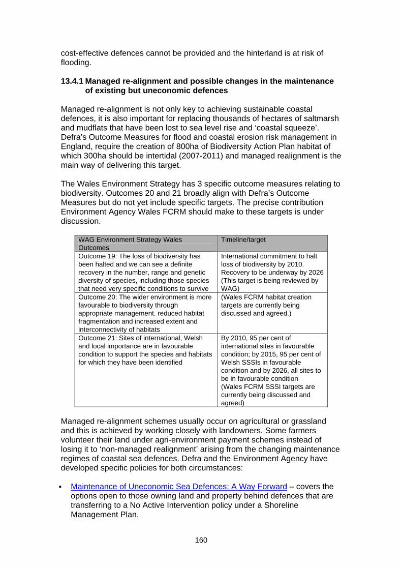
160
cost-effective defences cannot be provided and the hinterland is at risk of flooding. 13.4.1 Managed re-alignment and possible changes in the maintenance
of existing but uneconomic defences Managed re-alignment is not only key to achieving sustainable coastal defences, it is also important for replacing thousands of hectares of saltmarsh and mudflats that have been lost to sea level rise and ‘coastal squeeze’. Defra’s Outcome Measures for flood and coastal erosion risk management in England, require the creation of 800ha of Biodiversity Action Plan habitat of which 300ha should be intertidal (2007-2011) and managed realignment is the main way of delivering this target. The Wales Environment Strategy has 3 specific outcome measures relating to biodiversity. Outcomes 20 and 21 broadly align with Defra’s Outcome Measures but do not yet include specific targets. The precise contribution Environment Agency Wales FCRM should make to these targets is under discussion.
WAG Environment Strategy Wales Outcomes
Timeline/target
Outcome 19: The loss of biodiversity has been halted and we can see a definite recovery in the number, range and genetic diversity of species, including those species that need very specific conditions to survive
International commitment to halt loss of biodiversity by 2010. Recovery to be underway by 2026 (This target is being reviewed by WAG)
Outcome 20: The wider environment is more favourable to biodiversity through appropriate management, reduced habitat fragmentation and increased extent and interconnectivity of habitats
(Wales FCRM habitat creation targets are currently being discussed and agreed.)
Outcome 21: Sites of international, Welsh and local importance are in favourable condition to support the species and habitats for which they have been identified
By 2010, 95 per cent of international sites in favourable condition; by 2015, 95 per cent of Welsh SSSIs in favourable condition and by 2026, all sites to be in favourable condition (Wales FCRM SSSI targets are currently being discussed and agreed)
Managed re-alignment schemes usually occur on agricultural or grassland and this is achieved by working closely with landowners. Some farmers volunteer their land under agri-environment payment schemes instead of losing it to ‘non-managed realignment’ arising from the changing maintenance regimes of coastal sea defences. Defra and the Environment Agency have developed specific policies for both circumstances: Maintenance of Uneconomic Sea Defences: A Way Forward – covers the
options open to those owning land and property behind defences that are transferring to a No Active Intervention policy under a Shoreline Management Plan.

161
Managed Re-alignment: Land Purchase, Compensation and Payment for
Alternative Beneficial Land Use – covers potential arrangements landowners can expect when offering land for a scheme.
Coastal Squeeze – Implications for Flood Management and the
requirements of the European Birds and Habitats Directive – covers the legislative requirements to allow wildlife at designated sites to adapt to coastal change.
However, managed realignment can be unpopular with coastal communities. Landowners who feel threatened by an encroaching sea sometimes dislike changes to the local landscape or are concerned about the loss of agricultural land. Significant engagement work with coastal communities is crucial to ensure the local and wider-scale benefits are understood and local ‘buy-in’ secured for the scheme. The benefits of managed realignment have also been underestimated in project appraisal in the past, in part because the non-monetary benefits were not properly accounted for. 13.4.2 Coastal Futures – A case study for supporting communities
through coastal change on the Humber Estuary The joint Environment Agency, Defra, Natural England, and RSPB ‘Coastal Futures’ project associated with the development of the Humber Strategy sought to address the issues around acceptance of managed realignment schemes through innovative community engagement. It identified barriers to progressing such schemes on the ground, assessed the benefits of managed realignment and recommended how they could be better incorporated in scheme cost-benefit analysis. The final report ‘The Economics of Managed Realignment’ concluded that the approach would only become attractive in scheme appraisal if the following were taken into account:
The effects upon flood defence capital and maintenance costs arising from the flood defence function of the new inter-tidal area
The effects on fluvial/estuarine/coastal form, and on associated flood defence costs away from the immediate site
The wider benefits of habitat creation or compensation for losses associated with flood defence
A long-term appraisal window to account for the full impact of the above
Further information on this project and the final project report can be found on the following website:
Coastal Futures – supporting communities through coastal change

162
13.4.3 Valuing non-monetary benefits Project appraisal has for some time highlighted the importance of factoring non-monetary benefits into the assessment of schemes and projects. The impacts that are difficult to value in monetary terms are often those of most interest and relevant to the local communities and partners affected by or interested in the decision. (see section 9.2 for further information on flood and coastal risk management appraisal guidance) A joint R&D project is currently underway looking at how best to accommodate adaptability in flood and coastal erosion risk management decision making, at all levels from strategic to project. The work is aimed at ensuring decisions are made on solutions that are adaptable both in terms of adjusting flooding and coastal erosion risk management assets and in terms of social impacts. The project is also examining how the economic appraisal can overcome any bias against adaptation options or difficulties in the appraisal system. Further information on this project can be found on the following website:
FD2617: Economic Appraising of Adaptation Options in Flood Risk Management
13.5 Examples of adapting to coastal change The following case studies provide examples of some of the approaches which have already been taken to adapt to a changing coast. Further case studies can be found on the following website:
Climate change adaptation: case studies Caravan park roll-back in East Riding of Yorkshire: The East Riding Coastal Zone, stretching from Flamborough Head to Spurn Point, has one of the fastest eroding coastlines in North West Europe. The coastline is one of the region’s key environmental assets and the caravan park is an important tourist destination. With the need to have a sustainable approach to maintaining the viability of the caravan industry on this coastline, a “rollback” approach was developed by the Local Authority, Environment Agency and caravan park owners. Rollback looks at how moveable assets like caravan parks can be physically relocated further inland away from the threat of coastal erosion whilst improving the quality of the local environment and sustaining the communities which are dependent on coastal tourism. Partners such as the Local Planning Authority have looked at the implications of the approach, and have developed guidelines, standards and policies within which any moves can be made, now incorporated into CLG’s newly revised PPS25. ‘Rollback’ provides a tried and tested approach to reducing the risk of coastal erosion that can be applied to other coastal areas. Visitors to the coast now
163
have access to better quality tourism facilities and they will also be able to enjoy a higher quality natural environment. Innovative approaches at Slapton Ley, Devon: Slapton Sands in South Devon is a 5km long shingle beach facing east into Start Bay and the English Channel. Behind the beach (also known as Slapton Line) is Slapton Ley nature reserve, with the largest natural freshwater lake in the Southwest of England. The beach and nature reserve are a popular visitor destination with car parks and the village of Torcross, while the main A379 road runs along the beach-head linking the towns of Dartmouth and Kingsbridge and the intervening villages. The area lies within the South Devon Area of Outstanding Natural Beauty and Heritage Coast, and is designated a Site of Special Scientific Interest, National Nature Reserve and Geological Conservation Review site. Slapton Sands is very vulnerable to coastal erosion. The main coastal A-road was closed for several months in 2001 following storms, causing significant disruption to the communities, traffic and local economy, and with extensive damage to the carpark and old coast defences. Recent studies have confirmed that it is not feasible on economic or environmental grounds to defend the road and beachhead from future erosion by engineered intervention. With some limited realignment the road may survive for 30 years or more, although a catastrophic storm and breach could happen at any time. The policy is therefore about implementing small-scale protective measures coupled with a long-term adaptation programme, working with the community to manage the process of responding to coastal change creatively and positively. A broad range of linked actions will include an extensive public communication and engagement programme; adaptation of local small business sector; development of sustainable environmental tourism; habitat adaptation; policy integration (incorporating the coastal policy and adaptation programme into the Local Development Framework and other strategies); review and adoption of emergency plan; traffic adaptation planning (redesign of local transport links and services for local people); development of options for alternative public access; exploration of alternative inland coast path corridor; coastal monitoring; and sharing best practice. The aim is to ensure that the right measures are put in place to adapt to the changing coastline, to mitigate against damaging impacts, and to develop new opportunities and benefits, with the support and engagement of the local community. The three year work programme, led and coordinated by the Slapton Line Partnership, includes:
Working through the Slapton Line Advisory Forum (community representatives), with adaptation workshops and public engagement;
further research on economic impacts and business opportunities, working with the small business sector both in the immediate Torcross locality and the wider Dartmouth to Kingsbridge area;

164
the further development of emergency planning, communication and contingency arrangements;
working with key service providers (emergency, transport, health, education, etc) to develop future adaptation measures;
environmental modelling and actions for the National Nature Reserve, developing future management options to mitigate loss of certain habitats and develop new ones;
a communication and public engagement programme with web site, newsletters, on-site panels, etc;
securing compliance with statutory regulations and permissions and to advance these in readiness for response to future erosion events;
learning from and exchanging current good practice in other areas. This programme of work has recently benefited from Defra’s Coastal Change Fund, which will extend the work to include work in local schools, and more information online. Alkborough Flats, Humber Estuary: Officially opened by Ian Pearson, Environment and Climate Change Minister on 20 September 2006, the Alkborough Flats Tidal Defence Scheme reduces the risk of flooding for 300,000 people on the Humber and is a haven for wildfowl and wading birds. The scheme, which involved breaching the existing flood defences, will help lower high tide levels by allowing water from the estuary to run over the Alkborough Flats to create a massive flood storage area. The capacity of the site is so great that the Environment Agency predicts a 150mm reduction in high tide levels over a large part of the upper estuary. The project also created a huge new inter-tidal habitat, which is still developing and should attract more species of wildfowl and wading birds to the area including shelduck, wigeon, teal, avocet and redshank. The site is being used as a demonstration project to help promote new approaches to the impacts of sea level rise across Europe. The effects of climate change are expected to increase high tide levels in the Humber Estuary, which, if defences were left as they are, would increase the risk of flooding for the communities who live in the area.

165
CHAPTER 14: Planning Policy 14.1 Purpose of this chapter This chapter summarises the overall approach to coastal spatial planning. It sets out the Government’s (England and Wales) planning policy for development in coastal areas and the new Coastal Change Management Areas in England. It explains the Environment Agency’s role in development and coastal change. The top three things to remember are:
Linkages between Local Planning Authorities and flood and coastal risk Operating Authorities must be strengthened
Shoreline Management Plans (SMPs) are becoming more influential on coastal spatial planning matters
Coastal planning policy takes account of local development needs where the coast is changing
14.2 Governments approach to coastal planning in England The Government’s approach to spatial planning at the coast is set out in new planning policy on Development and Coastal Change that has been issued as a supplement to Planning Policy Statement 25 ‘Development and Flood Risk’. It provides greater emphasis on mechanisms which allow areas of coastal change to be economically viable whilst remaining sustainable – a ‘yes if’ approach rather than a ‘no, but’ approach. Until the new Planning Policy Statement on Planning for a Natural and Healthy Environment (published for consultation in March 2010) is issued, some sections of the former PPG20, that cover the undeveloped coast and access to the coast (paragraphs 2.9, 2.10 and 3.9), will remain active. 14.3 Planning policy for coastal change in England – the new
PPS25 supplement ‘Development and Coastal Change’ The new Planning Policy on Development and Coastal Change focuses primarily upon the impacts of permanent coastal change. Flooding, biodiversity, the historic environment and coastal access are covered in other documents in the Planning Policy Statement (PPS) series. It links spatial planning with Shoreline Management Planning (developed after PPG20 was written), and introduces a new evidence-based planning designation in the form of Coastal Change Management Areas (CCMAs). This new planning policy can be found on the following website:
Planning Policy Statement 25 Supplement: Development and Coastal Change

166
The overall aim of the new policy is to strike the right balance between economic prosperity and reducing the consequences of coastal change on communities. It takes a strategic risk based approach to managing coastal change so long term adaptation of communities can be planned, whilst allowing necessary development that is both appropriate and safe. This risk-based approach is dependent on a simple decision-making procedure to be used at all stages of the planning process:
Appraise risk – use an agreed evidence base to understand the impact of coastal change
Avoid risk – avoid inappropriate development in areas that are vulnerable to coastal change
Manage risk – recognise that certain types of development may be permitted in particular circumstances with conditions that ensure any risk from coastal change can be managed during the course of its lifetime.
Mitigate impact – help communities develop strategies to adapt to coastal change in the future, by improving their resilience or by facilitating their roll-back or relocation
The new planning policy highlights how key statutory and non-statutory coastal and maritime organisations drawing up these strategies need to work with communities and with each other in partnership to agree a sustainable and balanced approach. It also covers how coastal planning and marine planning should interact. The policy is supported by a Practice Guide which CLG published alongside the new policy in March 2010. The Practice Guide provides guidance for planners and other partners on how to implement the new policy. It draws on existing good practice, and is illustrated with case studies. It is available on the following website:
Planning Policy Statement 25 Supplement: Development and Coastal Change – Practice Guide
14.3.1 Coastal Change Management Areas The new Coastal Change Supplement is applicable in specifically designated spatial planning zones called ‘Coastal Change Management Areas’ (CCMAs). These areas are to be identified by coastal local planning authorities, working in partnership with other local planning authorities, other agencies and bodies with an interest in the coast, and coastal communities. They are areas where rates of shoreline change are likely to be significant over the next 100 years, taking account of climate change and based upon the best information available. The boundaries are largely underpinned by coastal processes, particularly coastal erosion, landslip and permanent inundation, but are drawn up by taking community boundaries into account as well. The primary evidence base for Coastal Change Management Areas is the Shoreline Management Plans, which will have been assessed against a range

167
of European environmental legislation and will have incorporated the latest coastal recession data from the National Coastal Erosion Risk Mapping Project. SMPs also represent an agreed coastal management policy platform based upon widely scrutinised evidence. The new planning policy sets out the principles for development in Coastal Change Management Areas: Applications for development (including applications to renew time-limited planning permissions in the CCMA where erosion has progressed at a lower rate than predicted) should be considered appropriate where (following the outcome of consultation with relevant agencies and bodies, particularly the Environment Agency and local communities), it can be demonstrated that:
The assessment of vulnerability shows that the development will be safe over its planned lifetime and will not have an unacceptable impact on coastal change
The character of the coast including designations is not compromised The development provides wider sustainability benefits The development does not hinder the creation and maintenance of a
continuous signed and managed route around the coast So that appropriate development in a CCMA is not impacted by coastal change, local planning authorities should limit the planned life-time of the proposed development to reduce the risk to people and the development, taking account of the assessment of vulnerability. Planning conditions should be applied where there is a need to:
Manage the risk to the proposed development during its planned life-time
Manage the removal of the development to minimise the impact of the community and on the natural and historic environment
The designation of Coastal Change Management Areas also needs to be flexible enough to account for instances where new data may reflect a greater or lesser risk or where policies within SMPs may not be funded. 14.4 PPS25 and coastal planning The new Coastal Change Supplement is designed to complement PPS25 on Development and Flood Risk, integrating consideration of risks from flooding and coastal change so that a consistent approach is followed along the entire coast of England. The risk-based approach taken in PPS25 is also the basis for the new Coastal Change Supplement – that is, to appraise the risk, identify risk areas, avoid inappropriate development in those areas, manage the risk and mitigate its impact. PPS25 applies to both inland and sea flooding and can be found on the following website:
Planning Policy Statement 25: Development and Flood Risk

168
In assessing what constitutes appropriate development within the CCMAs and within flood risk areas, it is important to appreciate the fundamental difference between coastal change risk and risk from flooding. Flooding may happen on a recurring basis. Development can recover from flooding (albeit at a cost) and continue to be used, although there is a safety risk to people during the flood. This is reflected in PPS25’s sequential, risk-based approach that aims to locate development in areas of lowest risk first. But, PPS25 recognises that where there are no lower risk sites available and development is necessary, sites can be developed in flood risk areas, providing they are safe. Accordingly, the classification of flood risk vulnerability in PPS25 is based on the risk to people’s safety and well-being, as well as the capacity of different uses to adapt and keep functioning during, or resume functioning soon after, flooding. Coastal change differs from flooding in that it is a finite hazard which, when it impacts, results in actual loss of the properties, infrastructure and assets as well as a risk to the safety of residents. Consequently, the assessment of vulnerability in the Coastal Change Supplement, whilst also based on the risk to people’s safety and well-being, focuses on the impact of coastal change on, and from the development over its lifetime. In light of the differences between flood risk and coastal change impact, what may be appropriate development in a high flood risk area may not be appropriate in a CCMA. To prevent new development from being put at risk from coastal change, development would only be appropriate in a CCMA if it requires a coastal location and provides substantial economic and social benefits to communities. Where coastal areas are affected by a mixture of erosion and flooding, the Practice Guide to the Coastal Change Supplement advises planners that the proportionate assessment of vulnerability to coastal change should inter-relate with the site-specific Flood Risk Assessment. To facilitate the delivery of habitat creation under the Regional Habitat Creation Programme, Local Development Frameworks and Plans should allocate land for habitat creation to meet European biodiversity commitments and allow the development and coast protection needs of communities to be provided. (see section 18.10 for further information on Regional Habitat Creation Programmes). 14.5 Planning Policy in Wales Welsh Assembly Government Planning Policy is set out in Planning Policy Wales (PPW) and Minerals Planning Policy Wales (MPPW). They are each supplemented by a series of Technical Advice Notes (TANs) and Minerals Technical Advice Notes (MTANs). Further information on Planning Policy and Minerals Planning Policy Wales can be found on the following websites:

169
Planning Policy Wales
Minerals Planning Policy Wales Two Technical Advice Notes provide specific advice on flood and coastal erosion risk management. These are TAN14 and TAN15. 14.5.1 TAN 14 – Coastal Planning TAN 14 is specifically concerned with planning in relation to the coastal zone. Coastal Local Authorities are responsible for to identifying the coastal zone for their area, but the TAN provides advice and information on what should be taken into account when considering development proposals within that zone. The TAN discourages development in areas with rapidly eroding coasts and highlights the risks of coastal flooding. The importance of Shoreline Management Plans in making decisions is also recognised. TAN14 is available on the following website:
Technical Advice Note (TAN) 14: Coastal Planning 14.5.2 TAN 15 – Development and Flood Risk TAN 15 and the associated Development Advice Maps (DAMs) make it clear how Local Authorities should make decisions about development on flood plains and the coast. TAN 15 sets out a precautionary framework, the overarching aim of which is to:
Direct new development away from those areas which are at high risk of flooding
Where development has to be considered in high risk areas only those developments which can be justified on the basis of the tests outlined in TAN15 are located within such areas. The TAN utilises a series of development advice maps. These define three planning zones (zones A, B and C), where zone C represents the highest risk. The types of development that are considered acceptable and not acceptable within each of these zones is set out in the TAN. Even if development is considered appropriate in Zone C, a developer will need to satisfy the local planning authority that their proposal satisfies the criteria set in TAN15 (the justification test) before the application is determined. Part of the justification test includes a requirement for the developer to demonstrate through a "Flood Consequences Assessment" that the risks from flooding can be managed to an acceptable level.

170
TAN15 is available on the following website:
Technical Advice Note (TAN) 15: Development and Flood Risk 14.6 Environment Agency’s role in development and coastal
change Local Authorities lead on managing the risk from coastal erosion and are therefore the most involved in planning applications where land recession is an issue, and will continue to be so. The Environment Agency in England and Wales will continue to provide advice on planning applications where flood risk from the sea is an issue. However, the Environment Agency does have a Strategic Overview of flood and coastal risk management in England and does expect to be consulted on larger planning applications in CCMAs in the same way as it would comment on applications in flood risk areas. Standing Advice for smaller applications may be developed. The Secretary of State can also call-in controversial applications for decision. If experience of the new planning policy in operation shows it is necessary to expand the range of applications the Environment Agency should scrutinise, and place this consultee status on a statutory footing, the policy and planning legislation can be amended to this effect.

171
CHAPTER 15: Communications and Engagement 15.1 Purpose of this chapter People and the Environment should be at the centre of the actions of all organisations involved with coastal management and protection. Communities and individuals must be included in the decision making process or we risk failing to meet their needs. Continued and effective communications and engagement activities are essential. This chapter highlights some of the key engagement aims, approaches, and the resources available to help. The top three things to remember are:
Follow the Engage Deliberate Decide (EDD) not Decide Announce Defend (DAD) approach and engage at the start, before decisions are made
Make use of the tools and support available Proactive communication and engagement should be carried out
throughout all flood and coastal erosion risk management activities 15.2 Importance of communication and engagement In the majority of scenarios effective engagement with communities and partners must form a central part of all flood and coastal erosion risk management activities. Coastal engagement is a very active area of work, and must remain so in order to work with communities to find sustainable solutions. Effective engagement can help to find long term solutions that consider the needs of all parties involved. The dynamics of our evolving coast and the effects of climate change require society to make some difficult decisions. These will have an impact on the local economy and the strong emotional link that people have with the coast. The need to prepare planners and communities for the effects of climate change and sea level rise will continue to be a challenge for all those involved. Environment Agency staff and Local Authority officers need to represent Defra and WAG’s policies and be seen as experts providing clear, reliable evidence that enables society to understand change and make informed decisions. It is essential to keep elected representatives at all levels of Government (parish/town, district, county/unitary and MPs) fully briefed during any engagement process. 15.2.1 Coastal Engagement Officers In recognition of the importance of engagement, Defra funded Coastal Engagement Officers in England, from 2009 to run through to 2011. Located

172
in each region around the coast their remit is to work with Local Authorities, and the Environment Agency and engage with coastal partners to facilitate dialogue between coastal managers and local communities that might be affected by coastal change. The primary focus for the Engagement Officers is to support the SMP process and help ensure a smooth publication of the erosion risk information, to ensure communities on eroding coasts are aware of the erosion risk and understand what it means for them. The Engagement Officers also cover the wider coastal narrative including the new Defra and CLG policies on coastal change. Further information on the coastal erosion risk information project can be found in section 11.3. 15.2.2 Better Engagement and Risk Communication In 2005 Defra launched the cross-Government programme of work for taking forward and developing a new government strategy for improving flood and coastal erosion risk management in England (Making Space for Water). As part of this programme the Environment Agency led a project on improving engagement and risk communication at the local, regional and national level. The project identified ways to improve communication channels and arrangements for engaging with communities based on an understating of how people perceive risk. The project recommended ways to make good engagement easier to achieve in practice. The main ‘better engagement’ principles are as follows:
The Environment Agency and all levels of Government have to establish stronger mechanisms for collaborating over the integration of flood and coastal erosion risk management plans and existing planning frameworks.
When developing flood and coastal erosion risk management activities operating authorities must envisage such plans and projects as contributing to broader social and environmental outcomes.
In the majority of scenarios engagement of partners, the pubic and communities must be central to the work of all flood and coastal erosion risk management authorities.
Within the Environment Agency the profile and importance placed on engagement must be raised at a national level and disseminated throughout the organisation.
Staff at all levels need to be given time to form and maintain relationships with relevant partners.
The more inclusive and productive EDD (Engage, Deliberate, Decide) approach should be used for any new planning or development activity regarding flood and coastal risk management issues. Central to this approach is the value of engaging with others right from the start, from defining the problem all the way through to selecting the most appropriate solution and implementation.

173
15.2.3 Flood Awareness Wales Improving awareness to flooding is a high priority for the Welsh Assembly Government. Environment Agency Wales is responding to this through its new Flood Awareness Wales programme. The main principle is that one clear message is given to communities and individuals at risk of flooding, irrespective of the source of that message or the initiative behind it. This programme is placing a greater emphasis on face to face and direct community engagement. This programme is building on good practice nationally and locally and will work to the engagement and communication principles outlined below. During the programme, there will be ongoing evaluation into how effective these new ways of working have been. This will help to inform and shape the Flood Awareness Wales Programme and will feed into other national and associated initiatives. 15.3 The DAD and EDD approach There are currently two main approaches in use to bring the public and partners into a decision-making process: They have been described as Decide-Announce-Defend (DAD) and Engage-Deliberate-Decide (EDD). Decide – Announce – Defend: The “Decide – Announce – Defend” (DAD) approach describes the process of a public body developing and Deciding on a preferred solution to a problem, then Announcing this decision to the affected parties and subsequently Defending the solution in the face of opposition. Opposition may arise from those new to the problem or who have limited understanding of the issues involved, or who feel overrun – rather than involved – by a decision, which was made by others but likely to affect their lives and property. Engage – Deliberate – Decide: The “Engage – Deliberate – Decide” (EDD) approach defines the more recent involvement model of introducing all partners to a problem, discussing issues and options for dealing with it as early as possible and inviting their participation in identifying and weighing up likely solutions. Contributions from the public and partners are then taken into consideration and given sufficient weight in the decision-making process. The more inclusive and productive EDD approach may appear time consuming in the short term but is often more effective in the longer term and should be used for any new planning or development activity regarding flood and coastal erosion risk management issues. Central to this approach is the value of engaging with others right from the start - from defining the problem all the way through to selecting the most appropriate solution and implementation.

174
Case study – how should Bill decide: The following fictional case study illustrates the different outcomes to be expected from use of both these approaches:
Flood Defence or Flood Risk Management?
How should Chris decide?
Chris is the flood risk management officer for Kilnborough, a community which has traditionally been protected from sea flooding by a defence embankment. Coastal erosion is causing loss of the foreshore and Chris knows that the defences will be breached in the next two to three years. A single event could cause damage to homes and roads, and there is a 5% chance of flooding in any given year. In view of climate change and sea level rise, Chris knows that a new solution for the area needs to be considered. He could consider a new flood defence scheme or take a flood risk management approach. Flood Defence – using DAD (Decide – Announce – Defend) approach: First Week Chris brings together a range of expertise from his own and other teams to review the current status of the existing defence, expected changes and physical conditions at the site and any financial constraints on future work. First Month Together they plan an engagement process with the local community in deciding the best solution. They work out who the key community partners are and how they can target them. Chris works with the project team to explain the expected flood risk, that things are changing and why we have to adopt new approaches to dealing with flood risk. Chris needs to work with partners who are willing to help explain these messages and are trusted by the community. The team chooses a facilitator who the community trusts to act as mediator and discussion leader at all meetings. First Year Local partners are consulted to help ensure that the scheme fulfils local needs. Chris and colleagues make Local Authority planning officers aware of the limitations of the scheme, so that inappropriate development can be avoided. They also talk about how residents might be affected by building work. At a public meeting Chris explains that a defence is the best option, using the services of an engineering consultant to discuss design. We build an embankment, which incorporates drainage improvements. A flood warning plan is developed with the community in order to allow Kilnborough to be prepared for the new level of protection and its impact in future years. Chris tells residents they will have to develop their own resilience measures, but not understanding the limitations of the defence, very few of them take this seriously. People moving onto the area are unlikely to find out about the need to prepare for flooding, or anything about the limitations of the defence. Results of the scheme: The new scheme has been handed over to the local community. Chris will work with them to scope how long the defence will offer protection. In the meantime, they will need to accept some responsibility for protecting themselves and their properties considering resilience measures and evacuation. The public is happy with the new scheme as it is protecting them, but they may not understand that longer term investment is unlikely. The public would have had very little

175
information on climate change and associated risks, as Chris did not include this in the engagement process. As a result, any increased risk from overtopping of the defence in future may come as a surprise. Flood Risk Management – using EDD (Engage – Deliberate – Decide) approach: First Week Chris considers the economic justification for flood defence. In this case there is no economic justification for a full scheme over the normal 100 year appraisal. However, there may be possible schemes which could be justified over a shorter timescale and would allow time for local residents to consider adaptation and resilience options. First Month Although the scheme needs to provide protection in the short to medium term, the community may have to adjust their lifestyles to accept more frequent flooding and loss of access to and from the area. Chris discusses thoughts and potential options with the relevant partner organisations. A realigned flood defence embankment scheme is chosen and Chris informs the wider community of the proposal by way of a letter. First Year Chris’s team works to make the public and all partners aware of future changes to flood risk, and the options available. This would include outlining the advantages of various options and constraints on funding. While the community’s views are vital, Chris must also work on clear guidance from the Environment Agency, to keep expectation realistic. One option is a managed realignment scheme, which can provide both flood risk management benefits and habitat creation Chris explains the potential benefits of a managed realignment for Kilnborough, which could make more space for water in the estuary. Chris does this with help from other organisations involved with conservation, recreation, access and livestock management. Although some people disagree, most of the community can see that managed realignment is the most suitable long-term arrangement. A breach structure allows normal tidal inundation of the site. Chris’s team has successfully engaged the community, and they fully understand the scheme. The public rights of way through the new habitat create tourism opportunities. Results of the scheme: Flood risk management benefits have been achieved, as when river levels are high, for instance during tidal surges, some of the flood water will spill over the low and high level weirs into the wetland. This has the effect of reducing extreme water levels elsewhere in the river, reducing the cost of works in other locations and making money available for other projects. The realignment scheme has achieved a reduction in flood risk and an increase in social benefits. Jobs are created directly in the construction of the scheme, and indirectly in leisure and tourism. The local economic benefits are accompanied by continued involvement of partners and communities. 15.4 Engagement and communication tools The Building Trust with Communities/Working with Others approach is central to the better engagement principles identified through the Making Space for Water programme. A number of supplementary tools to provide further support and guidance were developed as part of the Better Engagement and Risk Communication project, led by the Environment Agency.
176
Many of links in this section can only be accessed by Environment Agency staff. Local Authority officers are advised to contact their local area office to gain further details on these areas. The Improvement and Development Agency (IDEA) has published guidance for Local Authorities and others on communicating and engaging with communities. Further information on this guidance can be found on the following websites:
Community empowerment Connecting with Communities: communications toolkit
15.4.1 Building Trust with Communities Toolkit The Environment Agency has produced an engagement toolkit called “Building trust with communities – a guide for staff” which is available to support the way we communicate and work with communities. It is designed to give staff the guidance and skills required to work better with communities. The Building Trust with Communities (BTWC) approach involves working with communities early on to understand their concerns, interests and priorities. Sometimes the lead authority concerned will still make the final decision, but they will have worked with others in developing the solution with reference to local knowledge and circumstances. At the very least, communities will better understand the role and limitations of the authorities involved, and the context of the decision in terms of risk management and available funding. This is taking the ‘EDD’ rather than ‘DAD’ approach. A copy of this guide is available on the following website:
Working with others – Building Trust with Communities [EA internal] 15.4.2 The ABC decision making tool This decision making tool identifies three different decision ‘types’ (A, B or C). These determine which one of three negotiating strategies should be used.

177
Deciding the type of decision:
Decision type A
B C
Feature 1: How affected will others be by the decision The decision has ___ effect on ____ public interest, health, livelihoods
Very little Few people’s
Some Some people’s
Severe Many people’s
Feature 2: Multiple perspectives There are likely to be ______ different perspectives on the issue (to ours) and _____ politics
No significant No/containable
A number of Some
A wide range of Significant
Feature 3: How much support or ownership of the decision or implementation by others is required The ‘best’ decision is ______ and we can implement ________
Known Alone (with or without support)
Open to influence, but limited options More easily if others work with us
Unknown Only with sufficient support, or only with others
Feature 4: Risk and uncertainty Risk and uncertainty relevant to the decision is ____
Low Medium: understood by us but not by others
High: poorly understood
Feature 5: Speed Actions or decisions need to be made and implemented ______
Immediately/very quickly
Over months Over years
Establishing a type of negotiation strategy: Type A decisions: Characteristics: Low conflict/controversy/uncertainty and/or little control over situation and or decision/ decided by others/procedure/few resources/crisis (including emergencies). Negotiation strategy: Type 5: Win: Lose Type of engagement: Light touch. Do what would normally do (e.g. DAD type approach), but undertake in a ‘more effective’ way e.g. ensure clarity of purpose internally/externally, better quality of communications materials, encourage effective conversations rather than defensiveness, improved questionnaires. Type B decisions: Characteristics: Need for buy in/understanding to reduce risk of non delivery through resistance Negotiation strategy: Type 2 (compromise) or Type 4 (accommodate) Type of engagement: Precautionary. Add time early on in the process to secure buy in to the problem (before looking at solutions) and to gather and use social intelligence to maximum effect Type C decisions: Characteristics: High conflict/controversy/risk/need for shared ownership of solution or significant risk of non delivery Negotiation strategy: type 1: Collaborating (win:win) Type of engagement: Fully collaborative. Business as usual (EIA processes etc) fits around an extensive engagement programme. An early ‘risk assessment’ process should incorporate the ABC approach. This ensures that at the beginning of any project, large or small, a project manager or team, perhaps with the support of a Building Trust with Communities mentor,

178
characterises the decision type using the ABC framework. This is then used to design the engagement process and determine associated resources required. In order to start this process early it may be that a case can be made for a small budget to be set to undertake the initial investigations required. The project plan should allow sufficient time for this work to be undertaken. 15.4.3 ‘How to’ guides A number of ‘How to’ guides exist as part of the Building Trust with Communities guidance. Those currently available are:
Deciding how much involvement is required Designing and running a drop-in surgery Guidelines for staff – working with people face to face Giving bad news Stakeholder analysis guide Using exhibitions for consultation Creating exhibition boards Explaining your engagement process How to work with a liaison group Using questionnaires Running collaborative meetings
These guides are available on the following website:
Working with others – ‘How to’ guides [EA internal] 15.4.4 Community adaptation planning and engagement tool The approach used in Building Trust With Communities has been adopted in a new set of guidance – Community Adaptation Planning and Engagement (CAPE) – developed by Defra to accompany the Coastal Change Policy. This uses elements of the ABC decision framework and is primarily for Local Authorities but will be used by a range of coastal managers. It is specifically aimed at what happens after coastal flood or erosion risk management decisions have been made. The main supporting principles of CAPE are:
Adaptation Planning as a Journey starting where the community is currently at.
Social Justice and Support: Communities most at risk need to be most supported.
Open and Honest Information that communities can trust. Joined up Coastal Planning that considers new structures and ways
of working. Community Based Partnerships built-up over time. Vibrant, Empowered Communities where people want to live and
visit.

179
The Environment Agency will use CAPE to support its activity under BTWC, Coastal Engagement Officers will be part of the overall ‘dialogue’ at the coast, as flood and erosion management decisions and the adaptation options that could follow them are closely linked. Acceptance of an Shoreline Management Plan (SMP) policy option may, for example, depend on whether the community feels that the adaptation options associated with it are acceptable. 15.4.5 Coastal landowner engagement pack Within the Environment Agency’s Anglian Region a team has specifically considered how best to tackle the issues that changing flood and coastal risk management policy may have for landowners and farmers. The project team identified several outcomes to ensure landowners are well supported through any change in flood risk management policy. These are:
Landowners will have the relevant information and tools that they need to make decisions about the future management of their flood defences
Landowners will know who they can contact within the Environment
Agency to discuss flood and coastal risk management issues
Landowners will be aware of the Environment Agency’s and other partners roles and know where to seek alternative advice
Organisational outcomes:
All relevant Environment Agency staff have information about the timing and rollout of upcoming Catchment Flood Management Plans and Shoreline Management Plans
All relevant Environment Agency staff have an awareness of the
likelihood of changing flood risk management policy within the above Plans and the potential consequences of this on the landowning community
All relevant Environment Agency staff have the tools they need to
deliver consistent messages to landowners about changing flood and coastal risk management policy.
All relevant Environment Agency teams and staff are aware of the work
of the Environment Agency and its partners with the landowning community and are able to promote integrated approaches that benefit the customer.
Following a range of workshops and meetings for key staff and representative members of the landowning community a series of products have been drafted, refined and produced to meet the needs of landowners and staff outlined above. These products form an information pack for landowners and staff that include

180
factsheets, case study examples and local maps and contact details. The packs are designed to allow additional and updated material to be added when appropriate. For further information on the development and dissemination of these packs is available from Karen Thomas, Environment Agency Eastern Area (Anglian) Coastal Advisor ([email protected]). 15.4.6 Mentoring The Head Office Community Relations Team has set up a mentoring network to help staff carry out successful engagement. For each Region and Head Office there are several mentors who are trained to work effectively with communities and provide support with the Building Trust With Communities approach. Staff undertaking a new project or strategic planning exercise should consult their mentors for further guidance on engagement and specifically on using this approach. Further information on this mentoring service is available on the following website:
Know your mentor [EA internal] 15.4.7 Engagement training courses Several training courses have been developed to help Environment Agency staff work better with their communities and partners. They are:
Designing and managing a partner involvement process Facilitating face to face involvement with partners Short/introductory courses on Building trust with communities
Further information on these courses is available on the following website:
Training [EA internal] 15.4.8 Stakeholder engagement contract Sometimes it is useful to use outside help in engagement with partners, stakeholders and communities. They are well-practised, often objective and ‘fresh’, and can provide an independent ‘broker’ or facilitator in discussions and decisions. The Stakeholder Engagement Advice and Facilitation Service (SEAFS) has developed a new contract for those involved in engagement that will take some of the strain in terms of choosing a facilitator, procurement and ensuring value for money. Further information on this service is available on the following website:
Stakeholder engagement contract [EA internal]

181
15.4.9 Coastal engagement case studies A number of case studies are available which provide examples of how colleagues have approached engagement at the coast and have used the Building Trust with Communities approach. They provide a useful way for staff to learn from the experiences and expertise of others and are available on the following website:
Examples of Building trust with communities case studies [EA internal]
Shaldon, South Devon: The village of Shaldon in the South West was used by the Environment Agency as a pilot to test a new way of working with people affected by coastal management decisions in line with the principles of Building Trust with Communities approach. The community, located on a Devon estuary, had no previous experience of flooding. The Team worked with the community to establish a solution to the increased coastal flood risk, which had a limiting effect on the picturesque nature of the village. Further information can be found on the following website:
Safeguarding Shaldon and Ringmore Making Space for Water case studies: A number of good practice case studies were captured under the Making Space for Water programme, many of which give examples of effective and successful engagement and communication. Copies of these case studies can be found on the following website, by searching for ‘making space for water’:
Environment Agency publications catalogue

182
CHAPTER 16: The Marine Environment 16.1 Purpose of this chapter This chapter details the main legislative and policy guidance for the marine environment and how this impacts on flood and erosion risk management at the coast. There are many interrelationships between activities on the coast and in the marine environment, and the way in which one is managed can affect the other. With the passing of the Marine and Coastal Access Act 2009 there has, and will be, some changes to the way the marine environment is managed. The top three things to remember are:
In April 2010 a Marine Management Organisation (MMO) for England was created, replacing the Marine and Fisheries Agency. The MMO has responsibility for marine planning, licensing and enforcement, and management of fisheries. In Wales, these activities are administered by the Welsh Assembly Government
New marine licences will be required for all coastal works (generally replacing works that would be covered by FEPA or CPA licences) from April 2011.
The Marine and Coastal Access Act introduces a forward planning approach to the management of the marine environment that will join up with terrestrial planning through integrated coastal zone management.
16.2 Implications of the Marine and Coastal Access Act 2009
for flood and coastal risk management The Marine and Coastal Access Act (Marine Act) was passed on the 12th November 2009 after nearly a decade of planning and preparation. The Act covers all UK marine waters starting at the high tide mark and extending out to 200 nautical miles. It covers the intertidal area of the coast and has important implications for flood and coastal erosion risk management (FCRM). The Act creates several new management areas which are discussed below. A summary of what is covered in the Act is available in section 5.2.10. The part of the Act dealing with Coastal Access is covered in section 18.8. The Marine and Coastal Access Act 2009 has given the MMO in England and WAG in Wales new powers and responsibilities in the Marine Environment. In Wales, devolved functions including marine planning, marine licensing, inshore fisheries management and the designation of marine conservation zones will be administered by the Welsh Assembly Government (WAG).
183
16.2.1 The Marine Management Organisation The Marine Management Organisation (MMO) will be a new champion of England’s marine environment and will deliver the key items set out by the Marine and Coastal Access Act. It will ensure that everything it does contributes to the achievement of sustainable development of the marine environment. Based in Newcastle, it has taken over the functions of marine licensing and fisheries management from the Marine and Fisheries Agency (MFA). The MMO is responsible for the key marine functions in England, including marine planning, licensing, and enforcement. The Environment Agency and the MMO will both have statutory responsibilities in the near shore area, and will have a clear working relationship to ensure these are delivered effectively and consistently. The MMO and WAG will also have a duty to have regard to River Basin Management Plans and the decisions it makes should contribute to achieving good status in transitional and coastal waters. Further information on the new Marine Management Organisation can be found on the following websites:
The Marine Management Organisation
Managing our marine resources: the Marine Management Organisation
Further information on the Welsh Marine Consents Unit can be found on the following website:
Marine Licensing 16.2.2 Marine Planning – Marine Policy Statements and Marine Plans The Marine Act creates a new, strategic, two tier planning framework which consists of:
A Marine Policy Statement – providing the overarching framework, objectives and priorities at a high level, and
A series of Marine Plans – which will implement the policy statement in specific areas, using information about spatial uses and needs in those areas.
The proposals within the Marine and Coastal Access Act are far reaching both in scope and time. The production of Marine Plans is not expected to commence until 2011 and will not be complete until around 2026. The Act divides UK waters into marine regions with an inshore and offshore region under each of the four Administrations (England, Northern Ireland, Scotland and Wales). The Act also refers to ‘marine plan authorities’ who are responsible for planning in each region.

184
The Marine Policy Statement will be developed jointly by the UK Government and the Devolved Governments to create one overarching policy statement applying to the whole UK marine area (from the inland tidal limit out to the furthest extent of the UK Continental Shelf or Renewable Energy Zone). It is currently in the process of being developed and it is anticipated that it should be in place by 2011. Marine plans can only be created once the policy statement is in place. It is likely that they will be developed in a phased approach, with two plans being written at a time. Marine plans will apply up to the high tide limit in coastal waters and estuaries and they will be produced for the whole UK marine area covered by the marine policy statement. The marine policy statement will set clear objectives and priorities for managing the sea, guiding decision-makers and providing developers with more certainty about where developments may or may not be permitted. The scale and boundaries of the plan areas will be decided by the planning authorities. Marine plans should support Shoreline Management Plans (SMPs). The timescales for developing marine plans means that the majority of the second round of SMPs will have been completed before the marine planning process begins so the outcomes from these can be fed straight in to this process. Much of the data and information used in the shoreline management planning process will provide a useful base for the marine plans. As there is already some planning overlap in the coastal zone, it has been a priority to ensure that marine planning contributes effectively towards more consistent and coordinated decision making at the coast, rather than making the process more complicated. It will ensure there is coherence between coastal proposals, and the different policies and management processes at work in coastal area. Further information on marine planning can be found on the following websites:
Marine planning
Marine planning (WAG) 16.2.3 Marine Licensing The Environment Agency has a responsibility for licensing certain activities in the coastal zone to ensure they do not impact on flood risk management activities. This is through the Water Resources Act 1991 section 109 and byelaws under Schedule 25. The new marine licensing arrangements, as a result of the Marine Act, mean that if the Environment Agency is content that the marine licence addresses all flood and coastal risk management concerns, then the licence applicant does not need to apply for a flood defence consent as well. This should make the process swifter and more efficient, and improve communications between the licensing bodies and the

185
Environment Agency. The process for enabling this to happen is currently being created. Any activity taking place below mean high water springs which involves either depositing or placing something in the marine environment, such as building a sea defence, beach recharge, enhancing a current structure, will require a licence, as is currently the case under the Food and Environment Protection Act 1985 (FEPA). In addition to the current arrangements, if any items are removed then they too will require a marine licence. This is a new requirement, as FEPA did not cover removal of substances. The Environment Agency is currently working with Defra and WAG on drawing up exemptions for certain flood risk activities. Further information on the marine licensing processes can be found on the following websites:
Marine Works and Licensing
Marine Licensing (WAG) 16.2.4 Marine Conservation Zones Marine Conservation Zones (MCZs) will form a network of zones to protect species and habitats of national importance. These sites will form a key part of the protection for our wildlife alongside Natura 2000 network (SACs and SPAs), Ramsar sites and other locally protected sites. Marine Conservation Zones will be designated with a set of conservation objectives, setting out the aspirations for its important ecological features. Natural England and the Joint Nature Conservation Committee are responsible for advising English Ministers on Marine Conservation Zones. In Wales, the Welsh Assembly Government intends to use Marine Conservation Zones to help protect and improve ecosystems and complement the existing designated marine protected areas. They propose to introduce a small number of Highly Protected Marine Conservation Zones. Flood and coastal management operating authorities have a duty to further, and not hinder, the achievement of these conservation objectives. The Marine Act in particular states that any flood risk management byelaws cannot interfere with byelaws or orders made for the conservation of Marine Conservation Zones. In some sites all activities may be prohibited in order to provide for full recovery of the ecosystems and act as a baseline for the network, while others may just restrict certain activities or be restricted at certain times of the year. There are currently four regional projects to identify MCZs in English and UK waters. These are:

186
Finding Sanctuary in the south west Balanced Seas in the south and south east Net Gain in the eastern waters Irish Sea Conservation Zones in the north west
These projects will identify a collection of Marine Conservation Zones within each of these larger project areas. The process has been establish so that local people can help identify potential sites. In January 2010, the waters around Lundy Island, off the coast of Devon, became England’s first Marine Conservation Zone. This zone will protect species and habitats of national importance and the Marine Act will allow local laws to be put in place to protect the zone from human activity which may cause damage. Further information on marine conservation zones can be found on the following websites:
Protecting the Environment
Marine Conservation Zones(Defra)
Marine Conservation Zones (WAG) 16.2.5 Inshore Fisheries Prior to the Marine Act, the Environment Agency was the Sea Fisheries Committee (SFC) in many estuaries. With the passing of the Marine Act, Sea Fisheries Committees are replaced by new Inshore Fisheries and Conservation Authorities (IFCAs) in England and have statutory duties to manage fisheries in a sustainable way. The Inshore Fisheries and Conservation Authorities also gain improved byelaw-making powers. The Environment Agency is represented on the IFCAs and through close collaboration with these new authorities there is an excellent opportunity to protect migratory fisheries in estuaries and coastal waters. Welsh Assembly Government is responsible for inshore fisheries management in Wales. In April 2010 the two Sea Fisheries Committees in Wales were amalgamated to form the fisheries enforcement arm of the WAG fisheries unit. Environment Agency Wales is working closely with the Welsh Assembly Government and the Countryside Council for Wales to help develop how Wales will implement the requirements of the fisheries reform in the most effective way. Further information on Inshore Fisheries can be found on the following websites:
Fisheries Fisheries Management

187
Wales Fisheries Strategy
16.2.6 Freshwater Fisheries The Act will provide the Environment Agency with wider duties for smelt and lampreys and better powers to manage fisheries. Among these improvements is a new licensing and authorisation scheme covering emergency and wider byelaw-making powers, powers to introduce a new live fish movements scheme, and tighter regulation of historic salmon and sea trout fisheries. Further information on Freshwater Fisheries can be found on the following websites:
Fisheries Marine and Freshwater Fisheries (Defra)
Fisheries (WAG)
Fish for the Future [EA internal]
16.3 Requirements of the Marine Strategy Framework
Directive The EC Marine Strategy Framework Directive requires Member States to achieve “good environmental status” for their marine waters by 2020, including designing and implementing programmes of measures to achieve this. The requirement has been defined as:
“The environmental status of the marine waters where these provide ecologically diverse and dynamic oceans and seas which area clean, healthy and productive within their intrinsic conditions, and the use of the marine environment is at a level that is sustainable, this safeguarding the potential for uses and activities for current and future generations”.
Determining “good environmental status” must be made at a regional seas scale and Member States are required to cooperate with each other in the implementation process. Further information on the Directive can be found in section 5.3.6. The approach required for implementation mirrors that of the Water Framework Directive (WFD), and the two Directives overlap geographically in coastal waters (as defined by the WFD). Coastal waters are covered by the Marine Strategy Framework Directive in so far as additional descriptors of “good environmental status” are not already addressed by the WFD, such as aquatic litter and noise. The UK Government and the Devolved Administrations are committed to implementing the Marine Strategy Framework Directive consistent with the WFD.

188
Where the Marine Strategy Framework Directive overlaps with the Water Framework Directive in coastal waters, implementation should be consistent and aligned with the WFD, including across English and Welsh coastal waters. The draft Regulations require that competent authorities take steps to coordinate and secure consistency in establishing monitoring programmes and programmes of measures.

189
CHAPTER 17: Evidence – Research and Development 17.1 Purpose of this chapter Defra and the Environment Agency have a joint Flood and Coastal Risk Management Research and Development (R&D) programme. Funding for this programme also includes an allocation for Wales. There is a huge wealth of information available. This chapter introduces the joint R&D Programme, provides guidance on how to access the information, and highlights how future research needs from all operating authorities are being addressed. It also highlights some of the key projects. The top three things to remember are:
The Programme addresses the needs of all flood and coastal operating authorities in England and Wales.
Before carrying out specific research within your area, first check with the Environment Agency’s Evidence Directorate as the joint R&D Programme may have carried out a similar project, hold relevant data, or may be able to develop a project to address the research need
The project summaries catalogue is a good source for all completed projects
17.2 Environment Agency Evidence Directorate The Environment Agency’s Evidence Directorate’s role is to collate and maintain all relevant knowledge, facts, data and science available internally and externally, and analyse and interpret these to provide the evidence required to inform decision makers and to ensure strategies, policies, priorities and targets can be substantiated. Within the Research, Monitoring and Innovation section of the Directorate, one of the roles of the Flooding and Communities team is to deliver the joint Defra/Environment Agency Flood and Coastal Risk Management Research and Development (R&D) Programme. 17.3 Joint Defra/Environment Agency Flood and Coastal
Erosion Risk Management R&D Programme The Joint Defra and Environment Agency Flood and Coastal Erosion Risk Management R&D Programme covers both England and Wales and aims to help inform policy development and ensure that flood and coastal erosion risk management measures are delivered in a sustainable and cost-effective manner. It provides key scientific knowledge, evidence, information, tools and techniques required:
190
To develop policies and strategies for flood and coastal risk management
Understand and assess flood and coastal risks and the processes by which these risks arise
To manage the assets used in flood and coastal risk management sustainably
To prepare for and manage flood incidents effectively These aims are delivered through a thematic user-oriented research and development programme, guided and peer-reviewed by experts in the relevant fields. It focuses on both the development of relevant evidence and innovation and the appropriate delivery of research outputs to end-users. The Programme addresses the needs of all flood and coastal defence authorities. It aims to bridge the gap between work carried out by others (fundamental scientific research) and the development of operational systems. The Joint Programme benefits from collaborative working in a number of areas, including: the integration of project outcomes, the provision of programme level support (IT, planning, configuration management, risk management), the sharing of resource and skills across a range of projects, the consistency of tools, procedures and methods and economies of scale. 17.3.1 Objective of the programme The Joint R&D Programme has a number of key objectives:
To develop the evidence and innovation required to underpin sustainable flood and coastal erosion risk management policy, process and delivery through the provision of leading-edge science and development of good practice
To integrate R&D work further into the development and delivery of flood and coastal erosion risk management by both Defra and the Environment Agency and other operating authorities as they work in partnership
To improve integration with R&D in other related areas (such as the Research Councils, Science Programmes within Defra and the Environment Agency, plus others including CIRIA (the construction industry research and information association) and UKWIR (facilitating collaborative research for UK water operators) and increase the effectiveness and efficiency of the management of the Joint Programme
To put in place and manage effective but simple solutions to capture and present benefits arising from the Programme to justify the investment made, and therefore deliver benefits that will contribute to the targets laid down in the Making Space for Water Delivery Plan, recognising that some of the benefits arising from R&D are not realised for many years
Further information on the Joint Defra/EA Flood and Coastal Erosion Risk Management R&D Programme can be found on the following website:

191
Joint Defra/EA Flood and Coastal Erosion Risk Management R&D Programme
17.3.2 Programme research areas The Joint Programme comprises four areas of research (called themes). Each theme has a Theme Manager who is supported by a Theme Champion and a Theme Advisory Group made up of a range of end user representatives, funders and researchers. Each theme produces research project outputs. The distribution of resources and budget across the four themes is reviewed annually by the Joint Programme Board. The themes are as follows: Theme 1: Strategy and Policy Development Theme (SPD) – Defra led This theme covers areas of strategic national interest and areas of developing policy related to flood and coastal risk management which are currently based on the Making Space for Water Implementation Plan. The theme will develop a broad horizon-scanning role to consider longer-term requirements. Theme 2: Modelling and Risk Theme (MAR) – Environment Agency led This theme covers risk based methods and model developments required to support established flood and coastal risk management policy areas and improve effectiveness and efficiency in their delivery. It includes work on major improvements in: Generic knowledge, risk methods and data requirements Coastal, estuarine, fluvial and catchment process modelling Integrated system models and applications
Theme 3: Sustainable Asset Management Theme (SAM) – Environment Agency led This theme covers all aspects of improved delivery of the flood and coastal risk management asset management function. Assets include all physical measures that contribute to flood and coastal risk management and are owned or operated by the Environment Agency or other operating authorities. Theme 4: Incident Management and Community Engagement Theme (IMC) – Environment Agency led This theme covers delivery of flood and coastal risk management services not concerned with the management of physical assets covered by the SAM Theme. These are mainly:
Provision of improved flood incident management services (technical and social aspects)
Delivery of effective community engagement Flood forecasting and real-time modelling
Further information on each of the four themes and their respective project outputs can be found on the following website:

192
Programme research areas
17.3.3 Programme communications Communication and dissemination are crucial elements of the Joint Programme, to ensure the outputs of the research are used in policy and operational delivery, and to raise awareness of flood and coastal management issues in communities at risk. The Programme seeks to use a range of approaches to engage with partners and increase accessibility to on-going research and development, building on the programme website and bi-annual newsletter to trial innovative methods of engagement, including workshops, conferences, and media coverage (both trade and popular press). The Joint Programme publishes a bi-annual newsletter (Research News) which includes articles on current research and development across the programme. Research News is free of charge, and previous copies and details of how to subscribe can be found on the following website:
Programme publications: Research News 17.4 Project summaries catalogue The Project Summaries Catalogue is an invaluable resource, providing a summary and statement of all R&D work recently completed and those which are ongoing. The catalogue contains the full project title, overarching objective and contains hyper-linked information to all published outputs and can be found on the following website:
Programme publications: Programme catalogue To give a flavour of the information available, the following provides a short list of ‘coastal-relevant’ research, either ongoing or recently completed (and its reference number). Ongoing research:
The economic appraisal of adaptation options in flood and coastal erosion risk management (FD2617)
Development and dissemination of information on coastal and estuary extremes (SC060064)
Use of concrete in maritime engineering (SC060049) Update of the beach management manual (SC060077) Option analysis for coastal toe scour (SC070056) Communication and dissemination of probabilistic flood forecasts
(SC070060) Completed research:
SANDPIT: Effects of offshore dredging (FD1911)
193
National evaluation of costs of meeting coastal environment requirements (FD2017)
Wave overtopping of coastal defences - Design and assessment manual (SC050059)
Use of rock in hydraulic engineering (SC030221) Saltmarsh management manual (SC030220) Sustainable reuse of tyres in coastal engineering (SC020120) Understanding the lowering of beaches in front of coastal defence
structures (FD1916) Development of predictive tools and design guidance for mixed
beaches - stage 2 (FD1901) Understanding the processes and mechanisms for community lead
adaptation planning (FD2624) 17.5 Coastal science framework There has been considerable coastal R&D delivered by the Joint Programme, but there has been no overarching analysis of the coastal field to identify gaps in knowledge, and to guide future R&D. The Joint Programme is therefore looking at the establishment of a coherent plan to underpin and prioritise coastal R&D. A coastal R&D framework would integrate all four Themes and incorporate other external research programmes. The science that underpins coastal flood and erosion risk covers a wide range from engineering, through physical, biological and chemical science, to social science and health. The implementation strands do not map directly onto basic research areas, but develop progressively from basic research through the different types of R&D into professional practice. This coastal framework will promote stronger links between practitioners and the Joint Programme to ensure increased involvement and buy-in from all those working in the coastal field with the direction of the science. The framework will recommend a method for maintaining practitioner input to future R&D programmes. It is anticipated that this framework will be available by, and used to guide Coastal Science, from 2011 onwards.
194
CHAPTER 18: Further Coastal Guidance and Tools 18.1 Purpose of this chapter A lot of guidance exists to help coastal managers and engineers. This chapter identifies and explains some of the guidance and tools available to coastal practitioners. The list is not exhaustive. The top three things to remember are:
Make use of guidance that already exists and work that has been done before
Learn lessons from previous work and share lessons and experiences with others
Some areas of work are still underdevelopment and policy is emerging. The relevant websites provided should provide the most up to date information
18.2 Skills capacity and training There is, and will continue to be pressures on staff time and resources for coastal management work. In 2006 and 2009, Keith Cole, a former Local Authority Engineering Manager, undertook a skills and capacity review of Local Authorities in England. The comparison between these two reports shows that full time Local Authority staff working on the coast has reduced by a third since 2005. Ensuring staff capacity in Local Authorities is maintained and staff are suitably trained to manage the coast is a critical issue. Copies of the Local Authorities skills and capacity reviews can be found on the following websites:
Coast Protection Authority skills and capacity review (2006 edition)
Coast Protection Authority skills and capacity review (2009 edition) 18.2.1 Environment Agency training The Environment Agency’s Learning and Development Team have prepared material that is available to the Environment Agency, Local Authorities and other interested organisations. The first level of learning presents a range of topics concerning coastal issues which is suitable for people who have recently joined coastal teams and people with an interest in coastal issues. The self-learning format will facilitate learning rather than equipping people with new skills.

195
The second level presents more detailed information about coastal topics and is suitable for people who have a day-to-day responsibility for coastal issues. The material is also in a self-learning format. Additional training will be provided through the commissioning of workshops where experience and skilled coastal practitioners will be able to discuss and compare knowledge and experience on coastal subjects. 18.2.2 Graduate and foundation degree programmes There are a number of specific graduate and foundation degree programmes available for those working in coastal fields:
Environment Agency River and Coastal Engineering Foundation Degree
Local Authorities River and Coastal Engineering Foundation Degree BSc River and Coastal Engineering River and Coastal Engineering Graduate Diploma Civil Engineering Graduate and Sponsorship Programme
The Environment Agency’s River and Coastal Engineering Foundation Degree has been co-created with The University of the West of England and Middlesex University’s Flood Hazard Research Centre. It is a two-year training and development programme that combines academic study with practical training. Further information on this degree can be found on the following website:
River and Coastal Engineering Foundation Degree The Local Authority River and Coastal Engineering Foundation Degree has also been co-created with The University of the West of England and Middlesex University’s Flood Hazard Research Centre, and is a two-year training and development programme that combines academic study with practical training. Further information on this degree can be found on the following website:
Local Authorities River and Coastal Engineering Foundation Degree The BSc River and Coastal Engineering top-up qualification is the logical extension to the Foundation Degree. The BSc top-up operates in the same way as the Foundation Degree, with some university attendance but mainly through distance learning. Applicants must satisfy the University of the West of England’s entry level requirements. Further information on this degree can be found on the following website: (Environment Agency employees can also find information on the FCRM professional development Easinet pages)
River and Coastal Engineering (BSc) The River and Coastal Engineering Graduate Diploma is a conversion programme for graduates from a non-engineering background but proven

196
scientific, technical and numerate ability. If offers an introduction to river and coastal engineering principles. The programme takes 4 years to complete. Further information can be found on the following website: (again Environment Agency employees can also view internally)
River and Coastal Engineering (Graduate Diploma) The Environment Agency Civil Engineering Graduate Programme is for Civil Engineering graduates, who have the potential and motivation to undertake structured training towards a professional qualification. The course is tailored to the individual needs of the graduate and those of flood and coastal erosion risk management. The programme can take three to four years to complete. Further information on this graduate programme can be found on the following website:
Civil Engineering Graduate and Sponsorship Programme 18.2.3 Flood and Coastal Risk Management Conference Each year (usually in June/July) the joint Defra and Environment Agency Flood and Coastal Risk Management Conference is held. The conference provides an opportunity to share and learn from current best practice around the country. It also presents an excellent opportunity to view practical demonstrations and technology solutions. 18.2.4 Local Authority clusters In response to the reports on capacity and skills issues across Local Authorities and their ability to adapt to the new roles emanating from the Flood and Water Management Act, it has been proposed that inland Local Authorities build on the approach to joint working adopted by some coastal authorities. This model would encourage Local Authorities to share skilled resources, mentoring capacity, learning, and possibly to pool delivery programmes. Given the diverse nature of local government, it is unlikely that there would be a one-size-fits-all model. However, working together should overcome these organisational challenges and help remain focussed on the outcomes. It is hoped these groups will evolve to meet the needs and opportunities within their locality. Coastal Groups have been an integral part of delivering coastal risk management for a number of years and it is recognised that through this vehicle it has been possible to improve understanding, modify attitudes and take appropriate action. It has also ensured that the language that it uses does not marginalise or create barriers to the uninitiated. Adopting a similar approach across inland authorities could help the process of becoming familiar with new systems.

197
The Environment Agency covers both policy and operation aspects of flood and coastal risk management. There are opportunities for Local Authorities to form closer working relationships through mentoring arrangements with expert groups such as the National Capital Programme Management Service (NCPMS) and the National Environmental Assessment Service (NEAS). 18.2.5 Flood and coastal risk management portal A project is currently underway to develop a ‘portal’ or website to share learning and guidance on local flood and coastal risk across Local Authorities, the Environment Agency, consultants and contractors. Further information will be provided when this project and produced some outputs. A coastal version of Wikipedia (Coastal Wiki) currently exists providing an internet encyclopaedia of information pages for and by coastal professionals across Europe on coastal and marine information. Like any wikipedia, it improves through contributions. Further information can be found on the following website:
Encora: Coastal portal 18.3 Coastal case studies A number of coastal related case studies exist which can provide help and guidance. Such case studies can be found on the following websites (this list is not exhaustive:
Making Space for Water case studies - (search for ‘making space for water’
Adapting to sea level rise case studies
Local Authority case studies
Building trust with communities case studies [EA internal] 18.4 Coastal risk management non-technical guide A non-technical guide to coastal management has been produced by the Standing Conference on Problems Associated with the Coastline (SCOPAC). Its aim is to assist coastal partners and the public understand the technical and administrative arrangements for coastal risk management. A copy of this guide is available by contacting Robin McInnes – [email protected] 18.5 Futurecoast Futurecoast is a product produced by Halcrow in 2002 at the request of Defra, and provides predictions of coastal evolution over the next century which informs Shoreline Management Plans (SMPs) and other planning documents.

198
The results of the Futurecoast project were widely distributed on CD. The interactive CD contains the entire Futurecoast analysis for 6000km of shoreline, containing approximately 3000 pages of reported analysis and over 70,000 mapped features. Two further CDs contain a complete aerial oblique-imagery coverage for the entire English shoreline. Further information on the Futurecoast project can be found on the following website:
FD2002 – Prediction of Future Coastal Evolution for SMP Review (Futurecoast)
18.6 CoastRanger CoastRanger is a product produced by Halcrow in 2009 as part of the Defra Making Space for Water Innovation Fund project. CoastRanger has been designed to help explain the consequences that different management approaches have on coastal processes, natural environments and flood and coastal erosion risk. It highlights the range of interests that need to be balanced on the coast and demonstrates the difficult decisions that have to be made in some areas. The software simulates typical real world scenarios and provides information on management approaches, defence types, coastal behaviour and legislation. CoastRanger presents a virtual coastline within a pc-gaming type environment. The aim of the software is to improve public understanding of the difficult decisions that need to be made in the management of our coasts and thereby facilitate the greater engagement of local communities in coastal risk management. The software is intended to appeal to a wide range of audiences including:
People that live, work and play on the coast Professionals involved in the management of the coast Students of coastal management in schools and universities
18.7 Integrated coastal zone management Integrated Coastal Zone Management (ICZM) is a process which brings together all those involved in the development, management and use of coastal areas within a framework that facilitates the integration of their interests and responsibilities, and the integration of the many different policies and decision making structures which affect coastal areas at all levels of governance. The overall objective of this process is to establish sustainable levels of economic and social activity in coastal areas while protecting the coastal environment. However, it is a process from which a variety of specific social, economic and environmental deliverables can be attached.
199
In January 2009 Defra published “A strategy for promoting an integrated approach to the management of coastal areas in England”. This ‘Strategy’ briefly explains the variety of work being taken forward by Defra which will contribute to the implementation of ICZM in England. The Strategy contains the vision for the process of coastal management and sets the following objectives:
To integrate coastal policies and provide a clear strategic direction to coastal managers
To ensure a consistent, joined-up approach to regional and local planning and decision making
To promote the benefits of coastal local initiatives which bring together coastal stakeholders
To promote awareness and understanding of the value of the coast and the issues facing it
To improve the quality and co-ordination of information about the coast to improve management practices
There are a series of actions within each objective as well as an overview of the relevant work already being taken forward. This work includes the marine planning provisions through the Marine and Coastal Access Act 2009, and the reform and streamlining of the marine consents regime. The Local Democracy, Economic Development and Construction Act 2009 will provide for the integration of regional strategies into one single integrated regional strategy in England. It will also enable greater participation from the local level in the development of this regional strategy. The marine planning system will lead the process of integration with terrestrial planning and management through a series of legislative measures and processes for the development of marine plans, making a significant contribution to wider integration and the implementation of ICZM along the coast. Shoreline Management Plans (SMPs) and the integrated process through which they are developed will make a further contribution to ICZM. Further information on ICZM can be found on the following website:
Integrated Coastal Zone Management (ICZM) In 2007, the Welsh Assembly Government (WAG) produced “Making the Most of Wales Coast”, the Integrated Coastal Zone Management Strategy for Wales, which provides an overview for the development of actions that will bring together the coastal policies and activities in Wales. Further information on this can be found on the following website:
A Welsh Integrated Coastal Zone Management Strategy 18.8 Coastal access Part 9 of the Marine and Coastal Access Act 2009 contains provisions for improving access to the English coast. The Act places a duty on the Secretary
200
of State and Natural England to secure a long distance route (“the English coastal route”) and land available for open-air recreation accessible to the public around the coast of England. In doing so, the Act amends existing legislation – the National Parks and Access to the Countryside Act 1949 and the Countryside and Rights of Way Act 2000. Natural England and Local Authorities will have a key role to play in the implementation and management of the new coastal access route. Natural England will work with the relevant access authority who will be responsible for leading local delivery. The English coast will be split into between 50 and 60 stretches, so each county will contain a number of stretches and some may cross county boundaries. Natural England has ten years to complete this route. The Environment Agency will be a statutory consultee within this delivery process. It will be particularly important that flood risk and coastal management needs are recognised, as coastal defence structures will become accessible to the public. The Environment Agency will work with Natural England and the authorities putting the routes in place to ensure this only happens where appropriate, and that coastal management needs are recognised. Further information on the coastal access provisions can be found on the following websites:
Access to the English coast (Defra)
Coastal access (Natural England) In Wales, an all-Wales Coastal Path Improvement Programme exists to improve access to the coast for local communities and visitors. The Marine and Coastal Access Act gives the Welsh Assembly Government (WAG) framework powers to create a route if needed. Further information can be found on the following website:
Coastal access (Welsh Assembly Government) 18.9 Managed Realignment Electronic Platform The Managed Realignment Electronic Platform is a product produced by the Environment Agency in 2007. It aims to provide an easy to use, portable source of reference on undertaking managed realignment. It introduces the relevance of this coastal and estuarine management approach and presents the policies and decisions the Environment Agency has already implemented. It provides a mechanism for the dissemination of current and future Environment Agency policy to aid in providing coherence and consistency in the responses to dealing with flood risk management decisions and consultation (both to the Environment Agency and by the Environment Agency) concerning managed realignment projects.
201
This platform is a tool to assist in providing and identifying information, and also provides links to those information sources. The electronic platform will not design realignments, but should provide awareness of the diverse range of policy, legislation, and issues that managing a realignment might entail. Access to this platform can be gained from the following website:
Managed Realignment Electronic Platform 18.10 Regional Habitat Creation Programme The Regional Habitat Creation Programmes (RHCP), have been produced by the Environment Agency in close consultation with Natural England, Countryside Council for Wales, and Local Authorities. There is a programme in place in each Environment Agency Region and Environment Agency Wales. They aim to provide a strategic and proactive approach for the provision and delivery of compensatory habitats. Habitat Creation Programmes are Defra and WAG’s recommended vehicle for delivering strategic habitat compensation. RHCPs comply with the compensatory habitat creation needs for a Region from the Appropriate Assessment carried out for the different Shoreline Management Plans (SMPs). Habitat needs are therefore based on the estimated impacts of approved SMP policies for all frontages, including Local Authority and third party frontages. As long as RHCPs meet certain standards, SMPs may rely on the programmes to ‘secure’ compensation habitat required. For SMPs it is not necessary for all of the anticipated compensatory habitats to be in place at the time the SMP is approved. However, it is essential that the RHCP provides the required compensation habitat before any damage is likely to occur, otherwise schemes and projects will be unable to proceed and the SMP cannot be implemented. There are three elements of this approach that must be in place before a SMP can be approved on the basis of the Environment Agency RHCP:
To ensure that compensatory measures are undertaken at the appropriate time within the SMP, the RHCPs must be sufficiently robust to enable compensatory measures to be secured at the relevant time. To do this RHCPs should identify:
− How and what powers and funds there are, or will be, to secure the necessary compensation at the relevant time
− Any gaps and obstacles that would prevent the Environment Agency or Local Authorities from securing the compensation (and how these would be addressed). This is effectively a robust risk assessment
There must be a commitment to carry out a review of the SMP at
regular intervals so that an assessment of compensatory measures can be made. The SMP guidance advises that SMP’s should be

202
reviewed and amended, where necessary, to include up-to-date information and reflect changes in policy guidance. Following preparation of the SMP, the Client Steering Group should make arrangements for the RHCP ongoing implementation. Future reviews of the SMP should take place at appropriate intervals and there should be a rolling action in the SMP action plan to do an annual review of the RHCP.
As it is difficult to predict how successful secured compensatory habitat
will be in delivering timely compensation (especially in regard to dynamic habitats) the area of compensatory habitat secured my be greater than what will be lost (for example, a ratio of 3:1 has been agreed in one specific case). However, there are exceptions to this:
− Where compensating for coastal squeeze losses, a ratio of 1:1 is normally acceptable as these are long-term losses
− Where compensation is provided in advance and can be shown to be an effective functional replacement for the habitat that will be lost at ratio 1:1 (or even less in some circumstances) is appropriate.
The ongoing regional coastal monitoring programme in England will have an important role in assisting the RHCPs and to better understand where suitable replacement habitats might be found. A project to identify suitable locations for replacement habitats is starting to Wales in 2010/11. When the habitat is being developed, there may be cost effective reasons to include some of the site monitoring within the regional packages, such as LIDAR surveys. See chapter 12 for further information on the coastal monitoring programme. Each Environment Agency region and Environment Agency Wales has a designated Regional Habitat Creation Programme manager who can provide further help and advice. 18.11 Land purchase The purchase or long term-lease of land is a legitimate charge on the flood and coastal risk management budget when:
It is required for the building of set back defences, i.e. the land under the ‘footprint’ of the new defence
It will contribute to the performance of the new defences, e.g. where the wave attenuation of a stretch of land seaward of a new defence will allow smaller defences to be built. (In both the above situations any purchase or lease costs must be included in the cost benefit analysis of the scheme)
It is required for habitat creation to offset the impact of new defences or sea level rise on a Natura 2000 site
The purchase or long-term lease of land is not a legitimate charge on the flood and coastal risk management budget in any other circumstances, including for habitat creation outside the Natura 2000 structure.

203
Anticipatory Land Acquisition (or land banking) is a process by which areas of land are purchased for the specific purpose of creating habitats to compensate for the impacts of future development. Sufficient time should be allowed for this process. Where a strategic assessment has been made of sea defence needs, a controlled form of land banking is acceptable, having regard to the following:
Land should only be purchased once predicted losses have been identified, either specifically or in principle
Land can only be used as compensation following liaison with local planning authorities and Defra or WAG on an appropriate assessment for the scheme proposal to ensure that no reasonable alternatives exist and that there is a case of overriding public interest
Land should normally be acquired within the area of the strategic plan that identified a need for it. Where habitat creation opportunities are limited within one CHaMP area, operating authorities may agree to create new habitat elsewhere
Where there is a need to create freshwater habitats it may be more sustainable to create compensatory habitat well inland. However, this must be supported by Natural England or CCW and will be subject to overall approval from Defra or WAG
Where the land required for managed realignment does not improve flood or coastal defence and is not required under the Habitats regulations (i.e. the realignment is undertaken for purely economic reasons) it may have other benefits. Although no financial compensation can be paid from the flood and coastal risk management budget, there are other sources of funding available to assist landowners to manage the transition of land from agricultural to intertidal or wetland habitat. 18.12 Coastal squeeze Coastal squeeze is a term used to describe what happens to coastal habitats that are trapped between a fixed landward boundary, such as a sea wall, and rising sea levels and/or increased storminess. The habitat effectively becomes ‘squeezed’ between the two forces and diminishes in quantity and quality. Flood risk and coastal erosion management measures have an enormous effect on wetland and coastal environments and their conservation interest. It is therefore important that the planning of, and investment in, flood risk management and coastal protection is consistent with the requirements of the European Birds and Habitats Directives and associated domestic legislation. (see section 5.3 for further information) Defra has produced a policy guidance note to provide assistance to operating authorities on the appraisal and assessment of plans and projects in areas where there is an ongoing loss of habitat in European sites due to a combination of flood risk management and sea level rise. This guidance note, which is also currently used in Wales, can be found on the following website:

204
Guidance for operating authorities: Coastal squeeze
18.13 Estuary Edges: ecological design guidance When reconstructing or refurbishing the banks of an estuary, a project should include features that support wildlife, improve public access, and educate people about the importance of protecting the environment. The Estuary Edges: Ecological design guidance has been developed by the Environment Agency through a project coordinated and steered by the Thames Estuary Partnership. It provides guidance and advice to help increase the ecological value of estuaries and can be found on the following website:
Estuary Edges: Ecological design guidance 18.14 Marine sediments from capital and maintenance
dredging The Environment Agency and WRAP (Waste Resources Action Programme) has recently published a technical report and a position statement on the beneficial use of marine sediments from capital and maintenance dredging in land based projects. The report recognises the potential of these materials for use in port development, flood defence and the construction sector. Further information on these reports can be found on the following website:
Marine sediments from capital and maintenance dredging 18.15 Coastal regeneration handbook The Coastal Communities Alliance (CCA) have developed a handbook for Coastal Regeneration in English resorts. The comprehensive guide provides a toolkit for coastal regeneration practitioners. It encourages new approaches to address long standing problems of deprivation, shares knowledge and best practice, and outlines who is doing what in coastal regeneration. The handbook can be found on the following website:
Coastal Communities Alliance: Coastal Regeneration Handbook 18.16 National Indicators for English Local Authorities The Local Government White Paper Strong and Prosperous Communities committed to introducing a set of streamlined indicators that would reflect national priority outcomes for Local Authorities working alone or in partnership. A single set of 198 national indicators was announced as part of the Comprehensive Spending Review 2007. These indicators are they way in which central Government manage the performance and outcomes delivered by local government. These indicators only apply to England.

205
Further information on these indicators and a handbook of definitions can be found on the following website:
National indicators for Local Authorities and Local Authority partnerships
The two key indicators for flood and coastal risk management are as follows: National Indicator 188: National indicator 188 (NI188) – Planning to adapt to climate change, is designed to measure progress and preparedness in assessing and addressing the risks and opportunities of a changing climate. The aim of this indicator is to embed the management of climate risks and opportunities across all levels of services, plans and estates. The data for NI188 is provided through self assessment by the Local Authority and local strategic partnerships. All Local Authorities (unitary, county and districts) and partnerships report each year on their progress again the indicator. Further details on this indicator, guidance, and a reporting template can be found on the following website:
National indicator 188: Adapting to climate change National Indicator 189: National indicator 189 – flood and coastal erosion risk management, aims to record the progress of Local Authorities in delivering agreed actions to implement long term flood and coastal erosion risk management plans – the Shoreline Management Plans (SMPs) and Catchment Flood Management Plans (CFMPs). Adoption of SMPs and CFMPs should inform Regional Spatial Strategies and other plans. Measurement of this indicator is through recording the percentage of agreed actions to implement long term flood and coastal risk management plans that are being undertaken satisfactorily. Agreed actions are those activities identified in the SMP or CFMP Action Plan signed off by the Environment Agency’s Regional Director that are attributed to the relevant Local Authority. The Environment Agency records progress against all actions with the SMP and CFMP and produces a report on an annual basis identifying the proportion of actions attributed to a particular Local Authority that are being undertaken satisfactorily. Baselines will be set at the Local Authority level on a case by case basis. The target is dependent on the SMP or CFMP Action Plans being in place. Further information on this indicator can be found on the following website:

206
National indicator 189: Flood and coastal erosion risk management 18.17 Local Area Agreements In England Local Area Agreements (LAA) set the strategic direction and focus on the priorities for making a community a better place to be. LAAs are three-year agreements with priorities agreed between all the main public sector agencies working in the area and with central Government. The Local Government White Paper Strong and Prosperous Communities sets out the new, fundamentally different arrangements for LAAs. The new LAAs are based on a stronger role for Local Authorities to lead their communities, shape their areas, and with other local service providers to innovate and respond to local needs. The aim of the new LAAs is to provide Local Authorities and partners with the flexibility and capacity to deliver the best solutions for their areas through a reformed relationship between central and local government. Further information on the Local Area Agreements can be found on the following website:
Local Area Agreements In 2008, 150 Local Area Agreements covering the whole of England were announced between central and local government. Details of these individual agreements can be found on the following website:
Local priorities website Local Authorities have to choose up to 35 of the 198 national indicators as designated targets, which form their Local Area Agreement. Local Authorities need to make progress on all 198 indicators, but the designated targets are those where they need to demonstrate greater progress. The uptake of national indicator 188 and 189 is shown on the following maps:
LAA proposals - Uptake of NI188 – Adapting to climate change
LAA proposals – Uptake of NI189 – Flood and coastal erosion risk management
Further information on Local Area Agreements and the update of Defra led indicators can be found on the following website:
Local Area Agreements 2008 (Defra) In Wales, Local Delivery Agreements are developed by the Local Service Boards (Local Authorities and partners) to ensure delivery of priority action for the community planning process. Further information can be found on the following website:

207
Local Delivery Agreement 18.18 Local Strategic Partnerships A Local Strategic Partnership is a single body that, at the local level, brings together the different parts of the public sector, private, business, community and voluntary sectors, so that different initiatives and services support each other and work together. They are non-statutory partnerships and provide a single overarching local coordination framework within which other partnerships can operate. The Partnerships are responsible for developing and driving the implementation of Community Strategies and Local Area Agreements in England. In Wales the Local Service Board of the community planning strategic partnership develops and delivers the Local Delivery Agreement. Strategic Partnerships at the local level develop Community Strategies. Further information on Local Strategic Partnerships in England can be found on the following website:
Local Strategic Partnerships Further information on the Welsh Community Strategies and the preparation of these strategies can be found on the following websites:
Community Strategies
Preparing Community Strategies
Statutory guidance ‘Local Vision’ on developing and delivering community strategies
18.19 Local Development Frameworks and Plans Each Local Authority in England should be preparing a Local Development Framework (LDF), and in Wales and Local Development Plan (LDP). Where the National Park is the local planning authority, they will be responsible for preparing either a LDF or LDP. These set out how the local area may change over the next few years. The new planning system of LDFs and LDPs has been designed to streamline the local planning process and promote a proactive, positive approach to managing development. Further information on Local Development Frameworks can be found on the following website:
Local Development Frameworks Further information and guidance on Local Development Plans can be found on the following website:

208
Local Development Plans A visual guide for LDFs which explains the importance and role of each development document, and the importance of community involvement, can be found on the following website:
Planning Portal: Visual guide to Local Development Frameworks 18.20 Guidance on Parliamentary Questions Parliamentary Questions arise from questions addressed to the Minister and require immediate attention. Environment Agency staff are often required to supply information to answer Parliamentary Questions at short notice. The Parliamentary and Government Relations Team is the first point of contact for requests for information from Defra. The Guide to Parliamentary Questions sets out details of the types of written questions and provides templates for responding and can be found on the following website:
Parliamentary and Government Relations: Guide to Parliamentary Questions: [EA internal]
Questions addressed to the Welsh Assembly Government Minister from a member of the National Assembly of Wales may similarly require immediate attention. Environment Agency staff are often required to supply information to answer Ministerial questions at short notice. The Environment Agency Wales Corporate Affairs team are the first point of contact for information requests from the Welsh Assembly Government. 18.21 Purdah period The purdah period is the time from when a local or national election is called until the election day itself. During this period, public sector communications are very restricted. There is often a ban on publicising the views of political parties, promoting initiatives, or using public funds to support one particular political party or another. The Cabinet Office and Welsh Assembly Government issue further guidance once election dates have been set. Purdah period is in place before elections in both England and Wales. 18.22 Key Environment Agency coastal policies and guidance
notes The National Coastal Team has a coastal Q&A which is regularly updated with key facts and figures and policy lines to take on a number of key coastal issues. A copy of this document is available on the O:\ Drive (Coastal Policy Folder) or by contacting Nick Hardiman ([email protected]) There is extensive guidance available to Environment Agency staff on the Environment Agency’s internal Management System covering coastal and

209
inland issues in England and Wales. All these documents can be found on the Easinet Management System website:
Our management system: [EA internal] The following list is a selection of key coastal policies, processes and guidance notes available. This list is not exhaustive. All documents can be found on the above website:
Guidance: Flood risk management response on flood risk issues to consultation on applications for Government view to extract aggregate ad sand from the sea
Guidance: FRM response on flood risk issues to consultation on
food and Environment Protection Act (FEPA) licence applications
Operational instruction: Approval of Local Authority and internal drainage board flood risk management studies, strategies and projects
Operational instruction: Approval of Local Authority coastal erosion,
studies, strategies and projects
Operational instruction: Assessing shoreline management plans against the requirements of the Water Framework Directive
Operational instruction: Asset maintenance policy protocol for sea
defences (for England only)
Operation instruction: Withdrawal of maintenance from uneconomic sea defences
Operational instruction: Definitions, targets and reporting for flood
and coastal erosion risk management Outcome Measures 1,2 and 3
Operational instruction: How to analyse and prioritise candidate flood and coastal risk management projects for the capital programme
Operational instruction: How to produce a flood and coastal risk
management strategy plan
Operational instruction: Strategic Environmental Assessment: advice for application to Shoreline Management Plans
Operational instruction: Reporting to Trinity House service on
coastal aids to navigation
Operational instruction: Third party maintained flood defence management assets

210
Operational instruction: Applying the Habitats regulations to
navigation plans and projects in the Environment Agency -[note there are a number of Ops Instructions relating to the Habitats Directive]
Operational Instruction: Guidance for appraising flood and coastal
defence schemes funded by the Welsh Assembly Government
Policy: Guidance on dealing with third party flood defence assets
Policy: Delivering benefits for flood and coastal risk management through Agri-environment schemes in England
Policy: Encroachment policy for tidal rivers and estuaries
Policy: Regional Habitat Creation Programmes
Policy: Understanding and communicating flood risk
Policy: Flood warning service limit for fluvial and coastal flooding
Policy: Appropriate assessment of flood risk management plans
under the Habitats Regulation

211
Appendix 1
A Commentary on the Coast Protection Act 1949
This paper summarises coast protection legislation as it was operated by the Department for Environment, Food and Rural Affairs prior to April 2008. It is intended to be used as a resource pointing to the provisions, which exist in the Act. It has been written from an English perspective. In case of any legal dispute or query over interpretation, the legal advice should be gained. The Coast Protection Act extends to England, Wales and Scotland, but the Secretary of State for Environment, Food and Rural Affairs only gives grants to English Local Authorities. The devolved administrations in Wales and Scotland have their own arrangements under the Act. In Wales there has not been a full devolution of Ministerial functions. Accordingly, some functions will be exercised by the Welsh Assembly Government (for examples inquires relating to coastal works pursuant to sections 5(4) whereas others are retained by the Secretary of State. A detailed analysis as to whether the Welsh Assembly Government exercise ministerial functions in respect of each sections of the Act is beyond the scope of this note. If you are applying the provisions of the Act in Wales you should liaise with the Environment Agency Wales legal department who will be able to provide detailed advise as to whether the relevant Ministerial functions have been devolved. Part I refers to coast protection and is commented upon below. Part II refers to provisions for safety of navigation between the shoreline and the limits of territorial waters, and is the responsibility of the Transport Department. Part III was repealed by the Crown Estate Act 1961. Part IV covers supplementary matters relating to how the Act is enforced, its effect on other legislation and the interpretation of various terms used in the Act. Lastly there are or were four schedules. Schedule 1 refers to Ministerial Orders, Schedule 2 concerns excavation from the seashore, Schedule 3 was repealed by statute and Schedule 4 defines the extent of the Act around Great Britain by listing the excluded waters of estuaries and other points of river discharge to the sea. Comments on Part 1 Section 1 (1 to 3) – Coast Protection Authorities The definition of a coast protection authority includes the fact that their administrative district must be “maritime” i.e. it must adjoin the sea. Section 2 (1 to 10) – Constitution of coast protection boards This section has never been activated in England because all English maritime authorities have been content to use their permissive powers for their own coastal frontages. The supervisory drainage authority role was

212
inherited under legislation by the Environment Agency and that role has effectively replaced the need for sea defence commissioners. Section 3 – This section was repealed by the Local Government Act 1972 Section 4 (1 to 4) – General powers of coast protection authorities In very similar terms to the powers of all land drainage authorities, coast protection authorities may execute coast protection works and acquire land anywhere for the benefit of lands subject to coastal erosion under their jurisdiction. Coast protection authorities also may carry out coast protection works for individual coastal frontagers at their expense. However, in addition to section 5 below and due to other enactments, exercise of these powers is subject to environmental impact assessment, consultation with all possible interested parties and the obtaining of all necessary statutory consents, permissions and licences including those from Natural England. Whilst section 4(4) means that an action in the civil courts e.g. a legal injunction cannot be brought against the exercise of powers by coast protection authorities, the regulations mentioned in section 5 concerning objections to works are paramount. Section 5 (1 to 7) – Objections to, and approval of, proposals to carry out coast protection work Apart from instances of emergencies urgently requiring the commencement of coastal works, authorities must abide by the Coast Protection (Notices) (England) Regulations 2002 (SI 2002/1278). These regulations require coastal authorities to advertise for a prescribed period, currently 28 days. Defra and its predecessors have taken a liberal attitude towards the 28 day expiry date, not wishing to disadvantage potential objectors. Objections received by Defra under section 5(3) of the Act as a result of notices under SI 2002/1278, have paramount importance. Authorities should instigate discussions with objectors and attempt to reach agreed solutions. However, if an objection is not withdrawn or resolved and it is confirmed for determination in a letter to the Secretary of State, for Environment, Food & Rural Affairs, c/o Flood Management Division, Ergon House, Horseferry Road, London, SW1P 2AL, the Secretary of State may cause a public local hearing to be held under section 5(4) of the Act. Objections made under the Planning Regulations, including concerns about environmental issues not dealt with elsewhere, have similar importance, but are dealt with by the Secretary of State for Communities & Local Government. Projects with unresolved objections cannot be approved for grant. The Secretary of State for Environment, Food and Rural Affairs has exercised powers under the Environment Act 1995 section 38 to delegate functions and decided to authorise the Environment Agency from 1 April 2008 to approve coastal schemes where there are no outstanding objections, and pay grants to Maritime Local Authorities towards the cost of capital works they are
213
empowered to undertake. Approvals for consent to works under section 5(5) of the Act are normally considered in parallel with grant applications under section 21(1)(a) for formal approval. In an emergency (for example where major repairs are needed to restore current standard of protection following a storm event) if any delay would put lives or assets at additional unacceptable risk, urgent works carried out under section 5(6) of the Act can begin without prior approval. However, the Environment Agency and other statutory consultees must be informed of this and where a Site of Special Scientific Interest (SSSI) is involved the nearest office of Natural England must be informed at the earliest practical opportunity. Section 6 – Power to make schemes for carrying out work Section 7 – Works schemes providing for coast protection charges Section 8 – Confirmation of works schemes Section 9 – Carrying out of work provided for by works schemes Section 10 – Recovery of coast protection charges Section 11 – Incidence of coast protection charges, etc The powers of sections 6 to 11 above have been invoked only very rarely, since it has always proved difficult to differentiate between individual benefit and community benefit when exercising coast protection powers on compulsory terms. In the main where additional individual benefits can be gained by extra works or the sum total of benefits can be increased by the adoption of an alternative works option, Defra has been willing to give consent to properly justified extra works where contributions have been secured from individual coastal frontagers. Such contributions are always taken to be deductible from the overall scheme cost before the award of grant. The recovery of coast protection charges from a frontage owner or occupier for a works scheme may be disputed and taken to arbitration, or appeal to the appropriate Minister. Section 12 (1 to 4) – General powers of maintenance and repair of works Coast protection authorities have the power to enter land for access to any part of their coastal frontage for maintenance purposes, subject the boundaries listed in Schedule 4 of the Act. They also have the power to require frontagers to carry out maintenance work, but this is normally restricted to those few private frontages where the public have no right of access. Authorities have to serve notice of specified maintenance or maintenance access needed for a reasonable period, usually at least seven days.

214
In an emergency, authorities may enter land without giving notice in order to effect urgent repairs. The measure of urgency is taken to be where there is unreasonable additional risk to lives or assets. However, see Section 17 and reference to the Ministry of Defence. Maintenance and repair is considered to be limited to superficial repair and minor replacement of failed items. Capital improvements and capital renewals are effected by works schemes, which require ministerial consent. Section 13 (1 to 9) – Recovery of cost of maintenance of works not constructed under works schemes The provisions of this section are very similar to those for works schemes except that a frontage owner or occupier has recourse to complain to a court of summary jurisdiction about the recovery of maintenance costs. Section 14 (1 to 3) – Compulsory acquisition of land The normal provisions for compulsory purchase of land by a Local Authority apply to this Act. Section 15 (1 to 5) – Provisions as to subsisting obligations to carry out coast protection work This Act did not relieve owners and occupiers of any obligations they might have had prior to its Royal Assent. In addition if sea defence commissioners (and now the Environment Agency) were required by local legislation to include coast protection measures in their works and were found on appeal to the appropriate Minister to have failed in that duty, an authority may recover the reasonable expense of carrying out those works. Section 16 (1 to 5) – Consent of coast protection authority required to carrying out of coast protection work No person may carry out substantial coast protection works beyond the repair or maintenance of existing works without the consent of the relevant coast protection authority. Unapproved works may be required to be removed subject to a minimum notice of 30 days and the cost of removal or alteration may be recovered from a person in default of consent. Notices of applications for maintenance consent will be given to any adjoining coast protection authority, the Environment Agency and any drainage board whose district benefits from the defences subject to an application. Representations from those bodies will be considered by the coast protection authority. Section 17 (1 to 10) – Notification to coast protection authority of coast protection work to be carried out by certain authorities

215
Formal consent for works as section 16, is not required of undertakers such as adjoining coast protection authorities, frontagers with prior obligations, highway authorities, railway authorities nor harbour authorities. However, the undertakers will give not less than 28 days notice of their intentions to all affected coast protection authorities, the Environment Agency and any affected drainage board and those bodies may before expiration of the notice serve an objection on the undertaker and to the appropriate Minister for resolution of the objection or ministerial determination and direction. Not withstanding the above an undertaker in an emergency situation may carry out urgent works, but must give notice of the nature of the work before or as soon as possible after commencement of work to the coast protection authority. It should be noted that the Ministry of Defence can be both an undertaker and a private frontage owner and access to and works upon their lands including in emergency situations can be subject to considerations of national security. Section 18 (1 to 11) – Prohibition of excavation, etc of materials on or under the seashore Once a coast protection authority has made an order under this section and had it confirmed by the Minister after the prescribed adverts, it is unlawful to excavate or remove any material from the land of the seashore other than minerals more than 50 feet below its surface, without a licence from the authority. In addition the coast protection authority will consult all relevant drainage authorities and advertise before issuing such licences to enable e.g. beach management works by the Environment Agency. Section 19 (1 to 6) – Provisions as to compensation A claim for compensation may be considered by an authority and may attract grant from the Minister where the beneficial interest in land affected by schemes of work has been depreciated or damage consequential upon the works can be identified. In addition claims can arise from a ministerial refusal to give consent to works or from a ministerial determination which imposes conditions on a works scheme. The statutory limitation for the submission of a claim is within 12 months of the date of substantial completion of approved works. Disputed claims shall be determined by arbitration and occasionally such proceedings have continued beyond the maximum 24 months after works completion for the submission of the final statement of account for grant. In that case a separate final account for grant on compensation claims has been accepted. Section 20 (1 to 7) – Contributions towards expenses of coast protection In practice now due to the restructuring of grant arrangements, contributions by County Councils towards coast protection works costs are no longer relevant.

216
Adjoining coast protection authorities may choose to promote schemes for joint benefit. In that case one authority will be the lead promoter of the scheme and the other authority (or authorities) are permitted to contribute to scheme expenses after grant, i.e. ineligible costs. Section 21 (1 to 3) – Exchequer grants The appropriate Minister may make grants towards any coast protection expenditure incurred by a maritime authority. Expenditure is taken to cover the eligible costs of both works schemes and preliminary studies, as defined in the Memorandum relating to Scheme Approvals and Grants to Local Authorities under The Coast Protection Act 1949 agreed with Defra, acting with permission of HM Treasury. It should be noted that the definition of coast protection work has been taken by Defra not to include works solely to control unstable land above and behind a coast protection frontage. Measures to control land instability will only be considered for grant where existing coast protection works, giving benefit to other assets immediately in front of or adjacent to such instabilities, are being threatened. The power to administer Coast Protection Act grants under section 21(1)(a) has been delegated to the Environment Agency by the Secretary of State for Environment, Food and Rural Affairs as from 1 April 2008. Section 22 (1 to 3) – Power to use for incidental purposes land acquired for coast protection The normal powers of a Local Authority apply under this Act. For example land bought for access to frontages with ongoing maintenance requirements or for future coast protection schemes may be used in the interim for benefit to an authority in serving their community e.g. car parking or market trading leases. Section 23 (1 to 2) – Power of coast protection authority to sell materials This is a rarely invoked power to dispose for gain, materials surplus to coast protection requirements. Any owner of such materials has a period of 14 days from the date of removal from the foreshore in which to make a claim and the proceeds of a sale are to be paid to the rightful owner. Section 24 (1 to 4) – Provisions as to arbitrations Any arbitration requested or directed under this Act including matters of compensation valuation and compulsory land purchase shall be referred to the Lands Tribunal. Section 25 (1 to 9) – Powers of entry and inspection Any person authorised by an authority to enter lands for coast protection purposes may do so at any reasonable time including emergency situations,

217
but allowing they have an identity document to show. That person may also take other persons, vehicles, plant and materials and authorise the facilitating of their passage across such lands. The compensation provisions of this Act apply to this section and there is a confidentiality clause about commercial information acquired incidental to coast protection operations. Section 26 (1 to 2) – Power of coast protection authorities to require information as to ownership of land A coast protection authority may require the occupier or receiver of rent for land subject to coast protection to confirm in writing the names of all known persons and their addresses having an interest in that land. Section 27 (1 to 6) – Acquisition by coast protection authority of right of passage for facilitating coast protection work In addition to section 25, an authority may secure the right of passage for convenient access to land in need of coast protection works and may acquire land for the purpose of facilitating access including the payment of compensation. Section 28 (1 to 5) – Powers of Minister to facilitate coast protection work Persons wishing to carry out coast protection works or having been ordered to carry them out and are prevented by restrictive covenant or the absence or objection of a neighbour preventing access, may apply to the Minister for an order facilitating access for specific work. The Minister may also grant an order to a coast protection authority who find themselves similarly restricted from carrying out works to which they are empowered. The Minister will give four weeks notice of an application for objections and after expiry of notice all objectors will be heard and considered before an order is made, similarly to section 5. The normal compensation provisions apply to this section. The ministerial powers of this section have not been delegated to the Environment Agency. Section 29 (1 to 7) – Default powers of Minister If complaint is made of failure by a coast protection authority the Minister may cause a local enquiry to be held. Then if the authority is held to be at fault the Minister may make an order giving them direction to exercise powers in specific ways and at specific times. The ministerial powers of this section have not been delegated to the Environment Agency.

218
Section 30 (1 to 3) – Transfer and compensation of officers, and superannuation rights This section in connection with a coast protection board has not been known to have been used. Section 31 (1 to 4) – Repeal or amendment of local Acts If any provision of a local Act is found to be inconsistent with the provisions of this Act, the Minister has the power to make an order to repeal or amend in accordance with Schedule 1 of this Act. The operation of this section is by statutory instrument. The ministerial powers of this section have not been delegated to the Environment Agency. Section 32 (1 to 5) – Application to the Crown This Act applies to Crown Land in as much as it applies to any other land except that the Crown cannot be made to pay any coast protection charge and orders regarding section 18 and material from the beach must be confirmed by the Minister. Section 33 (1 to 2) – Provisions as to land belonging to ecclesiastical corporations Coast Protection charges are confirmed to be payable in respect of Church Lands and the Church Commissioners are empowered to use any funds available to them to defray such charges. Part II – Provisions for Safety of Navigation Sections 34 to 39 The sections of this part of the Act are the responsibility of the Minister for Transport (including navigation of the sea beyond Schedule 4 boundaries and below mean high water springs). However, all coast protection works so long as they are approved, consented to or ordered by a Defra Minister or a duly delegated authority, are exempted from being consented to by a Minister for Navigation. Part III – Sections 37 to 40 This part of the Act has been repealed completely by the Crown Estate Act 1961. Part IV - Supplementary Section 41 (1 to 2) – Expenses Any expense incurred by any appropriate Minister or government department under this Act shall be defrayed out of moneys provided by Parliament.

219
Section 42 – (Repealed by the Local Government Act 1972 and by the Local Government (Scotland) Act 1973) Section 43 – Penalties for offences Unless specified elsewhere, any person committing an offence under this Act shall be liable on summary conviction to a fine not exceeding level 3 on the standard scale. Section 44 (1 to 2) – Regulations and orders Powers of appropriate Ministers to make regulations are exercised by statutory instrument, which may be annulled by resolution of either House of Parliament. Appropriate Ministers may also revoke or vary any order or direction given under this Act. The ministerial powers of this section have not been delegated to the Environment Agency. Section 45 (1 to 2) – Service of notices and other documents Notices and documents having to be served under this Act may be served on any person having an interest in land in question or sent to that person’s last known address. In the case of a local council or body corporate, service may be on the clerk or secretary at the registered address or by post. If after reasonable inquiry that person or body or their address cannot be ascertained then the notices or documents may be served on any other responsible person on the land or may be affixed to a prominent point on the land. Section 46 (1 to 5) – Local inquiries The powers of an appropriate Minister to hold local inquiries are confirmed as is the requirement to give notice by advertisement of such inquiries. The ministerial powers of this section have not been delegated to the Environment Agency. Section 47 – Savings All powers, rights and duties conferred under other legislation are preserved from being adversely affected by this Act. In particular, apart from in emergency situations the requirement to obtain consent to works from other authorities having an interest in the coastline is preserved. Section 48 – (Repealed by the Statute Law Revision Act 1953) Section 49 (1 to 4) – Interpretation Certain terms and expressions used in this Act are listed with their meanings. Interestingly, “land” includes land covered by water and “surface” of that land is that under the water. A land “owner” is one generally able to sell land and convey it to a coastal authority or promoters of a coastal undertaking.
220
Amongst the other meanings “coast protection work” includes the sowing or planting of vegetation for that purpose, and “Minister” includes “Secretary of State”. Section 50 (1 to 2) – Short title and extent The correct reference to this Act is the Coast Protection Act 1949, and Parts I and II cover Great Britain and its islands, but not Northern Ireland. SCHEDULE 1 This Schedule is referred to in Sections 2, 8 and 31 above, and in its own parts I to IV covers the procedure to be adopted by Ministers for making Orders under this Act and provisions as to the validity of those Orders. SCHEDULE 2 This schedule is referred to in Section 18 above and enlarges in its own Parts I to III on the provisions as to Orders Restricting Excavation of Materials from the seashore. SCHEDULE 3 Repealed by the Statute Law Revision Act 1953. SCHEDULE 4 This is the all important Schedule, which defines the extent of the Act around Great Britain and lists those inland waters excluded for purposes of definitions of “Sea” and “Seashore” Alan Ibbotson – Faber Maunsell February 2008