Embed Size (px)
Citation preview
The Com u ity of m nSan Co le d u e
Water Systemr l ary n e iP e imin E gine r ng Report
rovided f the:P orand oulee Water i ri tS C D st c
123 East Blanchard Lake Rd.Whitefish, MT. 59937Ph: (406) 752-5478
Fax: (406) 752-5490
4509 North Star Blvd.Great Falls, MT. 59405
Ph: (406) 453-5478Fax: (406) 453-2009
Provi e by:d d
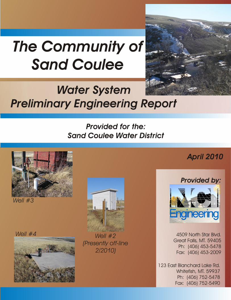
#Well 3
Well #2e tl - e(Pr sen y off lin
2/2010)
el #W l 4
April 2010
PRELIMINARY ENGINEERING REPORT
for
SAND COULEE WATER DISTRICT
WATER SYSTEM EVALUATION
April 2010
Prepared by:
NCI Engineering Co. 4509 North Star Boulevard
P.O. Box 6350 Great Falls, MT 59405 Phone: (406) 453-5478
Fax: (406) 453-2009
i SAND COULEE Water PER
SAND COULEE WATER DISTRICT PRELIMINARY ENGINEERING REPORT
TABLE OF CONTENTS
CHAPTER I – EXECUTIVE SUMMARY PAGE NO. A. SELECTED ALTERNATIVES I - 1 B. PURPOSE I - 4 C. SCOPE I - 5 D. PLANNING AREA I - 5 E. AUTHORIZATION I - 5 F. POLITICAL JURISDICTION I - 5 CHAPTER II – EXISTING CONDITIONS A. PLANNING AREA DESCRIPTION II - 1
1. Location II - 1 2. Physical Characteristics II - 1 3. Environmental Resources II - 4 4. Growth Areas and Population Trends II - 6
B. DESCRIPTION OF EXISTING WATER SYSTEM II - 7
1. System Layout and History II - 7 2. Analysis of Existing Facilities II - 9 3. Financial Status II - 22
C. NEED FOR WATER PROJECT & PROBLEMS TO BE SOLVED II - 23
1. Health and Safety II - 23 2. System O&M II - 24 3. Growth II - 26 4. Unresolved Problems II - 26
D. WATER SYSTEM DESIGN REQUIREMENTS II - 26
1. Design Standards for Water Facilities II - 26 CHAPTER III – ALTERNATIVE SCREENING A. GENERAL III - 1 B. WATER SYSTEM ALTERNATIVES III - 1
ii SAND COULEE Water PER
C. ALTERNATIVE SCREENING RECOMMENDATIONS III - 8 CHAPTER IV - ALTERNATIVE ANALYSIS A. GENERAL IV - 1 B. WATER SYSTEM ALTERNATIVES IV - 1 1. Alternative #1 - Alternative source water – Madison Formation IV - 1 2. Alternative #2 - Increase water storage IV - 5
3. Alternative #3 – Replace undersized water main IV - 7 4. Alternative #4 – Combine Alternative #1 and #2 IV - 9 5. Alternative #5 – Combine Alternative #1, #2, and #3 IV- 15 C. SELECTION OF PREFERRED ALTERNATIVES IV - 22
1. General IV - 22 2. Analysis of Cost IV - 23 3. Other Selection Criteria IV - 24 4. Recommendations IV - 26 CHAPTER V – DETAILED DESCRIPTION OF PREFERRED ALTERNATIVES
A. WATER SYSTEM V - 1
1. Site Location and characteristics V - 1 2. Operational Requirements V - 1 3. Impact on Existing Facilities V - 2 4. Design Criteria V - 2 5. Environmental Impacts and Mitigation V - 4 6. Cost Summary V - 4
CHAPTER VI - PROJECT RECOMMENDATIONS AND IMPLEMENTATION A. INSTITUTIONAL RESPONSIBILITY VI - 1 B. SCHEDULE OF PROJECT COMPLETION VI - 1 C. FINANCIAL ASSISTANCE VI - 2 D. FINANCING WITH LOAN FUNDS VI - 4 E. RATE STRUCTURE/EXISTING BUDGET VI - 4 F. ESTIMATED FUTURE COSTS VI - 6 G. PUBLIC PARTICIPATION VI - 6
iii SAND COULEE Water PER
LIST OF FIGURES Figure I -1 - Sand Coulee Vicinity Map Figure II-1 - District Boundary and Planning Area Figure II-2 - Overall Water System Figure II-3 - Existing Water Storage Facility Figure II-4 - Existing Well Sources Figure II-5 - Record of Maintenance and Repairs Figure IV-1 - Alternative #1 – Well locations and access road Figure IV-2 - Alternative #2 – Water tank and access road Figure IV-3 - Alternative #3 – Water distribution system Figure V-1 - Preferred Alternative – Well locations and access road APPENDICES APPENDIX A - DISTRICT CREATION/BOUNDARY DESCRIPTION/USER LIST APPENDIX B - GEOLOGY/SOILS/WELL LOGS/SURFACE
WATERS/WETLANDS/FLOODPLAIN/UST SITES APPENDIX C - DEQ ABANDONED MINE SITES/CORP 404 PERMITS APPENDIX D - CLIMATIC RECORDS APPENDIX E - ENVIRONMENTAL CLEARINGHOUSE CONTACTS/RESPONSES APPENDIX F - WATER QUALITY DATA APPENDIX G - POPULATION/CENSUS DATA/ECONOMIC DATA APPENDIX H - MAINTANANCE RECORDS/RECENT BREAK/REPAIR MEMORANDUM APPENDIX I - PWS REPORT/DEQ APPROVAL OF 2008 WELL DESIGN APPENDIX J - 2007 SANITARY SURVEY
APPENDIX K - 2002 WATER TANK INSPECTION/TANK COMPARISON (BY OTHERS)/2010
TANK INSPECTION APPENDIX L - FIRE MARSHAL RECOMMENDATIONS REGARDING FIRE-FLOW APPENDIX M - LEAK DETECTION SURVEY (3/23/10) APPENDIX N - DEPT OF INTERIOR/DEQ SURFACE WATER QUALITY AROUND SAND
COULEE APPENDIX O - GWIC WELL LOGS FOR SECTIONS 13,14,23, AND 24 TOWNSHIP 19N, RANGE
4E

iv SAND COULEE Water PER
APPENDIX P - PUBLCI MEETING MINUTES APPENDIX Q - UNIFORM ENVIRONMENTAL CHECKLIST APPENDIX R - PUBLIC SUPPORT LETTERS
APPENDIX S - HYDRAULIC ANALYSIS
Chapter I – Executive Summary
I-1 Sand Coulee Water District Water PER
CHAPTER I
EXECUTIVE SUMMARY A. SELECTED ALTERNATIVE The Sand Coulee Water District water system consists of two wells; one bolted steel storage tank and an undersized water distribution system with a single hydrant. The original water system was constructed pre 1959, while the storage tank was installed in 1960. A water users association operated and maintained the water system from 1959 to 2009, and in late 2009 Sand Coulee Water District was formed. The existing water system has been expanded several times throughout its history, and in 1987 was assisted by DEQ – Abandoned Mines Department who financed a water main improvements project. This project consisted of installation of a 6” PVC main to deliver potable water to the south end of the District to eliminate concerns with residence consuming mine waste contaminated shallow groundwater. In general terms the water system has “limped” by for as long as it has been in existence. Several original wells were eliminated or abandoned from the system and others were drilled to replace them. All the wells that have, or do supply groundwater to the water system have experienced decreased capacity over brief periods of time, and require cleaning/hydro blasting every few years to maintain any capacity at all. Presently two wells (Wells #3, and #4), supply source water for Sand Coulee Water District, (at the beginning of this PER writing there were three wells but Well #2 was taken off-line due to non-sustainable well yield capacities). The existing well field is located up-gradient (at a higher elevation) to the storage facility and the community, and therefore partial gravity flow from the wells supplies water to the existing storage tank. Well #3 was drilled in 1999 into the Kootenai Formation and presently produces 18gpm. Well #4 was drilled in 2008 also into the Kootenai Formation and is presently producing 28gpm. Combined the two existing wells can produce 66,240 gallons per day, while the estimated Maximum Day Demand for the present population is 72,400 gallon per day. Therefore the existing well production cannot produce adequate source water for the present population let alone the design year population. Per DEQ-1 “The groundwater source capacity must equal or exceed the design maximum day demand with the largest well out of service”. With the largest well out of service (well #4) the existing well #3 can produce a maximum capacity of 25,920 gallons per day, which is only 35.8% of the maximum day demand for the present population, and only 28.8% of the design year population. Therefore the existing groundwater sources do not meet DEQ -1 design requirements specific to quantity of water. The District’s drinking water is safe and meets federal and state requirements (per latest Water Quality Report), although there have been many total coliform positive samples in the past. The existing storage facility supplies 100,000 gallons of usable storage. This available storage volume unfortunately does not supply adequate storage for fire-flow and DEQ-1 required maximum day demands. Based upon State Fire Marshal recommendations and DEQ-1 design requirements an adequately sized storage facility should supply 135,000 gallons. The existing tank is presently is poor condition (recent tank evaluation completed 3/2010) indicates it is in dire need of interior cleaning, sand blasting and repainting along with exterior spot painting and ladder/handrail maintenance. There are visual signs of leaks towards the bottom of the tank where the bottom shell plates meet the floor plates. The existing water level controls are extremely problematic and are very susceptible to ice cake movement and often fail.
Chapter I – Executive Summary
I-2 Sand Coulee Water District Water PER
The water distribution system consists of a 6” Transite piping, 6” PVC (installed in 1987 and funded by Abandoned Mines/DEQ) and 4” thin walled solvent weld, iron pipe sized piping. The 4” piping is non AWWA/NSF approved piping; non pressure rated, and has a history of failing (two recent failures in 3/2010). Services are typically ¾” which range in material from copper, galvanized, and poly piping. The homeowner’s bylaws indicate the service lines from the curb stop to the residence are the responsibility of the individual property owner. The District water system currently does not include water meters. The existing water system has only one fire hydrant, DEQ -1 requires hydrant spacing at each street intersection and at intermediate points between intersections and must be provided as recommended by the fire protection agency, who recommends a 500 foot hydrant spacing. Per DEQ-1 (8.4.3), hydrant leads must be a minimum of 6-inches. Therefore, the existing water system does not supply adequate number of fire hydrants nor adequate size of fire hydrants. No known pressure problems exist throughout the District. Due to the gravity nature of the primary sources and elevated level of the storage tank, the pressure near the middle of the community is approximately 69psi indicating that the elevation of the existing tank is adequate to deliver adequate pressures to users. The existing 4” piping fails in a consistent manner whereby when a break occurs the piping splits from glued coupling to coupling generally in a straight line. These breaks are displayed and documented in later references in this document. As indicated in later references and pictures the existing 4” piping has accumulated granular coal/coal slack materials, and as reported by District personnel this condition is true for the entire distribution piping. There are no present means of flushing the distribution system to remove settled deposits of coal/coal slack. The actual source of the settled granular coal within the distribution system is unknown, what is known is that it is not uncommon for the coal deposits to plug service connections or come through your tap into your drinking glass. Many residences have been forced to install filters within their homes to remove suspended granular coal/coal slack. The coal mined in Sand Coulee is considered “high pyritic” coal meaning that it contains a large percentage of iron compounds. These compounds when mixed with water cause mine waste drainage constituents (known and documented by DEQ and others in Sand Coulee and outlying areas where past coal mining operations existed) when the iron is leached from the coal, which in turn depresses the PH forming acidic, rusty water. The accumulated granular coal within the distribution system can potentially lead to harmful health concerns that mirror health concerns with acid mine drainage waters do if consumed. Per Montana DEQ Circular 1, 2006 Edition, the minimum size of water main providing fire protection and serving fire hydrants must be six-inch diameter. Any departure from minimum requirements must be justified by hydraulic analysis and future water use, and can be considered only in special circumstances. The majority of the existing distribution system does not meet this requirement, nor can the existing 4” piping deliver adequate fire flows to the District. The District does not presently treat their source water and only performs disinfection measures when maintenance/repairs are performed utilizing bleach as a disinfectant. The District has witnessed many positive total coliform samples (with follow-up sampling showing E. coli absent results). Due to these positive samples, the District must work to remedy all possible problem areas in the District. The engineer recommends the District work with Midwest Assistance Program to develop a sampling plan and work to remedy the sampling problems. Due to the imminent nature, complexity, and compliance cost of the Groundwater Rule, and its possible effects on the District’s water system, the treatment system improvements will need to be planned for. The District should consider what future improvements such as full-time chlorination that may be required to meet GWR requirements.
Chapter I – Executive Summary
I-3 Sand Coulee Water District Water PER
The focus of this report is to identify water system deficiencies and recommend alternatives to solve the greatest needs. The deficiencies associated with the system include:
• Existing groundwater sources cannot supply adequate quantities of water for present average day demand let alone DEQ peak day demands for future population projections.
• Existing storage facility cannot supply fire flows which is a serious health and safety concern.
• Existing water main system is mostly undersized, cannot deliver fire flows, has inadequate valving, and only contains a single fire hydrant, all of which are serious health and safety concerns.
• The existing 4” thin walled water main is experiencing main break problems and is beyond its useful life, and is non AWWA/NSF approved water piping, is partially filled with coal/coal slag, and requires replacement. Deteriorated thin wall water main creates a serious health and safety concern and the coal/coal slag deposits create an environment that coliform bacteria can thrive in and is expected to be a source of the many total coliform positive samples.
• The single existing 4-inch hydrants require replacement (does not meet DEQ-1 guidelines specific to sizing).
• Maintenance intensive control system requires replacement. Numerous costly repairs are made on the control system yearly.
• Security improvements such as fencing and locks around wells and storage tanks are recommended.
• Storage facility requires expansion/replacement, and presently does not supply adequate storage to meet DEQ-1 design standards.
• Due to the total coliform positive testing trend, the District water system will be under scrutiny as the GWR comes into affect in the near future. Treatment system improvements may be required to meet the requirements of the GWR. Auxiliary power should be a consideration with this work.
• Existing water system does not include well head meter or water service meters. From this study, a number of potential improvement alternatives were evaluated to rectify problems associated with specific components of the existing failing water system. Chapter III and IV provide a comprehensive analysis of these options relative to various evaluation criterion. Included in the alternative evaluations are the following: No action Alternative source water, surface water, and groundwater Regionalization with adjacent communities for water system needs Address storage requirements, Rehabilitation/expansion of existing tank or construct new storage facility
utilizing various types of materials (concrete, and steel) Water main system rehabilitation Pipe bursting Slip-lining
Pipe material alternatives Pump house treatment improvements Control system improvements
Chapter I – Executive Summary
I-4 Sand Coulee Water District Water PER
Water system security improvements Through this extensive evaluation, a water system improvements project is recommended. Chapter V and VI outline the project scope in detail as well as provide a financial plan and implementation schedule. Essentially the conclusions to remedy water system problems include three projects that individually correct existing water system failures specific to; 1. source water capacity and pump control, 2. adequate storage measures and water level controls, and 3. distribution system corrections including residential metering. Due to the severity of the problems associated with each of these water system components the recommendation would be to proceed with all identified projects to correct all associated health, safety, and non DEQ-1 conforming issues with the existing water system. This, however, appears to be financially non-viable with an anticipated user rate for all three projects combined of $135/01, and combining the two least expensive proposed project would increase the user rates to $58.65, or 1.53 times the water target rate of $38.28/month per user. Therefore through a prioritization process a single project is proposed, and the remaining identified and needed projects will have to be phased. The proposed project is to remedy source water quantity by drilling new wells into the underlying Madison Formation. The first phase recommended water system improvements will include three new wells into the Madison Formation, including new DEQ-1 conforming control system and pump house building. The new wells and pump house facility will be located adjacent to the existing well field and will require a small amount of additional land purchase and improved access roadway. A project budget including administrative, legal, engineering, and other applicable costs as well as funding scenario and scheduling are described in Chapter VI – Project Recommendations and Implementation. The resultant water project is estimated to cost approximately $582,966 and a final monthly rate of $43.61 per equivalent user would be expected, based on the anticipated funding scenario. B. PURPOSE This Preliminary Engineering Report (PER) addresses the necessary planning and engineering required to comply with Federal and State water operation standards for the Sand Coulee Water District, Montana. Properly functioning utilities are necessary to protect public health and safety by maintaining standards established by the Montana Department of Environmental Quality (MDEQ) and the U.S. Environmental Protection Agency (EPA). State and Federal funding agencies in Montana jointly developed an outline of necessary subjects that must be addressed in an engineering report prior to application for financial assistance. This study will address those subjects, enabling Sand Coulee Water District to qualify for financial assistance. Through the PER process, the optimum infrastructure improvements can be determined. An analysis of the existing water utilities including improvement alternatives was completed to identify the most cost-effective system that will comply with Federal and State regulations and meet the goals of the District. Life-cycle costs were evaluated relative to construction and operating needs. Land-use, public acceptance and environmental conditions were also considered. The PER includes an analysis of those alternatives considered to be technologically feasible and politically acceptable to the Sand Coulee Water District.
Chapter I – Executive Summary
I-5 Sand Coulee Water District Water PER
C. SCOPE The water utility consists of two well sources, a single water storage tanks, one fire hydrant, 4” and 6” water main of various materials. There is no water treatment system presently utilized. The distribution system does not include water meters on service lines, nor does it presently have well head meters. The scope of this PER is to evaluate the effectiveness of the existing water system, identify problems that may exist, consider alternatives for the correction of such problems and select a recommended plan for the improvements. The selected plan represents a cost effective and environmentally sound water project that will address the most immediate utility deficiencies. D. PLANNING AREA The Sand Coulee Water District (WSD) is strictly a residential area. No businesses currently exist within the District. The community of Sand Coulee is accessed via State Secondary routes 226 or 227 and lies approximately 10 miles from Great Falls, MT, where most people commute to work, and shop. The water planning area includes the entire District boundary as indicated on Figure I-1 Sand Coulee Vicinity Map and Figure II-1 District Boundary and Planning Area. The District was recently formed in November 2009, and prior to that the water system was operated and maintained by Water Users Association that was established in 1959. E. AUTHORIZATION This PER has been authorized by the Sand Coulee Water District. Development of the study was coordinated closely with Montana DEQ’s Planning, Prevention and Assistance Division and the Montana Department of Commerce TSEP Program, and the Department of Natural Resources and Conservation. NCI Engineering Co. of Great Falls, Montana was responsible for the engineering and related analyses involved in the study. F. POLITICAL JURISDICTION Sand Coulee Water District Water District is an unincorporated community, organized under the laws of the State of Montana. Management of the District is the responsibility of the Board of Directors, as authorized under Title7, Chapter 13, Parts 22 and 23. The District is primarily responsible for meeting the requirements of the Montana Water Quality Act. Members of the current District Board and staff are as follows: Kent Luoma, President Pat Darko, Board member Mike Waldner, Board member Kelly Luoma, Bookkeeper Mary Ann Freeman, Secretary
Chapter II – Existing Conditions
II-1 Sand Coulee Water District Water PER
CHAPTER II
EXISTING CONDITIONS A. PLANNING AREA DESCRIPTION 1. Location The Sand Coulee Water District is located in Cascade County, Montana. The community lies along a County Collector road between State Secondary Routes 227 (to the east of Sand Coulee) and 226 (to the west of Sand Coulee) approximately 10 miles southeast of Great Fall, Montana, please refer to Figure 1-1, and II-1 through II-4 for vicinity maps, district boundary, land use from aerial photos, and USGS maps of the area, water utility system layout. Adjacent small communities located within several miles from Sand Coulee are Tracy, Centerville, and Stockett. Sand Coulee Water District was formally created on November 17/2009 (please refer to Appendix A for District creation documentation, planning area description and users). Prior to becoming a District the water system was maintained and operated by a Water Users Association that was initially established in 1959. The community was initially established as a coal mining town, and the present District lies in Township 19N, Range 4E, in parts of sections 13 and 14 at a latitude and longitude in decimal degrees of 47.39952 and -111.16797. Sand Coulee has an approximate elevation of 3,465 feet above sea level. Figure II-1 indicates the planning area, district boundaries and general residential land use that were considered under this study. The recently completed District formation established the boundary to account for the present planning area therefore the planning area is coincident with the District boundary. Figure II-2 displays the overall water system layout, Figure II-3 existing water storage facility, and Figure II-4 displays existing well sources. 2. Physical Characteristics Geology, topography and general land use: Sand Coulee, as the name implies, is located in a coulee or narrow valley floor area with the an average elevation of approximately 3465 with a slight grade of 1-2% in the northeast direction, the adjacent flat top bluffs lying directly north and south and hemming in the community rise to elevations of approximately 3700’, or approximately 235’ above the average elevation of Sand Coulee valley bottom (please refer to Figure I-1 and Figure II-4 for USGS maps of the Sand Coulee area). The surrounding area is generally agricultural and rangeland in use with trees/vegetation surviving mostly in coulee areas or adjacent to water collection/transport areas such as irrigation ditches. The community was established as a coal mining town as was the adjacent areas and communities and therefore there are many abandoned mines in and around the vicinity. Coal mining at Sand Coulee started in the late 1880’s and continued for approximately 60 years in and around the immediate area. Sand Coulee Creek lies east of the Sand Coulee community, and within the community itself and running northeast is a small unnamed tributary to Sand Coulee Creek locally known as “rusty ditch” and as the name implies is heavily contaminated with mine waste and is orange in color. Mining occurred in the upper part of the Morrison Formation (Jurassic age). The potable water wells utilized by Sand Coulee District penetrate interbedded sandstone, mudstone and minor limestone of the Kootenai Formation. The sandstone layer at the base of the Kootenai formation forms a regional aquifer that is the source of water for Sand Coulee with three active but steadily decreasing capacity wells (please refer to Appendix B for geology map). As indicated in the “Source Water Delineation Report – April 13/2000”; “Lithology logs for the Sand Coulee wells and nearby well drilled by the MBMG suggest the aquifer is 50-60 feet thick. However, most of the production from Sand Coulee’s wells probably comes from course-grained sandstone and conglomerates near the base of the aquifer. A mudstone layer that overlies the basal sandstone is a
Chapter II – Existing Conditions
II-2 Sand Coulee Water District Water PER
confining unit south of Sand Coulee but discharge to mine workings has depressurized the aquifer resulting in unconfined conditions at Sand Coulee (Osborne et al., 1987)”. There have been and continues to be decreasing capacity problems with Sand Coulees potable water wells in the Madison formation, that generally exhibit decreased capacity within a short 1 or 2 year period. Soils: Soils (please refer to Appendix B) in the area of Sand Coulee were obtained from NRCS website are listed as Bitton and Roy Soils with 10-65% slopes and Fergus silty clay loams (located primarily in and around Sand Coulee Community) with 2-15% slopes. Both soil types are considered well drained with no frequency of flooding. The Bitton and Roy soils have a profile from 1-60 inches in depth of stony loam to very stony loam. The Fergus silty clay loam material have a profile from 1-60 inches of silty clay loams. Neither of these soil types exhibit properties that may be problematic with installation or replacement of water main or service utilities, both soils appear to be good material for back fill of utilities, and both are listed with a depth to water table of more than 6.66 feet. Groundwater: Based on local well logs, groundwater levels average approximately 130 feet with the maximum will depth of 636 feet below the surface. Groundwater used for Sand Coulee potable water and irrigation comes from two (at the beginning of this writing there were three well but one well was taken off-line due to non sustainable water yield) wells drilled into the Kootenai formation. As indicated in the Source Water Delineation and Assessment Report dated 4/2000 “Water that infiltrates the bench tops southwest of Sand Coulee recharges the sandstone aquifer. Water discharges from the aquifer to underlying formation, to outcrops along coulees, and to mine workings. The aquifer is confined southwest of Sand Coulee but is unconfined west of Sand Coulee because of partial dewatering by nearby mine workings (Osborne et al., 1987)”. The existing three wells utilized by Sand Coulee (well #2 was taken off-line in February 2010) are all approximately drilled to the same depth (181’ to 212’ knows as the Kootenai Formation) and all have similar surface water levels (150’ to 154’) with historical decreasing capacities from initial drilling capacities (please refer to Appendix B for well logs). While static water levels have remained mostly constant capacity in each well utilized presently and historically by Sand Coulee have decreased. Two wells (well #1 – GWIC 31884 drilled in 1920, & Well 2 GWIC 31883 – drilled in 1960 plugged and abandoned in 5/2000) have been abandoned and are no longer in use due to diminished capacities to the point that they could no longer be viable as water sources. The present groundwater wells (Well 2, 3 and 4 <well 2 recently taken off-line) have also displayed decreasing capacities. Well 2 has a recorded yield of 60gpm at the time of drilling but presently only produces 12gpm (this well was taken off-line in February 2010 due to unsustainable water yields), Well 3 has a recorded yield of 50gpm at the time of drilling but presently only produces 18gpm, and well 4 (drilled in 2008) had a recorded yield of 30gpm at the time of drilling and presently only produced 28gpm. It is not knows exactly what causes the decrease in well capacities but appears to be encrustation of the surrounding aquifer material and/or biofouling conditions such that the groundwater aquifer can no longer supply/recharge original capacities. These conditions of decreased yields are experienced over relatively short time frames (within a year or two). During the design and approval of the new 2008 well (well #4) the original proposal was to remove existing well #2 from production but due to the fact that the anticipated design yield for the new well #4 was not achieved the existing well #2 was kept online and well #4 was reclassified as an additional redundant will in lieu of a primary well classification.
Chapter II – Existing Conditions
II-3 Sand Coulee Water District Water PER
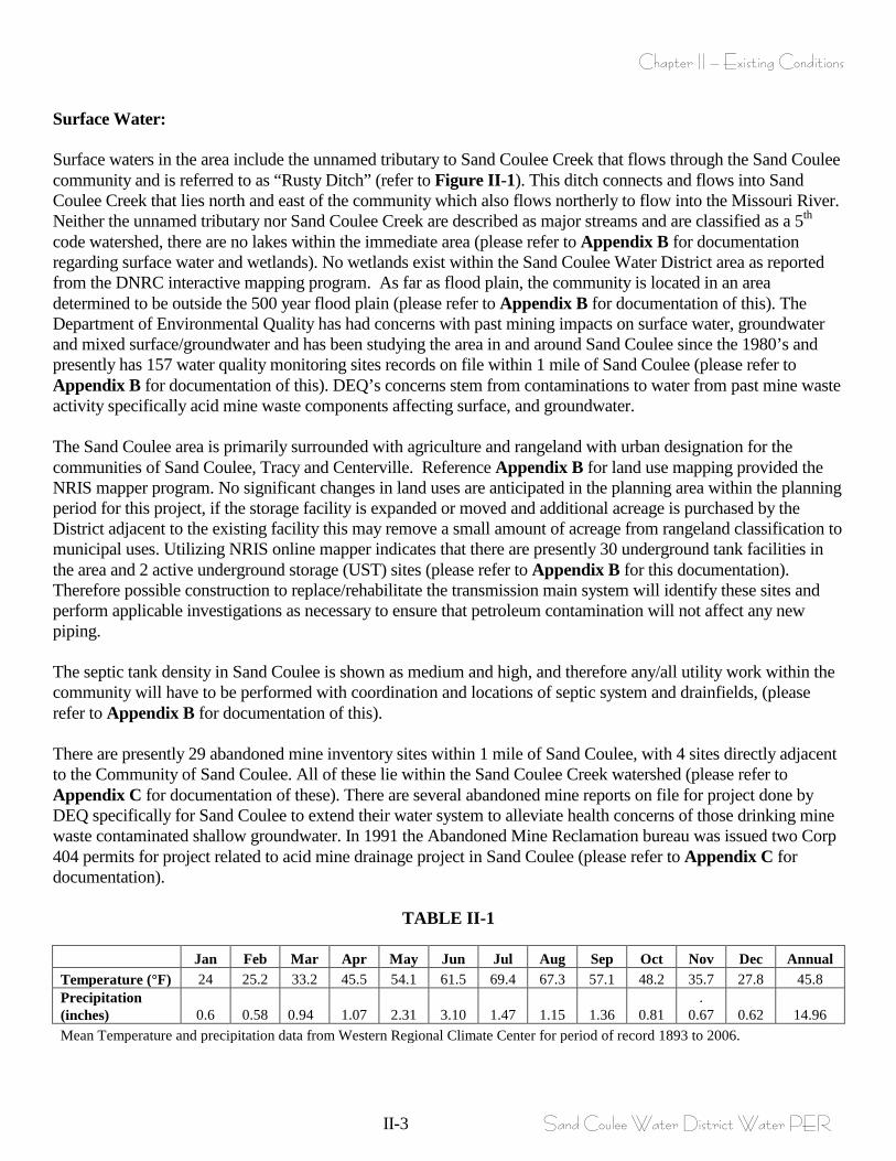
Surface Water: Surface waters in the area include the unnamed tributary to Sand Coulee Creek that flows through the Sand Coulee community and is referred to as “Rusty Ditch” (refer to Figure II-1). This ditch connects and flows into Sand Coulee Creek that lies north and east of the community which also flows northerly to flow into the Missouri River. Neither the unnamed tributary nor Sand Coulee Creek are described as major streams and are classified as a 5th code watershed, there are no lakes within the immediate area (please refer to Appendix B for documentation regarding surface water and wetlands). No wetlands exist within the Sand Coulee Water District area as reported from the DNRC interactive mapping program. As far as flood plain, the community is located in an area determined to be outside the 500 year flood plain (please refer to Appendix B for documentation of this). The Department of Environmental Quality has had concerns with past mining impacts on surface water, groundwater and mixed surface/groundwater and has been studying the area in and around Sand Coulee since the 1980’s and presently has 157 water quality monitoring sites records on file within 1 mile of Sand Coulee (please refer to Appendix B for documentation of this). DEQ’s concerns stem from contaminations to water from past mine waste activity specifically acid mine waste components affecting surface, and groundwater. The Sand Coulee area is primarily surrounded with agriculture and rangeland with urban designation for the communities of Sand Coulee, Tracy and Centerville. Reference Appendix B for land use mapping provided the NRIS mapper program. No significant changes in land uses are anticipated in the planning area within the planning period for this project, if the storage facility is expanded or moved and additional acreage is purchased by the District adjacent to the existing facility this may remove a small amount of acreage from rangeland classification to municipal uses. Utilizing NRIS online mapper indicates that there are presently 30 underground tank facilities in the area and 2 active underground storage (UST) sites (please refer to Appendix B for this documentation). Therefore possible construction to replace/rehabilitate the transmission main system will identify these sites and perform applicable investigations as necessary to ensure that petroleum contamination will not affect any new piping. The septic tank density in Sand Coulee is shown as medium and high, and therefore any/all utility work within the community will have to be performed with coordination and locations of septic system and drainfields, (please refer to Appendix B for documentation of this). There are presently 29 abandoned mine inventory sites within 1 mile of Sand Coulee, with 4 sites directly adjacent to the Community of Sand Coulee. All of these lie within the Sand Coulee Creek watershed (please refer to Appendix C for documentation of these). There are several abandoned mine reports on file for project done by DEQ specifically for Sand Coulee to extend their water system to alleviate health concerns of those drinking mine waste contaminated shallow groundwater. In 1991 the Abandoned Mine Reclamation bureau was issued two Corp 404 permits for project related to acid mine drainage project in Sand Coulee (please refer to Appendix C for documentation).
TABLE II-1
Jan Feb Mar Apr May Jun Jul Aug Sep Oct Nov Dec Annual Temperature (°F) 24 25.2 33.2 45.5 54.1 61.5 69.4 67.3 57.1 48.2 35.7 27.8 45.8 Precipitation (inches) 0.6 0.58 0.94 1.07 2.31 3.10 1.47 1.15 1.36 0.81
. 0.67 0.62 14.96
Mean Temperature and precipitation data from Western Regional Climate Center for period of record 1893 to 2006.
Chapter II – Existing Conditions
II-4 Sand Coulee Water District Water PER
The mean annual precipitation and temperatures are recorded/collected from the Western Regional Climate Center located at the Great Falls station and consist of collected data from 1893 to 2006. The mean annual precipitation for this period is 14.96 inches, and the mean annual temperature for this same period is 45.8 degrees Fahrenheit. Reference Appendix D for all applicable climatic records. 3. Environmental Resources The following agencies/entities have been contacted to define if land resources, historic sites, endangered species/critical habitats, etc may be affected by potential wastewater collection modification or expansions to the existing treatment system;
1. Cascade County Conservation District 2. Cascade County Planning Department 3. US Fish and Wildlife Service 4. US Army Corps of Engineers 5. State Historic Preservation Office 6. MT Dept of Fish, Wildlife and Parks 7. MT Department of Environmental Quality 8. Montana DNRC – Floodplain Management
Please see Appendix E for verification of these contacts and response letters. The surrounding area is generally agricultural and rangeland in use with trees/vegetation surviving mostly in coulee areas or adjacent to water collection/transport areas such as irrigation ditches. No significant changes in land uses are anticipated in the planning area within the planning period for this project. The potential impacts to local wildlife from improvements to the water utilities have been requested from the U.S. Fish and Wildlife Service and the Montana Department of Fish, Wildlife and Parks and comments from both agencies have been solicited. According to US Department of Interior Fish and Wildlife Service, the project is unlikely to have any significant adverse effects upon fish, wildlife, or habitat resources under the purview of the U.S. Fish and Wildlife Service. Please see Appendix E for verification of this contact and the corresponding response letters. The Sand Coulee Water District currently serves 73 residential connections. The water system utilizes two groundwater wells drilled into the Kootenai Formation. Based upon a present population of 2.47 people per serviced residence the present population is (2.47 X 73) is 181 people. With an average use of 100 gallons per day per person this equates to 18,100 gallons per day average use. Utilizing DEQ Figure 1 from DEQ-2 concludes with a peaking factor of 4 which concludes with a maximum day demand of 72,400 gallon per day. The present capacity of the wells (as recently measured by District personnel) concludes that Well #2 produces 12gpm (this well was recently taken off-line due to unsustainable yields), Well #3 produces 18gpm and Well #4 produces 28gpm for a total production of 46gpm with all producing wells combined. If all wells were to operate 24 hours a day at this capacity they could only supply 66,240 gallons per day which obviously falls short of producing adequate water for the maximum day demand. Through water quality monitoring (refer to Water Quality Report, Appendix F), it has been determined that some constituents have been detected; however, the EPA has determined that the drinking water is safe at the reported levels. A single 100,000 gallon tank provides storage for the District. Due to continued capacity/yield problems with the present wells it is anticipated that a different groundwater source will have to be utilized (Madison Formation) and therefore the District must obtain approved plans/specification from DEQ and water rights from DNRC in order to use this as a potable water
Chapter II – Existing Conditions
II-5 Sand Coulee Water District Water PER
source. If/when the District utilized the deeper Madison Formation for their public water supply system there is no anticipation that this groundwater source will be affected by potential surface water contaminations. In Appendix E we have supplied a brief memo from John Koerth of the Abandoned Mines Program who indicates that the Abandoned Mines program may become a potential project financing avenue specifically for a new well source because of their past involvement with extending a portion of Sand Coulees water main system to alleviate concerns with those on the south side of town drinking mine waste contaminated groundwater and now existing the well capacity issue may also fall under their financing power. There are no flood plains in the Sand Coulee Water District area that would be affected by the recommended projects. The Cascade County Planning Department indicated that a possible utility project in Sand Coulee would involve the floodway and floodway fringe of Sand Coulee Creek and may require a Floodplain permit, they also indicated the a proposed water utility improvements project is in compliance with the County Growth Policy and the County Zoning Regulations. The Army Corps of Engineers was contacted regarding streams, wetlands, flood plains, and other water bodies permitting. Under the authority of Section 404 of the Clean Water Act, Department of the Army permits are required for the placement of dredged or fill material below the ordinary high water mark of our nation’s rivers, streams, lakes, some irrigation ditches, and their adjacent wetlands. Any work involving these activities would fall under the Corps of Engineers’ Regulatory Program. The determination presented by the Corps was that based on the information submitted, it appears that some of the water lines may impact tributaries to Sand Coulee Creek. If this is the case, a permit from the Corps of Engineers will be required prior to commencing construction. See floodplain and wetlands mapping research in Appendix B and DNRC contact letters in Appendix E. The Montana State Historical Preservation Office (SHPO) has been contacted regarding known or potential historical, archaeological or cultural resources that may be impacted. Response to the request and results of the cultural resource file search are included in Appendix E. SHPO concluded that their records show that there have been a few previously recorded historic mining sites within the designated search local, and also a few previously conducted cultural resource inventories performed in the area. It is SHPO’s position that any structure over fifty years of age is considered historic and is potentially eligible for listing on the National Register of Historic Places. It is not anticipated to disrupt any building in this water utility improvements project therefore no impacts are anticipated and we agree with SHPO’s statement “that there is a low likelihood that cultural properties will be impacted”. There are no socio-economic/environmental justice issues as described in the Uniform Preliminary Engineering Report guidelines associated with the possible alternatives for the Sand Coulee Water District water improvement recommendations. Because all of the proposed water improvement alternatives will occur along previously disturbed corridors, no permanent environmental impacts are anticipated by these improvements. Temporary noise and dust creation will occur during utility installation, but will be mitigated by the contractor through best management practices.
Chapter II – Existing Conditions
II-6 Sand Coulee Water District Water PER
4. Growth Areas and Population Trends The community of Sand Coulee Water District is unincorporated town. The boundaries of the District were set with local involvement to account for anticipated growth areas over the next 20 years; therefore the District Boundary is also the Planning Boundary. Figure II-1 defines the District boundary and planning area. Accurate information specific to population and income values for those that reside within the District cannot be directly determined through Census information as the Census data is specific to a larger geographical area which is not coincident with the District Boundary. On behalf of the District the Census and Economic Center has been contacted and agreed to establish a Census Designated Place (CDP) that is coincident with the Sand Coulee Water District Boundary. Unfortunately population and economic data for the new CDP will not be available for use until the middle or late summer of 2010; therefore defining existing population for the Sand Coulee District is performed using the best available information. At the time of this writing Midwest Assistance Program (MAP) is in the process of performing an income survey for the Sand Coulee District that is anticipated to yield more accurate income results than using the present information generated by the 2000 census for the general area. In order to establish present population residing within the District boundary, a present population is based on the existing number of water services of 73, coupled with 2000 Census information specific to average number of people per household. The statistics for the 2000 census specific to population and number of households documents there are 80,357 people and 32,547 households which equates to 2.47 peoples per household (please refer to Appendix G). Utilizing this data the existing population is determined by multiplying the 2.47 people per household time the number of existing water services of 73 to conclude with a present population of (2.47 X 73) = 181 people. Census information for Cascade County indicates that in 1980 there was a population based of 80,696, and in 1990 a population based of 77,691 which calculates to a decrease of approximately 0.4% per year for this decade. The 2000 census indicates a population of 80,357 which calculates at a 0.3% increase per year for this decade. While the 2010 census is not completed they do have population estimates for Cascade County and show that the estimated population for 2008 is 82,026, or an increase of 0.2% per year (please refer to Appendix G). The above population changes do not really show a consistent trend other than Cascade County appears to be growing at a very modest rate of somewhere between 0.2 and 0.3% per year since the 1990 census. At this point we simply have to attempt to make a good guess at population projections. In general populations in smaller rural communities are increasing slightly more than larger cities due to perceived better living conditions in smaller communities verses larger populated areas. It is not uncommon to use a population of 1% per year for planning purposes, and in the interest of nothing more scientific we propose using this population projection. Therefore starting with a base population residing within the District of 181 people and using a population projection of 1% per year for a period of 22 years concludes with a population of (181 people X 1.0122) = 225 people in the year of 2032. Please refer to Appendix G for census data and information from TSEP program specific to target rates, LMI, and poverty values collected from a larger census area surrounding the Sand Coulee area.
Chapter II – Existing Conditions
II-7 Sand Coulee Water District Water PER
B. DESCRIPTION OF EXISTING WATER SYSTEM The Sand Coulee water system currently has 73 single family year round residential connections. The water system utilizes two well sources (at the beginning of this writing the District was relying on three wells but due to decreased inconsistent capacities well #2 was taken off-line). The community relies upon a single steel bolted storage tank for water storage with a rated capacity of approximately 100,000 gallons. The distribution system is composed of 4”, and 6” piping of various materials. Service lines are currently comprised of different materials such as galvanized iron, poly, and copper piping. The general age of the distribution system (with the exception of approximately 1,230’ of PVC installed in 1987 by Abandoned Mines), dates back to pre 1959, while the existing tank was installed in approximately 1960. The District operates and maintains the source water wells, storage tank, water main distribution system, and services to the curb stops; each homeowner connected to the system is responsible for their own service from curb stop to the residence. No water meters exist within the distribution system, nor are there well head meters, therefore accounting for water use is impossible. The water distribution system is experiencing continual main breaks (several per year please refer to Figure II-5 and Appendix H for recent break documentation), and consists of mostly 4” thin walled, non AWWA/NSF piping incapable of delivering fire flows. The water system original intent was to provide minimum fire protection, however the distribution system contains only one fire hydrant, and is not looped, therefore there are long dead end mains with no flushing hydrants. The distribution system does not have adequate flushing hydrants (only one exists) therefore after maintenance for main break flushing cannot adequately be performed. The water system does not supply any type of treatment. 1. System Layout and History Figure II-2 through II-4 shows the general layout and location of the existing Sand Coulee Water District water system inclusive of groundwater sources, storage facility and water distribution system. The existing water system relies on two groundwater wells (again at the beginning of this writing the District was relying on three wells but Well #2 was taken off-line in February 2010 due to decreased and inconsistent capacity) drilled into the Kootenai Formation, with histories of decreasing source water capacity, a single 100,000 gallon storage facility that presently leaks and dates to 1960. Reference the well logs in Appendix B. The District has water rights documentation for each of the water sources (reference water right general abstracts in Appendix B). The distribution system dates to pre 1959 consisting of mostly 4” undersized, thin walled solvent weld, iron pipe size, non AWWA/NSF approved water main. There are no as-built drawings for the original system, and the only found design information is specific to the single stretch of 6” PVC piping (approximately 1,230 feet in length) that was installed in 1987 and funded by DEQ Abandoned Mines Section. The abandoned mines section funded this project to alleviate health concerns with residences in the southern portion of the community consuming mine waste contaminated shallow groundwater. The water system was constructed in the early part of the 20th century and has been added onto multiple times. Originally, the water system was developed for a company mining town established by the Sand Coulee Coal Company, an affiliate of the Great Northern Railroad Company. The water system has been expanded several times throughout its history to accommodate additional users and to obtain additional groundwater sources. A Water Users Association took over control of the water system in 1959 and operated as such until late in 2008 when a Water District was formed (please refer to Appendix A for District creation documentation).
Chapter II – Existing Conditions
II-8 Sand Coulee Water District Water PER
The existing water distribution system consists of; 1 fire hydrant, approximately 1,230 lineal feet of 6”PVC water main (funded by Abandoned Mines/DEQ and installed in 1987), 400 lineal feet of 6” Transite water distribution main from the existing water storage facility connecting the 6” PVC, and 4,000 lineal feet of 4” solvent weld, iron pipe size, thin walled, non AWWA/NSF approved water transmission main (this water main could not be identified with a pressure rating). Refer to Figure II-2 for an illustration of the existing water distribution system. Figure II-3 illustrates the existing storage facility and Figure II-4 displays the existing groundwater well sources. The existing water system has no provisions for water treatment, nor is there room within the existing pump house facility to accommodate treatment facilities. In 2008 a new well was drilled to alleviate water shortages due to dramatic decreases in existing well capacity, and prior to completing the new well Sand Coulee was forced to implement emergency water rationing and was forced to haul water to the storage facility to keep up with potable water use, these two activities depleted much of the Districts financial reserves and costs the District approximately $49,000 for the new well and $7,500 for water hauling activities. Since the original creation of the Water Users Association the water system has been unable to supply adequate water during high use season and the bylaws indicate summer water rationing which continues to the present time. Additional miscellaneous maintenance activities have been performed on the water system throughout the years. Please refer to Appendix H and Figure II-5 for a list and graphical presentation of maintenance items that have occurred from the year 1995, this list is a synopsis from reviewing meeting minutes. In addition to this list there were two main breaks that occurred the first week of March/2010, please refer to Appendix H for pictures the repair, they are also noted on Figure II-5. Please note on these pictures how the existing thin walled piping breaks. Typically a break will go from solvent welded coupling to coupling laterally along entire length of pipe (22’ sticks of pipe). Also note on these photos the volume of course granular coal imbedded and deposited inside of the existing piping, it is not uncommon for this coal to find its way into your drinking or washing potable water. The water system is controlled with wet/dry probes installed and hanging from the interior roof of the storage structure. When water level rises and probes become wet, they de-activate pumps. There is a separate set of probes per pump, one set controls the lag pump (well #3) while the first and highest elevation probes control the lead pump (well #4). The set point of the wet/dry probes can be altered but are presently set at approximately 2’ below overflow piping elevation and when water demand draws the water elevation to below this elevation pump/well #4 is activated. If demand is less that well #4 capacity the water level rises and once probes are wet deactivate well #4. The second set of probes is set at 5’ below overflow capacity. If water demand from the tank is greater than the capacity of well #4 the water level will continue to lower in the tank until the second 5’ set point is reached which activates well #3. Both wells will operate until water level rises and probes become wet deactivating each pump as water level rises. The probes have historically been problematic and each winter the water level in the tank must be manually operated such that water level remains high in the tank, keeping the ice cake that forms from moving. If/when a formed ice cake moves downward it will/has sheared the probes away from their mounting bracket and eliminating all automatic water level controls until they can be removed from ice and reset. The controls in each pump house are basic at best and do to have electric surge/brownout or lightning strike protection, and continue to demand maintenance each time an occurrence is experienced. The existing controls within the pump houses also do not have the capacity to send any type of alarm signal, nor does it supply remote access capabilities. Each pump house is equipped with an exterior light than can be viewed from parts of town, this light when on indicates that a particular pump is operating. The pumps do not cycle (existing controls have no pump cycling controller) and are actuated based upon the largest well operating for the majority of the demand.
Chapter II – Existing Conditions
II-9 Sand Coulee Water District Water PER
2. Analysis of Existing Facilities Groundwater Sources and Quantity: At the beginning of the writing of this PER there were three wells supplying the District with potable water use (please refer to Appendix B for well logs, water rights etc), due to dramatic decrease and inconsistent capacity in well #2 it was taken off line in late February of 2010. Historically there have been additional wells used for potable water, but over time the capacity in several wells has decreased and new wells have been drilled to replace original wells. All historic and present wells exhibit decreased capacity over quite brief periods of time. Information obtained from the Groundwater Information Center (GWIC) indicates multiple wells that were part of the original water system that are no longer in use or have been abandoned. From this information one of the original wells, original well #1 was drilled in 1929, and produced 12gpm, this well is no longer in use. Another well, original well #2 was drilled in 1960, and originally produced 45gpm, this well over time failed to produce adequate water and was plugged and abandoned in the year 2000. The present wells that are in use are Well #3, and Well #4 (Well #2 was taken off line late in February of 2010 due to decreased and inconsistent capacity), please refer to Figures II-1, II-2 and II-4 for location and pictures. From a review of well logs, please refer to Appendix B, all historical and present wells were/are drilled into the Kootenai Formation. All present wells are located up on a bench area west of Sand Coulee at an approximate ground elevation of 3700’. None of the existing wells have well head meters; therefore volumes of water pumped over a time span cannot be determined. All wells are tied into a common 4” header prior to discharging into the water storage facility. At each well head and adjacent to the well head existing piping to the surface exists such that direct pump to waste and pump/well capacity can be determined (using a simplistic bucket and timer test). The District has recently test pumped all the wells utilizing this existing pump to waste piping and concluding that present capacity of the three wells are; Well #2 – 12gpm (this decreased and became inconsistent and this well was taken off line in late February of 2010), Well #3 – 18gpm, and Well #4 – 28gpm. Well #2, (please refer to Figures II-1 through II-4) is located furthest to the north, was drilled in 1973, and is the oldest well still in use (during the writing of the PER this well was taken off-line due to decreased and unsustainable well yield). As indicated in the well logs (please refer to Appendix B) it was drilled to a total depth 210’ into the Kootenai Formation with a reported static water level of 150’ and an original capacity of 60gpm. This well (also the same for all existing wells) presently has a 1-1/2 horsepower pump, three phase, and 240 volt pump. This well is identified with a GWIC #2254. This well has had inconsistent capacity for some time and during the writing of this PER it was taken off line as capacity decreased and became too inconsistent to rely on. During the design and approval for well #4 it was anticipated that his well would be abandoned, but due to the actual yield of Well #4 at the time of construction it was determined that the existing well #2 would be needed for demand use and well #4 was reclassified from the primary well to redundant well. Again this well is presently off-line due to decreased and inconsistent capacity. Well #3 is located furthest to the south and was drilled in 1999. This well is identified with a GWIC #177478, and was drilled to a total depth of 181’, with an original static water level of 150.5’ and an original capacity of 50gpm. This well presently has a 1-1/2 horsepower pump, three phase, 240 volt pump, and is presently producing 18gpm.
Chapter II – Existing Conditions
II-10 Sand Coulee Water District Water PER
Well #4 is the newest well drilled in 2008 when the Districts existing wells could not supply adequate quantity for potable water use, prior to and during the time this well was being drilled the District was forced to perform emergency water hauling to the storage facility to supply users with minimum potable water. Initial DEQ/DNRC design approvals were based upon appropriating 50gpm, but actual well yield could only produce 30gpm. Well #4 identified with GWIC # 241877 was drilled to a total depth of 212’ with a static water level of 154.5’ and an original capacity of 30gpm. This well is presently producing 28gpm, indicating the severity of the Kootenai water bearing formations decreased capacity over relatively short periods of time (this well was test pumped and placed into production at 30gpm). Total capacity of all two existing producing wells totals 46gpm. Assuming that these reported well yields are sustainable over a 24 hour period the maximum quantity of water that can be produced from the existing groundwater well sources operating together is (46gpm X 60minutes/hr X 24 hours/day) = 66,240 gallons per day. Water Source (Water Demand, Adequacy of Supply, Source Water Protection) Present Population Water Demand: There are no meters on the existing water system inclusive of well head meters or residential meters therefore actual water accounting cannot be performed. Utilizing accepted average water use data of 100 gallons per capita per day and the present population of 181 people concludes with an average day demand of 18,100 gallons per day. Water demand is diurnal in nature and a general demand day of 16 hours is applied concluding with an average demand of (18,100 gallons/demand day X demand day/16hours X hr/60minutes) = 19 gallons per minute. Utilizing DEQ published peaking factors for this present population (from DEQ 2, based upon population base) of 4 concludes with a peak demand day usage (or maximum day demand) of 72,400 gallons per day. Utilizing the same demand day as above concludes with peak demand of (19 gallons per minute X 4peaking factor) = 76 gallons per minute. The average daily demand as concluded above is estimated at 18,100 gpd (19gpm based upon a 16 hour demand day). The maximum daily demand was estimated (utilizing a peaking factor of 4) to be 72,400 gpd (76gpm based upon a 16 hour demand day). PER Montana DEQ Circular 1, the groundwater source capacity must equal or exceed the design maximum day demand with the largest well out of service. The existing public water supply source capacity cannot meet the maximum day demand and in fact falls extremely short of this design requirement. The 2 existing producing wells can only provide a possible 66,240 gallon per day if all wells were to operate 24 hours per day, this falls short of the estimated maximum day demand (72,400gpd) of 6,160 gallons per day. With the largest well out of service (Well #4 produces the most yield at 28gpm), the remaining well (Well Well #3 producing 18gpm) can produce a maximum volume of 25,920 gallons per day (if the well operated 24 hours per day). Therefore with the largest well out of service the existing remaining source capacity can only produce 35.8% of the required maximum day demand for the present population if operated 24 hours per day.
Chapter II – Existing Conditions
II-11 Sand Coulee Water District Water PER
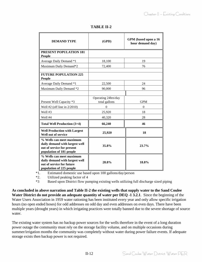
Future Population Water Demand: Utilizing accepted average water use data of 100 gallons per capita per day and the future population of 225 people concludes with an average day demand of 22,500 gallons per day. Water demand is diurnal in nature and a general demand day of 16 hours is applied concluding with an average demand of (22,500 gallons/demand day X demand day/16hours X hr/60minutes) = 24 gallons per minute. Utilizing DEQ published peaking factors for this present population (from DEQ 2) of 4 concludes with a peak demand day usage of 90,000 gallons per day. Utilizing the same demand day as above concludes with peak demand of (24 gallons per minute X 4peaking factor) = 96 gallons per minute. The average daily demand as concluded above for future population is estimated at 22,500 gpd (24gpm based upon a 16 hour demand day). The maximum daily demand was estimated (utilizing a peaking factor of 4) to be 90,000 gpd (96gpm based upon a 16 hour demand day). PER Montana DEQ Circular 1, the groundwater source capacity must equal or exceed the design maximum day demand with the largest well out of service. The existing public water supply source capacity cannot meet the maximum day demand for future population and in fact falls extremely short of this design requirement. The 2 existing producing wells can only provide a possible 66,240 gallon per day if all wells were to operate 24 hours per day, this falls short of the estimated maximum day demand (90,000gpd) of 23,760 gallons per day. With the largest well out of service (Well #4 produces the most yield at 28gpm), the remaining well (Well #3 producing 18gpm) can produce a maximum volume of 25,920 gallons per day (if the wells operated 24 hours per day). Therefore with the largest well out of service the existing remaining source capacity can only produce 28.8% of the required maximum day demand for the future population if operated 24 hours per day. Please Refer to Table II-2 for a synopsis of above narrated water demands and existing well production. Please note that the existing wells cannot produce adequate quantity of water for peak demands for neither the present or future population.
Chapter II – Existing Conditions
II-12 Sand Coulee Water District Water PER
TABLE II-2
DEMAND TYPE (GPD) GPM (based upon a 16 hour demand day)
PRESENT POPULATION 181 People Average Daily Demand *1 18,100 19 Maximum Daily Demand*2 72,400 76 FUTURE POPULATION 225 People Average Daily Demand *1 22,500 24 Maximum Daily Demand *2 90,000 96
Present Well Capacity *3 Operating 24hrs/day
total gallons GPM Well #2 (off line in 2/2010) 0 0 Well #3 25,920 18 Well #4 40,320 28
Total Well Production (3+4) 66,240 46
Well Production with Largest Well out of service 25,920 18
% Wells can meet maximum daily demand with largest well out of service for present population of 181 people
35.8% 23.7%
% Wells can meet maximum daily demand with largest well out of service for future population of 225 people
28.8% 18.8%
*1. Estimated domestic use based upon 100 gallons/day/person *2. Utilized peaking factor of 4 *3 Based upon District flow pumping existing wells utilizing full discharge sized piping
As concluded in above narration and Table II-2 the existing wells that supply water to the Sand Coulee Water District do not provide an adequate quantity of water per DEQ -1 3.2.1. Since the beginning of the Water Users Association in 1959 water rationing has been instituted every year and only allow specific irrigation hours (no open ended hoses) for odd addresses on odd day and even addresses on even days. There have been multiple years (drought years) in which irrigating practices were totally banned due to the severe shortage of source water. The existing water system has no backup power sources for the wells therefore in the event of a long duration power outage the community must rely on the storage facility volume, and on multiple occasions during summer/irrigation months the community was completely without water during power failure events. If adequate storage exists then backup power is not required.
Chapter II – Existing Conditions
II-13 Sand Coulee Water District Water PER
A Source Water Delineation and Assessment Report was produced in April 2000 for the Sand Coulee Public Water supply system. The report was developed to meet the technical requirements for the completion of the delineation and assessment report for Sand Coulee Water District as required by the Safe Drinking Water Act (SDWA). The Sand Coulee Water District Public Water Supply Source Water Protection Plan can be reviewed in Appendix I. In addition to this report all requirements for the new well #4 approval was submitted and approved these requirements include water rights, preliminary assessment report, well protection easement, yield and drawdown tests, well log completion, compliance reporting per provision DEQ-1, 3.2.5.2, and submission of as-built record drawings (please find documentation of this in Appendix I). Multiple significant deficiencies were noted on the most recent (2007) Sanitary Survey Inspection Report. These included; 1. Annually, the Sand Coulee PWS experiences coliform positive bacteriological samples. The source of the contamination hasn’t been identified, corrective actions were to submit bacteriological sample from the well #2 prior to bringing it back on line. 2. Unauthorized individuals have easy access to the top of the storage tank which can result in vandalism and the potential contamination of the source water. 3. Alteration of the PWS by changing the size of pumps or the configuration of the well casing, etc requires DEQ review and approval prior to the work being done. 4. The access hatch on the top of the tank is missing bolts. 5. The vents should have a rubber gasket around the opening to prevent the entry of dirt and insects. Typically, the District resolves all concerns noted in a sanitary survey immediately following an inspection. (Refer to Appendix J for the 2007 Sanitary Survey). Water Treatment No water treatment measures are presently performed or required by the District. Water is disinfected only when repair work or maintenance is done, and bleach is used as a disinfectant if bacteriological tests come back positive. Water Quality Requirements and Water Quality Since the Sand Coulee Water District water system is a community system, Montana regulations require it to monitor microbiological, chemical and radiological quality (please refer to Appendix F for sampling results). For microbiological quality testing, community water supplies must sample for total coliform bacteria on a monthly basis (at minimum – based on population), in accordance with the Total Coliform Rule. Coliform bacteria are not a disease producer, however, are often associated with disease-causing organisms which in turn makes it a good index of bacteriological safety of water. Based on population, Sand Coulee Water District WSD is only required to sample for total coliform once monthly. Chemical quality testing includes lead and copper (Lead and Copper Rule); nitrate + nitrite as nitrogen (Phase II Rule); and volatile organic chemicals and inorganic chemicals (Phase II & V). Sampling frequency of chemical quality of a community water system varies. Typically, radiological quality testing is required quarterly to every nine years for a community water system. For Sand Coulee, combined radium testing is required once every three years and for gross alpha particle activity, once every nine years. In Montana, radiological content testing includes combined radium-226 and radium-228 and gross alpha particle activity (including radium-226 and 228 but excluding radon and uranium).
Chapter II – Existing Conditions
II-14 Sand Coulee Water District Water PER
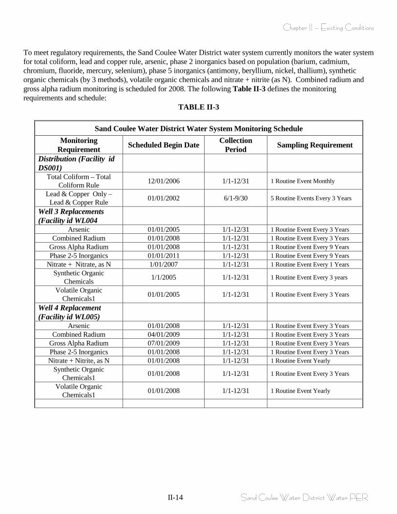
To meet regulatory requirements, the Sand Coulee Water District water system currently monitors the water system for total coliform, lead and copper rule, arsenic, phase 2 inorganics based on population (barium, cadmium, chromium, fluoride, mercury, selenium), phase 5 inorganics (antimony, beryllium, nickel, thallium), synthetic organic chemicals (by 3 methods), volatile organic chemicals and nitrate + nitrite (as N). Combined radium and gross alpha radium monitoring is scheduled for 2008. The following Table II-3 defines the monitoring requirements and schedule:
TABLE II-3
Sand Coulee Water District Water System Monitoring Schedule Monitoring
Requirement Scheduled Begin Date Collection Period Sampling Requirement
Distribution (Facility id DS001)
Total Coliform – Total Coliform Rule 12/01/2006 1/1-12/31 1 Routine Event Monthly
Lead & Copper Only – Lead & Copper Rule 01/01/2002 6/1-9/30 5 Routine Events Every 3 Years
Well 3 Replacements (Facility id WL004
Arsenic 01/01/2005 1/1-12/31 1 Routine Event Every 3 Years Combined Radium 01/01/2008 1/1-12/31 1 Routine Event Every 3 Years
Gross Alpha Radium 01/01/2008 1/1-12/31 1 Routine Event Every 9 Years Phase 2-5 Inorganics 01/01/2011 1/1-12/31 1 Routine Event Every 9 Years
Nitrate + Nitrate, as N 1/01/2007 1/1-12/31 1 Routine Event Every 1 Years Synthetic Organic
Chemicals 1/1/2005 1/1-12/31 1 Routine Event Every 3 years
Volatile Organic Chemicals1 01/01/2005 1/1-12/31 1 Routine Event Every 3 Years
Well 4 Replacement (Facility id WL005)
Arsenic 01/01/2008 1/1-12/31 1 Routine Event Every 3 Years Combined Radium 04/01/2009 1/1-12/31 1 Routine Event Every 3 Years
Gross Alpha Radium 07/01/2009 1/1-12/31 1 Routine Event Every 3 Years Phase 2-5 Inorganics 01/01/2008 1/1-12/31 1 Routine Event Every 3 Years Nitrate + Nitrite, as N 01/01/2008 1/1-12/31 1 Routine Event Yearly
Synthetic Organic Chemicals1 01/01/2008 1/1-12/31 1 Routine Event Every 3 Years
Volatile Organic Chemicals1 01/01/2008 1/1-12/31 1 Routine Event Yearly
Chapter II – Existing Conditions
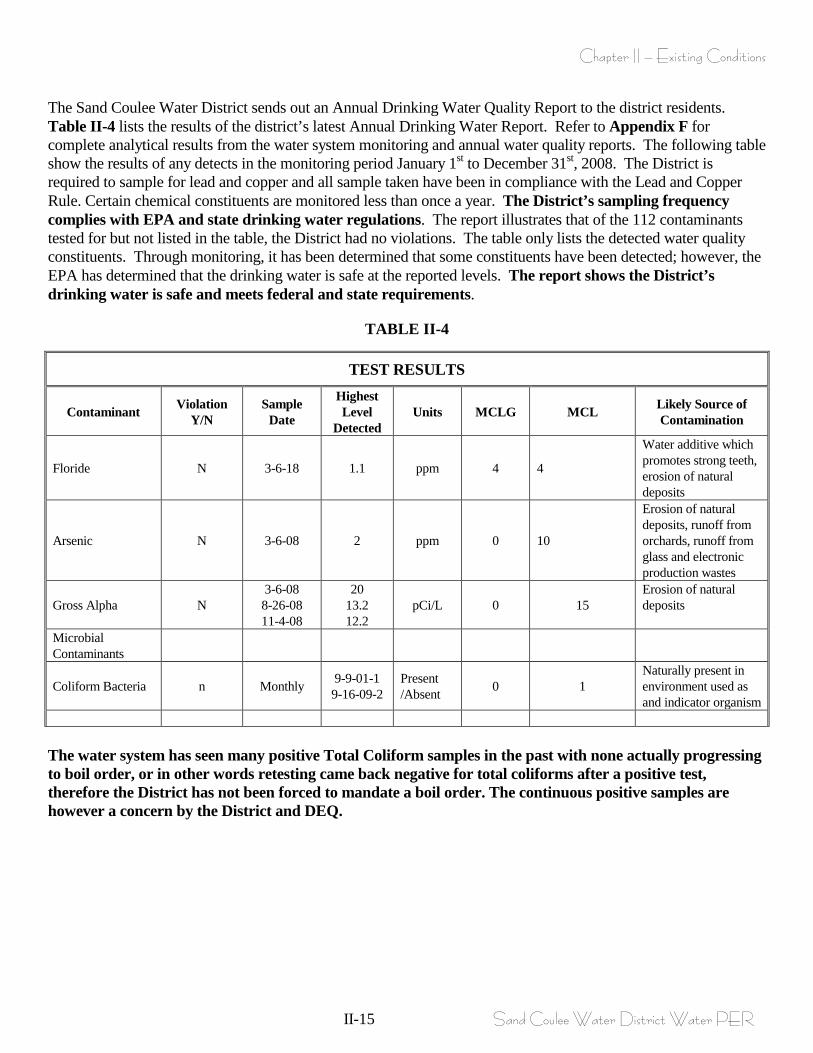
II-15 Sand Coulee Water District Water PER
The Sand Coulee Water District sends out an Annual Drinking Water Quality Report to the district residents. Table II-4 lists the results of the district’s latest Annual Drinking Water Report. Refer to Appendix F for complete analytical results from the water system monitoring and annual water quality reports. The following table show the results of any detects in the monitoring period January 1st to December 31st, 2008. The District is required to sample for lead and copper and all sample taken have been in compliance with the Lead and Copper Rule. Certain chemical constituents are monitored less than once a year. The District’s sampling frequency complies with EPA and state drinking water regulations. The report illustrates that of the 112 contaminants tested for but not listed in the table, the District had no violations. The table only lists the detected water quality constituents. Through monitoring, it has been determined that some constituents have been detected; however, the EPA has determined that the drinking water is safe at the reported levels. The report shows the District’s drinking water is safe and meets federal and state requirements.
TABLE II-4
TEST RESULTS
Contaminant Violation Y/N
Sample Date
Highest Level
Detected Units MCLG MCL Likely Source of
Contamination
Floride N 3-6-18 1.1 ppm 4 4
Water additive which promotes strong teeth, erosion of natural deposits
Arsenic N 3-6-08 2 ppm 0 10
Erosion of natural deposits, runoff from orchards, runoff from glass and electronic production wastes
Gross Alpha N 3-6-08 8-26-08 11-4-08
20 13.2 12.2
pCi/L 0 15 Erosion of natural deposits
Microbial Contaminants
Coliform Bacteria n Monthly 9-9-01-1 9-16-09-2
Present /Absent 0 1
Naturally present in environment used as and indicator organism
The water system has seen many positive Total Coliform samples in the past with none actually progressing to boil order, or in other words retesting came back negative for total coliforms after a positive test, therefore the District has not been forced to mandate a boil order. The continuous positive samples are however a concern by the District and DEQ.
Concrete Debris
Chapter II – Existing Conditions
II-16 Sand Coulee Water District Water PER
The District is working to remedy the current problem with total coliform positive samples by sealing or repairing all possible suspected points during warmer/better weather periods. The existing thin walled PVC main break history may be contributing to the total coliform positive samples exhibited by the water system. With main breaks, the water system risks potential contamination from outside sources. The existing distribution system (system wide) contains settled granular carbon as viewed during the March main break maintenance documentation (please refer to Appendix H and Figure II-5) and the deposited granular carbon (suspected to originate from initial installation and during each main break maintenance event) creates a media for harmful bacteria to survive and could be the continued source of the total coliform positive results. The distribution system has only a single fire hydrant and therefore only has a single flushing location, and while distribution flushing through the existing 4” hydrant is performed yearly it has not resulted in cleaning the distribution system to any thorough results. Future monitoring requirements for the system may be necessary once the final EPA Groundwater Rule is enforced. All information regarding the final Groundwater Rule was obtained from the EPA website. The Environmental Protection Agency (EPA) promulgated the final Ground Water Rule (GWR) in October 2006. The rules intent is to reduce the risk of exposure to fecal contamination that may be present in public water systems that utilize groundwater sources. The GWR applies to all groundwater sources. In the final requirements, the rule addresses risk through a risk-targeting approach that relies on four major components including periodic sanitary surveys, source water monitoring, corrective actions and compliance monitoring. According to the EPA rule summary, the periodic sanitary surveys of groundwater systems will require evaluation of eight (8) critical elements and the identification of significant deficiencies. An example of a significant deficiency would be if a well is located near a septic system. States are required to complete the initial survey by December 31, 2012 for most community water systems (CWSs) and by December 31, 2014 for CWSs with outstanding performance and for all non-community water systems. Source water monitoring will test for the presence of E.coli, enterococci, or coliphage in the water sample. For the source water monitoring there are two monitoring provisions, triggered monitoring and assessment monitoring. The triggered monitoring is for systems that do not already provide treatment that achieves at least 99.99% (4-log) inactivation or removal of viruses and that have a total coliform-positive routine sample under Total Coliform Rule sampling in the distribution system. Assessment monitoring gives the state the option to require systems, at any time, to conduct source water assessment monitoring to identify high risk systems. Corrective action will be required for any system with a significant deficiency or source water fecal contamination. There are currently four (4) corrective action options including: correct all significant deficiencies; eliminate the source of contamination; provide an alternate source of water; or provide treatment which reliable achieves 99.99% inactivation or removal of viruses. The rule also requires compliance monitoring to ensure that treatment technology installed reliably achieves at least 99.99% inactivation or removal of viruses. The District has been having many positive total coliform samples (with follow-up sampling showing ecoli absent results). Because of the total coliform positive samples the District will be under scrutiny by MDEQ regarding the Groundwater Rule (GWR) in the future. Therefore, implementation of the GWR could very likely require full-time chlorination, additional testing and possibly equipment purchase, specifically if the present water supply (Kootenai Formation) is continued to be utilized. If the water source is altered to the Madison Formation the GWR may not apply, but the District will be subject to proving that this water source is of excellent quality. In order to meet adequate contact time for the water system well sources, well head chlorine tablet dispensers or hypochlorination storage tanks provided at the well sources may be a consideration if the Groundwater Disinfection Groundwater Rule is implemented by DEQ for Sand Coulee. The anticipation of changing the groundwater source to the Madison Formation may preclude the implementation of the Disinfection Groundwater Rule for Sand Coulee. The District should be aware of the additional requirements that they may be required to meet in the future and plan for additional O&M costs accordingly.
Chapter II – Existing Conditions
II-17 Sand Coulee Water District Water PER
Water Storage & Distribution The District presently relies on a single 100,000 gallon bolted steel storage facility that was installed in 1960. The total usable storage is approximately 100,000 gallons. The tank is located (please refer to Figure II-3 and II-4) up on a constructed bench area towards the southern end of the District at a base elevation of approximately USGS elevation of 3610’. The storage facility sits down-gradient of the existing wells which are sited on top of the bench, and west of the tank at USGS approximate elevation of 3,700’. The existing wells discharge piping ties into a single common header of size 4” that feeds the storage facility. This common header is buried piping to approximately 30’-50’ from the near edge of the storage facility when it daylights horizontally to the top of the storage tank. The existing storage influent piping from the wells is supported with stacked railroad ties, and a metal cat walk support structure, and enters/penetrates the tank through the roof near the center of the tank. The influent piping is wrapped with insulation that generally keeps it from freezing. All source water from the wells enters the storage tank facility prior to entering the distribution system. There are no existing well head meters or influent metering devices therefore accounting for water entering the storage facility is impossible. Due to costs, tank maintenance has been historically performed only when necessary. To alleviate concerns with the storage facility and to define the condition of the tank the District had the tank evaluated/inspected in 2002, (please refer to Appendix K for this report). The general finding of this inspection indicated moderate internal corrosion below the waterline on the shell plate sections, and heavy sediment buildup. This report recommended that the tank be cleaned and interior painting within a 12-24 month period from the date of the report (this was not done due to cost restraints). This report also identified corrosion on ladders, inlet piping, and railings. This report indicated that there was evidence of a leak on the west side of the tank, at the bottom section where the shell plate and tank floor join. In the latest sanitary survey on file (2007), significant deficiencies and corrective actions were noted for the storage tank area, the following list these specific to the storage structure, Please refer to Appendix J for documentation. 1. Unauthorized individuals have easy access to the top of the storage tank which can result in vandalism and the potential contamination of the source water. The side ladder should have a locked plate placed over the lower portion of the ladder the access from the side hill should be restricted, security fencing would provide a deterrent and limit access to the tank. 2. The access hatch on the top of the tank is missing bolts; these holes should be caulked shut to prevent insects, dirt and precipitation from entering the tank. The vents should have a rubber gasket around the opening to prevent the entry of dirt and insects. District personnel accomplished some of the tasks within their budget, but have not erected security fencing. Due to concerns with the existing tank facility specific to a visual leak and to determine the integrity of the facility the District had the tank re-evaluated in March of 2010. As part of the tank evaluation scope of work the contracted entity also made determinations as to the viability of increasing tank volumes by adding plates to increase the height. The finding of the re-evaluations can be found in Appendix K. As documented in Appendix K, the original tank manufacturer indicates that the existing tank can be increased in storage up to 143,000 gallons with the installation of bottom shell plates. Expanding the tank involves jacking the existing tank up, placing bottom shell plates, reconnection to floor and testing and placing tank back in service.
Chapter II – Existing Conditions
II-18 Sand Coulee Water District Water PER
The findings from this recent evaluation indicate that the existing tank does have a leak in the lower portion of the tank probably at the lowest shell seam connection to the floor. The tank is displaying heavy corrosion on the vast majority of the tank shell below the water line, although the roof structure appears to be in relatively good condition. The storage facility does not sit on a concrete foundation and appears to be sitting on compacted sand and gravels. The thickness of specific portions of the tank plates including the bottom, middle and top shell are all 1/8” material which precludes adding onto/or increasing the tank height without either removing these section and installing heavier gauge (thickness) materials or jacking up the entire tank and adding new lower shell plates. Per the tank evaluation report the tank is in need of sandblasting, recoating and resealing multiple bolted seams, in order to keep it in functioning order. Obviously these procedures can only be done once the tank is decanted and off-line. If the existing tank is taken off-line to expand storage volume piping modifications from the wells directly to distribution must be accomplished to supply the District with water while the tank is rehabilitated. The operation of the storage facility relies on two sets of wet/dry probes. These probes basically hang from the roof structure, and when the water level is high in the tanks and the probes are submerged/wet they de-activate the well pump or pumps that they are connected to. One set of probes is tied to Well #4, while the other set of probes is tied to well #3. The first set of probes hangs approximately 3’ from top of the tank, and therefore actuate Well #4 when water drops below this level in the tank. If the capacity of well #4 exceeds the demand being withdrawn from the tanks the probes will de-activate this well when the water level at 3’ below the roof is achieved. If well #4 cannot keep up with demand and water level continues to drop to 5’ below the roof elevation then well #3 is activated. The wells will deactivate in this same order as water level rises in the tank. For further discussion of the control system, refer to the Other Infrastructure Section of this Chapter. Above-ground piping from the wells is wrapped with insulation, but on occasion does freeze. As previously mentioned, the existing useable storage capacity is approximately 100,000 gallons. The two existing wells can presently provide a possible 46 gpm (or 66,240 gallons per day) to the system. This existing well capacity is based upon recent flowing of the wells as performed by the District and earlier narrated (well #3 – 18gpm, and well #4 – 28gpm). The following simplistic water balance on the system illustrates the inadequacy of the existing storage capacity to meet average and maximum daily domestic demands. From Table II-2, the maximum daily demand for the present population is 72,400 gallons per day and the maximum daily demand for the future design population is 90,000 gallon per day. Therefore: Water in from wells– Water out at maximum day demands = Present Population of 181 people: 66,240 gallons/day – 72,400 gallons/day = <-6,160> gallons/day deficit Future Population of 225 people: 66,240 gallon/day – 90,000 gallons/day = <-23,760> gallons/day deficit Assuming a full tank situation for a peak day the existing storage capacity is adequate, but obviously the well sources cannot meet this demand. While the existing storage capacity on its own (not considering source water capacity) supplies adequate storage for peak domestic daily demands the capacity must also meet fire suppression measures. Utilizing published fireflow requirement from the Department of Justice/Fire Marshal Bureau along with the requirements for residential areas of lot size 100’ or less with separation between residences of 20’ concludes with a fire flow requirement of 750 gpm for a period of 2 hours (please refer to Appendix L for documentation). Circular DEQ-1 Section 7.0.1 states that the minimum allowable storage must be equal to the average daily demand for a 24-hour period plus fire flow demand where fire protection is provided.
Chapter II – Existing Conditions
II-19 Sand Coulee Water District Water PER
A storage facility should supply adequate volumes of water to supply at least demands for a maximum day plus fire flow plus reserve or emergency storage. A conservative value for the emergency storage is two days of average daily demands. The actual volume of storage can be reduced by the amount of sustained yield supplied from the water sources. Based upon the present population, well capacity and storage volume and referring to Table II-2, the design average daily demand and maximum daily demand is 18,100 gpd and 72,400 gpd, respectively. The total water storage capacity required for fire flow (750 gpm for 2 hrs) is 90,000 gallons. The existing wells can provide a possible 66,240 gpd. Therefore the total storage requirement to supply a Peak daily demand of 72,400 gallons, plus two days of average daily demand (18,100 X 2) of 36,200 gallons plus fire flow of 90,000 minus sustained capacity from existing wells of 66,240 gallons equates to a storage requirement of ( 72,400 + 36,200 + 90,000 – 66,240) 132,236 gallons. The present storage facility supplies 100,000 gallons therefore falls short of supplying adequate storage by 32,360 gallons per day based upon existing conditions. Additional storage is required, not only for present population but for design population of 225 people. Based upon the future population of 225 people, and the existing well capacity and storage volume and referring to Table II-2, the design average daily demand and maximum daily demand is 22,500 gpd and 90,000 gpd, respectively. The total water storage capacity required for fire flow (750 gpm for 2 hrs) is 90,000 gallons. The existing wells can provide a possible 66,240 gpd. Therefore the total storage requirement (for future/design population) to supply a Peak daily demand of 90,000 gallons, plus two days of average daily demand (22,500 X 2) of 45,000 gallons plus fire flow of 90,000 minus sustained capacity from existing wells of 66,240 gallons equates to a storage requirement of (90,000 + 45,000 + 90,000 – 66,240) 158,760 gallons. The present storage facility supplies 100,000 gallons therefore falls short of supplying adequate storage (for future population with existing well capacity) by 58,760 gallons. The parameter in this equation that affects storage requirements is the sustained capacity of the wells, assuming that a new water source is utilized that supplies peak demands with the largest well out of service concludes with the following storage sizing. Adhering to DEQ -1, Supplying the District with an adequate water source capable of delivering maximum daily demand of 90,000 gallons (with largest well out of service) alters the storage requirements and the following applies. The total storage requirement (for future/design population) to supply a Peak daily demand of 90,000 gallons, plus two days of average daily demand (22,500 X 2) of 45,000 gallons plus fire flow of 90,000 minus sustained capacity per DEQ-1 of 90,000 gallons equates to a storage requirement of ( 90,000 + 45,000 + 90,000 – 90,000) 135,000 gallons. This value for storage volume required will be utilized in all subsequent evaluations. The water distribution system consists of a 6” Transite piping, 6” PVC (installed in 1987 and funded by Abandoned Mines/DEQ) and 4” thin walled solvent weld, iron pipe sized piping. The 4” piping has a history of failing. Services are typically ¾” which range in material from copper, galvanized, and poly piping. The homeowner’s bylaws indicate the service lines from the curb stop to the residence are the responsibility of the individual property owner. The District water system currently does not include water meters.
Chapter II – Existing Conditions
II-20 Sand Coulee Water District Water PER
The existing water system had only one fire hydrant, DEQ -1 requires hydrant spacing at each street intersection and at intermediate points between intersections and must be provided as recommended by the fire protection agency, who recommends a 500 foot hydrant spacing. Per DEQ-1 (8.4.3), hydrant leads must be a minimum of 6-inches. Therefore, the existing water system does not supply adequate number of fire hydrants nor adequate size of fire hydrants. No known pressure problems exist throughout the District. Due to the gravity nature of the primary sources and elevated level of the storage tanks, the pressure near the middle of the community is approximately 69psi indicating that he elevation of the existing tank is adequate to deliver adequate pressures to users. The District has performed a recent leak detection survey in order to determine present loss of water from the distribution system. The results of this survey indicated that the existing system is not leaking to any great extent (please reference Appendix M for a summary of recent leak detection report completed February 26/2010). Historically the main breaks are reported in the 4” thin-walled water main, the oldest pipe within the water system. As coincidence would have it shortly after the leak detection analysis was completed two main breaks occurred (March 1/2010) on the 4” thin walled piping. The existing 4” piping has no pressure rating, is non AWWA/NSF approved water piping, and was installed pre 1959. An interview with a local (old timer) that was onsite during the repair maintenance regaled that the 4” piping was the most inexpensive piping that could be purchased at the time after all those using the water system passed around the collection hat. This old piping fails in a consistent manner whereby when a break occurs the piping splits from glued coupling to coupling generally in a straight line. Please refer to Appendix H, and Figure II-5 for a brief memorandum, and graphical repair presentation of the main breaks and photographs of the breaks. As indicated in the memorandum and the pictures the existing 4” piping had accumulated granular coal/coal slack, and as reported by District personnel this condition is true for the entire distribution piping. There are no present means of flushing the distribution system to remove settled deposits of coal/coal slack. The actual source of the settled granular coal within the distribution system is unknown, what is known is that it is not uncommon for the coal deposits to plug service connections or come through your tap into your drinking glass. Many residences have been forced to install filters within their homes to remove suspended granular coal/coal slack. The coal mined in Sand Coulee is considered “high pyritic” coal meaning that it contains a large percentage of iron compounds. These compounds when mixed with water cause mine waste drainage (known and documented by DEQ and others in Sand Coulee and outlying areas where past coal mining operations existed) when the iron is leached from the coal, which in turn depresses the PH forming acidic, rusty water. The accumulated granular coal within the Distribution system can potentially lead to harmful health concerns that mirror health concerns with acid mine drainage waters do if consumed. Per Montana DEQ Circular 1, 2006 Edition, the minimum size of water main providing fire protection and serving fire hydrants must be six-inch diameter. Any departure from minimum requirements must be justified by hydraulic analysis and future water use, and can be considered only in special circumstances. The majority of the existing distribution system not does meet this requirement. As previously mentioned, no pressure problems are reported with the system. A concise hydraulic analysis was run on the existing distribution system utilizing EPANET, involving a single fire flow demand of 1000 gpm at the north end of the District. Conclusions of this analysis (please refer to Appendix S) show that all junction nodes on the 4” water main display negative pressures under this fireflow event. While the results are theoretical (showing negative pressures far in excess of what the piping could withstand) the results clearly show that the 4” main will go into a negative pressure situation if such a demand were to be placed at the shown location. This type of demand, it ever placed on the existing 4” distribution main, would essentially collapse the existing main piping.
Chapter II – Existing Conditions
II-21 Sand Coulee Water District Water PER
Other Infrastructure - Controls The District has reported that the existing control system requires frequent and expensive repair. The existing control system does not protect against adjacent lightning strikes, brown-outs, or reset when loss of electric power occurs. During adjacent lightning strikes and brown-outs or loss of power the control system historically will simply not operate and an electrician must be scheduled for repairs, and during these events the control system has to be manually operated. Manual operation consists of measuring the depth of water in the tank (with a long stick through the top hatch) then activating the pumps until full level is achieved. This type of manual operation can lead to contaminants entering the storage facility, and requires availability of at least two operators (one to measure water depth in the tank and the other to activate/de-activate pumps). The control system includes electrode level controls that hang down into the water column inside the tank located toward the middle of the existing storage facility. The control panels from electrodes and for pumps are located in pump house building for well #2 (also controls well #4), and #3 (please refer to photographs of these building on Figure II-4) building. Underground shielded control cable run from the well houses to the probes in the tank. When the tank level lowers beyond the set point wells are actuated until water levels submerses the probes at which time the pumps are de-activated. The well pumps are not automatically alternated and are set up so that the largest producing well/pump (well #4) is the primary well and when demand exceeds the capacity of this well and water level in the tanks continues to drop then well #3 will activate. This pump activation set up based upon the wet/dry level control probes creates a situation in which the largest pump operates all low demand season with well #3 only operating rarely during winter season. During irrigation demand Well #4 will pump almost non stop along with well #3. This pump operation is deviant of DEQ-1 design guidelines, in which each well should be capable of delivering average day demands and maximum day demands, whereby the wells/pumps would be able to cycle between several pumps so that no single pump would continue to run and wear out quicker than any other pump. The pump controls do not supply any type of remote access or alarm system. The present system has visual lights mounted on the pump houses that indicate when the pumps are operating (light is on) but in the event of an alarm (such as overheated pump, low water level in either tanks or wells, over-amperage/voltage draws for individual pumps etc) there are no means of sending an alarm signal to an operator. Per DEQ-1 Section 6.5 “All automatic stations must be provided with automatic signaling apparatus which will report when the station is out of service. All remote controlled stations must be electrically operated and controlled and must have signaling apparatus of proven performance. Installation of electrical equipment must conform with the applicable state and local electrical codes and the NEC”. The existing pump houses do not supply signaling apparatus other than a light when the pumps are operating. Therefore the existing control system will require replacement. The electrodes utilized to monitor water level in the storage facility are also a challenge when ice forms and moves. During the winter months the top of the water freezes and forms an ice cake, which traps the wet/dry probes in the cake. When the ice cake moves downward (with the level of the water) it tears these probes away from the top harness making them useless for water level control until the ice cake melts and they can be re-mounted. A less maintenance intensive water level control system would be warranted with the Sand Coulee water system based upon pressure transducer technology that penetrates the side and bottom of the tank to alleviate surface ice cake issues. Concerns were noted in the most recent sanitary survey. Refer to Section C of this Chapter for additional information regarding the sanitary survey. Due to the maintenance and cost of replacement parts for the existing control system, the existing controls system requires replacement upgrades.
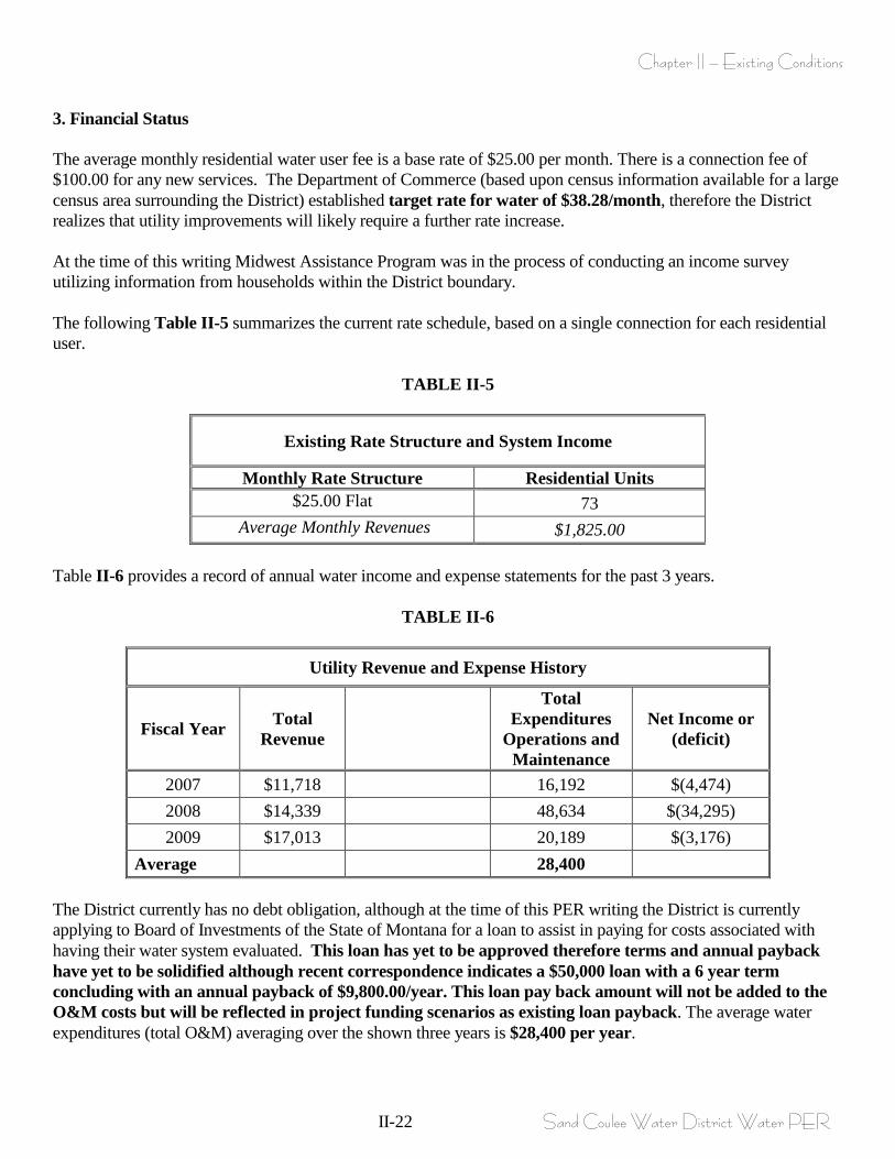
Chapter II – Existing Conditions
II-22 Sand Coulee Water District Water PER
3. Financial Status The average monthly residential water user fee is a base rate of $25.00 per month. There is a connection fee of $100.00 for any new services. The Department of Commerce (based upon census information available for a large census area surrounding the District) established target rate for water of $38.28/month, therefore the District realizes that utility improvements will likely require a further rate increase. At the time of this writing Midwest Assistance Program was in the process of conducting an income survey utilizing information from households within the District boundary. The following Table II-5 summarizes the current rate schedule, based on a single connection for each residential user.
TABLE II-5
Existing Rate Structure and System Income
Monthly Rate Structure Residential Units $25.00 Flat 73
Average Monthly Revenues $1,825.00 Table II-6 provides a record of annual water income and expense statements for the past 3 years.
TABLE II-6
Utility Revenue and Expense History
Fiscal Year Total Revenue
Total Expenditures
Operations and Maintenance
Net Income or (deficit)
2007 $11,718 16,192 $(4,474) 2008 $14,339 48,634 $(34,295) 2009 $17,013 20,189 $(3,176)
Average 28,400 The District currently has no debt obligation, although at the time of this PER writing the District is currently applying to Board of Investments of the State of Montana for a loan to assist in paying for costs associated with having their water system evaluated. This loan has yet to be approved therefore terms and annual payback have yet to be solidified although recent correspondence indicates a $50,000 loan with a 6 year term concluding with an annual payback of $9,800.00/year. This loan pay back amount will not be added to the O&M costs but will be reflected in project funding scenarios as existing loan payback. The average water expenditures (total O&M) averaging over the shown three years is $28,400 per year.
Chapter II – Existing Conditions
II-23 Sand Coulee Water District Water PER
C. NEED FOR WATER PROJECT AND PROBLEMS TO BE SOLVED 1. Health and Safety The existing Sand Coulee water system is woefully inadequate in every aspect, from inadequate source water capacity, inadequate storage that presently leaks, incapability of delivering fireflows, undersized mains that lack adequate fire-hydrants, and valving, mains that consist of thin walled, non NSF approved piping with breakage history that are partially filled with coal/coal slag. All these existing problems have associated health and safety concerns. Source Water Capacity: The present water sources consisting of two wells cannot supply adequate source water for present population at average daily demand. All of the historical wells and present groundwater wells have experienced continual decrease in water capacity experienced within brief periods of time (within one or two years, please refer to Figure II-5 specific occurrences when wells were “air blasted” in attempts to clean the aquifer bearing formation). At the beginning of the writing of this PER the District was relying on three wells, in late February of 2010, one of the wells was taken off-line because this well could no longer produce water capacity for any extended period of time. All of the wells are drilled into the Kootenai Formation, and as documented by the Source Water Delineation and Assessment Report (please refer to Appendix I), this formation experiences partial dewatering due to nearby historical mine workings. The historical wells and present wells experience decreased water source capacity not only from dewatering but also from encrustation, or bio-fouling of the underground aquifer. There have been multiple attempts to hydro-clean the water bearing well section, and these attempts have temporarily increased well capacity but only for brief periods of time (please refer to Figure II-5 for well cleaning events). In 2008 the existing wells were incapable of supplying adequate quantity of potable water for the users and emergency water hauling was necessary until a new well (well #4) was drilled and placed into production. Historically every year the District is forced to ration water specifically for irrigation season allowing strict irrigation hours every other day. The inability of the existing water system to deliver even average daily flows is a health concern and is deviant of DEQ-1 standards for source water capacity. Fire Flows, Storage, and Distribution System: In addition to inadequate source water capacity, the existing storage and distribution system cannot meet the required 750 gpm (for 2 hours) fire flow. The existing storage is inadequate in size, and a large portion of the existing mains are undersized, and there is only a single fire-hydrant, these are serious health and safety concerns. Therefore, storage and main up-sizing and installation of additional fire hydrants are necessary. Further, the District’s fire hydrant spacing does not meet the Fire Marshall recommendations of 500 feet between each hydrant. All main improvements should meet this requirement. The single fire hydrant does not meet DEQ-1 requirements (6-inch leads). Therefore, all new hydrants should have 6-inch leads. The existing entire distribution system contains settled granular coal/coal slag (refer to Figure II-5 for pictures of a recent man break) that continues to plug service lines or find its way into drinking water, many residents rely on filters to remove this material. The origin of the existing coal/coal slag in the distribution system is not known. This existence of the material has multiple health concerns, and can become a media for bacteria growth (and is suspected as the present source of the total coliform positive samples), and can produce acid mine constituents. The coal in the area is a high pyritic coal, meaning it contains a large percentage of iron constituents (compared with coal from other parts of the US), and this iron leaches out when combined with water which in turn depresses the pH forming acidic and rusty water.
Chapter II – Existing Conditions
II-24 Sand Coulee Water District Water PER
Source Water Quality: The existing quality of water from the present well sourced is of adequate quality and, as stated earlier, is safe and meets Federal and State requirements, although it is considered to be very hard water and causes hard water deposits along with rusty deposits on plumbing fixtures. The system however has witnessed multiple Total Coliform hits in the past (approximately 20 since 1995), and while attempting to define exactly where the source of these comes from have not been able to identify the actual source. None of these initial total coliform samples have lead to a boil order, but do indicate a health and safety concern with the water system. The District’s drinking water is safe and meets federal and state requirements (per 2006 Water Quality Report). Through monitoring, it has been determined that some constituents have been detected; however, the EPA has determined that the drinking water is safe at the reported levels. The District’s latest annual water report indicated that the water system was in compliance with testing required of a community water system under the Safe Drinking Water Act. The most recent sanitary survey on the District water system was completed in April 2007. Multiple significant sanitary deficiencies were noted during the inspection. Reference Appendix J to review the sanitary survey. The deficiencies and corrective actions noted during the survey are summarized in the following specific to the existing storage structure: 1. Unauthorized individuals have easy access to the top of the storage tank which can result in vandalism and the potential contamination of the source water. The side ladder should have a locked plate placed over the lower portion of the ladder the access from the side hill should be restricted, security fencing would provide a deterrent and limit access to the tank. 2. The access hatch on the top of the tank is missing bolts; these holes should be caulked shut to prevent insects, dirt and precipitation from entering the tank. The vents should have a rubber gasket around the opening to prevent the entry of dirt and insects. 3. Annually, the Sand Coulee PWS experiences coliform positive bacteriological samples. The source of the contaminations hasn’t been identified. Multiple corrective actions specific to well #2 are listed Sanitary Survey, please refer to Appendix J. 4. Alteration of the PWS by changing the size of pumps or the configuration of the well casing, etc. requires DEQ review and approval prior to the work being done. 2. System O&M The original distribution system was installed pre 1959 (with the exception of the 6” PVC main that was installed in 1987 and funded by DEQ/Abandoned Mines), while the tank was erected in 1960. Operation and maintenance related issues with the system are due to age and original material selection of the system with deterioration/corrosion over time. The existing 4” thin walled water main piping is viewed as beyond its functional life, and is non pressure rated, non AWWA/NSF approved piping that was simply originally installed because it was economical at the time. Maintenance issues related to the water distribution system typically involve main breaks in the portions of existing 4” thin walled piping. Recent breaks and maintenance indicated that this piping is also partially filled with coal/coal slag deposits (please refer to Appendix H and Figure II-5). The original thin walled piping needs to be replaced to relieve the burden of increasing maintenance costs (as well as health and safety concerns with the deposited coal/coal slag). Inclusive of the distribution system are the lack of adequate hydrants and valving. The distribution undersized (4”) portion of the distribution system requires replacement with adequately spaced valves and hydrants.
Chapter II – Existing Conditions
II-25 Sand Coulee Water District Water PER
The existing control system requires frequent and expensive repair. Therefore, anytime maintenance is required on the control system (usually after a power outage, brownout, or lightning strike), it is time consuming, expensive and the existing wells and tank must be manually operated until the control system becomes functional. In addition, since the control system is not a standard system, electricians spend additional time trouble-shooting problems which is costly. As previously mentioned, the electrodes utilized to monitor water storage volume can also be maintenance intensive during the winter. Therefore, the existing controls system requires upgrades. Decreasing well yields has lead to increased costs borne by the District, and has historically involved paying a well driller to remove existing pump and discharge piping and proceeding with Hydro-Cleaning of the water bearing aquifer materials. This procedure does increase well production but only for brief periods of time (please refer to Figure II-5 specific to the notes by the existing well indicating when these procedures have been performed). The District does not currently disinfect the water source. However, given the total coliform positive sampling trends, the water system will be under scrutiny by MDEQ after the implementation of the Groundwater Rule (GWR) in the future. There is a strong likelihood that the District may be required to provide full-time chlorination unless the sampling/testing program initiated with Midwest Assistance Program (MAP) makes disinfection unnecessary, or if the District utilizes new source water. Consideration of treatment system improvements is recommended. Additional sampling may also be required to meet the requirements of the GWR. The following is a summary of water system deficiencies/problems identified within this Chapter:
• Existing groundwater sources cannot supply adequate quantities of water for present average day demand let alone DEQ peak day demands for future population projections.
• Existing storage facility cannot supply fire flows which is a serious health and safety concern. • Existing water main system is mostly undersized, cannot deliver fireflows, has inadequate
valving, and only contains a single fire hydrant, all of which are serious health and safety concerns.
• The existing 4” thin walled water main is experiencing main break problems and is beyond its useful life, and is non AWWA/NSF approved water piping, is partially filled with coal/coal slag, and requires replacement. Deteriorated thin wall water main creates a serious health and safety concern and the coal/coal slag deposits create an environment that coliform bacteria can thrive in and is expected to be a source of the many total coliform positive samples.
• The single existing 4-inch hydrants require replacement (does not meet DEQ-1 guidelines specific to sizing).
• Maintenance intensive control system requires replacement. Numerous costly repairs are made on the control system yearly.
• Security improvements such as fencing and locks around wells and storage tanks are recommended.
• Storage facility requires expansion/replacement, and presently does not supply adequate storage to meet DEQ-1 design standards.
• Due to the total coliform positive testing trend, the District water system will be under scrutiny as the GWR comes into affect in the near future. Treatment system improvements may be required to meet the requirements of the GWR. Auxiliary power should be a consideration with this work.
Chapter II – Existing Conditions
II-26 Sand Coulee Water District Water PER
• Existing water system does not include well head meter or water service meters. Future water source, pump house facilities, storage facilities and distribution system operation and maintenance would be considered routine. O&M for these facilities include repair to pumping units, potential chemical disinfection operation, water quality monitoring, and tank inspection, cleaning and maintenance. The District staff shall need to stay apprised of the water quality testing and equipment requirements and plan accordingly in the O&M budget to provide the State with all mandatory information. 3. Growth The District’s design population is estimated to be 225 at the end of the 22-year planning period (allowing for a 20 year design life plus two years for financing and design). The projected population is 44 persons greater than the current population. At 2.48 persons per household, this equates to a 1% growth projection per projection period of 22 years. This growth projection has been discussed with the District Board, and they agree with these growth conclusions and have signed a memo indicating their agreement (please refer to Appendix G for documentation of this). As previously discussed, additional or alternative water sources are required to meet water demands. Additional/rehabilitated adequately sized storage is required, and the existing thin walled plastic water main requires replacement inclusive of adequately spaced valves and fire hydrants in order to continue to provide safe and adequate water service to the District residents. The maintenance intensive control system is in need of upgrades to provide consistent water service to the design population. Several security improvements were recommended in the latest sanitary survey inspection specific to security fencing the well heads and storage facility. Water treatment per the groundwater disinfection rule may affect the public water system and therefore disinfection facilities should be planned for. 4. Unresolved Problems All problems identified with the existing water system will be identified in the coming chapters, however, final project costs and available funding will determine the scope final project. All concerns with the water system will be addressed if the entire project is financially feasible. Water system improvements must first focus on, obtaining adequate source water, adequate storage and replacement of existing thin walled plastic water main with adequate spaced fire hydrants and valves, and control system upgrades. All deficiencies not completed during this funding cycle will be pursued in the future through the aid of grant/loan programs. D. WATER SYSTEM DESIGN REQUIREMENTS 1. Design Standards for Water Facilities In general, the selected water system improvements (groundwater source, storage, distribution, fire hydrants, control system, water meters and security improvements) will adhere to MDEQ Guidelines as defined in Circular DEQ-1, Standard for Water Works, 2006 Edition. The recommended alternative will alleviate health and safety issues, reduce environmental impacts, improve maintenance efforts, and adhere to design and regulatory requirements. Final project design will again meet Circular DEQ-1 guidelines as well as Montana Public Works Standard Specifications and generally accepted engineering principles.
Chapter II – Existing Conditions
II-27 Sand Coulee Water District Water PER
Regulatory Requirements and Permits All applicable regulatory requirements shall be met and permits obtained during the design phase of improvements. Source of Water Supply (quantity/quality/reliability/water rights) The well sources that supply water to the District do not provide an adequate quantity of water for present population of the District and cannot obviously supply adequate quantity of water for the design year population. The present well sources do however provide adequate quality of water. The two wells can presently provide a possible 66,240 gpd. This estimated flow is based on recently conducted yields of 18 gpm (Well #3), and 28 gpm (from Well #4). Reference Appendix B for water rights documentation. Per DEQ-1 3.2.1.1 Source capacity; “The total developed groundwater source capacity for systems utilizing gravity storage, unless otherwise specified by MDEQ must equal or exceed the design maximum day demand with the largest producing well out of service”. As reported earlier the two existing well produce a maximum of 66,240 gallons per day, based upon both wells operating 24 hours a day. With the largest well out of service (Well #4 at 28gpm) leaves total production of 25,920 gallons per day. As shown earlier the Average daily Demand for the present population is 18,100 gallons per day, while the maximum day demand is 72,400 gallons per day. Therefore with the largest well out of service the existing groundwater well source (Well #3), can provide adequate water for average daily demand but can only provide approximately 36% of the needed capacity for present maximum day demand. With a projected future population of 225 people the future average daily demand is estimated to be 22,500 gallons per day while the maximum day demand for the future population is 90,000 gallons per day. Again with the largest well out of service the existing well source (Well #3) can supply adequate future average day demand but only 29% of the future maximum day demands. This is summarized in the earlier Table II-2, and Table II-7. . Source Water Protection As previously mentioned, a Source Water Delineation and Assessment Report was developed for the existing public water supply wells (please refer to Appendix I). This Appendix also contains design report and assessment documentation for the 2008 well. The report was developed to meet the technical requirements for the completion of the delineation and assessment report for Sand Coulee Water District as required by the Montana Source Water Protection Program (DEQ 1999) and the federal Safe Drinking Water Act (SDWA). The report was prepared in 2000. The well sources were concluded to have moderate susceptibility specific to herbicides, and nitrates and pathogens with the sources of these from cultivation and spray irrigation of animal wastes respectively. No further updates are required for this document unless the land use surrounding the sources drastically changes. Water Use/demand data (average day, maximum day, instantaneous maximum day, fire flow) Based upon the previously described present population, estimated planning year populations, water demand data is as follows:
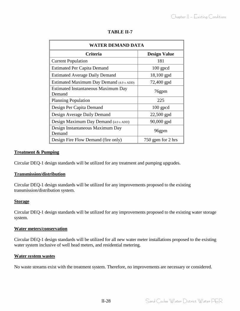
Chapter II – Existing Conditions
II-28 Sand Coulee Water District Water PER
TABLE II-7
WATER DEMAND DATA
Criteria Design Value Current Population 181 Estimated Per Capita Demand 100 gpcd Estimated Average Daily Demand 18,100 gpd Estimated Maximum Day Demand (4.0 x ADD) 72,400 gpd Estimated Instantaneous Maximum Day Demand 76gpm
Planning Population 225 Design Per Capita Demand 100 gpcd Design Average Daily Demand 22,500 gpd Design Maximum Day Demand (4.0 x ADD) 90,000 gpd Design Instantaneous Maximum Day Demand 96gpm
Design Fire Flow Demand (fire only) 750 gpm for 2 hrs Treatment & Pumping Circular DEQ-1 design standards will be utilized for any treatment and pumping upgrades. Transmission/distribution Circular DEQ-1 design standards will be utilized for any improvements proposed to the existing transmission/distribution system. Storage Circular DEQ-1 design standards will be utilized for any improvements proposed to the existing water storage system. Water meters/conservation Circular DEQ-1 design standards will be utilized for all new water meter installations proposed to the existing water system inclusive of well head meters, and residential metering. Water system wastes No waste streams exist with the treatment system. Therefore, no improvements are necessary or considered.
Chapter III – Alternative Screening
III- 1 Sand Coulee Water District Water PER
CHAPTER III
ALTERNATIVE SCREENING A. GENERAL Problem areas/deficiencies within the Sand Coulee water system were identified in the previous Chapter. These issues vary in degree of importance and immediate need. For the purpose of correcting water system problems faced by the community, the following alternative screening process was developed in order to identify viable possible solutions. To eliminate project alternatives that are either not practical or not critical at this time, the following screening will briefly address each. As previously described, the existing water sources cannot provide adequate capacity of water to meet current or future needs, the existing storage facility is undersized and cannot meet future storage requirements for fire-flows, the majority of the existing water main system is undersized, has inadequate fire hydrants, and valving and cannot deliver fire flows, and the existing pump control system is beyond its useful life and will require replacement. In order of importance that may affect the phasing of the entire project we have identified the following in order of importance; 1. Adequate Source Water with DEQ-1 conforming pump house structures and controls. 2. Adequate Storage with DEQ -1 conforming level/pump controls. 3. Adequate distribution with DEQ-1 conforming piping capable of delivering fire flows. B. WATER SYSTEM ALTERNATIVES As previously described, the water system consists of two wells, a single 100,000 gallon capacity bolted steel storage tank and a water distribution system that lacks adequate valving and has only one fire hydrant, and was installed pre 1959 with non AWWA/NSF approved water piping that consists of thin walled, non pressure rated, glued joint PVC materials. The District has recently performed a leak detection survey of the system and has concluded that the existing water distribution system is not presently leaking, but knows that the existing thin walled piping has histories of breaking and that this portion of the system is a “ticking time bomb”. As recently as of March 1/2010 the District experienced two major leaks on the 4” thin walled main (please refer to Appendix H and Figure II-5), and required immediate repair. The pictures of this repair also show the granular coal that has deposited in the water distribution system and has a potential to become breeding ground media for bacteria etc. The granular coal deposits in all sections of piping are theorized to originate from initial installation, all repair/maintenance, and some entering the system from the existing wells. While the distribution piping with the coal deposits is viewed as a water system deficiency and required corrective measures, it is also viewed with less importance than obtaining adequate source water and adequate storage. The single hydrant has a 4-inch lead connection piping and is on 4” main and does not meet Montana DEQ requirements of 6” minimum size. The District does not have a treatment system. Treatment system upgrades may be required to meet requirements of the Groundwater Rule to be implemented in the future. The existing wells do not supply minimum DEQ-1 requirements for well head metering, sample taps, gauges, groundwater water level monitor piping, nor do the existing pump house structures adequately address DEQ-1 pump facilities or supply adequate space for future treatment components.
Chapter III – Alternative Screening
III- 2 Sand Coulee Water District Water PER
In summary, water system problems identified in Chapter II include:
• The existing well cannot supply adequate quantity of water to meet present or future population therefore additional source water needs to be obtained or an alternative water source is required.
• The existing storage facility is undersized for future the design population and is undersized for fire flow storage requirements.
• The existing pump control system is beyond its useful life, continues to have to be repaired and requires replacement.
• The existing distribution system specifically the 4” piping is undersized, does not conform to DEQ minimum size requirements, cannot deliver fire flows, lacks adequate valving, and only contains a single fire hydrant for the entire community. The entire distribution system contains settled granular coal/coal slag that can lead to health problems if this condition is allowed to persist.
• The existing fire hydrant is a 4-inch hydrant, does not conform to DEQ minimum size hydrant and requires replacement.
• The water system lacks any form of metering. Neither well head meters nor residential meters exist therefore water accounting or billing based upon use cannot presently be performed.
• Security improvements such as fencing and locks around source water and storage tanks are recommended.
• Due to the total coliform positive testing trend, the District water system will be under scrutiny as the GWR comes into affect in the future. Treatment system improvements may be required to meet the requirements of the GWR. Auxiliary power should be a consideration with this work.
The following alternative screening is intended to identify all potential solutions to the aforementioned system deficiencies. Any of the water main replacement alternatives will include replacement of the existing hydrant and installation of source water meters and residential water meters. For the purposes of eliminating project alternatives that are either not practical or not critical at this time, the following screening will briefly address each. The following alternatives are considered for preliminary evaluation: No action Alternative source water, surface water, and groundwater Regionalization with adjacent communities for water system needs Address storage requirements, Rehabilitation/expansion of existing tank or construct new storage facility
utilizing various types of materials (concrete poured in place and precast, and steel) Water main system rehabilitation Pipe bursting Slip-lining
Pipe material alternatives Pump house treatment improvements Control system improvements Water system security improvements Each of the above is briefly described and evaluated below.
Chapter III – Alternative Screening
III- 3 Sand Coulee Water District Water PER
No Action The No Action alternative would involve District allowing existing water system deficiencies to continue without correction. Financial records for the District indicate the substantial costs for keeping the system in barely functioning order including emergency water hauling and drilling a new well, are anticipated to simply increase. The condition of the existing water sources, storage facility, undersized thin walled main, and the cost associated with continued repairs indicate further analysis for replacement is necessary in order for the District to deliver adequate quantity and quality of water to its constituency. Therefore, the No Action alternative will not be examined through the Alternative Analysis process. Alternative water source, surface and groundwater Surface Water: Surface water sources close to Sand Coulee are 1. Rusty Ditch and 2. Sand Coulee Creek. Both surface water sources have been evaluated specific to quantity and quality spawned by concerns of mine waste contaminations (please refer Appendix N for excerpts form a Water Quality Data Report produced by US Department of Interior, US Geological Survey in Cooperation with the MDEQ). Rusty Ditch itself is a highly contaminated un-named tributary to Sand Coulee Creek, and as shown in the referenced Report is not only contaminated by mine waste but had Zero (0) flow at certain times of the year, therefore this surface water source will no longer be considered as a potential source water. The same argument hold true for Sand Coulee Creek, it also is highly contaminated by acid mine drainage and had a Zero (0) flow at certain times of the year, therefore it will not be considered further. Groundwater: The groundwater sources presently and historically utilized by Sand Coulee draw water from the Kootanai Formation, and all wells (present and historical) have exhibited decreased capacity (over brief 1-2 years of time) with several wells either plugged and abandoned or simply taken off-line due to non sustainable capacities. Well #2 that was taken off line in February of 2010 was producing approximately 12gpm several months prior to exhibiting decreased and non-sustainable capacities and finally could not be relied upon. The depth to the Kootenai Formation is approximately 3,500 feet USGS elevation. The underlying Madison Formation is known to produce excellent quantity and generally good quality water. Reviewing well logs (please refer to Appendix O for GWIC well logs) in surrounding Sections 13,14,23, and 24, Township 19N, Range 4E, indicate many wells drilled into the Madison Formation with various results. The vast majority of the wells on file at the Groundwater Information Center drilled into the Madison in this location are specifically for domestic use and were therefore were not test pumped for maximum capacity, therefore specific data as to the actual Madison’s capacity is somewhat undefined. Many of the wells drilled in the area were drilled by Pat Byrne Well Drilling and a telephone interview was conducted with Pat Byrne. Mr. Byrne simply indicated that as a general rule the Madison Formation in the area of Sand Coulee will produce 50+ gpm, and water quality is generally good to excellent in the area. He stated that the Madison Formation is quite variable and can consist of “caverns” or voids in the limestone that when encountered and submerged can produce capacities of 100gpm+. A review of the well logs on file at the groundwater information center indicates that the Madison Formation is approximately at USGS 3240’. Since the Kootenai Formation has historically exhibited decreased capacities with all present public water wells for Sand Coulee, and since there are no other obtainable sources of water it is proposed to utilize the Madison Formation as the groundwater source for Sand Coulee Water District.

Chapter III – Alternative Screening
III- 4 Sand Coulee Water District Water PER
Regionalization with Adjacent Communities Communities that have Public Water Supply system and are adjacent to Sand Coulee are Tracy which is 1.4 miles to the east, Centerville which lies 2 miles to the east and south, and Stockett which lies 4.7 miles to the east and south. Tracy PWS: Tracy has a public water supply system that consists of two well with a maximum production combined of 75gpm for a total of 108,000 gallons per day. According to the Source Water Delineation and Assessment Report (produced in 2000) Tracy serves 320 people and has 86,000 gallons of storage. Utilizing these findings for present population with an average demand of 100 gallon/capita/day concludes with an average demand for Tracy of 32,000 gallons per day. Utilizing a peaking factor of 4 concludes with a maximum demand for Tracy of 128,000 gallons per day. Comparing this to the present well production concludes that the Tracy water system does not have adequate capacity for their own population base. A quick look at storage requirements for Tracy supplying 750 gallons for a period of 2 hours plus (fire-flow), two days of average day demand for emergency storage of (32,000 X 2) 64,000 gallons plus a maximum demand day of 128,000 minus sustained well capacity concludes with a storage requirement for Tracy of (90,000 gallons + 64,000 gallons + 128,000 – 108,000 gallons) 174,000 gallons. Tracy’s present storage capacity is 86,000 gallons and therefore falls short of supplying adequate capacity its own population. Due to lack of capacity for both source water and storage for Tracy’s own population there is not adequate additional capacity for regionalization with Sand Coulee and will not be considered further. Centerville PWS: Centerville has a Public Water Supply system, and NCI Engineering has had recent design involvement with this system, specific to performing a design for the Centerville bar with attempts to obtain a water service connection to the existing public water supply system. What was concluded with this work was that the present Water Users Association did not allow a connection due to present water source capacity issues (lack of source water) and therefore Centerville is not considered further specific to regionalization with Sand Coulee. Stockett PWS: NCI engineering personnel has recent dealing with the Stockett public water system. The present water system collects water from a spring source that has had continued capacity problems, and has investigated utilizing a private well to obtain adequate source water. The bottom line is that Stockett is presently dealing with source water capacity issues of their own and therefore regionalization with Sand Coulee will not be further investigated.
Chapter III – Alternative Screening
III- 5 Sand Coulee Water District Water PER
Storage As earlier indicated the capacity of the present storage facility for the Sand Coulee Water District is inadequate for maximum day demands and fire flow capacities, this tank is also 50 years old and has no cathodic protection. The area where the tank sits is an excellent location with respect to elevation, and is capable of delivering adequate pressures to the District users; unfortunately this location affords difficult access for both existing tank maintenance and new tank construction. The existing tank has been cleaned several times throughout its history but has not received sand blasting or new coatings. The existing steel bolted tank facility supplies 100,000 gallons of capacity. The earlier storage facility sizing concludes with a required capacity of 135,000 gallons. This capacity is dependant upon multiple parameters including maximum day demand (as determined by population base), emergency storage capacity, and sustained yield of source water. Of these parameters we have made an assumption that altering the source water to the Madison formation will conclude with sustainable delivered water capacity at maximum day demands with the largest well(s) out of service per DEQ-1 design requirements. A recent tank evaluation indicates the existing tank is in dire need of sand blasting and re-coating of interior and exterior surfaces, along with modifications to ladders, walkways, and handrails. The tank presently has a leak at the bottom seam where the side shell attaches to the bottom panels, and during sandblasting/recoating procedures seams will be resealed. The findings from the report indicate that the existing tank cannot easily be increased in volume due to the thickness of portions of the shell plate (1/8” thickness). This evaluation does however indicate that the existing tank (please refer to Appendix K for this documentation), can be jacked up and additional thicker plates installed on the bottom portion of the shell, increasing storage to 143,000 gallons. This increase in storage capacity to 143,000 gallons resolves storage issues (as indicated earlier storage requirements conclude with 135,000 gallons), but will take the storage tank out of service while this work is being completed, which will require piping modifications from the wells directly to distribution. Piping modification from the well sources directly to distribution piping (bypassing the tank while it is modified), along with water rationing are proposed while the existing tank is undergoing rehabilitation. Rehabilitation costs on the existing tank verses costs associated with the installation of a new tank were briefly evaluated based upon the conclusions by EXTECH (tank evaluation entity). As indicated in the evaluation report (please refer to Appendix K), replacing the tank with a new steel tank facility is estimated to cost $200,000 while increasing the capacity of the existing tank, rehabilitation of existing tank surfaces, adding cathodic protection, and modifying ladders, walkways and handrail is estimated to cost $104,000. The estimated costs of a new tank do not consider costs associated with access improvements or expanding the existing benched area to accommodate additional tank area. A brief discussion regarding various water storage options with respect to materials is in order. There are various types of materials utilized for tank construction with the two primary and common types being steel tanks and concrete tanks. Information obtained from concrete tank companies (Natgun Corporation) indicate that concrete tanks become competitive in capital costs when tank sizing reaches 300,000 gallon or more. As indicated by EXTEC the capital costs associated with increasing the existing storage facility to 143,000 (along with rehabilitation of the tank with new surface painting, new cathodic protection, and modifying ladders, walkways and handrail) are $0.73/gallon, while a concrete tank of same size is estimated to be in the range of $2.50-$2.70/gallon equating to an initial capital cost for the construction of a concrete tank of approximately 3.5X the costs associated with the rehabilitation of the existing tank facility.
Chapter III – Alternative Screening
III- 6 Sand Coulee Water District Water PER
Capital costs however are only one aspect of life cycle costs, additional parameters to be considered are yearly O&M costs and anticipated serviceable life. Life cycle costs comparing concrete verses steel tanks was performed by others (please refer to excerpts from a project in Stanford, Montana in Appendix K) for a 300,000 gallon tank concluding that a steel tank (based upon a present worth costs evaluation) had the lowest present worth costs equating to the most cost effective alternative. This evaluation compared two types of tanks of 300,000 gallons each (Appendix K alternative #4 and #6), which is the sizing of tank where concrete tanks become competitive with respect to capital costs, and still concluded that the steel tank option was the best choice (based upon 20 year life span). In the case of Sand Coulee with the proposed expansion to the existing tank facility a similar comparison would yield more disparity due to the capital cost non-competitiveness of concrete tanks in this size range. For these reasons modifications to the existing tank is chosen for the additional storage required for Sand Coulee. Due to industry changes in material costs over time, it is anticipated that during pre-design a current comparison of tank materials will be re-compared and revisited to ensure that the most advantageous present worth tank is chosen. The proposed expansion to the existing tank facility increases the storage to 143,000 gallons verses the needed storage of 135,000 gallons. While this additional storage (beyond needed capacity) could lead to “stale” water during periods of low demand, this condition can be eliminated by resetting the transducer so the fill volumes are less in the tanks during minimum demand season. An additional work scope items that must be done under the tank reconstruction will be to establish and construct adequate access to the tank area. The existing tank area presently lacks all weather access for construction type vehicles. Access to the tank appears to be easiest from the top bench area that is presently accessed via the gravel roadway that presently accesses the existing well field. Several existing access points from the bench top to the tank have been utilized in the past but neither affords an all weather surface, adequate drainage measures or roadway widths to accommodate heavy equipment access. Therefore access improvements are proposed as part of increased storage. These improvements will be for; 1. creation of new all weather roadway access from well field to tank area for construction purposes and maintenance activities. Water Main System Rehabilitation The water distribution system in the District as previously stated has several deficiencies in need of repair specific to the existing thin walled PVC piping non AWWA/NSF approved piping. This piping is undersized does not conform to DEQ minimum pipe size of 6”, cannot deliver fire-flows, has accumulations of granular coal, has a history of breaking, contains only a single fire-hydrant, and has inadequate valves. For these reasons, a water main system rehabilitation project is one of the alternatives in need of consideration specific to all of the thin walled 4” piping main. Conventional open-trench construction is still the most frequently used and cost-effective method of water main replacement in the U.S. However, open-cut methods can create considerable inconveniences that can become costly; therefore trenchless technologies are considered as an option to open-cut methods.
Chapter III – Alternative Screening
III- 7 Sand Coulee Water District Water PER
Pipe-bursting There are several types of pipe-bursting technologies that are available for water main piping replacement, these are; hydraulic pipe bursting, pneumatic pipe bursting, and static pull pipe bursting. All of these alternatives force new piping through existing piping by some type of mechanical/hydraulic method. Pipe-bursting is considered a structural lining technique. All service connections must be completely disconnected and isolated from the existing pipe before pipe-bursting operations begin. Each method must intermittently create excavations (and associated surface replacement areas) for the pull or push station(s) and at each service connection, valve, tee, and hydrant location. High density polyethylene pipes are utilized as the replacement pipe. A temporary bypass system is provided to maintain service to customers. Breaking of existing repair clamps may also be a problem with this alternative. According to the District, the existing 4” thin walled plastic piping main has a large amount of repair clamps used to repair main breaks. If the pipe-bursting heads cannot break a repair clamp, the pipe needs to be excavated and the repair clamps must be removed or cut with a pipe saw. Generally, water main pipe bursting can efficiently burst and up-size piping 2-inches greater than the existing host pipe. If more than 2-inches of up-sizing is required, the cost per foot dramatically increases. Industry data suggests that pipe bursting, at present, only becomes feasible where construction access is limited, utility conflicts abound, and utility depths greater than 20 feet are both conditions of the project. In the case of the Sand Coulee water system, no constraints to open cut technology exist. With the limitations regarding pipe bursting, along with costs associated with supplying temporary service to all users during pipe bursting construction makes it an unviable solution. With these arguments in mind, it is concluded pipe bursting is not a feasible option to further entertain. Slip-lining Slip-lining the piping was considered as an alternative for this water project. Slip-lining is considered a semi-structural lining technique. With this method, a protective lining is installed on the interior of the water main. Excavations are required for service connections, entrance pits and exit pits. Various pipe materials can be used as new pipe; however, no strength is added to the host pipe with this method. This method is not appropriate for a deteriorated 4” water main with structural problems, and obviously does not obtain an increase in diameter. Therefore, a slip-lining alternative is not viable and will not be considered for further evaluation. Pipe Material Alternatives The most common types of distribution size materials include ductile iron (DI), polyvinyl chloride (PVC), and high density polyethylene (HDPE). The following information was collected from an EPA document titled Deteriorating Buried Infrastructure. The primary difference between these pipe materials is that DI is much stronger than PVC or HDPE. Ductile iron, however, is highly susceptible to corrosion. Due to this reason alone with respect to Sand Coulee and the vast areas of mine waste/mine drainage in the area precludes the use of DI piping due to the corrosiveness of mine waste drainage waters. With PVC and HDPE, corrosion is not an issue. PVC pipe is similar to DI pipe in terms of installation, repair, and tapping. HDPE is flexible and less brittle than PVC. HDPE pipe requires heat fused joints while both PVC and DI require push-on or mechanical joints. Industry standard valves and fittings are not common for HDPE. The design life of HDPE pipe, per manufacturer’s information is 50 years. While DI and PVC manufacturers state that a 100-year design life is expected. HDPE pipe will be eliminated from the analyses since the design life is not as long as DI and PVC. Ductile iron pipe presents high corrosion risk (exacerbated by present mine waste drainage water/soil matrix in the area) and is more expensive than PVC water main, especially in today’s market. Therefore, PVC pipe materials will considered in all further evaluations.
Chapter III – Alternative Screening
III- 8 Sand Coulee Water District Water PER
Pump House Buildings, Treatment System Improvements The Districts present pump house facilities do not adequately address DEQ-1 design requirements specific to having a well head meter, smooth nose sample taps, pressure gauges, heating/ventilation, adequate lighting, automatic signaling devices, secure access, weather/rodent proof enclosures, space for treatment component, etc. Assuming that a different groundwater source is to be utilized by Sand Coulee Water District new pump house structures will be required to satisfy DEQ-1 chapter 3 and chapter 6 design requirements. Control System Improvements The existing control system requires frequent and expensive repair. The existing control system is not protected from power outages, brownout, or lightning strike conditions, is incapable of sending alarms, and therefore does not conform to DEQ-1 Section 6.5. The electrodes utilized to monitor water storage/level are also a challenge when ice forms and moves and are often physically pulled from mounting brackets by the ice, leaving the control system to manual operation. Due to these reasons, the existing controls system requires replacement Therefore, control system improvement alternative requires further analysis. Water System Security Improvements It was recommended in the latest sanitary survey that the District install additional security measures such as fencing around the wells and storage tank. Therefore, water system security improvements will be included in cost evaluations. C. ALTERNATIVE SCREENING RECOMMENDATIONS Upon evaluating the above water improvement projects, the following are worthy of further consideration: Alter ground water source from Kootenai Formation to Madison Formation including pump house facilities,
control system improvements, and security improvements. Obtaining adequate storage either via rehabilitation of existing storage and adding additional new storage,
inclusive of security improvements. Water main replacement of all 4” thin walled non AWWA/NSF existing piping inclusive of installation of fire
hydrants in southern portion of district on existing 6” PVC main (where none presently exist). The alternative screening process was discussed with the District Board and the public during the April 6th, and 7th/2010 meetings and a consensus agreement was expressed by the board members to proceed with the alternative analysis as described above.
Chapter IV – Alternative Analysis
IV- 1 Sand Coulee Water District Water PER
CHAPTER IV
ALTERNATIVE ANALYSIS A. GENERAL This chapter of the PER presents the viable engineering alternatives to the problems described in previous chapters, provides cost estimates and preliminary layouts, and provides the basis for the economic analyses of project costs and potential user rates described in detail in Chapter VI. Both capital costs and operating costs are summarized in the analyses to ensure that both factors are considered when selecting an option that must be operated and maintained for 20 years or more. In addition to financial impacts, other factors such as environmental characteristics, operational complexity and public acceptance are considered when selecting the preferred alternative project. As discussed in the previous chapters there are no viable alternatives that can be compared that achieve the same goal, therefore the emphasis for selecting a project will be simply to prioritize the projects based upon affordability and public acceptance. B. WATER SYSTEM ALTERNATIVES 1. ALTERNATIVE #1 – ALTERNATIVE SOURCE WATER – MADISON FORMATION AQUIFER a. Description
The various alternatives for an alternate source of water for the Sand Coulee Water District were discussed in the previous chapter and included potential use of adjacent surface water sources and regionalization with adjacent communities. As discussed previously the surface waters close to Sand Coulee are an unnamed tributary to Sand Coulee Creek referred to by the locals as “rusty ditch” and Sand Coulee Creek lying approximately 2 miles to the north and east. Both surface water sources are heavily contaminated with mine waste and their flows decrease to zero during late summer months, both factors conclude that surface water sources are not viable for potable water for Sand Coulee Water District. The present two wells that supply source water for the Sand Coulee Water District are into the Kootenai Formation, as well as previous wells that have supplied water to the Sand Coulee Community. This groundwater aquifer experiences declining capacity within quite brief periods of time, and several wells that were source water wells have since been abandoned or simply taken of line due to declining capacities. In February of 2010 well #2 was taken off line for this very reason. This well had been pumping approximately 12gpm previous months but was experiencing decreasing capacity and in February no capacity could be sustained therefore the well was taken out of service. This same issue was also true for original wells #1 and #2 and has since been abandoned as source water wells. The actual mechanism responsible for the decreased capacity is unknown but thought to be caused by encrustation or fouling of the aquifer bearing zone possibly by microbial growth known as biofouling. Several wells have undergone hydro-cleaning procedures whereby a drill stem is inserted into the well within the aquifer bearing zone and intermittently charges with pressurized air until increased production is achieved (please refer to Figure II-5 and Appendix H for both a graphical representation and documentation). All wells that have been cleaned in this fashion have experienced decreased production within a brief periods of time (sometimes months) after cleaning procedures (as indicated on Figure II-5). Adjacent communities such as Tracy, Centerville and Stockett have their own problems with adequate source water and storage and therefore are not considered further as “Regional” candidates. Regionalization with an adjacent community can only be viable when infrastructure is shared, specific to source water capacity, storage etc. All adjacent communities are experiencing their own problems with source water capacity therefore there no viable sharing component available for regionalization, without even considering piping/transmission costs
Chapter IV – Alternative Analysis
IV- 2 Sand Coulee Water District Water PER
to actually obtain water from an adjacent community to Sand Coulee. For these reasons and the fact that the Kootenai cannot yield adequate volumes of water to meet maximum day demands for the Sand Coulee Water District an alternate source of water is needed. The underlying Madison Formation aquifer appears to be the only viable source of water. As with any groundwater source there are many unknown parameters specific to anticipated well yield. Discussions with Pat Byrne Well Drilling indicate that the Madison limestone formation is quite inconsistent in and around Sand Coulee and exhibits “caverns” that when submerged under static water levels can produce vast quantities of water but if dewatered by adjacent tilting caverns produce little capacity. Most of the wells into the Madison formation in surrounding sections were drilled with domestic use in mind, therefore recorded test pumping on these wells only documented information specific to domestic demands, and cannot be used as actual well capacities. An evaluation of existing well into the Madison Formation in surrounding Sections 13, 14, 23 and 24 (refer to Appendix O)indicate that they were drilled on the average into the Madison formation to an average elevation of approximately 3242. Assuming the new wells will be drilled in the area presently owned by the District within the existing well field, the average surface elevation of this area is approximately 3700. This equates to an anticipated well depth of 3700-3242 = 458’. Due to the variability of well depths into the Madison Formation and attempting to error on the conservative side an additional 50 feet is figured above the average well depth concluding with an anticipated well depth of 510’ each.
b. Schematic Layout Figure IV-1 displays the proposed new well improvements drilled into the Madison Formation. This proposal sites three wells within and adjacent to the existing well field area. Three wells are anticipated to produce 50gpm each satisfying DEQ-1 requirements (with any well out of service the two remaining wells at anticipated 50gpm yield will satisfy Maximum day demands of 96gpm). As the layout indicates proposed Wells #1 and #2 lie within the area presently owned by the District, while proposed Madison Well #3 will lie on adjacent privately owned property in which a isolation well control zone was obtained for the present well #4. Discussion with the landowner (Don Maier) indicate that he is willing sell this piece of property to the District. The piece of topic property is approximately 1.34 acres in size. While the actual cost or sale of this piece of property has not been totally defined, discussions with the owner indicate that he is willing to sell the topic property for $2,500/acre for a total purchase price of $3,350. Once financing is in place and during pre-design the District will proceed with purchasing of this piece of property. While the assumption is made that the wells are anticipated to produce 50gpm each, if/when each well is drilled and yield is determined the actual yield may eliminate the need for all three proposed wells, for instance if two wells are drilled that produce 100gpm each only two wells are needed to satisfy DEQ design requirements. The assumption with three new wells includes a new pump facility whereby a pump house structure will be constructed and house above grade discharge piping from each well inclusive of individual well head meters, smooth nose sampling devices, pump to waste piping, gauges, etc. The new pump house building is anticipated to be a 30X30 heated/ventilated building with all new electrical control panels with available space for potential future, treatment components, in anticipation of the disinfection groundwater rule, please refer to the detail on Figure IV-1.
Chapter IV – Alternative Analysis
IV- 3 Sand Coulee Water District Water PER
This proposal also alters the existing access roadway to the well field. The existing roadway has been established with an easement specifically for access by the District up to the well field for maintenance procedures etc. The existing roadway has historically simply been utilized for inspection access up to the well field, and does not supply adequate widths for construction/well drilling equipment, nor is it presently surfaced with all weather surfacing, nor does it presently supply adequate borrow drainage ditching or culverts. In order to efficiently gain access to the well field to drill new wells, construct the well house building, and continue to access the well field for maintenance an improved roadway is proposed. This improved roadway will consist of a crowned section, with a total lane width of 16’, surfaced with 6” minimum ¾” crushed base course gravels, 12” of compacted pit run materials, with side drainage borrow ditches and culverts to transport storm water away from and under the roadway, please refer to detail on Figure IV-1. Additional easement area will be obtained from the present landowners and the District has had conversations with these landowners with conclusions that additional width easement will be granted at no cost in exchange for roadway maintenance. Once financing is in place the District will pursue needed alterations to the existing easement width. c. Operational/Energy Requirements No additional direct personnel operational requirements would coincide with new wells/well pumps and new pump house structures, and could alleviate operational requirements spent on the existing pumps/wells and electrical control system. Without improvements to the groundwater source and pump house structures, future maintenance frequency will likely increase as the existing electrical components continue to age and existing well yield decreases. The existing well pumps are rated at 1-1/2 Horsepower each and operate on 3phase 240 volt power. The size of the pumps in the new wells will increase to approximately 5HP but still utilize existing power source of 3 phase 240 volt service. The District indicates that electrical usage on a monthly basis for the existing system averages $225.00 month, of this usage it is assumed that 75% is used by the well pumps while the remaining portions is used to heat the pump house buildings (existing pump house building are not insulated) and operate the control system, which equates to an average electrical use of $165.00/month for pumping ($1,980/year). The proposed wells into the Madison Formation will have 5HP pumps, and electrical usage is estimated for these pumps. It is assumed that 9 months out of the year (low demand months), that a single well/pump will be capable of keeping up with average day demands (rated pump capacity is 50gpm) of 22,500 gallons per day, which equates to a 5HP pump operating for 7.5 hours/day for the entire low demand period of 9 months. Therefore the estimated electrical usage for this period will be (5HP x 746 w/HP/.95 (efficiency) = 3.9KW x 7.5hrs/dayX 365days/yr x 9operating months/12 month year x $0.065/kw-hr = $520.00/9 month period. For the rest of the year (high demand months), two wells will operate to keep up with maximum day demand of 90,000 gallons per day. Two wells will operate 15 hours per day, which equates to 5HP x 2 pumps x 746w/HP/.95 = 7.8KW x 15hrs/day x 365days/yr x 3operating months/12month year x $0.065/kw-hr = $925/3 month period. Totaling estimated power consumption for deep well pumps concludes with a total power usage of $1,445/year, compared with present electrical usage for existing pumps of $1,980/year. This estimated power consumption for new wells into the Madison Formation is actually less expensive that what is presently spent, displaying that the existing pumps are pumping extremely inefficiently due to decreased water capacity in existing wells (and continued cavitations of the existing pumps). The proposed source water collection system into the Madison Formation includes a new pump house building of larger size than what presently exists, therefore the new pump building will require additional electrical usage to heat the new facility, but the new building will be much more energy efficient that what exists. Therefore the estimated power usage for the proposed 3 new Madison Formation Wells and new well house facility are anticipated to be the same as the existing electrical expenditures equating to no additional O&M costs above what is presently spent.
Chapter IV – Alternative Analysis
IV- 4 Sand Coulee Water District Water PER
d. Regulatory Compliance and Permits The regulatory compliance or permit requirements associated with this project involve MDEQ review of the preliminary design, design report and bid documents. Also once wells are drilled additional information must be submitted and approved by DEQ specific to actual well yield, water testing results, etc. Once wells are drilled and placed into service the well driller is responsible to file the well logs with the Bureau of Mines Groundwater Information Center. All Circular DEQ-1 standards must be addressed. Also required is DNRC approval to legally obtain water from the Madison along with water right approvals for the projected capacity of 50gpm per well. e. Land Requirements As indicated earlier an additional 1.34 acres for the well field will be obtained which will allow adequate area for the wells and individual well 100’ radius isolation zones. The District has had previous and recent dealings with the landowner and has previously obtained a well isolation zone on his property for the existing well #4. Discussions indicate that the owner is willing to sell the piece of property at the stated cost and these costs are a portion of the estimated proposed project budget. In addition, the easement roadway to access the well field is proposed to be widened and improved. The present access roadway does not allow construction sized vehicles to access the well field and therefore (as indicated earlier) a widened lane width to 16’, new all weather surfacing, reshaping side ditches and installing storm drain culverts is proposed. Again the District has discussed this with present landowners and anticipates that there will be no costs associated with widening the easement, in exchange for roadway maintenance. f. Environmental Considerations Minor, short-term environmental impacts will occur during well drilling, installation of discharge piping and construction of pump house building, but can be easily mitigated with carefully planned construction practices. Noise, dust control and storm water runoff must be addressed during construction. No long-term impacts to the environment will result from this project. g. Construction Problems Careful coordination with existing wells and pump house facilities (primary electric and controls) will be necessary to limit water service outages when new wells are completed, placed into service and old wells are abandoned. h. Cost Estimates
Table IV-1 exhibits capital costs along with 20-year salvage value and operational costs. Existing operation and maintenance expenses are based upon the average annual water operating costs over the last three years. The average operating and maintenance budget for the previous three years, estimates a total water expense of $28,400 per year. As indicated above the O&M costs are not anticipated to increase over what is presently being spent for this proposed water system improvement.
Chapter IV – Alternative Analysis
IV- 5 Sand Coulee Water District Water PER
2. ALTERNATIVE #2 – INCREASE WATER STORAGE TO SUPPLY ADEQUATE STORAGE FOR MAXIMUM DAY DEMANDS AND FIRE FLOWS
a. Description
As earlier indicated the capacity of the present storage facility for the Sand Coulee Water District is inadequate for maximum day demands and fire flow capacities, this tank is also 50 years old and has no cathodic protection. The area where the tank sits is an excellent location with respect to elevation, and is capable of delivering adequate pressures to the District users; unfortunately this location affords difficult access for both existing tank maintenance and proposed tank rehabilitation.
The existing tank has been cleaned several times throughout its history but has not received sand blasting or new coatings. The existing steel bolted tank facility supplies 100,000 gallons of capacity. The earlier storage facility sizing concludes with a required capacity of 135,000 gallons. This capacity is dependant upon multiple parameters including maximum day demand (as determined by population base), emergency storage capacity, and sustained yield of source water. Of these parameters we have made an assumption that altering the source water to the Madison formation will conclude with sustainable delivered water capacity at maximum day demands with the largest well(s) out of service per DEQ-1 design requirements.
A recent tank evaluation indicates the existing tank is in dire need of sand blasting and re-coating of interior surfaces with spot painting the exterior surfaces. The tank presently has a leak at the bottom seam where the side shell attaches to the bottom panels, and during sandblasting/recoating procedures seams will be resealed. The findings from the report indicate that the existing tank can be increased in volume up to approximately 143,000 gallons. The construction operations to increase the storage of the existing tank will require the existing tank be; taken off-line while rehabilitation is in process, jacking up and existing tank facility and bottom shell plates installed. This increased storage satisfies storage and appears to be the most economical storage alternative.
An additional work scope items that must be done under new tank construction is to establish and construct adequate access to the tank area. Access to the tank appears to be easiest from the top bench area that is presently accessed via the gravel roadway that presently accesses the existing well field (improvements to this roadway were discussed in the previous well source proposal). Several existing access points from the bench top to the tank have been utilized in the past but neither afford an all weather surface, adequate drainage measures or roadway widths to accommodate heavy equipment access. Therefore access improvements are proposed as part of increased storage. These improvements will be for; 1.creation of new all weather roadway access from well field to tank area. The proposed alignment for the access roadway crosses private property. The District has had previous conversations with the land owner who has indicated that he will not monetarily charge for the proposed easement. The roadway is proposed as a 2% crowned 14’ total width lane, surfaced with ¾” crushed based course, borrow side ditches, and 12” culverts.
During the proposed increased storage capacity and rehabilitation to the existing tank, the source water piping from the new wells will require modification. This modification will be temporary during tank rehabilitation work and will include direct piping from the wells to the distribution system (tying into the tank discharge piping) to allow potable water from the wells to bypass the tank. This temporary piping along with temporary water rationing should allow adequate water to District users during the tank rehabilitation procedures, until the tank is tested and placed back on line.
Chapter IV – Alternative Analysis
IV- 6 Sand Coulee Water District Water PER
b. Schematic Layout Figure IV-2 displays the proposed storage rehabilitation and access roadway improvements. c. Operational/Energy Requirements No additional District personnel costs are anticipated with increased and rehabilitated storage and in fact expenditures may actually decrease as less time will be involved with new fully operational/automatic storage. Without improvements to the present single storage, future maintenance frequency will likely increase, as it ages. O&M costs for recoating the rehabilitated and expanded storage facilities should however be planned for in the form of a yearly sinking fund, this is presently not budgeted for. On the average a steel tank will require surface preparation and repainting, inside and out every 10 years, with an estimated cost at $5.00/square foot. The new expanded storage facility with have a total surface area of approximately 4,500 square feet X $5.00/sf = $22,500 for this maintenance every 10 years. Over a 20year design life this operation will occur twice for a total expenditure over the design life of $45,000 or $2,250.00/year set aside into a sinking fund. This additional sinking fund should be added to the O&M budget in order to have this money available for this type of maintenance to keep the tank functioning well into the future. Please note on the cost estimated that these costs are entered into the O&M budget. d. Regulatory Compliance and Permits The only regulatory compliance or permit requirements associated with this project involve MDEQ review of the design, design report and bid documents. All Circular DEQ-1 standards must be addressed and construction stormwater permitting may need to be secured (if disturbed area is 1 acre or greater). e. Land Requirements No additional land is required for the proposed water storage project. The District presently owns a circular (40’ diameter) piece of property where the existing storage facility sits and also holds easements for the access roadway to the tank and the discharge piping from the existing wells to the tank facility. The tank will be jacked up, new shell plates added and reset on the same footprint that it presently accommodates. The existing acreage that he District owns is .029 acres. The proposed widened easement issue for the access roadway was discussed between the District and the land owner, and indications are that the owner will not charge for the proposed easement area required by the access roadway. f. Environmental Considerations Minor, short-term environmental impacts will occur during water tank and access roadway construction, but can be easily mitigated with carefully planned construction practices. Noise, dust control and storm water runoff must be addressed during construction. No long-term impacts to the environment will result from this project. g. Construction Problems Careful coordination with new tank construction and placing this tank on-line while existing tank undergoes rehabilitation will be crucial to ensure water delivery and storage requirements to District users are met.
Chapter IV – Alternative Analysis
IV- 7 Sand Coulee Water District Water PER
h. Cost Estimates Tables IV-2, present capital costs along with 20-year salvage value and operational costs for the storage facility improvements. The shown costs for the access roadway to the tank area are higher than those shown for the access improvements to the well field, due to the fact that no base roadway exists to the tank, therefore this proposed access roadway will have additional excavation costs. Existing operation and maintenance expenses are based upon the average annual water operating costs over the last three years plus estimated costs pertaining to a sinking fund that is set aside for tank resurfacing based upon evaluation previously narrated in operation/energy requirements above. A contingency of 10% was utilized. 3. ALTERNATIVE #3 – REPLACEMENT OF ALL UNDERSIZED PIPING INCLUDING FIRE
HYDRANTS, VALVING AND POLY SERVICE PIPING a. Description This alternative would involve replacement of all undersized 4” water distribution main, installation of fire hydrants and residential water meters. The project essentially replaces all the undersized thin walled non AWWA/NSF approved water main in the distribution system, installation of adequately spaced fire hydrants and valves, and installation of residential water meters. This project also proposed creating a looped water main installation eliminating the existing dead end mains. The project would include installation of 73 exterior meter pits with residential water meters and new water services utilizing poly piping, and new curb stops. This project also includes removal of the existing 4” fire hydrant and existing main valve boxes and abandoning the existing 4” main in place. This proposed main replacement consists of 1,200 lineal feet of 8-inch pvc water main, 4,800 lineal feet of 6-inch pvc water main (looped 6” main on northern portion of District) The project will also include surface removal and restoration associated with the paved streets in the construction limits, and grass and gravel driveway restoration would be necessary. The new looped alignment lies within existing roadways, but utility easements will be sought and obtained for the water utility during pre-design phase of the project. The 6” looped alignment creates much better hydraulics for residential pressure delivery and fire flows but does alter service connection points to residences. While rerouting existing services to new main alignment adds capital costs, the reasoning are multiple. The vast majority of existing 3/4” services consist of galvanized piping that are beyond useful life, many are plugged with granular coal/coal slag. The proposed looped alignment creates a much more consistent “street” alignment for the water utility, leaving the alley ways, available for future sewer collection when that time comes. The vast majority of existing on-site septic tank/drainfields are located in back yards therefore a future wastewater collection system would more economically align with alleys. The proposed replacement water main alignment within defined street corridors is also much more beneficial from a fire fighting standpoint and alleviates alley way fire hydrants, which would be much more inaccessible to fire crews. b. Schematic Layout Figure IV-3 displays graphics of the proposed water main replacement improvements.
Chapter IV – Alternative Analysis
IV- 8 Sand Coulee Water District Water PER
c. Operational/Energy Requirements The water main replacement improvements are considered replacement therefore operation/energy requirements are considered unchanged with the exception of reading residential meters and billing procedures. While this proposal increases the actual lineal footage of piping above what is presently in the ground, inclusive of additional valves, it is anticipated that expenditures for O&M may decrease as the need to make repairs for main breaks etc will decrease. The District presently bills customers based upon a flat rate, with the proposed water main and residential meter improvements it is anticipated that additional time will be spent to read meters (radio read) and perform billing based upon usage which will increase O&M costs above what is presently being spent. It is estimated that an additional 16hours will be spent by the billing clerk to read meters and generate billing invoices, at a rate of $15.00 for a total monthly estimate of $240.00/month or $2,880/year. This additional O&M increased is reflected in the cost estimate for this project. d. Regulatory Compliance and Permits The regulatory compliance or permit requirements associated with this project involve MDEQ review of the submitted design, design report and bid documents. All Circular DEQ-1 standards must be addressed. e. Land Requirements No additional land purchase requirements are necessary with this alternative. Due to the water main alignment changes additional easements are necessary, but anticipated to be easily obtained due to the fact that the alignment runs down existing street corridors. Along East Hunter Road (County collector roadway) a utility easement must be applied for and obtained from the Cascade County Road Department.
f. Environmental Considerations Minor, short-term environmental impacts will occur during water tank and access roadway construction, but can be easily mitigated with carefully planned construction practices. Noise, dust control and storm water runoff must be addressed during construction. No long-term impacts to the environment will result from this project. g. Construction Problems Careful coordination with users will be necessary to limit the water service outage (if any) at the time of control system installation. Construction proposed during low water usage times would reduce any potential water outages. h. Cost Estimates
Table IV-3 exhibits capital costs along with 20-year salvage value and operational costs. Operation and maintenance expenses are based upon the average annual water operating costs over the last three years. Operation and Maintenance costs are not anticipated to increase over what is presently being spent, with the exception of reading residential meters and billing based upon water usage. While there is additional piping over the present condition with additional valves to exercise it is anticipated that eliminating existing continual main breaks will keep O&M costs the same as the present value. As viewed on the cost estimate additional O&M costs have been added for the additional meter reading and billing tasks.
Chapter IV – Alternative Analysis
IV- 9 Sand Coulee Water District Water PER
4. ALTERNATIVE #4 – COMBINES ALTERNATIVE #1 AND #2 – SOURCE WATER WELLS INTO MADISON (INCLUDING PUMP HOUSE FACILITIES AND NEW CONTROLS), AND ADDITIONAL STORAGE.
a. Descriptions: Alternative #1
The various alternatives for an alternate source of water for the Sand Coulee Water District were discussed in the previous chapter and included potential use of adjacent surface water sources and regionalization with adjacent communities. As discussed previously the surface waters close to Sand Coulee are an unnamed tributary to Sand Coulee Creek referred to by the locals as “rusty ditch” and Sand Coulee Creek lying approximately 2 miles to the north and east. Both surface water sources are heavily contaminated with mine waste and their flows decrease to zero during late summer months, both factors conclude that surface water sources are not viable for potable water for Sand Coulee Water District. The present two wells that supply source water for the Sand Coulee Water District are into the Kootenai Formation, as well as previous wells that have supplied water to the Sand Coulee Community. This groundwater aquifer experiences declining capacity within quite brief periods of time, and several wells that were source water wells have since been abandoned or simply taken of line due to declining capacities. In February of 2010 well #2 was taken off line for this very reason. This well had been pumping approximately 12gpm previous months but was experiencing decreasing capacity and in February no capacity could be sustained therefore the well was taken out of service. This same issue was also true for original wells #1 and #2 and have since been abandoned as source water wells. The actual mechanism responsible for the decreased capacity is unknown but thought to be caused by encrustation or fouling of the aquifer bearing zone possibly by microbial growth known as biofouling. Several wells have undergone hydro-cleaning procedures whereby a drill stem is inserted into the well within the aquifer bearing zone and intermittently charges with pressurized air until increased production is achieved (please refer to Figure II-5 and Appendix H for both a graphical representation and documentation). All wells that have been cleaned in this fashion have experienced decreased production within a brief periods of time (sometimes months) after cleaning procedures (as indicated on Figure II-5). Adjacent communities such as Tracy, Centerville and Stockett have their own problems with adequate source water and storage and therefore are not considered further as “Regional” candidates. Regionalization with an adjacent community can only be viable when infrastructure is shared, specific to source water capacity, storage etc. All adjacent communities are experiencing their own problems with source water capacity therefore there no viable sharing component available for regionalization, without even considering piping/transmission costs to actually obtain water from an adjacent community to Sand Coulee. For these reasons and the fact that the Kootenai cannot yield adequate volumes of water to meet maximum day demands for the Sand Coulee Water District an alternate source of water is needed. The underlying Madison Formation aquifer appears to be the only viable source of water. As with any groundwater source there are many unknown parameters specific to anticipated well yield. Discussions with Pat Byrne Well Drilling indicate that the Madison limestone formation is quite inconsistent in and around Sand Coulee and exhibits “caverns” that when submerged under static water levels can produce vast quantities of water but if dewatered by adjacent tilting caverns produce little capacity. Most of the wells into the Madison formation in surrounding sections were drilled with domestic use in mind, therefore recorded test pumping on these wells only documented information specific to domestic demands, and cannot be used as actual well capacities. An evaluation of existing well into the Madison Formation in surrounding Sections 13, 14, 23 and 24 (refer to Appendix O)indicate that they were drilled on the average into the Madison formation to an average elevation of approximately 3242. Assuming the new wells will be drilled in the area presently owned by the District within the existing well field, the average surface elevation of
Chapter IV – Alternative Analysis
IV- 10 Sand Coulee Water District Water PER
this area is approximately 3700. This equates to an anticipated well depth of 3700-3242 = 458’. Due to the variability of well depths into the Madison Formation and attempting to error on the conservative side an additional 50 feet is figured above the average well depth concluding with an anticipated well depth of 510’ each. Alternative #2
As earlier indicated the capacity of the present storage facility for the Sand Coulee Water District is inadequate for maximum day demands and fire flow capacities, this tank is also 50 years old and has no cathodic protection. The area where the tank sits is an excellent location with respect to elevation, and is capable of delivering adequate pressures to the District users; unfortunately this location affords difficult access for both existing tank maintenance and proposed tank rehabilitation.
The existing tank has been cleaned several times throughout its history but has not received sand blasting or new coatings. The existing steel bolted tank facility supplies 100,000 gallons of capacity. The earlier storage facility sizing concludes with a required capacity of 135,000 gallons. This capacity is dependant upon multiple parameters including maximum day demand (as determined by population base), emergency storage capacity, and sustained yield of source water. Of these parameters we have made an assumption that altering the source water to the Madison formation will conclude with sustainable delivered water capacity at maximum day demands with the largest well(s) out of service per DEQ-1 design requirements.
A recent tank evaluation indicates the existing tank is in dire need of sand blasting and re-coating of interior surfaces with spot painting the exterior surfaces. The tank presently has a leak at the bottom seam where the side shell attaches to the bottom panels, and during sandblasting/recoating procedures seams will be resealed. The findings from the report indicate that the existing tank can be increased in volume up to approximately 143,000 gallons. The construction operations to increase the storage of the existing tank will require the existing tank be; taken off-line while rehabilitation is in process, jacking up and existing tank facility and bottom shell plates installed. This increased storage satisfies storage and appears to be the most economical storage alternative.
An additional work scope items that must be done under new tank construction is to establish and construct adequate access to the tank area. Access to the tank appears to be easiest from the top bench area that is presently accessed via the gravel roadway that presently accesses the existing well field (improvements to this roadway were discussed in the previous well source proposal). Several existing access points from the bench top to the tank have been utilized in the past but neither affords an all weather surface, adequate drainage measures or roadway widths to accommodate heavy equipment access. Therefore access improvements are proposed as part of increased storage. These improvements will be for; 1.creation of new all weather roadway access from well field to tank area. The proposed alignment for the access roadway crosses private property. The District has had previous conversations with the land owner who has indicated that he will not monetarily charge for the proposed easement. The roadway is proposed as a 2% crowned 14’ total width lane, surfaced with ¾” crushed based course, borrow side ditches, and 12” culverts.
During the proposed increased storage capacity and rehabilitation to the existing tank, the source water piping from the new wells will require modification. This modification will be temporary during tank rehabilitation work and will include direct piping from the wells to the distribution system (tying into the tank discharge piping) to allow potable water from the wells to bypass the tank. This temporary piping along with temporary water rationing should allow adequate water to District users during the tank rehabilitation procedures, until the tank is tested and placed back on line.
Chapter IV – Alternative Analysis
IV- 11 Sand Coulee Water District Water PER
b. Schematic Layout Alternative #1 Figure IV-1 displays the proposed new well improvements drilled into the Madison Formation. This proposal sites three wells within and adjacent to the existing well field area. Three wells are anticipated to produce 50gpm each satisfying DEQ-1 requirements (with any well out of service the two remaining wells at anticipated 50gpm yield will satisfy Maximum day demands of 96gpm). As the layout indicates proposed Wells #1 and #2 lie within the area presently owned by the District, while proposed Madison Well #3 will lie on adjacent privately owned property in which a isolation well control zone was obtained for the present well #4. Discussion with the landowner (Don Maier) indicate that he is willing sell this piece of property to the District. The piece of topic property is approximately 1.34 acres in size. While the actual cost or sale of this piece of property has not been totally defined, discussions with the owner indicate that he is willing to sell the topic property for $2,500/acre for a total purchase price of $3,350. Once financing is in place and during pre-design the District will proceed with purchasing of this piece of property.
While the assumption is made that the wells are anticipated to produce 50gpm each, if/when each well is drilled and yield is determined the actual yield may eliminate the need for all three proposed wells, for instance if two wells are drilled that produce 100gpm each only two wells are needed to satisfy DEQ design requirements. The assumption with three new wells includes a new pump facility whereby a pump house structure will be constructed and house above grade discharge piping from each well inclusive of individual well head meters, smooth nose sampling devices, pump to waste piping, gauges, etc. The new pump house building is anticipated to be a 30X30 heated/ventilated building with all new electrical control panels with available space for potential future, treatment components, in anticipation of the disinfection groundwater rule, please refer to the detail on Figure IV-1.
This proposal also alters the existing access roadway to the well field. The existing roadway has been established with an easement specifically for access by the District up to the well field for maintenance procedures etc. The existing roadway has historically simply been utilized for inspection access up to the well field, and does not supply adequate widths for construction/well drilling equipment, nor is it presently surfaced with all weather surfacing, nor does it presently supply adequate borrow drainage ditching or culverts. In order to efficiently gain access to the well field to drill new wells, construct the well house building, and continue to access the well field for maintenance an improved roadway is proposed. This improved roadway will consist of a crowned section, with a total lane width of 16’, surfaced with 6” minimum ¾” crushed base course gravels, 12” of compacted pit run materials, with side drainage borrow ditches and culverts to transport storm water away from and under the roadway, please refer to detail on Figure IV-1. Additional easement area will be obtained from the present landowners and the District has had conversations with these landowners with conclusions that additional width easement will be granted at no cost in exchange for roadway maintenance. Once financing is in place the District will pursue needed alterations to the existing easement width.
Alternative #2 Figure IV-2 displays the proposed storage and access roadway improvements.
Chapter IV – Alternative Analysis
IV- 12 Sand Coulee Water District Water PER
c. Operational/Energy Requirements Alternative #1 No additional direct personnel operational requirements would coincide with new wells/well pumps and new pump house structures, and could alleviate operational requirements spent on the existing pumps/wells and electrical control system. Without improvements to the groundwater source and pump house structures, future maintenance frequency will likely increase as the existing electrical components continue to age and existing well yield decreases. The existing well pumps are rated at 1-1/2 Horsepower each and operate on 3phase 240 volt power. The size of the pumps in the new wells will increase to approximately 5HP but still utilize existing power source of 3 phase 240 volt service. The District indicates that electrical usage on a monthly basis for the existing system averages $225.00 month, of this usage it is assumed that 75% is used by the well pumps while the remaining portions is used to heat the pump house buildings (existing pump house building are not insulated) and operate the control system, which equates to an average electrical use of $165.00/month for pumping ($1,980/year).
The proposed wells into the Madison Formation will have 5HP pumps, and electrical usage is estimated for these pumps. It is assumed that 9 months out of the year (low demand months), that a single well/pump will be capable of keeping up with average day demands (rated pump capacity is 50gpm) of 22,500 gallons per day, which equates to a 5HP pump operating for 7.5 hours/day for the entire low demand period of 9 months. Therefore the estimated electrical usage for this period will be (5HP x 746 w/HP/.95 (efficiency) = 3.9KW x 7.5hrs/dayX 365days/yr x 9operating months/12 month year x $0.065/kw-hr = $520.00/9 month period. For the rest of the year (high demand months), two wells will operate to keep up with maximum day demand of 90,000 gallons per day. Two wells will operate 15 hours per day, which equates to 5HP x 2 pumps x 746w/HP/.95 = 7.8KW x 15hrs/day x 365days/yr x 3operating months/12month year x $0.065/kw-hr = $925/3 month period. Totaling estimated power consumption for deep well pumps concludes with a total power usage of $1,445/year, compared with present electrical usage for existing pumps of $1,980/year. This estimated power consumption for new wells into the Madison Formation is actually less expensive that what is presently spent, displaying that the existing pumps are pumping extremely inefficiently due to decreased water capacity in existing wells (and continued cavitation of the existing pumps). The proposed source water collection system into the Madison Formation includes two pump house building of larger size than what presently exists, therefore the new pump building will require additional electrical usage to heat them, but the new building will be much more energy efficient that what exists. Therefore the estimated power usage for the proposed 4 new Madison Formation Wells and 2 new well house buildings is anticipated to be the same as the existing electrical expenditures equating to no additional O&M costs above what is presently spent.
Alternative #2 No additional District personnel costs are anticipated with increased and rehabilitated storage and in fact expenditures may actually decrease as less time will be involved with new fully operational/automatic storage. Without improvements to the present single storage, future maintenance frequency will likely increase, as it ages. O&M costs for recoating the rehabilitated and expanded storage facilities should however be planned for in the form of a yearly sinking fund, this is presently not budgeted for. On the average a steel tank will require surface preparation and repainting, inside and out every 10 years, with an estimated cost at $5.00/square foot. The new expanded storage facility with have a total surface area of approximately 4,500 square feet X $5.00/sf = $22,500 for this maintenance every 10 years. Over a 20year design life this operation will occur twice for a total expenditure over the design life of $45,000 or $2,250.00/year set aside into a sinking fund. This additional sinking fund should be added to the O&M budget in order to have this money available for this type of maintenance to
Chapter IV – Alternative Analysis
IV- 13 Sand Coulee Water District Water PER
keep the tank functioning well into the future. Please note on the cost estimated that these costs are entered into the O&M budget. d. Regulatory Compliance and Permits Alternative #1 The regulatory compliance or permit requirements associated with this project involve MDEQ review of the preliminary design, design report and bid documents. Also once wells are drilled additional information must be submitted and approved by DEQ specific to actual well yield, water testing results, etc. Once wells are drilled and placed into service the well driller is responsible to file the well logs with the Bureau of Mines Groundwater Information Center. All Circular DEQ-1 standards must be addressed. Also required is DNRC approval to legally obtain water from the Madison along with water right approvals.
Alternative #2 The only regulatory compliance or permit requirements associated with this project involve MDEQ review of the design, design report and bid documents. All Circular DEQ-1 standards must be addressed and construction stormwater permitting may need to be secured (if disturbed area is 1 acre or greater). e. Land Requirements Alternative #1 As indicated earlier an additional 1.34 acres for the well field will be obtained which will allow adequate area for the wells and individual well 100’ radius isolation zones. The District has had previous and recent dealings with the landowner and has previously obtained a well isolation zone on his property for the existing well #4. Discussions indicate that the owner is willing to sell the piece of property at the stated cost and these costs are a portion of the estimated proposed project budget. In addition, the easement roadway to access the well field is proposed to be widened and improved. The present access roadway does not allow construction sized vehicles to access the well field and therefore (as indicated earlier) a widened lane width to 24’, new all weather surfacing, reshaping side ditches and installing storm drain culverts is proposed. Again the District has discussed this with present landowners and anticipates that there will be no costs associated with widening the easement, in exchange for roadway maintenance.
Alternative #2 No additional land is required for the proposed water storage project. The District presently owns a circular (40’ diameter) piece of property where the existing storage facility sits and also holds easements for the access roadway to the tank and the discharge piping from the existing wells to the tank facility. The tank will be jacked up, new shell plates added and reset on the same footprint that it presently accommodates. The existing acreage that he District owns is .029 acres. The proposed widened easement issue for the access roadway was discussed between the District and the land owner, and indications are that the owner will not charge for the proposed easement area required by the access roadway.
Chapter IV – Alternative Analysis
IV- 14 Sand Coulee Water District Water PER
f. Environmental Considerations Alternative #1 Minor, short-term environmental impacts will occur during well drilling, installation of discharge piping and construction of pump house building, but can be easily mitigated with carefully planned construction practices. Noise, dust control and storm water runoff must be addressed during construction. No long-term impacts to the environment will result from this project.
Alternative #2 Minor, short-term environmental impacts will occur during water tank and access roadway construction, but can be easily mitigated with carefully planned construction practices. Noise, dust control and storm water runoff must be addressed during construction. No long-term impacts to the environment will result from this project. g. Construction Problems Alternative #1 and #2 Careful coordination with existing wells and pump house facilities (primary electric and controls) will be necessary to limit water service outages when new wells are completed, placed into service and old wells are abandoned. Careful coordination with new tank construction and placing this tank on-line while existing tank undergoes rehabilitation will be crucial to ensure water delivery and storage requirements to District users are met. h. Cost Estimates Alternative #1 and #2
Table IV-4 exhibits capital costs along with operational costs. For Alternative #1 existing operation and maintenance expenses are based upon the average annual water operating costs over the last three years. The average operating and maintenance budget for the previous three years, estimates a total water expense of $28,400 per year. As indicated above the O&M costs are not anticipated to increase over what is presently being spent for this proposed water system improvement. For Alternative #2, the shown costs for the access roadway to the tank area are higher than those shown for the access improvements to the well field, due to the fact that no base roadway exists to the tank, therefore this proposed access roadway will have additional excavation costs. Existing operation and maintenance expenses are based upon the average annual water operating costs over the last three years plus estimated costs pertaining to a sinking fund that is set aside for tank resurfacing based upon evaluation previously narrated in operation/energy requirements above.
Chapter IV – Alternative Analysis
IV- 15 Sand Coulee Water District Water PER
5. ALTERNATIVE #5 – COMBINES ALTERNATIVE #1, #2 AND #3– SOURCE WATER WELLS INTO MADISON (INCLUDING PUMP HOUSE FACILITIES AND NEW CONTROLS), ADDITIONAL STORAGE, AND REPLACEMENT OF UNDERSIZED MAINS (INDLUDING FIRE HYDRANTS AND VALVES).
a. Descriptions: Alternative #1
The various alternatives for an alternate source of water for the Sand Coulee Water District were discussed in the previous chapter and included potential use of adjacent surface water sources and regionalization with adjacent communities. As discussed previously the surface waters close to Sand Coulee are an unnamed tributary to Sand Coulee Creek referred to by the locals as “rusty ditch” and Sand Coulee Creek lying approximately 2 miles to the north and east. Both surface water sources are heavily contaminated with mine waste and their flows decrease to zero during late summer months, both factors conclude that surface water sources are not viable for potable water for Sand Coulee Water District. The present two wells that supply source water for the Sand Coulee Water District are into the Kootenai Formation, as well as previous wells that have supplied water to the Sand Coulee Community. This groundwater aquifer experiences declining capacity within quite brief periods of time, and several wells that were source water wells have since been abandoned or simply taken of line due to declining capacities. In February of 2010 well #2 was taken off line for this very reason. This well had been pumping approximately 12gpm previous months but was experiencing decreasing capacity and in February no capacity could be sustained therefore the well was taken out of service. This same issue was also true for original wells #1 and #2 and has since been abandoned as source water wells. The actual mechanism responsible for the decreased capacity is unknown but thought to be caused by encrustation or fouling of the aquifer bearing zone possibly by microbial growth known as biofouling. Several wells have undergone hydro-cleaning procedures whereby a drill stem is inserted into the well within the aquifer bearing zone and intermittently charges with pressurized air until increased production is achieved (please refer to Figure II-5 and Appendix H for both a graphical representation and documentation). All wells that have been cleaned in this fashion have experienced decreased production within a brief periods of time (sometimes months) after cleaning procedures (as indicated on Figure II-5). Adjacent communities such as Tracy, Centerville and Stockett have their own problems with adequate source water and storage and therefore are not considered further as “Regional” candidates. Regionalization with an adjacent community can only be viable when infrastructure is shared, specific to source water capacity, storage etc. All adjacent communities are experiencing their own problems with source water capacity therefore there no viable sharing component available for regionalization, without even considering piping/transmission costs to actually obtain water from an adjacent community to Sand Coulee. For these reasons and the fact that the Kootenai cannot yield adequate volumes of water to meet maximum day demands for the Sand Coulee Water District an alternate source of water is needed. The underlying Madison Formation aquifer appears to be the only viable source of water. As with any groundwater source there are many unknown parameters specific to anticipated well yield. Discussions with Pat Byrne Well Drilling indicate that the Madison limestone formation is quite inconsistent in and around Sand Coulee and exhibits “caverns” that when submerged under static water levels can produce vast quantities of water but if dewatered by adjacent tilting caverns produce little capacity. Most of the wells into the Madison formation in surrounding sections were drilled with domestic use in mind, therefore recorded test pumping on these wells only documented information specific to domestic demands, and cannot be used as actual well capacities. An evaluation of existing well into the Madison Formation in surrounding Sections 13, 14, 23 and 24 (refer to Appendix O)indicate that they were drilled on the average into the Madison formation to an average elevation of approximately 3242. Assuming the new wells will
Chapter IV – Alternative Analysis
IV- 16 Sand Coulee Water District Water PER
be drilled in the area presently owned by the District within the existing well field, the average surface elevation of this area is approximately 3700. This equates to an anticipated well depth of 3700-3242 = 458’. Due to the variability of well depths into the Madison Formation and attempting to error on the conservative side an additional 50 feet is figured above the average well depth concluding with an anticipated well depth of 510’ each. Alternative #2 As earlier indicated the capacity of the present storage facility for the Sand Coulee Water District is inadequate for maximum day demands and fire flow capacities, this tank is also 50 years old and has no cathodic protection. The area where the tank sits is an excellent location with respect to elevation, and is capable of delivering adequate pressures to the District users; unfortunately this location affords difficult access for both existing tank maintenance and proposed tank rehabilitation. The existing tank has been cleaned several times throughout its history but has not received sand blasting or new coatings. The existing steel bolted tank facility supplies 100,000 gallons of capacity. The earlier storage facility sizing concludes with a required capacity of 135,000 gallons. This capacity is dependant upon multiple parameters including maximum day demand (as determined by population base), emergency storage capacity, and sustained yield of source water. Of these parameters we have made an assumption that altering the source water to the Madison formation will conclude with sustainable delivered water capacity at maximum day demands with the largest well(s) out of service per DEQ-1 design requirements.
A recent tank evaluation indicates the existing tank is in dire need of sand blasting and re-coating of interior surfaces with spot painting the exterior surfaces. The tank presently has a leak at the bottom seam where the side shell attaches to the bottom panels, and during sandblasting/recoating procedures seams will be resealed. The findings from the report indicate that the existing tank can be increased in volume up to approximately 143,000 gallons. The construction operations to increase the storage of the existing tank will require the existing tank be; taken off-line while rehabilitation is in process, jacking up and existing tank facility and bottom shell plates installed. This increased storage satisfies storage and appears to be the most economical storage alternative.
An additional work scope items that must be done under new tank construction is to establish and construct adequate access to the tank area. Access to the tank appears to be easiest from the top bench area that is presently accessed via the gravel roadway that presently accesses the existing well field (improvements to this roadway were discussed in the previous well source proposal). Several existing access points from the bench top to the tank have been utilized in the past but neither affords an all weather surface, adequate drainage measures or roadway widths to accommodate heavy equipment access. Therefore access improvements are proposed as part of increased storage. These improvements will be for; 1.creation of new all weather roadway access from well field to tank area. The proposed alignment for the access roadway crosses private property. The District has had previous conversations with the land owner who has indicated that he will not monetarily charge for the proposed easement. The roadway is proposed as a 2% crowned 14’ total width lane, surfaced with ¾” crushed based course, borrow side ditches, and 12” culverts.
Chapter IV – Alternative Analysis
IV- 17 Sand Coulee Water District Water PER
During the proposed increased storage capacity and rehabilitation to the existing tank, the source water piping from the new wells will require modification. This modification will be temporary during tank rehabilitation work and will include direct piping from the wells to the distribution system (tying into the tank discharge piping) to allow potable water from the wells to bypass the tank. This temporary piping along with temporary water rationing should allow adequate water to District users during the tank rehabilitation procedures, until the tank is tested and placed back on line. Alternative #3
This alternative would involve replacement of all undersized 4” water distribution main, installation of fire hydrants and residential water meters. The project essentially replaces all the undersized thin walled non AWWA/NSF approved water main in the distribution system, installation of adequately spaced fire hydrants and valves, and installation of residential water meters. This project also proposed creating a looped water main installation eliminating the existing dead end mains. The project would include installation of 73 exterior meter pits with residential water meters and new water services utilizing poly piping, and new curb stops. This project also includes removal of the existing 4” fire hydrant and existing main valve boxes and abandoning the existing 4” main in place. This proposed main replacement consists of 1,200 lineal feet of 8-inch pvc water main, 4,800 lineal feet of 6-inch pvc water main (looped 6” main on northern portion of District) The project will also include surface removal and restoration associated with the paved streets in the construction limits, and grass and gravel driveway restoration would be necessary. The new looped alignment lies within existing roadways, but utility easements will be sought and obtained for the water utility during pre-design phase of the project. The 6” looped alignment creates much better hydraulics for residential pressure delivery and fire flows but does alter service connection points to residences. While rerouting existing services to new main alignment adds capital costs, the reasoning are multiple. The vast majority of existing 3/4” services consist of galvanized piping that are beyond useful life, many are plugged with granular coal/coal slag. The proposed looped alignment creates a much more consistent “street” alignment for the water utility, leaving the alley ways, available for future sewer collection when that time comes. The vast majority of existing on-site septic tank/drainfields are located in back yards therefore a future wastewater collection system would more economically align with alleys. The proposed replacement water main alignment within defined street corridors is also much more beneficial from a fire fighting standpoint and alleviates alley way fire hydrants, which would be much more inaccessible to fire crews.
b. Schematic Layout Alternative #1 Figure IV-1 displays the proposed new well improvements drilled into the Madison Formation. This proposal sites three wells within and adjacent to the existing well field area. Three wells are anticipated to produce 50gpm each satisfying DEQ-1 requirements (with any well out of service the two remaining wells at anticipated 50gpm yield will satisfy Maximum day demands of 96gpm). As the layout indicates proposed Wells #1 and #2 lie within the area presently owned by the District, while proposed Madison Well #3 will lie on adjacent privately owned property in which a isolation well control zone was obtained for the present well #4. Discussion with the landowner (Don Maier) indicate that he is willing sell this piece of property to the District. The piece of topic property is approximately 1.34 acres in size. While the actual cost or sale of this piece of property has not been totally defined, discussions with the owner indicate that he is willing to sell the topic property for $2,500/acre for a total purchase price of $3,350. Once financing is in place and during pre-design the District will proceed with purchasing of this piece of property.
Chapter IV – Alternative Analysis
IV- 18 Sand Coulee Water District Water PER
While the assumption is made that the wells are anticipated to produce 50gpm each, if/when each well is drilled and yield is determined the actual yield may eliminate the need for all three proposed wells, for instance if two wells are drilled that produce 100gpm each only two wells are needed to satisfy DEQ design requirements. The assumption with three new wells includes a new pump facility whereby a pump house structure will be constructed and house above grade discharge piping from each well inclusive of individual well head meters, smooth nose sampling devices, pump to waste piping, gauges, etc. The new pump house building is anticipated to be a 30X30 heated/ventilated building with all new electrical control panels with available space for potential future, treatment components, in anticipation of the disinfection groundwater rule, please refer to the detail on Figure IV-1.
This proposal also alters the existing access roadway to the well field. The existing roadway has been established with an easement specifically for access by the District up to the well field for maintenance procedures etc. The existing roadway has historically simply been utilized for inspection access up to the well field, and does not supply adequate widths for construction/well drilling equipment, nor is it presently surfaced with all weather surfacing, nor does it presently supply adequate borrow drainage ditching or culverts. In order to efficiently gain access to the well field to drill new wells, construct the well house building, and continue to access the well field for maintenance an improved roadway is proposed. This improved roadway will consist of a crowned section, with a total lane width of 16’, surfaced with 6” minimum ¾” crushed base course gravels, 12” of compacted pit run materials, with side drainage borrow ditches and culverts to transport storm water away from and under the roadway, please refer to detail on Figure IV-1. Additional easement area will be obtained from the present landowners and the District has had conversations with these landowners with conclusions that additional width easement will be granted at no cost in exchange for roadway maintenance. Once financing is in place the District will pursue needed alterations to the existing easement width.
Alternative #2 Figure IV-2 displays the proposed storage and access roadway improvements.
Alternative #3
Figure IV-3 displays graphics of the proposed water main replacement improvements. c. Operational/Energy Requirements Alternative #1 No additional direct personnel operational requirements would coincide with new wells/well pumps and new pump house structures, and could alleviate operational requirements spent on the existing pumps/wells and electrical control system. Without improvements to the groundwater source and pump house structures, future maintenance frequency will likely increase as the existing electrical components continue to age and existing well yield decreases. The existing well pumps are rated at 1-1/2 Horsepower each and operate on 3phase 240 volt power. The size of the pumps in the new wells will increase to approximately 5HP but still utilize existing power source of 3 phase 240 volt service. The District indicates that electrical usage on a monthly basis for the existing system averages $225.00 month, of this usage it is assumed that 75% is used by the well pumps while the remaining portions is used to heat the pump house buildings (existing pump house building are not insulated) and operate the control system, which equates to an average electrical use of $165.00/month for pumping ($1,980/year).
Chapter IV – Alternative Analysis
IV- 19 Sand Coulee Water District Water PER
The proposed wells into the Madison Formation will have 5HP pumps, and electrical usage is estimated for these pumps. It is assumed that 9 months out of the year (low demand months), that a single well/pump will be capable of keeping up with average day demands (rated pump capacity is 50gpm) of 22,500 gallons per day, which equates to a 5HP pump operating for 7.5 hours/day for the entire low demand period of 9 months. Therefore the estimated electrical usage for this period will be (5HP x 746 w/HP/.95 (efficiency) = 3.9KW x 7.5hrs/dayX 365days/yr x 9operating months/12 month year x $0.065/kw-hr = $520.00/9 month period. For the rest of the year (high demand months), two wells will operate to keep up with maximum day demand of 90,000 gallons per day. Two wells will operate 15 hours per day, which equates to 5HP x 2 pumps x 746w/HP/.95 = 7.8KW x 15hrs/day x 365days/yr x 3operating months/12month year x $0.065/kw-hr = $925/3 month period. Totaling estimated power consumption for deep well pumps concludes with a total power usage of $1,445/year, compared with present electrical usage for existing pumps of $1,980/year. This estimated power consumption for new wells into the Madison Formation is actually less expensive that what is presently spent, displaying that the existing pumps are pumping extremely inefficiently due to decreased water capacity in existing wells (and continued cavitation of the existing pumps). The proposed source water collection system into the Madison Formation includes two pump house building of larger size than what presently exists, therefore the new pump building will require additional electrical usage to heat them, but the new building will be much more energy efficient that what exists. Therefore the estimated power usage for the proposed 4 new Madison Formation Wells and 2 new well house buildings is anticipated to be the same as the existing electrical expenditures equating to no additional O&M costs above what is presently spent.
Alternative #2 No additional District personnel costs are anticipated with increased and rehabilitated storage and in fact expenditures may actually decrease as less time will be involved with new fully operational/automatic storage. Without improvements to the present single storage, future maintenance frequency will likely increase, as it ages. O&M costs for recoating the rehabilitated and expanded storage facilities should however be planned for in the form of a yearly sinking fund, this is presently not budgeted for. On the average a steel tank will require surface preparation and repainting, inside and out every 10 years, with an estimated cost at $5.00/square foot. The new expanded storage facility with have a total surface area of approximately 4,500 square feet X $5.00/sf = $22,500 for this maintenance every 10 years. Over a 20year design life this operation will occur twice for a total expenditure over the design life of $45,000 or $2,250.00/year set aside into a sinking fund. This additional sinking fund should be added to the O&M budget in order to have this money available for this type of maintenance to keep the tank functioning well into the future. Please note on the cost estimated that these costs are entered into the O&M budget.
Alternative #3
The water main replacement improvements are considered replacement therefore operation/energy requirements are considered unchanged with the exception of reading residential meters and billing procedures. While this proposal increases the actual lineal footage of piping above what is presently in the ground, inclusive of additional valves, it is anticipated that expenditures for O&M may decrease as the need to make repairs for main breaks etc will decrease. The District presently bills customers based upon a flat rate, with the proposed water main and residential meter improvements it is anticipated that additional time will be spent to read meters (radio read) and perform billing based upon usage which will increase O&M costs above what is presently being spent. It is estimated that an additional 16hours will be spent by the billing clerk to read meters and generate billing invoices, at a rate of $15.00 for a total monthly estimate of $240.00/month or $2,880/year. This additional O&M increased is reflected in the cost estimate for this project.
Chapter IV – Alternative Analysis
IV- 20 Sand Coulee Water District Water PER
d. Regulatory Compliance and Permits Alternative #1 The regulatory compliance or permit requirements associated with this project involve MDEQ review of the preliminary design, design report and bid documents. Also once wells are drilled additional information must be submitted and approved by DEQ specific to actual well yield, water testing results, etc. Once wells are drilled and placed into service the well driller is responsible to file the well logs with the Bureau of Mines Groundwater Information Center. All Circular DEQ-1 standards must be addressed. Also required is DNRC approval to legally obtain water from the Madison along with water right approvals.
Alternative #2 The only regulatory compliance or permit requirements associated with this project involve MDEQ review of the design, design report and bid documents. All Circular DEQ-1 standards must be addressed and construction stormwater permitting may need to be secured (if disturbed area is 1 acre or greater).
Alternative #3
The regulatory compliance or permit requirements associated with this project involve MDEQ review of the submitted design, design report and bid documents. All Circular DEQ-1 standards must be addressed e. Land Requirements Alternative #1 As indicated earlier an additional 1.34 acres for the well field will be obtained which will allow adequate area for the wells and individual well 100’ radius isolation zones. The District has had previous and recent dealings with the landowner and has previously obtained a well isolation zone on his property for the existing well #4. Discussions indicate that the owner is willing to sell the piece of property at the stated cost and these costs are a portion of the estimated proposed project budget. In addition, the easement roadway to access the well field is proposed to be widened and improved. The present access roadway does not allow construction sized vehicles to access the well field and therefore (as indicated earlier) a widened lane width to 24’, new all weather surfacing, reshaping side ditches and installing storm drain culverts is proposed. Again the District has discussed this with present landowners and anticipates that there will be no costs associated with widening the easement, in exchange for roadway maintenance.
Alternative #2 No additional land is required for the proposed water storage project. The District presently owns a circular (40’ diameter) piece of property where the existing storage facility sits and also holds easements for the access roadway to the tank and the discharge piping from the existing wells to the tank facility. The tank will be jacked up, new shell plates added and reset on the same footprint that it presently accommodates. The existing acreage that he District owns is .029 acres. The proposed widened easement issue for the access roadway was discussed between the District and the land owner, and indications are that the owner will not charge for the proposed easement area required by the access roadway
Chapter IV – Alternative Analysis
IV- 21 Sand Coulee Water District Water PER
Alternative #3
No additional land purchase requirements are necessary with this alternative. Due to the water main alignment changes additional easements are necessary, but anticipated to be easily obtained due to the fact that the alignment runs down existing street corridors. Along East Hunter Road (County collector roadway) a utility easement must be applied for and obtained from the Cascade County Road Department. f. Environmental Considerations Alternative #1 Minor, short-term environmental impacts will occur during well drilling, installation of discharge piping and construction of pump house building, but can be easily mitigated with carefully planned construction practices. Noise, dust control and storm water runoff must be addressed during construction. No long-term impacts to the environment will result from this project.
Alternative #2 Minor, short-term environmental impacts will occur during water tank and access roadway construction, but can be easily mitigated with carefully planned construction practices. Noise, dust control and storm water runoff must be addressed during construction. No long-term impacts to the environment will result from this project.
Alternative #3
Minor, short-term environmental impacts will occur during water tank and access roadway construction, but can be easily mitigated with carefully planned construction practices. Noise, dust control and storm water runoff must be addressed during construction. No long-term impacts to the environment will result from this project. g. Construction Problems Alternative #1 and #2 and #3 Careful coordination with existing wells and pump house facilities (primary electric and controls) will be necessary to limit water service outages when new wells are completed, placed into service and old wells are abandoned. Careful coordination with new tank construction and placing this tank on-line while existing tank undergoes rehabilitation will be crucial to ensure water delivery and storage requirements to District users are met. Careful coordination with users will be necessary to limit the water service outage (if any) at the time of control system installation. Construction proposed during low water usage times would reduce any potential water outages.
Chapter IV – Alternative Analysis
IV- 22 Sand Coulee Water District Water PER
h. Cost Estimates Alternative #1, #2, and #3
Table IV-5 exhibits capital costs along with operational costs. For Alternative #1 existing operation and maintenance expenses are based upon the average annual water operating costs over the last three years. The average operating and maintenance budget for the previous three years, estimates a total water expense of $28,400 per year. As indicated above the O&M costs are not anticipated to increase over what is presently being spent for this proposed water system improvement. For Alternative #2, the shown costs for the access roadway to the tank area are higher than those shown for the access improvements to the well field, due to the fact that no base roadway exists to the tank, therefore this proposed access roadway will have additional excavation costs. Existing operation and maintenance expenses are based upon the average annual water operating costs over the last three years plus estimated costs pertaining to a sinking fund that is set aside for tank resurfacing based upon evaluation previously narrated in operation/energy requirements above. For Alternative #3, operation and maintenance expenses are based upon the average annual water operating costs over the last three years. Operation and Maintenance costs are not anticipated to increase over what is presently being spent, with the exception of reading residential meters and billing based upon water usage. While there is additional piping over the present condition with additional valves to exercise it is anticipated that eliminating existing continual main breaks will keep O&M costs the same as the present value. As viewed on the cost estimate additional O&M costs have been added for the additional meter reading and billing tasks. C. SELECTION OF PREFERRED ALTERNATIVES 1. General The specific alternatives evaluated resolve specific deficiencies and correct these problems that the present water system is plagued with, these include;
A. New source water to the Madison Formation including 3 wells, new pump house facility, new controls, discharge piping to existing piping, and security fencing source water well heads.
B. New adequately sized storage facility and rehabilitation of existing storage facility including new access roadway, and water level control system, security fencing storage facility.
C. New distribution system replacing all existing undersized 4” main, inclusive of valving, fire hydrants, services and meter pits/meters for all residential users.
Each alternative evaluated individually resolves problems that presently plague to the existing water system. As indicated in Chapter III there are no direct comparable alternatives to resolve a single problem, therefore the primary criteria used to select a preferred alternative includes overall cost, affordability, prioritization, technical feasibility, O&M complexity, public health and safety, environmental impacts and public acceptance. A systematic means of evaluating the alternatives is utilized.
Chapter IV – Alternative Analysis
IV- 23 Sand Coulee Water District Water PER
2. Analysis of Costs In previous sections, construction costs were developed including engineering, legal, and administrative expenses, contingencies and salvage values. The salvage value reflects the estimated value of the facilities that have a usable life greater than twenty years. To perform a present worth analysis, the salvage value is brought back to the "present" value using the appropriate economic calculations. For example, a water distribution system estimated to have a value of $500,000 in the year 2028 is worth $ 156,000 in today's dollars utilizing an interest rate of 6.0%. In the cost analysis, salvage values are considered an asset rather than an expense therefore; they are subtracted from the present worth cost of the project. Typical evaluation methods estimate operation and maintenance expenses on an annual basis. These annual costs are then brought back to a present worth using a capital recovery factor at a given interest rate and term. The costs are added to the capital costs of the project, allowing a comparison of total "present worth" of the alternatives to determine the least expensive option over the life of the facility. This approach addresses problems that might occur with true comparable alternative that initially display a low initial cost but high operational expenses. In the case of Sand Coulee Water District, the alternatives evaluated each individually resolve a specific problem with the water system and of these alternatives 2 and 3 are anticipated to increase operation or maintenance costs for the reasons cited previously. Table IV-6 provides a synopsis of present worth cost analysis of the viable projects (#1, #2 and #3) that resolve serious problems with the present water system as narrated in this chapter. Please note that this is a summary table and the various “alternatives” cannot be “compared” as each of the proposed alternatives resolves a specific problem.
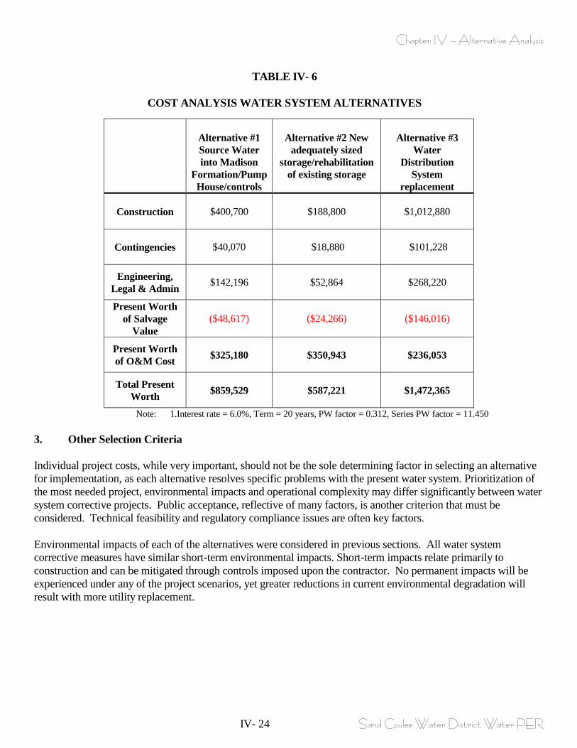
Chapter IV – Alternative Analysis
IV- 24 Sand Coulee Water District Water PER
TABLE IV- 6
COST ANALYSIS WATER SYSTEM ALTERNATIVES
Alternative #1 Source Water into Madison
Formation/Pump House/controls
Alternative #2 New
adequately sized storage/rehabilitation
of existing storage
Alternative #3
Water Distribution
System replacement
Construction $400,700 $188,800 $1,012,880
Contingencies $40,070 $18,880 $101,228
Engineering, Legal & Admin $142,196 $52,864 $268,220
Present Worth of Salvage
Value ($48,617) ($24,266) ($146,016)
Present Worth of O&M Cost $325,180 $350,943 $236,053
Total Present Worth $859,529 $587,221 $1,472,365
Note: 1.Interest rate = 6.0%, Term = 20 years, PW factor = 0.312, Series PW factor = 11.450 3. Other Selection Criteria Individual project costs, while very important, should not be the sole determining factor in selecting an alternative for implementation, as each alternative resolves specific problems with the present water system. Prioritization of the most needed project, environmental impacts and operational complexity may differ significantly between water system corrective projects. Public acceptance, reflective of many factors, is another criterion that must be considered. Technical feasibility and regulatory compliance issues are often key factors. Environmental impacts of each of the alternatives were considered in previous sections. All water system corrective measures have similar short-term environmental impacts. Short-term impacts relate primarily to construction and can be mitigated through controls imposed upon the contractor. No permanent impacts will be experienced under any of the project scenarios, yet greater reductions in current environmental degradation will result with more utility replacement.
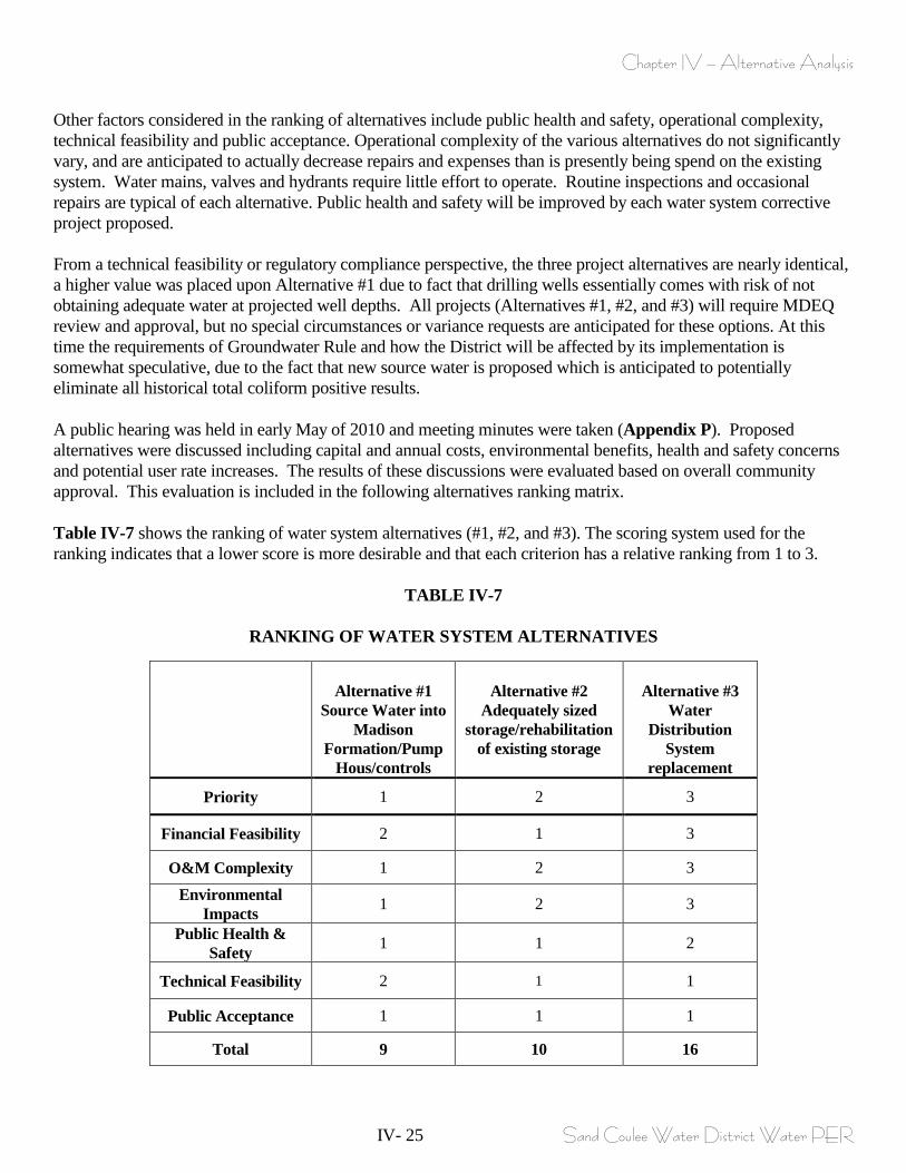
Chapter IV – Alternative Analysis
IV- 25 Sand Coulee Water District Water PER
Other factors considered in the ranking of alternatives include public health and safety, operational complexity, technical feasibility and public acceptance. Operational complexity of the various alternatives do not significantly vary, and are anticipated to actually decrease repairs and expenses than is presently being spend on the existing system. Water mains, valves and hydrants require little effort to operate. Routine inspections and occasional repairs are typical of each alternative. Public health and safety will be improved by each water system corrective project proposed. From a technical feasibility or regulatory compliance perspective, the three project alternatives are nearly identical, a higher value was placed upon Alternative #1 due to fact that drilling wells essentially comes with risk of not obtaining adequate water at projected well depths. All projects (Alternatives #1, #2, and #3) will require MDEQ review and approval, but no special circumstances or variance requests are anticipated for these options. At this time the requirements of Groundwater Rule and how the District will be affected by its implementation is somewhat speculative, due to the fact that new source water is proposed which is anticipated to potentially eliminate all historical total coliform positive results. A public hearing was held in early May of 2010 and meeting minutes were taken (Appendix P). Proposed alternatives were discussed including capital and annual costs, environmental benefits, health and safety concerns and potential user rate increases. The results of these discussions were evaluated based on overall community approval. This evaluation is included in the following alternatives ranking matrix. Table IV-7 shows the ranking of water system alternatives (#1, #2, and #3). The scoring system used for the ranking indicates that a lower score is more desirable and that each criterion has a relative ranking from 1 to 3.
TABLE IV-7
RANKING OF WATER SYSTEM ALTERNATIVES
Alternative #1
Source Water into Madison
Formation/Pump Hous/controls
Alternative #2
Adequately sized storage/rehabilitation
of existing storage
Alternative #3
Water Distribution
System replacement
Priority 1 2 3
Financial Feasibility 2 1 3
O&M Complexity 1 2 3
Environmental Impacts 1 2 3
Public Health & Safety 1 1 2
Technical Feasibility 2 1 1
Public Acceptance 1 1 1
Total 9 10 16
Chapter IV – Alternative Analysis
IV- 26 Sand Coulee Water District Water PER
4. Recommendations Initial affordability for any of the proposed projects to remedy water system problems can initially be evaluated based upon anticipated project O&M costs and retirement of the Intercap Loan (at the time of this writing the District is presently finalizing an intercap loan). The following applies to individual user rates for the estimated O&M costs for the three proposed projects, and individual debt retirement for the Intercap Loan, recall that the target water rate determined by MDOC is $38.28 (please also recall that at the time of this writing MAP is presently working with Sand Coulee on an income survey, with anticipated completion date by end of 3/2010; Alternative #1 – New Well Sources/pump house facilities and controls = Annual O&M - $28,400/73 users/12 months = $32.42/user per month. Adding to this the monthly amount to retire the Intercap Loan with an annual payment of $9,800/73/12 = $11.19 totals to ($32.42 + $11.19) = $43.61/month per user. Therefore the estimated O&M costs for this project (remember that the O&M costs utilized for this project did not increase O&M costs above what is presently spent based upon averaging the last three years) added to the Intercap loan retirement increases the user rate beyond the target rate by ($43.61-$38.28) = $5.33/user/month. Alternative #2 – New storage/rehabilitate existing storage/water level controls and security fencing storage structures = Annual O&M - $32,888/73 users/12 months = $37.54. Adding to this the monthly amount to retire the Intercap Loan with an annual payment of $9,800/73/12 = $11.19 totals to ($37.54 + $11.19) = $48.73/month per user. Therefore the O&M costs for this project (remember that the O&M costs utilized for this project only increased O&M costs above what is presently spent based upon averaging the last three years by $4,488 annually) added to the Intercap loan retirement increases the user rate beyond the target rate by ($48.73-$38.28) = $10.45/user/month. Alternative #3 – Replacement of all undersized piping inclusive of adequately spaced valves, fire hydrants, water services, meter pits/meters and surface replacement = Annual O&M - $31,280/73 users/12 months = $35.71. Adding to this the monthly amount to retire the Intercap Loan with an annual payment of $9,800/73/12 = $11.19 totals to ($35.71 + $11.19) = $46.90/month per user. Therefore the O&M costs for this project (remember that the O&M costs utilized for this project only increase O&M costs above what is presently spent based upon averaging the last three years by $2,880 annually) added to the Intercap loan retirement increases the user rate beyond the target rate by ($46.90-$38.28) = $8.62/user/month. The point of the above is that the anticipated user rates will increase above Target Rates without considering any additional debt retirement required to finance any of the needed projects. It does not appear that Sand Coulee is eligible for a CDBG grant as the LMI (as determined by MDOC) is 36.1%, and also Cascade County is sponsoring a CDBG grant for another District. It also does not appear that Sand Coulee is a good candidate for RD financing (specific to grant) because the MHI (as determined by MDOC) is $32,813 and RD bases a project at an MHI a maximum value of $33,065 for any grant funding. Therefore RD could possibly be a loan entity (with a small grant portion) for project funding but their loan packages generally have higher interest rates than can be found at the SRF program (4.125% verses 3.75%<and possibly 2.75% if rates are above target rates). Therefore based upon this information a project for Sand Coulee would anticipate pursuing grant funding from DNRC – RDG program, TSEP program and capping the financing package with a loan from the SRF program.
Chapter IV – Alternative Analysis
IV- 27 Sand Coulee Water District Water PER
Each of the alternatives individually rectifies specific issues related to health and safety problems related to the existing water system specifically 1. source water, 2. storage and, 3. distribution system. Choosing an individual alternative or phase only remedies problems associated with that portion of the water system. A single project that combines all of the proposed projects together rectifies all the problems with the existing water system for Sand Coulee. Table IV-8 shows associated anticipated user rates for a project encompassing Alternative #1, #2, and #3, referenced above as Alternative #5. Based upon receiving grant financing from DNRC-RDG, TSEP and capping the project with an SRF loan concludes with a user rate of $135.01 for the entire project. This obviously, is a much too expensive project and is totally unviable for the District water rate payers, and this rate exceeds the target water rate by 3.5X. Therefore an additional evaluation of user rate costs were evaluated based upon combining (the two least expensive alternatives) Alternative #1, and #2 referenced above as Alternative #4. A project budget based upon receiving a TSEP grant, DNRC – RDG grant and an SRF loan is presented in the following Table IV-9 for alternative #4 (combined alternative #1 and #2). As shown in Table IV-9 the minimum user rate for the combined projects Alternative #1 and #2 is $58.68 per user per month. This is still viewed as much too expensive and unviable and exceeds the target user rate by almost 1.53 times. Therefore the project will simply have to be phased, into individual alternatives or phases. The following Tables IV-10 and IV-11 display user rate increases based on the same above funding assumptions specifically for Alternative #1 and Alternative #2 respectively.
Chapter IV – Alternative Analysis
IV- 28 Sand Coulee Water District Water PER
Based upon the above reasoning, specifically the ranking shown in Table IV-7, the recommended priority project is Alternative #1 Adequate Source Water. The remaining projects will have to be phased based upon available financing This financial strategy is based on receiving a TSEP grant, DNRC - RDG grant and an SRF loan. Success of each grant application will ultimately dictate the extent of water utility improvements that can be implemented. Based on the anticipated budget and magnitude of benefit to the community, it appears that the following improvements are affordable as a Phase 1 project:
• New source water well sourced into the Madison Formation • Improved access to the well field • New pump house building, discharge piping, with new controls • Security fencing new well heads
If future maintenance issues arise specific to continued main breaks on old thin walled, undersized piping or existing storage failures prior to implementation of design then the scope of the project may alter to remedy such an event. All of the project alternatives are required to alleviate health and safety concerns with each aspect of the existing water system, but due to potentially available project funding it appears that a phased total project approach is necessary with the first priority phase to remedy adequate source water, pump house facility and new controls.
Chapter V – Detailed Description of Preferred Alternative
V - 1 Sand Coulee Water District Water PER
CHAPTER V
DETAILED DESCRIPTION OF PREFERRED ALTERNATIVE
A. WATER SYSTEM 1. Site Location and characteristics Figure V-1 displays the proposed new water source well field, new pump house facility and control system improvement recommendations. The recommended improvements should be considered as a Phase 1 project. Additional phases to remedy serious existing problems with storage and distribution system will be considered as needed future phased projects as viable financing becomes available. The proposed Phase 1 project essentially replaces the existing Kootenai groundwater source with new wells into the Madison formation (with anticipated sustainable yield of 50gpm each), constructs a new well house pump building conforming to all DEQ-1 chapter 6 requirements, and replaces the existing control system, with a new control system capable of cycling well pumps, sending alarm signals with remote access controls. The location of the new wells is proposed at the existing well field due to its excellent location, and the fact that the District already owns a portion of this property (and has a present easement for existing well #4 isolation zone). While additional property is proposed to be purchased (1.5 acres) allowing the new wells 100’ isolation zones to be fully protected, the topic property has been discussed with the present landowner and appears to be readily available for purchase. The well field is located west of Sand Coulee (please refer to Figure V-1), up on the bench area, which allows partial gravity flow from the proposed wells to the storage facility. Present access to the well field will have to be improved to allow larger construction type of equipment (drill and maintenance vehicles) efficient access to the site. Present easements exist to allow access to the well field site, and the proposed improvements to the access roadway have been discussed with the landowners with initial discussions concluding with approvals for a widened access in exchange for road maintenance by the District. 2. Operational Requirements System operational requirements for implementation of the proposed new wells/pump houses and control system improvement recommendations will not require greater personnel effort from those currently performed by the District. As discussed earlier the new wells will have 5HP pumps verses the 1.5HPH pumps that are installed in the existing wells. A comparison for electrical usage was performed in Chapter IV comparing what is presently spent on electrical usage for existing pumps and for heating the existing pump house buildings verses estimated usage for new 5HP pumps. The proposed wells into the Madison Formation will have 5HP pumps, and electrical usage is estimated for these pumps. It is assumed that 9 months out of the year (low demand months), that a single well/pump will be capable of keeping up with average day demands (rated pump capacity is 50gpm) of 22,500 gallons per day, which equates to a 5HP pump operating for 7.5 hours/day for the entire low demand period of 9 months. Therefore the estimated electrical usage for this period will be (5HP x 746 w/HP/.95 (efficiency) = 3.9KW x 7.5hrs/dayX 365days/yr x 9operating months/12 month year x $0.065/kw-hr = $520.00/9 month period. For the rest of the year (high demand months), two wells will operate to keep up with maximum day demand of 90,000 gallons per day. Two wells will operate 15 hours per day, which equates to 5HP x 2 pumps x 746w/HP/.95 = 7.8KW x 15hrs/day x 365days/yr x 3operating months/12month year x $0.065/kw-hr = $925/3 month period. Totaling estimated power consumption for deep well pumps concludes with a total power usage of $1,445/year, compared with present
Chapter V – Detailed Description of Preferred Alternative
V - 2 Sand Coulee Water District Water PER
electrical usage for existing pumps of $1,980/year. This estimated power consumption for new wells into the Madison Formation is actually less expensive that what is presently spent, displaying that the existing pumps are pumping extremely inefficiently due to decreased water capacity in existing wells (and continued cavitation of the existing pumps). The proposed source water collection system into the Madison Formation includes two pump house building of larger size than what presently exists, therefore the new pump building will require additional electrical usage to heat them, but the new building will be much more energy efficient that what exists. Therefore the estimated power usage for the proposed 4 new Madison Formation Wells and 2 new well house buildings is anticipated to be the same as the existing electrical expenditures equating to no additional O&M costs above what is presently spent. Operational and maintenance requirements will likely decrease with the proposed improvement made to the water source/ pump house buildings and controls, eliminating continued time and expenditures presently being spent to keep the existing system operational. 3. Impact on Existing Facilities Improvements to the water facilities will not deleteriously affect any other utilities in the District. The District does not have a community wastewater system. The impacts the improvements will have will only be positive to the District users who will finally have a source water capable of supplying adequate quantity and quality water and eliminate traditional summer time water rationing. 4. Design Criteria The selected water system improvements will adhere to MDEQ Guidelines as set forth in Circular DEQ-1 and Appendices. The recommended alternatives will alleviate health and safety issues, improve operating conditions and adhere to regulatory requirements. Final project design will again meet Circular DEQ-1 guidelines as well as Montana Public works Standard Specifications and generally accepted engineering principles. The following table illustrates present well source capacity and required water capacity for the present and estimated design populations.
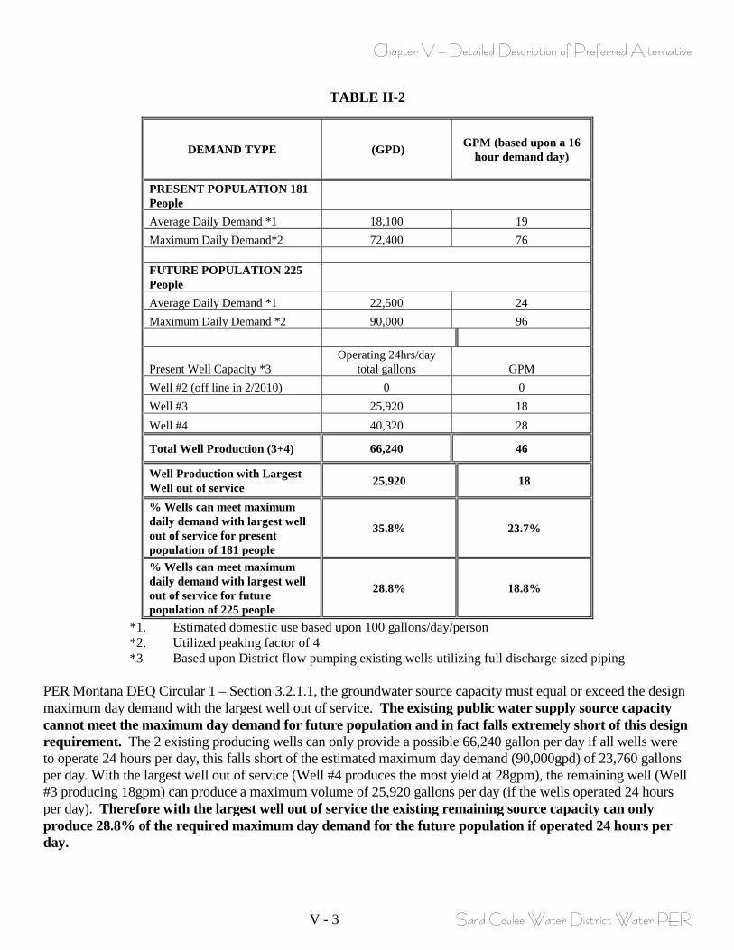
Chapter V – Detailed Description of Preferred Alternative
V - 3 Sand Coulee Water District Water PER
TABLE II-2
DEMAND TYPE (GPD) GPM (based upon a 16 hour demand day)
PRESENT POPULATION 181 People Average Daily Demand *1 18,100 19 Maximum Daily Demand*2 72,400 76 FUTURE POPULATION 225 People Average Daily Demand *1 22,500 24 Maximum Daily Demand *2 90,000 96
Present Well Capacity *3 Operating 24hrs/day
total gallons GPM Well #2 (off line in 2/2010) 0 0 Well #3 25,920 18 Well #4 40,320 28
Total Well Production (3+4) 66,240 46
Well Production with Largest Well out of service 25,920 18
% Wells can meet maximum daily demand with largest well out of service for present population of 181 people
35.8% 23.7%
% Wells can meet maximum daily demand with largest well out of service for future population of 225 people
28.8% 18.8%
*1. Estimated domestic use based upon 100 gallons/day/person *2. Utilized peaking factor of 4 *3 Based upon District flow pumping existing wells utilizing full discharge sized piping
PER Montana DEQ Circular 1 – Section 3.2.1.1, the groundwater source capacity must equal or exceed the design maximum day demand with the largest well out of service. The existing public water supply source capacity cannot meet the maximum day demand for future population and in fact falls extremely short of this design requirement. The 2 existing producing wells can only provide a possible 66,240 gallon per day if all wells were to operate 24 hours per day, this falls short of the estimated maximum day demand (90,000gpd) of 23,760 gallons per day. With the largest well out of service (Well #4 produces the most yield at 28gpm), the remaining well (Well #3 producing 18gpm) can produce a maximum volume of 25,920 gallons per day (if the wells operated 24 hours per day). Therefore with the largest well out of service the existing remaining source capacity can only produce 28.8% of the required maximum day demand for the future population if operated 24 hours per day.
Chapter V – Detailed Description of Preferred Alternative
V - 4 Sand Coulee Water District Water PER
The proposed 3 wells into the Madison Formation with anticipated sustained yield of 50gpm each satisfies this DEQ requirement meeting Maximum Day Demands with two wells operating at 100gpm. The proposed pump house facility will conform to DEQ-1 design requirements found in chapter 6, and allow space for potential future disinfection components as determined by the Groundwater Disinfection Rule. The proposed pump house facility will allow for a lighted/heated/ventilated space for above ground piping that conforms with DEQ-1 Chapter 6 design requirements for well head metering, sampling ports, pressure gauges, and pump to waste piping, inclusive of piping taps for future disinfection requirements. This proposal also replaces the existing dilapidated control system with a system that conforms to DEQ-1 Section 6.5 specific to providing pump cycling, automatic signaling and reporting for various alarms such as excessive voltage/amp draws, overheating of pumps, unauthorized pump house entry, and low well water levels. This proposal also supplies remote access and controls for pump activation/deactivation, pressure readings etc. 5. Environmental Impacts and Mitigation Obtaining water for the new wells into the Madison Formation will require approval from DEQ and DNRC specific to obtaining public water system design approval and legal water rights. Drilling and placing into use 3 new wells into the Madison Formation will require the purchase of additional land. As previously discussed 1.5 acres of additional land is required to completely protect the new 100’ radius isolation zones for the new wells. Initial discussions indicate that the land can be purchased at economical values and these costs have been considered in the estimated project costs. In addition to needed well field purchased acreage this project proposes improved access to the well field site, and discussion with landowners indicate positive indication that a widened easement and improved access roadway improvements can be obtained at no land purchase costs in exchange for roadway maintenance. Minor, short-term environmental impacts will occur during the well drilling and pump house construction and control improvement construction but can be easily mitigated with carefully planned construction practices. Included are dust creation, sediment runoff, noise, and pumped groundwater water discharges during test pumping. A number of restrictions can be placed upon the construction contractor to significantly reduce impacts to the environment and public. Best management practices (BMP’s) and detailed erosion control measures can nearly eliminate sediment transport caused by groundwater pumping procedures and rainfall events. Dust control will likely be provided by water trucks and strict oversight by the engineer will ensure watering operations sufficiently eliminate dust concerns. Noise nuisance can be reduced through limited construction operation hours. Multiple state and federal agencies were contacted for comments regarding environmental impacts associated with the proposed improvements project. Records of this correspondence can be referenced in Appendix E and the Uniform Environmental Checklist is located in Appendix Q. 6. Cost Summary Operational costs will not increase after the completion of this project. Capital costs including construction, engineering, administration and contingencies along with operations costs were detailed in Chapter IV for each alternative. Implementation of those activities will be contingent upon project funding and bid prices.
Chapter V – Detailed Description of Preferred Alternative
V - 5 Sand Coulee Water District Water PER
Table V-1 and Table V-2 identify project related costs and a proposed budget for the water project recommendations. The aforementioned project budget includes loan reserve and coverage values that meet the requirements of the lending agency. The tables also incorporate final, annual operation and maintenance costs, loan coverage, debt service, project engineering, design, inspection, construction and contingency, number of equivalent users and grant/loan program funding to establish a post-project user rate of $43.61 per month per equivalent dwelling unit (EDU). This user rate includes repayment of an Intercap Loan (at the time of this writing this loan was being completed and correspondence indicates a $50,000 loan with a 6 year payback of $9,800/year) that after six years will retire. Therefore after the Intercap Loan is retired the user rates will decrease to $32.42. The final user rate will be contingent upon the District successfully receiving the grant assistance for which they apply. The District applied for STAG and/or WRDA grants in 2009, 2010, and anticipates applying again in 2011 as well, however due to the nature of these appropriated funds, the project budget does not reflect receiving these funds (the District had actually received approval for 2009 appropriation but this appropriation never came to fruition). Currently water user rates are $25.00 per month per EDU. Current annual operating budget and income exclusive of the planning process along with alternative funding scenarios are described in further detail in Chapter VI – Project Implementation. The District currently maintains approximately $7,135 in a reserve account for the purposes of maintenance and capital improvements, which obviously is not adequate.
Chapter VI – Project Recommendations and Implementation
VI - 1 Sand Coulee Water District Water PER
CHAPTER VI
PROJECT RECOMMENDATIONS AND IMPLEMENTATION A. INSTITUTIONAL RESPONSIBILITY Sand Coulee Water District is an unincorporated community, organized under the laws of the State of Montana. Management of the District is the responsibility of the Board of Directors, as authorized under Title7, Chapter 13, Parts 22 and 23. Board members of the District act as the local government for purposes of operating a utility such as a water system. A Board has the authority to make special assessments, set and collect user fees, provide man-power and operating costs, and pay off debt. The District must have financial capabilities to construct, operate and administer the water system. Given the estimated costs for the proposed facilities, financial assistance must be obtained for design and construction of the selected alternative in order to make the project acceptable to District residents. B. SCHEDULE OF PROJECT COMPLETION The following schedule provides an achievable time line for construction of necessary improvements, presuming that affordable project financing can be arranged. This schedule is based on receiving TSEP, DNRC and SRF grant/loan funding. The project schedule will likely be as follows: WATER SYSTEM IMPROVEMENTS 1. Submit Preliminary Engineering Report April 2010 to TSEP & District 2. Apply for TSEP Grant and DNRC Grant April/May 2010 3. Apply for SRF Loan March 2011 4. Complete financing and obtain funds June 2011 5. Submit final engineering plans and January 2011 specifications to the MDEQ 6. Advertise for construction bids, May 2012 receive bids, award contract and commence construction. 7. Complete construction of all proposed August 2012 facilities and initiate operation.

Chapter VI – Project Recommendations and Implementation
VI - 2 Sand Coulee Water District Water PER
C. FINANCIAL ASSISTANCE Most small communities must obtain financial assistance to build new water facilities because relying on the issuance of debt alone will exceed the user’s ability to pay. Often, more than one loan or grant program is combined to assemble a viable financial package. A short description of the available financial assistance programs is as follows: 1. State Revolving Fund (SRF) Loan Program This loan program is administered by the Montana Department of Environmental Quality. Loans are typically made for a 20-year term at an estimated rate of 3-4%, currently 3.75%. Financial hardship cases can apply for a reduced rate of 2.75%. This is the lowest available rate on the loan market. There is no cap on the SRF loan. SRF loans must be secured by issuance of a bond. Due to the relatively low interest rate and relative ease of application an SRF loan may be a very viable source for Sand Coulee Water District water improvements project. 2. Montana Treasure State Endowment (TSEP) Program The Treasure State Endowment Program is a state-funded grant and loan program designed to assist cities, towns, and counties in financing wastewater systems, drinking water systems, sanitary or storm sewer systems, solid waste disposal and separation systems and bridges. Legislative Referendum 110 provides that interest from the Treasure State Endowment Fund and proceeds from the sale of bonds may be used to provide financial assistance for local government infrastructure projects. The maximum allowable grant available on a single project basis is $750,000, if final utility rates are equal to or greater than 150% of the Department of Commerce established target rates. Grants in the amount of $625,000 are available for communities at 1.25 times their DOC target rates and if minimum target rates are met, $500,000 is available to communities. The grant generally requires a 50:50 match. Sand Coulee Water District WSD presently has water rates of $25.00. The Target Water Rate determined by Montana Department of Commerce (based upon a Median Household Income of $32,813) is $38.28. This is 1.5 times the District’s present user rates. The TSEP program will not award grants to recipients that do not have rates at or above the Target Rate value by the time the project is completed. As stated above the TSEP program requires a dollar for dollar match for their grants, or, in other words, for every dollar that the TSEP program will assist a District with the District will have to match this with a dollar from another source. If the District will raise their user rates up to equal or greater than the Target rate, the TSEP program is an extremely viable grant source for the District water project. 3. Community Development Block Grant (CDBG) Program This grant program is administered by the Montana Department of Commerce. All CDBG applications must document that at least 51 percent of the non-administrative funds requested for a CDBG project are clearly designed to meet the needs for low and moderate income families. Having a high percentage of low and moderate income people in the community and the presence of a high potential health threat helps a community compete for a CDBG grant. The maximum allowable grant available on a single project basis is $450,000.
Chapter VI – Project Recommendations and Implementation
VI - 3 Sand Coulee Water District Water PER
As determined by the Department of Commerce the District presently has 36.1% low to moderate income households within the District. A District must document that at least 51 percent of the non-administrative funds requested for a CDBG project are clearly designated to meet the needs of low and moderate income families. Since the District currently has significantly less than 51% low to moderate income residents, the potential for CDBG funding is quite slim for the Sand Coulee Water District. If the District were to pursue CDBG funding they would have to perform an approved income survey and the results of that survey would have to show at least 51% low to moderate incomes within the District. 4. DNRC Renewable Resources Grant and Loan (RDG) Program This grant and loan program is administered by the Montana Department of Natural Resources and Conservation. The DNRC grants are limited to $300,000 through the RDG program. This program promotes reclamation and development of areas and communities that are suffering from past mining operations. The DNRC grant program appears to be an excellent viable grant program for the District due to the fact that they are proposing to install new groundwater wells and abandon the existing Kootenai Formation wells that are suspected to be dewatered by past mining activities. 5. USDA Rural Development Program The RD grant and loan program is administered by the Rural Development Program of the US Department of Agriculture, formerly known as the Farmers Home Administration (FmHA). RD has grants and loans available with the combination of the two dependent on the District resident’s median household income (MHI) and target user rates. A 75% grant is the maximum if the communities' per capita income is below the median household income poverty rate. The ratio of grant to loan varies depending upon the District MHI and final sewer rate. RD bases their grant/loan percentages based upon Median Household income levels and essentially allows a larger percentage of grant for those applicants with a larger percentage of residents below MHI values. If an applicant has MHI values in excess of $33,065 the applicant is not eligible for an RD grant but may become eligible for an RD loan. An RD loan has higher interest rates than an SRF loan therefore the District will not be beneficially served by an RD loan. Sand Coulee Water District may be eligible for small amount of RD grant due to its MHI value of $32.813 as determined by the Department of Commerce, but the remainder of the RD financing would be in the form of a loan at higher interest rate than SRF offers. Therefore it does not appear that RD would be a good financing choice for the proposed Sand Coulee water improvements project.
6. State and Tribal Assistance Grant (STAG) The STAG grant program is a federally funded, direct appropriation administered nationally by the Environmental Protection Agency (EPA). Within the State of Montana, the MDEQ SRF Program monitors the disbursement of funds. Grant applications are due in March of every year and require a 45% non-federal match. No specific request limits exist, but grant awards can approach $2 million. More typical awards have been in the range of $500,000.
The District is eligible to apply for a STAG grant through Montana’s congressional delegates. The grant applications are be due in February of each year. The District applied for this funding in 2009 (in 2009 received correspondence that they were successful with the application but later found out that the appropriation did not get earmarked for Sand Coulee). The District has applied for STAG funding in early 2010. The grant process is extremely competitive. However, due to the nature of the grant (appropriated funds from Congress) it is not typically seen as viable grant when developing a planning a budget at this time. Therefore, the District is eligible, and should apply next year.
Chapter VI – Project Recommendations and Implementation
VI - 4 Sand Coulee Water District Water PER
The attached figure provides further information on the financial assistance programs. D. FINANCING WITH LOAN FUNDS Although grant assistance is generally sought, very rarely can a small community implement significant improvements to their utility systems without borrowing some portion of the project costs. Most financial assistance programs require some type of local match for grant funds. Districts have three primary mechanisms by which Montana Statutes allow the incurrence of debt. GO Bonds--Districts have the authority to issue General Obligation bonds upon approval, through a vote of 60% of the property owners. This type of financing does not require a debt reserve placed on deposit or the collection of debt coverage. The rate of charges is based on taxable value of the property and all property owners would pay the tax, whether connected to the utility or not. Revenue Bonds--This type of debt is secured by the pledging of user charges and, in the case of a deficiency, a tax can be levied on properties in the District. This type of debt requires the collection of coverage or 25% of the annual debt service and that one annual principal and interest payment must be placed in reserve. The rates and charges for revenue bonds would apply only to connected users and would be based on actual use. Rural Special Improvement Districts--While not directly available to Water and/or Sewer Districts, this type of financial district can be created by a county for the purpose of building a water or sewer system within a District. An interlocal agreement would then be arranged to established system ownership and operation and maintenance responsibilities. A specific process must be followed to create the district and the process can be stopped by a protest of 50% or more of the property owners, unless overridden by the county commissioners. All properties in the district benefited by the improvements will be assessed. Portions of the assessment are deposited into a revolving fund to act as security for the debt. E. RATE STRUCTURE/EXISTING BUDGET The average monthly residential water user fee is a base rate of $25.00 per month. There is a connection fee of $100.00 for any new services. The Department of Commerce established target rate of $38.28, therefore the District realizes that utility improvements will likely require a further rate increase. The following Table VI-1 summarizes the current rate schedule, based on a single connection for each residential user.
TABLE VI-1
Existing Rate Structure and System Income
Monthly Rate Structure Residential Units $25.00 Flat 73
Average Monthly Revenues $1,825.00 Table VI-2 provides a record of annual income and expense statements for the past 3 years. The District understands the need for further rate increases and will implement a structured plan to meet their fiscal obligations.
Chapter VI – Project Recommendations and Implementation
VI - 5 Sand Coulee Water District Water PER
The total revenues include funds from services charges (user rates and late fees), hook-up fees, investment earnings and tax assessments. The District is presently finalizing a loan with Intercap for an anticipated amount of $50,000 with a six year annual payback of $9,800.
TABLE VI-2
Utility Revenue and Expense History
Fiscal Year Total Revenue
Total Expenditures
Operations and Maintenance
Net Income or (deficit)
2007 $11,718 16,192 $(4,474) 2008 $14,339 48,634 $(34,295) 2009 $17,013 20,189 $(3,176)
Average 28,400 Revenues from monthly user charges currently account for approximately $21,900 annually. The average operating and maintenance budget (total expenditures) for the previous three years, estimates a total water expense of $28,400 per year. Future operations and maintenance budgeting will not be significantly impacted by any of the recommended improvements, and is not anticipated to increase for the proposed Phase 1 project. For this reason, budgeting for short-lived assets will not be increased over current estimates. The following table summarizes the estimated future operating expenditures and annual costs but does not estimate costs associated with emergency maintenance items such as main breaks, storage facility maintenance costs etc (as these are unforeseen costs):
TABLE VI-3
AVERAGE ANNUAL WATER BUDGET EXPENDITURES Water Utility AVERAGE COST Treasurer’s reimbursement 1,200 State of MT report fee 30.00 DEQ Pub. Water $2/connection 160.00 Rural Water Membership 125.00 Electrical Usage 3,000.00 Taxes 200.00 Sampling 240.00 DSL 300.00 Post office shipping 56.00 Postage 176.00 Convention 300.00 Certification renewal 60.00 Wages 2,500.00 TOTAL WATER BUDGET $8,347.00
Chapter VI – Project Recommendations and Implementation
VI - 6 Sand Coulee Water District Water PER
F. ESTIMATED FUTURE COSTS The cost increase anticipated with this project will depend on the actual construction cost and the amount of financial assistance that is obtained. To project the potential rate increase, Table VI-4 is displayed. Costs were calculated on an equivalent dwelling unit (EDU) basis for existing connections assuming each EDU currently pays an average water bill of $25.00 per month. Due to existing LMI percentage of 36.1%, MDOC CDBG program funding is not an option. Therefore, CDBG funding was not considered in the aforementioned funding scenario. The project proposes new wells into the Madison Formation eliminating the existing wells in the Kootenai Formation that are suspected of being dewatered due to past mining practices. Due to this information, the District would be a likely candidate for DNRC – RDG funding, TSEP grant funding, with an SRF loan capping the proposed project. The Department of Commerce water utility target rate on an equivalent residential dwelling unit basis for the Sand Coulee Water District is $38.28. The projected water user rate of $43.61 per month exceeds the DOC water target rate. From this information, Sand Coulee Water District should be an excellent candidate for TSEP grant funding. G. PUBLIC PARTICIPATION Public meeting agenda, minutes and supporting documentation are included in Appendix P of this report. Efforts were made through the planning process to update the public and incorporate their comments and concerns into the Preliminary Engineering Report. The newspaper advertisement and posted notices were used to alert the community that a public hearing was scheduled. A public hearing was held resulting in overwhelming support for the recommended project, user rates and financing strategy. Support letters from concerned citizens have been received throughout the planning process (Appendix R).


![Galileu Leu[2]](https://img.pdfslide.net/doc/110x75/559422ad1a28abfd568b45ab/galileu-leu2.jpg)