Embed Size (px)
Citation preview
HS 2 - Session II: Famous European Surveyors Cavelti Madlena Hammer The Conquest of the Swiss Alps - The Survey and Engineering Work of Xaver Imfeld (1853-1909) Shaping the Change XXIII FIG Congress Munich, Germany, October 8-13, 2006
1/12
The Conquest of the Swiss Alps The Survey and Engineering Work of Xaver Imfeld (1853 – 1909)
Madlena Cavelti HAMMER, Switzerland
Key words: Swiss Alps, Federal Bureau of Topography, Nineteenth Century, trigonometrical measuring, three-dimensional models, photogrammetry, SUMMARY In those days surveying and mapping the Alps required a lot of outdoor work. This paper presented the work of a famous Swiss engineer in the Nineteenth Century: the multi-talented Xaver Imfeld, who was not only a perfect engineer, but also a physically strong alpinist. His work includes a great number of maps, panoramas and 3D-models of the Alps. ZUSAMMENFASSUNG Im 19.Jahrhundert erfolgten viele Erstbesteigungen der Schweizer Alpen. Gleichzeitig führte die Schweiz eine Landesvermessung durch, die auf der einen Seite eine technische, auf der andern Seite jedoch eine alpinistische Leistung war. Xaver Imfeld gehörte zu den Pionieren seiner Zeit. Darüber hinaus gelang es ihm in sehr hohem Mass, das Gelände künstlerisch vollendet auf Karten, Reliefs und Panoramen wiederzugeben.
HS 2 - Session II: Famous European Surveyors Cavelti Madlena Hammer The Conquest of the Swiss Alps - The Survey and Engineering Work of Xaver Imfeld (1853-1909) Shaping the Change XXIII FIG Congress Munich, Germany, October 8-13, 2006
2/12
The Conquest of the Swiss Alps The Survey and Engineering Work of Xaver Imfeld (1853 – 1909)
Madlena Cavelti HAMMER, Switzerland
In the Nineteenth Century there was an international race to climb to the top of the Swiss Alps. It was not only a question of being the first on the top, but there was also a desire to add as many of this 4000m high mountains as possible to one’s personal record.
It was in those days that the first rush on the highest summits of the Alps began. An Englishman marked the start with his ascent of the Wetterhorn in 1854. One year later the Monte Rosa was conquered, in 1857 the Mönch followed, 1858 the Eiger, 1859 the Bietschhorn, 1861 both the Weisshorn and Schreckhorn, and in 1865 finally the Matterhorn. The place of departure for all of those alpine expeditions had been Zermatt and Grindelwald. The English ranked among the best alpinists, one reason for that was that Great Britain as the leading world power had enormous financial wealth at its disposal, and was able to create new trends thanks to its Industrialisation. Even the first Alpine Club was founded in England in 1857. In order to become a member of this exclusive club, one had to had reached the top of at least one 4000 meter mountain as an admittance-requisite. The Austrian Alpine Association based in Vienna was founded in 1862, which was renamed as German and Austrian Alps-Association in 1874. In 1863 followed the “Club Alpino Italiano” based in Turin and the Parisian “Club Alpin Français” in 1874. The Swiss Alpine Club (SAC) based in Olten was established in 1863. This club’s declared goal was to explore and research the Alps with regard to topographical, natural historical and scenic aspects. The most distinguished alpine topographers were members of the SAC. Xaver Imfeld (1853 – 1909) born in Central Switzerland was also a member of the SAC, and after completing his study as an engineer in Zurich – at the polytechnic institute, which was founded in 1855 and nowadays known as the ETH – he was offered a job at the Federal Bureau of Topography in Bern. As an experienced Alpinist he was sent off to the mountains.
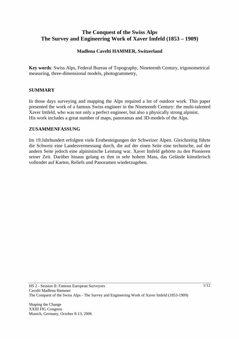
It was in those days that the first rush on the highest summits of the Alps began. An Englishman marked the start with his ascent of the Wetterhorn in 1854. One year later the Monte Rosa was conquered, in 1857 the Mönch followed, 1858 the Eiger, 1859 the Bietschhorn, 1861 both the Weisshorn and Schreckhorn, and in 1865 finally the Matterhorn. The place of departure for all of those alpine expeditions had been Zermatt and Grindelwald. Fig.1. Xaver Imfeld (1853 – 1909)

HS 2 - Session II: Famous European Surveyors Cavelti Madlena Hammer The Conquest of the Swiss Alps - The Survey and Engineering Work of Xaver Imfeld (1853-1909) Shaping the Change XXIII FIG Congress Munich, Germany, October 8-13, 2006
3/12
Fig. 2. Photography of Zermatt at the end of the Nineteenth Century Xaver Imfeld became one of Switzerland’s best engineers, and was sent to Zermatt and later to the Berner Oberland to survey the surrounding mountains. Xaver Imfeld’s first masterpiece was the survey of the Matterhorn. He even constructed three-dimensional models of several summits of the Alps. 1. ABOUT THE EXTREMELY DIFFICULT SURVEY WORK IN THE ALPS Xaver Imfeld’s friend and work colleague Fridolin Becker confirmed years later that a good topographer was paid according to how many sheets he completed. ‘... in the year 1876, hence at the time of the tightened terms, at a price of 400 CHF per square hour à 23.04 square-km which is 17.36 CHF per square-km or 17.4 Rappen per hectare. One section of 24/35 cm is 8.4 dm drawingsurface which contains 210 km2 or 9.01 square hours.’1 One meter reading sheet was thus worth about 3600 CHF which is at the same time the approximate annual salary of a topographer, since he was normally able to finish a meter reading sheet during one summer. In addition, he could add the fair drawing and the copies for the lithographie during the winter. Up in the mountains, the summer months were generally short and due to the still existing snow cover, work started only in the middle of June and lasted till mid-October. Hence, only four months or 120 days were actually available for work. Fridolin Becker concluded that one third of the actual topographical workdays dropped away because of three reasons: It was either bad weather, the time to get to the working area was long or there were unexpected difficulties. What remained in the end were 70 to 80 working days for 210 square-km, which means that 3 square-km had to be edited during one day. The topographers definitely had to work on Sundays if the weather permitted it, and surely it was not an easy job, as it was physically demanding and full of 1 Becker, 1920

HS 2 - Session II: Famous European Surveyors Cavelti Madlena Hammer The Conquest of the Swiss Alps - The Survey and Engineering Work of Xaver Imfeld (1853-1909) Shaping the Change XXIII FIG Congress Munich, Germany, October 8-13, 2006
4/12
privation. They measured and drew often with cold hands and had to spend the short nights underneath an uncomfortable ledge. Since they had to carry a lot of material, they sometimes took along less food but more drawing material. As an example for such exertions, but also for Imfeld’s determined will to finish his work, we shall have a closer look at a topographical expedition in the canton of Valais. Xaver Imfeld described in the yearbook of the Swiss Alpine Club one of his numerous topographical expeditions. It was the exploration tour to the Baltschiederjoch and to the valley of Baltschied.2 This area of interest can be found in the canton of Valais in between the Matterhorn and the Jungfrau-massif. Since it was impossible for Imfeld to undertake a trip lasting several days into unknown terrain all by himself, he hired an experienced guide and a porter. It was the evening of the 8th of August 1881 when Imfeld met his two companions, the guide Peter Siegen und Benedikt Henzen, at the ‘Hôtel Nesthorn’ in Ried, which is in the area of Lötschental. They planned a week-long expedition for topographical work on the sheet ‘Kippel’ for the Siegfried-atlas. Imfeld cunningly noted that they did not intend to climb hilltops for the glory of the SAC members, but that he went on this trip with his companions solely as a topographer of the Federal Bureau of Topography. It was he, who was responsible for the trip and its execution. Actually, the weather on the 8th of August 1881 was bad, as it was snowing, which is not surprising since in those days the Swiss summers were on an average 2-3 degrees colder than nowadays.3 At 4 o’clock in the morning, the three men were packed and ready, while the moon was hidden behind heavy rain clouds. They would have cancelled the trip under those circumstances since they could predict the rain, but the tour was planned and they were determined to set out. Short after, a cold rain came across the Baltschiederjoch and the three men sought shelter underneath a ledge. After one and a half hours they continued their trip over scree, snow and glaciers, and soon the rain turned to snow. Furthermore, the wind was blowing snow and ice into their faces, and the mountain guide already wanted to turn back, while the porter almost collapsed under the increasingly heavier load. Only Imfeld did not think about capitulating and he managed to convince the others to move on. But the weather remained bad, and they were 3 or 4 times caught off guard by rain and hail. As a bedding place they found a gneiss plate, which was even and about 90 cm high. After having made a fire with dry Alpine roses to dry their clothes and fry some cheese, it was time to sleep and they crawled on all fours under the rock and went to sleep on their available space of 3 on 3 meters. Fortunately, the next morning was bright and clear and the three men could go on with their expedition. The porter had to get some milk from a nearby alpine dairy while the others moved on. Imfeld discovered many deficiencies about the old maps. There was a peak that was mapped completely wrong, and apparently the dimensions of the glaciers did not correspond with reality. In addition, Imfeld was able to correct a serious mistake: According
2 Imfeld, Xaver: Baltschiederjoch und Baltschiederthal. In: Jahrbuch XVII des Schweizerischen Alpen-Club, Bern 1881 3 www.meteoschweiz.ch, November 2005
HS 2 - Session II: Famous European Surveyors Cavelti Madlena Hammer The Conquest of the Swiss Alps - The Survey and Engineering Work of Xaver Imfeld (1853-1909) Shaping the Change XXIII FIG Congress Munich, Germany, October 8-13, 2006
5/12
to his new measuring the Jägihorn was 3420 meters high in stead of the so far recorded 2960 meters. They spent the next night outdoor as well, protected by a rock, and as far as we know that place was considerably larger and cosier. It was especially the view to the south and the view of the Matterhorn that appealed to the newly wed Imfeld, because from that specific spot he was able to see his father-in-law’s Riffelhotel in Zermatt. To have a relatively comfortable bivouac after a day of hard work and to think of his beloved wife should be enough to fall asleep easily, but Imfeld did not sleep well and complained about his eyes, as he began to feel the snow blindness. He reasoned, that “one has to bear the consequences of a glacier-trip twofold, if one is forced to let the eye wander between the blinding firn, the binocular and the nonius. This is different from swiftly making one’s way through the terrain and protecting the eyes with glasses or veil.”4 The three men spent two more days and one night up in the mountains, before they decided to descend at 6pm, and they literally ran down the hill to Visp just in order to be ready for the next day’s return to the Lötschental. Thus, their expedition lasted 5 days, not counting the lead time and the time to get to the Lötschental, of which Imfeld could use 3 days for his topographical work. This limited time made it necessary to work precisely and very hard. Imfeld wrote that despite their comfortable bed in the hay, they got up at 3 in the morning, worked the whole day and arrived the same evening in Visp at 8pm, which truly is a 17 hour working day! 2. THE MAPS PRODUCED DURING THIS PERIOD The Federal Bureau of Topography kept an accurate account of the works of its engineers. Moreover, the engineers were asked to hand in written reports about their work, which have been preserved as well. These monthly reports are now stored at the Federal archives where the labour contracts and the board decisions are kept. The engineer R. Tank described the engineer’s work as follows: “Siegfried’s topographers had better working conditions [than Dufour’s] and had a considerably improved trigonometrical measuring material at their disposal; based on the manifold experiences of their predecessors, they were able to complete and expand a topographical cartography which had been started with big success. In the mountains, they preferably triangulated with the help of a plane-table, and measured forward different selected points from the opposite slope. The horizontal distances resulted from the graphical triangulation. The altitude of the stations were calculated logarithmically and the differences in elevation were matched with the points in the terrain which have been put in an altitude chart and taking into consideration the refraction and the curvature of the earth. The valleys as well as the Swiss plateau and the Jura were topographically calculated with the help of optical distance measurement. By means of sketches, pacing out, and visual judgement, the topographer reviews, completes and draws his ordnance map.”5
4 Jahrbuch XVII des Schweizerischen Alpenclubs, Bern 1881 5 Tank, R: Topographische Arbeiten. In: Hundert Jahre Eidg. Landestopographie 1838-1938. Bern, 1938
HS 2 - Session II: Famous European Surveyors Cavelti Madlena Hammer The Conquest of the Swiss Alps - The Survey and Engineering Work of Xaver Imfeld (1853-1909) Shaping the Change XXIII FIG Congress Munich, Germany, October 8-13, 2006
6/12
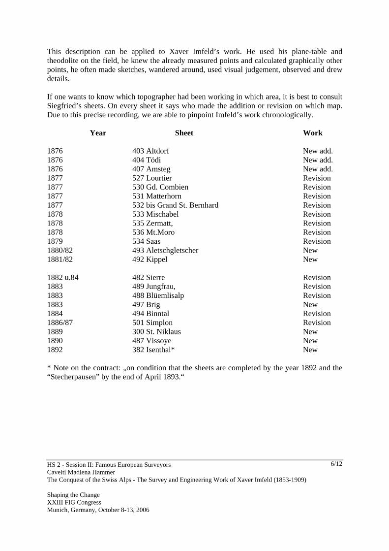
This description can be applied to Xaver Imfeld’s work. He used his plane-table and theodolite on the field, he knew the already measured points and calculated graphically other points, he often made sketches, wandered around, used visual judgement, observed and drew details. If one wants to know which topographer had been working in which area, it is best to consult Siegfried’s sheets. On every sheet it says who made the addition or revision on which map. Due to this precise recording, we are able to pinpoint Imfeld’s work chronologically. Year Sheet Work 1876 403 Altdorf New add. 1876 404 Tödi New add. 1876 407 Amsteg New add. 1877 527 Lourtier Revision 1877 530 Gd. Combien Revision 1877 531 Matterhorn Revision 1877 532 bis Grand St. Bernhard Revision 1878 533 Mischabel Revision 1878 535 Zermatt, Revision 1878 536 Mt.Moro Revision 1879 534 Saas Revision 1880/82 493 Aletschgletscher New 1881/82 492 Kippel New 1882 u.84 482 Sierre Revision 1883 489 Jungfrau, Revision 1883 488 Blüemlisalp Revision 1883 497 Brig New 1884 494 Binntal Revision 1886/87 501 Simplon Revision 1889 300 St. Niklaus New 1890 487 Vissoye New 1892 382 Isenthal* New * Note on the contract: „on condition that the sheets are completed by the year 1892 and the “Stecherpausen” by the end of April 1893.“
HS 2 - Session II: Famous European Surveyors Cavelti Madlena Hammer The Conquest of the Swiss Alps - The Survey and Engineering Work of Xaver Imfeld (1853-1909) Shaping the Change XXIII FIG Congress Munich, Germany, October 8-13, 2006
7/12
3. THE IMPRESSIVE THREE-DIMENSIONAL MODELS OF THE MATTERHORN AND THE JUNGFRAU
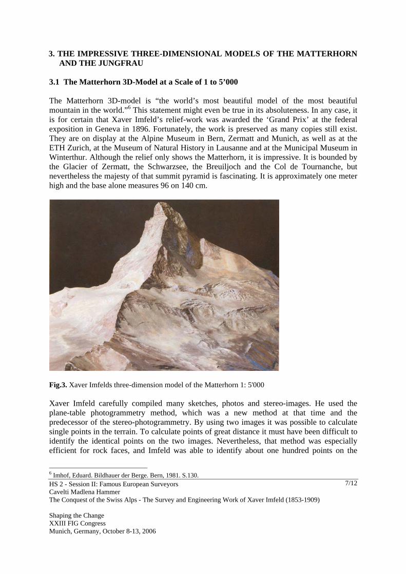
3.1 The Matterhorn 3D-Model at a Scale of 1 to 5’000 The Matterhorn 3D-model is “the world’s most beautiful model of the most beautiful mountain in the world.”6 This statement might even be true in its absoluteness. In any case, it is for certain that Xaver Imfeld’s relief-work was awarded the ‘Grand Prix’ at the federal exposition in Geneva in 1896. Fortunately, the work is preserved as many copies still exist. They are on display at the Alpine Museum in Bern, Zermatt and Munich, as well as at the ETH Zurich, at the Museum of Natural History in Lausanne and at the Municipal Museum in Winterthur. Although the relief only shows the Matterhorn, it is impressive. It is bounded by the Glacier of Zermatt, the Schwarzsee, the Breuiljoch and the Col de Tournanche, but nevertheless the majesty of that summit pyramid is fascinating. It is approximately one meter high and the base alone measures 96 on 140 cm.
Fig.3. Xaver Imfelds three-dimension model of the Matterhorn 1: 5'000 Xaver Imfeld carefully compiled many sketches, photos and stereo-images. He used the plane-table photogrammetry method, which was a new method at that time and the predecessor of the stereo-photogrammetry. By using two images it was possible to calculate single points in the terrain. To calculate points of great distance it must have been difficult to identify the identical points on the two images. Nevertheless, that method was especially efficient for rock faces, and Imfeld was able to identify about one hundred points on the
6 Imhof, Eduard. Bildhauer der Berge. Bern, 1981. S.130.

HS 2 - Session II: Famous European Surveyors Cavelti Madlena Hammer The Conquest of the Swiss Alps - The Survey and Engineering Work of Xaver Imfeld (1853-1909) Shaping the Change XXIII FIG Congress Munich, Germany, October 8-13, 2006
8/12
Matterhorn alone. Having done that, he roughly extracted the form of the Matterhorn for his relief. With the help of images, sketches and his own knowledge, Imfeld formed the details, and he undoubtedly did a great job. The discreet colouring intensifies the expressiveness of the shape. Imfeld’s relief of 1896 became one of the great classics. The Matterhorn relief also promoted a project for the Matterhorn railways, planned in 1890 by entrepreneur L. Heer from Biel.7 The Swiss state granted him concession and the railway to the Gornergrat was inaugurated in 1898. The more spectacular plan of a railway directly to the top of the Matterhorn with a stop at the Hörnlihütte was never realised. 3.2 The 3D Model of the Jungfrau Group at a Scale of 1 to 2’500 From 1897 to 1900 Xaver Imfeld created his most impressive and monumental model: The whole Jungfrau group at a scale of 1 to 2500. It measured almost 25 square meters and was 1,40meter high.8 There were times when up to 30 people were working on the relief, which consisted of 22 pieces, so called sections.9 The relief advertised the Berner Oberland and especially the planned railway to the Jungfrau at the world exposition of 1900 in Paris (Plate Jungfraugruppe 1:2’500). Fritz Gygax wrote 1937 in his relief catalogue: “This relief is probably the most magnificent and impressive geoplasitc construction, a jewel which evokes an artistic impression. The model shows an extraordinary scientific achievement; the single snow patches, the rock faces and the debris and snow on the narrow rock terraces are exactly like one can find them in real life.”10 Imfeld planned to send his relief on tour through Europe to every big European city after the world exposition,11 but the assembly and disassembly turned out to be too time consuming and risky. The relief moved to the Museum of Peace in Lucerne in 1909. This museum exists no more despite its significant name and its prominent location near the main station. The German and Austrian Alpine Club bought the relief and it was exhibited at the main hall of the Alpine Museum in Munich. Unfortunately, a bombardment during the Second World War destroyed it completely.
7 L. Heer-Bétrix; Concessions-Gesuch. Projekt der Zermatt-Hochgebirgs-Bahnen Gornergrat und Matterhorn. Biel, 1890. Ein von Xaver Imfeld korrigierter Abdruck befindet sich in der ETH-Archiv in Zürich, 31272 Rar. 8 Gygax, Fritz: Das topographische Relief in der Schweiz. Bern, 1937: Die Masse betrugen: 550 x 450cm, Höhe: 140 cm. 9 Der Landbote / Tagblatt de Stadt Winterthur 22.2.1900. Gemäss einen Artikel (Korr aus Zürich) bestand Relief aus 19 Teilen. 10 Gygax, Fritz: Das topographische Relief in der Schweiz. Bern, 1937. S. 52 11 Becker, Fridolin: Das Imfeldsche Relief der Jungfraugruppe, in Schweizer Bauzeitung, 6.Sept.1902. S.104–107.

HS 2 - Session II: Famous European Surveyors Cavelti Madlena Hammer The Conquest of the Swiss Alps - The Survey and Engineering Work of Xaver Imfeld (1853-1909) Shaping the Change XXIII FIG Congress Munich, Germany, October 8-13, 2006
9/12
The production process for such a huge exhibition object was a technical and logistic challenge. Since the relief measured 550 on 450 cm, Imfeld had to find an appropriate location to begin his work. His studio in Zurich was big enough and he first built an iron construction as a frame. During his work, he always had to bear in mind the difficulty of transport, because it was impossible to move it as a whole. Therefore, he had to build several fragments, which could be assembled at the new place. But the assembly had to be carried out by professionals since Imfeld did not want the visitors to see any seams between the fragments. That is why normally Imfeld painted and modelled the seams himself. Despite the admiration and reference for the art of relief construction, what ultimately ensures the survival of a relief is the space available. The relief of the Jungfrau group was first exhibited in Basel in 1902, then at the Museum of Peace in Lucerne and finally in Munich. There, in the Alpine Museum it found a place that was thematically and technically suitable. However, it did not survive the Second World War. This relief promoted a railway as well, and Imfeld as a freelance engineer had a hand in it. Characteristic for the upcoming euphoria at that time, he planned a station at the Jungfraujoch and the terminal stop on the 4166 meter high Jungfrau. In the year 1912 the railway was inaugurated, however it ended at Jungfraujoch on 3464m.12 It was already known that heights above 4000m would stress the human body. Common symptoms are quickened puls, shortness of breath, nausea, and head and neck ache. However, it remained unclear what actually caused the mountain sickness. That is why Imfeld kept records about the way of health of himself and his two doctors Egli and Guglelminetti during his Mont Blanc expedition in 1890. He even repeatedly collected blood samples.
12 Die Höhenangabe bezieht sich auf das Konzessionsgesuch Jungfraubahn, 1896.

HS 2 - Session II: Famous European Surveyors Cavelti Madlena Hammer The Conquest of the Swiss Alps - The Survey and Engineering Work of Xaver Imfeld (1853-1909) Shaping the Change XXIII FIG Congress Munich, Germany, October 8-13, 2006
10/12
Fig. 5. The planned mountain railway to the Jungfrau was only built to the Jungfraujoch With regard to the planned mountain railways to the Matterhorn and the Jungfrau the question came up whether they would be a health risk for the passengers and crew. The first research results proved the existence of the mountain sickness and linked it to changed haemoglobin concentration in the blood and oxygen deficiency. However, the report stated that the mountain sickness does not pose a threat to the passenger’s health. REFERENCES - Amrein, K.C.: 1889 Weltausstellung in Paris. Geographische und cosmographische Karten und Apparate Klasse 16. Zürich, 1890 - Becker, Friedolin: Die schweizerische Kartographie auf der Weltausstellung in Paris 1889 und ihre neuen Ziele. Frauenfeld, 1890. - Bibliothèque nationale. Images de la montagne. Paris, 1984 - Caminada, Paul: Pioniere der Alpentopografie. Die Geschichte der Schweizer Kartenkunst. Zürich, 2003. - Cavelti, Madlena: Messbare Sinnlichkeit. Die Schweizer Reliefkarten des 19. Jahrhunderts. In: Vermessenen Landschaften. Zürich, 1999. S.165-180. - Cavelti Madlena: Farbe, Licht und Schatten. Die Entwicklung der Reliefkartographie seit 1660. Verlag Cartographica Helvetica. Murten, 1997.

HS 2 - Session II: Famous European Surveyors Cavelti Madlena Hammer The Conquest of the Swiss Alps - The Survey and Engineering Work of Xaver Imfeld (1853-1909) Shaping the Change XXIII FIG Congress Munich, Germany, October 8-13, 2006
11/12
- Dörflinger, Johannes: Kupferstich. In: Lexikon zur Geschichte der Kartographie. Wien 1986, S. 424–430. - Eidg. Landestopographie (Hrsg.): Hundert Jahre Eidg. Landestopographie 1838-1938. Erinnerungsmappe. Bern, 1938. - ETH-Bibliothek (Hrg.): Albert Heim (1849-1937), Professor für Geologie an ETH und Universität Zürich. Zürich, 1988. - Feldmann, Hans-Uli: Die Lithographie in der Reliefkartographie. In: Farbe, Licht und Schatten: Die Entwicklung der Reliefkartographie seit 1660. Murten 1997, S.36–38. - Grosjean, Georges; Cavelti, Madlena: 500 Jahre Schweizer Landkarten. Zürich, 1970. - Gugerli, David; Speich, Daniel: Topografien der Nation. Politik, kartografische Ordnung und Landschaft im 19.Jahrhundert. Zürich, 2002. - Heim, Albert: Xaver Imfeld, Ingenieur-Topograph. In. Jahrbuch des Schweizer Alpenclub, 1909. - Imfeld, Xaver: Baltschiederjoch und Baltschiederthal. In SAC 1881. - Imhof , Viola: Katalog der Zentralbibliothek des Schweizer Alpen-Club. Bern, 1990 - Imhof, Eduard: Bildhauer der Berge. Ein Bericht über alpine Gebirgsmodelle in der Schweiz. Schweizer Alpen-Club, Bern, 1981. - Imhof, Eduard: Kartenverwandte Darstellungen der Erdoberfläche. Eine systematische Übersicht. - Schertenleib, Urban: Die Reliefkarte der Zentralschweiz von Xaver Imfeld. In: Mitteilungen der Naturwissenschaftlichen Gesellschaft Winterthur 40. Winterthur 1993, S. 41–68. - Schweizerisches Alpines Museum und Schweizer Alpen-Club (Hrsg.) Augenreisen. Das Panorama der Schweiz. Bern, 2001. - Wärtli, H.: Die Lithographie im Dienste der Kartenreproduktion. In: 100 Jahre Eidg. Landestopographie 1838–1938 (Beitrag 17). Bern 1928. - Wolf, Rudolf. Geschichte der Vermessung in der Schweiz. Zürich, 1879. BIOGRAPHICAL NOTES Study of geography and mathematics at the University of Berne; 1975 diploma Geographer; 1989 initial member of Cartographica Helvetica, technical periodical for cartography; Editor of Cartographica Helvetica. Headmaster of the Literargymnasium Lucerne; National foundation project with ETH Zurich about the 3D-model of the Urschweiz by general Franz Ludwig Pfyffer. Chairman in the foundation board of “Glacier Garden” Lucerne. Member of the group for Swiss cartography. Main points of work: Cartography of the Nineteenth ant twentieths Century. Swiss cartography, panoramas and 3D-models.

HS 2 - Session II: Famous European Surveyors Cavelti Madlena Hammer The Conquest of the Swiss Alps - The Survey and Engineering Work of Xaver Imfeld (1853-1909) Shaping the Change XXIII FIG Congress Munich, Germany, October 8-13, 2006
12/12
CONTACTS: Madlena Cavelti Cartographica Helvetica Untermattstrasse 16 CH-6048 Horw SWITZERLAND Tel. +4141 340 31 44 Fax + 4141 340 31 44 Email: [email protected]


![cavelti edition.ppt [Kompatibilitätsmodus]...•Universität Bern, Prof. Dr. Hans-Rudolf Egli • Universität Luzern, Prof. Dr. Jon Mathieu • Schweizerische Arbeitsgruppe für](https://img.pdfslide.net/doc/110x75/60e6ed568e843e0bd22c752b/cavelti-kompatibilittsmodus-auniversitt-bern-prof-dr-hans-rudolf.jpg)