Embed Size (px)
Citation preview
THE CORPORATION OF THE CITY OF GUELPH
By-law Number (2002)-17017 (Office Consolidation)
A by-law to consolidate, update and make housekeeping amendments to the existing regulations for the use of Highways within the City of Guelph and the Traffic and Parking thereon, to adopt Municipal Code Amendment #284, and to repeal By-law Number (2002)-16991 and By-law Number (1979)-10208 (the Traffic By-law) and all amendments thereto.
THE CORPORATION OF THE CITY OF GUELPH ENACTS AS FOLLOWS:
INTERPRETATION
1. (1) For the purposes of this By-law the following terms shall have the corresponding meanings:
“Authorized Emergency Vehicle” means,
(i) a vehicle of any fire department;
(ii) a vehicle of any police service;
(iii) a Ministry of Public Safety and Security (Correctional Services) vehicle;
(iv) an ambulance;
(v) an armoured car carrying cash or negotiable securities;
(vi) a Ministry of Transportation of Ontario maintenance vehicle; and
(vii) a clearly marked public utility vehicle, owned by a company (other than a municipal or local board of a municipality) incorporated for the purpose of supplying a public utility, as defined in the Public Utilities Act, R.S.O. 1990, c. P. 52, as amended from time to time, or any successor thereof.
“Act” means the Highway Traffic Act, R.S.O. 1990, Chap. H.8, as amended from time to time, or any successor thereof
(2009)-18877 “Bicycle” includes without limitation:
(a) an electric bicycle (e-bike) or power assisted bicycle
(b) a unicycle or tricycle that has any wheel greater than 0.6 metres in diameter.
(2012)-19387 “Bus” means a bus as defined in the Highway Traffic Act, R.S.O. 1990, c. H.8, as amended from time to time or any successor thereof;
“Bus Stop” means an area designated by a Traffic Control Device as a bus stop.
“Designated Bicycle Lane” means that portion of a Highway, set out in Schedule IV of this By-law, that is set apart by a Traffic Control Device for the use of Bicycles;
“Boulevard” means that portion of a Highway that is not used as a Sidewalk, driveway, Roadway, median strip or Shoulder;
“By-law Enforcement Officer” means a person appointed by the City to enforce the
2
Parking and Stopping provisions of this By-law;
“City” means The Corporation of the City of Guelph;
(2008)-18572 “City Service” includes fire, ambulance, police and utility services, and any other service provided or requested by or on behalf of the City, or relating to an emergency;
“Coin of Recognized Currency” means a legal coin of Canadian or United States currency or a token manufactured for and distributed by the City;
“Curb” means the lateral boundary of the Roadway, whether such lateral boundary is physically marked or not;
(2012)-19387 “Delivery Vehicle” means a vehicle engaged in delivering goods, and not people;
(2009)-18877 “Electric Bicycle” (e-bike) is a bicycle that has an electric motor;
(2014)-19687 “Elementary School Zone” means a portion of a Highway under the City’s jurisdiction and within the geographic limits of the City, that adjoins the entrance to or exit from an elementary school (as defined in the Education Act) and that is within 150 metres along the highway in either direction beyond the limits of the land used for the purposes of the elementary school;
(2008)-18572 “Emergency” includes, but is not limited to, a fire, flood or other natural disaster, unplanned removal of ice or snow, unplanned road repairs or maintenance work of a public utility and any circumstance in which section 134 of the Highway Traffic Act applies;
(2014)-19746 “Executive Director” means the Executive Director of Operations, Transit and Emergency Services of the City or his or her designate;
“Heavy Truck” means any commercial motor vehicle having a registered gross weight or actual gross weight in excess of four thousand, five hundred (4,500) kilograms, but does not include Authorized Emergency Vehicles, Buses, or vehicles owned by or operated for the City or any local board of the City.
“Highway” includes a common and public highway, street, avenue, parkway, driveway, square, place, bridge, viaduct or trestle, any part of which is intended for or used by the general public for the passage of vehicles and includes the area between the lateral property lines thereof;
“In-line Skating” includes roller skating, and “In-line Skate” and “In-line Skater” shall have a corresponding meaning;
“Non-Motorized Scooter” means a horizontal platform on small wheels with a handlebar that extends upwards from the base for steering purposes, and which is propelled by muscle power;
“Park” when prohibited, means the standing of a vehicle, whether occupied or not, except when standing temporarily for the purpose of and while actually engaged in loading or unloading merchandise or passengers, and “Parked” and “Parking” shall have a corresponding meaning;
“Parking Meter” means a device used in conjunction with a Parking Space to indicate the length of time during which a vehicle may be Parked in such Parking Space;
3
“Parking Space” means a portion of a Highway designated by the City with road paint marking, designed and intended for the parking of a vehicle;
“Pedestrian” includes a person on foot and a person in a wheelchair, carriage, stroller or the like;
“Police Officer” means a police officer employed by the Guelph Police Service or the Ontario Provincial Police;
“Road Allowance” means the part of the Highway that lies between the lateral property line on each side of the Highway and the corresponding Curb.
“Roadway” means the part of the Highway that is improved, designed or ordinarily used for vehicular traffic, but does not include the Shoulder, and, where a Highway includes two or more separate roadways, the term “Roadway” refers to any one roadway separately and not to all of the roadways collectively;
(2007)-18384 “Roundabout” means a form of intersection that accommodates traffic flow in a circular direction around a centre island;
“Shoulder” means that portion of a Highway that is paved or has a gravel surface, which is immediately adjacent to the Curb;
“Sidewalk” means the finished portion of a Highway that is situated,
(a) between the Shoulder of the Roadway and the lateral property line of the Highway; and
(b) where there is no Shoulder, between the Curb and the lateral property line of the Highway,
and is designed for the use of Pedestrians;
“Skateboard” means a horizontal platform on small wheels that is capable of being used by a person or persons for transportation or play;
“Stop” when prohibited, means the halting of a vehicle, even momentarily, whether occupied or not, except when necessary to avoid conflict with other Traffic or in compliance with the directions of a Police Officer or of a Traffic Control Device and “Stopped” and “Stopping” shall have a corresponding meaning;
(2012)-19387 “Taxi” means a taxicab as defined in the Pubic Vehicles Act, R.S.O. 1990, c. P.54, as amended from time to time or any successor thereof;
“Traffic” includes a Pedestrian, ridden or herded animal, vehicle, or other conveyance either singularly or together, while using any Highway for the purpose of travel;
“Traffic Control Device” means any sign, traffic control signal, Roadway, Curb or Sidewalk marking, or other device erected or placed under the authority of this By-law or of the City for the purpose of guiding, directing or regulating Traffic;
“U Turn” means the turning of a vehicle within a Highway, or across or through a median strip, so as to proceed in the opposite direction.
(2) Terms that are not defined in this By-law shall have the meaning set out in the Act.
4
(3) In the event of conflict between this By-law and the Act, the Act shall supersede.
ADMINISTRATION
2. (1) It shall be the general duty of the Executive Director to determine the installation, maintenance and proper timing of Traffic Control Devices, to conduct engineering analyses of Traffic collisions to identify deficiencies within the street network and to devise remedial measures to correct said deficiencies, to conduct engineering analyses of Traffic conditions, to plan the operation of Traffic on the Highways of the City of Guelph, and to co-operate with other City officials in the development of ways and means to improve Traffic conditions in the City of Guelph.
(2) The Executive Director or a Police Officer may place and maintain on any Highway within the City of Guelph any official Traffic Control Device authorized by the City, including a temporary Traffic Control Device, as is required to give effect to the provisions of this By-law, or as required to warn, guide or direct Traffic for the safety and convenience of the public.
(3) (i) Where a temporary Traffic Control Device is placed that prohibits Parking or Stopping, the enforcement of such Traffic Control Device may occur after one (1) hour has elapsed since the placing of the Traffic Control Device.
(2008)-18572 (ii) No person shall Stop or Park or remain Stopped or Parked on a Highway in Contravention of a temporary Traffic Control Device that prohibits Parking of Stopping, as the case may be, after one (1) hour has elapsed from the time when the temporary Traffic Control Device was placed on the Highway.
(2008)-18572 (4) (i) Not withstanding Subsection 2(3), no person shall Stop or Park or remain Stopped or Parked on a Highway at any time in such a manner as to interfere with any City Service relating to an Emergency, or with any other service working in conjunction with such City Service.
(2008)-18572 (ii) Any person who is requested by a By-law Enforcement Officer or Police Officer to move a vehicle Stopped or Parked in contravention of clause 2(4)(i) of this By-law, shall do so immediately in accordance with the directions of the By-law Enforcement or Police Officer.
(5) The Executive Director may issue permits authorizing vehicles or loads of excessive weight, width or length to travel on a Highway.
3. A Police Officer employed by the Guelph Police Service has the authority to enforce any provision of this By-law and a By-law Enforcement Officer has the authority to enforce any Parking or Stopping provision of this By-law.
4. No provision of this By-law is deemed to permit the operation, Stopping or Parking of a vehicle where, or at any time, or in such a manner as would otherwise be prohibited by law.
GENERAL REGULATIONS
5. No person shall place, deposit or throw any handbill or literature on or into any vehicle that is Stopped or Parked on a Highway, except when authorized by law or by the City.
6. (1) No person shall place, maintain or display upon or in view of a Highway any sign, signal, marking or device which purports to be or is an imitation of, or resembles, or conceals from view or interferes with the effectiveness of, any Traffic Control Device.
5
(2) Except when authorized by law or by the City, no person shall place, maintain or display upon a Highway any drawing, graffiti, art or the like which may distract or confuse any motorist using such Highway.
7. (1) No person shall obstruct, occupy or otherwise encumber any portion of any Highway or bridge by placing, constructing or depositing, or permitting to be placed, constructed or deposited, any object or structure on such Highway or bridge, including any building, fence, recreational device, sign, snow, ice, brick, piece of wood, waste receptacle, table, construction material, tree, shrub or other planting, or the like, without authority to do so from the City or other lawful authority.
(2) (a) Any person who obstructs, occupies or otherwise encumbers a Highway contrary to Subsection 7(1) of this By-law shall remove the object causing such obstruction, occupation or encumbrance.
(b) Where any person fails to comply with Clause 7(2)(a) of this By-law, the City may, in addition to any other remedy, remove the object causing the obstruction, occupation or encumbrance at the person’s expense, and the City may recover the expense by action or in like manner as municipal taxes.
EXEMPTIONS(2014)-19783
8. Sections 11, 12, 14, 19(3), 28(2) and (5), 29(2), 36(2), 37(2), 38(2), 39(2), 41(2) and (3), 44, 45, 47, 49, 50(1), 53, 54, 55(1)(b), 56, 57(1) and (5), and 58(3), (4), (5) and (7) of this By-law do not, if compliance therewith would be impractical, apply to an Authorized Emergency Vehicle or to a vehicle operated on behalf of the City by a City employee, while actually engaged in work authorized by the organization for whom the vehicle is operated.
DRIVING REGULATIONS
9. (1) U Turns are prohibited at the locations set out in Column I of Schedule I of this By-law in the directions set out in Column II of Schedule I of this By-law.
(2) Where a Traffic Control Device to that effect is displayed, no person shall make a U Turn at a location set out in Column I of Schedule I of this By-law in the direction set out in Column II of Schedule I of this By-law.
(3) In addition to Subsection 9(2) of this By-law, no person shall make a U Turn at any other location upon any Highway, unless such U Turn can be made in safety and without interfering with other Traffic.
10. Except under the direction of a Police Officer, no person shall drive any vehicle on a Highway between the vehicles comprising a funeral or other procession recognizable as such by the display of pennants, lights or other identifying insignia, while the vehicles in such procession are in motion.
11. No person shall drive any vehicle upon a Sidewalk, footpath or Boulevard of a Highway except for the purpose of directly crossing such Sidewalk, footpath or Boulevard and only at a location designed for vehicular access.
12. No person shall drive a vehicle over a raised Curb except at a place where the Curb is designed for such purpose.
13. (1) No person shall back a vehicle on any portion of a Highway, unless such movement can be made in safety and without interfering with other Traffic.
(2) (a) No person driving a vehicle shall enter an intersection, facing a traffic control
6
signal that shows a circular green or green arrow indication, unless Traffic in front of such vehicle is moving in a manner that would reasonably lead the driver to believe that he or she can clear the intersection before the signal indication changes to a circular red indication.
(b) Clause 13(2)(a) shall not apply to a driver of a vehicle entering an intersection for the purpose of turning left or right into an intersecting Highway, where the driver has signalled his or her intention to make the turn prior to entering the intersection
(2007)-18384 (3) No person shall drive any vehicle or animal in a roundabout other than in a counter clockwise direction.
(2012)-19495 (4) When a Traffic Control Device to that effect is displayed, no person shall operate a vehicle on Carden Street, east of Wyndham Street, except a Delivery Vehicle engaged in delivering goods, and not people, to or from a destination on Carden Street, east of Wyndham Street, a Bus that is operated by the City, GO Transit or Greyhound, a Taxi or an Authorized Emergency Vehicle.
14. No person shall ride a Bicycle upon any Sidewalk or footpath unless a Traffic Control Device has been erected on or alongside such Sidewalk or footpath to indicate a recognized Bicycle pathway.
15. No person shall drive a vehicle over any unprotected fire hose of the Guelph Fire Department, when laid down to be used at any fire, alarm of fire or training operations, unless directed to do so by a Police Officer or employee of the Guelph Fire Department.
16. No person shall drive a vehicle within 100 metres of a road painting machine while such machine is actively engaged in painting a Roadway.
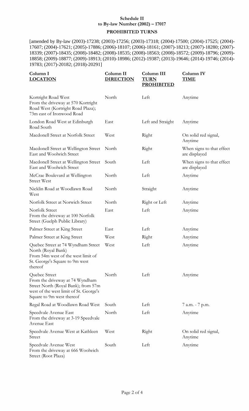
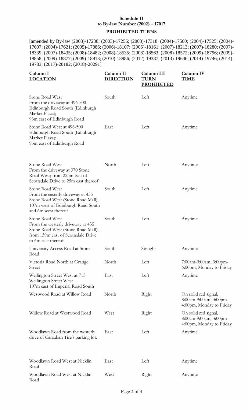
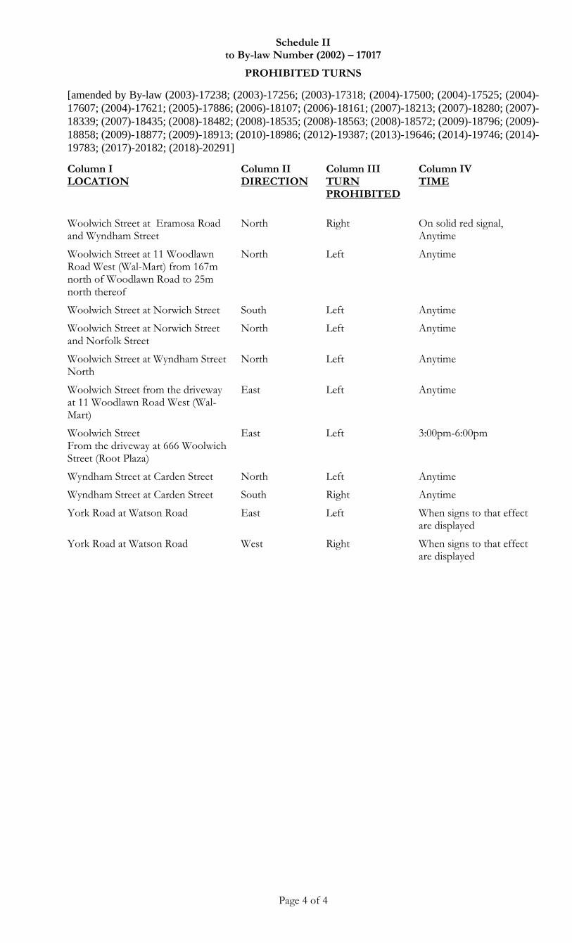
17. (1) Turns are prohibited as set out in Schedule II of this By-law at the times and locations and in the directions set out therein.
(2) When a Traffic Control Device to that effect is displayed, no person proceeding in the direction set out in Column II of Schedule II of this By-law at a location set out in Column I of such Schedule shall turn a vehicle in the direction set out in Column III at the time indicated in Column IV of such Schedule.
(2014)-19687
18. (1) When a Traffic Control Device to that effect is displayed, no person shall operate a vehicle under an overhead bridge set out in Schedule XXIX of this By-law when the height of the vehicle or any person or thing on or attached to the vehicle exceeds the height set out in the said Schedule.
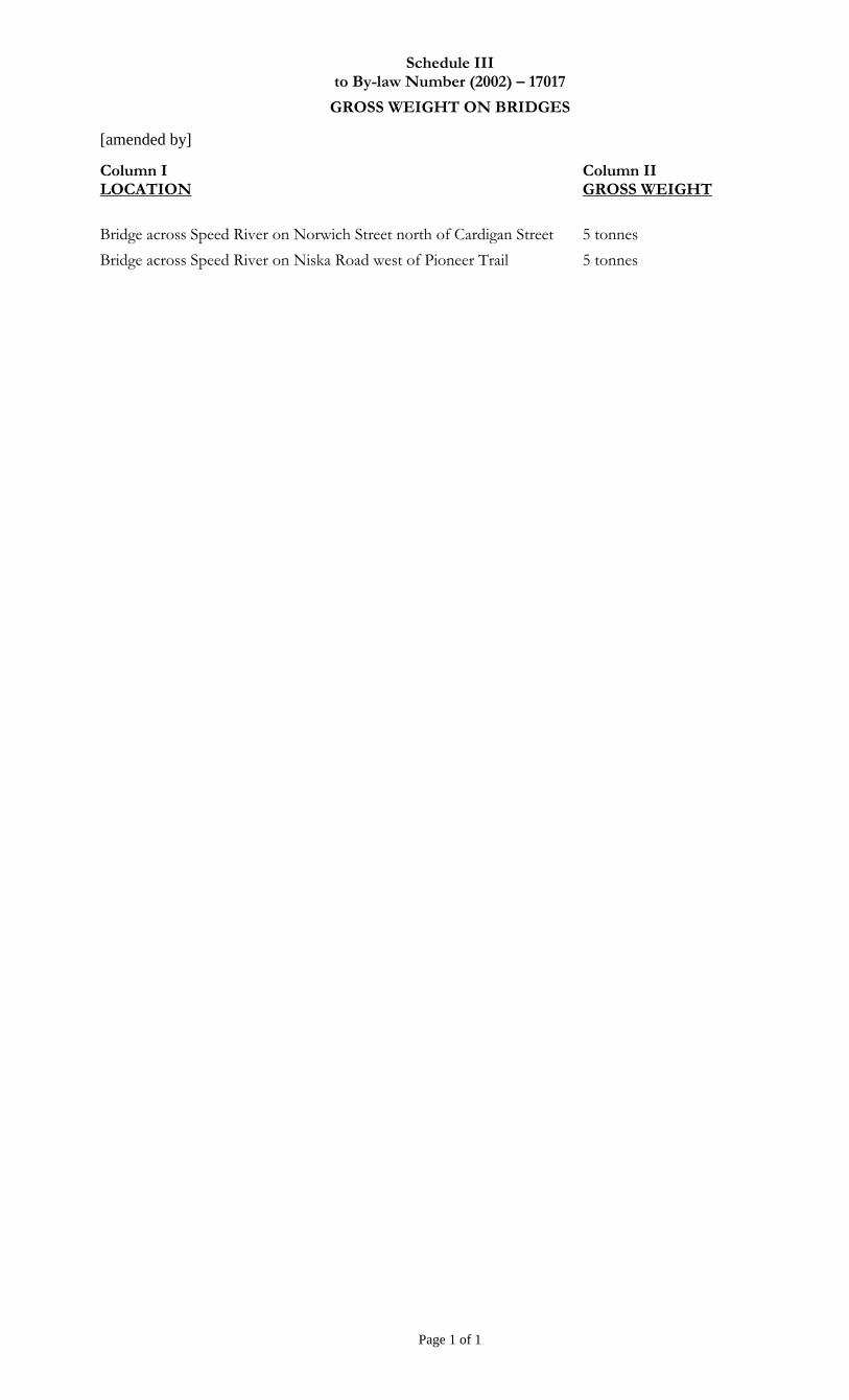
(2) The maximum gross weight of any vehicle permitted on or over any bridge is as set out in Schedule III of this By-law.
(3) When a Traffic Control Device to that effect is displayed, no person shall drive a vehicle on a bridge set out in Column I of Schedule III of this By-law when such vehicle exceeds the maximum weight set out in Column II of Schedule III of this By-law.
19. (1) Designated Bicycle Lanes are hereby established as set out in Schedule IV of this By-law.
(2) Except in accordance with a Traffic Control Device or when necessary to avoid
7
conflict with other Traffic or in compliance with the directions of a Police Officer, no person shall Park any portion of a vehicle, including a bicycle, in a Designated Bicycle Lane.
(3) Except in accordance with Section 34 of this By-law, where a Designated Bicycle Lane set out in Schedule IV of this By-law is marked by a Traffic Control Device, no person shall operate a vehicle other than a Bicycle in any portion of the Designated Bicycle Lane, other than,
(a) for the purpose of ingress to or egress from a private lane or driveway adjacent to the Bicycle Lane;
(b) for the purpose of making a turn at a Highway intersecting the Bicycle Lane;
(c) for the purpose of entering or exiting a curb lane used for Parking; or
(d) for the purpose of actually loading or unloading merchandise or passengers where such activity is otherwise permitted
(4) Every person riding a bicycle on the Highway shall face and move in the direction of vehicular Traffic, and shall travel in the Designated Bicycle Lane or on the finished Shoulder, or where there is no Designated Bicycle Lane or finished Shoulder, as close as is practicable to the right hand Curb.
TRAFFIC CONTROL
20. (1) Every Highway, or portion thereof, set out in Schedule V of this By-law is designated as a through highway for the purposes of the Act.
(2007)-18384 (2) Despite Subsection 20(1) of this By-law, a through highway shall not include any intersection where a traffic control signal, an all-way stop or roundabout are installed.
21. The installation of traffic control signals is hereby authorized at the locations set out in Schedule VI of this By-law.
22. The designation of lanes on Highways to indicate the permitted direction of travel within such lanes are as set out in Schedule VII of this By-law for the Highways set out therein.
23. (1) The installation of Yield Right of Way signs is hereby authorized at the locations set out in Schedule VIII of this By-law.
(2007)-18384 (2) In addition subsection 23(1), the installation of Yield Right of Way signs is hereby authorized at all roundabouts, facing the traffic entering from any approach to the roundabout.
24. The installation of All-Way Stop Signs is hereby authorized at the locations set out in Schedule IX of this By-law.
25. The installation of pedestrian crossovers is hereby authorized at the locations set out in Schedule X of this By-law.
26. Every Highway, or portion thereof, set out in Schedule XI of this By-law is hereby designated for one-way traffic for vehicles to move only in the direction set out in such Schedule.
8
27. The rate of speed permitted on the Highways, or portions thereof, set out in Schedule XII of this By-law is as indicated therein.
HEAVY TRUCKS
28. (1) The Highways and portions of Highways indicated in Schedule XIII of this By-law are hereby designated as permissive truck routes during the times set out therein.
(2) When Traffic Control Devices indicating that permissive truck routing is in effect are displayed, no person shall move, drive or operate a Heavy Truck as defined in Section 1 of this By-law on any Highway or portion of Highway, at any time, other than as expressly permitted in Schedule XIII of this By-law.
(2004)-17428 (3) (a) Subject to subsection 28(3)(b), subsection 28(2) of this By-law shall not apply to any vehicle engaged in the provision of goods or services to any premises in the City of Guelph, while travelling to or returning from such premises.
(b) Where a Highway or portion thereof is a permissive truck route during restricted hours, as set out in Schedule XIII of this By-law, such Highway or portion thereof may be used outside of permitted hours by a Heavy Truck engaged in the provision of goods or services to a premises only if the premises is located directly on the Highway or portion thereof or can only be reached through the use of the Highway or portion thereof, and provided that the Highway or portion thereof is travelled only in so far as is unavoidable in getting to and from such premises.
(2004)-17428 (4) Subsection 28(2) of this By-law shall not apply to a privately owned commercial vehicle being driven to or from the residence of the owner or operator, where such residence is located within the City of Guelph, or to any authorized vehicle being driven to or from,
(i) an area where Heavy Truck parking is permitted by the City; or
(ii) any other parking area where Heavy Truck parking is permitted under the City of Guelph Zoning By-law (1995)-14864, as amended from time to time, or any successor thereof
if the residence or parking area in question cannot be reached except through the use of a Highway or portion of Highway not expressly permitted in Schedule XIII, and provided that the said Highway or portion thereof is travelled only in so far as is unavoidable in getting to and from such premises.
(5) No person shall Park a heavy truck on any Highway between 8:00 p.m. of one day and 6:00 a.m. of the next day.
HALF LOADS
29. (1) During the period from the first day of March to the thirtieth day of April inclusive in each calendar year, half load restrictions may be implemented on the Highways set out in Column I of Schedule XIV of this By-law between the locations set out in Columns II and III of Schedule XIV of this By-law.
(2) When a Traffic Control Device to that effect is displayed in respect of a portion of Highway set out in Schedule XIV, half load restrictions are in effect on such portion of Highway, and no person shall operate a vehicle on such portion of Highway in excess of the half load restriction.
9
PEDESTRIAN REGULATIONS
30. (1) Except where a Traffic Control Device indicates that a Pedestrian may cross, where a Pedestrian is lawfully within a crosswalk as set out Subsection 144(7) of the Act, or where a Pedestrian is directed to proceed by a Police Officer controlling Traffic, every Pedestrian crossing a Highway, at any place other than a pedestrian crossover, shall yield the right-of-way to all vehicles upon such Highway.
(2) Notwithstanding subsection 30(1), every driver shall take all reasonable care to avoid a collision with a Pedestrian.
(2006)-18047 (3) Notwithstanding any other provision of this By-law, when a Traffic Control Device to that effect is displayed, no person shall at any time cross at or upon the intersection listed in Column I of Schedule XXVII to this By-law in the crossing set out Column II therein
31. No Pedestrian shall proceed over, under or around any barrier installed on a Highway or part of a Highway.
32. No person shall play or take part in any game, sport, activity or the like upon any Highway, without authority to do so from the City.
33. (1) Except as set out in Sections 33(2), 34 and 35, no person shall ride by means of In-line Skates, a Skateboard, or a Non-Motorized Scooter, or ride in or by means of any other coaster, toy vehicle, or by similar device upon any Roadway, Sidewalk, or any other portion of a Highway, or within St. George’s Square or upon any other City property without authority to do so from the City.
(2) Despite Subsection 33(1) of this By-law, the use of Skateboards, In-line Skates and Non-Motorized Scooters is permitted in any park within the City of Guelph, except on any object including a bench, raised Curb, play equipment or the like and except in any area set aside for use as a tennis court, swimming pool or parking lot.
IN-LINE SKATING
34. (1) In-line Skating is permitted on Highways within the City of Guelph, only as set out in this Section.
(2) “Designated Bicycle Lane Extension” means that part of a Highway at an intersection that is included within the connections of the lateral lines of the Designated Bicycle Lanes on opposite sides of the Highway, measured from the edges of the Roadway.
(3) Every person In-line Skating on any Highway or portion thereof shall, at all times,
(a) exercise due care and attention to his or her safety;
(b) skate in a manner and at a speed appropriate to the surface being skated upon; and
(c) exercise due care and attention to the safety of all other users of the Highway.
(4) No person shall In-line Skate on any portion of a Highway set out in Schedule XXIV of this By-law, unless within the Designated Bicycle Lane, on the finished Shoulder or on the Sidewalk. If on any such portion of a Highway there is no Designated Bicycle Lane, finished Shoulder or Sidewalk, In-line Skating is prohibited at that
10
point.
(5) (a) Subject to Subsections 34(9) and (10), an In-line Skater legally upon a Highway, including a portion of a Highway set out in Schedule XXIV of this By-law, may cross such Highway or an intersecting Highway,
(i) within a crosswalk;
(ii) within a pedestrian crossover;
(iii) within a Designated Bicycle Lane Extension; or
(iv) at a location other than a crosswalk, pedestrian crossover or Designated Bicycle Lane Extension, only after ensuring that it is safe to do so.
(b) Notwithstanding clause (a), every driver of a vehicle shall take all reasonable care to avoid a collision with an In-line Skater crossing a Highway.
(6) No person shall In-line Skate on any Highway in such a manner so as to cause any damage to public or private property.
(7) Every person In-line Skating on a Highway shall,
(a) at all times wear a Canadian Standards Association (CSA) approved helmet appropriate for In-line Skating, with the chin strap securely fastened; and
(b) at all times between dusk and dawn wear reflective materials that are visible from both the front and back of the person and that are at least 24 millimetres wide by 250 millimetres long;
(8) Every person In-line Skating, other than on a Sidewalk, shall move in the direction of vehicular Traffic, and shall travel in the Designated Bicycle Lane or on the finished Shoulder, or where there is no Designated Bicycle Lane or finished Shoulder, travel as close as is practicable to the right hand Curb;
(9) Every person In-line Skating on a Roadway, in a Designated Bicycle Lane or on a finished Shoulder shall,
(a) obey all Traffic Control Devices;
(b) when stopped at a stop sign, yield the right-of-way to all other Traffic on the Roadway and proceed only when it is safe to do so;
(c) when being overtaken by another user of the Roadway, Designated Bicycle Lane or paved Shoulder that is travelling at a greater speed than such person, turn out to the right and allow the other user to pass;
(d) when turning to the left or right or stopping, clearly signal such movement by using the appropriate hand signals as set out in the Act; and
(e) when making a left turn, use only a Designated Bicycle Lane Extension or combination of Designated Bicycle Lane Extensions, a crosswalk or a pedestrian crossover.
(10) Every person In-line Skating on a Sidewalk shall,
11
(a) come to a complete stop before entering any Roadway, proceeding only when it is safe to do so;
(b) obey all pedestrian control signals; and
(c) at all times yield the right-of-way to Pedestrians using the Sidewalk; and
(11) Nothing in this Section relieves an In-line Skater from complying with the provisions of the Act.
SKATEBOARDS AND NON-MOTORIZED SCOOTERS
35. (1) The riding of Skateboards and Non-Motorized Scooters is permitted on Sidewalks within the City of Guelph, only as set out in this Section.
(2) No person shall ride a Skateboard or Non-Motorized Scooter on any Sidewalk designated in Schedule XXV of this By-law.
(3) Every person who is riding a Skateboard or Non-Motorized Scooter on any Sidewalk shall, at all times,
(a) exercise due care and attention to his or her safety;
(b) travel in a manner and at a speed appropriate to the surface being travelled upon; and
(c) exercise due care and attention to the safety of all other users of the Sidewalk.
(4) Every person riding a Skateboard or Non-Motorized Scooter on a Sidewalk shall come to a complete stop and disembark from the Skateboard or Non-Motorized Scooter prior to entering any Roadway.
(5) No person shall ride a Skateboard or Non-Motorized Scooter on any Sidewalk in such a manner so as to cause any damage to public or private property.
(6) Any person riding a Skateboard or Non-Motorized Scooter on a Sidewalk shall,
(a) at all times wear a Canadian Standards Association (CSA) approved helmet appropriate for Skateboarding or the riding of a Non-Motorized Scooter, as the case may be, with the chin strap securely fastened;
(b) at all times between dusk and dawn wear reflective materials that are visible from both the front and back of the person and that are at least 24 millimetres wide by 250 millimetres long;
(c) travel as close as is practicable to the right-hand side of the Sidewalk, having regard to their direction of travel; and
(d) at all times yield the right-of-way to Pedestrians.
(7) Without limiting the generality of Subsection (3), no person shall engage in any of the following activities while riding a Skateboard or Non-Motorized Scooter on any Sidewalk:
(a) vaulting from a ramp or other object;

12
(b) using any object to move over, under, on, in or around for a recreational purpose;
(c) dismounting from a Skateboard or Non-Motorized Scooter in an unsafe manner;
(d) riding the Skateboard or Non-Motorized Scooter in such a manner so as to permit or cause it to leave the ground; or
(e) moving erratically from side to side.
(8) No person shall place on any Sidewalk any object that is intended to be used to ride a Skateboard or Non-Motorized Scooter over, under, on, in or around.
(9) Every person riding a Skateboard or a Non-Motorized Scooter on a Sidewalk shall ensure that such Skateboard or Non-Motorized Scooter does not enter into the Roadway.
NO PARKING ZONES
36. (1) “No Parking Zones” are hereby established prohibiting Parking at the times and locations set out in Schedule XV of this By-law.
(2008)-18482 (2) When a Traffic Control Device to that effect is displayed, no person shall Park any portion of a vehicle at a location set out in Columns I, II and III of Schedule XV of this By-law at the time set out in Column IV of Schedule XV of this By-law, or Park any portion of a vehicle in a No Parking Zone set out in Subsection 36(3) of this By-law, except when necessary to avoid conflict with other Traffic or in compliance with a temporary Traffic Control Device, or the directions of a Police Officer.
(2003)-17226 (3) “No Parking Zones” are further established as follows:
(a) At the times and locations set out in clauses 54 (1) (a), (b), (c), (d), (e), (f), (g), (h), (i), (j) and (k) of this Bylaw.
(b) At stands for taxi cabs established pursuant to Subsection 42(1) of this By-law, except for vehicles authorized by the city pursuant to Section 42 of this By-law
(c) In School Bus Loading Zones established pursuant to Section 53 of this By-law, except for school buses
(d) At the locations set out in Clauses 56(1)(a), (b), (c), (d), (e), (f), (g), (h), (i) and (j) of this By-law.
(2003)-17226 (4) When a Traffic Control Device to that effect is posted, no person shall Park any portion of a vehicle in a No Parking Zone set out in Subsection 36(3) of this By-law, unless in accordance with an exception set out in Subsection 36(3)(b) or (c), or when necessary to avoid conflict with other Traffic or in compliance with a temporary Traffic Control Device or the directions of a Police Officer.
NO STOPPING ZONES
37. (1) “No Stopping Zones” are hereby established prohibiting Stopping at the times and locations set out in Schedule XVI of this By-law.
(2008)-18482 (2) When a Traffic Control Device to that effect is displayed, no person shall Stop any
13
portion of a vehicle at a location set out in Columns I, II and III of Schedule XVI of this By-law at the time set out in Column IV of Schedule XVI of this By-law, or Stop any portion of a vehicle in a No Stopping Zone set out in Subsection 37(3) of this By-law, except when necessary to avoid conflict with other Traffic or in compliance with a temporary Traffic Control Device or the directions of a Police Officer.
(2003)-17226 (3) “No Stopping Zones” are further established as follows:
(a) At the times and locations set out in Clauses 54(1)(a), (b), (c), (d), (e), (f), (g), (h), (i), (j) and (k) of this By-law
(b) At stands for taxi cabs established pursuant to Subsection 42(1) of this By-law, except for vehicles authorized by the City pursuant to Section 42 of this By-law
(c) In School Bus Loading Zones established pursuant to Section 53 of this By-law, except for school buses
(d) At the locations set out in Clauses 56(1)(a), (b), (c), (d), (e), (f), (g), (h), (i) and (j) of this By-law.
(2003)-17226 (4) When a Traffic Control Device to that effect is posted, no person shall Stop any portion of a vehicle in a No Stopping Zone set out in Subsection 37(3) of this By-law, unless in accordance with an exception set out in Subsection 37(3)(b) or (c), or when necessary to avoid conflict with other Traffic or in compliance with a temporary Traffic Control Device or the directions of a Police Officer.
(2003)-17111
(2003)-17262 (5) “Disabled Permit Stopping Zones” are hereby established at the times and locations set out in Schedule XVI-A of this By-law.
(2003)-17111
(2003)-17262 (6) Subject to subsection (7), when a Traffic Control Device to that effect is displayed, no person shall Stop any portion of a vehicle at a location set out in Columns I, II and III of Schedule XVI-A of this By-law at any time set out in Column IV of the said Schedule, except when a valid permit issued to a physically disabled person by the Ontario Ministry of Transportation is properly displayed and used in accordance with the provisions of O. Reg. 581/90 and Part III of the Highway Traffic Act relating to disabled permits.
(2003)-17111
(2003)-17262 (7) A person displaying and using a valid permit issued to a physically disabled person by the Ontario Ministry of Transportation in accordance with the provisions of O. Reg. 581/90 and Part III of the Highway Traffic Act relating to disabled permits shall not Stop any portion of a vehicle at a location set out in Columns I, II and III of Schedule XVI-A of this By-law at any time set out in Column IV of the said Schedule for longer than fifteen (15) consecutive minutes.
DURATION RESTRICTED ZONES
38. (1) Parking is limited to the duration of time set out in Schedule XVII of this By-law at the corresponding locations shown therein.
(2003)-17038
(2008)-18482 (2) Unless otherwise provided for by this By-law or so authorized by the City, when a Traffic Control Device to that effect is displayed, no person shall Park any portion of a vehicle on a Highway set out in Column I of Schedule XVII of this By-law at a location set out in Column III of such Schedule on the side of the Highway set out
14
in Column II of such Schedule in excess of the time limit set out at any time indicated in Column IV of such Schedule.
15 MINUTE / PUBLIC LOADING ZONES
(2008)-18482 (2015)-19939
39. Unless so authorized by the City, when a Traffic Control Device to that effect is displayed, no person shall Park any portion of a vehicle on a Highway set out in Column I of Schedule XVIII of this By-law on the side of the Highway set out in Column II of such schedule at a location set out in Column III of such Schedule between the times set out in Column IV of such schedule, for longer than fifteen (15) minutes.
KISS N’ RIDE ZONES
39.A (1) Kiss N’ Ride Zones are hereby established at the locations and times set out in Schedule XXVI of this By-law.
(2008)-18482 (2) Where a Traffic Control Device is displayed indicating a Kiss N’ Ride Zone, no person shall park any portion of a vehicle within such zone for longer than five minutes.
SCHOOL BUS LOADING ZONES
40. When a Traffic Control Device to that effect is posted, School Bus Loading Zones are in effect at the locations set out in Schedule XIX of this By-law.
ANGLE PARKING ZONES
41. (1) Angle parking is in effect as set out in Schedule XX of this By-law.
(2) Where angle parking exists on any Highway or portion thereof in accordance with Schedule XX of this By-law, no person shall Park any portion of a vehicle at that location except at the angle as indicated by road paint markings or, if not indicated by such markings, at a 45 angle from the lateral line of the Curb or, where no Curb exists, the lateral line of the Shoulder.
(3) No person shall park any portion of a vehicle in a Parking Space where angle parking is designated pursuant to Schedule XX of this By-law, without the front end of such vehicle as close to the Curb as is practicable where a raised Curb exists, and as close as is practicable to the furthest limit of the Shoulder beyond the Roadway where a Shoulder exists.
TAXI STANDS
42. (1) Stands for taxi cabs are hereby established as set out in Schedule XXI of this By-law.
(2) Stands for taxi cabs shall be allotted as to location and Parking Space as approved by the City.
(3) Every taxi cab company wishing to use a portion of a Highway as a taxi cab stand shall obtain authority to do so from the City annually and pay the amount of the fee as set by the City for such authorization.
(4) The authority to use a taxi cab stand is subject to compliance with the provisions of this By-law and may be cancelled by the City at any time for infraction of such provisions.
15
(5) Section 57 does not apply to taxi cabs that have been authorized to Park in a taxi stand, provided however that where a taxi cab is Parked in a taxi stand between the hours of 2:00 a.m. and 6:00 a.m., the driver shall move such taxi cab from the taxi stand immediately upon request by the City.
(2003)-17226 (6) No person shall Park or Stop any portion of a vehicle in a stand for a taxi cab, except with the authorization of the City as set out in this Section.
GENERAL STOPPING AND PARKING PROVISIONS
43. (1) No person shall Park any portion of a vehicle on any Highway when such vehicle is leaking any fluid, including but not limited to, oil or gasoline, but not including water from the vehicle’s air-conditioning unit.
(2) Where a vehicle Parked in contravention of Subsection 43(1) leaks any fluid onto any portion of the Highway, the owner of the vehicle shall cause the fluid to cleaned up to the satisfaction of the City.
(3) If the owner of the vehicle fails to comply with Subsection 43(2), the City may, in addition to any other remedy, clean up the fluid at the vehicle owner’s expense, and the City may recover the expense by action or in like manner as municipal taxes.
44. No person shall Stop or Park any portion of a vehicle on any Highway in such a manner, or under such conditions, so as to leave less than 3.0 metres width of the Roadway available for the movement of other Traffic.
45. No person shall Park any portion of a vehicle on any Highway for a period exceeding forty-eight (48) consecutive hours.
46. No person shall Stop or Park any portion of a vehicle on any Highway when such vehicle does not bear valid proper number plates or a corresponding current validation sticker, issued by the Ministry of Transportation of Ontario or an extra-provincial government agency, and registered to such vehicle.
47. No person shall Park any portion of a vehicle in a Parking Space except wholly within the road paint markings for such Parking Space.
(2009)-18877
48. No person shall Park any portion of a vehicle on or over a public or private driveway in any part of a Road Allowance unless authorized by the City.
49. No person shall Stop or Park any portion of a vehicle on any Highway in such a manner so as to obstruct other Traffic.
50. (1) No person shall Stop or Park any portion of a vehicle on any Highway except on the right hand side of such Highway, having regard to the forward direction in which the vehicle was travelling, with the right wheels parallel to and not further than 0.3 metres from the Curb where there is a raised Curb, and with the right wheels parallel to and as near to the right hand limit of the Shoulder as is practicable where a Shoulder exists.
(2) Despite Subsection 50(1) of this By-law, no person shall Stop or Park any portion of a bus in a Bus Stop on any Highway without the right wheels being parallel to and not further than 0.5 metres from the Curb where there is a raised Curb, and with the right wheels parallel to and as near to the right hand limit of the Shoulder as is practicable where a Shoulder exists.
16
(3) Subsection 50(1) of this By-law shall not prevent the Stopping or Parking of a vehicle on the left hand side of a Highway which is designated for one-way traffic pursuant to Schedule XI of this By-law, provided the left wheels of such vehicle are parallel to and not more than 0.3 metres from the Curb where there is a raised Curb, and that the left wheels are parallel to and as near to the left hand limit of the Shoulder as is practicable where a Shoulder exists.
(4) Subsections 50(1) to (3) inclusive of this By-law shall not apply where a Traffic Control Device indicating otherwise has been erected in accordance with this By-law.
51. (1) No person shall Stop any portion of a bus on any Highway at any place other than a Bus Stop, except when authorized by the City or when necessary to avoid conflict with other Traffic or at the direction of a Police Officer or Traffic Control Device.
(2) Subsection 51(1) of this By-law does not apply to a bus operated on behalf of the City.
52. Unless authorized by the City, no person shall Park any portion of a school bus on any Highway at any place other than a School Bus Loading Zone.
53. No person shall Stop any portion of a vehicle, other than a school bus, on any Highway in a location designated by Schedule XIX of this By-law as a School Bus Loading Zone and so indicated by a Traffic Control Device.
54. (1) No person shall Stop or Park any portion of a vehicle, except when necessary to avoid conflict with other Traffic or in compliance with a Traffic Control Device or with the direction of a Police Officer:
(a) on or over a Sidewalk between 6:00 a.m. of one day and 2:00 a.m. of the next day;
(b) on or over a Sidewalk between 2:00 a.m. and 6:00 a.m.;
(c) in front of, or within one (1.0) metre of a public or private driveway or laneway;
(d) within three (3.0) metres of the point on the Curb or edge of the Shoulder adjacent to a fire hydrant;
(2007)-18384 (e) within an intersection, or a roundabout;
(f) within a pedestrian crossover;
(g) within nine (9.0) metres of any intersection;
(h) on a Roadway alongside of any vehicle which is Stopped or Parked at the Curb or edge of a Shoulder of such Roadway;
(i) on any bridge or other elevated structure of a Highway;
(2007)-18384 (j) within fifteen (15.0) metres of a signalized intersection, or a roundabout;
(k) on or over any part of a Highway where grass is growing or is seeded, or where an earth surface exists.
(2) Subsections 54(1)(c), (d), (e), (g) and (j) do not apply where a Parking Space is provided by the City.
17
55. (1) No person shall Stop or Park any portion of a vehicle on any Highway for the purpose of:
(a) washing, greasing or repairing such vehicle, except for repairs necessitated by emergency;
(b) unloading or transferring materials of any kind from one vehicle to another, except in cases of emergency; or
(c) advertising or selling goods without authority to do so from the City.
SIGNED PARKING REGULATIONS
56. (1) Where a Traffic Control Device to that effect is displayed, no person shall Stop or Park any portion of a vehicle on any Highway,
(a) within fifteen (15.0) metres of a non-signalized intersection;
(b) within fifteen (15.0) metres of the nearest rail of the approach to a railroad crossing;
(c) within seven (7.0) metres of a driveway entrance to any fire station on the side of the Highway on which the driveway is located, and, on the side of the Highway opposite such entrance, within 23.0 metres of either side of the point on the Curb or Shoulder of the Highway opposite said entrance;
(d) in front of the entrance to a hotel, theatre, office building or place where goods are regularly delivered or removed;
(2007)-18384 (e) within thirty (30.0) metres of a signalized intersection, or a roundabout;
(f) within thirty (30.0) metres of a pedestrian crossover;
(g) within fifteen (15.0) metres of the point on the Curb or edge of the Shoulder adjacent to the Bus Stop sign, on the side of the Highway on which the Bus Stop is located;
(h) within thirty (30.0) metres of a Pedestrian Crosswalk which is controlled by a Traffic Control Signal;
(i) within fifteen (15.0) metres of a school crosswalk signed with a Traffic Control Device; or
(j) within fifteen (15.0) metres of the termination of a dead end street.
(2009)-18766 (2013)-19592 (2014)-19783 (2015)-19974
57. (1) When a Traffic Control Device to that effect is displayed at each Highway entrance to the City, no person shall Park any portion of a vehicle on or over any Highway between the hours of 2:00 a.m. and 6:00 a.m. from the 1st day of December in each calendar year until the 31st day of March in the next calendar year inclusive.
(2) Subsection 57(1) of this By-law does not apply to a vehicle that is exempted by the City.
18
(3) Subsection 57(1) of this By-law does not apply to a portion of a Highway at a location set out in Schedule XXII of this By-law that is not part of a Guelph Transit Bus Route and when a Traffic Control Device is displayed permitting Parking between 2:00 a.m. and 6:00 a.m. on such portion of Highway, provided that such Parking is carried out in accordance with the Traffic Control Device.
(4) The Executive Director may declare a temporary Parking ban at any time on any portion of any Highway within the City.
(5) Notwithstanding any other provision of this By-law, that permits the Parking of a vehicle on a Highway, when a Temporary Parking ban has been declared, no person shall Park a vehicle or permit a vehicle to remain parked on any portion of a Highway included in the ban.
PARKING METER ZONES
58. (1) “Parking Meter Zones” are hereby established as set out in Schedule XXIII of this By-law, including the location of the Parking Meters, the maximum duration of such Parking Meters and the rate to be deposited in such Parking Meters to cover the length of time a vehicle is Parked in a corresponding Parking Space.
(2) Every Parking Meter within a Parking Meter Zone is in effect during the days and times set out on such meter, which days and times shall be in accordance with Schedule XXIII of this By-law.
(3) No person shall Stop or Park any portion of a vehicle on a Highway in any Parking Space located in a Parking Meter Zone and equipped with a Parking Meter,
(a) without setting the Parking Meter into operation, such that the expiry signal is not visible, by depositing a Coin of Recognized Currency into such meter in the amount sufficient to cover the duration of time that the vehicle is to be Stopped or Parked in such Parking Space; or
(b) in accordance the terms and conditions of a parking permit issued by the City for that location.
(4) Section 47 of this By-law shall not apply in a Parking Meter Zone to any vehicle which is of a size too large to be Parked wholly within a single Parking Space, provided that the Parking Meter corresponding to each Parking Space occupied, or partially occupied, is placed into operation as required in Subsection 58(3) of this By-law.
(5) No person shall Park any portion of a vehicle on a Highway in any Parking Space located in a Parking Meter Zone and equipped with a Parking Meter, for a consecutive period of time longer than the maximum period of time permitted on such Parking Meter in accordance with Schedule XXIII of this By-law, irrespective of the amount of Coin of Recognized Currency deposited in such Parking Meter or the number of times a person deposits a Coin of Recognized Currency in such Parking Meter.
(6) No person shall deposit or attempt to deposit in any Parking Meter any other coin or substance other than a Coin of Recognized Currency.
(7) Within a Parking Meter Zone, no person shall Stop or Park any portion of a vehicle in a metered Parking Space when such Parking Meter is covered, unless so authorized by the City.
19
OFFENCE
59. Every person who contravenes any provision of this By-law is guilty of an offence.
60. The owner of a vehicle that is found Parked or Stopped in contravention of this By-law is guilty of an offence and, upon conviction, shall be subject to the governing penalties, unless the owner of a vehicle proves to the Court that, at the time of the offence, the vehicle was in the possession of another person without the owner’s consent, express or implied.
PENALTIES
61. Every person who is convicted of an offence under any provision of this By-law shall be liable to a penalty as set out in Section 61 of the Provincial Offences Act, R.S.O. 1990, Chapter P.33, as amended from time to time, or any successor thereof.
REMOVAL OF VEHICLE
62 (1) Where a vehicle is found Parked or Stopped in contravention of this By-law, a By-law Enforcement Officer or Police Officer may cause the vehicle to be moved or taken to and placed or stored in a suitable place and all costs and charges for this removal and for any care and storage of the vehicle, are a lien upon the vehicle, which may be enforced in the manner provided by the Repair and Storage Liens Act.
(2008)-18572 (2) Without limiting Subsection 62(1) of Subsection 2(4) of this By-law, where a vehicle is found Parked or Stopped in contravention of subsection 2(4)(i) of this By-law, and:
(i) was Parked or Stopped in that location prior to the posting of a Traffic Control Device to indicate that Parking or Stopping is prohibited; and
(2008)-18572 (ii) the Owner of the vehicle has not been located so as to request the Owner to remove the vehicle, or a By-law Enforcement Officer or Police Officer determines that it is impractical to attempt to locate the Owner of the vehicle in the circumstances,
(2008)-18572 a By-law Enforcement Officer or Police Officer may cause the vehicle to be moved to a location in reasonable proximity, on-street or in a City owned facility, where the vehicle will not contravene the said provisions and where parking is permitted. No fee shall be charged to the Owner for said removal.
EARLY PAYMENT FOR PARKING INFRACTION NOTICES
63. Where a Parking Infraction Notice is issued in respect of an offence committed under this By-law, the Executive Director or any person designated by him or her to accept such payments on behalf of the City may, within seven (7) calendar days of the date indicated on the Parking Infraction Notice, accept a lesser fine payment than the Set Fine amount, which payment shall be deemed to be an Early Payment of the penalty in full satisfaction of the offence, and a receipt therefore shall be given to the person making payment.
SCHEDULES FORM PART OF BY-LAW
64. All Schedules shall form part of this By-law.
EFFECTIVE DATE OF BY-LAW
65. (1) This By-law shall come into effect at 12:01 a.m. on March 1, 2003 or when the set fines have been approved by the Regional Senior Justice of the Peace, whichever
20
occurs first.
(2) Notwithstanding Subsection 65(1), those provisions requiring approval by the Ministry of Transportation of Ontario in accordance with Section 195 of the Act shall not come into effect until such approval has been granted by the Ministry.
66. Notwithstanding Section 65, Section 67 of this By-law shall come into effect immediately.
PRIOR BY-LAWS REPEALED
67. By-law Number (2002)-16991 and all amendments thereto are hereby repealed.
68. By-law Number (1979)-10208 and all amendments thereto are hereby repealed as of the date that this By-law comes into effect in accordance with Section 65.
MUNICIPAL CODE AMENDMENT
69. This By-law is hereby adopted as Municipal Code Amendment #284.
PASSED THIS SIXTEENTH DAY OF DECEMBER, 2002.
KAREN FARBRIDGE - MAYOR
LOIS A. GILES – CLERK
[Last Updated – July 25, 2016]
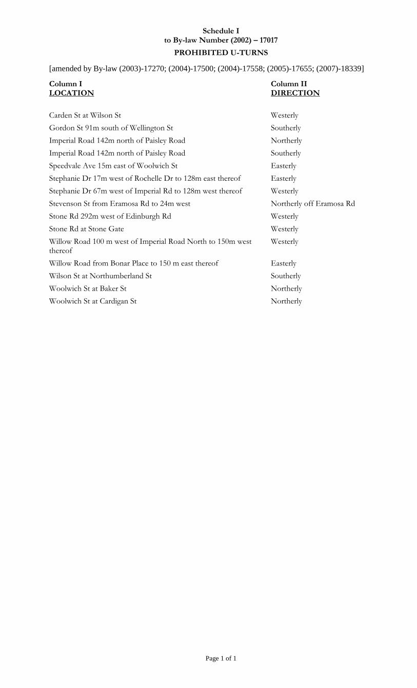
Schedule I to By-law Number (2002) – 17017
PROHIBITED U-TURNS
[amended by By-law (2003)-17270; (2004)-17500; (2004)-17558; (2005)-17655; (2007)-18339]
Page 1 of 1
Column I LOCATION
Column II DIRECTION
Carden St at Wilson St Westerly
Gordon St 91m south of Wellington St Southerly
Imperial Road 142m north of Paisley Road Northerly
Imperial Road 142m north of Paisley Road Southerly
Speedvale Ave 15m east of Woolwich St Easterly
Stephanie Dr 17m west of Rochelle Dr to 128m east thereof Easterly
Stephanie Dr 67m west of Imperial Rd to 128m west thereof Westerly
Stevenson St from Eramosa Rd to 24m west Northerly off Eramosa Rd
Stone Rd 292m west of Edinburgh Rd Westerly
Stone Rd at Stone Gate Westerly
Willow Road 100 m west of Imperial Road North to 150m west thereof
Westerly
Willow Road from Bonar Place to 150 m east thereof Easterly
Wilson St at Northumberland St Southerly
Woolwich St at Baker St Northerly
Woolwich St at Cardigan St Northerly
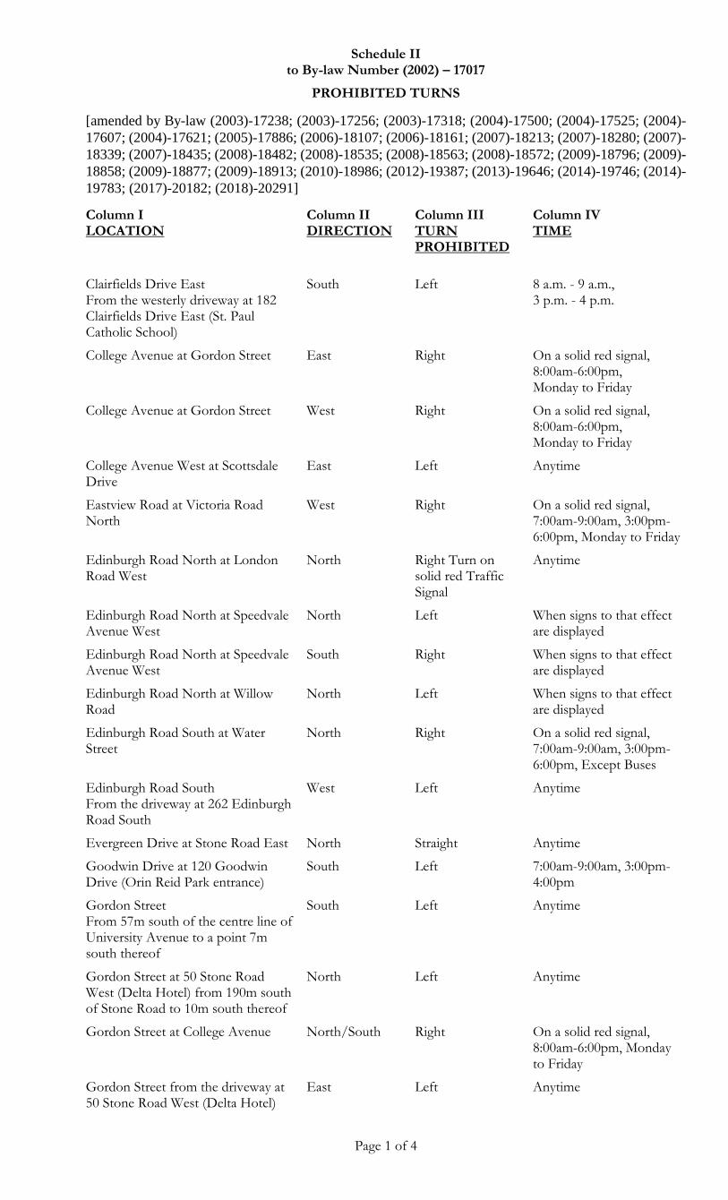
Schedule II to By-law Number (2002) – 17017
PROHIBITED TURNS
[amended by By-law (2003)-17238; (2003)-17256; (2003)-17318; (2004)-17500; (2004)-17525; (2004)-
17607; (2004)-17621; (2005)-17886; (2006)-18107; (2006)-18161; (2007)-18213; (2007)-18280; (2007)-
18339; (2007)-18435; (2008)-18482; (2008)-18535; (2008)-18563; (2008)-18572; (2009)-18796; (2009)-
18858; (2009)-18877; (2009)-18913; (2010)-18986; (2012)-19387; (2013)-19646; (2014)-19746; (2014)-
19783; (2017)-20182; (2018)-20291]
Page 1 of 4
Column I LOCATION
Column II DIRECTION
Column III TURN PROHIBITED
Column IV TIME
Clairfields Drive East From the westerly driveway at 182 Clairfields Drive East (St. Paul Catholic School)
South Left 8 a.m. - 9 a.m., 3 p.m. - 4 p.m.
College Avenue at Gordon Street East Right On a solid red signal, 8:00am-6:00pm, Monday to Friday
College Avenue at Gordon Street West Right On a solid red signal, 8:00am-6:00pm, Monday to Friday
College Avenue West at Scottsdale Drive
East Left Anytime
Eastview Road at Victoria Road North
West Right On a solid red signal, 7:00am-9:00am, 3:00pm-6:00pm, Monday to Friday
Edinburgh Road North at London Road West
North Right Turn on solid red Traffic Signal
Anytime
Edinburgh Road North at Speedvale Avenue West
North Left When signs to that effect are displayed
Edinburgh Road North at Speedvale Avenue West
South Right When signs to that effect are displayed
Edinburgh Road North at Willow Road
North Left When signs to that effect are displayed
Edinburgh Road South at Water Street
North Right On a solid red signal, 7:00am-9:00am, 3:00pm-6:00pm, Except Buses
Edinburgh Road South From the driveway at 262 Edinburgh Road South
West Left Anytime
Evergreen Drive at Stone Road East North Straight Anytime
Goodwin Drive at 120 Goodwin Drive (Orin Reid Park entrance)
South Left 7:00am-9:00am, 3:00pm-4:00pm
Gordon Street From 57m south of the centre line of University Avenue to a point 7m south thereof
South Left Anytime
Gordon Street at 50 Stone Road West (Delta Hotel) from 190m south of Stone Road to 10m south thereof
North Left Anytime
Gordon Street at College Avenue North/South Right On a solid red signal, 8:00am-6:00pm, Monday to Friday
Gordon Street from the driveway at 50 Stone Road West (Delta Hotel)
East Left Anytime
Schedule II to By-law Number (2002) – 17017
PROHIBITED TURNS
[amended by By-law (2003)-17238; (2003)-17256; (2003)-17318; (2004)-17500; (2004)-17525; (2004)-
17607; (2004)-17621; (2005)-17886; (2006)-18107; (2006)-18161; (2007)-18213; (2007)-18280; (2007)-
18339; (2007)-18435; (2008)-18482; (2008)-18535; (2008)-18563; (2008)-18572; (2009)-18796; (2009)-
18858; (2009)-18877; (2009)-18913; (2010)-18986; (2012)-19387; (2013)-19646; (2014)-19746; (2014)-
19783; (2017)-20182; (2018)-20291]
Page 2 of 4
Column I LOCATION
Column II DIRECTION
Column III TURN PROHIBITED
Column IV TIME
Kortright Road West From the driveway at 570 Kortright Road West (Kortright Road Plaza); 73m east of Ironwood Road
North Left Anytime
London Road West at Edinburgh Road South
East Left and Straight Anytime
Macdonell Street at Norfolk Street West Right On solid red signal, Anytime
Macdonell Street at Wellington Street East and Woolwich Street
North Right When signs to that effect are displayed
Macdonell Street at Wellington Street East and Woolwich Street
South Left When signs to that effect are displayed
McCrae Boulevard at Wellington Street West
North Left Anytime
Nicklin Road at Woodlawn Road West
North Straight Anytime
Norfolk Street at Norwich Street North Right or Left Anytime
Norfolk Street From the driveway at 100 Norfolk Street (Guelph Public Library)
East Left Anytime
Palmer Street at King Street East Left Anytime
Palmer Street at King Street West Right Anytime
Quebec Street at 74 Wyndham Street North (Royal Bank) From 54m west of the west limit of St. George's Square to 9m west thereof
West Left Anytime
Quebec Street From the driveway at 74 Wyndham Street North (Royal Bank); from 57m west of the west limit of St. George's Square to 9m west thereof
North Left Anytime
Regal Road at Woodlawn Road West South Left 7 a.m. - 7 p.m.
Speedvale Avenue East From the driveway at 3-19 Speedvale Avenue East
North Left Anytime
Speedvale Avenue West at Kathleen Street
West Right On solid red signal, Anytime
Speedvale Avenue West From the driveway at 666 Woolwich Street (Root Plaza)
South Left Anytime
Schedule II to By-law Number (2002) – 17017
PROHIBITED TURNS
[amended by By-law (2003)-17238; (2003)-17256; (2003)-17318; (2004)-17500; (2004)-17525; (2004)-
17607; (2004)-17621; (2005)-17886; (2006)-18107; (2006)-18161; (2007)-18213; (2007)-18280; (2007)-
18339; (2007)-18435; (2008)-18482; (2008)-18535; (2008)-18563; (2008)-18572; (2009)-18796; (2009)-
18858; (2009)-18877; (2009)-18913; (2010)-18986; (2012)-19387; (2013)-19646; (2014)-19746; (2014)-
19783; (2017)-20182; (2018)-20291]
Page 3 of 4
Column I LOCATION
Column II DIRECTION
Column III TURN PROHIBITED
Column IV TIME
Stone Road West From the driveway at 496-500 Edinburgh Road South (Edinburgh Market Plaza); 93m east of Edinburgh Road
South Left Anytime
Stone Road West at 496-500 Edinburgh Road South (Edinburgh Market Plaza); 93m east of Edinburgh Road
East Left Anytime
Stone Road West From the driveway at 370 Stone Road West; from 225m east of Scottsdale Drive to 25m east thereof
North Left Anytime
Stone Road West From the easterly driveway at 435 Stone Road West (Stone Road Mall); 107m west of Edinburgh Road South and 6m west thereof
South Left Anytime
Stone Road West From the westerly driveway at 435 Stone Road West (Stone Road Mall); from 139m east of Scottsdale Drive to 6m east thereof
South Left Anytime
University Access Road at Stone Road
South Straight Anytime
Victoria Road North at Grange Street
North Left 7:00am-9:00am, 3:00pm-6:00pm, Monday to Friday
Wellington Street West at 715 Wellington Street West 107m east of Imperial Road South
East Left Anytime
Westwood Road at Willow Road North Right On solid red signal, 8:00am-9:00am, 3:00pm-4:00pm, Monday to Friday
Willow Road at Westwood Road West Right On solid red signal, 8:00am-9:00am, 3:00pm-4:00pm, Monday to Friday
Woodlawn Road from the westerly drive of Canadian Tire's parking lot.
East
Left Anytime
Woodlawn Road West at Nicklin Road
East Left Anytime
Woodlawn Road West at Nicklin Road
West Right Anytime
Schedule II to By-law Number (2002) – 17017
PROHIBITED TURNS
[amended by By-law (2003)-17238; (2003)-17256; (2003)-17318; (2004)-17500; (2004)-17525; (2004)-
17607; (2004)-17621; (2005)-17886; (2006)-18107; (2006)-18161; (2007)-18213; (2007)-18280; (2007)-
18339; (2007)-18435; (2008)-18482; (2008)-18535; (2008)-18563; (2008)-18572; (2009)-18796; (2009)-
18858; (2009)-18877; (2009)-18913; (2010)-18986; (2012)-19387; (2013)-19646; (2014)-19746; (2014)-
19783; (2017)-20182; (2018)-20291]
Page 4 of 4
Column I LOCATION
Column II DIRECTION
Column III TURN PROHIBITED
Column IV TIME
Woolwich Street at Eramosa Road and Wyndham Street
North Right On solid red signal, Anytime
Woolwich Street at 11 Woodlawn Road West (Wal-Mart) from 167m north of Woodlawn Road to 25m north thereof
North Left Anytime
Woolwich Street at Norwich Street South Left Anytime
Woolwich Street at Norwich Street and Norfolk Street
North Left Anytime
Woolwich Street at Wyndham Street North
North Left Anytime
Woolwich Street from the driveway at 11 Woodlawn Road West (Wal-Mart)
East Left Anytime
Woolwich Street From the driveway at 666 Woolwich Street (Root Plaza)
East Left 3:00pm-6:00pm
Wyndham Street at Carden Street North Left Anytime
Wyndham Street at Carden Street South Right Anytime
York Road at Watson Road East Left When signs to that effect are displayed
York Road at Watson Road West Right When signs to that effect are displayed
Schedule III to By-law Number (2002) – 17017
GROSS WEIGHT ON BRIDGES
[amended by]
Page 1 of 1
Column I LOCATION
Column II GROSS WEIGHT
Bridge across Speed River on Norwich Street north of Cardigan Street 5 tonnes
Bridge across Speed River on Niska Road west of Pioneer Trail 5 tonnes
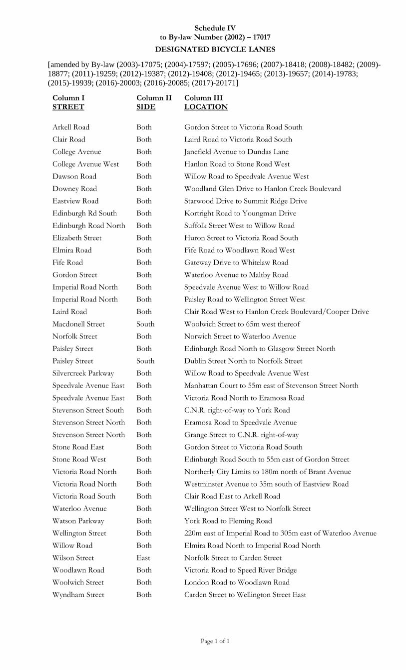
Schedule IV to By-law Number (2002) – 17017
DESIGNATED BICYCLE LANES
[amended by By-law (2003)-17075; (2004)-17597; (2005)-17696; (2007)-18418; (2008)-18482; (2009)-
18877; (2011)-19259; (2012)-19387; (2012)-19408; (2012)-19465; (2013)-19657; (2014)-19783;
(2015)-19939; (2016)-20003; (2016)-20085; (2017)-20171]
Page 1 of 1
Column I STREET
Column II SIDE
Column III LOCATION
Arkell Road
Clair Road
Both
Both
Gordon Street to Victoria Road South
Laird Road to Victoria Road South
College Avenue
College Avenue West
Dawson Road
Downey Road
Eastview Road
Both
Both
Both
Both
Both
Janefield Avenue to Dundas Lane
Hanlon Road to Stone Road West
Willow Road to Speedvale Avenue West
Woodland Glen Drive to Hanlon Creek Boulevard
Starwood Drive to Summit Ridge Drive
Edinburgh Rd South
Edinburgh Road North
Both
Both
Kortright Road to Youngman Drive
Suffolk Street West to Willow Road
Elizabeth Street Both Huron Street to Victoria Road South
Elmira Road Both Fife Road to Woodlawn Road West
Fife Road Both Gateway Drive to Whitelaw Road
Gordon Street Both Waterloo Avenue to Maltby Road
Imperial Road North Both Speedvale Avenue West to Willow Road
Imperial Road North Both Paisley Road to Wellington Street West
Laird Road Both Clair Road West to Hanlon Creek Boulevard/Cooper Drive
Macdonell Street South Woolwich Street to 65m west thereof
Norfolk Street Both Norwich Street to Waterloo Avenue
Paisley Street Both Edinburgh Road North to Glasgow Street North
Paisley Street South Dublin Street North to Norfolk Street
Silvercreek Parkway Both Willow Road to Speedvale Avenue West
Speedvale Avenue East Both Manhattan Court to 55m east of Stevenson Street North
Speedvale Avenue East Both Victoria Road North to Eramosa Road
Stevenson Street South Both C.N.R. right-of-way to York Road
Stevenson Street North Both Eramosa Road to Speedvale Avenue
Stevenson Street North Both Grange Street to C.N.R. right-of-way
Stone Road East Both Gordon Street to Victoria Road South
Stone Road West Both Edinburgh Road South to 55m east of Gordon Street
Victoria Road North Both Northerly City Limits to 180m north of Brant Avenue
Victoria Road North Both Westminster Avenue to 35m south of Eastview Road
Victoria Road South Both Clair Road East to Arkell Road
Waterloo Avenue Both Wellington Street West to Norfolk Street
Watson Parkway Both York Road to Fleming Road
Wellington Street Both 220m east of Imperial Road to 305m east of Waterloo Avenue
Willow Road
Wilson Street
Both
East
Elmira Road North to Imperial Road North
Norfolk Street to Carden Street
Woodlawn Road Both Victoria Road to Speed River Bridge
Woolwich Street
Wyndham Street
Both
Both
London Road to Woodlawn Road
Carden Street to Wellington Street East
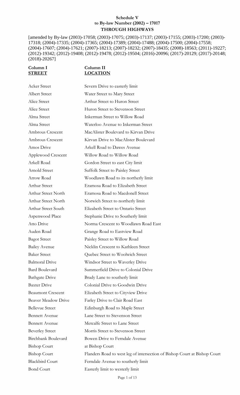
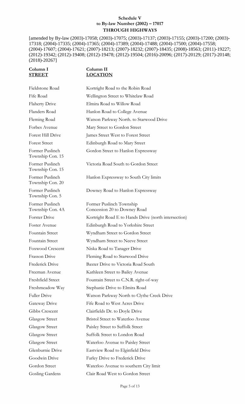
Schedule V to By-law Number (2002) – 17017
THROUGH HIGHWAYS
[amended by By-law (2003)-17058; (2003)-17075; (2003)-17137; (2003)-17155; (2003)-17200; (2003)-
17318; (2004)-17335; (2004)-17365; (2004)-17389; (2004)-17488; (2004)-17500; (2004)-17558;
(2004)-17607; (2004)-17621; (2007)-18213; (2007)-18232; (2007)-18435; (2008)-18563; (2011)-19227;
(2012)-19342; (2012)-19408; (2012)-19478; (2012)-19504; (2016)-20096; (2017)-20129; (2017)-20148;
(2018)-20267]
Page 1 of 13
Column I STREET
Column II LOCATION
Acker Street Severn Drive to easterly limit
Albert Street Water Street to Mary Street
Alice Street Arthur Street to Huron Street
Alice Street Huron Street to Stevenson Street
Alma Street Inkerman Street to Willow Road
Alma Street Waterloo Avenue to Inkerman Street
Ambrous Crescent MacAlister Boulevard to Kirvan Drive
Ambrous Crescent Kirvan Drive to MacAlister Boulevard
Amos Drive Arkell Road to Dawes Avenue
Applewood Crescent Willow Road to Willow Road
Arkell Road Gordon Street to east City limit
Arnold Street Suffolk Street to Paisley Street
Arrow Road Woodlawn Road to its northerly limit
Arthur Street Eramosa Road to Elizabeth Street
Arthur Street North Eramosa Road to Macdonell Street
Arthur Street North Norwich Street to northerly limit
Arthur Street South Elizabeth Street to Ontario Street
Aspenwood Place Stephanie Drive to Southerly limit
Atto Drive Norma Crescent to Woodlawn Road East
Auden Road Grange Road to Eastview Road
Bagot Street Paisley Street to Willow Road
Bailey Avenue Nicklin Crescent to Kathleen Street
Baker Street Quebec Street to Woolwich Street
Balmoral Drive Windsor Street to Waverley Drive
Bard Boulevard Summerfield Drive to Colonial Drive
Bathgate Drive Brady Lane to southerly limit
Baxter Drive Colonial Drive to Goodwin Drive
Beaumont Crescent Elizabeth Street to Cityview Drive
Beaver Meadow Drive Farley Drive to Clair Road East
Bellevue Street Edinburgh Road to Maple Street
Bennett Avenue Lane Street to Stevenson Street
Bennett Avenue Metcalfe Street to Lane Street
Beverley Street Morris Street to Stevenson Street
Birchbank Boulevard Bowen Drive to Ferndale Avenue
Bishop Court at Bishop Court
Bishop Court Flanders Road to west leg of intersection of Bishop Court at Bishop Court
Blackbird Court Ferndale Avenue to southerly limit
Bond Court Easterly limit to westerly limit
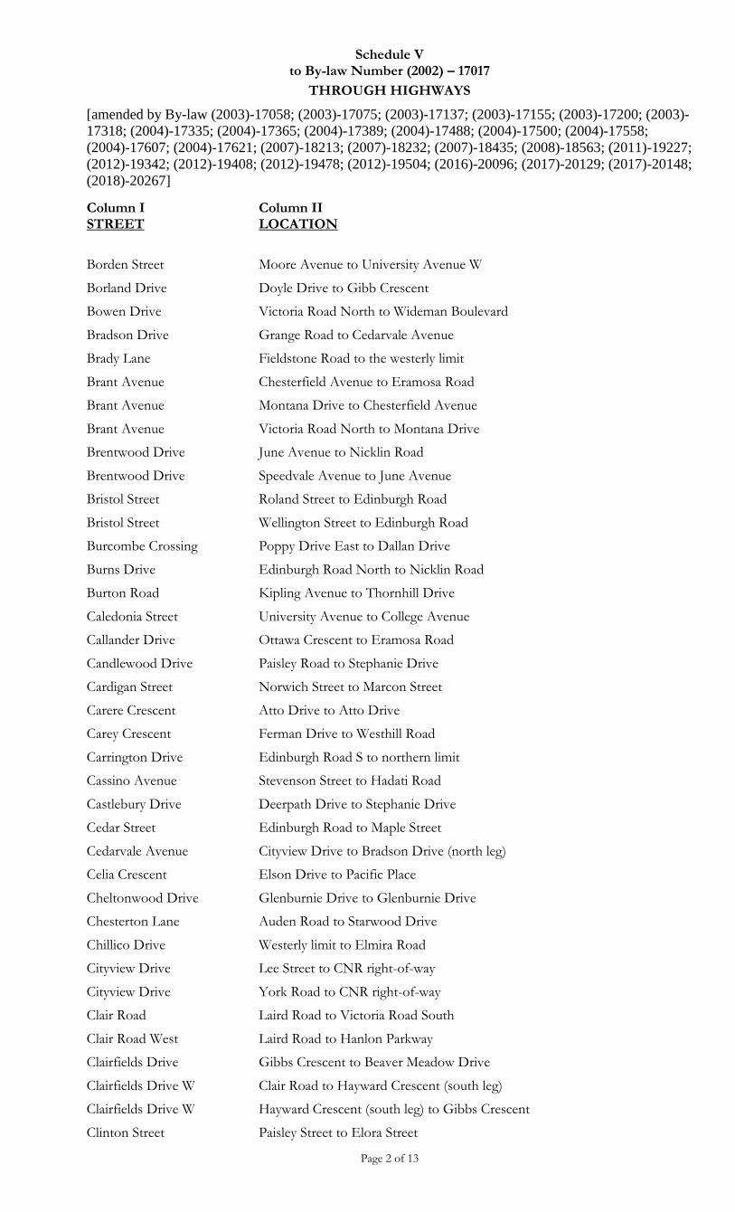
Schedule V to By-law Number (2002) – 17017
THROUGH HIGHWAYS
[amended by By-law (2003)-17058; (2003)-17075; (2003)-17137; (2003)-17155; (2003)-17200; (2003)-
17318; (2004)-17335; (2004)-17365; (2004)-17389; (2004)-17488; (2004)-17500; (2004)-17558;
(2004)-17607; (2004)-17621; (2007)-18213; (2007)-18232; (2007)-18435; (2008)-18563; (2011)-19227;
(2012)-19342; (2012)-19408; (2012)-19478; (2012)-19504; (2016)-20096; (2017)-20129; (2017)-20148;
(2018)-20267]
Page 2 of 13
Column I STREET
Column II LOCATION
Borden Street Moore Avenue to University Avenue W
Borland Drive Doyle Drive to Gibb Crescent
Bowen Drive Victoria Road North to Wideman Boulevard
Bradson Drive Grange Road to Cedarvale Avenue
Brady Lane Fieldstone Road to the westerly limit
Brant Avenue Chesterfield Avenue to Eramosa Road
Brant Avenue Montana Drive to Chesterfield Avenue
Brant Avenue Victoria Road North to Montana Drive
Brentwood Drive June Avenue to Nicklin Road
Brentwood Drive Speedvale Avenue to June Avenue
Bristol Street Roland Street to Edinburgh Road
Bristol Street Wellington Street to Edinburgh Road
Burcombe Crossing Poppy Drive East to Dallan Drive
Burns Drive Edinburgh Road North to Nicklin Road
Burton Road Kipling Avenue to Thornhill Drive
Caledonia Street University Avenue to College Avenue
Callander Drive Ottawa Crescent to Eramosa Road
Candlewood Drive Paisley Road to Stephanie Drive
Cardigan Street Norwich Street to Marcon Street
Carere Crescent Atto Drive to Atto Drive
Carey Crescent Ferman Drive to Westhill Road
Carrington Drive Edinburgh Road S to northern limit
Cassino Avenue Stevenson Street to Hadati Road
Castlebury Drive Deerpath Drive to Stephanie Drive
Cedar Street Edinburgh Road to Maple Street
Cedarvale Avenue Cityview Drive to Bradson Drive (north leg)
Celia Crescent Elson Drive to Pacific Place
Cheltonwood Drive Glenburnie Drive to Glenburnie Drive
Chesterton Lane Auden Road to Starwood Drive
Chillico Drive Westerly limit to Elmira Road
Cityview Drive Lee Street to CNR right-of-way
Cityview Drive York Road to CNR right-of-way
Clair Road Laird Road to Victoria Road South
Clair Road West Laird Road to Hanlon Parkway
Clairfields Drive Gibbs Crescent to Beaver Meadow Drive
Clairfields Drive W Clair Road to Hayward Crescent (south leg)
Clairfields Drive W Hayward Crescent (south leg) to Gibbs Crescent
Clinton Street Paisley Street to Elora Street

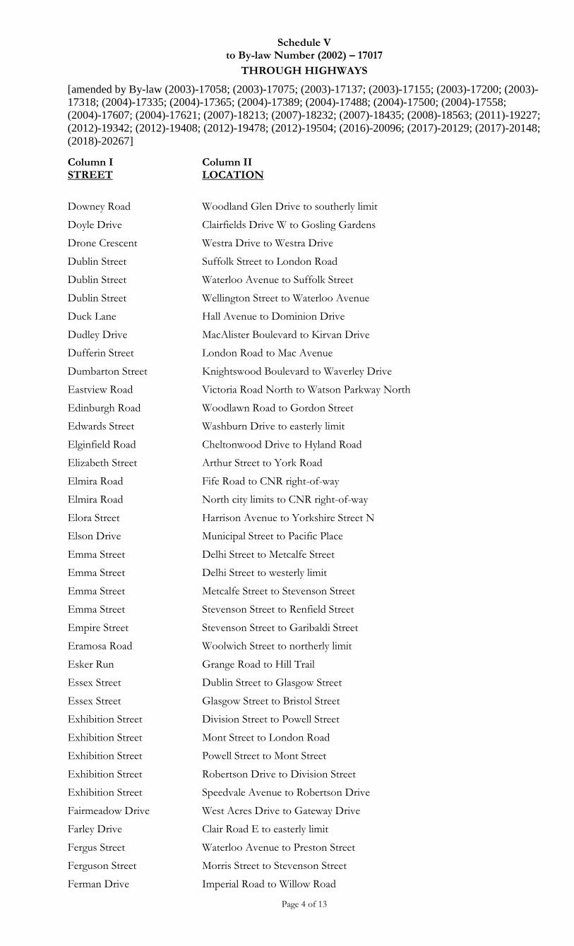
Schedule V to By-law Number (2002) – 17017
THROUGH HIGHWAYS
[amended by By-law (2003)-17058; (2003)-17075; (2003)-17137; (2003)-17155; (2003)-17200; (2003)-
17318; (2004)-17335; (2004)-17365; (2004)-17389; (2004)-17488; (2004)-17500; (2004)-17558;
(2004)-17607; (2004)-17621; (2007)-18213; (2007)-18232; (2007)-18435; (2008)-18563; (2011)-19227;
(2012)-19342; (2012)-19408; (2012)-19478; (2012)-19504; (2016)-20096; (2017)-20129; (2017)-20148;
(2018)-20267]
Page 3 of 13
Column I STREET
Column II LOCATION
Clive Avenue Speedvale Avenue to Waverley Drive
Clythe Creek Drive Grange Road to Law Drive
Colborn Street Stone Road to Monticello Crescent
Cole Road Ironwood Road to easterly limit
Cole Road Ironwood Road to Steffler Drive
Cole Road Scottsdale Drive to Ironwood Road
College Avenue Stone Road to Victoria Road South
Colonial Drive Arkell Road to Frederick Drive
Columbus Crescent Rickson Avenue to Kron Drive
Country Club Drive Woodlawn Road to Inverness Drive
Coventry Drive Flanders Road to south leg of Southbound Drive/Eastbound intersection of Bishop Court
Cox Court Kortright Road to southerly limit
Creekside Drive Watson Parkway North to Fleming Road
Curtis Drive Silvercreek Parkway North to Imperial Road North
Curzon Crescent Westra Drive to Tovell Drive
Dallan Drive Clair Road East to Poppy Drive East
Darby Road Rochelle Drive to Stephanie Drive
Davis Street Shackleton Drive to Eastview Road
Davis Street Eastview Road to Acker Street
Dawes Avenue West limit to east limit
Dawn Avenue Clairfields Drive W to northern limit
Dawson Road Woodlawn Road to Willow Road
Dean Avenue Gordon Street to Talbot Street
Dean Avenue Talbot Street to Edinburgh Road
Deerpath Drive Imperial Road to Stephanie Drive
Deerpath Drive Stephanie Drive to Stephanie Drive
Delaware Avenue Brant Avenue to Speedvale Avenue
Delhi Street Eramosa Road to Riverview Drive
Derry Street Arthur Street to Queen Street
Deshane Street Norma Crescent to Mullin Drive
Devere Drive Flanders Road to College Avenue
Dimson Avenue Hands Drive to Kortright Road
Division Street Exhibition Street to Westmount Road
Division Street Woolwich Street to Exhibition Street
Dominion Drive Goodwin Drive to northerly limit
Dormie Lane Gordon Street to easterly limit
Doughty Court MacAlister Boulevard to southerly limit
Schedule V to By-law Number (2002) – 17017
THROUGH HIGHWAYS
[amended by By-law (2003)-17058; (2003)-17075; (2003)-17137; (2003)-17155; (2003)-17200; (2003)-
17318; (2004)-17335; (2004)-17365; (2004)-17389; (2004)-17488; (2004)-17500; (2004)-17558;
(2004)-17607; (2004)-17621; (2007)-18213; (2007)-18232; (2007)-18435; (2008)-18563; (2011)-19227;
(2012)-19342; (2012)-19408; (2012)-19478; (2012)-19504; (2016)-20096; (2017)-20129; (2017)-20148;
(2018)-20267]
Page 4 of 13
Column I STREET
Column II LOCATION
Downey Road Woodland Glen Drive to southerly limit
Doyle Drive Clairfields Drive W to Gosling Gardens
Drone Crescent Westra Drive to Westra Drive
Dublin Street Suffolk Street to London Road
Dublin Street Waterloo Avenue to Suffolk Street
Dublin Street Wellington Street to Waterloo Avenue
Duck Lane Hall Avenue to Dominion Drive
Dudley Drive MacAlister Boulevard to Kirvan Drive
Dufferin Street London Road to Mac Avenue
Dumbarton Street Knightswood Boulevard to Waverley Drive
Eastview Road Victoria Road North to Watson Parkway North
Edinburgh Road Woodlawn Road to Gordon Street
Edwards Street Washburn Drive to easterly limit
Elginfield Road Cheltonwood Drive to Hyland Road
Elizabeth Street Arthur Street to York Road
Elmira Road Fife Road to CNR right-of-way
Elmira Road North city limits to CNR right-of-way
Elora Street Harrison Avenue to Yorkshire Street N
Elson Drive Municipal Street to Pacific Place
Emma Street Delhi Street to Metcalfe Street
Emma Street Delhi Street to westerly limit
Emma Street Metcalfe Street to Stevenson Street
Emma Street Stevenson Street to Renfield Street
Empire Street Stevenson Street to Garibaldi Street
Eramosa Road Woolwich Street to northerly limit
Esker Run Grange Road to Hill Trail
Essex Street Dublin Street to Glasgow Street
Essex Street Glasgow Street to Bristol Street
Exhibition Street Division Street to Powell Street
Exhibition Street Mont Street to London Road
Exhibition Street Powell Street to Mont Street
Exhibition Street Robertson Drive to Division Street
Exhibition Street Speedvale Avenue to Robertson Drive
Fairmeadow Drive West Acres Drive to Gateway Drive
Farley Drive Clair Road E to easterly limit
Fergus Street Waterloo Avenue to Preston Street
Ferguson Street Morris Street to Stevenson Street
Ferman Drive Imperial Road to Willow Road
Schedule V to By-law Number (2002) – 17017
THROUGH HIGHWAYS
[amended by By-law (2003)-17058; (2003)-17075; (2003)-17137; (2003)-17155; (2003)-17200; (2003)-
17318; (2004)-17335; (2004)-17365; (2004)-17389; (2004)-17488; (2004)-17500; (2004)-17558;
(2004)-17607; (2004)-17621; (2007)-18213; (2007)-18232; (2007)-18435; (2008)-18563; (2011)-19227;
(2012)-19342; (2012)-19408; (2012)-19478; (2012)-19504; (2016)-20096; (2017)-20129; (2017)-20148;
(2018)-20267]
Page 5 of 13
Column I STREET
Column II LOCATION
Fieldstone Road Kortright Road to the Robin Road
Fife Road Wellington Street to Whitelaw Road
Flaherty Drive Elmira Road to Willow Road
Flanders Road Hanlon Road to College Avenue
Fleming Road Watson Parkway North. to Starwood Drive
Forbes Avenue Mary Street to Gordon Street
Forest Hill Drive James Street West to Forest Street
Forest Street Edinburgh Road to Mary Street
Former Puslinch Township Con. 15
Gordon Street to Hanlon Expressway
Former Puslinch Township Con. 15
Victoria Road South to Gordon Street
Former Puslinch Township Con. 20
Hanlon Expressway to South City limits
Former Puslinch Township Con. 5
Downey Road to Hanlon Expressway
Former Puslinch Township Con. 4A
Former Puslinch Township Concession 20 to Downey Road
Forster Drive Kortright Road E to Hands Drive (north intersection)
Foster Avenue Edinburgh Road to Yorkshire Street
Fountain Street Wyndham Street to Gordon Street
Fountain Street Wyndham Street to Neeve Street
Foxwood Crescent Niska Road to Tanager Drive
Frasson Drive Fleming Road to Starwood Drive
Frederick Drive Baxter Drive to Victoria Road South
Freeman Avenue Kathleen Street to Bailey Avenue
Freshfield Street Fountain Street to C.N.R. right-of-way
Freshmeadow Way Stephanie Drive to Elmira Road
Fuller Drive Watson Parkway North to Clythe Creek Drive
Gateway Drive Fife Road to West Acres Drive
Gibbs Crescent Clairfields Dr. to Doyle Drive
Glasgow Street Bristol Street to Waterloo Avenue
Glasgow Street Paisley Street to Suffolk Street
Glasgow Street Suffolk Street to London Road
Glasgow Street Waterloo Avenue to Paisley Street
Glenburnie Drive Eastview Road to Elginfield Drive
Goodwin Drive Farley Drive to Frederick Drive
Gordon Street Waterloo Avenue to southern City limit
Gosling Gardens Clair Road West to Gordon Street
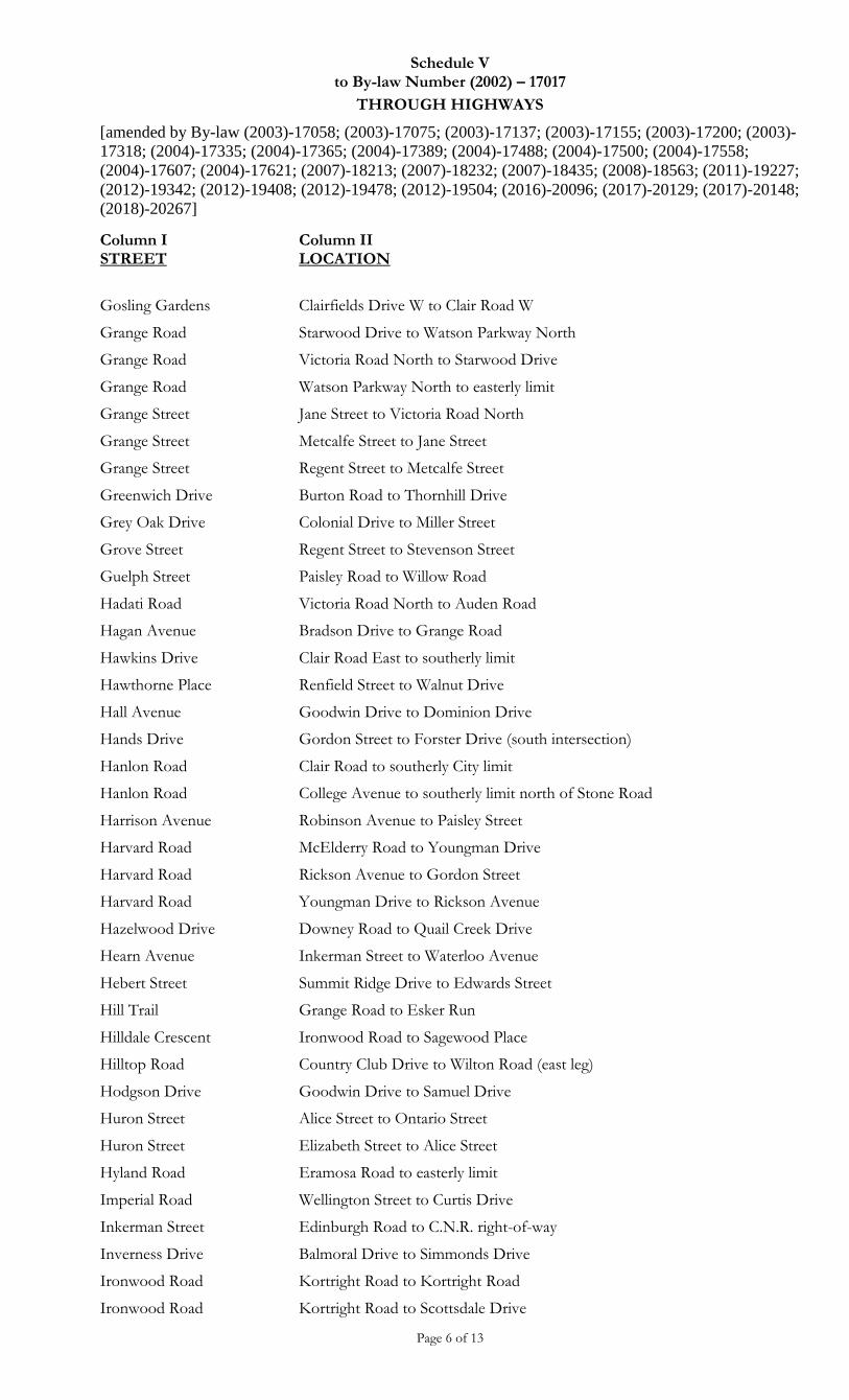
Schedule V to By-law Number (2002) – 17017
THROUGH HIGHWAYS
[amended by By-law (2003)-17058; (2003)-17075; (2003)-17137; (2003)-17155; (2003)-17200; (2003)-
17318; (2004)-17335; (2004)-17365; (2004)-17389; (2004)-17488; (2004)-17500; (2004)-17558;
(2004)-17607; (2004)-17621; (2007)-18213; (2007)-18232; (2007)-18435; (2008)-18563; (2011)-19227;
(2012)-19342; (2012)-19408; (2012)-19478; (2012)-19504; (2016)-20096; (2017)-20129; (2017)-20148;
(2018)-20267]
Page 6 of 13
Column I STREET
Column II LOCATION
Gosling Gardens Clairfields Drive W to Clair Road W
Grange Road Starwood Drive to Watson Parkway North
Grange Road Victoria Road North to Starwood Drive
Grange Road Watson Parkway North to easterly limit
Grange Street Jane Street to Victoria Road North
Grange Street Metcalfe Street to Jane Street
Grange Street Regent Street to Metcalfe Street
Greenwich Drive Burton Road to Thornhill Drive
Grey Oak Drive Colonial Drive to Miller Street
Grove Street Regent Street to Stevenson Street
Guelph Street Paisley Road to Willow Road
Hadati Road Victoria Road North to Auden Road
Hagan Avenue Bradson Drive to Grange Road
Hawkins Drive Clair Road East to southerly limit
Hawthorne Place Renfield Street to Walnut Drive
Hall Avenue Goodwin Drive to Dominion Drive
Hands Drive Gordon Street to Forster Drive (south intersection)
Hanlon Road Clair Road to southerly City limit
Hanlon Road College Avenue to southerly limit north of Stone Road
Harrison Avenue Robinson Avenue to Paisley Street
Harvard Road McElderry Road to Youngman Drive
Harvard Road Rickson Avenue to Gordon Street
Harvard Road Youngman Drive to Rickson Avenue
Hazelwood Drive Downey Road to Quail Creek Drive
Hearn Avenue Inkerman Street to Waterloo Avenue
Hebert Street Summit Ridge Drive to Edwards Street
Hill Trail Grange Road to Esker Run
Hilldale Crescent Ironwood Road to Sagewood Place
Hilltop Road Country Club Drive to Wilton Road (east leg)
Hodgson Drive Goodwin Drive to Samuel Drive
Huron Street Alice Street to Ontario Street
Huron Street Elizabeth Street to Alice Street
Hyland Road Eramosa Road to easterly limit
Imperial Road Wellington Street to Curtis Drive
Inkerman Street Edinburgh Road to C.N.R. right-of-way
Inverness Drive Balmoral Drive to Simmonds Drive
Ironwood Road Kortright Road to Kortright Road
Ironwood Road Kortright Road to Scottsdale Drive
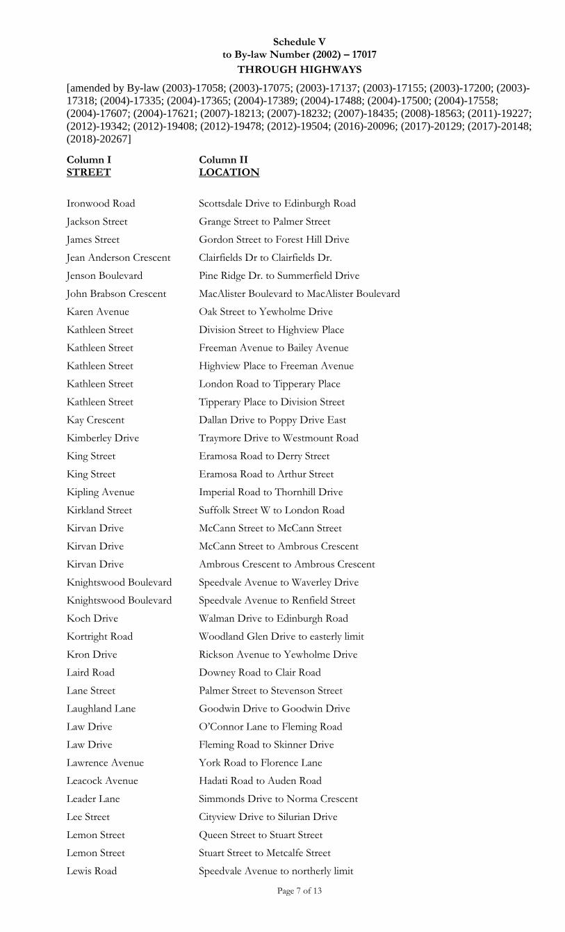
Schedule V to By-law Number (2002) – 17017
THROUGH HIGHWAYS
[amended by By-law (2003)-17058; (2003)-17075; (2003)-17137; (2003)-17155; (2003)-17200; (2003)-
17318; (2004)-17335; (2004)-17365; (2004)-17389; (2004)-17488; (2004)-17500; (2004)-17558;
(2004)-17607; (2004)-17621; (2007)-18213; (2007)-18232; (2007)-18435; (2008)-18563; (2011)-19227;
(2012)-19342; (2012)-19408; (2012)-19478; (2012)-19504; (2016)-20096; (2017)-20129; (2017)-20148;
(2018)-20267]
Page 7 of 13
Column I STREET
Column II LOCATION
Ironwood Road Scottsdale Drive to Edinburgh Road
Jackson Street Grange Street to Palmer Street
James Street Gordon Street to Forest Hill Drive
Jean Anderson Crescent Clairfields Dr to Clairfields Dr.
Jenson Boulevard Pine Ridge Dr. to Summerfield Drive
John Brabson Crescent MacAlister Boulevard to MacAlister Boulevard
Karen Avenue Oak Street to Yewholme Drive
Kathleen Street Division Street to Highview Place
Kathleen Street Freeman Avenue to Bailey Avenue
Kathleen Street Highview Place to Freeman Avenue
Kathleen Street London Road to Tipperary Place
Kathleen Street Tipperary Place to Division Street
Kay Crescent Dallan Drive to Poppy Drive East
Kimberley Drive Traymore Drive to Westmount Road
King Street Eramosa Road to Derry Street
King Street Eramosa Road to Arthur Street
Kipling Avenue Imperial Road to Thornhill Drive
Kirkland Street Suffolk Street W to London Road
Kirvan Drive McCann Street to McCann Street
Kirvan Drive McCann Street to Ambrous Crescent
Kirvan Drive Ambrous Crescent to Ambrous Crescent
Knightswood Boulevard Speedvale Avenue to Waverley Drive
Knightswood Boulevard Speedvale Avenue to Renfield Street
Koch Drive Walman Drive to Edinburgh Road
Kortright Road Woodland Glen Drive to easterly limit
Kron Drive Rickson Avenue to Yewholme Drive
Laird Road Downey Road to Clair Road
Lane Street Palmer Street to Stevenson Street
Laughland Lane Goodwin Drive to Goodwin Drive
Law Drive O’Connor Lane to Fleming Road
Law Drive Fleming Road to Skinner Drive
Lawrence Avenue York Road to Florence Lane
Leacock Avenue Hadati Road to Auden Road
Leader Lane Simmonds Drive to Norma Crescent
Lee Street Cityview Drive to Silurian Drive
Lemon Street Queen Street to Stuart Street
Lemon Street Stuart Street to Metcalfe Street
Lewis Road Speedvale Avenue to northerly limit
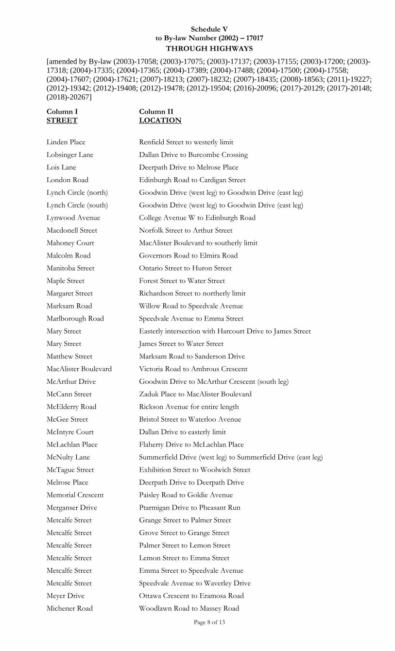
Schedule V to By-law Number (2002) – 17017
THROUGH HIGHWAYS
[amended by By-law (2003)-17058; (2003)-17075; (2003)-17137; (2003)-17155; (2003)-17200; (2003)-
17318; (2004)-17335; (2004)-17365; (2004)-17389; (2004)-17488; (2004)-17500; (2004)-17558;
(2004)-17607; (2004)-17621; (2007)-18213; (2007)-18232; (2007)-18435; (2008)-18563; (2011)-19227;
(2012)-19342; (2012)-19408; (2012)-19478; (2012)-19504; (2016)-20096; (2017)-20129; (2017)-20148;
(2018)-20267]
Page 8 of 13
Column I STREET
Column II LOCATION
Linden Place Renfield Street to westerly limit
Lobsinger Lane Dallan Drive to Burcombe Crossing
Lois Lane Deerpath Drive to Melrose Place
London Road Edinburgh Road to Cardigan Street
Lynch Circle (north) Goodwin Drive (west leg) to Goodwin Drive (east leg)
Lynch Circle (south) Goodwin Drive (west leg) to Goodwin Drive (east leg)
Lynwood Avenue College Avenue W to Edinburgh Road
Macdonell Street Norfolk Street to Arthur Street
Mahoney Court MacAlister Boulevard to southerly limit
Malcolm Road Governors Road to Elmira Road
Manitoba Street Ontario Street to Huron Street
Maple Street Forest Street to Water Street
Margaret Street Richardson Street to northerly limit
Marksam Road Willow Road to Speedvale Avenue
Marlborough Road Speedvale Avenue to Emma Street
Mary Street Easterly intersection with Harcourt Drive to James Street
Mary Street James Street to Water Street
Matthew Street Marksam Road to Sanderson Drive
MacAlister Boulevard Victoria Road to Ambrous Crescent
McArthur Drive Goodwin Drive to McArthur Crescent (south leg)
McCann Street Zaduk Place to MacAlister Boulevard
McElderry Road Rickson Avenue for entire length
McGee Street Bristol Street to Waterloo Avenue
McIntyre Court Dallan Drive to easterly limit
McLachlan Place Flaherty Drive to McLachlan Place
McNulty Lane Summerfield Drive (west leg) to Summerfield Drive (east leg)
McTague Street Exhibition Street to Woolwich Street
Melrose Place Deerpath Drive to Deerpath Drive
Memorial Crescent Paisley Road to Goldie Avenue
Merganser Drive Ptarmigan Drive to Pheasant Run
Metcalfe Street Grange Street to Palmer Street
Metcalfe Street Grove Street to Grange Street
Metcalfe Street Palmer Street to Lemon Street
Metcalfe Street Lemon Street to Emma Street
Metcalfe Street Emma Street to Speedvale Avenue
Metcalfe Street Speedvale Avenue to Waverley Drive
Meyer Drive Ottawa Crescent to Eramosa Road
Michener Road Woodlawn Road to Massey Road
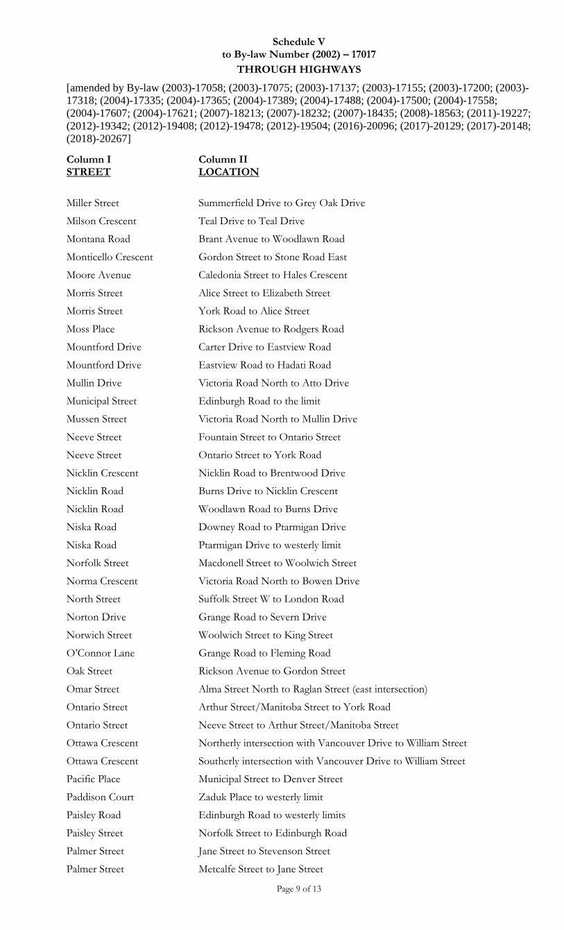
Schedule V to By-law Number (2002) – 17017
THROUGH HIGHWAYS
[amended by By-law (2003)-17058; (2003)-17075; (2003)-17137; (2003)-17155; (2003)-17200; (2003)-
17318; (2004)-17335; (2004)-17365; (2004)-17389; (2004)-17488; (2004)-17500; (2004)-17558;
(2004)-17607; (2004)-17621; (2007)-18213; (2007)-18232; (2007)-18435; (2008)-18563; (2011)-19227;
(2012)-19342; (2012)-19408; (2012)-19478; (2012)-19504; (2016)-20096; (2017)-20129; (2017)-20148;
(2018)-20267]
Page 9 of 13
Column I STREET
Column II LOCATION
Miller Street Summerfield Drive to Grey Oak Drive
Milson Crescent Teal Drive to Teal Drive
Montana Road Brant Avenue to Woodlawn Road
Monticello Crescent Gordon Street to Stone Road East
Moore Avenue Caledonia Street to Hales Crescent
Morris Street Alice Street to Elizabeth Street
Morris Street York Road to Alice Street
Moss Place Rickson Avenue to Rodgers Road
Mountford Drive Carter Drive to Eastview Road
Mountford Drive Eastview Road to Hadati Road
Mullin Drive Victoria Road North to Atto Drive
Municipal Street Edinburgh Road to the limit
Mussen Street Victoria Road North to Mullin Drive
Neeve Street Fountain Street to Ontario Street
Neeve Street Ontario Street to York Road
Nicklin Crescent Nicklin Road to Brentwood Drive
Nicklin Road Burns Drive to Nicklin Crescent
Nicklin Road Woodlawn Road to Burns Drive
Niska Road Downey Road to Ptarmigan Drive
Niska Road Ptarmigan Drive to westerly limit
Norfolk Street Macdonell Street to Woolwich Street
Norma Crescent Victoria Road North to Bowen Drive
North Street Suffolk Street W to London Road
Norton Drive Grange Road to Severn Drive
Norwich Street Woolwich Street to King Street
O’Connor Lane Grange Road to Fleming Road
Oak Street Rickson Avenue to Gordon Street
Omar Street Alma Street North to Raglan Street (east intersection)
Ontario Street Arthur Street/Manitoba Street to York Road
Ontario Street Neeve Street to Arthur Street/Manitoba Street
Ottawa Crescent Northerly intersection with Vancouver Drive to William Street
Ottawa Crescent Southerly intersection with Vancouver Drive to William Street
Pacific Place Municipal Street to Denver Street
Paddison Court Zaduk Place to westerly limit
Paisley Road Edinburgh Road to westerly limits
Paisley Street Norfolk Street to Edinburgh Road
Palmer Street Jane Street to Stevenson Street
Palmer Street Metcalfe Street to Jane Street
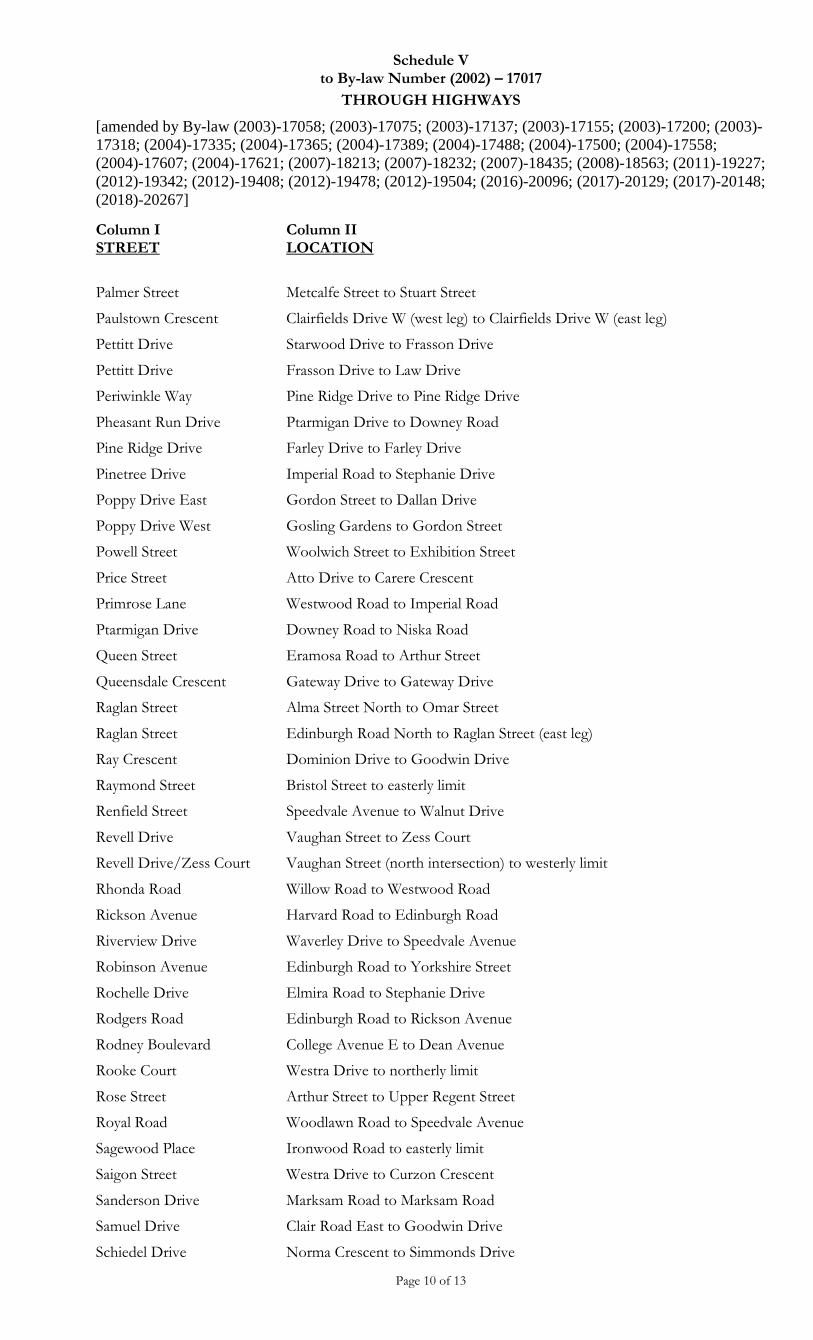
Schedule V to By-law Number (2002) – 17017
THROUGH HIGHWAYS
[amended by By-law (2003)-17058; (2003)-17075; (2003)-17137; (2003)-17155; (2003)-17200; (2003)-
17318; (2004)-17335; (2004)-17365; (2004)-17389; (2004)-17488; (2004)-17500; (2004)-17558;
(2004)-17607; (2004)-17621; (2007)-18213; (2007)-18232; (2007)-18435; (2008)-18563; (2011)-19227;
(2012)-19342; (2012)-19408; (2012)-19478; (2012)-19504; (2016)-20096; (2017)-20129; (2017)-20148;
(2018)-20267]
Page 10 of 13
Column I STREET
Column II LOCATION
Palmer Street Metcalfe Street to Stuart Street
Paulstown Crescent Clairfields Drive W (west leg) to Clairfields Drive W (east leg)
Pettitt Drive Starwood Drive to Frasson Drive
Pettitt Drive Frasson Drive to Law Drive
Periwinkle Way Pine Ridge Drive to Pine Ridge Drive
Pheasant Run Drive Ptarmigan Drive to Downey Road
Pine Ridge Drive Farley Drive to Farley Drive
Pinetree Drive Imperial Road to Stephanie Drive
Poppy Drive East Gordon Street to Dallan Drive
Poppy Drive West Gosling Gardens to Gordon Street
Powell Street Woolwich Street to Exhibition Street
Price Street Atto Drive to Carere Crescent
Primrose Lane Westwood Road to Imperial Road
Ptarmigan Drive Downey Road to Niska Road
Queen Street Eramosa Road to Arthur Street
Queensdale Crescent Gateway Drive to Gateway Drive
Raglan Street Alma Street North to Omar Street
Raglan Street Edinburgh Road North to Raglan Street (east leg)
Ray Crescent Dominion Drive to Goodwin Drive
Raymond Street Bristol Street to easterly limit
Renfield Street Speedvale Avenue to Walnut Drive
Revell Drive Vaughan Street to Zess Court
Revell Drive/Zess Court Vaughan Street (north intersection) to westerly limit
Rhonda Road Willow Road to Westwood Road
Rickson Avenue Harvard Road to Edinburgh Road
Riverview Drive Waverley Drive to Speedvale Avenue
Robinson Avenue Edinburgh Road to Yorkshire Street
Rochelle Drive Elmira Road to Stephanie Drive
Rodgers Road Edinburgh Road to Rickson Avenue
Rodney Boulevard College Avenue E to Dean Avenue
Rooke Court Westra Drive to northerly limit
Rose Street Arthur Street to Upper Regent Street
Royal Road Woodlawn Road to Speedvale Avenue
Sagewood Place Ironwood Road to easterly limit
Saigon Street Westra Drive to Curzon Crescent
Sanderson Drive Marksam Road to Marksam Road
Samuel Drive Clair Road East to Goodwin Drive
Schiedel Drive Norma Crescent to Simmonds Drive
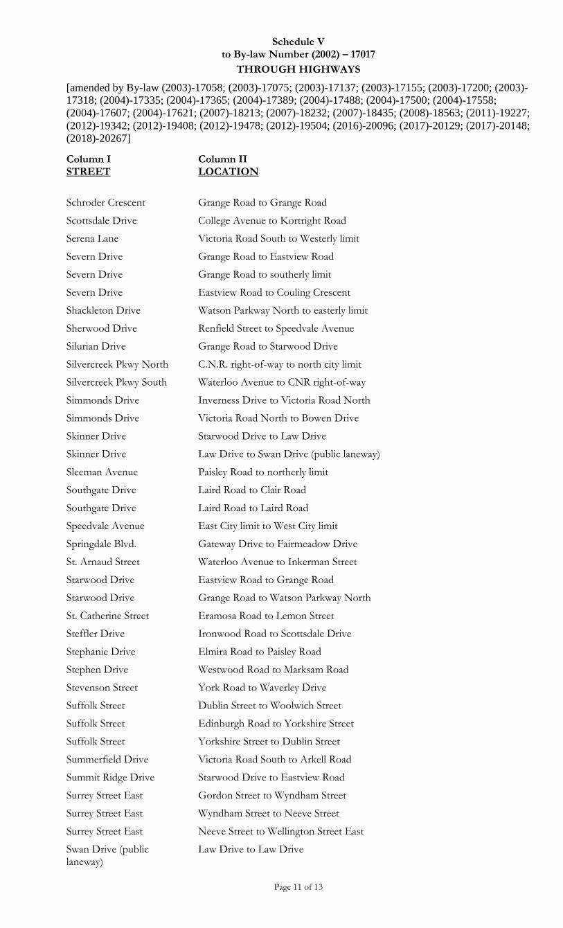
Schedule V to By-law Number (2002) – 17017
THROUGH HIGHWAYS
[amended by By-law (2003)-17058; (2003)-17075; (2003)-17137; (2003)-17155; (2003)-17200; (2003)-
17318; (2004)-17335; (2004)-17365; (2004)-17389; (2004)-17488; (2004)-17500; (2004)-17558;
(2004)-17607; (2004)-17621; (2007)-18213; (2007)-18232; (2007)-18435; (2008)-18563; (2011)-19227;
(2012)-19342; (2012)-19408; (2012)-19478; (2012)-19504; (2016)-20096; (2017)-20129; (2017)-20148;
(2018)-20267]
Page 11 of 13
Column I STREET
Column II LOCATION
Schroder Crescent Grange Road to Grange Road
Scottsdale Drive College Avenue to Kortright Road
Serena Lane Victoria Road South to Westerly limit
Severn Drive Grange Road to Eastview Road
Severn Drive Grange Road to southerly limit
Severn Drive Eastview Road to Couling Crescent
Shackleton Drive Watson Parkway North to easterly limit
Sherwood Drive Renfield Street to Speedvale Avenue
Silurian Drive Grange Road to Starwood Drive
Silvercreek Pkwy North C.N.R. right-of-way to north city limit
Silvercreek Pkwy South Waterloo Avenue to CNR right-of-way
Simmonds Drive Inverness Drive to Victoria Road North
Simmonds Drive Victoria Road North to Bowen Drive
Skinner Drive Starwood Drive to Law Drive
Skinner Drive Law Drive to Swan Drive (public laneway)
Sleeman Avenue Paisley Road to northerly limit
Southgate Drive Laird Road to Clair Road
Southgate Drive Laird Road to Laird Road
Speedvale Avenue East City limit to West City limit
Springdale Blvd. Gateway Drive to Fairmeadow Drive
St. Arnaud Street Waterloo Avenue to Inkerman Street
Starwood Drive Eastview Road to Grange Road
Starwood Drive Grange Road to Watson Parkway North
St. Catherine Street Eramosa Road to Lemon Street
Steffler Drive Ironwood Road to Scottsdale Drive
Stephanie Drive Elmira Road to Paisley Road
Stephen Drive Westwood Road to Marksam Road
Stevenson Street York Road to Waverley Drive
Suffolk Street Dublin Street to Woolwich Street
Suffolk Street Edinburgh Road to Yorkshire Street
Suffolk Street Yorkshire Street to Dublin Street
Summerfield Drive Victoria Road South to Arkell Road
Summit Ridge Drive Starwood Drive to Eastview Road
Surrey Street East Gordon Street to Wyndham Street
Surrey Street East Wyndham Street to Neeve Street
Surrey Street East Neeve Street to Wellington Street East
Swan Drive (public laneway)
Law Drive to Law Drive
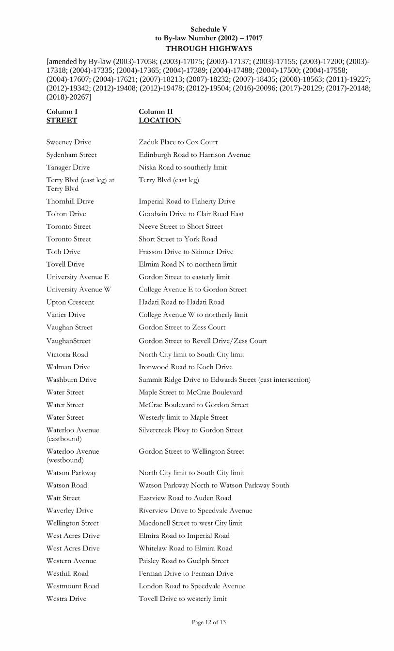
Schedule V to By-law Number (2002) – 17017
THROUGH HIGHWAYS
[amended by By-law (2003)-17058; (2003)-17075; (2003)-17137; (2003)-17155; (2003)-17200; (2003)-
17318; (2004)-17335; (2004)-17365; (2004)-17389; (2004)-17488; (2004)-17500; (2004)-17558;
(2004)-17607; (2004)-17621; (2007)-18213; (2007)-18232; (2007)-18435; (2008)-18563; (2011)-19227;
(2012)-19342; (2012)-19408; (2012)-19478; (2012)-19504; (2016)-20096; (2017)-20129; (2017)-20148;
(2018)-20267]
Page 12 of 13
Column I STREET
Column II LOCATION
Sweeney Drive Zaduk Place to Cox Court
Sydenham Street Edinburgh Road to Harrison Avenue
Tanager Drive Niska Road to southerly limit
Terry Blvd (east leg) at Terry Blvd
Terry Blvd (east leg)
Thornhill Drive Imperial Road to Flaherty Drive
Tolton Drive Goodwin Drive to Clair Road East
Toronto Street Neeve Street to Short Street
Toronto Street Short Street to York Road
Toth Drive Frasson Drive to Skinner Drive
Tovell Drive Elmira Road N to northern limit
University Avenue E Gordon Street to easterly limit
University Avenue W College Avenue E to Gordon Street
Upton Crescent Hadati Road to Hadati Road
Vanier Drive College Avenue W to northerly limit
Vaughan Street Gordon Street to Zess Court
VaughanStreet Gordon Street to Revell Drive/Zess Court
Victoria Road North City limit to South City limit
Walman Drive Ironwood Road to Koch Drive
Washburn Drive Summit Ridge Drive to Edwards Street (east intersection)
Water Street Maple Street to McCrae Boulevard
Water Street McCrae Boulevard to Gordon Street
Water Street Westerly limit to Maple Street
Waterloo Avenue (eastbound)
Silvercreek Pkwy to Gordon Street
Waterloo Avenue (westbound)
Gordon Street to Wellington Street
Watson Parkway North City limit to South City limit
Watson Road Watson Parkway North to Watson Parkway South
Watt Street Eastview Road to Auden Road
Waverley Drive Riverview Drive to Speedvale Avenue
Wellington Street Macdonell Street to west City limit
West Acres Drive Elmira Road to Imperial Road
West Acres Drive Whitelaw Road to Elmira Road
Western Avenue Paisley Road to Guelph Street
Westhill Road Ferman Drive to Ferman Drive
Westmount Road London Road to Speedvale Avenue
Westra Drive Tovell Drive to westerly limit
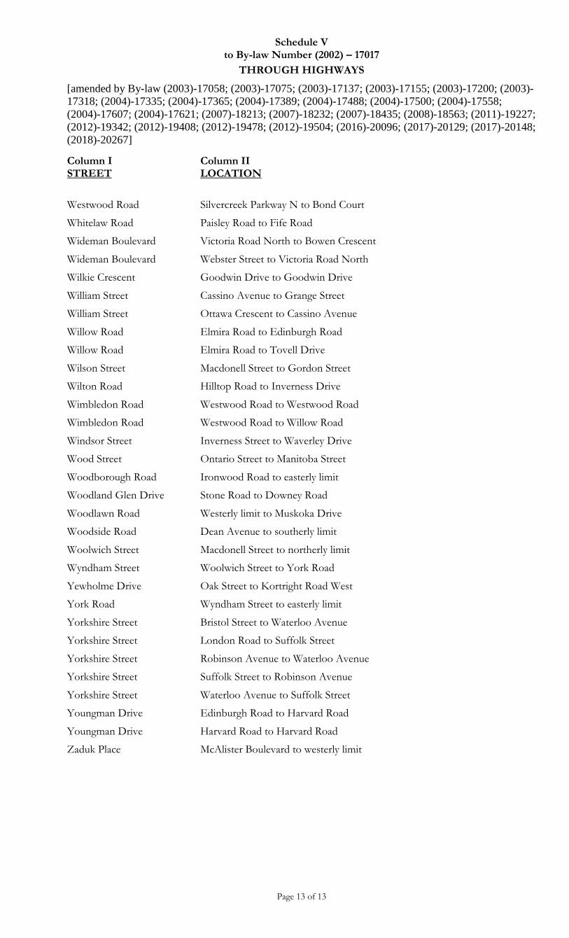
Schedule V to By-law Number (2002) – 17017
THROUGH HIGHWAYS
[amended by By-law (2003)-17058; (2003)-17075; (2003)-17137; (2003)-17155; (2003)-17200; (2003)-
17318; (2004)-17335; (2004)-17365; (2004)-17389; (2004)-17488; (2004)-17500; (2004)-17558;
(2004)-17607; (2004)-17621; (2007)-18213; (2007)-18232; (2007)-18435; (2008)-18563; (2011)-19227;
(2012)-19342; (2012)-19408; (2012)-19478; (2012)-19504; (2016)-20096; (2017)-20129; (2017)-20148;
(2018)-20267]
Page 13 of 13
Column I STREET
Column II LOCATION
Westwood Road Silvercreek Parkway N to Bond Court
Whitelaw Road Paisley Road to Fife Road
Wideman Boulevard Victoria Road North to Bowen Crescent
Wideman Boulevard Webster Street to Victoria Road North
Wilkie Crescent Goodwin Drive to Goodwin Drive
William Street Cassino Avenue to Grange Street
William Street Ottawa Crescent to Cassino Avenue
Willow Road Elmira Road to Edinburgh Road
Willow Road Elmira Road to Tovell Drive
Wilson Street Macdonell Street to Gordon Street
Wilton Road Hilltop Road to Inverness Drive
Wimbledon Road Westwood Road to Westwood Road
Wimbledon Road Westwood Road to Willow Road
Windsor Street Inverness Street to Waverley Drive
Wood Street Ontario Street to Manitoba Street
Woodborough Road Ironwood Road to easterly limit
Woodland Glen Drive Stone Road to Downey Road
Woodlawn Road Westerly limit to Muskoka Drive
Woodside Road Dean Avenue to southerly limit
Woolwich Street Macdonell Street to northerly limit
Wyndham Street Woolwich Street to York Road
Yewholme Drive Oak Street to Kortright Road West
York Road Wyndham Street to easterly limit
Yorkshire Street Bristol Street to Waterloo Avenue
Yorkshire Street London Road to Suffolk Street
Yorkshire Street Robinson Avenue to Waterloo Avenue
Yorkshire Street Suffolk Street to Robinson Avenue
Yorkshire Street Waterloo Avenue to Suffolk Street
Youngman Drive Edinburgh Road to Harvard Road
Youngman Drive Harvard Road to Harvard Road
Zaduk Place McAlister Boulevard to westerly limit
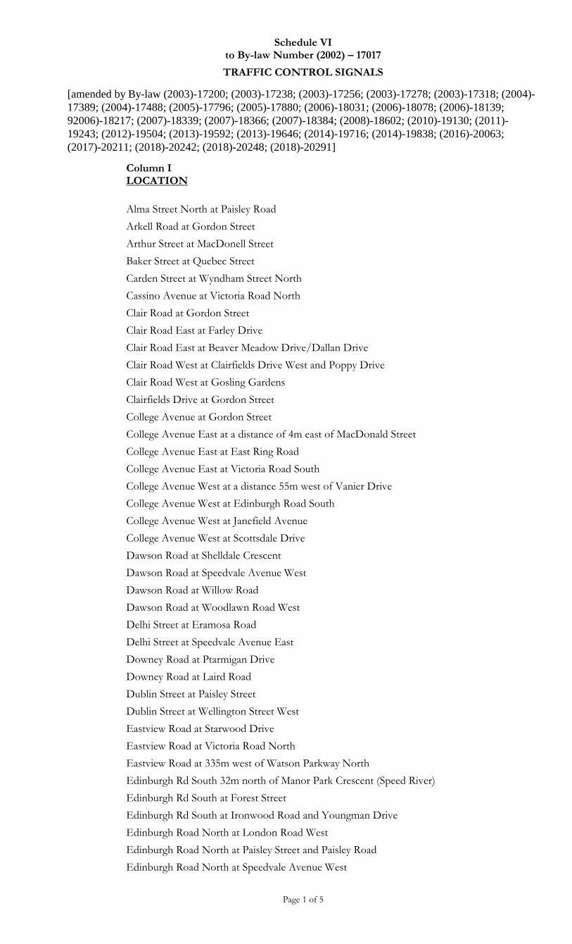
Schedule VI to By-law Number (2002) – 17017
TRAFFIC CONTROL SIGNALS
[amended by By-law (2003)-17200; (2003)-17238; (2003)-17256; (2003)-17278; (2003)-17318; (2004)-
17389; (2004)-17488; (2005)-17796; (2005)-17880; (2006)-18031; (2006)-18078; (2006)-18139;
92006)-18217; (2007)-18339; (2007)-18366; (2007)-18384; (2008)-18602; (2010)-19130; (2011)-
19243; (2012)-19504; (2013)-19592; (2013)-19646; (2014)-19716; (2014)-19838; (2016)-20063;
(2017)-20211; (2018)-20242; (2018)-20248; (2018)-20291]
Page 1 of 5
Column I LOCATION
Alma Street North at Paisley Road
Arkell Road at Gordon Street
Arthur Street at MacDonell Street
Baker Street at Quebec Street
Carden Street at Wyndham Street North
Cassino Avenue at Victoria Road North
Clair Road at Gordon Street
Clair Road East at Farley Drive
Clair Road East at Beaver Meadow Drive/Dallan Drive
Clair Road West at Clairfields Drive West and Poppy Drive
Clair Road West at Gosling Gardens
Clairfields Drive at Gordon Street
College Avenue at Gordon Street
College Avenue East at a distance of 4m east of MacDonald Street
College Avenue East at East Ring Road
College Avenue East at Victoria Road South
College Avenue West at a distance 55m west of Vanier Drive
College Avenue West at Edinburgh Road South
College Avenue West at Janefield Avenue
College Avenue West at Scottsdale Drive
Dawson Road at Shelldale Crescent
Dawson Road at Speedvale Avenue West
Dawson Road at Willow Road
Dawson Road at Woodlawn Road West
Delhi Street at Eramosa Road
Delhi Street at Speedvale Avenue East
Downey Road at Ptarmigan Drive
Downey Road at Laird Road
Dublin Street at Paisley Street
Dublin Street at Wellington Street West
Eastview Road at Starwood Drive
Eastview Road at Victoria Road North
Eastview Road at 335m west of Watson Parkway North
Edinburgh Rd South 32m north of Manor Park Crescent (Speed River)
Edinburgh Rd South at Forest Street
Edinburgh Rd South at Ironwood Road and Youngman Drive
Edinburgh Road North at London Road West
Edinburgh Road North at Paisley Street and Paisley Road
Edinburgh Road North at Speedvale Avenue West
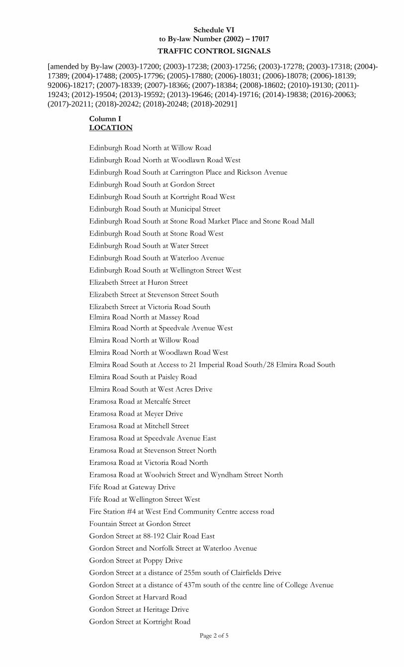
Schedule VI to By-law Number (2002) – 17017
TRAFFIC CONTROL SIGNALS
[amended by By-law (2003)-17200; (2003)-17238; (2003)-17256; (2003)-17278; (2003)-17318; (2004)-
17389; (2004)-17488; (2005)-17796; (2005)-17880; (2006)-18031; (2006)-18078; (2006)-18139;
92006)-18217; (2007)-18339; (2007)-18366; (2007)-18384; (2008)-18602; (2010)-19130; (2011)-
19243; (2012)-19504; (2013)-19592; (2013)-19646; (2014)-19716; (2014)-19838; (2016)-20063;
(2017)-20211; (2018)-20242; (2018)-20248; (2018)-20291]
Page 2 of 5
Column I LOCATION
Edinburgh Road North at Willow Road
Edinburgh Road North at Woodlawn Road West
Edinburgh Road South at Carrington Place and Rickson Avenue
Edinburgh Road South at Gordon Street
Edinburgh Road South at Kortright Road West
Edinburgh Road South at Municipal Street
Edinburgh Road South at Stone Road Market Place and Stone Road Mall
Edinburgh Road South at Stone Road West
Edinburgh Road South at Water Street
Edinburgh Road South at Waterloo Avenue
Edinburgh Road South at Wellington Street West
Elizabeth Street at Huron Street
Elizabeth Street at Stevenson Street South
Elizabeth Street at Victoria Road South
Elmira Road North at Massey Road
Elmira Road North at Speedvale Avenue West
Elmira Road North at Willow Road
Elmira Road North at Woodlawn Road West
Elmira Road South at Access to 21 Imperial Road South/28 Elmira Road South
Elmira Road South at Paisley Road
Elmira Road South at West Acres Drive
Eramosa Road at Metcalfe Street
Eramosa Road at Meyer Drive
Eramosa Road at Mitchell Street
Eramosa Road at Speedvale Avenue East
Eramosa Road at Stevenson Street North
Eramosa Road at Victoria Road North
Eramosa Road at Woolwich Street and Wyndham Street North
Fife Road at Gateway Drive
Fife Road at Wellington Street West
Fire Station #4 at West End Community Centre access road
Fountain Street at Gordon Street
Gordon Street at 88-192 Clair Road East
Gordon Street and Norfolk Street at Waterloo Avenue
Gordon Street at Poppy Drive
Gordon Street at a distance of 255m south of Clairfields Drive
Gordon Street at a distance of 437m south of the centre line of College Avenue
Gordon Street at Harvard Road
Gordon Street at Heritage Drive
Gordon Street at Kortright Road
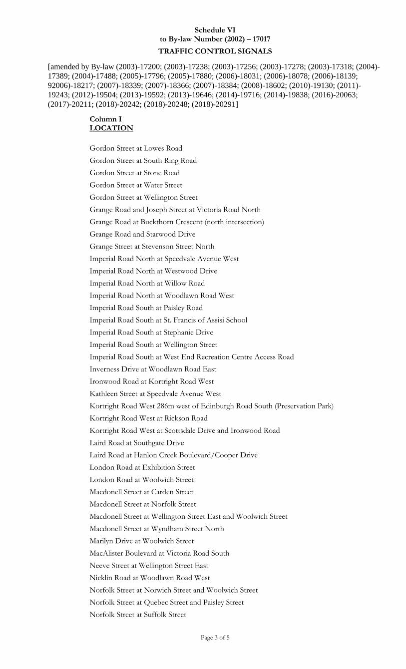
Schedule VI to By-law Number (2002) – 17017
TRAFFIC CONTROL SIGNALS
[amended by By-law (2003)-17200; (2003)-17238; (2003)-17256; (2003)-17278; (2003)-17318; (2004)-
17389; (2004)-17488; (2005)-17796; (2005)-17880; (2006)-18031; (2006)-18078; (2006)-18139;
92006)-18217; (2007)-18339; (2007)-18366; (2007)-18384; (2008)-18602; (2010)-19130; (2011)-
19243; (2012)-19504; (2013)-19592; (2013)-19646; (2014)-19716; (2014)-19838; (2016)-20063;
(2017)-20211; (2018)-20242; (2018)-20248; (2018)-20291]
Page 3 of 5
Column I LOCATION
Gordon Street at Lowes Road
Gordon Street at South Ring Road
Gordon Street at Stone Road
Gordon Street at Water Street
Gordon Street at Wellington Street
Grange Road and Joseph Street at Victoria Road North
Grange Road at Buckthorn Crescent (north intersection)
Grange Road and Starwood Drive
Grange Street at Stevenson Street North
Imperial Road North at Speedvale Avenue West
Imperial Road North at Westwood Drive
Imperial Road North at Willow Road
Imperial Road North at Woodlawn Road West
Imperial Road South at Paisley Road
Imperial Road South at St. Francis of Assisi School
Imperial Road South at Stephanie Drive
Imperial Road South at Wellington Street
Imperial Road South at West End Recreation Centre Access Road
Inverness Drive at Woodlawn Road East
Ironwood Road at Kortright Road West
Kathleen Street at Speedvale Avenue West
Kortright Road West 286m west of Edinburgh Road South (Preservation Park)
Kortright Road West at Rickson Road
Kortright Road West at Scottsdale Drive and Ironwood Road
Laird Road at Southgate Drive
Laird Road at Hanlon Creek Boulevard/Cooper Drive
London Road at Exhibition Street
London Road at Woolwich Street
Macdonell Street at Carden Street
Macdonell Street at Norfolk Street
Macdonell Street at Wellington Street East and Woolwich Street
Macdonell Street at Wyndham Street North
Marilyn Drive at Woolwich Street
MacAlister Boulevard at Victoria Road South
Neeve Street at Wellington Street East
Nicklin Road at Woodlawn Road West
Norfolk Street at Norwich Street and Woolwich Street
Norfolk Street at Quebec Street and Paisley Street
Norfolk Street at Suffolk Street
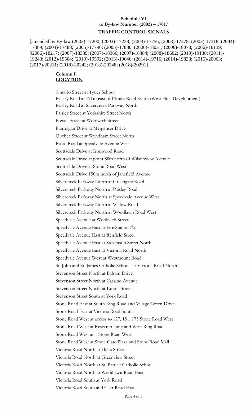
Schedule VI to By-law Number (2002) – 17017
TRAFFIC CONTROL SIGNALS
[amended by By-law (2003)-17200; (2003)-17238; (2003)-17256; (2003)-17278; (2003)-17318; (2004)-
17389; (2004)-17488; (2005)-17796; (2005)-17880; (2006)-18031; (2006)-18078; (2006)-18139;
92006)-18217; (2007)-18339; (2007)-18366; (2007)-18384; (2008)-18602; (2010)-19130; (2011)-
19243; (2012)-19504; (2013)-19592; (2013)-19646; (2014)-19716; (2014)-19838; (2016)-20063;
(2017)-20211; (2018)-20242; (2018)-20248; (2018)-20291]
Page 4 of 5
Column I LOCATION
Ontario Street at Tytler School
Paisley Road at 191m east of Elmira Road South (West Hills Development)
Paisley Road at Silvercreek Parkway North
Paisley Street at Yorkshire Street North
Powell Street at Woolwich Street
Ptarmigan Drive at Merganser Drive
Quebec Street at Wyndham Street North
Royal Road at Speedvale Avenue West
Scottsdale Drive at Ironwood Road
Scottsdale Drive at point 88m north of Wilsonview Avenue
Scottsdale Drive at Stone Road West
Scottsdale Drive 150m north of Janefield Avenue
Silvercreek Parkway North at Greengate Road
Silvercreek Parkway North at Paisley Road
Silvercreek Parkway North at Speedvale Avenue West
Silvercreek Parkway North at Willow Road
Silvercreek Parkway North at Woodlawn Road West
Speedvale Avenue at Woolwich Street
Speedvale Avenue East at Fire Station #2
Speedvale Avenue East at Renfield Street
Speedvale Avenue East at Stevenson Street North
Speedvale Avenue East at Victoria Road North
Speedvale Avenue West at Westmount Road
St. John and St. James Catholic Schools at Victoria Road North
Stevenson Street North at Balsam Drive
Stevenson Street North at Cassino Avenue
Stevenson Street North at Emma Street
Stevenson Street South at York Road
Stone Road East at South Ring Road and Village Green Drive
Stone Road East at Victoria Road South
Stone Road West at access to 127, 151, 175 Stone Road West
Stone Road West at Research Lane and West Ring Road
Stone Road West at 1 Stone Road West
Stone Road West at Stone Gate Plaza and Stone Road Mall
Victoria Road North at Delta Street
Victoria Road North at Greenview Street
Victoria Road North at St. Patrick Catholic School
Victoria Road North at Woodlawn Road East
Victoria Road South at York Road
Victoria Road South and Clair Road East
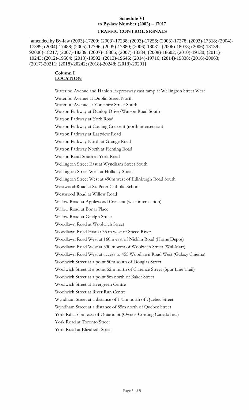
Schedule VI to By-law Number (2002) – 17017
TRAFFIC CONTROL SIGNALS
[amended by By-law (2003)-17200; (2003)-17238; (2003)-17256; (2003)-17278; (2003)-17318; (2004)-
17389; (2004)-17488; (2005)-17796; (2005)-17880; (2006)-18031; (2006)-18078; (2006)-18139;
92006)-18217; (2007)-18339; (2007)-18366; (2007)-18384; (2008)-18602; (2010)-19130; (2011)-
19243; (2012)-19504; (2013)-19592; (2013)-19646; (2014)-19716; (2014)-19838; (2016)-20063;
(2017)-20211; (2018)-20242; (2018)-20248; (2018)-20291]
Page 5 of 5
Column I LOCATION
Waterloo Avenue and Hanlon Expressway east ramp at Wellington Street West
Waterloo Avenue at Dublin Street North
Waterloo Avenue at Yorkshire Street South
Watson Parkway at Dunlop Drive/Watson Road South
Watson Parkway at York Road
Watson Parkway at Couling Crescent (north intersection)
Watson Parkway at Eastview Road
Watson Parkway North at Grange Road
Watson Parkway North at Fleming Road
Watson Road South at York Road
Wellington Street East at Wyndham Street South
Wellington Street West at Holliday Street
Wellington Street West at 490m west of Edinburgh Road South
Westwood Road at St. Peter Catholic School
Westwood Road at Willow Road
Willow Road at Applewood Crescent (west intersection)
Willow Road at Bonar Place
Willow Road at Guelph Street
Woodlawn Road at Woolwich Street
Woodlawn Road East at 35 m west of Speed River
Woodlawn Road West at 160m east of Nicklin Road (Home Depot)
Woodlawn Road West at 330 m west of Woolwich Street (Wal-Mart)
Woodlawn Road West at access to 455 Woodlawn Road West (Galaxy Cinema)
Woolwich Street at a point 50m south of Douglas Street
Woolwich Street at a point 52m north of Clarence Street (Spur Line Trail)
Woolwich Street at a point 5m north of Baker Street
Woolwich Street at Evergreen Centre
Woolwich Street at River Run Centre
Wyndham Street at a distance of 175m north of Quebec Street
Wyndham Street at a distance of 85m north of Quebec Street
York Rd at 65m east of Ontario St (Owens-Corning Canada Inc.)
York Road at Toronto Street
York Road at Elizabeth Street
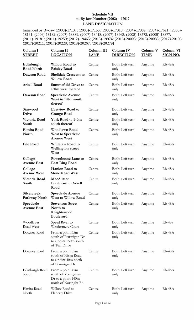
Schedule VII to By-law Number (2002) – 17017
LANE DESIGNATION
[amended by By-law (2003)-17137; (2003)-17155; (2003)-17318; (2004)-17389; (2004)-17621; (2006)-
18161; (2006)-18182; (2007)-18339; (2007)-18418; (2007)-18463; (2008)-18572; (2009)-18877;
(2011)-19181; (2011)-19259; (2012)-19465; (2015)-19974; (2016)-20003; (2016)-20085; (2017)-20195;
(2017)-20211; (2017)-20228; (2018)-20267; (2018)-20279]
Page 1 of 12
Column I STREET
Column II LOCATION
Column III LANE
Column IV DIRECTION
Column V TIME
Column VI SIGN NO.
Edinburgh Road North
Willow Road to Paisley Road
Centre Both: Left turn only
Anytime Rb-48A
Dawson Road Shelldale Crescent to Willow Road
Centre Both: Left turn only
Anytime Rb-48A
Arkell Road Summefield Drive to 180m west thereof
Centre Both: Left turn only
Anytime Rb-48A
Dawson Road Speedvale Avenue West to 190m south thereof
Centre Both: Left turn only
Anytime Rb-48A
Starwood Drive
Eastview Road to Grange Road
Centre Both: Left turn only
Anytime Rb-48A
Victoria Road South
York Road to 140m south thereof
Centre Both: Left turn only
Anytime Rb-48A
Elmira Road North
Woodlawn Road West to Speedvale Avenue West
Centre Both: Left turn only
Anytime Rb-48A
Fife Road Whitelaw Road to Wellington Street West
Centre Both: Left turn only
Anytime Rb-48A
College Avenue East
Powerhouse Lane to East Ring Road
Centre Both: Left turn only
Anytime Rb-48A
College Avenue West
Hanlon Road to Stone Road West
Centre Both: Left turn only
Anytime Rb-48A
Victoria Road South
MacAlister Boulevard to Arkell Road
Centre Both: Left turn only
Anytime Rb-48A
Silvercreek Parkway North
Speedvale Avenue West to Willow Road
Centre Both: Left turn only
Anytime Rb-48A
Speedvale Avenue East
Stevenson Street North to Knightswood Boulevard
Centre Both: Left turn only
Anytime Rb-48A
Woodlawn Road West
Speed River to Windermere Court
Centre Both: Left turn only
Anytime Rb-48a
Downey Road From a point 35m south of Ptarmigan Dr to a point 150m south of Teal Drive
Centre Both: Left turn only
Anytime Rb-48A
Downey Road From a point 55m south of Niska Road to a point 40m north of Ptarmigan Dr
Centre Both: Left turn only
Anytime Rb-48A
Edinburgh Road South
From a point 45m south of Youngman Dr to a point 140m north of Kortright Rd
Centre Both: Left turn only
Anytime Rb-48A
Elmira Road North
Willow Road to Flaherty Drive
Centre Both: Left turn only
Anytime Rb-48A
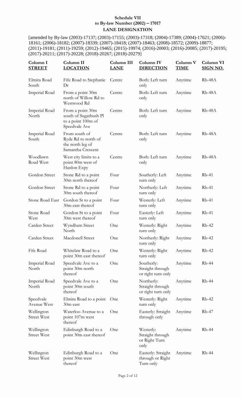
Schedule VII to By-law Number (2002) – 17017
LANE DESIGNATION
[amended by By-law (2003)-17137; (2003)-17155; (2003)-17318; (2004)-17389; (2004)-17621; (2006)-
18161; (2006)-18182; (2007)-18339; (2007)-18418; (2007)-18463; (2008)-18572; (2009)-18877;
(2011)-19181; (2011)-19259; (2012)-19465; (2015)-19974; (2016)-20003; (2016)-20085; (2017)-20195;
(2017)-20211; (2017)-20228; (2018)-20267; (2018)-20279]
Page 2 of 12
Column I STREET
Column II LOCATION
Column III LANE
Column IV DIRECTION
Column V TIME
Column VI SIGN NO.
Elmira Road South
Fife Road to Stephanie Dr
Centre Both: Left turn only
Anytime Rb-48A
Imperial Road From a point 30m north of Willow Rd to Westwood Rd
Centre Both: Left turn only
Anytime Rb-48A
Imperial Road North
From a point 30m south of Sugarbush Pl to a point 100m of Speedvale Ave
Centre Both: Left turn only
Anytime Rb-48A
Imperial Road South
From south of Ryde Rd to north of the north leg of Samantha Crescent
Centre
Both: Left turn only
Anytime Rb-48A
Woodlawn Road West
West city limits to a point 80m west of Hanlon Expy
Centre Both: Left turn only
Anytime Rb-48A
Gordon Street Stone Rd to a point 30m north thereof
Four Southerly: Left turn only
Anytime Rb-41
Gordon Street Stone Rd to a point 30m south thereof
Four Northerly: Left turn only
Anytime Rb-41
Stone Road East Gordon St to a point 30m east thereof
Four Westerly: Left turn only
Anytime Rb-41
Stone Road West
Gordon St to a point 30m west thereof
Four Easterly: Left turn only
Anytime Rb-41
Carden Street Wyndham Street North
One Westerly: Right turn only
Anytime Rb-42
Carden Street Macdonell Street One Northerly: Right turn only
Anytime Rb-42
Fife Road Whitelaw Road to a point 30m east thereof
One Westerly: Right turn only
Anytime Rb-42
Imperial Road North
Speedvale Ave to a point 30m north thereof
One Southerly: Straight through or right turn only
Anytime Rb-44
Imperial Road North
Speedvale Ave to a point 30m south thereof
One Northerly: Straight through or right turn only
Anytime Rb-44
Speedvale Avenue West
Elmira Road to a point 30m east
One Westerly: Right turn only
Anytime Rb-42
Wellington Street West
Waterloo Avenue to a point 107m west thereof
One Easterly: Straight through only
Anytime Rb-47
Wellington Street West
Edinburgh Road to a point 30m east thereof
One Westerly: Straight through or Right Turn only
Anytime Rb-44
Wellington Street West
Edinburgh Road to a point 30m west thereof
One Easterly: Straight through or Right Turn only
Anytime Rb-44
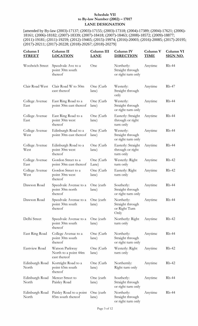
Schedule VII to By-law Number (2002) – 17017
LANE DESIGNATION
[amended by By-law (2003)-17137; (2003)-17155; (2003)-17318; (2004)-17389; (2004)-17621; (2006)-
18161; (2006)-18182; (2007)-18339; (2007)-18418; (2007)-18463; (2008)-18572; (2009)-18877;
(2011)-19181; (2011)-19259; (2012)-19465; (2015)-19974; (2016)-20003; (2016)-20085; (2017)-20195;
(2017)-20211; (2017)-20228; (2018)-20267; (2018)-20279]
Page 3 of 12
Column I STREET
Column II LOCATION
Column III LANE
Column IV DIRECTION
Column V TIME
Column VI SIGN NO.
Woolwich Street Speedvale Ave to a point 30m south thereof
One Northerly: Straight through or right turn only
Anytime Rb-44
Clair Road West Clair Road W to 50m east thereof
One (Curb lane)
Westerly: Straight through only
Anytime Rb-47
College Avenue East
East Ring Road to a point 30m east thereof
One (Curb lane)
Westerly: Straight through or right turn only
Anytime Rb-44
College Avenue East
East Ring Road to a point 30m west thereof
One (Curb lane)
Easterly: Straight through or right turn only
Anytime Rb-44
College Avenue West
Edinburgh Road to a point 30m east thereof
One (Curb lane)
Westerly: Straight through or right turn only
Anytime Rb-44
College Avenue West
Edinburgh Road to a point 30m west thereof
One (Curb lane)
Easterly: Straight through or right turn only
Anytime Rb-44
College Avenue East
Gordon Street to a point 30m east thereof
One (Curb Lane)
Westerly: Right turn only
Anytime Rb-42
College Avenue West
Gordon Street to a point 30m west thereof
One (Curb lane)
Easterly: Right turn only
Anytime Rb-42
Dawson Road Speedvale Avenue to a point 30m north thereof
One (curb lane)
Southerly: Straight through or right turn only
Anytime Rb-44
Dawson Road Speedvale Avenue to a point 30m south thereof
One (curb lane)
Northerly: Straight through or Right Turn Only
Anytime Rb-44
Delhi Street Speedvale Avenue to a point 30m south thereof
One (curb lane)
Northerly: Right turn only
Anytime Rb-42
East Ring Road College Avenue to a point 30m south thereof
One (Curb lane)
Northerly: Straight through or right turn only
Anytime Rb-44
Eastview Road Watson Parkway North to a point 44m east thereof
One (Curb lane)
Westerly: Right turn only
Anytime Rb-42
Edinburgh Road North
Kortright Road to a point 65m south thereof
One (Curb lane)
Northernly: Right turn only
Anytime Rb-42
Edinburgh Road North
Mercer Street to Paisley Road
One (curb lane)
Southerly: Straight through or right turn only
Anytime Rb-44
Edinburgh Road North
Paisley Road to a point 85m south thereof
One (curb lane)
Northerly: Straight through or right turn only
Anytime Rb-44
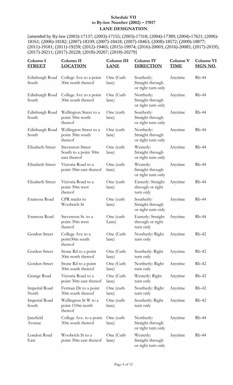
Schedule VII to By-law Number (2002) – 17017
LANE DESIGNATION
[amended by By-law (2003)-17137; (2003)-17155; (2003)-17318; (2004)-17389; (2004)-17621; (2006)-
18161; (2006)-18182; (2007)-18339; (2007)-18418; (2007)-18463; (2008)-18572; (2009)-18877;
(2011)-19181; (2011)-19259; (2012)-19465; (2015)-19974; (2016)-20003; (2016)-20085; (2017)-20195;
(2017)-20211; (2017)-20228; (2018)-20267; (2018)-20279]
Page 4 of 12
Column I STREET
Column II LOCATION
Column III LANE
Column IV DIRECTION
Column V TIME
Column VI SIGN NO.
Edinburgh Road South
College Ave to a point 30m north thereof
One (Curb lane)
Southerly: Straight through or right turn only
Anytime Rb-44
Edinburgh Road South
College Ave to a point 30m south thereof
One (Curb lane)
Northerly: Straight through or right turn only
Anytime Rb-44
Edinburgh Road South
Wellington Street to a point 30m north thereof
One (curb lane)
Southerly: Straight through or right turn only
Anytime Rb-44
Edinburgh Road South
Wellington Street to a point 30m south thereof
One (curb lane)
Northerly: Straight through or right turn only
Anytime Rb-44
Elizabeth Street Stevenson Street South to a point 30m east thereof
One (curb lane)
Westerly: Straight through or right turn only
Anytime Rb-44
Elizabeth Street Victoria Road to a point 30m east thereof
One (curb lane)
Westerly: Straight through or right turn only
Anytime Rb-44
Elizabeth Street Victoria Road to a point 30m west thereof
One (curb lane)
Easterly: Straight through or right turn only
Anytime Rb-44
Eramosa Road CPR tracks to Woolwich St
One (curb lane)
Southerly: Straight through or right turn only
Anytime Rb-44
Eramosa Road Stevenson St. to a point 30m west thereof
One (curb Lane)
Easterly: Straight through or right turn only
Anytime Rb-44
Gordon Street College Ave to a point30m south thereof
One (Curb lane)
Northerly: Right turn only
Anytime Rb-42
Gordon Street Stone Rd to a point 30m north thereof
One (Curb lane)
Southerly: Right turn only
Anytime Rb-42
Gordon Street Stone Rd to a point 30m south thereof
One (Curb lane)
Northerly: Right turn only
Anytime Rb-42
Grange Road Victoria Road to a point 30m east thereof
One (Curb lane)
Westerly: Right turn only
Anytime Rb-42
Imperial Road North
Ferman Dr to a point 30m south thereof
One (curb lane)
Northerly: Right turn only
Anytime Rb-42
Imperial Road South
Wellington St W to a point 110m north thereof
One (curb lane)
Southerly: Right turn only
Anytime Rb-42
Janefield Avenue
College Ave. to a point 30m south thereof
One (curb lane)
Northerly: Straight through or right turn only
Anytime Rb-44
London Road East
Woolwich St to a point 30m east thereof
One (Curb lane)
Westerly: Straight through or right turn only
Anytime Rb-44
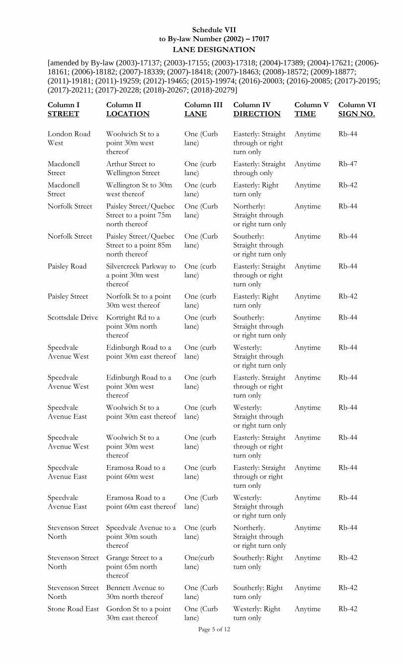
Schedule VII to By-law Number (2002) – 17017
LANE DESIGNATION
[amended by By-law (2003)-17137; (2003)-17155; (2003)-17318; (2004)-17389; (2004)-17621; (2006)-
18161; (2006)-18182; (2007)-18339; (2007)-18418; (2007)-18463; (2008)-18572; (2009)-18877;
(2011)-19181; (2011)-19259; (2012)-19465; (2015)-19974; (2016)-20003; (2016)-20085; (2017)-20195;
(2017)-20211; (2017)-20228; (2018)-20267; (2018)-20279]
Page 5 of 12
Column I STREET
Column II LOCATION
Column III LANE
Column IV DIRECTION
Column V TIME
Column VI SIGN NO.
London Road West
Woolwich St to a point 30m west thereof
One (Curb lane)
Easterly: Straight through or right turn only
Anytime Rb-44
Macdonell Street
Arthur Street to Wellington Street
One (curb lane)
Easterly: Straight through only
Anytime Rb-47
Macdonell Street
Wellington St to 30m west thereof
One (curb lane)
Easterly: Right turn only
Anytime Rb-42
Norfolk Street Paisley Street/Quebec Street to a point 75m north thereof
One (Curb lane)
Northerly: Straight through or right turn only
Anytime Rb-44
Norfolk Street Paisley Street/Quebec Street to a point 85m north thereof
One (Curb lane)
Southerly: Straight through or right turn only
Anytime Rb-44
Paisley Road Silvercreek Parkway to a point 30m west thereof
One (curb lane)
Easterly: Straight through or right turn only
Anytime Rb-44
Paisley Street Norfolk St to a point 30m west thereof
One (curb lane)
Easterly: Right turn only
Anytime Rb-42
Scottsdale Drive Kortright Rd to a point 30m north thereof
One (curb lane)
Southerly: Straight through or right turn only
Anytime Rb-44
Speedvale Avenue West
Edinburgh Road to a point 30m east thereof
One (curb lane)
Westerly: Straight through or right turn only
Anytime Rb-44
Speedvale Avenue West
Edinburgh Road to a point 30m west thereof
One (curb lane)
Easterly. Straight through or right turn only
Anytime Rb-44
Speedvale Avenue East
Woolwich St to a point 30m east thereof
One (curb lane)
Westerly: Straight through or right turn only
Anytime Rb-44
Speedvale Avenue West
Woolwich St to a point 30m west thereof
One (curb lane)
Easterly: Straight through or right turn only
Anytime Rb-44
Speedvale Avenue East
Eramosa Road to a point 60m west
One (curb lane)
Easterly: Straight through or right turn only
Anytime Rb-44
Speedvale Avenue East
Eramosa Road to a point 60m east thereof
One (Curb lane)
Westerly: Straight through or right turn only
Anytime Rb-44
Stevenson Street North
Speedvale Avenue to a point 30m south thereof
One (curb lane)
Northerly. Straight through or right turn only
Anytime Rb-44
Stevenson Street North
Grange Street to a point 65m north thereof
One(curb lane)
Southerly: Right turn only
Anytime Rb-42
Stevenson Street North
Bennett Avenue to 30m north thereof
One (Curb lane)
Southerly: Right turn only
Anytime Rb-42
Stone Road East Gordon St to a point 30m east thereof
One (Curb lane)
Westerly: Right turn only
Anytime Rb-42
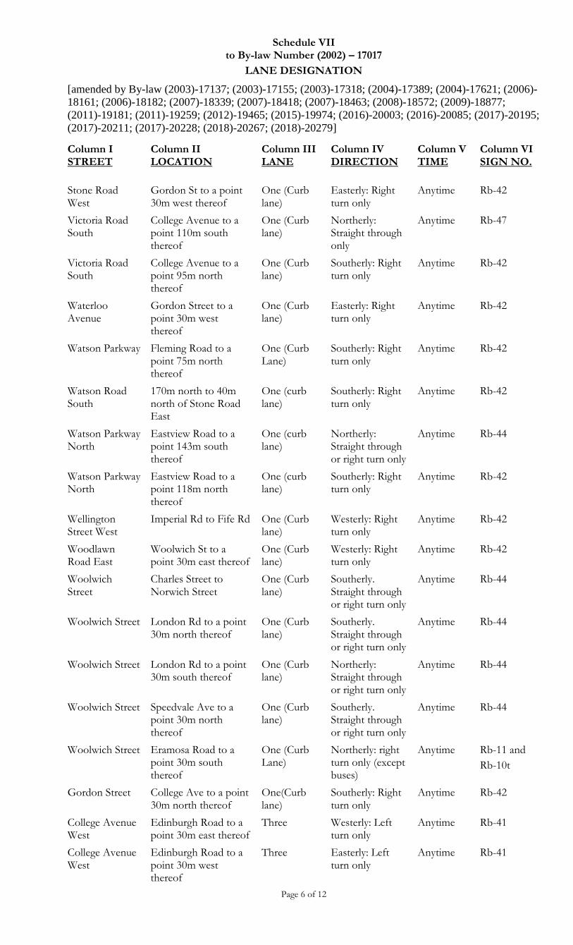
Schedule VII to By-law Number (2002) – 17017
LANE DESIGNATION
[amended by By-law (2003)-17137; (2003)-17155; (2003)-17318; (2004)-17389; (2004)-17621; (2006)-
18161; (2006)-18182; (2007)-18339; (2007)-18418; (2007)-18463; (2008)-18572; (2009)-18877;
(2011)-19181; (2011)-19259; (2012)-19465; (2015)-19974; (2016)-20003; (2016)-20085; (2017)-20195;
(2017)-20211; (2017)-20228; (2018)-20267; (2018)-20279]
Page 6 of 12
Column I STREET
Column II LOCATION
Column III LANE
Column IV DIRECTION
Column V TIME
Column VI SIGN NO.
Stone Road West
Gordon St to a point 30m west thereof
One (Curb lane)
Easterly: Right turn only
Anytime Rb-42
Victoria Road South
College Avenue to a point 110m south thereof
One (Curb lane)
Northerly: Straight through only
Anytime Rb-47
Victoria Road South
College Avenue to a point 95m north thereof
One (Curb lane)
Southerly: Right turn only
Anytime Rb-42
Waterloo Avenue
Gordon Street to a point 30m west thereof
One (Curb lane)
Easterly: Right turn only
Anytime Rb-42
Watson Parkway Fleming Road to a point 75m north thereof
One (Curb Lane)
Southerly: Right turn only
Anytime Rb-42
Watson Road South
170m north to 40m north of Stone Road East
One (curb lane)
Southerly: Right turn only
Anytime Rb-42
Watson Parkway North
Eastview Road to a point 143m south thereof
One (curb lane)
Northerly: Straight through or right turn only
Anytime Rb-44
Watson Parkway North
Eastview Road to a point 118m north thereof
One (curb lane)
Southerly: Right turn only
Anytime Rb-42
Wellington Street West
Imperial Rd to Fife Rd One (Curb lane)
Westerly: Right turn only
Anytime Rb-42
Woodlawn Road East
Woolwich St to a point 30m east thereof
One (Curb lane)
Westerly: Right turn only
Anytime Rb-42
Woolwich Street
Charles Street to Norwich Street
One (Curb lane)
Southerly. Straight through or right turn only
Anytime Rb-44
Woolwich Street London Rd to a point 30m north thereof
One (Curb lane)
Southerly. Straight through or right turn only
Anytime Rb-44
Woolwich Street London Rd to a point 30m south thereof
One (Curb lane)
Northerly: Straight through or right turn only
Anytime Rb-44
Woolwich Street Speedvale Ave to a point 30m north thereof
One (Curb lane)
Southerly. Straight through or right turn only
Anytime Rb-44
Woolwich Street Eramosa Road to a point 30m south thereof
One (Curb Lane)
Northerly: right turn only (except buses)
Anytime Rb-11 and
Rb-10t
Gordon Street College Ave to a point 30m north thereof
One(Curb lane)
Southerly: Right turn only
Anytime Rb-42
College Avenue West
Edinburgh Road to a point 30m east thereof
Three Westerly: Left turn only
Anytime Rb-41
College Avenue West
Edinburgh Road to a point 30m west thereof
Three Easterly: Left turn only
Anytime Rb-41
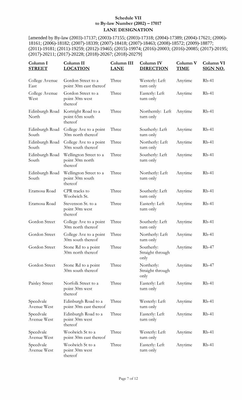
Schedule VII to By-law Number (2002) – 17017
LANE DESIGNATION
[amended by By-law (2003)-17137; (2003)-17155; (2003)-17318; (2004)-17389; (2004)-17621; (2006)-
18161; (2006)-18182; (2007)-18339; (2007)-18418; (2007)-18463; (2008)-18572; (2009)-18877;
(2011)-19181; (2011)-19259; (2012)-19465; (2015)-19974; (2016)-20003; (2016)-20085; (2017)-20195;
(2017)-20211; (2017)-20228; (2018)-20267; (2018)-20279]
Page 7 of 12
Column I STREET
Column II LOCATION
Column III LANE
Column IV DIRECTION
Column V TIME
Column VI SIGN NO.
College Avenue East
Gordon Street to a point 30m east thereof
Three Westerly: Left turn only
Anytime Rb-41
College Avenue West
Gordon Street to a point 30m west thereof
Three Easterly: Left turn only
Anytime Rb-41
Edinburgh Road North
Kortright Road to a point 65m south thereof
Three Northernly: Left turn only
Anytime Rb-41
Edinburgh Road South
College Ave to a point 30m north thereof
Three Southerly: Left turn only
Anytime Rb-41
Edinburgh Road South
College Ave to a point 30m south thereof
Three Northerly: Left turn only
Anytime Rb-41
Edinburgh Road South
Wellington Street to a point 30m north thereof
Three Southerly: Left turn only
Anytime Rb-41
Edinburgh Road South
Wellington Street to a point 30m south thereof
Three Northerly: Left turn only
Anytime Rb-41
Eramosa Road CPR tracks to Woolwich St.
Three Southerly: Left turn only
Anytime Rb-41
Eramosa Road Stevenson St. to a point 30m west thereof
Three Easterly: Left turn only
Anytime Rb-41
Gordon Street College Ave to a point 30m north thereof
Three Southerly: Left turn only
Anytime Rb-41
Gordon Street College Ave to a point 30m south thereof
Three Northerly: Left turn only
Anytime Rb-41
Gordon Street Stone Rd to a point 30m north thereof
Three Southerly: Straight through only
Anytime Rb-47
Gordon Street Stone Rd to a point 30m south thereof
Three Northerly: Straight through only
Anytime Rb-47
Paisley Street Norfolk Street to a point 30m west thereof
Three Easterly: Left turn only
Anytime Rb-41
Speedvale Avenue West
Edinburgh Road to a point 30m east thereof
Three Westerly: Left turn only
Anytime Rb-41
Speedvale Avenue West
Edinburgh Road to a point 30m west thereof
Three Easterly: Left turn only
Anytime Rb-41
Speedvale Avenue West
Woolwich St to a point 30m east thereof
Three Westerly: Left turn only
Anytime Rb-41
Speedvale Avenue West
Woolwich St to a point 30m west thereof
Three Easterly: Left turn only
Anytime Rb-41
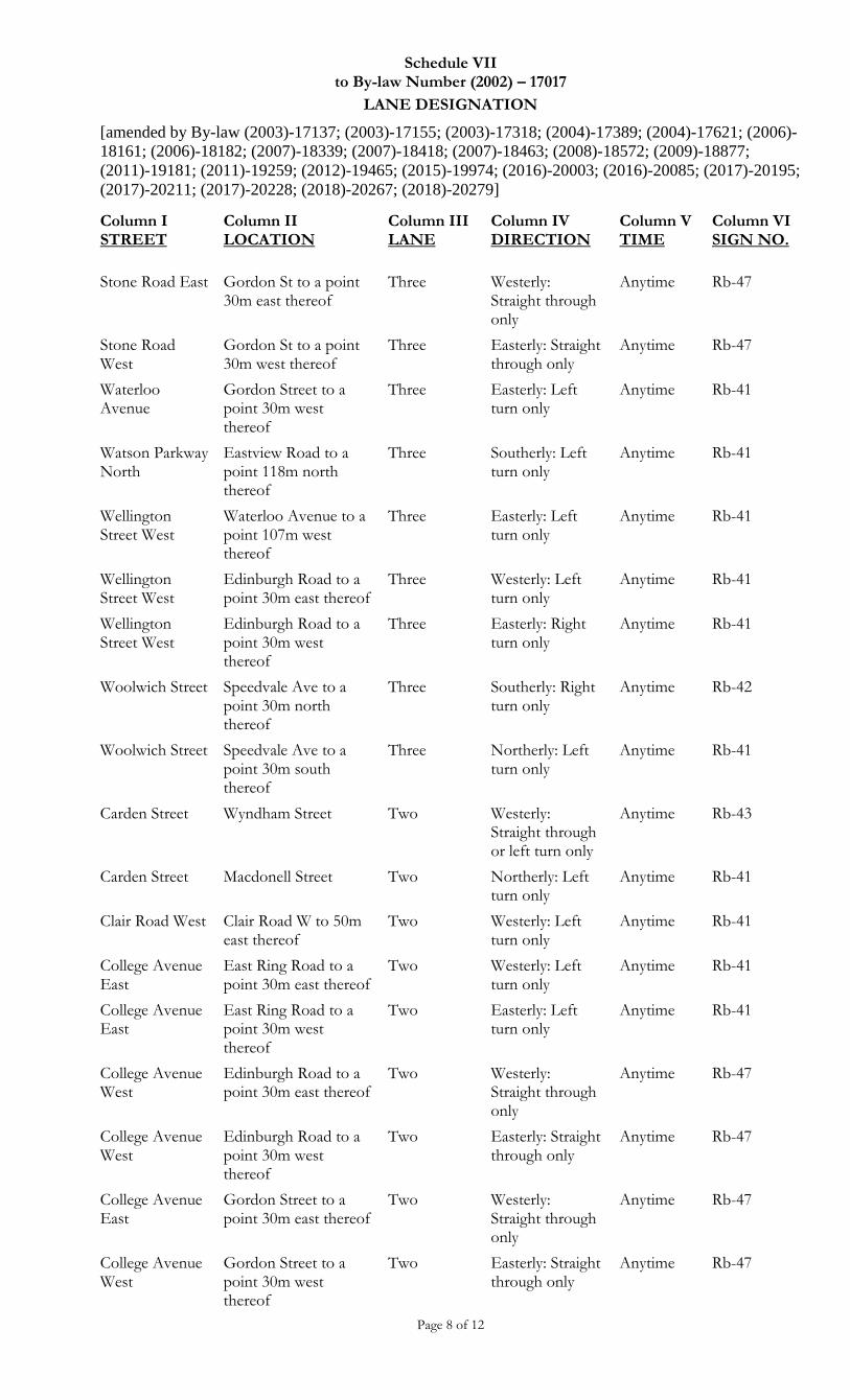
Schedule VII to By-law Number (2002) – 17017
LANE DESIGNATION
[amended by By-law (2003)-17137; (2003)-17155; (2003)-17318; (2004)-17389; (2004)-17621; (2006)-
18161; (2006)-18182; (2007)-18339; (2007)-18418; (2007)-18463; (2008)-18572; (2009)-18877;
(2011)-19181; (2011)-19259; (2012)-19465; (2015)-19974; (2016)-20003; (2016)-20085; (2017)-20195;
(2017)-20211; (2017)-20228; (2018)-20267; (2018)-20279]
Page 8 of 12
Column I STREET
Column II LOCATION
Column III LANE
Column IV DIRECTION
Column V TIME
Column VI SIGN NO.
Stone Road East Gordon St to a point 30m east thereof
Three Westerly: Straight through only
Anytime Rb-47
Stone Road West
Gordon St to a point 30m west thereof
Three Easterly: Straight through only
Anytime Rb-47
Waterloo Avenue
Gordon Street to a point 30m west thereof
Three Easterly: Left turn only
Anytime Rb-41
Watson Parkway North
Eastview Road to a point 118m north thereof
Three Southerly: Left turn only
Anytime Rb-41
Wellington Street West
Waterloo Avenue to a point 107m west thereof
Three Easterly: Left turn only
Anytime Rb-41
Wellington Street West
Edinburgh Road to a point 30m east thereof
Three Westerly: Left turn only
Anytime Rb-41
Wellington Street West
Edinburgh Road to a point 30m west thereof
Three Easterly: Right turn only
Anytime Rb-41
Woolwich Street Speedvale Ave to a point 30m north thereof
Three Southerly: Right turn only
Anytime Rb-42
Woolwich Street Speedvale Ave to a point 30m south thereof
Three Northerly: Left turn only
Anytime Rb-41
Carden Street Wyndham Street Two Westerly: Straight through or left turn only
Anytime Rb-43
Carden Street Macdonell Street Two Northerly: Left turn only
Anytime Rb-41
Clair Road West Clair Road W to 50m east thereof
Two Westerly: Left turn only
Anytime Rb-41
College Avenue East
East Ring Road to a point 30m east thereof
Two Westerly: Left turn only
Anytime Rb-41
College Avenue East
East Ring Road to a point 30m west thereof
Two Easterly: Left turn only
Anytime Rb-41
College Avenue West
Edinburgh Road to a point 30m east thereof
Two Westerly: Straight through only
Anytime Rb-47
College Avenue West
Edinburgh Road to a point 30m west thereof
Two Easterly: Straight through only
Anytime Rb-47
College Avenue East
Gordon Street to a point 30m east thereof
Two Westerly: Straight through only
Anytime Rb-47
College Avenue West
Gordon Street to a point 30m west thereof
Two Easterly: Straight through only
Anytime Rb-47
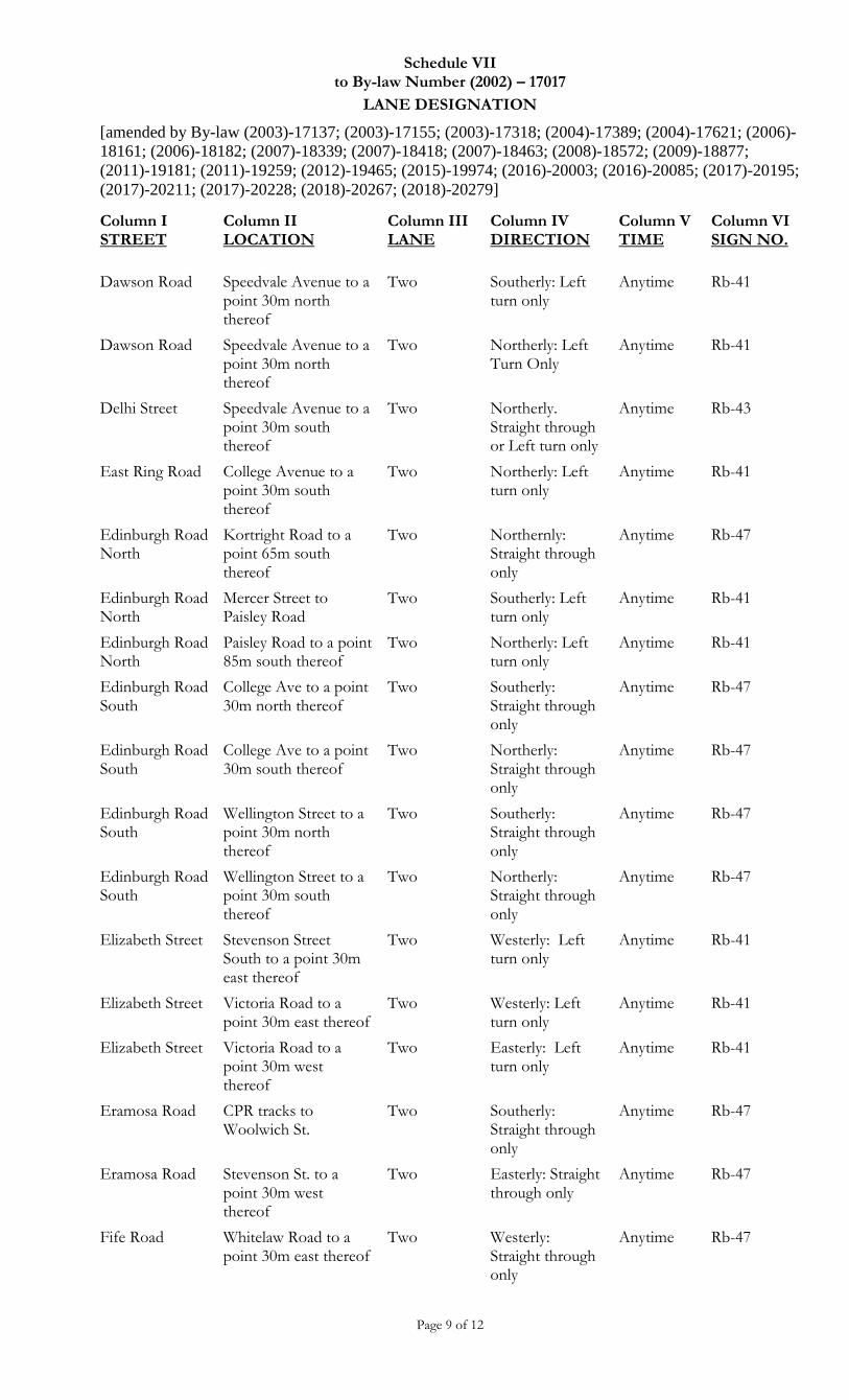
Schedule VII to By-law Number (2002) – 17017
LANE DESIGNATION
[amended by By-law (2003)-17137; (2003)-17155; (2003)-17318; (2004)-17389; (2004)-17621; (2006)-
18161; (2006)-18182; (2007)-18339; (2007)-18418; (2007)-18463; (2008)-18572; (2009)-18877;
(2011)-19181; (2011)-19259; (2012)-19465; (2015)-19974; (2016)-20003; (2016)-20085; (2017)-20195;
(2017)-20211; (2017)-20228; (2018)-20267; (2018)-20279]
Page 9 of 12
Column I STREET
Column II LOCATION
Column III LANE
Column IV DIRECTION
Column V TIME
Column VI SIGN NO.
Dawson Road Speedvale Avenue to a point 30m north thereof
Two Southerly: Left turn only
Anytime Rb-41
Dawson Road Speedvale Avenue to a point 30m north thereof
Two Northerly: Left Turn Only
Anytime Rb-41
Delhi Street Speedvale Avenue to a point 30m south thereof
Two Northerly. Straight through or Left turn only
Anytime Rb-43
East Ring Road College Avenue to a point 30m south thereof
Two Northerly: Left turn only
Anytime Rb-41
Edinburgh Road North
Kortright Road to a point 65m south thereof
Two Northernly: Straight through only
Anytime Rb-47
Edinburgh Road North
Mercer Street to Paisley Road
Two Southerly: Left turn only
Anytime Rb-41
Edinburgh Road North
Paisley Road to a point 85m south thereof
Two Northerly: Left turn only
Anytime Rb-41
Edinburgh Road South
College Ave to a point 30m north thereof
Two Southerly: Straight through only
Anytime Rb-47
Edinburgh Road South
College Ave to a point 30m south thereof
Two Northerly: Straight through only
Anytime Rb-47
Edinburgh Road South
Wellington Street to a point 30m north thereof
Two Southerly: Straight through only
Anytime Rb-47
Edinburgh Road South
Wellington Street to a point 30m south thereof
Two Northerly: Straight through only
Anytime Rb-47
Elizabeth Street Stevenson Street South to a point 30m east thereof
Two Westerly: Left turn only
Anytime Rb-41
Elizabeth Street Victoria Road to a point 30m east thereof
Two Westerly: Left turn only
Anytime Rb-41
Elizabeth Street Victoria Road to a point 30m west thereof
Two Easterly: Left turn only
Anytime Rb-41
Eramosa Road CPR tracks to Woolwich St.
Two Southerly: Straight through only
Anytime Rb-47
Eramosa Road Stevenson St. to a point 30m west thereof
Two Easterly: Straight through only
Anytime Rb-47
Fife Road Whitelaw Road to a point 30m east thereof
Two Westerly: Straight through only
Anytime Rb-47
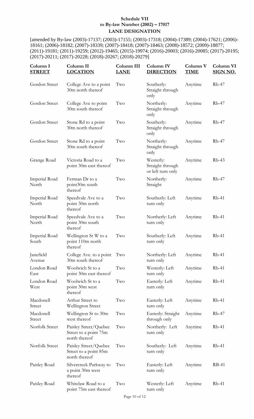
Schedule VII to By-law Number (2002) – 17017
LANE DESIGNATION
[amended by By-law (2003)-17137; (2003)-17155; (2003)-17318; (2004)-17389; (2004)-17621; (2006)-
18161; (2006)-18182; (2007)-18339; (2007)-18418; (2007)-18463; (2008)-18572; (2009)-18877;
(2011)-19181; (2011)-19259; (2012)-19465; (2015)-19974; (2016)-20003; (2016)-20085; (2017)-20195;
(2017)-20211; (2017)-20228; (2018)-20267; (2018)-20279]
Page 10 of 12
Column I STREET
Column II LOCATION
Column III LANE
Column IV DIRECTION
Column V TIME
Column VI SIGN NO.
Gordon Street College Ave to a point 30m north thereof
Two Southerly: Straight through only
Anytime Rb-47
Gordon Street College Ave to point 30m south thereof
Two Northerly: Straight through only
Anytime Rb-47
Gordon Street Stone Rd to a point 30m north thereof
Two Southerly: Straight through only
Anytime Rb-47
Gordon Street Stone Rd to a point 30m south thereof
Two Northerly: Straight through only
Anytime Rb-47
Grange Road Victoria Road to a point 30m east thereof
Two Westerly: Straight through or left turn only
Anytime Rb-43
Imperial Road North
Ferman Dr to a point30m south thereof
Two Northerly: Straight
Anytime Rb-47
Imperial Road North
Speedvale Ave to a point 30m north thereof
Two Southerly: Left turn only
Anytime Rb-41
Imperial Road North
Speedvale Ave to a point 30m south thereof
Two Northerly: Left turn only
Anytime Rb-41
Imperial Road South
Wellington St W to a point 110m north thereof
Two
Southerly: Left turn only
Anytime Rb-41
Janefield Avenue
College Ave. to a point 30m south thereof
Two Northerly: Left turn only
Anytime Rb-41
London Road East
Woolwich St to a point 30m east thereof
Two Westerly: Left turn only
Anytime Rb-41
London Road West
Woolwich St to a point 30m west thereof
Two Easterly: Left turn only
Anytime Rb-41
Macdonell Street
Arthur Street to Wellington Street
Two Easterly: Left turn only
Anytime Rb-41
Macdonell Street
Wellington St to 30m west thereof
Two Easterly: Straight through only
Anytime Rb-47
Norfolk Street Paisley Street/Quebec Street to a point 75m north thereof
Two Northerly: Left turn only
Anytime Rb-41
Norfolk Street Paisley Street/Quebec Street to a point 85m north thereof
Two Southerly: Left turn only
Anytime Rb-41
Paisley Road Silvercreek Parkway to a point 30m west thereof
Two Easterly: Left turn only
Anytime RB-41
Paisley Road Whitelaw Road to a point 75m east thereof
Two Westerly: Left turn only
Anytime Rb-41
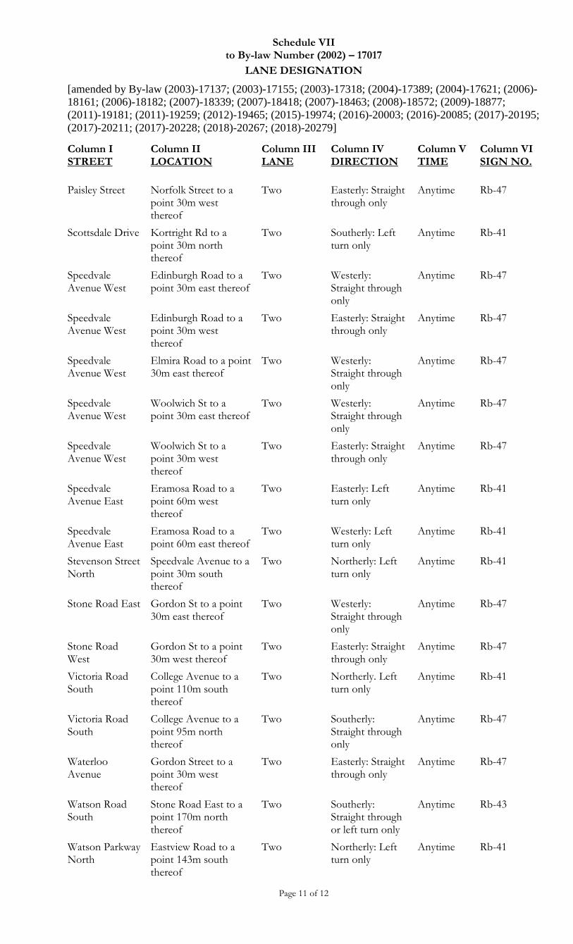
Schedule VII to By-law Number (2002) – 17017
LANE DESIGNATION
[amended by By-law (2003)-17137; (2003)-17155; (2003)-17318; (2004)-17389; (2004)-17621; (2006)-
18161; (2006)-18182; (2007)-18339; (2007)-18418; (2007)-18463; (2008)-18572; (2009)-18877;
(2011)-19181; (2011)-19259; (2012)-19465; (2015)-19974; (2016)-20003; (2016)-20085; (2017)-20195;
(2017)-20211; (2017)-20228; (2018)-20267; (2018)-20279]
Page 11 of 12
Column I STREET
Column II LOCATION
Column III LANE
Column IV DIRECTION
Column V TIME
Column VI SIGN NO.
Paisley Street Norfolk Street to a point 30m west thereof
Two Easterly: Straight through only
Anytime Rb-47
Scottsdale Drive Kortright Rd to a point 30m north thereof
Two Southerly: Left turn only
Anytime Rb-41
Speedvale Avenue West
Edinburgh Road to a point 30m east thereof
Two Westerly: Straight through only
Anytime Rb-47
Speedvale Avenue West
Edinburgh Road to a point 30m west thereof
Two Easterly: Straight through only
Anytime Rb-47
Speedvale Avenue West
Elmira Road to a point 30m east thereof
Two Westerly: Straight through only
Anytime Rb-47
Speedvale Avenue West
Woolwich St to a point 30m east thereof
Two Westerly: Straight through only
Anytime Rb-47
Speedvale Avenue West
Woolwich St to a point 30m west thereof
Two Easterly: Straight through only
Anytime Rb-47
Speedvale Avenue East
Eramosa Road to a point 60m west thereof
Two Easterly: Left turn only
Anytime Rb-41
Speedvale Avenue East
Eramosa Road to a point 60m east thereof
Two Westerly: Left turn only
Anytime Rb-41
Stevenson Street North
Speedvale Avenue to a point 30m south thereof
Two Northerly: Left turn only
Anytime Rb-41
Stone Road East Gordon St to a point 30m east thereof
Two Westerly: Straight through only
Anytime Rb-47
Stone Road West
Gordon St to a point 30m west thereof
Two Easterly: Straight through only
Anytime Rb-47
Victoria Road South
College Avenue to a point 110m south thereof
Two Northerly. Left turn only
Anytime Rb-41
Victoria Road South
College Avenue to a point 95m north thereof
Two Southerly: Straight through only
Anytime Rb-47
Waterloo Avenue
Gordon Street to a point 30m west thereof
Two Easterly: Straight through only
Anytime Rb-47
Watson Road South
Stone Road East to a point 170m north thereof
Two Southerly: Straight through or left turn only
Anytime Rb-43
Watson Parkway North
Eastview Road to a point 143m south thereof
Two Northerly: Left turn only
Anytime Rb-41
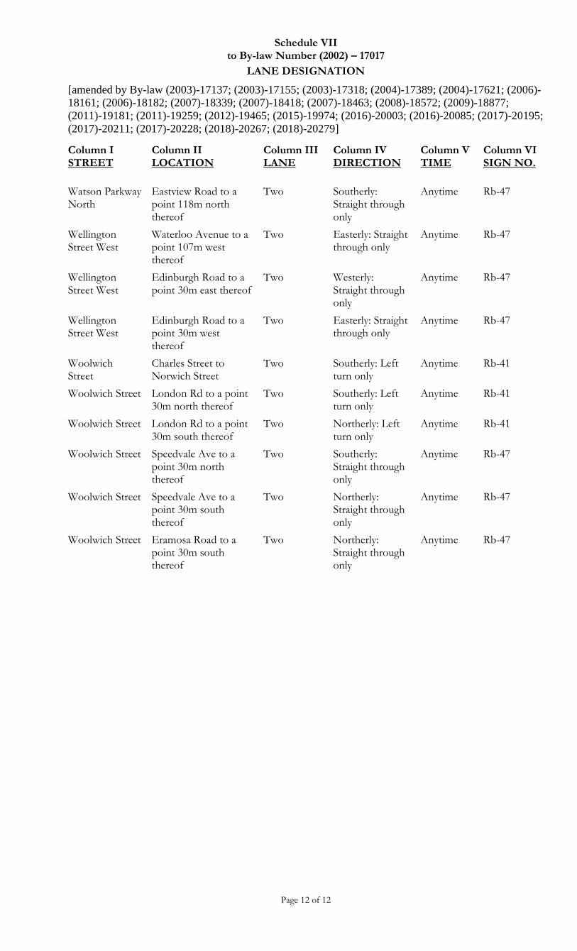
Schedule VII to By-law Number (2002) – 17017
LANE DESIGNATION
[amended by By-law (2003)-17137; (2003)-17155; (2003)-17318; (2004)-17389; (2004)-17621; (2006)-
18161; (2006)-18182; (2007)-18339; (2007)-18418; (2007)-18463; (2008)-18572; (2009)-18877;
(2011)-19181; (2011)-19259; (2012)-19465; (2015)-19974; (2016)-20003; (2016)-20085; (2017)-20195;
(2017)-20211; (2017)-20228; (2018)-20267; (2018)-20279]
Page 12 of 12
Column I STREET
Column II LOCATION
Column III LANE
Column IV DIRECTION
Column V TIME
Column VI SIGN NO.
Watson Parkway North
Eastview Road to a point 118m north thereof
Two Southerly: Straight through only
Anytime Rb-47
Wellington Street West
Waterloo Avenue to a point 107m west thereof
Two Easterly: Straight through only
Anytime Rb-47
Wellington Street West
Edinburgh Road to a point 30m east thereof
Two Westerly: Straight through only
Anytime Rb-47
Wellington Street West
Edinburgh Road to a point 30m west thereof
Two Easterly: Straight through only
Anytime Rb-47
Woolwich Street
Charles Street to Norwich Street
Two Southerly: Left turn only
Anytime Rb-41
Woolwich Street London Rd to a point 30m north thereof
Two Southerly: Left turn only
Anytime Rb-41
Woolwich Street London Rd to a point 30m south thereof
Two Northerly: Left turn only
Anytime Rb-41
Woolwich Street Speedvale Ave to a point 30m north thereof
Two Southerly: Straight through only
Anytime Rb-47
Woolwich Street Speedvale Ave to a point 30m south thereof
Two Northerly: Straight through only
Anytime Rb-47
Woolwich Street Eramosa Road to a point 30m south thereof
Two Northerly: Straight through only
Anytime Rb-47
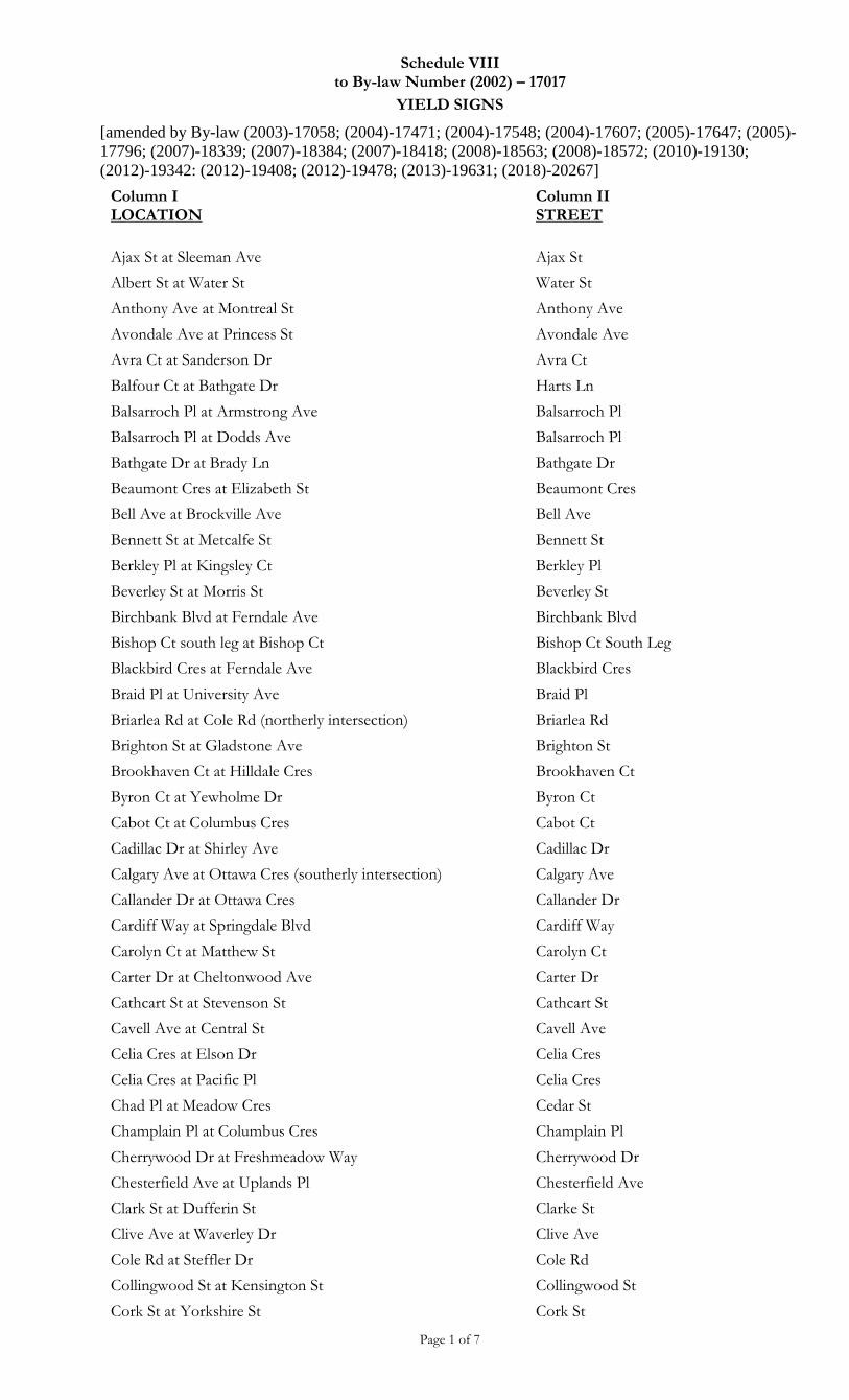
Schedule VIII to By-law Number (2002) – 17017
YIELD SIGNS
[amended by By-law (2003)-17058; (2004)-17471; (2004)-17548; (2004)-17607; (2005)-17647; (2005)-
17796; (2007)-18339; (2007)-18384; (2007)-18418; (2008)-18563; (2008)-18572; (2010)-19130;
(2012)-19342: (2012)-19408; (2012)-19478; (2013)-19631; (2018)-20267]
Page 1 of 7
Column I LOCATION
Column II STREET
Ajax St at Sleeman Ave Ajax St
Albert St at Water St Water St
Anthony Ave at Montreal St Anthony Ave
Avondale Ave at Princess St Avondale Ave
Avra Ct at Sanderson Dr Avra Ct
Balfour Ct at Bathgate Dr Harts Ln
Balsarroch Pl at Armstrong Ave Balsarroch Pl
Balsarroch Pl at Dodds Ave Balsarroch Pl
Bathgate Dr at Brady Ln Bathgate Dr
Beaumont Cres at Elizabeth St Beaumont Cres
Bell Ave at Brockville Ave Bell Ave
Bennett St at Metcalfe St Bennett St
Berkley Pl at Kingsley Ct Berkley Pl
Beverley St at Morris St Beverley St
Birchbank Blvd at Ferndale Ave Birchbank Blvd
Bishop Ct south leg at Bishop Ct Bishop Ct South Leg
Blackbird Cres at Ferndale Ave Blackbird Cres
Braid Pl at University Ave Braid Pl
Briarlea Rd at Cole Rd (northerly intersection) Briarlea Rd
Brighton St at Gladstone Ave Brighton St
Brookhaven Ct at Hilldale Cres Brookhaven Ct
Byron Ct at Yewholme Dr Byron Ct
Cabot Ct at Columbus Cres Cabot Ct
Cadillac Dr at Shirley Ave Cadillac Dr
Calgary Ave at Ottawa Cres (southerly intersection) Calgary Ave
Callander Dr at Ottawa Cres Callander Dr
Cardiff Way at Springdale Blvd Cardiff Way
Carolyn Ct at Matthew St Carolyn Ct
Carter Dr at Cheltonwood Ave Carter Dr
Cathcart St at Stevenson St Cathcart St
Cavell Ave at Central St Cavell Ave
Celia Cres at Elson Dr Celia Cres
Celia Cres at Pacific Pl Celia Cres
Chad Pl at Meadow Cres Cedar St
Champlain Pl at Columbus Cres Champlain Pl
Cherrywood Dr at Freshmeadow Way Cherrywood Dr
Chesterfield Ave at Uplands Pl Chesterfield Ave
Clark St at Dufferin St Clarke St
Clive Ave at Waverley Dr Clive Ave
Cole Rd at Steffler Dr Cole Rd
Collingwood St at Kensington St Collingwood St
Cork St at Yorkshire St Cork St
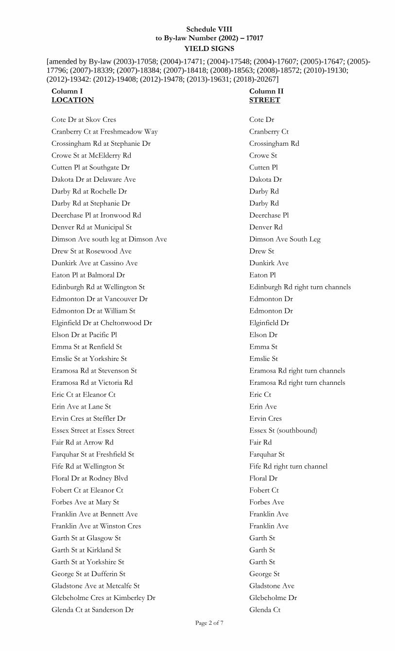
Schedule VIII to By-law Number (2002) – 17017
YIELD SIGNS
[amended by By-law (2003)-17058; (2004)-17471; (2004)-17548; (2004)-17607; (2005)-17647; (2005)-
17796; (2007)-18339; (2007)-18384; (2007)-18418; (2008)-18563; (2008)-18572; (2010)-19130;
(2012)-19342: (2012)-19408; (2012)-19478; (2013)-19631; (2018)-20267]
Page 2 of 7
Column I LOCATION
Column II STREET
Cote Dr at Skov Cres Cote Dr
Cranberry Ct at Freshmeadow Way Cranberry Ct
Crossingham Rd at Stephanie Dr Crossingham Rd
Crowe St at McElderry Rd Crowe St
Cutten Pl at Southgate Dr Cutten Pl
Dakota Dr at Delaware Ave Dakota Dr
Darby Rd at Rochelle Dr Darby Rd
Darby Rd at Stephanie Dr Darby Rd
Deerchase Pl at Ironwood Rd Deerchase Pl
Denver Rd at Municipal St Denver Rd
Dimson Ave south leg at Dimson Ave Dimson Ave South Leg
Drew St at Rosewood Ave Drew St
Dunkirk Ave at Cassino Ave Dunkirk Ave
Eaton Pl at Balmoral Dr Eaton Pl
Edinburgh Rd at Wellington St Edinburgh Rd right turn channels
Edmonton Dr at Vancouver Dr Edmonton Dr
Edmonton Dr at William St Edmonton Dr
Elginfield Dr at Cheltonwood Dr Elginfield Dr
Elson Dr at Pacific Pl Elson Dr
Emma St at Renfield St Emma St
Emslie St at Yorkshire St Emslie St
Eramosa Rd at Stevenson St Eramosa Rd right turn channels
Eramosa Rd at Victoria Rd Eramosa Rd right turn channels
Eric Ct at Eleanor Ct Eric Ct
Erin Ave at Lane St Erin Ave
Ervin Cres at Steffler Dr Ervin Cres
Essex Street at Essex Street Essex St (southbound)
Fair Rd at Arrow Rd Fair Rd
Farquhar St at Freshfield St Farquhar St
Fife Rd at Wellington St Fife Rd right turn channel
Floral Dr at Rodney Blvd Floral Dr
Fobert Ct at Eleanor Ct Fobert Ct
Forbes Ave at Mary St Forbes Ave
Franklin Ave at Bennett Ave Franklin Ave
Franklin Ave at Winston Cres Franklin Ave
Garth St at Glasgow St Garth St
Garth St at Kirkland St Garth St
Garth St at Yorkshire St Garth St
George St at Dufferin St George St
Gladstone Ave at Metcalfe St Gladstone Ave
Glebeholme Cres at Kimberley Dr Glebeholme Dr
Glenda Ct at Sanderson Dr Glenda Ct
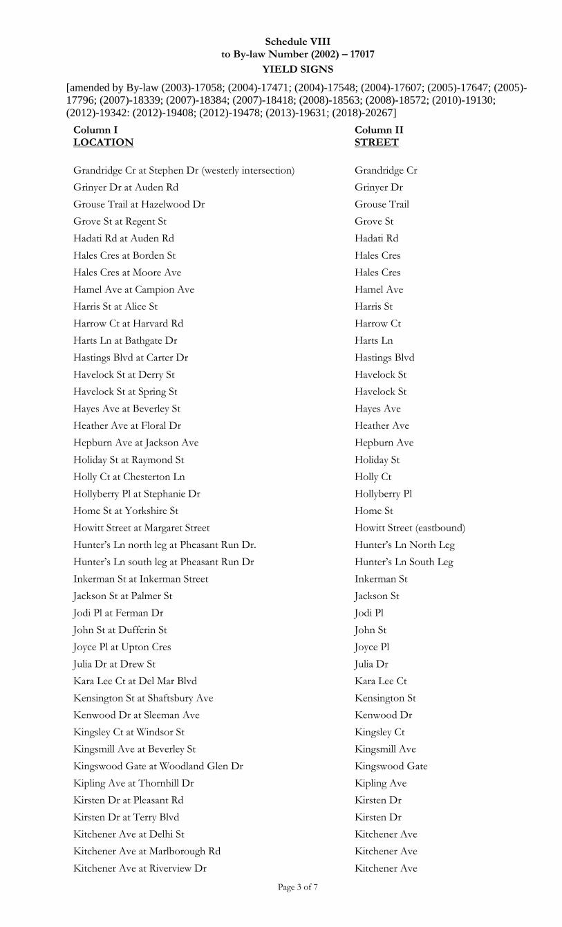
Schedule VIII to By-law Number (2002) – 17017
YIELD SIGNS
[amended by By-law (2003)-17058; (2004)-17471; (2004)-17548; (2004)-17607; (2005)-17647; (2005)-
17796; (2007)-18339; (2007)-18384; (2007)-18418; (2008)-18563; (2008)-18572; (2010)-19130;
(2012)-19342: (2012)-19408; (2012)-19478; (2013)-19631; (2018)-20267]
Page 3 of 7
Column I LOCATION
Column II STREET
Grandridge Cr at Stephen Dr (westerly intersection) Grandridge Cr
Grinyer Dr at Auden Rd Grinyer Dr
Grouse Trail at Hazelwood Dr Grouse Trail
Grove St at Regent St Grove St
Hadati Rd at Auden Rd Hadati Rd
Hales Cres at Borden St Hales Cres
Hales Cres at Moore Ave Hales Cres
Hamel Ave at Campion Ave Hamel Ave
Harris St at Alice St Harris St
Harrow Ct at Harvard Rd Harrow Ct
Harts Ln at Bathgate Dr Harts Ln
Hastings Blvd at Carter Dr Hastings Blvd
Havelock St at Derry St Havelock St
Havelock St at Spring St Havelock St
Hayes Ave at Beverley St Hayes Ave
Heather Ave at Floral Dr Heather Ave
Hepburn Ave at Jackson Ave Hepburn Ave
Holiday St at Raymond St Holiday St
Holly Ct at Chesterton Ln Holly Ct
Hollyberry Pl at Stephanie Dr Hollyberry Pl
Home St at Yorkshire St Home St
Howitt Street at Margaret Street Howitt Street (eastbound)
Hunter’s Ln north leg at Pheasant Run Dr. Hunter’s Ln North Leg
Hunter’s Ln south leg at Pheasant Run Dr Hunter’s Ln South Leg
Inkerman St at Inkerman Street Inkerman St
Jackson St at Palmer St Jackson St
Jodi Pl at Ferman Dr Jodi Pl
John St at Dufferin St John St
Joyce Pl at Upton Cres Joyce Pl
Julia Dr at Drew St Julia Dr
Kara Lee Ct at Del Mar Blvd Kara Lee Ct
Kensington St at Shaftsbury Ave Kensington St
Kenwood Dr at Sleeman Ave Kenwood Dr
Kingsley Ct at Windsor St Kingsley Ct
Kingsmill Ave at Beverley St Kingsmill Ave
Kingswood Gate at Woodland Glen Dr Kingswood Gate
Kipling Ave at Thornhill Dr Kipling Ave
Kirsten Dr at Pleasant Rd Kirsten Dr
Kirsten Dr at Terry Blvd Kirsten Dr
Kitchener Ave at Delhi St Kitchener Ave
Kitchener Ave at Marlborough Rd Kitchener Ave
Kitchener Ave at Riverview Dr Kitchener Ave
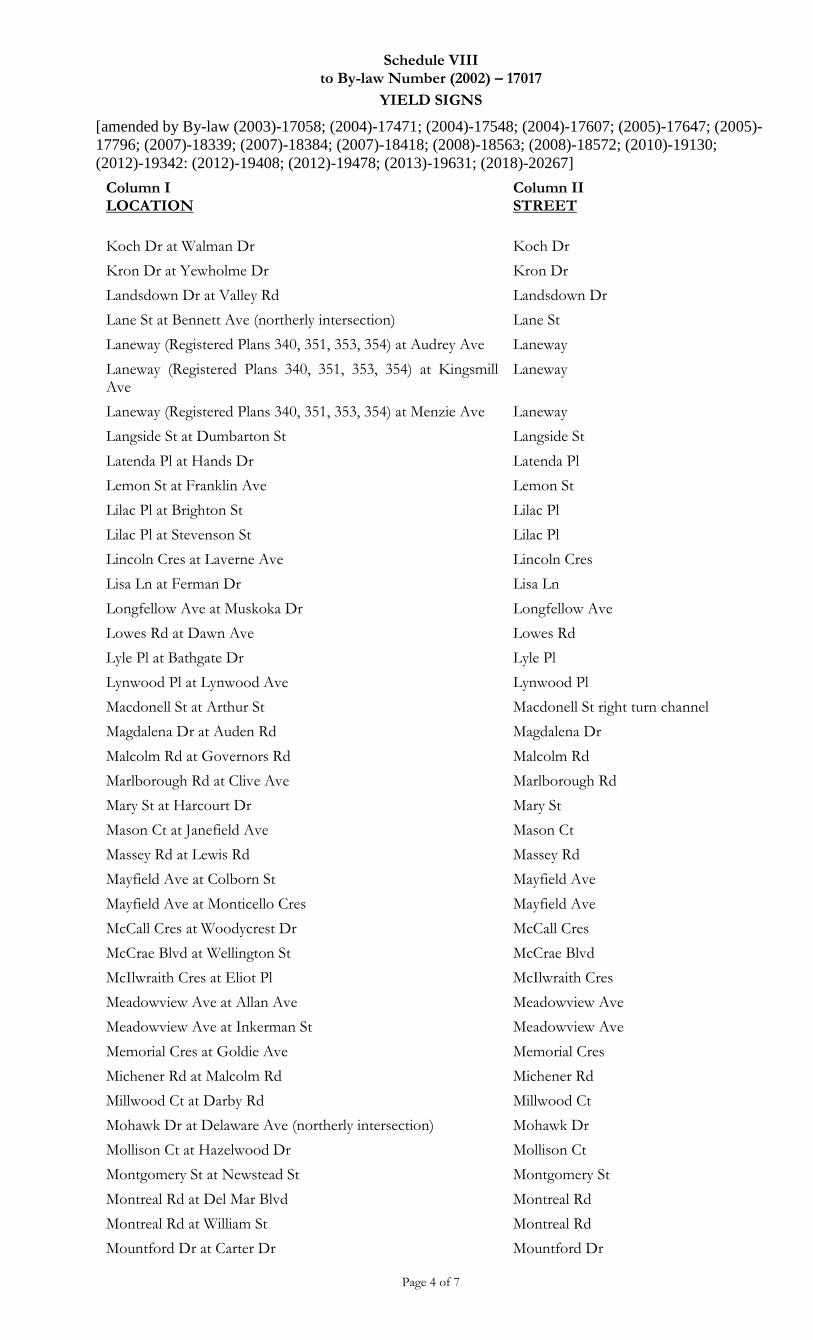
Schedule VIII to By-law Number (2002) – 17017
YIELD SIGNS
[amended by By-law (2003)-17058; (2004)-17471; (2004)-17548; (2004)-17607; (2005)-17647; (2005)-
17796; (2007)-18339; (2007)-18384; (2007)-18418; (2008)-18563; (2008)-18572; (2010)-19130;
(2012)-19342: (2012)-19408; (2012)-19478; (2013)-19631; (2018)-20267]
Page 4 of 7
Column I LOCATION
Column II STREET
Koch Dr at Walman Dr Koch Dr
Kron Dr at Yewholme Dr Kron Dr
Landsdown Dr at Valley Rd Landsdown Dr
Lane St at Bennett Ave (northerly intersection) Lane St
Laneway (Registered Plans 340, 351, 353, 354) at Audrey Ave Laneway
Laneway (Registered Plans 340, 351, 353, 354) at Kingsmill Ave
Laneway
Laneway (Registered Plans 340, 351, 353, 354) at Menzie Ave Laneway
Langside St at Dumbarton St Langside St
Latenda Pl at Hands Dr Latenda Pl
Lemon St at Franklin Ave Lemon St
Lilac Pl at Brighton St Lilac Pl
Lilac Pl at Stevenson St Lilac Pl
Lincoln Cres at Laverne Ave Lincoln Cres
Lisa Ln at Ferman Dr Lisa Ln
Longfellow Ave at Muskoka Dr Longfellow Ave
Lowes Rd at Dawn Ave Lowes Rd
Lyle Pl at Bathgate Dr Lyle Pl
Lynwood Pl at Lynwood Ave Lynwood Pl
Macdonell St at Arthur St Macdonell St right turn channel
Magdalena Dr at Auden Rd Magdalena Dr
Malcolm Rd at Governors Rd Malcolm Rd
Marlborough Rd at Clive Ave Marlborough Rd
Mary St at Harcourt Dr Mary St
Mason Ct at Janefield Ave Mason Ct
Massey Rd at Lewis Rd Massey Rd
Mayfield Ave at Colborn St Mayfield Ave
Mayfield Ave at Monticello Cres Mayfield Ave
McCall Cres at Woodycrest Dr McCall Cres
McCrae Blvd at Wellington St McCrae Blvd
McIlwraith Cres at Eliot Pl McIlwraith Cres
Meadowview Ave at Allan Ave Meadowview Ave
Meadowview Ave at Inkerman St Meadowview Ave
Memorial Cres at Goldie Ave Memorial Cres
Michener Rd at Malcolm Rd Michener Rd
Millwood Ct at Darby Rd Millwood Ct
Mohawk Dr at Delaware Ave (northerly intersection) Mohawk Dr
Mollison Ct at Hazelwood Dr Mollison Ct
Montgomery St at Newstead St Montgomery St
Montreal Rd at Del Mar Blvd Montreal Rd
Montreal Rd at William St Montreal Rd
Mountford Dr at Carter Dr Mountford Dr
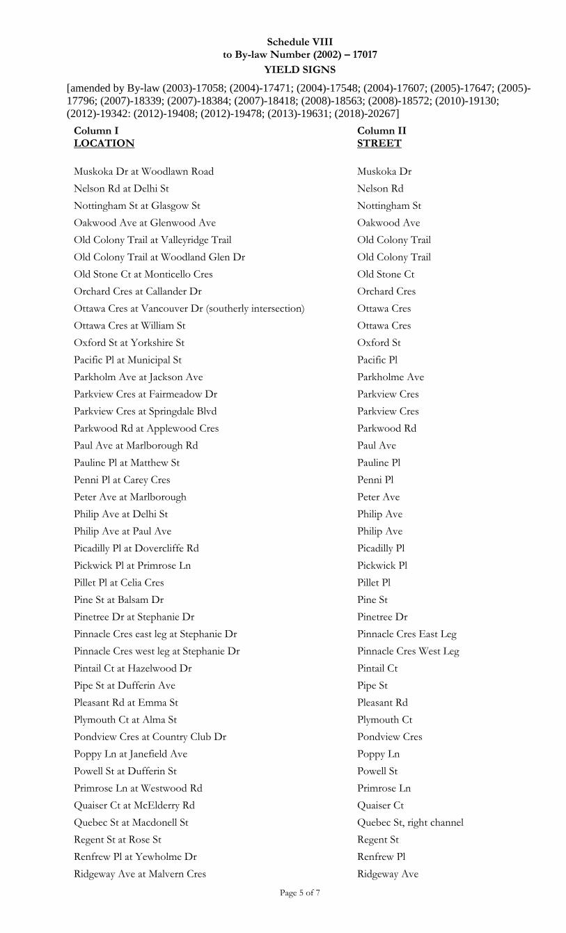
Schedule VIII to By-law Number (2002) – 17017
YIELD SIGNS
[amended by By-law (2003)-17058; (2004)-17471; (2004)-17548; (2004)-17607; (2005)-17647; (2005)-
17796; (2007)-18339; (2007)-18384; (2007)-18418; (2008)-18563; (2008)-18572; (2010)-19130;
(2012)-19342: (2012)-19408; (2012)-19478; (2013)-19631; (2018)-20267]
Page 5 of 7
Column I LOCATION
Column II STREET
Muskoka Dr at Woodlawn Road Muskoka Dr
Nelson Rd at Delhi St Nelson Rd
Nottingham St at Glasgow St Nottingham St
Oakwood Ave at Glenwood Ave Oakwood Ave
Old Colony Trail at Valleyridge Trail Old Colony Trail
Old Colony Trail at Woodland Glen Dr Old Colony Trail
Old Stone Ct at Monticello Cres Old Stone Ct
Orchard Cres at Callander Dr Orchard Cres
Ottawa Cres at Vancouver Dr (southerly intersection) Ottawa Cres
Ottawa Cres at William St Ottawa Cres
Oxford St at Yorkshire St Oxford St
Pacific Pl at Municipal St Pacific Pl
Parkholm Ave at Jackson Ave Parkholme Ave
Parkview Cres at Fairmeadow Dr Parkview Cres
Parkview Cres at Springdale Blvd Parkview Cres
Parkwood Rd at Applewood Cres Parkwood Rd
Paul Ave at Marlborough Rd Paul Ave
Pauline Pl at Matthew St Pauline Pl
Penni Pl at Carey Cres Penni Pl
Peter Ave at Marlborough Peter Ave
Philip Ave at Delhi St Philip Ave
Philip Ave at Paul Ave Philip Ave
Picadilly Pl at Dovercliffe Rd Picadilly Pl
Pickwick Pl at Primrose Ln Pickwick Pl
Pillet Pl at Celia Cres Pillet Pl
Pine St at Balsam Dr Pine St
Pinetree Dr at Stephanie Dr Pinetree Dr
Pinnacle Cres east leg at Stephanie Dr Pinnacle Cres East Leg
Pinnacle Cres west leg at Stephanie Dr Pinnacle Cres West Leg
Pintail Ct at Hazelwood Dr Pintail Ct
Pipe St at Dufferin Ave Pipe St
Pleasant Rd at Emma St Pleasant Rd
Plymouth Ct at Alma St Plymouth Ct
Pondview Cres at Country Club Dr Pondview Cres
Poppy Ln at Janefield Ave Poppy Ln
Powell St at Dufferin St Powell St
Primrose Ln at Westwood Rd Primrose Ln
Quaiser Ct at McElderry Rd Quaiser Ct
Quebec St at Macdonell St Quebec St, right channel
Regent St at Rose St Regent St
Renfrew Pl at Yewholme Dr Renfrew Pl
Ridgeway Ave at Malvern Cres Ridgeway Ave
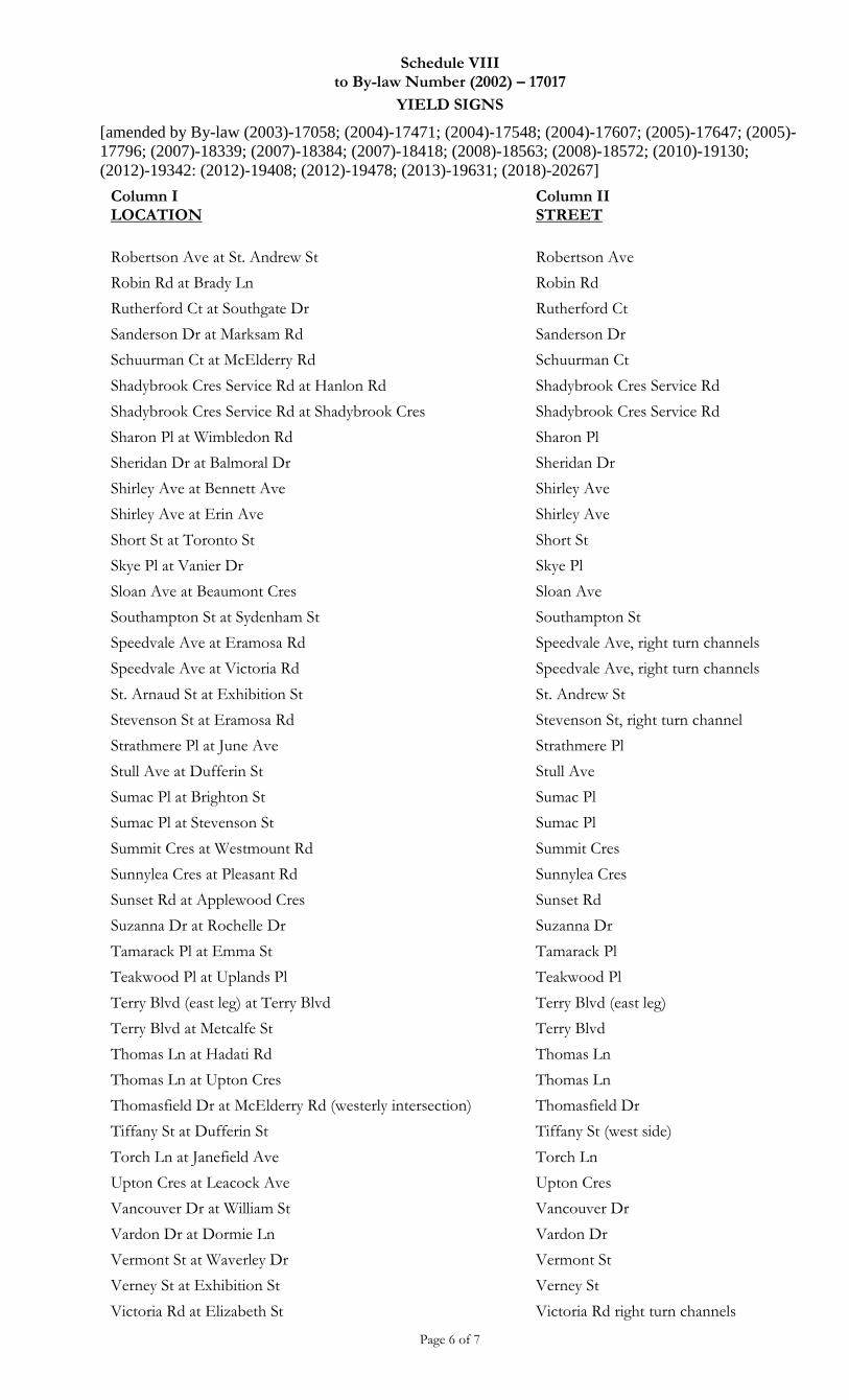
Schedule VIII to By-law Number (2002) – 17017
YIELD SIGNS
[amended by By-law (2003)-17058; (2004)-17471; (2004)-17548; (2004)-17607; (2005)-17647; (2005)-
17796; (2007)-18339; (2007)-18384; (2007)-18418; (2008)-18563; (2008)-18572; (2010)-19130;
(2012)-19342: (2012)-19408; (2012)-19478; (2013)-19631; (2018)-20267]
Page 6 of 7
Column I LOCATION
Column II STREET
Robertson Ave at St. Andrew St Robertson Ave
Robin Rd at Brady Ln Robin Rd
Rutherford Ct at Southgate Dr Rutherford Ct
Sanderson Dr at Marksam Rd Sanderson Dr
Schuurman Ct at McElderry Rd Schuurman Ct
Shadybrook Cres Service Rd at Hanlon Rd Shadybrook Cres Service Rd
Shadybrook Cres Service Rd at Shadybrook Cres Shadybrook Cres Service Rd
Sharon Pl at Wimbledon Rd Sharon Pl
Sheridan Dr at Balmoral Dr Sheridan Dr
Shirley Ave at Bennett Ave Shirley Ave
Shirley Ave at Erin Ave Shirley Ave
Short St at Toronto St Short St
Skye Pl at Vanier Dr Skye Pl
Sloan Ave at Beaumont Cres Sloan Ave
Southampton St at Sydenham St Southampton St
Speedvale Ave at Eramosa Rd Speedvale Ave, right turn channels
Speedvale Ave at Victoria Rd Speedvale Ave, right turn channels
St. Arnaud St at Exhibition St St. Andrew St
Stevenson St at Eramosa Rd Stevenson St, right turn channel
Strathmere Pl at June Ave Strathmere Pl
Stull Ave at Dufferin St Stull Ave
Sumac Pl at Brighton St Sumac Pl
Sumac Pl at Stevenson St Sumac Pl
Summit Cres at Westmount Rd Summit Cres
Sunnylea Cres at Pleasant Rd Sunnylea Cres
Sunset Rd at Applewood Cres Sunset Rd
Suzanna Dr at Rochelle Dr Suzanna Dr
Tamarack Pl at Emma St Tamarack Pl
Teakwood Pl at Uplands Pl Teakwood Pl
Terry Blvd (east leg) at Terry Blvd Terry Blvd (east leg)
Terry Blvd at Metcalfe St Terry Blvd
Thomas Ln at Hadati Rd Thomas Ln
Thomas Ln at Upton Cres Thomas Ln
Thomasfield Dr at McElderry Rd (westerly intersection) Thomasfield Dr
Tiffany St at Dufferin St Tiffany St (west side)
Torch Ln at Janefield Ave Torch Ln
Upton Cres at Leacock Ave Upton Cres
Vancouver Dr at William St Vancouver Dr
Vardon Dr at Dormie Ln Vardon Dr
Vermont St at Waverley Dr Vermont St
Verney St at Exhibition St Verney St
Victoria Rd at Elizabeth St Victoria Rd right turn channels
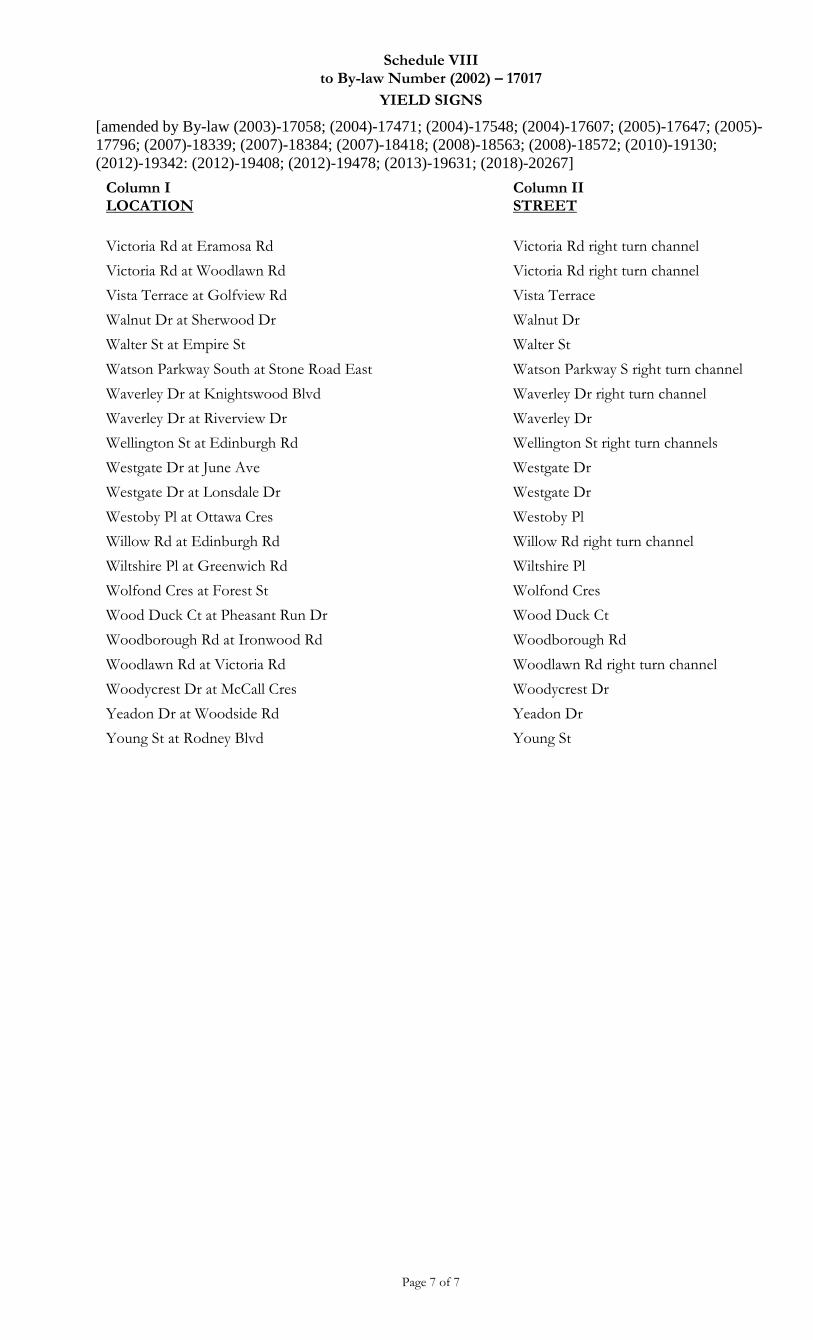
Schedule VIII to By-law Number (2002) – 17017
YIELD SIGNS
[amended by By-law (2003)-17058; (2004)-17471; (2004)-17548; (2004)-17607; (2005)-17647; (2005)-
17796; (2007)-18339; (2007)-18384; (2007)-18418; (2008)-18563; (2008)-18572; (2010)-19130;
(2012)-19342: (2012)-19408; (2012)-19478; (2013)-19631; (2018)-20267]
Page 7 of 7
Column I LOCATION
Column II STREET
Victoria Rd at Eramosa Rd Victoria Rd right turn channel
Victoria Rd at Woodlawn Rd Victoria Rd right turn channel
Vista Terrace at Golfview Rd Vista Terrace
Walnut Dr at Sherwood Dr Walnut Dr
Walter St at Empire St Walter St
Watson Parkway South at Stone Road East Watson Parkway S right turn channel
Waverley Dr at Knightswood Blvd Waverley Dr right turn channel
Waverley Dr at Riverview Dr Waverley Dr
Wellington St at Edinburgh Rd Wellington St right turn channels
Westgate Dr at June Ave Westgate Dr
Westgate Dr at Lonsdale Dr Westgate Dr
Westoby Pl at Ottawa Cres Westoby Pl
Willow Rd at Edinburgh Rd Willow Rd right turn channel
Wiltshire Pl at Greenwich Rd Wiltshire Pl
Wolfond Cres at Forest St Wolfond Cres
Wood Duck Ct at Pheasant Run Dr Wood Duck Ct
Woodborough Rd at Ironwood Rd Woodborough Rd
Woodlawn Rd at Victoria Rd Woodlawn Rd right turn channel
Woodycrest Dr at McCall Cres Woodycrest Dr
Yeadon Dr at Woodside Rd Yeadon Dr
Young St at Rodney Blvd Young St
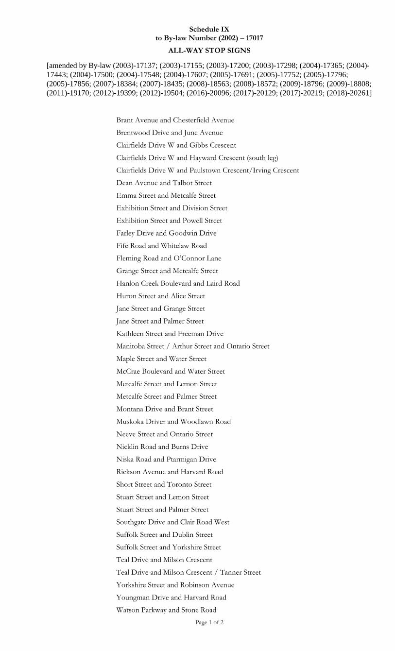
Schedule IX to By-law Number (2002) – 17017
ALL-WAY STOP SIGNS
[amended by By-law (2003)-17137; (2003)-17155; (2003)-17200; (2003)-17298; (2004)-17365; (2004)-
17443; (2004)-17500; (2004)-17548; (2004)-17607; (2005)-17691; (2005)-17752; (2005)-17796;
(2005)-17856; (2007)-18384; (2007)-18435; (2008)-18563; (2008)-18572; (2009)-18796; (2009)-18808;
(2011)-19170; (2012)-19399; (2012)-19504; (2016)-20096; (2017)-20129; (2017)-20219; (2018)-20261]
Page 1 of 2
Brant Avenue and Chesterfield Avenue
Brentwood Drive and June Avenue
Clairfields Drive W and Gibbs Crescent
Clairfields Drive W and Hayward Crescent (south leg)
Clairfields Drive W and Paulstown Crescent/Irving Crescent
Dean Avenue and Talbot Street
Emma Street and Metcalfe Street
Exhibition Street and Division Street
Exhibition Street and Powell Street
Farley Drive and Goodwin Drive
Fife Road and Whitelaw Road
Fleming Road and O’Connor Lane
Grange Street and Metcalfe Street
Hanlon Creek Boulevard and Laird Road
Huron Street and Alice Street
Jane Street and Grange Street
Jane Street and Palmer Street
Kathleen Street and Freeman Drive
Manitoba Street / Arthur Street and Ontario Street
Maple Street and Water Street
McCrae Boulevard and Water Street
Metcalfe Street and Lemon Street
Metcalfe Street and Palmer Street
Montana Drive and Brant Street
Muskoka Driver and Woodlawn Road
Neeve Street and Ontario Street
Nicklin Road and Burns Drive
Niska Road and Ptarmigan Drive
Rickson Avenue and Harvard Road
Short Street and Toronto Street
Stuart Street and Lemon Street
Stuart Street and Palmer Street
Southgate Drive and Clair Road West
Suffolk Street and Dublin Street
Suffolk Street and Yorkshire Street
Teal Drive and Milson Crescent
Teal Drive and Milson Crescent / Tanner Street
Yorkshire Street and Robinson Avenue
Youngman Drive and Harvard Road
Watson Parkway and Stone Road
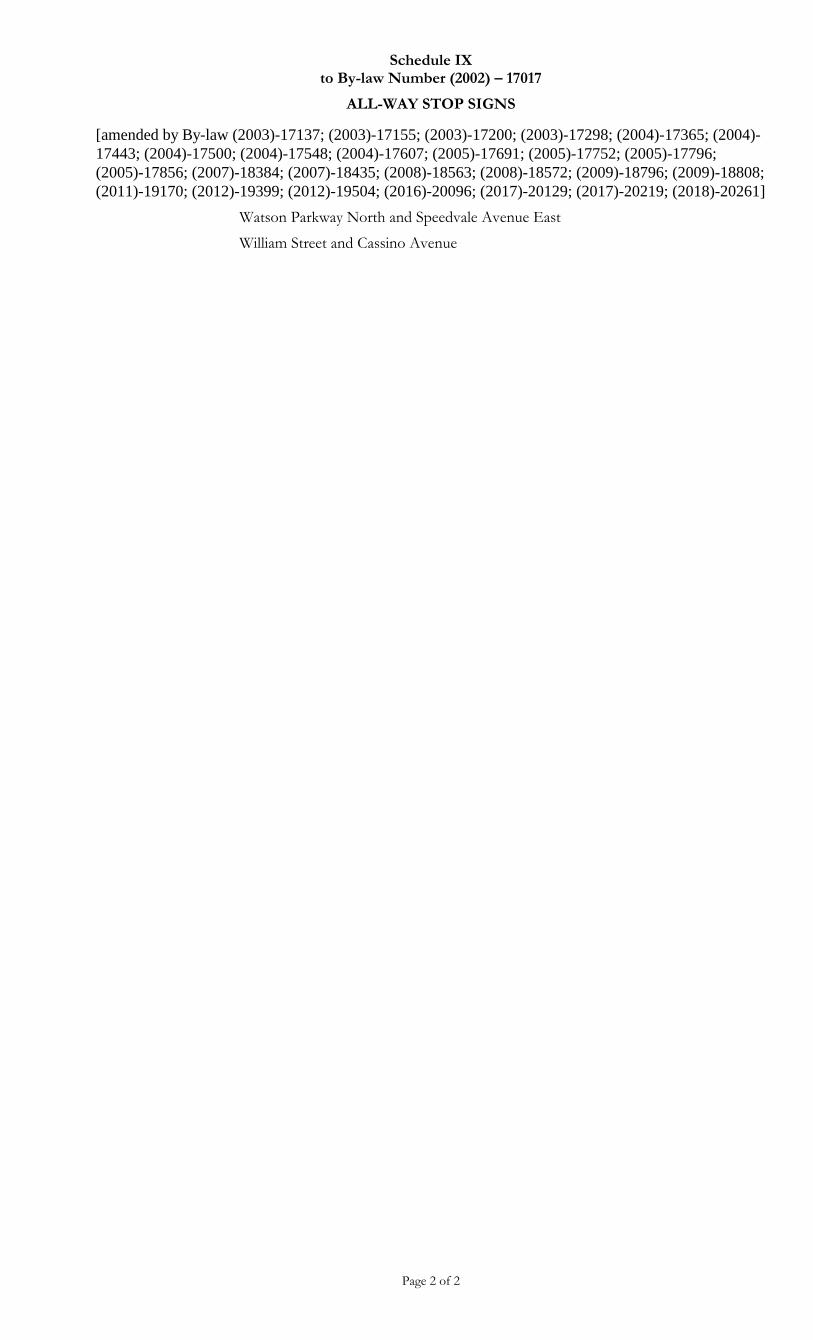
Schedule IX to By-law Number (2002) – 17017
ALL-WAY STOP SIGNS
[amended by By-law (2003)-17137; (2003)-17155; (2003)-17200; (2003)-17298; (2004)-17365; (2004)-
17443; (2004)-17500; (2004)-17548; (2004)-17607; (2005)-17691; (2005)-17752; (2005)-17796;
(2005)-17856; (2007)-18384; (2007)-18435; (2008)-18563; (2008)-18572; (2009)-18796; (2009)-18808;
(2011)-19170; (2012)-19399; (2012)-19504; (2016)-20096; (2017)-20129; (2017)-20219; (2018)-20261]
Page 2 of 2
Watson Parkway North and Speedvale Avenue East
William Street and Cassino Avenue
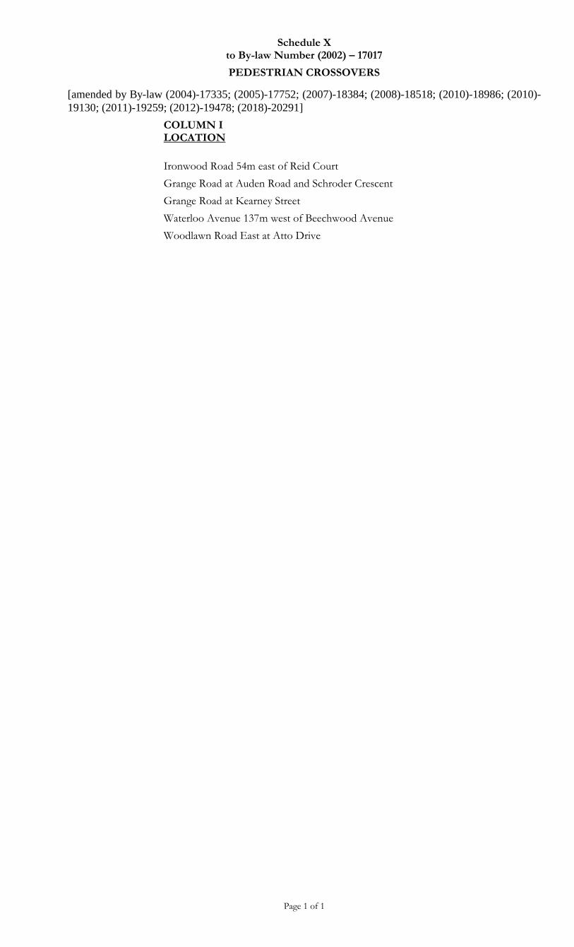
Schedule X to By-law Number (2002) – 17017
PEDESTRIAN CROSSOVERS
[amended by By-law (2004)-17335; (2005)-17752; (2007)-18384; (2008)-18518; (2010)-18986; (2010)-
19130; (2011)-19259; (2012)-19478; (2018)-20291]
Page 1 of 1
COLUMN I LOCATION
Ironwood Road 54m east of Reid Court
Grange Road at Auden Road and Schroder Crescent
Grange Road at Kearney Street
Waterloo Avenue 137m west of Beechwood Avenue
Woodlawn Road East at Atto Drive
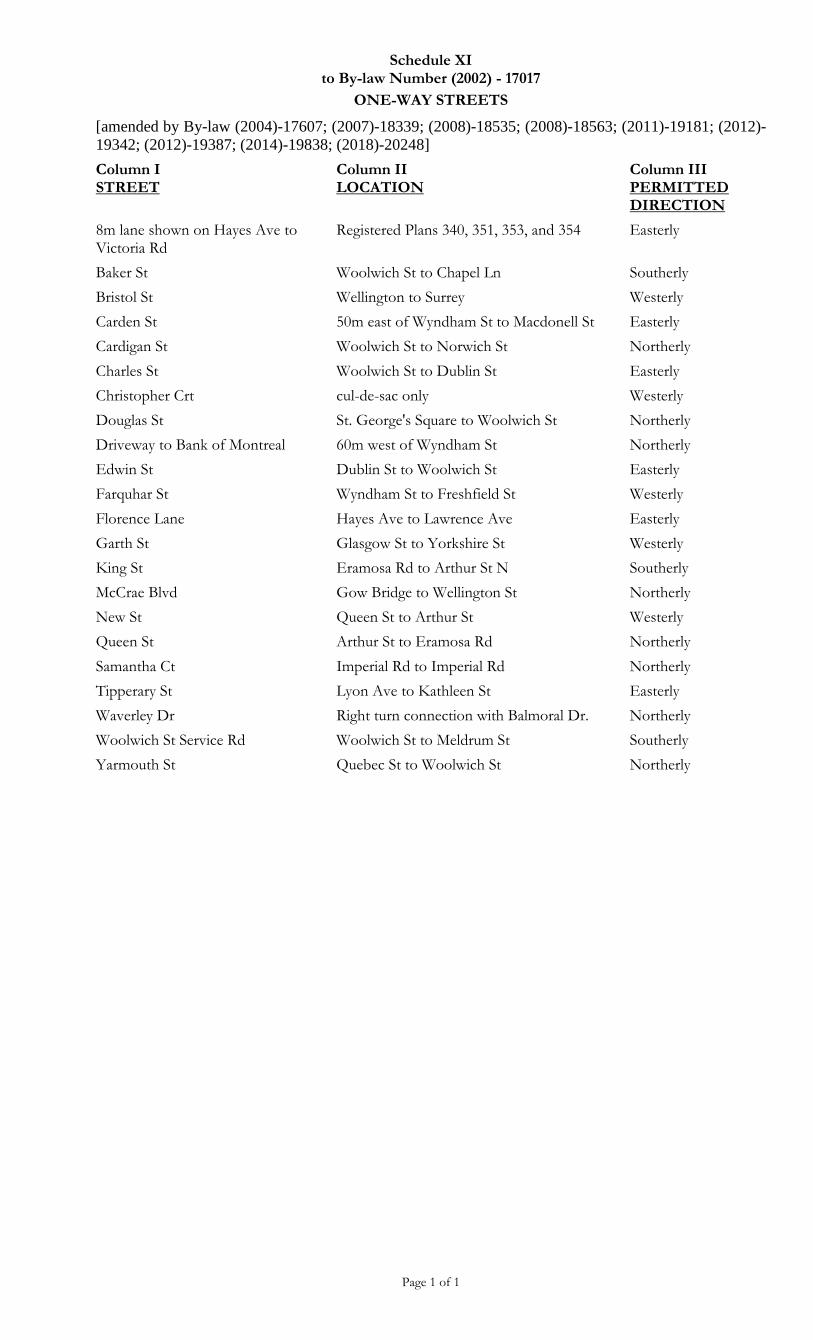
Schedule XI to By-law Number (2002) - 17017
ONE-WAY STREETS
[amended by By-law (2004)-17607; (2007)-18339; (2008)-18535; (2008)-18563; (2011)-19181; (2012)-
19342; (2012)-19387; (2014)-19838; (2018)-20248]
Page 1 of 1
Column I STREET
Column II LOCATION
Column III PERMITTED DIRECTION
8m lane shown on Hayes Ave to Victoria Rd
Registered Plans 340, 351, 353, and 354 Easterly
Baker St Woolwich St to Chapel Ln Southerly
Bristol St Wellington to Surrey Westerly
Carden St 50m east of Wyndham St to Macdonell St Easterly
Cardigan St Woolwich St to Norwich St Northerly
Charles St Woolwich St to Dublin St Easterly
Christopher Crt cul-de-sac only Westerly
Douglas St St. George's Square to Woolwich St Northerly
Driveway to Bank of Montreal 60m west of Wyndham St Northerly
Edwin St Dublin St to Woolwich St Easterly
Farquhar St Wyndham St to Freshfield St Westerly
Florence Lane Hayes Ave to Lawrence Ave Easterly
Garth St Glasgow St to Yorkshire St Westerly
King St Eramosa Rd to Arthur St N Southerly
McCrae Blvd Gow Bridge to Wellington St Northerly
New St Queen St to Arthur St Westerly
Queen St Arthur St to Eramosa Rd Northerly
Samantha Ct Imperial Rd to Imperial Rd Northerly
Tipperary St Lyon Ave to Kathleen St Easterly
Waverley Dr Right turn connection with Balmoral Dr. Northerly
Woolwich St Service Rd Woolwich St to Meldrum St Southerly
Yarmouth St Quebec St to Woolwich St Northerly

Schedule XII to By-law Number (2002) – 17017
SPEED LIMITS
[amended by By-law (2003)-17155; (2003)-17200; (2003)-17208; (2003)-17238; (2003)-17256; (2003)-
17298; (2003)-17278; (2003)-17318; (2004)-17488; (2004)-17548; (2004)-17607; (2004)-17621;
(2006)-18031; (2006)-18147; (2006)-18182; (2007)-18280; (2007)-18363; (2007)-18435; (2007)-18463;
(2008)-18572; (2008)-18593; (2008)-18626; (2009)-18858; (2010)-18986; (2011)-19323; (2012)-19342;
(2012)-19387; (2012)-19408; (2013)-19530; (2013)-19605; (2013)-19646; (2014)-19687; (2014) -
19754; (2014)-19838; (2015)-19947; (2016)-20021; (2016)-20085; (2017)-20182; (2017)-20195;
(2017)-20211; (2017)-20219]
Page 1 of 5
Column I STREET
Column II LOCATION
Column III SPEED
Alice Street Sacred Heart Catholic School Elementary School Zone
30 km/h
Bishop Court Mary Phelan Catholic School Elementary School Zone
30 km/h
Brant Avenue Brant Avenue Public School Elementary School Zone
30 km/h
Brighton Street Ecole L’Odysee School Elementary School Zone
30 km/h
Carden Street Wilson Street to Wyndham Street 30 km/h
Carden Street Wyndham Street to Macdonell Street 40 km/h
Cityview Drive Lee Street Elementary School Zone 30 km/h
Clair Road East Gordon Street to Victoria Road 60 km/h
Clair Road West Gordon Street to Clairfields Drive 60 km/h
Clair Road West Hanlon Parkway to Laird Road 60 km/h
Clairfields Drive East St. Paul Catholic School Elementary School Zone
30 km/h
Clarke Street West Victory Public School Elementary School Zone 30 km/h
College Avenue East A point 732m east of Gordon Street to Victoria Road
60 km/h
College Avenue West Ecole St. Rene Goupil School Elementary School Zone
40 km/h
When flashing
8:00 a.m. to 9:00 a.m., 3:00 p.m. to 4:00 p.m.
College Avenue West Guelph Community Christian School Elementary School Zone
40 km/h
When flashing
8:00 a.m. to 9:00 a.m., 3:00 p.m. to 4:00 p.m.
Colonial Drive Sir Isaac Brock Public School Elementary School Zone
30 km/h
Colonial Drive St. Ignatius of Loyola Catholic School Elementary School Zone
30 km/h
Couling Crescent Ecole Guelph Lake Public School Elementary School Zone
30 km/h
Crawley Road Maltby Road to Clair Road 60 km/h
Downey Road 255m south of Teal Drive to south City limit 70 km/h
Dublin Street North Central Public School Elementary School Zone 30 km/h
Dumbarton Street Resurrection Christian Academy Elementary School Zone
30 km/h
Eastview Road 150m east of Summit Ridge Drive to Watson Parkway North
60 km/h
Edinburgh Road North Woodlawn Road to a point 200m south of Willow Road
60 km/h
Emma Street Holy Rosary Catholic School Elementary School Zone
30 km/h
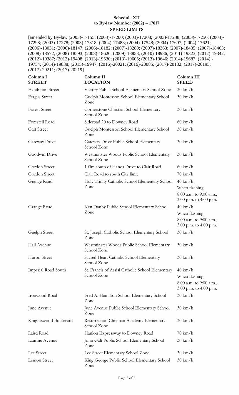
Schedule XII to By-law Number (2002) – 17017
SPEED LIMITS
[amended by By-law (2003)-17155; (2003)-17200; (2003)-17208; (2003)-17238; (2003)-17256; (2003)-
17298; (2003)-17278; (2003)-17318; (2004)-17488; (2004)-17548; (2004)-17607; (2004)-17621;
(2006)-18031; (2006)-18147; (2006)-18182; (2007)-18280; (2007)-18363; (2007)-18435; (2007)-18463;
(2008)-18572; (2008)-18593; (2008)-18626; (2009)-18858; (2010)-18986; (2011)-19323; (2012)-19342;
(2012)-19387; (2012)-19408; (2013)-19530; (2013)-19605; (2013)-19646; (2014)-19687; (2014) -
19754; (2014)-19838; (2015)-19947; (2016)-20021; (2016)-20085; (2017)-20182; (2017)-20195;
(2017)-20211; (2017)-20219]
Page 2 of 5
Column I STREET
Column II LOCATION
Column III SPEED
Exhibition Street Victory Public School Elementary School Zone 30 km/h
Fergus Street Guelph Montessori School Elementary School Zone
30 km/h
Forest Street Cornerstone Christian School Elementary School Zone
30 km/h
Forestell Road Sideroad 20 to Downey Road 60 km/h
Galt Street Guelph Montessori School Elementary School Zone
30 km/h
Gateway Drive Gateway Drive Public School Elementary School Zone
30 km/h
Goodwin Drive Westminster Woods Public School Elementary School Zone
30 km/h
Gordon Street 100m south of Hands Drive to Clair Road 60 km/h
Gordon Street Clair Road to south City limit 70 km/h
Grange Road Holy Trinity Catholic School Elementary School Zone
40 km/h
When flashing
8:00 a.m. to 9:00 a.m., 3:00 p.m. to 4:00 p.m.
Grange Road Ken Danby Public School Elementary School Zone
40 km/h
When flashing
8:00 a.m. to 9:00 a.m., 3:00 p.m. to 4:00 p.m.
Guelph Street St. Joseph Catholic School Elementary School Zone
30 km/h
Hall Avenue Westminster Woods Public School Elementary School Zone
30 km/h
Huron Street Sacred Heart Catholic School Elementary School Zone
30 km/h
Imperial Road South St. Francis of Assisi Catholic School Elementary School Zone
40 km/h
When flashing
8:00 a.m. to 9:00 a.m., 3:00 p.m. to 4:00 p.m.
Ironwood Road Fred A. Hamilton School Elementary School Zone
30 km/h
June Avenue June Avenue Public School Elementary School Zone
30 km/h
Knightswood Boulevard Resurrection Christian Academy Elementary School Zone
30 km/h
Laird Road Hanlon Expressway to Downey Road 70 km/h
Laurine Avenue John Galt Public School Elementary School Zone
30 km/h
Lee Street Lee Street Elementary School Zone 30 km/h
Lemon Street King George Public School Elementary School Zone
30 km/h
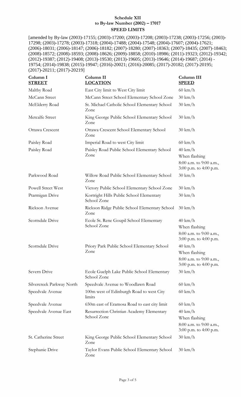
Schedule XII to By-law Number (2002) – 17017
SPEED LIMITS
[amended by By-law (2003)-17155; (2003)-17200; (2003)-17208; (2003)-17238; (2003)-17256; (2003)-
17298; (2003)-17278; (2003)-17318; (2004)-17488; (2004)-17548; (2004)-17607; (2004)-17621;
(2006)-18031; (2006)-18147; (2006)-18182; (2007)-18280; (2007)-18363; (2007)-18435; (2007)-18463;
(2008)-18572; (2008)-18593; (2008)-18626; (2009)-18858; (2010)-18986; (2011)-19323; (2012)-19342;
(2012)-19387; (2012)-19408; (2013)-19530; (2013)-19605; (2013)-19646; (2014)-19687; (2014) -
19754; (2014)-19838; (2015)-19947; (2016)-20021; (2016)-20085; (2017)-20182; (2017)-20195;
(2017)-20211; (2017)-20219]
Page 3 of 5
Column I STREET
Column II LOCATION
Column III SPEED
Maltby Road East City limit to West City limit 60 km/h
McCann Street McCann Street School Elementary School Zone 30 km/h
McElderry Road St. Michael Catholic School Elementary School Zone
30 km/h
Metcalfe Street King George Public School Elementary School Zone
30 km/h
Ottawa Crescent Ottawa Crescent School Elementary School Zone
30 km/h
Paisley Road Imperial Road to west City limit 60 km/h
Paisley Road Paisley Road Public School Elementary School Zone
40 km/h
When flashing
8:00 a.m. to 9:00 a.m., 3:00 p.m. to 4:00 p.m.
Parkwood Road Willow Road Public School Elementary School Zone
30 km/h
Powell Street West Victory Public School Elementary School Zone 30 km/h
Ptarmigan Drive Kortright Hills Public School Elementary School Zone
30 km/h
Rickson Avenue Rickson Ridge Public School Elementary School Zone
30 km/h
Scottsdale Drive Ecole St. Rene Goupil School Elementary School Zone
40 km/h
When flashing
8:00 a.m. to 9:00 a.m., 3:00 p.m. to 4:00 p.m.
Scottsdale Drive Priory Park Public School Elementary School Zone
40 km/h
When flashing
8:00 a.m. to 9:00 a.m., 3:00 p.m. to 4:00 p.m.
Severn Drive Ecole Guelph Lake Public School Elementary School Zone
30 km/h
Silvercreek Parkway North Speedvale Avenue to Woodlawn Road 60 km/h
Speedvale Avenue 100m west of Edinburgh Road to west City limits
60 km/h
Speedvale Avenue 650m east of Eramosa Road to east city limit 60 km/h
Speedvale Avenue East Resurrection Christian Academy Elementary School Zone
40 km/h
When flashing
8:00 a.m. to 9:00 a.m., 3:00 p.m. to 4:00 p.m.
St. Catherine Street King George Public School Elementary School Zone
30 km/h
Stephanie Drive Taylor Evans Public School Elementary School Zone
30 km/h
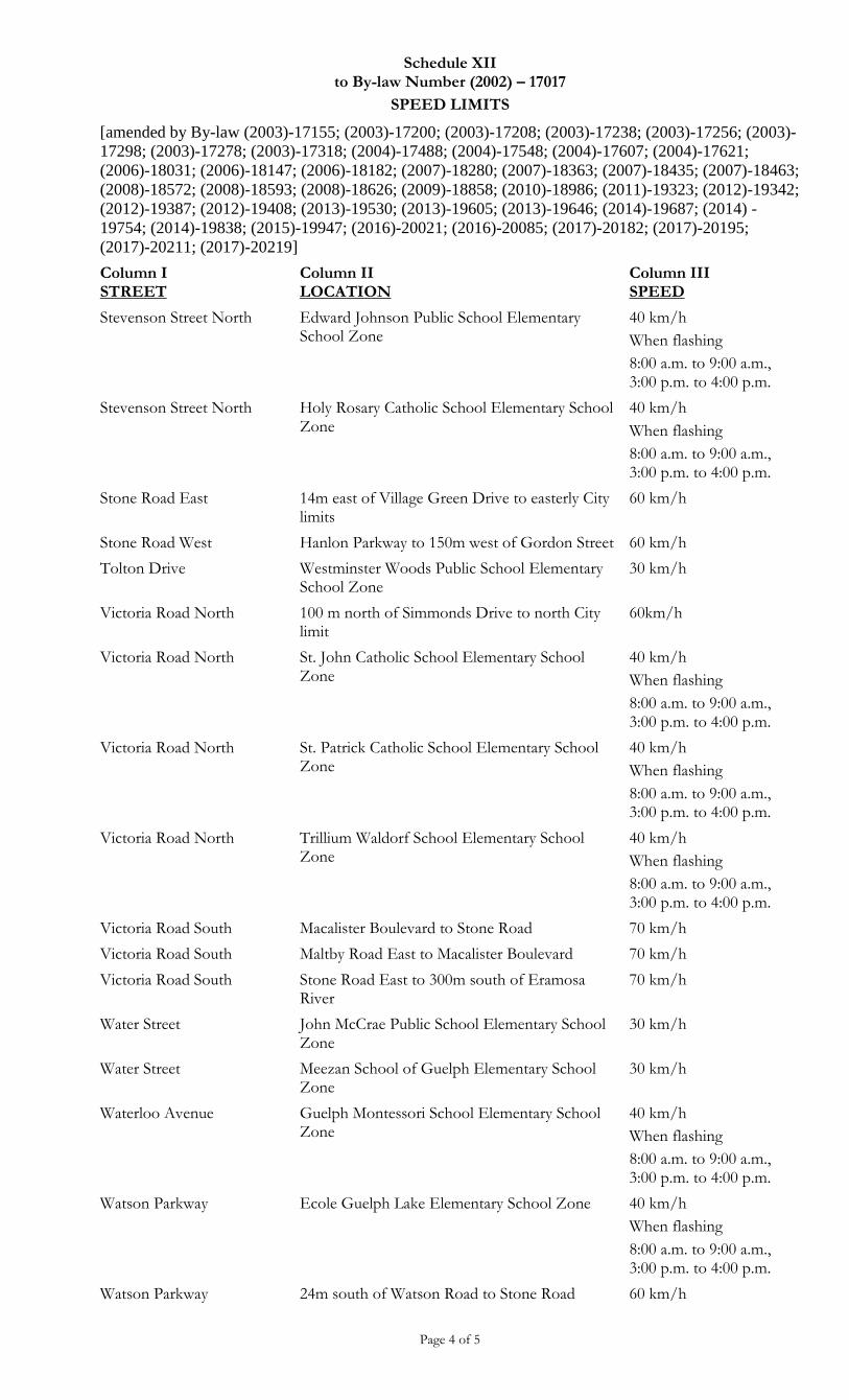
Schedule XII to By-law Number (2002) – 17017
SPEED LIMITS
[amended by By-law (2003)-17155; (2003)-17200; (2003)-17208; (2003)-17238; (2003)-17256; (2003)-
17298; (2003)-17278; (2003)-17318; (2004)-17488; (2004)-17548; (2004)-17607; (2004)-17621;
(2006)-18031; (2006)-18147; (2006)-18182; (2007)-18280; (2007)-18363; (2007)-18435; (2007)-18463;
(2008)-18572; (2008)-18593; (2008)-18626; (2009)-18858; (2010)-18986; (2011)-19323; (2012)-19342;
(2012)-19387; (2012)-19408; (2013)-19530; (2013)-19605; (2013)-19646; (2014)-19687; (2014) -
19754; (2014)-19838; (2015)-19947; (2016)-20021; (2016)-20085; (2017)-20182; (2017)-20195;
(2017)-20211; (2017)-20219]
Page 4 of 5
Column I STREET
Column II LOCATION
Column III SPEED
Stevenson Street North Edward Johnson Public School Elementary School Zone
40 km/h
When flashing
8:00 a.m. to 9:00 a.m., 3:00 p.m. to 4:00 p.m.
Stevenson Street North Holy Rosary Catholic School Elementary School Zone
40 km/h
When flashing
8:00 a.m. to 9:00 a.m., 3:00 p.m. to 4:00 p.m.
Stone Road East 14m east of Village Green Drive to easterly City limits
60 km/h
Stone Road West Hanlon Parkway to 150m west of Gordon Street 60 km/h
Tolton Drive Westminster Woods Public School Elementary School Zone
30 km/h
Victoria Road North 100 m north of Simmonds Drive to north City limit
60km/h
Victoria Road North St. John Catholic School Elementary School Zone
40 km/h
When flashing
8:00 a.m. to 9:00 a.m., 3:00 p.m. to 4:00 p.m.
Victoria Road North St. Patrick Catholic School Elementary School Zone
40 km/h
When flashing
8:00 a.m. to 9:00 a.m., 3:00 p.m. to 4:00 p.m.
Victoria Road North Trillium Waldorf School Elementary School Zone
40 km/h
When flashing
8:00 a.m. to 9:00 a.m., 3:00 p.m. to 4:00 p.m.
Victoria Road South Macalister Boulevard to Stone Road 70 km/h
Victoria Road South Maltby Road East to Macalister Boulevard 70 km/h
Victoria Road South Stone Road East to 300m south of Eramosa River
70 km/h
Water Street John McCrae Public School Elementary School Zone
30 km/h
Water Street Meezan School of Guelph Elementary School Zone
30 km/h
Waterloo Avenue Guelph Montessori School Elementary School Zone
40 km/h
When flashing
8:00 a.m. to 9:00 a.m., 3:00 p.m. to 4:00 p.m.
Watson Parkway Ecole Guelph Lake Elementary School Zone 40 km/h
When flashing
8:00 a.m. to 9:00 a.m., 3:00 p.m. to 4:00 p.m.
Watson Parkway 24m south of Watson Road to Stone Road 60 km/h
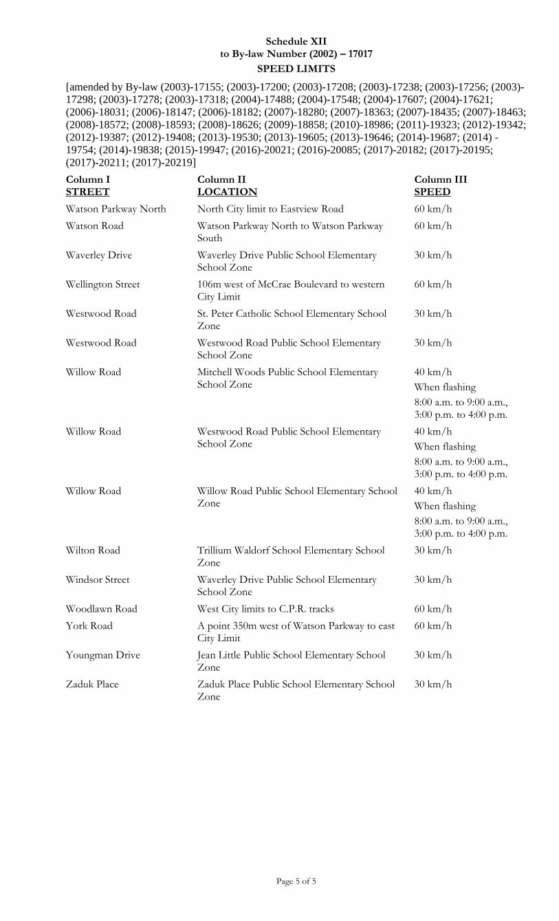
Schedule XII to By-law Number (2002) – 17017
SPEED LIMITS
[amended by By-law (2003)-17155; (2003)-17200; (2003)-17208; (2003)-17238; (2003)-17256; (2003)-
17298; (2003)-17278; (2003)-17318; (2004)-17488; (2004)-17548; (2004)-17607; (2004)-17621;
(2006)-18031; (2006)-18147; (2006)-18182; (2007)-18280; (2007)-18363; (2007)-18435; (2007)-18463;
(2008)-18572; (2008)-18593; (2008)-18626; (2009)-18858; (2010)-18986; (2011)-19323; (2012)-19342;
(2012)-19387; (2012)-19408; (2013)-19530; (2013)-19605; (2013)-19646; (2014)-19687; (2014) -
19754; (2014)-19838; (2015)-19947; (2016)-20021; (2016)-20085; (2017)-20182; (2017)-20195;
(2017)-20211; (2017)-20219]
Page 5 of 5
Column I STREET
Column II LOCATION
Column III SPEED
Watson Parkway North North City limit to Eastview Road 60 km/h
Watson Road Watson Parkway North to Watson Parkway South
60 km/h
Waverley Drive Waverley Drive Public School Elementary School Zone
30 km/h
Wellington Street 106m west of McCrae Boulevard to western City Limit
60 km/h
Westwood Road St. Peter Catholic School Elementary School Zone
30 km/h
Westwood Road Westwood Road Public School Elementary School Zone
30 km/h
Willow Road Mitchell Woods Public School Elementary School Zone
40 km/h
When flashing
8:00 a.m. to 9:00 a.m., 3:00 p.m. to 4:00 p.m.
Willow Road Westwood Road Public School Elementary School Zone
40 km/h
When flashing
8:00 a.m. to 9:00 a.m., 3:00 p.m. to 4:00 p.m.
Willow Road Willow Road Public School Elementary School Zone
40 km/h
When flashing
8:00 a.m. to 9:00 a.m., 3:00 p.m. to 4:00 p.m.
Wilton Road Trillium Waldorf School Elementary School Zone
30 km/h
Windsor Street Waverley Drive Public School Elementary School Zone
30 km/h
Woodlawn Road West City limits to C.P.R. tracks 60 km/h
York Road A point 350m west of Watson Parkway to east City Limit
60 km/h
Youngman Drive Jean Little Public School Elementary School Zone
30 km/h
Zaduk Place Zaduk Place Public School Elementary School Zone
30 km/h
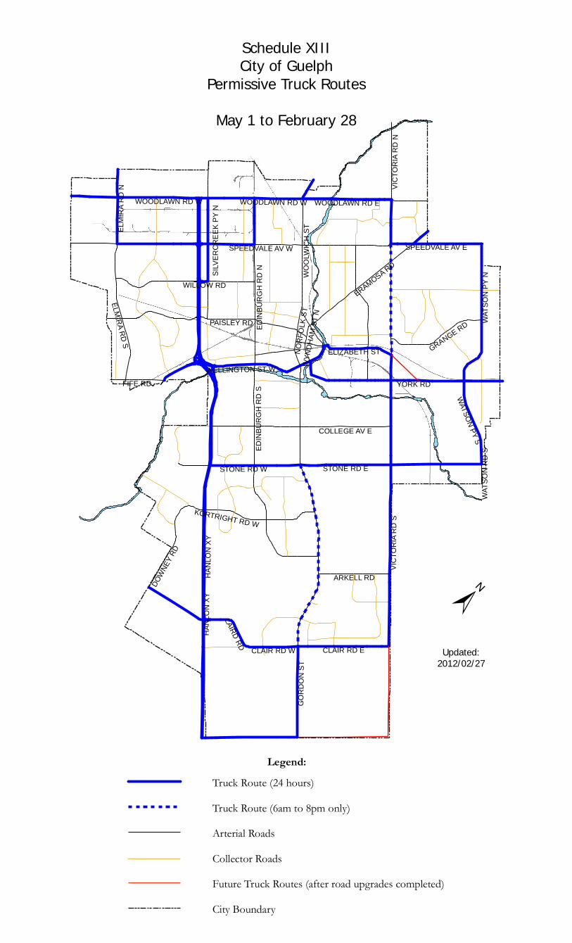
SILVE
RCRE
EK PY
N
GORD
ON S
T
HANL
ON XY
VICTO
RIA R
D S
YORK RD
STONE RD E
SPEEDVALE AV WED
INBU
RGH
RD S
PAISLEY RD
WILLOW RD
WOOL
WICH
ST
ERAMOSA RD
WATS
ON PY
N
ELMI
RA R
D N
STONE RD W
WOODLAWN RD W
EDIN
BURG
H RD
N
CLAIR RD E
GRANGE RD
DOWNE
Y RD
WELLINGTON ST W
WOODLAWN RD E
ELMIRA RD S
FIFE RD
ARKELL RD
COLLEGE AV E
KORTRIGHT RD W
WATSON PY S
SPEEDVALE AV E
VICTO
RIA R
D N
LAIRD RD CLAIR RD W
ELIZABETH STNORF
OLK S
TWY
NDHA
M ST
N
WATS
ON R
D S
HANL
ON XY
WOODLAWN RD W
±
Schedule XIIICity of Guelph
Permissive Truck RoutesMay 1 to February 28
Updated:2012/02/27
Legend:Truck Route (24 hours)Truck Route (6am to 8pm only)Arterial RoadsCollector RoadsFuture Truck Routes (after road upgrades completed)City Boundary
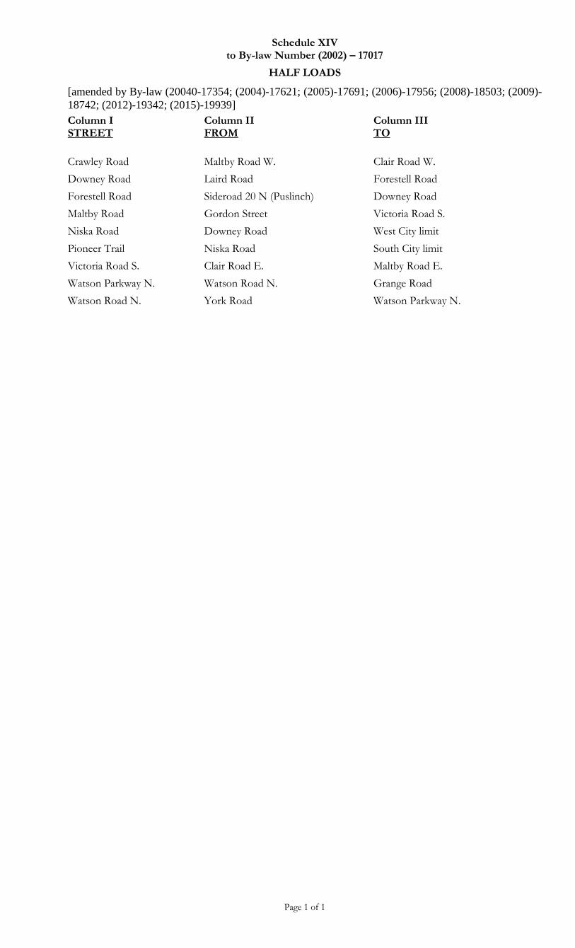
Schedule XIV to By-law Number (2002) – 17017
HALF LOADS
[amended by By-law (20040-17354; (2004)-17621; (2005)-17691; (2006)-17956; (2008)-18503; (2009)-
18742; (2012)-19342; (2015)-19939]
Page 1 of 1
Column I STREET
Column II FROM
Column III TO
Crawley Road Maltby Road W. Clair Road W.
Downey Road Laird Road Forestell Road
Forestell Road Sideroad 20 N (Puslinch) Downey Road
Maltby Road Gordon Street Victoria Road S.
Niska Road Downey Road West City limit
Pioneer Trail Niska Road South City limit
Victoria Road S. Clair Road E. Maltby Road E.
Watson Parkway N. Watson Road N. Grange Road
Watson Road N. York Road Watson Parkway N.
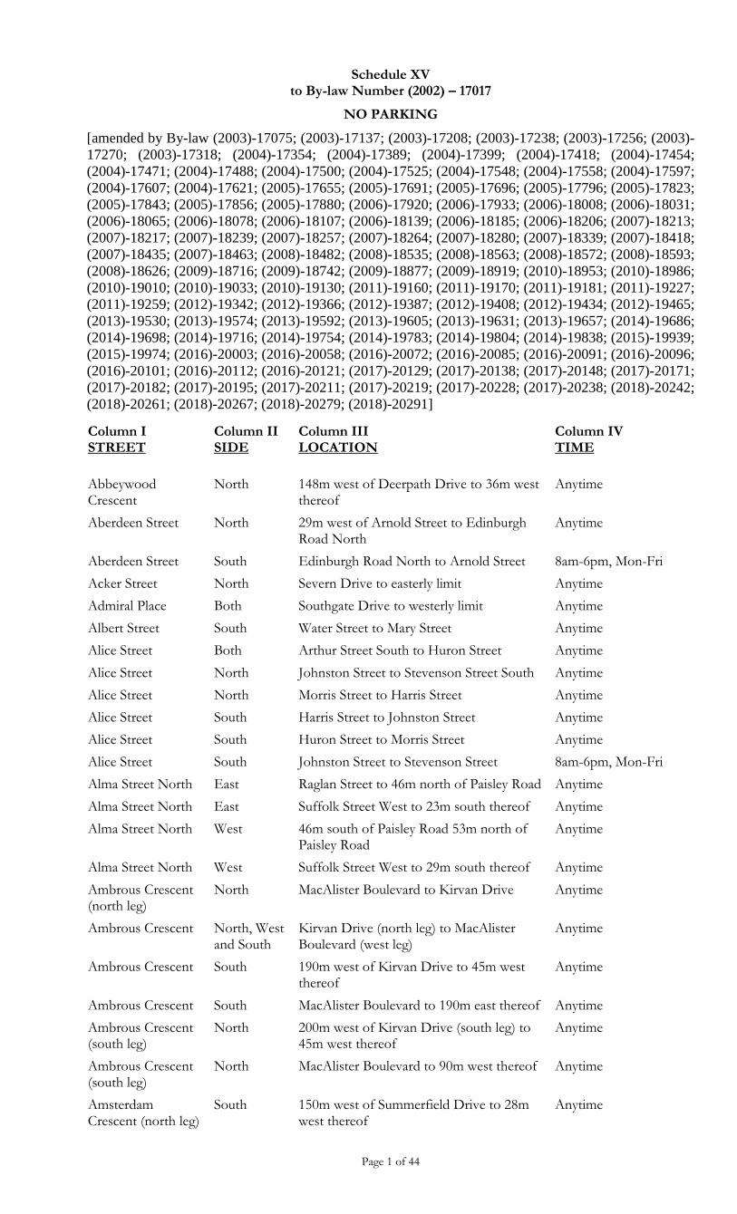
Schedule XV to By-law Number (2002) – 17017
NO PARKING
[amended by By-law (2003)-17075; (2003)-17137; (2003)-17208; (2003)-17238; (2003)-17256; (2003)-
17270; (2003)-17318; (2004)-17354; (2004)-17389; (2004)-17399; (2004)-17418; (2004)-17454;
(2004)-17471; (2004)-17488; (2004)-17500; (2004)-17525; (2004)-17548; (2004)-17558; (2004)-17597;
(2004)-17607; (2004)-17621; (2005)-17655; (2005)-17691; (2005)-17696; (2005)-17796; (2005)-17823;
(2005)-17843; (2005)-17856; (2005)-17880; (2006)-17920; (2006)-17933; (2006)-18008; (2006)-18031;
(2006)-18065; (2006)-18078; (2006)-18107; (2006)-18139; (2006)-18185; (2006)-18206; (2007)-18213;
(2007)-18217; (2007)-18239; (2007)-18257; (2007)-18264; (2007)-18280; (2007)-18339; (2007)-18418;
(2007)-18435; (2007)-18463; (2008)-18482; (2008)-18535; (2008)-18563; (2008)-18572; (2008)-18593;
(2008)-18626; (2009)-18716; (2009)-18742; (2009)-18877; (2009)-18919; (2010)-18953; (2010)-18986;
(2010)-19010; (2010)-19033; (2010)-19130; (2011)-19160; (2011)-19170; (2011)-19181; (2011)-19227;
(2011)-19259; (2012)-19342; (2012)-19366; (2012)-19387; (2012)-19408; (2012)-19434; (2012)-19465;
(2013)-19530; (2013)-19574; (2013)-19592; (2013)-19605; (2013)-19631; (2013)-19657; (2014)-19686;
(2014)-19698; (2014)-19716; (2014)-19754; (2014)-19783; (2014)-19804; (2014)-19838; (2015)-19939;
(2015)-19974; (2016)-20003; (2016)-20058; (2016)-20072; (2016)-20085; (2016)-20091; (2016)-20096;
(2016)-20101; (2016)-20112; (2016)-20121; (2017)-20129; (2017)-20138; (2017)-20148; (2017)-20171;
(2017)-20182; (2017)-20195; (2017)-20211; (2017)-20219; (2017)-20228; (2017)-20238; (2018)-20242;
(2018)-20261; (2018)-20267; (2018)-20279; (2018)-20291]
Page 1 of 44
Column I STREET
Column II SIDE
Column III LOCATION
Column IV TIME
Abbeywood Crescent
North 148m west of Deerpath Drive to 36m west thereof
Anytime
Aberdeen Street North 29m west of Arnold Street to Edinburgh Road North
Anytime
Aberdeen Street South Edinburgh Road North to Arnold Street 8am-6pm, Mon-Fri
Acker Street North Severn Drive to easterly limit Anytime
Admiral Place Both Southgate Drive to westerly limit Anytime
Albert Street South Water Street to Mary Street Anytime
Alice Street Both Arthur Street South to Huron Street Anytime
Alice Street North Johnston Street to Stevenson Street South Anytime
Alice Street North Morris Street to Harris Street Anytime
Alice Street South Harris Street to Johnston Street Anytime
Alice Street South Huron Street to Morris Street Anytime
Alice Street South Johnston Street to Stevenson Street 8am-6pm, Mon-Fri
Alma Street North East Raglan Street to 46m north of Paisley Road Anytime
Alma Street North East Suffolk Street West to 23m south thereof Anytime
Alma Street North West 46m south of Paisley Road 53m north of Paisley Road
Anytime
Alma Street North West Suffolk Street West to 29m south thereof Anytime
Ambrous Crescent (north leg)
North MacAlister Boulevard to Kirvan Drive Anytime
Ambrous Crescent North, West and South
Kirvan Drive (north leg) to MacAlister Boulevard (west leg)
Anytime
Ambrous Crescent South 190m west of Kirvan Drive to 45m west thereof
Anytime
Ambrous Crescent South MacAlister Boulevard to 190m east thereof Anytime
Ambrous Crescent (south leg)
North 200m west of Kirvan Drive (south leg) to 45m west thereof
Anytime
Ambrous Crescent (south leg)
North MacAlister Boulevard to 90m west thereof Anytime
Amsterdam Crescent (north leg)
South 150m west of Summerfield Drive to 28m west thereof
Anytime
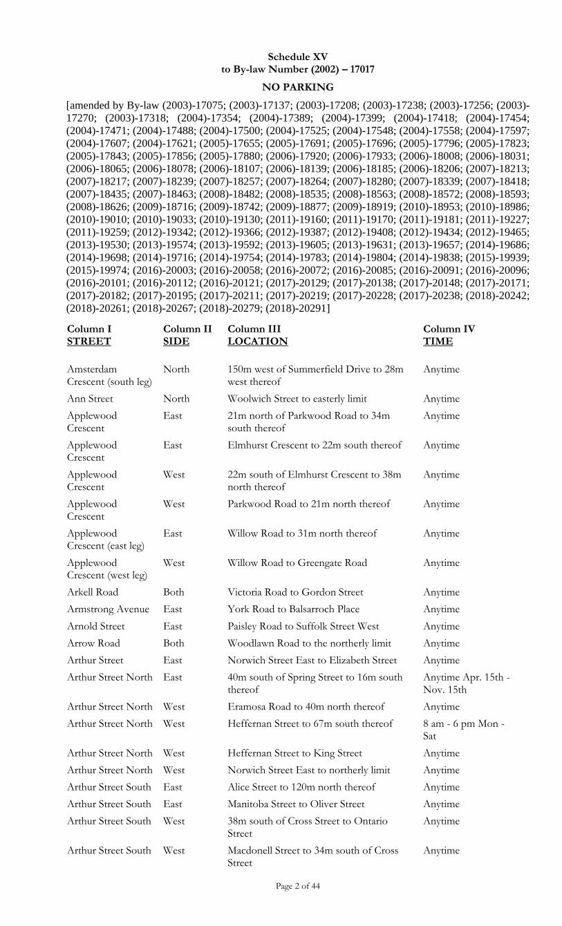
Schedule XV to By-law Number (2002) – 17017
NO PARKING
[amended by By-law (2003)-17075; (2003)-17137; (2003)-17208; (2003)-17238; (2003)-17256; (2003)-
17270; (2003)-17318; (2004)-17354; (2004)-17389; (2004)-17399; (2004)-17418; (2004)-17454;
(2004)-17471; (2004)-17488; (2004)-17500; (2004)-17525; (2004)-17548; (2004)-17558; (2004)-17597;
(2004)-17607; (2004)-17621; (2005)-17655; (2005)-17691; (2005)-17696; (2005)-17796; (2005)-17823;
(2005)-17843; (2005)-17856; (2005)-17880; (2006)-17920; (2006)-17933; (2006)-18008; (2006)-18031;
(2006)-18065; (2006)-18078; (2006)-18107; (2006)-18139; (2006)-18185; (2006)-18206; (2007)-18213;
(2007)-18217; (2007)-18239; (2007)-18257; (2007)-18264; (2007)-18280; (2007)-18339; (2007)-18418;
(2007)-18435; (2007)-18463; (2008)-18482; (2008)-18535; (2008)-18563; (2008)-18572; (2008)-18593;
(2008)-18626; (2009)-18716; (2009)-18742; (2009)-18877; (2009)-18919; (2010)-18953; (2010)-18986;
(2010)-19010; (2010)-19033; (2010)-19130; (2011)-19160; (2011)-19170; (2011)-19181; (2011)-19227;
(2011)-19259; (2012)-19342; (2012)-19366; (2012)-19387; (2012)-19408; (2012)-19434; (2012)-19465;
(2013)-19530; (2013)-19574; (2013)-19592; (2013)-19605; (2013)-19631; (2013)-19657; (2014)-19686;
(2014)-19698; (2014)-19716; (2014)-19754; (2014)-19783; (2014)-19804; (2014)-19838; (2015)-19939;
(2015)-19974; (2016)-20003; (2016)-20058; (2016)-20072; (2016)-20085; (2016)-20091; (2016)-20096;
(2016)-20101; (2016)-20112; (2016)-20121; (2017)-20129; (2017)-20138; (2017)-20148; (2017)-20171;
(2017)-20182; (2017)-20195; (2017)-20211; (2017)-20219; (2017)-20228; (2017)-20238; (2018)-20242;
(2018)-20261; (2018)-20267; (2018)-20279; (2018)-20291]
Page 2 of 44
Column I STREET
Column II SIDE
Column III LOCATION
Column IV TIME
Amsterdam Crescent (south leg)
North 150m west of Summerfield Drive to 28m west thereof
Anytime
Ann Street North Woolwich Street to easterly limit Anytime
Applewood Crescent
East 21m north of Parkwood Road to 34m south thereof
Anytime
Applewood Crescent
East Elmhurst Crescent to 22m south thereof Anytime
Applewood Crescent
West 22m south of Elmhurst Crescent to 38m north thereof
Anytime
Applewood Crescent
West Parkwood Road to 21m north thereof Anytime
Applewood Crescent (east leg)
East Willow Road to 31m north thereof Anytime
Applewood Crescent (west leg)
West Willow Road to Greengate Road Anytime
Arkell Road Both Victoria Road to Gordon Street Anytime
Armstrong Avenue East York Road to Balsarroch Place Anytime
Arnold Street East Paisley Road to Suffolk Street West Anytime
Arrow Road Both Woodlawn Road to the northerly limit Anytime
Arthur Street East Norwich Street East to Elizabeth Street Anytime
Arthur Street North East 40m south of Spring Street to 16m south thereof
Anytime Apr. 15th -Nov. 15th
Arthur Street North West Eramosa Road to 40m north thereof Anytime
Arthur Street North West Heffernan Street to 67m south thereof 8 am - 6 pm Mon - Sat
Arthur Street North West Heffernan Street to King Street Anytime
Arthur Street North West Norwich Street East to northerly limit Anytime
Arthur Street South East Alice Street to 120m north thereof Anytime
Arthur Street South East Manitoba Street to Oliver Street Anytime
Arthur Street South West 38m south of Cross Street to Ontario Street
Anytime
Arthur Street South West Macdonell Street to 34m south of Cross Street
Anytime
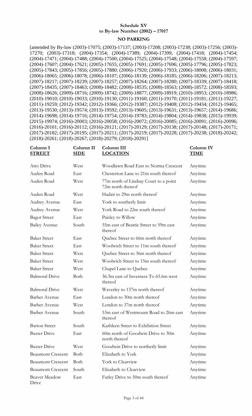
Schedule XV to By-law Number (2002) – 17017
NO PARKING
[amended by By-law (2003)-17075; (2003)-17137; (2003)-17208; (2003)-17238; (2003)-17256; (2003)-
17270; (2003)-17318; (2004)-17354; (2004)-17389; (2004)-17399; (2004)-17418; (2004)-17454;
(2004)-17471; (2004)-17488; (2004)-17500; (2004)-17525; (2004)-17548; (2004)-17558; (2004)-17597;
(2004)-17607; (2004)-17621; (2005)-17655; (2005)-17691; (2005)-17696; (2005)-17796; (2005)-17823;
(2005)-17843; (2005)-17856; (2005)-17880; (2006)-17920; (2006)-17933; (2006)-18008; (2006)-18031;
(2006)-18065; (2006)-18078; (2006)-18107; (2006)-18139; (2006)-18185; (2006)-18206; (2007)-18213;
(2007)-18217; (2007)-18239; (2007)-18257; (2007)-18264; (2007)-18280; (2007)-18339; (2007)-18418;
(2007)-18435; (2007)-18463; (2008)-18482; (2008)-18535; (2008)-18563; (2008)-18572; (2008)-18593;
(2008)-18626; (2009)-18716; (2009)-18742; (2009)-18877; (2009)-18919; (2010)-18953; (2010)-18986;
(2010)-19010; (2010)-19033; (2010)-19130; (2011)-19160; (2011)-19170; (2011)-19181; (2011)-19227;
(2011)-19259; (2012)-19342; (2012)-19366; (2012)-19387; (2012)-19408; (2012)-19434; (2012)-19465;
(2013)-19530; (2013)-19574; (2013)-19592; (2013)-19605; (2013)-19631; (2013)-19657; (2014)-19686;
(2014)-19698; (2014)-19716; (2014)-19754; (2014)-19783; (2014)-19804; (2014)-19838; (2015)-19939;
(2015)-19974; (2016)-20003; (2016)-20058; (2016)-20072; (2016)-20085; (2016)-20091; (2016)-20096;
(2016)-20101; (2016)-20112; (2016)-20121; (2017)-20129; (2017)-20138; (2017)-20148; (2017)-20171;
(2017)-20182; (2017)-20195; (2017)-20211; (2017)-20219; (2017)-20228; (2017)-20238; (2018)-20242;
(2018)-20261; (2018)-20267; (2018)-20279; (2018)-20291]
Page 3 of 44
Column I STREET
Column II SIDE
Column III LOCATION
Column IV TIME
Atto Drive West Woodlawn Road East to Norma Crescent Anytime
Auden Road East Chesterton Lane to 21m south thereof Anytime
Auden Road West 77m north of Lindsay Court to a point 72m north thereof
Anytime
Auden Road West Hadati to 29m north thereof Anytime
Audrey Avenue East York to southerly limit Anytime
Audrey Avenue West York Road to 22m south thereof Anytime
Bagot Street East Paisley to Willow Anytime
Bailey Avenue South 55m east of Beattie Street to 59m east thereof
Anytime
Baker Street East Quebec Street to 66m north thereof Anytime
Baker Street East Woolwich Street to 11m south thereof Anytime
Baker Street West Quebec Street to 36m north thereof Anytime
Baker Street West Woolwich Street to 15m south thereof Anytime
Baker Street West Chapel Lane to Quebec Anytime
Balmoral Drive Both 36.3m east of Inverness To 65.6m west thereof
Anytime
Balmoral Drive West Waverley to 137m north thereof Anytime
Barber Avenue East London to 30m north thereof Anytime
Barber Avenue West London to 37m north thereof Anytime
Barber Avenue South 53m east of Westmount Road to 26m east thereof
Anytime
Barton Street South Kathleen Street to Exhibition Street Anytime
Baxter Drive East 60m north of Goodwin Drive to 30m north thereof
Anytime
Baxter Drive West Goodwin Drive to northerly limit Anytime
Beaumont Crescent Both Elizabeth to York Anytime
Beaumont Crescent Both York to Clearview Anytime
Beaumont Crescent South Elizabeth to Clearview Anytime
Beaver Meadow Drive
East Farley Drive to 50m south thereof Anytime
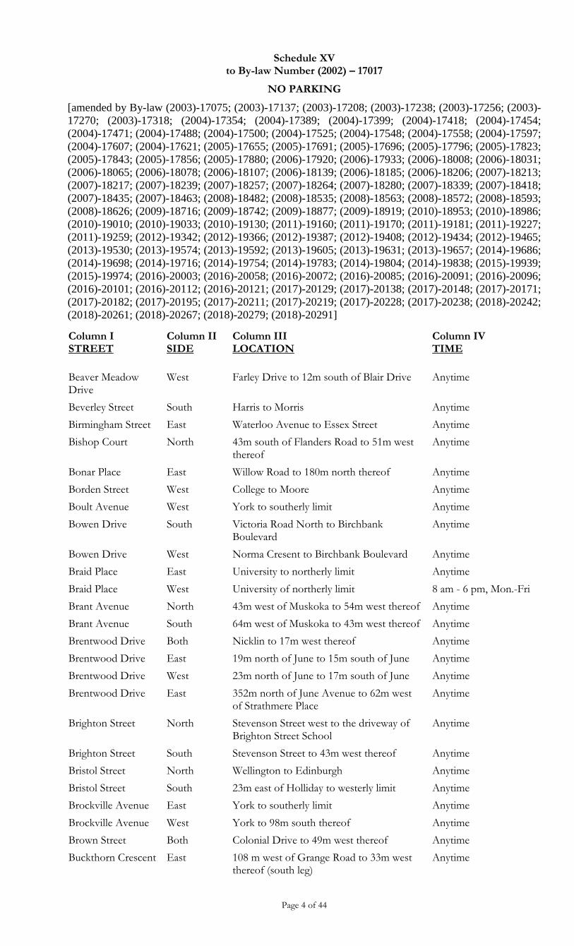
Schedule XV to By-law Number (2002) – 17017
NO PARKING
[amended by By-law (2003)-17075; (2003)-17137; (2003)-17208; (2003)-17238; (2003)-17256; (2003)-
17270; (2003)-17318; (2004)-17354; (2004)-17389; (2004)-17399; (2004)-17418; (2004)-17454;
(2004)-17471; (2004)-17488; (2004)-17500; (2004)-17525; (2004)-17548; (2004)-17558; (2004)-17597;
(2004)-17607; (2004)-17621; (2005)-17655; (2005)-17691; (2005)-17696; (2005)-17796; (2005)-17823;
(2005)-17843; (2005)-17856; (2005)-17880; (2006)-17920; (2006)-17933; (2006)-18008; (2006)-18031;
(2006)-18065; (2006)-18078; (2006)-18107; (2006)-18139; (2006)-18185; (2006)-18206; (2007)-18213;
(2007)-18217; (2007)-18239; (2007)-18257; (2007)-18264; (2007)-18280; (2007)-18339; (2007)-18418;
(2007)-18435; (2007)-18463; (2008)-18482; (2008)-18535; (2008)-18563; (2008)-18572; (2008)-18593;
(2008)-18626; (2009)-18716; (2009)-18742; (2009)-18877; (2009)-18919; (2010)-18953; (2010)-18986;
(2010)-19010; (2010)-19033; (2010)-19130; (2011)-19160; (2011)-19170; (2011)-19181; (2011)-19227;
(2011)-19259; (2012)-19342; (2012)-19366; (2012)-19387; (2012)-19408; (2012)-19434; (2012)-19465;
(2013)-19530; (2013)-19574; (2013)-19592; (2013)-19605; (2013)-19631; (2013)-19657; (2014)-19686;
(2014)-19698; (2014)-19716; (2014)-19754; (2014)-19783; (2014)-19804; (2014)-19838; (2015)-19939;
(2015)-19974; (2016)-20003; (2016)-20058; (2016)-20072; (2016)-20085; (2016)-20091; (2016)-20096;
(2016)-20101; (2016)-20112; (2016)-20121; (2017)-20129; (2017)-20138; (2017)-20148; (2017)-20171;
(2017)-20182; (2017)-20195; (2017)-20211; (2017)-20219; (2017)-20228; (2017)-20238; (2018)-20242;
(2018)-20261; (2018)-20267; (2018)-20279; (2018)-20291]
Page 4 of 44
Column I STREET
Column II SIDE
Column III LOCATION
Column IV TIME
Beaver Meadow Drive
West Farley Drive to 12m south of Blair Drive Anytime
Beverley Street South Harris to Morris Anytime
Birmingham Street East Waterloo Avenue to Essex Street Anytime
Bishop Court North 43m south of Flanders Road to 51m west thereof
Anytime
Bonar Place East Willow Road to 180m north thereof Anytime
Borden Street West College to Moore Anytime
Boult Avenue West York to southerly limit Anytime
Bowen Drive South Victoria Road North to Birchbank Boulevard
Anytime
Bowen Drive West Norma Cresent to Birchbank Boulevard Anytime
Braid Place East University to northerly limit Anytime
Braid Place West University of northerly limit 8 am - 6 pm, Mon.-Fri
Brant Avenue North 43m west of Muskoka to 54m west thereof Anytime
Brant Avenue South 64m west of Muskoka to 43m west thereof Anytime
Brentwood Drive Both Nicklin to 17m west thereof Anytime
Brentwood Drive East 19m north of June to 15m south of June Anytime
Brentwood Drive West 23m north of June to 17m south of June Anytime
Brentwood Drive East 352m north of June Avenue to 62m west of Strathmere Place
Anytime
Brighton Street North Stevenson Street west to the driveway of Brighton Street School
Anytime
Brighton Street South Stevenson Street to 43m west thereof Anytime
Bristol Street North Wellington to Edinburgh Anytime
Bristol Street South 23m east of Holliday to westerly limit Anytime
Brockville Avenue East York to southerly limit Anytime
Brockville Avenue West York to 98m south thereof Anytime
Brown Street Both Colonial Drive to 49m west thereof Anytime
Buckthorn Crescent East 108 m west of Grange Road to 33m west thereof (south leg)
Anytime
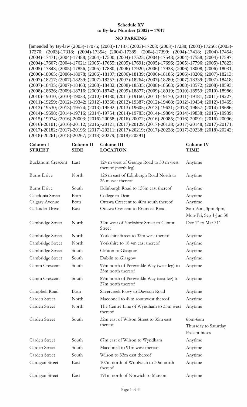
Schedule XV to By-law Number (2002) – 17017
NO PARKING
[amended by By-law (2003)-17075; (2003)-17137; (2003)-17208; (2003)-17238; (2003)-17256; (2003)-
17270; (2003)-17318; (2004)-17354; (2004)-17389; (2004)-17399; (2004)-17418; (2004)-17454;
(2004)-17471; (2004)-17488; (2004)-17500; (2004)-17525; (2004)-17548; (2004)-17558; (2004)-17597;
(2004)-17607; (2004)-17621; (2005)-17655; (2005)-17691; (2005)-17696; (2005)-17796; (2005)-17823;
(2005)-17843; (2005)-17856; (2005)-17880; (2006)-17920; (2006)-17933; (2006)-18008; (2006)-18031;
(2006)-18065; (2006)-18078; (2006)-18107; (2006)-18139; (2006)-18185; (2006)-18206; (2007)-18213;
(2007)-18217; (2007)-18239; (2007)-18257; (2007)-18264; (2007)-18280; (2007)-18339; (2007)-18418;
(2007)-18435; (2007)-18463; (2008)-18482; (2008)-18535; (2008)-18563; (2008)-18572; (2008)-18593;
(2008)-18626; (2009)-18716; (2009)-18742; (2009)-18877; (2009)-18919; (2010)-18953; (2010)-18986;
(2010)-19010; (2010)-19033; (2010)-19130; (2011)-19160; (2011)-19170; (2011)-19181; (2011)-19227;
(2011)-19259; (2012)-19342; (2012)-19366; (2012)-19387; (2012)-19408; (2012)-19434; (2012)-19465;
(2013)-19530; (2013)-19574; (2013)-19592; (2013)-19605; (2013)-19631; (2013)-19657; (2014)-19686;
(2014)-19698; (2014)-19716; (2014)-19754; (2014)-19783; (2014)-19804; (2014)-19838; (2015)-19939;
(2015)-19974; (2016)-20003; (2016)-20058; (2016)-20072; (2016)-20085; (2016)-20091; (2016)-20096;
(2016)-20101; (2016)-20112; (2016)-20121; (2017)-20129; (2017)-20138; (2017)-20148; (2017)-20171;
(2017)-20182; (2017)-20195; (2017)-20211; (2017)-20219; (2017)-20228; (2017)-20238; (2018)-20242;
(2018)-20261; (2018)-20267; (2018)-20279; (2018)-20291]
Page 5 of 44
Column I STREET
Column II SIDE
Column III LOCATION
Column IV TIME
Buckthorn Crescent East 124 m west of Grange Road to 30 m west thereof (north leg)
Anytime
Burns Drive North 126 m east of Edinburgh Road North to 26 m east thereof
Anytime
Burns Drive South Edinburgh Road to 158m east thereof Anytime
Caledonia Street Both College to Dean Anytime
Calgary Avenue Both Ottawa Crescent to 40m south thereof Anytime
Callander Drive East Ottawa Crescent to Eramosa Road 8am-9am, 3pm-4pm,
Mon-Fri, Sep 1-Jun 30
Cambridge Street North 32m west of Yorkshire Street to Clinton Street
Dec 1st to Mar 31st
Cambridge Street North Yorkshire Street to 32m west thereof Anytime
Cambridge Street North Yorkshire to 18.4m east thereof Anytime
Cambridge Street South Clinton to Glasgow Anytime
Cambridge Street South Dublin to Glasgow Anytime
Camm Crescent South 99m north of Periwinkle Way (west leg) to 23m north thereof
Anytime
Camm Crescent South 89m north of Periwinkle Way (east leg) to 27m north thereof
Anytime
Campbell Road Both Silvercreek Pkwy to Dawson Road Anytime
Carden Street North Macdonell to 49m southwest thereof Anytime
Carden Street North The Centre Line of Wyndham to 35m west thereof
Anytime
Carden Street South 32m east of Wilson Street to 35m east thereof
6pm-6am
Thursday to Saturday
Except buses
Carden Street South 67m east of Wilson to Wyndham Anytime
Carden Street South Macdonell to 91m west thereof Anytime
Carden Street South Wilson to 32m east thereof Anytime
Cardigan Street East 107m north of Woolwich to 30m north thereof
Anytime
Cardigan Street East 191m north of Norwich to Marcon Anytime
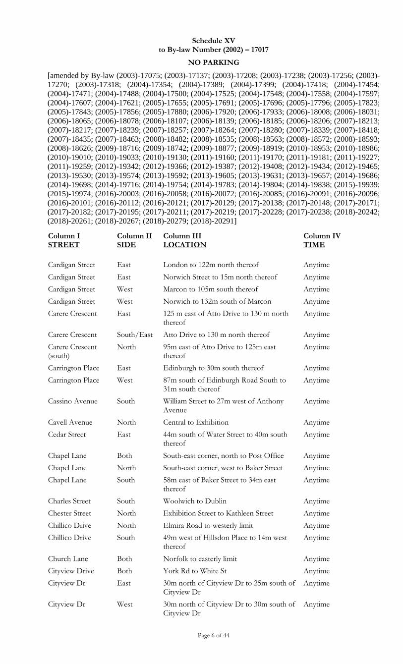
Schedule XV to By-law Number (2002) – 17017
NO PARKING
[amended by By-law (2003)-17075; (2003)-17137; (2003)-17208; (2003)-17238; (2003)-17256; (2003)-
17270; (2003)-17318; (2004)-17354; (2004)-17389; (2004)-17399; (2004)-17418; (2004)-17454;
(2004)-17471; (2004)-17488; (2004)-17500; (2004)-17525; (2004)-17548; (2004)-17558; (2004)-17597;
(2004)-17607; (2004)-17621; (2005)-17655; (2005)-17691; (2005)-17696; (2005)-17796; (2005)-17823;
(2005)-17843; (2005)-17856; (2005)-17880; (2006)-17920; (2006)-17933; (2006)-18008; (2006)-18031;
(2006)-18065; (2006)-18078; (2006)-18107; (2006)-18139; (2006)-18185; (2006)-18206; (2007)-18213;
(2007)-18217; (2007)-18239; (2007)-18257; (2007)-18264; (2007)-18280; (2007)-18339; (2007)-18418;
(2007)-18435; (2007)-18463; (2008)-18482; (2008)-18535; (2008)-18563; (2008)-18572; (2008)-18593;
(2008)-18626; (2009)-18716; (2009)-18742; (2009)-18877; (2009)-18919; (2010)-18953; (2010)-18986;
(2010)-19010; (2010)-19033; (2010)-19130; (2011)-19160; (2011)-19170; (2011)-19181; (2011)-19227;
(2011)-19259; (2012)-19342; (2012)-19366; (2012)-19387; (2012)-19408; (2012)-19434; (2012)-19465;
(2013)-19530; (2013)-19574; (2013)-19592; (2013)-19605; (2013)-19631; (2013)-19657; (2014)-19686;
(2014)-19698; (2014)-19716; (2014)-19754; (2014)-19783; (2014)-19804; (2014)-19838; (2015)-19939;
(2015)-19974; (2016)-20003; (2016)-20058; (2016)-20072; (2016)-20085; (2016)-20091; (2016)-20096;
(2016)-20101; (2016)-20112; (2016)-20121; (2017)-20129; (2017)-20138; (2017)-20148; (2017)-20171;
(2017)-20182; (2017)-20195; (2017)-20211; (2017)-20219; (2017)-20228; (2017)-20238; (2018)-20242;
(2018)-20261; (2018)-20267; (2018)-20279; (2018)-20291]
Page 6 of 44
Column I STREET
Column II SIDE
Column III LOCATION
Column IV TIME
Cardigan Street East London to 122m north thereof Anytime
Cardigan Street East Norwich Street to 15m north thereof Anytime
Cardigan Street West Marcon to 105m south thereof Anytime
Cardigan Street West Norwich to 132m south of Marcon Anytime
Carere Crescent East 125 m east of Atto Drive to 130 m north thereof
Anytime
Carere Crescent South/East Atto Drive to 130 m north thereof Anytime
Carere Crescent (south)
North 95m east of Atto Drive to 125m east thereof
Anytime
Carrington Place East Edinburgh to 30m south thereof Anytime
Carrington Place West 87m south of Edinburgh Road South to 31m south thereof
Anytime
Cassino Avenue South William Street to 27m west of Anthony Avenue
Anytime
Cavell Avenue North Central to Exhibition Anytime
Cedar Street East 44m south of Water Street to 40m south thereof
Anytime
Chapel Lane Both South-east corner, north to Post Office Anytime
Chapel Lane North South-east corner, west to Baker Street Anytime
Chapel Lane South 58m east of Baker Street to 34m east thereof
Anytime
Charles Street South Woolwich to Dublin Anytime
Chester Street North Exhibition Street to Kathleen Street Anytime
Chillico Drive North Elmira Road to westerly limit Anytime
Chillico Drive South 49m west of Hillsdon Place to 14m west thereof
Anytime
Church Lane Both Norfolk to easterly limit Anytime
Cityview Drive Both York Rd to White St Anytime
Cityview Dr East 30m north of Cityview Dr to 25m south of Cityview Dr
Anytime
Cityview Dr West 30m north of Cityview Dr to 30m south of Cityview Dr
Anytime
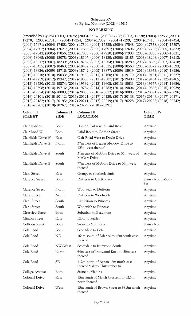
Schedule XV to By-law Number (2002) – 17017
NO PARKING
[amended by By-law (2003)-17075; (2003)-17137; (2003)-17208; (2003)-17238; (2003)-17256; (2003)-
17270; (2003)-17318; (2004)-17354; (2004)-17389; (2004)-17399; (2004)-17418; (2004)-17454;
(2004)-17471; (2004)-17488; (2004)-17500; (2004)-17525; (2004)-17548; (2004)-17558; (2004)-17597;
(2004)-17607; (2004)-17621; (2005)-17655; (2005)-17691; (2005)-17696; (2005)-17796; (2005)-17823;
(2005)-17843; (2005)-17856; (2005)-17880; (2006)-17920; (2006)-17933; (2006)-18008; (2006)-18031;
(2006)-18065; (2006)-18078; (2006)-18107; (2006)-18139; (2006)-18185; (2006)-18206; (2007)-18213;
(2007)-18217; (2007)-18239; (2007)-18257; (2007)-18264; (2007)-18280; (2007)-18339; (2007)-18418;
(2007)-18435; (2007)-18463; (2008)-18482; (2008)-18535; (2008)-18563; (2008)-18572; (2008)-18593;
(2008)-18626; (2009)-18716; (2009)-18742; (2009)-18877; (2009)-18919; (2010)-18953; (2010)-18986;
(2010)-19010; (2010)-19033; (2010)-19130; (2011)-19160; (2011)-19170; (2011)-19181; (2011)-19227;
(2011)-19259; (2012)-19342; (2012)-19366; (2012)-19387; (2012)-19408; (2012)-19434; (2012)-19465;
(2013)-19530; (2013)-19574; (2013)-19592; (2013)-19605; (2013)-19631; (2013)-19657; (2014)-19686;
(2014)-19698; (2014)-19716; (2014)-19754; (2014)-19783; (2014)-19804; (2014)-19838; (2015)-19939;
(2015)-19974; (2016)-20003; (2016)-20058; (2016)-20072; (2016)-20085; (2016)-20091; (2016)-20096;
(2016)-20101; (2016)-20112; (2016)-20121; (2017)-20129; (2017)-20138; (2017)-20148; (2017)-20171;
(2017)-20182; (2017)-20195; (2017)-20211; (2017)-20219; (2017)-20228; (2017)-20238; (2018)-20242;
(2018)-20261; (2018)-20267; (2018)-20279; (2018)-20291]
Page 7 of 44
Column I STREET
Column II SIDE
Column III LOCATION
Column IV TIME
Clair Road W Both Hanlon Parkway to Laird Road Anytime
Clair Road W Both Laird Road to Gordon Street Anytime
Clairfields Drive W East Clair Road West to Doyle Drive Anytime
Clairfields Drive E North 37m west of Beaver Meadow Drive to 133m west thereof
Anytime
Clairfields Drive E South 31m east of McGarr Drive to 35m west of McGarr Drive
Anytime
Clairfields Drive E South 97m west of McGarr Drive to 33m west thereof
Anytime
Clara Street East Grange to southerly limit Anytime
Clarence Street Both Dufferin to C.P.R. track 8 am - 6 pm, Mon - Sat
Clarence Street North Woolwich to Dufferin Anytime
Clark Street North Dufferin to Woolwich Anytime
Clark Street South Exhibition to Princess Anytime
Clark Street South Woolwich to Princess Anytime
Clearview Street Both Suburban to Beaumont Anytime
Clinton Street East Elora to Paisley Anytime
Colborn Street Both Stone to Monticello 8 am - 6 pm
Cole Road Both Scottsdale to Cole Anytime
Cole Road NE 164m south of Briarlea to 46m south-east thereof
Anytime
Cole Road NW/West Scottsdale to Ironwood South Anytime
Cole Road North 64m east of Ironwood Road to 30m east thereof
Anytime
Cole Road SE 112m north of Aspen 46m north-east thereof Valley/Christopher to
Anytime
College Avenue Both Stone to Victoria Anytime
Colonial Drive East 15m south of Marsh Crescent to 92.5m north thereof
Anytime
Colonial Drive West 15m south of Brown Street to 98.5m north thereof
Anytime

Schedule XV to By-law Number (2002) – 17017
NO PARKING
[amended by By-law (2003)-17075; (2003)-17137; (2003)-17208; (2003)-17238; (2003)-17256; (2003)-
17270; (2003)-17318; (2004)-17354; (2004)-17389; (2004)-17399; (2004)-17418; (2004)-17454;
(2004)-17471; (2004)-17488; (2004)-17500; (2004)-17525; (2004)-17548; (2004)-17558; (2004)-17597;
(2004)-17607; (2004)-17621; (2005)-17655; (2005)-17691; (2005)-17696; (2005)-17796; (2005)-17823;
(2005)-17843; (2005)-17856; (2005)-17880; (2006)-17920; (2006)-17933; (2006)-18008; (2006)-18031;
(2006)-18065; (2006)-18078; (2006)-18107; (2006)-18139; (2006)-18185; (2006)-18206; (2007)-18213;
(2007)-18217; (2007)-18239; (2007)-18257; (2007)-18264; (2007)-18280; (2007)-18339; (2007)-18418;
(2007)-18435; (2007)-18463; (2008)-18482; (2008)-18535; (2008)-18563; (2008)-18572; (2008)-18593;
(2008)-18626; (2009)-18716; (2009)-18742; (2009)-18877; (2009)-18919; (2010)-18953; (2010)-18986;
(2010)-19010; (2010)-19033; (2010)-19130; (2011)-19160; (2011)-19170; (2011)-19181; (2011)-19227;
(2011)-19259; (2012)-19342; (2012)-19366; (2012)-19387; (2012)-19408; (2012)-19434; (2012)-19465;
(2013)-19530; (2013)-19574; (2013)-19592; (2013)-19605; (2013)-19631; (2013)-19657; (2014)-19686;
(2014)-19698; (2014)-19716; (2014)-19754; (2014)-19783; (2014)-19804; (2014)-19838; (2015)-19939;
(2015)-19974; (2016)-20003; (2016)-20058; (2016)-20072; (2016)-20085; (2016)-20091; (2016)-20096;
(2016)-20101; (2016)-20112; (2016)-20121; (2017)-20129; (2017)-20138; (2017)-20148; (2017)-20171;
(2017)-20182; (2017)-20195; (2017)-20211; (2017)-20219; (2017)-20228; (2017)-20238; (2018)-20242;
(2018)-20261; (2018)-20267; (2018)-20279; (2018)-20291]
Page 8 of 44
Column I STREET
Column II SIDE
Column III LOCATION
Column IV TIME
Colonial Drive Both 20m south of Bard Boulevard to 15m north of Bard Boulevard
Anytime
Commercial Street North 58m west of Norfolk to 6.1m west thereof Anytime
Conroy Crescent West College to College Anytime
Cork Street West North Norfolk Street to Dublin Street North Anytime
Cork Street West South Norfolk Street to 30m west thereof Anytime
Cork Street North Yorkshire to 17m east thereof Anytime
Cork Street South Dublin to Yorkshire Anytime
Corporate Court Both Southgate Drive to easterly limit Anytime
Cote Drive Both Skov to northerly limit 8 am-6 pm, Mon.-Fri.
Couling Crescent North, West and South
Inner portion of the Crescent from Watson Parkway to Watson Parkway
Anytime
Crawford Street West Dean Avenue to University Avenue West Anytime
Crestwood Place West 60m north of Palmer Street to 12m north thereof
Anytime
Crestwood Place West 60m north of Palmer Street to 12m north thereof
Anytime
Crestwood Street East Palmer to the northerly limit Anytime
Crimea Street North Alma to 42m east thereof Anytime
Crimea Street North Edinburgh to 213m west thereof 8 am - 6 pm
Crimea Street South 105m west of C.N.R. crossing to Alma Anytime
Crimea Street South Edinburgh to 63m west to C.N.R. crossing Anytime
Cross Street North Neeve Street to Arthur Street South Anytime
Cross Street South Neeve Street to 25m east thereof Anytime
Cross Street South Arthur Street to 22m west thereof Anytime
Curtis Road Both Silvercreek Pkwy to the westerly limit Anytime
Curzon Crescent North Tovell Drive to 93m west thereof Anytime
Curzon Crescent North 54m west of Saigon Street to 32m west thereof
Anytime
Cutten Place Both Southgate Drive to easterly limit Anytime
Darby Road East 56m south of Stephanie Drive to 34m south thereof
Anytime
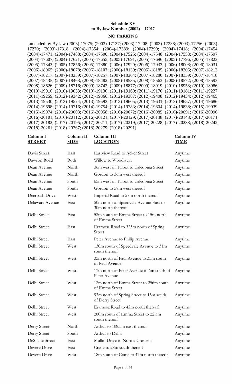
Schedule XV to By-law Number (2002) – 17017
NO PARKING
[amended by By-law (2003)-17075; (2003)-17137; (2003)-17208; (2003)-17238; (2003)-17256; (2003)-
17270; (2003)-17318; (2004)-17354; (2004)-17389; (2004)-17399; (2004)-17418; (2004)-17454;
(2004)-17471; (2004)-17488; (2004)-17500; (2004)-17525; (2004)-17548; (2004)-17558; (2004)-17597;
(2004)-17607; (2004)-17621; (2005)-17655; (2005)-17691; (2005)-17696; (2005)-17796; (2005)-17823;
(2005)-17843; (2005)-17856; (2005)-17880; (2006)-17920; (2006)-17933; (2006)-18008; (2006)-18031;
(2006)-18065; (2006)-18078; (2006)-18107; (2006)-18139; (2006)-18185; (2006)-18206; (2007)-18213;
(2007)-18217; (2007)-18239; (2007)-18257; (2007)-18264; (2007)-18280; (2007)-18339; (2007)-18418;
(2007)-18435; (2007)-18463; (2008)-18482; (2008)-18535; (2008)-18563; (2008)-18572; (2008)-18593;
(2008)-18626; (2009)-18716; (2009)-18742; (2009)-18877; (2009)-18919; (2010)-18953; (2010)-18986;
(2010)-19010; (2010)-19033; (2010)-19130; (2011)-19160; (2011)-19170; (2011)-19181; (2011)-19227;
(2011)-19259; (2012)-19342; (2012)-19366; (2012)-19387; (2012)-19408; (2012)-19434; (2012)-19465;
(2013)-19530; (2013)-19574; (2013)-19592; (2013)-19605; (2013)-19631; (2013)-19657; (2014)-19686;
(2014)-19698; (2014)-19716; (2014)-19754; (2014)-19783; (2014)-19804; (2014)-19838; (2015)-19939;
(2015)-19974; (2016)-20003; (2016)-20058; (2016)-20072; (2016)-20085; (2016)-20091; (2016)-20096;
(2016)-20101; (2016)-20112; (2016)-20121; (2017)-20129; (2017)-20138; (2017)-20148; (2017)-20171;
(2017)-20182; (2017)-20195; (2017)-20211; (2017)-20219; (2017)-20228; (2017)-20238; (2018)-20242;
(2018)-20261; (2018)-20267; (2018)-20279; (2018)-20291]
Page 9 of 44
Column I STREET
Column II SIDE
Column III LOCATION
Column IV TIME
Davis Street East Eastview Road to Acker Street Anytime
Dawson Road Both Willow to Woodlawn Anytime
Dean Avenue North 36m west of Talbot to Caledonia Street Anytime
Dean Avenue North Gordon to 36m west thereof Anytime
Dean Avenue South 65m west of Talbot to Caledonia Street Anytime
Dean Avenue South Gordon to 58m west thereof Anytime
Deerpath Drive West Imperial Road to 27m north thereof Anytime
Delaware Avenue East 50m north of Speedvale Avenue East to 30m north thereof
Anytime
Delhi Street East 52m south of Emma Street to 15m north of Emma Street
Anytime
Delhi Street East Eramosa Road to 323m north of Spring Street
Anytime
Delhi Street East Peter Avenue to Philip Avenue Anytime
Delhi Street West 130m south of Speedvale Avenue to 31m south thereof
Anytime
Delhi Street West 35m north of Paul Avenue to 35m south of Paul Avenue
Anytime
Delhi Street West 11m north of Peter Avenue to 6m south of Peter Avenue
Anytime
Delhi Street West 12m north of Emma Street to 256m south of Emma Street
Anytime
Delhi Street West 93m north of Spring Street to 15m south of Derry Street
Anytime
Delhi Street West Eramosa Road to 42m north thereof Anytime
Delhi Street West 280m south of Emma Street to 22.5m south thereof
Anytime
Derry Street North Arthur to 108.5m east thereof Anytime
Derry Street South Arthur to Delhi Anytime
DeShane Street East Mullin Drive to Norma Crescent Anytime
Devere Drive East Crane to 28m south thereof Anytime
Devere Drive West 18m south of Crane to 47m north thereof Anytime
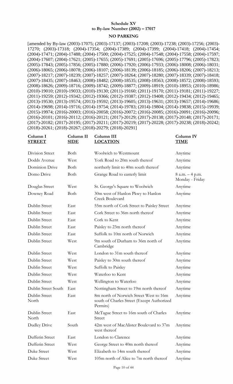
Schedule XV to By-law Number (2002) – 17017
NO PARKING
[amended by By-law (2003)-17075; (2003)-17137; (2003)-17208; (2003)-17238; (2003)-17256; (2003)-
17270; (2003)-17318; (2004)-17354; (2004)-17389; (2004)-17399; (2004)-17418; (2004)-17454;
(2004)-17471; (2004)-17488; (2004)-17500; (2004)-17525; (2004)-17548; (2004)-17558; (2004)-17597;
(2004)-17607; (2004)-17621; (2005)-17655; (2005)-17691; (2005)-17696; (2005)-17796; (2005)-17823;
(2005)-17843; (2005)-17856; (2005)-17880; (2006)-17920; (2006)-17933; (2006)-18008; (2006)-18031;
(2006)-18065; (2006)-18078; (2006)-18107; (2006)-18139; (2006)-18185; (2006)-18206; (2007)-18213;
(2007)-18217; (2007)-18239; (2007)-18257; (2007)-18264; (2007)-18280; (2007)-18339; (2007)-18418;
(2007)-18435; (2007)-18463; (2008)-18482; (2008)-18535; (2008)-18563; (2008)-18572; (2008)-18593;
(2008)-18626; (2009)-18716; (2009)-18742; (2009)-18877; (2009)-18919; (2010)-18953; (2010)-18986;
(2010)-19010; (2010)-19033; (2010)-19130; (2011)-19160; (2011)-19170; (2011)-19181; (2011)-19227;
(2011)-19259; (2012)-19342; (2012)-19366; (2012)-19387; (2012)-19408; (2012)-19434; (2012)-19465;
(2013)-19530; (2013)-19574; (2013)-19592; (2013)-19605; (2013)-19631; (2013)-19657; (2014)-19686;
(2014)-19698; (2014)-19716; (2014)-19754; (2014)-19783; (2014)-19804; (2014)-19838; (2015)-19939;
(2015)-19974; (2016)-20003; (2016)-20058; (2016)-20072; (2016)-20085; (2016)-20091; (2016)-20096;
(2016)-20101; (2016)-20112; (2016)-20121; (2017)-20129; (2017)-20138; (2017)-20148; (2017)-20171;
(2017)-20182; (2017)-20195; (2017)-20211; (2017)-20219; (2017)-20228; (2017)-20238; (2018)-20242;
(2018)-20261; (2018)-20267; (2018)-20279; (2018)-20291]
Page 10 of 44
Column I STREET
Column II SIDE
Column III LOCATION
Column IV TIME
Division Street Both Woolwich to Westmount Anytime
Dodds Avenue West York Road to 20m south thereof Anytime
Dominion Drive Both northerly limit to 40m south thereof Anytime
Domo Drive Both Grange Road to easterly limit 8 a.m. – 4 p.m. Monday - Friday
Douglas Street West St. George's Square to Woolwich Anytime
Downey Road Both 30m west of Hanlon Pkwy to Hanlon Creek Boulevard
Anytime
Dublin Street East 55m north of Cork Street to Paisley Street Anytime
Dublin Street East Cork Street to 36m north thereof Anytime
Dublin Street East Cork to Kent Anytime
Dublin Street East Paisley to 23m north thereof Anytime
Dublin Street East Suffolk to 10m north of Norwich Anytime
Dublin Street West 9m south of Durham to 36m north of Cambridge
Anytime
Dublin Street West London to 31m south thereof Anytime
Dublin Street West Paisley to 30m south thereof Anytime
Dublin Street West Suffolk to Paisley Anytime
Dublin Street West Waterloo to Kent Anytime
Dublin Street West Wellington to Waterloo Anytime
Dublin Street South East Nottingham Street to 19m north thereof Anytime
Dublin Street North
East 8m north of Norwich Street West to 16m south of Charles Street (Except Authorized Permits)
Anytime
Dublin Street North
East McTague Street to 16m south of Charles Street
Anytime
Dudley Drive South 42m west of MacAlister Boulevard to 37m west thereof
Anytime
Dufferin Street East London to Clarence Anytime
Dufferin Street West George Street to 40m north thereof Anytime
Duke Street West Elizabeth to 14m south thereof Anytime
Duke Street West 105m north of Alice to 7m north thereof Anytime
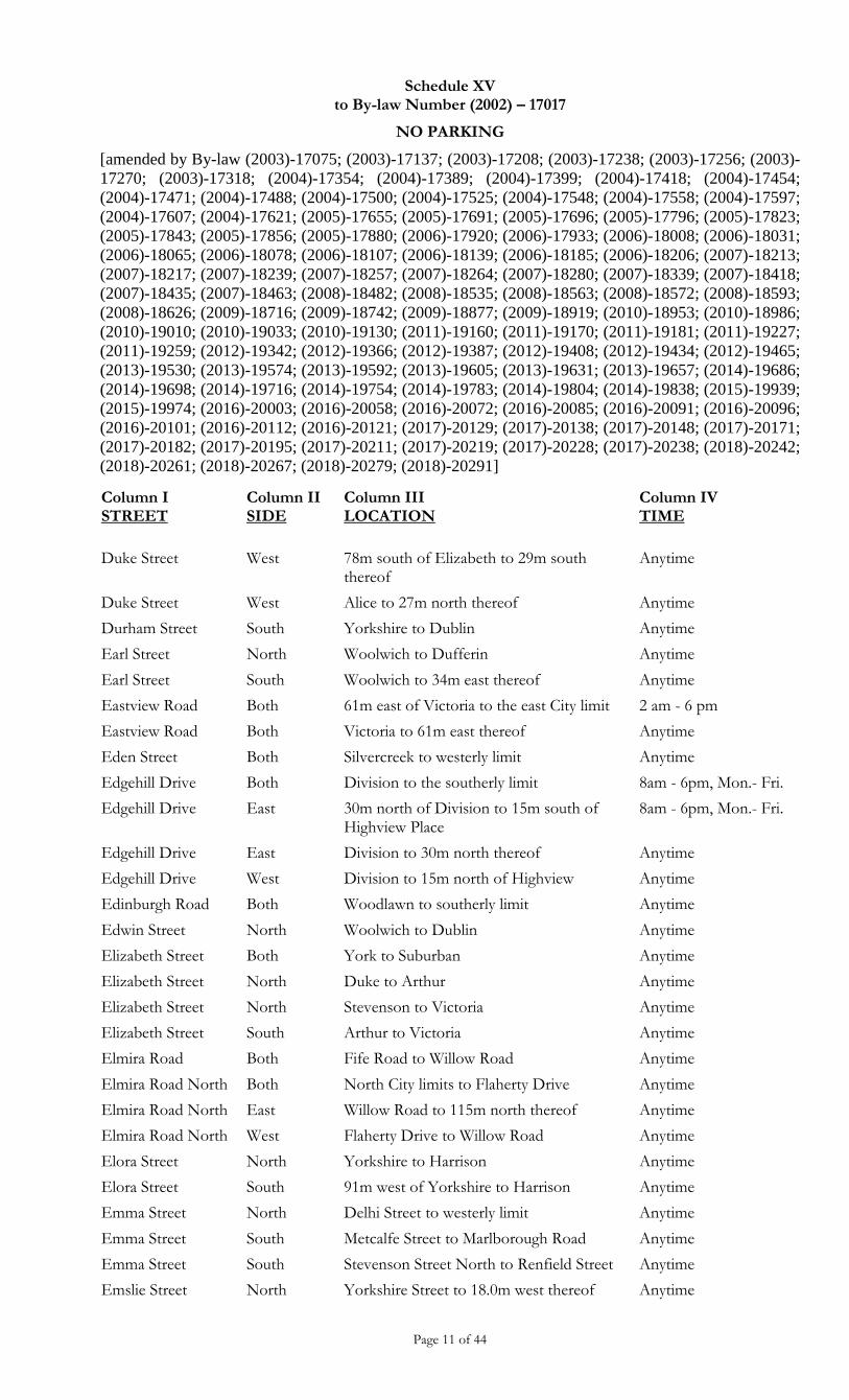
Schedule XV to By-law Number (2002) – 17017
NO PARKING
[amended by By-law (2003)-17075; (2003)-17137; (2003)-17208; (2003)-17238; (2003)-17256; (2003)-
17270; (2003)-17318; (2004)-17354; (2004)-17389; (2004)-17399; (2004)-17418; (2004)-17454;
(2004)-17471; (2004)-17488; (2004)-17500; (2004)-17525; (2004)-17548; (2004)-17558; (2004)-17597;
(2004)-17607; (2004)-17621; (2005)-17655; (2005)-17691; (2005)-17696; (2005)-17796; (2005)-17823;
(2005)-17843; (2005)-17856; (2005)-17880; (2006)-17920; (2006)-17933; (2006)-18008; (2006)-18031;
(2006)-18065; (2006)-18078; (2006)-18107; (2006)-18139; (2006)-18185; (2006)-18206; (2007)-18213;
(2007)-18217; (2007)-18239; (2007)-18257; (2007)-18264; (2007)-18280; (2007)-18339; (2007)-18418;
(2007)-18435; (2007)-18463; (2008)-18482; (2008)-18535; (2008)-18563; (2008)-18572; (2008)-18593;
(2008)-18626; (2009)-18716; (2009)-18742; (2009)-18877; (2009)-18919; (2010)-18953; (2010)-18986;
(2010)-19010; (2010)-19033; (2010)-19130; (2011)-19160; (2011)-19170; (2011)-19181; (2011)-19227;
(2011)-19259; (2012)-19342; (2012)-19366; (2012)-19387; (2012)-19408; (2012)-19434; (2012)-19465;
(2013)-19530; (2013)-19574; (2013)-19592; (2013)-19605; (2013)-19631; (2013)-19657; (2014)-19686;
(2014)-19698; (2014)-19716; (2014)-19754; (2014)-19783; (2014)-19804; (2014)-19838; (2015)-19939;
(2015)-19974; (2016)-20003; (2016)-20058; (2016)-20072; (2016)-20085; (2016)-20091; (2016)-20096;
(2016)-20101; (2016)-20112; (2016)-20121; (2017)-20129; (2017)-20138; (2017)-20148; (2017)-20171;
(2017)-20182; (2017)-20195; (2017)-20211; (2017)-20219; (2017)-20228; (2017)-20238; (2018)-20242;
(2018)-20261; (2018)-20267; (2018)-20279; (2018)-20291]
Page 11 of 44
Column I STREET
Column II SIDE
Column III LOCATION
Column IV TIME
Duke Street West 78m south of Elizabeth to 29m south thereof
Anytime
Duke Street West Alice to 27m north thereof Anytime
Durham Street South Yorkshire to Dublin Anytime
Earl Street North Woolwich to Dufferin Anytime
Earl Street South Woolwich to 34m east thereof Anytime
Eastview Road Both 61m east of Victoria to the east City limit 2 am - 6 pm
Eastview Road Both Victoria to 61m east thereof Anytime
Eden Street Both Silvercreek to westerly limit Anytime
Edgehill Drive Both Division to the southerly limit 8am - 6pm, Mon.- Fri.
Edgehill Drive East 30m north of Division to 15m south of Highview Place
8am - 6pm, Mon.- Fri.
Edgehill Drive East Division to 30m north thereof Anytime
Edgehill Drive West Division to 15m north of Highview Anytime
Edinburgh Road Both Woodlawn to southerly limit Anytime
Edwin Street North Woolwich to Dublin Anytime
Elizabeth Street Both York to Suburban Anytime
Elizabeth Street North Duke to Arthur Anytime
Elizabeth Street North Stevenson to Victoria Anytime
Elizabeth Street South Arthur to Victoria Anytime
Elmira Road Both Fife Road to Willow Road Anytime
Elmira Road North Both North City limits to Flaherty Drive Anytime
Elmira Road North East Willow Road to 115m north thereof Anytime
Elmira Road North West Flaherty Drive to Willow Road Anytime
Elora Street North Yorkshire to Harrison Anytime
Elora Street South 91m west of Yorkshire to Harrison Anytime
Emma Street North Delhi Street to westerly limit Anytime
Emma Street South Metcalfe Street to Marlborough Road Anytime
Emma Street South Stevenson Street North to Renfield Street Anytime
Emslie Street North Yorkshire Street to 18.0m west thereof Anytime
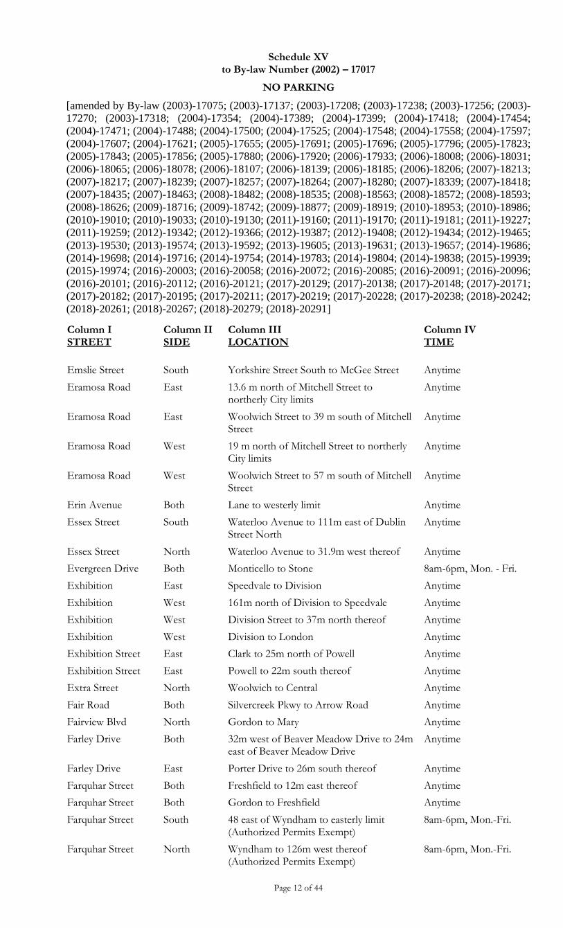
Schedule XV to By-law Number (2002) – 17017
NO PARKING
[amended by By-law (2003)-17075; (2003)-17137; (2003)-17208; (2003)-17238; (2003)-17256; (2003)-
17270; (2003)-17318; (2004)-17354; (2004)-17389; (2004)-17399; (2004)-17418; (2004)-17454;
(2004)-17471; (2004)-17488; (2004)-17500; (2004)-17525; (2004)-17548; (2004)-17558; (2004)-17597;
(2004)-17607; (2004)-17621; (2005)-17655; (2005)-17691; (2005)-17696; (2005)-17796; (2005)-17823;
(2005)-17843; (2005)-17856; (2005)-17880; (2006)-17920; (2006)-17933; (2006)-18008; (2006)-18031;
(2006)-18065; (2006)-18078; (2006)-18107; (2006)-18139; (2006)-18185; (2006)-18206; (2007)-18213;
(2007)-18217; (2007)-18239; (2007)-18257; (2007)-18264; (2007)-18280; (2007)-18339; (2007)-18418;
(2007)-18435; (2007)-18463; (2008)-18482; (2008)-18535; (2008)-18563; (2008)-18572; (2008)-18593;
(2008)-18626; (2009)-18716; (2009)-18742; (2009)-18877; (2009)-18919; (2010)-18953; (2010)-18986;
(2010)-19010; (2010)-19033; (2010)-19130; (2011)-19160; (2011)-19170; (2011)-19181; (2011)-19227;
(2011)-19259; (2012)-19342; (2012)-19366; (2012)-19387; (2012)-19408; (2012)-19434; (2012)-19465;
(2013)-19530; (2013)-19574; (2013)-19592; (2013)-19605; (2013)-19631; (2013)-19657; (2014)-19686;
(2014)-19698; (2014)-19716; (2014)-19754; (2014)-19783; (2014)-19804; (2014)-19838; (2015)-19939;
(2015)-19974; (2016)-20003; (2016)-20058; (2016)-20072; (2016)-20085; (2016)-20091; (2016)-20096;
(2016)-20101; (2016)-20112; (2016)-20121; (2017)-20129; (2017)-20138; (2017)-20148; (2017)-20171;
(2017)-20182; (2017)-20195; (2017)-20211; (2017)-20219; (2017)-20228; (2017)-20238; (2018)-20242;
(2018)-20261; (2018)-20267; (2018)-20279; (2018)-20291]
Page 12 of 44
Column I STREET
Column II SIDE
Column III LOCATION
Column IV TIME
Emslie Street South Yorkshire Street South to McGee Street Anytime
Eramosa Road East 13.6 m north of Mitchell Street to northerly City limits
Anytime
Eramosa Road East Woolwich Street to 39 m south of Mitchell Street
Anytime
Eramosa Road West 19 m north of Mitchell Street to northerly City limits
Anytime
Eramosa Road West Woolwich Street to 57 m south of Mitchell Street
Anytime
Erin Avenue Both Lane to westerly limit Anytime
Essex Street South Waterloo Avenue to 111m east of Dublin Street North
Anytime
Essex Street North Waterloo Avenue to 31.9m west thereof Anytime
Evergreen Drive Both Monticello to Stone 8am-6pm, Mon. - Fri.
Exhibition East Speedvale to Division Anytime
Exhibition West 161m north of Division to Speedvale Anytime
Exhibition West Division Street to 37m north thereof Anytime
Exhibition West Division to London Anytime
Exhibition Street East Clark to 25m north of Powell Anytime
Exhibition Street East Powell to 22m south thereof Anytime
Extra Street North Woolwich to Central Anytime
Fair Road Both Silvercreek Pkwy to Arrow Road Anytime
Fairview Blvd North Gordon to Mary Anytime
Farley Drive Both 32m west of Beaver Meadow Drive to 24m east of Beaver Meadow Drive
Anytime
Farley Drive East Porter Drive to 26m south thereof Anytime
Farquhar Street Both Freshfield to 12m east thereof Anytime
Farquhar Street Both Gordon to Freshfield Anytime
Farquhar Street South 48 east of Wyndham to easterly limit (Authorized Permits Exempt)
8am-6pm, Mon.-Fri.
Farquhar Street North Wyndham to 126m west thereof (Authorized Permits Exempt)
8am-6pm, Mon.-Fri.
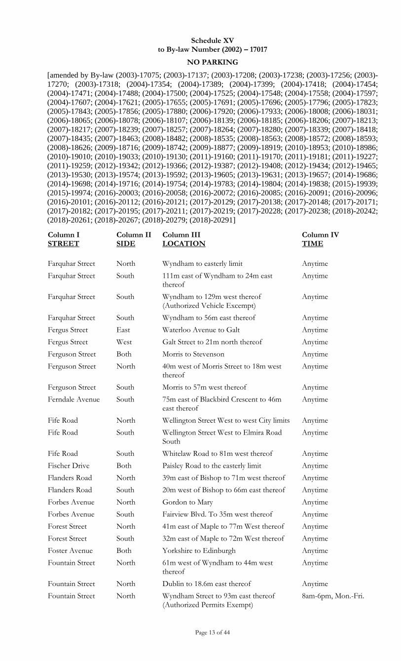
Schedule XV to By-law Number (2002) – 17017
NO PARKING
[amended by By-law (2003)-17075; (2003)-17137; (2003)-17208; (2003)-17238; (2003)-17256; (2003)-
17270; (2003)-17318; (2004)-17354; (2004)-17389; (2004)-17399; (2004)-17418; (2004)-17454;
(2004)-17471; (2004)-17488; (2004)-17500; (2004)-17525; (2004)-17548; (2004)-17558; (2004)-17597;
(2004)-17607; (2004)-17621; (2005)-17655; (2005)-17691; (2005)-17696; (2005)-17796; (2005)-17823;
(2005)-17843; (2005)-17856; (2005)-17880; (2006)-17920; (2006)-17933; (2006)-18008; (2006)-18031;
(2006)-18065; (2006)-18078; (2006)-18107; (2006)-18139; (2006)-18185; (2006)-18206; (2007)-18213;
(2007)-18217; (2007)-18239; (2007)-18257; (2007)-18264; (2007)-18280; (2007)-18339; (2007)-18418;
(2007)-18435; (2007)-18463; (2008)-18482; (2008)-18535; (2008)-18563; (2008)-18572; (2008)-18593;
(2008)-18626; (2009)-18716; (2009)-18742; (2009)-18877; (2009)-18919; (2010)-18953; (2010)-18986;
(2010)-19010; (2010)-19033; (2010)-19130; (2011)-19160; (2011)-19170; (2011)-19181; (2011)-19227;
(2011)-19259; (2012)-19342; (2012)-19366; (2012)-19387; (2012)-19408; (2012)-19434; (2012)-19465;
(2013)-19530; (2013)-19574; (2013)-19592; (2013)-19605; (2013)-19631; (2013)-19657; (2014)-19686;
(2014)-19698; (2014)-19716; (2014)-19754; (2014)-19783; (2014)-19804; (2014)-19838; (2015)-19939;
(2015)-19974; (2016)-20003; (2016)-20058; (2016)-20072; (2016)-20085; (2016)-20091; (2016)-20096;
(2016)-20101; (2016)-20112; (2016)-20121; (2017)-20129; (2017)-20138; (2017)-20148; (2017)-20171;
(2017)-20182; (2017)-20195; (2017)-20211; (2017)-20219; (2017)-20228; (2017)-20238; (2018)-20242;
(2018)-20261; (2018)-20267; (2018)-20279; (2018)-20291]
Page 13 of 44
Column I STREET
Column II SIDE
Column III LOCATION
Column IV TIME
Farquhar Street North Wyndham to easterly limit Anytime
Farquhar Street South 111m east of Wyndham to 24m east thereof
Anytime
Farquhar Street South Wyndham to 129m west thereof (Authorized Vehicle Excempt)
Anytime
Farquhar Street South Wyndham to 56m east thereof Anytime
Fergus Street East Waterloo Avenue to Galt Anytime
Fergus Street West Galt Street to 21m north thereof Anytime
Ferguson Street Both Morris to Stevenson Anytime
Ferguson Street North 40m west of Morris Street to 18m west thereof
Anytime
Ferguson Street South Morris to 57m west thereof Anytime
Ferndale Avenue South 75m east of Blackbird Crescent to 46m east thereof
Anytime
Fife Road North Wellington Street West to west City limits Anytime
Fife Road South Wellington Street West to Elmira Road South
Anytime
Fife Road South Whitelaw Road to 81m west thereof Anytime
Fischer Drive Both Paisley Road to the easterly limit Anytime
Flanders Road North 39m east of Bishop to 71m west thereof Anytime
Flanders Road South 20m west of Bishop to 66m east thereof Anytime
Forbes Avenue North Gordon to Mary Anytime
Forbes Avenue South Fairview Blvd. To 35m west thereof Anytime
Forest Street North 41m east of Maple to 77m West thereof Anytime
Forest Street South 32m east of Maple to 72m West thereof Anytime
Foster Avenue Both Yorkshire to Edinburgh Anytime
Fountain Street North 61m west of Wyndham to 44m west thereof
Anytime
Fountain Street North Dublin to 18.6m east thereof Anytime
Fountain Street North Wyndham Street to 93m east thereof (Authorized Permits Exempt)
8am-6pm, Mon.-Fri.
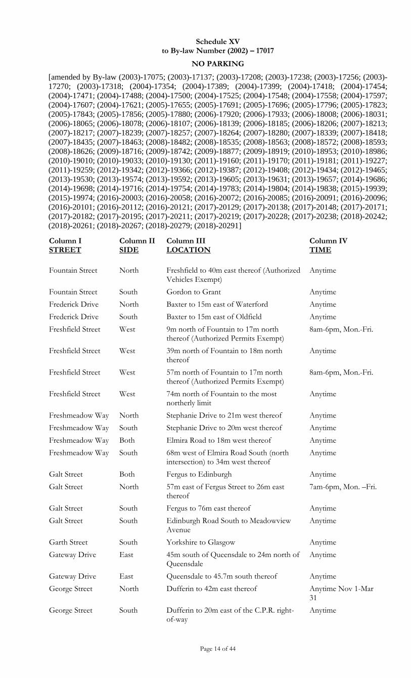
Schedule XV to By-law Number (2002) – 17017
NO PARKING
[amended by By-law (2003)-17075; (2003)-17137; (2003)-17208; (2003)-17238; (2003)-17256; (2003)-
17270; (2003)-17318; (2004)-17354; (2004)-17389; (2004)-17399; (2004)-17418; (2004)-17454;
(2004)-17471; (2004)-17488; (2004)-17500; (2004)-17525; (2004)-17548; (2004)-17558; (2004)-17597;
(2004)-17607; (2004)-17621; (2005)-17655; (2005)-17691; (2005)-17696; (2005)-17796; (2005)-17823;
(2005)-17843; (2005)-17856; (2005)-17880; (2006)-17920; (2006)-17933; (2006)-18008; (2006)-18031;
(2006)-18065; (2006)-18078; (2006)-18107; (2006)-18139; (2006)-18185; (2006)-18206; (2007)-18213;
(2007)-18217; (2007)-18239; (2007)-18257; (2007)-18264; (2007)-18280; (2007)-18339; (2007)-18418;
(2007)-18435; (2007)-18463; (2008)-18482; (2008)-18535; (2008)-18563; (2008)-18572; (2008)-18593;
(2008)-18626; (2009)-18716; (2009)-18742; (2009)-18877; (2009)-18919; (2010)-18953; (2010)-18986;
(2010)-19010; (2010)-19033; (2010)-19130; (2011)-19160; (2011)-19170; (2011)-19181; (2011)-19227;
(2011)-19259; (2012)-19342; (2012)-19366; (2012)-19387; (2012)-19408; (2012)-19434; (2012)-19465;
(2013)-19530; (2013)-19574; (2013)-19592; (2013)-19605; (2013)-19631; (2013)-19657; (2014)-19686;
(2014)-19698; (2014)-19716; (2014)-19754; (2014)-19783; (2014)-19804; (2014)-19838; (2015)-19939;
(2015)-19974; (2016)-20003; (2016)-20058; (2016)-20072; (2016)-20085; (2016)-20091; (2016)-20096;
(2016)-20101; (2016)-20112; (2016)-20121; (2017)-20129; (2017)-20138; (2017)-20148; (2017)-20171;
(2017)-20182; (2017)-20195; (2017)-20211; (2017)-20219; (2017)-20228; (2017)-20238; (2018)-20242;
(2018)-20261; (2018)-20267; (2018)-20279; (2018)-20291]
Page 14 of 44
Column I STREET
Column II SIDE
Column III LOCATION
Column IV TIME
Fountain Street North Freshfield to 40m east thereof (Authorized Vehicles Exempt)
Anytime
Fountain Street South Gordon to Grant Anytime
Frederick Drive North Baxter to 15m east of Waterford Anytime
Frederick Drive South Baxter to 15m east of Oldfield Anytime
Freshfield Street West 9m north of Fountain to 17m north thereof (Authorized Permits Exempt)
8am-6pm, Mon.-Fri.
Freshfield Street West 39m north of Fountain to 18m north thereof
Anytime
Freshfield Street West 57m north of Fountain to 17m north thereof (Authorized Permits Exempt)
8am-6pm, Mon.-Fri.
Freshfield Street West 74m north of Fountain to the most northerly limit
Anytime
Freshmeadow Way North Stephanie Drive to 21m west thereof Anytime
Freshmeadow Way South Stephanie Drive to 20m west thereof Anytime
Freshmeadow Way Both Elmira Road to 18m west thereof Anytime
Freshmeadow Way South 68m west of Elmira Road South (north intersection) to 34m west thereof
Anytime
Galt Street Both Fergus to Edinburgh Anytime
Galt Street North 57m east of Fergus Street to 26m east thereof
7am-6pm, Mon. –Fri.
Galt Street South Fergus to 76m east thereof Anytime
Galt Street South Edinburgh Road South to Meadowview Avenue
Anytime
Garth Street South Yorkshire to Glasgow Anytime
Gateway Drive East 45m south of Queensdale to 24m north of Queensdale
Anytime
Gateway Drive East Queensdale to 45.7m south thereof Anytime
George Street North Dufferin to 42m east thereof Anytime Nov 1-Mar 31
George Street South Dufferin to 20m east of the C.P.R. right-of-way
Anytime
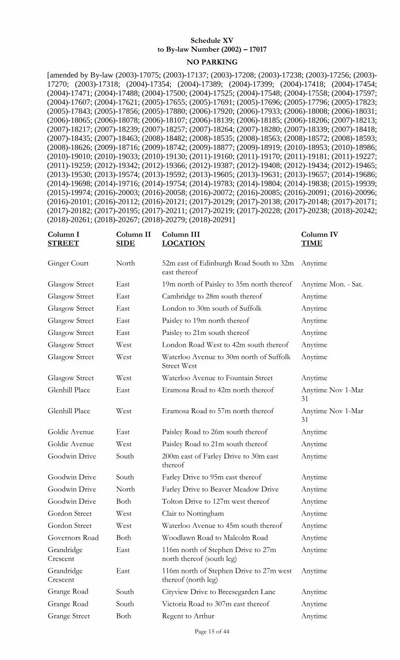
Schedule XV to By-law Number (2002) – 17017
NO PARKING
[amended by By-law (2003)-17075; (2003)-17137; (2003)-17208; (2003)-17238; (2003)-17256; (2003)-
17270; (2003)-17318; (2004)-17354; (2004)-17389; (2004)-17399; (2004)-17418; (2004)-17454;
(2004)-17471; (2004)-17488; (2004)-17500; (2004)-17525; (2004)-17548; (2004)-17558; (2004)-17597;
(2004)-17607; (2004)-17621; (2005)-17655; (2005)-17691; (2005)-17696; (2005)-17796; (2005)-17823;
(2005)-17843; (2005)-17856; (2005)-17880; (2006)-17920; (2006)-17933; (2006)-18008; (2006)-18031;
(2006)-18065; (2006)-18078; (2006)-18107; (2006)-18139; (2006)-18185; (2006)-18206; (2007)-18213;
(2007)-18217; (2007)-18239; (2007)-18257; (2007)-18264; (2007)-18280; (2007)-18339; (2007)-18418;
(2007)-18435; (2007)-18463; (2008)-18482; (2008)-18535; (2008)-18563; (2008)-18572; (2008)-18593;
(2008)-18626; (2009)-18716; (2009)-18742; (2009)-18877; (2009)-18919; (2010)-18953; (2010)-18986;
(2010)-19010; (2010)-19033; (2010)-19130; (2011)-19160; (2011)-19170; (2011)-19181; (2011)-19227;
(2011)-19259; (2012)-19342; (2012)-19366; (2012)-19387; (2012)-19408; (2012)-19434; (2012)-19465;
(2013)-19530; (2013)-19574; (2013)-19592; (2013)-19605; (2013)-19631; (2013)-19657; (2014)-19686;
(2014)-19698; (2014)-19716; (2014)-19754; (2014)-19783; (2014)-19804; (2014)-19838; (2015)-19939;
(2015)-19974; (2016)-20003; (2016)-20058; (2016)-20072; (2016)-20085; (2016)-20091; (2016)-20096;
(2016)-20101; (2016)-20112; (2016)-20121; (2017)-20129; (2017)-20138; (2017)-20148; (2017)-20171;
(2017)-20182; (2017)-20195; (2017)-20211; (2017)-20219; (2017)-20228; (2017)-20238; (2018)-20242;
(2018)-20261; (2018)-20267; (2018)-20279; (2018)-20291]
Page 15 of 44
Column I STREET
Column II SIDE
Column III LOCATION
Column IV TIME
Ginger Court North 52m east of Edinburgh Road South to 32m east thereof
Anytime
Glasgow Street East 19m north of Paisley to 35m north thereof Anytime Mon. - Sat.
Glasgow Street East Cambridge to 28m south thereof Anytime
Glasgow Street East London to 30m south of Suffolk Anytime
Glasgow Street East Paisley to 19m north thereof Anytime
Glasgow Street East Paisley to 21m south thereof Anytime
Glasgow Street West London Road West to 42m south thereof Anytime
Glasgow Street West Waterloo Avenue to 30m north of Suffolk Street West
Anytime
Glasgow Street West Waterloo Avenue to Fountain Street Anytime
Glenhill Place East Eramosa Road to 42m north thereof Anytime Nov 1-Mar 31
Glenhill Place West Eramosa Road to 57m north thereof Anytime Nov 1-Mar 31
Goldie Avenue East Paisley Road to 26m south thereof Anytime
Goldie Avenue West Paisley Road to 21m south thereof Anytime
Goodwin Drive South 200m east of Farley Drive to 30m east thereof
Anytime
Goodwin Drive South Farley Drive to 95m east thereof Anytime
Goodwin Drive North Farley Drive to Beaver Meadow Drive Anytime
Goodwin Drive Both Tolton Drive to 127m west thereof Anytime
Gordon Street West Clair to Nottingham Anytime
Gordon Street West Waterloo Avenue to 45m south thereof Anytime
Governors Road Both Woodlawn Road to Malcolm Road Anytime
Grandridge Crescent
East 116m north of Stephen Drive to 27m north thereof (south leg)
Anytime
Grandridge Crescent
East 116m north of Stephen Drive to 27m west thereof (north leg)
Anytime
Grange Road South Cityview Drive to Breesegarden Lane Anytime
Grange Road South Victoria Road to 307m east thereof Anytime
Grange Street Both Regent to Arthur Anytime
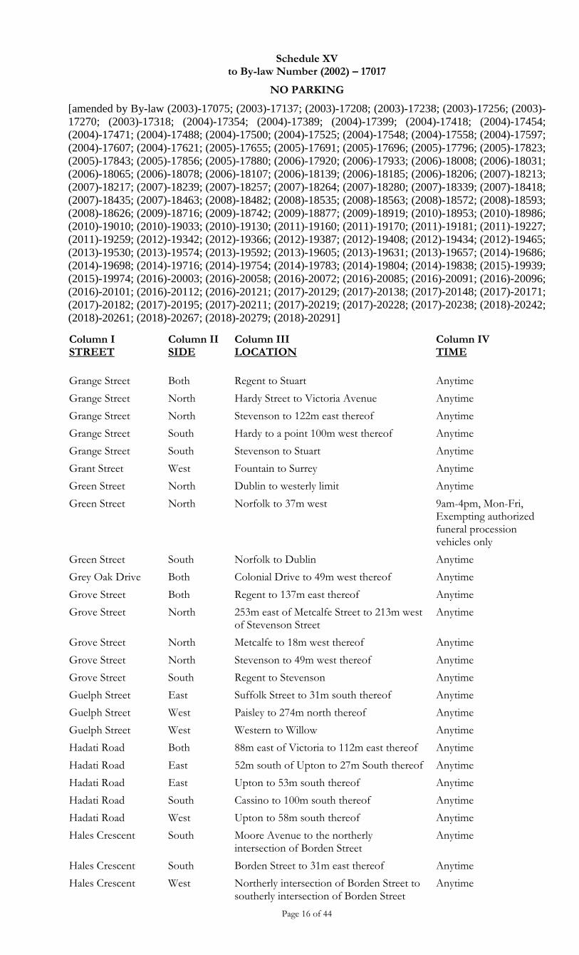
Schedule XV to By-law Number (2002) – 17017
NO PARKING
[amended by By-law (2003)-17075; (2003)-17137; (2003)-17208; (2003)-17238; (2003)-17256; (2003)-
17270; (2003)-17318; (2004)-17354; (2004)-17389; (2004)-17399; (2004)-17418; (2004)-17454;
(2004)-17471; (2004)-17488; (2004)-17500; (2004)-17525; (2004)-17548; (2004)-17558; (2004)-17597;
(2004)-17607; (2004)-17621; (2005)-17655; (2005)-17691; (2005)-17696; (2005)-17796; (2005)-17823;
(2005)-17843; (2005)-17856; (2005)-17880; (2006)-17920; (2006)-17933; (2006)-18008; (2006)-18031;
(2006)-18065; (2006)-18078; (2006)-18107; (2006)-18139; (2006)-18185; (2006)-18206; (2007)-18213;
(2007)-18217; (2007)-18239; (2007)-18257; (2007)-18264; (2007)-18280; (2007)-18339; (2007)-18418;
(2007)-18435; (2007)-18463; (2008)-18482; (2008)-18535; (2008)-18563; (2008)-18572; (2008)-18593;
(2008)-18626; (2009)-18716; (2009)-18742; (2009)-18877; (2009)-18919; (2010)-18953; (2010)-18986;
(2010)-19010; (2010)-19033; (2010)-19130; (2011)-19160; (2011)-19170; (2011)-19181; (2011)-19227;
(2011)-19259; (2012)-19342; (2012)-19366; (2012)-19387; (2012)-19408; (2012)-19434; (2012)-19465;
(2013)-19530; (2013)-19574; (2013)-19592; (2013)-19605; (2013)-19631; (2013)-19657; (2014)-19686;
(2014)-19698; (2014)-19716; (2014)-19754; (2014)-19783; (2014)-19804; (2014)-19838; (2015)-19939;
(2015)-19974; (2016)-20003; (2016)-20058; (2016)-20072; (2016)-20085; (2016)-20091; (2016)-20096;
(2016)-20101; (2016)-20112; (2016)-20121; (2017)-20129; (2017)-20138; (2017)-20148; (2017)-20171;
(2017)-20182; (2017)-20195; (2017)-20211; (2017)-20219; (2017)-20228; (2017)-20238; (2018)-20242;
(2018)-20261; (2018)-20267; (2018)-20279; (2018)-20291]
Page 16 of 44
Column I STREET
Column II SIDE
Column III LOCATION
Column IV TIME
Grange Street Both Regent to Stuart Anytime
Grange Street North Hardy Street to Victoria Avenue Anytime
Grange Street North Stevenson to 122m east thereof Anytime
Grange Street South Hardy to a point 100m west thereof Anytime
Grange Street South Stevenson to Stuart Anytime
Grant Street West Fountain to Surrey Anytime
Green Street North Dublin to westerly limit Anytime
Green Street North Norfolk to 37m west 9am-4pm, Mon-Fri, Exempting authorized funeral procession vehicles only
Green Street South Norfolk to Dublin Anytime
Grey Oak Drive Both Colonial Drive to 49m west thereof Anytime
Grove Street Both Regent to 137m east thereof Anytime
Grove Street North 253m east of Metcalfe Street to 213m west of Stevenson Street
Anytime
Grove Street North Metcalfe to 18m west thereof Anytime
Grove Street North Stevenson to 49m west thereof Anytime
Grove Street South Regent to Stevenson Anytime
Guelph Street East Suffolk Street to 31m south thereof Anytime
Guelph Street West Paisley to 274m north thereof Anytime
Guelph Street West Western to Willow Anytime
Hadati Road Both 88m east of Victoria to 112m east thereof Anytime
Hadati Road East 52m south of Upton to 27m South thereof Anytime
Hadati Road East Upton to 53m south thereof Anytime
Hadati Road South Cassino to 100m south thereof Anytime
Hadati Road West Upton to 58m south thereof Anytime
Hales Crescent South Moore Avenue to the northerly intersection of Borden Street
Anytime
Hales Crescent South Borden Street to 31m east thereof Anytime
Hales Crescent West Northerly intersection of Borden Street to southerly intersection of Borden Street
Anytime
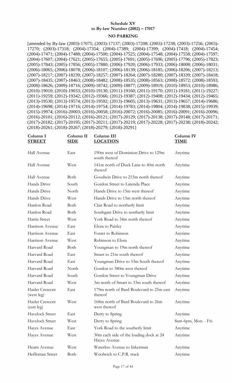
Schedule XV to By-law Number (2002) – 17017
NO PARKING
[amended by By-law (2003)-17075; (2003)-17137; (2003)-17208; (2003)-17238; (2003)-17256; (2003)-
17270; (2003)-17318; (2004)-17354; (2004)-17389; (2004)-17399; (2004)-17418; (2004)-17454;
(2004)-17471; (2004)-17488; (2004)-17500; (2004)-17525; (2004)-17548; (2004)-17558; (2004)-17597;
(2004)-17607; (2004)-17621; (2005)-17655; (2005)-17691; (2005)-17696; (2005)-17796; (2005)-17823;
(2005)-17843; (2005)-17856; (2005)-17880; (2006)-17920; (2006)-17933; (2006)-18008; (2006)-18031;
(2006)-18065; (2006)-18078; (2006)-18107; (2006)-18139; (2006)-18185; (2006)-18206; (2007)-18213;
(2007)-18217; (2007)-18239; (2007)-18257; (2007)-18264; (2007)-18280; (2007)-18339; (2007)-18418;
(2007)-18435; (2007)-18463; (2008)-18482; (2008)-18535; (2008)-18563; (2008)-18572; (2008)-18593;
(2008)-18626; (2009)-18716; (2009)-18742; (2009)-18877; (2009)-18919; (2010)-18953; (2010)-18986;
(2010)-19010; (2010)-19033; (2010)-19130; (2011)-19160; (2011)-19170; (2011)-19181; (2011)-19227;
(2011)-19259; (2012)-19342; (2012)-19366; (2012)-19387; (2012)-19408; (2012)-19434; (2012)-19465;
(2013)-19530; (2013)-19574; (2013)-19592; (2013)-19605; (2013)-19631; (2013)-19657; (2014)-19686;
(2014)-19698; (2014)-19716; (2014)-19754; (2014)-19783; (2014)-19804; (2014)-19838; (2015)-19939;
(2015)-19974; (2016)-20003; (2016)-20058; (2016)-20072; (2016)-20085; (2016)-20091; (2016)-20096;
(2016)-20101; (2016)-20112; (2016)-20121; (2017)-20129; (2017)-20138; (2017)-20148; (2017)-20171;
(2017)-20182; (2017)-20195; (2017)-20211; (2017)-20219; (2017)-20228; (2017)-20238; (2018)-20242;
(2018)-20261; (2018)-20267; (2018)-20279; (2018)-20291]
Page 17 of 44
Column I STREET
Column II SIDE
Column III LOCATION
Column IV TIME
Hall Avenue East 190m west of Dominion Drive to 129m south thereof
Anytime
Hall Avenue West 141m north of Duck Lane to 40m north thereof
Anytime
Hall Avenue Both Goodwin Drive to 215m north thereof Anytime
Hands Drive South Gordon Street to Latenda Place Anytime
Hands Drive North Hands Drive to 15m west thereof Anytime
Hands Drive West Hands Drive to 15m north thereof Anytime
Hanlon Road Both Clair Road to northerly limit Anytime
Hanlon Road Both Southgate Drive to northerly limit Anytime
Harris Street West York Road to 34m north thereof Anytime
Harrison Avenue East Elora to Paisley Anytime
Harrison Avenue East Foster to Robinson Anytime
Harrison Avenue West Robinson to Elora Anytime
Harvard Road Both Youngman to 19m north thereof Anytime
Harvard Road East Smart to 21m south thereof Anytime
Harvard Road East Youngman Drive to 53m South thereof Anytime
Harvard Road North Gordon to 380m west thereof Anytime
Harvard Road South Gordon Street to Youngman Drive Anytime
Harvard Road West 3m north of Smart to 33m south thereof Anytime
Hasler Crescent (west leg)
East 179m north of Bard Boulevard to 25m east thereof
Anytime
Hasler Crescent (east leg)
West 168m north of Bard Boulevard to 26m west thereof
Anytime
Havelock Street East Derry to Spring Anytime
Havelock Street West Derry to Spring 8am-6pm, Mon. - Fri.
Hayes Avenue East York Road to the southerly limit Anytime
Hayes Avenue West 30m each side of the loading dock at 24 Hayes Avenue
Anytime
Hearn Avenue West Waterloo Avenue to Inkerman Anytime
Heffernan Street Both Woolwich to C.P.R. track Anytime
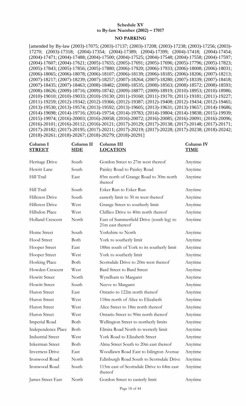
Schedule XV to By-law Number (2002) – 17017
NO PARKING
[amended by By-law (2003)-17075; (2003)-17137; (2003)-17208; (2003)-17238; (2003)-17256; (2003)-
17270; (2003)-17318; (2004)-17354; (2004)-17389; (2004)-17399; (2004)-17418; (2004)-17454;
(2004)-17471; (2004)-17488; (2004)-17500; (2004)-17525; (2004)-17548; (2004)-17558; (2004)-17597;
(2004)-17607; (2004)-17621; (2005)-17655; (2005)-17691; (2005)-17696; (2005)-17796; (2005)-17823;
(2005)-17843; (2005)-17856; (2005)-17880; (2006)-17920; (2006)-17933; (2006)-18008; (2006)-18031;
(2006)-18065; (2006)-18078; (2006)-18107; (2006)-18139; (2006)-18185; (2006)-18206; (2007)-18213;
(2007)-18217; (2007)-18239; (2007)-18257; (2007)-18264; (2007)-18280; (2007)-18339; (2007)-18418;
(2007)-18435; (2007)-18463; (2008)-18482; (2008)-18535; (2008)-18563; (2008)-18572; (2008)-18593;
(2008)-18626; (2009)-18716; (2009)-18742; (2009)-18877; (2009)-18919; (2010)-18953; (2010)-18986;
(2010)-19010; (2010)-19033; (2010)-19130; (2011)-19160; (2011)-19170; (2011)-19181; (2011)-19227;
(2011)-19259; (2012)-19342; (2012)-19366; (2012)-19387; (2012)-19408; (2012)-19434; (2012)-19465;
(2013)-19530; (2013)-19574; (2013)-19592; (2013)-19605; (2013)-19631; (2013)-19657; (2014)-19686;
(2014)-19698; (2014)-19716; (2014)-19754; (2014)-19783; (2014)-19804; (2014)-19838; (2015)-19939;
(2015)-19974; (2016)-20003; (2016)-20058; (2016)-20072; (2016)-20085; (2016)-20091; (2016)-20096;
(2016)-20101; (2016)-20112; (2016)-20121; (2017)-20129; (2017)-20138; (2017)-20148; (2017)-20171;
(2017)-20182; (2017)-20195; (2017)-20211; (2017)-20219; (2017)-20228; (2017)-20238; (2018)-20242;
(2018)-20261; (2018)-20267; (2018)-20279; (2018)-20291]
Page 18 of 44
Column I STREET
Column II SIDE
Column III LOCATION
Column IV TIME
Heritage Drive South Gordon Street to 27m west thereof Anytime
Hewitt Lane South Paisley Road to Paisley Road Anytime
Hill Trail East 85m north of Grange Road to 30m north thereof
Anytime
Hill Trail South Esker Run to Esker Run Anytime
Hillcrest Drive South easterly limit to 30 m west thereof Anytime
Hillcrest Drive West Grange Street to southerly limit Anytime
Hillsdon Place West Chillico Drive to 40m north thereof Anytime
Holland Crescent North East of Summerfield Drive (south leg) to 21m east thereof
Anytime
Home Street South Yorkshire to North Anytime
Hood Street Both York to southerly limit Anytime
Hooper Street East 188m south of York to its southerly limit Anytime
Hooper Street West York to southerly limit Anytime
Hosking Place Both Scottsdale Drive to 20m west thereof Anytime
Howden Crescent West Bard Street to Bard Street Anytime
Howitt Street North Wyndham to Margaret Anytime
Howitt Street South Neeve to Margaret Anytime
Huron Street East Ontario to 122m north thereof Anytime
Huron Street West 118m north of Alice to Elizabeth Anytime
Huron Street West Alice Street to 18m north thereof Anytime
Huron Street West Ontario Street to 90m north thereof Anytime
Imperial Road Both Wellington Street to northerly limits Anytime
Independence Place Both Elmira Road North to westerly limit Anytime
Industrial Street West York Road to Elizabeth Street Anytime
Inkerman Street Both Alma Street South to 20m east thereof Anytime
Inverness Drive East Woodlawn Road East to Islington Avenue Anytime
Ironwood Road North Edinburgh Road South to Scottsdale Drive Anytime
Ironwood Road South 115m east of Scottsdale Drive to 64m east thereof
Anytime
James Street East North Gordon Street to easterly limit Anytime
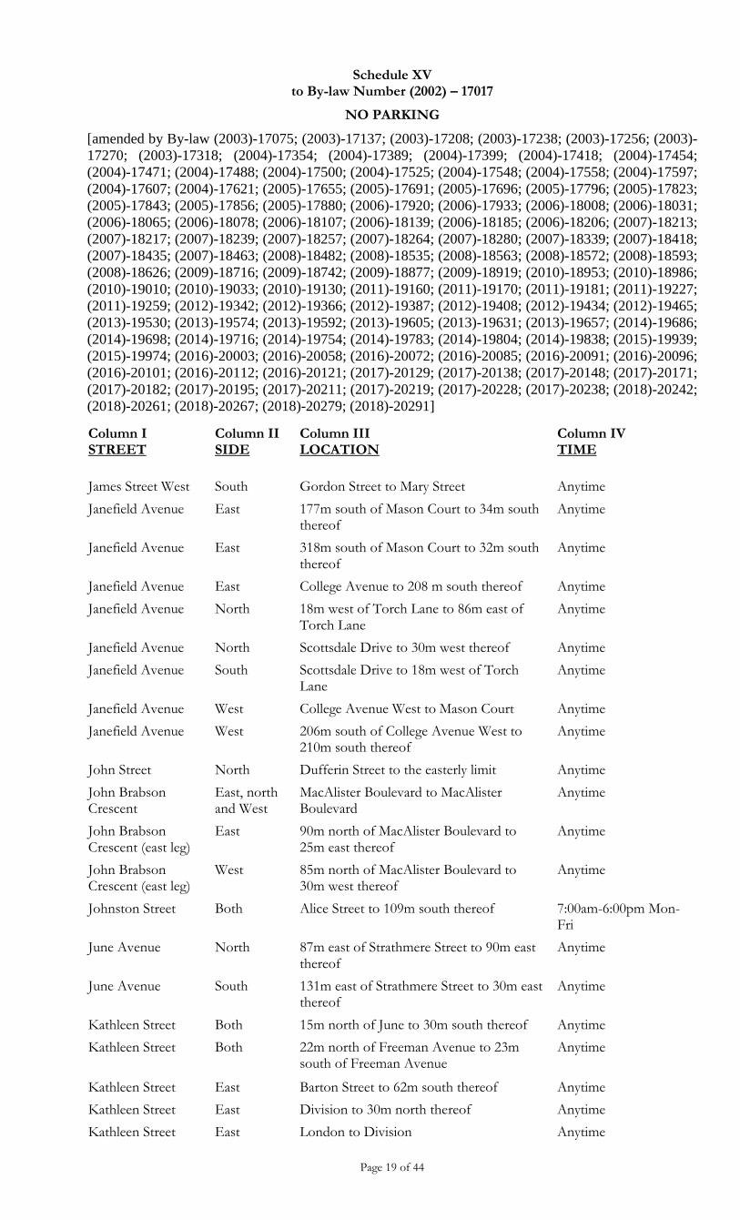
Schedule XV to By-law Number (2002) – 17017
NO PARKING
[amended by By-law (2003)-17075; (2003)-17137; (2003)-17208; (2003)-17238; (2003)-17256; (2003)-
17270; (2003)-17318; (2004)-17354; (2004)-17389; (2004)-17399; (2004)-17418; (2004)-17454;
(2004)-17471; (2004)-17488; (2004)-17500; (2004)-17525; (2004)-17548; (2004)-17558; (2004)-17597;
(2004)-17607; (2004)-17621; (2005)-17655; (2005)-17691; (2005)-17696; (2005)-17796; (2005)-17823;
(2005)-17843; (2005)-17856; (2005)-17880; (2006)-17920; (2006)-17933; (2006)-18008; (2006)-18031;
(2006)-18065; (2006)-18078; (2006)-18107; (2006)-18139; (2006)-18185; (2006)-18206; (2007)-18213;
(2007)-18217; (2007)-18239; (2007)-18257; (2007)-18264; (2007)-18280; (2007)-18339; (2007)-18418;
(2007)-18435; (2007)-18463; (2008)-18482; (2008)-18535; (2008)-18563; (2008)-18572; (2008)-18593;
(2008)-18626; (2009)-18716; (2009)-18742; (2009)-18877; (2009)-18919; (2010)-18953; (2010)-18986;
(2010)-19010; (2010)-19033; (2010)-19130; (2011)-19160; (2011)-19170; (2011)-19181; (2011)-19227;
(2011)-19259; (2012)-19342; (2012)-19366; (2012)-19387; (2012)-19408; (2012)-19434; (2012)-19465;
(2013)-19530; (2013)-19574; (2013)-19592; (2013)-19605; (2013)-19631; (2013)-19657; (2014)-19686;
(2014)-19698; (2014)-19716; (2014)-19754; (2014)-19783; (2014)-19804; (2014)-19838; (2015)-19939;
(2015)-19974; (2016)-20003; (2016)-20058; (2016)-20072; (2016)-20085; (2016)-20091; (2016)-20096;
(2016)-20101; (2016)-20112; (2016)-20121; (2017)-20129; (2017)-20138; (2017)-20148; (2017)-20171;
(2017)-20182; (2017)-20195; (2017)-20211; (2017)-20219; (2017)-20228; (2017)-20238; (2018)-20242;
(2018)-20261; (2018)-20267; (2018)-20279; (2018)-20291]
Page 19 of 44
Column I STREET
Column II SIDE
Column III LOCATION
Column IV TIME
James Street West South Gordon Street to Mary Street Anytime
Janefield Avenue East 177m south of Mason Court to 34m south thereof
Anytime
Janefield Avenue East 318m south of Mason Court to 32m south thereof
Anytime
Janefield Avenue East College Avenue to 208 m south thereof Anytime
Janefield Avenue North 18m west of Torch Lane to 86m east of Torch Lane
Anytime
Janefield Avenue North Scottsdale Drive to 30m west thereof Anytime
Janefield Avenue South Scottsdale Drive to 18m west of Torch Lane
Anytime
Janefield Avenue West College Avenue West to Mason Court Anytime
Janefield Avenue West 206m south of College Avenue West to 210m south thereof
Anytime
John Street North Dufferin Street to the easterly limit Anytime
John Brabson Crescent
East, north and West
MacAlister Boulevard to MacAlister Boulevard
Anytime
John Brabson Crescent (east leg)
East 90m north of MacAlister Boulevard to 25m east thereof
Anytime
John Brabson Crescent (east leg)
West 85m north of MacAlister Boulevard to 30m west thereof
Anytime
Johnston Street Both Alice Street to 109m south thereof 7:00am-6:00pm Mon-Fri
June Avenue North 87m east of Strathmere Street to 90m east thereof
Anytime
June Avenue South 131m east of Strathmere Street to 30m east thereof
Anytime
Kathleen Street Both 15m north of June to 30m south thereof Anytime
Kathleen Street Both 22m north of Freeman Avenue to 23m south of Freeman Avenue
Anytime
Kathleen Street East Barton Street to 62m south thereof Anytime
Kathleen Street East Division to 30m north thereof Anytime
Kathleen Street East London to Division Anytime
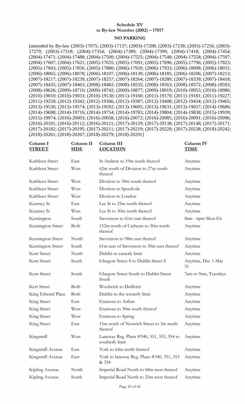
Schedule XV to By-law Number (2002) – 17017
NO PARKING
[amended by By-law (2003)-17075; (2003)-17137; (2003)-17208; (2003)-17238; (2003)-17256; (2003)-
17270; (2003)-17318; (2004)-17354; (2004)-17389; (2004)-17399; (2004)-17418; (2004)-17454;
(2004)-17471; (2004)-17488; (2004)-17500; (2004)-17525; (2004)-17548; (2004)-17558; (2004)-17597;
(2004)-17607; (2004)-17621; (2005)-17655; (2005)-17691; (2005)-17696; (2005)-17796; (2005)-17823;
(2005)-17843; (2005)-17856; (2005)-17880; (2006)-17920; (2006)-17933; (2006)-18008; (2006)-18031;
(2006)-18065; (2006)-18078; (2006)-18107; (2006)-18139; (2006)-18185; (2006)-18206; (2007)-18213;
(2007)-18217; (2007)-18239; (2007)-18257; (2007)-18264; (2007)-18280; (2007)-18339; (2007)-18418;
(2007)-18435; (2007)-18463; (2008)-18482; (2008)-18535; (2008)-18563; (2008)-18572; (2008)-18593;
(2008)-18626; (2009)-18716; (2009)-18742; (2009)-18877; (2009)-18919; (2010)-18953; (2010)-18986;
(2010)-19010; (2010)-19033; (2010)-19130; (2011)-19160; (2011)-19170; (2011)-19181; (2011)-19227;
(2011)-19259; (2012)-19342; (2012)-19366; (2012)-19387; (2012)-19408; (2012)-19434; (2012)-19465;
(2013)-19530; (2013)-19574; (2013)-19592; (2013)-19605; (2013)-19631; (2013)-19657; (2014)-19686;
(2014)-19698; (2014)-19716; (2014)-19754; (2014)-19783; (2014)-19804; (2014)-19838; (2015)-19939;
(2015)-19974; (2016)-20003; (2016)-20058; (2016)-20072; (2016)-20085; (2016)-20091; (2016)-20096;
(2016)-20101; (2016)-20112; (2016)-20121; (2017)-20129; (2017)-20138; (2017)-20148; (2017)-20171;
(2017)-20182; (2017)-20195; (2017)-20211; (2017)-20219; (2017)-20228; (2017)-20238; (2018)-20242;
(2018)-20261; (2018)-20267; (2018)-20279; (2018)-20291]
Page 20 of 44
Column I STREET
Column II SIDE
Column III LOCATION
Column IV TIME
Kathleen Street East St Andrew to 19m south thereof Anytime
Kathleen Street West 62m south of Division to 27m south thereof
Anytime
Kathleen Street West Division to 30m south thereof Anytime
Kathleen Street West Division to Speedvale Anytime
Kathleen Street West Division to London Anytime
Kearney St East Lee St to 25m north thereof Anytime
Kearney St West Lee St to 30m north thereof Anytime
Kensington South Stevenson to 61m east thereof 8am - 6pm Mon-Fri
Kensington Street Both 152m north of Cathcart to 30m north thereof
Anytime
Kensington Street North Stevenson to 98m east thereof Anytime
Kensington Street South 61m east of Stevenson to 30m east thereof Anytime
Kent Street North Dublin to easterly limit Anytime
Kent Street South Glasgow Street S to Dublin Street S Anytime, Dec 1-Mar 31
Kent Street South Glasgow Street South to Dublin Street South
7am to 9am, Tuesdays
Kerr Street Both Woolwich to Dufferin Anytime
King Edward Place Both Dublin to the westerly limit Anytime
King Street East Eramosa to Arthur Anytime
King Street West Eramosa to 30m south thereof Anytime
King Street West Eramosa to Spring Anytime
King Street East 15m north of Norwich Street to 3m north thereof
Anytime
Kingsmill West Laneway Reg. Plans #340, 351, 353, 354 to southerly limit
Anytime
Kingsmill Avenue East York to 64m north thereof Anytime
Kingsmill Avenue East York to laneway Reg. Plans #340, 351, 353 & 354
Anytime
Kipling Avenue North Imperial Road North to 68m west thereof Anytime
Kipling Avenue South Imperial Road North to 25m west thereof Anytime
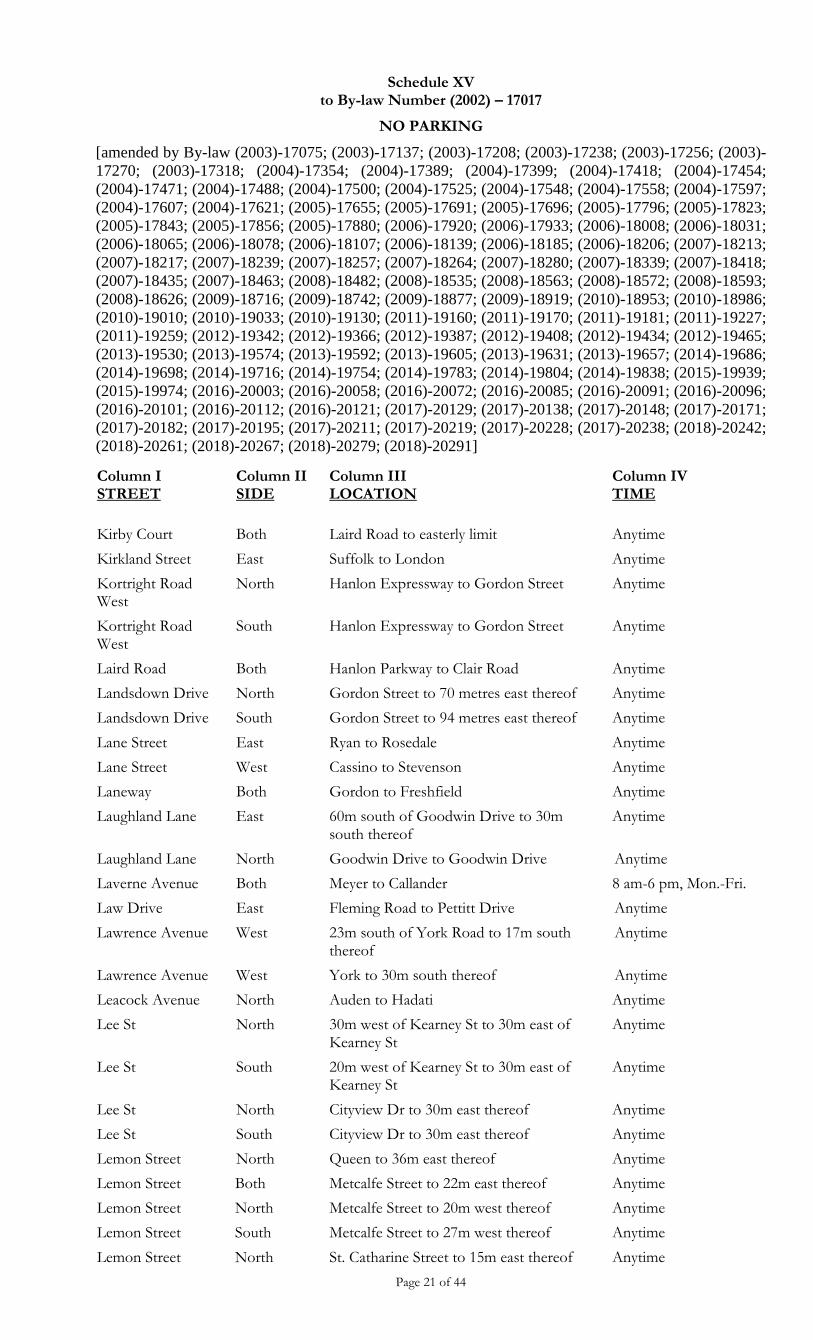
Schedule XV to By-law Number (2002) – 17017
NO PARKING
[amended by By-law (2003)-17075; (2003)-17137; (2003)-17208; (2003)-17238; (2003)-17256; (2003)-
17270; (2003)-17318; (2004)-17354; (2004)-17389; (2004)-17399; (2004)-17418; (2004)-17454;
(2004)-17471; (2004)-17488; (2004)-17500; (2004)-17525; (2004)-17548; (2004)-17558; (2004)-17597;
(2004)-17607; (2004)-17621; (2005)-17655; (2005)-17691; (2005)-17696; (2005)-17796; (2005)-17823;
(2005)-17843; (2005)-17856; (2005)-17880; (2006)-17920; (2006)-17933; (2006)-18008; (2006)-18031;
(2006)-18065; (2006)-18078; (2006)-18107; (2006)-18139; (2006)-18185; (2006)-18206; (2007)-18213;
(2007)-18217; (2007)-18239; (2007)-18257; (2007)-18264; (2007)-18280; (2007)-18339; (2007)-18418;
(2007)-18435; (2007)-18463; (2008)-18482; (2008)-18535; (2008)-18563; (2008)-18572; (2008)-18593;
(2008)-18626; (2009)-18716; (2009)-18742; (2009)-18877; (2009)-18919; (2010)-18953; (2010)-18986;
(2010)-19010; (2010)-19033; (2010)-19130; (2011)-19160; (2011)-19170; (2011)-19181; (2011)-19227;
(2011)-19259; (2012)-19342; (2012)-19366; (2012)-19387; (2012)-19408; (2012)-19434; (2012)-19465;
(2013)-19530; (2013)-19574; (2013)-19592; (2013)-19605; (2013)-19631; (2013)-19657; (2014)-19686;
(2014)-19698; (2014)-19716; (2014)-19754; (2014)-19783; (2014)-19804; (2014)-19838; (2015)-19939;
(2015)-19974; (2016)-20003; (2016)-20058; (2016)-20072; (2016)-20085; (2016)-20091; (2016)-20096;
(2016)-20101; (2016)-20112; (2016)-20121; (2017)-20129; (2017)-20138; (2017)-20148; (2017)-20171;
(2017)-20182; (2017)-20195; (2017)-20211; (2017)-20219; (2017)-20228; (2017)-20238; (2018)-20242;
(2018)-20261; (2018)-20267; (2018)-20279; (2018)-20291]
Page 21 of 44
Column I STREET
Column II SIDE
Column III LOCATION
Column IV TIME
Kirby Court Both Laird Road to easterly limit Anytime
Kirkland Street East Suffolk to London Anytime
Kortright Road West
North Hanlon Expressway to Gordon Street Anytime
Kortright Road West
South Hanlon Expressway to Gordon Street Anytime
Laird Road Both Hanlon Parkway to Clair Road Anytime
Landsdown Drive North Gordon Street to 70 metres east thereof Anytime
Landsdown Drive South Gordon Street to 94 metres east thereof Anytime
Lane Street East Ryan to Rosedale Anytime
Lane Street West Cassino to Stevenson Anytime
Laneway Both Gordon to Freshfield Anytime
Laughland Lane East 60m south of Goodwin Drive to 30m south thereof
Anytime
Laughland Lane North Goodwin Drive to Goodwin Drive Anytime
Laverne Avenue Both Meyer to Callander 8 am-6 pm, Mon.-Fri.
Law Drive East Fleming Road to Pettitt Drive Anytime
Lawrence Avenue West 23m south of York Road to 17m south thereof
Anytime
Lawrence Avenue West York to 30m south thereof Anytime
Leacock Avenue North Auden to Hadati Anytime
Lee St North 30m west of Kearney St to 30m east of Kearney St
Anytime
Lee St South 20m west of Kearney St to 30m east of Kearney St
Anytime
Lee St North Cityview Dr to 30m east thereof Anytime
Lee St South Cityview Dr to 30m east thereof Anytime
Lemon Street North Queen to 36m east thereof Anytime
Lemon Street Both Metcalfe Street to 22m east thereof Anytime
Lemon Street North Metcalfe Street to 20m west thereof Anytime
Lemon Street South Metcalfe Street to 27m west thereof Anytime
Lemon Street North St. Catharine Street to 15m east thereof Anytime
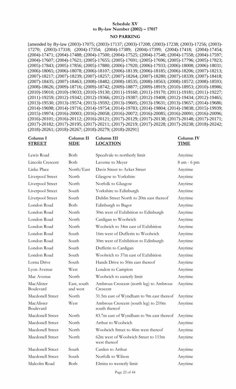
Schedule XV to By-law Number (2002) – 17017
NO PARKING
[amended by By-law (2003)-17075; (2003)-17137; (2003)-17208; (2003)-17238; (2003)-17256; (2003)-
17270; (2003)-17318; (2004)-17354; (2004)-17389; (2004)-17399; (2004)-17418; (2004)-17454;
(2004)-17471; (2004)-17488; (2004)-17500; (2004)-17525; (2004)-17548; (2004)-17558; (2004)-17597;
(2004)-17607; (2004)-17621; (2005)-17655; (2005)-17691; (2005)-17696; (2005)-17796; (2005)-17823;
(2005)-17843; (2005)-17856; (2005)-17880; (2006)-17920; (2006)-17933; (2006)-18008; (2006)-18031;
(2006)-18065; (2006)-18078; (2006)-18107; (2006)-18139; (2006)-18185; (2006)-18206; (2007)-18213;
(2007)-18217; (2007)-18239; (2007)-18257; (2007)-18264; (2007)-18280; (2007)-18339; (2007)-18418;
(2007)-18435; (2007)-18463; (2008)-18482; (2008)-18535; (2008)-18563; (2008)-18572; (2008)-18593;
(2008)-18626; (2009)-18716; (2009)-18742; (2009)-18877; (2009)-18919; (2010)-18953; (2010)-18986;
(2010)-19010; (2010)-19033; (2010)-19130; (2011)-19160; (2011)-19170; (2011)-19181; (2011)-19227;
(2011)-19259; (2012)-19342; (2012)-19366; (2012)-19387; (2012)-19408; (2012)-19434; (2012)-19465;
(2013)-19530; (2013)-19574; (2013)-19592; (2013)-19605; (2013)-19631; (2013)-19657; (2014)-19686;
(2014)-19698; (2014)-19716; (2014)-19754; (2014)-19783; (2014)-19804; (2014)-19838; (2015)-19939;
(2015)-19974; (2016)-20003; (2016)-20058; (2016)-20072; (2016)-20085; (2016)-20091; (2016)-20096;
(2016)-20101; (2016)-20112; (2016)-20121; (2017)-20129; (2017)-20138; (2017)-20148; (2017)-20171;
(2017)-20182; (2017)-20195; (2017)-20211; (2017)-20219; (2017)-20228; (2017)-20238; (2018)-20242;
(2018)-20261; (2018)-20267; (2018)-20279; (2018)-20291]
Page 22 of 44
Column I STREET
Column II SIDE
Column III LOCATION
Column IV TIME
Lewis Road Both Speedvale to northerly limit Anytime
Lincoln Crescent Both Laverne to Meyer 8 am - 6 pm
Linke Place North/East Davis Street to Acker Street Anytime
Liverpool Street North Glasgow to Yorkshire Anytime
Liverpool Street North Norfolk to Glasgow Anytime
Liverpool Street South Yorkshire to Edinburgh Anytime
Liverpool Street South Dublin Street North to 20m east thereof Anytime
London Road Both Edinburgh to Bagot Anytime
London Road North 30m west of Exhibition to Edinburgh Anytime
London Road North Cardigan to Woolwich Anytime
London Road North Woolwich to 34m east of Exhibition Anytime
London Road South 16m west of Dufferin to Woolwich Anytime
London Road South 30m west of Exhibition to Edinburgh Anytime
London Road South Dufferin to Cardigan Anytime
London Road South Woolwich to 37m east of Exhibition Anytime
Lorna Drive South Hands Drive to 50m east thereof Anytime
Lyon Avenue West London to Campion Anytime
Mac Avenue North Woolwich to easterly limit Anytime
MacAlister Boulevard
East, south and west
Ambrous Crescent (north leg) to Ambrous Crescent
Anytime
Macdonell Street North 31.5m east of Wyndham to 9m east thereof Anytime
MacAlister Boulevard
West Ambrous Crescent (south leg) to 210m south thereof
Anytime
Macdonell Street North 83.7m east of Wyndham to 9m east thereof Anytime
Macdonell Street North Arthur to Woolwich Anytime
Macdonell Street North Woolwich Street to 46m west thereof Anytime
Macdonell Street North 62m west of Woolwich Street to 115m west thereof
Anytime
Macdonell Street South Carden to Arthur Anytime
Macdonell Street South Norfolk to Wilson Anytime
Malcolm Road Both Elmira to westerly limit Anytime
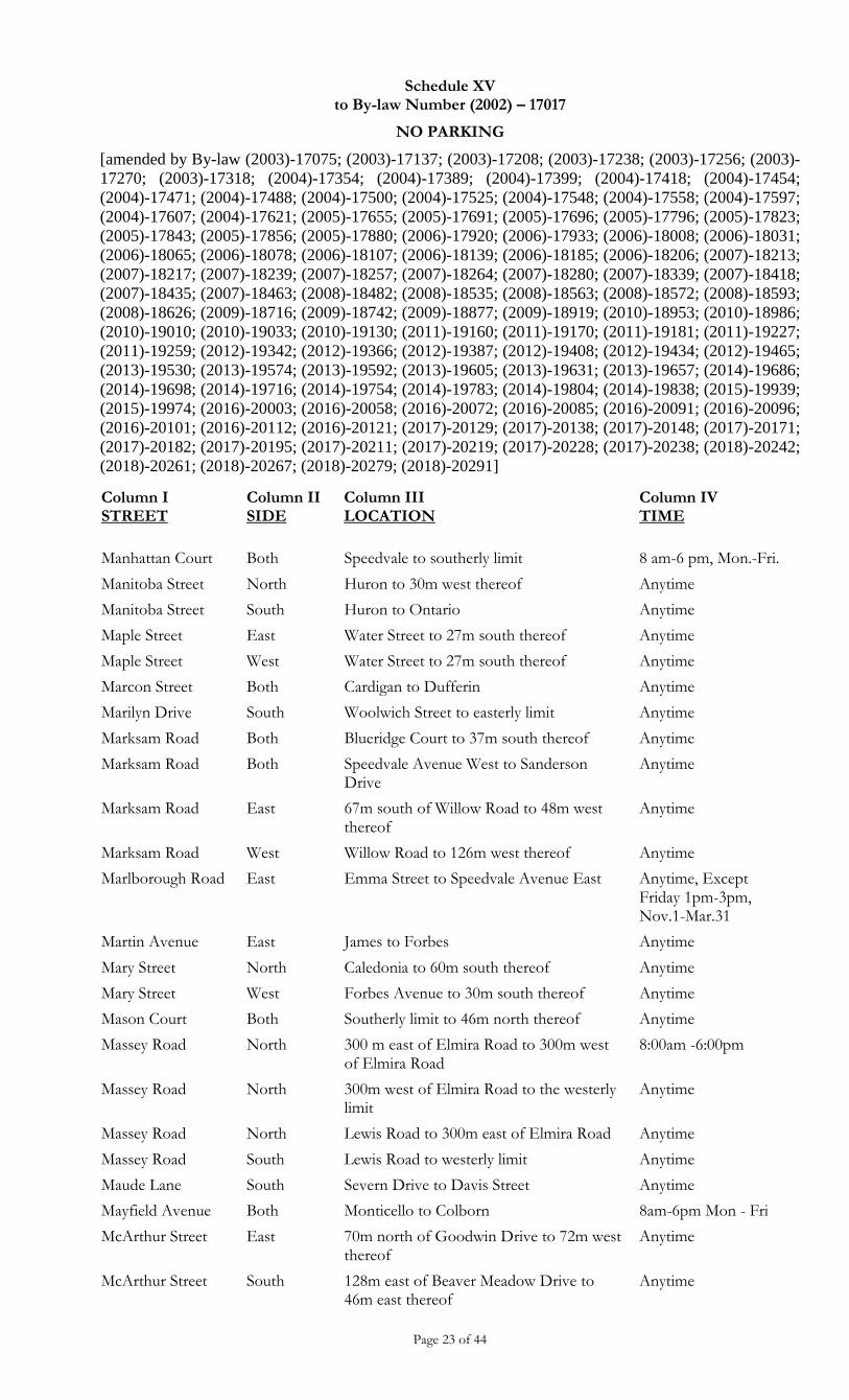
Schedule XV to By-law Number (2002) – 17017
NO PARKING
[amended by By-law (2003)-17075; (2003)-17137; (2003)-17208; (2003)-17238; (2003)-17256; (2003)-
17270; (2003)-17318; (2004)-17354; (2004)-17389; (2004)-17399; (2004)-17418; (2004)-17454;
(2004)-17471; (2004)-17488; (2004)-17500; (2004)-17525; (2004)-17548; (2004)-17558; (2004)-17597;
(2004)-17607; (2004)-17621; (2005)-17655; (2005)-17691; (2005)-17696; (2005)-17796; (2005)-17823;
(2005)-17843; (2005)-17856; (2005)-17880; (2006)-17920; (2006)-17933; (2006)-18008; (2006)-18031;
(2006)-18065; (2006)-18078; (2006)-18107; (2006)-18139; (2006)-18185; (2006)-18206; (2007)-18213;
(2007)-18217; (2007)-18239; (2007)-18257; (2007)-18264; (2007)-18280; (2007)-18339; (2007)-18418;
(2007)-18435; (2007)-18463; (2008)-18482; (2008)-18535; (2008)-18563; (2008)-18572; (2008)-18593;
(2008)-18626; (2009)-18716; (2009)-18742; (2009)-18877; (2009)-18919; (2010)-18953; (2010)-18986;
(2010)-19010; (2010)-19033; (2010)-19130; (2011)-19160; (2011)-19170; (2011)-19181; (2011)-19227;
(2011)-19259; (2012)-19342; (2012)-19366; (2012)-19387; (2012)-19408; (2012)-19434; (2012)-19465;
(2013)-19530; (2013)-19574; (2013)-19592; (2013)-19605; (2013)-19631; (2013)-19657; (2014)-19686;
(2014)-19698; (2014)-19716; (2014)-19754; (2014)-19783; (2014)-19804; (2014)-19838; (2015)-19939;
(2015)-19974; (2016)-20003; (2016)-20058; (2016)-20072; (2016)-20085; (2016)-20091; (2016)-20096;
(2016)-20101; (2016)-20112; (2016)-20121; (2017)-20129; (2017)-20138; (2017)-20148; (2017)-20171;
(2017)-20182; (2017)-20195; (2017)-20211; (2017)-20219; (2017)-20228; (2017)-20238; (2018)-20242;
(2018)-20261; (2018)-20267; (2018)-20279; (2018)-20291]
Page 23 of 44
Column I STREET
Column II SIDE
Column III LOCATION
Column IV TIME
Manhattan Court Both Speedvale to southerly limit 8 am-6 pm, Mon.-Fri.
Manitoba Street North Huron to 30m west thereof Anytime
Manitoba Street South Huron to Ontario Anytime
Maple Street East Water Street to 27m south thereof Anytime
Maple Street West Water Street to 27m south thereof Anytime
Marcon Street Both Cardigan to Dufferin Anytime
Marilyn Drive South Woolwich Street to easterly limit Anytime
Marksam Road Both Blueridge Court to 37m south thereof Anytime
Marksam Road Both Speedvale Avenue West to Sanderson Drive
Anytime
Marksam Road East 67m south of Willow Road to 48m west thereof
Anytime
Marksam Road West Willow Road to 126m west thereof Anytime
Marlborough Road East Emma Street to Speedvale Avenue East Anytime, Except Friday 1pm-3pm, Nov.1-Mar.31
Martin Avenue East James to Forbes Anytime
Mary Street North Caledonia to 60m south thereof Anytime
Mary Street West Forbes Avenue to 30m south thereof Anytime
Mason Court Both Southerly limit to 46m north thereof Anytime
Massey Road North 300 m east of Elmira Road to 300m west of Elmira Road
8:00am -6:00pm
Massey Road North 300m west of Elmira Road to the westerly limit
Anytime
Massey Road North Lewis Road to 300m east of Elmira Road Anytime
Massey Road South Lewis Road to westerly limit Anytime
Maude Lane South Severn Drive to Davis Street Anytime
Mayfield Avenue Both Monticello to Colborn 8am-6pm Mon - Fri
McArthur Street East 70m north of Goodwin Drive to 72m west thereof
Anytime
McArthur Street South 128m east of Beaver Meadow Drive to 46m east thereof
Anytime
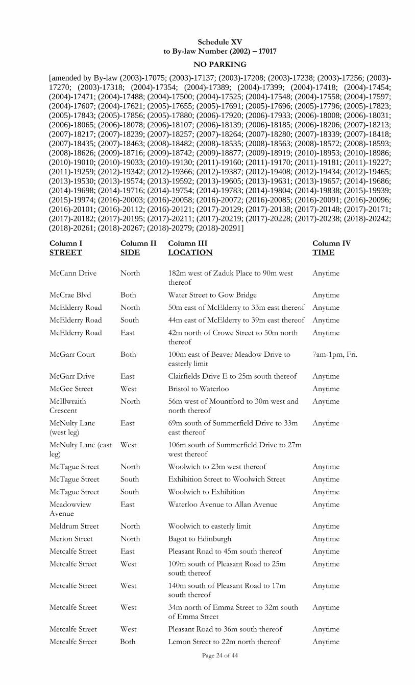
Schedule XV to By-law Number (2002) – 17017
NO PARKING
[amended by By-law (2003)-17075; (2003)-17137; (2003)-17208; (2003)-17238; (2003)-17256; (2003)-
17270; (2003)-17318; (2004)-17354; (2004)-17389; (2004)-17399; (2004)-17418; (2004)-17454;
(2004)-17471; (2004)-17488; (2004)-17500; (2004)-17525; (2004)-17548; (2004)-17558; (2004)-17597;
(2004)-17607; (2004)-17621; (2005)-17655; (2005)-17691; (2005)-17696; (2005)-17796; (2005)-17823;
(2005)-17843; (2005)-17856; (2005)-17880; (2006)-17920; (2006)-17933; (2006)-18008; (2006)-18031;
(2006)-18065; (2006)-18078; (2006)-18107; (2006)-18139; (2006)-18185; (2006)-18206; (2007)-18213;
(2007)-18217; (2007)-18239; (2007)-18257; (2007)-18264; (2007)-18280; (2007)-18339; (2007)-18418;
(2007)-18435; (2007)-18463; (2008)-18482; (2008)-18535; (2008)-18563; (2008)-18572; (2008)-18593;
(2008)-18626; (2009)-18716; (2009)-18742; (2009)-18877; (2009)-18919; (2010)-18953; (2010)-18986;
(2010)-19010; (2010)-19033; (2010)-19130; (2011)-19160; (2011)-19170; (2011)-19181; (2011)-19227;
(2011)-19259; (2012)-19342; (2012)-19366; (2012)-19387; (2012)-19408; (2012)-19434; (2012)-19465;
(2013)-19530; (2013)-19574; (2013)-19592; (2013)-19605; (2013)-19631; (2013)-19657; (2014)-19686;
(2014)-19698; (2014)-19716; (2014)-19754; (2014)-19783; (2014)-19804; (2014)-19838; (2015)-19939;
(2015)-19974; (2016)-20003; (2016)-20058; (2016)-20072; (2016)-20085; (2016)-20091; (2016)-20096;
(2016)-20101; (2016)-20112; (2016)-20121; (2017)-20129; (2017)-20138; (2017)-20148; (2017)-20171;
(2017)-20182; (2017)-20195; (2017)-20211; (2017)-20219; (2017)-20228; (2017)-20238; (2018)-20242;
(2018)-20261; (2018)-20267; (2018)-20279; (2018)-20291]
Page 24 of 44
Column I STREET
Column II SIDE
Column III LOCATION
Column IV TIME
McCann Drive North 182m west of Zaduk Place to 90m west thereof
Anytime
McCrae Blvd Both Water Street to Gow Bridge Anytime
McElderry Road North 50m east of McElderry to 33m east thereof Anytime
McElderry Road South 44m east of McElderry to 39m east thereof Anytime
McElderry Road East 42m north of Crowe Street to 50m north thereof
Anytime
McGarr Court Both 100m east of Beaver Meadow Drive to easterly limit
7am-1pm, Fri.
McGarr Drive East Clairfields Drive E to 25m south thereof Anytime
McGee Street West Bristol to Waterloo Anytime
McIllwraith Crescent
North 56m west of Mountford to 30m west and north thereof
Anytime
McNulty Lane (west leg)
East 69m south of Summerfield Drive to 33m east thereof
Anytime
McNulty Lane (east leg)
West 106m south of Summerfield Drive to 27m west thereof
McTague Street North Woolwich to 23m west thereof Anytime
McTague Street South Exhibition Street to Woolwich Street Anytime
McTague Street South Woolwich to Exhibition Anytime
Meadowview Avenue
East Waterloo Avenue to Allan Avenue Anytime
Meldrum Street North Woolwich to easterly limit Anytime
Merion Street North Bagot to Edinburgh Anytime
Metcalfe Street East Pleasant Road to 45m south thereof Anytime
Metcalfe Street West 109m south of Pleasant Road to 25m south thereof
Anytime
Metcalfe Street West 140m south of Pleasant Road to 17m south thereof
Anytime
Metcalfe Street West 34m north of Emma Street to 32m south of Emma Street
Anytime
Metcalfe Street West Pleasant Road to 36m south thereof Anytime
Metcalfe Street Both Lemon Street to 22m north thereof Anytime
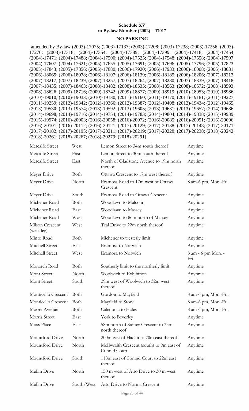
Schedule XV to By-law Number (2002) – 17017
NO PARKING
[amended by By-law (2003)-17075; (2003)-17137; (2003)-17208; (2003)-17238; (2003)-17256; (2003)-
17270; (2003)-17318; (2004)-17354; (2004)-17389; (2004)-17399; (2004)-17418; (2004)-17454;
(2004)-17471; (2004)-17488; (2004)-17500; (2004)-17525; (2004)-17548; (2004)-17558; (2004)-17597;
(2004)-17607; (2004)-17621; (2005)-17655; (2005)-17691; (2005)-17696; (2005)-17796; (2005)-17823;
(2005)-17843; (2005)-17856; (2005)-17880; (2006)-17920; (2006)-17933; (2006)-18008; (2006)-18031;
(2006)-18065; (2006)-18078; (2006)-18107; (2006)-18139; (2006)-18185; (2006)-18206; (2007)-18213;
(2007)-18217; (2007)-18239; (2007)-18257; (2007)-18264; (2007)-18280; (2007)-18339; (2007)-18418;
(2007)-18435; (2007)-18463; (2008)-18482; (2008)-18535; (2008)-18563; (2008)-18572; (2008)-18593;
(2008)-18626; (2009)-18716; (2009)-18742; (2009)-18877; (2009)-18919; (2010)-18953; (2010)-18986;
(2010)-19010; (2010)-19033; (2010)-19130; (2011)-19160; (2011)-19170; (2011)-19181; (2011)-19227;
(2011)-19259; (2012)-19342; (2012)-19366; (2012)-19387; (2012)-19408; (2012)-19434; (2012)-19465;
(2013)-19530; (2013)-19574; (2013)-19592; (2013)-19605; (2013)-19631; (2013)-19657; (2014)-19686;
(2014)-19698; (2014)-19716; (2014)-19754; (2014)-19783; (2014)-19804; (2014)-19838; (2015)-19939;
(2015)-19974; (2016)-20003; (2016)-20058; (2016)-20072; (2016)-20085; (2016)-20091; (2016)-20096;
(2016)-20101; (2016)-20112; (2016)-20121; (2017)-20129; (2017)-20138; (2017)-20148; (2017)-20171;
(2017)-20182; (2017)-20195; (2017)-20211; (2017)-20219; (2017)-20228; (2017)-20238; (2018)-20242;
(2018)-20261; (2018)-20267; (2018)-20279; (2018)-20291]
Page 25 of 44
Metcalfe Street West Lemon Street to 34m south thereof Anytime
Metcalfe Street East Lemon Street to 30m south thereof Anytime
Metcalfe Street East North of Gladstone Avenue to 19m north thereof
Anytime
Meyer Drive Both Ottawa Crescent to 17m west thereof Anytime
Meyer Drive North Eramosa Road to 17m west of Ottawa Crescent
8 am-6 pm, Mon.-Fri.
Meyer Drive South Eramosa Road to Ottawa Crescent Anytime
Michener Road Both Woodlawn to Malcolm Anytime
Michener Road East Woodlawn to Massey Anytime
Michener Road West Woodlawn to 86m north of Massey Anytime
Milson Crescent (west leg)
West Teal Drive to 22m north thereof Anytime
Minto Road Both Michener to westerly limit Anytime
Mitchell Street East Eramosa to Norwich Anytime
Mitchell Street West Eramosa to Norwich 8 am - 6 pm Mon. - Fri
Monarch Road Both Southerly limit to the northerly limit Anytime
Mont Street North Woolwich to Exhibition Anytime
Mont Street South 29m west of Woolwich to 32m west thereof
Anytime
Monticello Crescent Both Gordon to Mayfield 8 am-6 pm, Mon.-Fri.
Monticello Crescent Both Mayfield to Stone 8 am-6 pm, Mon.-Fri.
Moore Avenue Both Caledonia to Hales 8 am-6 pm, Mon.-Fri.
Morris Street East York to Beverley Anytime
Moss Place East 58m north of Sidney Crescent to 35m north thereof
Anytime
Mountford Drive North 200m east of Hadati to 70m east thereof Anytime
Mountford Drive North McIlwraith Crescent (south) to 9m east of Conrad Court
Anytime
Mountford Drive South 118m east of Conrad Court to 22m east thereof
Anytime
Mullin Drive North 150 m west of Atto Drive to 30 m west thereof
Anytime
Mullin Drive South/West Atto Drive to Norma Crescent Anytime
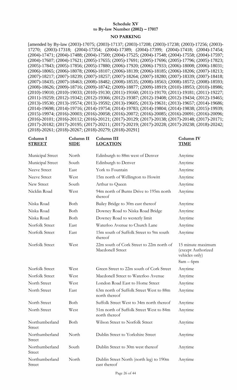
Schedule XV to By-law Number (2002) – 17017
NO PARKING
[amended by By-law (2003)-17075; (2003)-17137; (2003)-17208; (2003)-17238; (2003)-17256; (2003)-
17270; (2003)-17318; (2004)-17354; (2004)-17389; (2004)-17399; (2004)-17418; (2004)-17454;
(2004)-17471; (2004)-17488; (2004)-17500; (2004)-17525; (2004)-17548; (2004)-17558; (2004)-17597;
(2004)-17607; (2004)-17621; (2005)-17655; (2005)-17691; (2005)-17696; (2005)-17796; (2005)-17823;
(2005)-17843; (2005)-17856; (2005)-17880; (2006)-17920; (2006)-17933; (2006)-18008; (2006)-18031;
(2006)-18065; (2006)-18078; (2006)-18107; (2006)-18139; (2006)-18185; (2006)-18206; (2007)-18213;
(2007)-18217; (2007)-18239; (2007)-18257; (2007)-18264; (2007)-18280; (2007)-18339; (2007)-18418;
(2007)-18435; (2007)-18463; (2008)-18482; (2008)-18535; (2008)-18563; (2008)-18572; (2008)-18593;
(2008)-18626; (2009)-18716; (2009)-18742; (2009)-18877; (2009)-18919; (2010)-18953; (2010)-18986;
(2010)-19010; (2010)-19033; (2010)-19130; (2011)-19160; (2011)-19170; (2011)-19181; (2011)-19227;
(2011)-19259; (2012)-19342; (2012)-19366; (2012)-19387; (2012)-19408; (2012)-19434; (2012)-19465;
(2013)-19530; (2013)-19574; (2013)-19592; (2013)-19605; (2013)-19631; (2013)-19657; (2014)-19686;
(2014)-19698; (2014)-19716; (2014)-19754; (2014)-19783; (2014)-19804; (2014)-19838; (2015)-19939;
(2015)-19974; (2016)-20003; (2016)-20058; (2016)-20072; (2016)-20085; (2016)-20091; (2016)-20096;
(2016)-20101; (2016)-20112; (2016)-20121; (2017)-20129; (2017)-20138; (2017)-20148; (2017)-20171;
(2017)-20182; (2017)-20195; (2017)-20211; (2017)-20219; (2017)-20228; (2017)-20238; (2018)-20242;
(2018)-20261; (2018)-20267; (2018)-20279; (2018)-20291]
Page 26 of 44
Column I STREET
Column II SIDE
Column III LOCATION
Column IV TIME
Municipal Street North Edinburgh to 88m west of Denver Anytime
Municipal Street South Edinburgh to Denver Anytime
Neeve Street East York to Fountain Anytime
Neeve Street West 15m north of Wellington to Howitt Anytime
New Street South Arthur to Queen Anytime
Nicklin Road West 94m north of Burns Drive to 195m north thereof
Anytime
Niska Road Both Bailey Bridge to 30m east thereof Anytime
Niska Road Both Downey Road to Niska Road Bridge Anytime
Niska Road Both Downey Road to westerly limit Anytime
Norfolk Street East Waterloo Avenue to Church Lane Anytime
Norfolk Street East 15m south of Suffolk Street to 9m south thereof
Anytime
Norfolk Street West 22m south of Cork Street to 22m north of Macdonell Street
15 minute maximum (except Authorized vehicles only)
8am – 6pm
Norfolk Street West Green Street to 22m south of Cork Street Anytime
Norfolk Street West Macdonell Street to Waterloo Avenue Anytime
North Street West London Road East to Home Street Anytime
North Street East 63m north of Suffolk Street West to 88m north thereof
Anytime
North Street Both Suffolk Street West to 34m north thereof Anytime
North Street West 51m north of Suffolk Street West to 84m north thereof
Anytime
Northumberland Street
Both Wilson Street to Norfolk Street Anytime
Northumberland Street
North Dublin Street to Yorkshire Street Anytime
Northumberland Street
South Dublin Street to 30m west thereof Anytime
Northumberland Street
North Dublin Street North (north leg) to 190m east thereof
Anytime
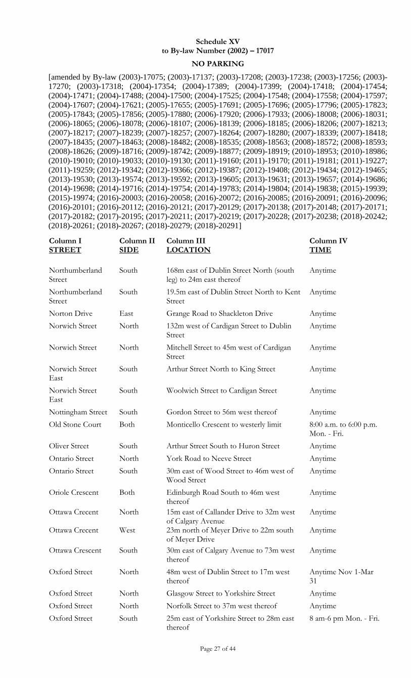
Schedule XV to By-law Number (2002) – 17017
NO PARKING
[amended by By-law (2003)-17075; (2003)-17137; (2003)-17208; (2003)-17238; (2003)-17256; (2003)-
17270; (2003)-17318; (2004)-17354; (2004)-17389; (2004)-17399; (2004)-17418; (2004)-17454;
(2004)-17471; (2004)-17488; (2004)-17500; (2004)-17525; (2004)-17548; (2004)-17558; (2004)-17597;
(2004)-17607; (2004)-17621; (2005)-17655; (2005)-17691; (2005)-17696; (2005)-17796; (2005)-17823;
(2005)-17843; (2005)-17856; (2005)-17880; (2006)-17920; (2006)-17933; (2006)-18008; (2006)-18031;
(2006)-18065; (2006)-18078; (2006)-18107; (2006)-18139; (2006)-18185; (2006)-18206; (2007)-18213;
(2007)-18217; (2007)-18239; (2007)-18257; (2007)-18264; (2007)-18280; (2007)-18339; (2007)-18418;
(2007)-18435; (2007)-18463; (2008)-18482; (2008)-18535; (2008)-18563; (2008)-18572; (2008)-18593;
(2008)-18626; (2009)-18716; (2009)-18742; (2009)-18877; (2009)-18919; (2010)-18953; (2010)-18986;
(2010)-19010; (2010)-19033; (2010)-19130; (2011)-19160; (2011)-19170; (2011)-19181; (2011)-19227;
(2011)-19259; (2012)-19342; (2012)-19366; (2012)-19387; (2012)-19408; (2012)-19434; (2012)-19465;
(2013)-19530; (2013)-19574; (2013)-19592; (2013)-19605; (2013)-19631; (2013)-19657; (2014)-19686;
(2014)-19698; (2014)-19716; (2014)-19754; (2014)-19783; (2014)-19804; (2014)-19838; (2015)-19939;
(2015)-19974; (2016)-20003; (2016)-20058; (2016)-20072; (2016)-20085; (2016)-20091; (2016)-20096;
(2016)-20101; (2016)-20112; (2016)-20121; (2017)-20129; (2017)-20138; (2017)-20148; (2017)-20171;
(2017)-20182; (2017)-20195; (2017)-20211; (2017)-20219; (2017)-20228; (2017)-20238; (2018)-20242;
(2018)-20261; (2018)-20267; (2018)-20279; (2018)-20291]
Page 27 of 44
Column I STREET
Column II SIDE
Column III LOCATION
Column IV TIME
Northumberland Street
South 168m east of Dublin Street North (south leg) to 24m east thereof
Anytime
Northumberland Street
South 19.5m east of Dublin Street North to Kent Street
Anytime
Norton Drive East Grange Road to Shackleton Drive Anytime
Norwich Street North 132m west of Cardigan Street to Dublin Street
Anytime
Norwich Street North Mitchell Street to 45m west of Cardigan Street
Anytime
Norwich Street East
South Arthur Street North to King Street Anytime
Norwich Street East
South Woolwich Street to Cardigan Street Anytime
Nottingham Street South Gordon Street to 56m west thereof Anytime
Old Stone Court Both Monticello Crescent to westerly limit 8:00 a.m. to 6:00 p.m. Mon. - Fri.
Oliver Street South Arthur Street South to Huron Street Anytime
Ontario Street North York Road to Neeve Street Anytime
Ontario Street South 30m east of Wood Street to 46m west of Wood Street
Anytime
Oriole Crescent Both Edinburgh Road South to 46m west thereof
Anytime
Ottawa Crecent North 15m east of Callander Drive to 32m west of Calgary Avenue
Anytime
Ottawa Crecent West 23m north of Meyer Drive to 22m south of Meyer Drive
Anytime
Ottawa Crescent South 30m east of Calgary Avenue to 73m west thereof
Anytime
Oxford Street North 48m west of Dublin Street to 17m west thereof
Anytime Nov 1-Mar 31
Oxford Street North Glasgow Street to Yorkshire Street Anytime
Oxford Street North Norfolk Street to 37m west thereof Anytime
Oxford Street South 25m east of Yorkshire Street to 28m east thereof
8 am-6 pm Mon. - Fri.
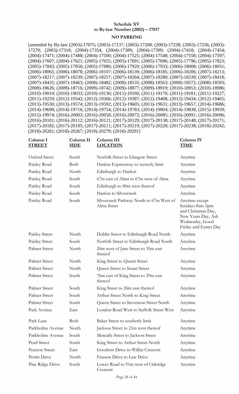
Schedule XV to By-law Number (2002) – 17017
NO PARKING
[amended by By-law (2003)-17075; (2003)-17137; (2003)-17208; (2003)-17238; (2003)-17256; (2003)-
17270; (2003)-17318; (2004)-17354; (2004)-17389; (2004)-17399; (2004)-17418; (2004)-17454;
(2004)-17471; (2004)-17488; (2004)-17500; (2004)-17525; (2004)-17548; (2004)-17558; (2004)-17597;
(2004)-17607; (2004)-17621; (2005)-17655; (2005)-17691; (2005)-17696; (2005)-17796; (2005)-17823;
(2005)-17843; (2005)-17856; (2005)-17880; (2006)-17920; (2006)-17933; (2006)-18008; (2006)-18031;
(2006)-18065; (2006)-18078; (2006)-18107; (2006)-18139; (2006)-18185; (2006)-18206; (2007)-18213;
(2007)-18217; (2007)-18239; (2007)-18257; (2007)-18264; (2007)-18280; (2007)-18339; (2007)-18418;
(2007)-18435; (2007)-18463; (2008)-18482; (2008)-18535; (2008)-18563; (2008)-18572; (2008)-18593;
(2008)-18626; (2009)-18716; (2009)-18742; (2009)-18877; (2009)-18919; (2010)-18953; (2010)-18986;
(2010)-19010; (2010)-19033; (2010)-19130; (2011)-19160; (2011)-19170; (2011)-19181; (2011)-19227;
(2011)-19259; (2012)-19342; (2012)-19366; (2012)-19387; (2012)-19408; (2012)-19434; (2012)-19465;
(2013)-19530; (2013)-19574; (2013)-19592; (2013)-19605; (2013)-19631; (2013)-19657; (2014)-19686;
(2014)-19698; (2014)-19716; (2014)-19754; (2014)-19783; (2014)-19804; (2014)-19838; (2015)-19939;
(2015)-19974; (2016)-20003; (2016)-20058; (2016)-20072; (2016)-20085; (2016)-20091; (2016)-20096;
(2016)-20101; (2016)-20112; (2016)-20121; (2017)-20129; (2017)-20138; (2017)-20148; (2017)-20171;
(2017)-20182; (2017)-20195; (2017)-20211; (2017)-20219; (2017)-20228; (2017)-20238; (2018)-20242;
(2018)-20261; (2018)-20267; (2018)-20279; (2018)-20291]
Page 28 of 44
Column I STREET
Column II SIDE
Column III LOCATION
Column IV TIME
Oxford Street South Norfolk Street to Glasgow Street Anytime
Paisley Road Both Hanlon Expressway to westerly limit Anytime
Paisley Road North Edinburgh to Hanlon Anytime
Paisley Road South 67m east of Alma to 67m west of Alma Anytime
Paisley Road South Edinburgh to 80m west thereof Anytime
Paisley Road South Hanlon to Silvercreek Anytime
Paisley Road South Silvercreek Parkway North to 67m West of Alma Street
Anytime except Sundays 8am-2pm and Christmas Day, New Years Day, Ash Wednesday, Good Friday and Easter Day
Paisley Street North Dublin Street to Edinburgh Road North Anytime
Paisley Street South Norfolk Street to Edinburgh Road North Anytime
Palmer Street North 20m west of Jane Street to 35m east thereof
Anytime
Palmer Street North King Street to Queen Street Anytime
Palmer Street North Queen Street to Stuart Street Anytime
Palmer Street South 76m east of King Street to 29m east thereof
Anytime
Palmer Street South King Street to 26m east thereof Anytime
Palmer Street South Arthur Street North to King Street Anytime
Palmer Street South Queen Street to Stevenson Street North Anytime
Park Avenue East London Road West to Suffolk Street West Anytime
Park Lane Both Baker Street to southerly limit Anytime
Parkholme Avenue North Jackson Street to 21m west thereof Anytime
Parkholme Avenue South Metcalfe Street to Jackson Street Anytime
Pearl Street South King Street to Arthur Street North Anytime
Pearson Street East Goodwin Drive to Wilkie Crescent Anytime
Pettitt Drive North Frasson Drive to Law Drive Anytime
Pine Ridge Drive South Lowes Road to 91m west of Oakridge Crescent
Anytime
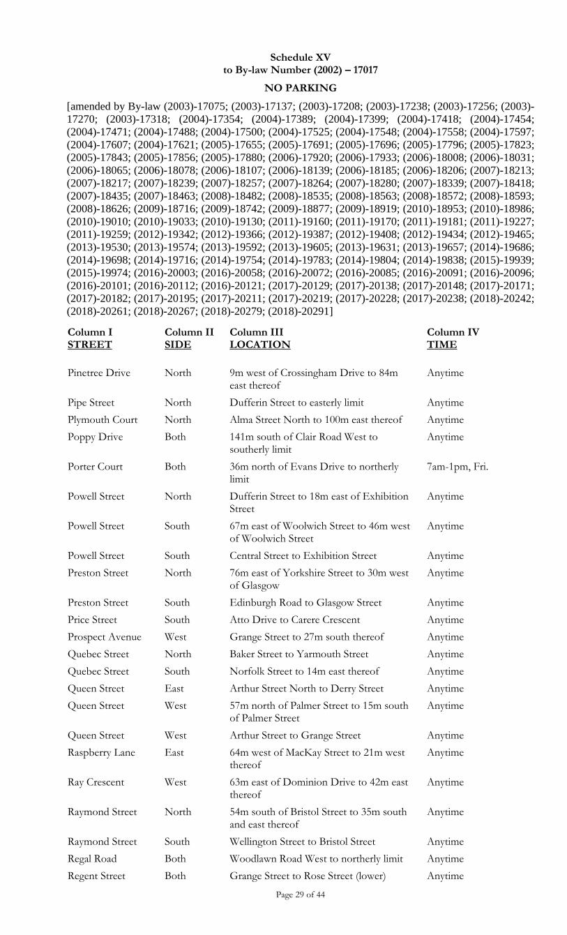
Schedule XV to By-law Number (2002) – 17017
NO PARKING
[amended by By-law (2003)-17075; (2003)-17137; (2003)-17208; (2003)-17238; (2003)-17256; (2003)-
17270; (2003)-17318; (2004)-17354; (2004)-17389; (2004)-17399; (2004)-17418; (2004)-17454;
(2004)-17471; (2004)-17488; (2004)-17500; (2004)-17525; (2004)-17548; (2004)-17558; (2004)-17597;
(2004)-17607; (2004)-17621; (2005)-17655; (2005)-17691; (2005)-17696; (2005)-17796; (2005)-17823;
(2005)-17843; (2005)-17856; (2005)-17880; (2006)-17920; (2006)-17933; (2006)-18008; (2006)-18031;
(2006)-18065; (2006)-18078; (2006)-18107; (2006)-18139; (2006)-18185; (2006)-18206; (2007)-18213;
(2007)-18217; (2007)-18239; (2007)-18257; (2007)-18264; (2007)-18280; (2007)-18339; (2007)-18418;
(2007)-18435; (2007)-18463; (2008)-18482; (2008)-18535; (2008)-18563; (2008)-18572; (2008)-18593;
(2008)-18626; (2009)-18716; (2009)-18742; (2009)-18877; (2009)-18919; (2010)-18953; (2010)-18986;
(2010)-19010; (2010)-19033; (2010)-19130; (2011)-19160; (2011)-19170; (2011)-19181; (2011)-19227;
(2011)-19259; (2012)-19342; (2012)-19366; (2012)-19387; (2012)-19408; (2012)-19434; (2012)-19465;
(2013)-19530; (2013)-19574; (2013)-19592; (2013)-19605; (2013)-19631; (2013)-19657; (2014)-19686;
(2014)-19698; (2014)-19716; (2014)-19754; (2014)-19783; (2014)-19804; (2014)-19838; (2015)-19939;
(2015)-19974; (2016)-20003; (2016)-20058; (2016)-20072; (2016)-20085; (2016)-20091; (2016)-20096;
(2016)-20101; (2016)-20112; (2016)-20121; (2017)-20129; (2017)-20138; (2017)-20148; (2017)-20171;
(2017)-20182; (2017)-20195; (2017)-20211; (2017)-20219; (2017)-20228; (2017)-20238; (2018)-20242;
(2018)-20261; (2018)-20267; (2018)-20279; (2018)-20291]
Page 29 of 44
Column I STREET
Column II SIDE
Column III LOCATION
Column IV TIME
Pinetree Drive North 9m west of Crossingham Drive to 84m east thereof
Anytime
Pipe Street North Dufferin Street to easterly limit Anytime
Plymouth Court North Alma Street North to 100m east thereof Anytime
Poppy Drive Both 141m south of Clair Road West to southerly limit
Anytime
Porter Court Both 36m north of Evans Drive to northerly limit
7am-1pm, Fri.
Powell Street North Dufferin Street to 18m east of Exhibition Street
Anytime
Powell Street South 67m east of Woolwich Street to 46m west of Woolwich Street
Anytime
Powell Street South Central Street to Exhibition Street Anytime
Preston Street North 76m east of Yorkshire Street to 30m west of Glasgow
Anytime
Preston Street South Edinburgh Road to Glasgow Street Anytime
Price Street South Atto Drive to Carere Crescent Anytime
Prospect Avenue West Grange Street to 27m south thereof Anytime
Quebec Street North Baker Street to Yarmouth Street Anytime
Quebec Street South Norfolk Street to 14m east thereof Anytime
Queen Street East Arthur Street North to Derry Street Anytime
Queen Street West 57m north of Palmer Street to 15m south of Palmer Street
Anytime
Queen Street West Arthur Street to Grange Street Anytime
Raspberry Lane East 64m west of MacKay Street to 21m west thereof
Anytime
Ray Crescent West 63m east of Dominion Drive to 42m east thereof
Anytime
Raymond Street North 54m south of Bristol Street to 35m south and east thereof
Anytime
Raymond Street South Wellington Street to Bristol Street Anytime
Regal Road Both Woodlawn Road West to northerly limit Anytime
Regent Street Both Grange Street to Rose Street (lower) Anytime
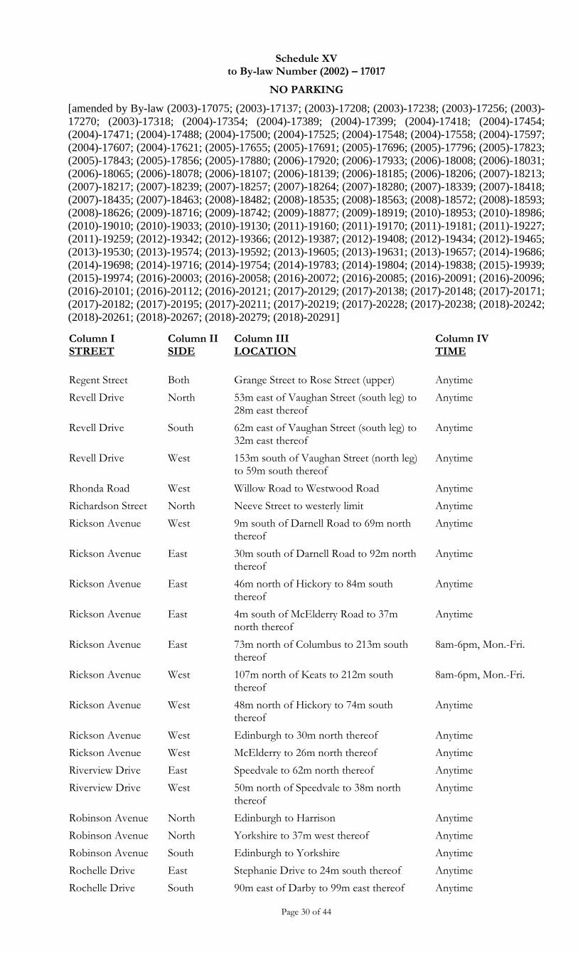
Schedule XV to By-law Number (2002) – 17017
NO PARKING
[amended by By-law (2003)-17075; (2003)-17137; (2003)-17208; (2003)-17238; (2003)-17256; (2003)-
17270; (2003)-17318; (2004)-17354; (2004)-17389; (2004)-17399; (2004)-17418; (2004)-17454;
(2004)-17471; (2004)-17488; (2004)-17500; (2004)-17525; (2004)-17548; (2004)-17558; (2004)-17597;
(2004)-17607; (2004)-17621; (2005)-17655; (2005)-17691; (2005)-17696; (2005)-17796; (2005)-17823;
(2005)-17843; (2005)-17856; (2005)-17880; (2006)-17920; (2006)-17933; (2006)-18008; (2006)-18031;
(2006)-18065; (2006)-18078; (2006)-18107; (2006)-18139; (2006)-18185; (2006)-18206; (2007)-18213;
(2007)-18217; (2007)-18239; (2007)-18257; (2007)-18264; (2007)-18280; (2007)-18339; (2007)-18418;
(2007)-18435; (2007)-18463; (2008)-18482; (2008)-18535; (2008)-18563; (2008)-18572; (2008)-18593;
(2008)-18626; (2009)-18716; (2009)-18742; (2009)-18877; (2009)-18919; (2010)-18953; (2010)-18986;
(2010)-19010; (2010)-19033; (2010)-19130; (2011)-19160; (2011)-19170; (2011)-19181; (2011)-19227;
(2011)-19259; (2012)-19342; (2012)-19366; (2012)-19387; (2012)-19408; (2012)-19434; (2012)-19465;
(2013)-19530; (2013)-19574; (2013)-19592; (2013)-19605; (2013)-19631; (2013)-19657; (2014)-19686;
(2014)-19698; (2014)-19716; (2014)-19754; (2014)-19783; (2014)-19804; (2014)-19838; (2015)-19939;
(2015)-19974; (2016)-20003; (2016)-20058; (2016)-20072; (2016)-20085; (2016)-20091; (2016)-20096;
(2016)-20101; (2016)-20112; (2016)-20121; (2017)-20129; (2017)-20138; (2017)-20148; (2017)-20171;
(2017)-20182; (2017)-20195; (2017)-20211; (2017)-20219; (2017)-20228; (2017)-20238; (2018)-20242;
(2018)-20261; (2018)-20267; (2018)-20279; (2018)-20291]
Page 30 of 44
Column I STREET
Column II SIDE
Column III LOCATION
Column IV TIME
Regent Street Both Grange Street to Rose Street (upper) Anytime
Revell Drive North 53m east of Vaughan Street (south leg) to 28m east thereof
Anytime
Revell Drive South 62m east of Vaughan Street (south leg) to 32m east thereof
Anytime
Revell Drive West 153m south of Vaughan Street (north leg) to 59m south thereof
Anytime
Rhonda Road West Willow Road to Westwood Road Anytime
Richardson Street North Neeve Street to westerly limit Anytime
Rickson Avenue West 9m south of Darnell Road to 69m north thereof
Anytime
Rickson Avenue East 30m south of Darnell Road to 92m north thereof
Anytime
Rickson Avenue East 46m north of Hickory to 84m south thereof
Anytime
Rickson Avenue East 4m south of McElderry Road to 37m north thereof
Anytime
Rickson Avenue East 73m north of Columbus to 213m south thereof
8am-6pm, Mon.-Fri.
Rickson Avenue West 107m north of Keats to 212m south thereof
8am-6pm, Mon.-Fri.
Rickson Avenue West 48m north of Hickory to 74m south thereof
Anytime
Rickson Avenue West Edinburgh to 30m north thereof Anytime
Rickson Avenue West McElderry to 26m north thereof Anytime
Riverview Drive East Speedvale to 62m north thereof Anytime
Riverview Drive West 50m north of Speedvale to 38m north thereof
Anytime
Robinson Avenue North Edinburgh to Harrison Anytime
Robinson Avenue North Yorkshire to 37m west thereof Anytime
Robinson Avenue South Edinburgh to Yorkshire Anytime
Rochelle Drive East Stephanie Drive to 24m south thereof Anytime
Rochelle Drive South 90m east of Darby to 99m east thereof Anytime
Schedule XV to By-law Number (2002) – 17017
NO PARKING
[amended by By-law (2003)-17075; (2003)-17137; (2003)-17208; (2003)-17238; (2003)-17256; (2003)-
17270; (2003)-17318; (2004)-17354; (2004)-17389; (2004)-17399; (2004)-17418; (2004)-17454;
(2004)-17471; (2004)-17488; (2004)-17500; (2004)-17525; (2004)-17548; (2004)-17558; (2004)-17597;
(2004)-17607; (2004)-17621; (2005)-17655; (2005)-17691; (2005)-17696; (2005)-17796; (2005)-17823;
(2005)-17843; (2005)-17856; (2005)-17880; (2006)-17920; (2006)-17933; (2006)-18008; (2006)-18031;
(2006)-18065; (2006)-18078; (2006)-18107; (2006)-18139; (2006)-18185; (2006)-18206; (2007)-18213;
(2007)-18217; (2007)-18239; (2007)-18257; (2007)-18264; (2007)-18280; (2007)-18339; (2007)-18418;
(2007)-18435; (2007)-18463; (2008)-18482; (2008)-18535; (2008)-18563; (2008)-18572; (2008)-18593;
(2008)-18626; (2009)-18716; (2009)-18742; (2009)-18877; (2009)-18919; (2010)-18953; (2010)-18986;
(2010)-19010; (2010)-19033; (2010)-19130; (2011)-19160; (2011)-19170; (2011)-19181; (2011)-19227;
(2011)-19259; (2012)-19342; (2012)-19366; (2012)-19387; (2012)-19408; (2012)-19434; (2012)-19465;
(2013)-19530; (2013)-19574; (2013)-19592; (2013)-19605; (2013)-19631; (2013)-19657; (2014)-19686;
(2014)-19698; (2014)-19716; (2014)-19754; (2014)-19783; (2014)-19804; (2014)-19838; (2015)-19939;
(2015)-19974; (2016)-20003; (2016)-20058; (2016)-20072; (2016)-20085; (2016)-20091; (2016)-20096;
(2016)-20101; (2016)-20112; (2016)-20121; (2017)-20129; (2017)-20138; (2017)-20148; (2017)-20171;
(2017)-20182; (2017)-20195; (2017)-20211; (2017)-20219; (2017)-20228; (2017)-20238; (2018)-20242;
(2018)-20261; (2018)-20267; (2018)-20279; (2018)-20291]
Page 31 of 44
Column I STREET
Column II SIDE
Column III LOCATION
Column IV TIME
Rodgers Road North Edinburgh to 53m east thereof Anytime
Rodgers Road South Edinburgh to 30m east thereof Anytime
Rodgers Road (south)
Both Edinburgh to 15m west thereof Anytime
Roland Street East Bristol Street to Waterloo Avenue Anytime
Rose Street Both Arthur to Regent Anytime
Rosewood Avenue East Paisley to 29m north thereof Anytime
Royal Road Both Speedvale Avenue to Woodlawn Road Anytime
Rutherford Court Both Southgate Drive to Easterly limit Anytime
Ryde Road West 63m south of Paisley Road to 33m south thereof
Anytime
Ryde Road East 59m north of Imperial Road South to 33m east thereof
Anytime
Sackville Street West Alice to northerly limit Anytime
Samantha Court Both Imperial to Imperial Anytime
Schiedel Drive West Bowen Drive to Norma Crescent Anytime
Schroder Crescent North 58m east of Thornton Street to 32m east thereof
Anytime
Schroder Crescent North 64m west of Thornton Street to 36m west thereof
Anytime
Schroder Crescent (west leg)
East Grange Road to 140m south thereof Anytime
Schroder Crescent (west leg)
West 51m south of Grange Road to 48m south thereof
Anytime
Schroder Crescent (west leg)
West 114m south of Grange Road to 15m south thereof
Anytime
Scottsdale Drive East 168m south of Wilsonview to 28m south thereof
Anytime
Scottsdale Drive East 224m east of Janefield to 103m east thereof
Anytime
Scottsdale Drive East 30m north of Kortright to Ironwood 8 am-6 pm, Mon.-Fri.
Scottsdale Drive East 70m north of Wilsonview to 61m north thereof
Anytime
Schedule XV to By-law Number (2002) – 17017
NO PARKING
[amended by By-law (2003)-17075; (2003)-17137; (2003)-17208; (2003)-17238; (2003)-17256; (2003)-
17270; (2003)-17318; (2004)-17354; (2004)-17389; (2004)-17399; (2004)-17418; (2004)-17454;
(2004)-17471; (2004)-17488; (2004)-17500; (2004)-17525; (2004)-17548; (2004)-17558; (2004)-17597;
(2004)-17607; (2004)-17621; (2005)-17655; (2005)-17691; (2005)-17696; (2005)-17796; (2005)-17823;
(2005)-17843; (2005)-17856; (2005)-17880; (2006)-17920; (2006)-17933; (2006)-18008; (2006)-18031;
(2006)-18065; (2006)-18078; (2006)-18107; (2006)-18139; (2006)-18185; (2006)-18206; (2007)-18213;
(2007)-18217; (2007)-18239; (2007)-18257; (2007)-18264; (2007)-18280; (2007)-18339; (2007)-18418;
(2007)-18435; (2007)-18463; (2008)-18482; (2008)-18535; (2008)-18563; (2008)-18572; (2008)-18593;
(2008)-18626; (2009)-18716; (2009)-18742; (2009)-18877; (2009)-18919; (2010)-18953; (2010)-18986;
(2010)-19010; (2010)-19033; (2010)-19130; (2011)-19160; (2011)-19170; (2011)-19181; (2011)-19227;
(2011)-19259; (2012)-19342; (2012)-19366; (2012)-19387; (2012)-19408; (2012)-19434; (2012)-19465;
(2013)-19530; (2013)-19574; (2013)-19592; (2013)-19605; (2013)-19631; (2013)-19657; (2014)-19686;
(2014)-19698; (2014)-19716; (2014)-19754; (2014)-19783; (2014)-19804; (2014)-19838; (2015)-19939;
(2015)-19974; (2016)-20003; (2016)-20058; (2016)-20072; (2016)-20085; (2016)-20091; (2016)-20096;
(2016)-20101; (2016)-20112; (2016)-20121; (2017)-20129; (2017)-20138; (2017)-20148; (2017)-20171;
(2017)-20182; (2017)-20195; (2017)-20211; (2017)-20219; (2017)-20228; (2017)-20238; (2018)-20242;
(2018)-20261; (2018)-20267; (2018)-20279; (2018)-20291]
Page 32 of 44
Column I STREET
Column II SIDE
Column III LOCATION
Column IV TIME
Scottsdale Drive East Kortright to 30m north thereof Anytime
Scottsdale Drive East Stone Road to 153m east of Janefield Avenue
Anytime
Scottsdale Drive West 60m north of Wilsonview to 69m north thereof
Anytime
Scottsdale Drive West College to 255m south thereof Anytime
Scottsdale Drive West Wilsonview to 268 m south thereof Anytime
Scottsdale Drive Both Kortright to 30m north of Janefield Anytime
Shelldale Crescent South Dawson to 46m east of the westerly limit Anytime
Short Street East 27m south of Ontario to 23m south thereof
Anytime
Sidney Crescent West 65m south of Moss Place to 28m south thereof
Anytime
Silurian Drive West Chesterton Lane to Grange Road Anytime
Silurian Drive East/North Grange Road to Starwood Drive Anytime
Silvercreek Parkway Both 621m north of Eden Street to northern city limit
Anytime
Silvercreek Parkway Both Waterloo Avenue to 621m North of Eden Street
Anytime except Sundays 8am-2pm
Simmonds Drive South 66m west of Ingram Drive to 33m west thereof
Anytime
Simmonds Drive North 58m west of Ingram Drive to 35m west thereof
Anytime
Simpson Way Both Gordon to the southerly limit Anytime
Southampton Street East Sydenham to Paisley Anytime
Southcreek Trail Both Edinburgh Road South to 23m west thereof (north leg)
Anytime
Southcreek Trail Both Edinburgh Road South to 24m west thereof (south leg)
Anytime
Southcreek Trail North 230m west of Edinburgh Road South (south intersection) to 45m west thereof
Anytime
Southcreek Trail South 178m west of Edinburgh Road South (north intersection) to 50m west thereof
Anytime
Schedule XV to By-law Number (2002) – 17017
NO PARKING
[amended by By-law (2003)-17075; (2003)-17137; (2003)-17208; (2003)-17238; (2003)-17256; (2003)-
17270; (2003)-17318; (2004)-17354; (2004)-17389; (2004)-17399; (2004)-17418; (2004)-17454;
(2004)-17471; (2004)-17488; (2004)-17500; (2004)-17525; (2004)-17548; (2004)-17558; (2004)-17597;
(2004)-17607; (2004)-17621; (2005)-17655; (2005)-17691; (2005)-17696; (2005)-17796; (2005)-17823;
(2005)-17843; (2005)-17856; (2005)-17880; (2006)-17920; (2006)-17933; (2006)-18008; (2006)-18031;
(2006)-18065; (2006)-18078; (2006)-18107; (2006)-18139; (2006)-18185; (2006)-18206; (2007)-18213;
(2007)-18217; (2007)-18239; (2007)-18257; (2007)-18264; (2007)-18280; (2007)-18339; (2007)-18418;
(2007)-18435; (2007)-18463; (2008)-18482; (2008)-18535; (2008)-18563; (2008)-18572; (2008)-18593;
(2008)-18626; (2009)-18716; (2009)-18742; (2009)-18877; (2009)-18919; (2010)-18953; (2010)-18986;
(2010)-19010; (2010)-19033; (2010)-19130; (2011)-19160; (2011)-19170; (2011)-19181; (2011)-19227;
(2011)-19259; (2012)-19342; (2012)-19366; (2012)-19387; (2012)-19408; (2012)-19434; (2012)-19465;
(2013)-19530; (2013)-19574; (2013)-19592; (2013)-19605; (2013)-19631; (2013)-19657; (2014)-19686;
(2014)-19698; (2014)-19716; (2014)-19754; (2014)-19783; (2014)-19804; (2014)-19838; (2015)-19939;
(2015)-19974; (2016)-20003; (2016)-20058; (2016)-20072; (2016)-20085; (2016)-20091; (2016)-20096;
(2016)-20101; (2016)-20112; (2016)-20121; (2017)-20129; (2017)-20138; (2017)-20148; (2017)-20171;
(2017)-20182; (2017)-20195; (2017)-20211; (2017)-20219; (2017)-20228; (2017)-20238; (2018)-20242;
(2018)-20261; (2018)-20267; (2018)-20279; (2018)-20291]
Page 33 of 44
Column I STREET
Column II SIDE
Column III LOCATION
Column IV TIME
Southgate Drive Both Laird Road to Laird Road Anytime
Speedvale Avenue Both Silvercreek to 650m east of Eramosa Anytime
Speedvale Avenue Both Westerly City limits to Hanlon Anytime
Spring Street South Delhi to King Anytime
Spring Street North King Street to 18m east thereof Anytime
St Arnaud Street West Chadwick to Waterloo Anytime
St. Catherine Street West Eramosa to Lemon Anytime
St. Catherine Street East Lemon Street to 21m north thereof Anytime
Stanley Street North Exhibition to Kathleen Anytime
Stanley Street South Kathleen Street to 17.5m east thereof Anytime
Stephanie Drive East 39m north of Freshmeadow Way to 48m south thereof
Anytime
Stephanie Drive North 116m west of Imperial Road South to 53m west of Rochelle Drive
Anytime
Stephanie Drive South 38m west of Rochelle Drive to 65m east thereof
Anytime
Stephanie Drive West 17m north of Freshmeadow Way to 41m south thereof
Anytime
Stephanie Drive West 20m north of Freshmeadow Way to 37m south thereof
Anytime
Stephen Drive North 134m west of Marksam Road to Grandridge Crescent
Anytime
Stephen Drive South 47m west of Marksam Road to 80m west thereof
Anytime
Stevenson Street Both Eramosa Road to Elizabeth Street Anytime
Stevenson Street North
Stevenson Street North
Both
East
Emma Street to Eramosa Road
Emma Street to 53m south of Balsam Drive
Anytime
Anytime
Stevenson Street North
East 24m north of Cathcart Street to Speedvale Avenue East
8 am - 6 pm
Stevenson Street North
East 50m south of Speedvale Avenue East to Emma Street
8 am - 6 pm
Schedule XV to By-law Number (2002) – 17017
NO PARKING
[amended by By-law (2003)-17075; (2003)-17137; (2003)-17208; (2003)-17238; (2003)-17256; (2003)-
17270; (2003)-17318; (2004)-17354; (2004)-17389; (2004)-17399; (2004)-17418; (2004)-17454;
(2004)-17471; (2004)-17488; (2004)-17500; (2004)-17525; (2004)-17548; (2004)-17558; (2004)-17597;
(2004)-17607; (2004)-17621; (2005)-17655; (2005)-17691; (2005)-17696; (2005)-17796; (2005)-17823;
(2005)-17843; (2005)-17856; (2005)-17880; (2006)-17920; (2006)-17933; (2006)-18008; (2006)-18031;
(2006)-18065; (2006)-18078; (2006)-18107; (2006)-18139; (2006)-18185; (2006)-18206; (2007)-18213;
(2007)-18217; (2007)-18239; (2007)-18257; (2007)-18264; (2007)-18280; (2007)-18339; (2007)-18418;
(2007)-18435; (2007)-18463; (2008)-18482; (2008)-18535; (2008)-18563; (2008)-18572; (2008)-18593;
(2008)-18626; (2009)-18716; (2009)-18742; (2009)-18877; (2009)-18919; (2010)-18953; (2010)-18986;
(2010)-19010; (2010)-19033; (2010)-19130; (2011)-19160; (2011)-19170; (2011)-19181; (2011)-19227;
(2011)-19259; (2012)-19342; (2012)-19366; (2012)-19387; (2012)-19408; (2012)-19434; (2012)-19465;
(2013)-19530; (2013)-19574; (2013)-19592; (2013)-19605; (2013)-19631; (2013)-19657; (2014)-19686;
(2014)-19698; (2014)-19716; (2014)-19754; (2014)-19783; (2014)-19804; (2014)-19838; (2015)-19939;
(2015)-19974; (2016)-20003; (2016)-20058; (2016)-20072; (2016)-20085; (2016)-20091; (2016)-20096;
(2016)-20101; (2016)-20112; (2016)-20121; (2017)-20129; (2017)-20138; (2017)-20148; (2017)-20171;
(2017)-20182; (2017)-20195; (2017)-20211; (2017)-20219; (2017)-20228; (2017)-20238; (2018)-20242;
(2018)-20261; (2018)-20267; (2018)-20279; (2018)-20291]
Page 34 of 44
Column I STREET
Column II SIDE
Column III LOCATION
Column IV TIME
Stevenson Street North
East 89m north of Cathcart Street to 65m south thereof
Anytime
Stevenson Street North
East Speedvale Avenue East to 50m south thereof
Anytime
Stevenson Street North
East Waverley Drive to 89m north of Cathcart Street
8 am - 6 pm
Stevenson Street North
West 100m north of Cathcart Street to 76m south thereof
Anytime
Stevenson Street North
West 24m north of Cathcart Street to Speedvale Avenue East
8 am - 6pm
Stevenson Street North
West Speedvale Avenue East to Emma Street Anytime Mon. - Sat
Stevenson Street North
West Waverley Drive to 100m north of Cathcart Street
8 am - 6 pm
Stevenson Street South
East Empire Street to York Road 8 am - 6 pm
Stevenson Street South
West Elizabeth Street to Alice Street 8 am - 6 pm
Stone Road Both College Avenue West to east City limits Anytime
Stuart Street Both Eramosa Road to 30m south thereof Anytime
Stuart Street West Eramosa Road to Palmer Street Anytime Nov 1-Mar 31
Stuart Street West Palmer Street to Grange Street Anytime
Suffolk Street West North 28m west of Park Street to Yorkshire Street North
Anytime
Suffolk Street West North Arnold Street to Edinburgh Road North Anytime
Suffolk Street West North Park Street to 28m west thereof Sun.
Suffolk Street West North Woolwich Street to Park Street Anytime
Suffolk Street West South Edinburgh Road North to Yorkshire Street North
Anytime
Suffolk Street West South Yorkshire Street North to Dublin Street North
Mon.-Sat.
Suffolk Street West South Norfolk Street to 76m west thereof Anytime
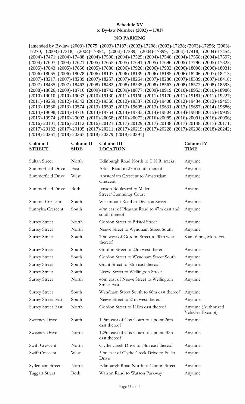
Schedule XV to By-law Number (2002) – 17017
NO PARKING
[amended by By-law (2003)-17075; (2003)-17137; (2003)-17208; (2003)-17238; (2003)-17256; (2003)-
17270; (2003)-17318; (2004)-17354; (2004)-17389; (2004)-17399; (2004)-17418; (2004)-17454;
(2004)-17471; (2004)-17488; (2004)-17500; (2004)-17525; (2004)-17548; (2004)-17558; (2004)-17597;
(2004)-17607; (2004)-17621; (2005)-17655; (2005)-17691; (2005)-17696; (2005)-17796; (2005)-17823;
(2005)-17843; (2005)-17856; (2005)-17880; (2006)-17920; (2006)-17933; (2006)-18008; (2006)-18031;
(2006)-18065; (2006)-18078; (2006)-18107; (2006)-18139; (2006)-18185; (2006)-18206; (2007)-18213;
(2007)-18217; (2007)-18239; (2007)-18257; (2007)-18264; (2007)-18280; (2007)-18339; (2007)-18418;
(2007)-18435; (2007)-18463; (2008)-18482; (2008)-18535; (2008)-18563; (2008)-18572; (2008)-18593;
(2008)-18626; (2009)-18716; (2009)-18742; (2009)-18877; (2009)-18919; (2010)-18953; (2010)-18986;
(2010)-19010; (2010)-19033; (2010)-19130; (2011)-19160; (2011)-19170; (2011)-19181; (2011)-19227;
(2011)-19259; (2012)-19342; (2012)-19366; (2012)-19387; (2012)-19408; (2012)-19434; (2012)-19465;
(2013)-19530; (2013)-19574; (2013)-19592; (2013)-19605; (2013)-19631; (2013)-19657; (2014)-19686;
(2014)-19698; (2014)-19716; (2014)-19754; (2014)-19783; (2014)-19804; (2014)-19838; (2015)-19939;
(2015)-19974; (2016)-20003; (2016)-20058; (2016)-20072; (2016)-20085; (2016)-20091; (2016)-20096;
(2016)-20101; (2016)-20112; (2016)-20121; (2017)-20129; (2017)-20138; (2017)-20148; (2017)-20171;
(2017)-20182; (2017)-20195; (2017)-20211; (2017)-20219; (2017)-20228; (2017)-20238; (2018)-20242;
(2018)-20261; (2018)-20267; (2018)-20279; (2018)-20291]
Page 35 of 44
Column I STREET
Column II SIDE
Column III LOCATION
Column IV TIME
Sultan Street North Edinburgh Road North to C.N.R. tracks Anytime
Summerfield Drive East Arkell Road to 27m south thereof Anytime
Summerfield Drive West Amsterdam Crescent to Amsterdam Crescent
Anytime
Summerfield Drive Both Jenson Boulevard to Miller Street/Cummings Court
Anytime
Summit Crescent South Westmount Road to Division Street Anytime
Sunnylea Crescent South 49m east of Pleasant Road to 47m east and south thereof
Anytime
Surrey Street North Gordon Street to Bristol Street Anytime
Surrey Street North Neeve Street to Wyndham Street South Anytime
Surrey Street South 70m west of Gordon Street to 30m west thereof
8 am-6 pm, Mon.-Fri.
Surrey Street South Gordon Street to 20m west thereof Anytime
Surrey Street South Gordon Street to Wyndham Street South Anytime
Surrey Street South Grant Street to 30m east thereof Anytime
Surrey Street South Neeve Street to Wellington Street Anytime
Surrey Street North 46m east of Neeve Street to Wellington Street East
Anytime
Surrey Street South Wyndham Street South to 66m east thereof Anytime
Surrey Street East South Neeve Street to 21m west thereof Anytime
Surrey Street East North Gordon Street to 110m east thereof Anytime (Authorized Vehicles Exempt)
Sweeney Drive South 145m east of Cox Court to a point 26m east thereof
Anytime
Sweeney Drive North 129m east of Cox Court to a point 40m east thereof
Anytime
Swift Crescent North Clythe Creek Drive to 74m east thereof Anytime
Swift Crescent West 59m east of Clythe Creek Drive to Fuller Drive
Anytime
Sydenham Street North Edinburgh Road North to Clinton Street Anytime
Taggart Street Both Watson Road to Watson Parkway Anytime
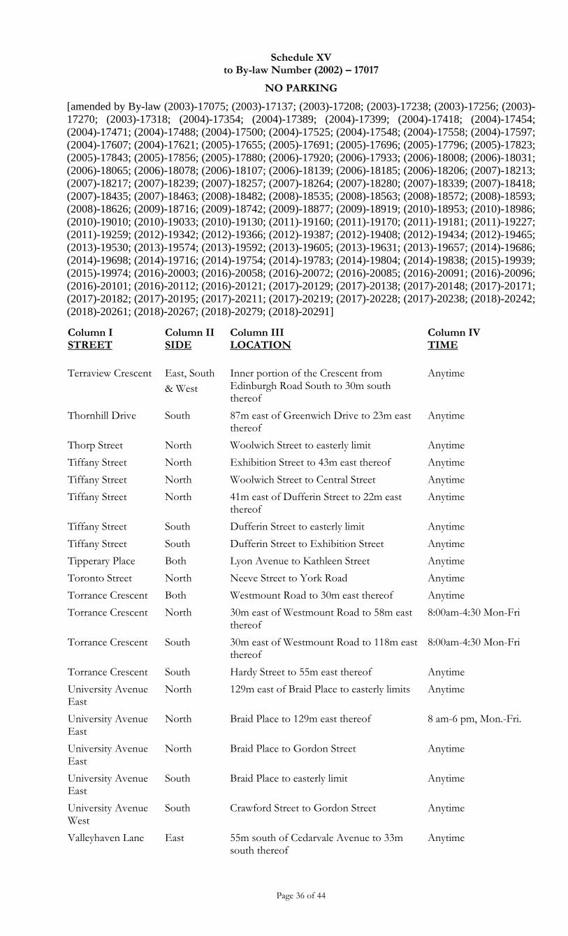
Schedule XV to By-law Number (2002) – 17017
NO PARKING
[amended by By-law (2003)-17075; (2003)-17137; (2003)-17208; (2003)-17238; (2003)-17256; (2003)-
17270; (2003)-17318; (2004)-17354; (2004)-17389; (2004)-17399; (2004)-17418; (2004)-17454;
(2004)-17471; (2004)-17488; (2004)-17500; (2004)-17525; (2004)-17548; (2004)-17558; (2004)-17597;
(2004)-17607; (2004)-17621; (2005)-17655; (2005)-17691; (2005)-17696; (2005)-17796; (2005)-17823;
(2005)-17843; (2005)-17856; (2005)-17880; (2006)-17920; (2006)-17933; (2006)-18008; (2006)-18031;
(2006)-18065; (2006)-18078; (2006)-18107; (2006)-18139; (2006)-18185; (2006)-18206; (2007)-18213;
(2007)-18217; (2007)-18239; (2007)-18257; (2007)-18264; (2007)-18280; (2007)-18339; (2007)-18418;
(2007)-18435; (2007)-18463; (2008)-18482; (2008)-18535; (2008)-18563; (2008)-18572; (2008)-18593;
(2008)-18626; (2009)-18716; (2009)-18742; (2009)-18877; (2009)-18919; (2010)-18953; (2010)-18986;
(2010)-19010; (2010)-19033; (2010)-19130; (2011)-19160; (2011)-19170; (2011)-19181; (2011)-19227;
(2011)-19259; (2012)-19342; (2012)-19366; (2012)-19387; (2012)-19408; (2012)-19434; (2012)-19465;
(2013)-19530; (2013)-19574; (2013)-19592; (2013)-19605; (2013)-19631; (2013)-19657; (2014)-19686;
(2014)-19698; (2014)-19716; (2014)-19754; (2014)-19783; (2014)-19804; (2014)-19838; (2015)-19939;
(2015)-19974; (2016)-20003; (2016)-20058; (2016)-20072; (2016)-20085; (2016)-20091; (2016)-20096;
(2016)-20101; (2016)-20112; (2016)-20121; (2017)-20129; (2017)-20138; (2017)-20148; (2017)-20171;
(2017)-20182; (2017)-20195; (2017)-20211; (2017)-20219; (2017)-20228; (2017)-20238; (2018)-20242;
(2018)-20261; (2018)-20267; (2018)-20279; (2018)-20291]
Page 36 of 44
Column I STREET
Column II SIDE
Column III LOCATION
Column IV TIME
Terraview Crescent East, South
& West
Inner portion of the Crescent from Edinburgh Road South to 30m south thereof
Anytime
Thornhill Drive South 87m east of Greenwich Drive to 23m east thereof
Anytime
Thorp Street North Woolwich Street to easterly limit Anytime
Tiffany Street North Exhibition Street to 43m east thereof Anytime
Tiffany Street North Woolwich Street to Central Street Anytime
Tiffany Street North 41m east of Dufferin Street to 22m east thereof
Anytime
Tiffany Street South Dufferin Street to easterly limit Anytime
Tiffany Street South Dufferin Street to Exhibition Street Anytime
Tipperary Place Both Lyon Avenue to Kathleen Street Anytime
Toronto Street North Neeve Street to York Road Anytime
Torrance Crescent Both Westmount Road to 30m east thereof Anytime
Torrance Crescent North 30m east of Westmount Road to 58m east thereof
8:00am-4:30 Mon-Fri
Torrance Crescent South 30m east of Westmount Road to 118m east thereof
8:00am-4:30 Mon-Fri
Torrance Crescent South Hardy Street to 55m east thereof Anytime
University Avenue East
North 129m east of Braid Place to easterly limits Anytime
University Avenue East
North Braid Place to 129m east thereof 8 am-6 pm, Mon.-Fri.
University Avenue East
North Braid Place to Gordon Street Anytime
University Avenue East
South Braid Place to easterly limit Anytime
University Avenue West
South Crawford Street to Gordon Street Anytime
Valleyhaven Lane East 55m south of Cedarvale Avenue to 33m south thereof
Anytime
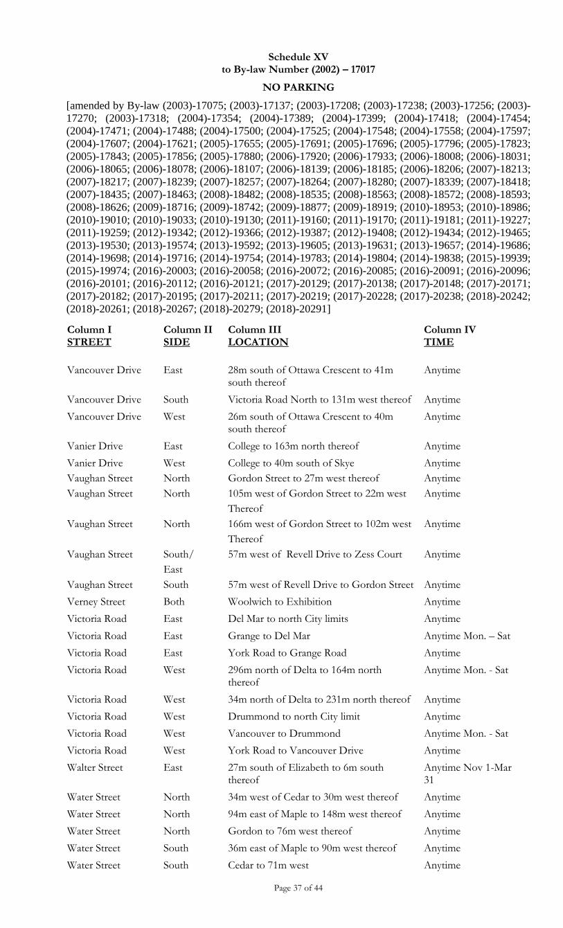
Schedule XV to By-law Number (2002) – 17017
NO PARKING
[amended by By-law (2003)-17075; (2003)-17137; (2003)-17208; (2003)-17238; (2003)-17256; (2003)-
17270; (2003)-17318; (2004)-17354; (2004)-17389; (2004)-17399; (2004)-17418; (2004)-17454;
(2004)-17471; (2004)-17488; (2004)-17500; (2004)-17525; (2004)-17548; (2004)-17558; (2004)-17597;
(2004)-17607; (2004)-17621; (2005)-17655; (2005)-17691; (2005)-17696; (2005)-17796; (2005)-17823;
(2005)-17843; (2005)-17856; (2005)-17880; (2006)-17920; (2006)-17933; (2006)-18008; (2006)-18031;
(2006)-18065; (2006)-18078; (2006)-18107; (2006)-18139; (2006)-18185; (2006)-18206; (2007)-18213;
(2007)-18217; (2007)-18239; (2007)-18257; (2007)-18264; (2007)-18280; (2007)-18339; (2007)-18418;
(2007)-18435; (2007)-18463; (2008)-18482; (2008)-18535; (2008)-18563; (2008)-18572; (2008)-18593;
(2008)-18626; (2009)-18716; (2009)-18742; (2009)-18877; (2009)-18919; (2010)-18953; (2010)-18986;
(2010)-19010; (2010)-19033; (2010)-19130; (2011)-19160; (2011)-19170; (2011)-19181; (2011)-19227;
(2011)-19259; (2012)-19342; (2012)-19366; (2012)-19387; (2012)-19408; (2012)-19434; (2012)-19465;
(2013)-19530; (2013)-19574; (2013)-19592; (2013)-19605; (2013)-19631; (2013)-19657; (2014)-19686;
(2014)-19698; (2014)-19716; (2014)-19754; (2014)-19783; (2014)-19804; (2014)-19838; (2015)-19939;
(2015)-19974; (2016)-20003; (2016)-20058; (2016)-20072; (2016)-20085; (2016)-20091; (2016)-20096;
(2016)-20101; (2016)-20112; (2016)-20121; (2017)-20129; (2017)-20138; (2017)-20148; (2017)-20171;
(2017)-20182; (2017)-20195; (2017)-20211; (2017)-20219; (2017)-20228; (2017)-20238; (2018)-20242;
(2018)-20261; (2018)-20267; (2018)-20279; (2018)-20291]
Page 37 of 44
Column I STREET
Column II SIDE
Column III LOCATION
Column IV TIME
Vancouver Drive East 28m south of Ottawa Crescent to 41m south thereof
Anytime
Vancouver Drive South Victoria Road North to 131m west thereof Anytime
Vancouver Drive West 26m south of Ottawa Crescent to 40m south thereof
Anytime
Vanier Drive East College to 163m north thereof Anytime
Vanier Drive
Vaughan Street
Vaughan Street
Vaughan Street
Vaughan Street
Vaughan Street
West
North
North
North
South/
East
South
College to 40m south of Skye
Gordon Street to 27m west thereof
105m west of Gordon Street to 22m west
Thereof
166m west of Gordon Street to 102m west
Thereof
57m west of Revell Drive to Zess Court
57m west of Revell Drive to Gordon Street
Anytime
Anytime
Anytime
Anytime
Anytime
Anytime
Verney Street Both Woolwich to Exhibition Anytime
Victoria Road East Del Mar to north City limits Anytime
Victoria Road East Grange to Del Mar Anytime Mon. – Sat
Victoria Road East York Road to Grange Road Anytime
Victoria Road West 296m north of Delta to 164m north thereof
Anytime Mon. - Sat
Victoria Road West 34m north of Delta to 231m north thereof Anytime
Victoria Road West Drummond to north City limit Anytime
Victoria Road West Vancouver to Drummond Anytime Mon. - Sat
Victoria Road West York Road to Vancouver Drive Anytime
Walter Street East 27m south of Elizabeth to 6m south thereof
Anytime Nov 1-Mar 31
Water Street North 34m west of Cedar to 30m west thereof Anytime
Water Street North 94m east of Maple to 148m west thereof Anytime
Water Street North Gordon to 76m west thereof Anytime
Water Street South 36m east of Maple to 90m west thereof Anytime
Water Street South Cedar to 71m west Anytime
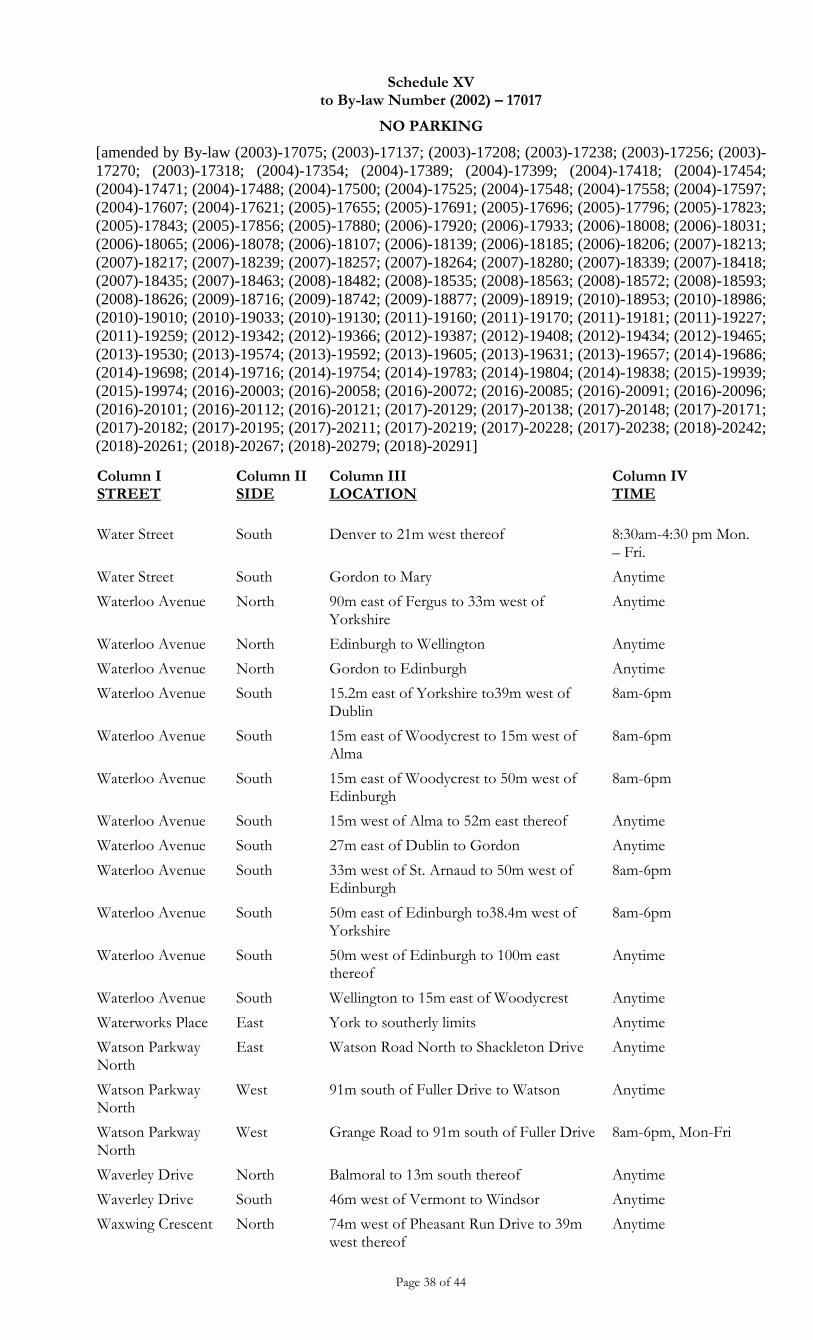
Schedule XV to By-law Number (2002) – 17017
NO PARKING
[amended by By-law (2003)-17075; (2003)-17137; (2003)-17208; (2003)-17238; (2003)-17256; (2003)-
17270; (2003)-17318; (2004)-17354; (2004)-17389; (2004)-17399; (2004)-17418; (2004)-17454;
(2004)-17471; (2004)-17488; (2004)-17500; (2004)-17525; (2004)-17548; (2004)-17558; (2004)-17597;
(2004)-17607; (2004)-17621; (2005)-17655; (2005)-17691; (2005)-17696; (2005)-17796; (2005)-17823;
(2005)-17843; (2005)-17856; (2005)-17880; (2006)-17920; (2006)-17933; (2006)-18008; (2006)-18031;
(2006)-18065; (2006)-18078; (2006)-18107; (2006)-18139; (2006)-18185; (2006)-18206; (2007)-18213;
(2007)-18217; (2007)-18239; (2007)-18257; (2007)-18264; (2007)-18280; (2007)-18339; (2007)-18418;
(2007)-18435; (2007)-18463; (2008)-18482; (2008)-18535; (2008)-18563; (2008)-18572; (2008)-18593;
(2008)-18626; (2009)-18716; (2009)-18742; (2009)-18877; (2009)-18919; (2010)-18953; (2010)-18986;
(2010)-19010; (2010)-19033; (2010)-19130; (2011)-19160; (2011)-19170; (2011)-19181; (2011)-19227;
(2011)-19259; (2012)-19342; (2012)-19366; (2012)-19387; (2012)-19408; (2012)-19434; (2012)-19465;
(2013)-19530; (2013)-19574; (2013)-19592; (2013)-19605; (2013)-19631; (2013)-19657; (2014)-19686;
(2014)-19698; (2014)-19716; (2014)-19754; (2014)-19783; (2014)-19804; (2014)-19838; (2015)-19939;
(2015)-19974; (2016)-20003; (2016)-20058; (2016)-20072; (2016)-20085; (2016)-20091; (2016)-20096;
(2016)-20101; (2016)-20112; (2016)-20121; (2017)-20129; (2017)-20138; (2017)-20148; (2017)-20171;
(2017)-20182; (2017)-20195; (2017)-20211; (2017)-20219; (2017)-20228; (2017)-20238; (2018)-20242;
(2018)-20261; (2018)-20267; (2018)-20279; (2018)-20291]
Page 38 of 44
Column I STREET
Column II SIDE
Column III LOCATION
Column IV TIME
Water Street South Denver to 21m west thereof 8:30am-4:30 pm Mon. – Fri.
Water Street South Gordon to Mary Anytime
Waterloo Avenue North 90m east of Fergus to 33m west of Yorkshire
Anytime
Waterloo Avenue North Edinburgh to Wellington Anytime
Waterloo Avenue North Gordon to Edinburgh Anytime
Waterloo Avenue South 15.2m east of Yorkshire to39m west of Dublin
8am-6pm
Waterloo Avenue South 15m east of Woodycrest to 15m west of Alma
8am-6pm
Waterloo Avenue South 15m east of Woodycrest to 50m west of Edinburgh
8am-6pm
Waterloo Avenue South 15m west of Alma to 52m east thereof Anytime
Waterloo Avenue South 27m east of Dublin to Gordon Anytime
Waterloo Avenue South 33m west of St. Arnaud to 50m west of Edinburgh
8am-6pm
Waterloo Avenue South 50m east of Edinburgh to38.4m west of Yorkshire
8am-6pm
Waterloo Avenue South 50m west of Edinburgh to 100m east thereof
Anytime
Waterloo Avenue South Wellington to 15m east of Woodycrest Anytime
Waterworks Place East York to southerly limits Anytime
Watson Parkway North
East Watson Road North to Shackleton Drive Anytime
Watson Parkway North
West 91m south of Fuller Drive to Watson Anytime
Watson Parkway North
West Grange Road to 91m south of Fuller Drive 8am-6pm, Mon-Fri
Waverley Drive North Balmoral to 13m south thereof Anytime
Waverley Drive South 46m west of Vermont to Windsor Anytime
Waxwing Crescent North 74m west of Pheasant Run Drive to 39m west thereof
Anytime
Schedule XV to By-law Number (2002) – 17017
NO PARKING
[amended by By-law (2003)-17075; (2003)-17137; (2003)-17208; (2003)-17238; (2003)-17256; (2003)-
17270; (2003)-17318; (2004)-17354; (2004)-17389; (2004)-17399; (2004)-17418; (2004)-17454;
(2004)-17471; (2004)-17488; (2004)-17500; (2004)-17525; (2004)-17548; (2004)-17558; (2004)-17597;
(2004)-17607; (2004)-17621; (2005)-17655; (2005)-17691; (2005)-17696; (2005)-17796; (2005)-17823;
(2005)-17843; (2005)-17856; (2005)-17880; (2006)-17920; (2006)-17933; (2006)-18008; (2006)-18031;
(2006)-18065; (2006)-18078; (2006)-18107; (2006)-18139; (2006)-18185; (2006)-18206; (2007)-18213;
(2007)-18217; (2007)-18239; (2007)-18257; (2007)-18264; (2007)-18280; (2007)-18339; (2007)-18418;
(2007)-18435; (2007)-18463; (2008)-18482; (2008)-18535; (2008)-18563; (2008)-18572; (2008)-18593;
(2008)-18626; (2009)-18716; (2009)-18742; (2009)-18877; (2009)-18919; (2010)-18953; (2010)-18986;
(2010)-19010; (2010)-19033; (2010)-19130; (2011)-19160; (2011)-19170; (2011)-19181; (2011)-19227;
(2011)-19259; (2012)-19342; (2012)-19366; (2012)-19387; (2012)-19408; (2012)-19434; (2012)-19465;
(2013)-19530; (2013)-19574; (2013)-19592; (2013)-19605; (2013)-19631; (2013)-19657; (2014)-19686;
(2014)-19698; (2014)-19716; (2014)-19754; (2014)-19783; (2014)-19804; (2014)-19838; (2015)-19939;
(2015)-19974; (2016)-20003; (2016)-20058; (2016)-20072; (2016)-20085; (2016)-20091; (2016)-20096;
(2016)-20101; (2016)-20112; (2016)-20121; (2017)-20129; (2017)-20138; (2017)-20148; (2017)-20171;
(2017)-20182; (2017)-20195; (2017)-20211; (2017)-20219; (2017)-20228; (2017)-20238; (2018)-20242;
(2018)-20261; (2018)-20267; (2018)-20279; (2018)-20291]
Page 39 of 44
Column I STREET
Column II SIDE
Column III LOCATION
Column IV TIME
Waxwing Crescent South 65m west of Pheasant Run Drive to 34m west thereof
Anytime
Wellington Street Both Macdonell to the west City limits Anytime
Wells Street Both York to northerly limit Anytime
West Acres Drive Both 140m east of Northwood to 40m east thereof
Anytime
West Acres Drive North 34m west of Gateway to41m east of Gateway
8:30am-4:30pm Mon – Fri
West Acres Drive North 43m west of Gateway to 80m east thereof Anytime
West Acres Drive South 140m east of Northwood39m east thereof Anytime
West Acres Drive South 17m east of Northwood to 74m east thereof
Anytime
West Acres Drive South Gateway to 43m west thereof Anytime
Westmount Road Both 99m south of Division to Highview Anytime
Westmount Road East 17m south of Division To 25m south thereof
Anytime
Westmount Road East 40m north of Torrance to London Road 8am-6pm Mon – Sat.
Westmount Road East 54m south of Division to45m south thereof
Anytime
Westmount Road East 66m north of Torrance to London Road 8am-6pm Mon – Sat
Westmount Road East 66m north of Torrance to Summit Anytime
Westmount Road East 67m north of Summitt to 55m north thereof
8am-6pm Mon – Fri
Westmount Road East Highview to 6m south of Division Anytime
Westmount Road West 27m north of Torrance to 196m north thereof
Anytime
Westmount Road West 305m south of Division to 377m north Division
Anytime
Westwood Road Both 22m south of Wimbledon to 44m north thereof
Anytime
Westwood Road North Silvercreek to 33m south of Willow Road Anytime
Westwood Road South Silvercreek to Rhonda Anytime
Westwood Road South Willow to 33m south thereof Anytime
Schedule XV to By-law Number (2002) – 17017
NO PARKING
[amended by By-law (2003)-17075; (2003)-17137; (2003)-17208; (2003)-17238; (2003)-17256; (2003)-
17270; (2003)-17318; (2004)-17354; (2004)-17389; (2004)-17399; (2004)-17418; (2004)-17454;
(2004)-17471; (2004)-17488; (2004)-17500; (2004)-17525; (2004)-17548; (2004)-17558; (2004)-17597;
(2004)-17607; (2004)-17621; (2005)-17655; (2005)-17691; (2005)-17696; (2005)-17796; (2005)-17823;
(2005)-17843; (2005)-17856; (2005)-17880; (2006)-17920; (2006)-17933; (2006)-18008; (2006)-18031;
(2006)-18065; (2006)-18078; (2006)-18107; (2006)-18139; (2006)-18185; (2006)-18206; (2007)-18213;
(2007)-18217; (2007)-18239; (2007)-18257; (2007)-18264; (2007)-18280; (2007)-18339; (2007)-18418;
(2007)-18435; (2007)-18463; (2008)-18482; (2008)-18535; (2008)-18563; (2008)-18572; (2008)-18593;
(2008)-18626; (2009)-18716; (2009)-18742; (2009)-18877; (2009)-18919; (2010)-18953; (2010)-18986;
(2010)-19010; (2010)-19033; (2010)-19130; (2011)-19160; (2011)-19170; (2011)-19181; (2011)-19227;
(2011)-19259; (2012)-19342; (2012)-19366; (2012)-19387; (2012)-19408; (2012)-19434; (2012)-19465;
(2013)-19530; (2013)-19574; (2013)-19592; (2013)-19605; (2013)-19631; (2013)-19657; (2014)-19686;
(2014)-19698; (2014)-19716; (2014)-19754; (2014)-19783; (2014)-19804; (2014)-19838; (2015)-19939;
(2015)-19974; (2016)-20003; (2016)-20058; (2016)-20072; (2016)-20085; (2016)-20091; (2016)-20096;
(2016)-20101; (2016)-20112; (2016)-20121; (2017)-20129; (2017)-20138; (2017)-20148; (2017)-20171;
(2017)-20182; (2017)-20195; (2017)-20211; (2017)-20219; (2017)-20228; (2017)-20238; (2018)-20242;
(2018)-20261; (2018)-20267; (2018)-20279; (2018)-20291]
Page 40 of 44
Column I STREET
Column II SIDE
Column III LOCATION
Column IV TIME
Westwood Road West 311m south of Willow to 154m south thereof
Anytime
Wheeler Avenue West Elizabeth to Ferguson Anytime
Whetstone Crescent
North East of Summerfield Drive (north leg) to 26m east thereof
Anytime
Whispering Ridge Drive
Both Cole to Scottsdale Anytime
Whitelaw Road East 49m north of Shoemaker Crescent to Paisley Road
Anytime
Whitelaw Road East Fife Road to West Acres Drive Anytime
Whitelaw Road West Paisley Road to south City limit Anytime
Wilkie Crescent East Goodwin Drive (east leg) to 180m south thereof
Anytime
Wilkie Crescent North 80m west of Pearson Street to 80m east of Pearson Street
Anytime
Wilkie Crescent West Goodwin Drive (west leg) to 180m south thereof
Anytime
Willow Road Both 62m west of Westwood to 40m east of Westwood
Anytime
Willow Road Both Edinburgh Road to Silvercreek Parkway North
Anytime
Willow Road North 39m west of Thistle Road to 85m west thereof
Anytime
Willow Road North Imperial Road North to 166m west of Elmira Road North
Anytime
Willow Road South 203m east of Elmira Road North to 187m east thereof
Anytime
Willow Road South 27m west of Imperial Road North to 60m west thereof
Anytime
Willow Road North 15m west of Elmira Road North to 87m west thereof
Anytime
Willow Road North 57m west of Westwood Road to 205m west thereof
Anytime
Wilson Street East Gordon Street to Carden Street Anytime
Schedule XV to By-law Number (2002) – 17017
NO PARKING
[amended by By-law (2003)-17075; (2003)-17137; (2003)-17208; (2003)-17238; (2003)-17256; (2003)-
17270; (2003)-17318; (2004)-17354; (2004)-17389; (2004)-17399; (2004)-17418; (2004)-17454;
(2004)-17471; (2004)-17488; (2004)-17500; (2004)-17525; (2004)-17548; (2004)-17558; (2004)-17597;
(2004)-17607; (2004)-17621; (2005)-17655; (2005)-17691; (2005)-17696; (2005)-17796; (2005)-17823;
(2005)-17843; (2005)-17856; (2005)-17880; (2006)-17920; (2006)-17933; (2006)-18008; (2006)-18031;
(2006)-18065; (2006)-18078; (2006)-18107; (2006)-18139; (2006)-18185; (2006)-18206; (2007)-18213;
(2007)-18217; (2007)-18239; (2007)-18257; (2007)-18264; (2007)-18280; (2007)-18339; (2007)-18418;
(2007)-18435; (2007)-18463; (2008)-18482; (2008)-18535; (2008)-18563; (2008)-18572; (2008)-18593;
(2008)-18626; (2009)-18716; (2009)-18742; (2009)-18877; (2009)-18919; (2010)-18953; (2010)-18986;
(2010)-19010; (2010)-19033; (2010)-19130; (2011)-19160; (2011)-19170; (2011)-19181; (2011)-19227;
(2011)-19259; (2012)-19342; (2012)-19366; (2012)-19387; (2012)-19408; (2012)-19434; (2012)-19465;
(2013)-19530; (2013)-19574; (2013)-19592; (2013)-19605; (2013)-19631; (2013)-19657; (2014)-19686;
(2014)-19698; (2014)-19716; (2014)-19754; (2014)-19783; (2014)-19804; (2014)-19838; (2015)-19939;
(2015)-19974; (2016)-20003; (2016)-20058; (2016)-20072; (2016)-20085; (2016)-20091; (2016)-20096;
(2016)-20101; (2016)-20112; (2016)-20121; (2017)-20129; (2017)-20138; (2017)-20148; (2017)-20171;
(2017)-20182; (2017)-20195; (2017)-20211; (2017)-20219; (2017)-20228; (2017)-20238; (2018)-20242;
(2018)-20261; (2018)-20267; (2018)-20279; (2018)-20291]
Page 41 of 44
Column I STREET
Column II SIDE
Column III LOCATION
Column IV TIME
Wilson Street West Gordon Street to Northumberland Street Anytime
Windsor Street East Waverley to 20m north thereof Anytime
Wood Street East Ontario to Manitoba Anytime
Wood Street West Manitoba to 17m south thereof Anytime
Woodborough Road
North 68m east of Ironwood Road [south] to 21m west thereof
Anytime
Woodborough Road
North 225m west of Ironwood Road [south] to 35m east thereof
Anytime
Woodborough Road
South 313m west of Ironwood Road [south] to 23m east thereof
Anytime
Woodland Glen Drive
North 145m south of Wagoners Trail to 115m south thereof
Anytime
Woodland Glen Drive
West 69m east of Old Colony to 45m southeast thereof
Anytime
Woodlawn Road Both Victoria Road to west City limits Anytime
Woodlawn Road North Ferndale to 19m east thereof Anytime
Woodlawn Road South 19m east of Ferndale to 37m west thereof Anytime
Woodlawn Road South Victoria Road to 35m East thereof Anytime
Woodlawn Road East
South 35m west of Atto Drive to 7m west thereof
Anytime
Woodridge Drive Both West Acres Drive to 91m north thereof Anytime
Woodycrest Drive Both Waterloo Avenue to McCall Anytime
Woolwich Street East Cardigan Street to 18m north thereof Anytime
Woolwich Street East 101m south of Norwich to 25m south thereof
Anytime
Woolwich Street East 147m north of Macdonell to 152m north thereof
Anytime
Woolwich Street East 30m north of London Road To McTague Street
12pm-1pm 4:30pm-6pm
Woolwich Street East 39.9m south of Eramosa to 56m south thereof
Anytime
Woolwich Street East Eramosa to 28.9m south thereof Anytime
Woolwich Street East Macdonell to 119m north thereof Anytime
Schedule XV to By-law Number (2002) – 17017
NO PARKING
[amended by By-law (2003)-17075; (2003)-17137; (2003)-17208; (2003)-17238; (2003)-17256; (2003)-
17270; (2003)-17318; (2004)-17354; (2004)-17389; (2004)-17399; (2004)-17418; (2004)-17454;
(2004)-17471; (2004)-17488; (2004)-17500; (2004)-17525; (2004)-17548; (2004)-17558; (2004)-17597;
(2004)-17607; (2004)-17621; (2005)-17655; (2005)-17691; (2005)-17696; (2005)-17796; (2005)-17823;
(2005)-17843; (2005)-17856; (2005)-17880; (2006)-17920; (2006)-17933; (2006)-18008; (2006)-18031;
(2006)-18065; (2006)-18078; (2006)-18107; (2006)-18139; (2006)-18185; (2006)-18206; (2007)-18213;
(2007)-18217; (2007)-18239; (2007)-18257; (2007)-18264; (2007)-18280; (2007)-18339; (2007)-18418;
(2007)-18435; (2007)-18463; (2008)-18482; (2008)-18535; (2008)-18563; (2008)-18572; (2008)-18593;
(2008)-18626; (2009)-18716; (2009)-18742; (2009)-18877; (2009)-18919; (2010)-18953; (2010)-18986;
(2010)-19010; (2010)-19033; (2010)-19130; (2011)-19160; (2011)-19170; (2011)-19181; (2011)-19227;
(2011)-19259; (2012)-19342; (2012)-19366; (2012)-19387; (2012)-19408; (2012)-19434; (2012)-19465;
(2013)-19530; (2013)-19574; (2013)-19592; (2013)-19605; (2013)-19631; (2013)-19657; (2014)-19686;
(2014)-19698; (2014)-19716; (2014)-19754; (2014)-19783; (2014)-19804; (2014)-19838; (2015)-19939;
(2015)-19974; (2016)-20003; (2016)-20058; (2016)-20072; (2016)-20085; (2016)-20091; (2016)-20096;
(2016)-20101; (2016)-20112; (2016)-20121; (2017)-20129; (2017)-20138; (2017)-20148; (2017)-20171;
(2017)-20182; (2017)-20195; (2017)-20211; (2017)-20219; (2017)-20228; (2017)-20238; (2018)-20242;
(2018)-20261; (2018)-20267; (2018)-20279; (2018)-20291]
Page 42 of 44
Column I STREET
Column II SIDE
Column III LOCATION
Column IV TIME
Woolwich Street East 14m south of Suffolk to 14m north thereof Anytime
Woolwich Street East Norwich to London Anytime
Woolwich Street East Woodlawn to 91m north Of the centre line of London Road
Anytime
Woolwich Street West 110m north of Verney to 97m north thereof
Anytime
Woolwich Street West Macdonell To 175m north thereof Anytime
Woolwich Street West 32.5m north of Douglas to 14.5m south of Douglas
Anytime Mon. – Sat.
Woolwich Street West Clarke to 18m north thereof Anytime
Woolwich Street West Clarke to 22m south thereof Anytime
Woolwich Street West Division to 18m north thereof Anytime
Woolwich Street West Division to 18m south thereof Anytime
Woolwich Street West Extra to 18m north thereof Anytime
Woolwich Street West Extra to 18m south thereof Anytime
Woolwich Street West Macdonell to 168m north thereof Anytime
Woolwich Street West Macdonell to Thorp Anytime
Woolwich Street West McTague to 18m north Anytime
Woolwich Street West Mont to 18m north thereof Anytime
Woolwich Street West Mont to 18m south thereof Anytime
Woolwich Street West Powell to 54m north thereof Anytime
Woolwich Street West Powell to 69m south thereof Anytime
Woolwich Street West Speedvale to Woodlawn Anytime
Woolwich Street West Tiffany to 18m north thereof Anytime
Woolwich Street West Tiffany to 18m south thereof Anytime
Woolwich Street West Verney to 18m south thereof Anytime
Woolwich Street West Verney to 48m north thereof Anytime
Woolwich Street West Wyndham to Suffolk Anytime
Wyndham Street East 4m south of Cork to 13m south thereof Anytime
Wyndham Street East Carden to Howitt Anytime
Wyndham Street West Carden to Wellington Anytime
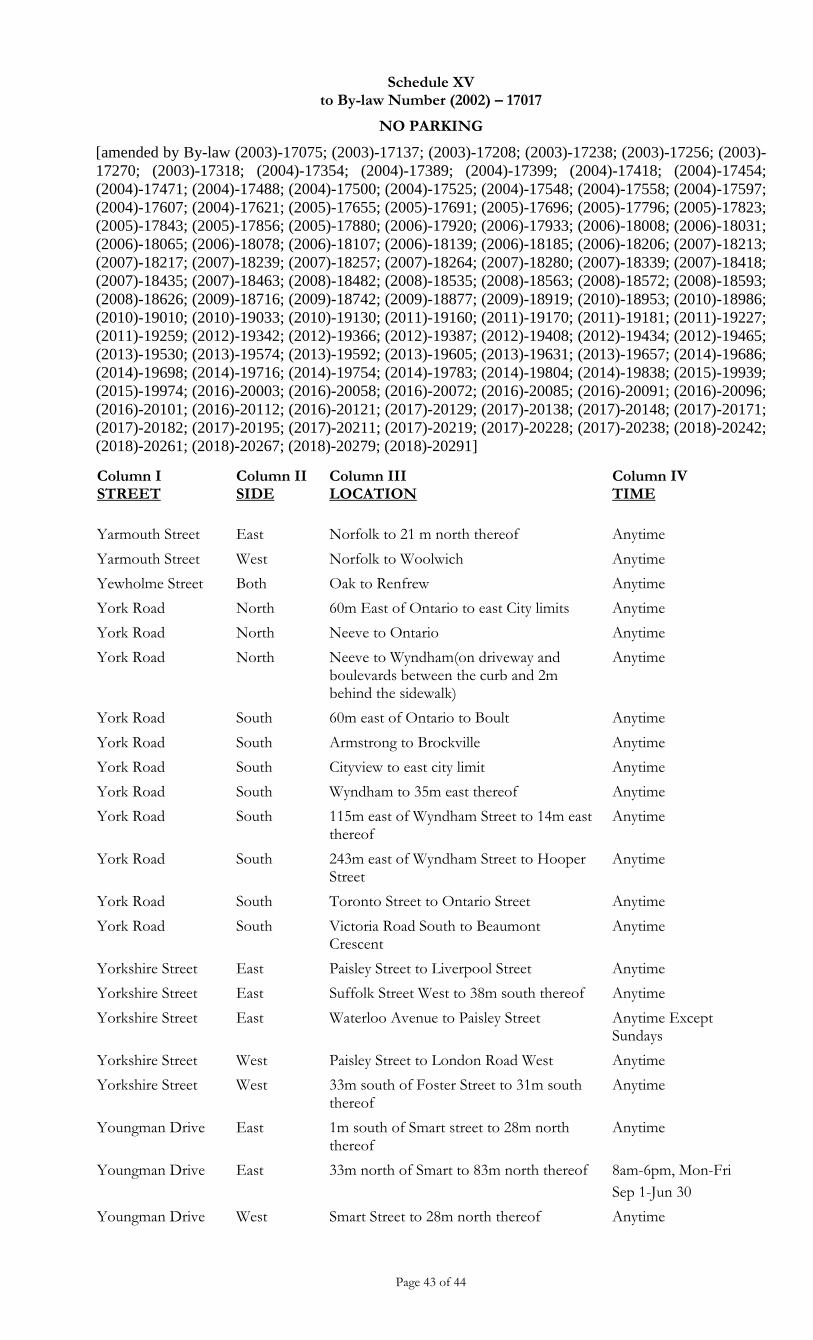
Schedule XV to By-law Number (2002) – 17017
NO PARKING
[amended by By-law (2003)-17075; (2003)-17137; (2003)-17208; (2003)-17238; (2003)-17256; (2003)-
17270; (2003)-17318; (2004)-17354; (2004)-17389; (2004)-17399; (2004)-17418; (2004)-17454;
(2004)-17471; (2004)-17488; (2004)-17500; (2004)-17525; (2004)-17548; (2004)-17558; (2004)-17597;
(2004)-17607; (2004)-17621; (2005)-17655; (2005)-17691; (2005)-17696; (2005)-17796; (2005)-17823;
(2005)-17843; (2005)-17856; (2005)-17880; (2006)-17920; (2006)-17933; (2006)-18008; (2006)-18031;
(2006)-18065; (2006)-18078; (2006)-18107; (2006)-18139; (2006)-18185; (2006)-18206; (2007)-18213;
(2007)-18217; (2007)-18239; (2007)-18257; (2007)-18264; (2007)-18280; (2007)-18339; (2007)-18418;
(2007)-18435; (2007)-18463; (2008)-18482; (2008)-18535; (2008)-18563; (2008)-18572; (2008)-18593;
(2008)-18626; (2009)-18716; (2009)-18742; (2009)-18877; (2009)-18919; (2010)-18953; (2010)-18986;
(2010)-19010; (2010)-19033; (2010)-19130; (2011)-19160; (2011)-19170; (2011)-19181; (2011)-19227;
(2011)-19259; (2012)-19342; (2012)-19366; (2012)-19387; (2012)-19408; (2012)-19434; (2012)-19465;
(2013)-19530; (2013)-19574; (2013)-19592; (2013)-19605; (2013)-19631; (2013)-19657; (2014)-19686;
(2014)-19698; (2014)-19716; (2014)-19754; (2014)-19783; (2014)-19804; (2014)-19838; (2015)-19939;
(2015)-19974; (2016)-20003; (2016)-20058; (2016)-20072; (2016)-20085; (2016)-20091; (2016)-20096;
(2016)-20101; (2016)-20112; (2016)-20121; (2017)-20129; (2017)-20138; (2017)-20148; (2017)-20171;
(2017)-20182; (2017)-20195; (2017)-20211; (2017)-20219; (2017)-20228; (2017)-20238; (2018)-20242;
(2018)-20261; (2018)-20267; (2018)-20279; (2018)-20291]
Page 43 of 44
Column I STREET
Column II SIDE
Column III LOCATION
Column IV TIME
Yarmouth Street East Norfolk to 21 m north thereof Anytime
Yarmouth Street West Norfolk to Woolwich Anytime
Yewholme Street Both Oak to Renfrew Anytime
York Road North 60m East of Ontario to east City limits Anytime
York Road North Neeve to Ontario Anytime
York Road North Neeve to Wyndham(on driveway and boulevards between the curb and 2m behind the sidewalk)
Anytime
York Road South 60m east of Ontario to Boult Anytime
York Road South Armstrong to Brockville Anytime
York Road South Cityview to east city limit Anytime
York Road South Wyndham to 35m east thereof Anytime
York Road South 115m east of Wyndham Street to 14m east thereof
Anytime
York Road South 243m east of Wyndham Street to Hooper Street
Anytime
York Road South Toronto Street to Ontario Street Anytime
York Road South Victoria Road South to Beaumont Crescent
Anytime
Yorkshire Street East Paisley Street to Liverpool Street Anytime
Yorkshire Street East Suffolk Street West to 38m south thereof Anytime
Yorkshire Street East Waterloo Avenue to Paisley Street Anytime Except Sundays
Yorkshire Street West Paisley Street to London Road West Anytime
Yorkshire Street West 33m south of Foster Street to 31m south thereof
Anytime
Youngman Drive East 1m south of Smart street to 28m north thereof
Anytime
Youngman Drive
East 33m north of Smart to 83m north thereof 8am-6pm, Mon-Fri
Sep 1-Jun 30
Youngman Drive West Smart Street to 28m north thereof Anytime
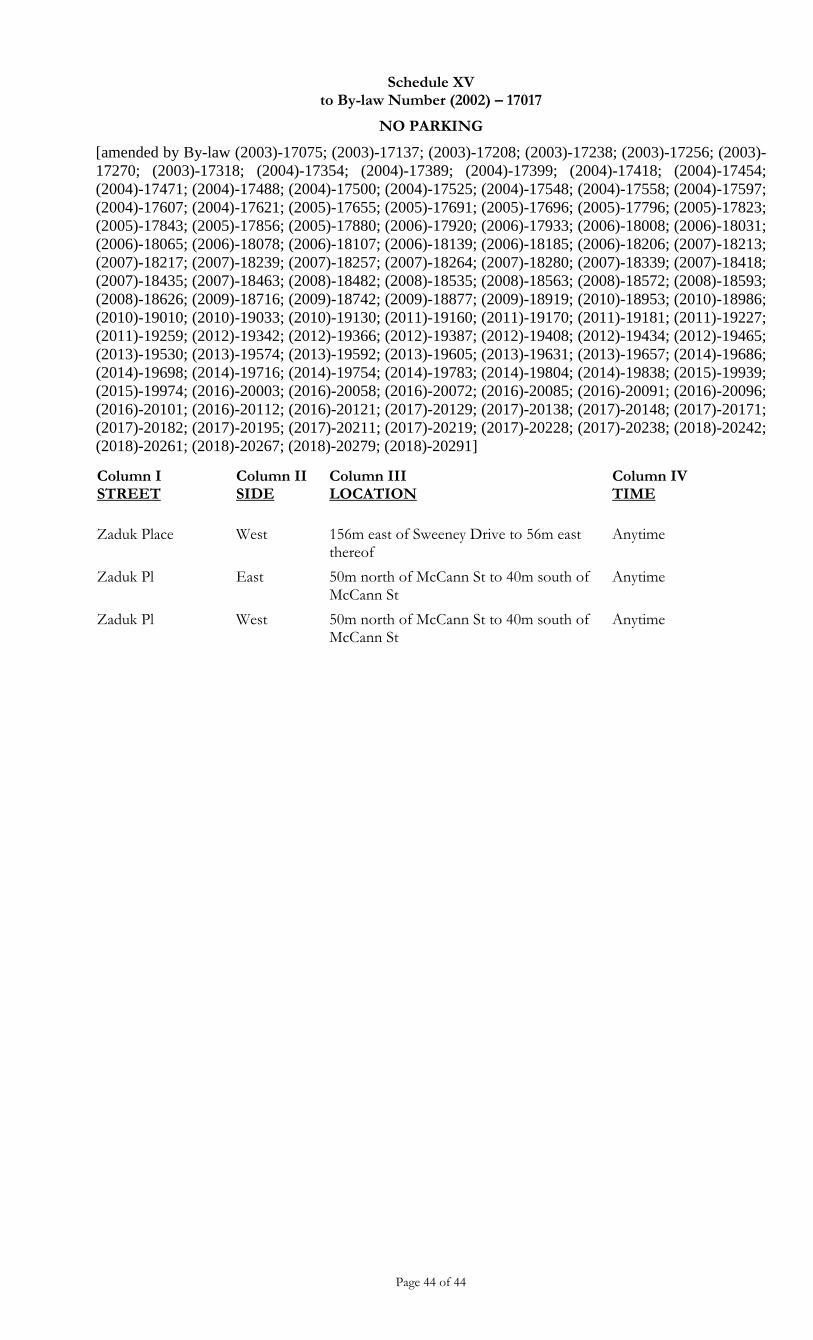
Schedule XV to By-law Number (2002) – 17017
NO PARKING
[amended by By-law (2003)-17075; (2003)-17137; (2003)-17208; (2003)-17238; (2003)-17256; (2003)-
17270; (2003)-17318; (2004)-17354; (2004)-17389; (2004)-17399; (2004)-17418; (2004)-17454;
(2004)-17471; (2004)-17488; (2004)-17500; (2004)-17525; (2004)-17548; (2004)-17558; (2004)-17597;
(2004)-17607; (2004)-17621; (2005)-17655; (2005)-17691; (2005)-17696; (2005)-17796; (2005)-17823;
(2005)-17843; (2005)-17856; (2005)-17880; (2006)-17920; (2006)-17933; (2006)-18008; (2006)-18031;
(2006)-18065; (2006)-18078; (2006)-18107; (2006)-18139; (2006)-18185; (2006)-18206; (2007)-18213;
(2007)-18217; (2007)-18239; (2007)-18257; (2007)-18264; (2007)-18280; (2007)-18339; (2007)-18418;
(2007)-18435; (2007)-18463; (2008)-18482; (2008)-18535; (2008)-18563; (2008)-18572; (2008)-18593;
(2008)-18626; (2009)-18716; (2009)-18742; (2009)-18877; (2009)-18919; (2010)-18953; (2010)-18986;
(2010)-19010; (2010)-19033; (2010)-19130; (2011)-19160; (2011)-19170; (2011)-19181; (2011)-19227;
(2011)-19259; (2012)-19342; (2012)-19366; (2012)-19387; (2012)-19408; (2012)-19434; (2012)-19465;
(2013)-19530; (2013)-19574; (2013)-19592; (2013)-19605; (2013)-19631; (2013)-19657; (2014)-19686;
(2014)-19698; (2014)-19716; (2014)-19754; (2014)-19783; (2014)-19804; (2014)-19838; (2015)-19939;
(2015)-19974; (2016)-20003; (2016)-20058; (2016)-20072; (2016)-20085; (2016)-20091; (2016)-20096;
(2016)-20101; (2016)-20112; (2016)-20121; (2017)-20129; (2017)-20138; (2017)-20148; (2017)-20171;
(2017)-20182; (2017)-20195; (2017)-20211; (2017)-20219; (2017)-20228; (2017)-20238; (2018)-20242;
(2018)-20261; (2018)-20267; (2018)-20279; (2018)-20291]
Page 44 of 44
Column I STREET
Column II SIDE
Column III LOCATION
Column IV TIME
Zaduk Place West 156m east of Sweeney Drive to 56m east thereof
Anytime
Zaduk Pl East 50m north of McCann St to 40m south of McCann St
Anytime
Zaduk Pl West 50m north of McCann St to 40m south of McCann St
Anytime
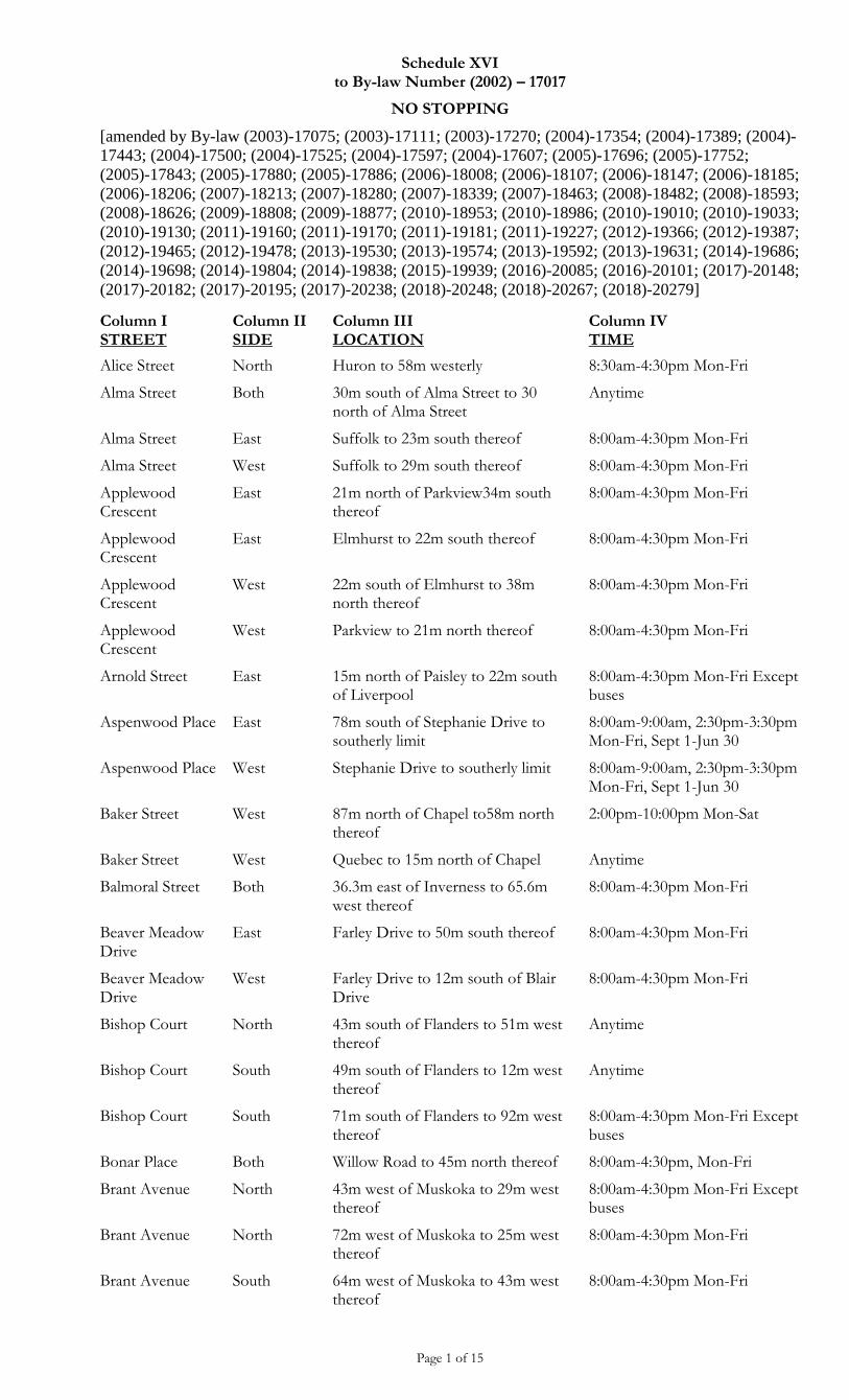
Schedule XVI to By-law Number (2002) – 17017
NO STOPPING
[amended by By-law (2003)-17075; (2003)-17111; (2003)-17270; (2004)-17354; (2004)-17389; (2004)-
17443; (2004)-17500; (2004)-17525; (2004)-17597; (2004)-17607; (2005)-17696; (2005)-17752;
(2005)-17843; (2005)-17880; (2005)-17886; (2006)-18008; (2006)-18107; (2006)-18147; (2006)-18185;
(2006)-18206; (2007)-18213; (2007)-18280; (2007)-18339; (2007)-18463; (2008)-18482; (2008)-18593;
(2008)-18626; (2009)-18808; (2009)-18877; (2010)-18953; (2010)-18986; (2010)-19010; (2010)-19033;
(2010)-19130; (2011)-19160; (2011)-19170; (2011)-19181; (2011)-19227; (2012)-19366; (2012)-19387;
(2012)-19465; (2012)-19478; (2013)-19530; (2013)-19574; (2013)-19592; (2013)-19631; (2014)-19686;
(2014)-19698; (2014)-19804; (2014)-19838; (2015)-19939; (2016)-20085; (2016)-20101; (2017)-20148;
(2017)-20182; (2017)-20195; (2017)-20238; (2018)-20248; (2018)-20267; (2018)-20279]
Page 1 of 15
Column I STREET
Column II SIDE
Column III LOCATION
Column IV TIME
Alice Street North Huron to 58m westerly 8:30am-4:30pm Mon-Fri
Alma Street Both 30m south of Alma Street to 30 north of Alma Street
Anytime
Alma Street East Suffolk to 23m south thereof 8:00am-4:30pm Mon-Fri
Alma Street West Suffolk to 29m south thereof 8:00am-4:30pm Mon-Fri
Applewood Crescent
East 21m north of Parkview34m south thereof
8:00am-4:30pm Mon-Fri
Applewood Crescent
East Elmhurst to 22m south thereof 8:00am-4:30pm Mon-Fri
Applewood Crescent
West 22m south of Elmhurst to 38m north thereof
8:00am-4:30pm Mon-Fri
Applewood Crescent
West Parkview to 21m north thereof 8:00am-4:30pm Mon-Fri
Arnold Street East 15m north of Paisley to 22m south of Liverpool
8:00am-4:30pm Mon-Fri Except buses
Aspenwood Place East 78m south of Stephanie Drive to southerly limit
8:00am-9:00am, 2:30pm-3:30pm Mon-Fri, Sept 1-Jun 30
Aspenwood Place West Stephanie Drive to southerly limit 8:00am-9:00am, 2:30pm-3:30pm Mon-Fri, Sept 1-Jun 30
Baker Street West 87m north of Chapel to58m north thereof
2:00pm-10:00pm Mon-Sat
Baker Street West Quebec to 15m north of Chapel Anytime
Balmoral Street Both 36.3m east of Inverness to 65.6m west thereof
8:00am-4:30pm Mon-Fri
Beaver Meadow Drive
East Farley Drive to 50m south thereof 8:00am-4:30pm Mon-Fri
Beaver Meadow Drive
West Farley Drive to 12m south of Blair Drive
8:00am-4:30pm Mon-Fri
Bishop Court North 43m south of Flanders to 51m west thereof
Anytime
Bishop Court South 49m south of Flanders to 12m west thereof
Anytime
Bishop Court South 71m south of Flanders to 92m west thereof
8:00am-4:30pm Mon-Fri Except buses
Bonar Place Both Willow Road to 45m north thereof 8:00am-4:30pm, Mon-Fri
Brant Avenue North 43m west of Muskoka to 29m west thereof
8:00am-4:30pm Mon-Fri Except buses
Brant Avenue North 72m west of Muskoka to 25m west thereof
8:00am-4:30pm Mon-Fri
Brant Avenue South 64m west of Muskoka to 43m west thereof
8:00am-4:30pm Mon-Fri
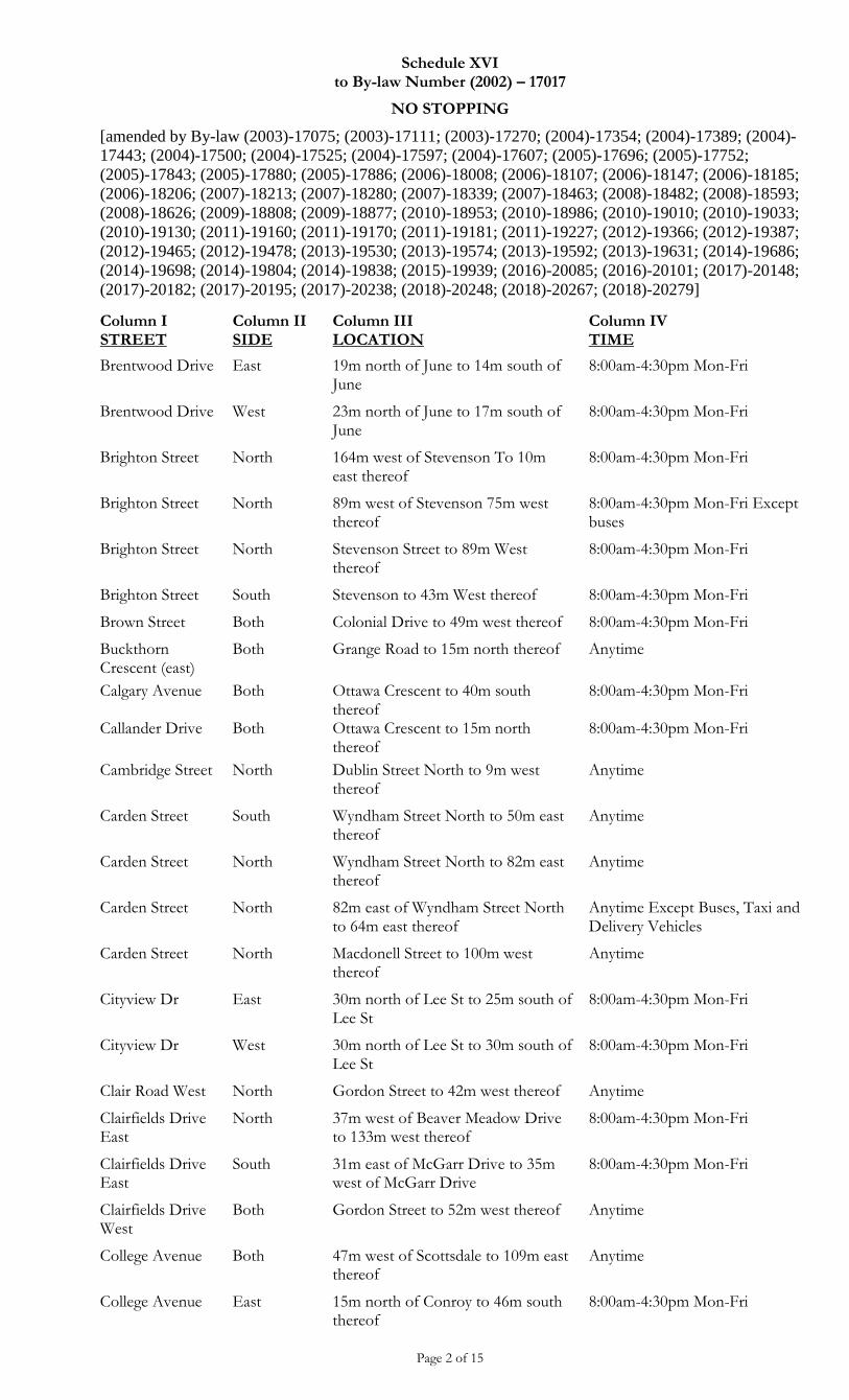
Schedule XVI to By-law Number (2002) – 17017
NO STOPPING
[amended by By-law (2003)-17075; (2003)-17111; (2003)-17270; (2004)-17354; (2004)-17389; (2004)-
17443; (2004)-17500; (2004)-17525; (2004)-17597; (2004)-17607; (2005)-17696; (2005)-17752;
(2005)-17843; (2005)-17880; (2005)-17886; (2006)-18008; (2006)-18107; (2006)-18147; (2006)-18185;
(2006)-18206; (2007)-18213; (2007)-18280; (2007)-18339; (2007)-18463; (2008)-18482; (2008)-18593;
(2008)-18626; (2009)-18808; (2009)-18877; (2010)-18953; (2010)-18986; (2010)-19010; (2010)-19033;
(2010)-19130; (2011)-19160; (2011)-19170; (2011)-19181; (2011)-19227; (2012)-19366; (2012)-19387;
(2012)-19465; (2012)-19478; (2013)-19530; (2013)-19574; (2013)-19592; (2013)-19631; (2014)-19686;
(2014)-19698; (2014)-19804; (2014)-19838; (2015)-19939; (2016)-20085; (2016)-20101; (2017)-20148;
(2017)-20182; (2017)-20195; (2017)-20238; (2018)-20248; (2018)-20267; (2018)-20279]
Page 2 of 15
Column I STREET
Column II SIDE
Column III LOCATION
Column IV TIME
Brentwood Drive East 19m north of June to 14m south of June
8:00am-4:30pm Mon-Fri
Brentwood Drive West 23m north of June to 17m south of June
8:00am-4:30pm Mon-Fri
Brighton Street North 164m west of Stevenson To 10m east thereof
8:00am-4:30pm Mon-Fri
Brighton Street North 89m west of Stevenson 75m west thereof
8:00am-4:30pm Mon-Fri Except buses
Brighton Street North Stevenson Street to 89m West thereof
8:00am-4:30pm Mon-Fri
Brighton Street South Stevenson to 43m West thereof 8:00am-4:30pm Mon-Fri
Brown Street Both Colonial Drive to 49m west thereof 8:00am-4:30pm Mon-Fri
Buckthorn Crescent (east)
Both Grange Road to 15m north thereof Anytime
Calgary Avenue Both Ottawa Crescent to 40m south thereof
8:00am-4:30pm Mon-Fri
Callander Drive Both Ottawa Crescent to 15m north thereof
8:00am-4:30pm Mon-Fri
Cambridge Street North Dublin Street North to 9m west thereof
Anytime
Carden Street South Wyndham Street North to 50m east thereof
Anytime
Carden Street North Wyndham Street North to 82m east thereof
Anytime
Carden Street North 82m east of Wyndham Street North to 64m east thereof
Anytime Except Buses, Taxi and Delivery Vehicles
Carden Street North Macdonell Street to 100m west thereof
Anytime
Cityview Dr East 30m north of Lee St to 25m south of Lee St
8:00am-4:30pm Mon-Fri
Cityview Dr West 30m north of Lee St to 30m south of Lee St
8:00am-4:30pm Mon-Fri
Clair Road West North Gordon Street to 42m west thereof Anytime
Clairfields Drive East
North 37m west of Beaver Meadow Drive to 133m west thereof
8:00am-4:30pm Mon-Fri
Clairfields Drive East
South 31m east of McGarr Drive to 35m west of McGarr Drive
8:00am-4:30pm Mon-Fri
Clairfields Drive West
Both Gordon Street to 52m west thereof Anytime
College Avenue Both 47m west of Scottsdale to 109m east thereof
Anytime
College Avenue East 15m north of Conroy to 46m south thereof
8:00am-4:30pm Mon-Fri
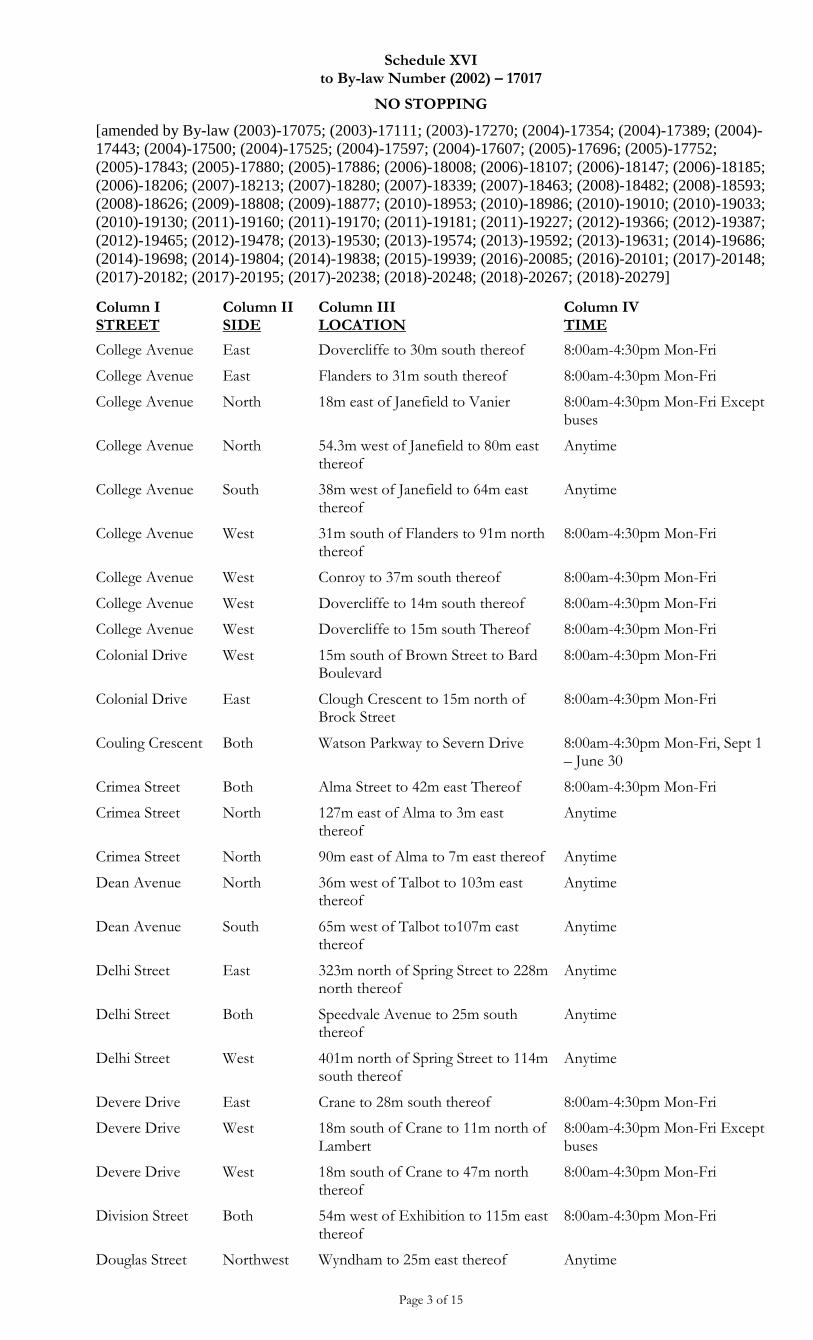
Schedule XVI to By-law Number (2002) – 17017
NO STOPPING
[amended by By-law (2003)-17075; (2003)-17111; (2003)-17270; (2004)-17354; (2004)-17389; (2004)-
17443; (2004)-17500; (2004)-17525; (2004)-17597; (2004)-17607; (2005)-17696; (2005)-17752;
(2005)-17843; (2005)-17880; (2005)-17886; (2006)-18008; (2006)-18107; (2006)-18147; (2006)-18185;
(2006)-18206; (2007)-18213; (2007)-18280; (2007)-18339; (2007)-18463; (2008)-18482; (2008)-18593;
(2008)-18626; (2009)-18808; (2009)-18877; (2010)-18953; (2010)-18986; (2010)-19010; (2010)-19033;
(2010)-19130; (2011)-19160; (2011)-19170; (2011)-19181; (2011)-19227; (2012)-19366; (2012)-19387;
(2012)-19465; (2012)-19478; (2013)-19530; (2013)-19574; (2013)-19592; (2013)-19631; (2014)-19686;
(2014)-19698; (2014)-19804; (2014)-19838; (2015)-19939; (2016)-20085; (2016)-20101; (2017)-20148;
(2017)-20182; (2017)-20195; (2017)-20238; (2018)-20248; (2018)-20267; (2018)-20279]
Page 3 of 15
Column I STREET
Column II SIDE
Column III LOCATION
Column IV TIME
College Avenue East Dovercliffe to 30m south thereof 8:00am-4:30pm Mon-Fri
College Avenue East Flanders to 31m south thereof 8:00am-4:30pm Mon-Fri
College Avenue North 18m east of Janefield to Vanier 8:00am-4:30pm Mon-Fri Except buses
College Avenue North 54.3m west of Janefield to 80m east thereof
Anytime
College Avenue South 38m west of Janefield to 64m east thereof
Anytime
College Avenue West 31m south of Flanders to 91m north thereof
8:00am-4:30pm Mon-Fri
College Avenue West Conroy to 37m south thereof 8:00am-4:30pm Mon-Fri
College Avenue West Dovercliffe to 14m south thereof 8:00am-4:30pm Mon-Fri
College Avenue West Dovercliffe to 15m south Thereof 8:00am-4:30pm Mon-Fri
Colonial Drive West 15m south of Brown Street to Bard Boulevard
8:00am-4:30pm Mon-Fri
Colonial Drive East Clough Crescent to 15m north of Brock Street
8:00am-4:30pm Mon-Fri
Couling Crescent Both Watson Parkway to Severn Drive 8:00am-4:30pm Mon-Fri, Sept 1 – June 30
Crimea Street Both Alma Street to 42m east Thereof 8:00am-4:30pm Mon-Fri
Crimea Street North 127m east of Alma to 3m east thereof
Anytime
Crimea Street North 90m east of Alma to 7m east thereof Anytime
Dean Avenue North 36m west of Talbot to 103m east thereof
Anytime
Dean Avenue South 65m west of Talbot to107m east thereof
Anytime
Delhi Street East 323m north of Spring Street to 228m north thereof
Anytime
Delhi Street Both Speedvale Avenue to 25m south thereof
Anytime
Delhi Street West 401m north of Spring Street to 114m south thereof
Anytime
Devere Drive East Crane to 28m south thereof 8:00am-4:30pm Mon-Fri
Devere Drive West 18m south of Crane to 11m north of Lambert
8:00am-4:30pm Mon-Fri Except buses
Devere Drive West 18m south of Crane to 47m north thereof
8:00am-4:30pm Mon-Fri
Division Street Both 54m west of Exhibition to 115m east thereof
8:00am-4:30pm Mon-Fri
Douglas Street Northwest Wyndham to 25m east thereof Anytime
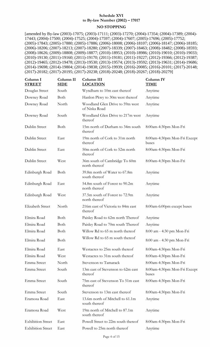
Schedule XVI to By-law Number (2002) – 17017
NO STOPPING
[amended by By-law (2003)-17075; (2003)-17111; (2003)-17270; (2004)-17354; (2004)-17389; (2004)-
17443; (2004)-17500; (2004)-17525; (2004)-17597; (2004)-17607; (2005)-17696; (2005)-17752;
(2005)-17843; (2005)-17880; (2005)-17886; (2006)-18008; (2006)-18107; (2006)-18147; (2006)-18185;
(2006)-18206; (2007)-18213; (2007)-18280; (2007)-18339; (2007)-18463; (2008)-18482; (2008)-18593;
(2008)-18626; (2009)-18808; (2009)-18877; (2010)-18953; (2010)-18986; (2010)-19010; (2010)-19033;
(2010)-19130; (2011)-19160; (2011)-19170; (2011)-19181; (2011)-19227; (2012)-19366; (2012)-19387;
(2012)-19465; (2012)-19478; (2013)-19530; (2013)-19574; (2013)-19592; (2013)-19631; (2014)-19686;
(2014)-19698; (2014)-19804; (2014)-19838; (2015)-19939; (2016)-20085; (2016)-20101; (2017)-20148;
(2017)-20182; (2017)-20195; (2017)-20238; (2018)-20248; (2018)-20267; (2018)-20279]
Page 4 of 15
Column I STREET
Column II SIDE
Column III LOCATION
Column IV TIME
Douglas Street South Wyndham to 10m east thereof Anytime
Downey Road Both Hanlon Pkwy to 30m west thereof Anytime
Downey Road North Woodland Glen Drive to 59m west of Niska Road
Anytime
Downey Road South Woodland Glen Drive to 217m west thereof
Anytime
Dublin Street Both 15m north of Durham to 34m south thereof
8:00am-4:30pm Mon-Fri
Dublin Street East 19m north of Cork to 31m north thereof
8:00am-4:30pm Mon-Fri Except buses
Dublin Street East 50m north of Cork to 52m north thereof
8:00am-4:30pm Mon-Fri
Dublin Street West 36m south of Cambridge To 60m north thereof
8:00am-4:30pm Mon-Fri
Edinburgh Road Both 39.8m north of Water to 67.8m south thereof
Anytime
Edinburgh Road East 54.8m south of Forest to 90.2m north thereof
Anytime
Edinburgh Road West 37.5m south of Forest to 72.9m north thereof
Anytime
Elizabeth Street North 216m east of Victoria to 84m east thereof
8:00am-6:00pm except buses
Elmira Road Both Paisley Road to 62m north Thereof Anytime
Elmira Road Both Paisley Road to 70m south Thereof Anytime
Elmira Road Both Willow Rd to 65 m north thereof 8:00 am - 4:30 pm Mon-Fri
Elmira Road Both Willow Rd to 65 m south thereof
8:00 am - 4:30 pm Mon-Fri
Elmira Road East Westacres to 25m south thereof 8:00am-4:30pm Mon-Fri
Elmira Road West Westacres to 31m south thereof 8:00am-4:30pm Mon-Fri
Emma Street North Stevenson to Tamarack 8:00am-4:30pm Mon-Fri
Emma Street South 13m east of Stevenson to 62m east thereof
8:00am-4:30pm Mon-Fri Except buses
Emma Street South 75m east of Stevenson To 51m east thereof
8:00am-4:30pm Mon-Fri
Emma Street South Stevenson to 13m east thereof 8:00am-4:30pm Mon-Fri
Eramosa Road East 13.6m north of Mitchell to 61.1m south thereof
Anytime
Eramosa Road West 19m north of Mitchell to 87.1m south thereof
Anytime
Exhibition Street East Powell Street to 22m south thereof 8:00am-4:30pm Mon-Fri
Exhibition Street East Powell to 25m north thereof Anytime
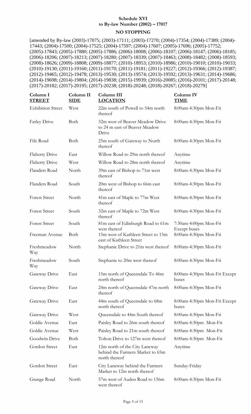
Schedule XVI to By-law Number (2002) – 17017
NO STOPPING
[amended by By-law (2003)-17075; (2003)-17111; (2003)-17270; (2004)-17354; (2004)-17389; (2004)-
17443; (2004)-17500; (2004)-17525; (2004)-17597; (2004)-17607; (2005)-17696; (2005)-17752;
(2005)-17843; (2005)-17880; (2005)-17886; (2006)-18008; (2006)-18107; (2006)-18147; (2006)-18185;
(2006)-18206; (2007)-18213; (2007)-18280; (2007)-18339; (2007)-18463; (2008)-18482; (2008)-18593;
(2008)-18626; (2009)-18808; (2009)-18877; (2010)-18953; (2010)-18986; (2010)-19010; (2010)-19033;
(2010)-19130; (2011)-19160; (2011)-19170; (2011)-19181; (2011)-19227; (2012)-19366; (2012)-19387;
(2012)-19465; (2012)-19478; (2013)-19530; (2013)-19574; (2013)-19592; (2013)-19631; (2014)-19686;
(2014)-19698; (2014)-19804; (2014)-19838; (2015)-19939; (2016)-20085; (2016)-20101; (2017)-20148;
(2017)-20182; (2017)-20195; (2017)-20238; (2018)-20248; (2018)-20267; (2018)-20279]
Page 5 of 15
Column I STREET
Column II SIDE
Column III LOCATION
Column IV TIME
Exhibition Street West 22m south of Powell to 54m north thereof
8:00am-4:30pm Mon-Fri
Farley Drive Both 32m west of Beaver Meadow Drive to 24 m east of Beaver Meadow Drive
8:00am-4:30pm Mon-Fri
Fife Road Both 25m south of Gateway to North thereof
8:00am-4:30pm Mon-Fri
Flaherty Drive East Willow Road to 29m north thereof Anytime
Flaherty Drive West Willow Road to 28m north thereof Anytime
Flanders Road North 39m east of Bishop to 71m west thereof
8:00am-4:30pm Mon-Fri
Flanders Road South 20m west of Bishop to 66m east thereof
8:00am-4:30pm Mon-Fri
Forest Street North 41m east of Maple to 77m West thereof
8:00am-4:30pm Mon-Fri
Forest Street South 32m east of Maple to 72m West thereof
8:00am-4:30pm Mon-Fri
Forest Street South 81m east of Edinburgh Road to 61m west thereof
7:30am-4:00pm Mon-Fri Except buses
Freeman Avenue Both 15m west of Kathleen Street to 15m east of Kathleen Street
8:00am-4:30pm Mon-Fri
Freshmeadow Way
North Stephanie Drive to 21m west thereof 8:00am-4:30pm Mon-Fri
Freshmeadow Way
South Stephanie to 20m west thereof 8:00am-4:30pm Mon-Fri
Gateway Drive East 15m north of Queensdale To 46m north thereof
8:00am-4:30pm Mon-Fri Except buses
Gateway Drive East 24m north of Queensdale 47m north thereof
8:00am-4:30pm Mon-Fri
Gateway Drive East 44m south of Queensdale to 68m north thereof
8:00am-4:30pm Mon-Fri Except buses
Gateway Drive West Queensdale to 44m South thereof 8:00am-4:30pm Mon-Fri
Goldie Avenue East Paisley Road to 26m south thereof 8:00am-4:30pm Mon-Fri
Goldie Avenue West Paisley Road to 21m south thereof 8:00am-4:30pm Mon-Fri
Goodwin Drive Both Tolton Drive to 127m west thereof 8:00am-4:30pm Mon-Fri
Gordon Street East 12m north of the City Laneway behind the Farmers Market to 65m north thereof
Anytime
Gordon Street East City Laneway behind the Farmers Market to 12m north thereof
Sunday-Friday
Grange Road North 57m west of Auden Road to 156m west thereof
8:00am-4:30pm Mon-Fri
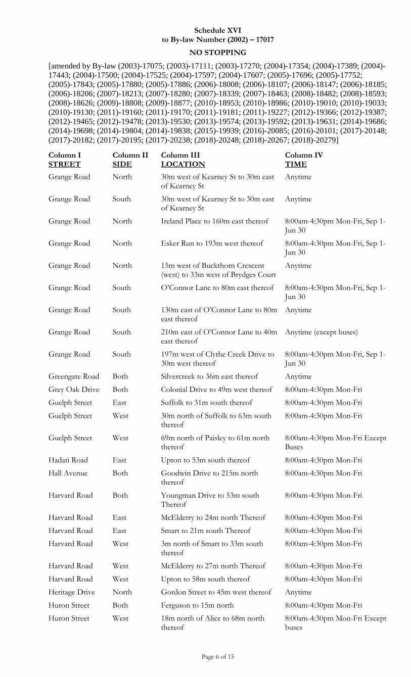
Schedule XVI to By-law Number (2002) – 17017
NO STOPPING
[amended by By-law (2003)-17075; (2003)-17111; (2003)-17270; (2004)-17354; (2004)-17389; (2004)-
17443; (2004)-17500; (2004)-17525; (2004)-17597; (2004)-17607; (2005)-17696; (2005)-17752;
(2005)-17843; (2005)-17880; (2005)-17886; (2006)-18008; (2006)-18107; (2006)-18147; (2006)-18185;
(2006)-18206; (2007)-18213; (2007)-18280; (2007)-18339; (2007)-18463; (2008)-18482; (2008)-18593;
(2008)-18626; (2009)-18808; (2009)-18877; (2010)-18953; (2010)-18986; (2010)-19010; (2010)-19033;
(2010)-19130; (2011)-19160; (2011)-19170; (2011)-19181; (2011)-19227; (2012)-19366; (2012)-19387;
(2012)-19465; (2012)-19478; (2013)-19530; (2013)-19574; (2013)-19592; (2013)-19631; (2014)-19686;
(2014)-19698; (2014)-19804; (2014)-19838; (2015)-19939; (2016)-20085; (2016)-20101; (2017)-20148;
(2017)-20182; (2017)-20195; (2017)-20238; (2018)-20248; (2018)-20267; (2018)-20279]
Page 6 of 15
Column I STREET
Column II SIDE
Column III LOCATION
Column IV TIME
Grange Road North 30m west of Kearney St to 30m east of Kearney St
Anytime
Grange Road South 30m west of Kearney St to 30m east of Kearney St
Anytime
Grange Road North Ireland Place to 160m east thereof 8:00am-4:30pm Mon-Fri, Sep 1-Jun 30
Grange Road North Esker Run to 193m west thereof 8:00am-4:30pm Mon-Fri, Sep 1-Jun 30
Grange Road North 15m west of Buckthorn Crescent (west) to 33m west of Brydges Court
Anytime
Grange Road South O’Connor Lane to 80m east thereof 8:00am-4:30pm Mon-Fri, Sep 1-Jun 30
Grange Road South 130m east of O’Connor Lane to 80m east thereof
Anytime
Grange Road South 210m east of O’Connor Lane to 40m east thereof
Anytime (except buses)
Grange Road South 197m west of Clythe Creek Drive to 30m west thereof
8:00am-4:30pm Mon-Fri, Sep 1-Jun 30
Greengate Road Both Silvercreek to 36m east thereof Anytime
Grey Oak Drive Both Colonial Drive to 49m west thereof 8:00am-4:30pm Mon-Fri
Guelph Street East Suffolk to 31m south thereof 8:00am-4:30pm Mon-Fri
Guelph Street West 30m north of Suffolk to 63m south thereof
8:00am-4:30pm Mon-Fri
Guelph Street West 69m north of Paisley to 61m north thereof
8:00am-4:30pm Mon-Fri Except Buses
Hadati Road East Upton to 53m south thereof 8:00am-4:30pm Mon-Fri
Hall Avenue Both Goodwin Drive to 215m north thereof
8:00am-4:30pm Mon-Fri
Harvard Road Both Youngman Drive to 53m south Thereof
8:00am-4:30pm Mon-Fri
Harvard Road East McElderry to 24m north Thereof 8:00am-4:30pm Mon-Fri
Harvard Road East Smart to 21m south Thereof 8:00am-4:30pm Mon-Fri
Harvard Road West 3m north of Smart to 33m south thereof
8:00am-4:30pm Mon-Fri
Harvard Road West McElderry to 27m north Thereof 8:00am-4:30pm Mon-Fri
Harvard Road West Upton to 58m south thereof 8:00am-4:30pm Mon-Fri
Heritage Drive North Gordon Street to 45m west thereof Anytime
Huron Street Both Ferguson to 15m north 8:00am-4:30pm Mon-Fri
Huron Street West 18m north of Alice to 68m north thereof
8:00am-4:30pm Mon-Fri Except buses
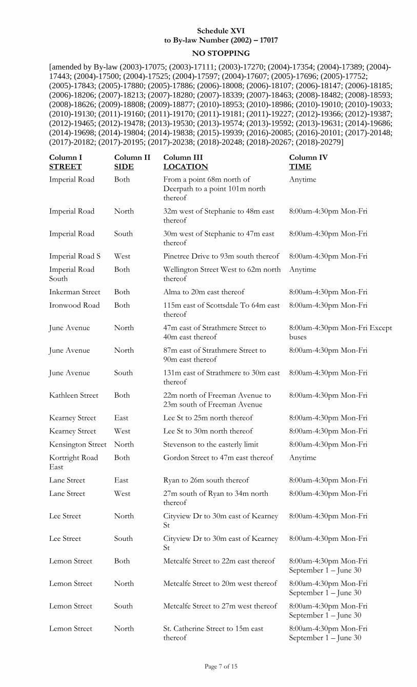
Schedule XVI to By-law Number (2002) – 17017
NO STOPPING
[amended by By-law (2003)-17075; (2003)-17111; (2003)-17270; (2004)-17354; (2004)-17389; (2004)-
17443; (2004)-17500; (2004)-17525; (2004)-17597; (2004)-17607; (2005)-17696; (2005)-17752;
(2005)-17843; (2005)-17880; (2005)-17886; (2006)-18008; (2006)-18107; (2006)-18147; (2006)-18185;
(2006)-18206; (2007)-18213; (2007)-18280; (2007)-18339; (2007)-18463; (2008)-18482; (2008)-18593;
(2008)-18626; (2009)-18808; (2009)-18877; (2010)-18953; (2010)-18986; (2010)-19010; (2010)-19033;
(2010)-19130; (2011)-19160; (2011)-19170; (2011)-19181; (2011)-19227; (2012)-19366; (2012)-19387;
(2012)-19465; (2012)-19478; (2013)-19530; (2013)-19574; (2013)-19592; (2013)-19631; (2014)-19686;
(2014)-19698; (2014)-19804; (2014)-19838; (2015)-19939; (2016)-20085; (2016)-20101; (2017)-20148;
(2017)-20182; (2017)-20195; (2017)-20238; (2018)-20248; (2018)-20267; (2018)-20279]
Page 7 of 15
Column I STREET
Column II SIDE
Column III LOCATION
Column IV TIME
Imperial Road Both From a point 68m north of Deerpath to a point 101m north thereof
Anytime
Imperial Road North 32m west of Stephanie to 48m east thereof
8:00am-4:30pm Mon-Fri
Imperial Road South 30m west of Stephanie to 47m east thereof
8:00am-4:30pm Mon-Fri
Imperial Road S West Pinetree Drive to 93m south thereof 8:00am-4:30pm Mon-Fri
Imperial Road South
Both Wellington Street West to 62m north thereof
Anytime
Inkerman Street Both Alma to 20m east thereof 8:00am-4:30pm Mon-Fri
Ironwood Road Both 115m east of Scottsdale To 64m east thereof
8:00am-4:30pm Mon-Fri
June Avenue North 47m east of Strathmere Street to 40m east thereof
8:00am-4:30pm Mon-Fri Except buses
June Avenue North 87m east of Strathmere Street to 90m east thereof
8:00am-4:30pm Mon-Fri
June Avenue South 131m east of Strathmere to 30m east thereof
8:00am-4:30pm Mon-Fri
Kathleen Street Both 22m north of Freeman Avenue to 23m south of Freeman Avenue
8:00am-4:30pm Mon-Fri
Kearney Street East Lee St to 25m north thereof 8:00am-4:30pm Mon-Fri
Kearney Street West Lee St to 30m north thereof 8:00am-4:30pm Mon-Fri
Kensington Street North Stevenson to the easterly limit 8:00am-4:30pm Mon-Fri
Kortright Road East
Both Gordon Street to 47m east thereof Anytime
Lane Street East Ryan to 26m south thereof 8:00am-4:30pm Mon-Fri
Lane Street West 27m south of Ryan to 34m north thereof
8:00am-4:30pm Mon-Fri
Lee Street North Cityview Dr to 30m east of Kearney St
8:00am-4:30pm Mon-Fri
Lee Street South Cityview Dr to 30m east of Kearney St
8:00am-4:30pm Mon-Fri
Lemon Street Both Metcalfe Street to 22m east thereof 8:00am-4:30pm Mon-Fri September 1 – June 30
Lemon Street North Metcalfe Street to 20m west thereof 8:00am-4:30pm Mon-Fri September 1 – June 30
Lemon Street South Metcalfe Street to 27m west thereof 8:00am-4:30pm Mon-Fri September 1 – June 30
Lemon Street North St. Catherine Street to 15m east thereof
8:00am-4:30pm Mon-Fri September 1 – June 30
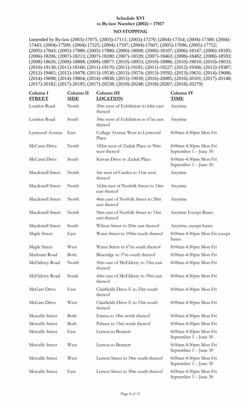
Schedule XVI to By-law Number (2002) – 17017
NO STOPPING
[amended by By-law (2003)-17075; (2003)-17111; (2003)-17270; (2004)-17354; (2004)-17389; (2004)-
17443; (2004)-17500; (2004)-17525; (2004)-17597; (2004)-17607; (2005)-17696; (2005)-17752;
(2005)-17843; (2005)-17880; (2005)-17886; (2006)-18008; (2006)-18107; (2006)-18147; (2006)-18185;
(2006)-18206; (2007)-18213; (2007)-18280; (2007)-18339; (2007)-18463; (2008)-18482; (2008)-18593;
(2008)-18626; (2009)-18808; (2009)-18877; (2010)-18953; (2010)-18986; (2010)-19010; (2010)-19033;
(2010)-19130; (2011)-19160; (2011)-19170; (2011)-19181; (2011)-19227; (2012)-19366; (2012)-19387;
(2012)-19465; (2012)-19478; (2013)-19530; (2013)-19574; (2013)-19592; (2013)-19631; (2014)-19686;
(2014)-19698; (2014)-19804; (2014)-19838; (2015)-19939; (2016)-20085; (2016)-20101; (2017)-20148;
(2017)-20182; (2017)-20195; (2017)-20238; (2018)-20248; (2018)-20267; (2018)-20279]
Page 8 of 15
Column I STREET
Column II SIDE
Column III LOCATION
Column IV TIME
London Road North 30m west of Exhibition to 64m east thereof
Anytime
London Road South 30m west of Exhibition to 67m east thereof
Anytime
Lynwood Avenue East College Avenue West to Lynwood Place
8:00am-4:30pm Mon-Fri
McCann Drive North 182m west of Zaduk Place to 90m west thereof
8:00am-4:30pm Mon-Fri September 1 – June 30
McCann Drive South Kirvan Drive to Zaduk Place 8:00am-4:30pm Mon-Fri September 1 – June 30
Macdonell Street North 5m west of Carden to 51m west thereof
Anytime
Macdonell Street North 162m east of Norfolk Street to 14m east thereof
Anytime
Macdonell Street North 46m east of Norfolk Street to 28m east thereof
Anytime
Macdonell Street North 96m east of Norfolk Street to 33m east thereof
Anytime Except Buses
Macdonell Street South Wilson Street to 20m east thereof Anytime, except buses
Maple Street East Water Street to 100m south thereof 8:00am-4:30pm Mon-Fri except buses
Maple Street West Water Street to 67m south thereof 8:00am-4:30pm Mon-Fri
Marksam Road Both Blueridge to 37m south thereof 8:00am-4:30pm Mon-Fri
McElderry Road North 50m east of McElderry to 33m east thereof
8:00am-4:30pm Mon-Fri
McElderry Road South 44m east of McElderry to 39m east thereof
8:00am-4:30pm Mon-Fri
McGarr Drive East Clairfields Drive E to 25m south thereof
8:00am-4:30pm Mon-Fri
McGarr Drive West Clairfields Drive E to 15m south thereof
8:00am-4:30pm Mon-Fri
Metcalfe Street Both Emma to 18m north thereof 8:00am-4:30pm Mon-Fri
Metcalfe Street Both Palmer to 15m north thereof 8:00am-4:30pm Mon-Fri
Metcalfe Street East Lemon to Bennett 8:00am-4:30pm Mon-Fri September 1 – June 30
Metcalfe Street West Lemon to Bennett 8:00am-4:30pm Mon-Fri September 1 – June 30
Metcalfe Street West Lemon Street to 34m south thereof 8:00am-4:30pm Mon-Fri September 1 – June 30
Metcalfe Street East Lemon Street to 30m south thereof 8:00am-4:30pm Mon-Fri September 1 – June 30
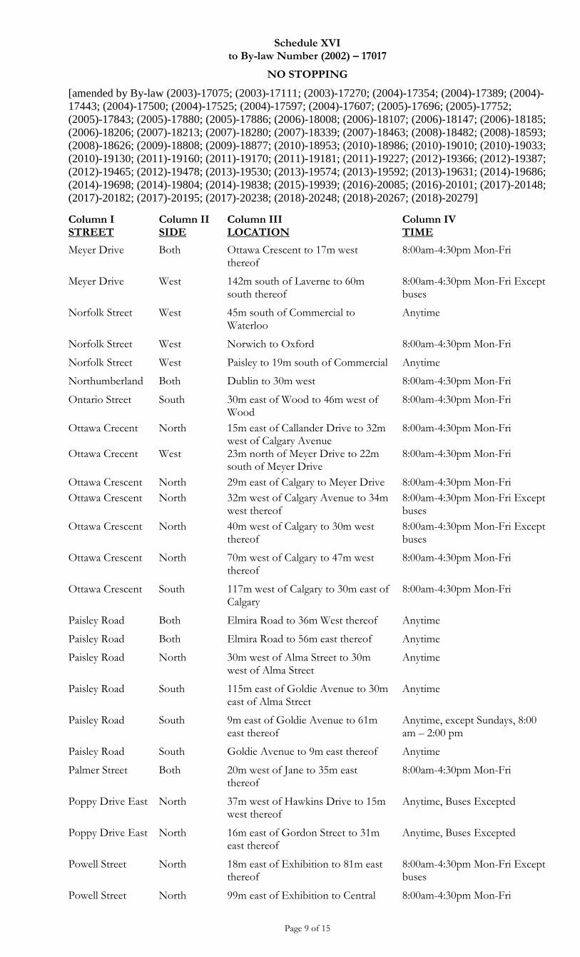
Schedule XVI to By-law Number (2002) – 17017
NO STOPPING
[amended by By-law (2003)-17075; (2003)-17111; (2003)-17270; (2004)-17354; (2004)-17389; (2004)-
17443; (2004)-17500; (2004)-17525; (2004)-17597; (2004)-17607; (2005)-17696; (2005)-17752;
(2005)-17843; (2005)-17880; (2005)-17886; (2006)-18008; (2006)-18107; (2006)-18147; (2006)-18185;
(2006)-18206; (2007)-18213; (2007)-18280; (2007)-18339; (2007)-18463; (2008)-18482; (2008)-18593;
(2008)-18626; (2009)-18808; (2009)-18877; (2010)-18953; (2010)-18986; (2010)-19010; (2010)-19033;
(2010)-19130; (2011)-19160; (2011)-19170; (2011)-19181; (2011)-19227; (2012)-19366; (2012)-19387;
(2012)-19465; (2012)-19478; (2013)-19530; (2013)-19574; (2013)-19592; (2013)-19631; (2014)-19686;
(2014)-19698; (2014)-19804; (2014)-19838; (2015)-19939; (2016)-20085; (2016)-20101; (2017)-20148;
(2017)-20182; (2017)-20195; (2017)-20238; (2018)-20248; (2018)-20267; (2018)-20279]
Page 9 of 15
Column I STREET
Column II SIDE
Column III LOCATION
Column IV TIME
Meyer Drive Both Ottawa Crescent to 17m west thereof
8:00am-4:30pm Mon-Fri
Meyer Drive West 142m south of Laverne to 60m south thereof
8:00am-4:30pm Mon-Fri Except buses
Norfolk Street West 45m south of Commercial to Waterloo
Anytime
Norfolk Street West Norwich to Oxford 8:00am-4:30pm Mon-Fri
Norfolk Street West Paisley to 19m south of Commercial Anytime
Northumberland Both Dublin to 30m west 8:00am-4:30pm Mon-Fri
Ontario Street South 30m east of Wood to 46m west of Wood
8:00am-4:30pm Mon-Fri
Ottawa Crecent North 15m east of Callander Drive to 32m west of Calgary Avenue
8:00am-4:30pm Mon-Fri
Ottawa Crecent West 23m north of Meyer Drive to 22m south of Meyer Drive
8:00am-4:30pm Mon-Fri
Ottawa Crescent North 29m east of Calgary to Meyer Drive 8:00am-4:30pm Mon-Fri
Ottawa Crescent North 32m west of Calgary Avenue to 34m west thereof
8:00am-4:30pm Mon-Fri Except buses
Ottawa Crescent North 40m west of Calgary to 30m west thereof
8:00am-4:30pm Mon-Fri Except buses
Ottawa Crescent North 70m west of Calgary to 47m west thereof
8:00am-4:30pm Mon-Fri
Ottawa Crescent South 117m west of Calgary to 30m east of Calgary
8:00am-4:30pm Mon-Fri
Paisley Road Both Elmira Road to 36m West thereof Anytime
Paisley Road Both Elmira Road to 56m east thereof Anytime
Paisley Road North 30m west of Alma Street to 30m west of Alma Street
Anytime
Paisley Road South 115m east of Goldie Avenue to 30m east of Alma Street
Anytime
Paisley Road South 9m east of Goldie Avenue to 61m east thereof
Anytime, except Sundays, 8:00 am – 2:00 pm
Paisley Road South Goldie Avenue to 9m east thereof Anytime
Palmer Street Both 20m west of Jane to 35m east thereof
8:00am-4:30pm Mon-Fri
Poppy Drive East North 37m west of Hawkins Drive to 15m west thereof
Anytime, Buses Excepted
Poppy Drive East North 16m east of Gordon Street to 31m east thereof
Anytime, Buses Excepted
Powell Street North 18m east of Exhibition to 81m east thereof
8:00am-4:30pm Mon-Fri Except buses
Powell Street North 99m east of Exhibition to Central 8:00am-4:30pm Mon-Fri
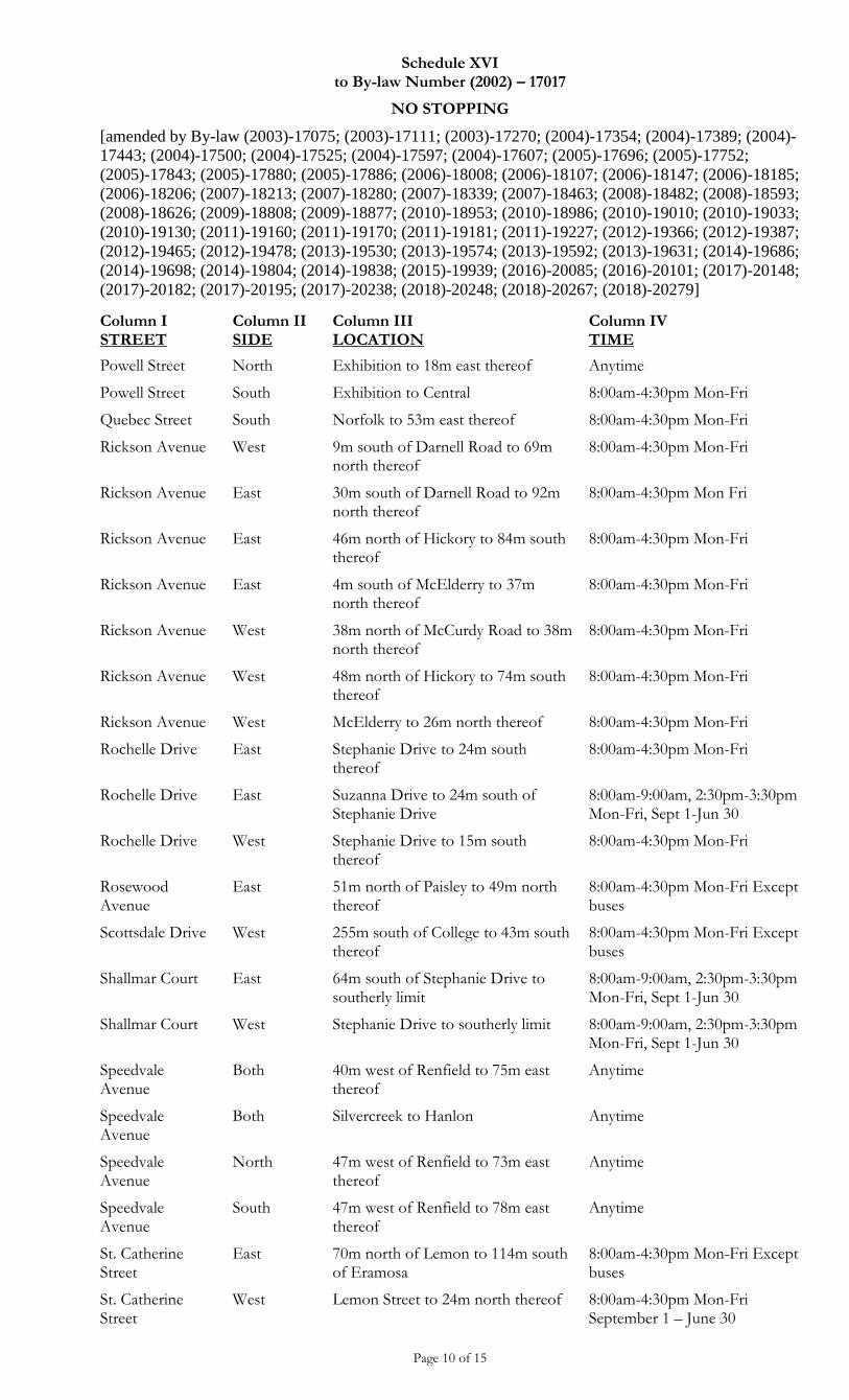
Schedule XVI to By-law Number (2002) – 17017
NO STOPPING
[amended by By-law (2003)-17075; (2003)-17111; (2003)-17270; (2004)-17354; (2004)-17389; (2004)-
17443; (2004)-17500; (2004)-17525; (2004)-17597; (2004)-17607; (2005)-17696; (2005)-17752;
(2005)-17843; (2005)-17880; (2005)-17886; (2006)-18008; (2006)-18107; (2006)-18147; (2006)-18185;
(2006)-18206; (2007)-18213; (2007)-18280; (2007)-18339; (2007)-18463; (2008)-18482; (2008)-18593;
(2008)-18626; (2009)-18808; (2009)-18877; (2010)-18953; (2010)-18986; (2010)-19010; (2010)-19033;
(2010)-19130; (2011)-19160; (2011)-19170; (2011)-19181; (2011)-19227; (2012)-19366; (2012)-19387;
(2012)-19465; (2012)-19478; (2013)-19530; (2013)-19574; (2013)-19592; (2013)-19631; (2014)-19686;
(2014)-19698; (2014)-19804; (2014)-19838; (2015)-19939; (2016)-20085; (2016)-20101; (2017)-20148;
(2017)-20182; (2017)-20195; (2017)-20238; (2018)-20248; (2018)-20267; (2018)-20279]
Page 10 of 15
Column I STREET
Column II SIDE
Column III LOCATION
Column IV TIME
Powell Street North Exhibition to 18m east thereof Anytime
Powell Street South Exhibition to Central 8:00am-4:30pm Mon-Fri
Quebec Street South Norfolk to 53m east thereof 8:00am-4:30pm Mon-Fri
Rickson Avenue West 9m south of Darnell Road to 69m north thereof
8:00am-4:30pm Mon-Fri
Rickson Avenue East 30m south of Darnell Road to 92m north thereof
8:00am-4:30pm Mon Fri
Rickson Avenue East 46m north of Hickory to 84m south thereof
8:00am-4:30pm Mon-Fri
Rickson Avenue East 4m south of McElderry to 37m north thereof
8:00am-4:30pm Mon-Fri
Rickson Avenue West 38m north of McCurdy Road to 38m north thereof
8:00am-4:30pm Mon-Fri
Rickson Avenue West 48m north of Hickory to 74m south thereof
8:00am-4:30pm Mon-Fri
Rickson Avenue West McElderry to 26m north thereof 8:00am-4:30pm Mon-Fri
Rochelle Drive East Stephanie Drive to 24m south thereof
8:00am-4:30pm Mon-Fri
Rochelle Drive East Suzanna Drive to 24m south of Stephanie Drive
8:00am-9:00am, 2:30pm-3:30pm Mon-Fri, Sept 1-Jun 30
Rochelle Drive West Stephanie Drive to 15m south thereof
8:00am-4:30pm Mon-Fri
Rosewood Avenue
East 51m north of Paisley to 49m north thereof
8:00am-4:30pm Mon-Fri Except buses
Scottsdale Drive West 255m south of College to 43m south thereof
8:00am-4:30pm Mon-Fri Except buses
Shallmar Court East 64m south of Stephanie Drive to southerly limit
8:00am-9:00am, 2:30pm-3:30pm Mon-Fri, Sept 1-Jun 30
Shallmar Court West Stephanie Drive to southerly limit 8:00am-9:00am, 2:30pm-3:30pm Mon-Fri, Sept 1-Jun 30
Speedvale Avenue
Both 40m west of Renfield to 75m east thereof
Anytime
Speedvale Avenue
Both Silvercreek to Hanlon Anytime
Speedvale Avenue
North 47m west of Renfield to 73m east thereof
Anytime
Speedvale Avenue
South 47m west of Renfield to 78m east thereof
Anytime
St. Catherine Street
East 70m north of Lemon to 114m south of Eramosa
8:00am-4:30pm Mon-Fri Except buses
St. Catherine Street
West Lemon Street to 24m north thereof 8:00am-4:30pm Mon-Fri September 1 – June 30
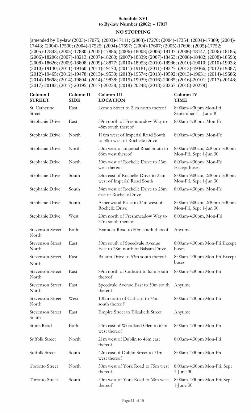
Schedule XVI to By-law Number (2002) – 17017
NO STOPPING
[amended by By-law (2003)-17075; (2003)-17111; (2003)-17270; (2004)-17354; (2004)-17389; (2004)-
17443; (2004)-17500; (2004)-17525; (2004)-17597; (2004)-17607; (2005)-17696; (2005)-17752;
(2005)-17843; (2005)-17880; (2005)-17886; (2006)-18008; (2006)-18107; (2006)-18147; (2006)-18185;
(2006)-18206; (2007)-18213; (2007)-18280; (2007)-18339; (2007)-18463; (2008)-18482; (2008)-18593;
(2008)-18626; (2009)-18808; (2009)-18877; (2010)-18953; (2010)-18986; (2010)-19010; (2010)-19033;
(2010)-19130; (2011)-19160; (2011)-19170; (2011)-19181; (2011)-19227; (2012)-19366; (2012)-19387;
(2012)-19465; (2012)-19478; (2013)-19530; (2013)-19574; (2013)-19592; (2013)-19631; (2014)-19686;
(2014)-19698; (2014)-19804; (2014)-19838; (2015)-19939; (2016)-20085; (2016)-20101; (2017)-20148;
(2017)-20182; (2017)-20195; (2017)-20238; (2018)-20248; (2018)-20267; (2018)-20279]
Page 11 of 15
Column I STREET
Column II SIDE
Column III LOCATION
Column IV TIME
St. Catherine Street
East Lemon Street to 21m north thereof 8:00am-4:30pm Mon-Fri September 1 – June 30
Stephanie Drive East 39m north of Freshmeadow Way to 48m south thereof
8:00am-4:30pm Mon-Fri
Stephanie Drive North 116m west of Imperial Road South to 30m west of Rochelle Drive
8:00am-4:30pm Mon-Fri
Stephanie Drive North 30m west of Imperial Road South to 86m west thereof
8:00am-9:00am, 2:30pm-3:30pm Mon-Fri, Sept 1-Jun 30
Stephanie Drive North 30m west of Rochelle Drive to 23m west thereof
8:00am-4:30pm Mon-Fri Except buses
Stephanie Drive South 28m east of Rochelle Drive to 25m west of Imperial Road South
8:00am-9:00am, 2:30pm-3:30pm Mon-Fri, Sept 1-Jun 30
Stephanie Drive South 34m west of Rochelle Drive to 28m east of Rochelle Drive
8:00am-4:30pm Mon-Fri
Stephanie Drive South Aspenwood Place to 34m west of Rochelle Drive
8:00am-9:00am, 2:30pm-3:30pm Mon-Fri, Sept 1-Jun 30
Stephanie Drive West 20m north of Freshmeadow Way to 37m south thereof
8:00am-4:30pm, Mon-Fri
Stevenson Street North
Both Eramosa Road to 50m south thereof Anytime
Stevenson Street North
East 50m south of Speedvale Avenue East to 28m north of Balsam Drive
8:00am-4:30pm Mon-Fri Except buses
Stevenson Street
North
East Balsam Drive to 53m south thereof 8:00am-4:30pm Mon-Fri Except buses
Stevenson Street North
East 89m north of Cathcart to 65m south thereof
8:00am-4:30pm Mon-Fri
Stevenson Street North
East Speedvale Avenue East to 50m south thereof
Anytime
Stevenson Street North
West 100m north of Cathcart to 76m south thereof
8:00am-4:30pm Mon-Fri
Stevenson Street South
East Empire Street to Elizabeth Street Anytime
Stone Road Both 34m east of Woodland Glen to 63m west thereof
8:00am-4:30pm Mon-Fri
Suffolk Street North 21m west of Dublin to 48m east thereof
8:00am-4:30pm Mon-Fri
Suffolk Street South 42m east of Dublin Street to 71m west thereof
8:00am-4:30pm Mon-Fri
Toronto Street North 30m west of York Road to 75m west thereof
8:00am-4:30pm Mon-Fri; Sept 1-June 30
Toronto Street South 30m west of York Road to 60m west thereof
8:00am-4:30pm Mon-Fri; Sept 1-June 30
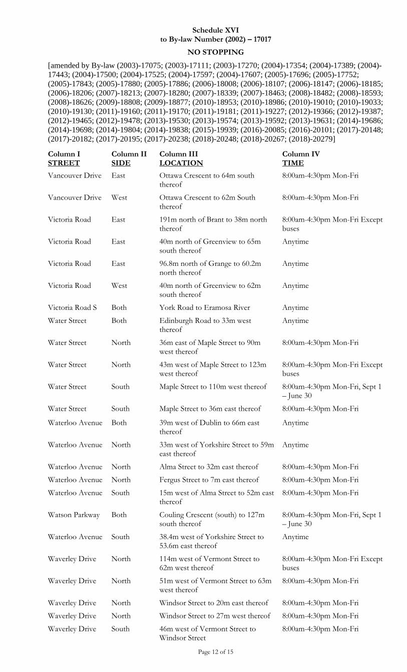
Schedule XVI to By-law Number (2002) – 17017
NO STOPPING
[amended by By-law (2003)-17075; (2003)-17111; (2003)-17270; (2004)-17354; (2004)-17389; (2004)-
17443; (2004)-17500; (2004)-17525; (2004)-17597; (2004)-17607; (2005)-17696; (2005)-17752;
(2005)-17843; (2005)-17880; (2005)-17886; (2006)-18008; (2006)-18107; (2006)-18147; (2006)-18185;
(2006)-18206; (2007)-18213; (2007)-18280; (2007)-18339; (2007)-18463; (2008)-18482; (2008)-18593;
(2008)-18626; (2009)-18808; (2009)-18877; (2010)-18953; (2010)-18986; (2010)-19010; (2010)-19033;
(2010)-19130; (2011)-19160; (2011)-19170; (2011)-19181; (2011)-19227; (2012)-19366; (2012)-19387;
(2012)-19465; (2012)-19478; (2013)-19530; (2013)-19574; (2013)-19592; (2013)-19631; (2014)-19686;
(2014)-19698; (2014)-19804; (2014)-19838; (2015)-19939; (2016)-20085; (2016)-20101; (2017)-20148;
(2017)-20182; (2017)-20195; (2017)-20238; (2018)-20248; (2018)-20267; (2018)-20279]
Page 12 of 15
Column I STREET
Column II SIDE
Column III LOCATION
Column IV TIME
Vancouver Drive East Ottawa Crescent to 64m south thereof
8:00am-4:30pm Mon-Fri
Vancouver Drive West Ottawa Crescent to 62m South thereof
8:00am-4:30pm Mon-Fri
Victoria Road East 191m north of Brant to 38m north thereof
8:00am-4:30pm Mon-Fri Except buses
Victoria Road East 40m north of Greenview to 65m south thereof
Anytime
Victoria Road East 96.8m north of Grange to 60.2m north thereof
Anytime
Victoria Road West 40m north of Greenview to 62m south thereof
Anytime
Victoria Road S Both York Road to Eramosa River Anytime
Water Street Both Edinburgh Road to 33m west thereof
Anytime
Water Street North 36m east of Maple Street to 90m west thereof
8:00am-4:30pm Mon-Fri
Water Street North 43m west of Maple Street to 123m west thereof
8:00am-4:30pm Mon-Fri Except buses
Water Street South Maple Street to 110m west thereof 8:00am-4:30pm Mon-Fri, Sept 1 – June 30
Water Street South Maple Street to 36m east thereof 8:00am-4:30pm Mon-Fri
Waterloo Avenue Both 39m west of Dublin to 66m east thereof
Anytime
Waterloo Avenue North 33m west of Yorkshire Street to 59m east thereof
Anytime
Waterloo Avenue North Alma Street to 32m east thereof 8:00am-4:30pm Mon-Fri
Waterloo Avenue North Fergus Street to 7m east thereof 8:00am-4:30pm Mon-Fri
Waterloo Avenue South 15m west of Alma Street to 52m east thereof
8:00am-4:30pm Mon-Fri
Watson Parkway Both Couling Crescent (south) to 127m south thereof
8:00am-4:30pm Mon-Fri, Sept 1 – June 30
Waterloo Avenue South 38.4m west of Yorkshire Street to 53.6m east thereof
Anytime
Waverley Drive North 114m west of Vermont Street to 62m west thereof
8:00am-4:30pm Mon-Fri Except buses
Waverley Drive North 51m west of Vermont Street to 63m west thereof
8:00am-4:30pm Mon-Fri
Waverley Drive North Windsor Street to 20m east thereof 8:00am-4:30pm Mon-Fri
Waverley Drive North Windsor Street to 27m west thereof 8:00am-4:30pm Mon-Fri
Waverley Drive South 46m west of Vermont Street to Windsor Street
8:00am-4:30pm Mon-Fri
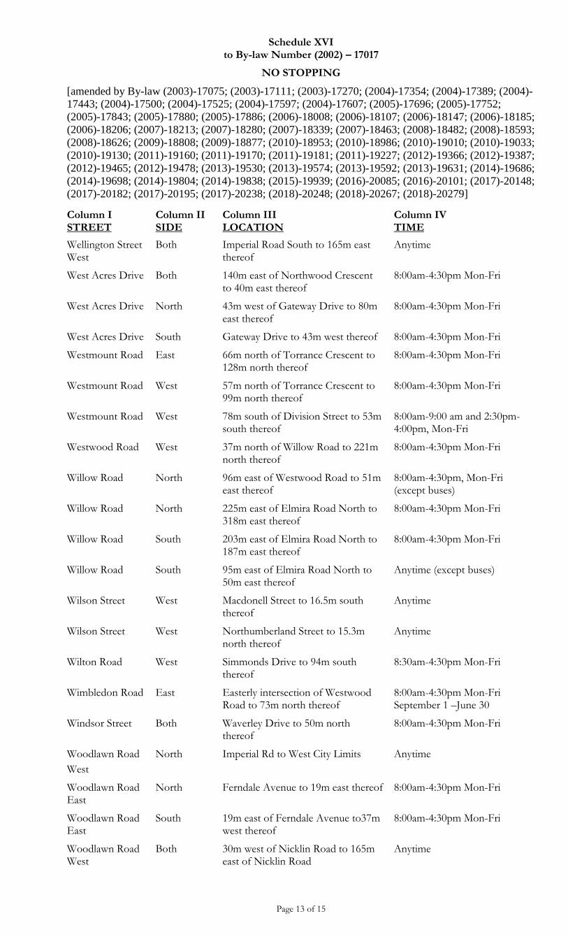
Schedule XVI to By-law Number (2002) – 17017
NO STOPPING
[amended by By-law (2003)-17075; (2003)-17111; (2003)-17270; (2004)-17354; (2004)-17389; (2004)-
17443; (2004)-17500; (2004)-17525; (2004)-17597; (2004)-17607; (2005)-17696; (2005)-17752;
(2005)-17843; (2005)-17880; (2005)-17886; (2006)-18008; (2006)-18107; (2006)-18147; (2006)-18185;
(2006)-18206; (2007)-18213; (2007)-18280; (2007)-18339; (2007)-18463; (2008)-18482; (2008)-18593;
(2008)-18626; (2009)-18808; (2009)-18877; (2010)-18953; (2010)-18986; (2010)-19010; (2010)-19033;
(2010)-19130; (2011)-19160; (2011)-19170; (2011)-19181; (2011)-19227; (2012)-19366; (2012)-19387;
(2012)-19465; (2012)-19478; (2013)-19530; (2013)-19574; (2013)-19592; (2013)-19631; (2014)-19686;
(2014)-19698; (2014)-19804; (2014)-19838; (2015)-19939; (2016)-20085; (2016)-20101; (2017)-20148;
(2017)-20182; (2017)-20195; (2017)-20238; (2018)-20248; (2018)-20267; (2018)-20279]
Page 13 of 15
Column I STREET
Column II SIDE
Column III LOCATION
Column IV TIME
Wellington Street West
Both Imperial Road South to 165m east thereof
Anytime
West Acres Drive Both 140m east of Northwood Crescent to 40m east thereof
8:00am-4:30pm Mon-Fri
West Acres Drive North 43m west of Gateway Drive to 80m east thereof
8:00am-4:30pm Mon-Fri
West Acres Drive South Gateway Drive to 43m west thereof 8:00am-4:30pm Mon-Fri
Westmount Road East 66m north of Torrance Crescent to 128m north thereof
8:00am-4:30pm Mon-Fri
Westmount Road West 57m north of Torrance Crescent to 99m north thereof
8:00am-4:30pm Mon-Fri
Westmount Road West 78m south of Division Street to 53m south thereof
8:00am-9:00 am and 2:30pm-4:00pm, Mon-Fri
Westwood Road West 37m north of Willow Road to 221m north thereof
8:00am-4:30pm Mon-Fri
Willow Road North 96m east of Westwood Road to 51m east thereof
8:00am-4:30pm, Mon-Fri (except buses)
Willow Road North 225m east of Elmira Road North to 318m east thereof
8:00am-4:30pm Mon-Fri
Willow Road South 203m east of Elmira Road North to 187m east thereof
8:00am-4:30pm Mon-Fri
Willow Road South 95m east of Elmira Road North to 50m east thereof
Anytime (except buses)
Wilson Street West Macdonell Street to 16.5m south thereof
Anytime
Wilson Street West Northumberland Street to 15.3m north thereof
Anytime
Wilton Road West Simmonds Drive to 94m south thereof
8:30am-4:30pm Mon-Fri
Wimbledon Road East Easterly intersection of Westwood Road to 73m north thereof
8:00am-4:30pm Mon-Fri September 1 –June 30
Windsor Street Both Waverley Drive to 50m north thereof
8:00am-4:30pm Mon-Fri
Woodlawn Road
West
North Imperial Rd to West City Limits Anytime
Woodlawn Road East
North Ferndale Avenue to 19m east thereof 8:00am-4:30pm Mon-Fri
Woodlawn Road East
South 19m east of Ferndale Avenue to37m west thereof
8:00am-4:30pm Mon-Fri
Woodlawn Road West
Both 30m west of Nicklin Road to 165m east of Nicklin Road
Anytime
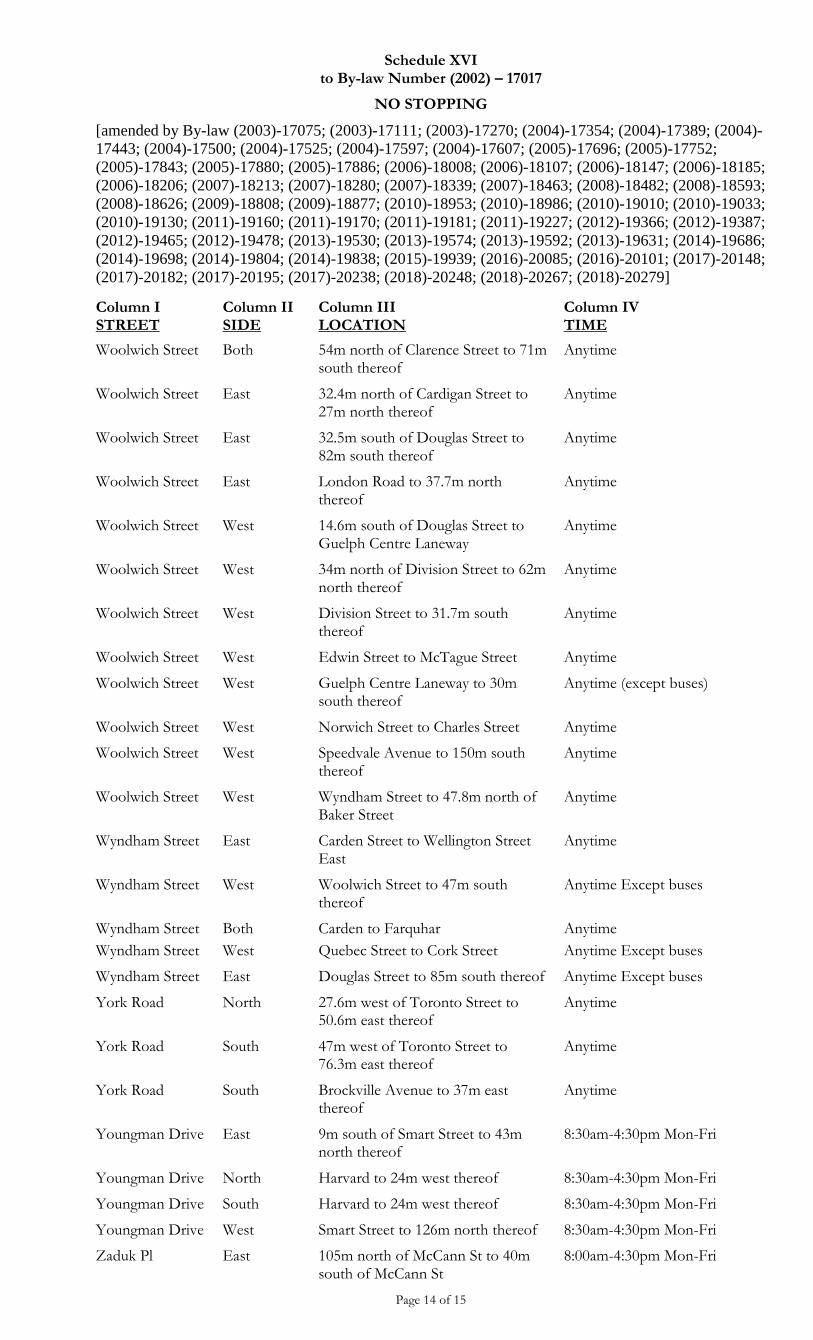
Schedule XVI to By-law Number (2002) – 17017
NO STOPPING
[amended by By-law (2003)-17075; (2003)-17111; (2003)-17270; (2004)-17354; (2004)-17389; (2004)-
17443; (2004)-17500; (2004)-17525; (2004)-17597; (2004)-17607; (2005)-17696; (2005)-17752;
(2005)-17843; (2005)-17880; (2005)-17886; (2006)-18008; (2006)-18107; (2006)-18147; (2006)-18185;
(2006)-18206; (2007)-18213; (2007)-18280; (2007)-18339; (2007)-18463; (2008)-18482; (2008)-18593;
(2008)-18626; (2009)-18808; (2009)-18877; (2010)-18953; (2010)-18986; (2010)-19010; (2010)-19033;
(2010)-19130; (2011)-19160; (2011)-19170; (2011)-19181; (2011)-19227; (2012)-19366; (2012)-19387;
(2012)-19465; (2012)-19478; (2013)-19530; (2013)-19574; (2013)-19592; (2013)-19631; (2014)-19686;
(2014)-19698; (2014)-19804; (2014)-19838; (2015)-19939; (2016)-20085; (2016)-20101; (2017)-20148;
(2017)-20182; (2017)-20195; (2017)-20238; (2018)-20248; (2018)-20267; (2018)-20279]
Page 14 of 15
Column I STREET
Column II SIDE
Column III LOCATION
Column IV TIME
Woolwich Street Both 54m north of Clarence Street to 71m south thereof
Anytime
Woolwich Street East 32.4m north of Cardigan Street to 27m north thereof
Anytime
Woolwich Street East 32.5m south of Douglas Street to 82m south thereof
Anytime
Woolwich Street East London Road to 37.7m north thereof
Anytime
Woolwich Street West 14.6m south of Douglas Street to Guelph Centre Laneway
Anytime
Woolwich Street West 34m north of Division Street to 62m north thereof
Anytime
Woolwich Street West Division Street to 31.7m south thereof
Anytime
Woolwich Street West Edwin Street to McTague Street Anytime
Woolwich Street West Guelph Centre Laneway to 30m south thereof
Anytime (except buses)
Woolwich Street West Norwich Street to Charles Street Anytime
Woolwich Street West Speedvale Avenue to 150m south thereof
Anytime
Woolwich Street West Wyndham Street to 47.8m north of Baker Street
Anytime
Wyndham Street East Carden Street to Wellington Street East
Anytime
Wyndham Street West Woolwich Street to 47m south thereof
Anytime Except buses
Wyndham Street
Wyndham Street
Both
West
Carden to Farquhar
Quebec Street to Cork Street
Anytime
Anytime Except buses
Wyndham Street East Douglas Street to 85m south thereof Anytime Except buses
York Road North 27.6m west of Toronto Street to 50.6m east thereof
Anytime
York Road South 47m west of Toronto Street to 76.3m east thereof
Anytime
York Road South Brockville Avenue to 37m east thereof
Anytime
Youngman Drive East 9m south of Smart Street to 43m north thereof
8:30am-4:30pm Mon-Fri
Youngman Drive North Harvard to 24m west thereof 8:30am-4:30pm Mon-Fri
Youngman Drive South Harvard to 24m west thereof 8:30am-4:30pm Mon-Fri
Youngman Drive West Smart Street to 126m north thereof 8:30am-4:30pm Mon-Fri
Zaduk Pl East 105m north of McCann St to 40m south of McCann St
8:00am-4:30pm Mon-Fri
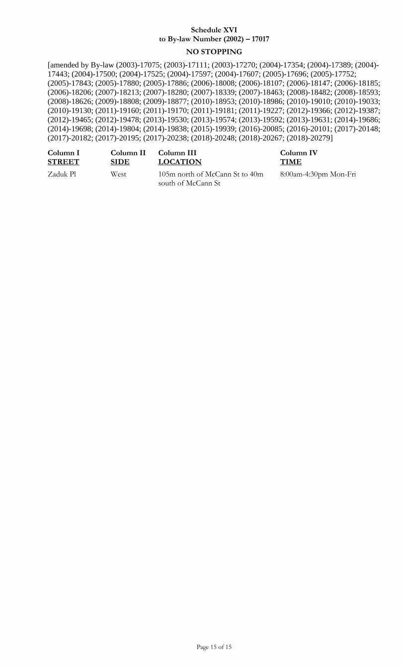
Schedule XVI to By-law Number (2002) – 17017
NO STOPPING
[amended by By-law (2003)-17075; (2003)-17111; (2003)-17270; (2004)-17354; (2004)-17389; (2004)-
17443; (2004)-17500; (2004)-17525; (2004)-17597; (2004)-17607; (2005)-17696; (2005)-17752;
(2005)-17843; (2005)-17880; (2005)-17886; (2006)-18008; (2006)-18107; (2006)-18147; (2006)-18185;
(2006)-18206; (2007)-18213; (2007)-18280; (2007)-18339; (2007)-18463; (2008)-18482; (2008)-18593;
(2008)-18626; (2009)-18808; (2009)-18877; (2010)-18953; (2010)-18986; (2010)-19010; (2010)-19033;
(2010)-19130; (2011)-19160; (2011)-19170; (2011)-19181; (2011)-19227; (2012)-19366; (2012)-19387;
(2012)-19465; (2012)-19478; (2013)-19530; (2013)-19574; (2013)-19592; (2013)-19631; (2014)-19686;
(2014)-19698; (2014)-19804; (2014)-19838; (2015)-19939; (2016)-20085; (2016)-20101; (2017)-20148;
(2017)-20182; (2017)-20195; (2017)-20238; (2018)-20248; (2018)-20267; (2018)-20279]
Page 15 of 15
Column I STREET
Column II SIDE
Column III LOCATION
Column IV TIME
Zaduk Pl West 105m north of McCann St to 40m south of McCann St
8:00am-4:30pm Mon-Fri
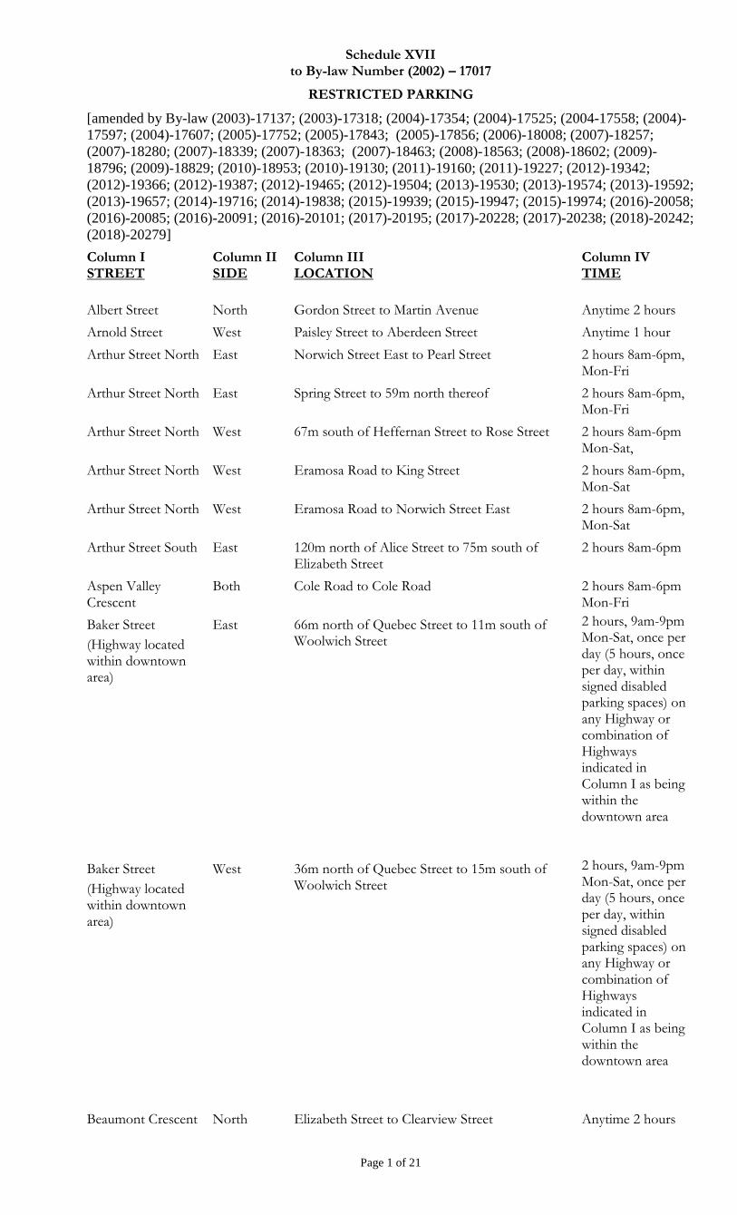
Schedule XVII to By-law Number (2002) – 17017
RESTRICTED PARKING
[amended by By-law (2003)-17137; (2003)-17318; (2004)-17354; (2004)-17525; (2004-17558; (2004)-
17597; (2004)-17607; (2005)-17752; (2005)-17843; (2005)-17856; (2006)-18008; (2007)-18257;
(2007)-18280; (2007)-18339; (2007)-18363; (2007)-18463; (2008)-18563; (2008)-18602; (2009)-
18796; (2009)-18829; (2010)-18953; (2010)-19130; (2011)-19160; (2011)-19227; (2012)-19342;
(2012)-19366; (2012)-19387; (2012)-19465; (2012)-19504; (2013)-19530; (2013)-19574; (2013)-19592;
(2013)-19657; (2014)-19716; (2014)-19838; (2015)-19939; (2015)-19947; (2015)-19974; (2016)-20058;
(2016)-20085; (2016)-20091; (2016)-20101; (2017)-20195; (2017)-20228; (2017)-20238; (2018)-20242;
(2018)-20279]
Page 1 of 21
Column I STREET
Column II SIDE
Column III LOCATION
Column IV TIME
Albert Street North Gordon Street to Martin Avenue Anytime 2 hours
Arnold Street West Paisley Street to Aberdeen Street Anytime 1 hour
Arthur Street North East Norwich Street East to Pearl Street 2 hours 8am-6pm, Mon-Fri
Arthur Street North East Spring Street to 59m north thereof 2 hours 8am-6pm, Mon-Fri
Arthur Street North West 67m south of Heffernan Street to Rose Street 2 hours 8am-6pm Mon-Sat,
Arthur Street North West Eramosa Road to King Street 2 hours 8am-6pm, Mon-Sat
Arthur Street North West Eramosa Road to Norwich Street East 2 hours 8am-6pm, Mon-Sat
Arthur Street South East 120m north of Alice Street to 75m south of Elizabeth Street
2 hours 8am-6pm
Aspen Valley Crescent
Both Cole Road to Cole Road 2 hours 8am-6pm Mon-Fri
Baker Street
(Highway located within downtown area)
East 66m north of Quebec Street to 11m south of Woolwich Street
2 hours, 9am-9pm Mon-Sat, once per day (5 hours, once per day, within signed disabled parking spaces) on any Highway or combination of Highways indicated in Column I as being within the downtown area
Baker Street
(Highway located within downtown area)
West 36m north of Quebec Street to 15m south of Woolwich Street
2 hours, 9am-9pm Mon-Sat, once per day (5 hours, once per day, within signed disabled parking spaces) on any Highway or combination of Highways indicated in Column I as being within the downtown area
Beaumont Crescent North Elizabeth Street to Clearview Street Anytime 2 hours
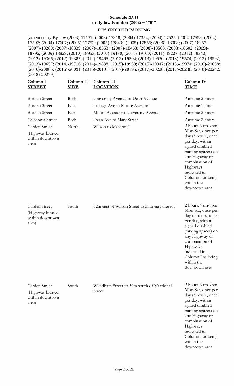
Schedule XVII to By-law Number (2002) – 17017
RESTRICTED PARKING
[amended by By-law (2003)-17137; (2003)-17318; (2004)-17354; (2004)-17525; (2004-17558; (2004)-
17597; (2004)-17607; (2005)-17752; (2005)-17843; (2005)-17856; (2006)-18008; (2007)-18257;
(2007)-18280; (2007)-18339; (2007)-18363; (2007)-18463; (2008)-18563; (2008)-18602; (2009)-
18796; (2009)-18829; (2010)-18953; (2010)-19130; (2011)-19160; (2011)-19227; (2012)-19342;
(2012)-19366; (2012)-19387; (2012)-19465; (2012)-19504; (2013)-19530; (2013)-19574; (2013)-19592;
(2013)-19657; (2014)-19716; (2014)-19838; (2015)-19939; (2015)-19947; (2015)-19974; (2016)-20058;
(2016)-20085; (2016)-20091; (2016)-20101; (2017)-20195; (2017)-20228; (2017)-20238; (2018)-20242;
(2018)-20279]
Page 2 of 21
Column I STREET
Column II SIDE
Column III LOCATION
Column IV TIME
Borden Street Both University Avenue to Dean Avenue Anytime 2 hours
Borden Street East College Ave to Moore Avenue Anytime 1 hour
Borden Street East Moore Avenue to University Avenue Anytime 2 hours
Caledonia Street Both Dean Ave to Mary Street Anytime 2 hours
Carden Street
(Highway located within downtown area)
North Wilson to Macdonell
2 hours, 9am-9pm Mon-Sat, once per day (5 hours, once per day, within signed disabled parking spaces) on any Highway or combination of Highways indicated in Column I as being within the downtown area
Carden Street
(Highway located within downtown area)
South 32m east of Wilson Street to 35m east thereof 2 hours, 9am-9pm Mon-Sat, once per day (5 hours, once per day, within signed disabled parking spaces) on any Highway or combination of Highways indicated in Column I as being within the downtown area
Carden Street
(Highway located within downtown area)
South Wyndham Street to 30m south of Macdonell Street
2 hours, 9am-9pm Mon-Sat, once per day (5 hours, once per day, within signed disabled parking spaces) on any Highway or combination of Highways indicated in Column I as being within the downtown area
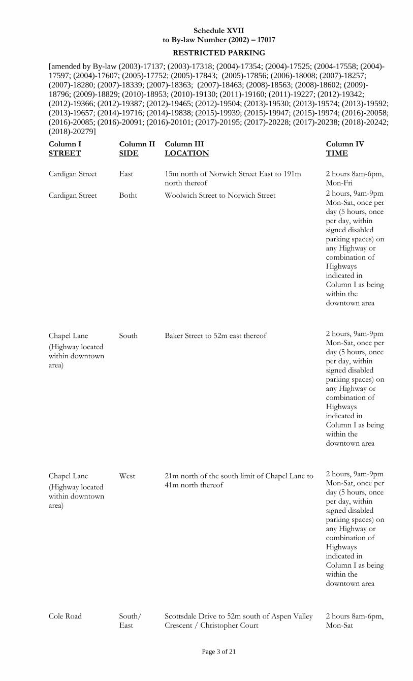
Schedule XVII to By-law Number (2002) – 17017
RESTRICTED PARKING
[amended by By-law (2003)-17137; (2003)-17318; (2004)-17354; (2004)-17525; (2004-17558; (2004)-
17597; (2004)-17607; (2005)-17752; (2005)-17843; (2005)-17856; (2006)-18008; (2007)-18257;
(2007)-18280; (2007)-18339; (2007)-18363; (2007)-18463; (2008)-18563; (2008)-18602; (2009)-
18796; (2009)-18829; (2010)-18953; (2010)-19130; (2011)-19160; (2011)-19227; (2012)-19342;
(2012)-19366; (2012)-19387; (2012)-19465; (2012)-19504; (2013)-19530; (2013)-19574; (2013)-19592;
(2013)-19657; (2014)-19716; (2014)-19838; (2015)-19939; (2015)-19947; (2015)-19974; (2016)-20058;
(2016)-20085; (2016)-20091; (2016)-20101; (2017)-20195; (2017)-20228; (2017)-20238; (2018)-20242;
(2018)-20279]
Page 3 of 21
Column I STREET
Column II SIDE
Column III LOCATION
Column IV TIME
Cardigan Street East 15m north of Norwich Street East to 191m north thereof
2 hours 8am-6pm, Mon-Fri
Cardigan Street Botht Woolwich Street to Norwich Street 2 hours, 9am-9pm Mon-Sat, once per day (5 hours, once per day, within signed disabled parking spaces) on any Highway or combination of Highways indicated in Column I as being within the downtown area
Chapel Lane
(Highway located within downtown area)
South Baker Street to 52m east thereof
2 hours, 9am-9pm Mon-Sat, once per day (5 hours, once per day, within signed disabled parking spaces) on any Highway or combination of Highways indicated in Column I as being within the downtown area
Chapel Lane
(Highway located within downtown area)
West 21m north of the south limit of Chapel Lane to 41m north thereof
2 hours, 9am-9pm Mon-Sat, once per day (5 hours, once per day, within signed disabled parking spaces) on any Highway or combination of Highways indicated in Column I as being within the downtown area
Cole Road South/ East
Scottsdale Drive to 52m south of Aspen Valley Crescent / Christopher Court
2 hours 8am-6pm, Mon-Sat
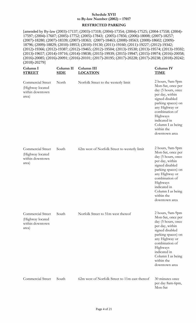
Schedule XVII to By-law Number (2002) – 17017
RESTRICTED PARKING
[amended by By-law (2003)-17137; (2003)-17318; (2004)-17354; (2004)-17525; (2004-17558; (2004)-
17597; (2004)-17607; (2005)-17752; (2005)-17843; (2005)-17856; (2006)-18008; (2007)-18257;
(2007)-18280; (2007)-18339; (2007)-18363; (2007)-18463; (2008)-18563; (2008)-18602; (2009)-
18796; (2009)-18829; (2010)-18953; (2010)-19130; (2011)-19160; (2011)-19227; (2012)-19342;
(2012)-19366; (2012)-19387; (2012)-19465; (2012)-19504; (2013)-19530; (2013)-19574; (2013)-19592;
(2013)-19657; (2014)-19716; (2014)-19838; (2015)-19939; (2015)-19947; (2015)-19974; (2016)-20058;
(2016)-20085; (2016)-20091; (2016)-20101; (2017)-20195; (2017)-20228; (2017)-20238; (2018)-20242;
(2018)-20279]
Page 4 of 21
Column I STREET
Column II SIDE
Column III LOCATION
Column IV TIME
Commercial Street
(Highway located within downtown area)
North Norfolk Street to the westerly limit 2 hours, 9am-9pm Mon-Sat, once per day (5 hours, once per day, within signed disabled parking spaces) on any Highway or combination of Highways indicated in Column I as being within the downtown area
Commercial Street
(Highway located within downtown area)
South 62m west of Norfolk Street to westerly limit 2 hours, 9am-9pm Mon-Sat, once per day (5 hours, once per day, within signed disabled parking spaces) on any Highway or combination of Highways indicated in Column I as being within the downtown area
Commercial Street
(Highway located within downtown area)
South Norfolk Street to 51m west thereof 2 hours, 9am-9pm Mon-Sat, once per day (5 hours, once per day, within signed disabled parking spaces) on any Highway or combination of Highways indicated in Column I as being within the downtown area
Commercial Street South 62m west of Norfolk Street to 11m east thereof 30 minutes once per day 8am-6pm, Mon-Sat
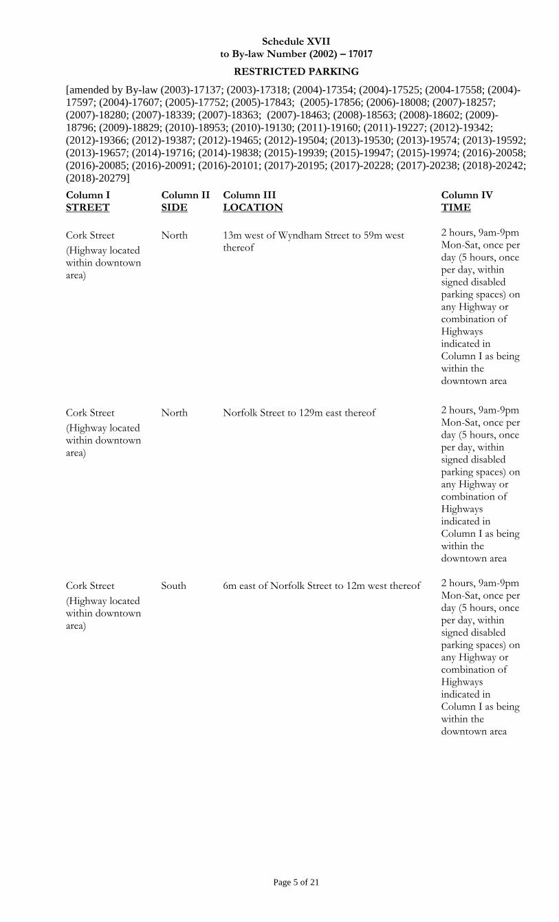
Schedule XVII to By-law Number (2002) – 17017
RESTRICTED PARKING
[amended by By-law (2003)-17137; (2003)-17318; (2004)-17354; (2004)-17525; (2004-17558; (2004)-
17597; (2004)-17607; (2005)-17752; (2005)-17843; (2005)-17856; (2006)-18008; (2007)-18257;
(2007)-18280; (2007)-18339; (2007)-18363; (2007)-18463; (2008)-18563; (2008)-18602; (2009)-
18796; (2009)-18829; (2010)-18953; (2010)-19130; (2011)-19160; (2011)-19227; (2012)-19342;
(2012)-19366; (2012)-19387; (2012)-19465; (2012)-19504; (2013)-19530; (2013)-19574; (2013)-19592;
(2013)-19657; (2014)-19716; (2014)-19838; (2015)-19939; (2015)-19947; (2015)-19974; (2016)-20058;
(2016)-20085; (2016)-20091; (2016)-20101; (2017)-20195; (2017)-20228; (2017)-20238; (2018)-20242;
(2018)-20279]
Page 5 of 21
Column I STREET
Column II SIDE
Column III LOCATION
Column IV TIME
Cork Street
(Highway located within downtown area)
North 13m west of Wyndham Street to 59m west thereof
2 hours, 9am-9pm Mon-Sat, once per day (5 hours, once per day, within signed disabled parking spaces) on any Highway or combination of Highways indicated in Column I as being within the downtown area
Cork Street
(Highway located within downtown area)
North Norfolk Street to 129m east thereof 2 hours, 9am-9pm Mon-Sat, once per day (5 hours, once per day, within signed disabled parking spaces) on any Highway or combination of Highways indicated in Column I as being within the downtown area
Cork Street
(Highway located within downtown area)
South 6m east of Norfolk Street to 12m west thereof 2 hours, 9am-9pm Mon-Sat, once per day (5 hours, once per day, within signed disabled parking spaces) on any Highway or combination of Highways indicated in Column I as being within the downtown area
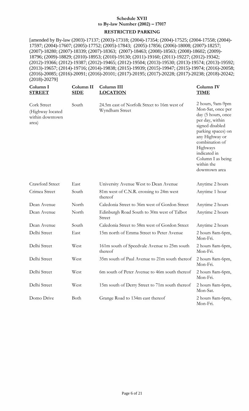
Schedule XVII to By-law Number (2002) – 17017
RESTRICTED PARKING
[amended by By-law (2003)-17137; (2003)-17318; (2004)-17354; (2004)-17525; (2004-17558; (2004)-
17597; (2004)-17607; (2005)-17752; (2005)-17843; (2005)-17856; (2006)-18008; (2007)-18257;
(2007)-18280; (2007)-18339; (2007)-18363; (2007)-18463; (2008)-18563; (2008)-18602; (2009)-
18796; (2009)-18829; (2010)-18953; (2010)-19130; (2011)-19160; (2011)-19227; (2012)-19342;
(2012)-19366; (2012)-19387; (2012)-19465; (2012)-19504; (2013)-19530; (2013)-19574; (2013)-19592;
(2013)-19657; (2014)-19716; (2014)-19838; (2015)-19939; (2015)-19947; (2015)-19974; (2016)-20058;
(2016)-20085; (2016)-20091; (2016)-20101; (2017)-20195; (2017)-20228; (2017)-20238; (2018)-20242;
(2018)-20279]
Page 6 of 21
Column I STREET
Column II SIDE
Column III LOCATION
Column IV TIME
Cork Street
(Highway located within downtown area)
South 24.5m east of Norfolk Street to 16m west of Wyndham Street
2 hours, 9am-9pm Mon-Sat, once per day (5 hours, once per day, within signed disabled parking spaces) on any Highway or combination of Highways indicated in Column I as being within the downtown area
Crawford Street East University Avenue West to Dean Avenue Anytime 2 hours
Crimea Street South 81m west of C.N.R. crossing to 24m west thereof
Anytime 1 hour
Dean Avenue North Caledonia Street to 36m west of Gordon Street Anytime 2 hours
Dean Avenue North Edinburgh Road South to 30m west of Talbot Street
Anytime 2 hours
Dean Avenue South Caledonia Street to 58m west of Gordon Street Anytime 2 hours
Delhi Street East 15m north of Emma Street to Peter Avenue 2 hours 8am-6pm, Mon-Fri.
Delhi Street West 161m south of Speedvale Avenue to 25m south thereof
2 hours 8am-6pm, Mon-Fri.
Delhi Street West 35m south of Paul Avenue to 21m south thereof 2 hours 8am-6pm, Mon-Fri.
Delhi Street West 6m south of Peter Avenue to 46m south thereof 2 hours 8am-6pm, Mon-Fri.
Delhi Street West 15m south of Derry Street to 71m south thereof 2 hours 8am-6pm, Mon-Sat.
Domo Drive Both Grange Road to 134m east thereof 2 hours 8am-6pm, Mon-Fri.

Schedule XVII to By-law Number (2002) – 17017
RESTRICTED PARKING
[amended by By-law (2003)-17137; (2003)-17318; (2004)-17354; (2004)-17525; (2004-17558; (2004)-
17597; (2004)-17607; (2005)-17752; (2005)-17843; (2005)-17856; (2006)-18008; (2007)-18257;
(2007)-18280; (2007)-18339; (2007)-18363; (2007)-18463; (2008)-18563; (2008)-18602; (2009)-
18796; (2009)-18829; (2010)-18953; (2010)-19130; (2011)-19160; (2011)-19227; (2012)-19342;
(2012)-19366; (2012)-19387; (2012)-19465; (2012)-19504; (2013)-19530; (2013)-19574; (2013)-19592;
(2013)-19657; (2014)-19716; (2014)-19838; (2015)-19939; (2015)-19947; (2015)-19974; (2016)-20058;
(2016)-20085; (2016)-20091; (2016)-20101; (2017)-20195; (2017)-20228; (2017)-20238; (2018)-20242;
(2018)-20279]
Page 7 of 21
Column I STREET
Column II SIDE
Column III LOCATION
Column IV TIME
Douglas Street
(Highway located within downtown area)
East 19m north of Wyndham Street to 43m north thereof
2 hours, 9am-9pm Mon-Sat, once per day (5 hours, once per day, within signed disabled parking spaces) on any Highway or combination of Highways indicated in Column I as being within the downtown area
Douglas Street
(Highway located within downtown area)
East 80m north of Wyndham Street to 12m north thereof
2 hours, 9am-9pm Mon-Sat, once per day (5 hours, once per day, within signed disabled parking spaces) on any Highway or combination of Highways indicated in Column I as being within the downtown area
Douglas Street
(Highway located within downtown area)
East Woolwich Street to 50.5m south thereof 2 hours, 9am-9pm Mon-Sat, once per day (5 hours, once per day, within signed disabled parking spaces) on any Highway or combination of Highways indicated in Column I as being within the downtown area
Dublin Street South East Waterloo Avenue to Kent Street 2 hours 8am-6pm, Mon-Fri
Duke Street West 27m north of Alice Street to 78m north thereof 2 hours 8am-6pm, Mon-Fri
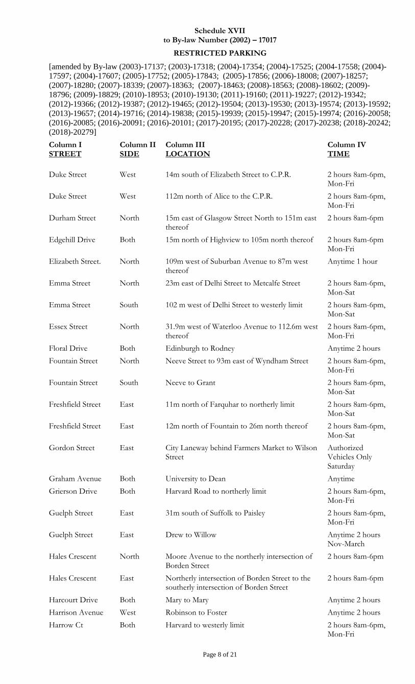
Schedule XVII to By-law Number (2002) – 17017
RESTRICTED PARKING
[amended by By-law (2003)-17137; (2003)-17318; (2004)-17354; (2004)-17525; (2004-17558; (2004)-
17597; (2004)-17607; (2005)-17752; (2005)-17843; (2005)-17856; (2006)-18008; (2007)-18257;
(2007)-18280; (2007)-18339; (2007)-18363; (2007)-18463; (2008)-18563; (2008)-18602; (2009)-
18796; (2009)-18829; (2010)-18953; (2010)-19130; (2011)-19160; (2011)-19227; (2012)-19342;
(2012)-19366; (2012)-19387; (2012)-19465; (2012)-19504; (2013)-19530; (2013)-19574; (2013)-19592;
(2013)-19657; (2014)-19716; (2014)-19838; (2015)-19939; (2015)-19947; (2015)-19974; (2016)-20058;
(2016)-20085; (2016)-20091; (2016)-20101; (2017)-20195; (2017)-20228; (2017)-20238; (2018)-20242;
(2018)-20279]
Page 8 of 21
Column I STREET
Column II SIDE
Column III LOCATION
Column IV TIME
Duke Street West 14m south of Elizabeth Street to C.P.R. 2 hours 8am-6pm, Mon-Fri
Duke Street West 112m north of Alice to the C.P.R. 2 hours 8am-6pm, Mon-Fri
Durham Street North 15m east of Glasgow Street North to 151m east thereof
2 hours 8am-6pm
Edgehill Drive Both 15m north of Highview to 105m north thereof 2 hours 8am-6pm Mon-Fri
Elizabeth Street. North 109m west of Suburban Avenue to 87m west thereof
Anytime 1 hour
Emma Street North 23m east of Delhi Street to Metcalfe Street 2 hours 8am-6pm, Mon-Sat
Emma Street South 102 m west of Delhi Street to westerly limit 2 hours 8am-6pm, Mon-Sat
Essex Street North 31.9m west of Waterloo Avenue to 112.6m west thereof
2 hours 8am-6pm, Mon-Fri
Floral Drive Both Edinburgh to Rodney Anytime 2 hours
Fountain Street North Neeve Street to 93m east of Wyndham Street 2 hours 8am-6pm, Mon-Fri
Fountain Street South Neeve to Grant 2 hours 8am-6pm, Mon-Sat
Freshfield Street East 11m north of Farquhar to northerly limit 2 hours 8am-6pm, Mon-Sat
Freshfield Street East 12m north of Fountain to 26m north thereof 2 hours 8am-6pm, Mon-Sat
Gordon Street East City Laneway behind Farmers Market to Wilson Street
Authorized Vehicles Only Saturday
Graham Avenue Both University to Dean Anytime
Grierson Drive Both Harvard Road to northerly limit 2 hours 8am-6pm, Mon-Fri
Guelph Street East 31m south of Suffolk to Paisley 2 hours 8am-6pm, Mon-Fri
Guelph Street East Drew to Willow Anytime 2 hours Nov-March
Hales Crescent North Moore Avenue to the northerly intersection of Borden Street
2 hours 8am-6pm
Hales Crescent East Northerly intersection of Borden Street to the southerly intersection of Borden Street
2 hours 8am-6pm
Harcourt Drive Both Mary to Mary Anytime 2 hours
Harrison Avenue West Robinson to Foster Anytime 2 hours
Harrow Ct Both Harvard to westerly limit 2 hours 8am-6pm, Mon-Fri
Schedule XVII to By-law Number (2002) – 17017
RESTRICTED PARKING
[amended by By-law (2003)-17137; (2003)-17318; (2004)-17354; (2004)-17525; (2004-17558; (2004)-
17597; (2004)-17607; (2005)-17752; (2005)-17843; (2005)-17856; (2006)-18008; (2007)-18257;
(2007)-18280; (2007)-18339; (2007)-18363; (2007)-18463; (2008)-18563; (2008)-18602; (2009)-
18796; (2009)-18829; (2010)-18953; (2010)-19130; (2011)-19160; (2011)-19227; (2012)-19342;
(2012)-19366; (2012)-19387; (2012)-19465; (2012)-19504; (2013)-19530; (2013)-19574; (2013)-19592;
(2013)-19657; (2014)-19716; (2014)-19838; (2015)-19939; (2015)-19947; (2015)-19974; (2016)-20058;
(2016)-20085; (2016)-20091; (2016)-20101; (2017)-20195; (2017)-20228; (2017)-20238; (2018)-20242;
(2018)-20279]
Page 9 of 21
Column I STREET
Column II SIDE
Column III LOCATION
Column IV TIME
Harvard Road North 380m west of Gordon Street to 19m north of Youngman Drive
2 hours, 8am-6pm, Mon-Fri
Heather Avenue Both Floral to Rodney Anytime 2 hours
Highview Place Both 15m east of Edgehill to 15m west of Kathleen Anytime
Highview Place Both 15m east of Westmount to 15m west of Edgehill Anytime
Hooper Street East York to 188m south thereof 2 hours 8am-6pm, Mon-Sat
Howitt Street South Margaret to 40m west thereof Anytime 2 hours
Huron Street East Ferguson to Alice 2 hours 8am-6pm, Mon-Sat
Huron Street West 58m north of Alice to 40m north thereof 2 hours 8am-6pm, Mon-Sat
Huron Street West 58m north of Alice to 60m north thereof 2 hours 8am-6pm, Mon-Sat
Industrial Street East York to Elizabeth 1 hour 8am-6pm
Johnston Street East Alice to northerly limit 2 hours 8am-6pm, Mon-Sat
Kimberley Drive Both 9m west of Westmount to Glebeholme 2 hours 8am-6pm, Mon-Sat
Kortright Road East
Both 47m east of Gordon Street to Huntington Place 2 hours 8am-6pm, Mon-Fri
Lockyer Road Both Edinburgh to westerly limit Anytime 2 hours
Macdonell Street
(Highway located within downtown area)
North Norfolk Street to 46m east of Wyndham Street 2 hours, 9am-9pm Mon-Sat, once per day (5 hours, once per day, within signed disabled parking spaces) on any Highway or combination of Highways indicated in Column I as being within the downtown area
Schedule XVII to By-law Number (2002) – 17017
RESTRICTED PARKING
[amended by By-law (2003)-17137; (2003)-17318; (2004)-17354; (2004)-17525; (2004-17558; (2004)-
17597; (2004)-17607; (2005)-17752; (2005)-17843; (2005)-17856; (2006)-18008; (2007)-18257;
(2007)-18280; (2007)-18339; (2007)-18363; (2007)-18463; (2008)-18563; (2008)-18602; (2009)-
18796; (2009)-18829; (2010)-18953; (2010)-19130; (2011)-19160; (2011)-19227; (2012)-19342;
(2012)-19366; (2012)-19387; (2012)-19465; (2012)-19504; (2013)-19530; (2013)-19574; (2013)-19592;
(2013)-19657; (2014)-19716; (2014)-19838; (2015)-19939; (2015)-19947; (2015)-19974; (2016)-20058;
(2016)-20085; (2016)-20091; (2016)-20101; (2017)-20195; (2017)-20228; (2017)-20238; (2018)-20242;
(2018)-20279]
Page 10 of 21
Column I STREET
Column II SIDE
Column III LOCATION
Column IV TIME
Macdonell Street
(Highway located within downtown area)
North 74m east of Norfolk Street to 18.35m east thereof
2 hours, 9am-9pm Mon-Sat, once per day (5 hours, once per day, within signed disabled parking spaces) on any Highway or combination of Highways indicated in Column I as being within the downtown area
Macdonell Street
(Highway located within downtown area)
North 129m east of Norfolk Street to 33m east thereof 2 hours, 9am-9pm Mon-Sat, once per day (5 hours, once per day, within signed disabled parking spaces) on any Highway or combination of Highways indicated in Column I as being within the downtown area
Macdonell Street
(Highway located within downtown area)
North 176m east of Norfolk Street to 16m east thereof 2 hours, 9am-9pm Mon-Sat, once per day (5 hours, once per day, within signed disabled parking spaces) on any Highway or combination of Highways indicated in Column I as being within the downtown area
Macdonell Street
(Highway located within downtown area)
North Wyndham Street to 205m east thereof 2 hours, 9am-9pm Mon-Sat, once per day (5 hours, once per day, within signed disabled parking spaces) on any Highway or combination of Highways indicated in Column I as being within the downtown area
Schedule XVII to By-law Number (2002) – 17017
RESTRICTED PARKING
[amended by By-law (2003)-17137; (2003)-17318; (2004)-17354; (2004)-17525; (2004-17558; (2004)-
17597; (2004)-17607; (2005)-17752; (2005)-17843; (2005)-17856; (2006)-18008; (2007)-18257;
(2007)-18280; (2007)-18339; (2007)-18363; (2007)-18463; (2008)-18563; (2008)-18602; (2009)-
18796; (2009)-18829; (2010)-18953; (2010)-19130; (2011)-19160; (2011)-19227; (2012)-19342;
(2012)-19366; (2012)-19387; (2012)-19465; (2012)-19504; (2013)-19530; (2013)-19574; (2013)-19592;
(2013)-19657; (2014)-19716; (2014)-19838; (2015)-19939; (2015)-19947; (2015)-19974; (2016)-20058;
(2016)-20085; (2016)-20091; (2016)-20101; (2017)-20195; (2017)-20228; (2017)-20238; (2018)-20242;
(2018)-20279]
Page 11 of 21
Column I STREET
Column II SIDE
Column III LOCATION
Column IV TIME
Macdonell Street
(Highway located within downtown area)
South 20m east of Wilson Street to 158m east of Wyndham Street
2 hours, 9am-9pm Mon-Sat, once per day (5 hours, once per day, within signed disabled parking spaces) on any Highway or combination of Highways indicated in Column I as being within the downtown area
Maple Street Both Forest to westerly limit Anytime 2 hours
Marlborough Road East Emma Street to Speedvale Avenue East 2 hours 8am-6pm, Mon-Fri, Apr.1-Oct.31
Marlborough Road West Speedvale Avenue East to Emma Street 2 hours 8am-6pm, Mon-Fri
Mary Street Both Forest to Caledonia Anytime 2 hours
Mary Street North 60 metres south of Caledonia to the southerly intersection at Harcourt
Anytime 2 hours
Mary Street South Caledonia to Harcourt Anytime 2 hours
Mayfield Avenue Both Colborn to easterly limit Anytime 2 hours
McTague Street North 23m west of Woolwich To Exhibition Street 2 hours 8am-6pm, Mon-Sat
Metcalfe Street Both Eramosa Road to Pleasant Road Anytime 2 hours
Mont Street South 15m west of Woolwich to 14m west thereof Anytime 2 hours
Mont Street South Exhibition to 61m west of Woolwich Anytime 2 hours
Morris Street West Alice to York Anytime 2 hours
Mutual Street Both University to Dean Anytime 2 hours
New Street North Arthur to Queen 2 hours 8am-6pm, Mon-Sat
Neeve Street West 12m north of Surrey Street East to 13m north thereof
2 hours, 8am-6pm, Mon-Fri
Norfolk Street West Liverpool to Norwich 2 hours 8am-6pm,
Schedule XVII to By-law Number (2002) – 17017
RESTRICTED PARKING
[amended by By-law (2003)-17137; (2003)-17318; (2004)-17354; (2004)-17525; (2004-17558; (2004)-
17597; (2004)-17607; (2005)-17752; (2005)-17843; (2005)-17856; (2006)-18008; (2007)-18257;
(2007)-18280; (2007)-18339; (2007)-18363; (2007)-18463; (2008)-18563; (2008)-18602; (2009)-
18796; (2009)-18829; (2010)-18953; (2010)-19130; (2011)-19160; (2011)-19227; (2012)-19342;
(2012)-19366; (2012)-19387; (2012)-19465; (2012)-19504; (2013)-19530; (2013)-19574; (2013)-19592;
(2013)-19657; (2014)-19716; (2014)-19838; (2015)-19939; (2015)-19947; (2015)-19974; (2016)-20058;
(2016)-20085; (2016)-20091; (2016)-20101; (2017)-20195; (2017)-20228; (2017)-20238; (2018)-20242;
(2018)-20279]
Page 12 of 21
Column I STREET
Column II SIDE
Column III LOCATION
Column IV TIME
Norfolk Street
(Highway located within downtown area)
East 14.8m north of Cork Street to Quebec Street
2 hours, 9am-9pm Mon-Sat, once per day (5 hours, once per day, within signed disabled parking spaces) on any Highway or combination of Highways indicated in Column I as being within the downtown area
Norfolk Street
(Highway located within downtown area)
West 27m south of Commercial Street to 33m south thereof
2 hours, 9am-9pm Mon-Sat, once per day (5 hours, once per day, within signed disabled parking spaces) on any Highway or combination of Highways indicated in Column I as being within the downtown area
Norfolk Street East 24m south of Suffolk Street to 52m southerly 2 hours, 8am-8pm
Norfolk Street East 83m south of Suffolk Street to 121m southerly 2 hours, 8am-8pm
North Street West 34m north of Suffolk Street West to 51m north thereof
2 hours 8am-6pm, Mon-Fri
North Street West 91m north of Suffolk Street West to 153m north thereof
2 hours 8am-6pm, Mon-Fri
North Street East 34m north of Suffolk Street West to 63m north thereof
2 hours 8am-6pm, Mon-Fri
North Street East 96m north of Suffolk Street West to 138m north thereof
2 hours 8am-6pm, Mon-Fri
North Street East 16m south of London Road West to 41m south thereof
2 hours 8am-6pm, Mon-Fri
Norwich Street E North 45m west of Cardigan Street to 87m west thereof
2 hours 8am-6pm, Mon-Fri
Oak Street Both Gordon Street to Yewholme Drive 2 hours 8am-6pm
Ontario Street South Short to 32m west thereof Anytime 2 hours
Ontario Street West 40m south of Wood to York Anytime 2 hours
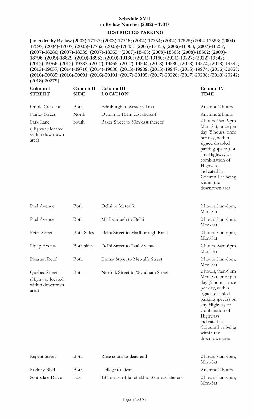
Schedule XVII to By-law Number (2002) – 17017
RESTRICTED PARKING
[amended by By-law (2003)-17137; (2003)-17318; (2004)-17354; (2004)-17525; (2004-17558; (2004)-
17597; (2004)-17607; (2005)-17752; (2005)-17843; (2005)-17856; (2006)-18008; (2007)-18257;
(2007)-18280; (2007)-18339; (2007)-18363; (2007)-18463; (2008)-18563; (2008)-18602; (2009)-
18796; (2009)-18829; (2010)-18953; (2010)-19130; (2011)-19160; (2011)-19227; (2012)-19342;
(2012)-19366; (2012)-19387; (2012)-19465; (2012)-19504; (2013)-19530; (2013)-19574; (2013)-19592;
(2013)-19657; (2014)-19716; (2014)-19838; (2015)-19939; (2015)-19947; (2015)-19974; (2016)-20058;
(2016)-20085; (2016)-20091; (2016)-20101; (2017)-20195; (2017)-20228; (2017)-20238; (2018)-20242;
(2018)-20279]
Page 13 of 21
Column I STREET
Column II SIDE
Column III LOCATION
Column IV TIME
Oriole Crescent Both Edinburgh to westerly limit Anytime 2 hours
Paisley Street North Dublin to 101m east thereof Anytime 2 hours
Park Lane
(Highway located within downtown area)
South Baker Street to 30m east thereof 2 hours, 9am-9pm Mon-Sat, once per day (5 hours, once per day, within signed disabled parking spaces) on any Highway or combination of Highways indicated in Column I as being within the downtown area
Paul Avenue Both Delhi to Metcalfe 2 hours 8am-6pm, Mon-Sat
Paul Avenue Both Marlborough to Delhi 2 hours 8am-6pm, Mon-Sat
Peter Street Both Sides Delhi Street to Marlborough Road 2 hours 8am-6pm, Mon-Sat
Philip Avenue Both sides Delhi Street to Paul Avenue 2 hours, 8am-6pm, Mon-Fri
Pleasant Road Both Emma Street to Metcalfe Street 2 hours 8am-6pm, Mon-Sat
Quebec Street
(Highway located within downtown area)
Both Norfolk Street to Wyndham Street
2 hours, 9am-9pm Mon-Sat, once per day (5 hours, once per day, within signed disabled parking spaces) on any Highway or combination of Highways indicated in Column I as being within the downtown area
Regent Street Both Rose south to dead end 2 hours 8am-6pm, Mon-Sat
Rodney Blvd Both College to Dean Anytime 2 hours
Scottsdale Drive East 187m east of Janefield to 37m east thereof 2 hours 8am-6pm, Mon-Sat
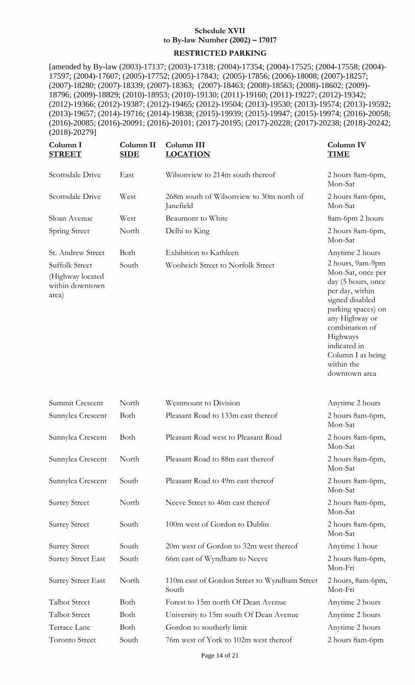
Schedule XVII to By-law Number (2002) – 17017
RESTRICTED PARKING
[amended by By-law (2003)-17137; (2003)-17318; (2004)-17354; (2004)-17525; (2004-17558; (2004)-
17597; (2004)-17607; (2005)-17752; (2005)-17843; (2005)-17856; (2006)-18008; (2007)-18257;
(2007)-18280; (2007)-18339; (2007)-18363; (2007)-18463; (2008)-18563; (2008)-18602; (2009)-
18796; (2009)-18829; (2010)-18953; (2010)-19130; (2011)-19160; (2011)-19227; (2012)-19342;
(2012)-19366; (2012)-19387; (2012)-19465; (2012)-19504; (2013)-19530; (2013)-19574; (2013)-19592;
(2013)-19657; (2014)-19716; (2014)-19838; (2015)-19939; (2015)-19947; (2015)-19974; (2016)-20058;
(2016)-20085; (2016)-20091; (2016)-20101; (2017)-20195; (2017)-20228; (2017)-20238; (2018)-20242;
(2018)-20279]
Page 14 of 21
Column I STREET
Column II SIDE
Column III LOCATION
Column IV TIME
Scottsdale Drive East Wilsonview to 214m south thereof 2 hours 8am-6pm, Mon-Sat
Scottsdale Drive West 268m south of Wilsonview to 30m north of Janefield
2 hours 8am-6pm, Mon-Sat
Sloan Avenue West Beaumont to White 8am-6pm 2 hours
Spring Street North Delhi to King 2 hours 8am-6pm, Mon-Sat
St. Andrew Street Both Exhibition to Kathleen Anytime 2 hours
Suffolk Street
(Highway located within downtown area)
South Woolwich Street to Norfolk Street 2 hours, 9am-9pm Mon-Sat, once per day (5 hours, once per day, within signed disabled parking spaces) on any Highway or combination of Highways indicated in Column I as being within the downtown area
Summit Crescent North Westmount to Division Anytime 2 hours
Sunnylea Crescent Both Pleasant Road to 133m east thereof 2 hours 8am-6pm, Mon-Sat
Sunnylea Crescent Both Pleasant Road west to Pleasant Road 2 hours 8am-6pm, Mon-Sat
Sunnylea Crescent North Pleasant Road to 88m east thereof 2 hours 8am-6pm, Mon-Sat
Sunnylea Crescent South Pleasant Road to 49m east thereof 2 hours 8am-6pm, Mon-Sat
Surrey Street North Neeve Street to 46m east thereof 2 hours 8am-6pm, Mon-Sat
Surrey Street South 100m west of Gordon to Dublin 2 hours 8am-6pm, Mon-Sat
Surrey Street South 20m west of Gordon to 32m west thereof Anytime 1 hour
Surrey Street East South 66m east of Wyndham to Neeve 2 hours 8am-6pm, Mon-Fri
Surrey Street East North 110m east of Gordon Street to Wyndham Street South
2 hours, 8am-6pm, Mon-Fri
Talbot Street Both Forest to 15m north Of Dean Avenue Anytime 2 hours
Talbot Street Both University to 15m south Of Dean Avenue Anytime 2 hours
Terrace Lane Both Gordon to southerly limit Anytime 2 hours
Toronto Street South 76m west of York to 102m west thereof 2 hours 8am-6pm
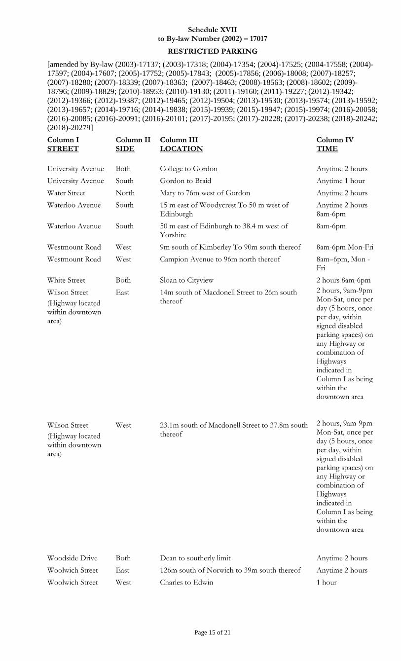
Schedule XVII to By-law Number (2002) – 17017
RESTRICTED PARKING
[amended by By-law (2003)-17137; (2003)-17318; (2004)-17354; (2004)-17525; (2004-17558; (2004)-
17597; (2004)-17607; (2005)-17752; (2005)-17843; (2005)-17856; (2006)-18008; (2007)-18257;
(2007)-18280; (2007)-18339; (2007)-18363; (2007)-18463; (2008)-18563; (2008)-18602; (2009)-
18796; (2009)-18829; (2010)-18953; (2010)-19130; (2011)-19160; (2011)-19227; (2012)-19342;
(2012)-19366; (2012)-19387; (2012)-19465; (2012)-19504; (2013)-19530; (2013)-19574; (2013)-19592;
(2013)-19657; (2014)-19716; (2014)-19838; (2015)-19939; (2015)-19947; (2015)-19974; (2016)-20058;
(2016)-20085; (2016)-20091; (2016)-20101; (2017)-20195; (2017)-20228; (2017)-20238; (2018)-20242;
(2018)-20279]
Page 15 of 21
Column I STREET
Column II SIDE
Column III LOCATION
Column IV TIME
University Avenue Both College to Gordon Anytime 2 hours
University Avenue South Gordon to Braid Anytime 1 hour
Water Street North Mary to 76m west of Gordon Anytime 2 hours
Waterloo Avenue South 15 m east of Woodycrest To 50 m west of Edinburgh
Anytime 2 hours 8am-6pm
Waterloo Avenue South 50 m east of Edinburgh to 38.4 m west of Yorshire
8am-6pm
Westmount Road West 9m south of Kimberley To 90m south thereof 8am-6pm Mon-Fri
Westmount Road West Campion Avenue to 96m north thereof 8am–6pm, Mon - Fri
White Street Both Sloan to Cityview 2 hours 8am-6pm
Wilson Street
(Highway located within downtown area)
East 14m south of Macdonell Street to 26m south thereof
2 hours, 9am-9pm Mon-Sat, once per day (5 hours, once per day, within signed disabled parking spaces) on any Highway or combination of Highways indicated in Column I as being within the downtown area
Wilson Street
(Highway located within downtown area)
West 23.1m south of Macdonell Street to 37.8m south thereof
2 hours, 9am-9pm Mon-Sat, once per day (5 hours, once per day, within signed disabled parking spaces) on any Highway or combination of Highways indicated in Column I as being within the downtown area
Woodside Drive Both Dean to southerly limit Anytime 2 hours
Woolwich Street East 126m south of Norwich to 39m south thereof Anytime 2 hours
Woolwich Street West Charles to Edwin 1 hour
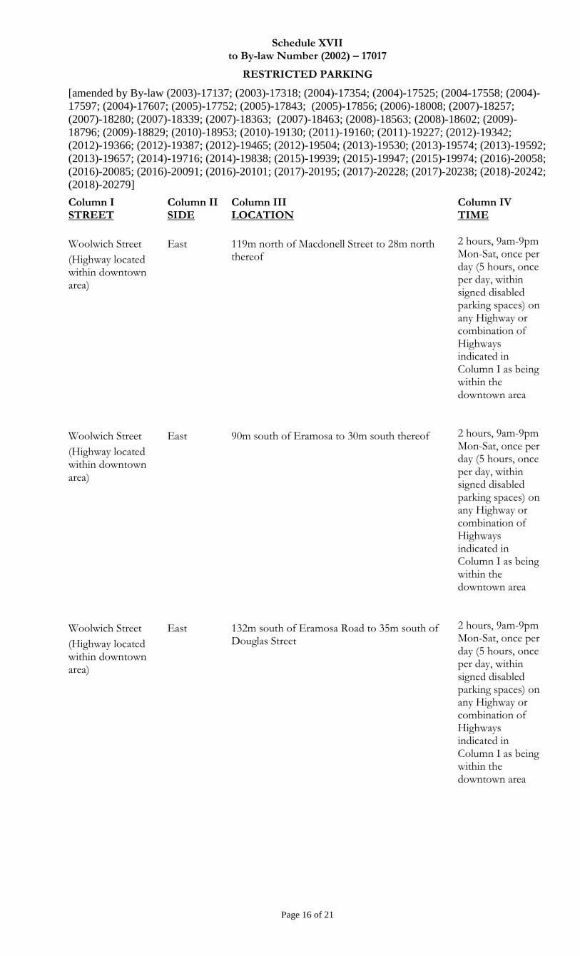
Schedule XVII to By-law Number (2002) – 17017
RESTRICTED PARKING
[amended by By-law (2003)-17137; (2003)-17318; (2004)-17354; (2004)-17525; (2004-17558; (2004)-
17597; (2004)-17607; (2005)-17752; (2005)-17843; (2005)-17856; (2006)-18008; (2007)-18257;
(2007)-18280; (2007)-18339; (2007)-18363; (2007)-18463; (2008)-18563; (2008)-18602; (2009)-
18796; (2009)-18829; (2010)-18953; (2010)-19130; (2011)-19160; (2011)-19227; (2012)-19342;
(2012)-19366; (2012)-19387; (2012)-19465; (2012)-19504; (2013)-19530; (2013)-19574; (2013)-19592;
(2013)-19657; (2014)-19716; (2014)-19838; (2015)-19939; (2015)-19947; (2015)-19974; (2016)-20058;
(2016)-20085; (2016)-20091; (2016)-20101; (2017)-20195; (2017)-20228; (2017)-20238; (2018)-20242;
(2018)-20279]
Page 16 of 21
Column I STREET
Column II SIDE
Column III LOCATION
Column IV TIME
Woolwich Street
(Highway located within downtown area)
East 119m north of Macdonell Street to 28m north thereof
2 hours, 9am-9pm Mon-Sat, once per day (5 hours, once per day, within signed disabled parking spaces) on any Highway or combination of Highways indicated in Column I as being within the downtown area
Woolwich Street
(Highway located within downtown area)
East 90m south of Eramosa to 30m south thereof 2 hours, 9am-9pm Mon-Sat, once per day (5 hours, once per day, within signed disabled parking spaces) on any Highway or combination of Highways indicated in Column I as being within the downtown area
Woolwich Street
(Highway located within downtown area)
East 132m south of Eramosa Road to 35m south of Douglas Street
2 hours, 9am-9pm Mon-Sat, once per day (5 hours, once per day, within signed disabled parking spaces) on any Highway or combination of Highways indicated in Column I as being within the downtown area
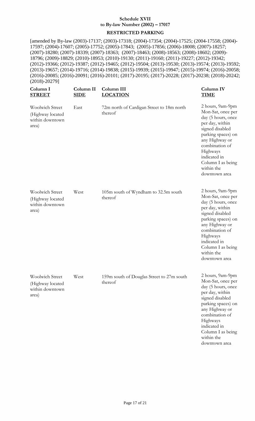
Schedule XVII to By-law Number (2002) – 17017
RESTRICTED PARKING
[amended by By-law (2003)-17137; (2003)-17318; (2004)-17354; (2004)-17525; (2004-17558; (2004)-
17597; (2004)-17607; (2005)-17752; (2005)-17843; (2005)-17856; (2006)-18008; (2007)-18257;
(2007)-18280; (2007)-18339; (2007)-18363; (2007)-18463; (2008)-18563; (2008)-18602; (2009)-
18796; (2009)-18829; (2010)-18953; (2010)-19130; (2011)-19160; (2011)-19227; (2012)-19342;
(2012)-19366; (2012)-19387; (2012)-19465; (2012)-19504; (2013)-19530; (2013)-19574; (2013)-19592;
(2013)-19657; (2014)-19716; (2014)-19838; (2015)-19939; (2015)-19947; (2015)-19974; (2016)-20058;
(2016)-20085; (2016)-20091; (2016)-20101; (2017)-20195; (2017)-20228; (2017)-20238; (2018)-20242;
(2018)-20279]
Page 17 of 21
Column I STREET
Column II SIDE
Column III LOCATION
Column IV TIME
Woolwich Street
(Highway located within downtown area)
East 72m north of Cardigan Street to 18m north thereof
2 hours, 9am-9pm Mon-Sat, once per day (5 hours, once per day, within signed disabled parking spaces) on any Highway or combination of Highways indicated in Column I as being within the downtown area
Woolwich Street
(Highway located within downtown area)
West 105m south of Wyndham to 32.5m south thereof
2 hours, 9am-9pm Mon-Sat, once per day (5 hours, once per day, within signed disabled parking spaces) on any Highway or combination of Highways indicated in Column I as being within the downtown area
Woolwich Street
(Highway located within downtown area)
West 159m south of Douglas Street to 27m south thereof
2 hours, 9am-9pm Mon-Sat, once per day (5 hours, once per day, within signed disabled parking spaces) on any Highway or combination of Highways indicated in Column I as being within the downtown area
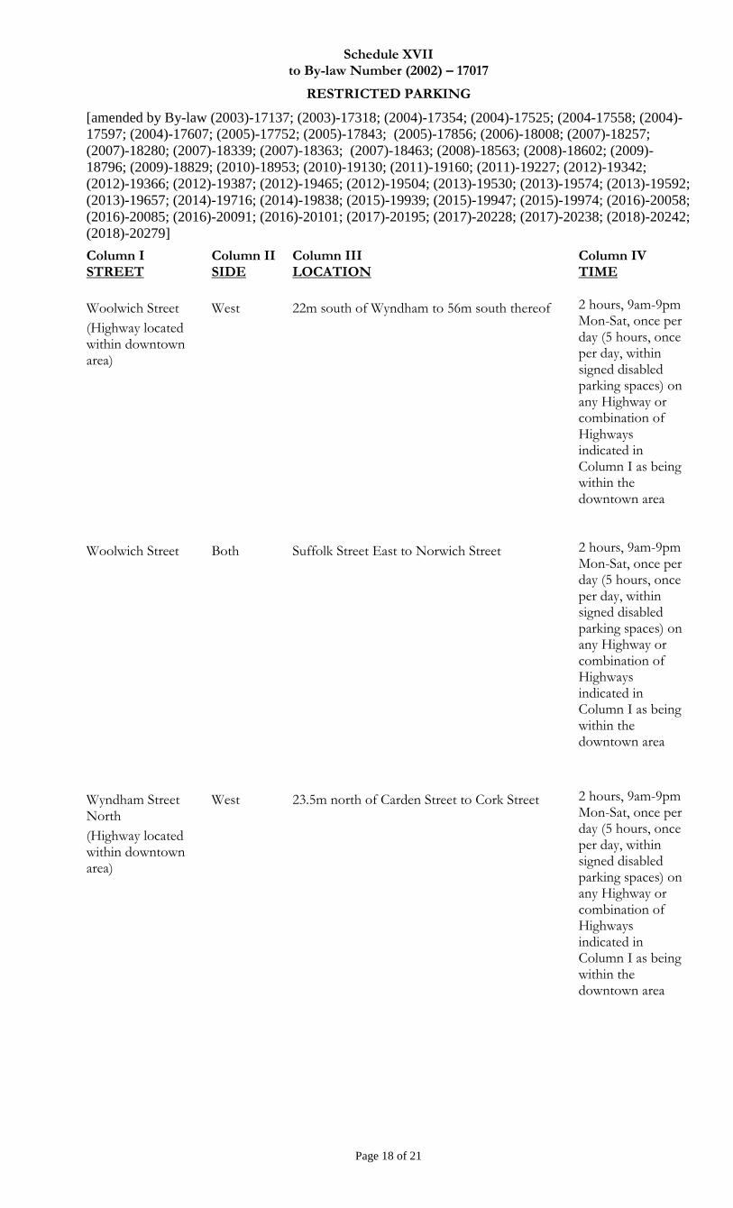
Schedule XVII to By-law Number (2002) – 17017
RESTRICTED PARKING
[amended by By-law (2003)-17137; (2003)-17318; (2004)-17354; (2004)-17525; (2004-17558; (2004)-
17597; (2004)-17607; (2005)-17752; (2005)-17843; (2005)-17856; (2006)-18008; (2007)-18257;
(2007)-18280; (2007)-18339; (2007)-18363; (2007)-18463; (2008)-18563; (2008)-18602; (2009)-
18796; (2009)-18829; (2010)-18953; (2010)-19130; (2011)-19160; (2011)-19227; (2012)-19342;
(2012)-19366; (2012)-19387; (2012)-19465; (2012)-19504; (2013)-19530; (2013)-19574; (2013)-19592;
(2013)-19657; (2014)-19716; (2014)-19838; (2015)-19939; (2015)-19947; (2015)-19974; (2016)-20058;
(2016)-20085; (2016)-20091; (2016)-20101; (2017)-20195; (2017)-20228; (2017)-20238; (2018)-20242;
(2018)-20279]
Page 18 of 21
Column I STREET
Column II SIDE
Column III LOCATION
Column IV TIME
Woolwich Street
(Highway located within downtown area)
West 22m south of Wyndham to 56m south thereof 2 hours, 9am-9pm Mon-Sat, once per day (5 hours, once per day, within signed disabled parking spaces) on any Highway or combination of Highways indicated in Column I as being within the downtown area
Woolwich Street Both Suffolk Street East to Norwich Street 2 hours, 9am-9pm Mon-Sat, once per day (5 hours, once per day, within signed disabled parking spaces) on any Highway or combination of Highways indicated in Column I as being within the downtown area
Wyndham Street North
(Highway located within downtown area)
West 23.5m north of Carden Street to Cork Street
2 hours, 9am-9pm Mon-Sat, once per day (5 hours, once per day, within signed disabled parking spaces) on any Highway or combination of Highways indicated in Column I as being within the downtown area

Schedule XVII to By-law Number (2002) – 17017
RESTRICTED PARKING
[amended by By-law (2003)-17137; (2003)-17318; (2004)-17354; (2004)-17525; (2004-17558; (2004)-
17597; (2004)-17607; (2005)-17752; (2005)-17843; (2005)-17856; (2006)-18008; (2007)-18257;
(2007)-18280; (2007)-18339; (2007)-18363; (2007)-18463; (2008)-18563; (2008)-18602; (2009)-
18796; (2009)-18829; (2010)-18953; (2010)-19130; (2011)-19160; (2011)-19227; (2012)-19342;
(2012)-19366; (2012)-19387; (2012)-19465; (2012)-19504; (2013)-19530; (2013)-19574; (2013)-19592;
(2013)-19657; (2014)-19716; (2014)-19838; (2015)-19939; (2015)-19947; (2015)-19974; (2016)-20058;
(2016)-20085; (2016)-20091; (2016)-20101; (2017)-20195; (2017)-20228; (2017)-20238; (2018)-20242;
(2018)-20279]
Page 19 of 21
Column I STREET
Column II SIDE
Column III LOCATION
Column IV TIME
Wyndham Street North
(Highway located within downtown area)
West Quebec Street to Woolwich Street
2 hours, 9am-9pm Mon-Sat, once per day (5 hours, once per day, within signed disabled parking spaces) on any Highway or combination of Highways indicated in Column I as being within the downtown area
Wyndham Street North
(Highway located within downtown area)
East Carden Street to Macdonell Street
2 hours, 9am-9pm Mon-Sat, once per day (5 hours, once per day, within signed disabled parking spaces) on any Highway or combination of Highways indicated in Column I as being within the downtown area
Wyndham Street North
(Highway located within downtown area)
East Douglas Street to 46m north thereof 2 hours, 9am-9pm Mon-Sat, once per day (5 hours, once per day, within signed disabled parking spaces) on any Highway or combination of Highways indicated in Column I as being within the downtown area
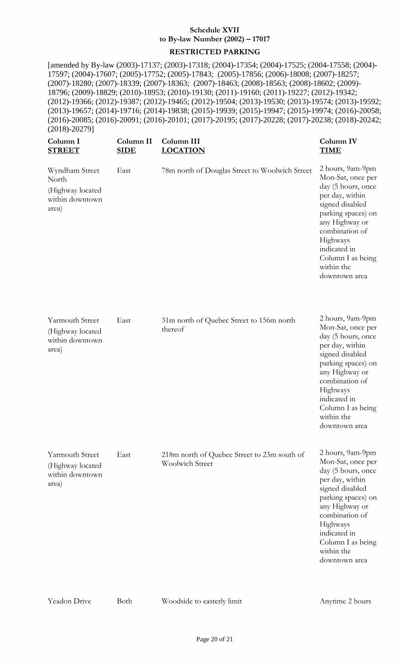
Schedule XVII to By-law Number (2002) – 17017
RESTRICTED PARKING
[amended by By-law (2003)-17137; (2003)-17318; (2004)-17354; (2004)-17525; (2004-17558; (2004)-
17597; (2004)-17607; (2005)-17752; (2005)-17843; (2005)-17856; (2006)-18008; (2007)-18257;
(2007)-18280; (2007)-18339; (2007)-18363; (2007)-18463; (2008)-18563; (2008)-18602; (2009)-
18796; (2009)-18829; (2010)-18953; (2010)-19130; (2011)-19160; (2011)-19227; (2012)-19342;
(2012)-19366; (2012)-19387; (2012)-19465; (2012)-19504; (2013)-19530; (2013)-19574; (2013)-19592;
(2013)-19657; (2014)-19716; (2014)-19838; (2015)-19939; (2015)-19947; (2015)-19974; (2016)-20058;
(2016)-20085; (2016)-20091; (2016)-20101; (2017)-20195; (2017)-20228; (2017)-20238; (2018)-20242;
(2018)-20279]
Page 20 of 21
Column I STREET
Column II SIDE
Column III LOCATION
Column IV TIME
Wyndham Street North
(Highway located within downtown area)
East 78m north of Douglas Street to Woolwich Street 2 hours, 9am-9pm Mon-Sat, once per day (5 hours, once per day, within signed disabled parking spaces) on any Highway or combination of Highways indicated in Column I as being within the downtown area
Yarmouth Street
(Highway located within downtown area)
East 31m north of Quebec Street to 156m north thereof
2 hours, 9am-9pm Mon-Sat, once per day (5 hours, once per day, within signed disabled parking spaces) on any Highway or combination of Highways indicated in Column I as being within the downtown area
Yarmouth Street
(Highway located within downtown area)
East 218m north of Quebec Street to 23m south of Woolwich Street
2 hours, 9am-9pm Mon-Sat, once per day (5 hours, once per day, within signed disabled parking spaces) on any Highway or combination of Highways indicated in Column I as being within the downtown area
Yeadon Drive Both Woodside to easterly limit Anytime 2 hours
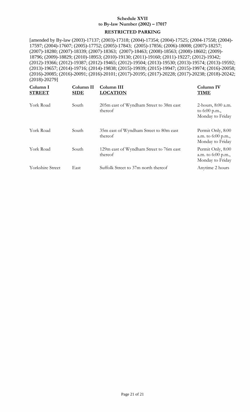
Schedule XVII to By-law Number (2002) – 17017
RESTRICTED PARKING
[amended by By-law (2003)-17137; (2003)-17318; (2004)-17354; (2004)-17525; (2004-17558; (2004)-
17597; (2004)-17607; (2005)-17752; (2005)-17843; (2005)-17856; (2006)-18008; (2007)-18257;
(2007)-18280; (2007)-18339; (2007)-18363; (2007)-18463; (2008)-18563; (2008)-18602; (2009)-
18796; (2009)-18829; (2010)-18953; (2010)-19130; (2011)-19160; (2011)-19227; (2012)-19342;
(2012)-19366; (2012)-19387; (2012)-19465; (2012)-19504; (2013)-19530; (2013)-19574; (2013)-19592;
(2013)-19657; (2014)-19716; (2014)-19838; (2015)-19939; (2015)-19947; (2015)-19974; (2016)-20058;
(2016)-20085; (2016)-20091; (2016)-20101; (2017)-20195; (2017)-20228; (2017)-20238; (2018)-20242;
(2018)-20279]
Page 21 of 21
Column I STREET
Column II SIDE
Column III LOCATION
Column IV TIME
York Road South 205m east of Wyndham Street to 38m east thereof
2-hours, 8:00 a.m. to 6:00 p.m., Monday to Friday
York Road South 35m east of Wyndham Street to 80m east thereof
Permit Only, 8:00 a.m. to 6:00 p.m., Monday to Friday
York Road South 129m east of Wyndham Street to 76m east thereof
Permit Only, 8:00 a.m. to 6:00 p.m., Monday to Friday
Yorkshire Street East Suffolk Street to 37m north thereof Anytime 2 hours
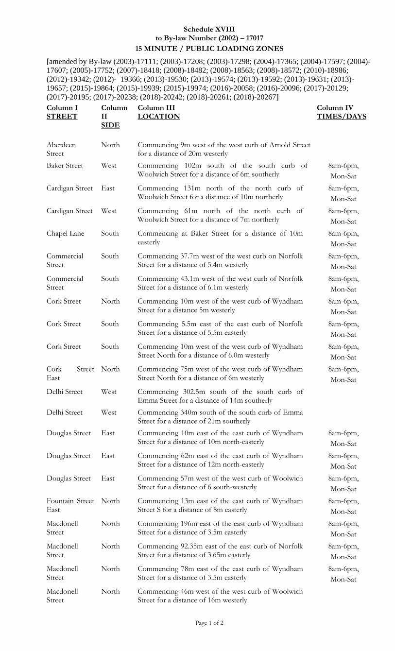
Schedule XVIII to By-law Number (2002) – 17017
15 MINUTE / PUBLIC LOADING ZONES
[amended by By-law (2003)-17111; (2003)-17208; (2003)-17298; (2004)-17365; (2004)-17597; (2004)-
17607; (2005)-17752; (2007)-18418; (2008)-18482; (2008)-18563; (2008)-18572; (2010)-18986;
(2012)-19342; (2012)- 19366; (2013)-19530; (2013)-19574; (2013)-19592; (2013)-19631; (2013)-
19657; (2015)-19864; (2015)-19939; (2015)-19974; (2016)-20058; (2016)-20096; (2017)-20129;
(2017)-20195; (2017)-20238; (2018)-20242; (2018)-20261; (2018)-20267]
Page 1 of 2
Column I STREET
Column II SIDE
Column III LOCATION
Column IV TIMES/DAYS
Aberdeen Street
North Commencing 9m west of the west curb of Arnold Street for a distance of 20m westerly
Baker Street West Commencing 102m south of the south curb of Woolwich Street for a distance of 6m southerly
8am-6pm,
Mon-Sat
Cardigan Street East Commencing 131m north of the north curb of Woolwich Street for a distance of 10m northerly
8am-6pm,
Mon-Sat
Cardigan Street West Commencing 61m north of the north curb of Woolwich Street for a distance of 7m northerly
8am-6pm,
Mon-Sat
Chapel Lane South Commencing at Baker Street for a distance of 10m easterly
8am-6pm,
Mon-Sat
Commercial Street
South Commencing 37.7m west of the west curb on Norfolk Street for a distance of 5.4m westerly
8am-6pm,
Mon-Sat
Commercial Street
South Commencing 43.1m west of the west curb of Norfolk Street for a distance of 6.1m westerly
8am-6pm,
Mon-Sat
Cork Street North Commencing 10m west of the west curb of Wyndham Street for a distance 5m westerly
8am-6pm,
Mon-Sat
Cork Street South Commencing 5.5m east of the east curb of Norfolk Street for a distance of 5.5m easterly
8am-6pm,
Mon-Sat
Cork Street South Commencing 10m west of the west curb of Wyndham Street North for a distance of 6.0m westerly
8am-6pm,
Mon-Sat
Cork Street East
North Commencing 75m west of the west curb of Wyndham Street North for a distance of 6m westerly
8am-6pm,
Mon-Sat
Delhi Street West Commencing 302.5m south of the south curb of Emma Street for a distance of 14m southerly
Delhi Street West Commencing 340m south of the south curb of Emma Street for a distance of 21m southerly
Douglas Street East Commencing 10m east of the east curb of Wyndham Street for a distance of 10m north-easterly
8am-6pm,
Mon-Sat
Douglas Street East Commencing 62m east of the east curb of Wyndham Street for a distance of 12m north-easterly
8am-6pm,
Mon-Sat
Douglas Street East Commencing 57m west of the west curb of Woolwich Street for a distance of 6 south-westerly
8am-6pm,
Mon-Sat
Fountain Street East
North Commencing 13m east of the east curb of Wyndham Street S for a distance of 8m easterly
8am-6pm,
Mon-Sat
Macdonell Street
North Commencing 196m east of the east curb of Wyndham Street for a distance of 3.5m easterly
8am-6pm,
Mon-Sat
Macdonell Street
North Commencing 92.35m east of the east curb of Norfolk Street for a distance of 3.65m easterly
8am-6pm,
Mon-Sat
Macdonell Street
North Commencing 78m east of the east curb of Wyndham Street for a distance of 3.5m easterly
8am-6pm,
Mon-Sat
Macdonell Street
North Commencing 46m west of the west curb of Woolwich Street for a distance of 16m westerly
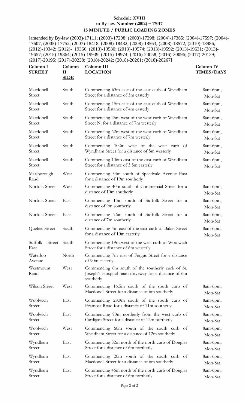
Schedule XVIII to By-law Number (2002) – 17017
15 MINUTE / PUBLIC LOADING ZONES
[amended by By-law (2003)-17111; (2003)-17208; (2003)-17298; (2004)-17365; (2004)-17597; (2004)-
17607; (2005)-17752; (2007)-18418; (2008)-18482; (2008)-18563; (2008)-18572; (2010)-18986;
(2012)-19342; (2012)- 19366; (2013)-19530; (2013)-19574; (2013)-19592; (2013)-19631; (2013)-
19657; (2015)-19864; (2015)-19939; (2015)-19974; (2016)-20058; (2016)-20096; (2017)-20129;
(2017)-20195; (2017)-20238; (2018)-20242; (2018)-20261; (2018)-20267]
Page 2 of 2
Column I STREET
Column II SIDE
Column III LOCATION
Column IV TIMES/DAYS
Macdonell Street
South Commencing 63m east of the east curb of Wyndham Street for a distance of 5m easterly
8am-6pm,
Mon-Sat
Macdonell Street
South Commencing 15m east of the east curb of Wyndham Street for a distance of 4m easterly
8am-6pm,
Mon-Sat
Macdonell Street
South Commencing 25m west of the west curb of Wyndham Street N. for a distance of 7m westerly
8am-6pm,
Mon-Sat
Macdonell Street
South Commencing 62m west of the west curb of Wyndham Street for a distance of 7m westerly
8am-6pm,
Mon-Sat
Macdonell Street
South Commencing 102m west of the west curb of Wyndham Street for a distance of 5m westerly
8am-6pm,
Mon-Sat
Macdonell Street
South Commencing 106m east of the east curb of Wyndham Street for a distance of 3.5m easterly
8am-6pm,
Mon-Sat
Marlborough Road
West Commencing 53m south of Speedvale Avenue East for a distance of 19m southerly
Norfolk Street West Commencing 40m south of Commercial Street for a distance of 10m southerly
8am-6pm,
Mon-Sat
Norfolk Street East Commencing 15m south of Suffolk Street for a distance of 9m southerly
8am-6pm,
Mon-Sat
Norfolk Street East Commencing 76m south of Suffolk Street for a distance of 7m southerly
8am-6pm,
Mon-Sat
Quebec Street South Commencing 4m east of the east curb of Baker Street for a distance of 10m easterly
8am-6pm,
Mon-Sat
Suffolk Street East
South Commencing 19m west of the west curb of Woolwich Street for a distance of 6m westerly
Waterloo Avenue
North Commencing 7m east of Fergus Street for a distance of 90m easterly
Westmount Road
West Commencing 6m south of the southerly curb of St. Joseph’s Hospital main driveway for a distance of 6m southerly
Wilson Street West Commencing 16.5m south of the south curb of Macdonell Street for a distance of 6m southerly
8am-6pm,
Mon-Sat
Woolwich Street
East Commencing 28.9m south of the south curb of Eramosa Road for a distance of 11m southerly
8am-6pm,
Mon-Sat
Woolwich Street
East Commencing 90m northerly from the west curb of Cardigan Street for a distance of 12m northerly
8am-6pm,
Mon-Sat
Woolwich Street
West Commencing 60m south of the south curb of Wyndham Street for a distance of 12m southerly
8am-6pm,
Mon-Sat
Wyndham Street
East Commencing 82m north of the north curb of Douglas Street for a distance of 6m northerly
8am-6pm,
Mon-Sat
Wyndham Street
East Commencing 20m south of the south curb of Macdonell Street for a distance of 6m southerly
8am-6pm,
Mon-Sat
Wyndham Street
East Commencing 46m north of the north curb of Douglas Street for a distance of 6m northerly
8am-6pm,
Mon-Sat
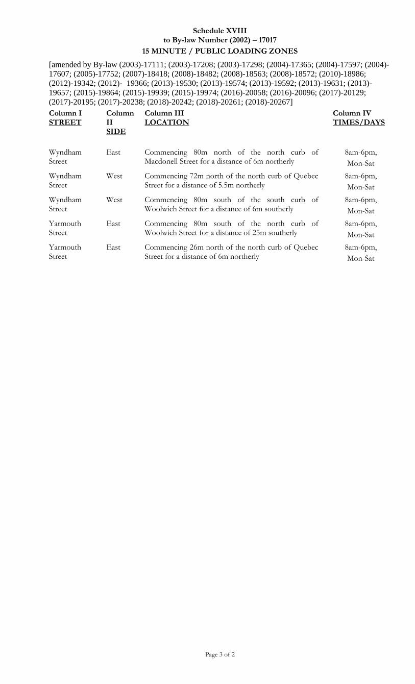
Schedule XVIII to By-law Number (2002) – 17017
15 MINUTE / PUBLIC LOADING ZONES
[amended by By-law (2003)-17111; (2003)-17208; (2003)-17298; (2004)-17365; (2004)-17597; (2004)-
17607; (2005)-17752; (2007)-18418; (2008)-18482; (2008)-18563; (2008)-18572; (2010)-18986;
(2012)-19342; (2012)- 19366; (2013)-19530; (2013)-19574; (2013)-19592; (2013)-19631; (2013)-
19657; (2015)-19864; (2015)-19939; (2015)-19974; (2016)-20058; (2016)-20096; (2017)-20129;
(2017)-20195; (2017)-20238; (2018)-20242; (2018)-20261; (2018)-20267]
Page 3 of 2
Column I STREET
Column II SIDE
Column III LOCATION
Column IV TIMES/DAYS
Wyndham Street
East Commencing 80m north of the north curb of Macdonell Street for a distance of 6m northerly
8am-6pm,
Mon-Sat
Wyndham Street
West Commencing 72m north of the north curb of Quebec Street for a distance of 5.5m northerly
8am-6pm,
Mon-Sat
Wyndham Street
West Commencing 80m south of the south curb of Woolwich Street for a distance of 6m southerly
8am-6pm,
Mon-Sat
Yarmouth Street
East Commencing 80m south of the north curb of Woolwich Street for a distance of 25m southerly
8am-6pm,
Mon-Sat
Yarmouth Street
East Commencing 26m north of the north curb of Quebec Street for a distance of 6m northerly
8am-6pm,
Mon-Sat
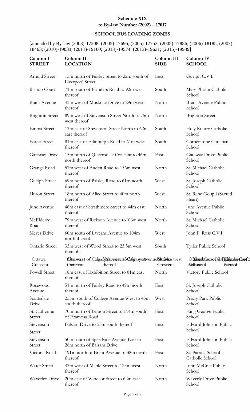
Schedule XIX
to By-law Number (2002) – 17017
SCHOOL BUS LOADING ZONES
[amended by By-law (2003)-17208; (2005)-17696; (2005)-17752; (2005)-17886; (2006)-18185; (2007)-
18463; (2010)-19033; (2011)-19160; (2013)-19574; (2013)-19631; (2015)-19939]
Page 1 of 2
Column I STREET
Column II LOCATION
Column III SIDE
Column IV SCHOOL
Arnold Street 15m north of Paisley Street to 22m south of Liverpool Street
East Guelph C.V.I.
Bishop Court 71m south of Flanders Road to 92m west thereof
South Mary Phelan Catholic School
Brant Avenue 43m west of Muskoka Drive to 29m west thereof
North Brant Avenue Public School
Brighton Street 89m west of Stevenson Street North to 75m west thereof
North Brighton Street
Emma Street 13m east of Stevenson Street North to 62m east thereof
South Holy Rosary Catholic School
Forest Street 81m east of Edinburgh Road to 61m west thereof
South Cornerstone Christian School
Gateway Drive 15m north of Queensdale Crescent to 46m north thereof
East Gateway Drive Public School
Grange Road 57m west of Auden Road to 156m west thereof
North St. Michael Catholic School
Guelph Street 69m north of Paisley Road to 61m north thereof
West St. Joseph Catholic School
Huron Street 18m north of Alice Street to 40m north thereof
West St. Rene Goupil (Sacred Heart)
June Avenue 46m east of Strathmere Street to 44m east thereof
North June Avenue Public School
McElderry Road
79m west of Rickson Avenue to106m west thereof
North St. Michael Catholic School
Meyer Drive 60m south of Laverne Avenue to 104m north thereof
West John F. Ross C.V.I.
Ontario Street 33m west of Wood Street to 23.5m west thereof.
South Tytler Public School
Ottawa Crescent
32m west of Calgary Avenue to 34m west thereof
North Ottawa Crescent Public School
Ottawa Crescent
32m west of Calgary Avenue to 34m west thereof
North Ottawa Crescent Public School
Ottawa Crescent
32m west of Calgary Avenue to 34m west thereof
North Ottawa Crescent Public School
Ottawa Crescent
32m west of Calgary Avenue to 34m west thereof
North Ottawa Crescent Public School
Powell Street 18m east of Exhibition Street to 81m east thereof
North Victory Public School
Rosewood Avenue
51m north of Paisley Road to 49m north thereof
East St. Joseph Catholic School
Scottsdale Drive
255m south of College Avenue West to 43m south thereof
West Priory Park Public School
St. Catherine Street
70m north of Lemon Street to 114m south of Eramosa Road
East King George Public School
Stevenson
Street
Balsam Drive to 53m south thereof East Edward Johnson Public School
Stevenson Street
50m south of Speedvale Avenue East to 28m north of Balsam Drive
East Edward Johnson Public School
Victoria Road 191m north of Brant Avenue to 38m north thereof
East St. Patrick School Catholic School
Water Street 43m west of Maple Street to 123m west thereof
North John McCrae Public School
Waverley Drive 20m east of Windsor Street to 62m east thereof
North Waverly Drive Public School
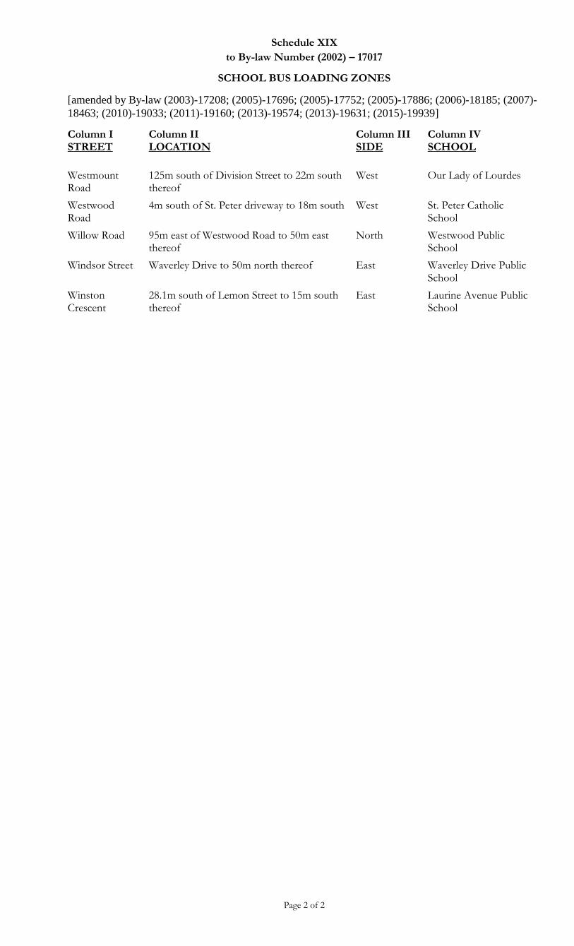
Schedule XIX
to By-law Number (2002) – 17017
SCHOOL BUS LOADING ZONES
[amended by By-law (2003)-17208; (2005)-17696; (2005)-17752; (2005)-17886; (2006)-18185; (2007)-
18463; (2010)-19033; (2011)-19160; (2013)-19574; (2013)-19631; (2015)-19939]
Page 2 of 2
Column I STREET
Column II LOCATION
Column III SIDE
Column IV SCHOOL
Westmount Road
125m south of Division Street to 22m south thereof
West Our Lady of Lourdes
Westwood Road
4m south of St. Peter driveway to 18m south West St. Peter Catholic School
Willow Road 95m east of Westwood Road to 50m east thereof
North Westwood Public School
Windsor Street Waverley Drive to 50m north thereof East Waverley Drive Public School
Winston Crescent
28.1m south of Lemon Street to 15m south thereof
East Laurine Avenue Public School
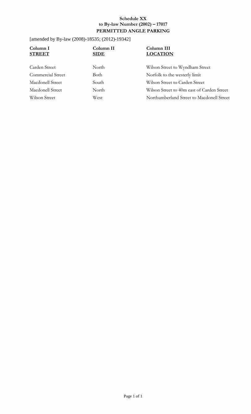
Schedule XX to By-law Number (2002) – 17017
PERMITTED ANGLE PARKING
[amended by By-law (2008)-18535; (2012)-19342]
Page 1 of 1
Column I STREET
Column II SIDE
Column III LOCATION
Carden Street North Wilson Street to Wyndham Street
Commercial Street Both Norfolk to the westerly limit
Macdonell Street South Wilson Street to Carden Street
Macdonell Street North Wilson Street to 40m east of Carden Street
Wilson Street West Northumberland Street to Macdonell Street
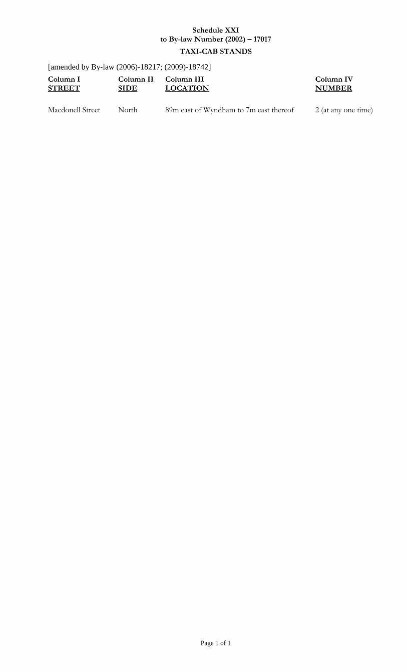
Schedule XXI to By-law Number (2002) – 17017
TAXI-CAB STANDS
[amended by By-law (2006)-18217; (2009)-18742]
Page 1 of 1
Column I STREET
Column II SIDE
Column III LOCATION
Column IV NUMBER
Macdonell Street North 89m east of Wyndham to 7m east thereof 2 (at any one time)
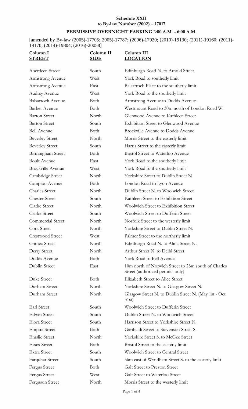
Schedule XXII to By-law Number (2002) – 17017
PERMISSIVE OVERNIGHT PARKING 2:00 A.M. - 6:00 A.M.
[amended by By-law (2005)-17705; 2005)-17787; (2006)-17920; (2010)-19130; (2011)-19160; (2011)-
19170; (2014)-19804; (2016)-20058]
Page 1 of 4
Column I STREET
Column II SIDE
Column III LOCATION
Aberdeen Street South Edinburgh Road N. to Arnold Street
Armstrong Avenue West York Road to southerly limit
Armstrong Avenue East Balsarroch Place to the southerly limit
Audrey Avenue West York Road to the southerly limit
Balsarroch Avenue Both Armstrong Avenue to Dodds Avenue
Barber Avenue Both Westmount Road to 30m north of London Road W.
Barton Street North Glenwood Avenue to Kathleen Street
Barton Street South Exhibition Street to Glenwood Avenue
Bell Avenue Both Brockville Avenue to Dodds Avenue
Beverley Street North Morris Street to the easterly limit
Beverley Street South Harris Street to the easterly limit
Birmingham Street Both Bristol Street to Waterloo Avenue
Boult Avenue East York Road to the southerly limit
Brockville Avenue West York Road to the southerly limit
Cambridge Street North Yorkshire Street to Dublin Street N.
Campion Avenue Both London Road to Lyon Avenue
Charles Street North Dublin Street N. to Woolwich Street
Chester Street South Kathleen Street to Exhibition Street
Clarke Street North Woolwich Street to Exhibition Street
Clarke Street South Woolwich Street to Dufferin Street
Commercial Street North Norfolk Street to the westerly limit
Cork Street North Yorkshire Street to Dublin Street N.
Crestwood Street West Palmer Street to the northerly limit
Crimea Street North Edinburgh Road N. to Alma Street N.
Derry Street North Arthur Street N. to Delhi Street
Dodds Avenue Both York Road to Bell Avenue
Dublin Street East 10m north of Norwich Street to 28m south of Charles Street (authorized permits only)
Duke Street Both Elizabeth Street to Alice Street
Durham Street North Yorkshire Street N. to Glasgow Street N.
Durham Street North Glasgow Street N. to Dublin Street N. (May 1st - Oct 31st)
Earl Street South Woolwich Street to Dufferin Street
Edwin Street South Dublin Street N. to Woolwich Street
Elora Street South Harrison Street to Yorkshire Street N.
Empire Street Both Garibaldi Street to Stevenson Street S.
Emslie Street North Yorkshire Street S. to McGee Street
Essex Street Both Bristol Street to the easterly limit
Extra Street South Woolwich Street to Central Street
Farquhar Street South 56m east of Wyndham Street S. to the easterly limit
Fergus Street Both Galt Street to Preston Street
Fergus Street West Galt Street to Waterloo Street
Ferguson Street North Morris Street to the westerly limit
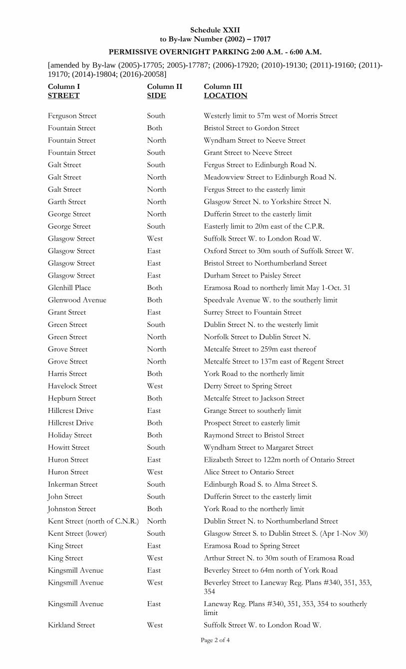
Schedule XXII to By-law Number (2002) – 17017
PERMISSIVE OVERNIGHT PARKING 2:00 A.M. - 6:00 A.M.
[amended by By-law (2005)-17705; 2005)-17787; (2006)-17920; (2010)-19130; (2011)-19160; (2011)-
19170; (2014)-19804; (2016)-20058]
Page 2 of 4
Column I STREET
Column II SIDE
Column III LOCATION
Ferguson Street South Westerly limit to 57m west of Morris Street
Fountain Street Both Bristol Street to Gordon Street
Fountain Street North Wyndham Street to Neeve Street
Fountain Street South Grant Street to Neeve Street
Galt Street South Fergus Street to Edinburgh Road N.
Galt Street North Meadowview Street to Edinburgh Road N.
Galt Street North Fergus Street to the easterly limit
Garth Street North Glasgow Street N. to Yorkshire Street N.
George Street North Dufferin Street to the easterly limit
George Street South Easterly limit to 20m east of the C.P.R.
Glasgow Street West Suffolk Street W. to London Road W.
Glasgow Street East Oxford Street to 30m south of Suffolk Street W.
Glasgow Street East Bristol Street to Northumberland Street
Glasgow Street East Durham Street to Paisley Street
Glenhill Place Both Eramosa Road to northerly limit May 1-Oct. 31
Glenwood Avenue Both Speedvale Avenue W. to the southerly limit
Grant Street East Surrey Street to Fountain Street
Green Street South Dublin Street N. to the westerly limit
Green Street North Norfolk Street to Dublin Street N.
Grove Street North Metcalfe Street to 259m east thereof
Grove Street North Metcalfe Street to 137m east of Regent Street
Harris Street Both York Road to the northerly limit
Havelock Street West Derry Street to Spring Street
Hepburn Street Both Metcalfe Street to Jackson Street
Hillcrest Drive East Grange Street to southerly limit
Hillcrest Drive Both Prospect Street to easterly limit
Holiday Street Both Raymond Street to Bristol Street
Howitt Street South Wyndham Street to Margaret Street
Huron Street East Elizabeth Street to 122m north of Ontario Street
Huron Street West Alice Street to Ontario Street
Inkerman Street South Edinburgh Road S. to Alma Street S.
John Street South Dufferin Street to the easterly limit
Johnston Street Both York Road to the northerly limit
Kent Street (north of C.N.R.) North Dublin Street N. to Northumberland Street
Kent Street (lower) South Glasgow Street S. to Dublin Street S. (Apr 1-Nov 30)
King Street East Eramosa Road to Spring Street
King Street West Arthur Street N. to 30m south of Eramosa Road
Kingsmill Avenue East Beverley Street to 64m north of York Road
Kingsmill Avenue West Beverley Street to Laneway Reg. Plans #340, 351, 353, 354
Kingsmill Avenue East Laneway Reg. Plans #340, 351, 353, 354 to southerly limit
Kirkland Street West Suffolk Street W. to London Road W.
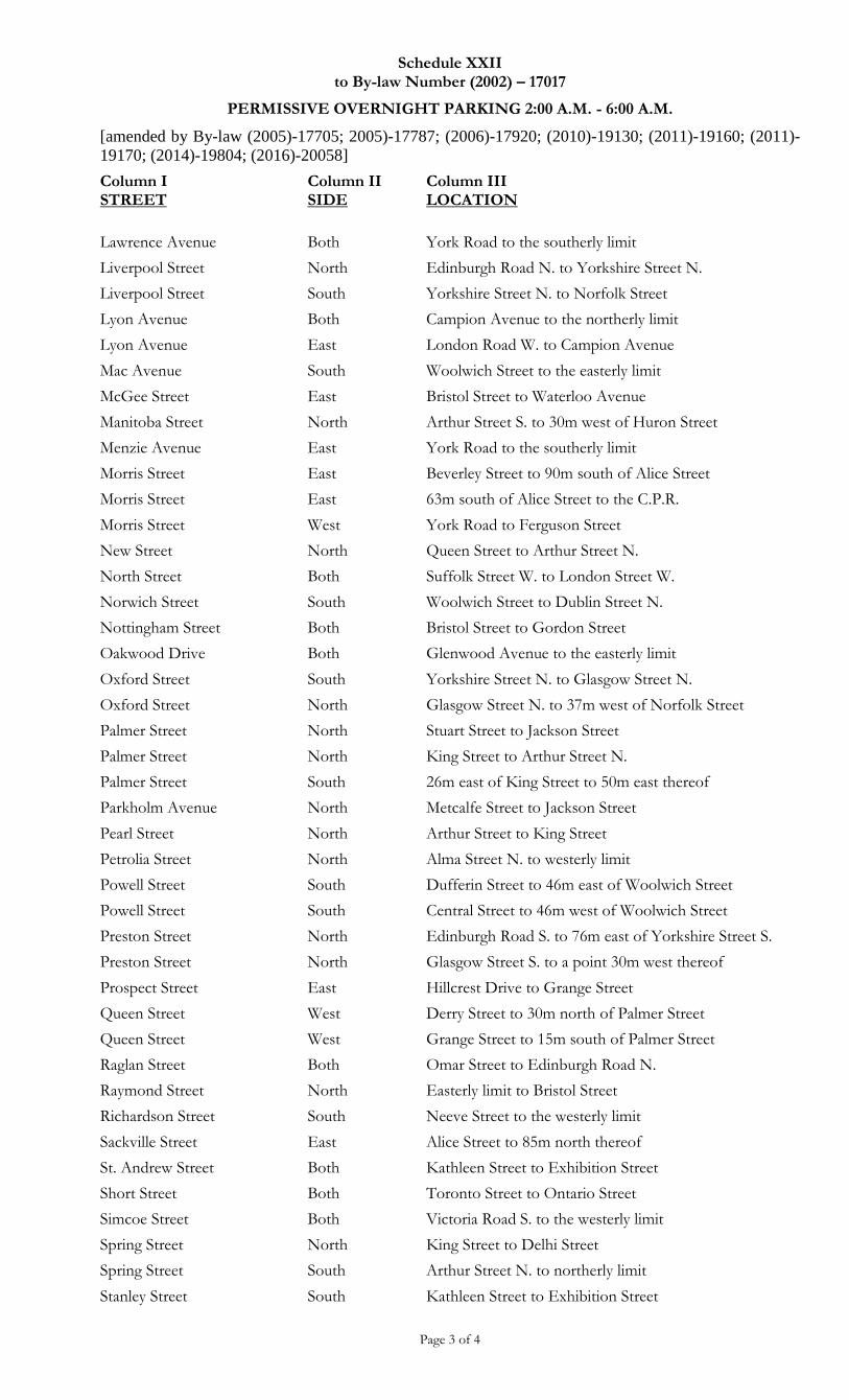
Schedule XXII to By-law Number (2002) – 17017
PERMISSIVE OVERNIGHT PARKING 2:00 A.M. - 6:00 A.M.
[amended by By-law (2005)-17705; 2005)-17787; (2006)-17920; (2010)-19130; (2011)-19160; (2011)-
19170; (2014)-19804; (2016)-20058]
Page 3 of 4
Column I STREET
Column II SIDE
Column III LOCATION
Lawrence Avenue Both York Road to the southerly limit
Liverpool Street North Edinburgh Road N. to Yorkshire Street N.
Liverpool Street South Yorkshire Street N. to Norfolk Street
Lyon Avenue Both Campion Avenue to the northerly limit
Lyon Avenue East London Road W. to Campion Avenue
Mac Avenue South Woolwich Street to the easterly limit
McGee Street East Bristol Street to Waterloo Avenue
Manitoba Street North Arthur Street S. to 30m west of Huron Street
Menzie Avenue East York Road to the southerly limit
Morris Street East Beverley Street to 90m south of Alice Street
Morris Street East 63m south of Alice Street to the C.P.R.
Morris Street West York Road to Ferguson Street
New Street North Queen Street to Arthur Street N.
North Street Both Suffolk Street W. to London Street W.
Norwich Street South Woolwich Street to Dublin Street N.
Nottingham Street Both Bristol Street to Gordon Street
Oakwood Drive Both Glenwood Avenue to the easterly limit
Oxford Street South Yorkshire Street N. to Glasgow Street N.
Oxford Street North Glasgow Street N. to 37m west of Norfolk Street
Palmer Street North Stuart Street to Jackson Street
Palmer Street North King Street to Arthur Street N.
Palmer Street South 26m east of King Street to 50m east thereof
Parkholm Avenue North Metcalfe Street to Jackson Street
Pearl Street North Arthur Street to King Street
Petrolia Street North Alma Street N. to westerly limit
Powell Street South Dufferin Street to 46m east of Woolwich Street
Powell Street South Central Street to 46m west of Woolwich Street
Preston Street North Edinburgh Road S. to 76m east of Yorkshire Street S.
Preston Street North Glasgow Street S. to a point 30m west thereof
Prospect Street East Hillcrest Drive to Grange Street
Queen Street West Derry Street to 30m north of Palmer Street
Queen Street West Grange Street to 15m south of Palmer Street
Raglan Street Both Omar Street to Edinburgh Road N.
Raymond Street North Easterly limit to Bristol Street
Richardson Street South Neeve Street to the westerly limit
Sackville Street East Alice Street to 85m north thereof
St. Andrew Street Both Kathleen Street to Exhibition Street
Short Street Both Toronto Street to Ontario Street
Simcoe Street Both Victoria Road S. to the westerly limit
Spring Street North King Street to Delhi Street
Spring Street South Arthur Street N. to northerly limit
Stanley Street South Kathleen Street to Exhibition Street
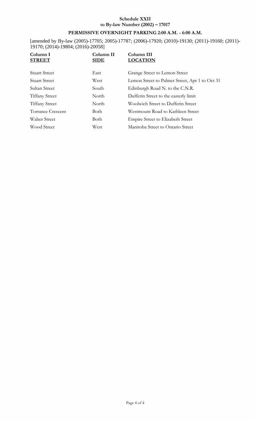
Schedule XXII to By-law Number (2002) – 17017
PERMISSIVE OVERNIGHT PARKING 2:00 A.M. - 6:00 A.M.
[amended by By-law (2005)-17705; 2005)-17787; (2006)-17920; (2010)-19130; (2011)-19160; (2011)-
19170; (2014)-19804; (2016)-20058]
Page 4 of 4
Column I STREET
Column II SIDE
Column III LOCATION
Stuart Street East Grange Street to Lemon Street
Stuart Street West Lemon Street to Palmer Street, Apr 1 to Oct 31
Sultan Street South Edinburgh Road N. to the C.N.R.
Tiffany Street North Dufferin Street to the easterly limit
Tiffany Street North Woolwich Street to Dufferin Street
Torrance Crescent Both Westmount Road to Kathleen Street
Walter Street Both Empire Street to Elizabeth Street
Wood Street West Manitoba Street to Ontario Street
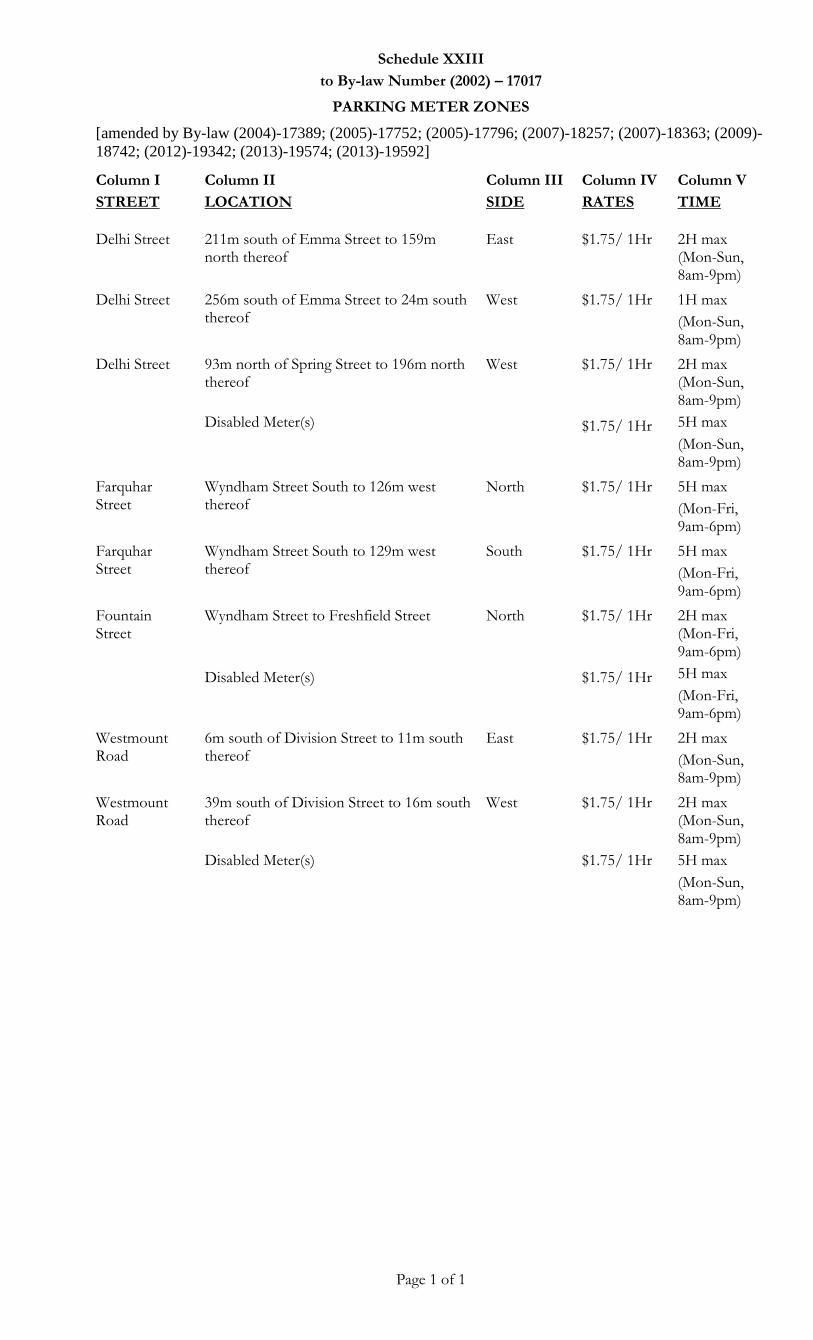
Schedule XXIII
to By-law Number (2002) – 17017
PARKING METER ZONES
[amended by By-law (2004)-17389; (2005)-17752; (2005)-17796; (2007)-18257; (2007)-18363; (2009)-
18742; (2012)-19342; (2013)-19574; (2013)-19592]
Page 1 of 1
Column I
STREET
Column II
LOCATION
Column III
SIDE
Column IV
RATES
Column V
TIME
Delhi Street 211m south of Emma Street to 159m
north thereof East $1.75/ 1Hr 2H max
(Mon-Sun, 8am-9pm)
Delhi Street 256m south of Emma Street to 24m south thereof
West $1.75/ 1Hr 1H max
(Mon-Sun, 8am-9pm)
Delhi Street 93m north of Spring Street to 196m north thereof
Disabled Meter(s)
West $1.75/ 1Hr
$1.75/ 1Hr
2H max (Mon-Sun, 8am-9pm)
5H max
(Mon-Sun, 8am-9pm)
Farquhar Street
Wyndham Street South to 126m west thereof
North $1.75/ 1Hr 5H max
(Mon-Fri, 9am-6pm)
Farquhar Street
Wyndham Street South to 129m west thereof
South $1.75/ 1Hr 5H max
(Mon-Fri, 9am-6pm)
Fountain Street
Wyndham Street to Freshfield Street
Disabled Meter(s)
North $1.75/ 1Hr
$1.75/ 1Hr
2H max (Mon-Fri, 9am-6pm)
5H max
(Mon-Fri, 9am-6pm)
Westmount Road
6m south of Division Street to 11m south thereof
East $1.75/ 1Hr 2H max
(Mon-Sun, 8am-9pm)
Westmount Road
39m south of Division Street to 16m south thereof
Disabled Meter(s)
West $1.75/ 1Hr
$1.75/ 1Hr
2H max (Mon-Sun, 8am-9pm)
5H max
(Mon-Sun, 8am-9pm)
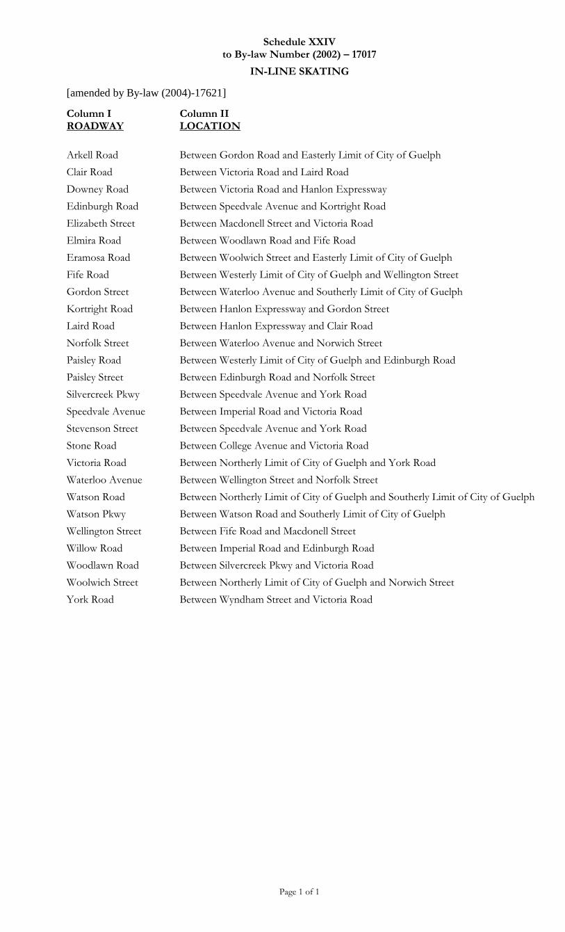
Schedule XXIV to By-law Number (2002) – 17017
IN-LINE SKATING
[amended by By-law (2004)-17621]
Page 1 of 1
Column I ROADWAY
Column II LOCATION
Arkell Road Between Gordon Road and Easterly Limit of City of Guelph
Clair Road Between Victoria Road and Laird Road
Downey Road Between Victoria Road and Hanlon Expressway
Edinburgh Road Between Speedvale Avenue and Kortright Road
Elizabeth Street Between Macdonell Street and Victoria Road
Elmira Road Between Woodlawn Road and Fife Road
Eramosa Road Between Woolwich Street and Easterly Limit of City of Guelph
Fife Road Between Westerly Limit of City of Guelph and Wellington Street
Gordon Street Between Waterloo Avenue and Southerly Limit of City of Guelph
Kortright Road Between Hanlon Expressway and Gordon Street
Laird Road Between Hanlon Expressway and Clair Road
Norfolk Street Between Waterloo Avenue and Norwich Street
Paisley Road Between Westerly Limit of City of Guelph and Edinburgh Road
Paisley Street Between Edinburgh Road and Norfolk Street
Silvercreek Pkwy Between Speedvale Avenue and York Road
Speedvale Avenue Between Imperial Road and Victoria Road
Stevenson Street Between Speedvale Avenue and York Road
Stone Road Between College Avenue and Victoria Road
Victoria Road Between Northerly Limit of City of Guelph and York Road
Waterloo Avenue Between Wellington Street and Norfolk Street
Watson Road Between Northerly Limit of City of Guelph and Southerly Limit of City of Guelph
Watson Pkwy Between Watson Road and Southerly Limit of City of Guelph
Wellington Street Between Fife Road and Macdonell Street
Willow Road Between Imperial Road and Edinburgh Road
Woodlawn Road Between Silvercreek Pkwy and Victoria Road
Woolwich Street Between Northerly Limit of City of Guelph and Norwich Street
York Road Between Wyndham Street and Victoria Road
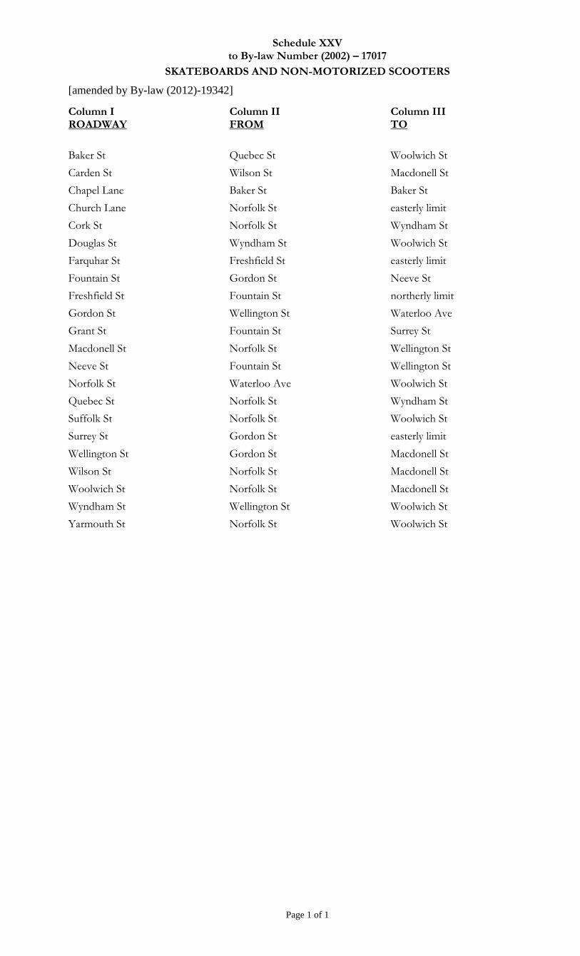
Schedule XXV to By-law Number (2002) – 17017
SKATEBOARDS AND NON-MOTORIZED SCOOTERS
[amended by By-law (2012)-19342]
Page 1 of 1
Column I ROADWAY
Column II FROM
Column III TO
Baker St Quebec St Woolwich St
Carden St Wilson St Macdonell St
Chapel Lane Baker St Baker St
Church Lane Norfolk St easterly limit
Cork St Norfolk St Wyndham St
Douglas St Wyndham St Woolwich St
Farquhar St Freshfield St easterly limit
Fountain St Gordon St Neeve St
Freshfield St Fountain St northerly limit
Gordon St Wellington St Waterloo Ave
Grant St Fountain St Surrey St
Macdonell St Norfolk St Wellington St
Neeve St Fountain St Wellington St
Norfolk St Waterloo Ave Woolwich St
Quebec St Norfolk St Wyndham St
Suffolk St Norfolk St Woolwich St
Surrey St Gordon St easterly limit
Wellington St Gordon St Macdonell St
Wilson St Norfolk St Macdonell St
Woolwich St Norfolk St Macdonell St
Wyndham St Wellington St Woolwich St
Yarmouth St Norfolk St Woolwich St
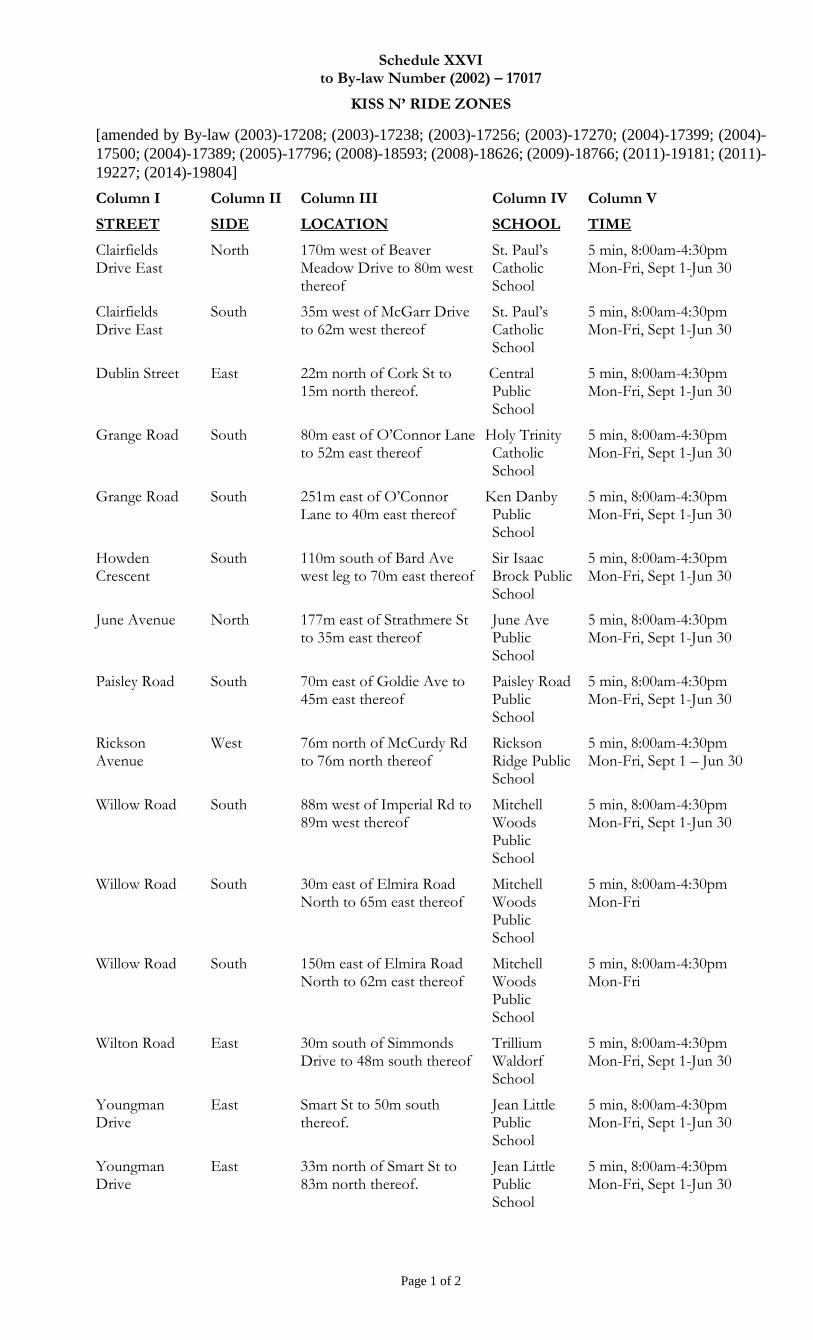
Schedule XXVI to By-law Number (2002) – 17017
KISS N’ RIDE ZONES
[amended by By-law (2003)-17208; (2003)-17238; (2003)-17256; (2003)-17270; (2004)-17399; (2004)-
17500; (2004)-17389; (2005)-17796; (2008)-18593; (2008)-18626; (2009)-18766; (2011)-19181; (2011)-
19227; (2014)-19804]
Page 1 of 2
Column I
STREET
Column II
SIDE
Column III
LOCATION
Column IV
SCHOOL
Column V
TIME
Clairfields Drive East
North 170m west of Beaver Meadow Drive to 80m west thereof
St. Paul’s Catholic School
5 min, 8:00am-4:30pm Mon-Fri, Sept 1-Jun 30
Clairfields Drive East
South 35m west of McGarr Drive to 62m west thereof
St. Paul’s Catholic School
5 min, 8:00am-4:30pm Mon-Fri, Sept 1-Jun 30
Dublin Street East 22m north of Cork St to 15m north thereof.
Central Public School
5 min, 8:00am-4:30pm Mon-Fri, Sept 1-Jun 30
Grange Road South 80m east of O’Connor Lane to 52m east thereof
Holy Trinity Catholic School
5 min, 8:00am-4:30pm Mon-Fri, Sept 1-Jun 30
Grange Road South 251m east of O’Connor Lane to 40m east thereof
Ken Danby Public School
5 min, 8:00am-4:30pm Mon-Fri, Sept 1-Jun 30
Howden Crescent
South 110m south of Bard Ave west leg to 70m east thereof
Sir Isaac Brock Public School
5 min, 8:00am-4:30pm Mon-Fri, Sept 1-Jun 30
June Avenue North 177m east of Strathmere St to 35m east thereof
June Ave Public School
5 min, 8:00am-4:30pm Mon-Fri, Sept 1-Jun 30
Paisley Road South 70m east of Goldie Ave to 45m east thereof
Paisley Road Public School
5 min, 8:00am-4:30pm Mon-Fri, Sept 1-Jun 30
Rickson Avenue
West 76m north of McCurdy Rd to 76m north thereof
Rickson Ridge Public School
5 min, 8:00am-4:30pm Mon-Fri, Sept 1 – Jun 30
Willow Road South 88m west of Imperial Rd to 89m west thereof
Mitchell Woods Public School
5 min, 8:00am-4:30pm Mon-Fri, Sept 1-Jun 30
Willow Road South 30m east of Elmira Road North to 65m east thereof
Mitchell Woods Public School
5 min, 8:00am-4:30pm Mon-Fri
Willow Road South 150m east of Elmira Road North to 62m east thereof
Mitchell Woods Public School
5 min, 8:00am-4:30pm Mon-Fri
Wilton Road East 30m south of Simmonds Drive to 48m south thereof
Trillium Waldorf School
5 min, 8:00am-4:30pm Mon-Fri, Sept 1-Jun 30
Youngman Drive
East Smart St to 50m south thereof.
Jean Little Public School
5 min, 8:00am-4:30pm Mon-Fri, Sept 1-Jun 30
Youngman Drive
East 33m north of Smart St to 83m north thereof.
Jean Little Public School
5 min, 8:00am-4:30pm Mon-Fri, Sept 1-Jun 30
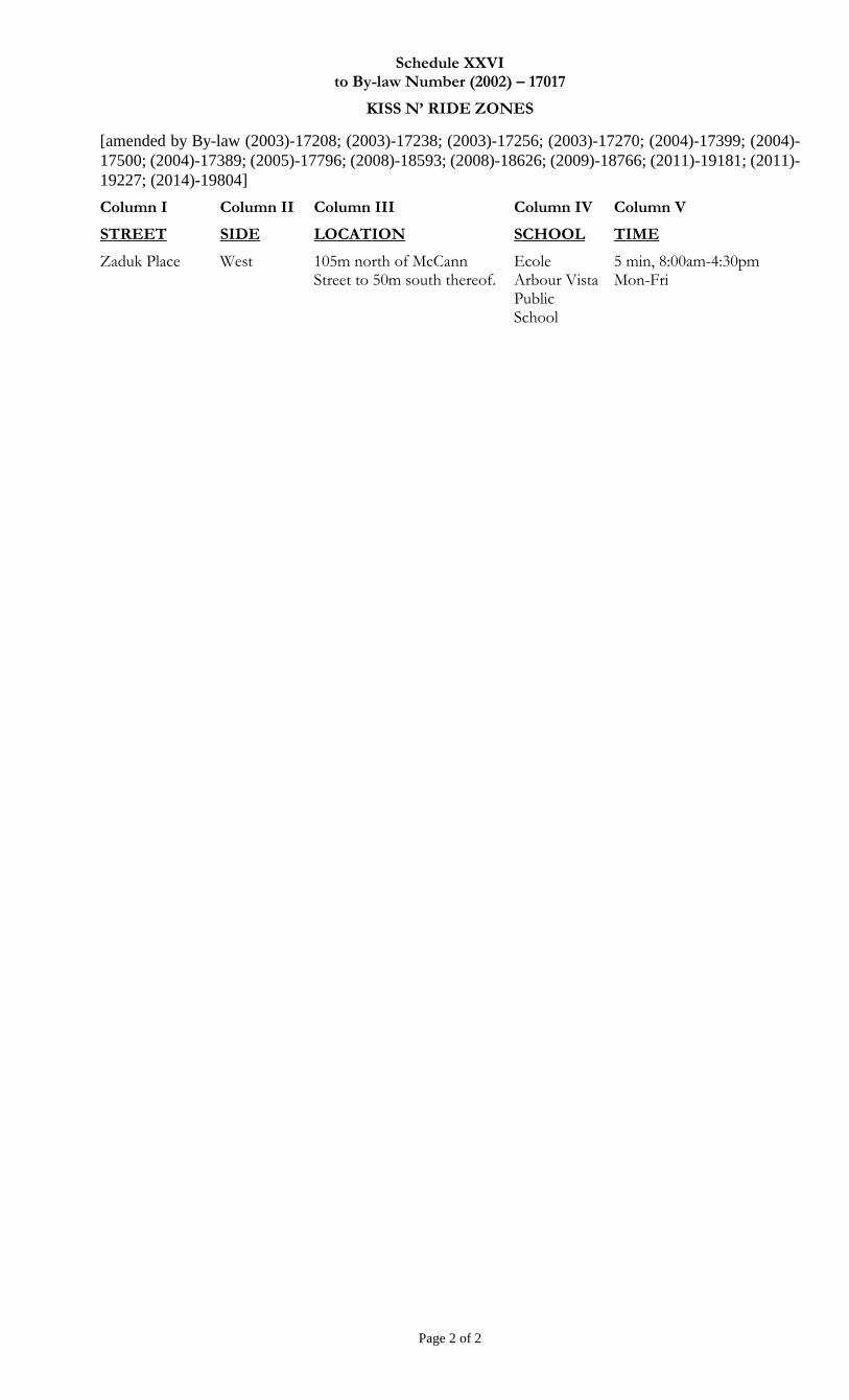
Schedule XXVI to By-law Number (2002) – 17017
KISS N’ RIDE ZONES
[amended by By-law (2003)-17208; (2003)-17238; (2003)-17256; (2003)-17270; (2004)-17399; (2004)-
17500; (2004)-17389; (2005)-17796; (2008)-18593; (2008)-18626; (2009)-18766; (2011)-19181; (2011)-
19227; (2014)-19804]
Page 2 of 2
Column I
STREET
Column II
SIDE
Column III
LOCATION
Column IV
SCHOOL
Column V
TIME
Zaduk Place West 105m north of McCann Street to 50m south thereof.
Ecole Arbour Vista Public School
5 min, 8:00am-4:30pm Mon-Fri
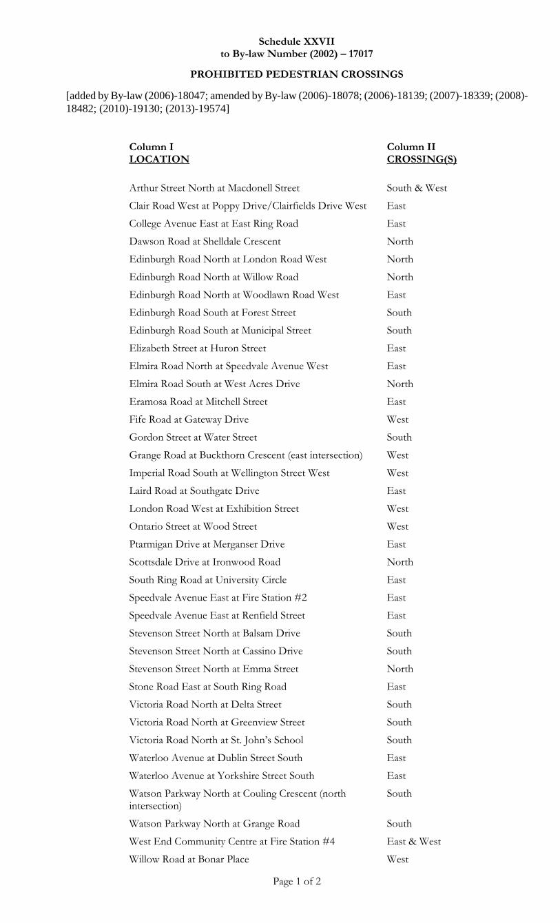
Schedule XXVII to By-law Number (2002) – 17017
PROHIBITED PEDESTRIAN CROSSINGS
[added by By-law (2006)-18047; amended by By-law (2006)-18078; (2006)-18139; (2007)-18339; (2008)-
18482; (2010)-19130; (2013)-19574]
Page 1 of 2
Column I LOCATION
Column II CROSSING(S)
Arthur Street North at Macdonell Street South & West
Clair Road West at Poppy Drive/Clairfields Drive West East
College Avenue East at East Ring Road East
Dawson Road at Shelldale Crescent North
Edinburgh Road North at London Road West North
Edinburgh Road North at Willow Road North
Edinburgh Road North at Woodlawn Road West East
Edinburgh Road South at Forest Street South
Edinburgh Road South at Municipal Street South
Elizabeth Street at Huron Street East
Elmira Road North at Speedvale Avenue West East
Elmira Road South at West Acres Drive North
Eramosa Road at Mitchell Street East
Fife Road at Gateway Drive West
Gordon Street at Water Street South
Grange Road at Buckthorn Crescent (east intersection) West
Imperial Road South at Wellington Street West West
Laird Road at Southgate Drive East
London Road West at Exhibition Street West
Ontario Street at Wood Street West
Ptarmigan Drive at Merganser Drive East
Scottsdale Drive at Ironwood Road North
South Ring Road at University Circle East
Speedvale Avenue East at Fire Station #2 East
Speedvale Avenue East at Renfield Street East
Stevenson Street North at Balsam Drive South
Stevenson Street North at Cassino Drive South
Stevenson Street North at Emma Street North
Stone Road East at South Ring Road East
Victoria Road North at Delta Street South
Victoria Road North at Greenview Street South
Victoria Road North at St. John’s School South
Waterloo Avenue at Dublin Street South East
Waterloo Avenue at Yorkshire Street South East
Watson Parkway North at Couling Crescent (north intersection)
South
Watson Parkway North at Grange Road South
West End Community Centre at Fire Station #4 East & West
Willow Road at Bonar Place West
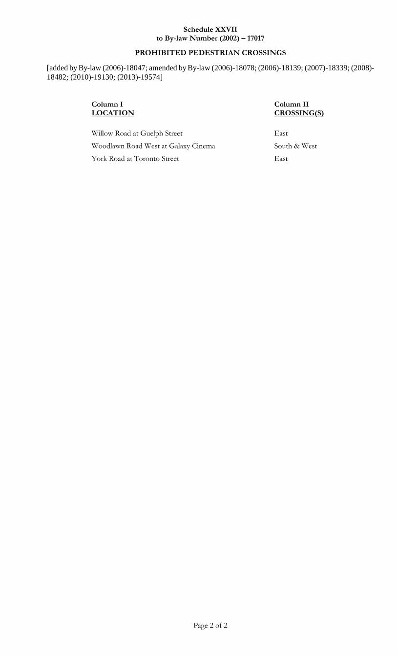
Schedule XXVII to By-law Number (2002) – 17017
PROHIBITED PEDESTRIAN CROSSINGS
[added by By-law (2006)-18047; amended by By-law (2006)-18078; (2006)-18139; (2007)-18339; (2008)-
18482; (2010)-19130; (2013)-19574]
Page 2 of 2
Column I LOCATION
Column II CROSSING(S)
Willow Road at Guelph Street East
Woodlawn Road West at Galaxy Cinema South & West
York Road at Toronto Street East
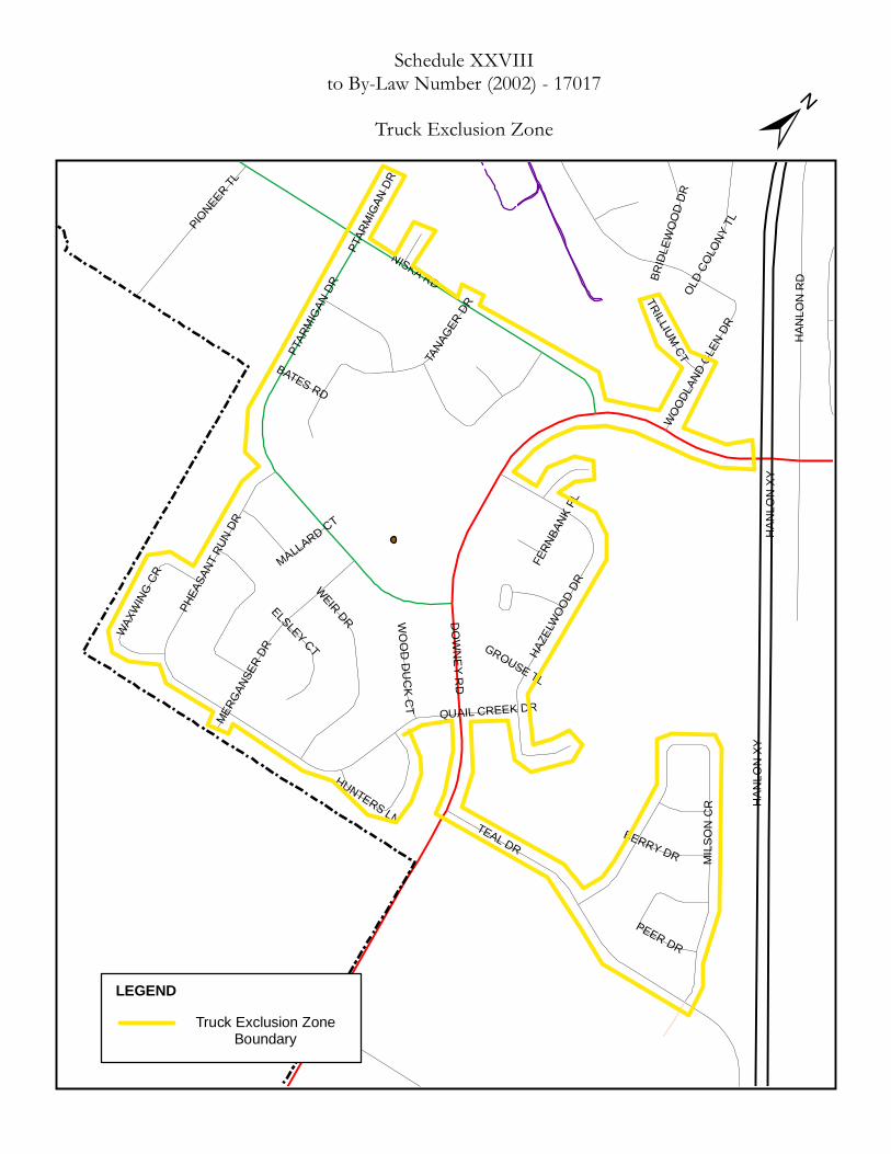
DOWNEY RD
NISKA RDPT
ARMIGA
N DR
HANL
ON XY
HANL
ON XY
TEAL DR
HANL
ON R
D
WEIR DR
MILS
ON C
R
HAZE
LWOO
D DR
PHEA
SANT
RUN D
R
TANA
GER DR
PIONEER TL
WOODL
AND G
LEN D
R
MERGA
NSER
DR
OLD C
OLON
Y TL
BERRY DR
ELSLEY CT
PEER DR
MALLARD CT
TRILLIUM CT
WAXWING
CR
BRIDL
EWOO
D DR
HUNTERS LN
WOOD DUCK CT
BATES RD
FERN
BANK
PL
PTAR
MIGA
N DR
QUAIL CREEK DR
GROUSE TL
±Schedule XXVIII
to By-Law Number (2002) - 17017Truck Exclusion Zone
LEGENDTruck Exclusion Zone
Boundary
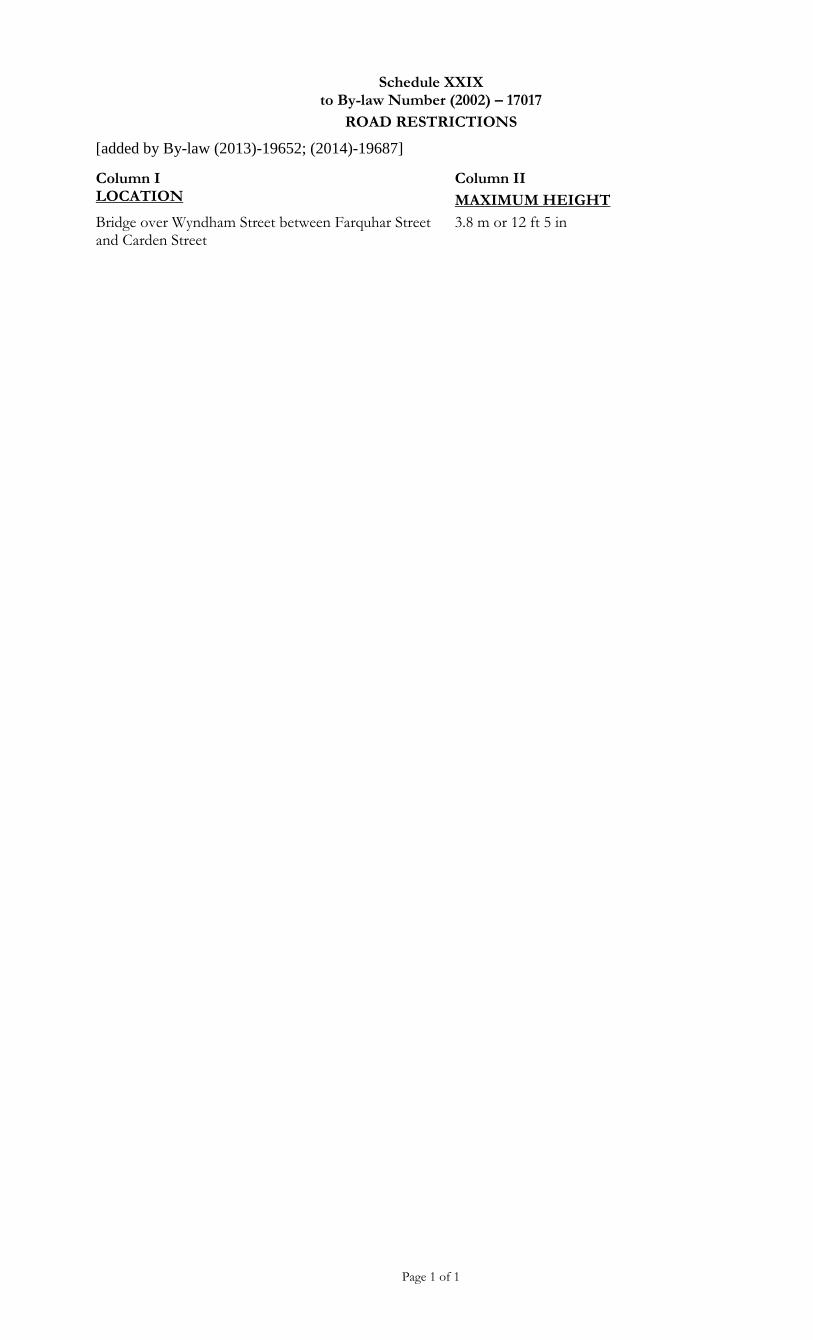
Schedule XXIX to By-law Number (2002) – 17017
ROAD RESTRICTIONS
[added by By-law (2013)-19652; (2014)-19687]
Page 1 of 1
Column I LOCATION
Column II
MAXIMUM HEIGHT
Bridge over Wyndham Street between Farquhar Street and Carden Street
3.8 m or 12 ft 5 in