Embed Size (px)
Citation preview

1
THE CORRELATION BETWEEN SOIL PERMEABILITY AND FLOODING IN THE NORTHEAST SECTOR OF THE DOG RIVER WATERSHED
Skyler E. Sampson, Department of Earth Sciences, University of South Alabama, Mobile, AL 36688. E-mail: [email protected]. Soil permeability plays a much larger role in flooding than most people estimate. Soil permeability can be defined as “the ease in which water, air or gases can move through a layer of soil” (Biology Online). Therefore, the higher the permeability of a soil layer, the faster water can infiltrate through and avoid flooding. To prove the correlation between soil permeability and flooding, a comparative analysis was created on the northeast quadrant of the Dog River Watershed. The analysis was done using soil data downloaded from the City of Mobile’s website along with FEMA flood data also obtained from the City of Mobile. Once downloaded and “clipped” for the study area, the two sets of data were compared and analyzed to find a correlation. Flooding has had a large negative impact on the Dog River Watershed, and has a great potential to become worse if the public does not gain more insight on the causes. This research educates people on how much soil permeability can be connected with flooding, and why it is an important factor to consider. Keywords: soil, permeability, flooding.
Introduction
Soil permeability plays a very large role in flood management. Typically when someone
thinks of why an area is prone to flooding, they think of the area’s elevation or terrain, or if it is
in a natural floodplain. Many people do not take into consideration if the soil’s permeability
plays a factor or not in flooding and flood recovery. The Journal of Environmental Management
included in their article on mapping flood hazards the three types of factors to strongly analyze to
help flood management and prediction: “topography, soil type, and land use” and that “soil
properties” was definitely a main driver in flood recovery (Kalantari et al., 2014). Soil
permeability affects not only how quickly and how much an area can flood, but also the recovery
time of an area after a flood event. For instance, a soil with a high permeability will be much less

2
likely to flood versus a soil with a low permeability, because of its ability to infiltrate water more
quickly, thus not flooding at all or possessing a fast recovery rate.
The concern here is not so much how to prevent flooding itself, but to grasp a better
understanding of which soils in what areas will permit a faster recovery post-flood. The Journal
of Hydrology explicitly states, “An important criteria in Natural Flood Management (NFM) is
understanding and improving the surface soil
permeability (or field, saturated hydraulic
conductivity, Kfs)(Bouwer, 1966, Reynolds et
al., 1985 and Talsma, 1987) of natural ground
surfaces with the view of increasing rainfall
infiltration and storage capacity (Bens et al.,
2007 and Marshall et. al., 2009)” (Archer et al.,
2013). This research will help to educate a vast
array of people such as famers (flood risks for
crops and fields) or potential home buyers (if the surrounding area is prone to flooding, how fast
can it recover?). By using FEMA flood zone data along with soil series data, both provided by
the City of Mobile, it is possible to predetermine which areas may recover more from a flood
event based on their soil permeability characteristics.
The area of interest for this research is the extreme northeast quadrant of the Dog River
Watershed (Figure 1). The western boundary is Interstate 65, and the southeastern boundary is
Interstate 10. The headwaters of E. Bolton Branch and E. Eslava Creek are included in this
subject area, as well as Woodcock Branch. This particular area in the watershed is also
considered to be the midtown area of Mobile, Alabama.
Figure 1: Area of study
3
Hypothesis
Most land classified by FEMA as having a high risk of flooding (presumably on the basis
of elevation, slopes, and proximity to water) tends to have soils with poor internal drainage.
Using the provided data, it is possible to see which select parts of the flood zone in my area will
recover at a faster rate based on their soil permeability and drainage.
Methods
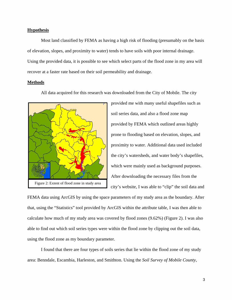
All data acquired for this research was downloaded from the City of Mobile. The city
provided me with many useful shapefiles such as
soil series data, and also a flood zone map
provided by FEMA which outlined areas highly
prone to flooding based on elevation, slopes, and
proximity to water. Additional data used included
the city’s watersheds, and water body’s shapefiles,
which were mainly used as background purposes.
After downloading the necessary files from the
city’s website, I was able to “clip” the soil data and
FEMA data using ArcGIS by using the space parameters of my study area as the boundary. After
that, using the “Statistics” tool provided by ArcGIS within the attribute table, I was then able to
calculate how much of my study area was covered by flood zones (9.62%) (Figure 2). I was also
able to find out which soil series types were within the flood zone by clipping out the soil data,
using the flood zone as my boundary parameter.
I found that there are four types of soils series that lie within the flood zone of my study
area: Benndale, Escambia, Harleston, and Smithton. Using the Soil Survey of Mobile County,
Figure 2: Extent of flood zone in study area

4
Alabama, I researched each soil on its permeability and general qualities. Benndale was
described as “well-drained, moderately permeable soils”; Escambia was described as having
“somewhat poorly drained soils”; Harleston was defined as consisting of “moderately well
drained, moderately permeable soils”; and Smithon was depicted as “poorly drained, moderately
slowly permeable soils” (Hickman & Owens, 1980). Since Benndale and Harleston soils
possessed similar “good” permeability characteristics, they were categorized as being
“permeable”. Similarly, since Escambia and Smithton soils shared “bad” permeability
characteristics, they were categorized as being “non-permeable”.
Once I researched each of my soil types, using ArcGIS, I divided up the soils within the
attribute table and clipped my permeable soils (Benndale and Harleston) and my non-permeable
soils (Escambia and Smithton) separately from each other. This would allow me to see how
much area each group of soils took up of the flood zone, both visually and statistically.
Results
The results showed that the non-
permeable soils took up the most area
of the flood zone. The flood zone
covers ~10% of the Midtown Mobile
area. I found that the Benndale soil
series took up 26.7% of the flood zone;
Escambia covered 4.5% of the flood
zone; Harleston covered 0.4% of the
flood zone; and Smithton took up
68.4% of the flood zone. Since I had
Figure 3: Extent of permeable and non-permeable soils within the flood zone of the Midtown Mobile area

5
planned on grouping the soils with their similar counterpart, I was able to come to the conclusion
that the non-permeable soils (Smithton and Escambia) took up 72.9% of my subject area, while
my permeable soils (Harleston and Benndale) took up only 27.1% of the flood zone. As you can
see in Figure 3, it’s visually obvious that the non-permeable soils covers a much larger expanse
than the permeable soils.
Discussion/Conclusion
It is clear that soil permeability does in fact play a very large role in flooding and flood
recovery. The original purpose of the research was to show a direct correlation between soil
permeability and just flooding alone. But, since the algorithm used for the FEMA flood zone
parameters did not include soil type as a variable, it was impossible to create such a comparison.
With the available data, it was, however, possible to create a risk analysis between soil drainage,
and flood recovery. Using these methods and data, it is possible to see which areas within a flood
zone may have a better time recovering from a flood event, than not. As stated earlier, this is
especially useful for farmers, potential home buyers, and even urban and real estate planning.
For example, of you are planning to build a deck or patio in the backyard of your home, you can
utilize this information to determine how high off the ground you should build it, based on how
fast your backyard has the ability to soak up water after a heavy rainstorm. Or, if you are a
farmer you can use this information to best determine which crops to grow, based on how long
the ground below them will be flooded. There are many different types of situations where this
research could potentially be beneficial.
To get a better visual understanding of the relationship between soil drainage and flood
risk, a matrix was created to better compare the two variables to each other. As you can see in
Figure 4, “flood risk” was defined as being either “low” or “high”, and soil drainage as either

6
being “good” or “poor”. In this matrix, block “A” represents the best case scenario, while block
“D” represents the worst case scenario, while “B” and “C” were grayed out as being medians.
Block A is based on the guidelines that if you have a potentially low flood risk, with good soil
drainage, you are in the clear. However, if you have a high flood risk associated with poor soil
drainage, you could find yourself in a potentially very dangerous situation.
Flooding has had a very large and negative impact on the Dog River Watershed, and especially
within the flood zones located in the Midtown area of Mobile, Alabama. This impact is not based
on the force of Mother Nature alone, but also the public’s lack of knowledge and information on
flooding and the potential causes and effects of it. Hopefully, this research will help people
realize the associated factors that come along with flood recovery and in the end will be used to
the public’s benefit.
Figure 4: Matrix showing the relationship between soil drainage and flood risk within the flood zone of the study area

7
References Cited
Archer, N. A. L., M. Bonell, N. Coles, A. M. MacDonald, C. A. Auton, and R. Stevenson. "Soil Characteristics and Landcover Relationships on Soil Hydraulic Conductivity at a Hillslope Scale: A View Towards Local Flood Management." Journal of Hydrology 497 (2013): 208-222. Print.
Bens, Oliver, Niels A. Walh, Holger Fischer, and Reinhard F. Huttl. "Water infiltration and hydraulic conductivity in sandy cambisols: impacts of forest transformation on soil hydrological processes." European Journal of Forest Research 126.1 (2007): 101-109. Print.
Bouwer, Herman. "Rapid field measurement of air entry value and hydraulic conductivity of soil as significant parameters in flow system analysis." Water Resources Research 2.4 (1966): 729-738. Print.
Hickman, Glenn & Charles Owens. Soil Survey of Mobile County, Alabama. Mobile: Soil Conservation Service, 1980. Print.
Kalantari, Zahra , Alireza Nickman, Steve W. Lyon, Bo Olofsson, and Lennart Folkeson. "A Method for Mapping Flood Hazard Along Roads." Journal of Environmental Management 133 (2014): 69-77. Print.
Marshall, Lucy A. , Michael N. Gooseff, Steven M. Wondzell, Kenneth E. Bencala, Kelsey G. Jencso, and Brian L. McGlynn. "Hydrologic connectivity between landscapes and streams: Transferring reach and plot scale understanding to the catchment scale." Water Resources Research 45.4 (2009): DOI: 10.1029/2008WR007225. Print.
Reynolds, WD, DE Elrick, and BE Clothier. "The constant head well permeameter: effect of unsaturated flow." Soil Science 39 (1985): 172-180. Print.
Talsma, T. "Reevaluation of the well permaeameter as a field method for measuring hydraulic conductivity." Australian Journal of Soil Research 25.4 (1987): 361-368. Print.