Embed Size (px)
Citation preview

GEOLOGY _
OF
THE COUNTY 0F CAPE MAY.,
.-.-. STATE OF
NEW JERSEY.
TRENTON:
PRATED AT THE OFFICE OF THE TRUE AMERICAN.
1857.
NEW JERSEY GEOLOGICAL SURVEY
NEW JERSEY GEOLOGICAL SURVEY

r "lI
/
;_Jntered according to Act of Congress, in the year One thousand eighthundred and fifty-six, by the
8ECItETART OF STATE OF TIlL STATE OF _EW JERSEY,
In the Clerk's Office in the District Court of the United States for New Jersey.
NEW JERSEY GEOLOGICAL SURVEY

TO HIS EXCELLENCY
, RODMAN M. PRICE!
" (_0VERNOR OF TIlE STATE OF NEW JERSEY,
, . g_is _]ohnl_ia r¢sF_ctfnl[_ _thiraleb,
AS A
TRIBUTE TO THE ENLARGED VIEWS WHICH IIAVE ORIGINATED_
AND THE I':NERGY AND PERSEVERANCE
WHICH HAVE SUSTAINED THIS IMPORTANT WORK;
DESIGNED TO DEVELOP THE RESOURCtL_
AND
TO FOSTER THE INDUSTRIAL ENTERPRISE OF TIIE STATE!
BY
HIS ODEDIENT SERVANT*
WILLIAM KITCHELL,
Superintendent ¢_f_vv2eJersey ,Slate Gcologfca! 8uvv_j.
NEW JERSEY GEOLOGICAL SURVEY

° l
\TO DR, WILLIAM KITCHELL,
_, Sul_erinleT_denlo3 tile GeologicalSurvey of tl_eStale of New Jersey.
Sm :
I have the honor herewith to submit the Final Report
on the Geology of the County of Cape May.
With much respect,
Your obedient servant,
GEO. II. COOK,
Assistant State Geologist.I_UTOER$ _OLLEGE 1 NEW _R'JNSWICK_
2!ovember 24_ 1856.
NEW JERSEY GEOLOGICAL SURVEY
, .INTRODUCTION.\
-\' T_z following Report, on the Geology of the County of
Cape May, is made under the authority of an Act of ttm
Legislature of the State of New Jersey, passed March 2,
1854, entitled "An Act to cause a Geological Survey."
The act requires, "That when the survey of a county
shall have been completed, it shall be the duty of the
Governor to require the same to be published."
In presenting this Report I feel some degree of hesi-
. tation ; for the general survey of the State is yet incom-
plete, and I cannot flatter myself that all my conclusions
will remain without modification, when a more extended
series of facts is brought together; or that my views areso comprehensive as not to be extended with longer timeand further observations.
The survey was partly made in the summer of 1855,and was finished in that of 1856.
In tile geology of the county there is but little variety ;
its formations are all of the most recent period. A gra-
dual subsidence of the land, and the changes attending it,
NEW JERSEY GEOLOGICAL SURVEY

10 INTRODUCTION'.
are perhaps the most interesting features in its geological
history.The agricultural resources of the county, and the means
for their development, have been prominent subjects of
study; and, in this respect, I feel confident that the results
will be valuable to the State, and will justify the enlight-
ened policy.which originated and has sustained .the survey, i._From the location of the County of Cape May, remote /from the great lines of travel, it has heretofore .been but
little known in other parts of the State; and/on accountof its distance from market, its agriculture has not been
much developed. Its climate is delightful; it has a soil
which yields generous returns to the cultivator; and its
resources for fertilizers are almost unequaled. It is sus-
ceptible of a high degree of agricultural improvement, and
is now rapidly advancing. Within the last six yeax's the
quantity of its staple agricultural products has increased
fifty per cent., and the price of land has doubled. When
the railroads now in process of construction are opened
through this county, and proper facilities for marketing:_re afforded, the whole area of Cape May will be desirable
ground for farmers and market gardeners.
Accompanying the Report is the elaborate and beauti-_.
Q'ully_exec._uted map of the county, by Lieut'. E. L. ¥iele,_tate Topographical Engineer. The importance-6f this
map for exhibiting the geography and topography, as well
"_-the geol0gy of the" 6our/_,-must commend it to the.'_:pproval of every one. I have colored it in accordance
**. ° . %_---
_,rlth the geological descriptions g3ven in-tl_'g'Report.
Though no specific provision has been made for other
NEW JERSEY GEOLOGICAL SURVEY

INTRODUCTION'. ] l
departments of Natural History than Geology and Mine-
ralogy, I have thought it would be useful to present cata-
logues of its zoological and botanical productions ; and for
this purpose have availed myself of the opportunities
which have offered to procure such catalogues, and regret
that I am not able to present them in every depdrtment.
A catalogue of the birds and of the larger wild animals':_, of the county has been contributed by Thomas Beesley,
Esq., of Dennisville. To persons in the county, the nameof the contributor will be a sufficient voucher for the full-
ness and accuracy of the list.
A catalogue of the fishes found in the vicinity of Bees-
ley's Point, prepared by Prof. Spencer F. Baird, of the
Smithsonian Institution, is copied from tile Ninth Annual
Report of that Institution. This list adds much to our
knowledge of the fishes of the shores of New Jersey; and
the distinction of Prof. Baird, as an ichthyologist, gives itthe stamp of authority.
A catalogue of plants collected at, and near, Beesley'sPoint by Samuel Ashmead, Esq., is inserted. It contains
but a small proportion of the plants found there; but it
shows the most common species of flowering plants of thatpart of the State. Mr. Ashmead also furnishes a list of
the Marine Algte growing in the same neighborhood. He
"has found a much greater variety of species at Beesley's
Point than Professor Harvey allots to the New Jersey
coast." A set of beautifully preserved specimens of all the
algte, and of part of the phenogamous plants, was pre-
sented to the State collection by Mr. Ashmead.
A Sketch of the Early Histm'y of the County of Cape
NEW JERSEY GEOLOGICAL SURVEY

12 INTRODUCTION.
May has been prepared for this Report, by Dr. Maurice
Bee_flcy,of Dennisville. It embodies the facts which he
has been years in collecting, and contains a gloat deal of
matter which has never before been printed. Intended as
tbis work is for general circulation in the county, I thinkthis "trtici'ewill increase its importance and usefulness.
/
NEW JERSEY GEOLOGICAL SURVEY

PART I.
Cf
NEW JERSEY GEOLOGICAL SURVEY

J
PART I.
PHYSICAL AND GEOLOGICAL DESCRIPTION.
As a district for geological investigatien, the County
'of Cape May presents but few features of interest. It
has no mines, no quarries, no reck formations whatever.
' It has no hills, no bold shores ; nor any railroad or other
excavations by means of which its geological structure
can be studied. With an are_ ef 266 square miles, it has
only 46 square miles ef cleared upland. The rest of the
county is either in forest_ er is salt-marsh.
:No remains of animals or of phmts, of species different
from those now living, are known to have been • found
within tile limits of the county.
§ Is geegraphical position, it is the most southerly
county of the _State. The well-known c'_pe, which lies on
the north side of tile outlet of Delaware Bay, is in this
count),, and gives name to it. Its boundaries are as follows :
Beginning "at the mouth of a small creek on the west ef
Stipson's Island, called West Creek; thence up the said
creek as high as the tide floweth ; thence in a straight llne
NEW JERSEY GEOLOGICAL SURVEY

16 PHYSICAL AND GEOLOGICAL DESCRIPTION'.
to the place where the waters of Mill or Hickman's Creek
, fall i:_to the channel of Tuckahoe River; thence down this
and Great Egg Harbor Rivers to the sea; the_ce along
' the _ea-coast to Delaware Bay, and so. up the said Bay
to the place of beginnilig."
It is divided into four townships, Lower, Middle, Dennis, : i
and "Upper. Each reaches entirely across the county fi'om. "
the seashore to Delaware Bay, or to the Cumberland line ;
and, beginning at the south end of the county, they stand
in the order in which they have been nmned.
The line between Lower and Middle, as described in
the order of the Court in 1723, runs "from John Tay-
lor's Branch to the middle main branch of Fishing Creek."
It is drawn on the map _ it is generally received.
The line between Middle and Upper was described at
• [y_ /the same time, as running "from Thomas Leamm_,s _'_
[Branch?'] to a creek called Dennis' (now Sluice) Creek,
and down it to the Bay."
Upper (which formerly included "the residue of the
county,") was divided by act of the Legislature in 1826 ;
a new township called Dennis, being set'off from the side
next Middle. The division line runs from the intersectiou
of the old County, or Cape May road, with the Cumber-
land line, southeasterly, a direct course to the head of
Ludlam's Creek at the Shore road; the1:lce, down said
creek to its mouth ; thence, the course of the direct line,
crossing Ludlam's Sound and Beach to the Atlantic
Ocean.
§ ThE areas of the several tbwnships arc given in the
NEW JERSEY GEOLOGICAL SURVEY

"%
PHYSICAL AND GEOLOGICAL DESCmPTION. ]7
following tables; in the first, in square miles, and in the
second, in acres. Under the head of Cleared Upland, is
• included all the land which is now free of timber, and
has been cultivated. With the W'eod and JBush.land, is
included all the land now in timber or sprouts--also the
.i_/ i::__edar a_d timber swamps. The _alt-Marsh, includes the_at meadows which, when not banked in, are hable to
'"_e overflowed j_y high tides; together with the creeks,_;%horol_CKi'dre%and inlets Which are in them. A few ofthe large Som_ds and Bays which lie in the Salt-Marsh
have been computed and are set down separately. The
t_eache%are the long and narrow sandy ridges whichline the whole length of the sea-side, and much of the
bay-side of the county.*
" "_ ClassifiedAreas of g]ieTownsMpsof _tpe May in S_uctreJIlIes.
_.'Total ©f
Cle_i Wo_l _ Salt_Ms._ah. I Sounds, [ Beaches, Townshlp_.Uplagd. Bush-land.
-Lower . . 12.133 11.418 410 1.10 37.441Middle . . . 16.862 30.274 37.808 I 5.643 I 3.240 93.827Deun_,s , , . 9.358 41.3,30 rL265 ( 1.'i',3OI 0.611 70.294Upper . . 7.786 27.467 25.4`30 I 1.962 I 1.688 64.333
i .....
Totalof County 46.139"-110.487 91.913 I 10.443 I 6.913 265.895I
Theee ar_ _ere cbt_iQQ_ by t_t_fally co_riug th_ Map of the f_cuuty c_ traothg
cloth, anti then o_ the o|oth in piecem on the lines dividing these several _lesctiptlonsof l_nd, and estimating each separately. The estimate was made by weighing a portion
of the cloth whioh would represent a square mile; weighing the several pieces of the map,
and then ¢alcul_tin_ the areas by proportion.
Within _his _re_was of course _ncludcd the water of the bayl, sound_, and inlets.
The north lln_ w_ h_ce(I along the border_ of TDck_hoe River _nd Grea_ _Kg
2
NEW JERSEY GEOLOGICAL SURVEY

18 PHYSICAL AND GEOLOGICAL DESCRIPTIOIq.
_assifiedArea8of theTownshlpsin Aclr_.
Wood and [Beaehe Total of
Cleared Bush-laud. [ Salt-Marsh[ Sounds. s. Tcwushlp$.Upland.
Lower .... 7,765 7.306 [ 7.302 I 710 880 ] 23,963Middle .... 10,792 19.375 [24.197 [ 3,610 2,073 60,047Dennis. . . 5,989 26,451 } 11,050 I 1,107 391 44,988Upper . . . 4,983 17.579 I 16.275 I 1,256 1,080 I 41,173 _ ._
Total of County 29,529 70.711 [ 58.824 I 6,683 4,424 1170,171
The accompanying Map of the county'Shows th_ severalvarieties of land referred to in the table, and gives a clearer
idea of their distribution than any description in words
possibly can.§ A _osT remarkable feature in the topography is the
large extent of salt-marsh. A strip of it extends thewhole length of the eastern side of the county, from Bees-
ley's Point to Cape May, being thirty miles long, and fromtwo, to three and a half miles wide. Marshes of a morelimited width are found along the Bay-shore for ten or
twelve miles up from the Cape ; and about the mouths of
Goshen, Dennis, East and West Creeks there is another
very large body of marsh. It is somewhat triangular inform, with a base on the Bay of about five miles, and
its apex on Dennis Creek, four miles and a half from theBay. On Tuckahoe River, and on Great Cedar Swamp
Creek, there is another tract of marsh several miles inextent.
The cleared upland is almost entirely upon the twomain roads of the county, the sea-shore and the bay-side
roads; and the wood and bush-lands occupy its central
portions. Included in the woodlands are several large
NEW JERSEY GEOLOGICAL SURVEY

7
PHYSICAL AND GEOLOGICAL DESCRIPTION'. i9
tracts of white cedar swamp, and of hard-wood or limber
swamis.
§ TIlE surface i,a uniform, and but little elevated above
the level of the sea. The salt-marslles, indeed, are nearly
at the level of high-water mark. The sand beaches are
usually from 1 to 25 feet high, though some rtre tligber;
one or two on Seven-mile Beach were found reaching the
height of 35 feet. The uphu]d_ or fi_sl land of the county,
is also very uniform. The highest ridges in the county
are not more than 40 feet high, and it is doubtful whether
any reach that elevation. The highest one measured,
which was that between the sea-side road and the marsh,
ten nliles up from Cape Island, was a little under that
height. The ridge called Mount Pleasant, on the road
between Dennisville and Tuckahoe, is onlyeight or tea
feet above the surrounding country, and is probably not
more than twenty feet above hlgh-water mark.* The
slight variation in the surface of the upland will be seen
fi'om the following table of heights, from the profiles of the
West Jersey Railroad. t The line of the road, as sur-
a Tidev.--The following table is taken from the Report of the Superintendent of the
U. S. Coast Survey for 1854.
Rise and fall of tile tide in feet and tenths.
_:_ .Mean. Spring. Neap.
Governor's Island, New York Harbor 4.3 5.4 3,4Samly ]look ...... 4.8 5.6 4.0Cold Spring Inlet ..... 4.4 5.4 8.fiCape May Laudlng ..... 4.8 6.0 4.3nigbie's ....... 4.9 6.2 3.9Egg Island Light ..... 6.0 7.0 5.1Philadelphia_ Wainut Street Wharf 5.9 6.6 5.L
t For the use of these profiles, the Survey is indebted to /he kindness of GOn, William
Cook_ Chief Engineer of the Camden and Amboy Railroad Company,
NEW JERSEY GEOLOGICAL SURVEY

20 I)nYSICAL AND GEOLOGICAL DESGRIPTIO,'¢.
veyed, was straight from the bridge over Island Creek at
Cape Island to Dennisville; there it curved slightly to the
left, and then continued, on another straight course, to the
western border of tile county, which it crossed near Hoff
man's Mill. In tile table, tile first column gives tile milcs
from Cape Island ; the second gives the average elevation
in tbet, of each mile above high tide ; the third gives tile
highest ground passed over in each mile; and the fourfll
gives tile lowest.
Mih,l' from I Average height ia Greatest height iu l_ast height in
Cape l_land, I fL,eL f_ot.. IbvL
1 0 1 02 2 10 03 8 15 04 17 22 ll5 15 18 96 13 22 147 16 22 108 11. 17 69 16 j 19 11
10 15 92 811 10 18 612 12 15 913 7 16 014 5 9 115 10 15 616 6 10 217 5 / 14 0
18 9 1 18 3
19 2 II 02O 9 11 12t 14 17 1002 19 2° 1623 20 23 16o4 19 , 24 10o4} 25 28 20
P ,.
]1 i 28 0"I
§ Tins eixtreme uniformity of surface is a great lfindrance
to the sl;udy of the geological structure of the county.
The slight elevations, which are met with, are generally in
NEW JERSEY GEOLOGICAL SURVEY

PIIYSICAL AND GEOLOGICAL DESCRIPTION'. 21
hillocks rather than in extended ridges; and the streams,
which in some countries indicate a general direction ibr
the valleys and ridges, are here short. They rise in the
swamps and higher flat grounds ill the central part of
the county, and run di_ectly towards the ocean or :Bay.
The only valley of much length is that of the Great Cedar
Swamp, which extends from Delaware Bay to Groat :Egg
Harbor_ a distance of fifteen miles. Its direction is north-oeast and southwest. In that part of tile county, between
this valley and tile Cumberland line, the ridges andstreams tend to a northeast and southwest direction more
than to any other; but the difference is not a very markedolle,
§ Tr[E soil and subsoil of the upland is generally a sandy
loam; in some places so light as to be called a sandy
soil, and in others with clay enough to make it a loam.
Gravel is found in all parts of the count),, though very
irregularly deposited. It is coarser and more abundant in
the northern and northwestern parts. At North Dennis-
ville, at Petersburg, and on the intervening ridges, all of
which lie on the northwest margin of the Great Cedar
Swamp, the gravel is very coarse, and forms a large con-
stituent of the soil. In ttle wells, which are generally
from eight to twenty feet deep, the materials passed
through are siinilar to those upon the surfime, cmlsisting
of sand and gravel, with an occasional layer of compact
clayey loam. At Cape Island there is a bluff bank abotlt
twelve feet high, and several hundred yards long, which
gives a short section of the material which fi/rnls the
Island. It is a fine, loamy sand, with some gravel, similar
NEW JERSEY GEOLOGICAL SURVEY
22 rnYSlCAL AND GEOLOGIG,_.L DESCRIPTIOn.
to the surface soll of that place. At Town Bank the upland
comes out to the Bay with a bold shore from fifteen to
twenty feet high ; and the action of tile waves has exposed
itTFstructure very distinctly. It is composed of stratified
s_.nd and gravel, with a little loam in some of tile layers.
The lines of stratification are generally horizontal, though
a slight inclination, in one direction or the other, is per-
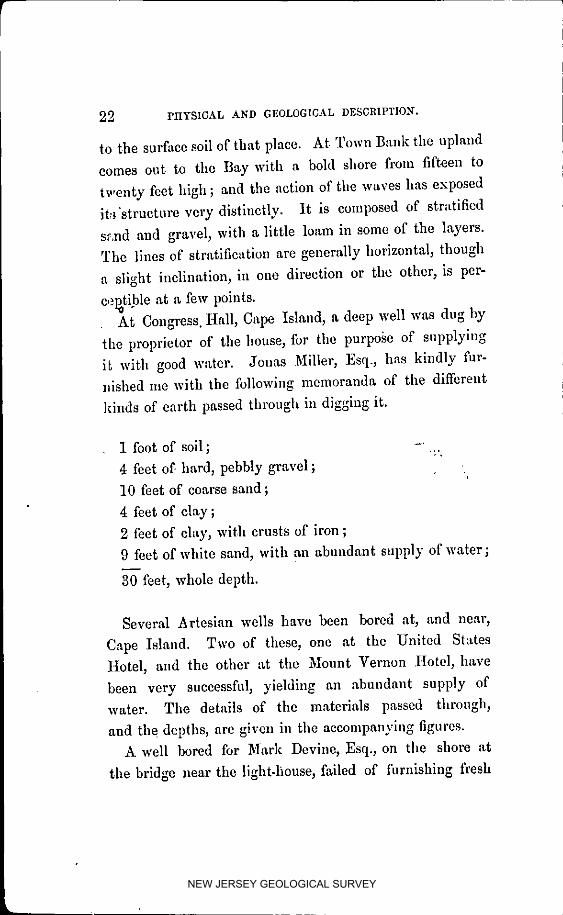
cepati.ble at a few points.At Congress. Hall, Cape Island, a deep well was dug by
the proprietor of the house_ for the purpose of supplying
i_ with good w'ttcr. Jon_ Miller, Esq., has kindly fur-
nished me with the following memoranda of the different
kinds of earth passed through in digging it.
1 foot of soil; -' .:.,4 feet of hard, pebbly gravel ;
I0 feet of coarse sand ;
4 feet of clay ;
2 feet of clay, with crusts of iron ;
9 feet of white sand, with an abundant supply of water;
30 feet, whole depth.
Several Artesian wells have been bored at, and near,
Cape Island. Two of these, one at the United States
Hotel, and the other at the Mount Vernon Hotel, have
been verv successfal_ yielding an abundant supply of
water. The details of the materials passed through,
and the depths, are given in the accompanying figures.
A well bored for Mark Devine, Esq., on the shore at
the bridge near the ligbt.lmuse, failed of filrnisbing fresh
NEW JERSEY GEOLOGICAL SURVEY

SECTIONS OF AI_TESIA_" WELLS.
WF_LL AT CO_GR_ _ALL, CAPE ISLAND. WELL AT NT. VER_0_ HOUSE_ C&P_ I_Lk._D
NEW JERSEY GEOLOGICAL SURVEY

PHYSICAL AND GEOLOGICAL DESCRIPTIO_ _, 2_
waterat120 feet.Therewas no layerof clayfoundto
shut off the salt water. For the particulars in regard to
these wells, the survey is indebted to Mr. J. iN. Bolles,
of Baltimore, a gentleman who has had extensive experi-
ence in boring Artesian wells in various parts of NewJersey, as well as in the adjoining States. The remarkmade by Mr. Bolles, that the gravel in the bottom of the
well at the Mount Vernon I-Iouse is "like that at Cold
Spring, should be noticed. Cold Spring, three miles north
of Cape Island, is noted for a large spring 'of fi'esh water
ill the valley just north of the village. There is no
spring of fresh water on the Cape south of this; and
it appears to be thought by Mr. Bolles, and others
have expressed the opinion, that the gravel stratum, in
which the water comes to the surface at Cold Spring,dips to the south, and is eighty or ninety feet below tide-level at Cape Island ; and that the water in the Artesian
wells at the Island is from the same stratum which sup-
plies the spring at the former place. I am sorry to saythat I have not been able to get any other fitcts, which
would throw further light upon this point.
§ VERY few boulders are to be found anywhere in the
county; none in the southern part. In the vicinity ofDennisville, particularly of North Dennisville, they aremore common than elsewhere. Several of them are in
sight of the road from Dennis to Port :Elizabeth, and within
one or two miles of the former village. They are found
among the gravel on the ridges along the northwest border
of the Great Cedar Swamp; they are said to be found in
the gravel beneath the muck of the Cedar Swamp, and a
NEW JERSEY GEOLOGICAL SURVEY

26 PHYSICAL AND GEOLOGICAL DESCRIPTION.
few Occur ell the southeast side of the same swamp near
Dennlsville. These boulders vary from a few pounds up
to two or three tons. They are mostly of a stratified sili-
cious stone, some specimens compact enough to be called
quart:" rock, and others more or less friable like a sand-
stone. Small boulders of granite rock are oceaslonallymet _rith.
§ ']'as gravel stones found with the boulders are very
coarse, and remarkable for the variety in their compo-
sition. Quartz pebbles are most abundant, but those of
slate, limestone, and sandstone are common; and those
containing shells, corals, and other organic remains, are
frequently met with. These fossils appear to belong to
the Silurian rocks which are in place in the northwestern
part of the State, and in New York and :Pennsylvania.
TowaMs the lower part of the Cape the gravel is not as
coarse_ and is more quartzose in its character; not only
granular quartz, but impure agate, chalcedony, &c., being
common. The strands near the steamboat landing, and at
Town Bauk, are noted localities for transparent quartz
pebbles. These are much sought after by visitors, and are
know:a as Cape May diamonds. The same varieties of
pehbl,_ are also found in the banks and on the upland, but
being covered with loam, they are not as conspicuous as
they become after having been washed from the bank, and
exposed for sgme time to the roll of the surf.
§ &T Tt!ckahoe, casts and impressions of the common
clam( Venus rnercenaria) are found in cemented gravel. The
cementing material is oxide of iron, and no traces of the
lime of the original shell are left. Some of the casts are
NEW JERSEY GEOLOGICAL SURVEY

PHYSICAL AND GEOLOGICAL DESCRIPTION. 27
very perfect; and being supposed by many ill the vicinity
to be the fleshy part of the clam petrified, they arc known
as pet,'tried cht_s. Tlm locality where they are found
most abundantly is upon the point of land between the
two roads which lead from Tuekahoe, the one towards
Petersburg, and the other towards Dennisviile, and
within a quarter of a mile of the village. They are
usually within a few inches of the surface. The ground
is nearly level, and six or eight feet above high water.
About five miles south of Beesley's Point, and a short
distance west of the sea-slde road, on land of Mr. Jonathan
Godfrey, is a locality of shell-marl. It was discovered
several years since in the roots of a tree which had been
blown down. It was also found in a water-bole. Mr.
John Stites and myself, found it on the right of the road
leading from the sea-side to the upper bridge across Cedar
Swamp Cl,eek. It was in a swampy hollow, and was
covered by a foot of decayed leaves and muck, and one
and a half feet of sand. The marl was a mixture of
broken shells and blue mud, and only about a foot and a"
half thick. The shells appeared to be those of the oyster;
all very much broken. A few specimens of a little snail,
or periwinkle (Buccinum obsoZetum) were found. It does
not appear to be very extensive, as in trials since made in
the vicinity it was not met with. The ground is several
feet above tide, and is covered with trees and bushes.
§ A REMARKABLE fact in regard to buried stumps at
Cupe Island, was related to me by Dr. S. S. Marcy, of
that place. It was observed by himself several years
since. Immediately after a violent easterly storm, which
NEW JERSEY GEOLOGICAL SURVEY

28 PLIYSICALAND GEOLOGICALDESCRIPTIO_N_.
had washed the earth out very low on the strand in front
of the boarding-houses, when the tide was out, he saw a
large number of stumps upon the sand. They were stand-
ing upright, and, on examining them carefully, he found
there was every indication that they were in the spot
where they grew. They were of medium size; about as
thick as trees usually stand in a forest---perhaps a hundred
of them on an eighth of an acre--some of them were of
oak. The bark was still on the roots, and the traces of
the fibrous rootlets were to be seen in the earth around
them. The next tide again buried them in the sand, and
they have not since been seen, to the Doctor's knowledge.
:the spot where they stood_ was, within the last thirty or
i!orty years, covered twelve feet deep by the rich loamy soil
of Cape Island.
The farm near the light.house, which is a loamy and
fertile soil, without any resemblance to the beaches now
fi)rming from the ocean, is underlaid to some extent, at
the depth of about two feet, by oyster and clam shells. It
is common to find them, at that depth, in digging holes for
fence posts, as I am informed by the Hon. Downcs Ed-
munds. This land is elevated a few feet above tide-level.
NEW JERSEY GEOLOGICAL SURVEY

GEOLOGICAL AGE AND FOR._IATIO.N'. -09
GEOLOGIC._LAGEOF TtlE COUNTY,ANDITS FORMATIONS,
THE facts which have been stated, together with otherscollected in adjacent parts of the State,* become the
basis for classifying the formations of the county, and
determining their geological age. The conclusion I have
arrived at from them, is, that they all belong to the Q_la-
ler_za_T _Jste_}t of the Geologists, and that two formations
can be distinctly recognized--the Drift and the Alluvium.
,_ystem, has reference to geological age, and the Qua-
ternary System is that which has originated in the latest
or most recent of the geological periods.
.For_al&_, has refcrence to origin_ and thc Drift Forma-
¢_ Shells of the common clam and oyster have been found several feet beneath the sur-
face, in digging we]l_ near the Delaware, in the township of Lower Alloway's Creek, Salem
County. Tlmy werebut little above tlde. At Fairton_ Cumberland County_ on the east of
the Cohansey_ shells have been found near the bottoms of wells_ the land there helng not
much elevated above tide. Shells have also been found in wells on Turkey Poiut_ in
Downe Township_ under similar circumstances. They have also been found a little above
high-water mark_ in the clay, at the brickyard in Buckshutem. In the east hank of Mau°
ri_e River, a mile above Port E_izabcth_ on the Lore property_ there is an ayster-hed ex°
posed by the wearing away of the bank_ whlch 18 at least ten feet above high°water mark.
his in hho mud, and the _hells are closely bedded in with thelr edges upward, just as
they are in the shell-beds fouad at the mouths of the creeks_ and in the bay. The bank
is twenty feet, high, and about two hundred feet long. The material under the ehells is clay
and sand ; the shells are in a hycr of from _ foot to a foot and a half thick in blue mud_
_vhlch is stratified th curved strata. Theupperpartofthohankiseand_andwithoutetr,qti-
fieatfom The tldo risee there between seven and eight feet. Other beds of ehells are found
on the _[nnamusklng, near Port Elizabeth. Igear Lecshurg, and also near Ilei_lervitle,
on Ewlng'8 Neek_ shel]_ of the specles now common in the ]]ny_ are found in the upland_
covered with several feet of earth. At May's Landing, Atlantle County, stumps have
been me_ in dlgglng wells ; and a_ Bnrnega[_ in Ocean Couuty_ both clumps and ehelle of
the common kinds have b_en found ia llk_ sltuatlon_.
NEW JERSEY GEOLOGICAL SURVEY

30 GEOLOGICAL AGE AND FOR._IATION.
tion includes those materi_ds--sand, clay, gravel, and loose
stone--which have been brought to their present places
from sources more or less distant; while the Alluvial' For-
mation includes those sauds, clays, loams, mud, peat, &c.,
which b_ve been deposited where they now are, from
sources comparatively, near.
Of these two formations, the Drift is tile oldest. The
mode of its origin, and the causes which have brought
its materials to their present places, have been the subject
of much diseussiou, and are not yet well understood. The
Alluvium is still forming, and the modes of its production
m'e various, but well known.
§ TII_ remains o[' animals and plauts which are found
in the Alluvium are those of specics still in existence;
mid the same is true, of at least a p,_rt, of those of the
Drift.
The/)r_t Form_ttio) b in this county, ineh_des very nearly
all the uplands within its bounds. That part where loose
stones and boulders are found, is unquestion0.hly of this
for_aation ; and the remainder of the upland, which con-
tain_ no fossils, which has extensive beds of gravel--the
gravel containiug fragments of rocks which arc in place
considerably north or northwest of this--and, iu general,
whicil possesses none of those peculiar and distinctive cha-
racters belonging to the upland of the succeeding forma-
tion, is, so fitr as nly present knowledge extends, properlyclassed here.
The Alhw, ium includes some limited portions of upland
not comprehended in the above description of the Drift.
l_ is ri_t easy to draw a distinct line of division between
NEW JERSEY GEOLOGICAL SURVEY
GEOLOGICAL AGE AND FOR._IATION. 31
the Drift and the upland Alluvium, unless there are fossil
shells, trees, or other organic remains found in them. By
these means Cape Island, the farm near the light-house, and
the sheU marl near Bcesley's Point, which were mentioned
on p. 27, are easily distloguished as Alluvium. Some
odmr points, as Stipson's Island, on which organic remains
have not been found, can be recognized as being also Allu-
vium from the quality of their soil, and from the mud and
brackish w£ter which are found a few feet beneath the
surface. There are numerous points of land on the edge of
the fast ground, both on the Bay-shore and on the sea-side,
which are probably Alluvium; but the lack of other evi-
deuce than the quality of the soil prevents the positive
decision of the question. These alluvial soils appear to
have been formed by the washing of the finer sand and
loam from the higher grounds, and the depositioll ofthem in lower situations.
§ THE sand-beaches on the ocean and bay-shores, the
salt-marshes, and the cedar swamp-bottoms, arc also
alluvial, and they are now in process of formation or
change.
§ As these changes are of an important character, and
will aid in niaking intelligible the descripiions of the
formations above mentioned, they may be introduced here.
For many years past it has been a subject of remark
among the older inhabitants, that the tides came up on the
uplands higher than formerly, and that the salt grass w,ts
killing out the fresh grass, or the timber which formerly
grew on the borders of the upland. Judge Goffe, of East
Creek, gives it as his opinion that fifty acres, part heavy
NEW JERSEY GEOLOGICAL SURVEY

32 GEOLOGICAL AGE AND FORMATION.
oak thnher,and part cultivatedhind,h,_vethus been lost
fi'omStipson's'Ishuldwithinthe fiftyyearssincehe resided
therewith hisfather.His opinioniscorroboratedby Mr.
Janms I.,. Smitl b who has resided on the island for the last
thirty-six years, and has lost many acres of good wheat
land wil:hin that period. Mr. Charles Ludlam, of South
Dcnnls_ille, pointed out to me places now covered with
salt gross which were formerly upland, and covered with
trees; he also showed me an island in the marsh, west of
the bridge, which he thinks has lost two foot of its eleva-
tion above themarsh since his recollection.
An i_land in the meadow of Richard Leaming, between
Dennisrille and Goshen, had living trees upon it seventy
years ago. Mr. Albert Pcterson sounded the depth of the
mud on it this summer, and found it to be four and a half
feet. ]?he bottom of this may be muck, but it has a con-
siderable depth of marsh mud on top, and high tides runover it.
Mr. Stephen Hand, on the sea-side, ten miles from Cape
Island, showed me places in the borders of his salt-marsh
whm'e trees and bushes had grown since he owned the
land. Mr. Joshua Townsend,'ncar Townsend's Inlet, on
the sea-side, knows, in his own vicinity, several spots where
white oak trees grew since his recollection, which are now
covered with marsh. Mr. Nicholas Godfrey, t_vo miles
below Beesley's Point, has instances on his own land where
the timber has been killed out, and salt-marsh taken its
place since his recollection. Mr. Johu Stites, Sen., of Becs-
ley's Point, says the advance of the marsh on the upland
is unquestioned. Mr. Stephen Young, at the Toll Bridge
NEW JERSEY GEOLOGICAL SURVEY

GEOLOGICXL AGE AND FORMATION. _
over Cedar Swamp Creek, "knows the salt water comes
higher on the upland than formerly, by the killing of tim-
ber on the low borders of tile upland." Testimony of the
same sort, to any amoun% can be obtained ; but the above,
from different parts of the county, is sufficient. Observa-
tions on the dying out of timber can easily be made by anyone who is interested to do so.
In most of tile marsh near the upland, which is shallow,
fitllen timber is found buried ; and the stmnps of trees are
still standing with their roots in the solid ground where
they grew. The timber found in this condition is of oak,
gum, magnolia, cedar, pine, and other species, such as arc
now the naturM grewth of the country. Where they are
of pine, cedar, or other durable wood, their broken and
weather-worn trunks arc seen projecting above the marsh
which has overrun tile place of their growth. On the land
side of the beaches, along the sea-shore, large numbers of
leafless and dead red cedars may be seen standing in the
marsh, the indestructibility of the wSod keeping the trees
erect, although the marsh has, in some instances, gathered
around them to the depth of severM feet. Instances of
this sort were seen on all the beaches; and they may also
be seen on the low sandy islands which stand in the marsh
opposite each of the inlets. It was observed very strikinglyin the salt-holes on Nummy's Island, which lies in front of.
Hereford Inlet. Cedar stumps and roots were lying in
many of these holes, and the sandy bottom on which they
grew was but little under the marsh. Within the last
fifty years the island is said to have had ,_ considerable
growth of cedar on it; now there is but a single living tree3
NEW JERSEY GEOLOGICAL SURVEY
3_: GEOLOGIGAL AGE AND FORMATION.
left, and there is every indication that the whole island
will soon 3i) covered by the marsh.
The swamps of white cedar, adjoining the marshes, are
continuall.y encroached upon by tile tide; tile timber oll
the borders is graduallj, being killed by the salt water; andhundreds of acres are to be seen about Dennisville all
dotted ever by cedar stumps, which are still standing
whei'e tlae'y grew, though the salt grass has long since
taken tlm place of the living timber. The soft and spongy
n,'_ture of the cedar swamp-bottoms would lead one to sup-
pose th:_t the mud, with the load upon it, was'gradually
going down, were it not for the fact that these bottoms arefound fz,r below tide-level, and the muck of which they con-
sist, ex':ending down to the gravel. Tim tbllowing section,
fl'om examinations made in company with Dr. Mauriee
Beesle)', shows the extent, and some of the effects of this
settling.
The timber and earth of the swamp, it will be seen, ex-
tend quite down to the hard ground, which is eleven feetunder file surface of the marsh. In some trials which were
made in the thoroughfare between Dennis and Goshen Creeks,
the cedar swamp earth was found at least seventeen feet
below the level of the marsh ; and some cedar stumps of
]argc size are known to be in the bed of Dennis Creek,
which are covered by seven feet of water at low tide. The
•appe:trance of these last-mentioned, indicates that they arein the spot where they grew.
S6me years since, an outlet was needed from a number
of tide-ponds near :East Creek, into Dennis Creek. :For this
purpose a ditch, ten feet wide and three feet deep, was dug
NEW JERSEY GEOLOGICAL SURVEY

NEW JERSEY GEOLOGICAL SURVEY

GEOLOGICAL AGE AND FORMATION. 37
across tile marsh from the ponds to the creek. Nothing
but mud and grass roots were met in digging the ditch.
From the size of the ponds, a large quantity of water neces-
sarily passed through the ditch at every tide. The noise
made by the violent rush of the water gave the name of
.Roari_g Ditch to the outlet; and the wear of the banks
soon changed it from its original narrow dimensions to a
large channel, seventy or eighty feet wide, and from one to
four feet deep at low water ; and, what is very remarkable,
is, that the whole bottom of the passage is thickly set with
piu% cedar, and gmn stumps. Some of these are laid bare
at low wate 5 and others are covered with several feet of
water. They stand upright, and there is every indication
they are in the spot where they grew.
Judge Gofib relates, that, in digging a dlteh through one
of the shallow tide-ponds_ under the mad were found mag-
nolia and huckleberry roots ; then four feet of mud_ beneath
which were found large pine stmnps; and when the ditch
came to be worn or dug still lower, white cedar snags were
found fbur or five feet under those of pine. The cedar
snags were standing, and there were four or. five feet of
water on them at low tide.
§ ThE wearing away of the shores wherever exposed to
the action of' the tides is not uncommon in other localities ;
but it is so rapid on most of the shores of this county, that
it may be fairly considered an effect of this subsidence.
On the side towards the Atlantic, the npland is protected
by the salt-marsh and the beaches; but the beaches them-
selves are rapidly wearing. Hundreds of acres of fiat or
sloping sands are now to be seen where a few years si_me
NEW JERSEY GEOLOGICAL SURVEY

38 GEOLOGICAL AGE A,N'DFOR,_[ATIO_.
sand banks from fifteen to thirty feet high were standing,
aud covered with living trees. The rapidity with which
these wear aw_,y is different in different years. Dr. Learn-
ing, of Seaville, thinks that the Seven-mile Bcaclb opposite
his residence, has worn away a hundred yards within the
last twenty years. Other residents of the county, who are
fat_iliar with the beaches, think this estimate not a large
one.
M'r. Ezekiel Stevens says, th,_t fi'om the accounts given
him by his fitther, the shore in fi'out of the boarding-houses
_t Cape Island must have worn away nearly a mile since
the l%voluticn. Duriug the war of that period a militi_
artillery company had its practicing grouad here. Their
gun was placed uear.a house which stood just outside the
present shore line, and their target was set up at the outer
side of a corl:, field three quarters of a mile east. Beyond
this there were sand hcaehcs for nearly or quite a quarter of
a mile, and then the sea-shore. Tim whole of this groun_l
is now gone, and one of the boarding-houses has been
moved back twice. The wear has not been as perceptible
for a few years past, the bank having been protected by a
covering of cedar brush.
At Town :[_ank, on the Bay-shore, where the first settle-
ment in the county was made in 1691, there has been a
rapid wear o[" the shore. In a note made by Aaron Learn-
ing, in relation to the grave of his grandfather, who was
buried here in 1694, he says: "In 1734 I saw the graves;
they were then fifty rods from the Bay, and the sand was
blown up to them. The town was formerly between them
• nd the water. There were still some signs of the rain of
the houses." The grave-yard is now allwashed away. A
NEW JERSEY GEOLOGICAL SURVEY

.GEOLOGICAL AGE AND FORMATION'. 39
few years since a skull was picked up on the strand whicil
had the appearance of one long buried, and which had
probably fallen from the bank. At dead low water, tile
marks of three wells call just be distinguished at the same
place. Nathan C. Price, surveyor at Town Bank, says his
lines, which run to the shore, are shorter by forty or fifty
rods than they were ill 1776. The Cedar Hummocksoat
Goshen are also wearing away.
From the Cedar Hummocks to West Creek there are no
sand beaches, and the salt-marsh is exposed to the directaction of the waves. Dennis Creek is said to have lost
more than a mile of its length within the last sixtj, or
seventy years, by the wearhlg away of the marsh at its
mouth. Several rods in width of the marsh are sometinles
worn away during a single storm. Four years since, a
human bed),, in an advanced stage of decomposition, was
washed up on the shore near tile mouth of Dennis Creek.
It was carried in forty rods from the shore, and buried in
the nmrsh. A year ago it was ibund the shore was worn
away quite up to the grave, 'rod the coffin was washed out.
Mr. James L. Smith, of Stipson's Island, who bus sur-
veyed nmch of tlle land about Dennisville, says there was
always a large allowance made by the old surveyors in
running out the marshes, so tllat it is difficult to trace tlleir
lines with accuracy ; but that, to the best of his judgment,
a strip fnlly three-quarters of a mile wide has been worn
from the marsh, the whole distance from West Creek to
Dennis, since the first surveys were made.*
¢_ Numerous facts of the same kind have been collected along tho shores of nolawara
Bay am[ River, in S_lem a21d Cumberla2_d Countic_ and on tb_ _o.a-_hlo in Atlantic,
Ocean t _,Ionmouth, and Middlesex Cotmt_es.
NEW JERSEY GEOLOGICAL SURVEY

40 GEOLOGICAL AGE AND FORMATION.
There is a common opinion among the watermen along
the Bay-shore, that the mouth of Mauriee River was for-
merly down near Fishing Creek, and that East, West, Den-
nis, and Goshen creeks were its branches. Their reason
for this opinion, in addition to that derived from the pre-
sent rapid wear of the shore, is, that a line of oyster-beds
is found out in the Bay, at different points, between tile
present mouth of Maurice River and Fishing Creek; and
similar beds extend out from tile mouths of the other
creeks tbr some distance into the Bay. New beds do not
form in the Bay now. These beds, near the mouths of the
creeks_ are almost bare at low-water; that opposite Fishing
Creek is in twelve feet of water. Tbero is also a traditiol h
derived from the Indians, tbat trees formerly grew on the
bank which is now Fishing Creek Slmah More fitcts are
needed to give certainty to this opiniou; but it is by no
means improbable.
§ THE C|lange of level between tbe land and water h_
produced an effect upon the efficiency of several mills
which were located on or near tide-water. Mr. Nicholas
Godfrey had a tide mill on the sea-shore, two miles below
Beesley's Point. I_e attended this mill himself for twenty-
five years, during which time no changes were made in the
arrangement of the wheel and raceways. He lc_towsthat in
that time he lost, at least, foul" incbes of head by the in-
creased height of low water, and says it nmy have been more.
The lower mill on West Creek Was built fifty-two years
since. It is a pond mill, and its wheel-pit floor was care-
felly set, so that it might be as low as possible, and not he
affected by the tide which flows up to it; and it has not
NEW JERSEY GEOLOGICAL SURVEY

.GEOLOGICAL AGE AND FORMATION. 41
\ been altered since. When first built, it was only an ex-
tremely lligh storm-tide that would stop it; now, a corn-
moll perigee tide will stop it; and it is stopped in this way
perhaps twenty timcs in ayear. JudgeGoflh, my informant,
is of opinion, tllat the tide rises on the wheel fifteen iuches
higher than at first, and he is stere it is not less than twelve
inches.
The saw-mill on Sluice Creek, owned by Mr. Clinton Lud-
lam, has been built a hundred years. It is a pond mill,
and from the old papers in Mr. Ludlam's possession, lie is
well satisfied that it was originally located so as to be out
of the reach of ordinary high tides. Now, such a tide
would conic half way up the mill-dam; and the mill is
only kept in operation by a dam and sluice some distance
below. 5udging fl'om all the fitcts, he thinks the tides rise,
on an average, at least two feet higher than when the mill
was built.
These measurements agree in giving the rate of sub-
sidence as about two feet in a century, or one quarter ot
an inch a year; a conclusion which was arrived at in my
Annual Itcport of last year fi'om observations in other
counties of the State.*
The whole amount of this subsidence is not known ; it
o The facts as to the rate of subsldencc glvea last year, were, tha_ below hancock's
Bridge, ever Alloway'_ Creek_ in Salem County_ the sluices in a meadow bank, built ahou_
the year 1700_are full three feet below low-water mark; so low that my informant had
only seen them twice in thirty years. On thc opposite bank of the creek is an oak stump
standing, the root_ of which are in hard bottem_ and the top of it_where eat off, is about the
level of high tide. It ha8 been cut by an axe; and, of course, has boca cut since the set-
tlement of the country, or within about one hundred and fifty years. The tides would have
killed a tree in that location when they were three feet lower than now. A settling of
three feet in a hundred and fifty yearh or a rate of Bubaideneo of about two feet in a cen-
tary_ is _hown by the_e faet_.
NEW JERSEY GEOLOGICAL SURVEY

42 .GEOLOGICAL AGE AND FORMATION.
must, at least, equal the whole depth from hlgh.wafer
mark to the lowest points at which stumps and roots of
trees have been found in tllcir places of growth. This,
frmn tile evidence on p. 34, is seventeen feet_ and it may
be nlore.
Ill this connection it m_y be interesting to again notice
the flints lncntioned on pp. 27 and 28, of the existence of
shells of the same species now inhabiting the adjacent bay
and ocean, at elevations considerably above the present
tide-level. Frmn this we may fairly il)fer, that the present
period of subsidence was preceded by one of elevation, in
which, what was before the bottom of the sea or bay, was
carried upward at ]east twenty-five or thirty feet above
high-water. And there may have been several alternate
periods of elevation and depression ; of which that, when the
timber and shells of the Alluvimn were buried, must have
been one of depression.
In tltese alternations of elevation and subsidence we may
find a reasonable explanation of the various phenomena
connected with the uphmd Alluvimn. If we go back to
the commencement of tile period of subsidence preceding
the present, for our starting point, and assume, as there is
reason to, that the ground was a little higher than it now
is, then, as the ground slowly sunk down, the watm" would
overflow tile upland, killing the tilnbel 5 and carrying it
beneath the level of the tide. This subsidence must have
continued until most, if not all, of the present upland of the
county was below tide-level. Oysters and other shell-fish
would of course be found wherever the sea-water extended.
The action of the waves would wash out. the loam and liner
NEW JERSEY GEOLOGICAL SURVEY

GEOLOGICAL AGE AND FORMATION. _3
purtleles of soil from the most elevated parts, and deposit
them in banks and points on the adjacent lower grounds,
burying beneath them whatever remains of animals or
plants might be there. In the succeeding elevations, these
points and banks, composed of fine and rich washings,
have bccorae the most productive soils of the county. The
shells and other fossils buried beneath them are preserved
unchangcd_ while those on or near the surface have decayed
witllout leaving any traces, except in cases like that at
Tuckahee, when some eemdnting matter has preserved the
form of the shell in the more indestructible materials which
surrounded them.
§ Fl_o,_iwhat has been said in relation to the advance
'of the salt-marshes on the npland, and to the existence of
cedar-swamp earth under them in many places, the evi-
dence is conclusive that these marshes are of very recent
origin. Quite large portions of them have been formed
since the first settlement of the county. The marshes
_long Delaware Bay, especially those about _Iauriee River
Cove, are well illustrated by the section, across the cedar
swamp and marsh fl'om the upland in fl'ont of Mr. W. S.Townsend's to near the mouth of Sluice Creek on Dennis
Creek.* In this section it will be seen tlmt the marsh is
on nearly the same level with the cedar swamp; the
lowest ground being near the place where the nmrsh lind
swamp meet, and the surface rising gradually both toward
the creek and the upland. The bottom on which the
swamp st'rods is full of logs and other remains of fifllen
timber, quite down to the sand and gravel which underlies
o See page 3G.
NEW JERSEY GEOLOGICAL SURVEY

44 GEOLOGICAL AGE AND FORMATION.
the whole. This cedar swamp bottom, it will be perceived,
extends out under the marsh for a considerable distance,
and, beyond where it is marked as extending, stumps and
logs are frcqueutly found low down ill the mud.
The marshes on the sea-side are well represented by the
accompanying Section, from tile edge of the upland, opposite
the stone marking nine miles from Cape Island, to _Five-mile
Beach, two hundred and twenty rods below its northeast
extremity. The lnarsh appears to occupy a hollow or valley
between the mainland and the beach, and to increase ill
depth very gradually from either side towards the middle;
slight inequalities only being noticed on the bottonl. Mr.N.
C. Price, who constructed this section, says_ that in soundit_g
the depths, "the mud w_ quite soft until I got within
about thirty chains of Grassy Sound; then I struck sonie-
thing similar to a sand-bar about eighteen inclies from the
bottom_ and this seemed to rise as I neared the Sound;
after driving the rod through this bar, it would pass down
very easily to the bottom. Upon reaching the Sound, this
bar was about three or four feet below the bottom of the
w,ate5 and very hard to penetrate. Crossing the Sound, I
found many snch bars or layers of sand; sometimes there
would be three or fou 5 one below the other, with a few feet
of soft mud between, quite down to the bottom. The rod
always brought up very tinc sand sticking to it after meet-
tug these bars. Sometimes the mud would be soft near the
bottom for several feet, and then again only for a few
iuclies. When about half a mile from the Five-mile Beach,
these sand-layers would come almost to the top of the
marsh; then, in a direction to the northeast, there would
NEW JERSEY GEOLOGICAL SURVEY

NEW JERSEY GEOLOGICAL SURVEY

GEOLOGICAL AGE AND FOR)IAT10N. _7
alw.tys be an island, with a few trees on it. These layers
I found until I came to the beach." "From the channel
'of Grassy Sound to twenty rods west of tile drain on the
left, shells were found down below the surfllce of the mud
twelve and fifteen feet." No trees or buried timber of any
kind are found ill the deep paris of the nlarsh; they are
not uncommon in tile shallow parts near the shores.
The level of the salt-marshes is nearly that of high-
)rater mark; those portions along the creeks, and other
water-courses, are usual]y a few inches higher than those
further back. Whei_e there is 11ocedar-swamp lIottom, the
marsh is more solid near the passages through _vllich thd
tide flows than at "Llittle distance from them; the differ-
ence being due to the greater or less amount of nlnd in it.
In many parts of the marsh scarcely any mud is to be
found, the whole substance consisting of the roots of sedge,
reeds or flags, which, when dry, is ahnost as light as hay,
is very combustible, when consunlcd leaves very little ash i
and, when allowed to decay slowly, wastes away to almost
nothing. The muddy water which comes in with the tide.
deposits the principal part of its sediment near the water-
courses_ where its rapid flow first slackens, and hy the time
it has reached the back part of the marshes it becomes
clear. The banks which are nmde by the mud hinder the
water from draining out completely at low-tide; and the
coarse grasses which thrive in such localities continually
increase, and their matted roots, buoyed up by the w,_ter,
ln_dntain the apparent level of tlle marsh. This appears
to have beeu the mode of growth throughout; for in sound-
ing the marshes at different depths, variations in solidity
NEW JERSEY GEOLOGICAL SURVEY

_8 GEOLOGIC&L AGE AND FORMATIOn.
wilt be found quite to the bottom, just as we now find on
the surihce. In forcing the rod down, much difficulty is
experienced in piercing the layers of mud, while it will
drop by its own weight in passing through the layers of
roots. In sounding for the Dennisville Section, a layer of
sedge, or other grass roots, was found about four feet under
the surface, and extending back from the creek a quarter
of a mile. It was extremely difficult to penetrate, being a
foot thick, and almost solid, with cbarse and strong roots.
It is represented on the sectlom
§ THE marsh, as will be perceived, is of variable depth ;
twenty-seven feet is the deepes_ found in sounding for the
section across the marsh near Grassy Sound. Mr. John
Stites, Sen., informs me that the deepest marsh opposite
Beesley's Point is thirty feet. In sounding across the
marsh at Tuckahoe for the Delaware and Raritan Buy
Ilailroad, the greatest depth found was seventeen feet.
Near the mouth of Dennis Creek, in putting in a stopping
across the mouth of a ditch, the piles driven down reached
the bottom at twenty-nlne feet.
§ THs marsh along the sea, shore, and also the smaller
ones on New :England Creek, Cox Hall Creek, Fishing
Creek, Green Creek, and Dyer's Creek, are all protected
from the action of the waves by sand-beaches, and appear
to have formed in quiet water. That about the mouths
of Goshen, Dennis, East and West creeks, is now exposed
2o the direct action of the waves; but there is reason to
believe that a sand beach has extended in front of these
,_lso, and that it has been worn away.
The Cedar Hummocks at Goshen have evidently been a
NEW JERSEY GEOLOGICAL SURVEY

av.onoarc,_L._G_A_'DrOR_ATI0Z_. 49
part of this line, and within fifty years, as I am informed
by Judge Goftb, the llne of beaches between West Creek
and N[aurice River was standing where now there is only a
low s,_ndy shore. The interval between these two points
is less than three miles_ and I have no doubt the hue of
beaches ha extended entirely across at a comparativelyrecent date.
The marshes on the Bay-shore, and on Tuckahoe and I
Great Egg Harbor rivers, have evidently all been formed
in the broad and shallow valleys of the streams; and in
this respect they have a common character. There is,however, no cedar-swamp bottom in those below Goshen.
The marshes along the seashore in this county are only
part of _ long strip of sMt-marsh which extends from a
short dist,_nce below Long Branch, in Monmouth County,
to Cape May, and has the same general features fllreughout.
They seem to fill a broad valley which fbrmerly extended
along the stmre. On the side next the upland the marsh
is shallow, and the f_t la_d meets it at a very gentle slope.
On the sea-side the marsh is terminated by a ridge, or
series of parallel ridges of sand beaches. These are hot
quite continuous, being broken at intervals by the occur-rence of inlets, through which the sea-water finds entrance
to the marshes, and the fresh water brought down by the
streams escapes. The marshes include considerable bodies
of w_ter, which are known as bay8 and 8ouuds; and they
arc traversed in various directions by ttmroughfares, which
connect the larger bodies of water, and erects, which
branch out from the sounds and thoroughfares, and termi-
nate in the marsh or upland.4
NEW JERSEY GEOLOGICAL SURVEY

_0 GEOLOGICAL AGE AND FORMATION,
In this county the marsh extends along its whole sea_
side, a distance of thirty-two miles. It is fi'om _wo to thl_ee
.miles and a half wide, including the beaches. An in-
spection of the Map will give a good idea of this line of
marshes, of the several beachcs which bound it on the sea-
side, and of the inlets and other water-courses by which thc
sea water enters and penetrates the mursh in every direc-
tion. The tide enters the inlets with a good deal of cur-
rent, and causes wear and shifting of the chammls and
sand-bars; and the marsh we_trs in some places where it is
most exposed; but generally there is an increase in the
marsh surface, and a diminution in the area covered by
xvatcr. The sedge-roots extend out into the water, mud is
entangled in them, and soon strong sods are formed ; and in
this way the sounds and bays are continually diminished
in area. Ditches and narrow passagcs, if left uueared for
a few ycars, become entirely filled up by tbese roots. Sods
torn off from the edges of the marsh have been del)osxted
in the shallow water in the sounds, where they have taken
root, and soon became islands of considerable size. Many
such ishmds c'_n be pointed out by those who have been
£tIniliar with the sounds for a long time. "Old pilots say
they used often to run in the sounds with their boats
during northeast storms, and that then they were so large
as to be like bays ; now they find it difficult to get in at
alL" Several old maps which I have seen also represent
the area of water in the marsh as being greater than it
i8 now.
- § TnEI{E is a kind of regularity in the arrangement of
the sounds_ in reh_tion to the beaches, which is worthy of
NEW JERSEY GEOLOGICAL SURVEY

NV300
3dlZA8 a311;)_ _J_
NEW JERSEY GEOLOGICAL SURVEY

GEOLOGICAL AGE AND FORMATIOn'. 53
notice. Directly bchlud each of the beaches, and almost
opposite its centre, is a large sound or bay; thus, opposite
Peck's Beach is Peck's Bay; Ludlam's Bay is opposite
Ludlam's Beach; Leaming's opposite Seven-mile Beach;
Grassy Sound behind Five-mile Beach; Jarvis's Sound op-
posite Two-mile Beach; and Cape Ishmd Sound opposite
Poverty Beach. Each of these sounds is connected by
thoroughfares with tim inlets at both ends of the beach.
There is another series of sounds opposite the inlets, and
nearer the upland ; some of the inlets have one, and others
two. They have thoroughfares connecting them with the
inlets to which they stand opposite, but are not connected
with the other sounds by thoroughfares. It would be diffi-
cult at this time to give a good explanation of the causes
which have produced this peculiar order, but it is evidently
in some way connected with the movement of the tides.
Tim beacl,es lie directly on the borders of the water, and
in ridges and hills which have a generM direction parallel
with the shore. They are composed of beach-sand, which
has been drifted or washed up into these long and narrow
banks. On the side next the water tlle sand is generally
bare, and easily moved by the wind; further in, the ridges
are covered by timber, and undergo but little change at
present. The accompanying Sectionswill help to explain
some of their peculiarities.
Section i was taken square across Five-mile Beach,
about two hundred and twenty rods below the northeast
end. Bearing in mind the distortion of the profile, which
represents the ridges as five times as high as they really
are in proportion to their breadth, it sufficiently explains
NEW JERSEY GEOLOGICAL SURVEY

54 GEOLOGICAL AGE AND FORmATIOn.
itself in most respects. The part calldd Old Beacl_ is made
up of parallel ridges, which extend without breaks almost
the whole length of the beach. Tile timber on it is also
very old. Zittle or Young ]_eaeh has its hills shorter and
more irregular, alld the timber on it is younger. The
"Savannas" arc open, fiat spaces between the parallel ridgesof Old ]3each. In wet seasons tbese are covered with fresh
water, and then are called Slaslles. They are a little
higher at the end_ so that the water is shut in. Water-
fowl fi'equent the slashes in great nmnbers, and they are
noted resorts for sportsmen. For the last three years those
on Five-mile Beach have been mostly dry, and now are
covered with grass, weeds, and moss. The ridges on Old
Beach are of about the usual height, bui Young Bea_,_h is
much higher in some places. A section across Seven-antic
Beach would vary but little from this; there are, in some
places, a greater number of parallel ridges on Old Beach_
the ridges being lower and wider apart, which are furtherout in the marsh.
Peck's and Ludlam's Beaches consist of but little except
the irregular hills of the Young Beach. A trace of the
parallel ridges may perhaps be recognized on the northeast
end of Pcck's Beach, and on the southwest end of Ludlam's.
Two-mile Beach is shorter and more curved_ but it is
covered with aged timber.
The beaches are wearing away by the action of the
waves; and there are places on Peck's and Ludlam's
Beaches where the sea has broken entirely over tbem, and
spread the sand on the marsh, so that nothing but a sandy
shore is now left between the ocean and the marsh
NEW JERSEY GEOLOGICAL SURVEY

CNVqdn _ /
NEW JERSEY GEOLOGICAL SURVEY

GEOLOGICAL AGE AND FORMATIO._. 57
Seven-mile, Five-mile, Two-mile, and Poverty Beaches are
wearing away fastest at their southwest extremities; the
effect of which is very apparent in the narrowed ends, as
exhibited on the Map. Poverty Beach, in particular, has
alalost all worn off. On an old map of New Jersey, en-
graved and published by William Eaden, in London, in
1777, it is called ]_'our-mile Beach, and extends downwards
from Cold Spring Inlet for that distance; now it is not a
half-mile long on the part which has sand banks.
Section 2 is taken across the beach on the Bay-shore,
sixty yards south of the steamboat landing. There is the
same series of parallel ridges of sand to be seen here that
were in the other section, and equal irregularity in the
ridges near the water; but instead of a salt-marsh lJehind
it,' tile last sand ,_ i 'ridoe 1 es d2rectly upon the upland. Lilly
Pond, which is here shown, is somewhat noted from being
the only fresh-water pond on the Cape, below Cold Spring;
it is at high-water mark, and storm tides have occasionallydriven the seawater into it. Beaches of this sort are found
all along the Bay up as far as tile Cedar Hummocks, and
beyond that they formerly existed between West Creek
and Mauriee River; and they can be traced up the eastbank of that river to Millville. These beaches are wear-
ing away on the water side.
The cedar swamps of the county are so extensive, and
the deposits of peaty earth, or muck, which they have
formed are so great, as to make an important feature in the
geology of tim county. The tree of which these swamps
axe composed, is the white cedar, the Cupressu8 thuyoides
of the botanists. It is an evergreen, which thrives best
NEW JERSEY GEOLOGICAL SURVEY

58 GEOLOGICAL AGE AND FORMATION.
in wet ground, and in favorable situations forms dense
swamps. It is most commoilly found on the head-waters
of streams, and several of those in this county rise in such
swamps. Wcst 'Creek, East Creek, Dennis Creek, Great
Ccdar Swamp Creek, and many of their small branches,
have ccdar s_i-amps through their whole lengths. There
is no cedar on the strealns south of those mentioned, ex-
cept in a few spots of limited extent, where it has been
planted. The arcaof these swamps has not been estimated,
but there must be some thousauds of acres. The largest
is that which lies in the valleys of Dennis and Great Cedar
Swamp creeks, and is continuous from the upper bridge on
the former creek, to Dennisville on the latter. The timber
which originally covered these swamps has now all been
cut off, and there is no first growth to be found. Very few
trees are known which are more than one hundred years
old, and most of the swamps are now cut off when the tim-
ber is of about sixty years grewth. Formerly, trees of
great age were found. Mr. Charles Ludlam counted 700
rings of annual growth in a tree which was alive when cut
down. Dr. Beesley counted 1080 in a stump; and Hon. J.
Diverty found 1000 in a log dug up out of the swamp
earth. "The trees stand very thick upon the ground, and
the first part of their growth is.vc_'y rapid, but as they get
lkrger ttiey are more crowded, and their tops remain small.
The annual growth is here very little; the rings near the
heart'of the tree are frequently an eighth of an inch thick,
while in those near the bark of a large tree they are as thin
ts paper. The average size of the old trees was from two
to three feet in diameter; those of four_ five, and six, and
NEW JERSEY GEOLOGICAL SURVEY

NEW JERSEY GEOLOGICAL SURVEY

62 GEOLOGICAL AGE AND FOR_rATION.
years_ are as sound as.ever they were ; and it would seem
as if most of the timber which had ever grown in these
swamps was still preserved in them. Trunks of trees are
found buried at all depths beneath the surfime, quite down
to tile gravel ; and so tllick, that in many places a number
of trials will have to be made before a sounding-rod can be
thrust down without striking against them. Tree after
tree, from two hundred to one thousand years old, may be
found lying crossed one under the other in every imagina-
ble direction. Some of them are partly decayed, us if they
had didd and remained standing for a long time, and then
been broken down. Others have been blown down, and
their upturned roots are still to be seen. Some wlfich have
been blown down, llave continued to grow for a long time
afterwards, as is known by the heart being very much
_bovc the centre, and by the wood on the under side being
hard and box?/. These trunks are found lying in every.
direction, as if they had fidlen at different times, as treeswould in a forest now. The view of fidlen timber which
is here presented was sketched in the swamp of Mr. Henry
Ludlam, ne,_r Dennisville. The living timber was cut off
fifty years ago, and the swamp earth being exposed to tlie
sun and air, has decayed fl'om around the timber which
was buried, mid thus brought some of the uppermost sticks
to view. It is not known how many others there may be
under these, as there is still six feet of the swamp earth
nndeeayed.
In this view, if we begin at the left hand, we notice the
cut end of ,_ small ]olg; which lies across n second; this
_econd has its broken and shivered end resting on a third
NEW JERSEY GEOLOGICAL SURVEY

GEOLOGICALAGE AND FORMATIOn. 61
_ven seven feet, were found, but rarely. The accompany-
ing cut was taken from a sketch of the swamp. It gives
a correct general impression, though in the thrifty growth
of trees these trunks are not half tall enough for theirdiameters.
The soil in which these trees grow is a black peaty earth,
which, when dry, will burn. It is of various depths.
Several soundings in the swamp near the Burnt Causeway,
showed a depth of from two to eight feet; which was the
deepest. Soundings in the Great Cedar Swamp near Long
Bridge showed the gravel bottom to be from six to eightfeet below the surface, l_ear Dennisvillc it has been found
thirteen feet deep, with no mixture of fired or any foreign
substance. It is very loose and porous, and always full of
water. The trees which grow on it have their roots run-
ning through it in every direction near the surface, but not
•penetrating to the solid ground. Their evergreen leaves
keep it continually shaded, and cool; and these conditions,
with the constant presence of water, retard the decay of
the twigs and leaves which fall every year: and thus there
is a continual and rapid increase in the amount of this
peaty soil, or muck. Mr. Charles Ludlmn told me, that he
recently found a log in the swamps which, from'its cut
ends, he was satisfied had lain there ever since the timber
was last cut off, which was sixty :),ears ago. It was about
a foot in diameter, and the accumulation of matter on the
surface since that tinm was enough to entirely bury it.
Timber which is buried in the swamp undergoes scarcely
any change; trees which are found several feet under the
surface, and which must have lain there for hundreds of
NEW JERSEY GEOLOGICAL SURVEY

NEW JERSEY GEOLOGICAL SURVEY

GEOLOGICAL AGE AND FORmATIOn. 6_
and much larger log; and this third lies directly across a
fourth, which lies with its cut end partly in the water. By
the side of this fourth log an old and decayed stump isshown, from beneath which a fifth log is seen projecting.
The stump just mentioned must have grown since the fifth
log fell_ and yet its roots appear to run under the third log,
as if it had grown before the falling of that ; while just
to the left of this stump, and partly behind the third log,is a second stump, the roots of which grow over the third
log, thus showing that it has grown entirely since that
has been lying in its present position. Both these stumps
are those of trees from two hundred to four hundred yearsold; and we know'not how long since the last one died.
By looking at these permanent records of the age of theswamp_we soon come to reckon the time of its accumulation
by hundreds, or even thousands of years. And yet this isonly the last of a succession of such changes which have
left their permanent marks upon this portion of the
State; and all of them only carry us back through tbe
last, and what has usually been considered the most in-
significant, of all the periods of geological time.
5
NEW JERSEY GEOLOGICAL SURVEY

PART II.
NEW JERSEY GEOLOGICAL SURVEY

PART II.
ECONOMICAL GEOLOGY.
SOILS.
TIIE soils are generally llght; there are none which are
clayey, and very few which would be designated as heavy
learns. The term, SlUldy loam, would designate almost all
the soils of the county. Spots are occasionally found
which are decidedly sandy, but these are not of any con-
siderable extent. Tracts of loamy soil are also found.The varieties of soil run into each other so much, in all "
parts of the county, that it is not possible to give descrip-tions which would be of any local value. In most cases,
the subsoil is similar to the soil, except in the want of
organic matter. A more tenacious subsoil has been found .
in a few places; as on Stipson's Island, and at :FishingCreek.
For the purpose of showing the character of the culti-
vated soils, a few specimens, taken from different parts of
the county, have been analyzedi*
o The chcmlcaI analyses which accompany this Report have been made in my Laboratory_
and under my direction, by Mr. Julius Koch.
NEW JERSEY GEOLOGICAL SURVEY

70 ECONOMICAL GEOLOGY.
TABLE I.
1 2 13 4 5 6 7.... l__
Silica ....... 92.210 91.60] 03.014 90.357 90.085 3t.$00 94.789
Perox. iron and |Alumina _ . . . 3.637 3.20_ 3.739 4.753 4.992 6.951 3.528Lime ........ 0.57I 0.424 0.341 5.,130 0.457 0.22t 11.121Magnesia ..... -. 0.27_ 0.25I 0.429 0.291 0.3t_ 0.699 0.158Potash ....... 0,291 0,46_ 0.441 0,304 0,497 9,713 0,249
Sulphuric acid . . . 0,225 trace. 0,280 0.171 trace, 0.359 OAO9Phosphoric acid . . , 0.059 0.08I 0.091 0.073 0.18_ 0.193 0.031Organic matter . . . 1.598 3.00( 2.035 1.817 2.02EI ,1.570 0.594Water ...... 0.707 0.904 0.602 1.497 1.16_ 1,522 0.371
99.548 99.941 100.974 100.228 1OO.O3_ 100.030 99.907
Ammonia . - . . . . 0.345
1. Taken from a back field of Dr. Wales', at Tuckahoe.
2. From a field of Stephen Young, near the Toll-bridge,
over Cedar Swamp Creek.*
3. From a field of John Stites, Sen., Beesley's Point.
4. From a field of Joshua Swain, Townsend's Inlet.
5. From Richard D. Edmlmds' field, Cold Spring.
6. From tile farm of James L. Smith, Stipson's Island.
7. A gravelly loam, from the farm of Peter Corson,
Petersburg.
For the purpose of comparison, analyses of different
varietics of fertile soils arc copied from agricultural works,
and inserted here :-
Thissoil is a sandy loam, known in Caps May as a black #and, The field of one and
a half acres was manured, in 1854, with twenty loads of barn-yard manure_ and three
hundred pounds of guano; and fifty bushol_ of wheat were harvested from it in 1355.
NEW JERSEY GEOLOGICAL SURVEY

72 ECONO_IICALGEOLOGY.
It will be perceived that the proportion of lime is less inTable I. than in Table II.
The soils which have been analyzed have been first dried
in the open air before commencing the analysis; and those
in the second table have undoubtedly been prepared in the
same way. It will be perceived that the amount of water
retained in the soils, after this exposure, varies, being least
in the sandy soils, more in the loamy, and most in the
clay soils. This, of itself, is a most important property;
but it becomes doubly interesting when it is considered
that the power of absorbing and retaining manures varies
in somewhat the same ratio. & consideration of this point
will suggest the importance of improving the texture m_d
retentiveness of the soils, by adding clay or mud from themarshes.
The following is an analysis of a soil from the farm
occupied by Downes Edmunds, Jun., near the Cape May
Light-house :-
ANALYSIS.Silica ................................... 87.506
Alumina ................................. 3.455
Peroxide of iron .......................... 2.882
Lime .................................... 0.967
Magnesia ................................ 0.753Potash .................................. 0.736
Sulphuric acid ........................... trace.
Phosphoric acid .......................... 0.155
Chloride of sodium (common salt) ......... ". 0.139
Organic matter ........................... 2.594Water ................................... 1.894
101.081
Ammonia ................................ 0.091
NEW JERSEY GEOLOGICAL SURVEY

ECONOMICAL GEOLOGY. 71
TABLE IL
Sandysoils. Clay soils. Loamy soils.
1 2 3 4 5 0
_illca aml quartz _and . 90.221 63.195 81.26Silica and fine clay ............... 84.100 72.83 .............Soluble silica .... ............. t.450 ....................
Alumina ...... 2.100 1.0} 3.070 6.07 14.94_ 3.58Oxide of iron .... 3.951 2.0 8.82 4.870 3.41
Oxide of manganese . . .960 ..................................Lime ........ 530 1.0 .415 1.44 0.830 1.2801agnesi_ ...... 730 trace. .005 0.92 1.020 1.13
l)otash ....... 066 } .1 ,269 1.48 2.800 0,80Soda ........ 010 .220 LOS 1.430 1.50Pbospht)ric acid .... 367 trace. .380 0.51 0.240 0.38Sull)huric acid .... trace ....... trace, trace. 0.00! 0.09Carbonic acid ..... ...... , ...... 325 ...... 0.050 0.92Chlorine ....... OlO ...... trace, trace. O.OlO trace.
Organic matter .... 1.040 .5 ;L621 } 3.38 8.551 2.43Walcr .................... 5,539 2.700 2.30Carbonic acid and loss ..................... 2.87 .............
100.000 99.9 100.000 100.00 99.830 00.37
1 is a soil from near Gandesheim, in Brunswick, givillg
luxuriant crops of pulse.
2. A fertile sandy loam, near Brunswick, producing
luxuriant crops of lucerne, saiufoin, luplns, poppies, &c.
1 and 2 from Sprengel.
3 and 4 are clay soils fl'om near Cirencester, England ;
analyzed by Dr. Voelcker.
5 and 6 are loamy soils; (5) by Dr. Anderson, and is
presumed to be from Scotland ; (6) by Dr. Playfair, and is
probably an English soil.
A comparison of these two tables will show the class of
soils to which tllose of Cape May belong. Soils containing
the largest amount of silica and quartz sand are the
]ightest, and those containing the largest amount of
_lumina and oxide of iron, or of fine clay, are the heaviest ;
and in this respect the soils in Table I. must be classed as
sandy soils, or sandy loams.
NEW JERSEY GEOLOGICAL SURVEY

74 ECONOMICAL GEOLOGY.
,_,NALYSIS--M._Rsr_ MuD.
1 2 3
Soluble silica ..... 25.919 15.690hlsoluble silica (sand) 25.946 ,18._83 ) 66.500Protoxid of iron .... 6.833 3.925 5.440Alumina ...... 14.335 9.412 8.000Limo ...... 0.866 2.171 0.656Magnesi_ ...... 1.917 1.657 0.532Potash ...... 1.570 2.376 2.076Sulphuric acid ..... 2.g72 1.697 1.472Phosphoric acid .... 0.3,13 0.327 trace.Carbonic acid . . . . . . 0.551 0.837 ....Common salt ..... 1.395 2.001 0.537Organic anatter ..... 8.624 6.270 "[Water ...... 9.014 5.361 J 14.600
99.786 100.113 99.813
Ammonia in 100 parts 0.591 0.318
1 was taken fi'om the surfi_ce of the marsh opposite
South Dennisville, last spring, and is entirely composed of
the deposit of last winter.2 was taken from the bank of a creek in in Bichard C.
Holmes' meadow, near C_pe May C. H.
3 was sent to me by Charles Ludlam, of Dennisville,and was taken from the bank of Dennis Creek.
The fbllowing is the analysis of _ subsoil fi'om the farm
_f Wm. J. Bate, of Fishing Creek.
ANALYSIS.Silica .......................... 87.468
Iron and alumina ................ 7.940
Lime .......................... : 0.423
Magnesia ....................... 0.647Potash .......................... 0.610
Sulphuric acid ........ : .......... 0.236
Phosphoric acid .................. 0.134
Organic matter .................. 1.760Water .......................... 1.353
100.571
NEW JERSEY GEOLOGICAL SURVEY

ECONOMICAL GEOLOGY. 73
Mr. Edmunds says of this soil : "It has been worked for
the last hundred years, as I am informed on the best au-
thority, without any vegetable or mineral matter whateverbeing put on it. It has been under cultivation in corn,
wheat, rye, oats, and potatoes, successfully, every three and
four years, from the time spoken of until the present. I
am not aware of its being impoverished by this mode of
cultivation since my knowledge. I have found the crop
to be as good the last season as it was the first that I knew
it. The re'ca of that part of the field so productive is abou_
five acres. In many places the soil is shelly; so much so,
that it requires some skill to manage the plow. The sub-
soil is deep, with a black sandy mould. I think the shellshave been in some way the cause of the productiveness oftbis field."
The analysis of a soil which has been under constantcultivation for a hundred years, with a three or four years'
rotation of field crops only, and which still produces fifty
bushels or upwards of corn per acre, is worthy of notice.
The following are analyses of the deposits on the _alt-
marshes. They can hardly be called soils at present, but
with an improved agriculture they must yet become the
most valuable "rod productive in the county ; and they are
also the repository of vast stores of fertilizing materials for
improving upland.
NEW JERSEY GEOLOGICAL SURVEY

ECONO,_IICAL GEOLOGY. 75
FORESTS.
§ ThE natural growth of timber on tile upland is--
White Oak .................. Qttereus alba.
Black Ol_k .................. Quercus Iinctoria.
lied Oak .................... Quevots rubra.
Pin Oak .................... QuercusTalustris.
Peach Oak .................. Quercus 1_hdlos.
Scrub Oak .................. Quercus nigra.
• Chestnut Oak ................ Quercua castanea?
Turkey or Spalt Oak ......... Quercus obtusiloba."J'eIlow Pine ................. l"inus mitls.
Sprueo Pine ................. l'inus inops.
Bed Cedar .................. Jum)_crus Virgi_ffana.
Persimmon .................. Diospyros Virginiana.
I)ogwood .................... Cornusflorida.
• lIickory (White Ileart) ....... Carya lomentosa.
Hickory (Red lIeart) ......... Carya albar
Wild Cherry (introduced ?) .... Cerasus scrotina.
Chestnut (introduced ?) ....... Castanea vesca.
Sassafras ................... 2a_safras o_iclnale.
The original growth of timber on the upland has been
all cut off. The growth of the young timber is rapid;
from fifteen to twenty years is long enough for it to getsufficient size for fire-wood, and it is then cut off. An acre
cut off in this way will yield about as many cords of wood
as it has been years in growing; thus, a twenty years'
growth will turn out twenty cords per acre. Last year
there was cut and sold 15,408 cords of wood in the county.Its average price at the landings is about _;2.75 a cord.
With land at a low price, the growing of fire-wood has in
many cases been found profitable. The greatest drawback
to this business are the fires_ which are too common, and
NEW JERSEY GEOLOGICAL SURVEY

76 ECO_'OmCALGEOLOGY.
which sometimes destroy hundreds of acres of growing
timber; and the late frosts, which frequently do serious
damage to the young sprouts.
§ I_ the timber swam2e , which are found in the central
part of the eounty_ there'is a heavy growth of
Whito Oak .................. Qu_rcus alba.
Black O_k .................. Quercus coccinea ?
Beech ...................... _'agusfcrruglnea.
Sweet Gum ................. Liquidambar styracifolla.
Sour Gum, or l'cpperidge ..... l_ssa muliijtora.
Spooawood .................. Mag;lolia glauca.
AspQn ...................... l"op_dus lremuloides.Buaonwood ................. Plata_lus occidentalis.
Maple ...................... Acer r_lbrum.
_' ltolly ....................... llcx opaca.Aah ........ : ............... t)'axinus Americana.
Elm ........................ Ullnl_s Americana.
).'ellow Poplar ............... Lb'iodendrol_ tul_ifera.
The timber in these swamps has been very large and
fine. The first growth is mostly cut off, but the young
growth is springing up rapidly. The trees are much taller
flmu on the dry upland ; some of them are said to be more
than a hundred feet high. It is reported that many years
since, a hollow yellow poplar was felled in the swamp on
the head of Sluice Creek, which was so large that Aaron
Leamiug rode into it on horseback, turned, and rode out
again.
§ TIlE timber on the beaches, tlmugh rather short, is
excellent for building purposes. The red cedar is in much
demand on account of its durability.
§ TIlE products of the cedar swamps are" quite an im-
portant item to the industry of this county. The live
.j
NEW JERSEY GEOLOGICAL SURVEY

ECONOMICAL GEOLOGY. 77
timber, being all of second growth_ is cut when large
enough to split into rails. Occasionally, a vm'y thrifty
tree is found large enough to make one or two saw logs ;
these are sawn into boards. The value of a good cedar
swamp, of from fifty to seventy years' growth, is from
$400 to 81,000 an acre; and some acres have yielded con-
siderably more than that. There were sold from Dennis
and Upper townships, last year, 315,000 white cedar rails,
which were worth from $8 to $10 a hundred; and 595,670
feet of white cedar boards, worth $20 a thousand; being an
aggregate value of $40,263.
The cedar logs which are buried in the swamps are also
mined, or raised and split into shingles; and this singular q)
branch of industry furnishes profitable occupation to a con-
siderable number of men. Six hundred and ten thousand
shingles of this kind were sold last year at $15 a thousand,
or an aggregate of $9,150.
In conducting this latter business, a great deal of skill
and experience is requisite. As many of the trees were
partly decayed and worthless when they fell, it becomes
important to judge of the value of the timber before much
labor is wasted upon it. With an iron rod the shingler
soun¢t_ the swamp until he finds what he judges to be a
good log ; he tries its length and size with this rod ; with
a sharp-cutting spade he digs through the roots and down
to iti lie next manages to get a chip from it, by the smell
of which he can tell whether it was a wlndfaN or a break-
down; that is, whether it was blown down or broken off.
The former are the best, as they were probably sound
when they fell. If he judges it worth working, he cuts
NEW JERSEY GEOLOGICAL SURVEY

78 ECOi;OmOAL_F.OLOr_Y.
out the matted roots and earth from over it, and saws it
off at the ends. Tills latter operation is easily performed,
as the mud is very soft, and without any grit. By means
of levers he then loosens it, when it at once rises and floats
in the water, which is always very near the level of the
swamp. The log is then cut into shingle lengths, and split
into shingles. The logs are sometimes, though rarely,
worked for thirty feet. The process, as carried on in the
swamp, is shown iu the cut.
It is very interesting to see one of these logs raised. It
comes up with as much buoyancy as a fi-eshly fi_lleu cedar;
not being water-logged at all. The bark on the under side
o looks fresh, as if it had lain but a few days ; and what is i
remarkable, the under side of the log is ahvays tile
lightest; the workmen observe that when tlle log floats
in the water it always turns over, the side which was
down coming uppermost. The drawing was taken in
swampwhich has been worked, for its buried logs, for fifty
years past; and the scattering trees which are seen are
only suclx as have escaped the workman's axe. The levers,
spade, and other tools of the shingler are seen_ and he is
in the act of cutting up the flo_tted Iog. Severt_l bolts, or
blocks in form for splitting into shingles, are lying on the
ground in front of him. In the background, u man is
seen shaving the shingles. The workmen go over tbe
same ground again and again, and find new logs each time.
The buoyancy of the timber remaining, it is probable tbe
lower logs rise in tile mud when the roots over them are
cut loose, and the logs which laid upon them are removed.
These logs are found not only in the swamp, but also
NEW JERSEY GEOLOGICAL SURVEY

NEW JERSEY GEOLOGICAL SURVEY

,!
NEW JERSEY GEOLOGICAL SURVEY

ECONOMICAL GEOLOGY. 83
out in the salt-marsh, beyond tile living timber. Such
marsh has, however, a cedar swamp bottom, which has
been overrun by the tide. In the view it will be noticed,
that while no livi_g timber is to be seen, stumps are pro-jectlng above the surfilce of tile marsh on all sides, h
this case, the method of working tile timber is the same as
in the preceding. The drawing was made at high-water,and the shingler is seen working at the timber below the
tide-level. Twenty thousand shingles were taken from a
small spot near this, the present year. A good idea may
be obtained from tile drawing of the appearance of fi_cso
lands, which are now being changed fi'mn timbered swamps
to salt-marshes. The heaviest part of" the business in
making the shingles is done in the neighborhood of Dennis-ville.
AGI_.ICULTURAL PRODUCTS.
The leadiug agricultural products of the county, and, to
some extent_ its agricultural condition and capabilities,
may be seen from the following statistical table. Thematerials fi'om which it has been made were collected by
tile assessors : Richard D. Edmunds, in Lower Township ;
Stephen Hand, in Middle; Albert Fcterson, in Dennis;
and Champion Corson, in Upper. In prosecuting the sur-
vey, it was found that agriculture had advanced very
rapidly since the United States' Census of 1850, and that
the returns made at that time would give a very inade-
quate idea of the present annual produce. Hence the
preparation of the present t_Lble,which_ it is gratifying to
say, shows an iucrc_tse beyond what was expected.
NEW JERSEY GEOLOGICAL SURVEY

84 ECONOM1GAL GEOLOGY.
Lower. Mlddlo. D¢nnis. Upper. Tgtal in Totalin1856. 1550.
)'arms. 3,580tteres of cultivated land ..... 4,150 4,827 3,190 15,747 14,31CWood and Bush-land 5,228 10,572 27,318 18,560 61,678 37,651_l_ankcd Meadow... 447 8_ 631 70( 1,918
¢) o o" Salt Meadow ...... 1,295 4,925 _,v0_, 8,70( 17,223
_raluc of cultivated land poxacre .................... $50 35 35 3( 37_
Stock. 045_umber of lIoraes ......... 281 24-_ 175 - 943 5V.Cattle .......... 945 1,214 915 1,60_ 4,682 3,56:_
Sheop ........... 526 1,175 734 79( 3,225 3,844
I Hogs ........... 563 77G 505 1,17( 3,014 1,90_l_roduce.
[3ushels of Wheat .......... 5,080 10,57{: 4,833 4,13( 24,653 16,33_
" Rye ............. 318 5C 200 1.11_ 1,773} 12,42_" Oats ............ 4,135 5,705 3,920 31000116,760" Corn ............ 20,732 37,680 13,365 18,740 90,517 84,91_" Potatoes ......... 3,126 4,565 3.753 6,215 17_659"[" SwcetPotatoes... 1,320 1,357 11310 2,130 i 6,117_. 18,54_
?ounds of Butter sold ....... 3,386 4,515 729 6,230 14,869 46,26C
[_ons of Upland llay cut .... 73 184 115 660 1,032 _ 9,97_" _%flt ]Jay cut ....... 1,915 2,50C 2/222 4,59( 11,227
iralue of fruit sold in dollars 592 50C 317 1,O0( 2,409 2,18__alue of market garden pro
dueo ia dollars ........... 748 34( 188 1,740 3,016 7(
In the area o/" land cultivated, it will be noticed that
the amount is considerably less than the area of cleared
land set down in the table on p. I8. Some of the cleared
hinds are not cultivated; and the house lots of six acres
and less were not all.included ia the returns. There
are one hundred and eight of this kind in Middle Town-
ship. In the same way, the wood and bush-land is not all
given in, not being attached to farms ; and the salt-marshes
arc by no means all in meadow. The prices of wood. and
bush-land are not given. That of the former is extremely
variable ; the price of the latter is from two to eight dollars
an acre, according to quality and location ; the average is
probably not above five dollars. _No comparison can be
NEW JERSEY GEOLOGICAL SURVEY

86 ECONO3fICAL GEOLOGY.
wood-chopping, lumbering, or cjobtcj b_d_oater; and yet tile
amount of gr._in raised is very nearly, if not quite sufficient
to support tlle population. This is a very gre_t advance
on the production of fifteen or twenty years since, when,
its I am informed by a respectable inhabitant of Lower
Township, there was no_ wheat enough raised in tha_
township to make a barrel of flour.
The average crops of wheat, corn, iTe , oats, and pot_
toes, arc not very different from those grown in the rest
of the State, or in the adjoining States. The following
utbalar s_ateloent, copied mostly from the Census of 1850,
gives the average of two or three staple crops per acre.
•_ew Jersey. Ca_ May.
Wheat . . 12 15 11 H '" 14_Corn . 07 20 20 83 30
Potatoes 100 75 75 150
By extra cultivation, large crops, thirty bllshcls of wheat
per acre, sixty to eighty of corn, &c, are not unoomlnonlyraised.*
• A view of the i_dustrlal resources of the County would he incomplete without somQ
knorrledge of those branches of business whleh the loeatlo_ and the tastes of the inhahltants
have largely developed.
Sntppxl_O.--The following is an estlmato of the number_ tonnage, and value of vessels
owned in the County. It comprises, however, but little more than'half those which are
sailed from hero. Ordinarily, the vessels _re held by several shareholderst and it is com-
mon to have some of the shares hold by merchants or others ia the l_rge cities.
TABLE.
Lower. _Itddl_. Dennis. Upper. Total.
_'._be,of_e.,.1,...........--l_-- --_-- ---5-3-- _ --'_--Tonnage ........................ 95_ 2,691 2,145 6,400 12_190• 30_600 74_010 5_940 80j000 241_550
alU0 ........................... 40 132 _'6 I20 268
FISuEIUI_S.--Th0 waters of the ocean and Bay_ as well as the sounds, ereeks, and tho-
roughfares, abound in filb, dams, and oysterl. Very large quantities of tbe_o are take_
NEW JERSEY GEOLOGICAL SURVEY

ECONOMICAL GEOLOGY'. 85
made in the article of butter, the estimate for this year
being on tile amount sohl, while in 1850 it was oil theRmount _t_¢Je.
The population of the county, according to the State
Census of 1855, was 6,936.* The comparative ratio of
agricultural production to population, ill different parts of
our countD, , is shown in the following table, mostly taken
from the Compendium of the United States Census of1850 :-
NewEnghmd ....... OB .54 .90 1.39 3.73 7.19Middle S ares ....... 15 .53 1.26 8.4,) 0.12 4.00Southern States ...... '2-9 .99 2.49 4.19 :'8.22 5.89
Southwestern States . . . _ 09 .99 3.13 0.77 ]9.45 5.40Northwestern States. . . :29 .80 3.18 7.80 14.02 2.82
United States ...... i 21 .77 2.25 5.55 5'5.53 4.49County of Cape May .... 14 .67 0.89 3.81 13.00 3.43I
The larger p_rt of the 'able-bodied men of tim county
are engaged in other pursuits than agriculture, such as
o Popuhlfi_n _f C_p¢ M_y _ce_rd[ag t_ the Stat_ Census of 1_55 :--
I_ATIVR, FOI_EIO_r.
Townships and _ _ _
Cape I_lan4 ......... 226 259 2l a3 2S 30 _97Dennis ................ 7,I1 720 l 5 8 5 1,450Lower ................. 549 57fi 70 83 14 10 1,302Middle ................ 9.11 961 32 _3 28 12 2,007Upper .................. 767 75l 12 7 7 5 1 1,550
3,224 ] 3_267 136 1ill 85 6"2 1 6,936
NEW JERSEY GEOLOGICAL SURVEY

88 ECOIqO._IICAL GEOLOGY.
14th of July ; being as early as any was offered in New
York market. The only manure used was plaster and
ashes. With poudrette, or some well-made compost, Dr. W.
thinks he can get it forward a week earlier.
Strawberries have been successfully cultivated. Mr.
Edwin Allen, of New Brunswick, and Mr. Townsend, of
Town Bank, have in bearing several acres of plants neai
the latter place. The fruit ripens so early, that the entire
crop is disposed of in New York by the time the Monmouthberries are first offered.
Cranberries of large size and good flavor grow in tlle
swamps, and some attention is being paid to their cultiv_
tion. Mr. Bate, of Fishing Creek, has set out several
acres, in a swamp which he cleared up fro" the purpose.
From draining off the water too thoroughly, the plants
suffered at first; but.on again filling the swamp with water,
they thrive. Several smaller patches are known. Mr.
Townsend Stltes, at Becsley's Point, raised eight bushels
from a patch two rods square.
Sweet potatoes, melons, and tomatoes, early and of supe-
rior quality, are raised by every one for home consumption ;
but, for want of a market, no attempt is made to raise
them in large quantities.
Apples are abundant and very handsome; fairer, it is
said by good judges, than those grown farther up the State.
Pears have had but little attention. Large and vigorous
trees are common, but the fruit is mostly natural. If the
fruit should equal the trees, it would be profitable for cul-
tivation. Peaches are not materially different from other
parts of the State. In some localities_ the trees are healthy
NEW JERSEY GEOLOGICAL SURVEY

ECONO.3IIGAL GEOLOGY. 87
The corn crop of 1855, which is given in the table, was
shortened by drought.
§TilE soil is particularly well adapted to the growth of
trz_c7c_or market garden produce. Early potatoes, tomatoes,
melons, &c., thrive here. Apples, pears, peaches, black-
berries, strawberries, cranberries, &e., can be raised in
abundance, and are very fine. The spring is between one
and two weeks earlier than in the centrM part of the
State; and for raising early crops this would give very
great advantage; but the distance from market, and want
of proper facilities for conveyance, have discouraged enter-
prise in this line of business. Tile results of a few trials
which have been made will give an indication of what
might be done under favorable circumstances.
Early potatoes have been raised by William J. Bate, of
Fishing Creek, as early as the first were brought from Nor-
folk and Portsmouth, in Virginia. Two years ago he dug,
fi'oiu a field of one and a quarter acres, fifty-one barrels,
which were sold in Philadelphia market at an average
price of six dollars a barrel. They were full grown, and
were dug the 20th of June.
Early corn was raised by Dr. Wiley, of Cape May C. H.,
this season, which was 2)ulled for market on the 13th and
for home eonsumptlon. Some attempts were made to ascertain the value of the fish and
shell-fish sold. The following are the returns made by the assessors, bu_ they do not con-
eider them very reliable. IS is difficult to get accurate statistics of this branch of business.
TABLE.
[" L..... _Ilddle. [ ])ennl,. Upper. 'ro,al_
x,sine of clams stdd ........ 1,0.56 2.400 644 2 450 6,550I Valueof Fishs°ld .......... I 537 I 2,105 [ 185 t 2,485 / 5,315]
L'°mher°''°e"e° gedl"l :'1 'tl / |
NEW JERSEY GEOLOGICAL SURVEY

90 ECONOMICAL GEOLOGY,
the stock is considerably below the average of our country.
There is no occasion for this deficiency, for any amount
_,i' fresh meadows and pastures, of the first quality, could
be obtained by banking-in the salt-marshes. Our great
staple, Indian corn, also thrives, and for green or dry
lbdder for cattle, is unsurpassed; sown broadcast or in
drills, it could be raised so as to be a cheap and excellent
substitute for grass. There is an inducement to make
this improve.nent, especially for dairy purposes. Butter
commands a price from five to fifteen dents a pound
higher than in New York market, and there is always a
demand for it in the county. From the want of cool
milk-houses, difficulty is experienced in making good
butter. A convenient plan for obviating this difficulty
was seen at the residence of Mr. Win. Few, on the se_
side road, three miles below the Court House. Instead
of a spring house, he has an out-of-door cellar dug to
the o!'dinary depth of a well, (nine or ten feet in this
case), so that the water stands a few inches deep all
over the bottom. This cellar is planked up at the sides,
and covered with beams, boards, and earth. The de-
scen_ is by a flight of stairs at one end; and planks sup-
ported just above the surface of the water, furnish con-
venient footing about the room. The shelves are placed
just beneath the suri_ace of the water, so that pans of
milk or plates of butter set on them, may be kept cool.
Ventilation is secured by a latticed ventilator in the door
of the stairway, and another on the opposite end of the
cellar. To have a supply of fresh and cool water, it may
be pumped out occasionally, and more allowed to drain in
NEW JERSEY GEOLOGICAL SURVEY

ECONOMICAL GEOLOGY. 89
and long-llved ; in others, two or three crops of fruit are
all that can be expected from a tree. The native fox-
grape grows hlxuriantly in the woods and on the beaches.
It is said that a white grape is found on Five-mile Beach
which is of superior quality. It is thought to be a foreign
grape, the seeds of which have been thrown up here fromsome wreck.*
§ GOODcrops of clover are raised; but, as is commonly
the case in warm climates and on light soils, upland grass
does not thrive. When sown on good ground it soons runs
out; and the open fields, when left, do not become covered
with a spontaneous growth of rich, soft gr_s, such as is
everywhere to be seen in the northern part of the State.
It is partly on this account, and partly because of the
worrying of flies and musquitos, that a larger amount ofstock is not kept. From the tables it will be seen that
• CLI_AT_._It is to bc regretted that there are so few records of the climate of this
county. There have been no meteorological registers kept, for any length of time. In
addition to the facts in regard to tha seasons, in the preceding section, I may add the fol-
lowing note from Dr. S. S. gtarey, of Cape Island : "Our winters embrace every variety
of cold and temperate weather. Ice i8 rarely obtained in this neighborhood more than
four inches thick, and frequently but three inches; often it is but a short time that it can
ha obtained of this thickness. It is cut from still water in artificial ponds, which are only
one or two feetdeep. So great is the uncertainty of obtaining a supply of ice, that we
commence filling our ice-houses with ice from two and a half to three inches thick; and t
every team within a dlstaneo of six miles is put in requisition for that purpose, with re.
teiTtingfee, some weeks before the appearance of ice.
"The lowest temperature observed here for the last thirty years was 2° above zero.
This was an the 9th of January_ 1856. On the 10th_ it was _i0 ; and for several days the
thermometer was as low as 8° or 10°. This will long he remembered as the cold winter
of 1855-6. In our winters generally t the thermometer does not fall below 14° to 18°,
though it has been known as low as 8° above. Up to last winter, the latter was thoughtto be the extreme of cold weather here.
'" The mildness of our winters admit of largo numbers of cattle being wintered on Seven,
Five, and Two-mile Beaches, without any provision being made for them by their owners.
In cold weather, the cattle find shelter in the thickets on the beach."
NEW JERSEY GEOLOGICAL SURVEY

92 ECONOMICAL GEOLOGY.
oats, or broom corm In Salem County, great value is
attached to such meadows, on account of their heavycrops of t_ay and grass seed; in the latter article of
which, the Census Report of 1850, under the head of
Clover and olher grass seeds, sets down to this county
53,875 bushels--a quantity greater than any of the other
States produced, except New York and Pennsylvania.
In Cumberland County, enormous crops have been rai_edon some of the banked meadows of Maurice River :--100
bushels of oats, 90 of corn, 45 of wheat, and three or four
tons of hay to the acre are reported. As meadows, thesereclaimed marshes are unequalled.
2. The marshes, which have been mostly raised by thegrowth of grass roots and turf, when the water is drained
off from them, settle considerably; and if they are keptin bank for a few years, will be found to have their sur-
face three or four feet below high-water mark. Fresh
grasses grow in them ; but from the deficiency of mineral
matter in the soil, or some other cause, the grass is wiry
and of little value. These marshes are usually awayfrom the creeks and other water-courses, and the tidereaches them only after it has flowed over the mud-bot-
tomed marshes, where its current has been checked, and
its sediment deposited, so that it is comparatively clear.
These marshes are usually a few inches, or perhaps a foot
•lower than the others; and could be much improved, before
banking, by cutting ditches, so that the muddy tide-watermight be carried directly to them before its current is
checked and the sediment precipitated• After they have
sunk down by banking and draining, they can be very
NEW JERSEY GEOLOGICAL SURVEY

ECONOMICAL GEOLOGY. 91
from the earth to take its place. The plan works admir-
ably; the milk remains sweet long enough for tlm cream
to rise pcrfectI2(_ and the butter is kept cool and hard.The whole cost of the cellar was but five dollars.
li_provcme_t of the l_r_'hes.--.By a comparison of the
statistics of the marshes as given ill the tables on pp. 17, 18,
it will be seen that there is a very large extent still lying
unimproved. The whole area of the marshes in the
county_ is 58,824 acres. The number of acres from
which the tide is banked out, is 1,918 ; and the nmnbeI
of acres of salt-marsh connected with farms_ and in part,
at least, meadow, is 17,223. The low price of land has
heretofore prevented the investment of much capital in
improvements of this sort; but the rapid advances now
nmking in the agriculture of the county, cannot but attract
attention to the opportunities for such improvements, and
the benefits to be derived from them.
When the flow of the tide is shut off from the marshes
by proper banks and sluiccs_ they soon become fresh, and
are capable of being improved for nleadows or for cultiva-
tion. The marshes, in regard to their improvement, may
be divided into three kinds.--1. Those with a mud bot-
tom, or covered with a thick layer of mud.--2. Those
made up mostly of tm'f and grass roots.--3. Those which
have a muck or swamp bottom.
1. The first kind having already a solid bottom, and.
the elements of fertility in their substance, are easily.
improved. They settle but little, and can at once be
brought into fresh meadow; or they may be cultivated,
when they will produce luxuriant crops of corn, wheat,
NEW JERSEY GEOLOGICAL SURVEY

94 ECONO.%I IG_lL GEOLOGY,
benefit them ; but a light coat of lime or ashes will usually
be sufficient to make them produce clover and fresh
grasses, or to fit them for tillage.
There is a large area of salt-marsh which is now en-
tirely nnimproved, and at the present price of lands, it
would not pay interest on costly improvements; but a
moderate expense; by which it could be made to produce
salt-grass suitable fop mowing, would be found profitable.
Salt-hay is in demand in the cities and towns for litter
and for packing merchandise; and at fi_ir prices, the sup-
ply is not sufficient to meet it. By proper ditching, open-
ing the salt-holes to the flow of the tide, and other compa-
ratively cheap improvements, a growth of grass might be
produced. Farther up the bay, it has become a regular
business to cut salt-hay for the city markets. With the
new adaptation of horse-power to cutting this kind of
grass, a great facility is added for turning to profit thishitherto waste land.*
• Tfio rand which is brought on the marshes is of much the same character with that
dflpositQd on a tract of land at the mouth of the ricer lIumberj on the eas_ coast of Eng-
land. The mud is there called *_arp_ and the process of filling up low grounds with it,
is eMled warpiny, aAbout 20,000 acres of fine, productive soil, averaging at least two
feet in thickness_ have been thus made by artificial dopositlon_ covering up poor, worth.
less wastos_ aml giving a more elevated surface Per securing good drainage. Five or six
hundred acres have been sometime_ warped in one p_eee; but the ¢om_artment_ as it is
ealled_ which is banked roued and laid open to the river water, is generlflly of taueh
sin:diet extent, say fifty acres or less_ being such a portlon as the farmer can conveniently
spare at a tlmo.
"The thickness of the warp deposlt varies from one to three feet, the land being raised
to this extent in one, two, or two and a half years. Sometimes the spongy moor _uhsldes
so much with the weight of solid material thus lald upon it, as to need a eecoad warping
after a few years i but once is generally su_cient.
"A slulco having been erected in the bank o£ the river_ and a main drain cut from it
to the land which is to he warped, (this drala being sufficiently large, say of three times
NEW JERSEY GEOLOGICAL SURVEY

ECONOMICAL GEOLOGY. 93
rapidly filled up by opening ditches, and giving a free
channel to them. Several years ago the marshes on Den-
nis Creek were banked in, and it is said they stalk threefeet or more. Tile bank has since been broken, and now
they are filled with mud up to high-water mark. I have
been informed by some owners of marshes, that they can
lay an inch of mud on their meadows ill a year. In tile
settled marshes, they must have filled up at a much more
rapid rate than this. The settling arises from the decay
of vegetable matter which has been drained and exposed
to tile action of the air; and as tllis decay does not go on
below the water-level, it is probable the marshes which
have been filled up in the way mentioned above, are per-
manently improved.
In places where the tlde-water is too clear to form any
deposit of mud, the marshes may still be improved by
covering them with a thin layer of clay or loam fro,n the
upland. An excellent piece of meadow, improved in this
way, was seen on tlle farm of Judge Holmes, at Cape May
Court House. It had re'ceived a coating of twenty or
tldrty loads per acre of sandy loam, fi'om an adjacentknoll.
3. The marshes which have muck bottoms are those
which have been originally swamp, and have been brought
to the tide-level by the subsidence of the land. A con-
siderable portion of the marsh on the Bay-shore, and some
of those which are shallow and near the upland on thesea.shore, are of this kind. These marshes do not settle
as rapidly as those with a turf or peat bottom, and can
be more easily improved. Dressings of loam or clay will
NEW JERSEY GEOLOGICAL SURVEY

96 ECONOMICAL GEOLOGY.
of importance in protecting the marshes behi,_d them and
the main land. In some foreign countries, forests have
been cultivated for the purposes of fixing such loose sands.
Boussingault, in his "Rur'fl Economy," p. 237, says :--
"It is a problem of the highest importance, in many
instances, to fix permanently masses of sand blown up
from the sea, by covering them with productive planta-
tions. This problem was studied t_nd successfully resolved
by M. Bremontier, a French engineer. Aware that cer-
tain plants thrive in the sands of downs, he saw that they
aloue were capable of staying their progress and consolidat-
ing them. The grand object was to get plants to grow in
moving sand, and to protect them from the violent winds
which blow off the ocean, until their roots had got firm
hold of the soil.
"Downs do not bound the ocean like se,'_beaches. From
the base of the first hillocks to the line which marks the
extreme height of spring-tides, there is always a level over
which the sand sweeps without pausing. It was upon
this level space that Bremontier sowed his first belt of
pine and furze seeds, sheltering it by means of green
branches fixed by forked pegs to the ground, and in such
a way that the wind should have least hold upon them,
viz: by turning the lopped extremity toward the wind.
Experience has shown that by proceeding thus, fir and
furze seeds not only germinate, but that the young plants
grow with such rapidity, that by-and-by they form a thick
belt a yard or more in height. Success is now certain.
The plantation, so far advanced, arrests the sand as it
comes from the bed of the sea, _,d forms an effectual bar-
NEW JERSEY GEOLOGICAL SURVEY
ECONO3IICAL GEOLOGY. 95
• n2rovems_g of the Ba_clteg.--In tile early part of the re-
port, the rapid wearing away of the beaches was alluded to.
This wear has been much increased by cutting off the
timber, so as to leave the sand loose and exposed to thefull force of tile wind. The value of these beaches is
not very great; but it might be much incre_ksed by
favoring the growth of timber on them; and they are
the area of the shzlco,so _ts toprevent any considerablereslstancotothe flowof water),
artembankment i_ thr_wtx up all ar_uu*l th_ intended eampart_eut. Th_ dlm_n_ions
of the embankment are commonly two or three feet wide at the top, with a slope of fifteen
to eighteen inches horizontal to one foot perpendicular; the altitude varying according
to the level of the surfltee. Of course the actual levels of the ground and of the river.
water must be ascerteined_ in order to determln* the height of the embtmhmonts ; but
this may decrease as they recede inland from the river, because the water does not
rise so high in the compartment as in the stream, owing to the ebb-tide commencing
before hlgh-water mark is felt in the warping ground. When th_ water is to bc admitted,
the doors of the sluicc---whtsh point outward, so as when lelf.aetlng to exclude the tide--
are held open by rods and staples attached for the purpose, the thick-water flowing ra-
pidly in carries the mud in suspension until arlved at the point where it begins to expand
in a quieter current, and tbcn lets it fall slowly upon the surface it inundates. The warp-
tug drain is prolonged to the farther side of the compartment, say along one side, and the
deposition there begun ; the water passing very slowly hack over the ground, and escaping
again into the dmln at the turfi of the tide by a tunnel laid for the purpose on the near
side of the compartment. When the farther sitie has received a sufficient eoatlng_ the
w_ter i_ udmitted through au _p_rture cut iu th_ bark at a tess advanced positiou_ttud
so on, until the water gradually shuts itself out. .... Great care and judgment are
required in guiding the ettrrents of water from the inlets, so as to insure an equal distribu-
tion of the warp, both as to qualityand tothe finaluniform levelof the surface....
The water having flowed over the ground again into the draln--mlnus much of its earthy
matter--returns to the river, scouring out in its passage any deposit that may be accumu-
lated in the drMu .... The water is not shut up in the compartment; the deposition
commences directly it has got fre_ from its restraint in th_ drain, and it is run _ff us
quickly as the tldo will allow, in order to make room for another flowing,
"The expense is a very variable item, depending upon various conditions. With the
costof largo drains and otherworks included_ itwould probably be from ;£12to "20 per
sere; while on hinds adjacent to the public warping drains, it would be much less than
half that sum. _:ho improvement, however, is very valuable, as it converts most worth.
less moors into firm, dry, and prolific land, worth £60 to £I00 per acre, and commanding
u rental O[ 50r. to fl0s., or oven muck more."--" eye. of A_r; Art. WmTl,_."
NEW JERSEY GEOLOGICAL SURVEY

98 ECONOMICAL GEOLOGY.
(Arundo arenarla) from Holland. They are of no use for
fodder. " The object of importing the seeds of these
grasses was_ to sow them on such parts of our coasts as
may be threatened, or are suffering injury from the sea,
particularly on beaches or sand-hills which are liable to
'changes from abrasion or drifting winds. The world-
renowned dikes of Holland" owe much of their strength
and durability to the protection aflbrded by these remark-
able plants."
The timber swamps of the county contain the best of its
arable lands. Though flat, they are sufficiently elevated
to be drained without difficulty, and need only a little
enterprise and skill to fit.them for fiarming purposes.
Being out of sight of the sea or Bay, they have not suited
the maritime tastes of the inhabitants; and requiring a
small, investment in draining, they have been passed by
for lands which could be brought into cultivation with less
labor.
LMPROVEbIENT OF TIIE SOIL,
IT would be out of place here to enumerate the various
means of improving the soil; and I shall only undertake
to point out some of the sources fl'om which fertilizers may
be obtained. The proF_r and liberal use of manure lies at
the foundation of successful farming; and he who avails
himself of Ml. the means within his leach for enriching the
soil, is laying the sure foundation for success in his calling.
Farm-yard Manure.--The most important source of
manure for every farmer should be the farm-yard; and
•when the fertility of the soil is to be kept up mainly from
NEW JERSEY GEOLOGICAL SURVEY

ECONOMICAL GEOLOGY. 9_
rier to the other belts that are made to succeed it toward
the interior. When the trees are five or six years of age,
a new plantation is made contiguous to the first, and more
inland, from 200 to 300 feet in breadth ; and so the pro-cess is carried on until the summits of the hillocks are
gradually attained.
"It was by proceeding in this way that Bremontier suc-
ceeded in covering the barren sands of the Arrachon basin
with useful trees. Begun in 1787, the plantations in 1809
covered a surface of between 9,000 and 10,000 acres. The
success of these plantations surpassed all expectations ; in
sixteen years, the pine trees were from thirty-five to forty
feet in height."
tks a matter of profit, the raising of pines on such lands
is entered upon in some parts of Massachusetts--the
French or Seaside pine (P/nv_ q_aritb_a) being preferred
to our Yellow pine, on account of its standing the sea-air
better, and being a more rapid grower.
The cultivation of pine has succeeded well on the up-
lands of this county. It makes an average growth of
about a cord a year on old fields which grow up to pine.
Mr. J. Diverty sowed a field with pine many years since.
The growth was rapid, and in thirty years it yielded from
thirty to thirty-five cords of wood per acre.
Beach sands are fixed in many places by holding them
together by means of the creeping and matted roots ofsome varieties of beach grass, which are cultivated for the
purpose. In the Report of the Patent Office for 1854, it is
mentioned that among the seeds imported were the sand or
Sea-side Lyme Grass (Elyrmes anenari_es), and the Se_Reed,.7
NEW JERSEY GEOLOGICAL SURVEY

ECONO._flCAL GEOLOGY. _9
this, every effort should be made to increase its amount.
For this purpose an adequate amount of stock should be
kept; iz1 which respect there is now a deficiency as com-
pared with our country generally, as shown in the table
on p. 85. The stock should be furnished with a liberal
amount of food; and their stalls, pens, or yards kept well
.littered with hay, straw, weeds, leaves, or other vegetable
matter. Any desired amount of salt-grass and sedge, for
this purpose, can always he obtained from the salt-marshes.
The manure of the farm, thus increased, should be kept
from w,_ste. It may be plowed in green in the spring,
or it mqy be kept for the fall crops; in the latter case, its
decomposition should he regulated by eomposting with
muck or earth, so as to allow none of its gases to escapeinto the air.
The supplies of manure may be greatly increased from
various sources, such as sea-weed, _me]_, _mrsh _md, king
crabs, fis] 6 s/_ell-fish, and she/,ls.
Sea-weed.--This substance is thrown up on the shores in
immense quantities at some seasons. Dr. S. S. Marcy, of
Cape Island, says that he has known two thousand wa'gon
loads to come ashore in a single tide, on a mile of Poverty
Beach. It is equally abundant at other places on the sea
and Bay-shore. It has been used to some extent, but not
at all in proportion to its value; and the mode in which it
has been uscd_ by throwing it into piles to decay or dry
up, is extremely wasteful. Sea-weeds diflbr from land
plants in decaying much more rapidly ; and, when mixed
with soil into a compost, they soon crumble down into a
black earth, in which little or no trace of the plant can be
NEW JERSEY GEOLOGICAL SURVEY

100 ECONOMIC&L GEOLOGY.
perceived. They are remarkable, also, for their large per-
centage of ash, containing, when dried, about twice as
much as the dry land-grasses. The components of the
ash, too, are those most generally found in vegetable ashes.
The following is the average of analyses of the ash of
several species of sea-weeds, taken frola "Morton's Cyclo-
pedia of Agriculture."
Analysis of the Aah of Sea-weed.
Potash .......................... 17.50t
Soda ............................ 12.70
Lime ............................ 7.39
Magnesia ........................ 9.89Chloride of sodium ............... 16.56
Chloride of potassium ............ 0.93Iodido of sodium ................. 0.95
Phosphate of lime ................ 7.24Oxide of iron .................... 0.24
Sulphurie acid ............... :... 24.76
Silica ........................... 1.82
99.98
Percentage of ash in weed dried at 212° Fah. 16.46
Common sea-weed contains from seventy-five to eighty-
five per cent. of water; it is also said to contain, when dry,
two per cent. of nitrogen. When exposed, to the air itloses about half its water; the remainder, amounting to
not far from forty per cent., is retained with great perti-
nacity. "The organic, or combustible portion, principally
consists of a peculiar mucilaginous substance and of nitro-
genized compounds, which latter are the cause of the rapiddecay to which sea-weed is subject.
"Sea-weed is more valuable as a green manure than any
NEW JERSEY GEOLOGICAL SURVEY

ECONOMICALGEOLOGY. ]01
other vegetable substance, whether occurring naturally orcuhivatcd for the purpose of being employed for the im-provement of land.
"When used by itself in a fresh seato, it is advisable to
plow it in at once. The decomposition then proceeds in
the soil; and this acts as an excellent absorber for the
ammonia which is gradually given off during decay. There
can be no objection to its application in the form of _ com-
post; and when there is a command of vegetable refuse
matters, peat mouht, and similar substances, which cannot
be economically applied in ally other form than that of a
compost, the addition of sea-weed will be found a most
valuable means to hasten the decomposition, and materiallyto improve the fertilizing qualities of the compost.
"Sea-weed produces very powerful fertilizing effects
when applied in a fresh state upon grass land ; and mixedwith lime or shell sand, it has also been used with advan.
rage as a top-dressing for young wheat and potatoes. The
addition of sea-weed to barn-yard manure hastens its de-
composition in a remarkable manner, and considerably
improves its quality."r--Cyc. Agr.
"The saline _tnd other inorganic matters which are con-
talned in tlm sea-weed we lay upon our fields_ is a l)OSitive
_ed¢lil&_to tl_el_d. If we plow in a green crop where it
grew, we restore to the soil the same saline mal.tcr only
which the phmts have already taken from it during their
growth, while the addition of seaweed imparts to it au
entirely new supply. It brings back from the sea
portion of that which the rivers are constantly carryinginto it; and is thus valuable in restoring, in some men-
NEW JERSEY GEOLOGICAL SURVEY

102 ECO.nOmCALGEOLOGY.
sure, what rains and crops are constantly removing fromthe land.
"Sea-weed is collected along most of our rocky coasts, and
is seldom neglected by the fitrmers on the borders of the.sea. ]n the Isle of T]mnet it is sometimes cast ashore
by one tide, and carried off by the next; so that after a
storm the teams of the farmers may be seen at work, even
during the night, in collecting the weed, and carrying it
beyond the reach of the sea. In that locality, it is said to
lmve doubled or tripled the produce of tile ]and. On the
Lothian coasts, a right of way to the sea for the collectionof sea-ware increases the value of the land from 25s. to 30s.
an acre. In the Western Isles it is extensively collected,
and employed as a manure; and on the northeast coast of
]reland_ the farming fishermen go out in their boats and
hook it up fi_om considerable depths in the sea.
"In the Western Islands, one cart-load of £urm.yard
manure is considered equal in immediate cffect,--upon the
first crop that is,--to 2½ of fi'esh sea-weed, or to 1_}after it
has stood two months in a heap.
"Sea-weed is said to be less suited to clay soils ; while
barren sand has been brought into the state of a fine loan;
by the constant application of sea-weed alone for a long
scrles of years."---Jolu_ston's Aft. C]_em.
Swamp .Earth, or M_ck.--This valuable fertilizer, the
product of the decay of leaves, twigs, and other vegetable
matters, is found in great abundance. The localities are
so numerous, and the deposits so commonly noticed and
so well known, that it has not been though_ necessary to
collect a list of them. Generally they are found in all
NEW JERSEY GEOLOGICAL SURVEY

ECONOMICAL GEOLOGY. ]03
the timberswamps in tllecentralpartsof the county,on
thebeadsof thestreamswhere thereareno cedarswamps,
illponds,and intllemeadows above where the tideflows.
The timber swamp on the head of Johuson'sBranch,be-
longingtoMr. J. S._Nixon,containsseveralhundred acres
el'soilcoveredwith from one to two feetof muck. It
is abundaut in the timber swamp on the head of Sluice
Creek. The cranberry patch of Mr. Bate, at Fishing
Creek, is a pond filled up with leaves, wood, and decayed
vegetable matter. Sonm of the head streams.of Fishing
Creek have nmek deposits to a great extent along their
courses. The deposit of shell-marl, near ]3eesley's Point,is covered with the same substance. There is an exten-
sive deposit of this material on the high, swampy ground
south of Tuckahoe ; but it is not necessary to enumerate
more. It is so generally found, that there are few farms
in tim county to which this material is not accessible.
It has not been much used by the farmers, though it is
highly prized as an addition to the supplies from the barn-
yard, wherever there is an improved agriculture.
By itself, in the open air, or when mixed in the soil,
it decays very slowly', and its effects on growing crops are
not satisfactory. But if its decay can be hastened, its
fertilizing powers are very plainly seen. It is the practice
of many good farmers to compost it with barn-yard ma-
nure, in the proportion of two or three loads of muck to
one of tile manure. The pile is made by putting down a
layer of muck about six inches thick, then a layer of ma-
nure of half that thickness, then another of muck six
. inches thick, and so on till the heap is as high as con-
NEW JERSEY GEOLOGICAL SURVEY

104 ECO_OmC_LGEOLOGY.
venient; the whole should be covered with the muck.This is allowed to heat moderately, and ferment together,
and turned over once or twice in the course of the season.
In this way, the whole m_ss is thougbt to become _ valu-
able as an equal weight of farm-yard manure.It is recommended, where sea-weed is convenient, to use
that substance, mixing the muck with from a sixth to a
quarter of its hulk of fresh sea-weed; the rapid decay of
this last will gradually reduce the entire heap into a ferti-
lizing mass.
Where barn-yard manure is not to be had conveniently,
the muck may be composted with lime, using from one tofive bushels of lime to a cord of muck. The action in this
case seems to be reciprocal; the muck is made valuable,and the lime is in a better form for applying to the soil,
than when in its caustic and pure state. Johnson says,
"such a compost is especially adapted to the lightest anddriest soils, and to such as are poorest in vegetable matter.
Iu tlfis form, lime has imparted an unexpected fertility,even to the white and barren sauds of the .La_dc_, in
France ; and upon the dry hills of Derbyshire, it has pro-
duced an almost equal benefit."In one or two localities, it was noticed that the muck
was charged with sulphate of iron (copperas) sufficient to
give it a decidedly inky taste. For such kinds of muck,lime is absolutely necessary; or else they will be injurious
to the soil, if used in any considerable quantity.*
§ No reference has been nmde in tlm preceding para-
graphs to the immense deposits of cedar swami>earth,
• I havo met with no formations of peatp such as is formed in wot and mo_sy raeadow_.
NEW JERSEY GEOLOGICAL SURVEY

ECONOMICAL GEOLOGY. 105
which cover several thousand acres of land, and are from
four to twelve or more feet thick. I have no knowledge
in relation to the fertilizing properties of this substance.
There is _ common impression that muck or mould, from
the decay of the leaves and wood of trees yielding turpen-
tine, is not valuable. Its great quantity, however, and its
importance, if it can be made available for manure, haveled me to some chemical examinations of it.
The cedar swamp-earth is, in appearance, like the muck
from other sources. It is combustible ; when dry, burning
with a bright flame, and a good deal of smoke. The
amount of ashes left is quite small, only 3.35 per cent. of
the dried earth. The following is the analysis of this ash.
Ash of Cedar Swamp-earlh--Analysls.
Sillea, ............................ 54.427
Peroxide of iron and alamlna ....... ].6.620
Lim_, ............................ ].1.042
Magnesia, ........................ 3.920
Potash, .......................... 4.249
Sulphurle aeid, .................... g.lll
Phosphoric acid .................... 5.436Chloride of eodiumt (Salt) ........... 0.987
99,792
An examination was made for nitrogen and ammonia;
but the result obtained was so large, that I have not been
willing to publish it, without the trial of another specimen ;
and a sedond specimen sent to me has been lost on the
way_ so that I cannot now verify it.IrT_ffcrabs, or tIorse<feet.--The Bay-shore of this county
is remarkable for the immense numbers of this animal, (the
Polyphemus eccldc_t_tlls,or Zimulus polyl_hernus of the na-
NEW JERSEY GEOLOGICAL SURVEY
106 _CO_OMmXLQ_OLOar.
turallsts) wbieh frequent it. At the season for depositing
their eggs, which is in the latter part of May and in June,
they come on shore in almost incredible numbers. The
whole strand for many miles is covered with them--some-
times two or three deep. Mr. Thos. P. Hughes_ of Town
Bank, says that on his shore of one hundred rods, he could
ge_ 100,000 in a week ; 750,000 were taken on about a half
mile of the strand, a yeb,r since; and this year, 1,200,000,
were taken on about a mile. They deposit their eggs, and
then leave the shore entirely, till tbe same season next
year. But little, if any thing, is known of their habits
or localities during the interval. The number of eggs is
•very great. They are so thick along the shore, that they
can be shovelled up and collected by the wagon load.
Great numbers are thus gathered and carried away to feed
chickens. When they hatch, the sand is fairly alive with
the little creatures. A year or two since, a vessel took in
a load of sand on the shore, and in two or three days, so
many of these young king crabs appeared in it, that they
were obliged to throw the wlmle overboard.
Hogs eat the crabs with great avidity; and it is the
common practice along all our shores, to gather them for
that purpose, in the proper season. It is common also to
gather them into pens, and allow them to putrefy, and
form a kind of compound, to be used as manure. Other
persons have compostcd them for the same purpose. For
the raising of wheat, they have been very successfully
used. On hind which would not grew wheat at all up to
that time_ crops of twenty, twenty-five, and even thirty
bushels to the acre, have been raised by the use of these
NEW JERSEY GEOLOGICAL SURVEY
ECO_N'O)fICAL GEOLOGY. 107
crabs compostcd with earth. It has been thought by some
that they injure the ground for the succeeding crops of
corn or grass,' and that they promoted the growth of sorrel.
lVIany persons, however, have continued their use for
years in succession, with success. Mr. Wm. J. Bate, of
Fishing Creek, uses them every year, and with the best
" effects, in compost, on early potatoes. A remarkably fine
and thrifty young orchard of his, has been manured prinoi.pally with crabs, in their raw state. Mr. Springer, of
Dyer's Creek, has used them for a number of years, corn-posting them with saw-dust, coal-pit bottoms, mud, and
barn-yard manure. With a compost of 7000 crabs, twenty
loads of mud, two coal bottoms, seven or eight loads of old
hay and manure, applied on six acres of sandy loam, heraised 151½ bushels of wheat. On another field, where
the crop, succeeding that manured with crabs, did not look
thrifty, he sowed a light dressing of quick lime. The crop
immediately began to improve, and turned out to be an
excellent one. Mr. Lex'i Corson, of Dyer's Creek, has an
acre and a half of sandy loam, on which he has raised all
the corn and wheat needed for the use of his family, con-
sisting of himself and wife, for the last fifteen years. Hehas it in two fields, and raises corn in one, and wheat in
the other, every year_ giving each field a two years' rota-
tion. Occasionally, he has plowed in the wheat s_ubble,
and raised a crop of buckwheat, thus getting three cropsfrom the same ground in two years. The straw and
stalks have all been taken off the field, and the only ma-
nure that has been applied, has been a compost of 2000
crabs, with eight or nine loads of sods from the fence cor-
NEW JERSEY GEOLOGICAL SURVEY

]08 ECONOMICAL GEOLOGY.
ners, each year. The compost was all put on tlle wheat;
no manure being used on the corn. The sorrel grew very
rank in the corn ; but by a diligent use of the hoe, it was
kept down. His first crop of wheat on 90 rods of ground,
was 16 bushels, weighing 65 pounds to the bushel; aud
his wheat has usually yielded at the rate of from 25 to 30
bushels an acre. His corn crop has been at the rate of "
from 30 to 50 bushels an acre. Two years ago, he stopped
gathering crabs, and has used lime; but his crops are not
as heavy as before. He thought they were falling off
while using crabs; but his neighbor says they had not
fidlen off more than was due to the variation in seasons.'
It is presumed these cases are sufficient to show the
value of this manure. In regard to the methods of apply-
ing the crabs, there is room for much improvement. Allow-
ing them to lie in piles, and decompose by themselves, is
very wasteful ; and the composts which are usually made
have by far too small a quantity of absorbent material
added, as is evident from the escape .of the gases from the
heaps, as well as from the results of experience in making
composts in ott_cr localities. The crabs, when alive, weigh
three or four pounds, and when thoroughly dried they
average nearly, if not quite, a pound each. To save all
the gases which will escape fi'om them in the course of
their decay, not less than five times their weight of muck,
sods, loam, or other absorbent material, should be used;
and a much larger quantity would not be injurious.
The abundance of these crabs has suggested the plan of
drying and grinding them for use as a concentrated mm
nure; and Messrs. Ingham and Beesley have erected a mill
NEW JERSEY GEOLOGICAL SURVEY

ECONOMICAL GEOLOGY. ]09
at Goshen for this purpose. They dry the crabs, grind
them as fine as possible, and mix them with a small quan-
tit.)"of some deodorizing material. The material, thus pre-
pared, is put up in bags, and sold under the name of
ca_ccrine. Its price is from $25 to $30 a toll at the works.Several lmndred tons were manufactured and sold last
o year; and an increased quantity will be made the present
year.
It was applied on wheat last year; but the winter was
so severe that all the wheat crops were injured, and tlle
reports on the action of the cancerine were very contra_
dictory. Some, who tried it side by side with guano and
barn-yard manure, asserting that it is by no means equal
to them; others claim that it is fully equal; and others
still that it is superior to either. Tile mam_facturers' cir-
cular shows very favorable reports from many thrifty and
observing fitrmers. It has met with universal approval
from those who have used it on summer crops, this season ;
corn, potatoes, &c., being greatly benefitted by it.
Analysis of Cancerine.W_ter .......................... 9.321
Organic matter ................. 70.867Lime ........................... 4.358
Phosphoric acid .................. 2.714
Sulphuric acid ................... 5.170Alkaline salts .................... 3.687
Sand ............................ 3.883
100.000
Ammonia, 10.750 per cent.
The specimen analyzed was sent to me by Mr. Ingham,
one of the proprietors of the manufitctory. It appears to
NEW JERSEY GEOLOGICAL SURVEY

110 ECONO,MICALGEOLOGY.
he almost pure crab, there being scarcely any charcoal orother absorbent material in it. The slight loss which may
have been ill the analysis is involved in the organic matter.
The ammonia was determined by an ultimate analysis. It
does not exist in the cancerine, ready formed, but the
nitrogen, from which ammonia is generated, is in it ; and in
accordance with the conunon practice of chemists, the o
amount of ammonia which the nitrogen will produce, iscalculated.
Another specimen of the crab shells, unmixed with other
matter, and only dried in the air, gave 10.78 per cent. of
ammonia. Two other specimens of the eancerine gave 9.22
and 9.77 per cent. of ammonia. The phosphoric acid in thelast two was 3.87 and 4.24 per cent. The analysis of the
single specimen is retained rather than the average of'the
three, as it is understood to be the intention of the manu-
facturers to send the dried and ground crab m,_terial intomarket without the addition of deodorizers or absorbents.
The establishment of this manufactory h_ been the
subject of much interest. The increasing use of concen-
trated manures, the continued reports of their early ex-
haustion, and their enhanced price, has drawn tbe atten-
tion of the public to other sources of supply; and c_very
honest attempt to meet this want should meet with public
encouragement. The agricultural value of the caueerine,
and its price compared with that of Peruvian guano, may
be estimated. The following table gives the highest, the
lowest, and the average composition of thlrty4wo well
authenticated specimens of Peruvi'an guano. It is copied
from " Morton's Cyclopedia of Agriculture."
NEW JERSEY GEOLOGICAL SURVEY

EGONOM1GAL GEOLOGY. 111
....... Highest Lowest Averagepercentage, pereelit0.go, percentage.
Water ........ 22.68 8.88 13.09Organic matter, and' salt_ of ......
ammonia .......... 58.82 37.78 52.61Sand ......... 2.95 1.17 1.54Earthy"_ phosphates . . . 34.45 19.46 24.12Alk_[[ae s_lta .... 13.48 0.61 8.78
Ammonia yielded by 100 parts. 18194 15.98 17.4[¢
Prof. Way, an eminent agricultural chemis_, in England,
and some in our own country, have computed the value
of guano from tile amount of ammonia and phosphates, or
phespilorie acid it contains; considering the other ingre-
dients as of little comparative value. The phosphates are
allowed, by them, to be worth about one eigtltb, and phos-
phoric acid one fourth as much as ammonia. Taking
these valuations as the basis of calculation_ the ammonia,
and one eighth of the phosphates of the Peruvian guano,
amount to 20.42, or are equivalent to that percentage of
ammonia ; the ammonia, and one fourth of the phosphoric
acid in the eancerine, are in the same way equivalent to
1].43 per cent. of ammonia; and the values of the two will
be as the numbers 20.42 and 11.43; or when guano is
worth $60 per ton, as it is now, the cancerine is worth
$33.5S.An analysis of guano was made in my Laboratory for
the purpose of comparing it with the cancerine. The
sample was obtMued by taking small quantities of guano
fi'om each of a large number of bags in the storehouse of a
merchant, and mixing them carefully. It was said to be
an average quality of guano.
NEW JERSEY GEOLOGICAL SURVEY

112 ECONOMICAL GEOLOGY.
Analysis.
Water .............................. 13.914
Sand ............................... 1.962
Lime ............................... 10.264
Potash and soda ..................... 5.874
Phosphoric acid ..................... 10.155
Organic matter, and salts not estimated 57.831
100.000O
Ammonia in 100 parta ............... 14.793
This analysis was made by the same method which
was pursued in analyzing the cancerine. If we calculate
its value according to the principles given in the preceding
pag% it will be to the cancerine as 17.33 to 11.43; or
when guano is worth $60 a ton, cancer;he is worth $39.57.
Not having its ammonia ready formed, the cancer;he
may not be quite as quick in its action as guano; but in
turn it is neither volatile nor soluble, and so not liable to
loss from exposure to air and water; and it appears to be
more lasting in its effects.
The amount of the material (cancer;he) which can be
produced annually is not yet known. There is so little
knowledge of the habits of the king crab, that no judgment
can be formed as to the effect that will be produced on a
coming year's supply by the destruction of great nmnbers
of those which come to the shores to lay their eggs. If
the number is not materially diminished, the manufacture
could be extended so as to produce many thousand tons
every year.
Fish for Manure.--The ocean and Delaware Bay, adja-
cent to this county, as well as the bays and sounds in the
salt-marshes, contain immense quantities of fish_ which
NEW JERSEY GEOLOGICAL SURVEY

ECONOMICAL GEOLOGY. 113
might be profitably caught for manure. Sharks, of which
there are several species, are abundant in the Buy. K
fishery for them has been carried on in Delaware :Bay,
opposite Fishing Creek, the past season. The main object
was the shark-liver oil ; but tile bodies of the sharks have
furnished the material for a very rich compost heap, the
worth of which will go far towards paying the expenses of
the fishery. Over five hundred were caught at that place
the present season. Of the average amount of oil I am
not informed, ]Jut one large fish yielded nine and a half
gallons of good oil.
Tile moss-bonker (the Alosa menhaden, or Chq_ea men,baden)
or, as it is sometimes called, bony-fish, menhaden, and other
names, is an abundant fish in all the waters of this part of
the State. It is frequently seen in immense shoals, fairly
blackening the surfitee of the water for many miles. It is
etLsily caught, aud in large quautitles at once. Mr. John
Stites, Sen., of :Beesley's Point, with his brother, some years
since, caught, in ,_ninety fathom net, thirty two-horse wagon
loads, at four hauls; taking fourteen of the loads at a single
haul. Last summer, in a trip through the sounds from
Beesley's l_oint to Cape Island, we passed through water
filled with these fishes. Many of them swam so near the
surface that their back fins projected above it; and the
appearance of the water was entirely changed by the slight
ripple they made in moving. They were most abundant
then in the vicinity of Hereford Inlet ; but they are found
near all the shores; and the only limit to the mnount
which can be taken is in the ability to take care of them
when caught.8
NEW JERSEY GEOLOGICAL SURVEY

114 ECONOMICAL GEOLOGY,
The value of these fish for manure is well known; but
the best methods of applying them has not been at all
understood. They have been usually spread upon the
surface, Or very incmnpletely covered with earth in the
compost heap or the field; so that in their decay they
have filled the air with their odor, and generated swarms
of flies. Their cheapness, and their efficiency as manure,
are strongly in their favor, and enable them to maintain
their ground in spite of these objections. By composting
them with muck, or other vegetable matter, in sufficient
quantity, these offensive products could be avoided, and
the whole of tile fertilizing properties of the fish retained.
The amount of absorbent material necessary to mix with
them I do not know. It is s_id that in Cambridgeshire,
England, a compost of one barrel of fish refuse to four or
five cart-loads of earth, is approved by tile farmers. And
it is probable that from five to ten times as much of theabsorbent as of the fish should be used.
A correspondent of the "Country Gentleman," Vol. 5,
p. 152, writing from Worcester County, Mass., says : "In
all the towns on the North Shore, fish are extensively used
as a manure. Most of the fish caught at this season are
for salting; and the refuse, which is very considerable,
consisting of heads, backbones, &c., when mixed with
muck, and allowed to ferment for a few months, makes an
excellent fertilizer. :For corn, potatoes, and turnips, he
has used it in this way with great success. It appears to
ameliorate the ef/_cts of drouth."
These fishes are used all along the New Jersey shore.
£ common way of applying them on corn, is to plow the
NEW JERSEY GEOLOGICAL SURVEY

ECONOMIC.4.L GEOLOGY. :1 1.'9
corn, t'urniag the furrow away from the' hill, and then to
deposit a fish in the furrow on each side of the hill, and,
after a day or two, to turn the furrow back to the hill
again, and cover the fish. In this-way ttiey carry tile corn
through to maturity, and good cr6ps are gathered from the
poorest and lightest soils in the State.
Dr. Dekay, in the "Natural History of New York," says
of this fish that, "although it is seldom eaten, as it is dry,
without flavor, and full of bones, yet it is one of the most
valuable fish found within our waters. Its use as a manure
is well known in the counties of Suffolk, King's, and
Queen's, where it is a source of great wealth to tbe farmer
who lives upon the sea-coast. They are used in various
ways : for Iudian cora, two or three are thrown on a bill ;
for wheat, they are thrown broadcast on the field, and
plowed undcr---although it is not uncommon to put them
in layers alternately with c_)mmon mould, and, when
decomposed, spread it like any other compost. Its effects
in renovatillg old grass-fields, when spread over with these
fish at the rate of abou_ two thousand to the acre, arc very
remarkable."
"They appear on the shores of Long Island about the
beginning of 5une, in immense scholes; and, as they fre-
quently swim with a part of the head above or near the
surface of the water, they are readily seen and captured.
They are commonly sold on the spot at the rate of two
dollars the wagon load, contaiuing about a thousand fi_h.
Tim largest haul I remember to have heard of, was through
the surf at Bridgehampton, at the east end of the island.
:Eighty-four wagon loads, or, in other words, 84,000 of
these fish were taken at a sifigle haul."
NEW JERSEY GEOLOGICAL SURVEY

116 ECO_O._ICALGEOLOGY.
Sixty wagon loads, of at least 2,500 fish each, were
taken at one haul in Raritan Bay this season.
Notwithstanding the large quantity of these fishes, their
quick decay, their bulk, and the large quantity of water
they contain, render it impossible to get the advantage of
them in their fresh state, far from tile shore. About four-
fifths of their weight is water ; they yield about two per
cent. of oil; and analysis, it is said, shows them to contain
not far from two per cent. of nitrogen.
The oil is supposed to be of no value to the farmer. If
they could be freed fi-om it, and from the water, and then
pulverized, they would make a valuable manure, and one
which would bear tlle cost of transportation to considerable
distances. A good deal of attention has been directed to
this subject, and many experiments tried; some, appa-
rently, with success.
S. B. Halliday, Esq., in a letter published in the
4,Country Gentleman," Vol. 6, p. 250, describes the process
used in making fish-guano at an establishment near Bristol,
R. I. : "The oil is taken from the fish by cooking with
steam; and with some chemical combinations the remains
are converted into two varieties of guano. One kind is
prepared somewhat as follows : the remains, after cooking,
is a soft mass of flesh and bones, and after being chemically
treated and partially dried, it is put into an oven and tho-
roughly baked, and then ground fine.
"The company have fixed its price louver, some ten dol-
lars a ton, than Peruvian guano is sold at."
An axticle written for the "Country Gentleman," Vol. 8,
p. 43, by Prof. S. W. Johnson, of Yale College, contains
NEW JERSEY GEOLOGICAL SURVEY

ECONOMICALGEOLOGY. 117
valuable matter in relation to the manufacture of fish n_a-
_urc. He says the method of De Molen, a Frenchman,
"consists merely in boiling or steaming the fish until they
are disintegrated to a pasty m_s; then pressing them to
separate the oil, which is itself economized; then drying
the cake left after this operation ill a current of hot air;
and finally grinding it to powder. Pcttit's patent process
involves the use of sulphuric acid, which is added to the
fresh fish, and has the same effect as steam in destroying
their consistence. After treatment with sulphurie acid,
the mass is pressed and dried as before.
"De Molen has at present an establishment on the island
Kerpon, near the Straits of Belle Isle, which was fitted up
to employ one hundred and fifty workmen, and sends yearly
to France large quantities o.f T_engrurn, as the product is
called. This name seems to be applied to the manure pre-
pared from herrings, or herring refuse.
" At Conearneau (Finistcrre) is also a large manufactory
of fish-manure, in which, in 1854, the labor of six men and
ten children produced daily, for two hundred days in the
year, eight to ten thousand pounds of dry manure, from
thirty-six to fort 2" thousand pounds of fish, or fish-refuse.
About half the supply of the raw material is the refuse of
the Sardine fisheries. /krratlgements are making to in-
crease the product to eight thousand tons yearly. This
manure is sold at $35 a ton. It is represented to contain
twelve per cent. of nitrogen, equal to fourteen and a half
of ammonia, and six per cent. of phosphoric acid ; and is
considered nmch cheaper tban Peruvian guano.
"According to an article in the 'Practical Mechanic's
NEW JERSEY GEOLOGICAL SURVEY

118 ECONOMICAL GEOLOGY.
Journal,' blov. 1853, the cost of making fifty tons of fish-
manure by Pettit's patent method is as follows :--
100 tons fish, at £2 per ton .... .£200
Sulphurlc acid ................ 17 los.Labor ....................... 25
Total ............... £242 10s.
"The cost of one ton is therefore £4 17s., not including
interest or capital invested, wear and tear, &c. Tile price
paid for fish is the chief expense of the manufacture ; and
when reduced one half or more, as it can be in some locali-
ties, we see how premising this manufacture is. It is to
be considered too, that the fresh fish yield, when steamed,
two and two and a half per cent. of oil, the value of which
nmst be deducted from tbo cost of the fish manure.
"A company has recently been formed at Christiana_ iu
Norway, with the object of making fish manure. Samples
of their first products have been analyzed by Dr. Stock-
hardt, and contained about ten per cent. of nitrogen, and
eight per cent. of phosphates of llme and magnesia.
"On the coast of the North Sea, in Oldenburgh, an
excellent manure is made from a kind of small sea crab
that is caught there in large quantities. The crabs are
simply dried and ground .... This manure, called Granat
Guano, front the name of the crab, contains 11.23 per cent.
of nitrogen, and 5.23 per cent. phosphates of lime and
magnesia."
The amount of material which can be obtained from the
waters for the manufacture of manure, it is impossible to
estimate; but the quantities of fish drawn from them, for
ordinary consumption_ is enormous. Poole, in the "Statistics
L NEW JERSEY GEOLOGICAL SURVEY

EC0_O._HCALGSOLOGY. 119
of British Commerce," sa);s the aggregate weight of herrings
caught each season has been estimated to' average 500,000
tons in weight. In the Compendium of the United States
Census of 1850_ the annual product of the Massachusetts
fisheries is set down at 215,170 quintals of codfish ; 236,46S
barrels of mackerel; 1_250 barrels of herring ; and 1S7,157
barrels of oil and bones. And of the moss-bunkers, which are
caught only for manure, Connecticut is set down as having
taken 36,946,000 fish; and Rhode Island, 1S7,000 barrels.
Tim number of ttmse caught on the shores of New Jersey
has not been estimated; but a friend who has inquired into
the matter, informs me that 100,000 barrels could be de-
livered, at a single point on the shore, in one season.
For several years past the price of these fishes, on the
shores of Raritan Bay, has ranged from five to eight cents
a bushel. The weight of a bushel is about eighty pounds.
Since the above was written I have received some of
these fishes for analysis. They were caught in Raritan
B_Ly,in the latter part of October. The weight of the five
fishes sent was 4 pounds 4t ounces. These fishes are alittle fatter and heavier at this season than in the summer.
Three-quarters of a pound is about their average weight.
They were several days on the road; and Mr. Charles
Sears, who sent them, found it necessary to add something
to keep them from spoiling; and accordingly added four
ounces of sulphurie acid. They were received in good
condition.
The oil was first separated from the fish by adding water
to them, as they were received, and boiling until the flesh
was reduced to a pulp. The oil was then skimmed off,
NEW JERSEY GEOLOGICAL SURVEY

120 ECONOMICAL GEOLOGY.
and purified from water and other substances by etber. It
then weighed 2.66 ounces; which is equiwdent to 3.914
per cent. of the original weight of the fish.The substance of the fish remaining w_ then strained
out and carefully dried in an air-bath at a telnperature of
290 ° Fah.; when the dry mass was found to weigh 11.8
ounces. On account of the solvent power of the sulphurio
acid, which was added to the fish, it was thought proper to
separate all the nlinerM matters from the fluid in which
the fish had been boiled, and add them to the dried fish ;
excluding, of course, the sulphurie acid. These weighed
1.1 ounces; and added to the weight of the dried fish given
above, 11.8 ounces, made, for the whole weight of the dried
matter 12.9 ounces; which is equivalent to 18.936 per cent.
of the original weight of tile fish. There was still left in
the fluid some animal matter, which could not be satisfac-
torily separated, and was left out.
The water in the fish was 77.15 per cent., as ascertained ,
by deducting the percentages of oil and dry matter from100.
The nitrogen in the dried fish was ascertained by ulti-
mate analysis to be 7.762 per cent., which is equivalent to
9.282 per cent. of ammonia.The mineral substances contained in the fish were freed
from the organic matter by burning, and then separated
from each other by the ordinary processes of analysis.
AnalyMs of the Fresh .b'ish.
- Writer .......................... 77.150
Oil ............................. 3.914
Dried fish ...................... 18.936
I00.000
NEW JERSEY GEOLOGICAL SURVEY

ECONOMICAL GEOLOGY. 121
AnalysisoftheDriedFish.
Lime ...........................8.670
_lagnesla........................0.670
Potash..........................1.545
Sods ............................1.019
Phosphoricacid..................7.784Chlorine.........................678
Sillclcacid......................1.333
Organicmatterand loss..........78.301
I00.000
Shell.fish for Ma_u_re.--There are great quantities of
mussels in the creeks and thoroughfares of the marshes.
They are usually attached to sods and roots in the banks,
entirely covering the surface of such objects. They could
be very easily and cheaply collected, by detaching them
from the sods, by the use of a sharp spade, and loading
them directly into boats. The animal matter and thelime of their thin shells are both valuable for manure, and
0 could be advantageously used.The value of mussel beds for manure is given in an arti-
cle from Essex County, Mass., published in the "Country
Gentleman," Vol. 7, p. 155. "Thousands of cords of mussel
beds are annually taken from the bed of the streams bor-
dering on the sea, and used on grounds cultivated. I haverepeatedly witnessed the "_alue of this fertilizer in the
growing of carrots and onions. The very best crops ofcarrots I saw the last season, more than thirty-four tons to
the acre, had" no other fertilizer applied to the land. For
the last thirty years I have known it applied to lands on
which onions have been grown, with a product varyingfrom three hundred to six hundred bushels to the acre. It
NEW JERSEY GEOLOGICAL SURVEY

122 ECONOSIICAL GEOLOGY.
sells, delivered several miles from where it is dug, at four
or five dollars the cord. It is usually gathered in the
winter mouths, taken to the shore in scows or gondolas,and thence to the fields where it is to be used. Sometimes
it is laid in a pile of several cords together, and, after it
has been exposed to the frosts of winter, distributed from
four to eight cords to the acre. At other times it is laid
out in heaps of a few bushels only, which remain for a
time exposed to the frost. What is the chemical effect of
this exposure I am not advised, but it is generally under-
stood to be improved by being thus exposed before it isused.
"Mussels and star fish (five fingers)," says a writer in
the "Agricultural Gazette," "have long been an established
manure in the neighborhood of Faversham, Kent. They
are procured by dredging. The mussels sell at sixteen
shillings sterling per wagou_ and five fingers at twenty-
one shillings." 0
Marsh q_ud.--The mud exposed in tim banks of the
creeks, and also that which is deposited on the marshes
by the tide, has long been known to possess fertilizing
properties, and has been used to a limited extent as amanure.
The mud has been used very successfidly by Mr. R. C.
Holmes. He has had it dug out and exposed.to the frost
for one, or sometimes for two winters, so that it might be
slaked down fine, and the salt leached out by the rains.
He uses it in compost with lime---one bushel of stone llme
to twenty of mud; also composted with barn-yard manure.
Its effects have been tested on wheat, corn, and grass, to
NEW JERSEY GEOLOGICAL SURVEY

ECONOMICAL GEOLOGY. 123
his satlsfact_on. Mr. Joshua Swain has also used the mud
tYom the salt-marshes, and finds it to be a valuable and
lasting manure. Mr. Joshua Townsend has used it corn-
posted with lime, with decidedly beneficial effects. Mr.
Coombs, at Port Elizabeth, Cumberlaud County, has used
mud from the fresh marshes of Maurice :River, with very
striking results. His soil is a very poor and light sand--
so poor, that with ordinary cultivation, it does not yield
more than ten bushels of corn to the acre. By the appli-
cation of from sixty to eighty loads of mud, to the acre,
it is made a permanently retentive soil, which, with good
cultivation, yields fifty bushels of corn, or twenty bushels
of wheat to the acre. Mr. Providence Ludlam, of Hopewell
Township, Cumberland Cpunty, has used the mud from tlm
fresh marshes on the Cohansey, for a number of years past.
His compost heap consisted of 300 loads of mud, with 475
bushels of lime. With this compost and ordinary harm
8 yard. manure, he raises very fine crops of corn, potatoes,
wheat, and ga'ass. Other instances might be mentioned ;
but these are sufficient to show the practical effect of
tlmse muddy deposits, and to confirm the conclusions
which could be drawn from their chemical composition.
Iu using this deposit from the salt-marshes, it should be
dug one, or, if possible, two years before using. The frosts
of winter cause the clayey lumps to slack down to a fine
mellow consistency; and the rains leach out any salt that
may be retained from the sea-water. It may then be
spread directly upon the soil ; but its best effects will be
produced by composting with lime or barn-yard manta'e.
Its value upon the light soils of this county will be found
NEW JERSEY GEOLOGICAL SURVEY

124 ECONOMICAL GEOLOGY•
greater even than what is due to the fertilizing substances
it contains; acting by the clay it contains to make them
withstand drought better, to be more retentive of manures,
and to favor the growth of wheat and grass.
57Loll-marl and Shells.--There are no extensive deposits
of shell-marl in the county; one small one has been men-
tioned on p. 27, as occurring below Beesley's Point. This
• consists of 4l per cent. of crumbled shells, probably of the
oyster, and the remaining 59 per cent•, of a bluish mud,
like that of the present oyster beds• It is probable that
as the county is more cleared up, other deposits of this
kind will be found. For applying to the soil, it only needs
exposure to the weather long enough to slake fine; when
it can be spread upon the surface. Both the linbe and the
mud are valuable fertilizers.
TILe deposits of recent shells of the clam and oyster, are
very common, and in some places, very large. At Beesley's
Point, I saw a large pile of broken clam shells; no others O
were mixed with them, and there were no whole shells;
the fragments were quite slnall. :_: They are just in the
borders of the marsh. A number of other piles of shells,
of the same kind, are known along the shore. Large piles
of oyster shells are found in different places along the
borders of the creeks and the upland• Oyster shells are
also found in great quantities in the bottoms of some of
the creeks and bays. They also form solid beds of con-
siderable thickness and extent in Delaware Bay, opposite
the mouths of Dennis and other creeks which run into
* Thoy are _upposed to be the remains of clam eheIls, broken up by the Indians, in mak.
[rig w_.tnptxm.
NEW JERSEY GEOLOGICAL SURVEY

ECONOMICAL GEOLOGY. ] 25
Maurice River Cove. On some of the fields, it has been
observed that the soil was mixed with great quantities of
shells, probably left there by tile Indians. The soil in
these spots is always good.
Shells m'ty be used to improve the soil, in their natural
state ; and by applying them in large quantities, they will
be found beneficial. They may, however, be used with
better economy, by grinding them in an iron mill, or under
an edge mill. The most common way of using them is
to burn them into quick lime. This is best done in kilns"
constructed for the purpose; but for agricultural use, it is
very frequently more convenient to burn them in a pile
with wood. By constructing a hollow square of logs, and
filling it with alternate layers of wood, brush, or chips, and
shells, and then firing the pile, the shells will be burned
into lime. If too little wood is used, they will only scale
and crack in pieces; but if a sufficiency is used, they will
slake into a fine powder. A large portion of the supply
of lime for the county might be obtained in this way, at
a cheap rate. The mode of using lime, its effect upon the
soil, and its groat importance in good husbandry, are too
well known to need repeating here.
BUILDING MATERIALS.
Clay suitable for making bricks is found in some places,
but it is not almndant. A thin streak of tough, light blue
clay can be seen near the edge of the water, at Beesley's
Point, which would make bricks; but it does not promise
to be sufficiently abundant to pay for working. The same
layer can be traced further up Great Egg Harbor and
NEW JERSEY GEOLOGICAL SURVEY

126 ECONOMICAL GEOLOGY.
Tuckahoe River, past Tuck_thoe, to Marshullville, \vhere
it has been used for m_ddng bricks. Clay has also been
dug and used quite extensively for brick making, by Peter
Corson, Esq., at Petersburg. The clay is seen at other
places to the "southwest of Petersburg, along the Great
Cedar Swamp Valley, but has not been worked. I do not
know that there has been any attempt at brick making in
the county, except the above. There is some clay near
Cresse Town, but it has not been worked.
Some of the clay at Petersburg is nearly white. Fire
bricks were made from it by Mr. Corson, some years since.
White clay is also found on the borders of the cedar
swamp, on the land of W. S. Townsend, Esq., at Dcnni_
ville. There is also white clay found near East Creek_
on the land of Mr. Dan Bishop, as I am informed by Judge
Goffe, who tested it by boring, some years since. He
thinks the layer is four feet thick.
A kind of concrete brick has been made from gravel,
which promises to be a cheap and durable building mate-
rial. The bricks, or rather blocks, for they are of large
size, art made by mixing the gravel with lime and water,
and then forming them ill moulds. They harden by ex-
posure to the sun and air, and are not burned. Tim
gravel used may have sand in it, without injury; butit must be free from loam. Good stone lime should be
used, in the proportion of one bushel of lime to twelve of
gravel.
In making the bricks, the gravel is laid on a common
mortar bed; and the lime, which has been previously
slaked and made into a thin putty in a lime trough, is
NEW JERSEY GEOLOGICAL SURVEY
ECONOMIGAL GEOLOGY. 127
then run on the gr_tvel, and the whole worked up into
mortar. The mortar is then shoveled into the moulds,
worked a little with the edge of the shovel, and struck off
at the flop. In ten or tifteea minutes, the mortar will
have set, so that the moulds can be taken off. In a short
time, the bricks are dry enough to handle, when tbcy can
be piled up and allowed to dry thoroughly. The moulds
for fhe bricks are made by t.'tking two long side pieces, as
wide as it is intended to have the tbickness of ttle bricks ;
these are set on their edges, as far apart as is needed for
the length of file bricks; and the space between the side
pieces is divided upby partitions set at intervals, equal to
the breadth of bricks desired. No bottom is needed_
smooth earth answering for that purpose. The sizes are
varied to sdit circumstances ; the length in general being
equal to the thickness of the wall to be built; the breadth
half the length, and the thickness one-third the length.
Other sizes, however, may be adopted, and they can be
made of any p'Lttern. They are laid in mortar similar to.
that from which tim bricks are made, and the outside of
the building is roughcast with the same.
These bricks should be made early in the season, so that
they may become thoroughly dried before the winter's
frost; and in laying them up, great care is needed to get a
solid tbundation; for the bricks are not very strong the
first year or two after they are made, and any irregularity
in settling would cause the wulls to crack.
The bricks were selling in Bridgeton, last year, for twenty
dollars a thousand; each one was 12 by 9 by 6 inches, or
between seven and eight times as large as a common red
NEW JERSEY GEOLOGICAL SURVEY

128 ECO_OmCALGEOLOGY.
brick. The cost of laying and mortar is about ten dollars
a thousand, which is not half so much as a red brick wall
of the same dimensions would cost. The above are cash
prices, and show something of the saving which is eJected
by them; but, in addition to this, most of the labor of
making and laying is such as every farmer can command
without the outlay" of money.
A few good dwellings have been built of this material in
the county. The residences of Messrs. Wescott and Whi-
taker, at Tuckahoe, have been standing some years, and
are liked by thcir owners. The house of Dr. Wiley, at
Cape May C. H., is also built of this material. It lms been
standing two years, and is as solid and substantial, in every
respect, as if built of stone. Other buildings of the same
material have been put up the past season. Bricks of this
sort have been used about Bridgcton, Cumberland County,
for eight or ten years, and are found to stand well, growing
harder and stronger every year. In Norristown, Pennsyl-
vania, they have been used for eighteen years past, with
entire success.
There is an abundance of material for making such
bricks; and the experience already gained in their use is
so satisfactory, that they can, with confidence, be recom-
mended for economy, comfort, and durability. For the
foundations of the buildings, stone, or burned brick should
be used; or else gravel brick, in which hydraulic cement
has been used instead of lime.
§ ThE red or brown stone which is found in many parts
of southern New Jersey, is almost unknown in Cape May.
A few specimens have been dug out of a field on the farm
NEW JERSEY GEOLOGICAL SURVEY

ECONOMICAL GEOLOGY. 129
of Judge Goffe, at East Creek; but I have not seen or
heard of any others.
§ T_RE are large quantities of beautiful washed pebbles
and gravel on the shore of Delaware Bay, in Lower Town-
ship. It is in considerable demand for graveling tarred orpitched roofs. Two thousand tons have been sent to Phila-
delphia, for this purpose, the past year, from the strand:
below the steamboat landing.
Wells and _72rings.--Water is found everywhere on the
upland at a moderate depth beneath the surface ; the ave-
rage being not above fifteen feet. The supply of water "in
such wells, though not very abundant, is sufficient for ordi-
nary purposes of household use. By sinking the wells a
few feet deeper, the supply is much increased, both in con-
stancy and amount. Generally, the water is good, but in
some localities it is brackish. The brackish water, as far
as I have observed, or been able to learn, is confined "to
the alluvial uplands of the county.
The well at Congress Hall, on Cape Island, which was
mentioned on page 22 as being thirty feet deep, is twelve
feet in di,_meter. It yields an abundant supply of water,
ninety hogsheads a day being pumped from it. The water
is good, and soft enough for washing.
The Artesian well at the United States Hotel is ninety-
five feet deep, and eight inches bore. The water rises to
within about seven feet of the surface, and is but little
lowered even by hard pumping. The water is abundant,and is said to be soft.
The Artesian well at the Mount Vernon House is eighty-
one feet deep, and eight inches in diameter. The water in9
I
INEW JERSEY GEOLOGICAL SURVEY

130 ECONO._IICALGEOLOGY.
it rises t_enty inches, above the marsh. It will supply
sixty gallons of water a minute; and continued pumping
at that rate will not reduce the head more than nine feet
below the marsh.
§ IN digging a well to supply the steam-engine at the
Cancerine manufactory in Goshen, water was reached within
a few feet of the surface, but was found to be salt ; much
salter than sea water, the owners judged. The salt in-
crusted the boiler, and much difficulty was experienced on
that account during the whole of last year. It has since
been found that of the water in the well, that which is near
the surface is fresh, and the salt water lies under it. After
learning this, a large and shallow well was dug, and the
supply for the boiler was drawn from near the surface of
the water in the well. The plan is entirely successful ; no
salt scale forming in the boiler.
There are some very fine springs of fresh water at Cold
Spring, in Lower Township. These springs are in a valley
near the village. They issue below the tide-level ; and the
flow of water is so copious, that even when overflowed by
sea water, the fresh water can be obtained by sinking a
proper vessel down through the salt water to the opening
of the spring.
The springs at Cold Spring have been mentioned on
page 25. There are a number of others of the same cha-
racter, in the edge of the marsh between Cold Spring and
Beesley's Point. They are generally small.
A few springs have been noticed which precipitated
oxide of iron, when the water came to the surface. One,
in the cedar swamp, just below Johnsou's saw-mill at North
NEW JERSEY GEOLOGICAL SURVEY

ECONOMICAL GEOLOGY. 131
Dennisvill% was remarkable for the abundant reddmh'Dre-
eipltate which covered the mud and sticks about it.
There ,are no springs on tile beaches, but fresh water is
found in the slasltes on the old beaches ; and it can be found
at any time in the sand ill the protected hollows between
the sand hills, by digging holes two or three feet deep,
_t/t.--The manufacture of this useful article might be
carried on to some extent with profit. It was made on the
shore during the war of 1S12, but on the return of peace,the manufacture was abandoned. The fiat sands near the
beaches furnished tim supply of brine. It was procured by
digging holes in these sands, and allowing the brine to
drain into them. It was so strong that a barrel of it would
make a bushel of salt. The brine was evaporated by
heating in iron kettles.There arc hundreds of acres of these fiat sands on the
back of the beaches. They appear to have been made by
the waves, wbich have at some time broken over and
washed away portions of the beach spreading out and
depositing the sand in an even layer on the surface of the
marsh. The sea water_ with which the sands are wet, is
concentrated by the heat of the sun_ until it becomes almost
saturated brine. Last August., in company with Mr. Thos.
Beesley, I visited the sands on 7Peck's Beth for the pur-
pose of examining them, and bringing away a specimen
of the brine. :It had rained the day before, and parts of
the sands were entirely covered with fresh water; and yet,
by scraping a hole ten or twelve inches deep, we obtained
a supply of pretty strong brine. On testing, it; proves to
have a specific gravity of 1.128, and to contain 15.11 per
INEW JERSEY GEOLOGICAL SURVEY

132 F_C0_'OMXCALGEOLOGY.
cent. of common salt. The value of it may be estimated
by comparing it with some other brines from which salt ismade :-
Specificgravity. Perc_ntag_of salt.Saturated brine ...................... 1.205 ,05.00
Sea-water ........................... 1.030 3.00
Brine from Onondaga, N. Y ........... 1.130 15.50
Brine from Kanawha, Va ............. 1.073 7.25
The English Liverpool salt is made from saturated brine,
by artificial heat. Tlfirty million bushels are made an-
nually, which, at the works, can be sold for five cents a
bushel, and yield the manufacturer a fair profit.
The Turk's Island, St. Ube's, and most other varieties of
coarse packing salt, are made from sea-water by the heat
of the sun. This is of course most rapidly made in hot
countries; but in the vicinity of Marseilles, in France,
which is the most northerly point of which I have informa-
tion, where it is made from the waters of the Mediterra-
.nean, 10,500,000 bushels were made in 1851, which, at
nine cents a bushel, paid a fair profit. It is sometimes
sold as low as five or six cents a bushel.
The brine of Onondaga is obtained from wells, and is
principally evaporated by artificial heat. Six million
bushels of salt are annually alade from this brine. It sells
at the works for from twelve to twenty cents a bushel.
Salt is also made from the same brine by solar heat, and is
sold at nearly the same prices.
The Kanawha brines are also obtained from wells, and
the salt is made by artificial heat. Three million bushels
are made annually. The price at the works is about
sixteen cents a bushel.
NEW JERSEY GEOLOGICAL SURVEY

ECONO._IIGAL GEOLOGY. i._$
The pricesmentioned above are much below those't_t
which saltissoldinour markets; a differencedue to the
expenses of transportation,and the costof bags or casks
used in packing it.
Sea Batl_ing.*--Cape May has acquired a very high repu-
tation as a resort for sea batbing. The entire length of
the county, from Beesley's Point to the extremity of the
Cape_ is adapted to this purpose; but from the peculiar
location of Cape Island, at a point where the uphmd comes
directly out upon the _e_-shore, it has received nearly allthe vlsltors.
The excellencies claimed for Cape Island, as a resort for
sea bathing, are, "that it has a rolling surf, safe at all
times, and with easy access from the shore and the board-
ing-houses. The bottom is clean, haM, and sandy. There
is a cool and refreshing sea-breeze every a_ernoon. It has
a delightful surrounding country of well cultivated land.
The location is proverbially healthy, t The temperature
of the place, during the bathing season, is from 75° Fah.
to 95 °, at noon. At 90 ° the heat is not oppressive, and
during the evenings, in consequence of the seu-breeze,woolen clothing is not uncomfortable.
The season for sea bathing commences about the 20th
of June, and closes the ]st of September. A very smal!
number of visitors is found there at either of those times;
but, in the course of the season, it is estimated that as
o F_r th_ f_¢t_ under thi_ head I _m iudehtG4 to Dr. Samuel S. Marcy, of C_pe Ialaud.
t Morse, in bib Qoography, odi_iou cf 1819, s_y_ this county is so healthy that no regu-
lar brea physician has e_er zeta_d there. S_-_raI have c_me i_ _iuee that time. There a_¢
_ow eight in the county. It is perhaps worthy of note that no lawyer h_s ever rcaide_
here.
NEW JERSEY GEOLOGICAL SURVEY

i_4 ECONOMICAL GEOLOGY.
many as twenty thousand persons visit the place; and,
during a portion of the time, there arc as many as five
thousand at once---or, including children and servants, six
thousand.
There are twenty-four public boarding-houses, varying
in their c'apacity to accommodate boarders from fifty to five
hundred each.
Beesley's Point, on Great :Egg Harbor, has two public
and several private boarding-houses; and is _ pleasant
resort for sea bathing. The beach is about two miles from
the Point. Sail-boats, provided by the keepers of the
houses_ are used to convey boarders to the bathing ground.
Those who enjoy sailing, or the sports of fishing and hunt-
ing, find this a delightful location. The whole shore, from
one end of the county to the other_ is much resorted to by
visitors.
"The character of the bathing ground opposite Beesley's
Point, and also along the beaches extending to the point
of the Cape, is good; but near, and immediately at the
Island, the shore becomes more steep, or less fiat ground
between high and low-water mark; consequently, the surf
approaches nearer the main land, and a stronger current
of the tide--particularly the under-current, or under4ow,
as it is termed--which, at near low water, with the wind
north or northeast, is of such strength as to make it dan-
gerous for persons venturing out so _ar as to lose a firm
foothold. Most of the accidents that have happened to
bathers here, have arisen from want of knowledge, or
ieattention to this fitct."
NEW JERSEY GEOLOGICAL SURVEY

CATALOGUESOP
ZOOLO_ICAI,ANDBOTANIeAI_PRODUeTIOI_S
COUNTY OF CAPE MAY.
NEW JERSEY GEOLOGICAL SURVEY

J
LISTOFTHE LARGERWILDANIMALSOFTHECOUNTYOFCAPEMAY,
]31"TIt0)IAS B_sI,E L :ESQ.
LaUn Names. ]gngmh Namem,
DIDELPHm VJRGINI_N'Ap American Opossum. Common in woods
and thickets adjacent to the farms.
Uasus AMZRICA,_US, American Black Bear. The Bear is quite
plentiful at certain periods, particularly
in the dense cedar swamps in the upper
part of the county, where five have been
killed the present autumn.
PltocTro_LoTor_ 1_accoun. Common inthe swamps and on
the beaches.
MEPHITIS AMFAIlCANA_ S]_UU]g. :Not rare.
I_UTORIU8 YISON t 2_t/#t]a. It is numerous in some portions of
the county
_USTELA PUSILLA_ Weasel. Common.
LUTRA CANADENSISp Oiler. The Otter is by no means rare ; but
on account of its cunning and shynesst is
seldom captured.
VULPES FULVUS, l_T_edEox. Seldom taken.
VULPES _rlRGINIANUS, Gray Fox. Common.
L_Nc_s Rufus, _Vild Cat. Rare,
SOIURUSLEUCO_IS, Gray Squirrel. ]
tSCIURUS VULPINUS_ __023 Squirrel.
Scluaus HUI)SO,'_IeUS, 2_ed Squirrel. Not very abundant.
SCIURUSsxutlArUS, Ground Squirrel.
PTEROMYS _[OLUCELLA, Flying Squirrel.
Flnxa ZIBETHICUS, 2_IUSk Rat. Very numerous.
LEPUS NANUS, Gray l_abbit. Common.
CERVUS VIRGINIANUS_ Deer. There are still a few remaining in
the northern part of the county.
NEW JERSEY GEOLOGICAL SURVEY
CATALOGUEOF THE BIRDSOF THE COUNTY OF CAPE MAY,
BY Tno.'_tAsBzzsI_z,ESQ.
The names of the birds are as given in " Wilson's* Ornithology."
Species marked by a * preceding the name, breed in the county.
LAND BIRDS.
ORDER I. RAPACES, Birds of Prey.
PAMILY VULTURIN2E, Vulture.
Latin l_amea. English _'ames.
*'_ULTUR A'dRA, Turkey Buzzard, or Vulture.
FAMILY FALCONID_, IIawke.
*FALse _OCOCEPm_OS, White-headed or Bald .Eagle.
*PALCO LI_F.aTVS, Bed-shouldered Hawk.
*_ALCO BOREAIHS_ t_ed-tailed tYawk.
FALse PERE(mI_OS, .PercgrincFalcon, or Duck Hawk. Rare.
]_ALCO COLU_IBARIUS, .Pigeon Halt)k,
FALCO SPARVERIUS, American Sparrow Hawk.
FALCO cooPrmi, Oooper's Hawk.
_'ALCO SANCTI-JOIIANNIS, Black Hawk. - ..... ]Rare.
FALCO _'USOUS, Sharp-shinned Hawk.
*FM_'O w'a_Eus, Marsh, or Mouse Hawk.
*F,*_CO HA_AETUS, .Fish tlawk, or Osprey.
FAMILY STR]GIN2E, Owls.
*Srmx 2_EntTLOSA, Barred OwL
STRIX NYCTEA, _nOWlJ Owl, * ...... Rare.
STmx ACADIOA, Acadian, or Little Owl. - - . Rare.
*S_RIX ores, Zong-eared Owl. - .... Rare.
¢_.Wilson made a number of visits to this county in the pursuit of his favorita science.
Ha is still remembered by some of the older inhabitants; and the interest whiebbo
awakened in the study of Ornithology has never ceased. The.field for the Ornithologist
is a remarkably rich one. A citizen of the county says : "If birds in their choice of a
re_idenco are glfted in determining what is the falrcst_ and what is bosh there can be no
question but that the County of Cape" May is among the most attractive portions of the
earth ; for here they congregate in as great a variety and'abundance as upon any other
portion of_ at !ottob the civilized globe."
NEW JERSEY GEOLOGICAL SURVEY

.0ATALOGUE OF BIRDS. 159
ORDER II. INSESSORES.
FAMILY CAFRIM ULGID_E.
Latin NameJ. English Names.
*CAPRIMULGUS VIRGINIANUSj A_T_(J_Lt_raWk.
*CAPRIMULGUS ¥0CIFERUS_ Whip-poor- Will.
FAMILY IIIRUNDINID]E.
_HmuNDO pELASGIA, Chimney Swallow.
*IImC_DO _U[CPUaEA, Pu_'ple Martin.
* ]_IRUND0 I_.USTIEA_ Bar?t Swallow.
*ttm_N_o _n_A_, Bank Swallow.
*tIm_N_o SlcoLo_, White-bellied Swallow.
FAMILY HALCVONID]E.
*ALCED0 ALeY0_, Belted King-fisher. . . - - Rare
FAMILY _tUSCtCAP[D_.
*_[_dBCICAPACRINITA, Crested Fly-catcher.
*M_SOmAPA Tye,2.NNVS, Tyrant Fly-catcher, or t[ing.bird.
*M_sc]cA_- _sc,% .Pew_ Fly.catcher.
*MUSOIC,_A vntzss, _Pewee Fly-ca_et_r.
*MUSOICAPA R_TICILLA, America_ Redstarl. . - - - Rare.
$MUSCICAPA O2ERUL]_A, _lue-gray Ely-caeeher.
*MuscIOAPA OANTATI_]X, While-eyed Fly-catcher.
SMUSCICAPA CUCULLATA, _:l_ooded Fly-ea_cher.
*MuscIcAPA OIAVAC_A, 2_ed-eyed FO-eatcher.
FAMILY LANIAD2"E.
LANIUS BOREALI¢ Great American Shrike. - - Rare.
"FAMILY MERULIDYE.
*TURDUB _IIG_tATORI_S, _obln,
*Tca_)us _STELIN_S, Wood Thrush. - .... Rare.
*T_aD'JS _uF_s, Browu Thrush.
Tga])gs SOLITARIES, Hcr_ait Thrash. . .... Rare•
*TvaD'_S PO_V_Lo_rvs, Mocking Bird. - .... Rare.
*Tva])_s y_]vox, Cat Bird.
A_A_JDA R'_A, Brown Lark. '- , . . - Rare.
NEW JERSEY GEOLOGICAL SURVEY

140 CATALOGUE OF BIRDS.
FAMILY SYLVIADtE.
I_tluName_ EnglahNsm_
*SYLVIA CORONATA_ Yellow-rump Warbler.
*SYLVIA STRIATA_ Black-poU Warbler.
*SYLVIA vra_Ns, Black.throated Green Warbler.
SYLVIA MARITIMA. Cape May Warbler. - - - - Rare.
*SYLVIA CHRYSOPTERA, Golden-winged Warbler.. - - Rare.
SYLVIA AUTUMNALIS, Autumnal Warbler. .... Rare.
*SYLVIA CITnJNELLA, Blue-eyed Yellow Warbler.
*SYLVIA SO_TARrA, Blue.winged Yellow Warbler.
*SYLVIA PUSlLI,A, Blue Yellow-back Warbler. - - Rare.
*SYLVIA V_RMIVOaA, Worm-eating Warbler. - - Rare.
*SYLVIA PETECIIIA, Yellow Bed.poU Warbler. Rare.
*SYLVIA eAR,A, Blaok and While Creeper.
SYLVIA PENNSYLVANICA_ Chestnut-sided Warbler. - Rare.
SYLVL_ PH_LADELPmA, Mourning Warbler. - - - - Rare.
SYLVIA BLACKBURNIA, Blaekburnian Warbler. - - Rare.
TROGLODYTES LUDOVICIANUS_ Carolina Wren. - .... Rare.
*TROGLODYTES_DON, _/ouse Wren.
TROGLODYTESI1YE._IALIS, Winter Wren ....... Rare.
*TROGLODYTESPALUSTRIS, Marsh Wren.
TROGLODYTESBEWICKII, Bewiek_s Wren. - ..... Rare.
*SYLVIA SIALIS, Bluebird.
*SYLVIA REGULUS t Gohlcn.crested Wren. - - - - Rare.
*SYLVIA CALENDULA, Buby-crowned Wren. - - - - Rare.
FAMILY CERTIIIAD2E.
CERTHIA FAMIL_ARIS, Brown Creeper. - .... Rare.
*PARUS BICOLOR, Crested Titmouse.
*PARUS ATRIOAPILLUS, l_laek-cap Titmouse.
AMILY VIREONIN2E.
*VmEO FI_VIFRONS, Yellow.throaled Vireo.
*VIREO GILVUS, Warbling Vireo.
*_rIRE0 NOVEBORACENSIS_ While-eyed Vireo.
NEW JERSEY GEOLOGICAL SURVEY

CATALOGUE OF BIRDS. 141
FAMILY PIPRAD2E.
Latin Names. EDgllshNameS,
*PIPRA POLYGLOTTA_ Yellow-breasted ChaL - - - . Rare.
*AMPELIS AMERICANA_ Cedar Bird.
FAMILY ALAUDINzE.
ALAUDRA ALPESTRIS, Shore Lark.
FAMILY FB1NGILLID_.
FRINGILI_A ]LI2tCA_ Fox-colored Sparrow,
*]2_RING1LLA MELODIA_ So_(I Sparrow.
*]_'RINGILLA PENN_'YLVANICA_ |Vhile-tbroated Sparrow.
*FR1NGILLA PD$ILLA, Field Sl)arrow.
*FRI_'GILLA SOCIALISt Chipping Sparrow.
*FR1NGII,LA CANADENSIS_ Tree Sparrow.
*FaIN_n,L_ HY_)IA[aS, Snow Bird.
*FRINGILLA .MARITISIA_ Sea-side Finch.
*FRING]LLA CAUDACUTA, Sharp-tailed Fi_eh.
_RINGILLA PALUSTRIS, Swamp Sparrow. - .... Rare.
FRINGILLA I'URPUREA, Purple Finch. - ..... Rare.
EMBERIZA NIVALIS_ S_OW Runling. - ..... Rare.
*FRL_GILLA GYANEAp Indigo Bird. - ...... Rare.
*FaI._mLA TaISTIS, Amebean Goldfi_wh.
*E._nEmZA ERYTIIROPTIIALMA, Swamp Robin, or Towhe Bunting.
*L0XIA CARDINALIS_ Cardinal Grosbeak, or Red Bird.
*TANAGRA 2ESTIVA, Summer Red ]?ird. .... Rare.
[ANAGRA RUBRAj S.earlel Tanager. ..... Rare.
FAMILY STURNIDYE.
*[CTERUS BALTIMORE, ]_altimore Oriole.
*]_CTERUS St'IJRIUS_ Orchard Oriole.
ICTERVS AGItIPENNIS_ Rob-o_-iink. - ..... Rare.
*IcrEaus PECORIS, Coil) Blackbird.
*ICTERUS PII_NICEUS, Red-winged Blackbird.
*GRAcUI_ Q_YISeAL.% Purple Grakle, or Crow Blackbird.
GRACULA _ERRU(_INEA, Rusly Grakle. - ..... Rare.
*2_kLAUDA MAGNA_ Meadow Lark.
NEW JERSEY GEOLOGICAL SURVEY
142 CATALOGUE OF BIRDS.
FA,',IILY CORVID2E.
LailuNameL Engash Names.
CORVUSCORAX, BffCe_l. - ........ Rare.
*CoRvus AMERICANUS_ C_'ow.
*CORVUSOSSIFRAGUS_ 1,_ish Crow.
*CORVUS CRISTATUS, ])lug joy.
FAMILY SITTIN/E.
S1TTA CAROI,INRNSIS, White-breasted 2_u_balch. . . . Rare.
SITTA CANAUE,_SJS, I_ed-bellied Arulhalch. - - - - Rare.
S1T'rA PUSILL.% J_rown-headed 2Jull_aleh.
FAMILY TROCIIILIDtE.
*TRocII1LUS COLUBRIS_ ._[um_ning Bird.
FAMILY PICIDIE.
PIous PrLEATUS, Pilcated Woodpecker. - . . - Rare.
PIous AURATUS, Golden-wi,ged Woodpecker.
Pieus WLLOS_S, .Hairy Woodpecker. .... Rare.
PIOUS PUBESCENSj 1)OWny Woodpecker. . - - . Rare.
rlcus VAR1US, _',llow-bellied Woodpecker. - . Rare.
PIous CAROr_SUS, Red-bellied Woodpecker. - - ]Rare.
*PIous ERYTIIROCrEpIIALUS_ 1)ed-headed Woodpecker.
FAMILY CUCULID_E.
*CUCULUS CAROL]NENSIS_ ]5_llow-billed Cuckoo. - - Rare.
*CUCULUSERYTHItOPHTHALLtUS,Black-biUed Cuckoo. - - . . Rare.
ORDER III. RASORES.
FAMILY COLU,_IBIDYE.
COLUMBA,_IIGRATORIA, IVild, or Passenger Pigeon.. Rare.
*CoLuMBA CAROLINENSI_ _?Ir_le _ove.
FAMILY TETRAONI DYE
*PERDIX V]RGINIANUS, Common Quail, or Partridge.
*T_TImO U_I_RLLUS, Pheasant, or ll_ed Grouse.
NEW JERSEY GEOLOGICAL SURVEY

CATALOGUE OF BIRDS. 143
WATER BIRDS.
ORDER I.. GRALLATORES.
FAMILY RALLID_.
LO.tinName_. Eggllsh Name.
FULICA AMERIOANA, 2fmer-_an Coot.. ..... Rare.
*RAL_US OaEPXTANS, Clapper Rail, or Mud Hen.
*RALLUS VIEmlNIASUS, Virginia 1Mil. - ..... Rare.
ILALLUS OAROLI,_US, _ora Bail. - ...... Rare.
*. ., Black _ail. . ...... Rare.
FAMILY GRUIDtE.
_LRDEA ItEItODIAS, Grea_ Blue Heron.
ARDEA 0CCIDENTAL][S, Great White Heron. - - - - Rare.
*_RDEA C,_,ND1DISSIMA_ Snowy.HerOn.
*ARDEA NYffrlCORAX, Nigb_ Heron, or Qua Bird.
• AItDEA CENTIGINOS,_ American ]3iltern.
*_kRDEA VIRESCENS_ Green Heron.
._kRDE_ C(EItULEA_ Blue Crane. - ...... Rare.
AitD_t, EXlLIS, Leag Bfftern. - ..... Rare.
FAMILY CRARABRIAD2E.
_tIARADRIUS MARMOILATUS_ Golden Plover. ...... Rare.
*_IIARADIL1US 3IELODUS, Piping Plover.
0H,kRADRIUS HELV]_T1CUSt Black-bellied Plover.
*CIIAR&DR1U_ V0C|FERIIS_ K_ldeeY Plover.
*CIIARADR1US WILSONIUS_ Wilson_s Plover. - .... Rare
_IIARADltlUS ItUBIDUS, 12uddy Plouer. . ..... Rare.
CIIARADRIUS CALIDRIS, Sanderling Plover.
TI_IN_A IIIATICULA, Ring Plover.
TRINOA INTERPRES_ Turnstone.
*H2EMATOPUS OSTRALEGUS_ American Oyster-catcher. - Rare.
FAMILY SCOLOPACIDzE,
TaI,_OA ClN_RF, A, Ash-coZored Sandpiper. - Rare.
TR_N(h_ ALelNA, Red-backed Sandpiper.
TRINeA SE_IEPAI,MAVA_ Semi.palmated Sandp_))er.
NEW JERSEY GEOLOGICAL SURVEY

144 CATALOGUE OF BIRDS.
LBtin Name. En{_l_sh Names.
TRINOA BARTRAMIA, Bertram's Sandpiper. .... Rare.
TEINOA , Brown-backed Sandpiper.
TmNGA PUmLLA, Izittle, or Least Sandpiper.
TRINGA CINCLUS_ _urrc.
TRINGA SOLITARIA, Solitary Sandpiper. - - - - Rare.
*TaINOA ._tAc_f_aiA, Spotted Sandpiper.
*ScoLorXx S_._IIPAL.'_TA, Send-palmated Snipe.
SC0LOrAX _nAWPES, Yellow-legged Snipe.
SCOLOpAX VOCIFERUS, Tell-lale Snipe.
NUMENIUS LONf]IROSTRIS t Long-billed Curlew.
SCOLOPAXBOUEALIS, _squimaux Curlew.
--., Straight-billed Curlew.
LLMOSA IIUDSONICAj t_udsonian eodtgit. - - * - Rare,
-- --, English Snipe.
*SCOLOPAXmNOa, American Woodcock.
SCOLOVAXNOV_ORAeENSIS, Robin, or Red-breasted Snipe.
ORDER IL NATATORES.
FAMILY PINNATIPEDES.
PHALAROPUe HYPERBOREUS, Red 2balarope. - ..... Rare.
FAMILY ANATID2E.
2__NSER CANADENSIS_ Canada Goose.
ANSER BERNICLA, Rrent Goose. - ..... Rare.
ANAS BoscnAS_ Mallard Duck. - ..... Rare.
*ANAS OBSCUrtA, Black Duck.
ANAS PERSPICILLATA_ Surf Duck.
ANAS Fuse2,, Velvet Duck.
A,N'AS ALBEOLA, Buffel.headed Duck.
ANAS VALISNERIA, Canvass.back Duck. - . . - Rare.
ANAS FERINA, Red-headed Duck. - .... Rare.
ANA8 MARILLA, Scaup, or Blue-bill Duck.
*ANas SrONSA, Wood, or Summer Duck.. - Rare.
A,_AS AOUTA, Sprig-tail Duck. - .... Rare.
ANAS CLYPEATA, Shoveller Duck. - .... Rare.
NEW JERSEY GEOLOGICAL SURVEY

CATALOGUE OF BIRDS. _45
Latin ]games. _]nglish Naive'8.
A_xs _umuus, Ruddy Duck. . ..... Rare.
A_AS A._IEIUOANOS, Gommon American Widgeon.
Axxs OLACIAUS, Soulh.soulhe,'ly, or Old Wife. - Rare.
A_AS CI_X_]ULA, Golden-eye, or Ilrhi.slle Duck.
M zata;s CUCUU_ATUS, Hooded Merganser, or Hairy-headed Duck
_IERGUS MERGANSER, Goosander.
FAMILY PELICANID2E.
I:*II.kLA¢_OCOP_kX CARB% . Cormora_k
FA_HLY LARID._.
$1{ItYNCIIOP$ NIGRA, ,_heerwater. - . ' ..... Rare.
*_E_-_,% Hir_u.',q)op Greal Tern.
*STERNA _I1NUTA, Lesser, or Zeo_ _rn.
STERNA PLUMBEA, _bo_'l'((_[l Tern. - ..... Rare.
S'n:_A AaA_',% Marsh "l"_rn. - ..... Rare.
STERNA FULIGINOSA, SOOty Tern. - ...... Rare.
LAltus zo.','oanvNonus, American IVinler Gull.
*Lartus a_utelr_La, Black-headed Gall.
LARUS BONAPARTH, Bonaparte's Gull: ..... :Rare.
FAMILY COLYMBID!E.
_OLY._II$1_S GLACI2xL_j Gl'eq_ Nortbern Diver, or Loon. Rare.
COLYMBUS AROTIOUS, l_laek-lhroaled Diver. - - - - _are.
PODICEPSCRISTATUS, Creeled Grebe, or Water Wilch. Rare.
PODIO_PS It_JBI%ICOLLIS, Red.necked Grebe. - .... l_re.
10
NEW JERSEY GEOLOGICAL SURVEY

146 GATALOGUE OF FfSIIES.
CATALOGUE OF FISHES,
Catalogue of 2"ishes. copied front a " Rel)orl on the 1,'ishes obserced on
the Coasls of New Jersey and Long Island, darb_g the s_onmer of
1854. By SPENCER F. BAHtD, Assistant Secretary of the SmithsonianInstitution." 1,'tom the -hrinlh Annual Bel)O_ of lhe Smilhsonia,
I_lslilulion for 1854.
AL_tOST all the species mentioned here were taken at Beesley's Poiot.
In this Catalogue no species have been introduced except those which
were actually caught, a,d carefully examined; though "many others,
doubtless, are to be found in the same region.'--Prof. ]_aird.
Latin Names. English Names.
LAnRAX LINEATUS,CIIV. and Val., J?ock-fieh, Striped 1?ass.
Lanm_x _tUCRO.UATUS,Cur. and Val., ]Vhile Perch.
CENTROPRISTES N1GRICANS, Cuv. and Yal., Black 13ass, Sea l_ass.
Po_lorm onEsvs, Girard.
1)O._mTISoHmrODON, Laird, Bm_ded Sun-fish.
CENTRARCIIUS POMOTIS,Baird, Bass Sun-fish.
_I, HR_)ODERUS SAYANUS t Lesaeur,
SmlYR]ENA BORE,LLIS, De Kay, Northern Barracuda.
Fam._ovus P]LATUS,Storer, Fly;rift Fish.
ACANTIIOCOTTUSVIRGINIANUS, Girard, The common Sculpin.
BOLEOSOMA I_USIFORME, Girard, Darter.
GASTElt0STEUSQUADItACUS,Mitch., Slieklebaek,
LEIOSTOMUSOBLI(_UUS,De Kay, The LafayeUe.
OTOLITIIUSREGALIS, CUr. and Yal., Weak FI.4_, Squetcague_ Blue ffish.
CORVINA ARGYROLEUCA, CtlV. andVal., The Silc.er Perch.
UMBRINA ALnURNUS,Cur.and Val., The ](bTg Fish.
POGONIASFASCIATUS,Laedp, The Banded Drum.
LOBOTES E.%IARGINATUS_ B. and G.
PAGR'JS ARGYROPS,Cur. and Val., The Big Porgce.
EUCINOSTOMUS ARGENTEUS_ B. and G.
CYBIUMMA_ULAT1]M,Cnv. and Val., S2olled Cybium, Spanish Mackerel.
LICIIIA CAROLINA, De Kay.
NEW JERSEY GEOLOGICAL SURVEY
CATALOGUE OF FISIIES. 147
Latin Names. English Names.
LICI_IA SPINOSA, ]_aird, The Spinous Dory.
CARANX CI]RY$0S, CUr. _Va]., TheYellow Caranx, Yellow Mackerel.
AItGYREmSUS CAeIL_AU_S, De Kay, The altair-finned Dory.
_PEMNODONSALTATOR, Ctl. &_al., B!ue I,'ish, Horse Mackerel, Skip Jack.
PEPP.ILUS TRIACANTHUS, _UV., Harvest fish.
ATImRL_OI'SlS _0TATUS, Girard, The Silverside, Sand Smelt.
Mtlom ALBULA, Linn., The White Mullet.
GoBIuS AI_EPODOTUS, Bose., The Variegated Goby.
BATRACn_S V,_ltlEaATUS, Los., Toad-fish, Oyster-fish.
TAUT0'.tA A,_tErUC,_NA, Cur. and Val., Tautog, the _lack-fish.
AILURIOIITIlYS .MARINUS, _B. and O., Sea Cat-fish.
LBUe0SO._tUS A._mltleANus, Girard, .Dace, Wind-fish, Shiner
CATOST0._tUS elBB0SUS, Los., The Horned Sucker, Chubsueker.
MELA_UaA I,Y(_._I2E,% Agass., Mud-fish.
FUNDELUS ZEBRA, De Kay.
FUNDULUS DIAPIIANUS_ Agass.
FUNDULUS MULTIBASCLkTUS_ Car.
HYDRAI_.GIR2k FLAVULA_ Storer.
HYDI{ARGIRA I,UCIzE, Baird.
CYI'RINODON 0VINUB_ Va].
CYPRINODON PARVUS, B. and G.
ESOX FASOIATUS, ])O Kay, Shorl-biUed _Pike.
Esox RETICULATUS, Los., _Pickerel.
]_ELONE TRUNCATA 1 Les., The Bill-fish, Sea Pike, Silver Garfish, &e.
SAUltUS MEXICANUS_ CU_'.
ENOR_tUL]S VITTATA, ]_.and G., The Anchovy.
ALOS#. _IENIIA])EN, Mitch., Moss _Bonker, Bony-fish, Hard.head.
ALOSA MATTOWA(_A, De :Kay.
ALOS,t TmtES, De Kay.
Cm_TO_SSUS sm._iFEa, De Kay, Thread Herring.
PLATESSA 0CELLARIS, De :Kay, The Long-toothed Flounder.
PnATESSA PI,_.UA, Storer, The New York Flat-fish, Winter Flounder.
Rt_0_iBVS ._mOULATUS, Girard, The Spotted Turbot.
Aeumlls _IOLLIS, Cur., The New York Sole.
NEW JERSEY GEOLOGICAL SURVEY
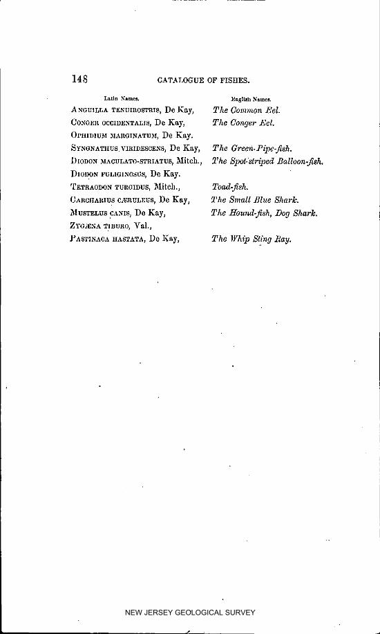
148 CATALOGUE OF FISHES.
Latin ._'amet_ Enslloh Names.
._NGUI[_LA TENUIROSTRIS, De ]_ay, The Co?TLglon Eel.
Co._Gmt OCCIVJ_NTALIS,De Kay, The Conger T, el.
0PIHDIUM MARGINATII3i, De K.ay.
SYNONATIIUS.VmmESCE._S, De Kay, The Green.Pipe-fish.
D[ODON r,IAOULATO-STRIATUS,Mitch., The Spot.striped Balloon-fish.
DIODON FULIGINOSUSt De Kay.
T_TRAODOnTUaG1DUS,_Iitch., Toad-fish.
CAnctlaaiu s C:_:agLEUS,De Kay, The Small Blue Shark.
51USTELUSC._.N:S,De Kay, The Hound-fish, Dog Shark.
ZYC_'_NATIBUR0, _ral.,
._ASTINAOAIIASTATA, De Kay, The Whip Sling l_ay.
NEW JERSEY GEOLOGICAL SURVEY

LIST OF rLANTS. ]49
LIST OF PLANTS.
List of t_lants collected at and in the viciT_ity of Beeslefe .Poi*_l.
By S_IU_L AminEs, :E_.
OF those marked*, specimens were presented to the State Collection
_CIIILLEA MILLEFOLIUM_ LiD. *C/HMAPHILA MACULATA, rursh.
Acoacs o_ta_us, Lin. *CtIRYSOPSIS MARIANA, _tltt.
2_kGROSTEMA GITHAGO_ Lam. *C_wnnA ALNIFOLL*., Lin.
SALETRIS F2.RINOSAj LiB, $ COREOPSlB TRICHOSPER.MA, _[ehx.
_NAGALLI$ AIt_NBI$, Lia, *CuScUTA GKONOVI[, WiUd.
J_NEMONE NEMOROSA, LiR, CALKILE MARITIMA. Seep.
._kI'IOS TUBEROSA, Mcench. *CAff_YSTEGIA SEP1UM, R. Br.
_iCLQUILEGIA CA,'qADJENSIS_ IJill.
_RABIS LYRATA t LiI1. DATURA STRAMONIUM, _11].
ASCLEPIAS CORNUTA, _)ec. *_ESMODIUI_I V1R1DIFLORUM 7 Beck.
_. TUBEROSA, Lin. DECODON VERT]CILLATUM, _ll,
*_. IaAUPERCULA, _[ichx. *DISCOPLEUnA CAI_ILLACEA_ _)e _,
$ASCYRUM CRUX ANDREYE t LhL *DRAIIA VERNA t Li[I.
*tk. STANS, _]ic_x. *DROSERA R(Y_UND1FOLIA, _iRU.
2__ZALEA I_EDIFLOI_A, Lin. *D. I_NGI_OL][A, L[n.
*_.. VL_C_SAj LI_. *DELPIIINIUM CO._SOLID_'_, Lie
*BAPTISIA TINffrORIA, _. ]3r. *_LODEA vmn]N[c,L Nutt.
]_IDENS BIPINNATA, Lie. ER_G£RON BELI, II)IFOLIUM_ _[uhl.
*BACOIIARIS IIALIMIFOLIA, *EuP2,TOR1UM PERFOLIATUM_ Lie,
_, PURPUREUM_ ]_ill.
_AI,OPOGON PULCIIELLUS, _. Br. ]_. RES1NOSU_I, Torr.
CAPSELLA BURSA-gASTORISt _fe_llC]l. IEuPIfORB1A IIYPERIC1FOLIA_ Lin.
*CASSI_k CIIA,_I]ECRISTA_ Lie. *]_. IpECACUANhA.
O. )IAItIIdk_DICA, Lin. E. MACUI,ATA, ]_iIL
*C, NI_TITANSp _1_. *_. POLYGONIFOLIA_ Lia.
*Cz_oTaus _Lv_c_._us, Lin. *_RYNGIUM VIRGINIANUM_ Lore.
NEW JERSEY GEOLOGICAL SURVEY

J
150 . LIST OF PLANTS.
FRAGARIA V]RGINIANA, Ehrh. *L. VIOLACEA. I var. 2¢_NGUSTIFOLIA
Pers.
GAULTHERIA PROCUMBENS, Llil. LEUGANTIIEMUM VULGARE s Lain.
GERANIUM CAltOL1N]ANUM_ LID. LIATRIS PILOSA.
G. _IACULATU_I, LiD. LINARIA VULGAIlIS, Mill.
*S. ROIIERTIANU_I, Lin. *L. CANADENSIS, Dum'ont.
*GEKARDIA I'URPUREA, Liu. *LIATRIS I'ILOSA_ ,_ DUBIA, Ph,
*G. TENU]FOLIA, _rah]. *LuD_,VIGIA IIIRTELLA.
G NAPIfALIUM PURPUREUM_ Lin. *L. ALTERNIFOLIA, Lin.
*G- POLYCEPIIA_LU.',], _[X. L. PALUSTItIS, Ell.
*GltATIOLA AUREA_ MuM. LUI'INUS PERENNIS, Lin.
LYCHN]S GITIIAGO_ Lain.
*]_ELEh_IUM AUTU._INALE, Lin. *LYCOPUS Y]RGll'HCUS_ Lin.
*L_E]',IANTHEMUM CANADENSE, _X. _. SINUATUS, E|I.
*HIBISCUS VIRGINIANA. *LYSL_IACIIIA STR]GTA, Air.
*H. _,IOSCIIEUTOS, T. and G. L. QUADRIFOLIA, LIlI.
| [IERACIU_I SCABRUM, _[X. *LINUM VIRGINIANUM, Lin.
H. VENOSU_I, LiB.
[[YDROCOTYLE A._IERICANA_ Lill. _AGNOLIA GLAUCA, Lill.
[[UDSONL a. TOMENTOSA, Nutt. _[EDEOLA VIItGI.N'ICA_ Lin.
*]I. ERIC0IDES. _[ENTIIA V]RIDIS, Linn.
*][YI'ERICUM CANADENSE, Lin. *_IKANIA SCAND_*_NS_ Wild.
*n. CORY_IBOSU31, _[L!hl. _]ONARDA FISTULOSAj Lin.*l_. PERFOR_.TUM. *_ITCIIELLA RE]'ENS.
*1_]. P_$.RVIFLOItUM, _[uh].
* I_. ELIJI_TICU-,! ? t[ook. _UPIIAIt ADVENA: Air.
*_[YPOX1S ERECTA, Lin.
*ORONTIUM AQUATICU]_I, LiB.
l NUr._ IIELENIUM_ Lin. (_NOTnERA }'RUT]COSA, Lift.
[I(IS VERSICOLOR, Lin. ORNITIIOGALUM U._IBEL]akTUM_ Lin.
OPUNTIA VULGAltlS, lt(lila
Kf_L_IIA ANGUSTIFOLIA, LiD.
K. LATIFOLIA, Lin. *I_ANAX TRIFOI.IUM, Lin.
KRIGIA VIRGIN]CA, Wild. PEDICULAItIS C,kNAI)ENSIS, LiB.
*PIIASEOLUS IIELVOLUS_ Lin.
LESPEDEZA HIRTA, Ell. _'IILOX I'ILOSA, Lin.
NEW JERSEY GEOLOGICAL SURVEY

LIST OF PLANTS. 15t
*_)IIYSAL]S V][SCOSA, Lin. *SIu,_I IakT]FOI,IUM, Lln.
*PLATANTIIERA C1LIARIS, Lindley. *S,_nr, Ax nOTUNmFOmA, Lin.
*POGONIA OPHIOGLOSSOIDESj _'uLtall. *SAItRACEN1A PURPUllEA.
* POIA'OALA LUTEA. * SPECULARIA I'ERFOLIATA,A] ph, D.C.
*POLYGONELLA AI_.TJ'C'UI_ATUM. *SPIRANTHES GRAC1LIS, Bigelow.
])LUCIIEA CA31Pll0RATA. STACHYS ASPERAj _X.
*POTENTILLA CAN,_.DENSIS, Lia. STATICE L]MONIU,_I.
*PR1NOS LAVIGATIS, _urfh, *SALSOL2L KALI.
*PRUNELLA VUIXtARIS_ Lilt.
*PROSERI_INACA PALUSTRIS. TECOMA RADICANS, -JIass.
*I)YCNANT[tE._IU,',ILINIFOL_UM_Pursh.WFmcalu3i VIRGJNICUM.
*PONTEDEItIA CORDATA_ Lin. *TEPI]ROSIA V]RG1NIANA_ Pots.
*TIIALICTRU3! ])I0]CUM, Lia.
*RII_XIA _,qRGINICAt Lin. TIIASPIUM BARBINODE_ Nutt
R IIUS TOXICODENDRON_ _la. *TRIcIIOSTEMA DICIIOTOMUM: Lin.
lot. COPALLINA, _in, *TRIENTALIS AMERICANUM r l)h.
*_0SA CAROIJNA, Lin.
_R. RUBIGINOSA, Lia. *_ACC]NIUM M_%CROCARPON_ _i_.
]{,UBUS CANADENSIS, Lin. V. S']?AI_I]NEU3I, Lin.
"R. _*qLLOSUS, _._. _r. C01Cn_mOSU,_L Lin.
]{UDBEGKIA, LACINIATA, Lin. _rERBASCUM TIIAPSU$, Lin.
*PtuMEX AOETOSELLA, LiIL _._r. BLATTARIA, Lin.
*VERBENA ANGUSTIFOLIA_ ]_[X.
SABBATIA ANGULARIS_ PlL *-V_EKNONIA NOVEBORACENSIS t Wild.
*S. STELLARIS, Ph. _'IBURNUM ACER]FOLIUS[, ]_ill.
*S. CHLOR0]DES, 1)h. *_. NUDU_; 'car. CI,AYTONI, Gray.
S. GRACILIS, Salisb. _r]OLA BI,,_.a'DA, Wild.
SA.MOLUS V,_LERANDI, ],in. V. CUCULLAT,'% Ait. •
*SAPONARIA OFFICIN2*L]S_ Lia. V. MUHLENBERGII, Tort.
*_0UTELLARIA INTEGRIFOLIA_ Lla. ,_r PALMATA_ IJin.
*_ER1COCARPUS CONYZOII)ES_ Noes. *_r. PEDAT_'_, Lhl.
*S. SOLIDAGENOUS, _ecs. ._'r LANCEOLATA.
*_ALICORNIA IIERBACEA. ,_'r .SAGITTATE_ Air.
*_CLERANTHUS ANNUUS .9
NEW JERSEY GEOLOGICAL SURVEY

152 CATALOGUE OF MAIIINE ALGzE.
CATALOGUE OF MARINE ALGJE,
Catalogue of Marine Algez, discovered at J_eesley's 2oi_ll during tl_e
Sumumr of 1855. By S_IUEL ASIIME2_), Esq.
ThE limited number of the species of marine Algc_ at Beesley's Point
must be attributed to the want of a suitable place, or foothold for deve-
lopment, as tile climate and the water, it would seem, supply all the
other conditions favorable to their growth.
Tile following catalogue, embracing five _IFZZtNOSI'_.RMS,nineteen
_HODOSPERMS, and six CIII,OROSPER_IS,are all that I have as yet been
able to detect. A more careful scorch may probably supply a'few more
species.
In the classification, and names of the species, I have followed that
eminent Algologist, ]:[on. Win. H. Harvey, in his "Novels Boreal;-
Americana," published by the Smitbsoeiaa Institute at Washington.
_erl¢$ I. MELANOSPERMEzE.
FUCUS VESm_,OSUS, _ia. _rery common betweefi tide marks, on the
shores of tim Bays and the thoroughfares ; not unfrcquently attached to
sods by a root penetrating several inches into the soil, throwing off
numerous lateral shoots, haviug the upl)earance of undeveloped fronds,
forming _ strong hold-f_tst, and af%rdiug an interesting illustration of
the modification of r_discoid root, where local circumstances arc unfa-
vorable to such e:_pansions, It is, however, more frequently found ad-
hering by a conical disc to mussels (Modiolo plieotula), which, at high
water, unable to resist the buoyancy of the full-grown plant with its in-flated vesicles, arc, by degrees, wrested from their place of growth and
_.ast upoa the shore to perish, whence the Fucus, together with other ma.
fine plants, arc carried away by the inhabitants for manure.
Sv]LoriIonA I_n_ZOI)ES,J. Ag. Rather rare; on old shells, _c., near
low-water mark. The few specimens which I obtained are fertile, of
• vigorous growth, and densely covered with wart-like fructification.
NEW JERSEY GEOLOGICAL SURVEY

1
CATALOGUE OF 31ARIN'E AI.GeE. :15_
EETOCARPUS L1TTOR_'tLIS, Ly_gb. Very abundant In the Bays, on
_'arious submerged substances. Also fringing the stee l) banks of the
thoroughfares between tide marks. Disappearing iu July.
Ec'roc,_al, iJs sHJcUl, OSUS,Lyngb. Occurs sparingly on the shores of
Little Bay, on Faeus vcsiculosus.
Uc'ruc,,npus VIItIDIS t tI_zro. Common in the Bays, on Zoslera marina,
&c. Disappearing in July.
h'erles II. RIIODOSPERMEnE.
CHO_Dn_A D._,SYrnYLLa, Ag. Plentiful in Little Bay, and on "BomPs
Bar," growing in largo tufts on the sandy mud, to whleh it is attaclmd
by a fibrous root.
CIIONI)RIA BAILE_:ANA, ]IoaL Common with the above.
POLYSIPIIONIA OLNEYI, Haro. Rare, on Zostera marina in "LittIe
Bay."
['OLYSIPIfONI_.I{AnVI-:','I, Bailey. Very abundant in the Bays, and on
Bond's Bar; on Zosleramarina.
• POLYSIPIIONIA VARIEGATAt Ay. Very conlmoo_, on Zoslera marina,
also attached to the mud by a fibrous root.
J?OLYSlPIIONIA NIGRESCENS, atoll I collected fine specimens of t]ds
most valuable plant, in fruit, in the month of May. It occurs in great
abundance in Little Bay, attached to the bottom by a fibrous root.
CHA3H'IX I':,aVULA, Haro. Plentiful in Little Bay, on Zo,slm.a
GnINELLIA A)innlca.'_,_, llarv. Of tlds beautifid plant I only found a
solitary perfect specimen, it was growing in the Great Egg Harber Bay
near tim shore, attached to the bottom by a somewhat fibrous root.
"GRAc1LkRIA 31ULTIPAnTITA, J. Ag. Plentiful, particularly fine mt
planted oysters iu Little :Bay.
SOLIEnlA (31IORDALIS,J. Ag. Very common on all the shores. There
can be no doubt but this bushy plant will grow and flourish in the coves
NEW JERSEY GEOLOGICAL SURVEY

V --
:1._4 CATALOGUE OF MARINE ALGAE.
of Little Bay, and other sheltered situations, _.vitbout a foothold; for I
have rarely found it attached to the bottom.
CII,'LOCLADIA BAILEYANA, Hare. :Frequent on Zostc,ra marina, Ulva
lalzssima, &c.
SPYRIDIDA FILAMENT0SA,Hare. 1)articuIm:ly abundant and vlgoeous
ill the Bays i where, sheltered from the winds and waves, like the Solieria
chordalis, it will luxuriate without the slightest attachment to the bottom.
C_:nA,_IIUM al)nauM, Ag. This plant, in all its pceplexing varieties, is
found on Zoslera marina, rather abundantly.
CERAM]UM DIAPIIANU.M,ltoth. Occurs sparingly associated with the
above.
CERAMIUM FASTIGIATUMj gary. In dense tufts, on Zoslcra _lar_ua,
rather rare.
CALLITIIA.MN10N BYSS0IDEUM t 2_ru. Frequent on Zosteramarlaa, also
attached to old shells in Great Egg Harbor Bay.
CALLITIIAMNION POLYSI'ERNUM,Ag. Rare, on oh] shells in Great Egg
Harbor Bay.
GELIDILM C0RNnl1M,ear. _,.pinnatnm, Grey. I obtained two or three
epcein)cns of this p]al)t in Little Bay, on old shells, _)car lo_Y-)).ater mark.
Series lit. CHLOROSI'ERME_E.
BaYoPSlS pr, u_iosa, Ag. _,Tot common; attached to old shells and
other submerged substances on the shore of Great Egg Harbor Bay.
Ct, al)oel[oRa _',_LOaTA,IIa_'v. Occurs plel_tlful i_ L_tt]e Bay.
ENTEROMORlOIA COMPRESSA_ (7trec. Very COlnnlon verywhcre; in-
festing the small pebbles on Great Egg Harbor l_ay.
ESTER0)tORPHA INTESTINALIS,L_lk. Abundant in Little Bay, and on
Bond's Bar. Frequently found floating iu large quautities in the Bays.
ULW#- LATISSIMA, ginn. Common with the above.
POIiP/_rIIA VI/LOARI8,Aft. Very rare. I bare obtalned but two or
three specimens of this Alga, on Zosteramarina in Little Bay.
NEW JERSEY GEOLOGICAL SURVEY

Fossils mentioned on page 27 of this voZnms.
BYPROFESSORJA_IESHALL.
_t
VENUS MEROENAEIA.
ThE CO_._O._ClJt_.
This iS clearly the common clam sold in our markets: tile cast gives the
characters of the recent shell in the most perfect degree; cven the subordi-
liato or second inllselllar impressions are seen above Ihe principal ones,--
marked in the drawings, a. a.
BUGCINUM OBSOLETUM.
*N'ASSA OB$OLITA_ SAY.
This little shell is abmldaat eyeD,where Ol| the coasl, living more com-
mouly oa the muddy flats of the hays and cL'eeks, prefcrrlug, apparently,
situations shellered from the surf of the open sea. ]t is keow,t fi'om l;'lorid_to Maitle.
0
NEW JERSEY GEOLOGICAL SURVEY

Cast of Venus Mercen_ia.
NEW JERSEY GEOLOGICAL SURVEY
SKETCHOP TII_
EARLY HIST.ORYrip TIIN
COUNTY OF CAPE MAY,
NEW JERSEY GEOLOGICAL SURVEY

SKETCH OF THE EARLY HISTORY
OF THE
COUNTY OF CAPE MAY.
BY _AUR[CE BEESLEY,._. D.
THE difficulties to be encountered in making a historical sketch
of the County of Cape May, arc perhaps as great, if not greater,
than will be found in any other county of our State. Isolated as
it was in early times from the upper districts of the Province, and
with a sparse populatiou, we find no material to consult, except a
meagre court record ; hence the inquirer is compelled to seek from
musty manuscripts and books in other places, a goodly portion of
the little that has escaped oblivion, iu the vista of years gone by,
and that little must necessarily be made up of scraps and fragments
which owe their interest, if any they have, more to their intrinsic
worth, than to the skill bestowed upon their arrangcmcut.
Order cannot come out of chaos; and any attempt to make a con-
nected history, with the resources at hand, would end in disappoint-
ment. Being partially surrounded by water, without a roadste;_d"
or harbor to invite the hardy pioneers who first visltcd the Dclawaro,
to sojourn and rest upon her shores, she was passed by to mo.'e
inviting rcglons, on its waters above, where ships could find refl,gcfrom winds and storms ; and man, in his inherent thirst for domln}on
and power, could secure the virgin soil of the country, in extent
NEW JERSEY GEOLOGICAL SURVEY

](J0 EARLY IIISTORY OF GAPE MAY COUNTY.
and proportions, and upon terms so inconsiderable, as to fill up the
fidl measure of his deslres, and gratify his ambitious aml venture-
some propensities.
After the most careful investigation and patient research in the
State and County archives, and the early as well as the more recent
chronicles of our past hlstory_ we find no data to prove that Cape May
was positively inhabited until the year 1685, when Caleb Carman
was appointed, by the Legislature, a justice of the peace, and Jona-
than Pine, constable. _
These were independent appointments, as Cape May was not
under the jurisdiction of the Salem Tenth.' This simple fact, how-
ever, that tbc appointment of a justice and constable for the pluce,
was necessary, goes to prove that there were inhahltants here at
this time; yet whence they came, in what number, or how long
they sojourned, are inquiries that will most probably ever remain in
mystery and doubt. Fenwiek made his entry into " New Salem,"
in 1675, and soon after extinguished the Indian title from the Dela-
ware to Prince Maurice River.'[" He made no claim and exercised
no dominion over Cape May; and we have nothing to show at the
time of his arrival, that the country from Salem to the sea-shore
was other than one primeval and unbroken forest, with ample na-
tural productions by sea. and land, to make i_ the" happy home
of tile red man, where he could roam, free and unmolested, in the
enjoyment of privileges and blessings, which the strong arm of
destiny soon usurped and converted to ulterior purposes.
Gordon, in his history of New Jersey) says : "Emigrants from :New
Haven settled on the leh shores of the Delaware so early as 1640,
some of whose descendants may probably be found in Salem)Cum-
berland, and Cape May counties."
As far as regards Cape May, we have no tradition of any such
settlement. LIist!)ry tells us that Hudson, in the Half-Moon, en-
tered the Delaware Bay, the 28th August) 1609, "but finding the
• Learning & Spiccr's collection. _" Johnson'_ Satcal, I ). 13.
NEW JERSEY GEOLOGICAL SURVEY

EARLY IIISTORYOF CAPE .MAY COUNTY, 161
water shoal, and the channel impeded by bars of sand, he did not
venture to explore it."
On the 5th of May, 1630, "a purchase of sixteen miles square,
was made at Cape 5fay, for Samuel Godyn and Samuel :Bloemart,
of nine resident Chiefs. Tiffs tract was purchased by Peter Hoyser,
Skipper of the ship Whale, and Giles Coster, commissary. It was
probably the first purchase of the natives within the limits of :New
Jersey ; at least it is the first upon record, and was made for and
in behalf of the Dutch West India Company."*
The renowned Capt. Cornelius Jaeobcse Mey, visited our shores,
and explored Delaware Bay in 1623, and to him.the County of Cape
May is indebted for a name. He built Fort :Nassau, at Timber
Creek, the site of which is now unknown.t
David Pieterson de Vries was tile next pioneer to the New World.
He entered Delaware ]_'.y in 1681, and first lauded at Huorekill,
near Cape Henlopen. He left a colony there; but on his re-
turn the succeeding year, found they had been massacred by the
savages. "Finding the whale fishery unsuccessful, he hastened his
departure, and, with the other colonists, proceeded to Holland by
the way of Fort Amsterdam," (New York). Thus, says Gordon, "at
the expiration of twenty years from the discovery of the Delaware
by tIudsou, not a single European remained upon its shores." De
Vries, in his journal, says, "March 29th, 1633, found that our peo-
ple has caught seven whales ; we could have done more if we had
good harpoons, for they had struck seventeen fish and only savedSeven."
"An immense flight of wild pigeons in April, obscuring the sky.
The 14th, sailed over to Cape May, where the coast trended E. N. E.
and S.W. Came st evening to the mouth of Egg Harbor; found
between Cape May and Egg Harbor a slight sand beach, full of
small, low sand hills. Egg Harbor is a little river or kill, and in-
side the land is broken, and within the bay are several small is-
• Mulford'sN. J. p. 58; &Gordon. , _ Micklc'_Reminiscences.11
NEW JERSEY GEOLOGICAL SURVEY

162 ZAaLY IIISTORY OF CAPE MAY COUNTY.
lands. Somewhere further up, in the same direction, is a beautiful
, high wood." This was probably Somer's or Bcesley's Point, clothed
in its primitive growth of tlmbcr.
About ]641, Cape May was again purchased by Swedish agents,
u short time before the arrival of the Swedish governor, Printz,
at Tinicum. This conveyance included all lands from Cape May
to Narrltieon, or Raccoon Creek.*
Campanius, a Swedish minister, who resided in New Sweden, on
the banks of the Delaware, from the year 1642 to 48, says, page 46,
" Cape May lies in latitude 38 ° 30'. To the south of it, there are
three sand banks, parallel to each other, and it is not safe to sall
between them. The safest course is to steer between them and
Cape May, between Cape May and Cape Henlopen." But for this
account, these sand-banks could only have existed in the imagina-
tion, as there have been none there within the memory of man.
Johnson in his sketch of Salem, says : "The Baptist church at Cape
May took its origin from a vessel which put in there from England,
in 1675." He evidently obtained this from ':Benedict's History
of the Baptists," who makes the same assertion, viz : "The founda-
tion of this church was laid in the year 1675, when a company of
emigrants arrived from England, some of whom settled at Cape
May. Amongst these were two Baptists, George Taylor and
Philip Hill."
It.is most likely, as Mr. Benedict gives ns no references for the
above statements, that an error has been made in the date, as no
record of the church here is to be found prior to 1711; and, as
before stated, no fact to prove that our county was inhabited until
1685.
The first will and inventory on file in the Secretary's office, at
Trenton, from Cape May, is that of John Story, dated the 28th
of the ninth month, 1687. He was a Friend, and left his personal
estate, amounting to £110, to his wife, having no heirs. The next
• Micklc_p. 83. \
NEW JERSEY GEOLOGICAL SURVEY

• EARLY IIISTORY OF CAPE MAY COUNTY. ]G:_
• were those of Abraham Wcston, :November 24th, 1687, and John
Briggs, in 1690. In April: May, and June, ]691, John Werlidge
and John Budd, from Burlington, came down the bay in a vessel:* and
laid a number of proprietary rights, commencing at Cohansey_ and
so on to Cape M:ay. They set off the larger proportion of this county,
consisting of 95,000 acres, to Dr. Daniel Coxe, of London. who had
large proprietary rights in West Jersey. Tbls was the first actual
proprietary survey made in the county. In the copy of the ori-
ginal draft of these surveys, and of the county of Cape May, made
by David Jamsisoa, in 1713, from another made by Lewis Morris,
in 1706, (which draft is now in my possession, and was presented
by William Gritlith, Esq., of Burlington, to Thomas Becsiey, of
Cape May, in 1812,) Egg Island, near the mouth of Maurice River,
is laid off to.Thomas Budd, for three hundred acres. Since this
survey was made_ the attrition of the waters has destroyed almost
every vestige of it--scarcely enough remaining to mark the spot;
of its former magnitude. Upon this map likewise is laid down
Cape May Town, at Town Bank on the Bay shore, the residence
of the whalers_ consisting of a number of dwellings ; and a short
distance above it we find Dr. Coxe's Hall, with a spire, on Coxehall
Creek_ a name yet retained by the inhabitants. .As no other build-
ings or improvements are noted upon this map, than those above
mentioned, it is to be presumed there were but few, if any, existing
except them, at this day. The only attraction then was the whale
fishery ; and the small town of fifteen or twenty houses marked upon
this map, upon the shore of Town Bank in close contiguity, would
lead us to infer that those adventurous spirits, who came for that
purpose, preferred in the way of their profession to be near each
other, and to make common stock in their operations of harpoon-
ing, in which, according to Thomas and others, they seemed to be
eminently successful.
"Dr. Coxe, in his capacity as proprietor_ continued to be ac-
e J. Townsend_s _Ianuscript.
NEW JERSEY GEOLOGICAL SURVEY

16_ EARLY IIISTORYOF CAPE MAY COUh;TY.
tively concerned in the management of business subsequent to the
surrender ; extensive purchases of land were made by him of the
natives, and these agreements was assented to by the Council of
Proprietors. These several purchases of the natives were mmle
and dated, respectively, on the 30th March, 30th April, and 16th
May, 1688. They were laid in the southern part of the province,
including part of the present counties of Cumberland and Cape
May. .Either dlshcartcn'ed by the ditlicultics be bad experienced, or
tempted by an offer that would cover the disbursements he had made,
Coxe rcsotved upon a sale of the whole of his interest in this province.
lie accordingly made an agreement, in the year 1691, with a body
composed of forty-eight persons, designated by the name of the
'West Jersey Society.' To this company, on the 20th January,
1692, the whole of the claim of Dr. Coxe, both as to government
and property, was conveyed, he recclving therefor the sum of
.£9000. ''_ This sale opened a now era to the people of Cape May.
As no land titles had been ohtalncd under the old regime of the
proprietors, except five conveyances from George Taylor, J"as agent
for Dr. Coxe, the West Jersey Society became a medium through
which they could select and locate the choice of the lands, at prices
corresponding with the means and wishes of the purchaser.
The society, through their agents appointed in the county, con-
tinued to make sales of land during a period of slxty-four years of
their having possession ; at the end of which time, in 1756, having
conveyed a large proportion of their interest, they sold the balance
to Jacob Splcer the second, for .£300. The title is now nearly
extlnot.
It has been handed down, that Spicer obtained the grant for the
proprietary right in Cape May, of Dr. Johnson, agent of the So-
ciety at Perth Amboy, at a time when the influence of the wine
bottle had usurped the place of reason, or he could not have ob-
tained it for so inconsiderable a sum as three hundred pounds ; and
o Mulford, 264, $. t Cape May Records.
NEW JERSEY GEOLOGICAL SURVEY

EARLY HISTORY OF CAPE _AY COUNTY. ]05
that the Doctor, sensible he had betrayed the trust reposed in him,
left tlle society at his death a thousand pounds as u salvo.
As history throws no light on the original occupiers of the soil,
conjecture only can be consulted on the subject. It would seem
probable, in as much as many of the old Swedish names, as recorded
in Cumpanin% from Rudman, are still to be tbund ia Cumber/and
and Cape May, that some of the veritable Swedes of Tinicum or
Christians might have strayed, or have been driven to our shores.
_,Then the I)utch governor, Stuyvesant, ascended the Delaware in
].654, with his seven ships and seven hundred men_ and subjected
the Swedes to his dominion, it would be easy to imagine, in their
mortification and chagrin at a defeat so bloodless and unexpected,
that many of them should fly from the arbitrary sway of their
rulers, and seek an asylum where they could be free to act for them-
selves, without restraiut or coercion from the stubbornness of myn-
heer, whose victory, though easily obtained, was permanent, as the
provincial power of :New Sweden had perished for ever.
Master Eve]in's letter in Plantagenct's New Albion,* dated 1648,
says : " I thought good to write unto you my knowledge, and first
to describe to you the north side of De/aware unto Hudson's River,
in Sir Edmund's putcnt called _New Albion, which lleth between
:New England antl Maryland, and that ocean sea. I take it to be
about 160 miles. I find some broken ]and, isles und inlets, and many
small isles at Eg Bay ; but going to Delaware Bay by Cape May,
which is twenty-four miles at most, and is, I understand, very well
set out and printed in Captain T'owen's map of New England, done
as is told me by a draft']: gave to Mr. Daniel, the plotmaster, which
he Edmund salth yon hare at home: on that north side (of Cape
May) about five miles within is a port or rode for any ships, called
the :Nook, and within liveth the king of ]':eehemeches, having, as I
suppose, about fifty men. I do account all these Indians to be
eight hundred, and are ia several factions and war against the Sar-
¢_Philadelphia Library.
NEW JERSEY GEOLOGICAL SURVEY
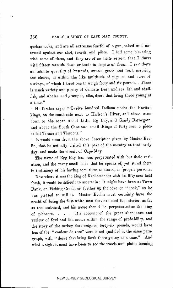
]6G EARLY HISTORY OF CAPE MAY COUNTY.
quehanncoks, and arc all extreame fearful of a gun, naked and un-
armed against our shol, swords and pikes. I had some bickering
with some of them, and they are of so little esteem that I durst
with fifteen men sit down or trade in despite of them. I saw there
an infinite quantity of bustards, swans, geese and fowl, covering
the shores, as within the like multitude of pigeons and store of
turkeys, of which I tried one to weigh forty and six pounds.. There
is much varietj and plenty of delicate fresh and sea fish and shell-
fish, and whales and grampus, elks I deere that bring three young at
a time."
• He further says_ " Twelve hundred Indians under the Raritan
kings_ on the south side next to Hudson's Rivcr_ and those come
down to the ocean about Little :Eg Bay, and Sandy Barnegate_
and about the South Cape two small :Kings of forty men a picco
called Titans and Tiascons."
It would seem from the above description given by M-aster Eve-
lin, that he actually visited this part of the country at that early
day, and made the circuit of Cape May.
The name of Egg Bay has been perpetuated with but little varl-
ation_ and the many small isles that he speaks of, yet stand there
in testimony of his having seen them as stated, in "propria persona.
How where it was the king of Keehcmeehcs with his fifty men held
forth_ it would be diffieuh to ascertain : it might have been at Town
Bank, or Fishing Creck_ or further up the cbvc or "nook," as he
was pleased to call it. _laster :Evelin must certainly have the
credit of being the first white man that explored the intcrior_ as far
as the seaboard, and his name should be perpetuated as the king
of pioneers. His account of the great abundance and
variety of fowl and fish seems within the range of probahility_ and
the story of the turkey that weighed forty-six pounds, would have
less of the " eoulcur de rose" were it not qualified in the same para-
graph_ with "decre that bring forth three young at a time." And
what a sight it must have been to see the woods and plains teeming
NEW JERSEY GEOLOGICAL SURVEY

EARLY IIISTORY OF C_kPE MAY COUNTY. 167
with wild animals, the shores and w_ters with fowl in every variety,
where they had existed unharmed and unmolested through an un-
known period of years ; and the magnificent forest, the stately and
towering cedar swamp, untouched by the axe of the despoiler, all
reveling in the beauties of Nature in her pristine state, the reali-
ties of which the imagination, only, can convey an imprcssion, or
give a foret_ste of the charms and. novelties of those primevaltimes.
Gabriel Thomas, in his history of West Jersey in 1698, gives us
the following particulars, viz : " Prince hlaurice River is where the
Swcdcs used to kill the geese in great numbers for their feathers
(only), leaving their carcasses behind them. Cohansey River,.by
which they send great store of cedar to 1)hiladelphia city. Great
Egg Harbor (up which a ship of two or three hundred tons may
sail), which runs by the back part of the country into the maln sea ;
I call it back, because the first improvements made by the Christians
was Delaware river-side. This place is noted for good store of corn,
horses, cows, sheep, hogs; the lands thereabouts being much im-
proved and built upon. Little Egg Harbor Creek, which takes their
names fi'om the great abundance of :Eggs which the swans, geese,
ducks, and other wild fowls of those rivers lay thereabouts. The
commodities of Cape May County are oyl and whalebone, of which
they make prodigious quantities every year ; having mightily ad-
vanced that great fishery, taking great numbers of whales yearly.
This county, for the general part of it, is extraordinary good and
proper for-the raising of all sm'ts of catte]], very plentiful here, as
cows, horses, sheep, and hogs, &c. Likcwlsc, it is well stored with
fruits which make very good and pleasant ]iquors_ such as neigh-
bouring country before mentioned affords."
OIdmi×on, 1708, says : " The tract of land between this (Cape
M,y) and Little Egg Harbor, which divides East and West :New
Jersey, goes by the name of Cape May County. Here are several
stragling houses on this neck of land, the chief of which is Cox's
NEW JERSEY GEOLOGICAL SURVEY

168 EARLY IIISTORY ()F CAPE 5lAY COUNTY.
_all; but there's yet no Town. Most of the inhabitants are fisher-
men, there being a whalery at the mouth of the Bay_ on this as
well as the opposite shore."
Cape May County, by an Act of Assembly on the 12th day of
November_ 1692, was instituted as follows, viz: _Whereas, this
Province hath formerly been divided into three counties for the
better regulation thereof; and whereas Cape May (being a place
well situated for trade) begins to increase to a considerable number
of families; and there being no greater encouragement to the settle-
ment of a place than that there be established therein an order by
government, and justice duly administered : Be it therefore enacted
by the Governor, Counci]_ and Representatives in this present As-
sembly mot and asscmblcd_ and by the authority of the same, that
5"ore henceforth Cape May shall be, and is hereby appointed a
County, the bounds whereof to begin at the utmost flowing of the
tide in Prince Maurlee River, being about twenty miles from the
_mouth of said river, and then by a line running easterly to the most
northerly point of Great :Egg Harbor_ and from thence southerly
along by the sea to the point of Cape May; thence around Cape
May_ and up Maurice River to the flu'st point mentioned ; and that
there be nominated and appointed such and so many justices and
other ot_cers, as at present may be necessary for keeping the peace,
and trying of small causes under forty sbilliugs. In which circum-
stance the same county shah remain until it shall appear they are
e_lpable of being erected into a County Court; and in case of any
aetion_ whether civil or criminal, the same to be heard and deter-
mined at the quartcrlv sessions in Salem County, with liberty for
the Justices of the County of Cape May, in conjunction with the
Justices of Salem County_ in every such action in judgment to slt_and with them to determine the same."
The time and place of healing the county elections were likewise
direeted_ and the number of representatives that each was entitled
to: Burlington to have °-.0_ Gloucester 20_ Salem 10_ and Cape
NEW JERSEY GEOLOGICAL SURVEY
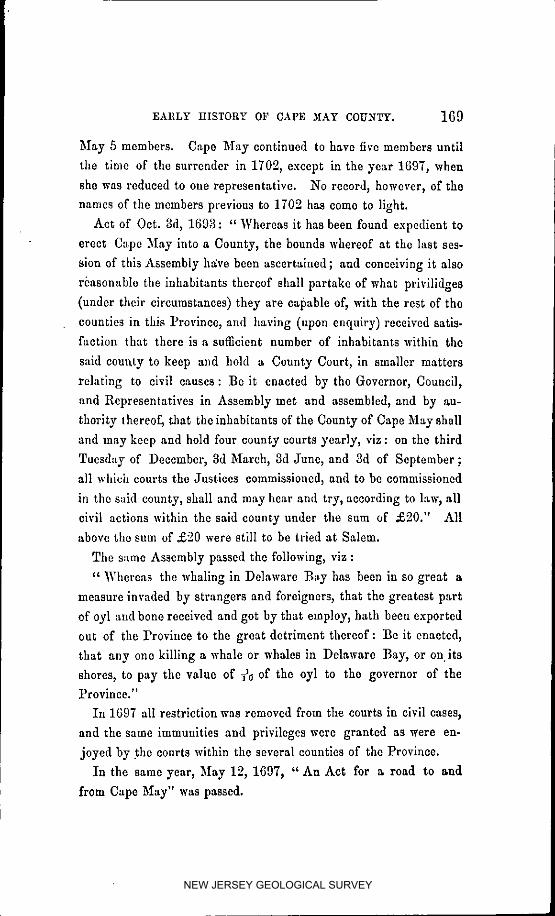
EARLY HISTORY 0F CAPE )IAY COUNTY. ].69
May 5 members. Cape M_ay continued to have five members until
the time of the surrender in 1702_ except in the year 1697, when
she was reduced to one representative. No record, however, of the
names of the members previous to 1702 has come to light.
Act of Oct. 3d, 1693 : " Whereas it has been found expedient to
erect Cape M:ay into a County, the hounds whereof at the last ses-
sion of this Assembly he:ve been ascertained; and conceiving it also
reasonable the inhabitants thereof shall partake of what prlvilidges
(under their circumstances) they are capable of_ with the rest of the
counties in this Province, and having (upon enquiry) received satis-faction that there is a sufficient number of inhabitants within the
said county to keep and hold a County Court, in smaller matters
relating to civil causes : :Be it enacted by the Governor, Council,
and Representatives in Assembly met and assembled, and by au-
thority thercof_ that the inhabitants of the County of Cape May shall
and may keep and hold four county courts ycarly_ viz : on tile third
Tuesday of December, 3d March, 3d June, and 3d of September ;
all which courts the Justices commissioned, and to be commissioned
in the said county, shall and may hear and try, according to law, all
civil actions within the said county under the sum of ._°0." All
above the sum of ,£'_0 were still to be tried at Salem.
The same Assembly passed the following, vlz :
" Whereas the whaling in Delaware :Bay has been in so great a
measure invaded by strangers and foreigners, that the greatest part
of oyl and bone received and got by that employ_ hath been exported
out of the Province to the great detriment thereof : :Be it enacted,
that any one killing a whale or whales in Delaware :Bay, or on its
shores, to pay the value of _a of the oyl to the governor of theProvince."
In 1697 all restriction was removed from the courts in civil eases_
and the same immunities and privileges were granted as were en-
joyed by the courts within the several counties of the Province.
In the same year, May 12, 1697_ " An Act for a road to and
from Cape May" was passed.
NEW JERSEY GEOLOGICAL SURVEY

170 EARLY HISTORY OF CAPE '._IAY COUNTY.
"Whereas the inhabitants of Cape May County do represent
themselves as under extreme hardship for want of a road from Cape
May, through their county to Cohansey, in order to their repair to
' Burlington to attend the public service; Be it enacted by the
Governor, &c., that George Taylor and John Crafford, be commis-
sioners appointed to lay out a road from Cape May the most conve-
nient to lead to Burlington_ between this and the 10th day of Sep-
tember next."
It was ordered likewise that the expense be borne by the inhabit-
ants of Cape May until such time as those lands through which the
road goes are settled. This road, so important to the convenience
and travel of the people of the county, was .not finished till 1707.
Prior to this the county was completely isolated from the upper
districts of the State by the extensive bed of codar swamps al_d
marshes stretching from the head-waters of Cedar Swamp Creek to
the head-waters of Dennis Creek, and no communication could have
been held with Cohansey or Burlington except by the waters of
the Delaware, or by horse-paths through the swamps that consti-
tuted the barrier.
• By the Ac: of the 21st January_ 1710,* the county of Cape May
was reduced to its present bounds, vlz: " Beginning at the mouth
of a small creek on the west side of Stipson's Island, called Jecak's
Creek; thence up the same as high as the tide floweth; thence
along the bounds of Salem County to the southernmost main branch
of Great :Egg Harbor River ; thence down the said river to the sea ;
thence along the sea-coast to Delaware Bay, and so up the said
Bay to the place of beginning."
It seems the inhabitants on the western side of Maurico River, .
the Cape 5Iay boundary, were without any legal control until
1707,t When an act was passed annexing the inhabitants between
the river Tweed, now Back Creek (being the lower bounds of Salem
County), and the bounds of Cape May County to Salem County,
• o Patterson'sLaws, Smlth'_ N, J.
NEW JERSEY GEOLOGICAL SURVEY

EARLY IIISTORY OF CAPE hIAY COUNTY. ] 71
putting them under its jurisdiction. The act of 1710 extends
Salem County, and curtails Cape May County, to Stipsen's Island,or West Creek.
The first town meeting for public business was held at the house
of Benjamin Godfrey, on the 7th of February, 1692. _ "The com-
missions for Justices and Sheriff were proclaimed, and George
Taylor was appointed clerk." The first suit on record is for
assault and battery; "Oliver Johnson against John Carman."
The second, John Jarvis is accused by George Taylor of helping
the Indians to rum. "William Johnson deposcth and saith, that
he came into the house of the said Jarvis, and he found Indians
drinking rum, and one of the said Indians gave of the said rum to
)'.hesaid Johnson, and he drank of it with them. The said Jarvls
refusing to clear himself, was convicted."
As early as 1692,1- a ferry was established by law, over Great
Egg Harbor River, at the place now called Beesley's Point, a proof
there must have been inhabitants upon both sides of the river, and
contiguous to it at that period.
The original settlers, or those who were here previous to the year
1700, were principally attracted (as the authors heretofore quoted
_uffieiently corroborate) by the inducements held out by the whale
fishery ; and Long Island supplied the principal proportion of those
who came prior to that time. The names of those who were known
to be whalers,:_ were Christopher Lcamyeng and his sen Thomas,
C,'esar I-Ioskins, Samuel Matthews, Jonathan Osborne, 1Vathaniel
Short, Cm'nelius Skellinks, Henry Stites, Thomas Hand and his
sons John and George, John and Caleb Carman, John Shaw,
Thomas _,Iiller, William Stillwell, Humphrey Hewes, William _Ia-
son, John Richardson, Ebenezer Swain, Henry Young; and no
doubt many others.
The jaw-bone of a whale, ten feet long, was recently found a few
rods from the shore at Town Bank, by Thomas P. Hughes, the pro-
* Cape _Iay Records. t Learning & Spieer's Colluction.
_. Secretary's o_ce, Trenton & Cape May records.
NEW JERSEY GEOLOGICAL SURVEY

172 EARLY IIISTORY OF CAPE ,MAY COUNTY.
prietor, partly imbedded in the sand, which has probably lain there
since the time of the whalers.
Eirst Court.
At a Court held at :Portsmouth (supposed to bc Town Bank or
,Cape May Town) or, the 20th March, ]693,which is the first of
whielt we have any record, the following officers were present,
viz:--Just&cg--John Wolredgc, Jeremiah Bass, e John Jervls, Jo-
seph Houlden_ and Samuel Crewel. Sherlff--Timothy Brandreth.
Clerk--George Taylor. Grand Jur_j--Shamgar Hand, Thomas
Hand, William Goulden, Samuel Mattbews, John Townsend, Wil-
liam Whitlock, Jacob Dayton, Oliver Johnson, Christopher Leayeman,
Arthur Crosse, Ezekiel E]dredge, W_lllaln Jacooks, John Carman,
Jonathan Pine, Caleb Carman, John Reeves, and Jonathan Eorcman.
"A rule of Court passed, the grand jury shall have their dinner
allowed them at the county charge ;" a rule that would semn reason-
able at the present day, when grand jurors have to pay their own
bills and serve the county gratis.
" Their charge beieg given them, the grand jury find it necessary
that a road be lald out, most convenient for the king and county,
and so far as one county goeth_ we are willing to clear a road for
travelers to pass." "John Townsend and Arthur Crosse appointed
Assessors; Timothy Brandretb, CoUector; Shamgar Hand, Trea-
surer; Samuel Matthews and William Johnson, Supervisors of the
Road; and John Seiners for Egg Harbor. At same Court, John
Seiners was appointed Constable for Great Egg Harbor." "The
Court likewise orders that no person shall sell liquor without a
license, and that ,£40 be raised by tax to defray expenses, with a
proviso that produce should he taken at ' money price' in payment."
The above appointment by the Court of John Seiners for Superrisor
¢_ This is supposed to be the same Jeremiah Bass who was agent for the West Jersey
Society in 1334 and 5, for Cape May, at which time he resided at Cohansey, and next year
at BQrlington ; was appointed governor of th_ State in 1693_ and departed h_r England
in 1699. [Mulford, 261.] A Jeremiah Bass figured at Salem from 171S to 1716, as an
attorney ; and a member of the Legislature from Cape _lay_ from 1717 to 1723 : hut whether
the eamep or a relative_ is uncertain.
NEW JERSEY GEOLOGICAL SURVEY

EARLY HISTORY OF CAPE ._[AY COUNTY. 173
of the roads and Constable for Gre_t Egg Itarbor, confirms the
op_nlon advanced by Mickle (page 38) that the County of Glouces-
ter did not originally reach to the ocean, and that the inhabitants
of the seaboard_ or Great Egg IIarbor, were under the jurisdiction
of C_tpe 5Iay. The act of 1694, however, made them dependent
upon Gloucester, and that of 1710 extended the County of Glouces-
ter to the ocean. A passage from Oldmixon, 1708_ heretofore
quoted, that Cape May County extended to Little Egg Harbor at
that time, is evidently incorrect.
Tlte following named persons purchased of the Agents of Dr. Cox
and tile West Jersey Society, mostly previous to 1696, some few as
early as ]689_ the number of acres attached to their respective names,
"*'iz :--'g" oAc_e_, Acrc_.
Christopher Lcamycng ........... 204 WiIliam Mason, ............... 150
Wi]llam Jacoks, ................ 340 IIenry Stltes .................. 200
Abigail Pine, .................. 200 Cornelius Skellinks, ........... 134
lIumphrey ]Iughes, ............ 206 John Richardson, .............. 124
Samuel Matthews ............... 175 Arthur Cresse, ................ 350
Jonatban Osborne, ............. 110 Peter Consort, ................. 400
Nathaniel Short ................. 200 John Causon, ................. 300
Caesar IIoskins .................. 250 John Townsend, ............... 640
Shamgar Hand,. ............... 700 Wm. Golden & Rem Garrotson,-1016
Joseph Weldon, (Whilldin),. ..... 150 William Johnson, .............. 436
Joseph lIoulding, . ............. 200 John Page, ................... 125
Dorothy IIewit,. ................ 340 John Parsons, ................ 315
Thomas IIand,. ................ 400 William Smith, ............... 130
John Taylor,. .................. 220 George Taylor ................. 175
John Curwith, . ................ 55 Dennis Lynch ................. 300
John Shaw, 2 surveys,. ......... 315 William Whltlock ............. 500
Tbnothy Brandreth,. ........... ll0 Jacob Spieer, 2 surveys, ....... 1000
John Crawford, . ............... 380 Benjamin Godfrey, ............ 210
Ezekiel Ehlridge ................ 90 Randal liewit, ................ 140
Oliver Russcl,. ................. 170 Elizabeth Carman, . ........... 300
Samuel Crowell, ............... 226 John Reeves, ................. 100
John Carman,. ................. 250 Benjamin Hand, ............... 373
Thomas Gaudy .................. 50 James Stanfield, .............. 100
Caleb Carman, ................. 250• Trenton & Cape _Iay Records.
NEW JERSEY GEOLOGICAL SURVEY

174 EARLY HISTORY OF CAPE 3fAY COUNTY.
Some few of the above locations were made on the sea-shore; but
the larger proportion of them in the lower part of the county. In
addition to those who located ]and previous to 1700, on the fore-
going page, the following-named persons had resided, and were then
residing in the county, many of whom possessed land by secondary
purchase. _
Thomas Leamyeng Thomas Hand
Alexander Humphrics Joseph Ludlam, Sen.
John Briggs Anthony LudlamAbraham Hand Jonathan Pine
Shamgar IIand, Jr. John Wolrcdgo
Benjamin I-Iand_ Jr. John gervisDaniel Johnson Jonathan Foreman
Oliver Johnson Thomas Goodwin
William Harwood Jonathan'High
Jacbb Dayton Edward Howell
Richard Ha. George Crawford
Jonatt_an Crosslo Joseph BadcockWilliamlLako William Dean
Theirs Raynor Richard JonesThomas Matthews John Howell
William Stillwell Thomas Stanford
John Cressd George Noble
Morris Raynor John Wolly
Joshua Howell 1)etcr Cartwright
Arthur Cresse, Jr. Abraham Smith
"William Blackburry John Hubard
Daniel Carman Thomas Miller
Joseph Knight Robert Croshy
John Stillwell John Fish
John Else Lubbart Gilberson
John Steele Edward Marshall
Staleand CountyRecords,
NEW JERSEY GEOLOGICAL SURVEY

. EARLY HISTORY OF CAPE MAY COUNTY. ] 75
James Crosse Thomas Bancroft
William Simpk_ns Edward Summis
Thomas Goodwln Henry GrayThomas Clifton Abraham Weston
Joshua Carman Thomas Going
William Dubohly Jonathan Edmunds
James Marshall _ieholas Martineau
John Baily John Garliek
William Richardson Samuel Matthews_ Jr.
Thomas Foster William Shaw
Thomas Hewit Robert French
George Taylor, Jr. Jeremiah Miller
John Dennis Zcbulon SharpIsaac Hand William Sharwood
Daniel Hand John StoryJeremiah Hand Richard Townsend
Josepb Hand Robert Townsend
The following is from the manuscript of Thomas Leaming_ one
of the early pioneers, who died in 1723, aged 49 years.
"In July, 1674, I was born in Southampton on Long Island.
When I was eighteen years of age (1692) I came to Cape May,
and that winter had a sore fit of the fever and flux. The next summer
I went to Philadelphia with my father Christopher, who was lame
with a withered hand, which held him till his death. The winter
following, I went a whaling, and we got eight whales; and five of
them we drove to the Hoarkills, and we went there to cut them up_
and staid a month. The 1st day of May we came hmne to Cape
May, and my father was very sick s and the tblrd day, 1(395, de-
parted this life at the house of Shamgar Hand. Then I went to
Long Island_ staid that summer_ and in the winter I went a whaling
again, and got an old cow and a calf. In 1696, I went to whaling
again, and made a great voyage; and in 1697_ I worked for John
Reeves all summer_ and in the winter_ went to whaling again. In
NEW JERSEY GEOLOGICAL SURVEY

176 EARL_ HISTORY OF CAPE MAY COUNTY.
1698,worked forJohn Crawfordand on my own land; and that
winterhad a sorefitof sicknessatHenry Stites';and in theyear
1700,I livedat my own plantationand worked forPeterCorson.
I was marriedin1701; and 1703 I went to Cohansic,and fetched
brotherAaron. In 1706, I builtmy house. Samuel Matthcws
tooka horsefrom me worth £7, becauseI couldnot train.In
1707,we made thecountyroad."
Accordingto the same author,in thewinterof 1713-14, the
countycame near being depopulated"by a grievoussickness,"
whichcarriedoffbetweenfortyand fiftyoftheinhabitants." The
disease came on with pain in the side, breast, and sometimes in the
back, navel, tooth, eye, hand, feet, legs, or car." Amongst the
victims were Nicholas Stillwell, Arthur Cresses, Sen. and Jr., Reu-
ben Swain, Richard Smith, Samucl Garretson, Cornelius Hand,
Joseph Hcwit, William Shaw,*' John Reeves, Richard Fortesquc,
John Stillwell, James Garrctson, Return Hand, John Foreman,
Jcdcdiah Hughes, John Matthews, Daniel Wells, and over twenty
others." It can scarcely be conjectured from the above recital of
symptoms, what the tree character of the disease could have been.
It was a severe retribution in a population of some two or three
hundred ; and Providcnce alone, who saw proper to afflict, can solve
themystery.
:FromsecondAaron Lcaming'smanuscript:-
" My father'sfatlmr,ChristopherLearning,was an Englishman,
and came toAmerica in1670,and landednearorat:Boston;thence
toEast Hampton. Thcrc he livedtillabout theyear 1691,and
then leaving his family at Long Island, he came himself to Cape
May, which, at that time, was a new county, and beginning to settle
very fast, and seemed to promise good advantages to the adven-
turers. Here he went to whaling in the proper season, and at otlmr
times ,a'orkcd at the eooper's trade, which was his occupation, and
good at the time by re,on of the great number of whalcs caught iu
• Aaron Leamiag first, afterward married his widow.
NEW JERSEY GEOLOGICAL SURVEY

EARLY IIISTORYOF CAPE _IAY COUNTY. ]7'7
those d:,ys,made the demand and pay for casks certain. He died
of a plcm'isie in 1696. His remains were interred at the place
called Cape May Town, was situated next above now New England
Town Creek, and contained about thirteen houses; but, on the
failure of the whale fishery in Delaware Bay, it dwindled into com-
mon farms, and the grave-yard is on the plantation now owned by
Ebenezer :Newton. At the first settlement of the county, the chief
whaling was in Delaware Bay, and that occasioned the town to be
built thin'e; but there has not been one house in that town since
my remembrance. In 1734 I saw the graves; Samuel Eldredgo
shewed them to me. They were then about fifty rods from the
Bay, and the sand was blown to them. The town was between
them and the water. There were then some signs of the ruin of
the houses. I never se.w any East India tea till 1735. It was the
Presbyterian parsons, the followers of Whitefield, that brought it into
use at Cape May, about the year 1744--5-6; and now it im-
poverisheth the country."
"Aaron Learning (the first), of the County of Cape May, departed
this life at Philadelphia, of a pleurieie, on the 20th June, 1746,
about five o'clock in the afternoon. He was born at Sag, near East-
hampton, on Long Island, Oct. 12th, 1687, being the son of Chris-
topher Lcamyeng (as he spelt hie name), an Englishman, and Hector
his wife, whose maiden name was Burner, and was born in New
England. Christopher Lcamyeng owned a lot at Easthampton, but
he came to Cape May, being a cooper, and stayed several years and
worked at his trade;rand about 1695-6 he died at Cape May, and
his land fell to Thomas Leamyeng, his eldest son ; the rest was left
poor."
Aaron Leamlng was bound to Collins, a shoemaker in Connecticut,
but didnot servehistimeout,and came intothe Jerseysatabout
sixteenyearsof age,verypoor,helpless,and friendless: embraced
theQuakerreliglon,riveda timeatSalem,came toCapeMay while
yet a boy (in1703),settledat Goshen, raisedcattle,boughta12
NEW JERSEY GEOLOGICAL SURVEY

] 78 EARLY .HISTORY OF CAI'_ MAY COUNTY.
shallop and went by water, gathered a considerable estate, but more
knowIcdge than money. The 12th day of October, 1714, married
Lydia Shaw, widow of William Shaw,* and daughter of John Par-
sons. By her he had four children, Aaron, Jeremiah, Mattbias, and
Elizabeth. He was first a justice of the peace at Cape May. In
1723 be was made Clerk of Cape May ; and in October, 1727, he
was chosen assemblyman, and served in that post till July, 17,14.
:He was universally confessed to have had a superior knowledge ; he
amassed largo possessions, and did more for his children than any
Cape May man has ever done. He left a clear estate_ and was
buried in the church-yard in Philadelphia. At Salem and Alloway's
Creek he became acquainted with Sarah Hall, an aged Quaker lady,
mother of Clement Hall. She herself was an eminent lawyer for
those times, and had a large collection of books, and very rich, and
took delight in my father on account of his sprightly wit and
genius, and his uncommon fondness for the law, which hc read in
her library, though a boy, and very small of his age (for tlo was a
little man), and could not write ; for the Presbyterians of New
England had taken no other care of his education than to send llim
to meeting.
Aaron Learning, the author of the foregoing manuscript relatlng
to his father and grandfather, was one of the most prominent and
influential men the county ever produced. The family lost nothing
in caste through him. He was a heavy land operator, and a member
of the Legislature for thirty years. From the manuscript he left
behind him, which is quite voluminous, it would appear he was a
man of great industry and much natural good sense_ well educated
for the times, and withal a little tinged with aristocracy; a trmt of
character not unexceptionable under the royal prerogative. No
man ever received greater honors from the eouflty, and noue_ per-
haps, better deserved them. The Legislature selected him, and
Jacob Spieer second of our county, to compile tile laws of the State,
@ William Shaw died in tho epidemic of 171S.
NEW JERSEY GEOLOGICAL SURVEY

EARLY IIISTORY OF CAPE ,_IAY COUNTY. 179
known as " Learning and Spicer's Colleetion_" a trust they executed
to the satisfuetion of the State and the people. He was barn in
171(3, and died in 1783.
Another of the early settlers was William Golden. He emigrated
to Cape May in or about 1691. tie was an Irishman, and espoused
the cause of James against Willi;lm and Mary, and fought as an
officer in the battle of the Boyne, in 1690. As he soon after came
to America, he was most likely one of those stubborn Jacobite
Catholics that William, in his clemency, gave permission to flee the
country, or abide the just iudiguatiea of the Protest_ut authority
for the part he took in said battle to promote its downfalh lie,
with Rein Garretson, located 1_016 acres of land at Egg Harbor,
now Becsley's Point. lie was oue of the justices of tile Court, and
occupied other prominent stations, lie died about 1715, leaving
but few descendants; one of whom_ his great grundson, Rein G.
Gelding, now past eighty years old, lives near the first and original
location_ and has in his possession at the present time the sword
with which his ancestor fought, and tile epaulette which he wore at
the battle of the Boyne.
Benedict, in his history of the Baptists, says of Nathaniel Jen-
kins, who was a Baptist minister_ and a member of the Legislature
from 17'28 to 1738, he " became the pastor of the church in Cape
5Iay in 1712. M.r. Jenkins was a Welchman, born in Cardigan-
shire in 1678, arrived in Americ_ in 2710, and two years after
settled at Cape _,Iay. Tie was a man of good parts, and tolerable
education, and quitted himself with honor in the Loan office whereof
he was trustee, and also in the Assembly, particularly in 1721 (3 ?),
when a bill was brought in to punish such as denied the doctrine of
tile Trinity, the Divinity of Christ, the inspiration of the Holy
Scriptures, kc. In opposition to which Mr. Jenkins stood up, audwith the warmth and action of a Welchman said: tI believe the
doctrines in question as much as the promoter of that ill-designcd
bill, but will never consent to oppose the opposers with law, or with
NEW JERSEY GEOLOGICAL SURVEY
1S0 EARLY ttlSTORY OF CAPE MAY COUNTY.
any weapon save that of argument.' Accordingly tile bill was sup-
pressed, to the great mortification of tltose who wanted to raise in
New Jersey the spirit which so raged in :New :England."
Col. Jacob Spicer was in the county as early as 1691. He was a
member of the Legislature fourteen years, from 1709 to 17-°3, and
Surrogate from 1723 to 1741 ; and for many years a justice of the
Court. It is believed he came over with William Penn, and settled
in the upper part of Gloucester a while previous to coming here. *
Born in 1668 ; died, 1741.
His son, Jacob Splcer, deserves a more particular notice. ]_[_
was born in 1716. We have nothing to guide us in relation, to his
early days, or until he became a member of the Legislature in
1744, which station he occupied for a period of twenty-one years ;
the first in connection with Henry Yolmg, Esq., and afterwards,
until his demise, with Aaron Learning (second) Esq. ; being almost a
moiety of the time he lived. He bore a prominent part in the pro-
ceodings and business of the House, as the journals of those days
fully prove, and received the appointment in connection with Aaron
Learning second to revise the laws of thc State ; and "Learning and
Spiocr's Collection," the result of their labor, is well known at this
day as a faithful exposition of the statutes.'[" He was a man of
exemplary habits, strong and vigorous imagination, and strictly
faithful in his business relations with his fellow-men, being punc-
tilious to the uttermost farthing, as his diary and accounts fully
attest. He carried system into all the ramifications of business;
nothing too small to escape the scrutiny of his active mind, nothingso large that it did not intuitively embrace. He married Judith
Hughes, daughter of Humpltrey Hughes, Esq., who died in 1747 ;
and in 1751 he married Deborah Learning, widow of Christopher
• d. Townsend'smanuscript.
_-I ammoreparticulartoreiteratethefactofhis beingconcernedwithAaronLearningin theworkof compilingthelaws_as Mickle,inhisReminiscencesnclaimsthe credit_fitf,_rJacobSpicer,of Mulliontlfll ; whichienodoubtan error,asIhave themost indubi-tableevidenceto thecontrary.
NEW JERSEY GEOLOGICAL SURVEY

EARLY HISTORY OF CAPE HAY COUNTY. ]81
Leamlug. The written marriage agreement which he entered intowith the said Deborah Learning, before consummating matrimony_
is indicative of much sound sense and discriminating judgment. In
1756 he purchased the interest of the " West Jersey Soeiety" in
the County of Cape May, constituting what has since been known
as the Vacant Right. In 1762 he made his will of thirty-nine
pages, the most'lengthy and elaborate testamentary document on
record in this or perhaps any other State. He lcf_ four children,
Sarah, Sylvia, Judith, and Jacob; and it would be curious and in-
teresting to truce their descendants down to the prcsc'at day, whose
goodly numbers, on the side of the daughter, are still mostly in the
home and county of their ancestor; yet, upon the male side, the
name of Splcer has nearly run out, and will soon, in this county_ be
among the things that were. He died in 1765, aged about forty-
nine years, and was buried by the side of his father_ in his family
ground at Cold Spring; a spot now overgrown with large foresttimber.
Henry Stites, ancestor of all in the county of that name_ came to the
county about or in the year 1691. lie located two hundred acres of
land, including the place now belonging to the heirs of Eli Townsend.
tie made his mark_ yet be afterwards acquired the art of writing,
and was justice of the court for n long series of years, being noted
such in 1746. He left a son Richard, who resided at Cape Island,
and he a son John, from whom the Lower Township Stites' have
descended, tlis son Isaiah, who died in 1767, and from whom the
Stites' of the Upper s and part of the Middle Township have de-
scended, lived on the places now occupied by his grandsons John
and Townsend Stites, at Reesley_s Point. The Middle Township
Stites'_ below tim Court House, are descendants of Benjamin Stites_
who was probably a brother of :[Ienry_ and was in the county in
1705.
Nicholas Stillwoll_ who was a member of the Legislature from I:1769 to 1771_ was a son of John stinwcll, of Town Rank. :He
NEW JERSEY GEOLOGICAL SURVEY

]82 EARLY IIISTORY OF CAPE ._IAY COUNTY.
purchased, in 1748, of Joseph Golden, the plantation at Beesley's
Point, now owned by Capt. John S. Chattln. After his death, in
17727 the place fell to his son, Capt. Nicholas Stillwell, who after-
wards sold to Thomas Borden, who sold, in 1803, to Thmnas Bees-
Icy, who resided on the premises until 1816_ and on an adjoining
property until hls death in 1849.
Capt. :Nicholas Stillwe]l, son of the ahove_ was an effmient officer
of the Revolution. Capt. Moses Griffing, who married Sarah, a
sister of Capt. Stillwcll, was taken prisoner by the British towards
the close of the war_ and placed in the famous, or rather infamous
New Jersey prison ship; that undying stigma upon the name and
fame of Britain_ where the dying, the dead_ the famished and famish-
ing, were promiscuously huddled together. A truthful, yet romantic
story could be told of his young wife, who, upon hearing of his un-
fortunate imprisonment, true to her plighted vows, and actuated by
a heroism which woman's love only can inspire, resolved to visi:
him and solicit his release, though one hundred miles distant
through woods and wilds, marauders and tories_ or die in the attempt.
She made the camp of Washington in her route, who put under her
charge a British officer ot equal rank with her husband. She
reached h*ew York in safety, and after a long and painful suspense
Sir Henry Clinton yielded to her importunities; her husband was
exchanged, and both made happy.*
John Willets was the son of Hope Willete, and was horn here in
1688, married Martha Corson in 1716, left three sons, Isaac, James,
and Jacob. ]:Ie was Judge of the Court many years, a member of
the Legislature in 1743, and was living in 1763.
Among those who deserve a passing notice as one of Cape May's
favorite sons_ was _icholas Willets, a grandson of John. In 1802
he took up the profession of survoying_ which he practiced with
great success, and obtained the confidence and respect of all who
knew him, by the sprightly and urbane deportment which he ever
• Letter frota Jared Grilling tu Dr. n. Willots_ I834
NEW JERSEY GEOLOGICAL SURVEY

EARLY HISTORY OF CAPE MAY COUNTY. ]83
manifested, together with stern integrity and strict impartiality inhis various business relations with his fellow man. It will he sees
he was a member of the Legislature nine years, and closed a life of
general usefulness in the year 1825, aged about fifty-six years.
These biographical sketches of the pioneers of Cape May, might
he extended much further, if the space allotted to the purpose
would permit. I must therefore close with tile following notices:-
Joseph Ludlam was here in 1692, and made purchases of land on
tile sea-side, at Ludlam's Run, upon which he afterwards resided;
and likewise purchased, in 177-0, of Jacob Spieer, a large traot in
Dennis's Neck. He left f_,ur sons: Anth°ny(wh° settled upon tile
South Dennis property, which is yet owned in part by his descend-
ants), Joseph, Isaac, and Samuel, from whom all the ],udlams of
the county have descended. He died in 1761, aged eighty-six years.*
John and Peter Corson came about the same time, 169-°. The
second generation was :Peter, Jr., John, Jr., Christian, and Jacob.
])eter represented the county in the Assembly in 1707. This
f_,mily, all of whom aro descendants of :Peter and John, numbered
in the county, at. the census of 1850, 295 souls ; 253 of whom belong
to the Upper Township; 6 to Dennis, 26 to the Middle, and 10 to
the Lower Township.
The Hand family was well represented amongst the early settlers,
there being eleven persons of that name previous to 1700.
John Townsend, the ancestor of all of that name now in the
county, and of many in :Philadelphia and elsewhere, came from
Long Island by way of :Egg Harbor, in or previous to 1691. He
traveled down the sea-slmre until he found a spot to suit him, where
he cleared land, built a cabin and a grlst-miil, and in 1690 located
six hundred and fifty acres of land. Capt. Thompson Vangilder
now owns the mill site, and a part of the adjacent property, for-
merly John Townsend's, upon which he resides. He left three sons,
Richard, Robert, and Sylvanus. He was sheriff of the county five
o A. Leaming's Memoirs.
NEW JERSEY GEOLOGICAL SURVEY

184 EARLY HISTORY OF CAPE MAY COUNTY.
years_ and departed this life in 1722. It will he seen by the county
records and list of officers, that his descendants have acted a promi-
nent part in the county, through the several generations that have
passed away since 1691.
Henry Young came about the year 1713. He served the county
as Judge of the Court for many years, and was a member of the
Legislature ten years. Judge Young was an extensive landbolder_
Deputy Surveyor, and was Judge of the Court from 1722 till his
death in 1767. He was Surrogate from 1743 to 1768. He was a
surveyor and scrivener ; and no one, of those times, was more highly
respected: or acted a more prmninent and useful part. _All of the
name now in the county have descended from him.
Jonathan Swain and Richard Swain, of Long Island, were here
in 1706_ and soon after their father, Ebenezer Swain, came to
Cape May, and followed whaling; Jonathan being a cooper for
them. Their immediate descendants were Zebulon_ 1721; Elemuel,
1724 ; Reuben, who died in the epidemic of 1713 ; and Silas, 1733.
There was a Capt. Silas Swain in 1778, from whom has descended
Joshua Swain, recently dcccascd, who held many important trusts
ill the county, as sheriff, member of the Legislature nine years,and a member of the convention to draft the new Constitution in
1844.
Cape May has never had the honor of but one representative
in Congress, and he was the 1ton. Thomas H. Hughes, from 1829
to 1833. Ife was likewise a member of the Legislature nine years.
In tile Upper Townshilb William Goldens, Sen. and Jr._ Rein
Garretson, John and Peter Corson, John Willets, John lluhbard,
and soon after I-[enry Young, were the pioneers, and at a later day
John Mackcy at Tuckahoe, and Abraham and John Yangilder at
Petersburgh. In Dennis, being a part of the old Upper precinct,
we find on the seaboard Joseph Ludlam, John Townsend, Robert
Riehards and Sylvanus Townsend, sons of John, :Benjamin God-
frey_ and John Reevcs_ who were among the earliest settlers.
NEW JERSEY GEOLOGICAL SURVEY

186 EARLY HISTORY OF CAPE MAY COUNTY.
:Few settlements, and but little alteration occurred with Cape Island
until recently.
Thomas YI. Hughes, Jonas C. hlillcr, R. S. Ludlam, and the
hl_essrs. Mohl[akin, were among the first to venture the experiment
of ereotlng large and commodious boarding-houses, who were fol-
lowed by a best of others, and an impetus was given to the enter-
prise, that has built up a city whcrc a few years ago corn grew andverdure flourished.
As a watering-place it stands among the most favored on the
coast_ and the shore and bathing grounds arc perhaps unrivaled.
In 1689, as noted in deeds to William Jacocks and_Humphrey
Hughes, the distance from the sea across the island to the creek
was '965 perches. As the deed calls for a line of marked trees, it
must have been on the upland, at which place the distance has been
greatly reduced by the inroads of the sea since that time.
In 1756 Jacob Spicer advertised to barter goods for all kinds
of produce and commodities, and among the rest particularly de-
signated wampmn. He offered a reward of £5 to the person that
should manufacture the most wampum ; and advertised, " I design
to give all due encouragement to the people's indust_'y, _,_,tonly by
accepting cattle, sheep, and staple commodities in a course of barter,
but also a large quantity of mittens will be taken, and indeed a
clam shell formed in wampum, a yarn-thrum, a goose-quill, a horse
hair, a hog's bristle, or a grain of mustard sced_ if tendered, shall
not escape my reward, being greatly desirous to encourage industry,
as it is one of the raost principal expedients under the favor of
ttcavcn_ that can revive our drooping circumstances at this time of
uncommon, but great and general burden."
In another place he advertises for a thousand pounds of woolen
stockings, to supply the army then in war with the French. He
succeeded in procuring a quantity of the wampum, and before send-
ing it off to Albany and a market, weighed a shot-bag full of silver
coin and the same shot-bag full of wampum, and found the latter
NEW JERSEY GEOLOGICAL SURVEY

EARLY IIISTORY OF CAPE MAY COUNTY. 185
Denn_sville was settled upon the south side of the creek, in or
sbout 1726, by Anthony Ludlam, and some few years afterwards
the north slde by his brother Joseph,'both being sons of 3oseph
Ludlam, of Ludlam's Run, sea-side. David Johnson was here in
1765, and o_ned at the time of his death, in 1805, a large scope
of land on the north side of Dennis Creek. James Stephenson
purchased of Jacob Spicer, in the year 1748, the property now
owned and occupied by his grandson :Enoch, now aged over eighty-
five years. East and West Creek were settled by Joseph Savage
and John Goff, the last of whom was here as early as 1710. He
had a son John, and his numerous descendants now occupy that
portion of the county.
In the Middle Township, we may name on the seaboard, in the
order in '_'hleh they resided, Thomas Learning, John Reeves, Henry
Stites, Shamgar Hand, Samuel Matthews, and John Parsons. Wil-
liam and Benjamin Johnson, Yelverson Crowell, and Aaron Learn-
ing, first, were first at Goshen, the latter with the ostensible object
of raising stock.
C,pe May Court House has been the county seat since 1745.
Daniel Hand presented the county with an acre of land, as a site
for the county buildings erected at that time. But little improve-
ment was made until within the present century, the last twenty-
five years having concentrated a sufi%ieney of inhabitants to build
up a village of its present extent and proportions, embellished by
the county, with a now and commodious Court House, and by the
people, with two beautiful new churches, one for the Baptist and an-
other for the Methodist persuasion.
In the Lower Township, the greater proportion of those who lo-
cated land (see list) were congregated, some at :Now :England, some
at Town Bank, and others at Cold Spring, and. on the sea-shoreabove and below.
Cape Island was owned previous to 1700 by Thomas Hand, (who
bought of William Jacoeks,) Randal Howit, and Humphrey Hughes.
NEW JERSEY GEOLOGICAL SURVEY

EARLY ItlSTORY OF CAPE ._[AY COUNTY. ]_7
mbst valuable by ten per cent. The black wampum was rues:
esteemed by the Indians, the white being of Iittle value.
Thmnpson, in his history of Long Island, page 60, says: "The
immense quantity which was manufactured here muy account for
the fact, that in the most extcnslve shell banks left by the
Indians, it is rare to find a w'holc shell; having all been broken in
the process of making the wampum." This curious fact applies
especially to Cape May, where large deposlts of shells arc to he
seen, mostly contiguous to the bays and sounds ; yet it is rare to
see a piece larger than a shilling, and those mostly the white part
of the shclI, tile black having been seIected for wampum.
Of the aborigines of Cape May little seems to be known. It
has been argued they were very inconsiderable at the advent of
the Europeans. _ Plantagcuet in 1648,t speaks of a tl'ihc of
rndlans near Cape h:Iay, called Xechemeches, who mustcrcd about
fifty men. The same author estimates the whole number in West
Jersey at eight hundred; and Oldmixon, in 1708, computes that
" they had been reduced to one quarter of that number." It can-
not be denied by any one who will view the seaboard of our county,
that they were very numerous at one time here, which is evidenced
by town plats, extensive and numberless shell banks, arrow heads,
stone hatchets, burying grounds, and other remains existing with us.
One of those burying grounds is on the farm formerly Joshua Gar-
retson's, near Beesley's Polar, which was first discovered by the
plowman. The bones (1826) were much decomposed, and some of
the tibia or leg bones bore unmistakable evidences of syphilis, one
of the fruits presented them by their Christian civilizers. A skull
was exhumed which must have belonged to one of great age, as the
sutures were entlrcly obliterated, and the tables firmly cemented toge-
ther. From the superciliary ridges, which were well developed, the
frontal bone receded almost on a direct line to the place of the occipi-
tal and parietal sutures, leaving no forehead, and had the appearance
Gordon, p. 62 _" Master Evelia's Letter.
NEW JERSEY GEOLOGICAL SURVEY

1S8 EARLY ]IISTOItY OF CAPE MAY COUNTY.
of having been done by artificial means, as practiced at present on
the Columbia among the _lat Heads. A jaw-bone of huge dimen-
sions was likewise found, which was coveted by the observer; but
the superstitions of the owner of the sell believing it was sacrile-
gious, and that he would be visited by the just indignation of
Heaven if hc suffered any of the teet_ to be removed, prevailed on
us to return it again to its mother earth.
In 1630, when sixteen miles square was purchased of nine Indian
chiefs, it would infer their numbers must have been considerable,
or so numerous a list of chiefs could not have been found on a spot
so limited. Yet, in 1692, we find them reduced to fractional parts,
and besotted with rum. _
A tradition is related by some of the oldest inhabitants, that in
the early part of the eighteenth eentury_ the remnant of Indians
remaining in the county, feeling themselves aggrieved in various
ways by the presence of the whites, held a counell in the evening
in the woods back of Gravelly Run, at which they dcelded to cmi.
grate ; which determination they carried into effect the same night;
Whither they went no one knew, nor were they heard from after-
wards. In less than fifty years from the first settlement of the
county, the aborigines had bid a final adieu to their ocean haunts
and fishing grounds.
Less than two centuries ago Cape May, as well as most other
parts of our State, was a wilderness ; her fields and lawns were
dense and forbidding forests; the stately Indian roved over her
domain in his native dignity and grandeur, lord of the soil, and
master of himself and actions, with few wants and numberless faci-
litlcs for supplying them. Civilization, his bane and dire enemy, .
smote him in a vital part ; he dwindled before it :,s the reed before
the flame ; and was soon destroyed by its infiaences, or compelled to
emlgratc to other regions to prolong for a while the doom al_xoll to
his name and nation.
• Court Record_ and Proud's Peun_yivanla.
NEW JERSEY GEOLOGICAL SURVEY

EARLY HISTORY OF CAPE MAY COUNTY. IS0
The following (synopsis of an) Indian deed, and believed to be
the only one that has been handed down, was found among the
papers of Jacob Spicer, and is now in the possession of Charles
Ludlam, Esq., of Dennisville.
It was given January ]st, 1687, by Panktoe to John Dennis, for
a tract of land near Cape Island, viz. : _ Beginning from the creek
and so running up into the woodland, along by Carman's llne to a
white oak tree, at the head of the swamp_ and running with marked
trees to a white oak by a pond joining to Jonathan Pine's bounds.
All the land and marsh lying and between the bounds above men-
tioned and Cape Island."The witnesses were Abiah Edwards and John Carman. Pank-
toe's mark bore a striking resemblance to a Chinese character.
In 1758, the commissioners appointed by the legislature, of
whom Jacob Spicer of our county was one, for the purpose of ex-
tinguishing the Indian title in the State, by special treaty, met at
Crosswieks, and afterwards at Easton, and among the lists of land
claimed by the Indians were the following tracts in Cape 5Iay and
Egg Harbor. " One claimed by Isaac Still, from the mouth of the
Great Egg Harbor River to the head branches thereof, on the east
side, so to the road that leads to Great Egg Harbor ; so along the
road to the seaside, except Tuekahoe: and the Seiners, Steelman,
and Scull places."
" Jacob Mullis claims the pine lands on Edge Pilloek Branch
and Goshen Neck Branch, where Benjamin Springer and George
Marpole's mill stands, and all the land between the head branches
of those creeks, to where the waters join or meet."
"Abraham Logues claims the cedar swamp on the east side of
Tuekahoe Branch, which John Champion and :Peter Campbell have
or $1ad in possession."
" Also, Stuypson's island_ near Delaware River. ''a
•Smith'sNewJersey.
NEW JERSEY GEOLOGICAL SURVEY

190 EARLY IIISTORY. OF CAPE MAY COUNTY'.
"At a court of thcGeneral Quarter Sessions of the Peace, holden
at the braise of ]{chert Townsend, on the 2d day of April, ]723 :
" Justices Prcsent.--Jaeoh Spicer, (first), Humphrey Hughes, Ro-
bert Townsend, John Hand, Henry Young, William Smith.
" The county divided into precincts, excepting the Cedar Swamp ;
the Lower precinct, being from John Taylor's branch to the middle
main branch of Fishing Creek, and so down ye said branch and
creek to the mouth thereof."
" Mhldle precinct, to be from the aforesaid John Taylor's branch
to Thmnas Lcamlng's, and from thence to a creek called Dennis
Creek, and so down the said creek to the bay shore, along the bay
to Fishing Creek."
" The Upper precinct, to be the residue of the said county, ex-
cepting the Cedar Swamp,* which is to be at the general charge of
the county."
In the year 1826, Dennis township was set off from the Upper
township by a line from Ludlam's Run to the county line, near Lud-
lam's Bridge.
Previous to the year 1745, the courts were held for the most part
in private d_elllngs. At this date, however, a new house had been
constructed upon the lot still occupied for the purpose, and the first
Court held in it ; " On the third Tuesday of May, 1745, the follow-
ing officers and jurors were present :
"Justices Prescnt.--Henry Young, ]lenry Stites, .Ebenezer Swain,
Nathanicl Foster--Jacob Hughes, Sl_eriff; Elijah Hughes, 6'lcrk.
" qrand Jurorg.--John Leonard, John Scull, Noah Garrison,
Peter Corson, Joscph Corson, George Hollingshead, Clement Da-
niels, Benjamin Johnson, Jeremiah Hand, Thomas Buck, Joseph
Badeock, Isaiah Stites, Joseph Edwards, James Godfrey, Thomas
OJfcaning the Long Bridge road over the Cedar Swamp, so essential to the peopl_ at
that time as th_ (,niy road off the Cap% and was always a county road until 1790, when the
road over Dennis Creek, which is likewise aeounty road, was made where it now exists.
The toll-brldge over Cedar Swamp Creek, at 1)etershurgh, was built in 1762_ which
op_ned a more direct communication with the upper part of the county.
NEW JERSEY GEOLOGICAL SURVEY

EARLY HISTORY OF CAPE 3IAY COUNTY. 191
Smith, Isaac Townsend, Ananias Osborne, Robert Cresse_ andThomas Hcwltt."
From Thomas ChaIkley's journal, a traveling Friend from Eng-
land, dated 2nd month, 172(_, it appeared to have been a wilderness
between Cohanscy and Cape May.
'_From Cohanscy I went through the wilderness over Mauriee
River, accompanied by James Daniel, through a mlry, boggy way,
in which we saw no house for about forty miles, except at the ferry;
and that night we got to Richard Townsend's, at Cape May, where
we were kindly received. :Next day we had a meeting at Rebecca
Garretson's, and the day after a pretty large one at Richard Town-
send's, and then went down to the Cape, and had a meeting at John
Page's ; and next day another at Aaron Leamlng's ; and several ex-
pressed their satisfaction with those meetings. I lodged two nights
at Jacob Spiccr's, my wife's brother. From Cape May, we traveled
along the sea-coast to Egg Harbor. We swam our horses over Egg
Harbor River_ and went over ourselves in canoes ; and afterward
had a meeting at Richard Sumors, which was a large one as could
be expected, considering the people live at such distance from eachother."
Jacob Splcer, in his Diary, gives us the following estimate of the
resources and consumption of the county, in the year 1758.
" And as my family consists of twelve in number, including my-
self, it amounts to each individual -£7 3s. 8½d. annual consumption
of foreign produce and manufacture. But perhaps the populace in
general may not live at a proportionate expense with my family, I'll
only suppose their foreign consumption may stand at ,£4 to an indl- -
vldual, as the county consisted of 1100 souls in the year 1746, since
which time it has increased; then the consumption of this county
ofoforcign manufacture and produce, will stand at .64400 annually,near one half of which will be linens.
NEW JERSEY GEOLOGICAL SURVEY

192 EARLY IIlSTORY OF CAPE :flAY COUNTY.
"The Stock article ef the county is about ............................ £1200
There is at least ten boats belonging to the county which carry oysters ;
and admit they make three trips fall and three trips spring, each, and
carry 100 bushels each trip, that makes 6000 busbels at what they
neat °2s.per bushel .............................................. 600
There is 14 pilots, which at _30 per annum, ......................... 420
Mitten article for the present year .................................. 500
Cedar posts,. .................................................... 300
White Cedar lumbar, ............................................. 500
Add for boards ................................................... 200
Pork and gammons ............................................... 200
Deer skins and venison hams, ..................................... 120
Furs and feathers ................................................. t00
Hides and tallow, ................................................. 120
Flax seed, neate' tongues, bees' wax, and myrtle, ..................... 80Tar, ........................................ _ ................... 60
Coal, . .......................................................... 30
.£4430
Annual consumption of county, ............................... £4400
Add public taxes, ............................................... 160
For a Presbyterian minister, ................................ 60
For a Baptist minister, . .................................... 40
Edueatlon of youth, ........................................ 90
Doeter for man and beast, .................................... 100
4850£420
I_ arear ;£400, to be paid by some uncertain fund, or left as a debt."
It appears by the above statement_ the mitten article of trade
in 1758 amounted to the sum of ,£500, which was quite a reward
to the female industry of the county. The manner in which the
mitten trade was first established, is related in a letter from Dr.
Franklin to Benjamin Vaughan, dated Passy, July 26th, 1748, "onq
the benefits and evils of luxury."
" The skipper of the shallop employed between Cape hiay and
Philadelphia, had done us some service, for which he refused to be
NEW JERSEY GEOLOGICAL SURVEY

EARLY IIISTORY OF CAPE _IAY COUNTY. 193
paid. My wife, understanding he had a daughter, sent her a pre-
sent of a new-fashioned cap. Three years afterward, this skipper
being at my house with an old farmer of Cape May, his passenger,
he mentioned the cap and how much his daughter had been pleased
with it; but, said he, _it proved a dear cup to our congregation.'
How so ? ' When my daughter appeared with it at meeting, it was
so much admired, that all the girls resolved to get such caps from
Philadelphia; and my wife and I computed that the whole would
not have cost less than one hundred pounds.' ' True,' said the far-
mer, ' but you do not tell all the story. I think the cap was never-
theless an advantage to us; for it was the first thing that put our
girls upon knitting worsted mittens for sale at Philadelphia, that
they might have wherewithal to buy caps and ribbons there; and
you know that that industry has continued, and is likely to continue
and increase to a much greater value, and answer better purposes.'
Upon the whole, I was more reconciled to this little piece of luxury,
since not only the girls were made happier by having fine caps, but
Philadelphians by the supply of warm mittens."*
"March 13th, 1761.--The election of Representatives began;
and on the 14th, it was ended, when the poll was :-
"Jacob Spieer, 72; Aaron Learning, 112; Joseph Corson, 41.
Whole amount of votes polled, 225. Spieer and Learning eleeted."_
In the year 1752, an association of a large number of persons
was formed for the purpose of purchasing of the West Jersey So-
ciety their interest in the county, having particular regard to the
Natural Privileges. These privileges, consisting of fishing and
fowling and all the articles of luxury and use obtained from the
bays and sounds, were held in high estimation ; and it was difficult
to name a valuation upon a right so endeared to the people as this.
This association being slow and cautious in its movements was no
doubt astounded, in the year 1756, to find that Jacob Spieer_ upon
his own responsibility, had supcrceded them, and had purchased
Franklin's Works, 2rid Vol., paso 577. _"A Loamlng'8 Memolr$.13
NEW JERSEY GEOLOGICAL SURVEY

19_ EARLY HISTORY OF CAPE MAY COUI'_'TY.
the right of the Society, through their acknowledged agent, Dr.
Johnson_ of Perth Amboy, not only in the l_atural Privileges, but in
the unloeated land in the whole county. Spicor, although he did
not attempt or desire to prevent the people from using and occupy-
ing these privileges as they had heretofore done, received for his
share in the transaction a large amount of obloquy and hostile feel-
ing, which required all the energy and moral courage he possessed
to encounter. He was publicly arraigned by the people ; the follow-
ing account being from his own pen.
"Went to hear myself arraigned by Mr. Aaron Leamlng and
others before the Pablic_ at the Presbyterian Meeting-house, for buy-
ing the Society's Estate at Cape May, and at same time desired toknow whether I would sell or not. I said not. He then threatened
me with a suit in chancery to compel me to abide by the first asso-
ciation, though the people had declined it_ and many of the original'
subscribers had dashed out their names. I proposed to abide the
suit, and told him he might commence it. If I should see _ bargain
- to my advantage, then I told the people I should be inclined to sell
them the natural privileges, if I should advance myself equally
otherwise; but upon no other fo()ting whatever, of which I would
be the judge. ''_
The following is Aaron Leaming's version of the affair.
"March 26th, 1761.--About forty people met at the Presbyte-
rian Meeting-house to ask Mr. Spiccr if he purchased the Society's
reversions at Cape May for himself or for the people. He answers
he bought it for himself; and upon asking him whether he will
release to the pcople_ ho refuses, and openly sets up his claim to the
oysters, to Basses' titles, and other deficient titlcs, and to a rosurvey,
whereupon the people broke up in great confusion_ as they have been
for some considerable time past."t
Jacob Spicer, at his death in 1765, left these privileges which
seemed to be so exciting to the people, to his son Jacob, who_ about
o Spicer's Diary. .t A Leaming'a Memoirs.
NEW JERSEY GEOLOGICAL SURVEY

EARLY HISTORY OF CAPE MAY COUNTY. ]95
the year 1795_ conveyed by deed to a comp_my or association of
persons_ his entire right to the natural privilegcs_ which were used
and viewed as a bona fide estatc_ and the Legislature passed acts
of incorporation_ giving them plenary powers to defend themselves
from foreign and domestic aggression, thus virtually acknowledging
the validity of their title. Previous to the year 1840_ a suit was
instituted in East Jersey_ the result of which was favorable to the
proprietors; but on an appeal to the United States' Supreme Court
fl'om the Circuit below_ the decision was reversed, confirming the
right of the State to all the immunities and privileges of the water
thereof, barring out thc proprietary claims altogether_ and establish-
ing the prlnciple that the State possessed the right as the guardian
and for the use of the whole people, in opposition to the claims of
individuals or assoeiations_ however instituted or empowered.
In June following he offered them his whole landed estate and
the natural privileges in tlle county, excepting his farm in Cold
Spring :Ncek_ and a right for his family in the privilcges_ for ,£7000,which offer was declined.*
lie further states : "Mr. James Godfrey, in behalf of the Upper
Precinct, applied to me to purchase the natural privileges in that
precinct. I told him I should be glad to gratify that precinet_ and
please myself also ; and could I see a prospect of making a good
foreign purchase, and thereby exchange a storm for a calm to equal
advantage to my posterity_ I should think it advisable ; and in that
case, if I sold_ I should by all means give the public a prcfercnce_
but at present did not incline to sell. I remarked to him this
was a delicate affair_ that I did not know well how to conduct
myself_ for I was willing, to please the people_ and at the same
time to do my posterity justicc_ and steer clear of reflection. Re-
collecting that ohl Mr. George Taylor_ to the best of my momory_
obtained a grant for the Five-Mile Beach and the Two-Mile Beaeh_
and_ if I mistake note the cedar-swamps and pines for his own uso_
o Spicer's Diary.
NEW JERSEY GEOLOGICAL SURVEY

196 EARLY ltISTORY OF CAPE 3rAY COUNTY.
and his son John 'Taylor reconveyed it for about .£9, to buy his
wife Margery a calico gown, for which he was derided for his
simplicity."
In the contest of our forefathers for independence, nothing praise.
worthy can be said of the other counties of the State, that would
not apply to Cape May. She was ever ready to meet the demands
made upon her by the Legislature and the necessities of the times,
whether that demand was for money or men." Being exposed, in
having a lengthened water frontier, to the :attacks and incursions
of the enemy, it was necessary to keep in readiness a flotilla of
boats and privateers, which were owned, manned, and armed by the
people, and were successful in defending the coast against the
British as well as refugees. Many prizes and i)risoncrs were taken,
which stand announced in the papers of th_ day as credible to the
parties concerned.* Acts of valor and daring might be related of
this band of boatmen, which would not discredit the name of a
Seiners, or brush a laurel from the brow of their compatriots in
arms. The women wore formed into committees, for the purpose
of preparing clothing for the army ; and acts of chivalry and forti-
tude were performed by them, which were equally worthy of their
fame and the cause they served. To record a single deserving
act, would do injustice to a part; and to give a place to all who
signalized themselves, would swell this sketch beyond its prescribedlimits.
Of those who served in a civil capacity, no one perhaps deserved
better of his country than Jesse Hand. He was a member of the
1)rovineial Congress of 1775 and 1776, which, on the 21st of June,
in the latter year, at Burlington, resolved a new State govern-
ment should be formed. He was likewise a member of Council
in '79, '80, '82 and '83. He was selected by the county in con-
junction with Jacob Eldridgo and Matthew Whillden, to meet the
convention at Trenton, on the second Tuesday of December, 1787,
e Collins, Oazette_ State Library.
NEW JERSEY GEOLOGICAL SURVEY

EARLY HISTORY OF CAPE .'FLAYCOUNTY. 197
to ratify the Constitution of the United States, which was unani-
mously adopted on the 19th, when the members went in solemn
procession to the Court House, where the ratification was publicly
read to the people, New Jersey being the third State to ratify. He
was entrusted by the Legislature with another important trust, vlz :
that of a member of the Committee of Pubile Safety from '77 to '81.
Tile duties of this committee were arduous and responsible.*
He created great astonishment with the people, when he pre-
sented to their wondering, eyes the first top-carriage (an old-fash-
ioncd chair) that was ever brought into the county. The horse-
cart was the favorite vehicle in those times, whether for family
visiting, or golng-to-mcet_ng purposes; and any innovation upon
these usages, or those of their ancestors_ was looked upon with
jealousy and distrust.
"Elijah Hughes was a member of the :Provincial Congress in 1776 t
and was one of the committee of ten, appointed on the 24th of June_
to prepare a Constitution, which was adopted and confirmed on the
2d day of duly, two days before the Declaration of Independence.'t"
Those who first located lands in the county, were particular to
select such portions as were contiguous to the waters of the bay
or ocean ; hence the sea-shore and bay-shore were first settled upon_
evidently for the purpose of being wittxln reach of the oysters, fish_
and clams, abounding in our waters. Thus we find the whole sea-
shore from Beesley's :Point to Cape Island, a continuous line of
farms and settlements, regardless of the quality of the soil; whilst
the interior portion, and considered by some much the better part_
remains to this day unimproved and uncultivated.
Between the years of 1740 and '50, the cedar-swamps of the county
were mostly loc._ted ; and the amount of lumber since taken from
them is incalculable, not only as an article of trade, but to supply
the home demand for fencing and building materials in the county.
Large portions of these swamps have been worked a second s and
• _Iinutes of Commlttce, _- (tordca.
NEW JERSEY GEOLOGICAL SURVEY

108 EARLY HISTORY OF CAPE MAY COUNTY.
some a third time, since located. At the present time, there is
not an acre of original growth of swamp standing, having all passed
away before the resistless sway of the speculator or the consumer.
The annual growth is sufSeicnt to fill our wharves yearly with
many thousands of rails and sawed lumber.
It was not until recently, within the present century, that cord-
u'ood became a staple article of trade. Many thonsand cords are
' annually shipped from the county_ m return for goods and produce
of various descriptions, of which flour and corn were formerly the
most heavy articles.
The failure in some measure of wood and lumber, and the im-
provements progressing in all parts of our State in agricultural
pursuits, have prompted our farmers to keep pace with the era of
progression, so much so that the corn and wheat now raised in the
county, fall but little short of a supply; and when the grand desi-
deratum shall have boca achieved, of supplying our own wants in
the great staple of corn and flour, it will be a proud day for Cape
_lay, and her people will be stimulated to greater exertions, from
which corresponding rewards and benefits may arise.
Being partially surrounded by water, inducements wore extended
to her sons at an early day to engage in maritime pursuits. As
early as 1698, Richard Harvo owned a sloop; and in 1705, Coy.
Cornbury granted a license to Capt. Jacob Spicer, of the sloop
Adventure, owned by John and Richard Townsend, burden sixteen
tons. The license privileged her to ran between Cape May, Phila-
delphia, and Burllngton; and in 1706, Dennis Lynch built and
owned the sloop l_ccessity. About the year 1760, there were nu-
merous boats trading fi'om the county to Oyster Bay, L. I., and
Rhode Island and Connecticut, carrying cedar lumber mostly; and
others to Philadelphia, with oysters and produce of various kinds.
Spicer shipped considerable quantities of corn, which hc purchased
of the people in the w_,y of trade arid cash, and forwardqd to a
NEW JERSEY GEOLOGICAL SURVEY

EARLY IIISTORY OF CAPE ,MAY COUNTY. 199
market. He owned a vessel which he occasionally sent to the WestIndies.*
It is supposed at the present time, that about one-fifth of the entire
male population are engaged in this pursuit; and a more hardy and
adventurous band never sailed from any port ; no sea or ocean
where commerce floats a sail, they do not visit if duty calls.
The Pilots of Cape Island arc likewise renowned for their skill
and enterprise in the way of their profession. They bravo
the tempest and the storm to relieve the mariner in distress, or to
conduct the steamer, the ship, or the barque to the haven of her
destination. There were fourteen pilots at the Cape in 1658: at
the present time their numbers are about trebled, being thirty-fivein 1850.
The population _ of Cape 5lay, at different periods since the year
1726_ was as follows_ vi_. :
Years. PopalaOon. Slaves. Fr_ Colored. Quakers.
1726 668173_ 1004 421745 1188 541790 257[ 1411800 3066 981810 3632 811820 4265 28 2051830 4936 3 2251840 5324 218'1850 64:13 2471855 6935 297
The population meets with an unceasing annual drain in the way
of emigration. Numerous families, every spring and fall_ sell off
their lands and effects to seek a home in the far West. Illinois has
heretofore been the State that has held out most inducements to
the emigrant, and there are at present located in the favored county
of Sangamon, in that State, some sixty or seventy families, which
have removed from this county within a few years past, most of
Spieer's Diary. _ •
J- _Ianuscript proceedings of As_cmbly_ State Library_ and Census Reports.
NEW JERSEY GEOLOGICAL SURVEY

200 EARLY HISTORY OF CAPE MAY COUNTY.
whom, be it said, arc blessed with prosperity and happiness. Many
of her people are to be found in the other free States of the West.
:Peter Frctwell, the first member from th_ county after the sur-
render, and the first on record that ever represented her, belonged
to Burlington. He was a Friend and a eotemporary of Samuel
Jennings, as tile record of the monthly meeting there attests, and
came over in the ship SMeld, in 1678,* with Mahlon Staey, Thomas
Revel, and others. It is curious that he, n non-resident, should
have been selected to represent the county in the Assembly for a
period of twelve years ; yet such is the fact, and I cannot find that
Jacob Huling, who was a member in 1716, or Jeremiah Bass, from
1717 to 1723, ever resided permanently here. The balance of the
list of representatives were ull legitimately Cape May men, and
taken in a body were the bone and sinew of the county. Of some
of those ancient worthies in the list we know but little, except that
they held important offices of trust and responsibility. Others
among them seemed to llve more for posterity than themselves, by
inditing almost daily the passing events of the times, and they are
consequently better known and appreciated. Their writings at that
day might have seemed to possess but little attraction, yet they
have become interesting through age, and valuable as links in the
chain which connects our early history whh the reminiscences and
associations of times more recent ; and to carry out this con-
nection, it will be the duty of some faithful chronicler to unite the
h.istory of those times and the present, which is so rapidly giving
place to the succeeding generation, by u descriptive and truthful
account, more full and complete, as the data and material incident
to later times are more abundant and illustrative. The troubles,
perplexities, and trims the members of Assembly endured previous
to the Revolution, in visiting the seat of government at Amboy and
Burlington, to attend the public service, cannot in this age of rail-
roads and steam be appreciated or realized. A single illustration{1
• Smith'sNowJersey.
NEW JERSEY GEOLOGICAL SURVEY

EARLY HISTORY OF CAPE MAY COUNTY. 201
will suffice for all. Aaron Learning gives an account of his journey
to Amboy in 1759, on horseback, as follows :'_
"March 3d. Set out from home; lodged at Tarkil; arrived at
Philadelphia on the 5tb. On the 6th, rill to :Burlington. 7th.
Extreme cold; rid to Crosswieks, and joined company with Mr.
Miller; rid to Cranberry, where we overtook Messrs. Hancock,
Smith, and Clement, (of Salem) who had laid up all day by reason
of the cold. 8th. Got to Amboy. 17th. Had the honor to dine
with his excellency governor Bernard, with more of the members
of the house. It was a plentiful table, but nothing very extraor-
dinary. The cheese he said was a Gloueestcrshirc cheese; was a
present to him, and said that it weighed 105 pounds when hc first
had it. He says its the collected milk of a whole village that
makes these cheeses, each one measuring in their milk, and takingits value in cheese.
"19tb. Left Amboy for home. 20th. Rid to Cranberry, and
lodged at Dr. Stltes'. 25th. Arrived home."
In July, 1761, he attended the Assembly at Burlington on the
6tb, and broke up on the 8th, and says : " July 9th. I set out home-
ward. llth. Got home, having been extremely unwell, occasioned
by the excessive heat. Almost ever since I went away, the 5th,
6tb, 7th, and 8tb, were the hottest days by abundance that ever I
was acquainted with."
"Sept. 3d. A rain fell five inches on a level. The lower end of
Cape May has been so dry that there will not be but one-third of a
crop of corn--here it is wet enough the whole season."
" 14th. Went a fishing, and caught thirty-nine sheepsbead."
It has not been necessary to enter into any disquisition of the
soil, productions, geological aspect of the county, or the general
statistics thereof, which are so ably sot forth in the report, to which
this is but an accompaniment.
In justice to this sketch of Cape May, in which an attemtt has
o A. Leaming'sM_moirs.
NEW JERSEY GEOLOGICAL SURVEY

202 EARLY HISTORY OF CAPE MAY COUNTY.
beenmade toelucidateher earlyhistory,by collectinga few relics
and incidentsof men and things_fromthescatteredfragmentsthat
have survivedoblivionsinceherfrstsettlement,itwillbe properto
state,thespaceallottedforthe purposeisinsufficienttoenterinto
a more extendeddetail,or to embody but a smallportionof the
materialthat years of inquiryand researchhave accumulated.
A historyof theriseand progressof the differentreligious'deno-
mlnations_and thenumerousnew and beautifulchurchestheyhave
erectedin lateryears,wouldof itselfform an interestingsketch,
yetitisneccssarilypostponed.The authorhas,therefore,sought
togivesuch portionsof it,forthe most part,as relatetotheear-
liertimes,believingtheywouldbe of more particularinterest,and
more gratifyingto thegeneralityof readersthanthoseof a more
recentdate.
As no system,as saidbefore,couldbe observedin thearrange-
ment,exceptin theway of chronology,itissubmittedin a form
imperfectand diversified,whichwillbe betterdescribedinthelan-
guageof the poet :
aVariou_; that the mind
• Of desultory man, studious of change,
And pleased with novelty, may be iuduIged."
Cot_/_r.
NEW JERSEY GEOLOGICAL SURVEY

EARLY IIISTORY OF CAPE MAY COUNTY. 203
I_IEMBEP_S OF THE LEGISLATURE,
21 List of the Members of the Legislature, from tile first record o/them
after the surrender of the Government in Queen Anne's reign in 1702
to tl.; present lime.
COUN(;IL. DATE. ASSEMBLY.
1702 to 1707 Peter Fretwell.1707 to 1708 Peter Corso..
1708 t. 171)9 Ezek'el Eldredge.1709 to 1716 J_tcob Spieer, Peter Fretwell.1716 to 1717 Jacob Spieer, Jacob lluling.1717 to 1723 Jacob Spicer, Jeremiah Bass.1723 to 1737i Ilumphrey llughes, Nathaniel Jenkins1733 to 1740 Aaron Learning 1st, llenry Yo,ng.1740 to 1743 Am'on Leanling, Aaron Learning, Jun.1743 to 1744 Aaron Learning, John Willets.1744 to 1745 IIenry Young, Jacob Spieer 2d.1745 to 1769 Aaron Learning 2d, Jacob Spieer 2d.1769 to 1771 Aaron Leaming 2d, Nichoh_s StillwslL1771 to 1773 Aaron Leaming 2d, Jonathan tland.
I773 to 1776 Eli E ldredge, Jonathan IIand.Jonathan lland, 1776 to 1778 Eli Eldredge, Joseph S_vage, IIugh IIay-
thorn.
Jonathan Jenkins, 1778 to 1779 Eli EIdredge, Richard Townsend.Jesse lland, 1779 to 1780 llenry y. Townsend, James,, Whillden
Jonathan Learning.Jesse lIand, 1780 to 1781 Joseph IIildreth, Jeremiah Eldredge Mat-
thow W Ill den.
Elijah IIughes, 1781 to 1782 Richard Townsend.Jesse IIand, 1782 to 1783 Matthew Whillden, John Baker, Elijah
Townsend.
Jesse IIand, 1783 to 1784 Jobn Baker, Joseph IIildreth.Jerenfiah Eldredge, 1784 to 1785 Elijah Townsend Levi EIdredge.Elijah ltughes, 1785 to 1786 Elijah l'ownsend, Jo n Baker, Nezer Swain.
Jerenfiah Eldredge, 1786 to 1787 Matthew Whillden, John Baker, ElijahTownsend.
Jerenfiah Eldredge, 1787 to 1788 Matthew Whillden, B.iehard Townsend,Elijah T(iwnsend.
Jeremiah Eldredge, 1788 to 1789 Matthew Wbillden, Richard Townsend,Elijah Townsend.
Jeremiah Eldredgo, 1789 to t790 Eli Townsend, Nezer Swain, Elijah Town-send.
Jeremiah Eldredge, 1790 to 1791 Richard Townsend, Nezer Swain, ElijahTownsend.
Jeremiah EIdtedge, 1791 to 1792 l'dchard Townsend, Matthew Whillden,Elijah _.'ownsend.
Jeremiah Eldredge, 1792 to 1793 Riet _rd rownsend, Matthew Whillden,Elijah Townsend.
Jeremiah E]dredge, 1793 to 1794 Richard Townsend, Matthew Whillden,Ebenezer Newton.
5Iattho.w Whillden, 1794 to 1795 David Johnson, Richard Townsend.
NEW JERSEY GEOLOGICAL SURVEY

r
204 EARLY HISTORY OF CAPE MAY COUNTY.
COUNCIL. DATE. ASSE_IBLY.
Matthew Whillden, 1795 to 1,790 Richard Townsend, Reubon Townsend,Eleazer lland.
Parmenae Carson, 1796 to 1797 Abij:lh Smith, Elijah and Richard Town-send,
Parmeuas Carson, 1797 to 1798 Pers_ms Learning, (3 members till this year.)Parmenas Carson, 1798 to 1799 Elijah Townsend.John Townsend, 1799 to 180l Ahijab Smith.Parmenas Carson, 1,801 to 1803 Persona Leamlng.Ebenezer Newton, 1803 to 1804 ,Joseph FalkcuburgeParmenas Carson, 1804 to J805 Matthew 1VhiJldin.William Eldredge, 1805 to 1806 Thomas ltughes.)latthew Whillden, 1806 to 180' Nicholas Willets.
_bonezer Neutron, 1807 to 1808 Thomas 1I; lInghes.Jc*sephFalkcnbur_.e, 1808 to 1809 Nicholas "4iliets._Iatthew _, hfllden, 1809 to 1810 Thomas [t. llughes.),latthew Wlfillden, 1810 to 18H Joseph E_dkenburge.Nathan]el Ifolmes, 1811. to 1812 Nicholas Willets.
J.sephFalkenburge, 1812to 1813 'rhnnms II. llughes,J.seph Falkenburge, 1813 to 1814 ,loshua Swain.Furman Learning, 1814 to 1815 Robert ll. ll(*lmes.Joshua Swain, 1815 to 18_9 Nicholas Willets.Thomae II. Hughes, 1819 to 1821 J sl ua h,_n.end.Thomas II. Hughes, 1821 to 1822 INicholas WillQts.'1,'homae H, llUghes, 1822 to 1823 Iloshua Townsend.Joshua Swain. 1823 to 18241 Israel Townsend.
Thomas 11. Hughes, 1824 to 1825 israel Townsend.Joshua Swain, 1825 to 1827 israel T..wnsend.Israel Townsend, 1827 to [829 Joshua Townsend.dsrael Townsend, 18-°9 tl) 1830 Jeremiah Leandng.Joshua Townsend, 1830 to 1833 Jeremiah Leamlng.Jeremiah Learning, 1833 to 1835 Richard Thompson.Richard Thompson, 1835 to 1837 Amos C'n,'s.n.Amos 0arson, 1837 to 1839 T lamas P. llughes.Thomas P. lltlghes, 1839 to 1841 Maurice lteesley._Iaurico Beesloy, 1841 to 1843 Reuben Willct_.
SENATE.
Reuben Wi/leta, 1844 to 1845 .loAn Stiles.1,::.euben WiHets, 1845 to 18,16 Samuel Townsend.James L. Smith, 1846 to 1848 Richard S. Ludlam.,/ames L. Smith, 1848 to 1850 N'athanle/ llohnes, Jr.Enoch Edmunds, 1850 to 1S51 Mackey Williams.Ennch Edmunds, 1851 to 1852 doshua Swain, Jr.Joshua Swain, Jr. 1'852 to 1853 Waters ]1. Miller.
J_*shua Swain, Jr. 1853 to 1,854 desse If. 1)iverty.
Joshua Swai., Jr. 1,854 to 1855 Jesse 1[. l)iverty.3esso IL Direrty. : 1855 to 1857 Do ns Edmunds, Jr.
NEW JERSEY GEOLOGICAL SURVEY

EARLY IIISTORY OF CAPE 31AY COUNTY. 205
SHEEIFFS,
ti List of the Sheriffs from 1093 to the present lime.
Timothy Brandreth .... 1693 to 1695 Jonathan llildreth ..... 1783 to 1784dohn Townsend ....... 1695 to 1007 lie.in,nAn Taylor ....... 1784 to 17871_zek el 1 Idredge ...... 16,b to 1700 Philip Hand ........... 1787 to 1788Edward llowoll ........ 1700 to 1701 llcnry StAtes........... 1788 to 1791Cmsar lIoskins ........ 1701 to 1704 Eieazer lland .......... 1791 to 1790J_hn Taylor .......... 1704 to 1705 Jacob Godfrey ......... 1790 to 1798.L_seph Whilldin ....... 1705 to 1708 Jeremiah tIand ........ 1798 to 1301IIum )hrey Iiughes .... 1708 to 1711 Tbomas H. 11ughcs ..... 180l to 1804Jc, m 'townsend ....... 17ll to 1713 Joseph lIildreth ....... 1804 to 1807]/ichard Downs ........ 1713 to 1715 Cresso Townsend ....... 1807 to 1808
t:1/, bert Pc_ se _d ...... 171a to 1721 Jacob Ilughes ......... 1808 to 1809Riebard Townsend ..... 1721 to 1722 Joshua Swain .......... 1809 to 1812
f' IIenry l"oung ......... 1722 to 1729 Aaron Leamlng.,(3rd), •1812 to 1815l(icbard Downs ........ 1723 to 1740 SpAcer Hughes ......... 1815 to 1818Constant llugbes ...... 1740 to 1744 David Townsend ....... 1818 to 1821
Jacob llughes ......... 1744 to 1745 SpAcer I!ughes ......... 1821 to 1824deremiab lIaad ....... 1745 to 1751 Swain !l ownsend ....... 182.1 to 1827J(dm Shaw . .......... 175 [ to 1754 Tbllmas P. llughes ..... 1827 to 1830Thomas Smith ......... 1754 to 1757 Ricbard Thompson ..... I820 to 1833Jeremiah lIand ........ 1757 to 1760 Ludlam Pierson ....... 1833 to 18:/,1Ebenezer' Johnson ...... 1760 to 1763 Joshua Swain, Jr ....... 1834 to 183511enry ]land .......... 17(13 10 1765 Samuel MMtbews ...... 1835 to 1838Sylvanus I'o_ send ..... 1"05 to 1768 Samuel Springer ....... 1838 1o18411)anlehl 1laud ......... 1768 to 177l Thomas Vangilder ..... 1841 to 1844Eli Ehh'edge ........... 1771 to 1774 Enoch Edmunds ....... 1844 to 1847llenry Y. Townsend .... 1774 to 1777 Peter Souder .......... 18,t7 to 1850Isaiah Soirees........... I777 to 1780 T " 5boreas l[ewltt ........ 18; 0 to 1853R'cl ard 1o _'nsend ..... 1780 to 1781 Elva Corson ........... 1853 to 1856NathanAel lhmd ....... 178l to 1782 William S. I[oopor ..... 1856 to 1859Danlel Garretson ....... 1782 to 1783
CLEItKS,
A List of the Cler£'s from 1693 to the present time.
George Tayh)r ......... 1693 to 1697 Jeremiah lIand ........ 1802 to 1804• Timothy Brandreth ..... 1697 to 1705 Ahijah Smith .......... 1804 to 1824
J_3hn T_tylor ........... 1705 to 17:_0 I_iehard Thompson ..... 1824 to 1830Aaron Learning, lst....1730 to 1740 Levy loster ........... 1880 to 1833Eli.iah l[ughes, Scnr.... 1740 tl) 1702 Jonathan lland, Sent...1833 to 1834]_lijab ]lughes, Jr ...... 1762 to 1768 Jacob G. Smith ........ 1834 to 1835Jeremiah Lid "e lge ..... 1708 to 1777 Swan _ownsend ....... 183o to 18,t0Jonathan Jenkins ...... 1777 to 1779 Jonathan lIand, Jr ..... 1840 to 1860Eli Eldredge .......... 1779 to 1802
S UI_R0(] AWES,
A List of tlte Surrogates from t/_e first appointment, in 17_3, to thepresent trine, l_rcvious to tMs, all business in the l_rcrogatice Courtwas transacted at Burlinglon.
Jacob SpAcer, 1st ....... 1723 to 1741 Ebenezer Newton ...... 1796 to 1802llonry Y_ung .......... l',il to 1768 Aaron Eldredge ....... 1802 to 1803Elijah Hughes, Jr ...... 1768 to 1787 Jehu Townsend ........ 180:_ to 1831Jesse lland ............ 1787 to 1793 IIumphrey Leaming.... 1831 to ]852Jeremiah Eldredge ..... 1693 to 1796 Elijah Townsend, Jr....1852 to
NEW JERSEY GEOLOGICAL SURVEY

LETTER OF STATE TOPOGRAPHICAL ENGINEER.
Topographical .Department of the State Survey,
May 1st, 1856.
DR. Wl_. ]_ITeHELL_
Supt. of N. J. State Geol. Survey.
Dear Sir :
I transmit herewith, for the purpose of the geological in-
vestigations, the Topographical Map of the County of Cape May,
constructed upon a scale of_v, or about two inches to the mile,
wtdch is the scale upon which the field-work is executed. The
engravcd Map will be drawn upon a scale of _z_v, or about one
inch to tile mile. The principles upon which the survey is con-
ducted, and the details of the field-work, are fully set forth in the
last annual report of progress. It is proper, however, to state, with
/ reference to this Map, that while endeavoring to keep pace with
the geological investigations, I have failed to complete the triangu-
lation of the southern portion of the State, for the reason that the
face of the country is so ren]arkably uniform, that it would hare
exhausted the greater portion of the funds at my disposal to erect
the necessary stations for taking observations. The alternative
therefore presented itself of relying upon such assistance as could
be derived from the secondary triangulation and plain-table work
of the Coast Survey, or of deferring for the present the topography
of that section of the State. The former course has been adopted
for the obvious reason that, without the topography, the geology
could trot be satisfactorily described. _,loreovcr, the peculiar shape
NEW JERSEY GEOLOGICAL SURVEY

508 LETTER TO DR. KETCIIELL.
and geographical position of the county were favorable to such a
com'se ; as being long and narrow, and surrounded on three sides
by water, there was little chance for error in laying down its topo-
graphy entirely with the plane-table. That portion already sur-
veyed by the general go'vcrnment, has simply been revised without
going over all its dctails.
It is presumed that the characters used in delineating the topo-
graphy will be comprehended without explanation. The salt
meadow can be readily distinguished from the upland ; the culti-
vated land from the woodcd; and the cedar swamps from tlm dry
forest.
In submitting this Map to the citizens of the county, I beg to
express the hope that it will meet their expectations ; and I wilt
add the conviction that, coupled with Profcssor Cook's Geological
Report, it will be of great value not only to them but to everycitizen of the State.
Very respectfully,
Your obedient servant,
EGBERT L. VIELE.
NEW JERSEY GEOLOGICAL SURVEY

INDEX.
Agrie_dttmfi pro&_ets, 83.Alluvimn, 30
Analysis of Cauc_rihe, 109.
" Cedar Swamp Earth, 105." Fish, 120." Guano, 111.
Marsh mud, 74
_eaw(!cd,100.
Soils, 70, 72." Sub-soil, 74.
Area of county, 17.Artesian wells, 2_.
Ashmead's, Samuel, lists of Pbmts and Algm, 149, 159.]lMrd's, Professor S. 1"., list of ]_Tishcs, 146.
:Beaches, 5(I.
]gcaches, improvement of, 95.
Beach grass, !)7.
Beesley's, I)' Mal rice, Early I:listory of Cape May, 159
y ]_eesley's, Thomas, lists of Wild Animals and Birds, 137, 138.' l_ouklers, _5.
]:lolmdaries, 15,
lhfilding materials, 125.
Cape Island, 21, 88.Cedar Sw_unps, 57.
Clay, 126,Climate, 89.
C.Imrete bricks, 126.
Cook's, G. H., Letter accompanyil_g ltepor$, 7.
County Clerks, 205.Drift, 30.
Flevation, 42.
Elevation of surface, 19.14
I
NEW JERSEY GEOLOGICAL SURVEY

210 INDEX.
Economical Geology, 69.Fisheries, 86.
]?orests, 75.:Formation, 29,
:Fossils, 26, 27, 29.
Geological Survey, .Act relating to, 9.
Geology, 29.Gravel, 26,.129.
]]all's, Professor J_,mes, Names of Fossils, 156.
History of Cape May, 157.Illustrations.
View of the :Beach near Cape May--Frontispiece. /
Diagram of Artesian Wells, 23.
Section across Cedar Swamp and Salt Marsh, 35.Salt Marsh, 45.Five-mile Beach, 52.
F}cech *lear Steamboat Lamliag, 56.
View ia Cedar Swami, , 59.View of fallen timber in Cedar Swami,, 63.
Making shingles frma imrled timber, 79.
},lining buried timber, 82.Figures of Venus Mereenaria, 156.
Indians, 165, 178.Introduction, 9.
KitehelPs, Dr. William, I)edication of Work, 3.List of Wild Animals, 137.
Birds, 138.
" Fisi_es, 14,6. • _ : "_FlalLts, 149,
_l,lrikhe Alga'., 15_.
Lumber, _6./
Manures, Farm-yard, 99. I'" :Fish, 112.
" King-crabs or 1[orse-feet, 105." 5Iarsh-mud, 122.
" Mock or Swamp earth, 102." Sea-weed, 99.
Shell-fish, 121.Shell-marl, 124.
M_rket Gardeaing, 87.
M:trshes, improver_ent of, 91._'.]embers of the Legislature_ 203.
NEW JERSEY GEOLOGICAL SURVEY

INDEX. 211
Milk-house, 90.
_lills, sobsideoee of, 40.
Part I., 13.
|)art ]I., 67.
Physical features, 18.
Pines, l)lautlng of, 97.
['Ol)ulation, 85.Prol_rictary Rights, 163.
Salt, 131.Salt-marshes, 43.
Sand-stoue, 128.
\ Sea-bathlng, 133.Settlers, list of, 173.
Sheriffs, list of, 205.
Shiugles, 77.Shipping, 86.Soils, 69.
Soil, improvement of, 98.
Springs, 1'29.Subsidence, 31.
System, 29.
Tides, 19.
Timber Swamps, 76.
Town Bank, 22, 38.
Viele's, Lieut., Letter respeetitbg Map, 207.Warping, 94.
Wells, 22, 129.
f-
THE END.
NEW JERSEY GEOLOGICAL SURVEY
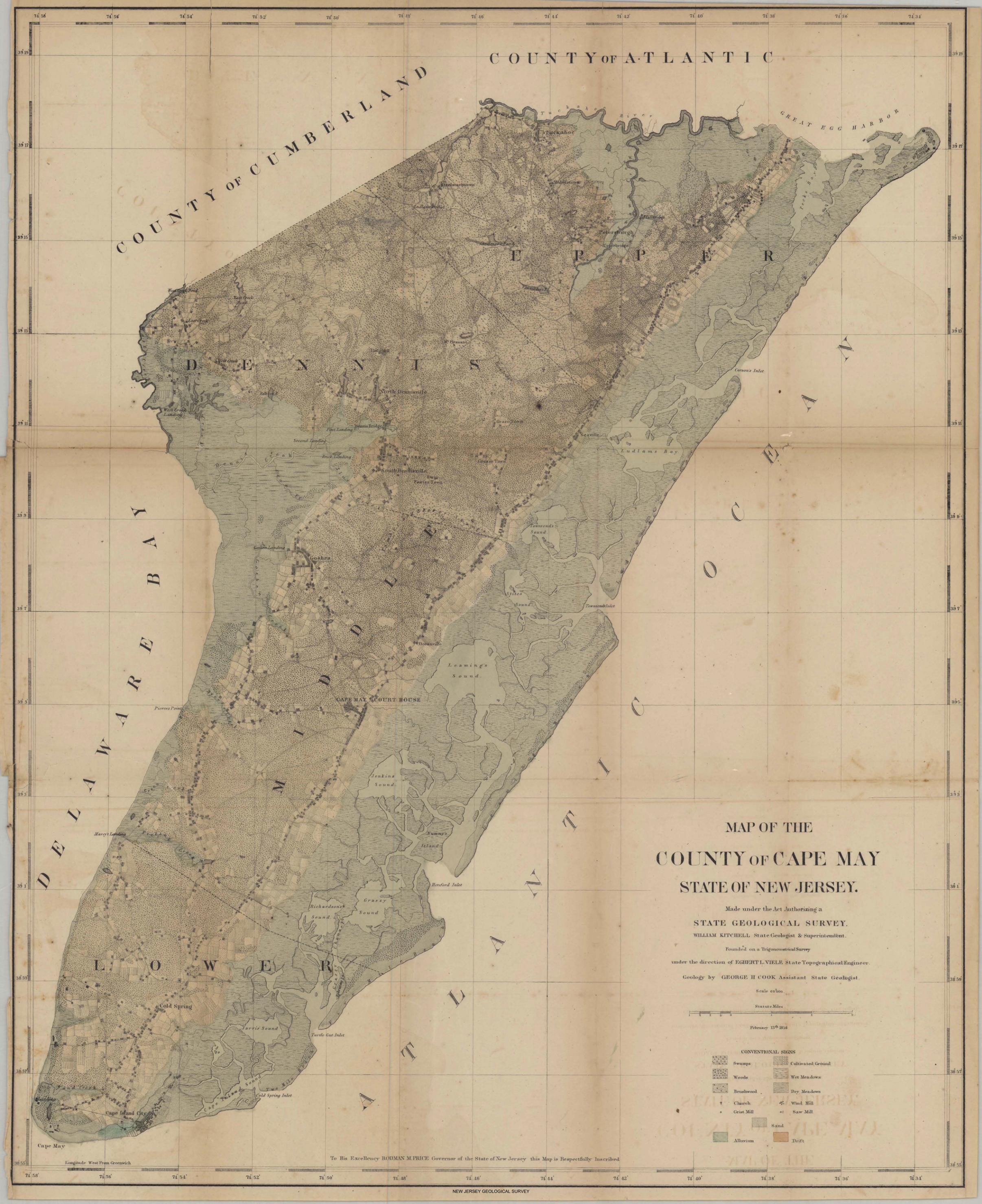
NEW JERSEY GEOLOGICAL SURVEY