Embed Size (px)
Citation preview
The Dalles Urban Reserve Area Report ▪ Winterbrook Planning ▪ September 2007 ▪ Page 1
The Dalles Urban Reserve Area Justification Report
Including Findings in Support of Establishment of
The Dalles Urban Reserve Area (URA)
September 2007
The Dalles Urban Reserve Area Report ▪ Winterbrook Planning ▪ September 2007 ▪ Page 2
Table of Contents
List of Maps ................................................................................................................................ 3
Background Reports and Memoranda ........................................................................................ 3 Additional Supporting Memoranda ............................................................................................ 3
Executive Summary ........................................................................................................................ 5 Recommendation to Move Ahead Separately with Establishment of the Urban Reserve Area . 5 Background ................................................................................................................................. 6
The Dalles 2056 Urban Reserve Area (URA) ............................................................................ 8 Introduction ................................................................................................................................... 13
Part I: Year 2056 Land Needs Assessment ................................................................................... 14
Year 2056 Population Projection .............................................................................................. 14 Employment Land Needs .......................................................................................................... 15 Residential and Public / Semi-Public Land Needs ................................................................... 18
Part II: URA Locational Criteria ................................................................................................... 24
Introduction ............................................................................................................................... 24 Potential URA Study Areas ...................................................................................................... 24
Urban Reserve Rule Locational Criteria ................................................................................... 26 Goal 14 Location Factors .......................................................................................................... 29 (1) Efficient accommodation of identified land needs .............................................................. 32
(2) Orderly and economic provision of public facilities and services ...................................... 32 (3) Comparative economic, social, environmental and energy (ESEE) consequences ............ 38
(4) Compatibility of the proposed urban uses with nearby agricultural activities occurring on
farm land outside the UGB. ...................................................................................................... 47
URA Location Conclusion ........................................................................................................ 49 Part III: URA Interim Development Policies and Agreements .................................................... 51
1. Interim Development Policies............................................................................................... 52 2. Urban Growth Management Agreement ............................................................................... 52
URA Conclusion ........................................................................................................................... 53
The Dalles Urban Reserve Area Report ▪ Winterbrook Planning ▪ September 2007 ▪ Page 3
List of Maps
Map 1: existing UGB Buildable Lands Inventory
Map 2: existing UGB, County Zoning & Study Areas
Map 3: existing UGB, Agricultural Soils, Federal Land & Exception Areas
Map 4: Potential Industrial and Commercial Sites
Map 5: Composite UGB & URA Buildable Lands
Map 6: Generalized Comprehensive Plan Map (2026 UGB & URA)
Background Reports and Memoranda
Volume II of The Dalles Comprehensive Plan includes the following background documents that
justify the need for, and location of the Year 2026 UGB and URA:
Land Use Needs and Locational Analysis (Erik C. Rundell, City of The Dalles, 2005)
Population Forecast for The Dalles (ECONorthwest, 2006)
City of The Dalles Economic Opportunities Analysis (ECONorthwest, 2007)
City of The Dalles Residential Land Needs Report (Winterbrook Planning, 2007)
City of The Dalles Recommended Zoning District Amendments (Winterbrook Planning,
2006)
City of The Dalles Demographic Trends Analysis (Winterbrook Planning, 2006)
Buildable Lands Inventory Methods and Maps for The Dalles UGB and URA
(Winterbrook Planning and the City of The Dalles, 2006)
Goal 13 Energy and Land Use Analysis (ECONorthwest, 2006)
Urban Growth Management Report (Winterbrook Planning, 2007)
Additional Supporting Memoranda
Public Facilities Findings for 2026 UGB and URA (City of The Dalles Public Works
Department, 2007)
Rural Residential Area Capacity Analysis (City of The Dalles Community Development
Department, 2007)

The Dalles Urban Reserve Area Report ▪ Winterbrook Planning ▪ September 2007 ▪ Page 4
The Dalles Urban Reserve Area Report ▪ Winterbrook Planning ▪ September 2007 ▪ Page 5
Executive Summary
The Dalles Urban Reserve Area (URA) identifies where growth will occur over the next 40-50
years and allows the City to plan for the extension of public facilities and services during this
period. Once land is included within an URA, it becomes “first priority” under Oregon law for
inclusion within The Dalles’ 20-year Urban Growth Boundary (UGB) and must be protected
from “interim development” until included within the 20-year UGB.
These findings are intended to justify the amount and location of land included within the Urban
Reserve Area. Amendment of The Dalles’ Urban Growth Boundary will follow joint adoption of
the URA by Wasco County and the City of The Dalles. Although these findings and referenced
reports demonstrate a 50-year need for residential, public / semi-public and employment land,
the proposed URA includes less than a 50-year buildable land supply. The primary reason for
not including more land at this time is the extreme topographic and institutional constraints that
limit The Dalles’ longer-term growth potential.
The URA is locally adopted and acknowledged by the land Conservation and Development
Commission (LCDC). However, the Columbia River Gorge Commission is not bound by a local
decision to adopt, or LCDC’s decision to acknowledge, an Urban Reserve Area.
Recommendation to Move Ahead Separately with Establishment of the Urban Reserve Area
The URA Justification Report was originally included as Part III of The Dalles Growth
Management Report.
Part I of that report addressed expansion the 20-Year Urban Growth Boundary (UGB)
and included extensive revisions to The Dalles Comprehensive Land Use Plan text and
maps.
Part II of that report addressed expansion of the “Urban Area” established under the
Columbia River Gorge National Scenic Area Act.
The original intent was to process all three amendment packages simultaneously. However,
expansion of the UGB is a complicated process – especially for cities within the Columbia River
Gorge National Scenic Area. Expansion of the UGB and Urban Area must be:
1. Coordinated with and adopted by Wasco County;
2. Approved by the Columbia Gorge Commission as a “minor amendment” under the
provisions of the Act (or alternatively by an act of the United State Congress); and then
3. Acknowledged by the Land Conservation and Development Commission (LCDC) as
complying with applicable Statewide Planning Goals.
In contrast, establishment of the 50-year Urban Reserve Area (URA) is a simpler but
nevertheless demanding process: it requires coordination and adoption by the Wasco County
The Dalles Urban Reserve Area Report ▪ Winterbrook Planning ▪ September 2007 ▪ Page 6
prior to acknowledgment by LCDC for consistency with the Urban Reserve Area administrative
rule (OAR Chapter 660, Division 021).
Gorge Commission staff have raised a number of issues that they believe should be addressed
through the City and County review process before submittal to the Gorge Commission. At the
same time, the Gorge Commission staff has recognized the Gorge Commission need not approve
the establishment of the URA. The Gorge Commission and the Department of Land
Conservation and Development are considering the appropriate process for review of the City’s
Urban Area / UGB expansion. Wasco County staff recently proposed a lengthy process for
review of the Urban Area / UGB expansion. The Friends of the Gorge assert that an Act of
Congress is required for The Dalles to amend its UGB to include a 20-year buildable land
supply. In short, it could be a while before the Urban Area / UGB amendment process is
complete.
Over the last two years, City staff and its consultants (Winterbrook Planning and
ECONorthwest) have completed the studies necessary to establish an Urban Reserve Area. None
of the objections received by the Planning Commission or City Council related to the amount of
land included within the proposed URA or its location. For these reasons, City staff proposes to
move ahead separately and expeditiously with establishment of the URA as the more
complex requirements of UGB / Urban Area expansion are addressed.
Background
The City of The Dalles’ growth is severely constrained by topographic features. The Dalles was
originally sited on a bench on a bend in the Columbia River. The bench is confined by steep
slopes and rimrock. Stream corridors and associated roads connect the town site with the upland
plateau to the south, east and west. Non-irrigated areas on the moderately fertile plateau to the
east and west of The Dalles are farmed for wheat. This area is comprised primarily of Class II-
IV agricultural soils, with inclusions of poorer soils. Irrigated Class II-IV areas to the south have
proven ideal for growing cherries – an industry that is highly valued in Wasco County. Grazing
and non-productive lands northwest and east of The Dalles generally have lower value (Class VI-
VIII) soils. Agricultural land is protected by Statewide Planning Goal 3 (Agricultural Lands).
The Dalles UGB was acknowledged by the Land Conservation and Development Commission
(LCDC) in 1983. The 1983 UGB included 7.3 square miles of land and was intended to meet
growth needs for the next 20 years. At that time, growth was confined by the Columbia River,
Federal Bonneville Power Administration land to the east, and cherry orchards to the south. In
1982, planned growth in The Dalles did not justify expansion into lower quality agricultural soils
(grazing lands) up Chenoweth Creek to the west and into Hidden Valley to the north.
In 1986, the United States Congress adopted the Columbia River Gorge National Scenic Area
Act (NSAA), which established the bi-state Columbia River Gorge Commission. Under the
provisions of the NSAA, the Gorge Commission established the National Scenic Area
surrounding The Dalles UGB on all sides. As intended by Congress, the Gorge Commission
The Dalles Urban Reserve Area Report ▪ Winterbrook Planning ▪ September 2007 ▪ Page 7
exempted the area within The Dalles UGB from provisions of the act.1 However, a “minor
amendment” is required for needed expansion of The Dalles “Urban Area.”
In 1993, the City conducted a thorough review of the Comprehensive Land Use Plan (CLUP)
with respect to economic development, housing and recreational needs. As part of that process,
the City adopted strong policies to encourage affordable housing and efficient use of land for
urban development. The City also adopted policies to allow mixed-use, nodal commercial
centers. As a result, residential development in The Dalles has averaged approximately 5.0
dwelling units per gross buildable acre – relatively high density for a community east of the
Cascades.
In August of 2005, the City published the Land Use Needs and Locational Analysis (Erik. C.
Rundell, RARE Planner). This document includes 36 GIS (geographic information system)
maps and text that summarize the physical (e.g., agricultural soil capability, slope, landslide
areas, floodplains, wetlands, stream corridors); public / semi-public (e.g., public and semi-public
land ownership, NSA boundaries); and economic (construction costs based on topography)
“limitations” that constrain long-term growth in The Dalles. These maps were prepared
specifically to address Statewide Planning Goal 14 (Urbanization) locational factors, as well as
Columbia River Gorge National Scenic Area Act (NSAA) requirements for “urban area” status.
Under the NSAA, the “urban area” is exempt from the provisions of the NSAA. Assuming
coordination among local, state and federal agencies, the federally-approved Urban Area
boundary should be collinear with the locally- and state-approved Urban Growth Boundary
(UGB).
In February of 2006, Winterbrook Planning and ECONorthwest were chosen by the City to
prepare comprehensive plan amendments and supporting studies necessary to justify expansion
of the City’s UGB, CRGNSAA Urban Area expansion, and establishment of the Urban Reserve
Area (URA). Over the last two years, Winterbrook has worked collaboratively with City staff to
prepare a series of growth management studies, to provide support for the public and agency
involvement process, and to draft findings in support of:
Amendments to the existing UGB and The Dalles Comprehensive Land Use Plan
(CLUP) pursuant to Statewide Planning Goal 14 (Urbanization) and the Goal 14
administrative rule (OAR Chapter 660, Division 024)
Minor Amendments to The Dalles “Urban Area” pursuant to the Columbia River
Gorge National Scenic Area Act
Establishment of The Dalles URA pursuant to the Urban Reserve Area administrative
rule (OAR Chapter 660, Division 021)
1 Due to apparent mapping errors, small areas at the edge of The Dalles UGB were not given urban exempt status,
and, therefore, have been required to comply with NSAA scenic standards. This error is being corrected as part of
the 2006-08 UGB amendment process.
The Dalles Urban Reserve Area Report ▪ Winterbrook Planning ▪ September 2007 ▪ Page 8
The Dalles 2056 Urban Reserve Area (URA)
The Dalles’ URA is intended to provide an additional 20- to 30-year land supply beyond the area
included within the UGB. The purpose of the URA is to retain rural areas in large parcels to
facilitate long-range public facilities planning. The process for establishing The Dalles URA is
similar to the process used to expand the UGB – prior to the enactment of the National Scenic
Area Act.
The standards for determining the location of the URA is governed by the Urban Reserve Area
administrative rule. In simple terms, rural exception areas are the highest priority for inclusion
within the URA and high value agricultural land (generally irrigated cherry orchards) is the
lowest priority. Less valuable, non-irrigated grazing and wheat land are medium priority. The
rule provides for an exception where “built and committed” rural residential areas cannot
reasonably meet identified needs, and where urban services cannot reasonably be provided.
The method for determining URA land need is similar to the method for determining UGB land
need. The population projection largely determines housing and public / semi-public land needs
and The Dalles’ Economic Opportunities Analysis largely determines employment land needs.
Population Projection
The Wasco County Court adopted coordinated forecasts for Wasco County and its constituent
cities on February 7, 2007. This forecast was based on a memorandum entitled Population
Forecast for The Dalles prepared by ECONorthwest (May 26, 2006). The adopted and
coordinated population projection shows a 2056 population of 31,926. The coordinated
population projection is the foundation for determining the amount of land needed to
accommodate population and livability growth needs within the URA. The Dalles population is
projected to increase by 7,073 from 2006-2026, and by 16,454 from 2026-2056. From 2026 to
2046, the average annual rate of population growth is projected to decrease to 1.3%. From 2047
to 2056, the rate is projected to decrease further to 0.9%. This population projection provides the
foundation for determining Year 2056 (URA) residential and public / semi-public land needs.
Residential and Public / Semi-Public Land Need and URA Supply
The City of The Dalles Residential Land Needs Report (Winterbrook Planning, 2007) determined
the gross buildable land area needed to meet the City’s housing needs during the 20- and 50-year
planning periods. Buildable land means vacant, partially vacant and redevelopable land that is
generally free of development constraints, such as steep slopes, wetlands, and riparian corridors.
The Dalles Residential Land Needs Report considered the results of the Housing Needs Analysis
model provided by the Oregon Community Development Department, and considered trends in
household income and housing cost as required by Statewide Planning Goal 10 (Housing). This
report recommended a series of measures to help bring housing costs in line with household
incomes in The Dalles and to increase land use efficiency. The Planning Commission reviewed
the Winterbrook report and recommended increasing overall planned residential density from 5.0
to 5.6 dwelling units per gross buildable acre (or 7.0 dwelling units per net acre after subtracting
for streets). At this increased density, The Dalles will need approximately 1,222 gross
buildable acres to meet Year 2056 housing needs.
The Dalles Urban Reserve Area Report ▪ Winterbrook Planning ▪ September 2007 ▪ Page 9
The Dalles Residential Land Needs Report also projected the need for public / semi-public land
use needs – that is, the land needs for the community college, public schools, public parks, the
golf course, religious institutions, group housing, and government uses. Most of these uses
require relatively flat vacant land (generally 10 percent or less slope) in varying parcel sizes.
The Dalles needs approximately 612 gross acres of land that meets the specific site suitability
requirements of each type of public / semi-public use. For example:
An elementary school typically requires about 10 acres of land with slopes of 10% or less
close to the residential areas they serve.
An active community park with athletic fields typically requires about 15-20 acres of
land with slopes of 10% or less close to the residential areas they serve
To expand to an 18-hole course with a driving and practice range, The Dalles Golf
Course requires approximately 120 acres of land with slopes of 10% or less adjacent to
the existing golf course.
Since public and semi-public land needs typically are met on land designated for residential use
in The Dalles, these land needs are included in the residential category. The Dalles will need
approximately 612 gross buildable acres to meet Year 2056 public / semi-public residential
land needs.
The Dalles Buildable Lands Inventory includes text and tables documenting the buildable land
area, by land use designation, within the existing UGB. Map 1: existing UGB Buildable Lands
Inventory shows the location of buildable lands within The Dalles UGB.
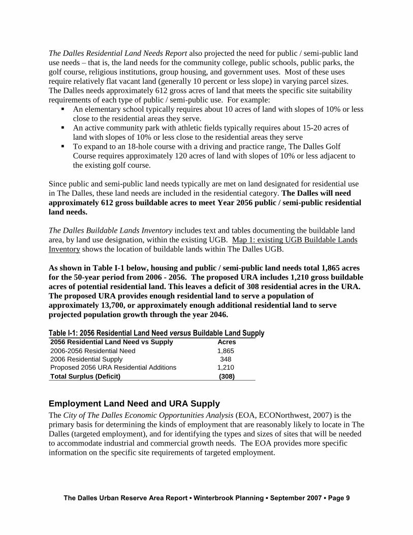
As shown in Table I-1 below, housing and public / semi-public land needs total 1,865 acres
for the 50-year period from 2006 - 2056. The proposed URA includes 1,210 gross buildable
acres of potential residential land. This leaves a deficit of 308 residential acres in the URA.
The proposed URA provides enough residential land to serve a population of
approximately 13,700, or approximately enough additional residential land to serve
projected population growth through the year 2046.
Table I-1: 2056 Residential Land Need versus Buildable Land Supply 2056 Residential Land Need vs Supply Acres
2006-2056 Residential Need 1,865
2006 Residential Supply 348
Proposed 2056 URA Residential Additions 1,210
Total Surplus (Deficit) (308)
Employment Land Need and URA Supply
The City of The Dalles Economic Opportunities Analysis (EOA, ECONorthwest, 2007) is the
primary basis for determining the kinds of employment that are reasonably likely to locate in The
Dalles (targeted employment), and for identifying the types and sizes of sites that will be needed
to accommodate industrial and commercial growth needs. The EOA provides more specific
information on the specific site requirements of targeted employment.
The Dalles Urban Reserve Area Report ▪ Winterbrook Planning ▪ September 2007 ▪ Page 10
Two major events have shaped The Dalles’ economy over the last five years: Google’s decision
to locate in The Dalles and the closing of the Northwest Aluminum plant:
Google requires about a hundred acres of light industrial land to meet anticipated growth
needs and will likely attract spin-off “cluster” industries.
On the other hand, approximately 250 potentially redevelopable acres at the defunct
Northwest Aluminum site have come on the market, and will help meet the site
requirements of targeted industries identified in the EOA.
After accounting for these two watershed events and reviewing the Economic Opportunities
Analysis (EOA), the Planning Commission determined that The Dalles needs approximately
515 sites in a variety of sizes ranging from small (less than five acres) to large (50 plus
acres) to meet industrial and commercial land needs over the next 50 years.
Commercial and industrial users typically require relatively flat sites (10% slope or less), with
arterial street access. Industrial uses typically prefer to locate in clusters – away from residential
areas – to minimize potential conflicts. Neighborhood commercial uses, on the other hand,
typically require sites in proximity to the residential areas they serve. Business parks (a
combination of commercial and industrial users located in “flex” buildings) require relatively flat
sites with access to an arterial street, but are more compatible with residential uses and therefore
need not locate in a strictly industrial area.
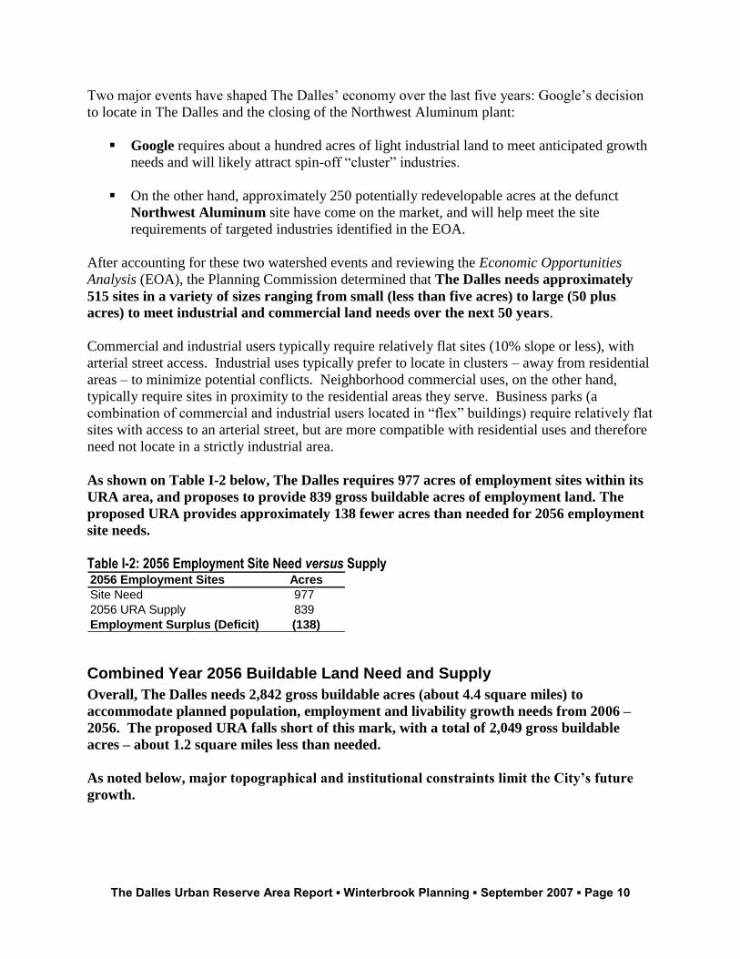
As shown on Table I-2 below, The Dalles requires 977 acres of employment sites within its
URA area, and proposes to provide 839 gross buildable acres of employment land. The
proposed URA provides approximately 138 fewer acres than needed for 2056 employment
site needs.
Table I-2: 2056 Employment Site Need versus Supply 2056 Employment Sites Acres
Site Need 977
2056 URA Supply 839
Employment Surplus (Deficit) (138)
Combined Year 2056 Buildable Land Need and Supply
Overall, The Dalles needs 2,842 gross buildable acres (about 4.4 square miles) to
accommodate planned population, employment and livability growth needs from 2006 –
2056. The proposed URA falls short of this mark, with a total of 2,049 gross buildable
acres – about 1.2 square miles less than needed.
As noted below, major topographical and institutional constraints limit the City’s future
growth.
The Dalles Urban Reserve Area Report ▪ Winterbrook Planning ▪ September 2007 ▪ Page 11
The Location of the URA
Map 6 shows the location of the proposed URA. The Urban Reserve Area Rule sets priorities for
determine which types of land to include within an urban reserve area. In The Dalles’ case, the
highest priority is rural exception areas, and the lowest priority is irrigated agricultural land.
Non-irrigated wheat land is medium priority.
As shown on Map 6, URA expansion is proposed in three areas:
1. Northwest of the existing UGB in Study Area 1. This area includes rural residential
exception areas along Chenoweth Creek and non-irrigated, low-quality grazing lands
north of Chenoweth Creek.
2. South of the existing UGB in Study Areas 2 and 3. This area includes rural residential
exception areas and very small agricultural parcels with existing development. The only
large agriculturally-zoned parcels (approximately 19 acres) are needed for expansion of
Columbia Gorge Community College.
3. East of the existing UGB in Study Area 4. This area is accessible from 15 Mile Creek
Road and includes small pockets of rural residential exception areas, and large, flat
development sites on non-irrigated grazing and wheat land on the plateau above
Petersburg school. To meet identified siting requirements for employment and
public/semi-public land, large parcels with slopes of 10% or less and access to a planned
arterial street are required. Such sites are extremely scarce near The Dalles UGB.
Winterbrook and City staff combed the four study areas and found only one area that has
large, contiguous parcels suitable for meeting the City’s longer-term employment needs:
the bench generally east of the BPA Starr Complex that is accessed from 15 Mile Road.
This medium priority rural area has predominantly Class II, III, and VIII soils that are not
irrigated and that are currently in wheat production.
Map 2 shows rural residential exception areas and rural zoning within the four URA expansion
study areas. Except for largely unbuildable canyon areas associated with Seven Mile Creek that
lie within the Columbia River Gorge National Scenic Area, the proposed URA includes all rural
exception areas within 1.5 road miles of the existing UGB.

The Dalles Urban Reserve Area Report ▪ Winterbrook Planning ▪ September 2007 ▪ Page 12
The Dalles Urban Reserve Area Report ▪ Winterbrook Planning ▪ September 2007 ▪ Page 13
Introduction
Establishment of The Dalles Urban Reserve Area is governed by the Land Conservation and
Development Commission’s (LCDC’s) Urban Reserve Rule (OAR Chapter 660, Division 021).
The purpose of urban reserves is stated in this rule as follows:
660-021-0000 Purpose
This division authorizes planning for areas outside urban growth boundaries to be reserved for
eventual inclusion in an urban growth boundary and to be protected from patterns of
development that would impede urbanization.
Section 1 of the rule states that cities may plan for 10-30 years beyond the 20-year planning
period required for UGBs. The Dalles URA is based on Year 2056 employment, residential and
public / semi-public land need projections. All cities in Oregon must maintain a 20-year urban
land supply. The Dalles URA includes land outside the acknowledged UGB that eventually will
be included within the UGB as (a) 20-year land need is demonstrated, and b)The Columbia
River Gorge Commission approves a “minor amendment” to The Dalles Urban Area.
During the interim, land within The Dalles URA must be “protected” by Wasco County
regulations to allow for efficient urban development in the future.
Report Organization
The Dalles’ URA is established to meet the City’s urban growth needs through the Year 2056.
This report is organized as follows:
Part I determines the land area that will be needed during the 50-year planning period.
Part II justifies the location of the URA based on relevant provisions of the Urban
Reserve Rule (OAR 660, Division 021).
Part III explains how The Dalles and Wasco County will manage interim development
within the URA prior to its inclusion within The Dalles’20-year Urban Growth Boundary
(UGB).
Relation to the Columbia River Gorge National Scenic Area Act (NSAA)
As part of the 2006-08 comprehensive plan revision process, The Dalles and Wasco County are
seeking approval from the Gorge Commission to amend the “Urban Area” established under the
Columbia River Gorge National Scenic Area Act (NSAA). Gorge Commission approval of an
expanded “Urban Area” is necessary for The Dalles to expand its 20-year UGB to meet
demonstrated population, employment and livability land needs. However, establishment of an
urban reserve area does not require changes to Wasco County Comprehensive Plan map
The Dalles Urban Reserve Area Report ▪ Winterbrook Planning ▪ September 2007 ▪ Page 14
designations or rural plan policies. In fact, OAR 660-021-0040 makes it clear that “lands in the
urban reserve area shall continue to be planned and zoned for rural uses.”2
To the extent that County zoning is changed as a result of the establishment of an urban reserve
area, interim zoning standards would be more restrictive. Therefore, there is no reason to
conclude that establishment of an urban reserve area would be in conflict with the purpose of the
NSAA. Moreover, a City and County decision to establish a URA is not binding upon the Gorge
Commission. For these reasons, The Dalles is coordinating with Wasco County in the
establishment of The Dalles’ URA independent of their request to amend the NSA Urban Area
and expand The Dalles 20-year UGB.
Part I: Year 2056 Land Needs Assessment This section demonstrates how much buildable land is needed to meet Year 2056 growth needs,
and describes site suitability requirements for targeted employment, parks and schools. The
following background documents provide the factual basis for establishing The Dalles URA:
Volume II of The Dalles Comprehensive Plan includes the following background documents that
justify the need for, and location of the Year 2026 UGB and URA:
Land Use Needs and Locational Analysis (Erik C. Rundell, City of The Dalles, 2005)
Population Forecast for The Dalles (ECONorthwest, 2006)
City of The Dalles Economic Opportunities Analysis (ECONorthwest, 2007)
City of The Dalles Residential Land Needs Report (Winterbrook Planning, 2007)
City of The Dalles Demographic Trends Analysis (Winterbrook Planning, 2006)
Buildable Lands Inventory Methods and Maps for The Dalles UGB and URA
(Winterbrook Planning and the City of The Dalles, 2006)
Goal 13 Energy and Land Use Analysis (ECONorthwest, 2006)
Urban Growth Management Report (Winterbrook Planning, 2007)
Year 2056 Population Projection
The coordinated population project is the basis for determining housing and public / semi-public
land needs. The Wasco County Court adopted coordinated forecasts for Wasco County and its
constituent cities on February 7, 2007. This forecast was based on a memorandum entitled
Population Forecast for The Dalles prepared by ECONorthwest (May 26, 2006). The adopted
and coordinated population projection shows a 2056 population of 31,926. The coordinated
population projection is the foundation for determining the amount of land needed to
accommodate population and livability growth needs within the URA. The 2056 population
projection of 31,926 is used to justify the 2056 Urban Reserve Area (URA). As shown on Table
2 The full text of this section reads as follows:
660-021-0040 Urban Reserve Area Planning and Zoning (1) Until included in the urban growth boundary, lands in the urban reserve area shall continue to be planned and zoned for rural uses in accordance with the requirements of this section, but in a manner that ensures a range of opportunities for the orderly, economic and efficient provision of urban services when these lands are included in the urban growth boundary.
The Dalles Urban Reserve Area Report ▪ Winterbrook Planning ▪ September 2007 ▪ Page 15
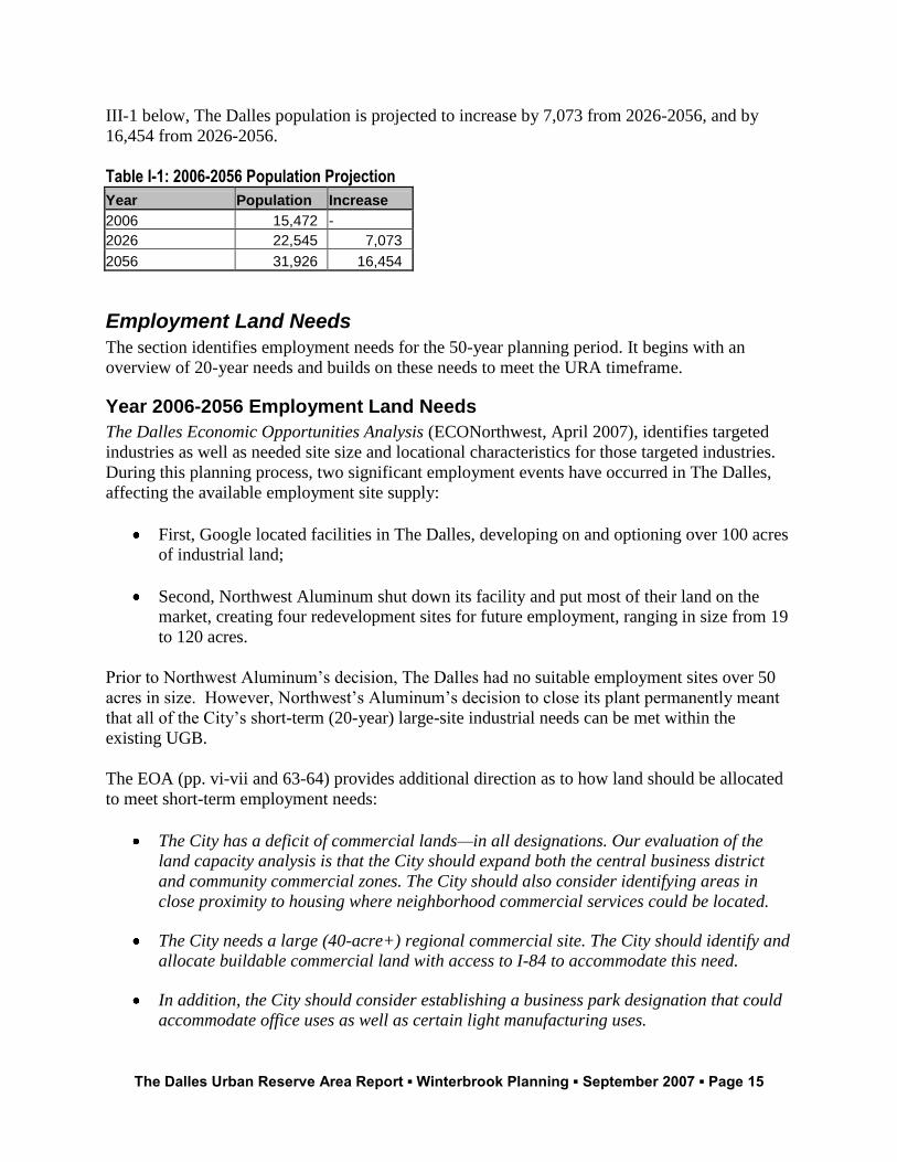
III-1 below, The Dalles population is projected to increase by 7,073 from 2026-2056, and by
16,454 from 2026-2056.
Table I-1: 2006-2056 Population Projection
Year Population Increase
2006 15,472 -
2026 22,545 7,073
2056 31,926 16,454
Employment Land Needs
The section identifies employment needs for the 50-year planning period. It begins with an
overview of 20-year needs and builds on these needs to meet the URA timeframe.
Year 2006-2056 Employment Land Needs
The Dalles Economic Opportunities Analysis (ECONorthwest, April 2007), identifies targeted
industries as well as needed site size and locational characteristics for those targeted industries.
During this planning process, two significant employment events have occurred in The Dalles,
affecting the available employment site supply:
First, Google located facilities in The Dalles, developing on and optioning over 100 acres
of industrial land;
Second, Northwest Aluminum shut down its facility and put most of their land on the
market, creating four redevelopment sites for future employment, ranging in size from 19
to 120 acres.
Prior to Northwest Aluminum’s decision, The Dalles had no suitable employment sites over 50
acres in size. However, Northwest’s Aluminum’s decision to close its plant permanently meant
that all of the City’s short-term (20-year) large-site industrial needs can be met within the
existing UGB.
The EOA (pp. vi-vii and 63-64) provides additional direction as to how land should be allocated
to meet short-term employment needs:
The City has a deficit of commercial lands—in all designations. Our evaluation of the
land capacity analysis is that the City should expand both the central business district
and community commercial zones. The City should also consider identifying areas in
close proximity to housing where neighborhood commercial services could be located.
The City needs a large (40-acre+) regional commercial site. The City should identify and
allocate buildable commercial land with access to I-84 to accommodate this need.
In addition, the City should consider establishing a business park designation that could
accommodate office uses as well as certain light manufacturing uses.
The Dalles Urban Reserve Area Report ▪ Winterbrook Planning ▪ September 2007 ▪ Page 16
Large, flat sites adjacent to the UGB with arterial street access are difficult to find. Therefore,
the City was forced to lower its siting requirements for business parks and neighborhood
commercial centers. These two employment categories are compatible with residential
neighborhoods and do not require direct I-5 access. However, they must:
Have direct access to an existing or planned arterial street;
Be centrally located to serve existing or planned residential growth (neighborhood
commercial centers only);
Have slopes of 15 percent or less;
Meet size requirements outlined by the EOA; and
Be serviceable during the planning period with sanitary sewer, water and storm drainage
facilities.
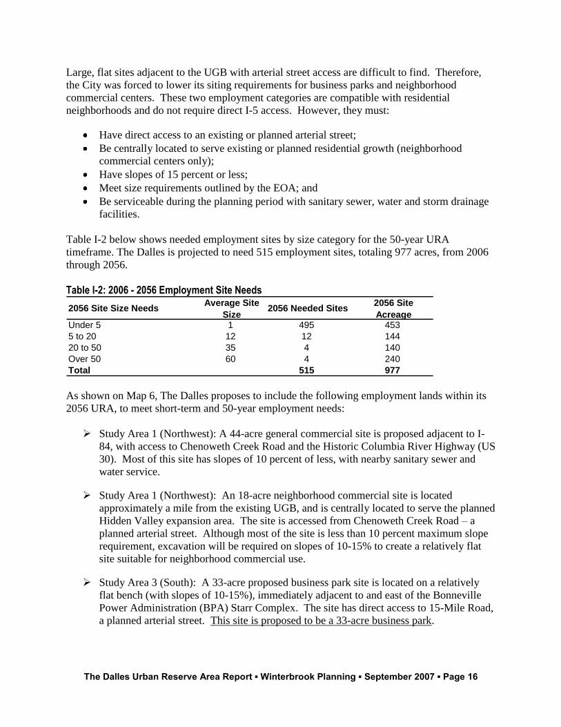
Table I-2 below shows needed employment sites by size category for the 50-year URA
timeframe. The Dalles is projected to need 515 employment sites, totaling 977 acres, from 2006
through 2056.
Table I-2: 2006 - 2056 Employment Site Needs
2056 Site Size NeedsAverage Site
Size2056 Needed Sites
2056 Site
AcreageUnder 5 1 495 453
5 to 20 12 12 144
20 to 50 35 4 140
Over 50 60 4 240
Total 515 977
As shown on Map 6, The Dalles proposes to include the following employment lands within its
2056 URA, to meet short-term and 50-year employment needs:
Study Area 1 (Northwest): A 44-acre general commercial site is proposed adjacent to I-
84, with access to Chenoweth Creek Road and the Historic Columbia River Highway (US
30). Most of this site has slopes of 10 percent of less, with nearby sanitary sewer and
water service.
Study Area 1 (Northwest): An 18-acre neighborhood commercial site is located
approximately a mile from the existing UGB, and is centrally located to serve the planned
Hidden Valley expansion area. The site is accessed from Chenoweth Creek Road – a
planned arterial street. Although most of the site is less than 10 percent maximum slope
requirement, excavation will be required on slopes of 10-15% to create a relatively flat
site suitable for neighborhood commercial use.
Study Area 3 (South): A 33-acre proposed business park site is located on a relatively
flat bench (with slopes of 10-15%), immediately adjacent to and east of the Bonneville
Power Administration (BPA) Starr Complex. The site has direct access to 15-Mile Road,
a planned arterial street. This site is proposed to be a 33-acre business park.
The Dalles Urban Reserve Area Report ▪ Winterbrook Planning ▪ September 2007 ▪ Page 17
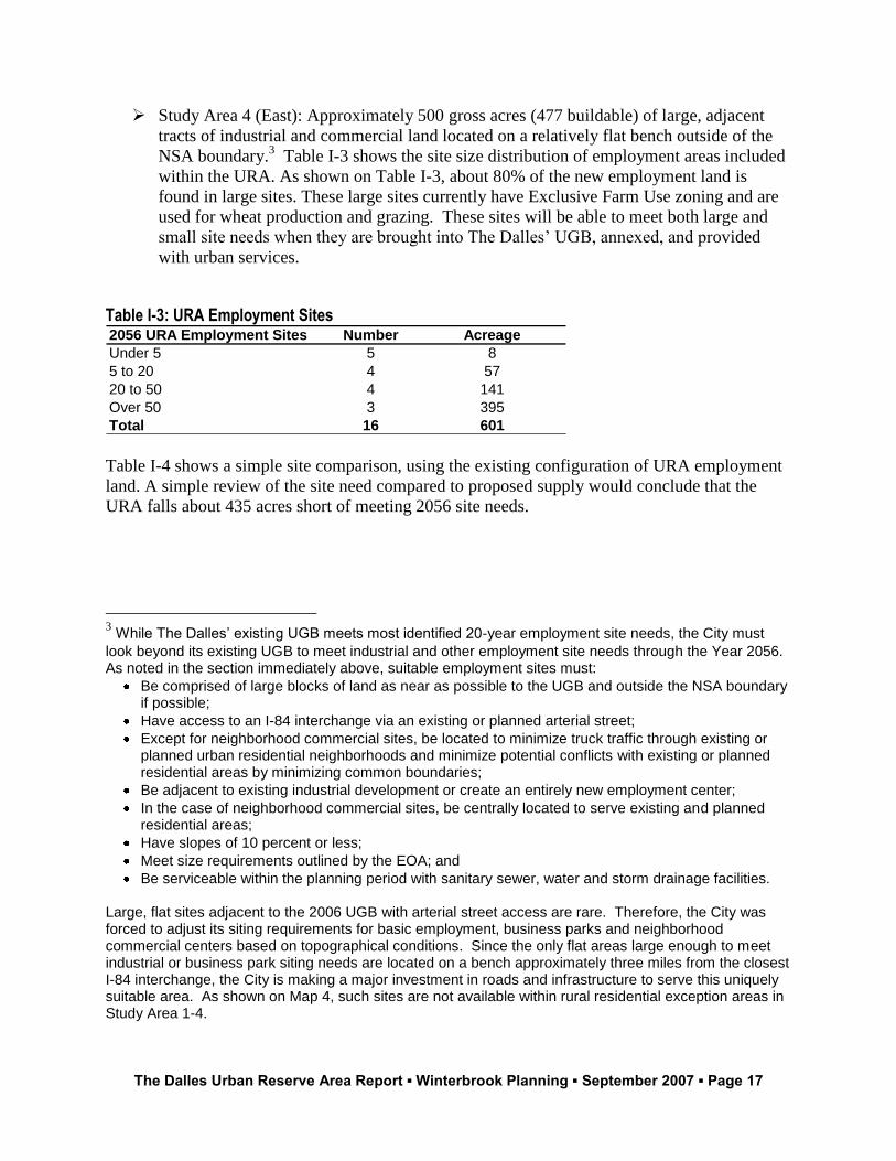
Study Area 4 (East): Approximately 500 gross acres (477 buildable) of large, adjacent
tracts of industrial and commercial land located on a relatively flat bench outside of the
NSA boundary.3 Table I-3 shows the site size distribution of employment areas included
within the URA. As shown on Table I-3, about 80% of the new employment land is
found in large sites. These large sites currently have Exclusive Farm Use zoning and are
used for wheat production and grazing. These sites will be able to meet both large and
small site needs when they are brought into The Dalles’ UGB, annexed, and provided
with urban services.
Table I-3: URA Employment Sites 2056 URA Employment Sites Number Acreage
Under 5 5 8
5 to 20 4 57
20 to 50 4 141
Over 50 3 395
Total 16 601
Table I-4 shows a simple site comparison, using the existing configuration of URA employment
land. A simple review of the site need compared to proposed supply would conclude that the
URA falls about 435 acres short of meeting 2056 site needs.
3 While The Dalles’ existing UGB meets most identified 20-year employment site needs, the City must
look beyond its existing UGB to meet industrial and other employment site needs through the Year 2056. As noted in the section immediately above, suitable employment sites must:
Be comprised of large blocks of land as near as possible to the UGB and outside the NSA boundary if possible;
Have access to an I-84 interchange via an existing or planned arterial street;
Except for neighborhood commercial sites, be located to minimize truck traffic through existing or planned urban residential neighborhoods and minimize potential conflicts with existing or planned residential areas by minimizing common boundaries;
Be adjacent to existing industrial development or create an entirely new employment center;
In the case of neighborhood commercial sites, be centrally located to serve existing and planned residential areas;
Have slopes of 10 percent or less;
Meet size requirements outlined by the EOA; and
Be serviceable within the planning period with sanitary sewer, water and storm drainage facilities. Large, flat sites adjacent to the 2006 UGB with arterial street access are rare. Therefore, the City was forced to adjust its siting requirements for basic employment, business parks and neighborhood commercial centers based on topographical conditions. Since the only flat areas large enough to meet industrial or business park siting needs are located on a bench approximately three miles from the closest I-84 interchange, the City is making a major investment in roads and infrastructure to serve this uniquely suitable area. As shown on Map 4, such sites are not available within rural residential exception areas in Study Area 1-4.
The Dalles Urban Reserve Area Report ▪ Winterbrook Planning ▪ September 2007 ▪ Page 18
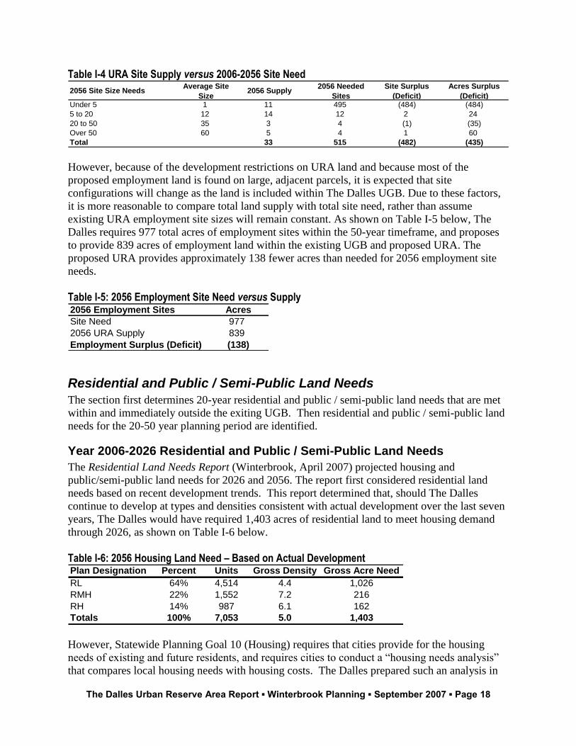
Table I-4 URA Site Supply versus 2006-2056 Site Need
2056 Site Size NeedsAverage Site
Size2056 Supply
2056 Needed
Sites
Site Surplus
(Deficit)
Acres Surplus
(Deficit)Under 5 1 11 495 (484) (484)
5 to 20 12 14 12 2 24
20 to 50 35 3 4 (1) (35)
Over 50 60 5 4 1 60
Total 33 515 (482) (435)
However, because of the development restrictions on URA land and because most of the
proposed employment land is found on large, adjacent parcels, it is expected that site
configurations will change as the land is included within The Dalles UGB. Due to these factors,
it is more reasonable to compare total land supply with total site need, rather than assume
existing URA employment site sizes will remain constant. As shown on Table I-5 below, The
Dalles requires 977 total acres of employment sites within the 50-year timeframe, and proposes
to provide 839 acres of employment land within the existing UGB and proposed URA. The
proposed URA provides approximately 138 fewer acres than needed for 2056 employment site
needs.
Table I-5: 2056 Employment Site Need versus Supply 2056 Employment Sites Acres
Site Need 977
2056 URA Supply 839
Employment Surplus (Deficit) (138)
Residential and Public / Semi-Public Land Needs
The section first determines 20-year residential and public / semi-public land needs that are met
within and immediately outside the exiting UGB. Then residential and public / semi-public land
needs for the 20-50 year planning period are identified.
Year 2006-2026 Residential and Public / Semi-Public Land Needs
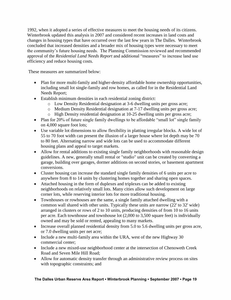
The Residential Land Needs Report (Winterbrook, April 2007) projected housing and
public/semi-public land needs for 2026 and 2056. The report first considered residential land
needs based on recent development trends. This report determined that, should The Dalles
continue to develop at types and densities consistent with actual development over the last seven
years, The Dalles would have required 1,403 acres of residential land to meet housing demand
through 2026, as shown on Table I-6 below.
Table I-6: 2056 Housing Land Need – Based on Actual Development Plan Designation Percent Units Gross Density Gross Acre Need
RL 64% 4,514 4.4 1,026
RMH 22% 1,552 7.2 216
RH 14% 987 6.1 162
Totals 100% 7,053 5.0 1,403
However, Statewide Planning Goal 10 (Housing) requires that cities provide for the housing
needs of existing and future residents, and requires cities to conduct a “housing needs analysis”
that compares local housing needs with housing costs. The Dalles prepared such an analysis in
The Dalles Urban Reserve Area Report ▪ Winterbrook Planning ▪ September 2007 ▪ Page 19
1992, when it adopted a series of effective measures to meet the housing needs of its citizens.
Winterbrook updated this analysis in 2007 and considered recent increases in land costs and
changes in housing types that have occurred over the last few years in The Dalles. Winterbrook
concluded that increased densities and a broader mix of housing types were necessary to meet
the community’s future housing needs. The Planning Commission reviewed and recommended
approval of the Residential Land Needs Report and additional “measures” to increase land use
efficiency and reduce housing costs.
These measures are summarized below:
Plan for more multi-family and higher-density affordable home ownership opportunities,
including small lot single-family and row homes, as called for in the Residential Land
Needs Report;
Establish minimum densities in each residential zoning district:
o Low Density Residential designation at 3-6 dwelling units per gross acre;
o Medium Density Residential designation at 7-17 dwelling units per gross acre;
o High Density residential designation at 10-25 dwelling units per gross acre;
Plan for 20% of future single family dwellings to be affordable “small lot” single family
on 4,000 square foot lots;
Use variable lot dimensions to allow flexibility in platting irregular blocks. A wide lot of
55 to 70 foot width can present the illusion of a larger house where lot depth may be 70
to 80 feet. Alternating narrow and wide lots can be used to accommodate different
housing plans and appeal to target markets.
Allow for rental additions to existing single family neighborhoods with reasonable design
guidelines. A new, generally small rental or "studio" unit can be created by converting a
garage, building over garages, dormer additions on second stories, or basement apartment
conversions.
Cluster housing can increase the standard single family densities of 6 units per acre to
anywhere from 8 to 14 units by clustering homes together and sharing open spaces.
Attached housing in the form of duplexes and triplexes can be added to existing
neighborhoods on relatively small lots. Many cities allow such development on large
corner lots, while reserving interior lots for more traditional housing.
Townhouses or rowhouses are the same, a single family attached dwelling with a
common wall shared with other units. Typically these units are narrow (22' to 32' wide)
arranged in clusters or rows of 2 to 10 units, producing densities of from 10 to 16 units
per acre. Each townhouse and townhouse lot (2,000 to 3,500 square feet) is individually
owned and may be sold or rented, appealing to many markets.
Increase overall planned residential density from 5.0 to 5.6 dwelling units per gross acre,
or 7.0 dwelling units per net acre;
Include a new multi-family area within the URA, west of the new Highway 30
commercial center;
Include a new mixed-use neighborhood center at the intersection of Chenoweth Creek
Road and Seven Mile Hill Road;
Allow for automatic density transfer through an administrative review process on sites
with topographic constraints; and
The Dalles Urban Reserve Area Report ▪ Winterbrook Planning ▪ September 2007 ▪ Page 20
Adopt zoning code amendments that ensure residential densities occur within planned
density ranges in each district.
The City of The Dalles Recommended Zoning District Amendments (Winterbrook Planning, July
2006) includes detailed recommendations to the City’s residential and mixed used districts that
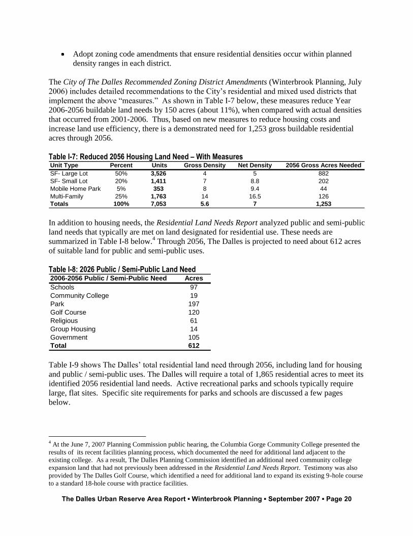
implement the above “measures.” As shown in Table I-7 below, these measures reduce Year
2006-2056 buildable land needs by 150 acres (about 11%), when compared with actual densities
that occurred from 2001-2006. Thus, based on new measures to reduce housing costs and
increase land use efficiency, there is a demonstrated need for 1,253 gross buildable residential
acres through 2056.
Table I-7: Reduced 2056 Housing Land Need – With Measures Unit Type Percent Units Gross Density Net Density 2056 Gross Acres Needed
SF- Large Lot 50% 3,526 4 5 882
SF- Small Lot 20% 1,411 7 8.8 202
Mobile Home Park 5% 353 8 9.4 44
Multi-Family 25% 1,763 14 16.5 126
Totals 100% 7,053 5.6 7 1,253
In addition to housing needs, the Residential Land Needs Report analyzed public and semi-public
land needs that typically are met on land designated for residential use. These needs are
summarized in Table I-8 below.4 Through 2056, The Dalles is projected to need about 612 acres
of suitable land for public and semi-public uses.
Table I-8: 2026 Public / Semi-Public Land Need 2006-2056 Public / Semi-Public Need Acres
Schools 97
Community College 19
Park 197
Golf Course 120
Religious 61
Group Housing 14
Government 105
Total 612
Table I-9 shows The Dalles’ total residential land need through 2056, including land for housing
and public / semi-public uses. The Dalles will require a total of 1,865 residential acres to meet its
identified 2056 residential land needs. Active recreational parks and schools typically require
large, flat sites. Specific site requirements for parks and schools are discussed a few pages
below.
4 At the June 7, 2007 Planning Commission public hearing, the Columbia Gorge Community College presented the
results of its recent facilities planning process, which documented the need for additional land adjacent to the
existing college. As a result, The Dalles Planning Commission identified an additional need community college
expansion land that had not previously been addressed in the Residential Land Needs Report. Testimony was also
provided by The Dalles Golf Course, which identified a need for additional land to expand its existing 9-hole course
to a standard 18-hole course with practice facilities.
The Dalles Urban Reserve Area Report ▪ Winterbrook Planning ▪ September 2007 ▪ Page 21
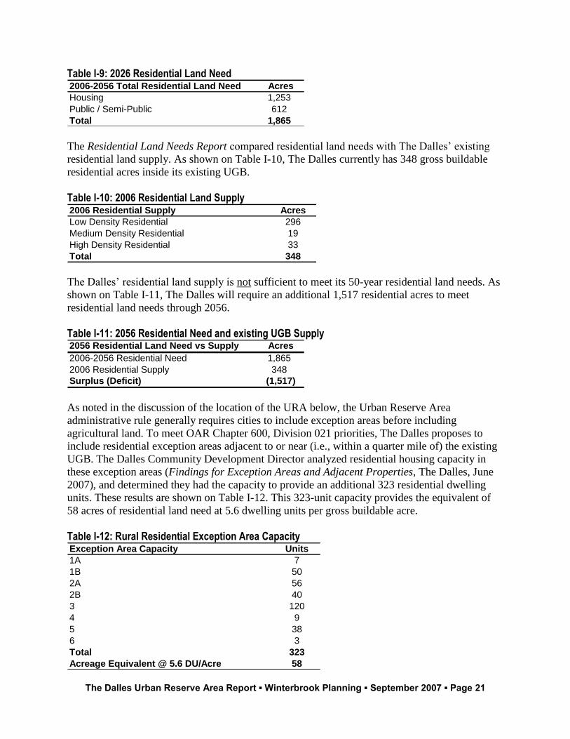
Table I-9: 2026 Residential Land Need 2006-2056 Total Residential Land Need Acres
Housing 1,253
Public / Semi-Public 612
Total 1,865
The Residential Land Needs Report compared residential land needs with The Dalles’ existing
residential land supply. As shown on Table I-10, The Dalles currently has 348 gross buildable
residential acres inside its existing UGB.
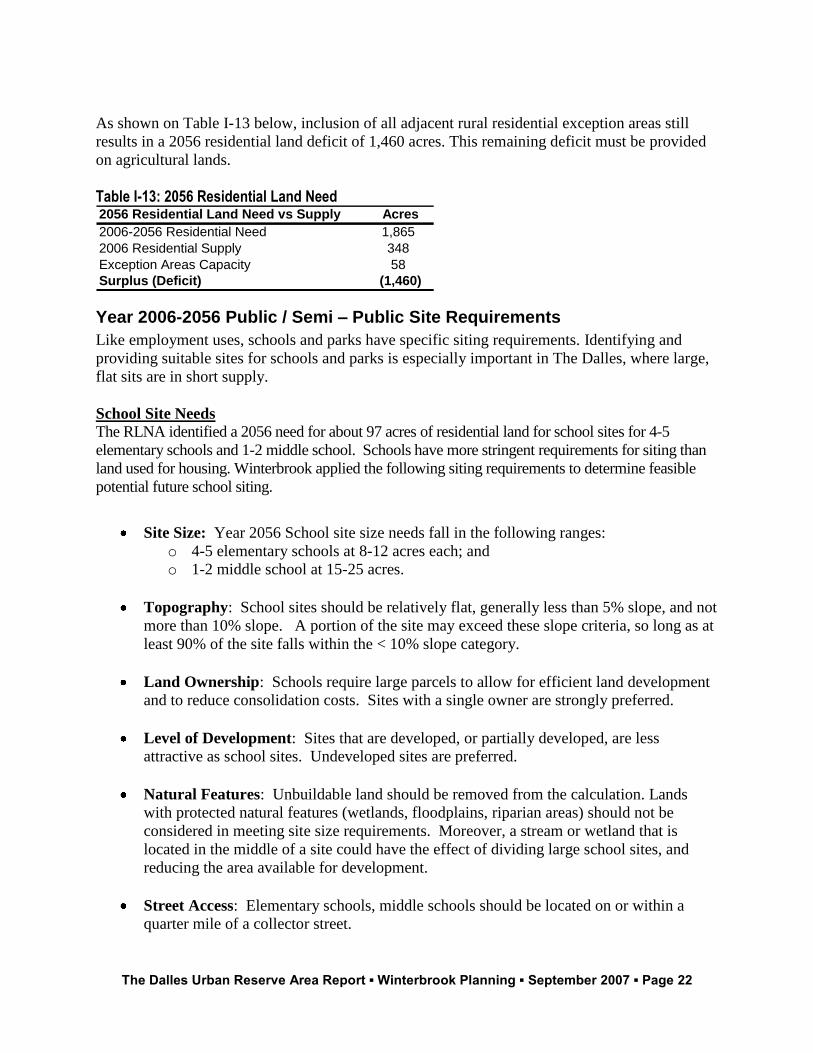
Table I-10: 2006 Residential Land Supply 2006 Residential Supply Acres
Low Density Residential 296
Medium Density Residential 19
High Density Residential 33
Total 348
The Dalles’ residential land supply is not sufficient to meet its 50-year residential land needs. As
shown on Table I-11, The Dalles will require an additional 1,517 residential acres to meet
residential land needs through 2056.
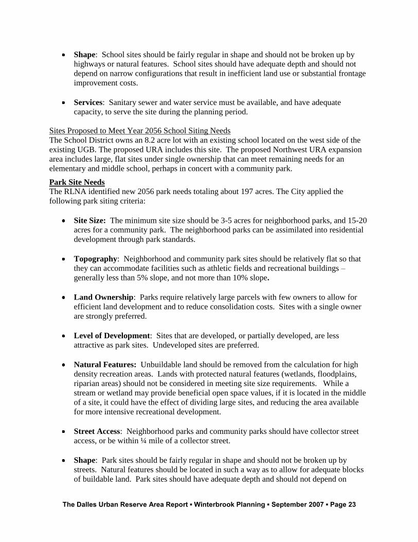
Table I-11: 2056 Residential Need and existing UGB Supply 2056 Residential Land Need vs Supply Acres
2006-2056 Residential Need 1,865
2006 Residential Supply 348
Surplus (Deficit) (1,517)
As noted in the discussion of the location of the URA below, the Urban Reserve Area
administrative rule generally requires cities to include exception areas before including
agricultural land. To meet OAR Chapter 600, Division 021 priorities, The Dalles proposes to
include residential exception areas adjacent to or near (i.e., within a quarter mile of) the existing
UGB. The Dalles Community Development Director analyzed residential housing capacity in
these exception areas (Findings for Exception Areas and Adjacent Properties, The Dalles, June
2007), and determined they had the capacity to provide an additional 323 residential dwelling
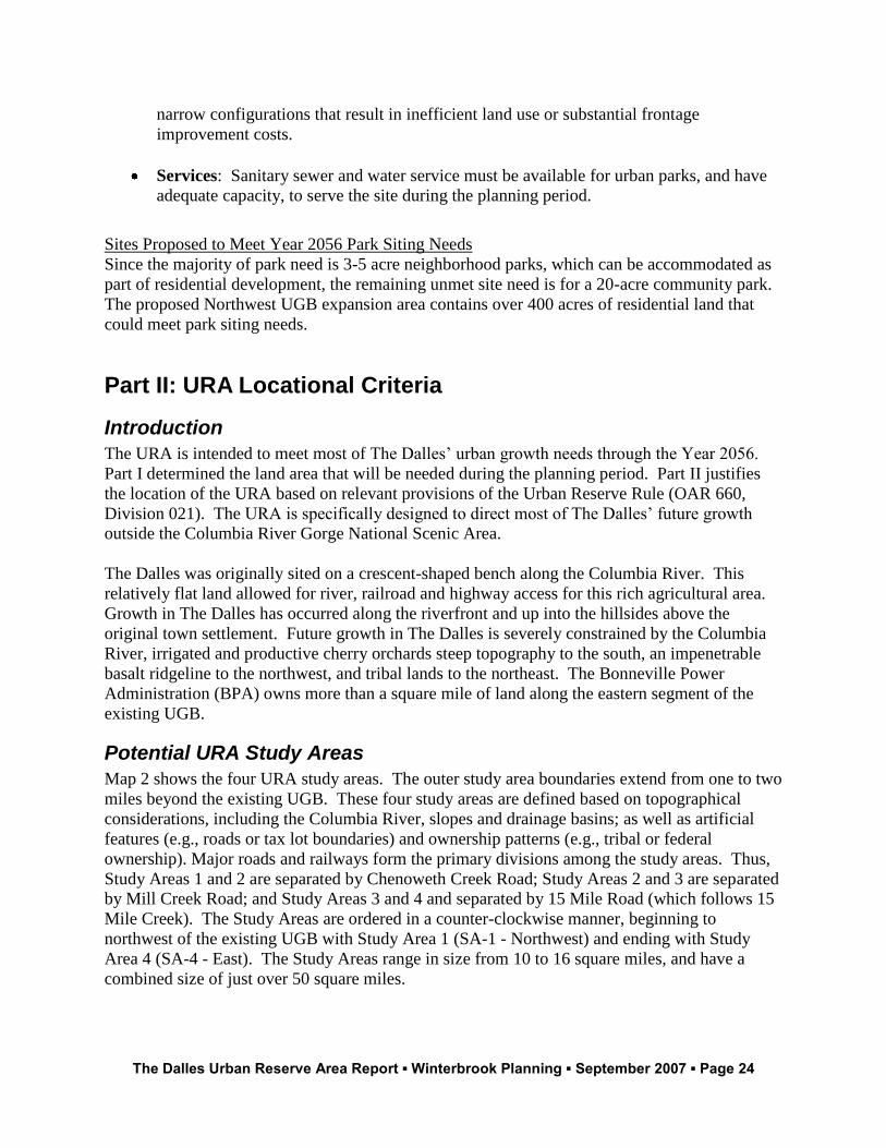
units. These results are shown on Table I-12. This 323-unit capacity provides the equivalent of
58 acres of residential land need at 5.6 dwelling units per gross buildable acre.
Table I-12: Rural Residential Exception Area Capacity Exception Area Capacity Units
1A 7
1B 50
2A 56
2B 40
3 120
4 9
5 38
6 3
Total 323
Acreage Equivalent @ 5.6 DU/Acre 58
The Dalles Urban Reserve Area Report ▪ Winterbrook Planning ▪ September 2007 ▪ Page 22
As shown on Table I-13 below, inclusion of all adjacent rural residential exception areas still
results in a 2056 residential land deficit of 1,460 acres. This remaining deficit must be provided
on agricultural lands.
Table I-13: 2056 Residential Land Need 2056 Residential Land Need vs Supply Acres
2006-2056 Residential Need 1,865
2006 Residential Supply 348
Exception Areas Capacity 58
Surplus (Deficit) (1,460)
Year 2006-2056 Public / Semi – Public Site Requirements
Like employment uses, schools and parks have specific siting requirements. Identifying and
providing suitable sites for schools and parks is especially important in The Dalles, where large,
flat sits are in short supply.
School Site Needs
The RLNA identified a 2056 need for about 97 acres of residential land for school sites for 4-5
elementary schools and 1-2 middle school. Schools have more stringent requirements for siting than
land used for housing. Winterbrook applied the following siting requirements to determine feasible
potential future school siting.
Site Size: Year 2056 School site size needs fall in the following ranges:
o 4-5 elementary schools at 8-12 acres each; and
o 1-2 middle school at 15-25 acres.
Topography: School sites should be relatively flat, generally less than 5% slope, and not
more than 10% slope. A portion of the site may exceed these slope criteria, so long as at
least 90% of the site falls within the < 10% slope category.
Land Ownership: Schools require large parcels to allow for efficient land development
and to reduce consolidation costs. Sites with a single owner are strongly preferred.
Level of Development: Sites that are developed, or partially developed, are less
attractive as school sites. Undeveloped sites are preferred.
Natural Features: Unbuildable land should be removed from the calculation. Lands
with protected natural features (wetlands, floodplains, riparian areas) should not be
considered in meeting site size requirements. Moreover, a stream or wetland that is
located in the middle of a site could have the effect of dividing large school sites, and
reducing the area available for development.
Street Access: Elementary schools, middle schools should be located on or within a
quarter mile of a collector street.
The Dalles Urban Reserve Area Report ▪ Winterbrook Planning ▪ September 2007 ▪ Page 23
Shape: School sites should be fairly regular in shape and should not be broken up by
highways or natural features. School sites should have adequate depth and should not
depend on narrow configurations that result in inefficient land use or substantial frontage
improvement costs.
Services: Sanitary sewer and water service must be available, and have adequate
capacity, to serve the site during the planning period.
Sites Proposed to Meet Year 2056 School Siting Needs
The School District owns an 8.2 acre lot with an existing school located on the west side of the
existing UGB. The proposed URA includes this site. The proposed Northwest URA expansion
area includes large, flat sites under single ownership that can meet remaining needs for an
elementary and middle school, perhaps in concert with a community park.
Park Site Needs
The RLNA identified new 2056 park needs totaling about 197 acres. The City applied the
following park siting criteria:
Site Size: The minimum site size should be 3-5 acres for neighborhood parks, and 15-20
acres for a community park. The neighborhood parks can be assimilated into residential
development through park standards.
Topography: Neighborhood and community park sites should be relatively flat so that
they can accommodate facilities such as athletic fields and recreational buildings –
generally less than 5% slope, and not more than 10% slope.
Land Ownership: Parks require relatively large parcels with few owners to allow for
efficient land development and to reduce consolidation costs. Sites with a single owner
are strongly preferred.
Level of Development: Sites that are developed, or partially developed, are less
attractive as park sites. Undeveloped sites are preferred.
Natural Features: Unbuildable land should be removed from the calculation for high
density recreation areas. Lands with protected natural features (wetlands, floodplains,
riparian areas) should not be considered in meeting site size requirements. While a
stream or wetland may provide beneficial open space values, if it is located in the middle
of a site, it could have the effect of dividing large sites, and reducing the area available
for more intensive recreational development.
Street Access: Neighborhood parks and community parks should have collector street
access, or be within ¼ mile of a collector street.
Shape: Park sites should be fairly regular in shape and should not be broken up by
streets. Natural features should be located in such a way as to allow for adequate blocks
of buildable land. Park sites should have adequate depth and should not depend on
The Dalles Urban Reserve Area Report ▪ Winterbrook Planning ▪ September 2007 ▪ Page 24
narrow configurations that result in inefficient land use or substantial frontage
improvement costs.
Services: Sanitary sewer and water service must be available for urban parks, and have
adequate capacity, to serve the site during the planning period.
Sites Proposed to Meet Year 2056 Park Siting Needs
Since the majority of park need is 3-5 acre neighborhood parks, which can be accommodated as
part of residential development, the remaining unmet site need is for a 20-acre community park.
The proposed Northwest UGB expansion area contains over 400 acres of residential land that
could meet park siting needs.
Part II: URA Locational Criteria
Introduction
The URA is intended to meet most of The Dalles’ urban growth needs through the Year 2056.
Part I determined the land area that will be needed during the planning period. Part II justifies
the location of the URA based on relevant provisions of the Urban Reserve Rule (OAR 660,
Division 021). The URA is specifically designed to direct most of The Dalles’ future growth
outside the Columbia River Gorge National Scenic Area.
The Dalles was originally sited on a crescent-shaped bench along the Columbia River. This
relatively flat land allowed for river, railroad and highway access for this rich agricultural area.
Growth in The Dalles has occurred along the riverfront and up into the hillsides above the
original town settlement. Future growth in The Dalles is severely constrained by the Columbia
River, irrigated and productive cherry orchards steep topography to the south, an impenetrable
basalt ridgeline to the northwest, and tribal lands to the northeast. The Bonneville Power
Administration (BPA) owns more than a square mile of land along the eastern segment of the
existing UGB.
Potential URA Study Areas
Map 2 shows the four URA study areas. The outer study area boundaries extend from one to two
miles beyond the existing UGB. These four study areas are defined based on topographical
considerations, including the Columbia River, slopes and drainage basins; as well as artificial
features (e.g., roads or tax lot boundaries) and ownership patterns (e.g., tribal or federal
ownership). Major roads and railways form the primary divisions among the study areas. Thus,
Study Areas 1 and 2 are separated by Chenoweth Creek Road; Study Areas 2 and 3 are separated
by Mill Creek Road; and Study Areas 3 and 4 and separated by 15 Mile Road (which follows 15
Mile Creek). The Study Areas are ordered in a counter-clockwise manner, beginning to
northwest of the existing UGB with Study Area 1 (SA-1 - Northwest) and ending with Study
Area 4 (SA-4 - East). The Study Areas range in size from 10 to 16 square miles, and have a
combined size of just over 50 square miles.
The Dalles Urban Reserve Area Report ▪ Winterbrook Planning ▪ September 2007 ▪ Page 25
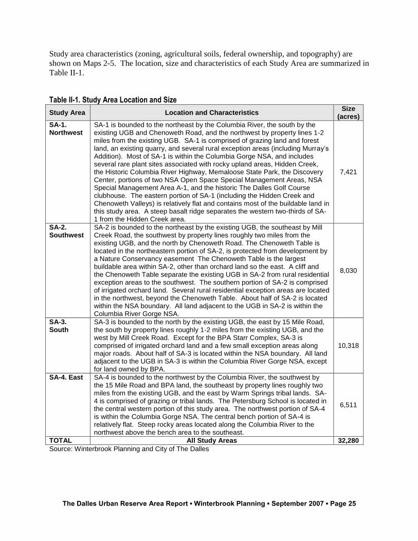
Study area characteristics (zoning, agricultural soils, federal ownership, and topography) are
shown on Maps 2-5. The location, size and characteristics of each Study Area are summarized in
Table II-1.
Table II-1. Study Area Location and Size
Study Area Location and Characteristics Size
(acres)
SA-1. Northwest
SA-1 is bounded to the northeast by the Columbia River, the south by the existing UGB and Chenoweth Road, and the northwest by property lines 1-2 miles from the existing UGB. SA-1 is comprised of grazing land and forest land, an existing quarry, and several rural exception areas (including Murray’s Addition). Most of SA-1 is within the Columbia Gorge NSA, and includes several rare plant sites associated with rocky upland areas, Hidden Creek, the Historic Columbia River Highway, Memaloose State Park, the Discovery Center, portions of two NSA Open Space Special Management Areas, NSA Special Management Area A-1, and the historic The Dalles Golf Course clubhouse. The eastern portion of SA-1 (including the Hidden Creek and Chenoweth Valleys) is relatively flat and contains most of the buildable land in this study area. A steep basalt ridge separates the western two-thirds of SA-1 from the Hidden Creek area.
7,421
SA-2. Southwest
SA-2 is bounded to the northeast by the existing UGB, the southeast by Mill Creek Road, the southwest by property lines roughly two miles from the existing UGB, and the north by Chenoweth Road. The Chenoweth Table is located in the northeastern portion of SA-2, is protected from development by a Nature Conservancy easement The Chenoweth Table is the largest buildable area within SA-2, other than orchard land so the east. A cliff and the Chenoweth Table separate the existing UGB in SA-2 from rural residential exception areas to the southwest. The southern portion of SA-2 is comprised of irrigated orchard land. Several rural residential exception areas are located in the northwest, beyond the Chenoweth Table. About half of SA-2 is located within the NSA boundary. All land adjacent to the UGB in SA-2 is within the Columbia River Gorge NSA.
8,030
SA-3. South
SA-3 is bounded to the north by the existing UGB, the east by 15 Mile Road, the south by property lines roughly 1-2 miles from the existing UGB, and the west by Mill Creek Road. Except for the BPA Starr Complex, SA-3 is comprised of irrigated orchard land and a few small exception areas along major roads. About half of SA-3 is located within the NSA boundary. All land adjacent to the UGB in SA-3 is within the Columbia River Gorge NSA, except for land owned by BPA.
10,318
SA-4. East SA-4 is bounded to the northwest by the Columbia River, the southwest by the 15 Mile Road and BPA land, the southeast by property lines roughly two miles from the existing UGB, and the east by Warm Springs tribal lands. SA-4 is comprised of grazing or tribal lands. The Petersburg School is located in the central western portion of this study area. The northwest portion of SA-4 is within the Columbia Gorge NSA. The central bench portion of SA-4 is relatively flat. Steep rocky areas located along the Columbia River to the northwest above the bench area to the southeast.
6,511
TOTAL All Study Areas 32,280
Source: Winterbrook Planning and City of The Dalles
The Dalles Urban Reserve Area Report ▪ Winterbrook Planning ▪ September 2007 ▪ Page 26
Urban Reserve Rule Locational Criteria
The Urban Reserve Rule sets forth locational criteria for establishment or amendment of Urban
Reserve Areas in OAR 660-021-030(2-5). OAR 660-021-030(2) sets forth the basic principal
underlying the location of urban reserve areas:
(2) Inclusion of land within an urban reserve area shall be based upon the locational factors of
Goal 14 and a demonstration that there are no reasonable alternatives that will require less, or
have less effect upon, resource land. Cities and counties cooperatively * * * shall first study
lands adjacent to, or nearby, the urban growth boundary for suitability for inclusion within
urban reserve areas, as measured by the factors and criteria set forth in this section. Local
governments shall then designate for inclusion within urban reserve areas that [sic] suitable
lands which satisfies the priorities in section (3) of this rule.
OAR 660-021-030(3) sets forth priorities for determining which kinds of land should be included
within the URA. These priorities mirror the priorities for urban growth boundary expansion set
forth in ORS 197.298.5 In The Dalles case, rural exception areas are first priority for inclusion
within a URA, lower value agricultural land (Class VI-VIII soils typically used for grazing) are
medium priority, and high value agricultural land (Class II-IV soils typically used for cherry or
wheat production) are lowest priority.
The locational criteria in Goal 14 require a comparative evaluation of potential expansion areas
that can reasonably be expected to meet identified needs. The review standards include (a) the
locational standards of Goal 14 (Urbanization) and the priorities (and reasons to depart from
them) set forth in the Urban Reserve Rule. Part II justifies the location of the URA based on
relevant provisions of the Urban Reserve Rule (OAR Chapter 660-021-030).
5 (3) Land found suitable for an urban reserve may be included within an urban reserve area only
according to the following priorities: (a) First priority goes to land adjacent to, or nearby, an urban growth boundary and identified in an
acknowledged comprehensive plan as an exception area or nonresource land. First priority may include resource land that is completely surrounded by exception areas unless these are high value crop areas as defined in Goal 8 or prime or unique agricultural lands as defined by the United States Department of Agriculture;
(b) If land of higher priority is inadequate to accommodate the amount of land estimated in section (1) of this rule, second priority goes to land designated as marginal land pursuant to ORS 197.247;
(c) If land of higher priority is inadequate to accommodate the amount of land estimated in section (1) of this rule, third priority goes to land designated in an acknowledged comprehensive plan for agriculture or forestry, or both. Higher priority shall be given to land of lower capability as measured by the capability classification system or by cubic foot site class, whichever is appropriate for the current use. (4) Land of lower priority under section (3) of this rule may be included if land of higher priority is found to be inadequate to accommodate the amount of land estimated in section (1) of this rule for one or more of the following reasons:
(a) Future urban services could not reasonably be provided to the higher priority area due to topographical or other physical constraints; or
(b) Maximum efficiency of land uses within a proposed urban reserve area requires inclusion of lower priority lands in order to include or to provide services to higher priority lands.” (5) Findings and conclusions concerning the results of the above consideration shall be adopted by the affected jurisdictions.”
The Dalles Urban Reserve Area Report ▪ Winterbrook Planning ▪ September 2007 ▪ Page 27
First priority goes to land adjacent to, or nearby, an urban growth boundary and identified in
an acknowledged comprehensive plan as an exception area or nonresource land.
As noted above, the Urban Reserve Rule sets priorities for determining which types of land to
include within an urban reserve area. Because (a) the preliminary 2026 UGB has not yet been
acknowledged by the Land Conservation & Development Commission, and (b) a minor
amendment to the NSA Urban Area has not yet been approved by the Columbia River Gorge
Commission, these findings justify establishment of The Dalles URA using the acknowledged
existing UGB as the base.
In The Dalles’ case, the highest priority is rural exception areas, and the lowest priority is
irrigated agricultural land. Non-irrigated wheat land is medium priority. Except for largely
unbuildable canyon areas associated with Seven Mile Creek, the Dalles URA includes all rural
exception areas within 1.5 road miles of the existing UGB.
To examine the potential for rural exception areas to meet long-term growth needs, the City
considered all “adjacent and nearby exception areas” within 1.5 miles of the existing UGB.6
Maps 2 and 3 and the map attached to the Rural Residential Exception Area Capacity Analysis
show six rural residential exception areas proposed for inclusion within The Dalles URA:
SA-1 (Northwest) has two large rural residential exception areas within 1.5 road miles of the
existing UGB along Chenoweth Creek Road. These areas are identified as Areas 1 (1A and 1B)
and 2 (2A and 2B) in the Rural Residential Area Capacity Analysis. These exceptions areas are
included within the URA. A relatively small rural residential exception area, located within and
at the edge of Seven Mile Creek canyon, was excluded because it is incapable of meeting
identified urban development needs and it would be prohibitively expensive to serve.7
7 This rural residential exception area located below Seven Mile Road was not included within the URA
for the following reasons: (1) First, future urban services cannot reasonably be provided to this exception area due to topographical constraints. As shown on Map 5, these canyon areas have relatively little accessible buildable land. There are ten parcels with 116 gross acres. The land drops down from the road to Seven Mile Creek, which is enclosed by steep canyon walls. There is a thin strip of land with less than 25% slope along the upper portion of Seven Mile Road – after it turns to the south. This area already has five homes and about 3.5 buildable acres (assuming that each home uses a half acre). If urban services were extended to this upper area, four to five additional homes could be constructed on the south side of the road. Therefore, inclusion of this area would do little to meet identified needs for urban housing in The Dalles. The cost of extending sanitary sewer and water to serve these areas would be prohibitive when compared with the potential development yield. Testimony from homeowners along this portion of Seven Mile Road was unanimously opposed to inclusion within the UGB – indicating that there is little likelihood that property owners would invest in sewer, water and street improvements necessary to serve remaining buildable land on the south side of Seven Mile Road. Although there is some land with less than 25% slope on the opposite side of the Seven Mille Creek canyon, road construction within these steep canyon areas is not feasible due to construction costs, and would disrupt the Seven Mile Creek riparian corridor. (2) Second, road and utility construction, even if it were feasible, would have serious adverse social and environmental consequences. These canyon areas are located within the Columbia River Gorge National Scenic Area (NSA) boundary at the gateway to The Dalles Urban Area. Urban development within this scenic canyon would be inconsistent with the CRGNSA Management Plan which encourages the protection of scenic riparian corridors. (See Part II of this report.) In conclusion, because the Seven Mile
The Dalles Urban Reserve Area Report ▪ Winterbrook Planning ▪ September 2007 ▪ Page 28
To meet identified siting requirements for employment and public/semi-public land, large parcels
with slopes of 10% or less and access to a planned arterial street are required. As noted in Parts I
and II of this report, such sites are extremely scarce near The Dalles UGB. Winterbrook and
City staff combed the four study areas and found only one area that has large, contiguous parcels
suitable for meeting the City’s longer-term employment needs: the bench generally north of the
BPS site that is accessed from 15 Mile Road. This medium priority rural area has predominantly
Class II-VI soils and is currently in wheat production or used for grazing.
There is a second large rural residential exception area to the about 1.5 miles south of the
existing UGB, accessible from Chenoweth Creek Road, but separated from the first exception
area (included in the URA) by agricultural land. However, the buildable portions of this
exception area are located almost entirely on the south side of Chenoweth Creek, and therefore
would be difficult to access with urban streets without extreme environmental damage the to
deep ravine and associated riparian corridor.
As shown on Map 4, this area has no sites that meet employment suitability criteria, and has very
little buildable area below the Chenoweth Water District service level of 660 feet. Thus,
inclusion of additional rural residential land within the URA would do little to meet long-term
growth needs, but would be very expensive to serve and would have adverse environmental
consequences. For these reasons, the upper Chenoweth Creek rural residential exception area is
not proposed for inclusion within the URA.
SA-2 (Southwest) and SA-3 (South) together have three rural residential exception areas that
abut the existing UGB (Areas 3, 4 and 5). All are included within the URA. Study Area 3 has a
large rural residential exception area that is accessible via Cherry Heights Road through irrigated
cherry orchards with Class II-IV soils. Preservation of this high value agricultural land would be
difficult, if not impossible, if urban roads and services were extended approximately 1.5 miles
through this agricultural land to reach the rural residential area further to the southwest.
SA-4 (East) has one, small rural residential exception area along 15 Mile Road (Area 6). It, too,
is included within the URA. The former Petersburg school building is located along 15 Mile
Road and will become part of the proposed neighborhood service center. 15 Mile Road
continues northeastward to serve the proposed the large employment area planned for the
relatively flat bench area above.
Next priority goes to land designated in an acknowledged comprehensive plan for agriculture
or forestry, or both. Higher priority shall be given to land of lower capability as measured by
the capability classification system or by cubic foot site class, whichever is appropriate for the
current use.
After bringing in all rural residential exception areas within 1.5 miles of the existing UGB, the
City concluded that it must bring agricultural land into the URA. As shown on Map 3
(Agricultural Soils), the City made a conscious choice to avoid areas with irrigated, Class II-IV
Creek exception areas in SA-1 have almost no accessible buildable land and serve as a scenic gateway to The Dalles Urban Area, these canyon areas are not included within the URA boundary.
The Dalles Urban Reserve Area Report ▪ Winterbrook Planning ▪ September 2007 ▪ Page 29
soils in Study Areas 2 and 3. Instead, the City chose to include the following areas within the
URA.
Study Area 1 (Northwest): Additional Class VII agricultural land located above the ridgeline.
This land is currently used for grazing but lies within the Columbia River Gorge NSA.
Study Area 4 (East): Additional Class II-VIII agricultural land located northeast of the BPA
Starr Complex. This non-irrigated land is used for wheat production and grazing, but does not
support cherry production. As noted above, the area with Class II-IV soils includes the only
relatively flat bench that provides large, suitable employment sites within any of the study areas.
Except for irrigated orchard lands, the only other large flat area adjacent to the preliminary 2026
UGB is the “Chenoweth Table”, which has a conservation easement held by the Nature
Conservancy. Except for a relatively small area immediately north of 15 Mile Creek, the
proposed URA is located outside the Columbia River Gorge NSA.
Goal 14 Location Factors
This section addresses applicable Goal 14 location factors. Goal 14 Boundary Location section
reads as follows:
The location of the urban growth boundary and changes to the boundary shall be determined
by evaluating alternative boundary locations consistent with ORS 197.298 and with
consideration of the following factors:
(1) Efficient accommodation of identified land needs
(2) Orderly and economic provision of public facilities and services;
(3) Comparative environmental, energy, economic and social consequences; and
(4) Compatibility of the proposed urban uses with nearby agricultural and forest activities
occurring on farm and forest land outside the UGB.
Background
In August of 2005, the City published the Land Use Needs and Locational Analysis (Erik. C.
Rundell, RARE Planner for The Dalles). This document includes 36 GIS maps and text that
summarize the physical (e.g., agricultural soil capability, slope, landslide areas, floodplains,
wetlands, stream corridors); institutional (e.g., public and semi-public land ownership, NSA
boundaries); and economic (construction costs based on topography) “limitations” that constrain
long-term growth in The Dalles. These maps were prepared specifically to address Goal 14
locational factors as well as National Scenic Area Act (NSAA) requirements for “urban exempt
area” status. Winterbrook and the City have drawn extensively from this maps and analysis in
the Rundell study in evaluating the direction of growth.
Working with City staff, Winterbrook identified four study areas surrounding the existing UGB
for potential inclusion in the URA, and evaluated each study area for consistency with Urban
Reserve Area establishment priorities and Goal 14 (Urbanization) Boundary Location Factors 1-
4 and Goals 5, 6 and 11. To address Urban Reserve Area establishment priorities and Goal 14
Boundary Location Factor 4, Map 3 shows rural exception areas and agricultural lands in relation
to the existing UGB.
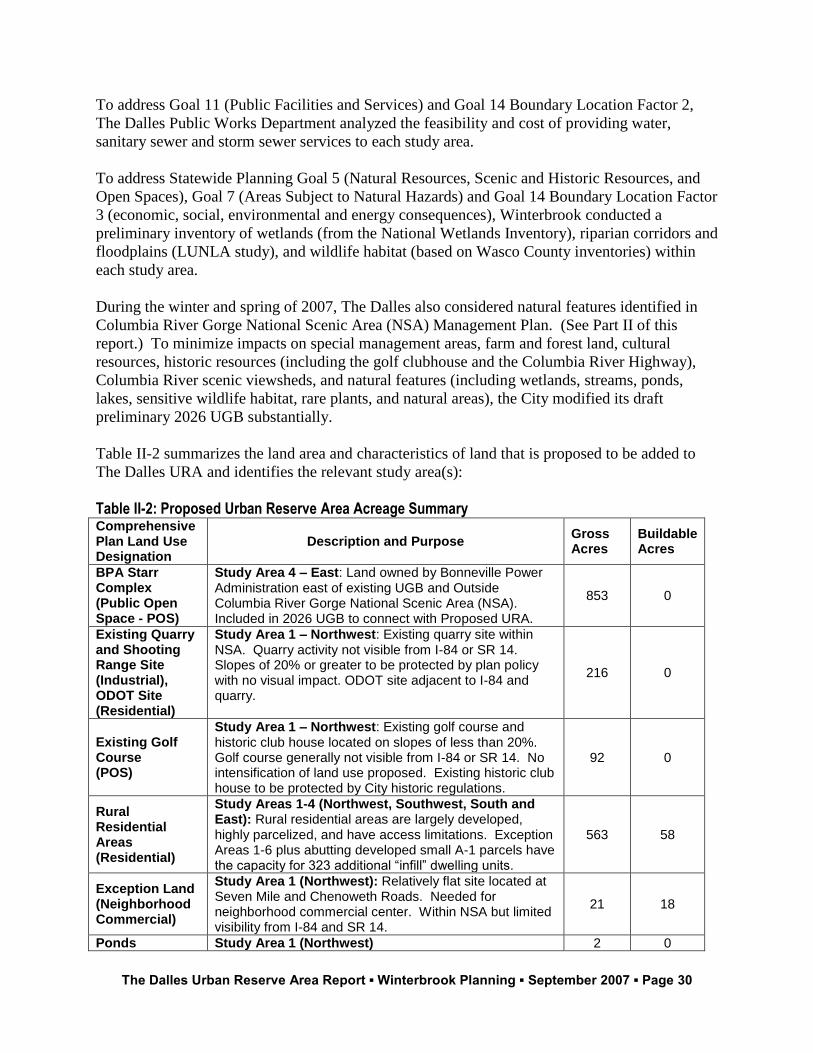
The Dalles Urban Reserve Area Report ▪ Winterbrook Planning ▪ September 2007 ▪ Page 30
To address Goal 11 (Public Facilities and Services) and Goal 14 Boundary Location Factor 2,
The Dalles Public Works Department analyzed the feasibility and cost of providing water,
sanitary sewer and storm sewer services to each study area.
To address Statewide Planning Goal 5 (Natural Resources, Scenic and Historic Resources, and
Open Spaces), Goal 7 (Areas Subject to Natural Hazards) and Goal 14 Boundary Location Factor
3 (economic, social, environmental and energy consequences), Winterbrook conducted a
preliminary inventory of wetlands (from the National Wetlands Inventory), riparian corridors and
floodplains (LUNLA study), and wildlife habitat (based on Wasco County inventories) within
each study area.
During the winter and spring of 2007, The Dalles also considered natural features identified in
Columbia River Gorge National Scenic Area (NSA) Management Plan. (See Part II of this
report.) To minimize impacts on special management areas, farm and forest land, cultural
resources, historic resources (including the golf clubhouse and the Columbia River Highway),
Columbia River scenic viewsheds, and natural features (including wetlands, streams, ponds,
lakes, sensitive wildlife habitat, rare plants, and natural areas), the City modified its draft
preliminary 2026 UGB substantially.
Table II-2 summarizes the land area and characteristics of land that is proposed to be added to
The Dalles URA and identifies the relevant study area(s):
Table II-2: Proposed Urban Reserve Area Acreage Summary Comprehensive Plan Land Use Designation
Description and Purpose Gross Acres
Buildable Acres
BPA Starr Complex (Public Open Space - POS)
Study Area 4 – East: Land owned by Bonneville Power Administration east of existing UGB and Outside Columbia River Gorge National Scenic Area (NSA). Included in 2026 UGB to connect with Proposed URA.
853 0
Existing Quarry and Shooting Range Site (Industrial), ODOT Site (Residential)
Study Area 1 – Northwest: Existing quarry site within NSA. Quarry activity not visible from I-84 or SR 14. Slopes of 20% or greater to be protected by plan policy with no visual impact. ODOT site adjacent to I-84 and quarry.
216 0
Existing Golf Course (POS)
Study Area 1 – Northwest: Existing golf course and historic club house located on slopes of less than 20%. Golf course generally not visible from I-84 or SR 14. No intensification of land use proposed. Existing historic club house to be protected by City historic regulations.
92 0
Rural Residential Areas (Residential)
Study Areas 1-4 (Northwest, Southwest, South and East): Rural residential areas are largely developed, highly parcelized, and have access limitations. Exception Areas 1-6 plus abutting developed small A-1 parcels have the capacity for 323 additional “infill” dwelling units.
563 58
Exception Land (Neighborhood Commercial)
Study Area 1 (Northwest): Relatively flat site located at Seven Mile and Chenoweth Roads. Needed for neighborhood commercial center. Within NSA but limited visibility from I-84 and SR 14.
21 18
Ponds Study Area 1 (Northwest) 2 0
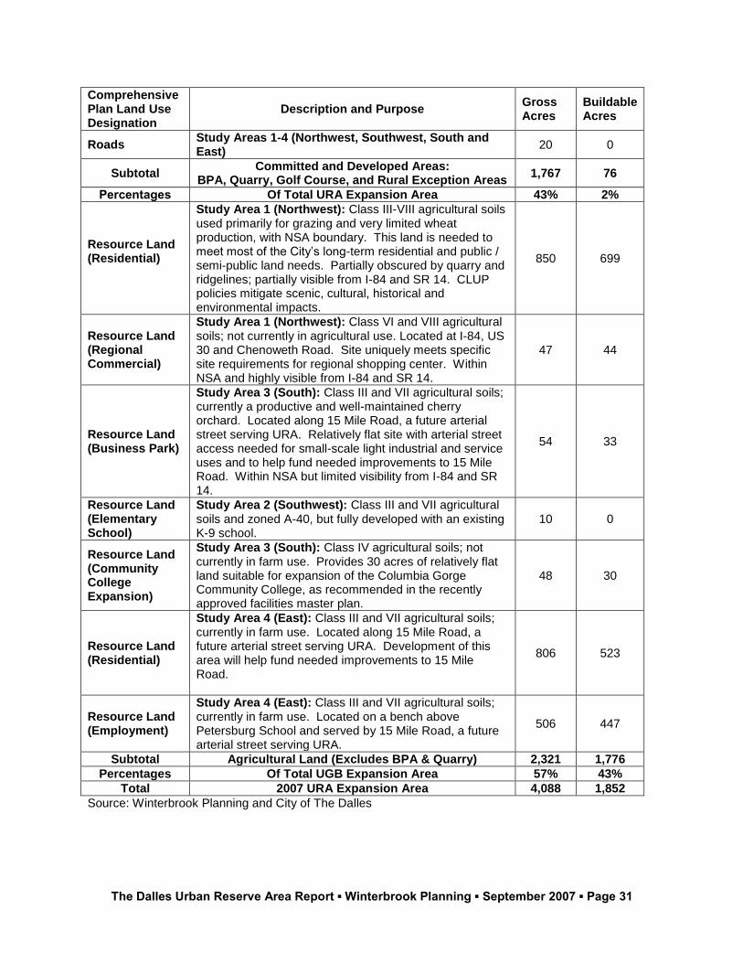
The Dalles Urban Reserve Area Report ▪ Winterbrook Planning ▪ September 2007 ▪ Page 31
Comprehensive Plan Land Use Designation
Description and Purpose Gross Acres
Buildable Acres
Roads Study Areas 1-4 (Northwest, Southwest, South and East)
20 0
Subtotal Committed and Developed Areas:
BPA, Quarry, Golf Course, and Rural Exception Areas 1,767 76
Percentages Of Total URA Expansion Area 43% 2%
Resource Land (Residential)
Study Area 1 (Northwest): Class III-VIII agricultural soils used primarily for grazing and very limited wheat production, with NSA boundary. This land is needed to meet most of the City’s long-term residential and public / semi-public land needs. Partially obscured by quarry and ridgelines; partially visible from I-84 and SR 14. CLUP policies mitigate scenic, cultural, historical and environmental impacts.
850 699
Resource Land (Regional Commercial)
Study Area 1 (Northwest): Class VI and VIII agricultural soils; not currently in agricultural use. Located at I-84, US 30 and Chenoweth Road. Site uniquely meets specific site requirements for regional shopping center. Within NSA and highly visible from I-84 and SR 14.
47 44
Resource Land (Business Park)
Study Area 3 (South): Class III and VII agricultural soils; currently a productive and well-maintained cherry orchard. Located along 15 Mile Road, a future arterial street serving URA. Relatively flat site with arterial street access needed for small-scale light industrial and service uses and to help fund needed improvements to 15 Mile Road. Within NSA but limited visibility from I-84 and SR 14.
54 33
Resource Land (Elementary School)
Study Area 2 (Southwest): Class III and VII agricultural soils and zoned A-40, but fully developed with an existing K-9 school.
10 0
Resource Land (Community College Expansion)
Study Area 3 (South): Class IV agricultural soils; not currently in farm use. Provides 30 acres of relatively flat land suitable for expansion of the Columbia Gorge Community College, as recommended in the recently approved facilities master plan.
48 30
Resource Land (Residential)
Study Area 4 (East): Class III and VII agricultural soils; currently in farm use. Located along 15 Mile Road, a future arterial street serving URA. Development of this area will help fund needed improvements to 15 Mile Road.
806 523
Resource Land (Employment)
Study Area 4 (East): Class III and VII agricultural soils; currently in farm use. Located on a bench above Petersburg School and served by 15 Mile Road, a future arterial street serving URA.
506 447
Subtotal Agricultural Land (Excludes BPA & Quarry) 2,321 1,776
Percentages Of Total UGB Expansion Area 57% 43%
Total 2007 URA Expansion Area 4,088 1,852
Source: Winterbrook Planning and City of The Dalles
The Dalles Urban Reserve Area Report ▪ Winterbrook Planning ▪ September 2007 ▪ Page 32
(1) Efficient accommodation of identified land needs
Part I of this report describes the two key ways that The Dalles has increased overall land use
efficiency within the existing UGB and the proposed URA:
1. As a result of new measures to increase residential land use efficiency, residential
densities in The Dalles are projected to increase by 12 percent – from “actual
development” at 5.0 dwellings per gross buildable acre to planned densities of 5.6
dwellings per gross buildable acre (or 7.0 dwelling units per net buildable acre, after
accounting for street rights-of-way). Residential efficiency measures have reduced the
need for residential land by 150 gross buildable acres.
2. Redevelopment of the Northwest Aluminum site will meet most of the City’s industrial
needs for the next 20 years. As a result, the need for industrial land over the next 20
years has been reduced by an additional 250 suitable acres. The only area adjacent to the
UGB that comes close to meeting industrial site suitability criteria (flat land close to
Interstate 84) is Hidden Valley in Study Area 1 (Northwest). Had the City expanded into
Hidden Valley to meet industrial land needs, 20-year residential needs would have been
meet in the proposed Urban Reserve Area served by Seven Mile Road, rather than
Hidden Valley.
The location of the URA maximizes land use efficiency by confining planned growth over the
next 50 years to relatively flat areas adjacent to the existing UGB, I-84 and the Columbia River
that can be developed at urban densities. The proposed Northwest URA expansion area provides
suitable sites in proximity to existing transportation corridors and basic employment for needed
schools, parks, a mixed used neighborhood centers and a large shopping center.
The curvilinear configuration of the existing UGB and proposed URA also allows for the
potential of public transit served by arterial streets that parallel I-84 (e.g., 10th
Street, 2nd
Street,
Seven Mile Road and 15 Mile Road), which could facilitate transit-oriented development in the
future.
Although rural residential areas adjacent to the UGB are anticipated to develop somewhat less
efficiently than large farm parcels, the Urban Reserve Rule places higher priority on adjacent
rural residential land for inclusion within a UGB. At 1.5 miles from the existing UGB,
Chenoweth Creek Road passes through agricultural land zoned A-1 (160) before encountering
another large rural exception area. The City excluded non-adjacent, rural residential land within
the Chenoweth Valley from the URA because it would result in an extremely inefficient urban
growth form. The Chenoweth Valley narrows as it extends further to the east. The relatively
small parcel size, combined with relatively little buildable land per parcel and distance from the
existing UGB, means that this rural residential area would be extremely expensive to serve.
(2) Orderly and economic provision of public facilities and services
The Dalles was originally sited on a bench on a bend in the Columbia River. The bench is
confined by steep slopes and rimrock. Stream corridors and associated valleys connect the town
site with the upland plateau to the south, east and west.
The Dalles Urban Reserve Area Report ▪ Winterbrook Planning ▪ September 2007 ▪ Page 33
Two relatively flat areas remain near the Columbia River. The eastern area is owned by the
Bonneville Power Administration and is not available for urban development. The northwestern
Bench (Hidden Valley) is, for the most part, privately owned and is available for urban
development. A third, privately owned, higher elevation bench is located east of the BPA Starr
Complex in a valley drained by 15 Mile Creek. The only other developable area is located south
of the existing UGB. This area is has predominately high value, irrigated agricultural soils, and
is used for cherry orchards.
The Dalles Public Works Department has identified major projects necessary to serve the two
large areas that can feasibly meet the need for urban population and employment growth over the
next 50 years. These two areas are proposed for inclusion within The Dalles 2026 UGB or URA
and are located in Study Areas 1 and 4.
The City has recently completed updates to the Transportation Master Plan, Water Master Plan,
and Sewer Master Plan, and is currently doing a Storm Water Master Plan. These plans cover
the existing UGB and demonstrate that the UGB can be serviced, or serviced with the projects
identified in each plan. Updates to all of these master plans are part of the Phase II planning
work that is planned to be done following approval of the new UGB / NSA Urban Area and
URA.
Throughout the current phase of the UGB/URA planning work, the Phase I planning issues
related to the provision of streets and utilities in the preliminary UGB and URA have been
reviewed and analyzed. The Public Works Department has determined that the preliminary
UGB/ Urban Area and the URA can be served by connections to the existing road pattern and
that the provision of utilities would generally follow the new road system.
However, the Public Works Department did not identify projects necessary to serve areas that
cannot feasibly be included with the UGB or URA for topographical or institutional reasons. For
example, the City did not identify projects in across the Columbia River in Washington State,
because the City does not and cannot have jurisdiction across the state line. Nor did the City
identify projects for cherry orchards on high value farm land in Study Areas 2 and 3. Aside from
strong local opposition from cherry growers, inclusion of such land would be inconsistent with
ORS 197.298 priorities for urban growth boundary expansion.
Study Area 1 (Northwest)
The bench on The Dalles’ bend in the Columbia River extends to the north to include the Hidden
Valley area in the southeastern portion of Study Area 1. Chenoweth, Seven Mile and Hidden
Creek Valleys connect with the Columbia River bench in Study Area 1. Together, these areas
provide the only developable land within this study area. These areas are adjacent to the UGB
and can be provided, efficiently, with urban services. Some of this land is developed at urban
densities and is served by the Chenoweth Water District.
Exception areas within 1.5 miles of the existing UGB, and about two-thirds of the buildable land
area drained by Chenoweth and Hidden Creeks, are within the proposed URA. Buildable land in
the Seven Mile Creek Valley is within the proposed URA. The Public Works Department has
The Dalles Urban Reserve Area Report ▪ Winterbrook Planning ▪ September 2007 ▪ Page 34
identified sewer, water and transportation projects necessary to serve the proposed URA in Study
Area 1.
The western two-thirds of Study Area 1 (Northwest) is located on a plateau above the 660-foot
water service elevation level. In most areas, this plateau is defined by steep slopes and ravines
carved by the Mazama floods and creeks draining the upland plateau. The northern portion of
Study Area 1 is located within the Columbia Gorge NSA, and includes several “Special
Management Areas.” For these reasons, the Public Works Department did not identify sewer,
water and transportation projects to serve land outside the URA.
As noted above, the City excluded non-adjacent, rural residential land within the Chenoweth
Valley from the URA because it would result in an extremely inefficient urban growth form.
The Chenoweth Valley narrows as it extends further to the east. The relatively small parcel sizes
in this area, combined with relatively little buildable land per parcel and distance from the
existing UGB, means that this rural residential area would be extremely expensive to serve.
Public Facilities Project Descriptions – Study Area 1 (Northwest)
The following describes how roads and utilities can be extended, feasibly, into the URA in Study
Area 1. These are general findings. The details regarding project costs, locations, and sizes will
need to be specifically determined in the Phase II planning work, as outlined in the planning
grant document developed with the help of DLDC and ODOT staff.
Sanitary Sewer
20-year:
o Capacity increases will be necessary for the two, 4-inch pressure lines running
along the historic highway.
o Capacity increases will be necessary for the main trunk line running from the
pressure lines to the treatment plant.
o Lower portion along Chenoweth Creek needs to tie into the force main along the
historic highway.
o Murray’s Addition will require the 8–inch trunk line along Chenoweth Loop Road
to be increased.
o The sewer treatment plant will need additional capacity to serve the UGB. The
land for that expansion already exists and is reserved for that purpose.
o All of the UGB expansion area can be served with a gravity system.
50-year: This area can be served using gravity feed line.
Water Service
20-year:
o Potential new well needed with storage reservoir, which would require new
groundwater rights and may need treatment because of mineral content.
The Dalles Urban Reserve Area Report ▪ Winterbrook Planning ▪ September 2007 ▪ Page 35
o Chenoweth Water PUD has some capacity to serve a portion of the expanded
UGB and is currently serving a portion of that area. Their capacity is somewhat
limited.
o The City’s water master plan calls for improvements that would increase capacity
to 12 MGD together with groundwater, service could be provided. The City has
8.4 MGD perfected ground water rights and 25.8 MGD unperfected water rights
to use in both ground water and Columbia River. The City currently uses 8 to 9
MGD in the summer high-use season. This serves about 12,000 people and the
industrial and commercial areas.
o Transmission lines will need to follow major road rights-of-way.
o Nearest water is at the Port land served by a 12 inch transmission line. A 16-inch
looped system is needed on the Port and Northwest Aluminum property for
industrial (re)development. This could then service a portion of the UGB.
50-year: A new reservoir and pump station will be needed to provide volume and
pressure to this area.
Transportation
20-year: Existing major street locations are shown on the Map 6: Generalized
Comprehensive Plan. These collector streets would connect into the Historic Highway at
two locations and to Chenoweth Road at two locations.
50-year: New streets in this area would connect to the major streets located in the UGB
and to Seven Mile Road. Once this land has been added to the UGB, a connection would
need to be made from Seven Mile Road to Hidden Valley.
Storm Drainage
20-year and 50-year: A separate system from the City’s current system needs to be
developed that would discharge into Chenoweth Creek.
o Some treatment may be needed prior to discharge to meet Federal standards.
Major trunk line sizes would need to be determined.
o All lines would follow the street system.
Summary: On a relative basis, the cost for providing transportation, sewer, water and
storm drainage service to land below the 660-foot water service elevation level in Study
Area 1 are moderate. Moderate costs are based on the need to construct new arterial and
collector streets to serve the URA in this study area. However, moderate costs are off-set
by the relatively low value grazing land in Study Area 1.
Study Areas 2 and 3 (Southwest and South):
The northern portion of Study Area 2 is located above the 660 water service elevation and is
separated from the existing UGB by the Chenoweth Table (which is protected by a Nature
Conservancy conservation easement) or high value agricultural land.
The Dalles Urban Reserve Area Report ▪ Winterbrook Planning ▪ September 2007 ▪ Page 36
In contrast, the southeastern portion of Study Area 2 and the northern portion of Study Area 3 are
within the Mill Creek drainage basin, are adjacent to the UGB, are relatively flat, are below the
660-foot water service elevation, and can be served by gravity flow sewer. For these reasons, the
area along Mill Creek Road can be efficiently provided with urban services. However, this
irrigated orchard area is the lowest priority for inclusion within The Dalles URA. Therefore, the
Public Works Department has not determined specific projects necessary to serve agricultural
land in Study Areas 2 and 3.
The City has included a few small agriculturally-zoned parcels that are adjacent to the UGB. As
discussed above, these small parcels typically have relatively poor agricultural soils, are
developed with a house, are needed for expansion of a specific use, or are bordered on two sides
by rural residential exception areas. These small agricultural parcels are adjacent to the UGB,
are located below the 660-foot water service elevation, can be served with gravity flow sewer,
and have access from existing roads.
These small areas, along with adjacent exception areas, can be provided with urban services
efficiently. However, no major public works projects are needed to serve areas added to the
UGB in Study Areas 2 and 3. Therefore, the Public Works Department did not identify specific
projects necessary to serve these relatively small and disparate areas.
Summary: On a relative basis, the cost for providing transportation, sewer, water and
storm drainage service to land below the 660-foot water service elevation level in Study
Areas 2 and 3 are low. Relatively low costs are based on the proximity of land within the
proposed URA to existing urban services. However, the areas that are least costly to serve
have high value, irrigated cherry orchards.
Study Area 4 (East)
The BPA Starr Complex abuts the UGB to the east. Generally unbuildable land within the
Columbia Gorge National Scenic Area (NSA) lies further to the north and east along the
Columbia River. The only growth alternative to the east is the bench above 15-Mile Creek. This
relatively flat bench area is accessed primarily from 15-Mile Creek. This bench area is proposed
for the URA.
City Public Works has identified projects and considered the feasibility of providing sanitary
sewer, water and transportation services to the bench area served by 15 Mile Road.
Public Facilities Project Descriptions – Study Area 4 (East)
The following describes how roads and utilities can be extended, feasibly, into the URA in Study
Area 4. These are general findings. The details regarding project costs, locations, and sizes will
need to be specifically determined in the Phase II planning work, as outlined in the planning
grant document developed with the help of DLDC and ODOT staff.
The Dalles Urban Reserve Area Report ▪ Winterbrook Planning ▪ September 2007 ▪ Page 37
Sanitary Sewer
20-year: Sewer trunk line placed within right-of-way of 15 Mile Road with lift station to
get it to the 2nd
Street existing sewer trunk location.
50-year: Existing 2nd
Street sewer trunk line will require capacity increase with build out
of the 50-year URA. The sewer treatment plant will need additional capacity to serve the
URA. It may be more feasible to construct a dedicated eastside treatment plant with
discharge into 15 Mile Creek. The land for that expansion already exists and is reserved
for that purpose.
Water Service
20-year: Existing reservoir and supply source is sufficient to serve the 20-year needs.
The far northeast may need a booster system. A new transmission line needs to be
installed from the reservoir in the Columbia View Heights along 15 Mile Road.
50-year: A new well source potentially needs to be developed.
o The City has well water and Columbia River water rights sufficient to supply this
area with water.
o Additional treatment facilities will be needed for the water supply.
o One additional reservoir and pump station will be needed for supply and pressure.
Transportation
20-year: Existing major street locations are shown on the planning map. These are Lower
Eight-Mile Road and Columbia View Drive. Right-of-way widths are adequate to serve
the UGB expansion area.
50-year: Lower Eight-Mile Road and Columbia View Drive would serve the proposed
URA. Additional major streets would extend into the URA. Additional right-of-way
width may be necessary to serve development planned for the URA.
Storm Drainage
20-year and 50-year: A separate system from the City’s current system needs to be
developed that would discharge into 15 Mile Creek.
o Some treatment may be needed prior to discharge to meet Federal standards.
Major trunk line sizes would need to be determined.
o All lines would follow the street system.
Summary: On a relative basis, the cost for providing transportation, sewer, water and
storm drainage service to land below the 660-foot water service elevation level in Study
Area 1 are high. High costs are based on distance from the existing UGB, and the fact that
abutting BPA property will not benefit from or pay for extension of urban services.
The Dalles Urban Reserve Area Report ▪ Winterbrook Planning ▪ September 2007 ▪ Page 38
However, the high cost of extending services in the short-term are necessary to provide
services to the bulk of the URA and to meet post 2026 population, employment and
livability growth needs outside the Columbia River Gorge National Scenic Area.
(3) Comparative economic, social, environmental and energy (ESEE) consequences
To address locational factor (3), the City compared the economic, social, environmental and
energy consequences of URA expansion into each of the four study areas shown on Map 2. The
City’s analysis of ESEE consequences also considered the social and environmental impacts that
related to The Dalles’ location within the Columbia River Gorge National Scenic Area (NSA).
Economic consequences considered below include impacts on The Dalles area employment
opportunities, Wasco County’s agricultural economy, and cost of providing urban public
facilities.
Comparative Economic Consequences – Employment Opportunities and Agriculture
Part I of this report identifies siting requirements for community commercial shopping centers,
large-site industrial users, and public / semi-public (park and school) development. The Dalles’
economic future depends on its ability to offer suitable sites to future industrial and commercial
employers. Providing suitable sites for educational and recreational facilities is essential to the
City’s ability to maintain a high quality of life for The Dalles’ work force, and thereby attract
and retain managers and qualified employees. These land-extensive uses require large sites with
relatively flat land and access to a major street.
Although most 20-year industrial siting needs can be met within the existing UGB, there are
unmet needs for a business park site, a regional commercial site, and a neighborhood commercial
site. Because there are unmet needs for such sites within the existing UGB, and rural exception
areas do not meet parcel size or topographical requirements, the loss of some agricultural land is
necessary to achieve The Dalles’ economic development and livability objectives.
Beyond the immediate 20-year planning period, there is ongoing need for large, flat sites that can
only be met on the bench to the east of the BPA Starr Complex, located outside the NSA.
For reasons stated below, suitable sites in Study Area 1 (Northwest), which has relatively low
value, non-irrigated grazing land, has the least impact on Wasco County’s agricultural economy.
Although Study Area 4 (East) has high value, non-irrigated soils that are devoted primarily to
wheat production, this land is needed for Year 2026-56 employment sites.
This analysis assumes that there is a relationship between agricultural soil class and the potential
impact on the agricultural economy. As shown on Map 3, relatively flat agricultural land is
found in all four study areas. However, on an acre-per-acre basis, cherry orchards and associated
packing plants provide the greatest economic benefit to The Dalles’ economy, followed by wheat
production, and then by grazing activities.
The Dalles Urban Reserve Area Report ▪ Winterbrook Planning ▪ September 2007 ▪ Page 39
The lowest value agricultural soils are found in Study Area 1 (Northwest), which has
predominantly non-irrigated Class VI-VII soils adjacent to the existing UGB and is used
for grazing. Study Area 1 has large, flat sites with access to I-84 and to planned arterial
streets (Chenoweth Creek Road) that are suitable for employment uses. Study Area 1
also has large, flat sites with access to major streets that is suitable for park and school
use. Conversion of agricultural land to urban employment uses will have a relatively low
impact on the agricultural economy when compared with positive economic impacts
resulting from increased business and employment opportunities.
In contrast, agricultural land adjacent to the existing UGB in Study Areas 2 (Southwest)
and 3 (South) is comprised primarily of irrigated Class II-IV soils. This area has
substantial public (irrigation district) and private (land owner) investments in cherry
production. Cooperatively owned cherry packing and shipping facilities contribute
substantially to The Dalles’ economy. Although these two study areas also have large,
flat sites that could meet the needs for employment, parks and schools, inclusion of large
tracts of irrigated orchard land within the URA would have serious and adverse
consequences for Wasco County’s agricultural economy.
Study Area 4 (East) has some irrigated orchard land along 15 Mile Road and large areas
of non-irrigated wheat land (predominantly Class II-IV soils) located on a higher-
elevation bench. Except for land along 15 Mile Road, Study Area 4 has no land adjacent
to the UGB that is suitable for employment or public / semi-public land uses. The upland
bench further to the east is in wheat production, and is suitable for meeting employment,
park and school land needs in the Urban Reserve Area.
Because large, flat sites adjacent to the UGB are needed to meet employment and institutional
large-site land needs, The Dalles must include some agricultural land within the URA. Land
adjacent to the existing UGB in Study Area 1 has large, suitable employment and public / semi-
public sites that have predominantly Class VI-VII soils. Inclusion of relatively flat land in Study
Area 1 will have the least adverse impact on Wasco County’s agricultural economy, while
meeting the site suitability requirements for a regional shopping center, a neighborhood
commercial center, a community park and schools identified Part I of this report.
The Dalles excluded areas with Class II-IV agricultural soils in Study Areas 2 and 3 due
primarily to adverse economic impacts to Wasco County’s cherry production, packing and
distribution economy. Large parcels with Class II-IV soils in the Southwest and South Study
Areas are not included within the URA.
The only large parcels with irrigated cherry orchards that are proposed for inclusion within the
URA are located along 15 Mile Road in Study Area 4 (East). Two parcels, with 33 suitable
acres, are needed for a planned business park. Development of the business park will provide for
employment during the 20-year planning period. As noted in Part III of this report, development
along 15 Mile Road will help pay for street and utility improvements to this arterial street.
Public and private investments to reconstruct 15 Mile Road to urban street standards are needed
that will provide access and construct utilities required to serve future employment and public /
semi-public sites located within the Urban Reserve Area. Therefore, on balance, the economic
The Dalles Urban Reserve Area Report ▪ Winterbrook Planning ▪ September 2007 ▪ Page 40
consequences of converting a relatively small area of irrigated cherry orchard land for business
park use in Study Area 4 are positive.
There are negative economic consequences associated with conversion of non-irrigated but
productive wheat land to use over time. However, land located on a bench east of the UGB and
the BPS Starr Complex is uniquely suited to meeting long-term employment needs. Therefore,
the loss in economic value resulting from conversion of wheat land to employment uses is off-set
by increased employment opportunities.
Comparative Economic Consequences for Extension of Public Facilities
Public facilities factors are addressed under UGB Locational Factor (2) above. While the cost of
extending public facilities are an important factor for The Dalles, the City’s and County’s
primary economic concern is to protect existing cherry orchards south of the existing UGB.
Briefly, land adjacent to the UGB in Study Areas 2 and 3 – below the 660-foot elevation level –
is the least expensive to serve with sanitary sewer, water, storm drainage and transportation
services. Existing streets, sanitary sewer, water and storm drainage facilities can be extended
from mostly developed areas within the UGB to serve relatively large and flat parcels adjacent to
the UGB. However, ORS 197.298(1) makes irrigated Class II-IV soils the lowest priority for
UGB expansion. Therefore, the City included only rural residential exception areas, small
developed agricultural parcels, and agricultural parcels with relatively low value agricultural
soils within the URA.
Land adjacent to the existing UGB in Study Area 1 (Northwest) is somewhat more expensive to
serve, primarily because new collector streets must be extended to serve the Hidden Valley area.
Because agricultural soils in this area are generally less productive, the City decided to absorb
the relatively higher costs for serving this area to protect cherry orchards to the southeast and
southwest of the UGB.
Land in Study Area 4 (East) is most expensive to serve, because federal land cannot be expected
to pay for extension of sanitary sewer, water and storm drainage facilities to serve development
along 15 Mile Road. However, the City must make public investments to property along 15 Mile
Road in order to access and provide urban services to suitable employment and public / semi-
public sites in Study Area 4.
In conclusion, while public facilities costs are an important consideration, they do not outweigh
economic costs that would result from the loss of public and private investments in irrigated
orchard land southwest and southeast of the existing UGB.
Comparative Social Consequences
Social consequences include the ability to meet affordable housing objectives, create complete
neighborhoods, and provide for supporting park and school needs.
Columbia River Gorge National Scenic Area
Social consequences also include social values identified in the Columbia Gorge National Scenic
Area Act (NSAA) – particularly scenic views and recreational opportunities that are now
The Dalles Urban Reserve Area Report ▪ Winterbrook Planning ▪ September 2007 ▪ Page 41
protected by the NSAA. However, because the existing UGB is completely surrounded by land
within the NSA boundary, and additional land is needed to for urban housing, parks and schools,
there will be some adverse impacts to scenic and recreational opportunities described in the
NSAA. The City’s proposed URA minimizes adverse impacts to scenic views and recreational
opportunities by the following locational decisions and policies.
Minimizing the need for urban land by increasing residential densities and relying on
redevelopment of the existing Northwest Aluminum site for meeting most of the City’s
future industrial needs.
Avoiding UGB expansion and urban development in highly visible gateway areas:
o Along Interstate 84 in Study Area 4 (East);
o East of the Historic Columbia River Highway in Study Area 1 (Northwest);
o In the US 197 Canyon (Study Area 3); and
o In the Seven Mile Creek Canyon (Study Area 1).
Avoiding UGB expansion into any designated Special Management Area (see Map 5).
Avoiding UGB expansion into large scenic orchard parcels in Study Areas 2 (Southwest)
and 3 (South).
Within the proposed URA:
o Protecting existing ridgelines facing the historic Columbia River Highway and I-
84 in Study Area 1 from future urban development;
o Encouraging urban development of existing rural residential exception areas, thus
reducing the need for agricultural lands within the UGB;
o Protecting highly visible land with slopes of 20 percent or greater in Study Areas
1 and 4 from urban development;
o Protecting the existing golf course and its historic club house from inappropriate
alteration or conversion to other urban uses;
o Protecting Chenoweth, Seven Mile, Hidden and 15 Mile Creeks and their scenic
riparian corridors and canyons from future urban development; and
o Encouraging passive recreational uses and trails within protected riparian
corridors and ridgelines to improve recreational access to scenic areas.
Social consequences associated with protection of scenic views and recreational opportunities
are addressed further in Part III of this report.
Comparative Social Consequences: Housing, Complete Neighborhoods, Schools & Parks
Study Areas 1 (Northwest), 2 (Southwest), 3 (South) and 4 (East) all provide relatively flat and
buildable land – near the UGB – that are capable of meeting identified neighborhood
commercial, residential and public / semi-public needs (park and school facilities). Relatively
flat, large and undeveloped sites in these study areas also are well-suited to efficient and
effective master planning. Because each of these study areas have access to existing and planned
arterial and collector streets, and can be provided with sanitary sewer, water and storm drainage
The Dalles Urban Reserve Area Report ▪ Winterbrook Planning ▪ September 2007 ▪ Page 42
facilities at reasonable costs, land adjacent to the UGB in Study Areas 1, 2, 3 and 4 would also
provide relatively affordable housing and school opportunities.
However, the positive social consequences associated with inclusion of land in orchard
production in Study Areas 2 and 3 are outweighed by the negative economic costs of bringing
converting highly-productive orchard land into the URA. The social consequences of bringing in
small, developed agricultural parcels in Study Areas 2 and 3 are also positive, because existing
homes and businesses in these areas will have access to urban services upon annexation to the
City. Relatively low value agricultural land is also provided for expansion of the Columbia
Gorge Community College, which has provides immense social value to the entire region.
Portions of Study Areas 1 and 5, because it includes little irrigated orchard land and otherwise
meets identified needs for residential, park and school development, is proposed for inclusion
within the URA. For example, Study Areas 1 and 5 provide exceptional opportunities for a
“complete” and compact master planned community:
In Study Area 1, the City has identified a site at the intersection of Chenoweth Creek and
Seven Mile Creek Roads for siting a mixed use, neighborhood commercial center. A site
for a second mixed use center has been identified in Study Area 4, near the Petersburg
School.
Several parcels in Study Areas 1 and r meet site suitability requirements for community
parks and public schools, and therefore will directly meet a portion of the City’s long-
term public / semi-public land need.
The protected Chenoweth Creek and Hidden Creek riparian corridors (Study Area 1) and
15 Mile Creek riparian corridor (Study Area 2), combined with the protected scenic vistas
and ridgelines within and outside the proposed URA, create an exceptional setting for
compact yet livable residential communities.
The varied topography in Study Area 1, including Hidden Creek and protected ridgelines,
will also provide passive recreational opportunities for existing and future area residents
and visitors.
The existing golf course, plus its planned expansion areas, will increase recreational and
open space opportunities for area residents. Because land near golf courses and protected
streams typically has higher value for residential buyers, Study Area 1 will also provide
needed higher end housing opportunities.
The social consequences of including land along 15 Mile Road within the preliminary 2026 UGB
are mixed. On the one hand, this large undeveloped area provides an attractive scenic gateway to
the community, with irrigated orchard lands on the gently sloping hillside next to the BPA Starr
Complex, and limited rural residential development in a small rural residential exception area
above 15 Mile Creek. On the other hand, this area provides needed employment land for the
community in the form of a business park. By providing a transportation and utility linkage to
the upland bench above 15 Mile Creek, the scenic impacts to the eastern portion of the Columbia
The Dalles Urban Reserve Area Report ▪ Winterbrook Planning ▪ September 2007 ▪ Page 43
Gorge NSA will be highly positive, because future urban development can occur almost
completely outside the NSA boundary.
Almost all adjacent rural residential exception areas within Study Areas 1-4 are included within
the proposed URA. Thus, existing and future residents of these rural residential areas will have
access to community parks and schools in the short-term, as well as urban sewer, water, police
and fire services upon annexation to the City. On the other hand, as urban services are requested
and become available to property owners in existing rural residential areas, urban densities will
be permitted, thus changing the “rural” quality of life. Despite the likelihood of increased land
values, many rural residents who voiced their opinions at the Planning Commission public
hearing view the transition from rural to urban densities as having negative social consequences.
In conclusion, Study Areas 1 and 4 provide the only reasonable opportunity for The Dalles to
create complete neighborhoods – without scarifying the highest value farmland – irrigated cherry
orchards. Study Areas 1, like all other areas adjacent to the existing UGB, is located within the
Columbia Gorge NSA. However, unlike other rural areas outside The Dalles, buildable land
within Study Area 1 has relatively low value agricultural soils. Study Area 1 also meets
residential, commercial, and public / semi-public land needs identified in Part 1 of this report by
providing:
Large tracts of buildable land that can accommodate a variety of housing types and
densities;
Suitable sites for a mixed use community center, a community park and schools;
Protected ridgelines and riparian corridors that define compact urban neighborhoods.
In contrast, most of Study Area 4 is located outside the NSA boundary. Thus, the social
consequences of including buildable land adjacent to the UGB in Study Areas 1 and 4 are largely
positive.
Environmental Consequences
For comparative analysis, the City considered the ESEE consequences of including each of the
four study areas abutting the existing UGB. Environmental consequences address potential
impacts on inventoried natural features (riparian corridors, wetlands and native plant
communities) both within and adjacent to UGB, as shown on Map 5, the Composite Buildable
Lands Inventory.
To address Statewide Planning Goal 5 (Natural Resources), Goal 7 (Natural Hazards) and Goal
14 Boundary Location Factor 3 (comparative environmental consequences), wetlands, riparian
corridors, native plant communities (identified by Columbia Gorge Commission staff in Study
Area 1), floodplains and steep slopes were inventoried within each study area. Land with the
above constraints is not considered to be suitable for meeting housing, park, school or
employment needs.
Certain areas within environmental constraints were eliminated from URA consideration early in
the process:
The Dalles Urban Reserve Area Report ▪ Winterbrook Planning ▪ September 2007 ▪ Page 44
Study Area 1:
o All NSA Special Management Areas;
o Most General Management Areas within the NSA boundary;
o Wetlands on the east side of Interstate 84;
o Land north of Hidden Valley with slopes of 20 percent or greater;
o The Seven Mile Creek canyon southwest of Seven Mile Road;
o The Chenoweth Creek Canyon southeast of Murray’s Addition and Chenoweth
Creek Road;
Study Area 2:
o Almost all General Management Areas, including irrigated orchard land, within
the NSA boundary;
o The ridgeline with slopes of 25% or greater southwest of the existing UGB;
o The Mill Creek canyon southwest of the Mill Creek Road rural residential
exception area;
o The Chenoweth Table area protected by a conservation easement; and
o The Chenoweth Creek Canyon below the Chenoweth Table.
Study Area 3:
o Almost all General Management Areas, including irrigated orchard land, within
the NSA boundary;
o The Mill Creek canyon southwest of the Mill Creek Road rural residential
exception area;
o The ridgeline with slopes of 25% or greater southeast of the existing UGB; and
o The Highway 97 canyon area at the entrance to the UGB.
Study Area 4:
o Almost all General Management Areas, including the scenic I-84 ridgeline, within
the NSA boundary; and
o The 15 Mile Creek canyon northeast of the 15 Mile Road and the rural residential
exception area.
In all cases, environmental impacts from urban development will be minimized because the City
is committed to providing vegetative buffers along Seven Mile, Chenoweth, Hidden, Mill, and
15 Mile Creeks and associated riparian corridors. Except for Hidden Lakes, which are protected
by CLUP policy, there are no inventoried wetlands that are not associated with a protected
riparian corridor within the URA expansion area. No additional floodplain land outside of
protected riparian corridors has been included within the URA expansion area.
Rare plant communities are located in all four study areas. However, Study Area 1 is the only
large area with relatively undisturbed hillsides with rare plant communities that is proposed for
inclusion within the URA. Gorge Commission staff have identified several rare plant
communities within Study Area 1 (Northwest). Since rare plants typically survive in areas that
have not been disturbed by grazing or farming activities, which typically occur in flatter areas,
restricting development to slopes of 20 percent or less will have the intended consequence of
protecting rare plant communities identified in the NSA inventories. CLUP policy commits the
The Dalles Urban Reserve Area Report ▪ Winterbrook Planning ▪ September 2007 ▪ Page 45
City to identifying and protecting rare plant communities prior to rezoning and through the land
development review process.
In conclusion, the URA was carefully drawn to exclude inventoried wetlands, floodplains, steep
canyons, unbuildable ridgelines and hillside areas, irrigated cherry orchards, and NSA Special
Management Areas. Where wetlands, riparian corridors, ridgelines, steeps slopes and rare plant
communities are included within the URA, they are protected by plan policies and by limiting
development within Study Area 1 to slopes of 20% or less. Overall, the proposed URA has
positive environmental consequences due to its location and strong policy measures to restrict
development within identified natural resource and hazard areas.
Comparative Energy Consequences
These findings consider the implications of alternative growth patterns on energy conservation.
The Dalles CLUP includes a new Goal 13 Energy Conservation chapter that address how energy
consumption can be reduced within the preliminary UGB.
Due to geographical constraints, development in The Dalles has followed the Columbia River
bench in curvilinear urban form. The existing UGB is approximately 14 miles long, and extends
from 1 to 1.5 miles inland from the river – until it reaches rimrock or irrigated orchard land.
Although expansion to high value farmland on the southern plateau would result in a more
compact, energy-efficient urban growth form, this option is prohibited by the Urban Reserve
Rule and ORS 197.298(1) Priorities for urban growth boundary expansion. Therefore, the City
has no choice but to continue its curvilinear growth pattern by expanding to the north into Study
Area 1, and ultimately to the east, to the relatively buildable bench area in Study Area 4.
However, as noted in The Dalles CLUP, the City’s curvilinear urban form does offer some
energy conservation opportunities to conserve energy:
By concentrating employment and housing along major streets (Tenth Street, Second and
Third Streets, 15 Mile and Chenoweth Creek Roads, and I-84) The Dalles transit service
becomes feasible over time. A functional public transit system is feasible in the
intermediate term (10-20 years), and would have substantial energy conservation
benefits.
Because longer-term growth in The Dalles is severely limited geography, in the very
long term the City will need to consider further intensification of land use along linear
transit corridors, which will have longer-term energy conservation benefits.
The proposed URA provides large tracts of relatively flat land that can meet the needs of
complete communities – with a mixed-use neighborhood center, a variety of housing
types and densities, community parks and open space, and neighborhood schools. This
approach conserves energy by reducing vehicle trip lengths and encouraging alternative
modes of transportation.
Solar orientation is also an important long-term consideration. Although buildable areas in
Study Areas 3 and 4 offer excellent solar access, with a few small exceptions these areas are
The Dalles Urban Reserve Area Report ▪ Winterbrook Planning ▪ September 2007 ▪ Page 46
committed to cherry orchards. Proposed URA expansion areas in Study Area 1 provide
reasonable solar access, although ridgelines to the south and west will provide considerable
shading, especially in the winter. Proposed URA expansion areas in Study Area 4 provide better
solar access, because development is proposed on an upper bench that is less shaded from
ridgelines to the south and west.
Finally, the City considered energy costs related to the provision of public facilities as follows:
Gravity flow sanitary sewer can serve the entire URA expansion area, thus eliminating
energy costs for new pump stations.
All land within the preliminary UGB is below the 660-foot water serve elevation, the
eliminating the need for to pump water to new development areas.
Existing county roads (Chenoweth Creek Road, Seven Mile Road, Mill Creek Road and
15 Mile Road) will serve as urban arterial and/or collector streets, thus minimizing the
need for new street construction to serve developing urban areas.
ESEE Summary
The City and County carefully considered economic, social, environmental and energy
consequences of expanding the URA to each of four study areas. In summary:
The need for large sites has been met for the most part on predominantly lower value
grazing land where necessary, rather than higher value, irrigated orchard land – with
positive urban employment benefits with minimum adverse impacts to Wasco County’s
agricultural economy.
The need for residential and public / semi-public land has been met first in adjacent rural
residential areas, and second in predominantly lower value grazing land – with positive
social consequences for existing and future community residents.
The URA has been drawn to minimize scenic and environmental impacts of UGB
expansion within the Columbia River Gorge NSA by:
o increasing urban residential densities;
o relying on redevelopment of the Northwest Aluminum site to meet long-term
industrial needs; and
o Prohibiting urban development on highly visible and sensitive lands within Study
Areas 1 and 4 (a) to slopes of 20 percent or less and (b) within protected riparian
corridors.
While avoidance of irrigated orchard land in Study Areas 2 and 3 continues a curvilinear
urban growth form, this form enhances the feasibility of public transit in the intermediate
term, with attendant energy conservation benefits.
The Dalles Urban Reserve Area Report ▪ Winterbrook Planning ▪ September 2007 ▪ Page 47
(4) Compatibility of the proposed urban uses with nearby agricultural activities occurring on farm land outside the UGB.
As shown on Map 3, the URA was drawn carefully to minimize impacts on existing agricultural
activities. In almost all cases, the proposed URA is defined by (a) existing development, (b) a
natural feature, and/or (c) an artificial feature such as a road that provides a buffer between
planned urban development and farming activities.
Study Area 1 (Northwest)
Farming activity in the proposed Study Area 1 URA is limited to grazing, due to generally poor
agricultural soils and the lack of irrigation.
The northern URA boundary separates future urban development from adjacent A-1
(160) grazing land by:
o The 20 percent slope break (at the base of the steep, rocky hillside with Class VIII
agricultural soils that continue northward beyond the UGB); and
o An existing developed golf course.
The western URA separates future urban development from adjacent A-1 (160) grazing
land by:
o The 20 percent slope break that separates the URA boundary from upland grazing
areas;
o A rural residential exception area; and
o Seven Mile Road and the Seven Mile Creek Canyon.
The southern URA separates future urban development from adjacent A-1 (40)
agricultural land by:
o A rural residential exception area; and
o The Chenoweth Creek Canyon.
The eastern URA separates future urban development from adjacent Public Recreational
land by:
o The Historic Columbia River Highway; and
o An existing manufactured dwelling park.
Study Area 2 (Southwest)
Farming activities in the proposed Study Area 2 URA include wheat, cherry production and
grazing.
The northern boundary of Study Area 2 is the proposed URA and the Chenoweth Creek
Canyon. There are no farming activities north of the proposed URA in Study Area 1.
The southwestern URA separates future urban development from adjacent agricultural
land by:
o A mile long ridgeline to the east;
o Several rural residential exception areas;
The Dalles Urban Reserve Area Report ▪ Winterbrook Planning ▪ September 2007 ▪ Page 48
o Several small, interspersed and mostly developed A-1 (40) parcels abutting the
existing UGB or existing exception areas.
Infill development on these relatively small parcels continues existing patterns of
development at the edge of the existing UGB and therefore will not create new adverse
impacts to adjoining orchard land.
Study Area 3 (South)
Farming activities in the proposed Study Area 3 URA include cherry production and limited
grazing.
The southern URA boundary separates future urban development from adjacent
agricultural land by:
o A mile long ridgeline to the east;
o Several rural residential exception areas;
o Several small, interspersed and mostly developed A-1 (40) parcels abutting the
existing UGB or existing exception areas.
Infill development on these relatively small parcels continues existing patterns of
development at the edge of the existing UGB and therefore will not create new adverse
impacts to adjoining orchard land.
The south-eastern URA boundary is the existing BPA Starr Complex and is owned by the
federal government.
Study Area 4 (East)
Farming activities outside the proposed Study Area 4 URA include grazing and wheat
production.
The northwestern URA boundary separates future urban development from A-1 (160)
grazing land by:
o A prominent ridgeline and substantial elevation differential; and
o A rural residential exception area and 15 Mile Creek.
The eastern and southern URA boundary separates future urban development from A-1
(160) wheat and grazing land by an elevation differential. Future URA expansion to the
south and east is most like in this Study Area.
The Dalles Urban Reserve Area Report ▪ Winterbrook Planning ▪ September 2007 ▪ Page 49
.
URA Location Conclusion
The City’s growth is constrained by topographic features. The Dalles was originally sited on a
bench on a bend in the Columbia River. The bench is confined by steep slopes and rimrock
before reaching the fertile, irrigated plateau to the south and west. This plateau proved ideal for
growing cherries – an industry that is highly valued in Wasco County and protected by Statewide
Planning Goal 3 (Agricultural Lands). Less valuable grazing land is found to the north in
Hidden Valley. The Bonneville Power Administration owns over a square mile of land to the
east. Further to the East is non-irrigated wheat and grazing land that has a large, flat bench area.
When The Dalles established its first UGB in 1982, growth was confined by the Columbia River
(to the north and west), BPA (to the east), and cherry orchards (to the south and west). In 1982,
planned growth in The Dalles did not justify expansion into lower quality agricultural soils
(grazing lands) up the Chenoweth Creek Valley and into Hidden Valley to the northwest.
In 1986, the United States Congress enacted the Columbia River Gorge National Scenic Area
Act (NSAA), which established the bi-state Columbia River Gorge Commission. The NSAA,
established the Columbia River Gorge National Scenic Area surrounding The Dalles UGB on all
sides, but exempted most of the “urban area” within The Dalles UGB and the BPA Starr
Complex from regulatory provisions of the act.8 However, a “minor amendment” to this “urban
area” is required for needed expansion of The Dalles UGB.
For the above reasons, The Dalles faces extraordinary topographic and administrative
constraints. To address these constraints, The Dalles has done an exceptional job of addressing
the need and locational requirements of the Urban Reserve Area administrative rule, while
directing urban growth outside the National Scenic Area wherever possible.
To ensure greater efficiency of land use (and thereby reduce the land area added to the existing
UGB), The Dalles has taken the following measures:
Planned residential densities have increased from 5.09 to 5.6 dwelling units per gross
buildable acre (or 7 units per net buildable acre).
To accomplish this objective, the City has amended its residential zoning districts to
allow automatic density transfer, a greater variety of housing types, and minimum
densities.
Rather than meeting large-site industrial needs in “green field” areas to the north, the City
has relied on largely on redevelopment of the Northwest Aluminum site and on
employment growth on the bench east of the BPA Star Complex and outside the NSA..
8 Due to apparent mapping errors, small areas at the edge of The Dalles UGB were not given urban exempt status,
and therefore have been required to comply with NSAA scenic standards. This error is being corrected as part of the
2006-07 UGB amendment process. 9 Actual development densities observed in The Dalles from 2001-2005.
The Dalles Urban Reserve Area Report ▪ Winterbrook Planning ▪ September 2007 ▪ Page 50
The City has allocated only one new general commercial area to meet 50-year needs – a
60-acre site with direct access to Interstate 84. Other commercial needs are met in
neighborhood centers, all but two of which is located within the existing UGB.
The City established new goals, policies, and implementation measures with the adoption
of the 1993 Comprehensive Land Use Plan update and the 1998 Land Use and
Development Ordinance update. These Plan and LUDO updates were specifically
directed to increase the efficiency of land use within the UGB.
To minimize impacts on Wasco County’s agricultural land base and on the National Scenic Area,
The Dalles has made the following tough decisions regarding the direction of growth:
With a few minor exceptions, the proposed URA excludes irrigated cherry orchards.
Like all other areas abutting the UGB, these cherry orchards are within the NSAA, but
they are the lowest priority for inclusion within an URA under ORS 197.298, Priorities
for urban growth boundary expansion.
Almost all near-by rural residential and commercial exception areas are included within
the proposed URA, in large part because these areas are highest priority for inclusion
within an URA under the Urban Reserve Area administrative rule. The Chenoweth
Valley to the northwest, the 15-Mile Creek corridor to the east, and a few areas
immediately south of the existing UGB to the south, fall into this category.
Unfortunately, these exception areas also are within the NSA boundary.
Most of the City’s Year 2056 residential land need is met by extending the URA to
Hidden Valley to the north. Although Hidden Valley is also within the NSA, this area
has relatively poor agricultural soils and lacks irrigation, and therefore is higher priority
for inclusion within the URA than irrigated cherry orchards. Although this area is
constrained by rocky steep slopes in some areas (the same reason it has poor soils),
automatic density transfer provisions will ensure that this area can be efficiently
developed at urban densities.
The square mile plus BPA site is included within the URA because it lies between the
exception area located along 15 Mile Creek and the existing UGB. It also separates the
existing UGB from the proposed URA located outside the NSA boundary to the east.
The Dalles Urban Reserve Area Report ▪ Winterbrook Planning ▪ September 2007 ▪ Page 51
Part III: URA Interim Development Policies and Agreements This section addresses OAR 660-021-0040 requirements for managing land within the urban
reserve area.
660-021-0040 Urban Reserve Area Planning and Zoning
(1) Until included in the urban growth boundary, lands in the urban reserve area shall
continue to be planned and zoned for rural uses in accordance with the requirements of this
section, but in a manner that ensures a range of opportunities for the orderly, economic and
efficient provision of urban services when these lands are included in the urban growth
boundary.
(2) Urban reserve area land use regulations shall ensure that development and land divisions
in exception areas and nonresource lands will not hinder the efficient transition to urban land
uses and the orderly and efficient provision of urban services. These measures shall be adopted
by the time the urban reserve area is designated …The measures may include:
(a) Prohibition on the creation of new parcels less than ten acres;
(b) Requirements for clustering as a condition of approval of new parcels;
(c) Requirements for preplatting of future lots or parcels;
(d) Requirements for written waivers of remonstrance against annexation to a provider
of sewer, water or streets;
(e) Regulation of the siting of new development on existing lots for the purpose of
ensuring the potential for future urban development and public facilities.
(3) For exception areas and nonresource land in urban reserve areas, land use regulations
shall prohibit zone amendments allowing more intensive uses, including higher residential
density, than permitted by acknowledged zoning in effect as of the date of establishment of the
urban reserve area. Such regulations shall remain in effect until such time as the land is
included in the urban growth boundary.
(4) Resource land that is included in urban reserve areas shall continue to be planned and
zoned under the requirements of applicable Statewide Planning Goals.
(5) Urban reserve area agreements consistent with applicable comprehensive plans and
meeting the requirements of OAR 660-021-0050 shall be adopted for urban reserve areas.
(6) Cities and counties are authorized to plan for the eventual provision of urban public
facilities and services to urban reserve areas. However, this division is not intended to
authorize urban levels of development or services in urban reserve areas prior to their
inclusion in the urban growth boundary. This division is not intended to prevent any planning
for, installation of, or connection to public facilities or services in urban reserve areas
consistent with the statewide planning goals and with acknowledged comprehensive plans and
land use regulations in effect on the applicable date of this division.
(7) A local government shall not prohibit the siting of a single family dwelling on a legal parcel
pursuant to urban reserve planning requirements if the single family dwelling would otherwise
have been allowed under law existing prior to the designation of the parcel as part of an urban
reserve area.
The Dalles Urban Reserve Area Report ▪ Winterbrook Planning ▪ September 2007 ▪ Page 52
1. Interim Development Policies
All rural residential exception areas proposed for inclusion within the URA will also be proposed
for inclusion within the 2026 UGB. To the extent that rural exception areas are included within
an acknowledged UGB, the provisions of the Urban Reserve administrative rule do not apply.
However, because the City has asked Wasco County to move ahead with establishment of the
URA in advance of UGB expansion, interim development standards may need to be adopted by
the County.
Due to existing land use patterns and County / GMA (Gorge Management Act) zoning, interim
development policies would serve little purpose.
First, Murray’s Addition, an existing rural residential subdivision, is almost completely
built out and zoned GMA R1. Because remaining undeveloped lots in the subdivision
typically are less than two acres, and almost all have single-family homes, there is
virtually no potential for land divisions in this area that would result in new buildable lots
or lots in Murray’s Addition. The primary reason for including Murray’s Addition into
the URA is the likelihood that this development area will eventually need urban services.
Second, as shown on Map 2, the remainder of the land with rural residential exception
areas is zoned either GMA 5 or GMA 10. Almost all of these parcels have an existing
house or are too small to be divided further under existing zoning. Therefore, interim
development policies would do little to preclude future land divisions or residential
development in these areas.
As the County and DLCD review this URA proposal, City staff anticipates working with County
and DLCD staff to develop appropriate interim development standards rural residential exception
areas included within the URA.
2. Urban Growth Management Agreement
The Urban Reserve Rule requires the City and County to amend the joint urban growth
management agreement to address interim development in rural residential exception areas that
are not included within the UGB. As the County and DLCD review this URA proposal, City
staff anticipates working with County and DLCD staff to review the existing growth
management agreement to address joint responsibilities within the URA but outside the UGB.
The Dalles Urban Reserve Area Report ▪ Winterbrook Planning ▪ September 2007 ▪ Page 53
URA Conclusion The Dalles’ proposed URA is located mostly outside the Columbia River Gorge National Scenic
Area by design. The Dalles’ followed the Urban Reserve Rule’s priorities for establishing an
urban reserve area, by first considering all “adjacent or nearby” rural exception areas. After
considering nearby rural residential exception areas, The Dalles’ rejected expansion of the URA
into irrigated, high value orchard land, despite the relatively low cost of providing urban services
to portions of Study Areas 2 and 3 below the 660-foot water service elevation.
Rather, The Dalles first included nearby rural residential exception areas to meet residential
needs in all four study areas. Next, The Dalles included relatively low quality (primarily Class
VII) grazing lands in Study Area 1 (Northwest) to meet residential and neighborhood
commercial land needs. To meet employment and public / semi-public siting requirements –
while providing future residential opportunities in proximity to employment and services – the
City chose to meet most of its 50-year growth needs in Study Area 4 (East). Most of the URA in
Study Area 4 is located outside the Columbia River Gorge NSA.
Although existing County regulations severely limit the potential for inappropriate interim
development, the Urban Reserve Area rule requires that counties adopt “interim development
standards” to ensure that land is retained in large parcels until needed for urban development.
The City, County and the Department of Land Conservation and Development (DLCD) need to
work together to determine necessary changes to the Urban Growth Management Agreement and
to develop appropriate interim development standards (for exception areas between the existing
UGB and the URA) for possible adoption by Wasco County.