Embed Size (px)
Citation preview

The Development of Barriadas & Access to Medical Services in Lima, Peru
Jeff Wielki, MGIS Candidate GEOG647 – Advanced Research in GIS
2
The Development of Barriadas & Access to Medical Services in Lima, Peru Jeff Wielki
Introduction
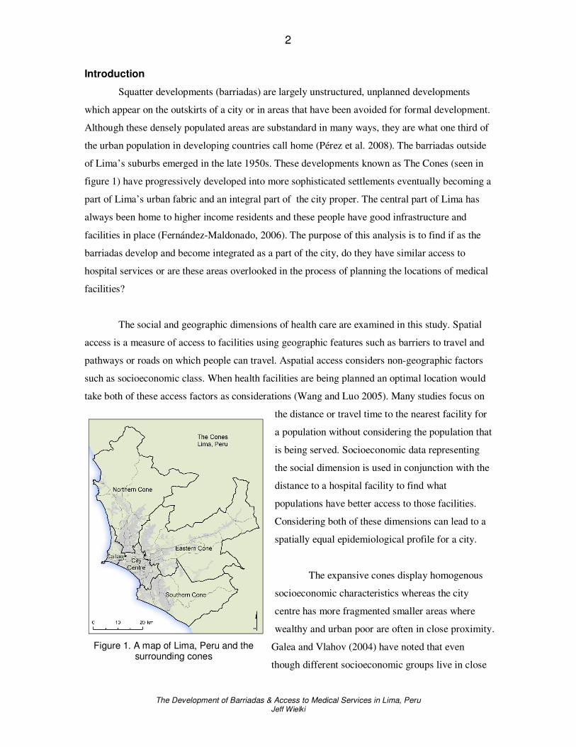
Squatter developments (barriadas) are largely unstructured, unplanned developments
which appear on the outskirts of a city or in areas that have been avoided for formal development.
Although these densely populated areas are substandard in many ways, they are what one third of
the urban population in developing countries call home (Pérez et al. 2008). The barriadas outside
of Lima’s suburbs emerged in the late 1950s. These developments known as The Cones (seen in
figure 1) have progressively developed into more sophisticated settlements eventually becoming a
part of Lima’s urban fabric and an integral part of the city proper. The central part of Lima has
always been home to higher income residents and these people have good infrastructure and
facilities in place (Fernández-Maldonado, 2006). The purpose of this analysis is to find if as the
barriadas develop and become integrated as a part of the city, do they have similar access to
hospital services or are these areas overlooked in the process of planning the locations of medical
facilities?
The social and geographic dimensions of health care are examined in this study. Spatial
access is a measure of access to facilities using geographic features such as barriers to travel and
pathways or roads on which people can travel. Aspatial access considers non-geographic factors
such as socioeconomic class. When health facilities are being planned an optimal location would
take both of these access factors as considerations (Wang and Luo 2005). Many studies focus on
the distance or travel time to the nearest facility for
a population without considering the population that
is being served. Socioeconomic data representing
the social dimension is used in conjunction with the
distance to a hospital facility to find what
populations have better access to those facilities.
Considering both of these dimensions can lead to a
spatially equal epidemiological profile for a city.
The expansive cones display homogenous
socioeconomic characteristics whereas the city
centre has more fragmented smaller areas where
wealthy and urban poor are often in close proximity.
Galea and Vlahov (2004) have noted that even
though different socioeconomic groups live in close
Figure 1. A map of Lima, Peru and the surrounding cones

3
The Development of Barriadas & Access to Medical Services in Lima, Peru Jeff Wielki
proximity to each other, there are still disparities between these different classes of people and
their access to health care. Not only do lower income urbanites often lack health care, they are
more likely to use emergency facilities and in the end receive poorer quality care (Galea and
Vlahov 2004).
Due to the aspatial barriers to healthcare experienced by lower socioeconomic classes,
policy experts are increasingly promoting health policies and developments explicitly directed at
lower socioeconomic classes. This may reverse the regressive nature of health care in developing
countries by analyzing the whole population and how the demand dynamic fits with the supply of
health care (Kruk and Freedman 2008). Health services should benefit those needing the services
the most. The analysis presented here enables a health care facility planner to find areas with
lower levels of access to medical services and plan a new facility or facilities. As a part of this
study, a hypothetical new facility will be located in an area with low access and a comparison to
the existing access will be made as a demonstration of the impact a new addition can have.
Related Work
Most studies of spatial inequality relating to healthcare measure access based on either
straight line distance or travel time distances between health services and demand points (Kohli et
al 1995; Rushton 1999; Phillips, Kinman, and Lindbloom 2000). Manhattan distances (the kind
used here) are distances that do not follow straight lines, but follow pathways such as roads
around city blocks. These distances are generally longer than a Euclidean distance but are more
accurate as the road networks more realistically emulate a real journey (Christie and Fone 2003).
The use of cost path models has been less common than Euclidean distance (Brabyn and
Skelly 2002; Christie and Fone 2003). In a large urban centre such as Lima, Peru there are
overpasses and bridges and presumably one way streets which impact the accessibility to services.
A raster cost path model (used here) does not easily take these factors into account which could
make a vector road network more appropriate in urban centres where these features are present.
There also may be areas where vehicle access is prohibited or impossible. In these instances a
cost path raster analysis can account for traveling over areas on foot or through open areas where
no formal route exists.

4
The Development of Barriadas & Access to Medical Services in Lima, Peru Jeff Wielki
Methods
A distance measure will be calculated instead of driving times to quantify accessibility to
hospitals. The road and building footprint data (supplied by the University of Calgary's Latin
America Research Centre (LARC)) does not have speed limit data associated with it so driving
times could not be calculated. This was accomplished through calculations of the areas around the
urban footprints using Spatial Analyst. High data detail has been used to accommodate some
small pathways in the road network.
The roads and block footprints were all buffered by 25m to create a study area of paths
that travel to a hospital could occur on. The urban land use blocks on which buildings and other
non-traversable areas exist were then used to eliminate those barriers to travel from the travel
surface. Essentially the urban block footprints punched holes in the background census areas
creating the travel surface.
Hospital locations were digitized from locations on Google Earth and Wikimapia. These
two sources were used to verify the locations of hospitals because their content is largely user
generated and can therefore be prone to errors. The definition of “hospitals” for Lima, Peru was
also the one used by Wikimapia so the facilities are both regional primary care facilities and
secondary care facilities. These hospital locations are plotted in figure 2. The outskirts of the city
demonstrate lower levels of access. This is one
reason for proposing the hospital in the northern
cone. This hypothetical proposal should
demonstrate enhanced access to a hospital in an
area with higher needs.
The socioeconomic data for Lima is
from the Peruvian 1993 Census (also provided
by LARC). Socioeconomic classes are already
defined in the dataset but that data was
aggregated and normalized to find the mean
socioeconomic class in each respective census
area. Populations defined by a census area can
be represented in a number of ways. In order to
define where that population actually resides,
and is therefore traveling from, a more specific Figure 2. A map of Lima, Peru and the cones displaying hospital facilities.

5
The Development of Barriadas & Access to Medical Services in Lima, Peru Jeff Wielki
location needs to be defined. Populations are not evenly distributed throughout the polygons that
represent them in census data. A single representative point (centroid) could be used to represent
the whole area. If the polygon area is quite large the centroid point could be quite inaccurate.
Many points could be evenly distributed throughout the area, each representing an equal
proportion of the population. This would intuitively be more accurate than the centroid point but
is still not realistically representative.
Langford and Higgs (2006) used dasymetric modeling to redistribute population variables
into relatively homogenous sub zones using the actual tabulation zones the data was collected at.
This takes the aggregated population data and spatially refines it to be more realistically
representative. This should provide the most detailed and best estimates of potential demand on
services when compared to the centroid or distributed points. The three methods described here
can be seen in figure 3. The data in this analysis has urban block footprints present which
represent areas where the populations are most likely to reside and so the census information has
been distributed dasymetrically for the analysis here. Each of the multiple blocks is used as a
location the distance was calculated from. For cartographic representation, and simpler display of
the results the population densities are averaged and shown as even across individual census areas.
Figure 3. Methods of representing a population by (left to right) centroid, evenly distributed points, and dasymetric modeling.

6
The Development of Barriadas & Access to Medical Services in Lima, Peru Jeff Wielki
Figure 4. A map of Lima, Peru and the cones displaying the socioeconomic levels
by census area.
Results
The results of the socioeconomic classification are displayed in figure 4. Central Lima
clearly has the highest socioeconomic class rating as depicted in figure 4 with progressively lower
classes radiating outwards. It is also evident that the Southern Cone is the lowest ranking in terms
of average socioeconomic class, with the Eastern and Northern Cones coming in with the next
lowest average class levels. Population densities are higher in the centre of Lima, as seen in figure
5 and the highest densities appear to correlate well in the central regions with lower
socioeconomic classes in figure 4.
Figures 6 and 7 display the results of the two path distance calculations. Figure 6 shows
current accessibility to hospitals and figure 7 displays the results when the new hospital is placed
in the Northern Cone. The differences between figures 6 and 7 exist in the Northern Cone as the
new facility will only affect areas where there is no other closer facility. Only a small portion of
the overall population is impacted.
Figure 5. A map of Lima, Peru and the cones displaying population density by
census area.

7
The Development of Barriadas & Access to Medical Services in Lima, Peru Jeff Wielki
Figure 6. Results of the path distance analysis with the current hospital facilities.
Figure 7. Results of the path distance analysis with the current and proposed hospital facilities.

8
The Development of Barriadas & Access to Medical Services in Lima, Peru Jeff Wielki
The proposed location in the Northern Cone improves access to about 4% of the total
population. The results can be seen in the histogram in Figure 8. The low and middle-low
socioeconomically ranked populations are the groups which show meaningful differences in their
access with the new hospital. The low socioeconomic group's average distance to a hospital
improves from 13.5 km to 8.5 km. The middle-low class' average distance is improved by over a
kilometre from 8.9 to 7.7km. The improved access in middle and middle-high classes is marginal.
What is quite striking is the difference in access to hospitals between the highest class and the
lowest class. The histogram demonstrates an inverse relationship between socioeconomic class
and access to hospitals. The highest socioeconomically classed groups have an average distance
of 1.5 km to a hospital increasing to 3.9km for middle classed populations, 8.9 km for middle-low
classes and an average for low socioeconomic classes of 13.5 km. The middle-low class is also by
far the most populous group with over 4.2 million people representing more than two thirds of
Lima’s population, but poor access to hospitals.
Average Distance to a Hospital by Socioeconomic Class
0
2
4
6
8
10
12
14
16
Low Middle-Low Middle High
Socioeconomic Class
0
500
1000
1500
2000
2500
3000
3500
4000
4500
Po
pu
lati
on
(th
ou
sa
nd
s)
Average distance withproposed hospital
Average distance withcurrent hospitals
Av
era
ge
Dis
tan
ce
(km
)
Population
Results displayed by region are found in figure 9. The city centre has the most facilities
and also the best access in terms of distance from the hospital facilities. The northern cone stands
out with the highest population and is the farthest average distance to a hospital. Adding the new
facility brings the access to a more comparable level with Callao and the other Cones. The
Northern Cone still has the highest average distance to a hospital.
Figure 8. Average distance to a hospital by socioeconomic class and the corresponding population

9
The Development of Barriadas & Access to Medical Services in Lima, Peru Jeff Wielki
0
2
4
6
8
10
12
14
16
18
20
Callao City Centre Eastern Cone Northern Cone Southern Cone
0
500
1000
1500
2000
2500
3000
3500
Ave
rag
e D
ista
nce (
km
)
Average Distance to a Hospital by Region
Region
Average distance withproposed hospital
Average distance withcurrent hospitals
Population
Po
pu
lati
on
(th
ou
san
ds
)
5
488
4
3
Number of hospital facilites in red
Discussion and Conclusions
The proposed hospital was located based on a community in need in the northern portion
of Lima and affects 4% of Lima’s population increasing accessibility to hospitals in
approximately a 7.5 km radius around the proposed location. This region of Lima demonstrates a
clear demand for a hospital (a socioeconomically vulnerable population with less access to
existing facilities) and the impact was expected to be greatest in this location. 46% of the
population is more than 4 km away from a hospital and that population is largely classified in the
Low socioeconomic group. The lowest socioeconomic class is clearly the farthest away with
average distances to a hospital currently of 13.5km. The impact of the new hospital would help
towards attaining equal access to hospitals for all socioeconomic populations. Even so, as seen in
figure 9 the northern cone still has the farthest average distance to a facility and the highest
population with a new facility. The northern cone shows a demonstrable need and the ideal
supply of health care should more representatively reflect that demand.
Looking back at the socioeconomic distribution in figure 4 the hospital locations appear
to be trickling outwards to the mainly middle-low class inhabited areas, but the hospitals are
located largely in the higher socioeconomic class populated areas of the city. These are also the
most densely populated areas of Lima as seen in figure 5. Although quite intermingled, as can be
seen in figure 4 higher socioeconomic classes generally exist in the older central regions of the
city and the lower classes generally can be found on the outskirts. There is merit in having close
access for dense populations. Although densely populated, the histogram in figure 8 still shows an
Figure 9. Average distance to a hospital by region and the corresponding population

10
The Development of Barriadas & Access to Medical Services in Lima, Peru Jeff Wielki
inverse relationship favouring higher socioeconomic classes for higher levels of access to
hospitals. Many of the barriadas established in the last fifty years have developed into improved
settlements but because policy makers are influenced by the wealthy, the middle and lower class
populations are not influencing urban development and infrastructure upgrades (Peters and Skop
2007). It appears that even as the old barriadas develop, access to health care services does not
develop concurrently.
Accessibility to hospitals in Lima varies considerably throughout the city and cones.
There is a clear bias. The hospitals are located largely in the higher socioeconomic class
populated areas of the city. One possible explanation is a lag in medical development and as the
city develops the services lag behind the population growth on the outskirts. Lima has seen
dramatic growth since the 1950s and as such the extents of the city are always being pushed
farther away from the metropolitan center. This means that when facilities have been planned in
the past the city has had a less sprawling profile. Now facilities will appear to have a less spatially
equal service because of this fast growth and outward expansion in areas outside of the original
city’s jurisdiction. Facility locations are often planned according to a number of factors including
site availability and often other locational factors are neglected (Gar-On Yeh and Chow 1996). It
is not unreasonable to observe that the fiscal perspective was an influence on the planning of
hospital facilities as they are currently near to each other and are therefore able to share costs and
facilities making the system less expensive to run. Considering both aspatial and spatial access
there is an imbalance on both counts. Those geographically near the hospitals are also populations
with fewer aspatial barriers to health care. When health facilities are being planned an optimal
location would take both of these access factors as considerations (Wang and Luo 2005).
Integrating the two perspectives can aid in defining areas with health care shortages which is
helpful when planning new healthcare facilities or expanding operations.
An assumption of this analysis is that a person requiring hospital care would visit the
nearest facility. People may prefer certain facilities or may only be aware of some. There could be
certain services provided at specific locations so more data reflecting preferences or what services
are available at which locations would be necessary to overturn this assumption. Additionally, the
analysis here considers a more realistic way to analyze a road network without a more commonly
used vector road centreline data set. This is highly applicable to urban poor as they reside more
often in rugged terrain or areas with only walking access. Three levels of roads are classified in
the data used here but the roads that are classified are fragmented so highways, for example, have
11
The Development of Barriadas & Access to Medical Services in Lima, Peru Jeff Wielki
gaps. Although no speed limit or travel time data is present assumptions could be made based on
the hierarchy in the data to create travel time catchments for each facility. Accessibility to
services is sensitive to the speeds on the roads. The speeds on the roads is not available in the data
set used here. The data provided also has very limited attributes associated with it so even if some
hefty assumptions about the speed of travel were to be put forth, driving times would likely be
quite inaccurate. The shortest travel time and shortest travel distance to a facility could potentially
take entirely different routes which would impact the results.
Geostatistical methods should be implemented in future work finding spatial
autocorrelation with a measure such as Moran’s I to quantify if the locations of hospitals in fact
are correlated spatially with attributes associated with near populations. Other variables could be
used to find if spatial inequality exists among populations ranked by political preference or
education level. Chung, Yang, and Bell (2004) note that many geographic analyses applied to
health applications visualize the results that are described, but the statistical descriptions of the
relationships in the data are not addressed in a way that does more than suggest relationships in
well mapped analyses. That is certainly the case here. Solid statistical analysis would add validity
and significance measures ton this study.
Acknowledgements
The data used in this analysis was provided by the Latin America Research Centre at the
University of Calgary and was a part of the course requirements for GEOG 647 in the MGIS
program.

12
The Development of Barriadas & Access to Medical Services in Lima, Peru Jeff Wielki
References
ArcGIS version 9.2 and Spatial Analyst. Redlands, CA: Environmental Systems Research Institute Brabyn L, and Skelly C 2002 Modeling population access to New Zealand public hospitals. International Journal of Health Geographics 1:3
Christie C, and Fone D 2003 Equity of access to tertiary hospitals in Wales: a travel time analysis. Journal of Public Health Medicine 25 (4): 344-350 Chung K, Yang D, and Bell R 2004 Health and GIS: Toward Spatial Statistical Analyses. Journal of Medical Systems 28 (4): 349-360 Environmental Systems Research Institute 2000 Using the ArcView Spatial Analyst. San Diego, ESRI Press
Fernández-Maldonado, A 2006 Barriadas and elite in Lima, Peru: Recent trends of urban integration and disintegration . WWW document, http://www.mckinleyville.com/cart/cabinet/cab_cartprinc.html Galea S, and Vlahov D 2005 Urban health: evidence, challenges and directions Annu. Rev. Public Health 26:341-365 Gar-On Yeh A, and Chow MH 1996 An integrated GIS and location-allocation approach to public facilities planning – an
example of open space planning. Computers Environment and Urban Systems 20 (4/5): 339-350
Google Earth WWW application http://earth.google.com Jumpa M, Jan S, and Mills A 2007 The role of regulation in influencing income-generating activities among public sector
doctors in Peru. Human Resources for Health 5:5 Kohli S, Sahlen K, Silvertun A, Lofman O, Trell E, and Wigertz O 1995 Distance from the primary health center: A GIS
method to study geographical access to health care. Journal of Medical Systems 19(6): 425-436
Kruk ME, and Freedman L 2008 Accessing health system performance in developing countries. Health Policy 85: 263-276 Langford M, and Higgs, G 2006 Measuring potential access to primary healthcare services: The influence of alternative
spatial representations of population. The Professional Geographer 58(3): 294-306 Minot N, and Baulch B 2005 Poverty mapping with aggregate census data: What is the loss in precision. Review of Development Economics 9 (1): 5-24
Pérez, RCG, and Pérez, R. 2008 Analyzing Urban Poverty: GIS for the Developing World. Redlands, ESRI Press Peters P, and Skop E 2007 Socio-spatial segregation in Metropolitan Lima, Peru. Journal of Latin American Geography 6 (1): 149-171 Rosero-Bixby, L 2004 Spatial access to health care in Costa Rica and its equity: a GIS based study. Social Science and Medicine 58: 1271-1284
Vaughan L, Clark, DLC, Sahbaz, O, and Haklay, M 2005 Space and exclusion: does urban morphology play a part in social
deprivation? Area 37.4, 402 -412. Wade T, Wickham J, Nash M, Neale A, Riitters K, Jones KB 2003 A comparison of vector and raster GIS methods for
calculating landscape metrics used in environmental assessments. Photogrammetric Engineering and Remote Sensing 69 (12) 1399-1405 Wang F, and Luo W 2004 Accessing spatial and nonspatial factors for healthcare access: towards an integrated approach
to defining health professional shortage areas. Health and Place 11: 131-146
Wikimapia WWW application. http://www.wikimapia.org