Embed Size (px)
Citation preview
The Disappearance of the Ancient Landscape and the Climatic Anomaly of the EarlyMiddle Ages
In the now substantial historical literature on the ‘transformation of the Roman world’ thesubject of agriculture and the rural world in what had been the western Empire has been relativelyneglected, despite the plethora of archaeological investigations that directly bear on the subject. Inthe series published under that commodious title, only one volume out of fourteen has been devotedto the rural economy, and that one under the curious questioning title The Making of FeudalAgricultures? Almost all consideration of the Late Antique and Early Medieval economies of what1
was once the western Roman Empire appears still to be in thrall to the questions and hypotheses firstput forward by Henri Pirenne over seventy years ago. Did cities remain vibrant and economicallyactive places? Did international commerce survive? What were the rhythms of decline and revivalof urban marketplaces and the trade that fed them? 2
There is no need to insist on the fact that urban centers and an urban economy of whateversize and strength, not to mention armies, monasteries, and aristocratic courts, would not have existedwithout a rural world to feed them. And although there is no way to calculate accurate figures forlate Antiquity and the early Middle Ages, the examples of both early modern European populationsand modern third world populations suggest that an estimate of eight or nine agricultural workersfor every individual not working in the fields would a be reasonable guess. The story of the rural3
world is therefore the story of the vast majority of the population, in addition to being the necessaryprerequisite to all those studies of the urban world and the market economy which dominate theliterature.
In all likelihood, the reasons for this neglect are many. Of the most important, surely the firstis the belief that there is little or no new evidence to make such a history possible, since all thewritten sources – the few relevant texts in the Roman law codes, the early ‘barbarian’ codes, sermonliterature, a few Italian papyri, and so forth – have long been worked over. Few conclusions drawnfrom them seem, however, to be above controversy. Second, the continuing assumption among4
many historians that the only changes that might have occurred would have been in the manner inwhich elites exploited the peasantry, from this to conclude that the only story worth telling, or theonly story that could be told, was how the Roman great estate turned into the monastic and imperialgreat estates of the Carolingian world. Third, the belief that if there were any changes in the way5
that agriculturalists – whether called slaves, serfs, or simply peasants – worked the land, thosechanges would have been mainly the result of technical or material losses. At the head of the listof such changes would have been the now long-disproved notion that iron tools disappeared frompeasant households (an idea popularized in particular by Georges Duby ). 6
All of these beliefs have commonly fed the conviction that there was very long-termcontinuity in the rural world between late Antiquity and the beginning of the great medievalexpansion, usually dated around the year 1000. From this, some have surmised that somewhereunder modern villages one would find the Roman villa that originally served as the pole of attractionfor medieval peasant households, while others have surmised that the dispersed habitat of antiquitycontinued until, sometime in the tenth or eleventh century or later, castle lords forcibly resettledpeasants into nucleated villages where they could more easily be controlled and exploited. 7
Over the last twenty years or so, archaeological field surveys and rescue archeology havebegun to suggest a very different narrative. This narrative has not been without its obscurities andpoints of contention, not surprising in the case of a young and rapidly developing field of study. The
2
results of these studies, nevertheless, have clarified the nature, rhythms, and chronology of changesin material culture and the agricultural economy over the half millennium from the third through theseventh century. They have thus brought into sharper focus the vexed issues of economic anddemographic “decline” (whatever its ideological baggage, still a useful term, I believe, to covermaterial impoverishment and reduced population). They have also described the nature andchronology of the stages through which the ancient rural landscapes of both northern andMediterranean Europe passed to become the very different landscapes of the Middle Ages. In8
particular, when looked at in detail, the research on the rural world points to an important distinctionbetween the developments of the third and fourth centuries and what happened in the centuries thatfollowed, a distinction that is obscured by the far more complex cultural, political, and physicaltransformations of the urban world. In this article I will briefly discuss the longer half-millennialnarrative before turning to the period when the ancient countryside vanished in the West and the firstelements of what would be the medieval countryside came into being: the period from the fifth tothe seventh century. A critical factor in this later period, I will argue, was a climate anomaly, largelyignored by historians but well known to historical climatologists.
I: The evidence of field surveys.
The general shape of this new archeology-based narrative was first sketched by the SouthEtruria Survey conducted in the years following the Second World War by the British School atRome. The results were summarized by Timothy Potter in 1979, and brought to the attention ofhistorians a few years later by Richard Hodges and David Whitehouse. In his analysis of African9
Red Slip ware (ARS) and Forum ware from the Ager faliscus, Potter showed that where 82% of allthe known Antique sites were occupied in the second century CE, only 58% were occupied in thethird century and only 19% in the fifth and sixth. When Helen Patterson and her team recently re-examined the material from the survey, including so called ‘coarse ware’ as well as ARS, they foundthat Potter’s broad narrative was substantially confirmed: they identified 1300 sites from the period100-250, fewer than 400 from the period 250-450, and a continued dramatic decline through the laterfifth, the sixth and seventh centuries. 10
Since the publication of the South Etruria survey, other surveys have confirmed equivalentdeclines in occupied sites between the second century and the end of the third, and the continueddisappearance of sites from the fifth century onward in region after region, not only in Italy butthroughout the western Empire. Many of these surveys have recently been summarized elsewhere;there is no need to do so again here. I will merely mention three recently published examples that11
have particular value.Marco Valenti’s fine-grained twenty-year study of 1979 square km. of the provinces of Siena
and Grosseto (9% of Tuscany), which involved both field surveys and excavations, revealed adecline in the average density of occupation from one site every 1.27 square km. in the early thirdcentury to one every 4 square km. in the fifth century and one every 10 square km. in the sixth. Bythe fifth century a little more than a fifth of the early third-century sites were still occupied, and onlyabout a third of these survived into the sixth. Patterson’s survey of the Tiber river basin showed asimilar decline, with a first reversal of expansion in the third century, a little more than a third of thesites surviving into the fifth century, and only 1/18 of that number still occupied in the seventh.12
3
Though more exact dating of pottery, especially of coarse or ‘common’ ware, has refined thechronology of older surveys, making the decline look less catastrophic than it did to Hodges andWhitehouse in 1983, both the direction and the rhythm of site abandonment has been confirmed timeand again in Italy, though with significant regional variation.13
Direction and rhythm have also been confirmed in southern Gaul, where the internationalprogram working under the name ‘Archaeomedes’ in their survey of eight separate regions of thelower Rhone valley discovered 865 Roman period sites. For these sites the group recorded not onlythe dates of occupation, size, and the nature of material found, but also data on the environment. Thedates of first occupation from the Roman conquest to the fifth century CE are presented in Table 1.780 of these sites gave no signs of occupation prior to the arrival of the Romans.
Table 1: date of foundation of Roman era sites in the mid- and lower-Rhône valley
B.C.E. 1 century 2 century 3 century 4 century 5 century totalst nd rd th th
252 462 36 21 58 26 865
Table 2 gives the number of individual sites occupied during the same centuries.
Table 2: number of Rhône valley sites occupied
B.C.E. 1 century 2 century 3 century 4 century 5 centuryst nd rd th th
252 541 565 313 224 188
That is, the number of sites occupied in the fifth century was only a third of the number of sitesoccupied in the second century, and nearly half of these could have been sites first occupied in thefourth or fifth century. The published data unfortunately do not give numbers for sixth-centuryoccupation. For the period up to 500 CE, however, the Rhône valley percentages are of the sameorder as those of the South Etruria survey. 14
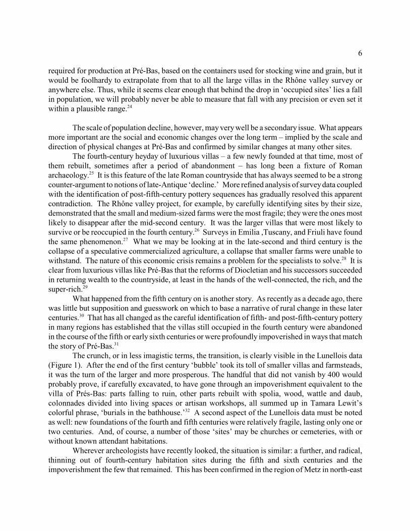
A richer vision of developments in the lower Rhône valley, and one extending beyond 500,comes from an earlier survey that was part of the same program, a survey of the Lunellois plainbetween Nîmes and Montpellier, just west of the mouth of the Rhône . Here, 150 ancient and15
medieval sites were intensively studied. The chronology of their occupation is represented in Figure1.
Figure 1: Numbers of sites in the Lunellois, by date of foundation and longevity
Not surprisingly, the rate of survival in this small sample reflect those of the larger survey of whichit was a part. Sixty-six of the sites were created de novo in the first century. Two-thirds of thesedid not survive into the third century, and three-quarters did not survive to the end of the third. Thefourth and fifth centuries mark a period of renewal, though about half of these new sites do notsurvive into the sixth. In terms of numbers of creations and disappearances, there are two important‘breaks’ in the pattern of settlement: one in the passage through the third century, the second in thesixth and seventh, by the end of which nearly all the ancient sites had been abandoned.
4
These three recent surveys are particularly important, first because of the size of the areascovered and the number of sites investigated, several thousand all told. They were conducted inareas where late-Antique and early-medieval fine and common wares have now been much moresecurely dated. They have involved excavation of selected sites as well as the gathering of surfacepottery. And they have been exceptionally attentive to all the factors that might bias their results.
What might their findings mean? The earliest impulse when the results of the South Etrurian survey were published was to
conclude, to quote Tim Potter himself, that ‘everything points to a level of depopulation that is asmarked in the towns as it is in the countryside.’ Whitehouse and Hodges were equally forceful.16 17
But not everyone was convinced. Some, in response, tried moving what appeared to be the absent country-dwellers to the
cities or to the villas and farmsteads that remained. This solution proved implausible, for thesupposed migrants would have had to be fed by someone in the very countryside that insteadappeared to be emptying out; and though luxury expenditures are everywhere visible in the greatvillas of the fourth-century countryside, there has been no demonstration of their increasedproductivity, in fact – where attempts have been made to answer the productivity question – just theopposite. Furthermore, with rare exceptions, such as Trier, which as imperial capital enjoyed a18
vibrant fourth century (as did the countryside around it), most Western cities were being partially,or in some cases completely, abandoned. Others have suggested that the people who had lived in19
dispersed farmsteads (or their immediate descendants) moved to new proto-villages (thus a hamletof three farmsteads could have the same population as three dispersed farmsteads, and inconsequence, in the tabulation of sites, three old ones would disappear and a single new one becreated without any necessary change in the total population represented). Yet others propose that20
many of the smaller sites, especially those of the first and second centuries, were not living spacesat all, but modest structures to hold equipment or temporary quarters for agricultural laborers whoseresidences were elsewhere21
These objections to a simple demographic interpretation of the evidence seem to be drivenmore by a desire to avoid a ‘catastrophist’ vision of late Antiquity, than to open up the debate on thefate of the late-Antique rural world. They do, however, have the heuristic advantage of raising twofundamental questions about the survey data, which we may put simply as, ‘What lies behind thoseblack lines in Figure 1?’ Specifically, what constitutes a ‘site’? And what do we understand by‘continuous occupation’? It is only in recent years, as archeologists have begun at long last to payattention to post-fifth-century levels of both rural and urban sites and, in the case of villas, to theworking areas as well as the living areas where art objects of value were likely to be found, that thenature and importance of these questions has become clear. No single excavation can represent all22
the complexities that have recently been found, but the work on one villa may at least suggest whatcould be hiding behind one of those long lines, and why ‘site’ and ‘continuous occupation’ areproblematic terms.
Not far to the west of the Lunellois is the villa of Pré-Bas just outside the village of Loupian,4 km. from the port of Mèze. There was a farm here in the Republican period, of which naught23
remains but some filled storage pits and ditches. The villa of the first century CE was devotedalmost exclusively to producing and exporting wine, with substantial space given over to livingquarters for the workforce and to the warehouse for the wine. In the late second and third century,
5
both areas were allowed to shrink. An entire section of the inhabited space fell to ruin. The remainsimply a partial shift to cereal cultivation. Among other changes, the storage area for wine wastransformed into an iron-working shop. One to two centuries later in second half of fourth centurythe building’s owner built new wine presses and wine storage areas, but the volume of containersfrom that period suggest a production that was only a half to a third of the production of the villa’smost profitable days in the first century. The remains of the fifth century suggest a production thatis in turn five to six times smaller than that of the fourth. Nevertheless, it was in the fourth centurythat the villa was rebuilt on an elaborate and luxurious scale, with mosaic floors and painted walls.It is that fourth-century villa that one visits now. Not more than a century later the villa sufferedwhat its excavator Christophe Pellecuer calls ‘a brutal and permanent decline’ (une brutale et durablerécession de l’occupation). The occupants continued to repair worn mosaics with mortar, but wallpaintings were allowed to fade and crumble, marble was removed from one wing, and mosaicseventually suffered when heavy objects (roof beams, perhaps) fell on them, after which they werecovered over with a mixture of cement and tile fragments. Finally in the sixth century the greatcourtyard was colonized with buildings that made use of the remaining walls. They were perhapstimber framed structures. Some may have been ‘sunken huts.’ The inhabitants threw their kitchengarbage just outside these buildings, where it was eventually buried in the ruins. These scant remains(only 3% of the potsherds collected on the site post-date the year 450) are the last signs ofoccupation. At length a destruction layer covered the entire site. After a glorious fourth, animpoverished but hopeful romanitas persisted at Pré-Bas through part of the fifth century, as fourth-century residential rooms were converted to utilitarian usage. Those who lived here strove tomaintain what they could of the old structure. Then the will, or the means, no longer survived, andfinally the site was abandoned and buried. .
Meanwhile, sometime in the fifth century, about 800 meters away a Christian church wentup, most likely at the behest of (and paid by) the owner of Pré-Bas, a church that also served as acemetery for the villa, for the artisanal and fishing hamlet near the lagoon whose products served thevilla, and for the small community that quickly gathered around the sacred space and remained thereuntil at least the Carolingian period. The original church probably fell to ruins by the seventh oreighth century and was replaced by another, which itself was replaced in the late Middle Ages by thegothic structure that is now on the site.
Here, we see, is the problem with just counting sites. A villa such as this, with a substantialwork force in the first century, an uncertain number in the second and third, and a renewed prosperitybut still perhaps only half the first-century work force in the fourth is counted as one site. It is stillone site in its impoverished sixth-century state. At the same time, small agglomerations (such asancient Lunel), post-fifth-century rural churches, and small farms are also counted individually as‘sites.’ Their presumed populations are very different. Furthermore, is Pré-Bas, with its associatedlate-Antique church and artisanal-fishing quarter one site, two, or three? Is the survival of thechurch after the villa and artisanal quarter disappear an example of continuity or of abandonment andnew foundation? Indeed, given the changes through all the centuries of its occupation, should wepay more attention to the continued use of the site (or sites) or to the direction and speed of thetransformations? However these questions are answered, it is obvious that a ‘site’ is not an entitywith any fixed physical meaning, still less any demographic meaning, even if defined by the numberof square meters where the shard fragments were found. Pellecuer could estimate the manpower
6
required for production at Pré-Bas, based on the containers used for stocking wine and grain, but itwould be foolhardy to extrapolate from that to all the large villas in the Rhône valley survey oranywhere else. Thus, while it seems clear enough that behind the drop in ‘occupied sites’ lies a fallin population, we will probably never be able to measure that fall with any precision or even set itwithin a plausible range.24
The scale of population decline, however, may very well be a secondary issue. What appearsmore important are the social and economic changes over the long term – implied by the scale anddirection of physical changes at Pré-Bas and confirmed by similar changes at many other sites.
The fourth-century heyday of luxurious villas – a few newly founded at that time, most ofthem rebuilt, sometimes after a period of abandonment – has long been a fixture of Romanarchaeology. It is this feature of the late Roman countryside that has always seemed to be a strong25
counter-argument to notions of late-Antique ‘decline.’ More refined analysis of survey data coupledwith the identification of post-fifth-century pottery sequences has gradually resolved this apparentcontradiction. The Rhône valley project, for example, by carefully identifying sites by their size,demonstrated that the small and medium-sized farms were the most fragile; they were the ones mostlikely to disappear after the mid-second century. It was the larger villas that were most likely tosurvive or be reoccupied in the fourth century. Surveys in Emilia ,Tuscany, and Friuli have found26
the same phenomenon. What we may be looking at in the late-second and third century is the27
collapse of a speculative commercialized agriculture, a collapse that smaller farms were unable towithstand. The nature of this economic crisis remains a problem for the specialists to solve. It is28
clear from luxurious villas like Pré-Bas that the reforms of Diocletian and his successors succeededin returning wealth to the countryside, at least in the hands of the well-connected, the rich, and thesuper-rich.29
What happened from the fifth century on is another story. As recently as a decade ago, therewas little but supposition and guesswork on which to base a narrative of rural change in these latercenturies. That has all changed as the careful identification of fifth- and post-fifth-century pottery30
in many regions has established that the villas still occupied in the fourth century were abandonedin the course of the fifth or early sixth centuries or were profoundly impoverished in ways that matchthe story of Pré-Bas. 31
The crunch, or in less imagistic terms, the transition, is clearly visible in the Lunellois data(Figure 1). After the end of the first century ‘bubble’ took its toll of smaller villas and farmsteads,it was the turn of the larger and more prosperous. The handful that did not vanish by 400 wouldprobably prove, if carefully excavated, to have gone through an impoverishment equivalent to thevilla of Prés-Bas: parts falling to ruin, other parts rebuilt with spolia, wood, wattle and daub,colonnades divided into living spaces or artisan workshops, all summed up in Tamara Lewit’scolorful phrase, ‘burials in the bathhouse.’ A second aspect of the Lunellois data must be noted32
as well: new foundations of the fourth and fifth centuries were relatively fragile, lasting only one ortwo centuries. And, of course, a number of those ‘sites’ may be churches or cemeteries, with orwithout known attendant habitations.
Wherever archeologists have recently looked, the situation is similar: a further, and radical,thinning out of fourth-century habitation sites during the fifth and sixth centuries and theimpoverishment the few that remained. This has been confirmed in the region of Metz in north-east
7
Gaul, in the Eifel west of the Rhine, in the Paris basin, along the Danube frontier, in northern andsouthern Italy. The ruin of baths, the subdividing of mosaic floors with light partitions made of33
wood and scavenged materials, the planting of ‘sunken huts’ in courtyards, and the disappearanceof all signs of luxury in an accumulation of garbage and crumbling walls, may be a sign of ‘squatter’occupation or not: archeology cannot tell us anything about the legal rights of the people who livedin these places, nor their connection to previous owners. They are all surely signs ofimpoverishment. The major exceptions to this story so far discovered (and their location issignificant) were along the coasts of the Adriatic and the Gulf of Taranto. I will return to these in34
a moment.If we compare the data from northern Gaul to that of the Mediterranean we see the same
pattern emerging. In 1992, P. Van Ossel summarized the results of a multiplicity of surveys in north-eastern Gaul. They showed that around Trier, on the rich soil of the Rhineland west of Cologne,35
in the Pays de France between the Seine and the Oise, and doubtless other regions of the Picard plainand north of France, about three-quarters of the sites occupied in the third century were still occupiedin the fourth. In contrast, around Nijmwegen and on the sandy soils of the northern Rhine perhaps80% of the inhabited sites were abandoned between the third and the fourth century. Then, evenwhere antique occupation had held its place, as in the region of Hambach (east of Jülich), desertionfollowed in the fifth century. During the course of the fifth century almost all of the last Roman-36
style villas and farmhouses disappeared in north-eastern Gaul. Van Ossel concluded that in a vastregion stretching from Ardennes and central Belgium through northern France, it is difficult to findestablishments even in the fourth century that presume a high economic productivity. This is trueboth of buildings in stone and buildings in wood. By the fifth century such impoverished sites hadbecome the substantial majority. And this economic downturn was not compensated by increasedactivity in the larger villas. In the archaeological material, he says, one witnesses a leveling to thebottom.
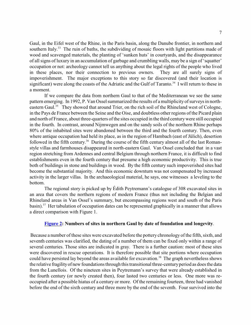
The regional story is picked up by Édith Peytremann’s catalogue of 308 excavated sites inan area that covers the northern regions of modern France (thus not including the Belgian andRhineland areas in Van Ossel’s summary, but encompassing regions west and south of the Parisbasin). Her tabulation of occupation dates can be represented graphically in a manner that allows37
a direct comparison with Figure 1.
Figure 2: Numbers of sites in northern Gaul by date of foundation and longevity.
Because a number of these sites were excavated before the pottery chronology of the fifth, sixth, andseventh centuries was clarified, the dating of a number of them can be fixed only within a range ofseveral centuries. Those sites are indicated in gray. There is a further caution: most of these siteswere discovered in rescue operations. It is therefore possible that site portions where occupationcould have persisted lay beyond the areas available for excavation. The graph nevertheless shows38
the relative fragility of new foundations through this transitional three-century period as does the datafrom the Lunellois. Of the nineteen sites in Peytremann’s survey that were already established inthe fourth century (or newly created then), four lasted two centuries or less. One more was re-occupied after a possible hiatus of a century or more. Of the remaining fourteen, three had vanishedbefore the end of the sixth century and three more by the end of the seventh. Four survived into the
8
tenth century and the remaining four into the eleventh, twelfth, and thirteenth. Twenty-four newsites were first established in the fifth century. Of these, eight were abandoned by the end of thesixth century. To these we can add another four sites less securely dated but occupied sometimeduring the fifth to sixth centuries. Fifty-nine new sites were first established in the sixth century,to which we can add another twenty-two of possible sixth-century foundation. Nearly half of thesewere likewise short-lived: only forty-five showed signs of occupation beyond the end of the seventhcentury, and most of these went on into the tenth century or beyond. For many of these new early-medieval creations of the fourth to sixth centuries, something created a bottle-neck. Only those thatpassed through this transition period survived to near or beyond the year 1000.
In Peytremann’s data, as in that from the Lunellois, it is clear that we are not witnessing adesertion of the countryside. The rural world remained inhabited from the fifth century to theseventh (otherwise who would have been buried in all those cemeteries that for a long time were ouronly archeological evidence for the Merovingian period in northern Gaul?). It was, however (andwith only localized exceptions), far more thinly populated than it had been at the end of the secondcentury or even in the fourth. Most important of all, some distinguishing features of that antiquecountryside – and, as we will see, perhaps all – were vanishing. Whatever new structures weretaking their place, they were very fragile, both in terms of their physical properties (light andperishable construction) and in terms of their continued use over time.
The most striking change is that all the settlements in Peytremann’s catalogue, even thosedating from the fourth century, were built in a manner that resembled the iron-age settlementsbeyond the Roman limes. Even when those of the fourth and fifth century (and even some of thesixth) occupied the sites of earlier Roman farmhouses, they were not built in the Roman manner.They were timber-framed one room or two-aisled structures, and sometimes nothing more than a‘sunken hut’ (a form that is found over almost all the surveyed area by the sixth century),occasionally associated with other structures that archaeologists have interpreted as granaries orworkshops. From the point of view of Imperial Rome these settlements were something radicallynew in the landscape. From the point of view of iron-age Europe beyond the Roman frontier theyare a sign that northern Gaul had rejoined their world. And not just northern Gaul, for the same typeof structures were being built in rural Italy, and by the sixth century in urban Italy as well.39
Peytremann points out, furthermore, that the passage from the seventh to the eighth centurywas also the period when a major change occurred in the plan of these settlements. At its beginninga majority of the newly created rural habitations were still dispersed farmsteads following the antiquepattern; at its end almost all new sites were groups of farmsteads that shared production and storageareas, truly proto-villages. In the sixth century, rural settlements still followed the alignments andthe field boundaries that survived from the ancient world; by the eighth, peasants were creating newand different field plans. And it is in the eighth century that one begins to find churches and chapelsin the midst of farmyards and the living sharing their space with the dead. Again, this40
transformation is sooner or later common to all the European lands that had once been part of theRoman Empire. After a long decline in inhabited sites since the second or third century, with a41
revival in some regions in the fourth, the passage through the fifth and early sixth century is thebeginning of a major transition. The last surviving major physical structures of the antique ruralworld are in ruins or disappear by the end of the sixth century. After a difficult passage through theseventh century a very different organization of the rural world begins to appear in the eighth.
9
II. The evidence of field structures.
Up to now we have been looking at buildings in the landscape, dwellings and farmhouses.The rural landscape, however, is far more than farm buildings. There is also the constructed terrain,consisting of roads, field boundaries (fenced and/or ditched), terraces or other structures to hold soilin place, ditches to drain and ditches to irrigate. The very existence of arable, in fact, impliesconstant upkeep, implies structures, in the sense of human actions to arrest natural processes. Signsthat such upkeep has been abandoned implies, at the very least, a change in land use, for withoutmeans to drain off excess rainfall or to irrigate when and where necessary, crops will fail; wherefields have not been cleared and plowed there will be no domesticated plants and natural successiontakes over, as any backyard gardener knows – grass and weeds, then shrubs and trees. Thissuccession also leaves its marks over time and can be read – as superimposed field patterns, as cropmarks, damp marks, or frost marks in aerial photographs, in soil stratigraphy, in fossil pollensamples.
Where these changes can be dated, they give us direct evidence for human impact on the ruralenvironment and tell us what happened in the increasingly impoverished and thinly populated westof the fifth, sixth, and seventh centuries. And what they reveal is a decrease in arable, a reversionof plowed lands to pasture for cows, sheep and goats, or, often enough, to forest for pigs, as mixedagriculture turned increasingly to stock raising. Here again, the evidence points to fewer mouths tobe fed, fewer stomachs to be filled, and both as cause and as consequence, fewer hands working thesoil. As we explore this narrative of fields, we will once again move from a broadly structured storyline, made evident now by radical changes in field plans, to the type of data that could in time spellout more precisely the rhythms and chronology of change, region by region.
Some of the most striking examples of the disappearance of Roman field systems and thephysical structures that implanted them in the landscape are in the same general area where theArcheomedes survey was made and in neighboring areas west along the Mediterranean coast.Roman centuriation practices had long been known from the texts of Roman surveyors, andrecognized in aerial photographs taken during the Second World War. But it was in Orange in thelower Rhone valley that André Paganiol discovered the first physical documentary record. Since42
then, historical geographers have discovered in the landscape the phantom traces of a number ofRoman centuriations belonging to the ancient cities of Orange, Nimes, Béziers, and Narbonne, andthe search for others, not only in Mediterranean regions but in the north as well, has become a minorindustry. It is important to emphasize the adjective ‘phantom’ in the previous sentence, for incontrast to some regions of Italy (in the Po valley, for example) to spot what may remain of thealignments of those ancient landscapes has sometimes demanded sophisticated computer analysisof aerial photographs. 43
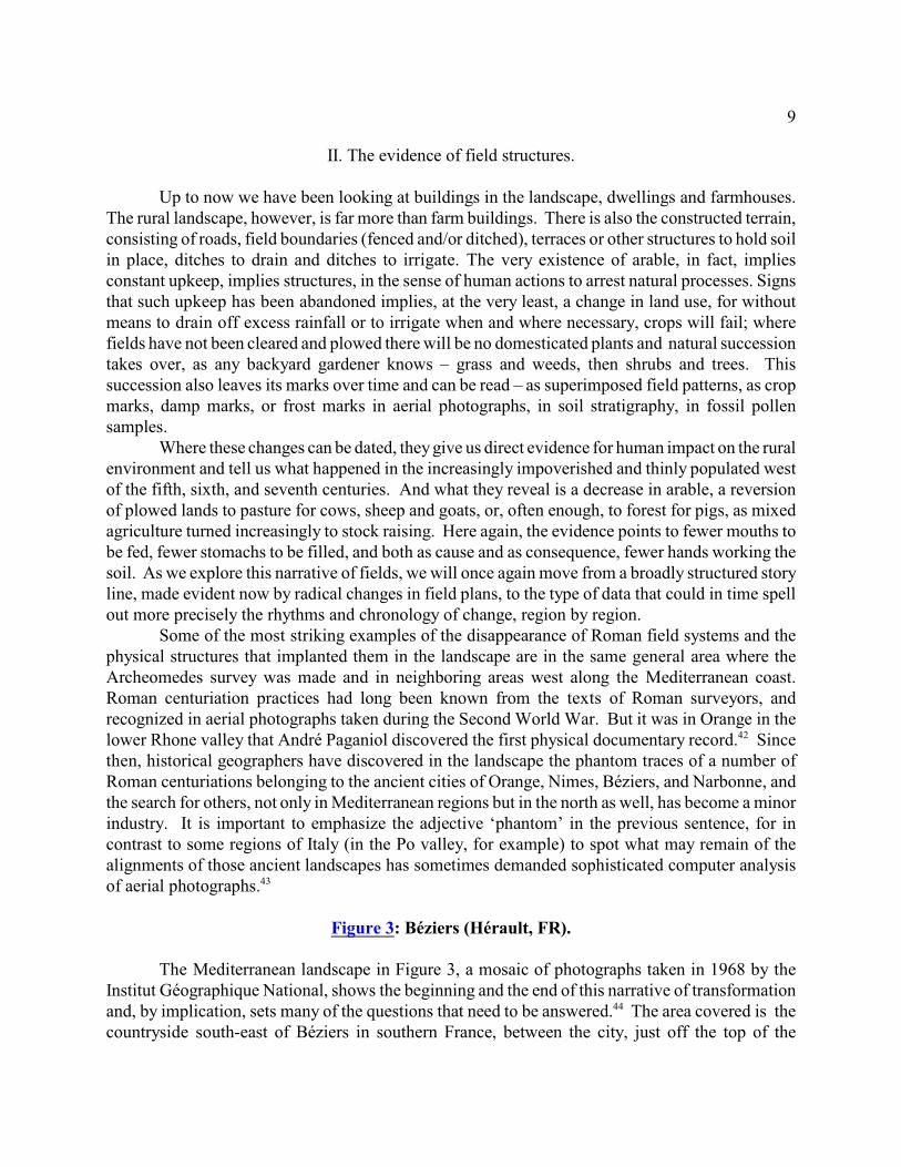
Figure 3: Béziers (Hérault, FR).
The Mediterranean landscape in Figure 3, a mosaic of photographs taken in 1968 by theInstitut Géographique National, shows the beginning and the end of this narrative of transformationand, by implication, sets many of the questions that need to be answered. The area covered is the44
countryside south-east of Béziers in southern France, between the city, just off the top of the
10
photograph and the Mediterranean, just off the bottom. The field patterns (primarily vineyards whenthe photographs were made) are dominated by the roads radiating out from three villages, Vendreson its lagoon (just off the bottom left), Sauvian, and Serignan, both on the Orb river. (The radiatingfields of Sauvian are partially, and those of Serignan are principally on the other side of the riverfrom the villages because they were laid out before the river changed its course in the mid-thirteenthcentury.) There are, however, a few field roads that appear to belong to another non-radiatingstructure. They are orthogonal and run north-south. The longest, to the left of the picture, turns offthe Vendres-Sauvian road and runs straight to the river flood-plain just south of Béziers. At the timethe photo was made it was still a dirt field-road; when the autoroute was built two decades later thisfield road was paved to link the highway to the beaches. This road and some much shorter parallelroads and field boundaries are all that remain here of the ancient centuriated landscape, intensivelystudied by Monique Clavel. Yellow arrows point to traces of this centuriation. Orange and green45
arrows point to medieval radiating field roads from Sauvian and Serignan, cut by the Orb river whenit changed its course.
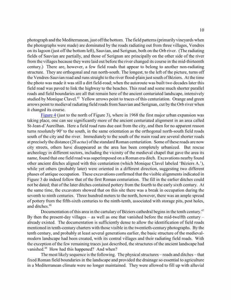
Figure 4 (just to the north of Figure 3), where in 1968 the first major urban expansion wastaking place, one can see significantly more of the ancient centuriated alignment in an area calledSt-Jean-d’Aureilhan. Here a field road runs due east from the city, and then for no apparent reasonturns resolutely 90 to the south, in the same orientation as the orthogonal north-south field roadso
south of the city and the river. Immediately to the south of the main road are several shorter roadsat precisely the distance (20 actus) of the standard Roman centuriation. Some of these roads are nowcity streets, others have disappeared as the area has been completely urbanized. But rescuearcheology in different sectors, including the vicinity of the medieval chapel that gave the area itsname, found that one field road was superimposed on a Roman era ditch. Excavations nearby foundother ancient ditches aligned with this centuriation (which Monique Clavel labeled ‘Béziers A.’),while yet others (probably later) were oriented in a different direction, suggesting two differentphases of antique occupation. These excavations confirmed that the visible alignments indicated inFigure 3 do indeed follow that of the first Roman centuriation. The fill in the earlier ditches couldnot be dated; that of the later ditches contained pottery from the fourth to the early sixth century. Atthe same time, the excavators showed that on this site there was a break in occupation during theseventh to ninth centuries. Three hundred meters to the north, however, there was an ample spreadof pottery from the fifth-sixth centuries to the ninth-tenth, associated with storage pits, post holes,and ditches. 46
Documentation of this area in the cartulary of Béziers cathedral begins in the tenth century.47
By then the present-day villages – as well as one that vanished before the mid-twelfth century –already existed. The documentation is sufficiently dense to allow the identification of field roadsmentioned in tenth-century charters with those visible in the twentieth-century photographs. By thetenth century, and probably at least several generations earlier, the basic structure of the medieval-modern landscape had been created, with its central villages and their radiating field roads. Withthe exception of the few remaining traces just described, the structures of the ancient landscape hadvanished. How had this happened? And when?48
The most likely sequence is the following. The physical structures – roads and ditches – thatfixed Roman field boundaries in the landscape and provided the drainage so essential to agriculturein a Mediterranean climate were no longer maintained. They were allowed to fill up with alluvial
11
soil, especially those ditches that did not run with the slope of the land. This would explain whysome north-south ditches and associated roads would survive or occasionally be cleared, for that isthe direction of natural drainage, while east-west ditches and roads, without practical purposes wereabandoned to natural processes. This could only mean that fields were no longer cultivated but wereallowed to return to grass and probably here and there to scrub and wood. Roman boundaries, nolonger meaningful, vanished from the land (though perhaps not always from memory). Place-names,however, survived here and there. An early eleventh-century charter mentions a substantial tract ofland called Licinianum (Licinius’s place?) east of the flood plain of the Orb, between the villagesof Cers and Villeneuve. Its eleventh-century boundaries, however had nothing to do with ancientcenturiation. They were determined by field roads that radiated from the nearby village, by the river,and by a wandering ‘carraria que discurrit per loca multa’ which can still be identified in the photosof the 1968 aerial survey. When medieval peasants plowed this land once again, it would have49
been easy for them to spot where ancient drainage ditches once had been. They would staywaterlogged for a longer time after heavy rains, and in time perhaps be overgrown with shrubs andtrees. Yet it would have been easier to re-dig the old ditches than to dig new ones where none hadbeen before. In this way ancient alignments could reappear here and there after centuries ofabandonment, but now in the context of very different field structures with very different field shapesand property boundaries. This narrative is not entirely imaginative. Exactly such a sequence of events has beenuncovered on the plain of Orange in the middle Rhône valley and dated with relative precision. Inthe commune of Lapalud, a few kilometers north of the city, archeologists working in advance of theconstruction of the TGV were able to test the identification of the hypothesized ‘centuriation B’ ofOrange and not only confirm its existence and orientation but also identify two other ancientcadasters. A complex sequence overlay the earliest Antique cadastration. The two ‘centuries’50
uncovered (whose exact numbering could be extrapolated from the recovered fragment of the Romancadastral map discovered by Paganiol) were originally co-planted in grain and vines, but by the lastquarter of the first century CE had been converted to pasture. Already in the early second centurythis was a less humanized landscape and was showing signs of heavy erosion. The ditches thatdefined the centuriation, write the excavators, appear to have silted up ‘almost instantaneously.’ Inthe third century, with a rising water table, the drainage system was completely abandoned, and 15to 20 cm. of soil slowly accumulated. Then, in the fourth century, cereal pollen, missing since thelate first century, reappear in the samples. Drainage ditches were re-cut. Arboreal pollen, however,is now over 30% of the total, and towards the end of the fourth or in the early fifth century, alluvialsoil once again filled these abandoned ditches. The ditches were invaded with hydrophilic plants andpioneering species, and over the ensuing centuries the soil level rose another 20 to 40 cm.Eventually, perhaps as late as the twelfth or thirteenth century, new ditches were cut where those ofAntiquity had been. A similar sequence was discovered not far away at Pierrelatte, ‘les51
Malalognes’, where the entire sequence of early ditches was covered in the seventeenth andeighteenth century by alluvial soil carried by a local stream, yet a modern hedge was planted barelytwo meters from the Antique ditch. In this manner the Antique alignment was repeatedly recreated52
through abandonments and reoccupations, over two millennia, while agriculturalists were succeededby pastoralists, the land abandoned, and reoccupied over several cycles. The story is enough to makeone wonder whether the apparent maintenance of centuriated fields in the Po valley, for example,
12
is an illusion that masks another case of recreation or even repeated recreations, rather thancontinuity of arable use.53
Ideally, one would like to have such careful stratigraphy of field structures from the Béziersplain, indeed, from all over Europe. In its absence one can only hypothesize, as I have done, that thesuperposition of medieval field patterns over radically different Antique patterns hides the samestory. It is a story of decay and abandonment of the physical infrastructure of production that followsthe same complex curve as the site data summarized in the first section of this article. Field ditcheswere abandoned and grain fields and vineyards were converted to pasture as the first-century‘bubble’ was reaching its climax. Erosion followed, and a slow reforestation. Then renewedinvestment of labor in arable agriculture in the fourth century, only to be followed by abandonment,alluviation, and a rise in the water table. Either money, or manpower, or the will was lacking to keepthese fields in production.
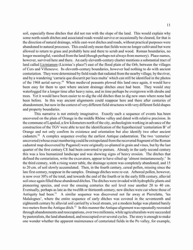
In the plains of northern Gaul and Britain the evidence of a sharp break between Antiquityand the Middle Ages is no less clear. Aerial photographs showing Iron Age and Roman periodenclosures, farmsteads, and villages as well as ‘Celtic fields’ eventually overlain by the long stripsof medieval open fields have often been published, especially from sites in the English midlands.The same phenomena are visible all across the northern plains of Europe and have been confirmedby excavation. Figure 5 is an example from Brittany. It shows proto-historic enclosures and traces54
of antique field systems revealed by aerial photographs, here overlain on an early nineteenth-centurycadastral map whose boundaries are directly inherited from the strips of medieval open fields. 55
Figure 5: St-Brieuc-de-Mauron (Morbihan, Brittany)
What we are seeing both north and south is thus a sharp reversal of a development that beganwith the spread of arable agriculture in the late Bronze Age. In the passage from one set of structuresto others that are very different, the rural economy of mixed arable and stock raising abandonedmuch of the arable (that, among other purposes, fed the ancient cities and the imperial armies) andmoved sharply in the direction of a silvo-pastoral economy.
For the regrowth of forests there is plentiful evidence from all over western Europe. Fromthe English midlands to Picardy to the Po valley evidence has long since emerged for extensiveRoman farming in land where forests were being cleared in the twelfth century. Two striking56
examples come from the Rhineland where two supposedly ‘primeval’ forests turned out to beregrowth of the early Middle Ages. In the Eifel, east of Jülich, the clearing of the forest of Hambachfor coal mining revealed that it had been cleared and densely occupied in the Roman period andabandoned by the sixth century, for the few Merovingian sites in the region were all outside thelimits of the forest except for two glass-making establishments. The Kottenforst not far to the southwas likewise densely occupied in the Roman period and abandoned by the sixth century.Unfortunately only 19 of the well over 200 Roman sites in and around the forest of Hambach wereexcavated, and there is no published data on the pottery collected during the rescue operations ineither of the two forests. A similar phenomenon with similar dating has been documented, mainly57
by studies of pollen, from the Rhineland all the way east to modern Poland. But it was not limited58
to areas that ancient and modern myth-making has long associated with primeval impenetrableforests. It was equally true of central Gaul, where a study of eighty-eight lake and bog sites indicates
13
reforestation beginning in the fourth century and lasting until the middle of the ninth. So, too, for59
areas along the Mediterranean coast and the Cantabrian mountains of north-west Spain. As might60
be expected, the dates for these developments vary from place to place, since so much depended onlocal factors. But the tendency can be found everywhere. To be sure, reforestation did not mean anabsence of human activity. Quite the contrary, there are many signs of forest use, for charcoal, forpottery-, glass-, and iron-making, for construction, and, perhaps most importantly, for feeding pigs.Yet the decline in human impact is evident.61
Even the pastures, apparently, were not maintained, or at least not sufficiently to support themore robust cattle and sheep that iron-age and Roman pastoralists had bred. The study of animalbones in fifth-century and later archeological sites reveals a steady decline in the stature of sheep,cows, oxen, and pigs (though not of horses). The most likely explanation is that larger and more62
robust animals were no longer selected to be fattened for market; meanwhile, in pasture no longerregularly hayed but invaded by woody plants, the lower metabolic needs of smaller animals wouldhave given them a competitive advantage. In all this we are seeing exactly what we might expect63
from the site-occupation data: a thin and widely-dispersed rural population that lived in what was,by comparison with the fourth century, a profoundly impoverished manner.
This correspondence with site-occupation data is suggestive, as is the chronologicalcorrespondence of the two carefully excavated sites in the lower Rhône valley. Are there any otherindependent data that might eventually give us more precise dates for this transformation and enrichour understanding of the changes occurring in the environment? The answer is yes, in studies offossilized pollen, such as those just mentioned, which allow paleobotanists to investigate theenvironment surrounding the sites from which the samples have been taken.
Figure 6: Pollen diagram from Glatinié
Figure 6 comes from the site of Glatinié, near the city of Laval, west of Paris. Pollen64
diagrams are made by extracting a soil core from a bog or other anaerobic environments, cutting itinto thin slices, then identifying and counting the fossilized pollen in each slice. The diagram ismade by representing the percentage of each species at each level from the present (top) to the mostancient (bottom). Absolute dates are derived by carbon dating when suitable material is present inthe core. In this diagram the different species have been gathered into general categories to indicatenot only the extent but also the nature of human impact on the area vegetation. Because not allplants produce air-borne pollen, and those that do so produce it in different quantities, thepercentages represented do not exactly represent the percentage of each species in the locallandscape. They do, however, signal the appearance, growth, decline, and disappearance of thepollen-spreading species. Because bogs have their own specialized species, it is necessary to filterthose out of the totals before calculating percentages in order to represent the wider environmentaround the bog. The diagram reproduced in Figure 6 presents the filtered data to the left of thecentral axis and the unfiltered to the right.
I have reproduced here only the section of the diagram pertinent to the present argument,between two calibrated C -14 dates: CE 73 ± 91 at the bottom and CE 989 ± 35 at the top. An65
intermediate date of 857 ± 87 is also marked. The diagram is arranged to read groups of plantsoutward from the central axis: closest to the axis are cereals and other cultivated plants, then weeds
14
of grain fields, followed by weeds of disturbed land (roadsides, around houses and farmyards, onabandoned sites), grasses, and forest cover. As we should now expect, the agricultural impact onthis environment was at its height in the first century CE, with mixed cereal, orchard and gardencrops and extensive pasture land. It was a very open landscape (indicated by the percentage ofruderal species). From then on, the species indicating human presence declines rapidly. Since thereis no proof that soil was accumulating in the bog at a steady rate it is impossible to date evenapproximately when forest took over much of the landscape, only that it did at some momentbetween about 400 and about 700. This was followed by a brief revival of agriculture (peakingaround 700-750?) with a notable extension of pasturage, followed by a less significant retreat (notethe continuation of cereals and accompanying weeds) before the rapid and more securely dateddeforestation and extension of pasture and plowed land in the late ninth to tenth centuries. Hereagain, the uncertain dating of the earlier changes may not be all that important, since we mightexpect that local ecological conditions as well as human decisions would have a large part in boththe chronology and the extent of pasture and forest expansion and therefore result in significantregional differences.
III. The role of climate.
What caused the transformation in productive practices, the decline in cereal cultivation, andthe end of the Ancient rural landscape?
Without a doubt, constructing a fully satisfactory answer to this question would require acomplex flowchart with numerous feedback loops, for given the centuries over which thistransformation took place and the economic and ecological complexities of any agriculturaleconomy, especially one as highly commercialized as was that of Rome during the early centuriesof the Empire, we are doubtless looking at many causes that were also consequences, tendencies thatwere self-reinforcing. Any satisfying answer, furthermore, would have to take into account thesimultaneous changes north and south. It would also have to take into account changes both withinwhat had once been the limits of the western Empire as well as beyond the camps and fortificationsthat marked the limes, beyond even the reaches of Mediterranean commerce. For, as we have justseen, pollen diagrams from as far east as Poland show the same rise and fall of cultivated speciesoccurring at around the same time as the same movements occurred in the west.
The most frequent answer to be found in the literature, whether archeological or historical,is local political and military events. It is the invasion of the Saxons (Britain), the invasion of theFranks (Gaul), the Gothic-Byzantine wars or the invasion of the Lombards (Italy). Yet, curiously,where careful excavation of late-Roman sites has been undertaken, signs of violent destruction rangefrom exceedingly rare to non-existent. And often enough, neither the signs nor the direction oftransformation change across such ‘important’ events. If warfare disrupted commerce, as it most66
likely did, why did the economy not quickly recover, and the population with it, after maraudingarmies had passed or had settled down? Furthermore, the supposed influx of new immigrants is hardto locate, now that grave goods are no longer taken to be ‘ethnic’ identifiers, and the population losssuffered by Europe beyond the limes is not reflected in population gain where they settled. Localpolitical conditions – the retreat of Roman armies from Britain, for example, or the ‘barbarians’crossing the Rhine, the Danube, or the Alps, whatever the antiquity of this explanation – cannot
15
possibly be sufficient. Other explanations, less localized this time, are the Justinianic plagues and their sequels, and
the so-called ‘536 event.’ Both undoubtedly had severe and long-lasting consequences, the plagueespecially. But they hit a West that was already well on the road to impoverishment anddepopulation. And they did not long interrupt the sixth-century economic prosperity of the East,which, far more densely populated than the West, surely suffered more. The cloud of volcanic dust67
that covered the earth in 536, a ‘year without a summer,’ was recorded in texts from Ireland to China.Major famines followed in Europe, perhaps continuing as late as 541. While the short-term68
consequences of this ‘dry fog’ were surely important, it seems unlikely that the long-term changesin the European landscape we have seen can be attributed to this one event. Indeed, there were evenstronger volcanic events noted world-wide that occurred at the beginning of what would be twoperiods of agricultural expansion, the eighth century and the eleventh. Once again, a particular69
event or sequence of events, no matter how dramatic and devastating in the short term, seemsinadequate to the explanatory demands. Something in the West prevented the region fromrecovering for centuries.
Was it the break in the commercial links that bound rural producers to cities and long-distance trade? This explanation cannot be dismissed out of hand, even though, as we have just70
seen, the decline in cereal cultivation (and apparently in population as well) affected lands far to theeast of the Roman limes, far beyond the reach of Mediterranean commerce. Nevertheless, there werea few areas of the old western empire that, however impoverished, continued to survive long afterothers went into decline, and those were the cities of the Adriatic coast, Emilia-Romagna, and theGulf of Taranto, as well as Rome and – to a lesser extent – Marseille, reconnected to Byzantine traderoutes by Justinian’s reconquest. Any explanation of the general pattern will also have to explain71
these exceptions. The possible mechanisms connecting long-distance trade to rural production haveyet to be explored. I will offer a few hypotheses later. For the moment, it is sufficient to note that,whatever those connections, the decline of commerce is not sufficient to explain what is happeningin the countryside. Again, the geographical range of the phenomena remains to be explained.
There remains the climate, which, of course, is European-wide despite the obviousdifferences between the Atlantic and continental regimes of the north and the Mediterranean regimeof the south. What follows is a brief review of some of the climatological evidence for the firstmillennium CE and some hypotheses to serve as a future research agenda.
Climate change, or more precisely a two- or three-century climate anomaly has occasionallybeen evoked by scholars studying the last centuries of Roman Britain and early Anglo-Saxonagriculture. It has also been evoked by some scholars working on Mediterranean agriculture72
(though just as forcefully denied by others). Recent research by climatologists has allowed more73
precise dating of this anomaly as well as clarifying its nature.74
Since the Bronze Age, cereals have been a large and fundamental part of the western diet.Two aspects of climate have a determining effect on their production: precipitation and temperature.All plants are genetically programmed to produce seed within a relatively narrow range of both wateravailability and of optimal degree days during the growing season. Too much or too little rainfallor bad timing of that rainfall during the growing season will lead to seed rotting or failing to sproutor, later on, to plants rotting or drying. If frost comes too late in the spring or too early in the fall orthe growing season is too cold, the plant will not have time to ripen its seeds. Grains are
16
particularly sensitive to wet, cold winters. There are, of course, no direct instrument records of75
either precipitation or temperatures before the nineteenth century to tell us when such eventshappened, so climatologists have been forced to turn to proxy records of a physical nature whosetraces are left in the soil, in arctic and alpine glaciers, and many other physical records. Such dataare significantly less precise than instrument records, but with the development of increasinglysophisticated dating techniques they are starting to become useful for historical analysis.
Indirect evidence for an extended period of heavy rainfall has long appeared in thearcheological record of Mediterranean Europe, from the ‘newer fill’ of Claudio Vita-Finzi to recentanalyses of accumulated sediments in Mediterranean river beds. The research of J.-F. Berger and76
his colleagues along the TGV right-of-way in the Rhone valley has given dates from the late fourthto the seventh century for an extended period of torrential rains, erosion , and a rise in the watertable, with fields becoming water-logged. Dating of such soil strata, however, is always77
problematic. First, because the accumulation of water-borne soil depends on the plants and man-made structures (such as drainage ditches, dams, terracing) upstream. Soil without plant cover iseroded rapidly by excess rainfall.. As grasses, shrubs and trees take hold, erosion will lessen, evenin times of torrential rains. On the other hand, the abandonment of ditches and terrace walls maylead to increased erosion. Therefore, the accumulation of soil downstream is usually not only anindirect but also an incomplete proxy record of when and where the rain was falling. Furthermore,with the exception of rare finds, such as that of the buried ships in Pisa’s ancient harbor, theaccumulation cannot be dated directly by the man-made material it may contain, since that materialhas been washed there from somewhere else; it can only be dated by what is in the strata sealedbeneath the alluvion and the more recent material in the stratum that seals the alluvion in turn. Theerror bar therefore may be very wide. 78
Recently, however, a group of climatologists have found proxy data with remarkable timeresolution for rainfall along the upper Rhône, in the north-western Alps,. Before 1870, when attemptsbegan to bring the river under control the the construction of dikes , and eventually of dams, theRhône at flood stage poured its waters into Lake le Bourget, a little to the south and west of Annecy.The flood waters carried silicate sediment which settled to the bottom of the lake. By measuring therelative amount of these sediments in 5 mm. slices cut from a nine-meter core extracted from the lakebottom, F. Arnaud and his colleagues were able to reconstruct periods of flooding over the last 7200years, with a resolution of 8 years. The portion of their graph relevant to this paper – the two79
millennia of the Common Era – is reproduced in Figure 7. The dating is in calibrated calendar years..
Figure 7: Flooding of the Rhône river.
Increased silicate sedimentation in the lake could come either from land clearing or from increasedprecipitation. Part of the sediment documented here may thus be due to the clearing of thecountryside between Lake Geneva and le Bourget during the Roman centuries. This may account atleast in part for the two small spikes on the graph dated to the first and third centuries, though thesealso correspond to flooding of rivers in the Appenines (perhaps, to be sure, caused by the sameprocess of land clearing). The large spike that begins between 450 and 500 CE, however, can onlybe due to a major long-term increase in precipitation, since it corresponds to a period of large-scaleabandonment of agriculture in the region and an increase in forest cover. 80
17
It should not be imagined that this increase in precipitation concerned only the north-westAlps. There is evidence from elsewhere, notably the Italian peninsula, that increased rainfall waswidespread. The spikes in the first and third centuries CE correspond, as I have said, to an increasein the recorded flood events of the Tiber river. So does the spike from the fifth to eighth. There werealso intense alluvial phases of rivers in the northern Appenines in the sixth and seventh centuries.81
There is equivalent evidence of colder and wetter weather in the same period in Denmark andGermany, associated with a decline in agriculture. The reason for this change in precipitation would82
have been a long-term shift in the North Atlantic Oscillation (NAO), the relative strengths of thewinter-time high pressure system near the Azores and the low pressure system near Iceland. Whenboth pressure systems are weak (a ‘negative’ NAO in the jargon of climatologists), the jet streamshifts south, bringing wet winters to southern Europe and cold winds out of the Arctic acrossnorthern Europe. There is a strong correlation between this record of high flood water on the Rhôneand some reconstructions of the NAO since 1500, so we may hypothesize that the same was likewisetrue for the early medieval change in the frequency of flood events.83
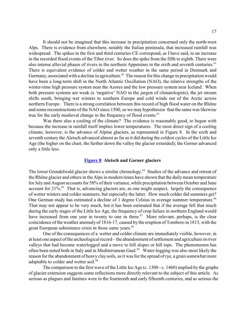
Was there also a cooling of the climate? The evidence is reasonably good, to begun withbecause the increase in rainfall itself implies lower temperatures. The most direct sign of a coolingclimate, however, is the advance of Alpine glaciers, as represented in Figure 8. In the sixth andseventh century the Aletsch advanced almost as far as it did during the coldest cycles of the Little IceAge (the higher on the chart, the further down the valley the glacier extended); the Gorner advancedonly a little less.
Figure 8: Aletsch and Gorner glaciers
The lower Grendelwald glacier shows a similar chronology. Studies of the advance and retreat of84
the Rhône glacier and others in the Alps in modern times have shown that the daily mean temperaturefor July and August accounts for 58% of their variance, while precipitation between October and Juneaccount for 21%. That is, advancing glaciers are, as one might suspect, largely the consequence85
of wetter winters and colder summers, but especially the latter. How much colder did summers get?One German study has estimated a decline of 1 degree Celsius in average summer temperature.86
That may not appear to be very much, but it has been estimated that if the average fell that muchduring the early stages of the Little Ice Age, the frequency of crop failure in northern England wouldhave increased from one year in twenty to one in three. More relevant, perhaps, is the clear87
coincidence of the weather anomaly of 1816-17, caused by the eruption of Tomboro in 1815, with thegreat European subsistence crisis in those same years. 88
One of the consequences of a wetter and colder climate are immediately visible, however, inat least one aspect of the archeological record – the abandonment of settlement and agriculture in rivervalleys that had become waterlogged and a move to hill slopes or hill tops. The phenomenon hasoften been noted both in Italy and in Mediterranean Gaul. Water-logging was also most likely the89
reason for the abandonment of heavy clay soils, as it was for the spread of rye, a grain somewhat moreadaptable to colder and wetter soil. 90
The comparison to the first wave of the Little Ice Age (c. 1300 - c. 1460) implied by the graphsof glacier extension suggests some reflections more directly relevant to the subject of this article. Asserious as plagues and famines were in the fourteenth and early fifteenth centuries, and as serious the
18
resulting demographic decline, the basic structure of the medieval rural world survived. Some villageswere abandoned, but most were not, and at least some of those abandoned were re-occupied once thepopulation began to recover. Field systems remained, even if some fields reverted to fallow and to‘waste.’ In Britain it was the enclosure movement of the early- modern period that transformed theopen fields (and fossilized many of them under grass), not the troubles of the fourteenth and fifteenthcenturies. In some areas on the Continent, as we have seen, tenth-, eleventh-, and twelfth-centuryfields could still be photographed from the air in the mid-twentieth century. In contrast, the climaticdown-turn that began around 500 CE wiped the slate clean and what began to emerge two hundredyears later was completely new.
Why was this so? I would suggest that the answer is connected indirectly to the longer survivalof a few exceptional Antique landscapes and economies along the Adriatic and Tyrrhenian coasts, theexceptions to the general picture of impoverishment and depopulation elsewhere. We saw earlier thatone of the consequences of the bursting of the early imperial ‘bubble’ in commercial agriculture wasapparently a disinvestment in rural infrastructure, revealed archaeologically in the filling of drainageditches with alluvial soil. In some areas field structures may have been recreated, at least in part,during the fourth-century revival, but they too were allowed to fill and be covered over. Was the sametrue for other necessary infrastructures of the agricultural economy? If so, a worsening of the climate,especially increased precipitation, would have been fatal, washing away the soil on slopes until grassand woodland began to fix it in place, water-logging low lying plains and bottom lands (naturallyamong the richest soils). Near to cities where the economy, whether through commercial exchangeor through the transfer of wealth from Constantinople to clients in the western outposts, there would91
have been incentive to continue or to begin again to invest in rural production, not least because thepresence of Byzantine troops and administrators in the cities provided a ready market. Here a tenuousromanitas maintained itself. It is thus not surprising that among the best survivals of centuriatedlandscapes are those around Modena and Cesena, where, as we saw, survival or reoccupation of olderrural sites in the fifth and sixth century was exceptionally high.
In most of the West that was not the case. Here political and military shocks, then the comingof plague, only exaggerated the effects of failed crops and famine in a world where even in the bestof times fertility barely held its own against mortality. The archaeology of the rural world reveals92
an infrastructure in decay or in ruins, drainage and irrigation ditches clogged, terrace walls collapsing,roads no longer maintained. This development in the countryside occurs at the same time that portionsof many urban centers begin to decay and are eventually abandoned. We are surely looking at a circle,or in systems language, a ‘feed-back loop.’ Urban centers were fed by commercial grain, meat, andwine production in their countryside, or, in the case of the greatest urban centers, from around theMediterranean. Fewer urban mouths meant a smaller market, less investment, and, for independentpeasants, reason enough to shift towards subsistence agriculture, away from labor-intensive grainproduction towards a pastoral economy requiring fewer hands. And even the producers of meateventually stopped selective breeding and the production of good forage.
Without stimulus from outside, the commercial agricultural economy would have spiraleddownward. This is exactly what we see in the gradual disappearance of the physical remains of thateconomy – the commercial pottery – from the archeological record. With a sparser population,infectious disease may not have spread as rapidly, but commercial circuits would no longer havefunctioned to supply those areas where crops had failed. It was in these circumstances that colder and
19
wetter weather would have had major consequences, ‘marginalizing’ soils that had once been primeproducers of grain, inducing agriculturalists to move to locations more suited to the new productivemix of animals, products of woodland and marsh, and enough grain for their own consumption. Thatthis happened at different rates in different regions should not be surprising, for the commercialcircuits did not subside everywhere at the same time or at the same rate. But eventually it happenedeven in Byzantine Italy. The ancient landscapes vanished and, in time, the new landscape, themedieval landscape emerged.
* * *It is traditional to end an article of this sort by saying that only further research will confirm
or disprove this hypothetical narrative. In this case, however, the data may already exist or soon comeout of the ground in the programs of rescue archeology associated with the construction of rapid trainlines and superhighways. It is to be hoped that the problems raised in this article will help shape theresearch agenda of those programs. What is needed above all is the rapid dissemination of the data ina form that historians can use. Needed as well is the rapid dissemination of data from the study offossil pollen, again in a form accessible to non-specialists and, where available, with a temporalresolution useful for historians whose interest is in changes over decades, or from century to century,and not periods of five-hundred or a thousand years. Much of this data probably already exists in deskdrawers, file cabinets, and digital data sets. May we hope to see it emerge to the light of day? So toowith the data series produced by climatologists, especially those who claim increasingly refinedtemporal resolutions. It is to be hoped that they too will make their data accessible with the claimedtemporal resolution made visible. For further progress in refining and correcting the story of thisimportant and still obscure period of European history will demand the communication andcooperation of specialists in all these fields. Historians with their traditional tools can no longer goit alone.93
Fredric L CheyetteAmherst College
20
1.The making of feudal agricultures? ed. M. Barceló and F. Sigaut. (Leiden / Boston, 2004). Thearticle in this volume by A. Durand and P. Leveau. ‘Farming in Mediterranean France and RuralSettlement in the Late Roman and Early Medieval Periods’ is one of the most important attempts in recent years to fill the gap. Because there is a vast bibliography on nearly every subjecttouched on in this article, I will restrict my references to only a few items, whose own notes andbibliographies will lead the interested reader on to a larger range of literature. For a moreextensive bibliography, regularly updated, see this article on my web site:http://www.amherst.edu/~flcheyette/Publications/Transformation%20rural%20world.pdf
2. A recent exception is C. Wickham, Framing the Early Middle Ages : Europe and theMediterranean 400-800 (Oxford, 2005), which considers many of the issues in the first part ofthis article. Some of the data that I present here was published too recently to have beenavailable to him.
3.In 1821, in the midst of industrialization, some English counties still counted over 60% of thepopulation engaged in agriculture, while in Finland in 1805 it was still 82% of the male laborforce. E.A. Wrigley, Poverty, Progress, and Population (Cambridge, 2004), pp.118, 297. Thefirst US census (1790) classified 95% of the population as ‘rural’: Historical Statistics of theUnited States (Washington, 1975), series A 67-72.
4.Discussion of the literary evidence in T. Lewit, Agricultural production in the Roman economy,A.D. 200-400, BAR international series 568, (Oxford, 1991), ch. 8, and in P. Van Ossel and P.Ouzoulias, ‘Rural settlement economy in Northern Gaul in the Late Empire: an overview’,Journal of Roman Archaeology 13 (2000), pp. 133-160. See also P. Ouzoulias, ‘La dépriseagricole du Bas-Empire: un mythe historiographique?’ in P. Ouzoulias, and P. Van Ossel (eds.),Les campagnes de l’Ile de France de Constantin à Clovis: Colloque de Paris 1996, Document detravail 3 (Ile-de-France, 1997) pp.10-20 ; P. Van Ossel, Etablisssements ruraux de l'Antiquitétardive dans le Nord de la Gaule, Gallia supplément 51 (Paris, 1992).
5. See the pertinent critical comments of Wickham, Framing, pp. 259-65, and for a recentexample of this historiographical tradition, P. Sarris. ‘The Origins of the Manorial Economy:New Insights from Late Antiquity,’ English Historical Review 119 (2004), pp. 279-311.
6. Notably G. Duby, Rural Economy and Country Life (Columbia SC, 1968), pp. 20-22 and TheEarly Growth of the European Economy (Ithaca, 1974), pp.13-17, repeated almost verbatim by R.Fossier, La terre et les hommes en Picardie (Paris, 1968) 1:236, both based essentially on theinventory of Annapes. The theory was already severely criticized by R. Delatouche, ‘Regardssur l’agriculture aux temps carolingiens’, Journal des Savants (1977), pp. 73-100 at 78-9. Archaeologists have since found that the country smithy (evident in the slag from his furnace)was far from unknown in the early Middle Ages: iron production is present at eighteen of thefifth- to eighth-century rural sites inventoried by E. Peytremann, Archaéologie de l’habitat rural
Notes
21
dans le nord de la France, 2 vols, Mémoires publiés par l'Association française d'Archéologiemérovingienne 13 (St-Germain-en-Laye, 2003). For the presence in the early Middle Ages ofiron-tipped plows capable of turning the soil see now J. Henning, ‘Germanisch-romanischeAgrarkontinuität und -discontinuität im nordalpinen Kontinentaleuropa’, in D. Hägermann et al.(eds.), Acculturation: Probleme einer germanisch-romanischen Kultursynthese in Spätantike undfrühem Mittelalter (Berlin, 2004), pp. 396-435.
7. The classic statement of the first idea is M. Bloch, French Rural History, an essay on its basiccharacteristics, trans. J. Sondheimer, (Berkeley/Los Angeles, 1966), p. 1. The classic statementof incastellamento is P. Toubert, Les structures du Latium médiéval , 2 vols. (Rome, 1973), I,330-54 , generalized as ‘encellulement’ by R. Fossier, Enfance de l’Europe , 2 vols. (Paris,1982), I, 288-317, and since turned into a commonplace in French and Italian historiography.Without denying the importance of 10th-11th century developments, both the archaeological anddocumentary evidence point to proto-villages as geographical and social entities and perhaps asnascent field systems at a significantly earlier date: see Wickham’s nuanced discussion ,Framing, pp. 516-17 and for Mediterranean Gaul, A. Durand, Les paysages médiévaux duLanguedoc (Xe-XIIe siècles) (Toulouse, 1998), pp.77-95. For Italy, see for example R.Francovich, ‘L'incastellamento e prima dell'íncastellamento nell'Italia centrale’, in E. Boldriniand R. Francovich (eds.), Acculturazione e mutamenti: prospettive nell'archeologia medievale delmediterraneo (Florence, 1995), 397-406; É. Hubert, L’incastellamento en Italie centrale (Rome,2002); R. Frankovich and R. Hodges, Villa to Village (London, 2003), ch. 3; and for the areastudied by Toubert, H. Patterson, H. DiGiuseppi et al., ‘Three South Etrurian 'crises': firstresults’, Papers of the British School at Rome 72 (2004), pp. 1-36
8. I set out this last problem in F. Cheyette, ‘The Origins of European Villages and the FirstEuropean Expansion’, Journal of Economic History 37 (1977), pp. 182-206 , and for theMediterranean landscape in C. Amado and F. Cheyette, ‘Organisation d'un terroir et d'un habitatconcentré: un exemple méridional’, in A. Bazzana, P. Guichard, and J.M. Poisson (eds.) Habitatsfortifiés et organisation de l'espace en Méditerranée médiévale (Lyon, 1983) pp.35-44.
9. T.W. Potter, The Changing Landscape of South Etruria (New York, 1979), ch. 6. R. Hodges &D. Whitehouse, Mohammed, Charlemagne & the origins of Europe : archaeology and the Pirennethesis (Ithaca, 1983), pp. 33-48.
10. H. Patterson et al., ‘Three South Etrurian ', p.18. At the time this publication was prepared,Patterson states, the survey data had not been completely analyzed.
11. See especially N. Christie From Constantine to Charlemagne : an Archaeology of Italy, AD300-800 (Aldershot/Burlington, 2006), ch. 5; Wickham, Framing, pp. 465-518; B. Ward-Perkins, The Fall of Rome and the End of Civilization (Oxford, 2005), especially pp.138-146. They reach very different conclusions about the meaning of the data. Major critiques of surveydata at P. v. Dommelen,‘Una riconsiderazione di ricognizioni estensive: il caso dello Scarlino-survey’, in M. Bernardi (ed.), Archeologia del paesaggio (Florence, 1992), pp. 859-76; P.vanOssel and P. Ouzoulias, ‘Rural settlement economy’; E. Louis, ‘A de-Romanised Landscape
22
in Northern Gaul: the Scarpe valley from the 4th to the 9th century AD’, in W. Bowden et al.(eds.), Recent research on the late antique countryside (Leiden, 2004), pp. 479-504.
12. H. Patterson et al., ‘Three South Etrurian ', and M. Valenti, (2005), ‘La formazionedell'insediamento altomedievale in Toscana. Dallo spessore dei numeri alla construzione dimodelli,’ in G. P. Brogiolo, et al. (eds.). Dopo la fine delle ville: le Campagne dal VI al IXsecolo, Documenti di Archeologia 40 (Mantua 2005), pp. 193-219. Similar densities in the areaof Claterna in Emilia: M. Librenti, ‘Ricognizione di superficie e insediamento medievale nellapianura emillano romagnola: alcune considerazioni’, in Secondo Congresso Nazionale diArcheologia Medievale (Florence 2000), pp. 170-74.
13. On the ‘catastrophic’ interpretation see the cautious remarks by Patterson, et al., ‘SouthEtrurian Crisis’, pp. 22-3. In general Christie, Constantine to Charlemagne, 412-27. For differingrates of survival between areas as close as Parma and Cesena see now S. Gelichi et al., ‘Latransizione dell' antichità al medioevo nel territorio dell'antica Regio VIII’, in G. P. Brogiolo, et al(eds.) Dopo la fine delle ville, pp 53-80, on which more below.
14. S. van der Leeuw et al. (eds.), Archéologie et systèmes socio-enviornnementaux: étudesmultiscalaires sur la vallée du Rhône dans le programme ARCHAEOMEDES, Collection deRecherches Archéologiques. Monographies 27 (Paris, 2003), annexe 2. The original data ispresented in fifty-year periods. I have simplified by giving in table 2 the higher of the twofigures for each century.
15. Archaeomedes, Des oppida aux métropoles (Paris , 1998), ch. 5 and annex 1.
16. Potter, Changing Landscape, p. 145.
17. ‘Depopulation ... is not impossible; the ruined towns and wasted countryside suggest that ithappened in the Mediterranean at the end of the Roman period – and the burden of proof restswith those who maintain that it didn’t.’ Hodges and Whitehouse, Mohammed, Charlemagne, p.53.
18. See the discussion of the villa of Pré-Bas, below. Older excavations of rural sites,unfortunately, largely ignored their production areas, since these were unlikely to producemuseum-quality artefacts.
19. See in general J. H. W. G. Liebeschuetz, Decline and Fall of the Roman City, (Oxford,2001) pp. 64-97, supplemented now by G.P. Brogiolo and S. Gelichi, La città nell’alto medioevoitaliano (Rome, 1998), and by S.T. Loseby, ‘Decline and Change in the Cities of Late AntiqueGaul’, in J-U. Krause and C. Witschel (eds.), Die Stadt in der Spätantike : Niedergang oderWandel? (Stuttgart, 2006), pp. 67-104. Italian exceptions are surveyed by F. Marazzi,‘Cadavera urbium, nuove capitali e Roma aeterna,’ in ibid., pp. 33-66. A striking example of thesynchronicity in the depopulation of a major urban center and the depopulation and
23
reorganization of its rural environs is presented by V. Bel et al., ‘Réflexions sur une ville et saproche campagne dans l'Antiquité: le cas de Nîmes (Gard)’, in A. Bouet and F. Verdin (eds.), Territoires et paysages: mélanges Philippe Leveau (Bordeaux, 2005), pp. 19-44.
20. A hypothesis recently proposed by E. Louis, ‘A de-Romanised Landscape’.
21. Proposed by F. Favory, J.- L. Fiches and C. Raynaud in ‘La dynamique spatio-temporelle del’habitat rural gallo-romain’, in van der Leeuw et al. (eds.), Archéologie et systèmes socio-environnementaux, especially pp. 309-11.
22. On the difficulties of using published reports to say anything about post-fifth-century villas asrecently as a decade ago see C. Balmelle, Les demeures aristocratiques d'Aquitaine (Bordeaux,2001), pp. 118-22. Not much had changed since my lament in ‘Origins of European Villages.’
23. What follows comes from C. Pellecuer, ‘La villa des Prés-Bas (Loupian, Hérault) dans sonenvironnement: contribution à l'étude des villae et de l'économie domaniale en Narbonnaise’,Thesis, University of Aix-Marseille I, (2000). It is to be hoped that this important thesis willsoon be published.
24. For a much richer examination of the problems involved in deriving demographic data fromarcheological surveys see F. Trément, ‘Études micro-regionales et paléodémographie’, in F,Gateau et al., L'Etang-de-Berre, Carte archéologique de la Gaule 13/1 (Paris,.1996), pp. 98-113. My thanks to Paul Van Ossel for clarifying these issues in conversation.
25. T. Lewit, Agricultural production. J. Banaji, Agrarian Change in Late Antiquity: Gold,Labour, and Aristocratic Dominance. ( Oxford, 2001), esp. p. 16. C. Balmelle, Les demeuresaristocratiques. Recent discoveries of second- to third-century abandonment and fourth-centuryreoccupation: L. Schneider, (2005). ‘Dynamiques spatiales et transformations de l'habitat enlanguedoc méditerranéen durant le haut Moyen Age (VIe- IXe s.)’, in Brogiolo et al (eds.) Dopola fine delle ville, pp. 287-312.
26. Favory et al., ‘Dynamique spatio-temporelle’, pp. 297-99, 307-10. Archaeomedes, Desoppida, pp. 110-14.
27. Gelichi, ‘La transizione dell' antichità al medioevo’. Librenti, ‘Ricognizione di superficie einsediamento’. Valenti, ‘Formazione dell'insediamento altomedievale’. C. Magrini,. ‘Il territoriodi Aquileia tra tardoantico e altomedioevo’, Archeologia Medievale 24 (1997), pp. 155-71.
28. As suggested by F. Favory et al., ‘Dynamique spatio-temporelle’, pp. 307-10. A start inconsidering the general problem, though only regionally, is J.-L. Fiches (ed.), Le IIIe siècle enGaule Narbonnaise (Sophia Antipolis, 1995).
29. Banaji, Agrarian Change, pp. 83-120.
24
30. Lewit, Agricultural production , ch. 5.
31. For example, M. Py (ed.), Dicocer : dictionnaire des céramiques antiques en Méditerranéenord-occidentale : VIIème s. av. n. è - VIIème s. de n. è., Provence, Languedoc, Ampurdan(Lattes, 1993)
32. T. Lewit, ‘Bones in the Bathhouse: re-evaluating the notion of “squatter occupation” in fifthto seventh century villas’, G. P. Brogiolo et al. (eds.) Dopo la fine delle ville, pp. 251-62.
33. T. Lewit, ‘ “Vanishing villas”: what happened to élite rural habitation in the West in the5th-6th c.?’, Journal of Roman Archaeology 16 (2003), pp. 260-74, whose argument that this wasonly a ‘cultural change’ and not a sign of impoverishment and depopulation, I find implausible. Metz: G. Halsall, ‘The Merovingian Period in North-East Gaul: Transition or Change?’ in J.Bintliff and H. Hamerow (eds.), Europe between late antiquity and the Middle Ages (Oxford,1995), pp. 38-52. Eifel: K. H. Lenz, ‘Late Roman rural settlement in the southern part of theprovince of Germania Secunda in comparison with other regions of the Roman Rhineland’, in P.Ouzoulias, P. Van Ossel et al. (eds.), Les Campagnes de la Gaule à la fin de l’Antiquité(Antibes, 2001), 113-46. Paris basin: P. Van Ossel, ‘Structure, évolution et statut des habitatsruraux au Bas-Empire en Ile-de-France,’ in Ouzoulias and Van Ossel (eds.), Campagnes de l’Ilede France, pp. 94-118, and P. Van Ossel and P. Ouzoulias, ‘La mutation des campagnes de laGaule du Nord entre le milieu du 3e siècle et le milieu du 5e siècle. Où en est-on?’ in M.Lodewijckx (ed.), Belgian archaeology in a European setting, 2 vols.(Louvain, 2001), II, 231-245. Danube: C. Siffre, ‘Kontinuität und Bruch entlang der Donau (4-8 Jahrhundert)’, in S.Biegert et al. (eds.), Kontinuitätsfragen Mittlere Kaiserzeit-Spätantike, Spätantike-Frühmittelalter(Oxford: 2006), pp. 71-75. Northern Italy: S. Gelichi et al., ‘La transizione dell' antichità almedioevo nel territorio dell'antica Regio VIII’, in Brogiolo et al. (eds.), Dopo la fine delle ville,pp. 53-80. Southern Italy: A. R. Staffa, ‘Riasseto urbano, trasformazioni territoriali, forme diacculturazione nell'Abruzzo Bizantino (secc. VI-VII)’, in Boldrini and Francovich (eds.)Acculturazione e mutamenti, pp. 315-360.
34. See the articles by S. Gelichi, G. Volpe, and P. Arthur in L'Archeologia dell'Adriatico dallapreistoria al medioevo (Florence, 2003). G. Volpe, ‘Villaggi e insediamento sparso in Italiameridionale fra tardoantico e altomedioevo: alcune note’, in G. P. Brogiolo et al. (eds.), Dopo lafine delle ville, pp. 221-49; S. Gelichi et al. ‘La transizione dell' antichità al medioevo.’
35. Data in P. Van Ossel, Etablisssements ruraux de l'Antiquité tardive. Comment in Van Osseland Ouzoulias, ‘Mutation des campagnes’.
36. Lenz, ‘Late Roman rural settlement’.
37. É Peytremann, Archéologie de l'habitat rural.
38. My thanks to Isabelle Catteddu for clarifying all these issues and for identifying theproblematic dates in Peytremann’s catalogue. In the following discussion I have included only
25
those sites whose dating is relatively certain (i.e. indicated in black on the graph).
39. M. Valenti, ‘Forme abitative e strutture materiali dell’insediamento in ambito rurale toscanotra Tardoantico ed Altomedioevo’, in G.P. Brogiolo (ed.), Edilizia residenziale tra 5 e 8 secolo(Mantua, 1994), pp. 179-90. G.P. Brogiolo and S. Gelichi. La città nell' alto medioevo italiano:Archeologia e storia ( Rome, 1998), chap. 4.
40. Peytremann, Archéologie de l’habitat rural, I, 335.
41. Here my interpretation differs from Wickham, Framing, pp. 476-81. His focus, however, isnot on numbers and physical properties but rather on the villa as a cultural and economicphenomenon. Compare Peytremann’s data to the schematic flow chart in Christie, Constantine toCharlemagne, p. 493. R. Francovich and R. Hodges, Villa to village. Gelichi, ‘Transizionedell'antichità al medioevo’. S. Gutiérrez-Lloret,‘La experiencia arqueológica en el debat sobre lastransformaciones del publamiento altomedieval en el SE de al-Andalus: el caso de Alicante,Murcia y Albacete’, in E Boldrini and R. Francovich (eds.), Acculturazione e mutamenti(Florence, 1995), pp. 165-189. L Schneider, ‘Dynamiques spatiales’.
42. A. Piganiol, Les documents cadastraux de la colonie romaine d’Orange, Gallia suppl. 16(Paris, 1962).
43. Centuriated landscapes: J. Bradford, Ancient landscapes; studies in field archaeology(London, 1957), and above all, Misurare la terra: centuriazione e coloni nel mondo romano. Catalogo del Mostra (Modena, 1983). Polemical critique of the Ancient cadaster scholarly‘industry’ by one of its early promoters: G. Chouquer, L’etude des paysages: essais sur leursformes et leur histoire (Paris, 2000).
44. For a detailed analysis of this landscape see C. Amado and F. Cheyette, ‘Organisation d'unterroir’.
45. M. Clavel, Béziers et son territoire dans l’Antiquite (Paris, 1970)
46. O. Ginouvez, and H. Pomaredes, ‘Premieres observation sur les sites antique et médiéval deSaint-Jean d'Aureilhan commune de Béziers’, Archéologie en Languedoc 17 (1993), pp. 157-71. Supplemented by Ginouvez et al., ‘Saint Jean d’Aureilhan, fouilles programmées 1994, ParcellesHX 241, 258', manuscript report, Direction Régional des Affaires Culturelles, Service Régionald’Archéologie [hereafter ms. DRAC SRA], Montpellier, (1994). Ginouvez et al., ‘St Jeand’Aureilhan, Sauvetage Archeologique’, ms. DRAC SRA, Montpellier, (1993). And P. Chevillotet al., ‘Beziers ZAC de Montimaran’, ms. DRAC SRA Montpellier (1998).
47. J. Rouquette (ed.), Cartulaire de Béziers : livre noir (Paris, 1918).
48. See C. Amado and F. Cheyette, ‘Organisation d'un terroir’.
49. Cartulaire de Béziers, no. 57.
26
50. J.-F. Berger and C. Jung, ‘Developing a methodological approach to the evolution of fieldsystems in the middle-Rhône valley’, in P. Leveau et al. (eds.)., Environmental reconstruction inMediterranean landscape archaeology, The archaeology of Mediterranean landscapes 2 (Oxford,1999), pp. 155-67, and reports on geomorphology by Berger and Jung in P. Boissinot et al.,‘Lapalud: Les Girardes. Archéologie et TGV: Lot 21. Rapport de Fouille’ , ms. DRAC SRA Aix-en-Provence, (1998) and M. Goy and I. Remy, ‘Montboucher-sur-Jabron : Constantin. Archéologie et TGV : Lot 12,.Rapport de Fouille’, ms. DRAC SRA Lyon, (1996).
51. P. Boissinot et al., ‘ Lapalud: Les Girardes’.
52. J.-F Berger et al., ‘Données paléogéographiques et données archéologiques dans le cadre del'opération de sauvetage archéologique du TGV-Méditerranée’, in J. Burnouf et al. (eds.), Ladynamique des paysages protohistoriques, antiques, médiévaux et modernes (Sophia Antipolis,1997), pp. 155-84.
53. See for example, M. Cremaschi, ‘Il territorio mantovano fra il Boreale e l'età romana:l'evoluzione ambientale’, in Misurare la terra, III, 13 - 17, describing medieval field patternsoverlying centuriation-oriented ditches filled with alluvial soil.
54. In northern Germany and Scandinavia the change has been dated to the seventh century,though there is some evidence from southern Scandinavia that in some locations it may haveoccurred as early as the third; in Anglo-Saxon England it has been dated to the eighth century: H.Hamerow, Early Medieval Settlements: the archaeology of rural communities in NorthwestEurope 400-900 (Oxford, 2002), pp. 140-44, 152.
55. D. Marguerie et al., ‘Bocages armoricains et sociétés, genèse, évolution et interactions’, in T.Muxart et al (eds.), Des milieux et des hommes: fragments d'histoires croisées (Paris, 2003), pp.115-131.
56. A representative sample: C. Lewis, P. Mitchell-Fox and C. Dyer, Village, Hamlet and Field:Changing Medieval Settlements in Central England (London, 2001), pp. 76-81. The photographsof Estrées-s-Noye in R. Agache, Atlas d’archéologie aérienne de Picardie : le bassin de la Sommeet ses abords à l’époque protohistorique et romaine, (Amiens, 1975), pp. 317, 385 where the relicof the medieval forest and even a charcoal burning pit impinge on a great Roman villa. G. Rippe,Padoue et son contado : Xe-XIIIe siècle (Rome, 2003) pp. 45-57, especially the case of the forestof Viminario, pp. 54-55.
57.W. Janssen, ‘Römische und frühmittelalterliche Landerschliessung im Vergleich’, in W.Janssen and D. Lohrmann (eds.), Villa–curtis–grangia: Landwirtschaft zwischen Loire und Fheinvon der Römerzeit zum Hochmittelalter (Munich, 1983), pp. 81-122.
58. Lenz, ‘Late-Roman rural settlement’. B. Zolitschka, and J.F.W. Negendank, ‘A HighResolution Record of Holocene Palaeohydrological Changes from Lake Holzmaar, Germany’, inS.P. Harrison et al. (eds.), Palaeohydrology as reflected in lake-level changes as climaticevidence for Holocene times Paleoclimate research 25 (Mainz, 1998), pp.37-52. ‘Environmental
27
change and human impact in the middle Lahn valley (Hessen) during the middle and lateHolocene’,http://web.uni-frankfurt.de/fb11/ipg/spp/Postergallery/Poster_pdf/Poster_Urz_etal.pdf. C. Siffre,‘Kontinuität und Bruch entlang der Donau (4-8 Jahrhundert)’, in S. Biegert et al. (eds.), Kontinuitätsfragen Mittlere Kaiserzeit-Spätantike, Spätantike-Frühmittelalter (Oxford, 2006), pp,71-75. S.T. Anderson, ‘Local and regional vegetational development in eastern Denmark in theHolocene’, Denmarks Geologiske Undersogelse. Arbog (1976), pp. 5-27. K.E. Barber, F.MChambers and D. Maddy, ‘ Late Holocene climatic history of northern Germany and Denmark:peat macrofossil investigations at Dosenmoor, Schleswig-Holstein, and Svanemose, Jutland’, Boreas 33 (2004), pp.132-44, at 142. See also the pollen diagram from Lake Woryty, Poland inB.E. Berglund (ed.), Handbook of Holocene Palaeoecology and Palaeohydrology (New York,1986), figure 22.10.
59. J.-L. de Beaulieu, A. Pons, M. Reille. ‘Histoire de la flore et de la végétation du MassifCentral depuis la fin de la dernière glaciation’, Cahiers de micropaleontologie n.s. 3 (1988), pp.5-35.
60. C. Raynaud,. Le Village gallo-romain et médiéval de Lunel- Viel (Hérault) (Paris, 1990), pp.322-3, 327 So also in the Cantabrian mountains of north-west Spain: C, Muñoz Sobrino et al.,‘Palynological data on major Holocene climatic events in NW Iberia’, Boreas 34 (2005), pp.381-98.
61. L. Bourgeois, ‘Espaces boisées, pôles d'habitat, et occupations marginales de l'Antiquité auHaut Moyen Age’, in P. Ouzoulias and P. Van Ossel (eds.) Les Campagnes de l'Ile de France, pp.32-4.
62. S. Lepetz, et al., ‘Culture et élevage en France septentrionale de l’Age du Fer à l’an Mil’, inA. Belmont (ed.), Autour d’Olivier de Serres : pratiques agricoles et pensée agronomique,Bibliothèque d’Histoire Rurale 6 (Paris, 2002), p. 96. S. Deschler-Erb, et al., ‘La crise de l'empireromain au IIIe siècle après J.-C: les données archéozoologiques en Suisse du nord’, in H. Richardand A. Vignot (eds.), Equilibres et ruptures dans les écosystèmes depuis 20 000 ans en Europede l’ouest Annales littéraires de Besançon 730 (Paris, 2002), pp. 281-90. F. Salvadori, ‘Restiosteologici animali: elementi di continuità e discontinuità tra tardoantico e altomedioevo’, in R.Francovich and M. Valenti (eds.), IV Congresso Nazionale di Archeologia Medievale (Florence,2006), pp. 520-24.
63. See M.W. Demment, and P.J. Vansoest. ‘A Nutritional Explanation for Body-Size Patterns ofRuminant and Nonruminant Herbivores’, American Naturalist 125 (1985), pp. 641-672.
64. D Barbier, J Burnouf, and D Visset, ‘Les diagrammes sociétés/végétation’, Quaternaire 12(2001), pp.103-9.
65. I have calibrated the raw BP dates given in Barbier et al. using CalPal (http://www.calpal.de).
28
66. For a new version of the old political explanation see Ward-Perkins, Fall of Rome, pp. 128-34. Yet the argument of P. Delogu, ‘La fine del mondo antico e l’inizio del medioevo: nuovi datiper un vecchio problema’, in R. Francovich and G. Noyé (eds.), La Storia dell’alto Medioevoitaliano (VI-X secolo) alla luce dell’archeologia (Florence, 1994), pp.7-29 has only beenconfirmed by more recent research, and seems as valid for the north as for Italy.
67. Brief narrative in L.K. Little, ‘Life and Afterlife of the First Plague Pandemic’, in L.K. Little(ed.), Plague and the End of Antiquity: the Pandemic of 541-750 (Cambridge, 2007), ch. 1.Literary evidence assembled and translated in D.C. Stathakopoulos Famine and pestilence in thelate Roman and early Byzantine empire (Aldershot, 2004). On prosperity of East see C. Foss,‘The near Eastern Countryside in Late Antiquity: A Review Article’, in The Roman andByzantine near East:Some Recent Archaeological Research, Journal of Roman Archaeology:Supplementary Series, 14: 1 (Ann Arbor MI, 1995), pp. 213-34; and Wickham, Framing, pp.443-65; disputed by H. Kennedy, ‘Justinianic Plague in Syria and the Archaeological Evidence’,and P. Sarris, ‘Bubonic Plague in Byzantium: the Evidence of Non-Literary Sources’, both inLittle (ed.), Plague, chs. 4 and 6.
68. See in general, J.D Gunn (ed.), The years without summer : tracing A.D. 536 and itsaftermath (Oxford, 2000). Tree-ring evidence analyzed in M.G.L Baillie, ‘Dendrochronologyraises questions about the nature of the AD 536 dust veil event’, The Holocene 4 (1994), pp.212-17. A skeptical assessment of volcanic effects (though not addressing the 536 event) is J.Grattan, ‘Aspects of Armageddon : an exploration of the role of volcanic eruptions in humanhistory and civilization’, Quaternary International 151:1, (2006), 10-18.
69. See the ‘volcanic explosivity index’ in A. Robock and M. Free. ‘The Volcanic Record in IceCores for the Past 2000 Years’, in P. D. Jones et al. (eds.), Climatic Variations and ForcingMechanisms of the last 2000 years (Heidelberg, 1996 ), pp. 533-46.
70. The explanation favored by B. Ward-Perkins, Fall of Rome, esp. pp. 132-7, and must beconsidered apart from his blaming it all on the ‘barbarians.’
71. E. Zanini, ‘Racontando la terra sigillata africana’, Archeologia Medievale 23 (1996), pp. 677-88. G. Volpe, ‘San Giusto e l'Apulia nel contesto dell'Adriatico tardoantico,’ in L'archeologiadell'Adriatico, pp.507-36. A. Toniolo, ‘Importazioni tra IV e VIII secolo d.c. nella laguna diVenezia’, ibid, pp. 616-21. P. Arthur,, ‘I Balcani e il Salento nel medioevo, ibid., pp. 654-65.Older survey by A.R. Staffa, ‘Riasseto urbano, trasformazioni territoriali, forme di acculturazionenell'Abruzzo Bizantino (secc. VI-VII)’, in Boldrini and Francovich (eds.) Accultrazione emutamenti, pp. 315-360. Comparison of site survival around Modena and Cesena with thatelsewhere in Gelichi, ‘La transizione dell' antichità al medioevo’. L. Sagui, ‘Indaginiarcheologiche a Roma: nuovi dati sul VII secolo’, in P. Delogu (ed.), Roma medievale:aggiornamenti (Florence, 1998), pp. 63-78. Patterson, ‘Three South-Etruria Crises’. F. Trément,Archéologie d'un paysage: les étangs de Saint-Blaise (Paris, 1999).
29
72. Notably by Jones, End of Roman Britain. See also E. Jones, ‘Climate, Archaeology, Historyand the Arthurian Tradition: a multiple-source study of two Dark-Age puzzles’, in J. Gunn (ed.),The Years without Summer: tracing AD 536 and its aftermath BAR International Series 872(Oxford, 2000), pp. 25-34.
73. A. Durand, ‘Les milieux naturels autour de l’An Mil: approches paléoenvironnementalesméditerranéennes’, in P. Bonnassie and P. Toubert (eds.), Hommes et sociétés dans l’Europe del’An Mil (Toulouse, 2004), pp. 74-9. A. Durand and P. Leveau. ‘Farming in MediterraneanFrance’, in Barceló and Sigaut (eds.). The Making of Feudal Agricultures?, pp. 177-241. J.-F.Berger, ‘Les étapes de la morphogenèse holocène dans le sud de la France’, in van der Leeuw etal. (eds.), Archéologie et systèmes, pp. 144-7, with a curious contradictory assertion by Favory etal. in the same volume, ‘Dynamique spatio-temporelle’, p. 311. P. Leveau et al., ‘La criseenvironnementale de la fin de l'Antiquité et du Haut Moyen Age: définition d'un modèle etretour aux milieux réels’, in H. Richard and A. Vignot (eds.), Equilibres et ruptures, pp. 291-303, is a skeptical view.
74. The period was labeled the ‘Vandal Minimum’ by R.A. Bryson ‘Orbital History, Volcanism,and Major Climate Changes: On Integrating Climate Change and Culture Change’, HumanEcology 22 (1994), pp.115-58, but this name has not gained popularity. It is usually now calledsimply ‘the early medieval cold period’: see for example M. Benvenuti et al., ‘Late-Holocenecatastrophic floods in the terminal Arno River (Pisa, Central Italy) from the story of a Romanriverine harbour’, The Holocene 16 (2006), pp. 863-76.
75. For scientific details see J.F Bierhuizen, ‘The effect of temperature on plant growth,development and yield’, in R.O. Slatyer (ed.), Plant response to climatic factors (Paris, 1973), pp.89-98. For historical data from the twentieth-century: C. Pfister, Bevölkerung, Klima undAgrarmodernisierung, 1525-1860, 2 vols. (Bern, 1985), II, 35-7.
76. C. Vita-Finzi, The Mediterranean valleys: geological changes in historical times (London,1969). C. Giraudi, ‘Late-Holocene alluvial events in the Central Apennines, Italy’, TheHolocene 15 (2005), pp.768-773. C. Morhange, C. Vella et al., ‘Human Impact and NaturalCharacteristics of the Ancient Ports of Marseille and Fos in Provence, Southern France’, in P.Leveau et al., (eds.), Environmental Reconstruction, pp. 145-53. For the Tiber, see D. Camuffoand S. Enzi, ‘The analysis of two bi-millennial series: Tiber and Po river floods’, in P.D. Jones etal. (eds.), Climatic Variations, pp. 433-50. For the Arno: M. Benvenuti et al., ‘Late-Holocenecatastrophic floods’. And in southern Gaul, the small Vidourle river: J.F. Berger et al.,“Villetelle/Ambrussum” in Service Régional d’Archéologie Languedoc-Roussillon, BilanScientifique (2001). Compare: Mark G Macklin et al., ‘Pervasive and Long-Term Forcing ofHolocene River Instability and Flooding in Great Britain by Centennial-Scale Climate Change’,The Holocene 15 (2005), pp.937-43. B. Vannière et al. ‘Land use change, soil erosion andalluvial dynamic in the lower Doubs Valley over the 1st millennium AD’, Journal ofArchaeological Science 30 (2003), pp.1283-99. F. Trément et al., ‘Mutations environnementaleset systèmes socio-économiques en Grande Limagne (Massif Central Français) de l'Age du Fer auMoyen Age’, in Hervé and Vignot (eds.), Equilibres et Ruptures, pp. 269-79.
30
77. Among others: J-F Berger et al. ‘Géoarchéologie du bassin valdainais’, in J.P. Bravard, andM. Prestreau, (eds.), Dynamique du Paysage: entretiens de géoarchéologie. DARA 15 (Lyon,1997), pp.103-128. Berger and C. Jung, ‘Developing a methodological approach to the evolutionof field systems in the middle-Rhône valley’, in Leveau et al. (eds.), EnvironmentalReconstruction, pp. 155-67. Berger and Jung, ‘Données paléogéographiques et donnéesarchéologiques’, in J. Burnouf et al. (eds.), Dynamique des paysages, pp. 175-6.
78. See.P. Leveau et al., ‘ Crise environnementale’, in Richard and Vignot, (eds.), Equilibres etruptures, pp. 291-303. For Pisa, see M. Benvenuti et al., ‘Late-Holocene catastrophic floods’.
79. F. Arnaud, M Revel et al. ‘7200 years of Rhône river flooding activity in Lake Le Bourget,France: a high-resolution sediment record of NW Alps hydrology’, The Holocene 15 (2005),pp.420-428. For the hydrology of the lake, see E. Chapron et al., ‘Climatic variability in thenorthwestern Alps, France, as evidenced by 600 years of terrigenous sedimentation in Lake LeBourget’, The Holocene 12 (2002) , pp.177-85.
80. See W. Tinner et al., ‘Climatic change and contemporaneous land-use phases north and southof the Alps 2300 BC to 800 AD’. Quaternary Science Reviews 22 (2003), pp. 1447-1460.
81. C. Giraudi,‘Late-Holocene Alluvial Events in the Central Apennines, Italy’, The Holocene15 (2005), pp.768-73.; and M. Benvenuti et al., ‘Late-Holocene catastrophic floods’.
82. K.E. Barber et al., ‘ Late Holocene climatic history of northern Germany and Denmark: peatmacrofossil investigations at Dosenmoor, Schleswig-Holstein, and Svanemose, Jutland’, Boreas 33 (2004), pp.132-44.
83. Compare Figure 7 to the reconstructed phases of the NAO in J. Luterbacher et al., ‘ExtendingNorth Atlantic Oscillation reconstructions back to 1500', Atmospheric Science Letters (2002) athttp://www.atmos.colostate.edu/ao/other_papers/ASL_NAO.pdf Also M.F. Glueck and G.WStockton,. ‘ Reconstruction of the North Atlantic Oscillation, 1429-1983', International Journalof Climatology 21 (2001), pp.1453-1465. For general information on the NAO consulthttp://www.ldeo.columbia.edu/NAO/
84. H. Holzhauser et al., ‘Glacier and Lake-Level Variations in West-Central Europe over theLast 3500 Years’, The Holocene 15 (2005), pp.789-801.
85. J. Grove, ‘The century Time-scale’, in T.S. Driver and G.P. Chapman, (eds.). Time-Scalesand Environmental Change (London, 1996), p. 41.
86. G. Patzelt, ‘Die klimatischen Verhaltnisse im südlichen Mitteleuropa zur Römerzeit’, in H.Bender and H. Wolff, (eds.), Ländliche Besiedlung und Landwirtschaft in den Rhein-Donau-Provinzen des Römischen Reiches (Leidorf, 1994), pp. 7-20, cited by A. Durand, ‘Farming inMediterranean France’, p.182.
31
87. M.L. Parry and T.R. Carter, ‘The effect of climatic variations on agricultural risk’, ClimaticChange 7 (1987), pp. 95-110. M.L. Parry presents the theoretical relationship between theprincipal climate factors and the growth and maturation of food crops in Climate Change andWorld Agriculture (London, 1990), pp. 41-52. Although his focus is on global warming, theanalysis is suggestive for cooling as well. See also, Pfister, Bevölkerung, Klima, II, 35-7.
88. J.D. Post, The Last Great Subsistence Crisis in the Western World (Baltimore, 1977).
89. This has been studied most thoroughly in the middle Rhône valley: Berger and Jung.‘Developing a Methodological Approach’. It has been noted from the Ile de France to Italy,though without specific reference to hydrological causes: L. Bourgeois, Territoires, réseaux ethabitats: l'occupation du sol dans l'ouest parisien du Ve au Xe siècle. Thesis, (1995). Paris I -Sorbonne, 3 vols., I, 75, 199. Frankovich and Hodges, Villa to Village, chapter 3.
90. Abandonment of heavy clay soils: private communication from P. Van Ossel a propos of thedifferences in Late Antique settlement survival between the Pays de France (between the Seineand Oise valleys) and Marne-la-Vallée. See also F. Gentili and N. Mahé, ‘Serris: Les Ruelles.Village Du Haut Moyen-Âge,’ ms. DRAC SRA St Denis (1997). Spread of rye cultivation: K.E.Behre, ‘The history of rye cultivation in Europe’, Vegetation History and Archaeobotany 1(1992), pp. 141-56. Hamerow, Early Medieval Settlements, pp. 135-7, 140.
91. On such transfers see J. Banaji, Agrarian Change in Late Antiquity.
92. D.S. Stathakopoulos, Farmine and Pestilence . For an overview of ancient demography and acritique, see W. Scheidel, Measuring sex, age and death in the Roman Empire : explorations inancient demography Journal of Roman archaeology, Supplementary series 21 (Ann Arbor,1996), and W. Scheidel (ed.), Debating Roman demography (Leiden/Boston, 2001).
Acknowledgments: Research for this article was supported by a faculty research grant fromAmherst College and by a Mellon Foundation Emeritus Fellowship. I have been much informedby conversations with I. Catteddu, L. Bourgeois, D. Marguerie, M.-P. Ruas, J. Henning, and P.Van Ossel and by the comments of an anonymous reviewer for this journal. I also owe much tothe hospitality of the American Academy in Rome, the C.E.S.C.M at Poitiers, and the ColumbiaInstitute for Scholars in Paris.