Embed Size (px)
Citation preview

P a g e | 14 Vol.10 Issue 5 (Ver1.0)October2010 Global Journal of Researches in Engineering
GJRE-J: Classification(FOR) 090701
The Ecological Reconstruction of the Zaghen
Tulcea Wetland and Its Evaluation
Abstract-The wetland undergoing the ecological reconstruction is
located in the east of Tulcea municipality and is marked on the
map with the toponym “Lake Zaghen”.The enclosure Tulcea-
Malcoci-Nufărul was embanked in the 60s, in order to use the land
for agricultural purposes. Due to the high level of groundwater
and the intense evaporation (favored by the use of mechanised
agriculture), the soil salinity tends to increase and agriculture
can be practiced only with persistent irrigation. Additionally in
the years 1970-72 works for dewatering of Lake Zaghen have
been attempted, which were not completed with a canal which
links the South of the lake and the Danube and has at each end
two pumping stations, a reversible one at the Danube (for ir-
rigation and dewatering) and a unidirectional one at the lake
(for the desiccation of the lake).Farming activities in the area
have been abandoned after 1990 due to soil salinity and lack of
productivity.Lake Zaghen has been strongly affected by human
intervention. Habitat deterioration is confirmed by studies and
field observations and caused the population decline and the reduc-
tion of species diversity. The most endangered are the fish and
bird species.The ecological reconstruction aims at restoring the
natural balance through adequate technical and technological
means, offering a long-term solution that will comply with the
interests of the local population.
For this project have been contracted bank loans, European
funds have been allocated, funds to state / local budget, foreign
loans contracted guaranteed by State and other external sources
. Keyword-wetland ,ecological reconstruction, habitat,
renaturation, protected area
I. INTRODUCTION
he term ―wetland‖ defines a habitat where the soil is permanently saturated with moisture and extremely
fertile, encompassing swamps, bogs, watermeadows and
low-lying coastal areas. It provides sheltered warm waters,
favoring fish hatcheries, and rich vegetation necessary for
grazing and a large variety of wild animals.In many
countries, wetlands constitute conservation areas, because
besides that they present a rich biodiversity, they also
contribute to the purification of wastewater.The Zaghen
polder is located in Northern Dobrogea, east from Tulcea
municipality, bounded by the eastern limit of the locality of
Tulcea, the Tulcea arm of the Danube River on the northern
side, and the regional road DJ 222C Tulcea – Malcoci. The
region consists of the Tulcea – Malcoci – Nufăru area
confined by dams, and is under the administration of the
mayor of Tulcea, and the town of Nufaru. In the south there
____________________________ About-1
-Academy of Economic Studies, Bucharest
About2-Bucharest University
About3-Academy of Economic Studies, Bucharest
are the hills of Tulcea and Mahmudia.From a hydrological
standpoint, the area belongs to the hydrographic basin of the Danube, on the inferior course, down river from where the
Danube branches into the two distributaries Chilia and
Sfântu Gheorghe, and upriver from where it branches into
the Sfântu Gheorghe distributary and the Sulina navigation
channel.LakeZaghen is located in Zaghen polder, east from
Tulcea municipality, has a surface of 180ha and a volume of
937.000 mc. It is an area of embanked bottomland. Lake
Zaghen is undergoing ecological reconstruction on 200 ha of
its surface. The Zaghen polder is the outlet point of the
streams Lipca and Băbăianu, that flow from the Tulcea
hills.The embanked area where Lake Zaghen is located used
to be the bottomlands of the Danube River, which was characterized also by floods, brooks, channels and
depression areas. It is separated from the Danube by a flood
embankment with a 1% insurance with the crest elevation at
+ 6,30 RMNS. The embankment is earth-filled and has been
created in 1962. The crest width of the dam is 4 m, and has
grass slopes with a 1 : 2 inclination, protecting an area of
2811 ha from flooding.The land is in the patrimony of the
Tulcea Local Council, outside the city limits. Some grass
lands have been rented in the past, but the contracts have not
been renewed. Some of them are occupied illegally, and
enclosed with light wooden fences, for animal husbandry, or through the extension to the lake of the houses in Orizont
street, beyond the property limits. The proclaimed purposes
of use (farming or grazing land) have been abandoned.The
lands that ―cannot be used for the purpose they have been
set up for, are due to be integrated in the natural system of
use by being subjected to the ecological reconstruction
procedures determined by A.R.B.D.D.‖ in agreement with
the stipulations of the nr 18/1999 Act of the territorial fund
and 82/1993 Act regarding the creation of the Danube
Biosphere Reservation.The geology of the area was
established after performing two drilling operations and
analyzing the water and soil samples obtained.From a geological standpoint, the Tulcea municipality is located on
the Triassic carbonate platform of the North-Dobrogea
orogen. The Triassic carbonate platform lies on top of a pre-
Alpine basement composed of crystalline formations
(crystalline epimetamorphic schists). Daily on the hill Hora
Tepe (the Monumentului hill) protrudes a pre-Alpine
basement outcrop. The hills of the Tulcea municipality are
composed of limestone, marno-limestone, lower/early
Triassic sandstone folded on large areas in the chimeric
tectogenesis. These rocks are exploited in the Bididia I and
II and Trei Fântâni quarries and are used in civil and
T
Dr. Maria Dimitriu1, Marian-Albert Scrieciu
2, Ioana-Aurelia Oprea
3

Global Journal of Researches in Engineering Vol.10 Issue5 (Ver 1.0)October 2010 P a g e | 15
hydrotechnic constructions and in concrete fabrication.In the
Tulcea area we find dark grey types of soil and leaching
black earth soil and to a lesser extent litosoil and carbonate
black earth. These soils have a clay or clay-loam texture and
have formed on Quaternary loess units, very sensitive to
moisture. They consist of mineral material formed through
rock decomposition and alteration, but also of organic
matter derived from vegetation decay. Their thickness varies between 2 and 3.5 m. The soils are neutral to slightly
alkaline (pH 6,5 – 7).Lake Zaghen is located in the Danube
bottomlands, at the south-west end of the Danube Delta, on
Quaternary deposits dating from late Holocene (qh2)
probably added on top of early Holocene (qh1) or even
Pleistocene deposits.The thickness of the Quaternary
deposits from Lake Zaghen area is approximately 30-40 m,
of which ―the aleuritic complex‖ from late Holocene (qh2)
ranges between 5-8 m.The alluvia from late Holocene (qh2)
found around Lake Zaghen region are largely aleuritic
(lutitic) belonging to an area of ―river divagation‖ and were deposited at different stages of the changes in the river
course.If 30-40 years ago Lake Zaghen had a 2 m depth
(according to some old fishermen), at present its depth has
greatly been reduced due to drainage works and the
colmation with terrigenous material drifted from the
neighboring higher land.From a seismic standpoint, the city
of Tulcea region is situated in the macro-area with 71
intensity and a recurrence of 50 years. In the city of Tulcea
area the peak ground acceleration for design/engineering is
ag=0,16g, for earthquakes having the mean recurrence
interval IMR=100 years and the control period of response
spectra Tc=0,7 sec. The area limitrophe to the Zaghen polder consists of current loose deposits intercalated with
turf and slurry. On the land‘s surface, underneath the vegetal
soil, its thickness ranging from 0.80m in F2 to 3.80m in F1,
there is a crust of clay dust and dusty clay, soft /stiff plastic
to hard plastic. Directly underneath this crust formed
through atmospheric contact drying are the highly
compressible layers of turf - with a thickness of 1.70m in F1
and 2.70 m in F2, followed by clay sand and silty
sand.Through drilling the underground water has been
intercepted in the form of infiltrations at 1.30-1.50 m depth
and in the form of aquifer level (ascensional) at 6.30m, 6.10m depth respectively below the natural ground level.
The infiltrations in the excavations will depend on the
pluviometric regime of the season when the work will be
performed. In a rainy season, water might be found at depths
under 1 m below the natural ground level.The chemical
analysis of the groundwater samples collected from drilling
operations have shown that the waters in the area present a
slightly carbonic aggression toconcrete, according to the
stipulations/regulations STAS 3349-83. To metals, the
samples have proved to be highly aggressive, as outlined in I
14-76. Special dataThe maximum frost line is 80-90cm,
according to STAS 6054/77.According to the NP 074/2002 regulations, the area is characterized by the
following:Terrain conditions difficult terrains 6
pointsgroundwater normal levels 2 pointsimportance of
constructio reduced 2 poin works neighboring regions
medium risk - 3points seismic(P100-92) zone C 1
pointTotal: 14 points.In conclusion, it can be said that the
geotechnical risk of the location is MODERATE. The
geotechnical category is 2.The optimal foundation depth, if
not technologically determined, is conditioned by the frost
line and will be with 0.10-0.20m above 0.80-0.90m, namely
1m below the natural land level. The foundation ground
consists of clay dust or dusty clay, soft /stiff plastic to hard
plastic. Below 1m, at very small vertical distances – 0.10cm in F2, there is a thick layer of turf. To avoid differential
settlements, light construction works are recommended.
II. CRITERIA FOR IDENTIFYING A WETLAND
HYDROLOGICAL CRITERION
The area known under the toponym Lake Zaghen is a wetland ecosystem. In the last 100 years it has lost its lake
characteristics, in the 60s-70s being described as a bog, and
as a result of the dewatering operations performed in the 70s
it has been downgraded to the swamp category due to the
high water deficit and the colmation process. The reed has
invaded practically the entire central part of the lake and
large areas are completely dry during dry seasons, when
water remains only in the channels. The normal hydrologic
regime that depended on the Danube is no longer functional,
due to the embankment of the Tulcea-Nufăru area. At
present the water body is maintained through rainwater and riffles from Tulcea Hills. The temporary excess water is
systematically moved to the Danube through the Bididia
pumping station. In November 2008 measurements have
shown that the water level at Zaghen is at 0.00m dMN, with
60cm below the Danube level. The supply of water is also
sustained by the low ground level (under 1m dMN per
perimeter and – 0.50m dMN at the center ), the lakebed
being supplied with groundwater as well. The springs that
were observed in the 70s in the southern part of the lake, are
no longer active at the surface. The current hydrologic
regime enables soil moisture in periods of plant growth
(spring).
III. THE CRITERION OF SUBSTRATE SATURATION
In order to develop wetland characteristics the soil must be
saturated with water as deep as 30cm, for at least 2 weeks,
during plant growth. At Zaghen the soil that was maintained
for a long period of time in a state of saturation developed
specific physicochemical properties: a specific sign is the
lack of oxygen in the moisture saturated soil (anoxia), the
oxygen being absorbed by roots, microbes and
microorganisms, and its diffusion in soil becoming greatly
reduced. The redox potential is high. the chronic lack of
oxygen causes the accumulation of decomposed biological material (turfary areas have been observed in the south) and
the selective growth of vegetation that support such
conditions.
IV. THE BIOLOGICAL CRITERION
This refers mainly to vegetation, the general rule being that
of having over 50% of the dominant taxa of the hydrophytes
category. The Zaghen area meets this criterion, including
reed, cattail, scouring rush and the rich channel vegetation.
P a g e | 16 Vol.10 Issue 5 (Ver1.0)October2010 Global Journal of Researches in Engineering
V. THE NATURAL BOUNDARIES OF THE WETLAND
Setting the boundaries of the wetland is based on the
aforementioned criteria, which lend it the attributes that
clearly distinguish it from the neighboring regions. The
polder created through the embankment of the Tulcea-
Nufăru area is no longer a wetland, but Lake Zaghen has
withstood the pressure of the human impact and can still be
identified and recognized as a wetland. In the polder area a similar region can be found near Murighiol. From
comparing the maps from the last 150 years it has been
observed that the surface of Lake Zaghen has been reduced
by about 1/3 on the north-eastern side. Satellite snapshots
can still capture the natural historical boundaries of the lake,
because the lost surface is still saturated enough with
moisture to be identified through color contrast.On the
current cadastral map, ―lake‖ Zaghen consists of the parcels
79 and 80, that can be easily recognized due to the channels
of the perimeter. The wetland still ―lives on‖ in parcel 81,
89, 90. The riparian area includes the parcels east of the lake, the ones from the subsiding tank and the ones in the
south (parcel 77).
VI. THE STATE OF THE HABITATS
Lake Zaghen has not been a lake ever since in the 70s, the
dewatering project was launched, with the intention of using
the land for farming. The project was never finished, but the
impact of the executed works has been disastrous for the
wetland habitats. Even after the embankment of the Tulcea-
Nufăru area (1962), the water was deep enough, so that the
reed was present only along the borders. In the 50s the
maximum depth was 2-3m, and in the 70s it became 0.6m.
The systematic exploitation of the dewatering pumps from the Bididia station has made the normal retention capacity of
the lake to drop at 0m dMN. Since in Tulcea the evaporation
rate fairly matches the precipitation rate, in the years
following the beginning of the dewatering project, a major
water deficit has been recorded with a negative impact on
the wetland habitats. The drainage channel of the waters
from the hills located in the south of the city has led to an
increased transport of solid material into the lake.
Theoretical calculations estimate an annual rate of over 300
mc solid material that has reached the lake in this manner.
Three siltations/ deposit cones/ debris cones/alluvial cones are clearly visible at the mouth of the channel,
corresponding to the discharge locations this channel has
had over the years.As a result of the colmation process and
the systematic pumping of the temporary excess water,
during dry season the reed covered surfaces have become
dry, and the water level in the channels, where water is still
present, has dropped to 0.5m. The reed growth has extended
to the center of the lake, the birds being the most affected by
the waterbody loss and shoal reduction (feeding area for
waders/shorebirds).
In the 70s the water supply of the lake came also from 12
springs (south of the lake), which held a constant temperature of 15-16 °C almost year-round, which had a
positive effect on the population of some bird species,
among which the wild duck, the northern lapwing, the
wagtail, the grasshopper warbler, the coot, the bearded
reedling, species that find shelter in the reed and cattail
layers. The cattail clusters at the edge of the waterbody
offered good conditions for early nesting birds.
The habitats encountered at Zaghen are:-natural, partially
altered by people: reed beds, parks of water willows, water
meadows.-anthropic, naturalized: drainage channels.-anthropic: farming lands, groups of individual agricultural
settlements and houses (without legal status), infields. The
natural regeneration capacity has been outbalanced by the
human impact even in those areas where wildlife seems
preserved. The major consequence of this was the decrease
of the biodiversity and the reduction of the species
populations, except for the marsh vegetation that invaded
the lake. Systematic studies have been done only for bird
species that used the region as nesting, feeding and rest area.
They have been strongly affected by human interference in
the area, but have not left the region entirely, although the habitat destruction has accelerated in the last 40 years. On
the other hand, the lack of maintenance works for the central
area of the lake has led to the reed invasion in that part.
Specialists suggest the reed to be reaped or burnt regularly
to avoid its degradation, to keep the nutrient balance and
avoid the colmation process. The region is located on the
migration route of birds and belongs to the avifauna special
conservation area of national interest. Signs of pollution are
visible (alluvia transported by streams, animal and
household waste), but the regeneration capacity limit has not
yet been reached, and this aspect will be kept under control
after the ecological reconstruction procedures. As part of the main objective for the habitat restoration is the necessity of
reconstructing the connection to the Danube, which will
ensure water transport and biological material directly from
the river. The secondary objectives are the following:the
decolmation of the channels and other major areas to alter
the waterbody: heed ratio, in favor of the former.Reducing
human presence and interference in the area (including
through the evacuation from illegally occupied spaces) by
creating protection corridors (the width of which will
inevitably be less than that stipulated in the regulations due
to the close vicinity to the urban area).Reconsidering the human presence in the area and redirecting it towards
leisure, educational, research, maintenance and wildlife
conservation activities.
VII. FAUNA
Local invertebrate species are the protozoa, ringed worms,
leeches (Hirudo medicinalis), snails (gastropods), shells,
spiders, myriapods, diurnal and nocturnal butterflies and
numerous insects: gadflies, mosquitoes, wasps, bumblebees,
ants, woodboring beetles, great silver beetles, May beetles,
dragonflies, bush-crickets, crickets, mole crickets,
grasshoppers.The vertebrates here are represented by
numerous species of fish, batrachians, reptiles, birds, and mammals. Up until two years ago fishing could be practiced
Lake Zaghen‘s channels, the fish species including the
European perch (Perca fluviatilis), the common bleak
Global Journal of Researches in Engineering Vol.10 Issue5 (Ver 1.0)October 2010 P a g e | 17
(Alburnus alburnus), the carp bream (Abramis brama), the
sunfish, the northern pike (Esox lucius), the common carp
(Cyprinus carpio), the European weather loach (Misgurnus
fossilis), the crucian carp (Carassius carassius).Batrachians
include the marsh frog (Rana ridibunda), the edible frog
(Rana esculenta), the European tree frog (Hyla
arborea).The local reptiles are the dice snake (Natrix
tessellata), the European green lizard (Lacerta viridis), the sand lizard, the European pond turtle. The mammals in the
area are the European mole (Talpa europaea), the European
hedgehog (Erinaceus europaeus), the European brown hare
(Lepus europaeus), the black rat (Tattus rattus), the house
mouse (Mus musculus), the common vole (Microtus
arvalis), European souslik (Citllus citellus), the lesser mole
rat (Spalax leucodon). In the area, numerous previously
domesticated animals also live in the wild.
VIII. THE AVIFAUNA
After reviewing the research studies performed in the area
before 1980, we have reached to an impressive number: 89 species had been identified, representing more than a quarter
of the total number of species observed in the Danube Delta.
The avifauna potential of Lake Zaghen is truly impressive,
but so is its decline. Today birds are still present in the
region, especially nesting bird species. Shorebirds, however,
have lost their feeding grounds while the birds of passage
have lost the resting grounds.The conservation regime of the
Danube Delta avifauna ROSPA0031 that includes Lake
Zaghen represents another strong argument in favor of the
ecological reconstruction.
IX. FLORA
Among the woody plants present are the white willow (Salix alba) and the black poplar (Populus nigra).On the surface of
the former settling tank a population of saltcedar (Tamarix
ramosissima), a plant well-known for its healing properties,
has grown rapidly.Reed species like the common reed
(Phragmites communis) occupy the central basin and stretch
even north and east, beyond the channels from the lake
perimeter.Besides reed we find common bulrush (Typha
latifolia), true bulrush (Scirpus lacustris), arrowhead
(Sagittaria sagittifolia), flowering rush or grass rush
(Butomus umbellatus), cowbane (Cicuta virosa), fineleaf
waterdropwort (Oenanthe aquatica), purple loosestrife (Lythrum salicaria), water mint (Mentha aquatica), marsh
euphorbia (Euphorbia palustris) stinging nettle (Urtica
dioica), three-parted beggar-ticks (Bidens tripartitus), marsh
sow-thistle (Sonchus paluster), the marsh thistle (Cirsium
paluster), the common water-plantain (Alisma plantago-
aquatica), soft rush (Juncus effusus), the water soldier
(Stratiotes aloides).Inside the channels, where the water is
deeper and contains more oxygen, the flora is richer and
specific to this type of habitat: tape grass (Vallisneria
spiralis), the curly-leef pondweed (Potamogeton crispus),
frogbit (Hydrocharis morsus-ranae), spiked water-milfoil
(Myriophyllum spicatum), soft hornwort (Cerathophyllum submersum), common duckweed (Lemna minor), and the
Spirogyra algae.The sandy land areas are covered with grass
and other plant species characteristic of the steppe.
X. THE FUNCTIONS OF THE WETLAND
a) Hydrological functions:
the Zaghen region collects the high floods/waters and
alluvia from Tulcea valley, stores water that replenishes the
groundwater levels, maintains a beneficial wet environment
during dry seasons, regulates temperature in seasons of extreme temperatures, serves as protection for farming lands
against floods.
b) Biogeochemical function:
retains and recycles nutrients (nitrogen, phosphorus),
mineralizes organic pollutants (denitrification), enables a
natural and efficient carbon cycle, maintains the surface
layer of the soil in an anoxia state.
c) Ecological functions:
habitat for plants and animals (reproduction area for fish,
nesting, feeding and resting grounds for birds); an essential
habitat for migratory birds, reservoir of genetic resources and biodiversity, the aquatic macrophytes and microbes are
necessary for the decay of organic waste (including
vegetation) and nutrient recycling, the underwater
macrophytes regulate the microbial metabolism and
biogeochemical cycles.
d) Socio-economical functions:
ecotourism, education, leisure activities (unexplored until
now), the creation of new work opportunities by making use
of traditional occupations (fishing, reaping the reed for
construction work, collecting plants), habitat for a
population that finds itself at a disadvantage because of the
technological progress, but which is also very well adapted to the delta environment, the natural purification area for
household waste.
These functions of the wetland are only partially and in an
uncontrolled manner explored today, but this process can
become more efficient through the ecological reconstruction
that will add value to the area.
XI. THE VALUE OF THE WETLAND
Although many years ago, wetlands were regarded as areas
of discomfort (mosquitoes, moisture, unexploitable land)
and have systematically went through land reclamation,
nowadays the role of wetland ecosystems in preserving the water quality and biodiversity is better understood. Gaining
the awareness that the right to a clean environment belongs
to the public rights domain has been a step forwards,
favoring the conservation of these areas. After being under
anthropic pressure so severe that it could have led to its
extinction, presumably followed by a period of falling into
complete oblivion, the time has come for the Zaghen area to
be discovered and explored for the benefit of the
community. For the Tulcea municipality the area can be
developed for its sanitary, leisure and esthetic values. The
P a g e | 18 Vol.10 Issue 5 (Ver1.0)October2010 Global Journal of Researches in Engineering
close location to the Danube also makes it suitable for
tourism and scientific research.
XII. PROJECT‘S OUTLINE
Within the Tulcea-Malcoci-Nufărul embanked region, an
area of about 200ha from the Lake Zaghen perimeter
undergoes the ecological reconstruction. This aims at
restoring the natural balance of the environment through
adequate technical and technological means, offering a long-term solution that would also answer the local community‘s
needs. This implies the following:enabling the water input
from the Danube into lake Zaghenthe restoration of a variety
of natural habitats specific to wetlands facilitating the
development of aquatic and terrestrial fauna and flora, the
development of natural resources: fish, reed, cattail, wood,
and establishing the adequate hydrologic regime. The
creation of special recreation areas for the local people of
the Tulcea municipality as well as for its visitors.
Setting up an inside tourist route consisting of a navigable
channel for small boats; setting up along the banks characteristic tourist stops, fishery, wind mill, traditional
fisherman houses, birdwatching facilities, workshops for
exploring the natural resources (carpentry, spaces for the
creation of trellis and other wood or cattail interwining work
and artisanship), tourist center, etc.Providing facilities for
visitors to take part in local events and activities: sport
fishing, non-motorized boating, exploration and
understanding of the fauna and flora specific to the delta,
landscape exploration with recording devices (cameras),
cultural events, culinary events with local food, etc.Ensuring
the necessary utilities and ways of access. Maintaining the
current function as a buffer zone against the high floods of Tulcea valley, by preserving the existing polder, which must
not affect the facilities area. The drainage system of Lake
Zaghen and SP Bididia will be restored and activated, as
well as the purification basin for torrential pluvial waters
that come through the Valea Tulcei channel and the two
reversible pumping stations. Additionally the adjacent areas
of Lake Zaghen will undergo ecological measures like the
removal of all inadequate dwellings and extensions.Based
on the studies and observations made, the wetland area that
had no economic relevance will be transformed into a
leisure, education and research area, that will be added to the list of tourist attractions. The area will serve as a means
of ecological education and raising awareness for children
and students, and as a practical example of the development
of a conservation area. The ecological objectives are the
renaturation of the wetland and the restoration of
biodiversity. From a technical standpoint the solution lies in
the restauration of the hydrologic regime specific to
floodplains. Coming back to the normal hydroperiods will
result in the recovery of the wetland‘s functions:habitat for
plants and animals specific to wetlandshabitat and
reproduction area for fishhabitat and reproduction area for
water and shore birdssource of biodiversity and genetic resourcesbio-corridor and genetic exchange biological
productionresuming the normal biogeochemical cycle of the
elementssettlement of sediments and toxic substances
(purification function)The habitat restoration is permitted in
order to resume the long-term development process for the
local economic, touristic and recreation resources of the
wetland.
Scenario zero, of non-intervention would condemn the
lake to advanced colmation in the next 30-40 years. The area
presenting no interest anymore would be degraded by
uncontrolled human interference. Because its natural purification capacity would be irreversibly damaged, the
area would become another ―rubbish dump‖ of the city. This
process has actually already begun:Without intervention the
colmation process will continue until the area‘s function to
attenuate the floods collected through Valea Tulcei will be
entirely compromised. Because the colmation area does not
match the location of the floodplains (adjacent to inhabited
areas), the output channels of the water will close, the water
will longer longer in the same location, and the precession
of pollutants will be reduced, the floodplains becoming
―hotbedsfor infections‖, in close vicinity to the inhabited area.
Minimal intervention scenario would imply only:taking
sanitary measures to clean the area along with the removal
of farms dealing with animal husbandryCorrecting the
channel in the Tulcea valley and creating a new output way
towards the pumping station.This scenario ignores lake
Zaghen‘s potential and the possibility for it to become a
restored wetland and be explored as a natural environment.If
there is no clearly outlined function of the area, the
sanitation costs will not bring in return direct and explicit
benefits.
Maximal intervention scenario, the renaturation of the entire Tulcea – Nufăru area as a floodplain, is not feasible,
because the embankment plays also a role in protecting the
Tulcea municipality from flooding.
Feasible scenarios are compromises that must reach a
balance between the need to restore the natural habitats and
the interests of the urban community to develop this area.
Therefore, the project has a different approach than the other
renaturation projects from the Danube Delta.The close
proximity to the city is a major advantage when it comes to
develop the region as a tourist, recreational, educational and
research attraction. Secondary scenarios and objectives can be described as follows: the rehabilitation of the pumping
stations and dredging the channel between Lake Zaghen and
the Danube, ―ensuring the operation of reversible pumps at
both stations‖ the downside of this is that pumping destroys
the biological material, which comes from the Danube and
is essential.Protecting the wetland with an embankment, in
order to trace clear boundaries for the perimeter, to protect
the banks and stabilize the specific hydrologic
regime.Dredging a large area of Lake Zaghen to restore
different habitat types: lake, bog, island, shoal.
The separation of the waters flowing from Valea Tulcei into
Lake Zaghen and the creation of a separate discharge way into the DanubeModeling the wetland with islands and
channels, diversifying the recovered dry land through
plantingConnecting Lake Zaghen to the other wet areas
from the embanked region, in an integrated
Global Journal of Researches in Engineering Vol.10 Issue5 (Ver 1.0)October 2010 P a g e | 19
systemConducting specialized studies for the identification
of species and habitats that are in need of protection and
relevant to the community
Setting up recreation facilitiesSetting up research and
conservation facilities
XIII. THE CURRENT ECONOMIC SITUATION
the Zaghen area has a direct cost that can be estimated from
the exploitation costs of the dewatering system (water pumping, building, equipment, hydrotechnic works
amortization) the Zaghen area has also a hidden cost
consisting of sanitation costs, irretrievable but necessary for
the community‘s well-beingthe Zaghen area has indirect
costs which represent losses arisen from the fact that the
land and the natural resources have not been exploitedthe
Zaghen area does not produce revenue (terrains have not
been leased anymore because this leads to indirect losses
through pollution, the beneficiaries of the hydrotechnic
works do not pay taxes, those responsible for pollution do
not pay taxes for the water that has been naturally purified by the wetland)the indirect benefits of the wetland location
(influences on the urban microclimate, depolluting the
pluvial waters containing urban pollutants in a natural
manner, minor resource for work opportunities for the low-
income population in the area) are hard to evaluate; they
create a socio-economic value, without any influence on the
financial prospects.The costs are greater than the financial
benefits. It is advisable that for economic calculations to
take into account the average economic value of the land is
null (calculation value = 0), because the value of current
ecological services is compensated by the operating costs.
Options for investment may be limited to strict the renaturation (variant A) or an investment which can be
expanded to develop the area of social functions (variant
B).Variant A can be achieved by limited hydraulic works,
with an investment of 7 200 000 euro , and by renaturation
the value of ecological services increases (estimate 200 ha.x
3000 Euro / ha / year = 600 000 euros/ ha / year. Under the
financial terms this the economic value is doomed to
failure because society is not yet prepared to recognize and
pay the price of services. The solution is the combination of
ecological services with other services that the company is
willing to pay.This intervention has effect on the economic value of the area. Its value will be 8.35 million euro (NPV),
but enhances the financial effects only in particular
conditions.Because of investment, financial NPV is
negative, -2.35 million euro. The investment is
economically justified, but only in conditions of
unsustainable financial i.e.only in conditions of subsidies.In
variant B, developed in this study, the development of area
is complex, with a lot of direct and indirect effects.The
beneficiary has the opportunity to obtain financial income
from operating (sale or exploitation of land, area concession
, access fees, taxes).If the area enters into a development
process to exploit its natural potential and specificity we can set achievable objectives:Minimum value of leaseable land
without infrastructure 10 euro / sqm;Average leaseable land
with infrastructure minimum 30 euro/ sqm;Value of
leaseable land with complete infrastructure 100 euro /
sqm.This potential developes and produces financial
revenue.The 296 ha area, studied by the project can update
its value as follows:- 60% as area protected by
anthropogenic effects, 2 euro/ sqm.- 10% as area with
permission for operating with minimal anthropogenic effects
(Scientific Tourism, Education, Research), 10 euro / sqm-
The proportion of 12% as utility area (research, education,
urban park), 20 euro / sqm- 15% as dwelling area,30 euro/ sqm- The rate of 3% for commercial development, 100 euro/
sqm.Exploitable value estimated in this scenario is
calculated as folows:296 hectares x Σ (proportion* value of
unit) = 15 764 000 euroOption B has three versions,
described in the text as variants I, II and III. The values of
investments proposed by the project are:
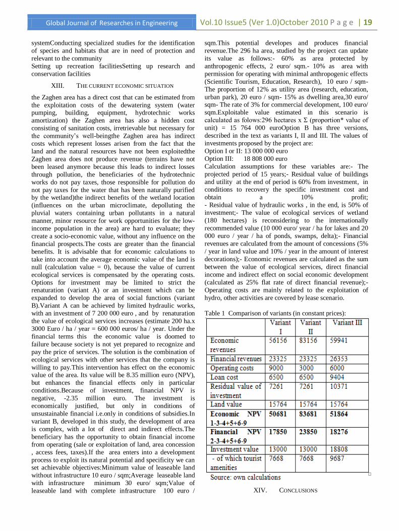
Option I or II: 13 000 000 euro
Option III: 18 808 000 euro
Calculation assumptions for these variables are:- The
projected period of 15 years;- Residual value of buildings
and utility at the end of period is 60% from investment, in conditions to recovery the specific investment cost and
obtain a 10% profit;
- Residual value of hydraulic works , in the end, is 50% of
investment;- The value of ecological services of wetland
(180 hectares) is reconsidering to the internationally
recommended value (10 000 euro/ year / ha for lakes and 20
000 euro / year / ha of ponds, swamps, delta);- Financial
revenues are calculated from the amount of concessions (5%
/ year in land value and 10% / year in the amount of interest
decorations);- Economic revenues are calculated as the sum
between the value of ecological services, direct financial
income and indirect effect on social economic development
(calculated as 25% flat rate of direct financial revenue);-
Operating costs are mainly related to the exploitation of
hydro, other activities are covered by lease scenario.
Table 1 Comparison of variants (in constant prices):
XIV. CONCLUSIONS

P a g e | 20 Vol.10 Issue 6 (Ver1.0)October2010 Global Journal of Researches in Engineering
a) Economic analysis:
The benchmarks for this type of project, qualified as
investment environment are:- Discount rate 5% (in real
terms since the projections in this draft have been in
constant prices)
- Financial IRR -0.1% (may increase up to max. 5%)-
Economic IRR 15.8%- reference period 15 yearsThe
economic significance of the results of cost-benefit analysis is that the investment is justified as economic, but in
financial terms it requires financing, including non-
refundable grant form. This situation is relatively normal,
because the largest share in investment is environmental
intervention works (ecological reconstruction) that produce
value in the first and only appearance in the socio-economic
background financial value (net revenue, profit).
b) Sensitivity analysis
In terms of financial efficiency, the project is sensitive to
market behavior. Market failure is taken into account, at
least in the short term, considering the possible lasting effects of the current financial crisis.
The project remains desirable even in those circumstances,
considering this is a restoration project of an area affected
by anthropogenic intervention. Restoration of this area is a
legal obligation.
c) Risk analysis.
Similar projects have been a success in Delta, nature
showing a remarkable capacity for regeneration, if the
human been removes the obstacles. In terms of risk, variant
A and B are similar. A difference in this case are between
versions 1 and , version for hydro works. Both are
technically feasible, but variant 1 modify the type of ecosystem, while version 2 restoring the existing support.
d) Sources of investment financing
Funding source of investment will be in accordance with
the law and consist in equity, bank loans, funds to state /
local budget, foreign loans contracted or guaranteed by State
grants and other sources of external funds legally
constituted.
XV. REFERENCES
1) DANCHIV, AL: Hidraulica Aplicată, Ed.
Universităţii Bucuresti, 2002
2) DIMITRIU, MARIA: Investments and risk, Editura Margaritar, 2000
3) GHEORGHE AL., ZAMFIRESCU F.,
SCRĂDEANU D., ALBU M. Aplicaţii şi
probleme de hidrogeologie, Universitatea din
Bucureşti, 1983
4) MUTIHAC V., IONESI L. Geologia României,
Ed. Tehnică, Bucureşti, 1974
5) UJVARI I. Geografia apelor României, Ed.
Ştiinţifică, Bucureşti, 1972