Embed Size (px)
Citation preview

Page 1 of 20
The Effects of Flow Regime and Land Use Practices on Ecological Health in the Grand Ronde Sub-basin
by Ann D. Fissekis
ABSTRACT The River Continuum Concept (Vannote et al. 1980) was developed to provide an
accurate description of the downstream trends of biologic communities in response to changing
physical systems. However, while the RCC claims to accommodate land use perturbations of
physical factors such as flow regime, research indicates that land use impacts depend on both
type of industry and location along the river channel. Furthermore, no definitive relationship is
established for the effects of land use in large basins. While the Grande Ronde’s flow regime has
changed in a way that is consistent with the expected impacts of its land use practices on the
magnitude and timing of flows, more specific knowledge that quantifies the relationship between
industry and flow regime is needed to make the RCC a more accurate tool.
INTRODUCTION
With the River Continuum Concept (RCC), Vannote et al. (1980) provide a model that
describes the patterns of changing biologic communities in response to changing physical
systems. One physical factor that would affect the surrounding ecology is a river’s flow regime.
Flow regime describes the pattern and volume of flow that is characteristic to a river. The RCC
should apply to both natural and disturbed flow regimes. A comparison of heavily land-used
areas to natural regions in the Grande Ronde sub-basin of the Columbia River watershed
(hereafter called the Grande Ronde) shows that land use has affected the ecological health of the
Grande Ronde and its flow regime has been altered. However, making a direct relationship
between land use and flow regime changes is difficult to establish. This paper will examine
whether the RCC continues to be an accurate model for a river’s flow regime and biotic
community once land use effects are taken into account. To illustrate these effects, this paper
will use the environmental needs of the Grande Ronde’s spring Chinook salmon population to
evaluate the ecological impacts of an altered flow regime.

A.D. Fissekis June 8, 2007
Page 2 of 20
HYDROLOGIC PATTERNS AND FLOW REGIME General
A river’s natural flow is determined by the area’s climate, topography and fluvial
geomorphology (Rheinheimer 2007, Caldwell 2007, both this volume;). These factors define
patterns of precipitation, baseflow, overland flow and snowmelt runoff. The extent to which
these sources of flow intersect as well as the volume of water contributed by each define a river’s
flow regime.
Flow regime describes five characteristics of discharge: magnitude, timing, frequency,
duration and rate of change of flows (Poff et al. 1997). Magnitude describes the volume of water
moving past a fixed location per unit time. For this paper, magnitude will be measured in units of
cubic feet per second (cfs) and cubic meters per second (cms). Timing refers to the occurrence of
flows within the annual hydrologic cycle. The timing of peak and base flows can have ecological
significance; therefore, records of their arrival are kept to determine whether any significant
shifts have taken place. Frequency, also described as exceedance probability, describes the
probability that flows above a certain magnitude will occur. Probabilities are defined over a
continuous range of flows using a statistical analysis and are illustrated by the flood frequency
curve (Fig 1).
Figure 1. Flood-Frequency Relationship for USGS Gage No. 13319000, Grande Ronde River at
LaGrande, Oregon. (USACE 1999)

A.D. Fissekis June 8, 2007
Page 3 of 20
Duration describes the period of time associated with a specific flow condition and can be
measured using different time steps. Baseflows may have durations of several months while
storm event runoff may last only a few days. Rate of change describes how quickly flows change
from one magnitude to another. The two main categories of rate of change are flashy (unstable)
or slow (stable) (Poff et al. 1997).
The Grande Ronde
Hydrologic Cycle
The hydrologic cycle of the Grande Ronde is mainly driven by snow accumulation and
runoff. While the climate patterns that define the processes of snow accumulation and melt in the
hydrologic cycle are discussed elsewhere in this document, aspects that are relevant to land use
effects will be briefly described here (Rheinheimer 2007, this volume). Two significant climate
zones exist in the Grande Ronde: the Warm Snow Zone, which ranges from 2000 ft. (609 m) to
5000 ft. (1524 m), and the Cold Snow Zone, which covers all areas above 5000 ft. (1524 m). The
Warm Snow Zone contains snow cover from October to March and is typically sensitive to
rainfall effects on snowpack. The Cold Snow Zone retains some snowpack throughout the year
and is less sensitive to rainfall events. Snow depths range from 5 ft. (1.5 m) to 20 ft. (6.1 m)
(Wissmar et al. 1994). In the Grande Ronde, the upper limits of the Cold Snow Zone are
determined by peak elevations in the Blue Mountains and Wallowa Mountains, which reach
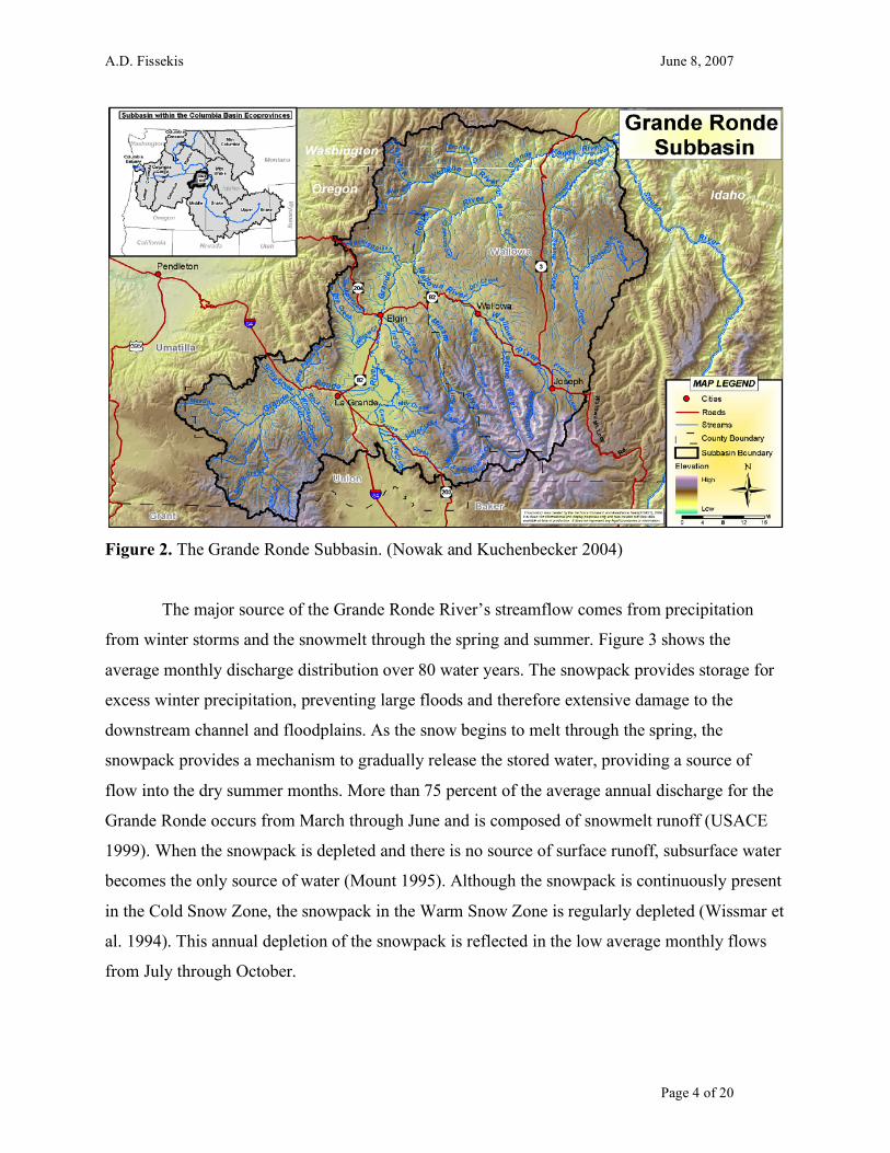
7,700 ft. and 10,000 ft., respectively (Fig. 2) (Nowak et al. 2004). As 78.29 percent of the
Grande Ronde is above 2000 ft (609 m) elevation and 20.38 percent is above 5000 ft (1524 m),
snow plays a significant role in defining the natural flow regime (Wissmar et al. 1994; Nichols,
personal communication, 2007). Additionally, more than 95 percent of streamflow used for rural,
domestic, municipal, industrial and agricultural needs comes from forested and alpine lands in
the Grande Ronde basin (Wissmar et al. 1994).
A.D. Fissekis June 8, 2007
Page 4 of 20
Figure 2. The Grande Ronde Subbasin. (Nowak and Kuchenbecker 2004)
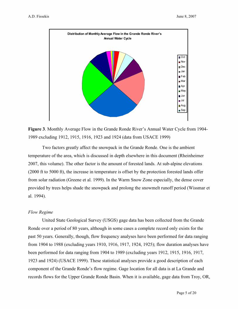
The major source of the Grande Ronde River’s streamflow comes from precipitation
from winter storms and the snowmelt through the spring and summer. Figure 3 shows the
average monthly discharge distribution over 80 water years. The snowpack provides storage for
excess winter precipitation, preventing large floods and therefore extensive damage to the
downstream channel and floodplains. As the snow begins to melt through the spring, the
snowpack provides a mechanism to gradually release the stored water, providing a source of
flow into the dry summer months. More than 75 percent of the average annual discharge for the
Grande Ronde occurs from March through June and is composed of snowmelt runoff (USACE
1999). When the snowpack is depleted and there is no source of surface runoff, subsurface water
becomes the only source of water (Mount 1995). Although the snowpack is continuously present
in the Cold Snow Zone, the snowpack in the Warm Snow Zone is regularly depleted (Wissmar et
al. 1994). This annual depletion of the snowpack is reflected in the low average monthly flows
from July through October.
A.D. Fissekis June 8, 2007
Page 5 of 20
Distribution of Monthly Average Flow in the Grande Ronde River's
Annual Water Cycle
Oct
Nov
Dec
Jan
Feb
Mar
Apr
May
Jun
Jul
Aug
Sep
Figure 3. Monthly Average Flow in the Grande Ronde River’s Annual Water Cycle from 1904-
1989 excluding 1912, 1915, 1916, 1923 and 1924 (data from USACE 1999)
Two factors greatly affect the snowpack in the Grande Ronde. One is the ambient
temperature of the area, which is discussed in depth elsewhere in this document (Rheinheimer
2007, this volume). The other factor is the amount of forested lands. At sub-alpine elevations
(2000 ft to 5000 ft), the increase in temperature is offset by the protection forested lands offer
from solar radiation (Greene et al. 1999). In the Warm Snow Zone especially, the dense cover
provided by trees helps shade the snowpack and prolong the snowmelt runoff period (Wissmar et
al. 1994).
Flow Regime
United State Geological Survey (USGS) gage data has been collected from the Grande
Ronde over a period of 80 years, although in some cases a complete record only exists for the
past 50 years. Generally, though, flow frequency analyses have been performed for data ranging
from 1904 to 1988 (excluding years 1910, 1916, 1917, 1924, 1925); flow duration analyses have
been performed for data ranging from 1904 to 1989 (excluding years 1912, 1915, 1916, 1917,
1923 and 1924) (USACE 1999). These statistical analyses provide a good description of each
component of the Grande Ronde’s flow regime. Gage location for all data is at La Grande and
records flows for the Upper Grande Ronde Basin. When it is available, gage data from Troy, OR,

A.D. Fissekis June 8, 2007
Page 6 of 20
is provided to illustrate downstream conditions. The period of record for Troy ranges from 1944
to 2006. The location of La Grande is indicated in Figure 2.
Magnitude of flows in the Grande Ronde directly relate to the volume of water stored in
the snowpack. Daily flows at La Grande range from 3 cfs (0.085 cms) to 12,200 cfs (345 cms); at
Troy, daily flows range from 1520 cfs (43 cms) to 15300 cfs (433 cms) (USACE 1999, USGS
2007). However, looking at the extrema does not provide a comprehensive picture of average
flow magnitudes in the Grande Ronde. Average monthly flows indicate more typical discharges
in the Grande Ronde at La Grande (Fig 4) and at Troy (Fig 5). Note the difference in discharge
scales for each location.
Grande Ronde River Average Monthly Flow (1904-1988)
0
200
400
600
800
1000
1200
1400
Oct Nov Dec Jan Feb Mar Apr May Jun Jul Aug Sep
Month
Dis
ch
arg
e (
cfs
)
Figure 4. Average monthly flow data at La Grande gage on the Grande Ronde River.
Average Monthly Flow at Troy (1944-2006)
0
1000
2000
3000
4000
5000
6000
7000
8000
Oct Nov Dec Jan Feb Mar Apr May Jun Jul Aug Sep
Month
Dis
ch
arg
e (
cfs
)
Figure 5. Average monthly flows at Troy gage for the Grande Ronde River.
A.D. Fissekis June 8, 2007
Page 7 of 20
Another flow regime characteristic that these figures describe is the timing of peak and
base flows. Figures 4 and 5 show that majority of flow arrives between the beginning of March
and the end of June. This is another characteristic of a snowmelt flow regime; though most of the
precipitation falls as snow during winter storms, runoff from those events are delayed until the
spring. When the snowpack is depleted, the Grande Ronde relies on baseflows until the next
water year begins again (Mount 1995, Rheinheimer 2007, this volume).
When anticipating peak and base flows, knowing the probability that a certain size event
could occur is a useful way to anticipate the size of seasonal flows. A table of discharges and
their respective exceedance probabilities (or frequencies) is shown in Figure 1. The probability
analysis shows that the 100-year event is around 10,000 cfs (283 cms). However, much debate
has focused on the accuracy of flood frequency curves, particularly for extreme events located at
the tail of the curves (van Gelder et al. 1999, Klemes 2000, Faber 2007). More data is needed
before the 100-year event can be accurately quantified on the Grande Ronde. Historical data of
higher flows combined with climate change projections indicate that future extreme events may
occur at higher magnitudes and more often than historical trends illustrate (Miller et al. 2003).
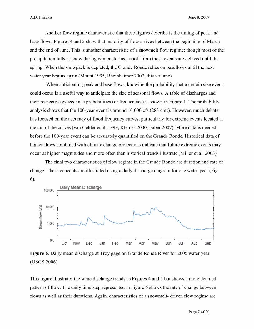
The final two characteristics of flow regime in the Grande Ronde are duration and rate of
change. These concepts are illustrated using a daily discharge diagram for one water year (Fig.
6).
Figure 6. Daily mean discharge at Troy gage on Grande Ronde River for 2005 water year
(USGS 2006)
This figure illustrates the same discharge trends as Figures 4 and 5 but shows a more detailed
pattern of flow. The daily time step represented in Figure 6 shows the rate of change between
flows as well as their durations. Again, characteristics of a snowmelt- driven flow regime are

A.D. Fissekis June 8, 2007
Page 8 of 20
evident. Steep increases in flow followed by gradual runoff declines illustrate a winter storm
pattern where the initial precipitation runs off quickly and the remaining snowpack releases its
stored water more gradually (Mount 1995). Also, the general increase in discharge from January
to May reflects the basin’s gradual increase in total discharge. A gradual rate of change and
prolonged duration are evident during the baseflow season as well. From August through
November, flows remain relatively consistent, reflecting the driest months in the annual water
cycle.
THE INTERACTION OF FLOW REGIME WITH HABITAT The amount of water available during the year has a direct effect on the type of biotic
community that develops. The fundamental way that streamflow affects ecology is by the
physical habitat that it constructs. Flow regimes directly affect the environment with their range
of variability (Poff et al. 1997). Some indirect ways that flow regimes affect aquatic habitats
include the shape and pattern of the river and the size and amount of sediment that is transported.
The variability of a flow regime’s five characteristics directly influences the community
that succeeds in a river’s environment. Magnitude and frequency variability provide critical
seasonal and interannual stresses for a wide array of riverine species (Poff and Ward 1989). One
function associated with frequent high flows is the regular transport of sediment through the river
channel (Leopold et al. 1964). Another characteristic that results from this variability is high
ecological productivity and diversity (Vannote et al. 1980, Poff et al. 1997). The Grande Ronde
contains 38 species of fish, of which 15 are introduced and six (including spring run Chinook
salmon) are federally listed as Threatened or Species of Concern (Nowak and Kuchenbecker
2004).
Timing variability also plays a vital role in shaping the biologic community that succeeds
in a river system. Variable timing functions as an environmental cue that is synchronized with
the life cycles of many aquatic and riparian species (Poff et al. 1997). The life cycle of spring
Chinook salmon is intricately connected to a natural flow regime (Nogroski 2007, this volume).
The life stages for which flow timing acts as a trigger include spawning, egg hatching, rearing,
feeding/reproduction, and migration (Poff et al. 1997, Sommer et al. 2001). One life phase
during which timing plays a critical role is the migration of smolts from the basin to the ocean
(McIntosh et al. 1994). Salmon also benefit from late spring peak flows because they have to

A.D. Fissekis June 8, 2007
Page 9 of 20
opportunity to physiologically develop for the strains of migration as well as the increased threat
of predation in the ocean (Wissmar et al. 1994).
The duration and rate of change of flows also play an important role in shaping the
biologic community. When flows regularly change throughout the year (such as spring peak
flows receding to prolonged baseflow), non-native species that are not adapted to the new flow
patterns will put less competitive pressure on native species that have adapted to the more
stressful environment (Poff et al. 1997, Sommer et al. 2001). Thus native species are favored for
long-term survival over non-native species by the variable rate of change and duration of flows.
LAND USE PRACTICES, FLOW REGIME AND FISH HABITAT OF THE
GRANDE RONDE Overview of Anthropogenic Influences
When Vannote et al. (1980) proposed their River Continuum Concept (RCC), they
argued that the trend of changing downstream communities could be modeled as a gradual
transition in response to the changing fluvial geomorphology and energy sources along a river.
This gradient would be in the form of a consistent pattern of community structure and function.
Specifically, they mention flow and substrate as two physical characteristics that would change
predictably. However, one important limitation of their model is that it applies to natural,
unperturbed stream ecosystems studied over population and evolutionary time scales.
Anthropogenic influences, specifically land use practices, physically change the land cover,
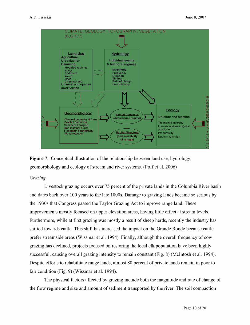
altering the movement of water and sediment through a basin (Poff et al. 2006). These alterations
in physical habitat propagate through ecologic responses, changing the river’s biologic
community (Fig. 7).
Although one downstream section of the Grande Ronde, from the Wallowa River
confluence to the Washington-Oregon border, is designated Wild and Scenic, the impacts of
upstream industry, particularly in the Upper Grande Ronde basin, propagate throughout the river.
Among the major factors affecting the flow regime and thus riparian and aquatic ecosystems are
grazing, logging, roads, stream channelization, mining and agriculture. A complete review of
these industries’ history and impacts can be found elsewhere in this volume (Lawson 2007, this
volume). Effects of land use not directly related to flow regime will only be mentioned here.
A.D. Fissekis June 8, 2007
Page 10 of 20
Figure 7. Conceptual illustration of the relationship between land use, hydrology,
geomorphology and ecology of stream and river systems. (Poff et al. 2006)
Grazing
Livestock grazing occurs over 75 percent of the private lands in the Columbia River basin
and dates back over 100 years to the late 1800s. Damage to grazing lands became so serious by
the 1930s that Congress passed the Taylor Grazing Act to improve range land. These
improvements mostly focused on upper elevation areas, having little effect at stream levels.
Furthermore, while at first grazing was mostly a result of sheep herds, recently the industry has
shifted towards cattle. This shift has increased the impact on the Grande Ronde because cattle
prefer streamside areas (Wissmar et al. 1994). Finally, although the overall frequency of cow
grazing has declined, projects focused on restoring the local elk population have been highly
successful, causing overall grazing intensity to remain constant (Fig. 8) (McIntosh et al. 1994).
Despite efforts to rehabilitate range lands, almost 80 percent of private lands remain in poor to
fair condition (Fig. 9) (Wissmar et al. 1994).
The physical factors affected by grazing include both the magnitude and rate of change of
the flow regime and size and amount of sediment transported by the river. The soil compaction

A.D. Fissekis June 8, 2007
Page 11 of 20
caused by trampling prevents infiltration, which in turn prevents the groundwater table from
recharging and increases surface runoff (Wissmar et al. 1994, Ziemer and Lisle 1999). Because
the water is transported to the river channel by way of surface runoff rather than through
infiltration to the groundwater, the rate of change of flows also becomes more flashy (Poff et al.
2006). In addition, as the livestock feed on and thus reduce the vegetative cover, they also
remove one method of erosion control. As the surface sediments are exposed, they become more
unstable and subject to weathering and erosion (Mount 1995).
Figure 8. Historical patterns of livestock and elk grazing. (McIntosh et al. 1994)
Figure 9. Condition of private lands as determined by the Soil Conservation Service. (Wissmar
et al. 1994)

A.D. Fissekis June 8, 2007
Page 12 of 20
Logging and Infrastructure Development
Logging began during the early 1900s when the highlands of eastern Oregon first became
accessible. As shown in Figure 10, timber harvesting remained minimal until World War II, at
which point the volume of timber removed from the forests jumped 50 percent from 1 million
board feet to 1.5 million board feet. The rate of timber harvest has steadily increased since then
to approximately 2 million board feet per year (Wissmar et al. 1994).
The development of the logging industry was made possible by the development of
transportation in and out of the forests. Road and railroad grades were built in the floodplains
and served as geomorphic controls; that is, they prevented the river from eroding its meandering
channel, reducing aquatic floodplain habitat and causing downcutting into the river bed, reducing
riparian habitat.
Figure 10. Timber harvest rates in eastern Washington and Oregon as determined by the
Washington Department of Natural Resources and the Oregon Department of Forestry. (Wissmar
et al. 1994)
The major impact on flow regime from logging and infrastructure development begins
with the soil compaction and road construction, which result in decreased infiltration and
increased runoff. More significantly, the lack of tree cover leaves the snowpack exposed to solar
radiation, accelerating the rate of snowmelt (Greene et al. 1999). In Oregon, logged areas contain
double the snow-water equivalent (SWE) than unlogged areas, meaning that more snowpack is
accumulating in areas with high sun exposure. Combined with 40 percent more energy from
solar radiaton in clear cut areas as opposed to unlogged areas, the rate of snowmelt increases and

A.D. Fissekis June 8, 2007
Page 13 of 20
the timing of flows shifts earlier in the water cycle (Ziemer and Lisle 1998). Finally, the large-
scale removal of trees reduces evapotranspiration rates, a key component to determining
baseflow levels (Ziemer and Lisle 1998, Greene et al. 1999, Poff et al. 2006, Rheinheimer 2007,
this volume). The result of decreased infiltration, decreased evapotranspiration and increased
surface runoff is increased magnitude and frequency of flows as well as a shift in timing due to
the accelerated snowmelt patterns. Also mass wasting and stream bank erosion occurs when the
stabilizing vegetation is removed from the hillsides, often resulting in massive amounts of fine
sediment runoff into the river, changing the channel geomorphology and increasing
sedimentation.
Urbanization, Agriculture and Irrigation
With 13,000 people, La Grande is the largest population center in the Upper Grande
Ronde basin. As the population increases, so do the water demands of the community. However,
when the total volumes of rural, domestic, municipal, industrial and agricultural diversions are
compared, agricultural irrigation far exceeds any of the other demands. Outflows from La
Grande include numerous irrigation diversions for regional agriculture as well as the State Ditch,
which diverts almost all of the flow from the river. As well as the surface water, outflows include
groundwater that is removed as a result of an increasing number of wells. The wells were
constructed as part of an effort to stimulate farming, recreation and retirement communities in
the area. Inflow at La Grande comes from minimal local flows as well as effluent from the city’s
wastewater treatment plant. The State Ditch returns the diverted flow 40 miles downstream of La
Grande in the town of Elgin. In between these locations, the only source of flow in the Upper
Basin is from Catherine Creek and other minor tributaries (Nowak and Kuchenbecker 2004).
The combined effect of these diversions is a lowered water table as well as the removal of
most of the flow volume from the main channel for the State Ditch (USACE 1999). Additionally,
agricultural clearing of native vegetation reduces evapotranspiration rates and soil infiltration.
These changes result in increased surface runoff as well as more flashy rates of change.
Urbanization creates more impervious areas, which also increase flashy conditions. Overall, flow
regime is affected by changes in magnitude, timing and rate of change of flows (Poff et al. 2006).
The decreased infiltration lowers the water table, while the increased magnitude as well as the
flashy flow conditions increase erosion and sedimentation.

A.D. Fissekis June 8, 2007
Page 14 of 20
Channelization
Regional flooding in 1964 prompted new efforts in flood control, resulting in the
channelization of the Grande Ronde. The purpose of channelization was to prevent lateral
migration of the river and therefore prevent the floodplain from spreading. Channelization
eliminated the meandering shape of the river, affecting the erosion and deposition processes
associated with that shape. It also eliminates the river’s interaction with the floodplain,
exacerbating the problems created by the incision due to logging and infrastructure development
(McIntosh et al. 1994). Finally, channelization increases the velocity of the river, eliminating
velocity refuges uses by salmon near large woody debris and shoals that would have been
present in the natural river (Mount 1995, Sommer et al. 2001).
FLOW REGIME CHANGES ON THE GRANDE RONDE AND THE
RIVER CONTINUUM CONCEPT General Changes
The effects of land use on the Grande Ronde’s flow regime are manifested in two
characteristics: timing and magnitude of flows. Both baseflows and peak flows are increasing in
magnitude (McIntosh et all 1994, Poff et al. 2006). Also, the timing of peak flows has shifted
earlier in the season by almost a month (McIntosh et al. 1994). These changes affect the biotic
community of the Grande Ronde River, prompting a comparison of the altered environment to
the predictions made by the RCC.
Although there is some uncertainty as to how baseflows are changing, there is general
agreement that they are increasing (Fig. 11). Increased baseflows are consistent with the
predicted impacts of logging and agriculture. Both land use practices reduce evapotranspiration
rates, which would reduce the amount of moisture removed from the subsurface flow. Increased
baseflows can result in the washout of eggs and small fish (Poff et al. 1997, Poff et al. 2006).

A.D. Fissekis June 8, 2007
Page 15 of 20
Figure 11. Grande Ronde baseflow trend from 1904-1990 in the Upper Grande Ronde (1
cms=35.3 cfs). (McIntosh 1994)
Peak flow magnitudes have also increased throughout the Pacific Northwest region. Poff
et al. (2006) determined that peak flows increased from eight percent to 33 percent due to
agricultural impacts and 22 percent to 84 percent due to urbanization. The Grande Ronde
contains both land use practices as well as logging and grazing, two other industries that increase
runoff and thus flow magnitudes. While the results of the peak flow analysis were not specific to
the Grande Ronde, they were based on general peak flow trends throughout the northwest United
States. Ecological impacts of increased peak flows include bed armoring due to increased
sediment transport as well as washout of spring Chinook salmon fry and other small fish
(McIntosh et al. 1994, Poff et al. 2006).
Finally, peak flow timing has shifted earlier by approximately one month (Fig. 12). The
shift in timing primarily corresponds to the predicted impacts of logging; however, other land
use practices that decrease infiltration and force discharge to runoff faster contribute to the
increase in peak flows. The main cause, though, is due to increased snow accumulation in clear
cut areas, increased exposure to solar radiation and decreased infiltration (Ziemer and Lisle
1998, Greene et al. 1999, Poff et al. 2006). With more snow exposed to the sun (due to the
increased accumulation in clear cut areas), snowmelt runs off sooner (McIntosh et al. 1994,
Wissmar et al. 1994). The accelerated snowmelt has altered the streamflow regimes, causing
peak flows to occur almost one month early. The ecological effects of earlier peak flows include
a disruption of environmental cues that trigger life cycle transitions. Specifically, when peak
flows arrive early, spring Chinook salmon have less opportunity to develop before leaving their

A.D. Fissekis June 8, 2007
Page 16 of 20
rearing habitat, increasing their physiologic stress and exposure to predation (McIntosh et al.
1994).
Figure 12. Trend in peak flow timing. (McIntosh et al. 1994)
Although land use practices have made a pervasive impact on the Grande Ronde’s flow
regime and ecological health, reversing those effects could reestablish the natural trends of the
basin. Figure 13 shows the recovery period for different land use impacts given their termination.
Figure 13. Recovery period for channels affected by land use practices in the Pacific Northwest
– does not address recovery at downstream locations, only state of recovery at land use site.
(Ziemer and Lisle 1998)
Recovery from grazing practices is relatively rapid because of the fast regeneration and spread of
grassland vegetation. The vegetation re-growth quickly loosens soils in compacted areas,

A.D. Fissekis June 8, 2007
Page 17 of 20
allowing infiltration capacities to increase. The effects of deforestation take longer to recover;
forest re-growth could take several decades before natural levels of forest snow retention and
melt rate are reached. Infrastructure effects are not expected to recover due to the low priority of
road maintenance due to reduced funding (Ziemer and Lisle 1998).
Analysis Limitations
While the general trend of land use impacts can be determined on a small scale,
translating those quantities to a large basin can be difficult. Small basins are typically considered
to be approximately 40 square miles (approx. 100 square kilometers), although Poff et al. (2006)
analyzed basins up to 109 square miles (282 square kilometers). Several studies mention that
land use impacts are only observable in small basins (Ziemer and Lisle 1998, van Noordwijk et
al. 2003, Poff et al. 2006), and that the results cannot be accurately extrapolated to represent a
larger basin.
One reason for this constraint is the variability of rainfall over large areas. Only a small
percentage of a large basin is affected by a single storm event (van Noordwijk et al. 2003). The
effects of a storm event on a small area would have a unique flood generation and routing pattern
that would not accurately describe the patterns in the basin on a large scale. Also, having a
mixture of land uses means that the cause of a specific flow alteration would not be easily
discernable (Poff et al. 2006). However, although land use effects are difficult to quantify on a
large scale, the information gained about the relationship between site conditions and runoff
processes make such research worthwhile (Ziemer and Lisle 1998).
Impact on the River Continuum Concept
Vannote et al. (1980) incorporate land use perturbations into the RCC as reset
mechanisms and predict that the biologic community would recreate the trends found in
headwater communities. However, the accuracy of that prediction is contingent on the type and
location of land use. Ziemer and Lisle (1998) observe that as one moves downstream, land use
that directly affects the channel will have a greater impact on the river’s flow regime than land
use practices located on surrounding hillslopes and tributary headwaters. The generalization
about the effects of land use made by the RCC may accommodate a range of observed patterns
but sacrifices site-specific accuracy. Considering the varied and dynamic forms of land use, the

A.D. Fissekis June 8, 2007
Page 18 of 20
RCC may not accurately predict the downstream trend of biologic communities without a closer
examination of industry specific impacts relative to their downstream location.
CONCLUSION While the RCC is a valuable tool that predicts the downstream communities based on a
gradient of physical characteristics, it is better suited for natural stream ecosystems rather than
for rivers affected by extensive land use practices. Vannote et al. (1980) postulate that the RCC
should accommodate unnatural disturbances; however, several studies observe that the
cumulative effects of land management need to be better understood (McIntosh et al. 1994,
Wissmar et al. 1994, Ziemer and Lisle 1998, Greene et al. 1999, van Noordwijk et al. 2003, Poff
et al. 2006). One area that is affected by land management is the natural flow regime. However,
given the natural variability of a basin’s flow regime as well as the impacts of climate change,
quantifying the impacts of land use becomes difficult (Poff et al. 1997, Rheinheimer 2007, this
volume). Given the daunting task, of particular concern is the extent to which land use practices
in upland forest zones play a role in affected riparian and aquatic communities (McIntosh et al.
1994, Wissmar et al. 1994). Without a good understanding of the effects of land use in all
regions of the basin, the RCC could predict a system within such a large range of possibilities
that the model losses credibility. However, rather than discard the RCC, new research that
develops our understanding of the relationship between land use practices and physical
components such as flow regime would help the RCC make more accurate predictions of
downstream aquatic and riparian communities within highly disturbed river environments.
A.D. Fissekis June 8, 2007
Page 19 of 20
REFERENCES
Faber, B. 2007. Limitation on Extrapolating Flood Frequency Distributions. Extreme Precipitation Conference. Sacramento, CA.
Greene, E.M., Liston, G.E., Pielke Sr., R.A. 1999. Relationships between landscape, snowcover
depletion, and regional weather and climate. Hydrologic Processes. 13: 2453-2466 Klemes, V. 2000. Tall tales about tails of hydrological distributions. Journal of Hydrologic
Engineering. 5 (3):227-239 McIntosh, B.A., Sedell J. R., Smith J.E., Wissmar, R. C., Clarke, S.E., Reeves, G.H., Brown,
L.A. 1994. Management history of eastside ecosystems: changes in fish habitat over 50 years. Eastside Forest Ecosystem Health Assesment. 3. United States Department of Agriculture, Forest Service
Poff, L.J., Allan, J.D., Bain, M.B., Karr, J.B., Prestegaard, K.L., Richter, B.D., Sparks, R.E.,
Stromberg, J.C. 1997. The natural flow regime: a paradigm for river conservation and restoration. BioScience 47: 769-784
Poff. N.L., Bledsoe, B.P., Cuhaciyan, C.O. 2006. Hydrologic variation with land use across the
contiguous United States: geomorphic and ecological consequences for stream ecosystems. Geomorphology 79: 264-285
Sommer, T., Harrell, B., Nobriga, M., Brown, R., Moyle, P., Kimmerer, W., Schemel, L. 2001.
California’s Yolo bypass: evidence that flood control can be compatible with fisheries, wetlands, wildlife and agriculture. Fisheries. 26 (8): 6-16
U.S. Federal Highway Administration. www.fhwa.dot.gov/ENVIRONMENT/stream1.gif.
Accessed 04/23/2007USGS. 2006. Grande Ronde River Basin. Van Gelder, P.H.A.J.M., Van Noortwijk, J.M., and Duits, M., 1999. Selection of probability
distributions with a case study on extreme oder river discharges. Safety and Reliability. 2:1475-1480
van Noordwijk M, Farida, D Suyamto, B Lusiana and N Khasanah. 2003. Spatial
variability of rainfall governs river flow and reduces effects of land use change at landscape scale: Gen River and Spat Rain simulations. MODSIM.: Natural Systems. 2: 571-583.
Vannote, R.L., Minshall, G.W., Cummins, K.W., Sedell, J.R., Cushing, C.E. 1980. The river continuum concept. Can. J. Fish. Aquat. 37: 130-137

A.D. Fissekis June 8, 2007
Page 20 of 20
Wallowa County Salmon Recovery Strategy Committee. 1999 Wallowa County - Nez Perce Tribe Salmon Habitat Recovery Plan with Multi-Species Management Strategy.
Wissmar, R.C., Smith, J.E., McIntosh, B.A., Li, H.W., Reeves, G.H., Sedell, J.R. 1994. Ecological health of river basins in forested regions of eastern Washington and Oregon. Eastside Forest Ecosystem Health Assesment. 3. United States Department of Agriculture, Forest Service.
Ziemer, R.R. and Lisle, T.E. 1998. River Ecology Management: Lessons from the Pacific
Coastal Ecoregion. Springer-Verlang. New York: 43-68