Embed Size (px)
Citation preview

Realising the potential of environmental data, models and toolsRealising the potential of environmental data, models and tools
The Environmental Virtual Observatory (Pilot):A new vision for Catchment Science
PIs: B Emmett (CEH), R J Gurney (Reading), D Tetzlaff (Aberdeen), J E Freer(Bristol), A Mcdonald (Leeds), G Rees (CEH), W Buytaert (Imperial), G Blair(Lancasters), and P Haygarth (Lancaster)
CoIs:Keith Beven (Lancaster), John Bloomfield (BGS), Penny Johnes (Reading),Paul Quinn (Newcastle), Mark Macklin (Abserystwyth), Christopher Macleod(Macaulay), Sim Reaney (Durham), Marc Stutter (James Hutton Institute)
PDRAs: Marcia Tavares-Smith, (Lancaster), Mark Wilkinson (Newcastle), YehiaEl-Khatib (Lancaster), Claudia Vitolo (Imperial) Alastair Gemmell (Reading)Eleanor Mackay (Lancaster), Nicola Thomas (Aberystwyth), Nick Odoni(Bristol), and Keith Marshall (James uhtton institute)
Realising the potential of environmental data, models and tools
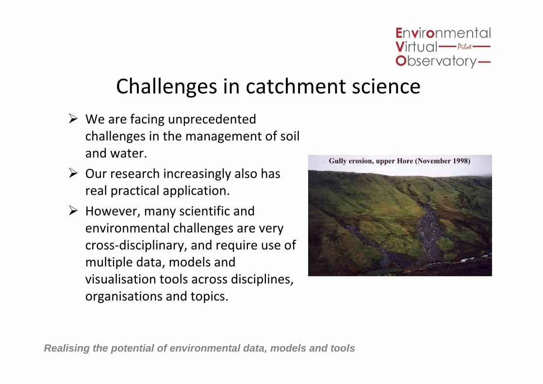
Challenges in catchment science
We are facing unprecedentedchallenges in the management of soiland water.
Our research increasingly also hasreal practical application.
However, many scientific andenvironmental challenges are verycross-disciplinary, and require use ofmultiple data, models andvisualisation tools across disciplines,organisations and topics.

Realising the potential of environmental data, models and tools
Solutions?
Is there are a way of providing the‘wiring’ to help people access whatresources they need, be they ascientist, policy maker, industrialbody, regulator or public?
Resources would have to gobeyond data (not that useful tomost people)…. so models andtools (visualisation, decisionsupport and valuation)
©Shutterstock

Realising the potential of environmental data, models and tools
What are the opportunities offered by newcloud technologies?
They offer a way to connect andintegrate our current fragmenteddata, models and knowledge.
The key to the cloud approach is therepresentation of everything as aservice, that is our data, models,visualisation tools and expertknowledge.
And then to view the cyber-infrastructure as a “cloud” of servicesout there that can be used andcombined in arbitrary ways, in this caseto solve environmental questions.

Realising the potential of environmental data, models and tools
HOLY GRAIL OF INTEROPERABILITY

Realising the potential of environmental data, models and tools 6

Realising the potential of environmental data, models and tools
Everything As a Service
[source: Zhang, Cheng, and Boutaba, 2010]
SalesForce.com
Realising the potential of environmental data, models and tools
If you’re like me – you’re a bit lost now....
• Only one way of finding out – try it out on real exemplars:
– UK Natural Environment Research Council funded a 2 year pilot project
– Unusually, project driven by scientists, endusers and techies together
– Three scales to capture different issues and audiences (local, nationaland global)
– Deal with data, models and visualisations
• Make sure we ask people what they really want
– 17 PIs, 13 institutions, 12 Endusers on Project Advisory Board fromwater companies, policy, software companies, land managers etc
• Not afraid to fail but doing it early and iterate with an even wider groupof endusers
• Link across to other projects globally so as not to reinvent the wheel

Realising the potential of environmental data, models and tools
Questions the EVO could help answer
ScientistsHow do we define which
model is better to select fromour model ensemble?
What kind of lanuage/tools touse to make models talk to
each other.
Water IndustryHow can we convert into saleable
product for UK plc?What is the whole impact of future
flooding?How can water security be assured?How can the industry carbon impact
be reduced?
PublicWill London run out of water?What is the state of the local
river?What are the options toprotect us from future
flooding?
RegulatorsHow can we reducemonitoring for same
information?Credible apportioning ofpollutant load between
industry, water, agriculture,other.
GovernmentAgencies
What models work?What policy works?
How do I do it for lessmoney?
EVO cloud

Realising the potential of environmental data, models and tools
But this is not enough for the techies to go on…
• Which data needs to be assimilated? Static or live?
• Which models? How linked?
• How do you want to visualise outputs?
• Need to be realistic about what is possible so apps forphones are not a priority
• And needs to testand demonstrate fundamentals of thecloud (techies have their needs to!). Exemplars had to showadded value of cloud
Storyboards

Realising the potential of environmental data, models and tools
Storyboard

Realising the potential of environmental data, models and tools
User Login
What part of the
country do you
want to look at?Choose location
What are you
interested in?Choose topic
Submit
What level do you want to use?
Beginner
Intermediate
Expert
Submit
User logs in to portal
Issue: User either has to know how toregister and log in or must be shown.Needs to be clear instructions fromfront page
Issue: linking up between catchmentwebpages and EVOp needs thinkingabout
User selects location of area they areinterested in, may also need search boxby name or postcode.
User selects topic (only flood riskactive) – submit
Issue: Will this portal be for everyoneor vary by user or scale or use e.g. local,national?Issue: Who is responsible for interfacedevelopment?
User selects level at which they want tointeract with data. This screendifferentiates users and determineswhat accessibility is needed in the restof the portal.
Issue: Will this be defined by userprofile when registering? Or would thattake away functionality unnecessarily?
2. Entering the portal(Eden catchment example)
Realising the potential of environmental data, models and tools
What are the land
uses in this area?
Slide land uses on
graph to changeGrazing, 80%
Crops, 10%
Woodland, 5%Urban, 5%
How well managed
is the land?
Use Slider
Bad
practice
Good
practice
SubmitSpecify management
Change
scenario
Ask a question
Upload info
What do you
think?
Return to
screen 3B
What does this mean?Animate prediction
Your Flood risk prediction #2
Chance of this area
flooding? Use Slider
What does
this mean?
Mouse over
graphVery HighVery low
What do you think?Calculate costs and
benefits of options
Impacts of Flooding #2 Tell me more
about:
Uncertainty in
these flood
estimates
Impact table
Impact Table Model run #1 Modelrun #2
Environmental X km2
Economic Loss offarmland £X,
Social X number ofhouses
Feedback form
Submit
Feedback on Model run #1
MyCatchment
Ask a question
Upload info
What do you
think?
Comments
Feedback on Model run #1….
Comments
Feedback on Model run #1….
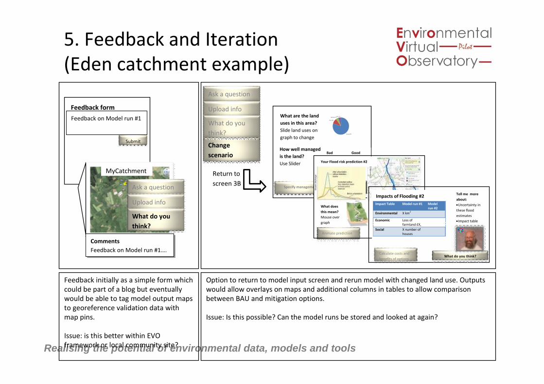
5. Feedback and Iteration(Eden catchment example)
Feedback initially as a simple form whichcould be part of a blog but eventuallywould be able to tag model output mapsto georeference validation data withmap pins.
Issue: is this better within EVOframework or local community site?
Option to return to model input screen and rerun model with changed land use. Outputswould allow overlays on maps and additional columns in tables to allow comparisonbetween BAU and mitigation options.
Issue: Is this possible? Can the model runs be stored and looked at again?

Realising the potential of environmental data, models and tools
BUT WHY WOULD ANYONE MAKETHEIR DATA, MODELS OR TOOLSAVAILABLE TO THE EVO CLOUD?

Realising the potential of environmental data, models and tools
Security• Some datasets in the EVO will have access open to some but closed to others.
• How to handle access rights? Delegating the user’s credentials was the keyissue:
– User logs onto portal
– Portal then accesses secure data on user’s behalf (‘one hop’)
– Often Portal accesses WPS which in turn accesses secure data (‘two hops’)
• ‘Mash my data’ project solved these issues using OpenID and Proxycertificates. The user only has to sign on once and system keeps track of whatthey can do
– Similar scenario using it to run simple models such as in EVOp
• Security of data-altering also a major issue; Currently digital data is notadmissible in court e.g. for water quality.
Other projects found that security issues dictated thearchitecture of the whole system – so need to sort early.

Realising the potential of environmental data, models and tools
Developments for interoperability
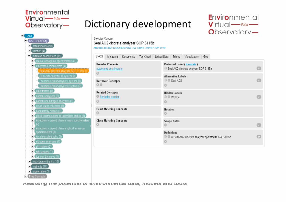
• Lessons from the CEHInformation Gateway(www.gateway.ceh.ac.uk)assimilating e.g. thePlynlimon legacy datasets,revealed a requirement fordictionaries to describe data.
• Links between locations, widearray of observations andanalyses need to be defined
Realising the potential of environmental data, models and tools
Dictionary development

Realising the potential of environmental data, models and tools
Gaining information from linked data

Realising the potential of environmental data, models and tools
Current linked data map …

Realising the potential of environmental data, models and tools

Realising the potential of environmental data, models and tools
We will deliver a prototype portal
User ScenariosTopics Resources Services
Authentication
Inside CloudInside Cloud
Outside Cloud Outside Cloud
data
maps
models
Visualtools
Open Open

Realising the potential of environmental data, models and tools
But …. most will be inactive with just our 3 exemplars live:Our aim is to show potential and thus drawdown next phase of funding
User ScenariosTopics Resources Services
Authentication
Inside CloudInside Cloud
Outside Cloud Outside Cloud
maps
Visualtools
Open Open
Imogendata
soil

Realising the potential of environmental data, models and tools
International related Projects• CUAHSI
– Provides unified access to data, tools and models relating to hydrological research
– Very data-oriented, but could help in visualisation
• Critical zone observatories / Soiltrec– Major data assimlation effort, combining with hydrological models and visualisation tools - only project with major modelling
component we have come across
• INTAMAP– Provides real time visualisation of critical environmental variables
– Uses OGC WPS and R interpolation modules
– Developed UncertML
• NeOn– Provides support to semantic distributed applications
– Developed the NeOn toolkit to import and manage ontologies
• LIS– Distributes embarrassingly-parallel processes over a flexible computational facility
– Uses DODS to abstract remote data sources location and format
– Uses GrADS, Live Access Server (LAS), Ferret, Matlab, Excel, etc. for visualisation
• GIGAS– Focuses on the representation and access interoperation of 3 initiatives:
• GEOSS: climate, biodiversity, energy, weather, etc.
• GMES: land, sea and air
• INSPIRE: any spatial information2005 to 2015
• HUMBOLDT– Aims to demonstrate the benefits of harmonising spatial information using the standards of INSPIRE.
Realising the potential of environmental data, models and tools
If the EVO is successful, what is the benefit forscientists?
• Enabling environmental researchers to concentrate onscience “Fewer wheels, more environmental science.”
• Not only those ‘in the know’ will be able to discover dataportals and information “Democratisation of science”
• Stop re-invention and repeated blind alleys e.g. re-
implementing models, file import and export routines etc.; End-users alsosuspect many contracts ‘reinvent’ work due to poor communication and lostknowledge
• Improved reputation of greater transparency andcontribution to societal needs

Realising the potential of environmental data, models and tools
What would be wider implications…?
• The EVO would make our sciencewhich underpin management optionsand decisions to deal with our mosturgent environmental problems more:– Efficient
– Effective
– And transparent
• And provide tools to help managersidentify the best options for today andan array of likely futures

Realising the potential of environmental data, models and tools

Realising the potential of environmental data, models and tools
QUESTIONS?

Realising the potential of environmental data, models and tools
But, what is Cloud Computing (contd)?
• Coulouris, Dollimore, Kindberg and Blair:– A cloud is defined as a set of Internet-based
application, storage and computing servicessufficient to support most users’ needs, thusenabling them to largely or totally dispensewith local data storage and applicationsoftware. The term also promotes a view ofeverything as a service from physical or virtualinfrastructure through to software, often paidfor on a per-usage basis rather than purchased