Embed Size (px)
Citation preview

IntroductionElassona basin is located in Thessaly, CentralGreece. It is crossed by the Titarisios River, whichdrains an area of 107.75 km². The geological base-ment of the basin belongs to the PelagonianZone.. In Potamia basin, (Elassona –Thessaly), twolignite deposits of 187.5 × 10⁶ tn (Domeniko: 167 ×10⁶ tn and Amourion: 20.5 × 10⁶ tn) have beenidentified (Dimitriou 1997). The exploitation ofthese two lignite deposits will result in changes ofthe natural and human environment of thearea.For the understanding and estimation of theenvironmental impacts that will incur from theprospective lignite exploitation, the evaluation ofthe current hydrogeological, hydrological, geo-morphological characteristics and the land use isof great interest. Specifically, the water balance, hy-drometeorological data, quantitative and qualita-tive analysis of the drainage networks of the areawere studied. In this paper we compare the cur-rent status in the area to that existing 30 years agoand anticipate the trend in the future. At this timethere are no specific plans for the exploitation ofthese two lignite deposits, the research is in pre-liminary stage.
geological settingsThe basement of the Neogene basin of Elassonageotectonically belongs to the ‘’Pelagonian Zone’’(IGME sheet, 1987). It consists of (figure 1):
• Marbles of the middle Triassic, which form thenorth outcrops near Evagelismos and Paleokas-tro and part of the south-east boundary of thebasin, near Domeniko. They also have beenpenetrated by some boreholes in the basementof the basin.
• Schists, gneiss-schists and gneisses, which un-derlay and form a ‘’ring’’ around the abovementioned karstified marbles.
• The Paleozoic gneiss with acid intrusions ofgranites, which forms the western boundary ofthe basin.
Hydrogeological settingsHydrogeological conditions of this area deter-mine the exploitation or not of these deposits.The area is covered by Quaternary and Neogenedeposits, in which the permeability varies.Potamia basin is more or less surrounded by im-pervious formations, schists, gneiss-schists andgneisses, which form impermeable boundaries.(Beloukas 1988) The overlaying marbles of thePelagonian series are of limited extend and thick-ness, especially in the area of Evagelismos and inthe basement of the basin, the total recharge vol-ume of it was estimated at about 3 × 10⁶ m³/year.So they are of minor importance concerning theirwater storage capacity. In the same formation,south of Domeniko, groundwater flows mainly tothe east and has a discharge point out of the basin.The only karstic formartion of major importanceis the one of the autochthonous series north of Ke-falovriso (karstic massif of Krania). Groundwatershave significant recharge from infiltrations, perco-lations of rivers, torrents and karstic volumes(Manakos, 1999).
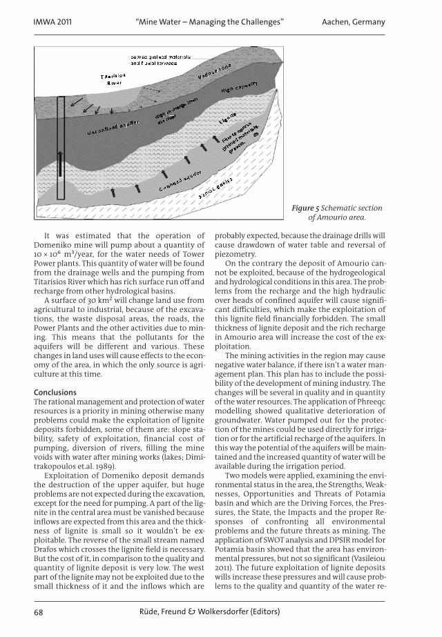
The springs at Kefalovriso (40 × 10⁶ m³/year)with an average flow of 1.3 m³/sec is the main dis-charge point of the above mentioned karsticaquifer (figure 2). These marbles as well as theTitarisios River are the main sources of rechargefor the aquifers of the filling of the basin at thenorthern boundaries of it. It was estimated thatan average quantity of 28 × 10⁶ m³/year, are perco-lated in the karstic mass of Krania (Vasileiou 2011).
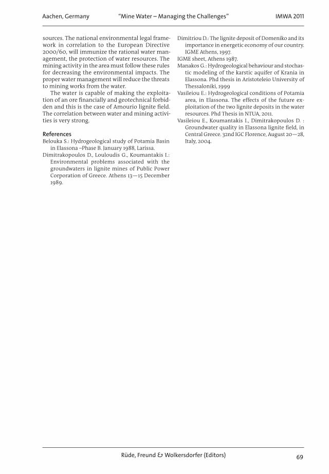
There is also rich surface run-off. The springsat Amourio area (figure 3; 13 × 10⁶ m³/year), in thealluvial sediments of the basin. Additionally, thebasin is crossed by Titarisios River (109 × 10⁶
Aachen, Germany IMWA 2011“Mine Water – Managing the Challenges”
Rüde, Freund & Wolkersdorfer (Editors) 65
the exploitation of lignite deposits in relation with the surface and groundwater inthe mining area — the case study of potamia basin, thessaly, greece
Eleni Vasileiou, Ioannis Koumantakis
National Technical University of Athens, School of Mining Engineering-Metallurgy, Section of GeologicalSciences, Laboratory of Engineering Geology & Hydrogeology, Heroon Polytechneiou 9, 15780,
[email protected], [email protected]
abstract The aim of this paper is to investigate the correlation of water resources and exploitation of lignitedeposits. This research took place in Elassona basin, in Thessaly, where two lignite deposits have been found,but the exploitation of them has not started yet. Multiple criteria have been analysed (geological, hydrogeo-logical, hydrological, hydrochemical etc) with the purpose of estimating the changes that will be caused duringthe mining activities in the area. The difficulties that the surface and groundwater cause to the lignite ex-ploitation are also examined.
Key Words mining, aquifers, hydrogeology, surface run-off, groundwater
Proceedings_Theme_01_Proceedings IMWA 2011 22/08/2011 12:36 AM Page 65

IMWA 2011 Aachen, Germany“Mine Water – Managing the Challenges”
Rüde, Freund & Wolkersdorfer (Editors)66
Figure 1 Simplified Geologi-cal map of the Potamia
basin.
Figure 2 Diagram of dis-charge fluctuation in Ke-
falovriso springs.
Figure 3 Diagram of dis-charge fluctuation in
Amourio springs.
nah claunnA
55,
05,
5,4
0,4
)ce/s
nirp sosurvolafe Kn iegrahcsi dff d oegn
)8002-2791 (sgn
5,3
0,3
5,2
0,2
51,
01,
5,0
0,0
3m (egrahc
isD
raYe
nMi
xMa
egraevA
C hanges of dis c harge in Amourio s prings (1972-2008)
0,00,20,40,60,81,01,21,41,61,82,02,22,42,62,8
1972
1974
1976
1978
1980
1982
1984
1986
1988
1990
1992
1994
1996
1998
2000
2002
2004
2006
2008
Year
Dis
char
ge(m
3 /sec
)
min
max
average
Proceedings_Theme_01_Proceedings IMWA 2011 22/08/2011 12:36 AM Page 66
m³/year), which is developed by the conflux ofBoulgari and Elassonitikos Rivers. The annual rainfall in the area, is about 549 mm/year. The totalamount of evaporation is very high in about 80%,the percolation is about 12% and the surface runoff 8% (Vasileiou 2011). The recharge of the basinis supported additionally by the infiltration of therivers. The recharge from Boulgaris and Elassoni-tikos rivers is rich, because it comes from other hy-drological basins in higher elevations, in whichthe rainfalls are higher. Boulgaris River has addi-tional supply from the Kefalovriso springs andsome small torrents in the west boundaries of thearea. In figures 2, 3 it is obvious that Kefalovrisosprings have a big capacity, even though there is adecrease during the period 1973—2008. The driedup rate (Maillet, 1905), a=10⁻² d⁻¹, shows that thiskarstic system is drained very quickly. On the con-trary Amourio springs have value of dried up rateabout a=10⁻³ d⁻¹, which means that this is a verygood hydraulic system, with normal operation(Vasileiou, 2011).
In Potamia basin, two aquifers are developed,one unconfined aquifer overlying of lignite de-posits, that has low capacity and one confinedaquifer underlying. In Domeniko sub-basin, theupper unconfined aquifer will be totally draineddue to the exploitation of lignite. The averagethickness of it is about 100m and the capacity islow. The transmissivity values are about 10⁻⁴–10⁻⁵ m²/sec, which are approved from the low welldischarges (30—40 m³/h). The hydrostatic pres-sures from the confined aquifer will be significantin the areas that the thicknesses of lignite de-posits are very small, the average thickness of thisaquifer is about 60 m and the discharge is about20—30m³/h (figure 4). This happens only in thewest boundaries of the mine, in the central areaof the basin near to the River Elassonitikos. In this
area there is expected recharge from the river andthe Quaternary deposits. A net of wells drainagewill be necessary in this area, to ensure the rightexploitation of the deposits.
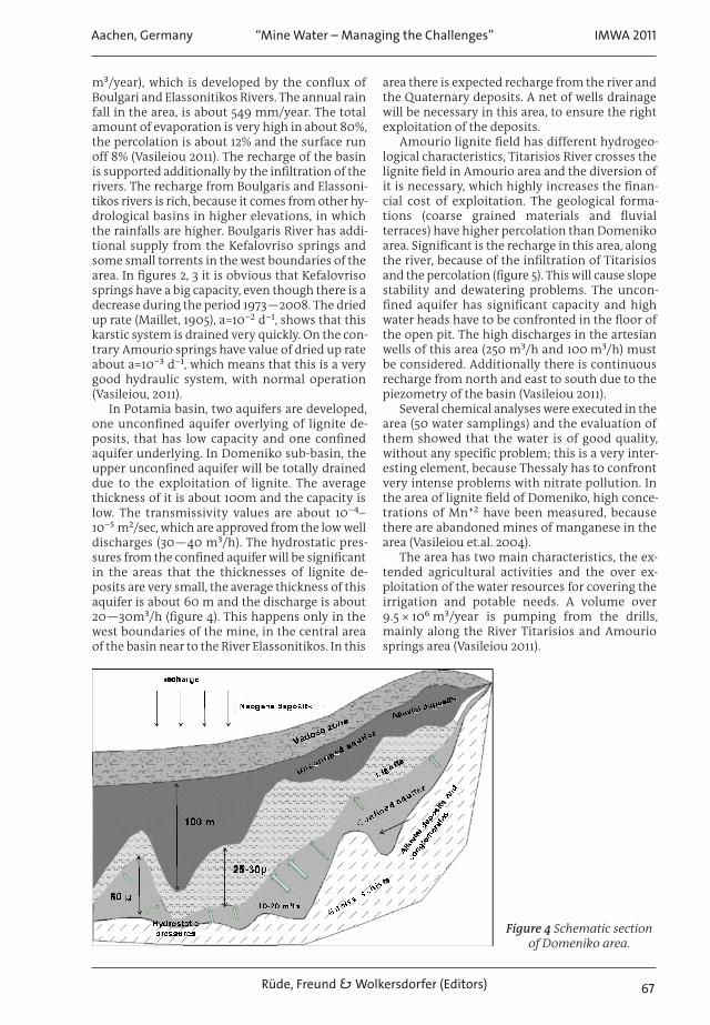
Amourio lignite field has different hydrogeo-logical characteristics, Titarisios River crosses thelignite field in Amourio area and the diversion ofit is necessary, which highly increases the finan-cial cost of exploitation. The geological forma-tions (coarse grained materials and fluvialterraces) have higher percolation than Domenikoarea. Significant is the recharge in this area, alongthe river, because of the infiltration of Titarisiosand the percolation (figure 5). This will cause slopestability and dewatering problems. The uncon-fined aquifer has significant capacity and highwater heads have to be confronted in the floor ofthe open pit. The high discharges in the artesianwells of this area (250 m³/h and 100 m³/h) mustbe considered. Additionally there is continuousrecharge from north and east to south due to thepiezometry of the basin (Vasileiou 2011).
Several chemical analyses were executed in thearea (50 water samplings) and the evaluation ofthem showed that the water is of good quality,without any specific problem; this is a very inter-esting element, because Thessaly has to confrontvery intense problems with nitrate pollution. Inthe area of lignite field of Domeniko, high conce-trations of Mn⁺² have been measured, becausethere are abandoned mines of manganese in thearea (Vasileiou et.al. 2004).
The area has two main characteristics, the ex-tended agricultural activities and the over ex-ploitation of the water resources for covering theirrigation and potable needs. A volume over9.5 × 10⁶ m³/year is pumping from the drills,mainly along the River Titarisios and Amouriosprings area (Vasileiou 2011).
Aachen, Germany IMWA 2011“Mine Water – Managing the Challenges”
Rüde, Freund & Wolkersdorfer (Editors) 67
Figure 4 Schematic sectionof Domeniko area.
Proceedings_Theme_01_Proceedings IMWA 2011 22/08/2011 12:36 AM Page 67
It was estimated that the operation ofDomeniko mine will pump about a quantity of10 × 10⁶ m³/year, for the water needs of TowerPower plants. This quantity of water will be foundfrom the drainage wells and the pumping fromTitarisios River which has rich surface run off andrecharge from other hydrological basins.
A surface of 30 km² will change land use fromagricultural to industrial, because of the excava-tions, the waste disposal areas, the roads, thePower Plants and the other activities due to min-ing. This means that the pollutants for theaquifers will be different and various. Thesechanges in land uses will cause effects to the econ-omy of the area, in which the only source is agri-culture at this time.
ConclusionsThe rational management and protection of waterresources is a priority in mining otherwise manyproblems could make the exploitation of lignitedeposits forbidden, some of them are: slope sta-bility, safety of exploitation, financial cost ofpumping, diversion of rivers, filling the minevoids with water after mining works (lakes; Dimi-trakopoulos et.al. 1989).
Exploitation of Domeniko deposit demandsthe destruction of the upper aquifer, but hugeproblems are not expected during the excavation,except for the need for pumping. A part of the lig-nite in the central area must be vanished becauseinflows are expected from this area and the thick-ness of lignite is small so it wouldn’t be ex-ploitable. The reverse of the small stream namedDrafos which crosses the lignite field is necessary.But the cost of it, in comparison to the quality andquantity of lignite deposit is very low. The westpart of the lignite may not be exploited due to thesmall thickness of it and the inflows which are
probably expected, because the drainage drills willcause drawdown of water table and reversal ofpiezometry.
On the contrary the deposit of Amourio can-not be exploited, because of the hydrogeologicaland hydrological conditions in this area. The prob-lems from the recharge and the high hydraulicover heads of confined aquifer will cause signifi-cant difficulties, which make the exploitation ofthis lignite field financially forbidden. The smallthickness of lignite deposit and the rich rechargein Amourio area will increase the cost of the ex-ploitation.
The mining activities in the region may causenegative water balance, if there isn’t a water man-agement plan. This plan has to include the possi-bility of the development of mining industry. Thechanges will be several in quality and in quantityof the water resources. The application of Phreeqcmodelling showed qualitative deterioration ofgroundwater. Water pumped out for the protec-tion of the mines could be used directly for irriga-tion or for the artificial recharge of the aquifers. Inthis way the potential of the aquifers will be main-tained and the increased quantity of water will beavailable during the irrigation period.
Two models were applied, examining the envi-ronmental status in the area, the Strengths, Weak-nesses, Opportunities and Threats of Potamiabasin and which are the Driving Forces, the Pres-sures, the State, the Impacts and the proper Re-sponses of confronting all environmentalproblems and the future threats as mining. Theapplication of SWOT analysis and DPSIR model forPotamia basin showed that the area has environ-mental pressures, but not so significant (Vasileiou2011). The future exploitation of lignite depositswills increase these pressures and will cause prob-lems to the quality and quantity of the water re-
IMWA 2011 Aachen, Germany“Mine Water – Managing the Challenges”
Rüde, Freund & Wolkersdorfer (Editors)68
Figure 5 Schematic sectionof Amourio area.
Proceedings_Theme_01_Proceedings IMWA 2011 22/08/2011 12:36 AM Page 68
sources. The national environmental legal frame-work in correlation to the European Directive2000/60, will immunize the rational water man-agement, the protection of water resources. Themining activity in the area must follow these rulesfor decreasing the environmental impacts. Theproper water management will reduce the threatsto mining works from the water.
The water is capable of making the exploita-tion of an ore financially and geotechnical forbid-den and this is the case of Amourio lignite field.The correlation between water and mining activi-ties is very strong.
referencesBelouka S.: Hydrogeological study of Potamia Basin
in Elassona –Phase B. January 1988, Larissa.Dimitrakopoulos D., Louloudis G., Koumantakis I.:
Environmental problems associated with thegroundwaters in lignite mines of Public PowerCorporation of Greece. Athens 13—15 December1989.
Dimitriou D.: The lignite deposit of Domeniko and itsimportance in energetic economy of our country.IGME Athens, 1997.
IGME sheet, Athens 1987.Manakos G.: Hydrogeological behaviour and stochas-
tic modeling of the karstic aquifer of Krania inElassona. Phd thesis in Aristoteleio University ofThessaloniki, 1999
Vasileiou E.: Hydrogeological conditions of Potamiaarea, in Elassona. The effects of the future ex-ploitation of the two lignite deposits in the waterresources. Phd Thesis in NTUA, 2011.
Vasileiou E., Koumantakis I., Dimitrakopoulos D. :Groundwater quality in Elassona lignite field, inCentral Greece. 32nd IGC Florence, August 20—28,Italy, 2004.
Aachen, Germany IMWA 2011“Mine Water – Managing the Challenges”
Rüde, Freund & Wolkersdorfer (Editors) 69
Proceedings_Theme_01_Proceedings IMWA 2011 22/08/2011 12:36 AM Page 69

IMWA 2011 Aachen, Germany“Mine Water – Managing the Challenges”
Rüde, Freund & Wolkersdorfer (Editors)70
Proceedings_Theme_01_Proceedings IMWA 2011 22/08/2011 12:36 AM Page 70