Embed Size (px)
Citation preview
RE
SP
ON
SIV
E S
YS
TE
MS
FALL 2012
Louisiana S
tate University
Robert R
eich School of Landscape A
rchitectureS
chool of Architecture
Bradley CantrellAssociate ProfessorRobert Reich School of Landscape Architecture
Frank MelendezAssistant ProfessorSchool of Architecture
Atchafalaya Basin | Land + Water InterfaceModeling Daily Water Conditions
RE
SP
ON
SIV
E S
YS
TE
MS
FALL 2012
Bradley CantrellAssociate ProfessorRobert Reich School of Landscape Architecture
Frank MelendezAssistant ProfessorSchool of Architecture
Brennan DedonBreton SmithBryce LambertChad CaletkaCharles PruittDanielle MartinDarren SharkeyDevon BoutteHunter LeroJi ParkJosh BrooksJustine HolzmanKevin KimballKevin NguyenKim NguyenLogan HarrellLou TonoreLuke VenableMarcia GibsonMartin MoserRhett ParkerRobert HerkesRyan SteibLogan HallSteven Mansfield
StudioAdvances in technology have drastically altered traditional methods of analysis, construction, representation, and collabo-ration. Architects, landscape architects and designers address temporal landscape and dynamic architectural elements through biological and computational devices that are responsive to humans and ephemeral environmental stimuli. The paradigm shift in architectural and environmental design from the static to the dynamic requires designers to understand how responsive objects and systems function within larger ecological fields. This advanced topic studio explores the role of the designer and their ability to develop responsive architectural and land-scape systems.
Students are asked to research sensing devices, diagram and map site related and real-time data, create working prototypes, develop case studies, examine nascent technologies and propose speculative ar-chitectural and landscape scenarios. The studio engages a range of site scales within Louisiana, focusing primarily on the Atchafalaya Basin, with each design team focusing on a specific site. Students are expected to speculate on how new respon-sive interventions could be used to en-hance and reinvigorate the sites. The stu-dio entertains a broad range of approaches organized around concepts of emergence,
object orientation, self-organization, and cultural/social expression.
The studio is envisioned in two phases. Phase 01 engages the course content and asks the students to develop entries for the 4th Advanced Architecture Competition: City Sense. The competition asks students to generate ideas, proposals, and visions of possible scenarios for a self sustaining city or building. The competition calls for entries that research and demonstrate the impact that real-time data collection might have on sensor-driven habitats and cities.
Students continue to develop the competi-tion proposals in Phase 02 of the semester. Participating in digitally focused workshops, students are expected to advance their de-sign and computational skills by complet-ing a series of tutorials that apply physical computing and scripting paradigms to their projects. Responsive and interactive com-ponents and prototypes are developed through digital and physical models. Em-ploying a bottom-up approach to design, these components and prototypes are de-veloped into architectural and landscape systems. The design teams determine the exact scale, scope, and programmatic im-plications of the final proposals.
01 Digital Prototype (parametric mod-el driven by inputs)
In groups of 2-3 from the original competi-tion teams the students developed a digital prototype of one of the responsive devices/systems in the original team proposal. This prototype utilized Rhino to create the model and Grasshopper to drive the dynamic in-puts; ie sensors and their inputs that drive responsive actions.The model focused on the devices formal aesthetic and the trans-formations the device will make. The Grass-hopper components were used to drive ac-tual values within the digital model such as rotation (0-360 degrees), transformations (movement in feet/meters) and/or binary actions (off/on).
Deliverables: Rhino model, Grasshopper definition and appropriate conceptual dia-grams and models.
02 Digital-Analog Prototype (1-2 sen-sors)
Further developing the digital model the students wired the inputs created in Grass-hopper to the Firefly Uno Read component driven by an Arduino and connected sen-sors. The sensor data directly controlled the digital device creating a virtual proto-type that was connected to environmental phenomena.
The prototype paid close attention to the interaction between the sensed data and how the information is remapped to cre-ate desired responses in the digital model. The digital prototype needed to respond in a clear and understandable manner. The prototype focused on 1-2 sensors driving actions within the digital prototype.
It was necessary for some projects to cre-ate environments (models) that could be adjusted to provide the sensing field. This could have been a scaled model that simu-lates the phenomena that is being sensed, a constructed environment or other meth-ods that the group devises.
Deliverables: Rhino model, Grasshopper definition, sensor circuit(s) and appropriate conceptual diagrams and models.
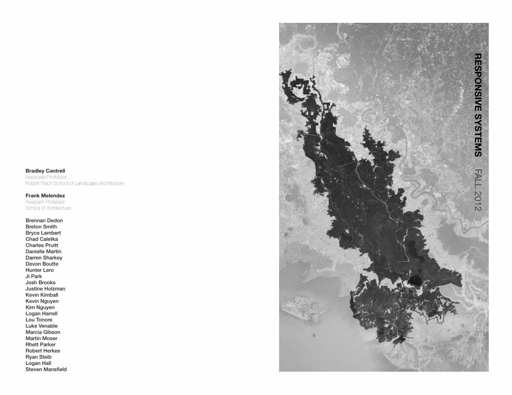
03 Digital-Analog Physical Prototype
After creating a responsive digital prototype each group used the digital model and ana-log sensors to construct a physical proto-type. The Firefly Uno Read was connected to the Uno Write component to connect to the Arduino to drive servos, LEDs or any other physical component necessary to de-velop the physical prototype.
The physical prototype expanded the sens-ing and responses to create a fully articulat-ed device that provides a proof of concept for a working device. This device attempted to capture the complexity of the sensing methods and the associated responses. Rather than exploring single interactions it was necessary to orchestrate a range of sensing and responses that fully explore how this device might function within the environment.
Deliverables: Rhino model, Grasshopper definition, sensor circuit(s), physical proto-type and appropriate conceptual diagrams and models.
Wes Michaels, RLAAssociate Professor Louisiana State University RRSLAPartner Spackman + Mossop + Michaels
Ammar Eloueini, Intl. Assoc AIAFavrot Professor of ArchitectureTulane UniversityFounder AEDS
Elizabeth MossopProfessorLouisiana State University RRSLAPartner Spackman + Mossop + Michaels
Michael McClureAssociate Professor of ArchitectureUniversity of Louisiana LafayettePartner emerymcclure architecture
Patrick Michaels, RLAAssociateManning Architects
Invited CriticsJeffrey CarneyDirector, Coastal Sustainability StudioResearch ProfessorLouisiana State University
Meredith SattlerAssistant ProfessorLouisiana State University SOA
Paul RussellAssistant ProfessorSchool of Planning, Preservation, and Landscape ArchitectureClemson University
Aron ChangArchitectural DesignerWaggonner and Ball Architects
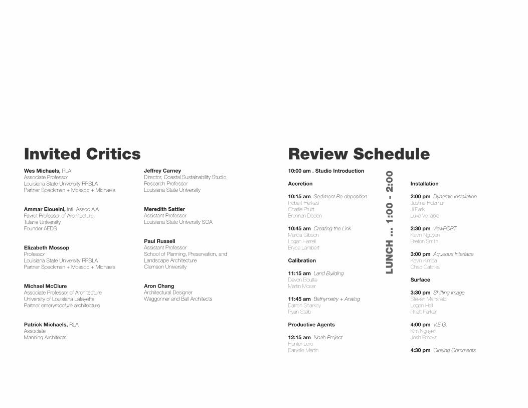
10:00 am . Studio Introduction
Accretion
10:15 am Sediment Re-depositionRobert HerkesCharlie PruittBrennan Dedon
10:45 am Creating the LinkMarcia GibsonLogan HarrellBryce Lambert
Calibration
11:15 am Land BuildingDevon BoutteMartin Moser
11:45 am Bathymetry + AnalogDarren SharkeyRyan Steib
Productive Agents
12:15 am Noah ProjectHunter LeroDanielle Martin
Installation
2:00 pm Dynamic InstallationJustine HolzmanJi ParkLuke Venable
2:30 pm viewPORTKevin NguyenBreton Smith
3:00 pm Aqueous InterfaceKevin KimballChad Caletka
Surface
3:30 pm Shifting ImageSteven MansfieldLogan HallRhett Parker
4:00 pm V.E.G.Kim NguyenJosh Brooks
4:30 pm Closing Comments
LU
NC
H ... 1
:00 -
2:0
0
Review Schedule
Sediment Re-depositionCharlie Pruitt, Brennan Dedon, Robert Herkes
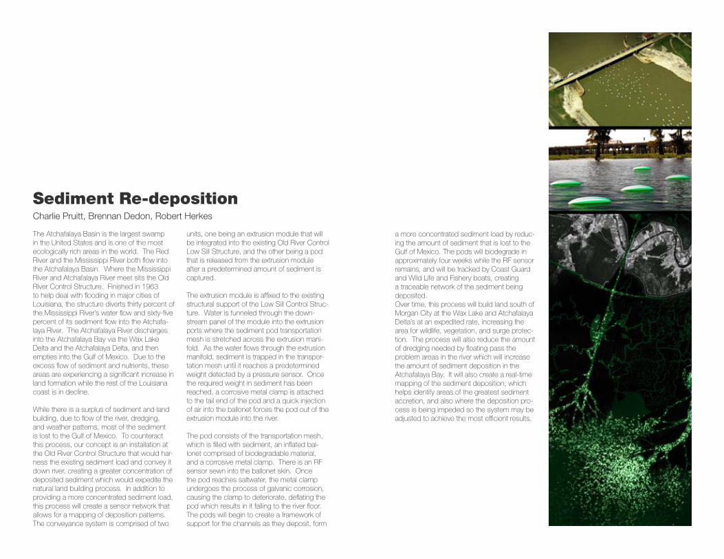
The Atchafalaya Basin is the largest swamp in the United States and is one of the most ecologically rich areas in the world. The Red River and the Mississippi River both flow into the Atchafalaya Basin. Where the Mississippi River and Atchafalaya River meet sits the Old River Control Structure. Finished in 1963 to help deal with flooding in major cities of Louisiana, the structure diverts thirty percent of the Mississippi River’s water flow and sixty-five percent of its sediment flow into the Atchafa-laya River. The Atchafalaya River discharges into the Atchafalaya Bay via the Wax Lake Delta and the Atchafalaya Delta, and then empties into the Gulf of Mexico. Due to the excess flow of sediment and nutrients, these areas are experiencing a significant increase in land formation while the rest of the Louisiana coast is in decline.
While there is a surplus of sediment and land building, due to flow of the river, dredging, and weather patterns, most of the sediment is lost to the Gulf of Mexico. To counteract this process, our concept is an installation at the Old River Control Structure that would har-ness the existing sediment load and convey it down river, creating a greater concentration of deposited sediment which would expedite the natural land building process. In addition to providing a more concentrated sediment load, this process will create a sensor network that allows for a mapping of deposition patterns.The conveyance system is comprised of two
units, one being an extrusion module that will be integrated into the existing Old River Control Low Sill Structure, and the other being a pod that is released from the extrusion module after a predetermined amount of sediment is captured.
The extrusion module is affixed to the existing structural support of the Low Sill Control Struc-ture. Water is funneled through the down-stream panel of the module into the extrusion ports where the sediment pod transportation mesh is stretched across the extrusion mani-fold. As the water flows through the extrusion manifold, sediment is trapped in the transpor-tation mesh until it reaches a predetermined weight detected by a pressure sensor. Once the required weight in sediment has been reached, a corrosive metal clamp is attached to the tail end of the pod and a quick injection of air into the ballonet forces the pod out of the extrusion module into the river.
The pod consists of the transportation mesh, which is filled with sediment, an inflated bal-lonet comprised of biodegradable material, and a corrosive metal clamp. There is an RF sensor sewn into the ballonet skin. Once the pod reaches saltwater, the metal clamp undergoes the process of galvanic corrosion, causing the clamp to deteriorate, deflating the pod which results in it falling to the river floor. The pods will begin to create a framework of support for the channels as they deposit, form
a more concentrated sediment load by reduc-ing the amount of sediment that is lost to the Gulf of Mexico. The pods will biodegrade in approximately four weeks while the RF sensor remains, and will be tracked by Coast Guard and Wild Life and Fishery boats, creating a traceable network of the sediment being deposited. Over time, this process will build land south of Morgan City at the Wax Lake and Atchafalaya Delta’s at an expedited rate, increasing the area for wildlife, vegetation, and surge protec-tion. The process will also reduce the amount of dredging needed by floating pass the problem areas in the river which will increase the amount of sediment deposition in the Atchafalaya Bay. It will also create a real-time mapping of the sediment deposition, which helps identify areas of the greatest sediment accretion, and also where the deposition pro-cess is being impeded so the system may be adjusted to achieve the most efficient results.
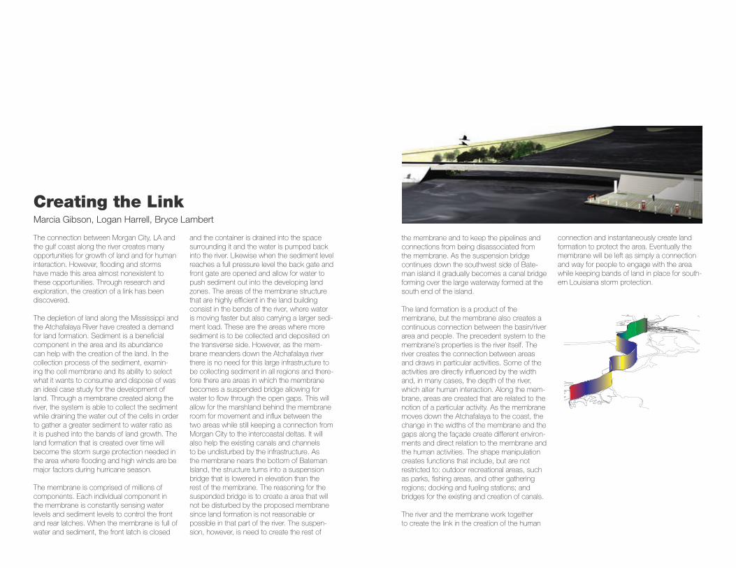
Creating the LinkMarcia Gibson, Logan Harrell, Bryce Lambert
The connection between Morgan City, LA and the gulf coast along the river creates many opportunities for growth of land and for human interaction. However, flooding and storms have made this area almost nonexistent to these opportunities. Through research and exploration, the creation of a link has been discovered.
The depletion of land along the Mississippi and the Atchafalaya River have created a demand for land formation. Sediment is a beneficial component in the area and its abundance can help with the creation of the land. In the collection process of the sediment, examin-ing the cell membrane and its ability to select what it wants to consume and dispose of was an ideal case study for the development of land. Through a membrane created along the river, the system is able to collect the sediment while draining the water out of the cells in order to gather a greater sediment to water ratio as it is pushed into the bands of land growth. The land formation that is created over time will become the storm surge protection needed in the area where flooding and high winds are be major factors during hurricane season.
The membrane is comprised of millions of components. Each individual component in the membrane is constantly sensing water levels and sediment levels to control the front and rear latches. When the membrane is full of water and sediment, the front latch is closed
and the container is drained into the space surrounding it and the water is pumped back into the river. Likewise when the sediment level reaches a full pressure level the back gate and front gate are opened and allow for water to push sediment out into the developing land zones. The areas of the membrane structure that are highly efficient in the land building consist in the bends of the river, where water is moving faster but also carrying a larger sedi-ment load. These are the areas where more sediment is to be collected and deposited on the transverse side. However, as the mem-brane meanders down the Atchafalaya river there is no need for this large infrastructure to be collecting sediment in all regions and there-fore there are areas in which the membrane becomes a suspended bridge allowing for water to flow through the open gaps. This will allow for the marshland behind the membrane room for movement and influx between the two areas while still keeping a connection from Morgan City to the intercoastal deltas. It will also help the existing canals and channels to be undisturbed by the infrastructure. As the membrane nears the bottom of Bateman Island, the structure turns into a suspension bridge that is lowered in elevation than the rest of the membrane. The reasoning for the suspended bridge is to create a area that will not be disturbed by the proposed membrane since land formation is not reasonable or possible in that part of the river. The suspen-sion, however, is need to create the rest of
the membrane and to keep the pipelines and connections from being disassociated from the membrane. As the suspension bridge continues down the southwest side of Bate-man island it gradually becomes a canal bridge forming over the large waterway formed at the south end of the island.
The land formation is a product of the membrane, but the membrane also creates a continuous connection between the basin/river area and people. The precedent system to the membrane’s properties is the river itself. The river creates the connection between areas and draws in particular activities. Some of the activities are directly influenced by the width and, in many cases, the depth of the river, which alter human interaction. Along the mem-brane, areas are created that are related to the notion of a particular activity. As the membrane moves down the Atchafalaya to the coast, the change in the widths of the membrane and the gaps along the façade create different environ-ments and direct relation to the membrane and the human activities. The shape manipulation creates functions that include, but are not restricted to: outdoor recreational areas, such as parks, fishing areas, and other gathering regions; docking and fueling stations; and bridges for the existing and creation of canals.
The river and the membrane work together to create the link in the creation of the human
connection and instantaneously create land formation to protect the area. Eventually the membrane will be left as simply a connection and way for people to engage with the area while keeping bands of land in place for south-ern Louisiana storm protection.
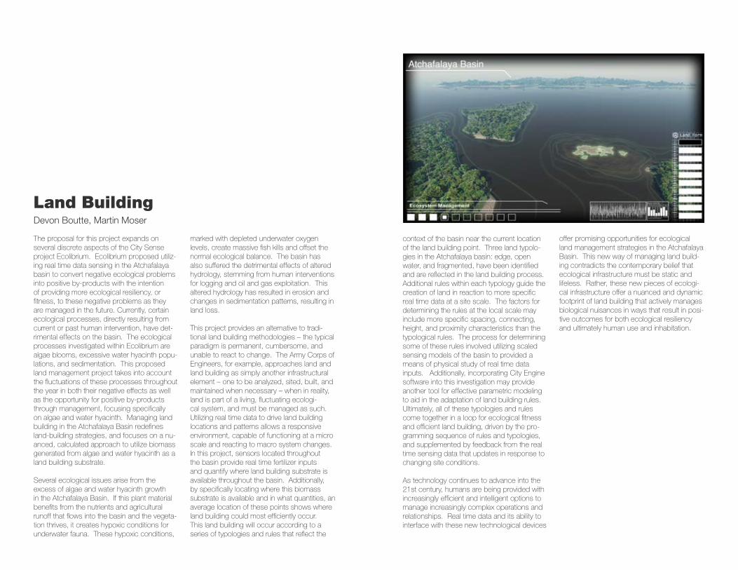
Land BuildingDevon Boutte, Martin Moser
The proposal for this project expands on several discrete aspects of the City Sense project Ecolibrium. Ecolibrium proposed utiliz-ing real time data sensing in the Atchafalaya basin to convert negative ecological problems into positive by-products with the intention of providing more ecological resiliency, or fitness, to these negative problems as they are managed in the future. Currently, certain ecological processes, directly resulting from current or past human intervention, have det-rimental effects on the basin. The ecological processes investigated within Ecolibrium are algae blooms, excessive water hyacinth popu-lations, and sedimentation. This proposed land management project takes into account the fluctuations of these processes throughout the year in both their negative effects as well as the opportunity for positive by-products through management, focusing specifically on algae and water hyacinth. Managing land building in the Atchafalaya Basin redefines land-building strategies, and focuses on a nu-anced, calculated approach to utilize biomass generated from algae and water hyacinth as a land building substrate.
Several ecological issues arise from the excess of algae and water hyacinth growth in the Atchafalaya Basin. If this plant material benefits from the nutrients and agricultural runoff that flows into the basin and the vegeta-tion thrives, it creates hypoxic conditions for underwater fauna. These hypoxic conditions,
marked with depleted underwater oxygen levels, create massive fish kills and offset the normal ecological balance. The basin has also suffered the detrimental effects of altered hydrology, stemming from human interventions for logging and oil and gas exploitation. This altered hydrology has resulted in erosion and changes in sedimentation patterns, resulting in land loss.
This project provides an alternative to tradi-tional land building methodologies – the typical paradigm is permanent, cumbersome, and unable to react to change. The Army Corps of Engineers, for example, approaches land and land building as simply another infrastructural element – one to be analyzed, sited, built, and maintained when necessary – when in reality, land is part of a living, fluctuating ecologi-cal system, and must be managed as such. Utilizing real time data to drive land building locations and patterns allows a responsive environment, capable of functioning at a micro scale and reacting to macro system changes. In this project, sensors located throughout the basin provide real time fertilizer inputs and quantify where land building substrate is available throughout the basin. Additionally, by specifically locating where this biomass substrate is available and in what quantities, an average location of these points shows where land building could most efficiently occur. This land building will occur according to a series of typologies and rules that reflect the
context of the basin near the current location of the land building point. Three land typolo-gies in the Atchafalaya basin: edge, open water, and fragmented, have been identified and are reflected in the land building process. Additional rules within each typology guide the creation of land in reaction to more specific real time data at a site scale. The factors for determining the rules at the local scale may include more specific spacing, connecting, height, and proximity characteristics than the typological rules. The process for determining some of these rules involved utilizing scaled sensing models of the basin to provided a means of physical study of real time data inputs. Additionally, incorporating City Engine software into this investigation may provide another tool for effective parametric modeling to aid in the adaptation of land building rules. Ultimately, all of these typologies and rules come together in a loop for ecological fitness and efficient land building, driven by the pro-gramming sequence of rules and typologies, and supplemented by feedback from the real time sensing data that updates in response to changing site conditions.
As technology continues to advance into the 21st century, humans are being provided with increasingly efficient and intelligent options to manage increasingly complex operations and relationships. Real time data and its ability to interface with these new technological devices
offer promising opportunities for ecological land management strategies in the Atchafalaya Basin. This new way of managing land build-ing contradicts the contemporary belief that ecological infrastructure must be static and lifeless. Rather, these new pieces of ecologi-cal infrastructure offer a nuanced and dynamic footprint of land building that actively manages biological nuisances in ways that result in posi-tive outcomes for both ecological resiliency and ultimately human use and inhabitation.
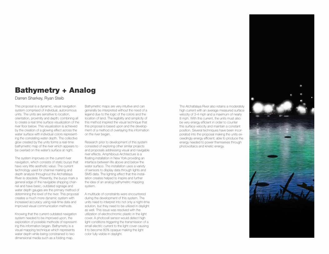
Bathymetry + AnalogDarren Sharkey, Ryan Steib
This proposal is a dynamic, visual navigation system comprised of individual, autonomous units. The units are sensitive to location, orientation, proximity and depth; combining all to create a real time surface visualization of the river floor below. This visualization is achieved by the creation of a glowing effect across the water surface with individual colors represent-ing the correlating water depth. The collective glow created by the units forms a real-time bathymetric map of the river which appears to be overlaid on the water’s surface at night.
The system improves on the current river navigation, which consists of static buoys that have very little aesthetic value. The current technology used for channel marking and depth analysis throughout the Atchafalaya River is obsolete. Presently, the buoys mark a general edge of the navigable shipping chan-nel and have basic, outdated signage and water depth gauges are the primary method of determining the level of the river. This proposal creates a much more dynamic system with increased accuracy using real-time data and improved visual communication methods.
Knowing that the current outdated navigation system needed to be improved upon, the exploration of possible methods of represent-ing this information began. Bathymetry is a visual mapping technique which represents water depth while being constrained to two dimensional media such as a folding map.
Bathymetric maps are very intuitive and can generally be interpreted without the need of a legend due to the logic of the colors and the location of land. The legibility and simplicity of this method inspired the visual technique that this proposal is based upon and the develop-ment of a method of overlaying this information on the river began.
Research prior to development of this system consisted of exploring other similar projects and proposals addressing visual and navigable river effects. Amphibious Architecture is a floating installation in New York providing an interface between life above and below the water surface. The installation uses a variety of sensors to display data through lights and SMS data. The lighting effect that this instal-lation creates helped to inspire and further the idea of an analog bathymetric mapping system.
A multitude of constraints were encountered during the development of this system. The units need to interpret into not only a night-time solution, but they need to be utilized in daylight as well. This issue was resolved with the utilization of electrochromic plastic in the light cover. A photocell sensor would detect high light conditions triggering the transmission of a small electric current to the light cover causing it to become 80% opaque making the light color fully visible in daylight.
The Atchafalaya River also retains a moderately high current with an average measured surface velocity of 3-4 mph and a maximum of nearly 8 mph. With this current, the units must also be very energy efficient in order to counter this surface velocity and maintain a constant position. Several techniques have been incor-porated into the proposal making the units ex-ceedingly energy efficient; able to produce the energy needed to power themselves through photovoltaics and kinetic energy.
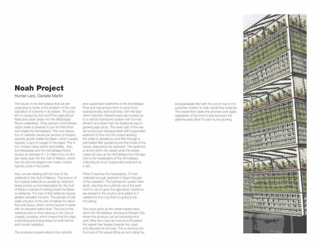
Noah ProjectHunter Lero, Danielle Martin
The issues in the Atchafalaya that we are proposing to tackle is the problem of the over saturation of nutrients in its waters. This prob-lem is caused by the runoff from agricultural fields and urban areas into the Mississippi River’s watershed. Thirty percent of the Missis-sippi’s water is diverted to join the Red River and create the Atchafalaya. This over satura-tion of nutrients causes an excess of invasive species growth inside the Basin, which causes hypoxia, a lack of oxygen in the water. This in turn hinders native plants and wildlife. Also, the Mississippi and the Atchafalaya Rivers dumps an average of 1.5 million tons of nitro-gen every year into the Gulf of Mexico, which has the second largest man-made coastal hypoxic zone in the world.
Also, we are dealing with the loss of the wetlands to the Gulf of Mexico. The erosion of the coastal wetlands is caused by sediment being picked up and deposited into the Gulf of Mexico instead of settling inside the Basin or wetlands. The loss of the wetlands causes greater saltwater intrusion. The penalty of salt-water intrusion is the loss of habitat for native flora and fauna, which cannot survive in water with an elevated saline level. The loss of the wetlands also is more obvious in the loss of coastal Louisiana, which means that the state is shrinking and losing areas for both animal and human habitation.
The proposed vessel extracts the nutrients
and suspended sediments in the Atchafalaya River and repurposes them to grow food, hydroponically, and build land, with the sedi-ment collected. Greenhouses are hooked up to a vertical hydroponic system with is more efficient and faster than the traditional way of growing agriculture. The lower part of the ves-sel would open allowing water with suspended sediment to flow into the vessel allowing the water to spread out and filter through a permeable filter spread across the inside of the vessel, depositing the sediment. The sediment is stored within the vessel while the vessel makes its way up the Atchafalaya from Morgan City to the headwaters of the Atchafalaya, collecting as much suspended sediment as it can.
When it reaches the headwaters, if it has collected enough sediment it stops that part of the operation. The hydroponic system then starts, leaching the nutrients out of the sedi-ment to use to grow the agriculture. Nutrients are sensed in the solution and added to if needed for the crop that it is going to be circulating.
The crops grow as the vessel travels back down the Atchafalaya, docking at Morgan City where the produce can be harvested and sold. After the crops are sold and off loaded the vessel then travels towards the coast and deposits its soil load. This is done by the front end of the vessel lifting up and rolling the
biodegradable filter with the soil on top of it to a precise location to help rebuild the wetlands. The vessel then starts the process over again, regardless of the time of year because the greenhouses allow for year round growing.
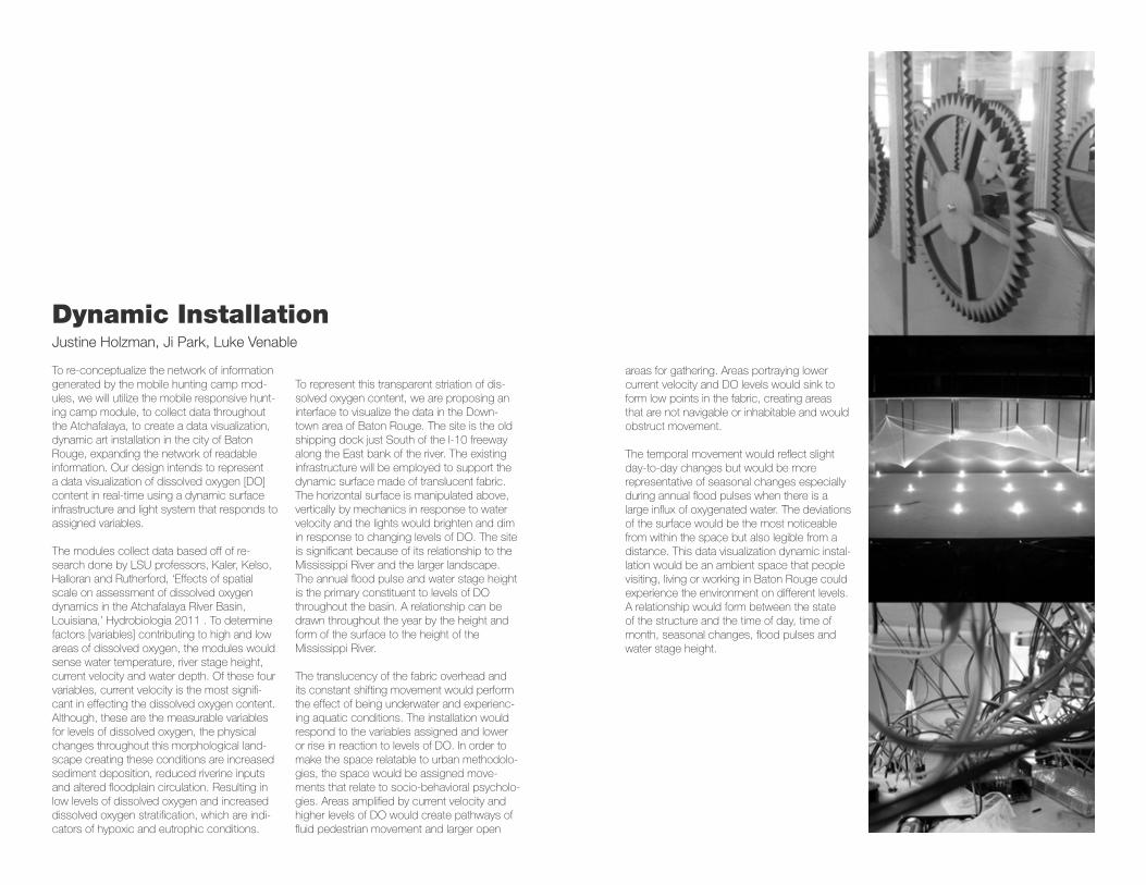
Dynamic InstallationJustine Holzman, Ji Park, Luke Venable
To re-conceptualize the network of information generated by the mobile hunting camp mod-ules, we will utilize the mobile responsive hunt-ing camp module, to collect data throughout the Atchafalaya, to create a data visualization, dynamic art installation in the city of Baton Rouge, expanding the network of readable information. Our design intends to represent a data visualization of dissolved oxygen [DO] content in real-time using a dynamic surface infrastructure and light system that responds to assigned variables.
The modules collect data based off of re-search done by LSU professors, Kaler, Kelso, Halloran and Rutherford, ‘Effects of spatial scale on assessment of dissolved oxygen dynamics in the Atchafalaya River Basin, Louisiana,’ Hydrobiologia 2011 . To determine factors [variables] contributing to high and low areas of dissolved oxygen, the modules would sense water temperature, river stage height, current velocity and water depth. Of these four variables, current velocity is the most signifi-cant in effecting the dissolved oxygen content. Although, these are the measurable variables for levels of dissolved oxygen, the physical changes throughout this morphological land-scape creating these conditions are increased sediment deposition, reduced riverine inputs and altered floodplain circulation. Resulting in low levels of dissolved oxygen and increased dissolved oxygen stratification, which are indi-cators of hypoxic and eutrophic conditions.
To represent this transparent striation of dis-solved oxygen content, we are proposing an interface to visualize the data in the Down-town area of Baton Rouge. The site is the old shipping dock just South of the I-10 freeway along the East bank of the river. The existing infrastructure will be employed to support the dynamic surface made of translucent fabric. The horizontal surface is manipulated above, vertically by mechanics in response to water velocity and the lights would brighten and dim in response to changing levels of DO. The site is significant because of its relationship to the Mississippi River and the larger landscape. The annual flood pulse and water stage height is the primary constituent to levels of DO throughout the basin. A relationship can be drawn throughout the year by the height and form of the surface to the height of theMississippi River.
The translucency of the fabric overhead and its constant shifting movement would perform the effect of being underwater and experienc-ing aquatic conditions. The installation would respond to the variables assigned and lower or rise in reaction to levels of DO. In order to make the space relatable to urban methodolo-gies, the space would be assigned move-ments that relate to socio-behavioral psycholo-gies. Areas amplified by current velocity and higher levels of DO would create pathways of fluid pedestrian movement and larger open
areas for gathering. Areas portraying lower current velocity and DO levels would sink to form low points in the fabric, creating areas that are not navigable or inhabitable and would obstruct movement.
The temporal movement would reflect slight day-to-day changes but would be more representative of seasonal changes especially during annual flood pulses when there is a large influx of oxygenated water. The deviations of the surface would be the most noticeable from within the space but also legible from a distance. This data visualization dynamic instal-lation would be an ambient space that people visiting, living or working in Baton Rouge could experience the environment on different levels. A relationship would form between the state of the structure and the time of day, time of month, seasonal changes, flood pulses and water stage height.
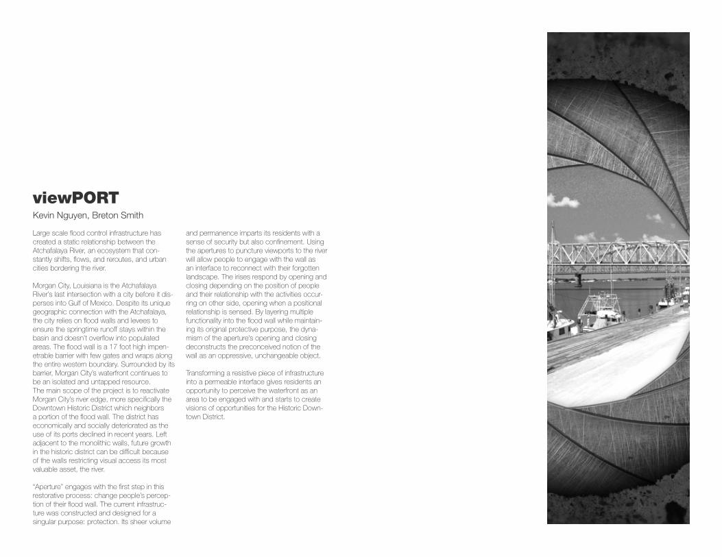
viewPORTKevin Nguyen, Breton Smith
Large scale flood control infrastructure has created a static relationship between the Atchafalaya River, an ecosystem that con-stantly shifts, flows, and reroutes, and urban cities bordering the river.
Morgan City, Louisiana is the Atchafalaya River’s last intersection with a city before it dis-perses into Gulf of Mexico. Despite its unique geographic connection with the Atchafalaya, the city relies on flood walls and levees to ensure the springtime runoff stays within the basin and doesn’t overflow into populated areas. The flood wall is a 17 foot high impen-etrable barrier with few gates and wraps along the entire western boundary. Surrounded by its barrier, Morgan City’s waterfront continues to be an isolated and untapped resource.The main scope of the project is to reactivate Morgan City’s river edge, more specifically the Downtown Historic District which neighbors a portion of the flood wall. The district has economically and socially deteriorated as the use of its ports declined in recent years. Left adjacent to the monolithic walls, future growth in the historic district can be difficult because of the walls restricting visual access its most valuable asset, the river.
“Aperture” engages with the first step in this restorative process: change people’s percep-tion of their flood wall. The current infrastruc-ture was constructed and designed for a singular purpose: protection. Its sheer volume
and permanence imparts its residents with a sense of security but also confinement. Using the apertures to puncture viewports to the river will allow people to engage with the wall as an interface to reconnect with their forgotten landscape. The irises respond by opening and closing depending on the position of people and their relationship with the activities occur-ring on other side, opening when a positional relationship is sensed. By layering multiple functionality into the flood wall while maintain-ing its original protective purpose, the dyna-mism of the aperture’s opening and closing deconstructs the preconceived notion of the wall as an oppressive, unchangeable object.
Transforming a resistive piece of infrastructure into a permeable interface gives residents an opportunity to perceive the waterfront as an area to be engaged with and starts to create visions of opportunities for the Historic Down-town District.
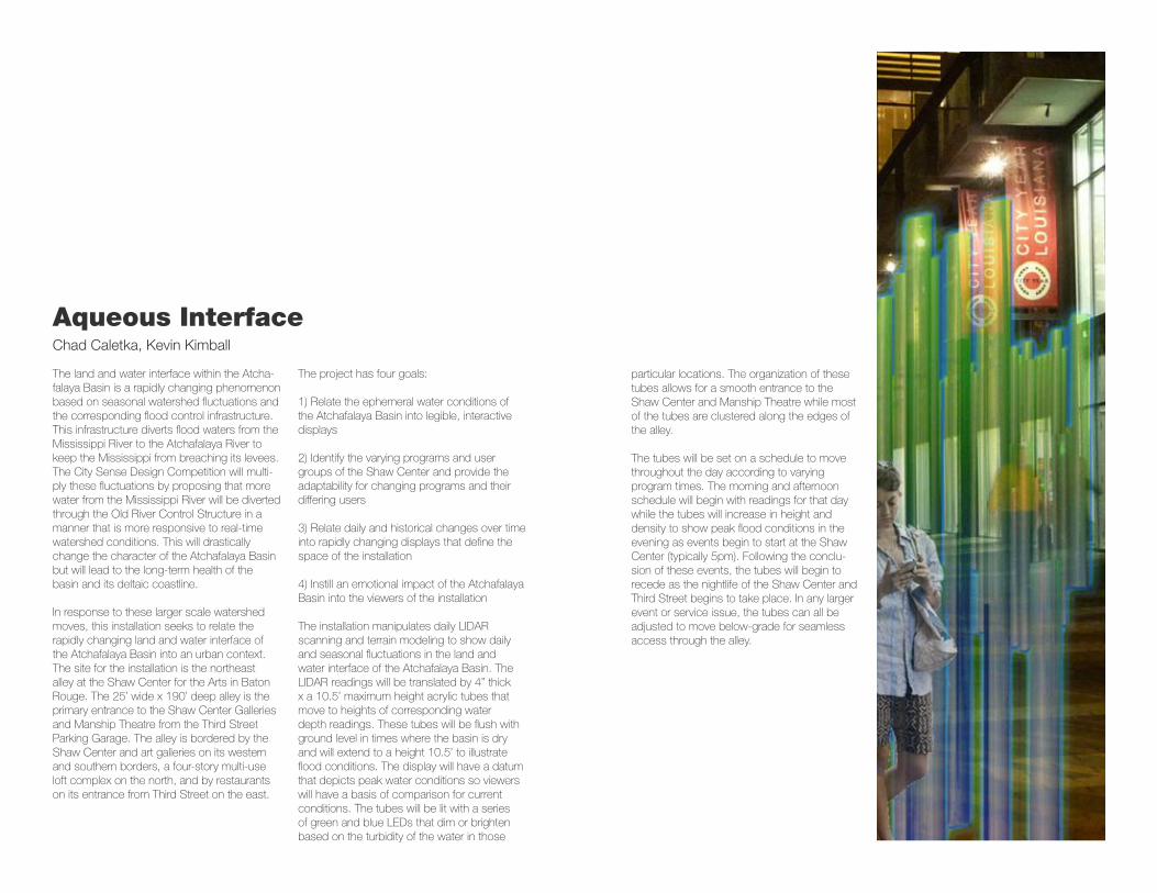
Aqueous InterfaceChad Caletka, Kevin Kimball
The land and water interface within the Atcha-falaya Basin is a rapidly changing phenomenon based on seasonal watershed fluctuations and the corresponding flood control infrastructure. This infrastructure diverts flood waters from the Mississippi River to the Atchafalaya River to keep the Mississippi from breaching its levees. The City Sense Design Competition will multi-ply these fluctuations by proposing that more water from the Mississippi River will be diverted through the Old River Control Structure in a manner that is more responsive to real-time watershed conditions. This will drastically change the character of the Atchafalaya Basin but will lead to the long-term health of the basin and its deltaic coastline.
In response to these larger scale watershed moves, this installation seeks to relate the rapidly changing land and water interface of the Atchafalaya Basin into an urban context. The site for the installation is the northeast alley at the Shaw Center for the Arts in Baton Rouge. The 25’ wide x 190’ deep alley is the primary entrance to the Shaw Center Galleries and Manship Theatre from the Third Street Parking Garage. The alley is bordered by the Shaw Center and art galleries on its western and southern borders, a four-story multi-use loft complex on the north, and by restaurants on its entrance from Third Street on the east.
The project has four goals:
1) Relate the ephemeral water conditions of the Atchafalaya Basin into legible, interactive displays
2) Identify the varying programs and user groups of the Shaw Center and provide the adaptability for changing programs and their differing users
3) Relate daily and historical changes over time into rapidly changing displays that define the space of the installation
4) Instill an emotional impact of the Atchafalaya Basin into the viewers of the installation
The installation manipulates daily LIDAR scanning and terrain modeling to show daily and seasonal fluctuations in the land and water interface of the Atchafalaya Basin. The LIDAR readings will be translated by 4” thick x a 10.5’ maximum height acrylic tubes that move to heights of corresponding water depth readings. These tubes will be flush with ground level in times where the basin is dry and will extend to a height 10.5’ to illustrate flood conditions. The display will have a datum that depicts peak water conditions so viewers will have a basis of comparison for current conditions. The tubes will be lit with a series of green and blue LEDs that dim or brighten based on the turbidity of the water in those
particular locations. The organization of these tubes allows for a smooth entrance to the Shaw Center and Manship Theatre while most of the tubes are clustered along the edges of the alley.
The tubes will be set on a schedule to move throughout the day according to varying program times. The morning and afternoon schedule will begin with readings for that day while the tubes will increase in height and density to show peak flood conditions in the evening as events begin to start at the Shaw Center (typically 5pm). Following the conclu-sion of these events, the tubes will begin to recede as the nightlife of the Shaw Center and Third Street begins to take place. In any larger event or service issue, the tubes can all be adjusted to move below-grade for seamless access through the alley.
Shifting ImageSteven Mansfield, Rhett Parker, Logan Hall
Research of the traditional Atchafalaya hunting camp reveals several fallibilities and advantag-es regarding its form and function, as well as its operation within the Atchafalaya Basin. The benefits vary from cultural and social aspects to providing adjacency to the hunt, while the inadequacies range from issues of accessibil-ity and stability to inadequacy of the camp itself as aid in the hunt. This investigation of the proficiency of the traditional hunting camp exposes its deficiency of one of the vital tactics of the hunt – camouflage – and poses the question of how to improve this condition.
The understanding of camouflage in both natural and synthetic methods provides the opportunity to reference the processes for reinterpretation. A common employer of cam-ouflage whose trick is unfamiliar to most is the chameleon – a unique, yet simple manipulation of the layers of the chameleon’s skin allows it to mimic the values of its immediate context. Synthetic (manmade) applications of camou-flage attempt to eliminate what is referred to as the “edge condition.” To elaborate, objects can be discerned as independent from their back-ground/foreground because of the viewer’s ability to make out the hard lines of change in color value. The intent of camouflage in this respect is to apply the pattern (of predeter-mined values based on context values) to the object in order to soften those lines and thus blend the edges of the object with its back/foreground.
While the two systems do have common ob-jectives and processes of color and perspec-tive alteration, there is also a crucial inconsis-tency between the two – one adjusts its own color values while the other manipulates the viewer’s perception of the existing values by simulating those values. Consequently, is it possible to combine these two techniques into a real-time data-responsive system that allows the hunting camp to blend in to a constantly changing environment as it moves?
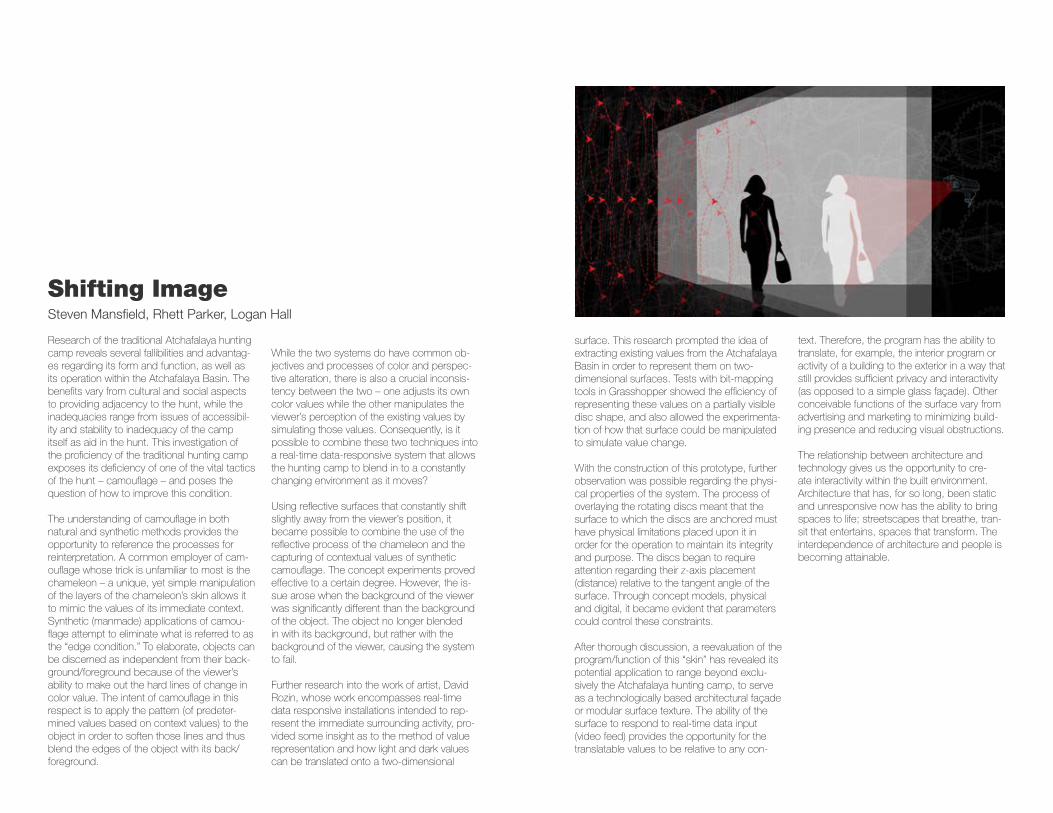
Using reflective surfaces that constantly shift slightly away from the viewer’s position, it became possible to combine the use of the reflective process of the chameleon and the capturing of contextual values of synthetic camouflage. The concept experiments proved effective to a certain degree. However, the is-sue arose when the background of the viewer was significantly different than the background of the object. The object no longer blended in with its background, but rather with the background of the viewer, causing the system to fail.
Further research into the work of artist, David Rozin, whose work encompasses real-time data responsive installations intended to rep-resent the immediate surrounding activity, pro-vided some insight as to the method of value representation and how light and dark values can be translated onto a two-dimensional
surface. This research prompted the idea of extracting existing values from the Atchafalaya Basin in order to represent them on two-dimensional surfaces. Tests with bit-mapping tools in Grasshopper showed the efficiency of representing these values on a partially visible disc shape, and also allowed the experimenta-tion of how that surface could be manipulated to simulate value change.
With the construction of this prototype, further observation was possible regarding the physi-cal properties of the system. The process of overlaying the rotating discs meant that the surface to which the discs are anchored must have physical limitations placed upon it in order for the operation to maintain its integrity and purpose. The discs began to require attention regarding their z-axis placement (distance) relative to the tangent angle of the surface. Through concept models, physical and digital, it became evident that parameters could control these constraints.
After thorough discussion, a reevaluation of the program/function of this “skin” has revealed its potential application to range beyond exclu-sively the Atchafalaya hunting camp, to serve as a technologically based architectural façade or modular surface texture. The ability of the surface to respond to real-time data input (video feed) provides the opportunity for the translatable values to be relative to any con-
text. Therefore, the program has the ability to translate, for example, the interior program or activity of a building to the exterior in a way that still provides sufficient privacy and interactivity (as opposed to a simple glass façade). Other conceivable functions of the surface vary from advertising and marketing to minimizing build-ing presence and reducing visual obstructions.
The relationship between architecture and technology gives us the opportunity to cre-ate interactivity within the built environment. Architecture that has, for so long, been static and unresponsive now has the ability to bring spaces to life; streetscapes that breathe, tran-sit that entertains, spaces that transform. The interdependence of architecture and people is becoming attainable.
Vascuolar Effluvia GenesisJosh Brooks, Kim Nguyen
Vacuolar Effluvia Genesis, if following the dictionary, is defined by the sequestration of a waste product or harmful substance as to create something new.
Everyday 2.16 million pounds of nitrate based fertilizer enters the Atchafalaya Basin before continuing downstream to the Gulf of Mexico. After entering the basin these anthropo-genic nutrients have an effect that is common around the world, hyper-eutrophication by way of algae bloom. Eutrophication is the natural oscillation in aerobic microbial decomposition and dissolved oxygen in aquatic ecosystems. With the introduction of these pollutants from upstream excessive growth of suspended algae occurs. As the massive amount algae dies and descends the water column they are consumed by the microbes (also consuming oxygen) causing a spike in both the rate of decomposition (positive) and the amount of dissolved oxygen (negative) resulting in a con-dition known as hypoxia. Hypoxia is a leading cause of fish kills such as the ‘Dead Zone’ in the Gulf of Mexico directly south of the Basin.
The original concept of this project was to define the asymptote between the microbial decomposition and dissolved oxygen curves to maintain ecosystem health. Using a hyper-efficient ecosystem management strategy that takes advantage of real time data modeling technology we are able to track eutrophication throughout the basin making micro interven-
tions where necessary. These interventions are made possible by sequestering the process of microbial decomposition of algae into a synthetic plant-like structure. The amalgama-tion of these units allows for an appropriately scaled response to each hypoxic event. After being deployed to an area of potential hypoxia these units will use a dissolved oxygen sensor to initiate sequestration at the threshold of five p.p.m. (parts per million) dissolved oxygen.
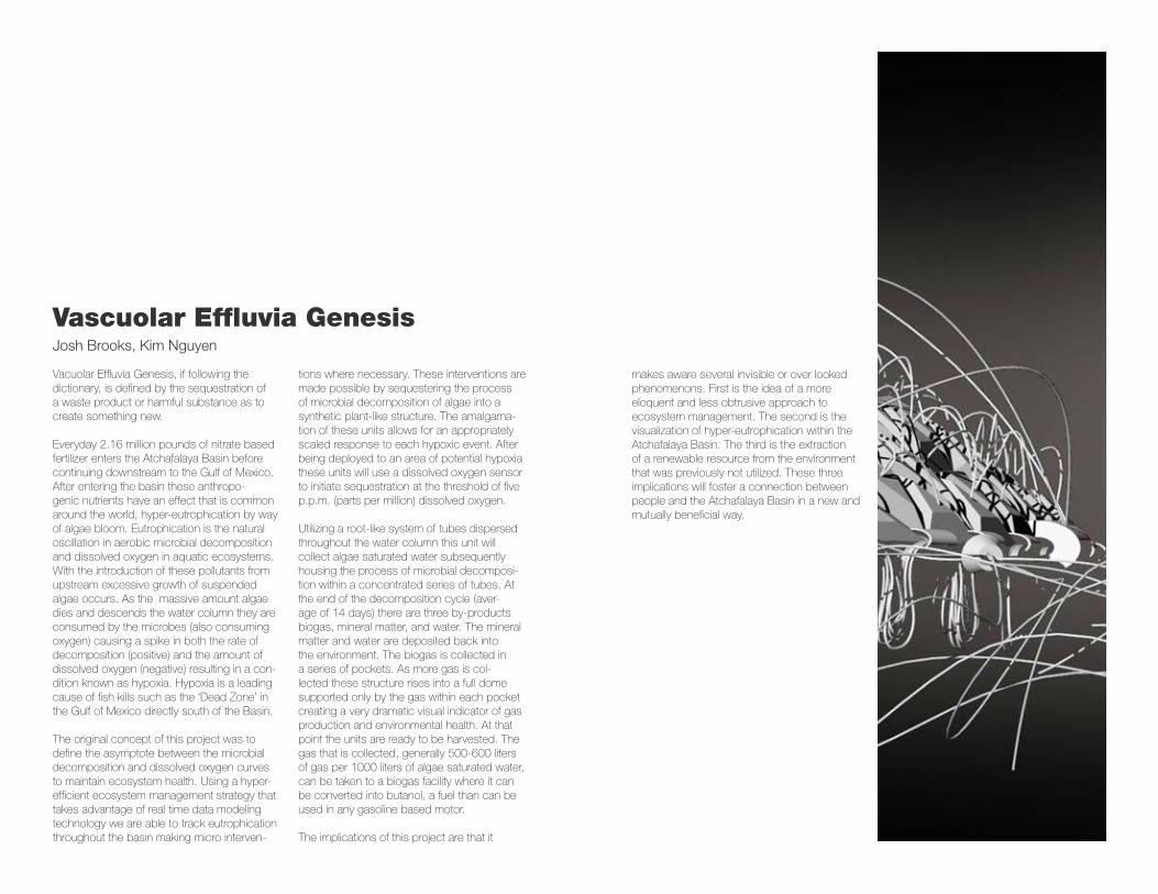
Utilizing a root-like system of tubes dispersed throughout the water column this unit will collect algae saturated water subsequently housing the process of microbial decomposi-tion within a concentrated series of tubes. At the end of the decomposition cycle (aver-age of 14 days) there are three by-products biogas, mineral matter, and water. The mineral matter and water are deposited back into the environment. The biogas is collected in a series of pockets. As more gas is col-lected these structure rises into a full dome supported only by the gas within each pocket creating a very dramatic visual indicator of gas production and environmental health. At that point the units are ready to be harvested. The gas that is collected, generally 500-600 liters of gas per 1000 liters of algae saturated water, can be taken to a biogas facility where it can be converted into butanol, a fuel than can be used in any gasoline based motor.
The implications of this project are that it
makes aware several invisible or over looked phenomenons. First is the idea of a more eloquent and less obtrusive approach to ecosystem management. The second is the visualization of hyper-eutrophication within the Atchafalaya Basin. The third is the extraction of a renewable resource from the environment that was previously not utilized. These three implications will foster a connection between people and the Atchafalaya Basin in a new and mutually beneficial way.
RE
SP
ON
SIV
E S
YS
TE
MS
FALL 2012
Louisiana S
tate University
Robert R
eich School of Landscape A
rchitectureS
chool of Architecture


![Cutting Sequences and Palindromescomet.lehman.cuny.edu/keenl/gilman-keen-harvey.pdf · terminology as found in Magnus-Karass-Solitar [MKS], but we review some terms here. We give](https://img.pdfslide.net/doc/110x75/60191ee5590c6c6ec37031bc/cutting-sequences-and-terminology-as-found-in-magnus-karass-solitar-mks-but-we.jpg)