Embed Size (px)
Citation preview
The Franklin Canyon/Fernandez Ranch Project
Initial Study and Mitigated Negative Declaration
April 25, 2013
Prepared for:
City of Hercules 111 Civic Drive
Hercules, CA 94547
Prepared by:
Restoration Design Group, LLC 2612 8th Street
Berkeley, CA 94710
and
GAIA Consulting, Inc.
2168 Penny Lane Napa, California 94559

THIS PAGE INTENTIONALLY LEFT BLANK
4/25/2013 i Franklin Canyon/Fernandez Ranch Project Draft IS/MND
Table of Contents The Franklin Canyon/Fernandez Ranch Project .............................................................................. i
1.0. SUMMARY ............................................................................................................................ 1
2.0. PROJECT DESCRIPTION ................................................................................................... 6
3.0. SUMMARY OF ENVIRONMENTAL EFFECTS ......................................................... 39
4.0. DETERMINATION ............................................................................................................ 40
5.0. EVALUATION OF ENVIRONMENTAL EFFECTS.................................................... 41
APPENDIX A Biological Resources at the Franklin Canyon Property ................................ A-1
APPENDIX B Biological Resources at the Fernandez Ranch Property ............................... B-1
LIST OF FIGURES Figure 1 Regional Vicinity Map ...................................................................................................3
Figure 2 Site Inventory Diagram ..................................................................................................7
Figure 3 Project Description Diagram ........................................................................................11
Figure 4 Plant Communities .......................................................................................................17
Figure 5 Special-Status Species .................................................................................................19

4/25/2013 Franklin Canyon/Fernandez Ranch Project Draft IS/MND
THIS PAGE INTENTIONALLY LEFT BLANK
4/25/2013 1 Franklin Canyon/Fernandez Ranch Project Draft IS/MND
Initial Study/Mitigated Negative Declaration
1.0. SUMMARY Project title: Franklin Canyon/Fernandez Ranch Project Lead agency name and address: City of Hercules 111 Civic Drive Hercules, CA 94547 Contact person and phone number: Robert Reber, 510-245-6531, [email protected] Project location: The property is located in the northwestern portion of Contra Costa County between Highway 4 to the north and Alhambra Valley Road to the south, along Christie Road along Rodeo Creek (Figure 1 - Regional Vicinity Map). The property lies within the eastern boundary of the City of Hercules and extends eastward into unincorporated County lands, south of and immediately adjacent to the Franklin Canyon Golf Course. Access to the site is off eastbound Highway 4 onto Christie Road just past the entry to the golf course, then 0.7 miles south on Christie Road to the Christie Road Staging Area on Fernandez Ranch site. Project sponsor’s name and address: Muir Heritage Land Trust (MHLT) P.0. Box 2452 Martinez, CA 94553 Contact: Glen Lewis, MHLT Open Space Ranger, 925-408-6503 email to:[email protected] General plan designation: AL - Agricultural Land (County Designation)
Franklin Canyon Area (City of Hercules) Zoning: A-4 Agricultural Preserve District
Franklin Canyon Area (City of Hercules) Surrounding land uses and setting (briefly describe the project’s surroundings): The property is bordered by: East Bay Municipal Utility Department (EBMUD) lands to the southwest; the Hanna Ranch and Refugio Heights housing developments to the west; the Franklin Canyon Golf Course and a PG&E substation to the north; Rodeo Creek, Christie Road, and a Burlington Northern Santa Fe (BNSF) Railroad line to the east; and private ranch lands to the south. Purpose and Use of this Initial Study: This Initial Study has been prepared to evaluate the potential environmental effects of the proposed project and to identify mitigation measures to

4/25/2013 2 Franklin Canyon/Fernandez Ranch Project Draft IS/MND
THIS PAGE INTENTIONALLY LEFT BLANK
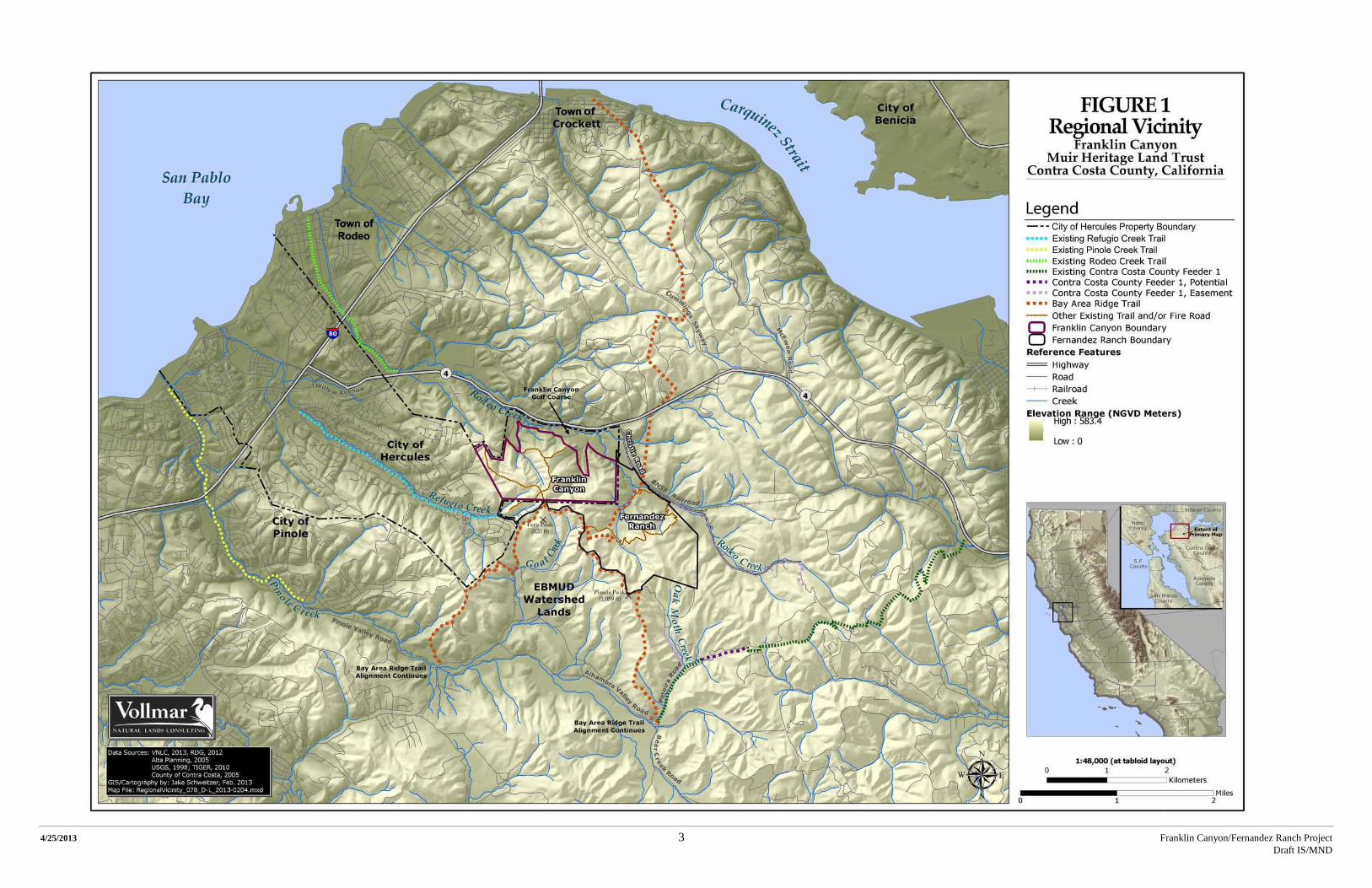
4/25/2013 3 Franklin Canyon/Fernandez Ranch Project Draft IS/MND
4/25/2013 4 Franklin Canyon/Fernandez Ranch Project Draft IS/MND
THIS PAGE INTENTIONALLY LEFT BLANK

4/25/2013 5 Franklin Canyon/Fernandez Ranch Project Draft IS/MND
reduce any potentially significant impacts to a less than significant level. This Initial Study will support decisions made by approval and permitting agencies in accordance with the California Environmental Quality Act (CEQA), including the California Public Resources Code section 21000 et seq., and the California Code of Regulations section 15000 et seq. The mitigation measures identified in this document would become conditions attached to the project, agreed to by the project sponsor, that support the adoption of a Negative Declaration. This Initial Study will be made available for public review for at least 30 days prior to adoption of the Negative Declaration, and all comments on the document will be considered by the Lead Agency as part of that action. All Responsible and Trustee Agencies will then rely on the adopted Negative Declaration when reviewing the project for subsequent permits or other approvals. Public agencies whose approval is required (e.g., permits, financing approval, or participation agreement): City of Hercules:
• Basic Application for Development Review • Use Permit • Grading Permit • Building Permit • Tree Removal Permit
Contra Costa County:
• Condition of Approval • Building Permit • Drainage Permit • Grading Permit • Land Use Permit • Stormwater Pollution Protection Plan • Stormwater Control Plan, if necessary • Tree Permit
San Francisco Bay Regional Water Quality Control Board (SFRWQCB) – Clean Water Act Section 401 Water Quality Certification California Department of Fish and Wildlife (CDFW) – Section 1602 Stream Alteration Agreement U.S. Army Corps (USACE) – Clean Water Act Section 404 Permit Other agencies and organizations that may rely on this Initial Study:
• East Bay Regional Park District • East Bay Municipal Utility District • Rodeo-Hercules Fire Protection District • Bay Area Ridge Trail Council

4/25/2013 6 Franklin Canyon/Fernandez Ranch Project Draft IS/MND
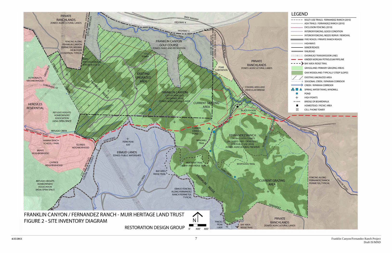
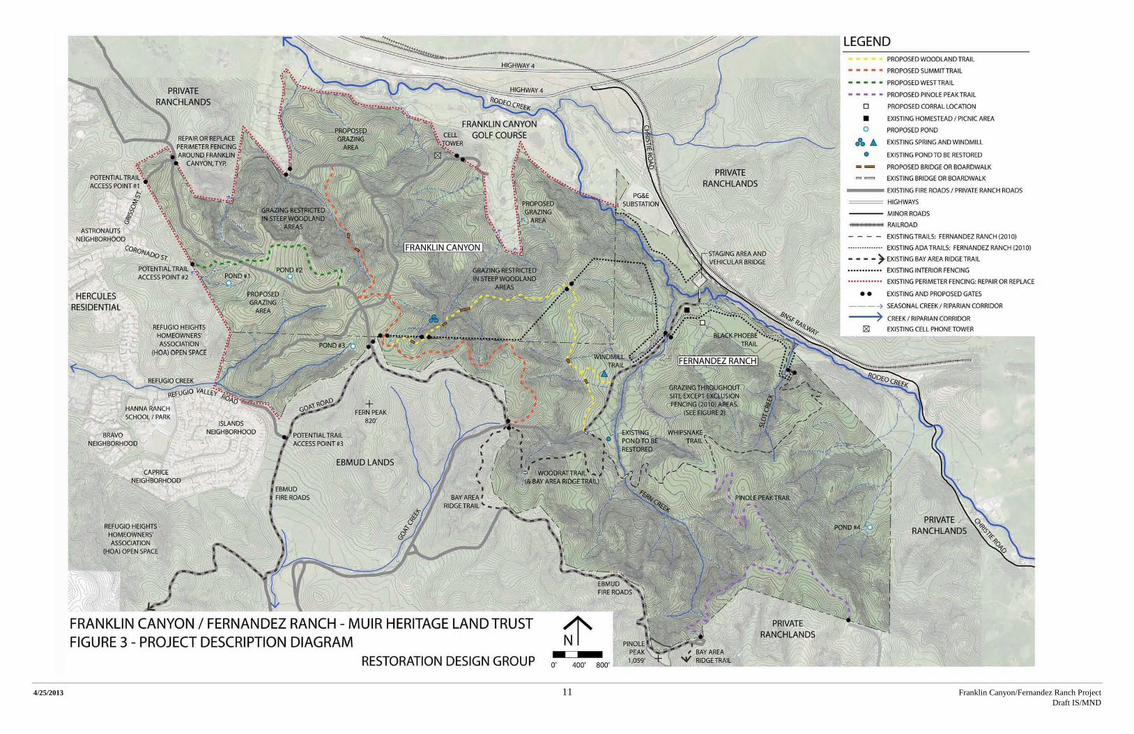
2.0. PROJECT DESCRIPTION Introduction The Muir Heritage Land Trust (MHLT) is proposing to integrate its newly purchased Franklin Canyon property with Fernandez Ranch, MHLT’s adjacent, publicly accessible open space (Figure 1). The project has two essential elements: livestock grazing and public access. The project purpose is to open the site for public use and enjoyment by providing multi-use trails, and to re-introduce grazing to the Franklin Canyon site to improve rangeland health and overall site habitat quality. The intent of the trails component is to create a series of trails which extend established Fernandez Ranch trails onto the Franklin Canyon parcel, add a trail on Franklin Canyon, and add one new Fernandez Ranch trail. The grazing component includes preparing Franklin Canyon for grazing by repairing or replacing existing fencing, installing new fencing, and creating watering facilities for livestock. The grazing would improve habitat in the area, and the watering facilities would also serve wildlife and potentially provide habitat. In June of 2010, the Muir Heritage Land Trust purchased Franklin Canyon as part of its mission to preserve Contra Costa County open space. The purchase followed years of contentious proposals to develop a resort and housing on the site. In 2004, City of Hercules voters stopped the development proposal with the passing of Measure M. Franklin Canyon is a 483-acre parcel of open space/agricultural land which forms the northeastern most parcel of land within the City of Hercules in Contra Costa County, California. It currently does not have a Williamson Act contract. Critical to Franklin Canyon is Fernandez Ranch and MHLT’s successful 2010 Fernandez Ranch Public Access and Creek Restoration Project which opened the Fernandez Ranch site to the public. MHLT’s work at the 702-acre Fernandez Ranch site included a major restoration of a reach of Rodeo Creek and adjacent tributaries, and a public access staging area (Figure 2-Site Inventory Diagram). Key to the site’s opening was the new 156-foot clear span vehicular bridge which accommodates range management vehicles, fire road access, and public and handicapped access (compliant with the Americans with Disabilities Act [ADA]). Within the ranch, 3.5-miles of new multi-use trails were created, supported by the new trailhead, seating and picnic facilities, interpretive exhibit, and a historical corral and homestead foundation. Fernandez Ranch is actively grazed by cattle by an independent grazing lessee under contract with the MHLT. Livestock grazing is a primary land management tool used by MHLT on its open space lands, a key goal being to promote biodiversity and to reduce wildfire fuel loads. Grazing also supports MHLT’s interest in site interpretation by maintaining the ranching heritage of the region’s open space lands. The Fernandez Ranch site provides the foundation and a critical link for Franklin Canyon’s development into public open space. In 2013, MHLT developed a description of the proposed work at the Franklin Canyon site. The primary purpose of the proposed project is to integrate Franklin Canyon into the existing, publically accessible Fernandez Ranch site by expanding the Fernandez Ranch multi-use trails system into the Franklin Canyon parcel and re-introducing livestock grazing in a way that supports a sustainable livestock operation, improves rangeland health, and minimizes the negative effects of grazing, including conflicts with recreation. The other important goal is to
4/25/2013 7 Franklin Canyon/Fernandez Ranch Project Draft IS/MND

4/25/2013 8 Franklin Canyon/Fernandez Ranch Draft IS/MND
THIS PAGE INTENTIONALLY LEFT BLANK
4/25/2013 9 Franklin Canyon/Fernandez Ranch Project Draft IS/MND
ensure existing habitat, including special-status species habitat, is maintained and enhanced where feasible. The proposed project would include new work in Franklin Canyon, improvements to public open space enhancements at Fernandez Ranch that would provide the linkage between Franklin Canyon and Fernandez Ranch, and new work at Fernandez Ranch. The project would integrate these two sites into one larger contiguous 1,185-acre open space area with multi-use public access and natural resource enhancements (Figure 3-Project Description Diagram). Subsequent phases may be proposed in the future. These subsequent phases could include grazing facilities improvements, additional trails, and/or other open space recreation elements such as picnic shelters and overlooks. However, no planning has been conducted to conceptualize these additional facilities/phases, nor is funding available to construct any future facilities. Therefore these potential subsequent phases are not ripe for analysis, and are not part of this Initial Study/Mitigated Negative Declaration (IS/MND). They would be addressed in subsequent CEQA documents and permits should planning progress to an appropriate level. Environmental Setting Location and Land Use The Franklin Canyon property is located east of the City of Hercules in northern Contra Costa County. It is on the Benicia and Briones Valley USGS 7.5-minute topographic quadrangle within the Pinole/Martinez land grant. The approximate center of the property is 122°13'21.5" W, 38°0'2.2" N. To the south and east of Franklin Canyon is MHLT’s 702 acre Fernandez Ranch parcel which MHLT acquired in 2005. Fernandez Ranch is in unincorporated Contra Costa County and zoned Agricultural Preserve, and is under a Williamson Act contract. South of the Fernandez Ranch panhandle lies an extensive parcel of East Bay Municipal Utility District (EBMUD) watershed land which is publically accessible via permit. West of Franklin Canyon is the Refugio Heights Home Owner Association (HOA) land zoned Open Space, and west of these lands are the residential communities surrounding Hanna Ranch School. North and northwest of the site lies the Franklin Canyon Golf Course, and directly east is a PG&E parcel and a substation (Figure 3). Historic Land Use Starting with the Mission Era, Franklin Canyon has been ranch land used for grazing. Franklin Canyon’s 483 acres were once part of the greater holdings of the Martinez family, whose El Rancho de Pinole Mexican land grant encompassed both Franklin Canyon and Fernandez Ranch. Nine thousand acres of these land grant holdings were sold to Bernardo Fernandez in the 1880s. The property appears to have been used continually only for cattle grazing and open space until some point between 1912 and 1939 when a dairy farm and homestead were constructed. The entire Fernandez Ranch was held by six generations of the Fernandez family, primarily as rangeland for cattle ranching, until financial changes forced the family to part with portions of the property in the 1990s and 2000s. In 2002, the Franklin Canyon parcel was acquired by overseas investors and then proposed for a housing and resort

4/25/2013 10 Franklin Canyon/Fernandez Ranch Draft IS/MND
THIS PAGE INTENTIONALLY LEFT BLANK
4/25/2013 11 Franklin Canyon/Fernandez Ranch Project Draft IS/MND
4/25/2013 12 Franklin Canyon/Fernandez Ranch Draft IS/MND
THIS PAGE INTENTIONALLY LEFT BLANK
4/25/2013 13 Franklin Canyon/Fernandez Ranch Project Draft IS/MND
development called “Green Park Development.” In 2004, City of Hercules voters approved Measure M which stopped the development by designating the land for agricultural and limited residential use (minimum parcel size of 40 acres). In 2005 the Fernandez Ranch parcel was purchased by MHLT and subsequently improved in 2010. In 2010 the Franklin Canyon parcel was purchased by MHLT from money collected through a series of donations from East Bay Regional Parks District, California Coastal Conservancy, Caltrans, and Hercules Measure WW fund. Current Land Use The Franklin Canyon property currently consists of unmanaged open space with three major utilities: a cellular telephone tower, PG&E overhead transmission lines, and a Kinder Morgan gas pipeline. There has been neither public access to the site nor land management apart from access to the site for utility company maintenance of facilities. The parcel is crossed by aerial high power lines on the west side, and the Kinder Morgan subsurface high pressure fuel pipelines and easements (Figure 2). A series of maintained fire roads follow the ridgeline and descend on all sides of the ridge to provide firefighting and utility access to the site. Currently, graded earthen fire road access to the site from two paved Hercules roads at Grissom Street and Refugio Valley Road (main EBMUD access point) is maintained by the Rodeo–Hercules Fire District. The Fernandez Ranch site currently includes the Christie Road Staging Area with parking for 11 cars (including 2 accessible spaces) and equestrian trailers, restroom facilities, and 3.5 miles of trails that connect with EBMUD fire roads on the western ridge. Visitors are able to access the site from dawn to dusk, seven days per week. The Staging Area serves as the central service area at the site, and connects to the trail system via a bridge across Rodeo Creek. The trails are part of the Bay Area Ridge Trail alignment, and a connection is made to the EBMUD Pinole Watershed. Where trails cross wetlands, footbridges and boardwalks have been installed to minimize trail impacts on sensitive habitat. As part of the work completed in 2010, there was extensive creek restoration of Rodeo Creek and its tributaries (Contra Costa County 2008). Topography/Watershed The property is located in the upper portion of the watershed of Rodeo Creek. Rodeo Creek enters San Pablo Bay in the community of Rodeo, approximately two miles southwest of the Carquinez Bridge. The headwaters of another stream, Refugio Creek, are located on an isolated western section of the property. Refugio Creek flows into San Pablo Bay through the City of Hercules. A small portion of the southeastern corner of the property is located within the Pinole Creek watershed. Topography within and around the project site is dominated by the steep northwest-trending Franklin Ridge, which is typical of the East Bay Hills. Pinole Peak lies southeast of the adjacent Fernandez Ranch property, and at 1,059 feet (323 meters NGVD), it is the highest point in northwestern Contra Costa County. Fern Peak at 820 feet (250 meters NGVD), just south of the Franklin Canyon project site, has multiple ridgeline fingers that run northward into the site and define the higher elevation areas in and around the project site (Vollmar 2013). Just north of the Franklin Canyon property the land slopes to 99 feet (30 meters NGVD), and just east of the Fernandez Ranch site the land slopes to 329 feet (100 meters NGVD). The slopes on the site range from nearly level at the northern Rodeo Creek floodplain,

4/25/2013 14 Franklin Canyon/Fernandez Ranch Draft IS/MND
to 50% on the hillside above the eastern tributary to Rodeo Creek. The steepest slopes generally occur along the cut sides of current and historic drainages (Contra Costa County 2008). Tributaries of Rodeo and Refugio Creek have cut into the site topography to create steeper cut valleys at the higher elevations. These valleys lead to the low elevation alluvial fans and floodplains. Much of the site is dominated by the rounded secondary ridges of Fern Peak. The Franklin Canyon Golf Course to the north occupies the majority of the Rodeo Creek floodplain area (Vollmar 2013). Steep cliffs occur in the west-central part of the Franklin Canyon property, at the boundary of Millsholm Loam, part of the upper Briones Sandstone formation, and Tierra Loam and Gaviota Sandy Loam, both part of the Neroly Sandstone. These two distinct geologic formations were created during the Miocene Epoch, when the coastal mountain range was a series of islands that were part of what was previously a larger mountain chain (Vollmar 2013). The Miocene coastline reached into the Sacramento and San Joaquin valleys, where rivers deposited sediments from the eroding volcanic Sierra Nevada mountains. Marine sediments were also deposited during this epoch. The marine and alluvial sediments were later compressed to form various layers of sedimentary rock. The upper Neroly Sandstone was formed in the late Miocene and consists of volcanic marine sandstone and shale, siltstone, tuff, and andesitic sedimentary rock. The lower Briones Sandstone was created in the mid- to late-Miocene epoch and consists of sandstone, siltstone, conglomerate, and shell breccias, and includes a tuffaceous layer (Vollmar 2013). The boundary between these two layers is clearly defined on Franklin Canyon (Vollmar 2013). Landslides on the project site are mostly small, shallow debris slides, and soil slips in the steep uplands. The tributaries typically have shallow slumps along their inner gorges. Geology/Soils The complex geologic formations of the Coastal Range of the Bay Area can be categorized into three broad units based on their basement rock content and faulting: the Great Valley sequence along the eastern edge of the Range, the Salinian block west of the San Andreas Fault, and the Franciscan assemblage, or mélange, underlying the area in-between the Great Valley sequence and Salinian block (Vollmar 2013). The project site lies within the Franciscan assemblage, which is the most complex of the units, consisting of accreted island arcs, isolated portions of oceanic crust, sedimentary depositions from the prehistoric continental shelf, mafic volcanic wedges, metamorphic rocks, and other seemingly disjunct geologic layers (Vollmar 2013). In the project vicinity, uplands within the Franciscan assemblage are predominantly made up of sedimentary rocks, but also include some metamorphic and basic igneous rocks (Vollmar 2013). The site also contains Botella and Conejo Clay Loams, both of which have greater levels of clay than the upslope loam soils. Botella and Conejo Clay Loams have low to moderate shear strength and may prove erosive under certain conditions (Vollmar 2013). Biological Resources The Franklin Canyon property was surveyed in November 2012, and a comprehensive Biological Resource Report (Biological Report) was prepared (Vollmar 2013). A summary of the biological communities at Franklin Canyon, special-status wildlife species known or with potential to occur
4/25/2013 15 Franklin Canyon/Fernandez Ranch Draft IS/MND
on the Franklin Canyon site, and potential special-status plant species and regionally rare plants at Franklin Canyon are provided in tabular form in Appendix A. The Fernandez Ranch site was also surveyed in 2006 and a Biological Resource Report (Biological Report) was prepared (Vollmar 2006). Appendix B provides a summary of the plant communities, and the special-status wildlife species and special-status plant species known or with potential to occur at the Fernandez Ranch site. A description of this information follows; information for Franklin Canyon is presented first, followed by information pertaining to Fernandez Ranch. Overview of the Franklin Canyon Biological Resources At the Franklin Canyon property, eighteen different plant communities were identified and mapped on the site (Vollmar 2013), including two forest, four woodland, four scrub, four grassland, two herbland, and two riparian communities (Figure 4 - Plant Communities). Table A-1 of Appendix A provides a list of these plant communities and their dominant plant species. Table A-2 in Appendix A provides summary descriptions of these communities including their distribution on the Franklin Canyon site. In Appendix A, Table A-3 provides a list of the special-status wildlife species known or with the potential to occur at the site, Table A-4 presents potential special-status plant species at the Franklin Canyon site, and Table A-5 provides an overview of the regionally rare plants at the site. Figure 5 (Special-Status Species) provides the location of the special-status species. Sensitive Plant Communities Franklin Canyon hosts multiple sensitive plant communities: oak woodlands, riparian habitats, multiple seasonal creek corridors, one spring, native perennial grasslands, remnant stands of coastal prairie, and scrub communities (Vollmar 2013). These communities are mapped on Figure 4. Woodland and Forest The oak and mixed oak/bay woodlands on the site are protected by the State Woodlands Preservation Act (Senate Bill 1334, Section 21083.4) and are considered sensitive plant communities by the project’s Biological Report (Vollmar 2013). The widespread mature oak woodlands on the site consist of coast live oak/California bay forest, coast live oak (Quercus agrifolia), mixed oak (coast live oak, valley oak, California black oak (Quercus kelloggii), Oregon white oak (Quercus garryana var. garryana), and valley oak woodlands. Annual and Perennial Grasslands Non-native and native grasslands cover large areas of the site, particularly open ridgeline areas. Generally native grasses and native coastal prairie species have been out-competed by non-native annuals, particularly Italian ryegrass (Festuca perennis). Still, significant stands of native grasses continue to persist, including large stands of creeping wildrye and scattered smaller stands of purple needle grass, and to a lesser extent California oatgrass (Vollmar 2013). Large stands of both creeping wildrye and purple needle grass are considered ‘sensitive’ habitats by CDFW. Representative native coastal prairie species are sparsely distributed within the larger annual grassland dominated by Italian ryegrass. These stands represent some of the easternmost known

4/25/2013 16 Franklin Canyon/Fernandez Ranch Draft IS/MND
THIS PAGE INTENTIONALLY LEFT BLANK

4/25/2013 17 Franklin Canyon/Fernandez Ranch Draft IS/MND

4/25/2013 18 Franklin Canyon/Fernandez Ranch Draft IS/MND
THIS PAGE INTENTIONALLY LEFT BLANK

4/25/2013 19 Franklin Canyon/Fernandez Ranch Draft IS/MND

4/25/2013 20 Franklin Canyon/Fernandez Ranch Draft IS/MND
THIS PAGE INTENTIONALLY LEFT BLANK

4/25/2013 21 Franklin Canyon/Fernandez Ranch Project Draft IS/MND
stands of coastal prairie-like habitat and therefore are important from a regional botanical standpoint. Scrub Community Scrub community habitats are important to local species and are typically located on the site’s northern slopes in less accessible areas of the Franklin Canyon property. Scrub communities themselves are not considered sensitive communities, however the Biological Report (Vollmar 2013) treats them as such due to their habitat association with the federally and state threatened Alameda whipsnake (Vollmar 2013). Riparian and Associated Stream Corridors Riparian habitats are typically limited to minor seasonal drainages. Most of the minor drainages on the site have little or no wetland vegetation. A large riparian corridor is found in the northeastern corner of Franklin Canyon where Rodeo Creek crosses the corner of the property for approximately 900 linear feet (LF). In the southwestern corner of the Franklin Canyon site there is a minor drainage which feeds Refugio Creek. Riparian habitats are considered sensitive habitats and are regulated as streambeds under Section 1602 of the State Fish and Wildlife Code. They are also regulated as CDFW-designated sensitive habitats and by a Contra Costa County riparian protection ordinance. The larger riparian corridor wetlands would likely be considered jurisdictional, subject to regulation under Section 404 of the Clean Water Act. The minor drainages throughout the site would be considered ‘other waters’ rather than wetlands, as defined by Section 404 (Vollmar 2013). Special-Status Species on the Franklin Canyon Property The Franklin Canyon property has the potential to be habitat for special-status wildlife species. Table A-3 in Appendix A lists the special-status wildlife species known or having the potential to occur on the Franklin Canyon Property. The Franklin Canyon property also has the potential to be habitat for special-status plant species. Table A-4 in Appendix A lists the special-status plant species known or having the potential to occur on the Franklin Canyon Property. Wildlife No special-status amphibians or reptiles were observed during Vollmar’s surveys of Franklin Canyon. However, previous surveys have documented three species on or adjacent to the Franklin Canyon property (Figure 5). California red-legged frog and western pond turtle are assumed to occur within the section of Rodeo Creek in the northeastern corner of the Franklin Canyon site since adjacent properties have documented occurrences in both up and downstream sections of Rodeo Creek. The major tributary to Rodeo Creek in the western portion of the Franklin Canyon property may serve as foraging and movement habitat for the frog, but does not pond enough to support western pond turtle. The single spring on the Franklin Canyon property may provide habitat for California red-legged frog individuals from the occupied pond south of the Franklin Canyon property. These two habitats are separated by an open annual grassland and ridgeline, which decreases the habitat potential of the spring. Alameda whipsnake was documented on the Franklin Canyon property in 2002 in the eastern scrub communities at transitional zones with oak woodlands and annual grasslands (Vollmar 2013) (Figure 5). The snake is presumed to occur
4/25/2013 22 Franklin Canyon/Fernandez Ranch Project Draft IS/MND
throughout the Franklin Canyon property within the widespread scrub communities and their transitional zones. Two special-status bird species, white-tailed kite (Elanus leucurus) and northern harrier (Circus cyaneus), were observed foraging at the site during the 2012 surveys. One Cooper’s hawk (Accipiter cooperi) nest was identified on California Natural Diversity Database (CNDDB) records in the western portion of the Franklin Canyon property, but no individuals were observed in 2012. Other species that were not observed but have potential to occur include golden eagle (Aquila chrysaetos), loggerhead shrike (Lanius ludovicianus), and yellow warbler (Dendroica petechia brewsteri). Woodrat nests were observed frequently throughout the understory of the California bay forest and coast- live oak/California bay forest communities. These are assumed to be created by the San Francisco dusky- footed woodrat due to the regional distribution of the subspecies. The American badger is presumed to be present on the Franklin Canyon property, as it was observed on Fernandez Ranch during the 2006 surveys and the assortment of plant communities on the two adjacent properties are very similar. The preferred habitat of American badgers consists of burrows within grassland and savannah with friable soils with burrowing rodents in the vicinity. This habitat is present at Franklin Canyon as well as Fernandez Ranch. The pallid bat (Antrozous pallidus) was not observed, but may occur on the Franklin Canyon property within the oak woodlands and forests which have ideal roosting trees. Plants Diablo helianthella was the only special-status plant species identified on the Franklin Canyon site. Although this species has no state or federal status, it is considered to be rare and endangered by the California Native Plant Society (CNPS) (List 1B.2). Eighteen locally rare species were also observed (Vollmar 2013) and are listed in Table A-5 of Appendix A. The site occurrences of Diablo helianthella were observed along steep slopes and ridgelines at oak woodland gaps or edges and on Millsholm Loam soils. Multiple regionally unique species were found on the site, some of which are mapped in Figure 5. Invasive Species No invasive wildlife was observed on the Franklin Canyon property, although there is potential for bullfrog from golf course ponds, feral domestic cat from Hercules neighborhoods, and feral pig from open space lands (Vollmar 2013). Overview of the Fernandez Ranch Biological Resources The Biological Report for the Fernandez Ranch site identified and mapped twenty-three different plant communities on the site. These included one forest community, three woodland communities, six scrub communities, four grassland communities, three riparian communities, and four seasonal wetland communities (Vollmar 2006). Table B-1 of Appendix B provides a list of these plant communities and their dominant plant species. Table B-2 in Appendix B provides summary descriptions of these communities including dominant and subdominant plant species and their distribution on the Fernandez Ranch site. Figure 4 shows the mapped distribution of

4/25/2013 23 Franklin Canyon/Fernandez Ranch Project Draft IS/MND
these communities on the site and Figure 5 presents associated special-status species on the Fernandez Ranch site. Fernandez Ranch is composed of three primary geomorphic features, each of which has a unique set of associated plant communities and wildlife and plant species including various special-status species (Vollmar 2006). These features include 1) the network of creeks on the site including Rodeo Creek, Refugio Creek, and other smaller tributary creeks, 2) the broad, relatively flat floodplain terrace bordering Rodeo Creek and, on a smaller scale, its largest tributary, and 3) the upland hillslopes that comprise the remainder of the site. Several of the plant communities on the site are considered ‘sensitive’ habitats, including the oak woodlands, riparian habitats, and seasonal wetland habitats (Vollmar 2006). Also included are native wildflower fields, native bunchgrasses, and coastal prairie, all of which lie within the extensive annual grasslands. Rodeo Creek, Refugio Creek, and the larger unnamed tributaries support corridors of mixed riparian habitat, primarily riparian forest and woodland dominated by coast live oak and California bay but also including pockets of willow and mixed riparian scrub. Smaller creeks and ephemeral drainages have little or no woody riparian habitat but do support herbaceous seasonal wetlands. Rodeo Creek was restored as part of the 2010 Fernandez Ranch Public Access and Creek Restoration Project. Sensitive Plant Communities The Fernandez Ranch site has multiple sensitive plant communities: oak woodlands, riparian habitats and multiple seasonal creek corridors, native perennial grasslands, remnant stands of coastal prairie, and scrub communities (Vollmar 2006). Woodland and Forest All of the oak woodlands on this site are also protected under the provisions of the State Woodlands Preservation Act (Senate Bill 1334, Section 21083.4) and are considered to be sensitive plant communities. There are large stands of valley oaks on the Fernandez Ranch site along ridgelines and upper slopes, which is very unusual for the species. While valley oaks constitute the large majority of the deciduous oaks on the site, there are perhaps a few dozen true Oregon white oaks. Only a few blue oaks were found on the site, and these trees represent the westernmost extent of this species in the local region. Riparian and Associated Stream Corridors Woody riparian habitats occur in dense stands along the larger creeks and in intermittent stands along most of the smaller creeks. All riparian habitats and their associated stream corridors are considered ‘sensitive’ habitats and are regulated as streambeds under Section 1602 of the State Fish and Wildlife Code. They are also regulated as CDFW-designated sensitive habitats and by a Contra Costa County riparian protection ordinance. The riparian habitats identified on the site include mixed riparian forest dominated by a dense cover of coast live oak and California bay, mixed riparian scrub dominated by a mix of willows and riparian shrubs (including poison oak and coyote brush), and willow riparian scrub dominated by a willows.
4/25/2013 24 Franklin Canyon/Fernandez Ranch Project Draft IS/MND
Seasonal Wetlands The broad, relatively flat floodplain terrace bordering Rodeo Creek is dominated by introduced annual grasslands but also supports scattered seasonal wetlands watered by small creeks that flow off of the adjacent hillslopes, meander across the terrace, and eventually drain into Rodeo Creek. The seasonal wetlands occur in some of the creek channels and low-lying areas on the Rodeo Creek floodplain terrace and other terraces, and within several stock ponds created on the site. A small number of seasonal pools occur within the seasonal wetlands. They are distinguished from the seasonal wetlands in that they are ponded rather than saturated for prolonged periods during the winter and early spring. These seasonal pools support a mix of interesting seasonal wetland plants including some vernal pool indicator species. A U.S. Army Corps of Engineers (USACE) wetland delineation was approved in 2007 for the parts of the site that were proposed for construction by the Fernandez Ranch Public Access and Creek Restoration project. Many of the deeply shaded creeks within coast live oak/bay forest had minimal herbaceous wetland vegetation and would be considered ‘other waters’ rather than wetlands under Section 404. Four different seasonal wetland types were identified and mapped on the site, including seasonal creeks within defined creek channels; seasonal wetlands within swales and low-lying areas on floodplain terraces subject to seasonal saturation but having no eroded bed or bank; seasonal pools consisting of ponded depressions within some of the seasonal wetlands on the Rodeo Creek terrace; and the stock ponds (Figure 4) (Vollmar 2006). Annual and Perennial Grasslands and Herblands The introduced annual grasslands limit the abundance of native wildflowers, native bunchgrasses, and native coastal prairie species, but there are scattered occurrences of these native species within the annual grasslands. Native wildflower fields, native bunchgrass stands, and coastal prairie stands are considered ‘sensitive’ habitats by CDFW. The mapped native wildflower fields are all concentrated in the far western portion of the Fernandez Ranch site, are typically dominated by California poppy (Eschscholtzia californica), cream cups (Platystemon californicus), and lupines (Lupinus spp.), and are concentrated on steep, thin-soiled hillslopes such as those above Refugio Creek. Purple needlegrass, a native perennial bunchgrass, was mapped in three localized areas. This species is generally absent from annual grasslands on the Fernandez Ranch site. Coastal prairie was mapped in two localized stands, identified by the occurrence of California oatgrass and western rush. Italian ryegrass, a common introduced annual grass species on the site, was the dominant species within these stands. Nonetheless, these stands represent a unique and uncommon botanical resource on the site. Coastal prairie is most common in more coastal areas and its occurrence here represents the most inland stand documented in the region. Scrub Community There are limited stands of scrub community habitat, generally occurring around the margins of the forests and woodlands. Predominant scrub community types include coyote brush scrub, poison oak scrub, and mixed coyote brush/poison oak scrub. Special-Status Species on the Fernandez Ranch property Wildlife Sixteen locally occurring special-status wildlife species that are associated with the habitat types present on Fernandez Ranch sere identified in the Biological Report (Vollmar 2006). These

4/25/2013 25 Franklin Canyon/Fernandez Ranch Project Draft IS/MND
species are summarized in Table B-3. Five of these species were observed on the Fernandez Ranch site during field surveys, including California red-legged frog, western pond turtle, northern harrier, San Francisco dusky-footed woodrat, and American badger. Alameda whipsnake, while not documented, is presumed to occur based on the presence of high quality habitat on the site as well as a documented occurrence on the Franklin Canyon property in 2002, and the fact that the site is wholly within the preferred habitat for the species. Though not observed during field surveys, six other species were determined to have potential to occur on the site based on the presence of suitable habitat. These include Cooper’s hawk, golden eagle, white-tailed kite, loggerhead shrike, yellow warbler, northern harrier, and pallid bat. White-tailed kite and northern harrier were observed to be foraging at the adjacent Franklin Canyon property (Vollmar 2013). Plants The Biological Report (Vollmar 2006) identified 13 locally occurring special-status plant species that are associated with the habitat types present on Fernandez Ranch and are listed in Table B-3 of Appendix B. Diablo helianthella was observed on the site during field surveys. Five other species were determined to have potential to occur based on the results of site habitat assessments and known occurrence in the site vicinity (Table B-3 of Appendix B). In addition to these special-status plant species, several species identified as regionally rare or unique species by the local CNPS chapter were found on the site (Table B-3 of Appendix B). Invasive Species Bullfrogs, feral domestic cats, and feral pigs are likely to occur at the site. The bullfrog poses a significant threat to California red-legged frog as a predator and competitor.
Project Components For the proposed project, MHLT would expand its existing management of the Fernandez Ranch site to include the newly acquired Franklin Canyon property (Figure 3). This would effectively establish one contiguous open space parcel of 1,185 acres. Activities and features at the Franklin Canyon parcel would include most of the activities and features now found on the Fernandez Ranch site; however, Franklin Canyon would not have its own staging area. Instead the existing Christie Road Staging Area at the Fernandez Ranch site would serve both parcels. Improvements to Franklin Canyon would include:
• Livestock grazing; • Up to two stock ponds for livestock; • Perimeter livestock fencing repair and replacement, and installation of new perimeter and
interior fencing; • Two multi-use trails with connections to Fernandez Ranch and EBMUD lands; • One multi-use trail accessing just the Franklin Canyon site; • Wayfinding and safety signage; • Habitat maintenance and preservation.
4/25/2013 26 Franklin Canyon/Fernandez Ranch Project Draft IS/MND
In addition to these improvements on the Franklin Canyon property, there would be improvements to the existing Fernandez Ranch site to allow the two parcels to function as one integrated unit. Fernandez Ranch improvements would include:
• Up to two new stock ponds for livestock; • Construction of a livestock corral for temporary livestock management near the
Homestead Area; • Two multi-use trail connections (extensions of the new named trails on Franklin Canyon)
between Fernandez Ranch and Franklin Canyon; • A multi-use trail in the southern area of Fernandez Ranch linking an existing Fernandez
Ranch trail (Whipsnake Trail) to Pinole Peak, EBMUD lands, and the existing Ridge Trail route;
• Wayfinding and safety signage.
The project components are described in detail below. Livestock Grazing The existing livestock grazing operation on the Fernandez Ranch parcel would be expanded into portions of the Franklin Canyon parcel, which has not been grazed for over 10 years. The purpose would be to utilize grazing to maintain habitat for special-status species and to maintain and improve the overall health of the rangeland ecosystem. The reintroduction of grazing would also help with fire prevention by reducing the fuel load. The grazing activities would begin with slowly re-introducing cattle on Franklin Canyon’s overgrown grasslands. Bringing foraging cattle back to the site would: reduce the annual grass mass, height, and thatch accumulation; prevent the expansion or even reduce the presence of invasive non-native weedy species; manage the existing configurations of woody habitats and slow woody habitat encroachment into grassland habitat; and reduce wildfire fuel loads by grazing down grassland mass levels. Grazing would also allow MHLT to maintain the historic land use of ranching. The region has been grazed since the 1800s and grazing continues today on adjacent Fernandez Ranch. The grazing strategy for Franklin Canyon would follow that recommended for Fernandez Ranch in the Fernandez Ranch Property Management Plan (Ford 2006). Because Franklin Canyon has not been actively grazed for over 10 years, the forage quality has been reduced. Each year the grasslands grow tall and add to the already dense thatch to create an unfavorable condition for some special-status species (including Alameda whipsnake and California red-legged frog). There are areas where the grassland is infested with invasive non-native plants, and the herbaceous fire hazard is high through the dry summers. Due to the condition of the grasslands, grazing at Franklin Canyon would have to be reintroduced through phases of up to several years with grazing infrastructure upgraded or developed before each new sector can be fully integrated into the grazing operation. Currently, the grazing operation at Fernandez Ranch uses either 70 yearlings or 40 calf-cow pairs with 2-3 bulls. Grazing is nearly year-round with some reduction in herd size during the drier summer months due to reduced forage. Through the expanded grazing program, MHLT expects that Franklin Canyon would offer significant new grassland habitat areas to complement those at Fernandez Ranch.
4/25/2013 27 Franklin Canyon/Fernandez Ranch Project Draft IS/MND
On Franklin Canyon and Fernandez Ranch there would be two main types of special management areas: 1) Habitat Fields (versus Auxiliary Fields) to be grazed by cattle; and 2) areas to be excluded from the grazing fields due to sensitivity to grazing. Habitat Fields are those that would benefit most from a more precise grazing prescription (such as early removal of all or some of the cattle, or concentration of the cattle within the field) to optimize the conditions of special-status species habitat or other special resources. Auxiliary Fields are those fields with less sensitivity, and are designated for potential under-utilization by grazing cattle during the higher precipitation and herbaceous production years, or over-utilization by grazing cattle during the lower precipitation and herbaceous production years (drought). If the grazing lessee has control of an adjacent property that can serve as an Auxiliary Field, then the distinction and management of Auxiliary Fields within Franklin Canyon and Fernandez Ranch may not be needed. During years of normal precipitation and herbaceous production, the gates between the Habitat and Auxiliary Fields are likely to be left open for circulation and greater distribution of the cattle. The grazing use of the Habitat Fields and Auxiliary Fields would be defined by MHLT annually based on an analysis of options and habitat sensitivities. Areas potentially excluded from the planned grazing fields (exclusion areas) would include places with resources or uses especially incompatible with grazing, such as: a) specific recreational use areas (trails in woodlands, picnic areas, and staging areas, and ADA trails); b) special habitat areas (native grasslands, damaged or sensitive riparian reaches, springs and seeps, wetlands on highly compactable soils); c) steep slopes and hazardous ravines; and, d) woodlands with little forage value. The locations of the exclusion areas and their management would be defined by MHLT annually and on a case-by-case basis following an on-site analysis of options and sensitivities. Some exclusion areas may be grazed for short duration periods under careful management review to reduce fire fuel loads and invasive noxious weed growth. This will be determined in the field on a case-by-case basis. Areas requiring special management through grazing may also be defined and grazed without permanent fencing. Temporary fencing and portable watering facilities may be used for short periods to confine the cattle. Attractants, such as mineral licks or shade structures, would also be used to attract the cattle to defined places (such as weed infestation or fire hazard reduction zones) to cause additional utilization of the forage there. Currently Franklin Canyon is not grazed and therefore does not require fencing. Fencing would be installed in phases as grazing is re-introduced to the site and the need for fencing arises. Fencing would need to be constructed or repaired around the parcel’s perimeter from the existing EBMUD fence near the southwest corner south of Refugio Valley Road, to the PG&E substation near the northeast corner of the parcel. Total perimeter fencing would be approximately 25,000 feet. All perimeter fencing would meet current legal standards for livestock grazing.1
1 Lawful fence is described in the California Livestock Law, California Food and Agriculture Code
(http://asci.uvm.edu/equine/law/fence/ca_fnc.htm) as “good, strong, substantial, and sufficient to prevent the ingress and egress of livestock...[with] three tightly stretched barbed wires securely fastened to posts of reasonable strength, firmly set in the ground not more than one rod [16.5 feet] apart, one of which wires shall be at least four feet [48 inches] above the surface of the ground. Any kind of wire or other fence of height, strength and capacity equal to or greater than the wire fence herein described is a good and substantial fence within the meaning of this article. The term ‘lawful fence’ includes cattle guards of such width, depth, rail spacing, and construction as will effectively turn livestock.” It applies mainly to fences adjoining public roads.
The actual
4/25/2013 28 Franklin Canyon/Fernandez Ranch Project Draft IS/MND
length and extent of fencing required would depend on the site conditions found during the survey of the perimeter and on the determination of whether to fence to the property boundary in all places. Interior fencing would also be constructed. Interior fencing is required to restrict cattle from areas where no grazing is to occur, and to separate Habitat and Auxiliary Fields. Interior fencing would also be constructed in phases as needed to support the reintroduction of grazing. There may be some areas of Franklin Canyon where no grazing or fencing would be appropriate, or fencing may not be necessary to control cattle in certain interior locations because of dense woody vegetation or impassably steep slopes. New fencing, replacement fencing, fencing repairs and removal of old unusable fencing would be implemented by the grazing lessee as negotiated and approved by MHLT. Due to the condition of the grasslands, grazing at Franklin Canyon would have to be reintroduced through phases of up to several years with grazing infrastructure upgraded or developed before each new sector can be fully integrated into the grazing operation. Although no wildlife injuries have been reported as a result of livestock fencing in the area, MHLT would work towards improving existing fencing and construct new fencing that is wildlife-friendly to the extent feasible (i.e., provided the fencing would remain effective for a livestock operation). Smooth wires would not be used for perimeter fencing because calves can pass under a smooth wire, cattle lean on and thus damage smooth wire fences more than they do on barbed wire fences, and livestock law requires barbed wire unless an effective alternative is used. Smooth top and bottom wires are better suited for interior fences (e.g., borders of riparian habitat fields). Therefore, the perimeter fencing would be equivalent to or better than the standard 4- or 3-strand fence specifications provided by the Natural Resources Conservation Service (NRCS 2012), with the top strand no less than 48 inches above the ground. These fencing specifications meet CDFW (formerly California Department of Fish and Game) guidance (CDFW 2003). These specifications will allow adult deer to easily jump over the top strand and allow fawns, skunks, raccoons, and coyotes and similar species to crawl under the bottom strand. Fencing materials would be transported to the project site via the Christie Road Staging Area, Windmill Trail fire road, and existing Franklin Canyon fire roads. In certain cases, all-terrain vehicles (ATVs) would be used to bring materials to the final staging area via trails and in limited cases via overland ranch routes. All replaced and un-needed fencing materials would be removed from the site after construction and disposed of in a proper facility. Equipment used to install fencing would be limited to pick-up and flatbed truck rigs for transportation of supplies and tools, mechanical posthole augers, and mechanical fence post drivers. The noise generated in the implementation of fencing would be minor, limited to daytime construction hours, and of short duration. A corral would be constructed on the south meadow near the Christie Road Staging Area on Fernandez Ranch (Figure 3). The corral would be constructed by the grazing lessee and would be approximately 60 to 80 feet on a side. It would be constructed of wooden post and rail perimeter for aesthetics with reinforcing steel on the interior. Gates would be tubular steel, post and rail, or both. Corral construction materials would be transported to the project site via the Christie Road Staging Area and the Windmill Trail fire road. Equipment used to install the corral would be

4/25/2013 29 Franklin Canyon/Fernandez Ranch Project Draft IS/MND
limited to pick-up and flatbed truck rigs for transportation of supplies and tools, mechanical posthole augers, and mechanical fence post drivers. The noise generated in the implementation of the corral would be minor, limited to daytime construction hours, and of short duration. No appurtenant structures are needed. Watering for the livestock would be provided via a temporary trough from a water tank on a truck or trailer, if needed. Corral use would be limited to temporary holding of livestock for medical examination, livestock operations and management, and transportation. It would not be used to permanently hold livestock. Use would be limited to up to three times a year for up to 40 cattle at a time. The corral (location shown in Figure 5) would not be constructed in an area that is a wetland or other sensitive habitat areas. In addition to livestock fencing, the provision of watering facilities for livestock is critical to opening Franklin Canyon to grazing. New livestock stock ponds would be constructed on Franklin Canyon at one of the two locations noted on Figure 3 (Ponds 1 and 2) and on Fernandez Ranch at the new southeast location (Pond 4) and potentially the new northwest location (Pond 3). In total, MHLT would potentially construct up to three new stock ponds on the combined 1,185-acre site (Figure 3). MHLT’s objective is to locate stock ponds away from riparian areas, seasonal creek drainages/stream corridors, and/or native perennial grasslands where feasible. If the stock ponds are be located within sensitive habitat, MHLT would comply with all associated regulatory and permitting requirements. Each stock pond would be approximately 5,000 square feet (SF) in surface area. The actual dimensions would depend on specific site conditions including exposure and wind, soil percolation, water table, evaporation, and the contributing drainage area. Pond depth would range from one to six feet. Pond bottoms may be sealed using an imported clay amendment. No soils would be off-hauled from the site. Each pond would include up to 900 cubic yards (CY) of soil excavation and grading. Grading of the pond excavation and the excavated soils would be done in a manner which melds the ponds and all excavated soils with the existing landscape/topographic setting. The final pond forms will appear as natural features. The majority of the pond water capacity would be held within an excavated area contour-graded into the natural contours of the site. Once constructed, there would be periodic inspection and maintenance of the stock ponds. Design, construction, and maintenance of these ponds would also follow the recommendations of NRCS and the Franklin Canyon/Fernandez Ranch Site Management Plan (to be completed in 2013). The site would be prepared using California Stormwater Quality Association (CASQA) Best Management Practices (BMPs) for erosion control and water quality, adapted for use in an agricultural ranchland setting. Construction would follow all regulatory agency permitting requirements, including excavation and grading requirements from the City of Hercules and Contra Costa County. Construction would be limited to the dry season from April 15th to October 15th. Construction access would be from the adjacent fire roads or, in the case of the southeastern pond on Fernandez Ranch, by permission via adjacent private ranch access. The ponds would be constructed with an excavator and/or backhoe. Site grading would be conducted to ensure cut and fill is balanced at the pond site. Soils would be compacted at the dam face, and the pond edge low point/overflow would be reinforced with rock. After construction, all areas disturbed by access and construction would be seeded with native grasses as soon as feasible after project construction (i.e., at the start of the rainy season). The stock ponds would be designed to look
4/25/2013 30 Franklin Canyon/Fernandez Ranch Project Draft IS/MND
like natural features and to encourage vegetative growth which would either blend into the existing landscape or add visual interest to the site. Bird and bat friendly design would be integrated into the pond detailing and trough detailing, if used. This design approach would include ensuring that the water surface is clear of all obstructions for fly-over drinking and that ponds are fitted with escape ramps to allow wildlife to crawl out of ponds or troughs. Public Access Features A key MHLT objective for Franklin Canyon is to open the site to public use and complement the existing public use now occurring on the adjacent Fernandez Ranch site. The project would maintain Franklin Canyon’s existing fire road network and utilize some of these fire roads as multi-use trails (as was done on Fernandez with the Windmill Trail fire road). The project would also extend the existing multi-use trail network at Fernandez Ranch into Franklin Canyon and create a “loop” trail experience. Multi-use trails would allow hiker, biker, and equestrian use. A total of four new trails would be constructed. Two of the new trails would link the Franklin Canyon and Fernandez Ranch parcels (the proposed Woodland Trail and the proposed Summit Trail). The proposed West Trail would be located entirely within the Franklin Canyon parcel, and the proposed Pinole Peak Trail would be located entirely within the Fernandez Ranch parcel. Short spur trails off the main trail route would be provided on the Woodland Trail and the Pinole Peak Trail. Public use at Franklin Canyon is anticipated to be the same as the public use at Fernandez Ranch. Public use at Fernandez Ranch includes hiking, running, mountain bicycling, birding, nature viewing and study, picnicking, and photography. At Franklin Canyon some trails would also be used for land management and fire control purposes, as is done currently at Fernandez Ranch. While Fernandez Ranch is ADA accessible via Christie Road Staging Area, the bridge and Homestead Area, and the Black Phoebe Trail, ADA accessibility at Franklin Canyon would be restricted. Franklin Canyon encompasses a high ridge with steeply descending side slopes and ravines, making the site unsuitable for ADA trails. Accessing Franklin Canyon requires ascending several hundred feet to access its proposed trails and existing fire roads. The existing ADA accessible trails and areas at Fernandez Ranch would be integrated into the overall Franklin Canyon trails. Christie Road Staging Area Public access to the Franklin Canyon trails would utilize the existing Christie Road Staging Area, completed in 2010. This fully accessible Staging Area provides 11 parking spaces, 2 of which are ADA accessible, equestrian trailer parking, a restroom, picnicking, tables and benches, and an interpretive kiosk. If it were required, the Christie Road Staging Area could also accommodate large event overflow parking on the North Meadow area. Additional access would be available via the EBMUD lands adjoining the southern edge of Franklin Canyon and the western edge of Fernandez Ranch. This access point is less likely to be used, and requires an EBMUD permit (which is readily available on request). Bicycles are not allowed on EBMUD property. EBMUD permitted access would provide access to both the existing Fernandez Ranch Windmill Trail fire road, and Franklin Canyon trails to the north via self-closing gates. The only
4/25/2013 31 Franklin Canyon/Fernandez Ranch Project Draft IS/MND
vehicle access to the site would remain from the Fernandez Ranch site, via the Christie Road Staging Area. Future Potential Trail Access Points MHLT is proposing one potential trail access point located at the end of the Pinole Peak Trail on Fernandez Ranch (southwest fork of proposed trail) where it meets with the EBMUD fire road and the Ridge Trail route to Pereira Road and Alhambra Valley Road. This access point would open the trail to the EBMUD land and make a second connection to the Bay Area Ridge Trail. It would occur only with the permission of EBMUD. Currently, Franklin Canyon abuts Refugio Heights Homeowner Association (HOA) open space lands which are private and restrict access. MHLT encourages public use of its lands, but MHLT is not planning for a public or vehicular trailhead adjacent to HOA land as part of this project. No gates would be built; however, the trail would extend to a point where the most likely access point could be located if HOA members determined they would like to make the link to this open space in the future. Proposed Trails The project would create approximately 5.0 miles of new trails: Woodland Trail; Summit Trail, West Trail, and the Pinole Peak Trail. These trails would be multi-use trails (accessible to hikers, bicyclists, and equestrians) to the extent feasible. On Fernandez Ranch, the existing Windmill Trail fire road connects the east and west sides of Fernandez Ranch and forms a segment of the Bay Area Ridge Trail (Ridge Trail), a regional trail circling San Francisco Bay along the ridgeline. The Windmill Trail is the northern-most Fernandez Ranch trail route and would serve as the access route to all Franklin Canyon trails, and the origination point for the two trails linking Franklin Canyon and Fernandez Ranch: the Woodland Trail and the Summit Trail. Approximately half of the total length of the Summit Trail would be located on Franklin Canyon, and the other half on Fernandez Ranch. The majority of the Woodland Trail would be located on Franklin Canyon. The third proposed trail on the Franklin Canyon parcel, the West Trail, would be a minor trail off an existing north-south fire road. There is one new trail proposed entirely within the Fernandez Ranch site: the Pinole Peak Trail, which includes a spur route to the southeast. All trails would be constructed with a 4-foot-wide tread. The trail tread is the portion of the trail on which trail users move and it would be composed of compacted native soil. The trails would typically be constructed within a cleared trail corridor, 8 feet wide (except where trees exist along the edge of the proposed trail route). In addition, a 10-foot-vertical clearance would be provided on all trails open to equestrians. The trail corridor is a zone that includes the trail tread, and the horizontal and vertical clearance as noted above. Vegetation and other obstacles, such as boulders, are trimmed back or removed from this area to make it possible to ride or walk on the tread. Proposed trails were laid out along a centerline (Figure 3) which represents the center of a 100-foot-wide trail planning corridor. Using a trail corridor allows trail planners and biologists to locate an appropriate, safe, and aesthetically pleasing trail route which limits impacts to site
4/25/2013 32 Franklin Canyon/Fernandez Ranch Project Draft IS/MND
resources (native plants and wildlife habitat). It also allows for flexibility during final flagging of the trail alignment so that site-specific conditions such as topography, mature trees, drainages, and special habitat features can be accommodated. Where the trails cross wetlands (or minor creek drainages), a footbridge or boardwalk would be constructed over the wetlands. The footbridge or boardwalk substructure would be located outside of any delineated wetland area or creek channel. Where trails must cross potentially delineated wetland habitat, crossings would be located in areas having a wetland span of 20 feet or less. Final determination of the jurisdictional wetland areas is pending review by the USACE. The trails would be laid out to take advantage of existing fire roads to extend the length of individual trails and create trail loop opportunities. There are 2.5 miles of graded earthen-surfaced fire roads on the Franklin Canyon parcel. MHLT envisions encouraging public use on 1.4 miles of these roads, and making that portion of the fire roads an integral part of the proposed trails network. These fire roads would also serve as links between proposed multi-use trails. No additional fire roads are proposed for the project. The existing fire roads, both within Franklin Canyon and Fernandez Ranch, are maintained by the Rodeo-Hercules Fire District and are required to be accessible at all times to Rodeo-Hercules Fire District fire and emergency vehicles. Trails would serve both as public access and as land management routes. In addition to public recreation use, site trails would be utilized as routes on foot or all-terrain vehicles (ATVs) for the management of livestock, invasive species, fire fuel loads, and as otherwise needed to manage the site. Signage would be posted prohibiting the use of firearms and making fires; signage would also include other public safety information. Signage and stewardship programs would illustrate the importance of fire safety and tell users what to do and where to go if fire occurred on-site. Wayfinding signage would also be installed at the Staging Area and all trail and fire road junctions. Tree removals would be restricted by City of Hercules tree and grading permit requirements, or Contra Costa County’s tree ordinance, depending on the specific location. Contra Costa County’s tree ordinance requires the pre-construction surveying of trees within 50 feet of a trail. The construction of the Woodland, Summit, and Pinole Peak trails would require some tree removal and in some cases extensive branch pruning. The trail alignment would be routed to avoid tree removals and severe branch pruning to the extent feasible. The trail alignments would result in the removal and pruning of no more than a combined total of 36 bay, oak, or buckeye trees on the project site. Preservation of large caliper valley and coast live oak trees would be a priority. All feasible measures would be utilized to avoid removal or severe pruning of native oak trees and other indigenous trees to accommodate trail tread or equestrian overhead clearance. If oak trees are removed or severely limbed, then acorns or saplings of the same species would be planted in sufficient numbers to ensure the replacement of the oaks, as determined by the regulatory agencies.
4/25/2013 33 Franklin Canyon/Fernandez Ranch Project Draft IS/MND
Anticipated Level of Use It is anticipated that existing levels of trail and open space use at Fernandez Ranch would remain unchanged with the opening of Franklin Canyon as nearly all public access will occur through the Christie Road Staging Area. Currently, high season use (spring and fall) is 10 vehicles and 1 equestrian truck/trailer mid-week; 15 vehicles and 2 equestrian trucks/trailers on weekends. Low season use (mid-summer and winter) is 5 vehicles and 2 equestrian trucks/trailers mid-week and 10 vehicles and 1 equestrian truck/trailer on weekends. Maintenance of the trails and overall site inspection by MHLT would require a visit to the site no more than one day per week. In addition, the grazing lessee would be expected to visit the site approximately one day per week. Trail and Fire Road Descriptions
Woodland Trail The Woodland Trail would be approximately 1.14 miles (6,000 feet) in length and be a multi-use trail to the extent feasible. The trail would start at the existing Fernandez Ranch Windmill Trail fire road and ascend up an open, grazed south-facing annual grassland, crossing two minor drainages. Boardwalks would be used to free-span these two minor drainages and ensure no impact occurs to wetland resources. Boardwalks would be approximately 5 feet wide and 8 feet long. Construction would be plank and girder design with end girders set well clear of the wetland area (minor drainage). After climbing over 150 feet the trail would reach a prominent shoulder of the main Franklin Canyon site ridge. Here the trail would enter a self-closing livestock fence gate to access north sloping terrain. The trail would follow the contours of the land along this canopied north-facing woodland, through a buckeye woodland and then through the predominant oak/bay forest. Within this forest habitat, the trail would skirt trees to the degree feasible, continue climbing along a route that follows the land contours, and cross several minor drainages. At the end of this trail route, near its junction with the Summit Trail, the trail would exit the oak/bay forest, turn north and cross a final minor drainage and climb up an open annual grassland with stands of native creeping wild rye grass. Three crossings in the woodland portion of the trail would also likely require either a footbridge or boardwalk structure. The eastern woodland crossing would be a 20-foot-long by 5-foot-wide footbridge; the central crossing would be a 6- to 10-foot-long plank-and-girder design boardwalk; and the western crossing would be a 12foot-footbridge. Abutments for the footbridges/boardwalk would be outside the top of bank per permitting requirements and to preserve the integrity of the drainage course. Boardwalk crossings less than 30 inches above grade would not require railings; footbridges over 30 inches above grade would require guard railings. The footbridges and boardwalk are anticipated to be either structural fiberglass (lightweight, site assembled) with wood treads, or all wood frame construction. Abutments would be constructed of large timbers, with potentially some footings constructed of concrete.
4/25/2013 34 Franklin Canyon/Fernandez Ranch Project Draft IS/MND
The construction of the Woodland Trail would require the greatest number of tree removals and most extensive branch pruning. The trail alignment would be adjusted to the extent feasible to avoid tree removals and branch pruning (see Proposed Trail Construction, below). The trail alignment will result in the removal and pruning of some bay and buckeye trees, and potentially oak trees. Preservation of large caliper valley and coast live oak trees would be a priority. All feasible measures would be utilized to avoid removal or severe limbing of native oak trees and other indigenous trees to accommodate trail tread or equestrian overhead clearance. Summit Trail The Summit Trail would be approximately 1.52 miles (8,000 feet) in length and be a multi-use trail. This trail would be the key link from Fernandez Ranch to Franklin Canyon. The trail would start at the southwest side of Fernandez Ranch, at the EBMUD property boundary and gate. This end of the Summit Trail would be a major trail junction point at Fernandez Ranch. Windmill Trail is a fire road; the fire road/Windmill Hill trail reaches a saddle, which is also top of the Windmill Trail, in this area. In addition, the Bay Area Ridge Trail is routed through this gate. From the gate, the Summit Trail would climb northeastward around a grassy bald to reach one of the high points (at approximately 820-foot elevation) on Fernandez Ranch and Franklin Canyon. From the high point, the trail would head west and northwest and descend gently through a steep north-facing slope of mixed oak woodland and grassland areas. There may be trail sections in this reach which necessitate retaining cut slopes with low post and plank walls. Along this section of the Summit Trail the major drainages are avoided, but to maintain a sustainable trail surface there still may be a need for several hardened trail tread sections at minor drainages to allow free flow of minor drainage water over the trail surface or tread. There would likely be tree removals and branch pruning on this portion of the trail (see Proposed Trail Construction). The trail alignment would be adjusted to the extent feasible to avoid tree removals and branch pruning. At about 0.75 of a mile along the Summit Trail, the Woodland Trail would tee into the Summit Trail in open grassland along the existing Franklin Canyon–Fernandez Ranch fence line. The vegetation in this area is studded with zones of native coastal prairie and creeping wildrye grassland, and the trail alignment would avoid these native grassland communities to the extent feasible, or cross them in as sensitive a manner as possible. One measure utilized to minimize trail construction impacts would be to haul trail tread cut soils away from these native grasslands and down cast them in areas of non-native annual grassland or grade them into the fire roads. Another measure would be to ensure no construction materials or soils are staged on native grassland habitat. After this junction, the Summit Trail would continue on a northwest trend and pass onto Franklin Canyon property through a gate in the existing livestock fence on the Franklin Canyon property line. The landscape in this area is dominated by non-native annual grassland. The trail would continue to wind through grassland for nearly 0.25 of a mile, at which point it would reach a prominent saddle on the northern fire road. At the junction with the northern fire road, users would be able to access the existing fire road network to supplement the multi-use trails network, or continue north on the Summit Trail. The final one half mile of the Summit Trail descends from the fire road into open oak woodland. Approximately 500 feet after the first fire road, the trail would connect to the western-most fire road, which would provide a link to the West Trail.
4/25/2013 35 Franklin Canyon/Fernandez Ranch Project Draft IS/MND
From the second fire road, the trail would descend north to follow a secondary drainage and former ranch roadbed. Along the way down this drainage there would be up to two boardwalk sections or short footbridges crossings of approximately 8 to 12 feet in length. Should the change in grade from deck to earth at these crossings exceed 30 inches, guardrails would be required. These two crossings would be wood or fiberglass frame construction with wood plank decking. At the bottom of this drainage the route would meet up with the northern fire road as it descends north to meet the golf course. Where the Summit Trail meets the fire road, users could utilize this fire road to ascend back up slope to meet again with the Summit Trail at the fire road saddle (i.e., at the first intersection of the fire road with trail). This route would create a northern loop trail. In addition to the two proposed boardwalks or footbridges, it is anticipated that trail structures would include minor retaining features for cut slopes and hardened crossings of minor drainages. West Trail The West Trail would be 0.68 mile (3,600 feet) in length and be a multi-use trail. This trail is a spur trail off the established western-most fire road on the Franklin Canyon parcel. This trail would have two sections, one north of the existing fire road which would create a small internal loop trail, and one section which dead ends at the Refugio Heights HOA open space lands to the west. Starting with the internal loop section from the east, the West Trail would climb a small but prominent high point, a grassy bald, where spectacular 360-degree views of the region are found. The trail would then descend and follow a prominent cliff which separates the accessible grassland bench from the lower, north Franklin Canyon property. The trail would follow the contour of the land, but stay safely inboard of the cliff edge and away from the special-status species which inhabit the rim of the cliff, including the perennial Diablo helianthella. The trail layout would ensure a 50-foot buffer between the trail edge and all known Diablo helianthella plants. The trail would also avoid disturbance to the native grassland species in the areas as feasible (Vollmar 2013). In approximately 0.50 mile, the West Trail would return to the fire road well west of its starting point. From this point the western portion of the West Trail could be extended approximately 0.20 mile to descend towards the Franklin Canyon property line where it meets the Refugio Heights HOA lands. This section of the West Trail (from the fire road to the Franklin Canyon/HOA property line near Coronado Street) would not be constructed unless, at some future date, the HOA authorizes access. Pinole Peak Trail The Pinole Peak Trail would be 1.66 miles (8,800 feet) in length and be a multi-use trail. This trail, located entirely within the Fernandez Ranch site, is intended to connect Fernandez Ranch’s Whipsnake Trail directly to the Bay Area Ridge Trail and Pinole Peak, the area’s high point at 1,059 foot elevation. This connection would create a key south area loop trail, integrating Fernandez Ranch with EBMUD fire roads and the Ridge Trail route. This trail would have a southeastern spur which would lead to the southeastern corner of the Fernandez Ranch property and serve as a potential future trail route connection point. The Pinole Peak Trail would start at Fernandez Ranch’s Whipsnake Trail just west of a prominent viewpoint and ascend southeast up an open, non-native annual grassland ridgeline. The trail would climb from a turn in the trail to ascend to the ridge top high point. After reaching

4/25/2013 36 Franklin Canyon/Fernandez Ranch Project Draft IS/MND
the ridge, the trail would continue on the ridge, west of the steep, northeast-sloping oak woodland. Approximately 4,000 feet from the Whipsnake Trail, a trail spur would head off to the southeast, while the main route would lead to the southwest and Pinole Peak. The southwest route leading to Pinole Peak would descend along the top of an oak woodland ridgeline above steep northwest facing slopes. After reaching a low point (saddle) on the ridge, the trail would make a short climb to meet an EBMUD fire road. This road serves as part of the Bay Area Ridge Trail and also defines the EBMUD property line. From the end of the Pinole Peak Trail, users could ascend 900 feet to the summit of Pinole Peak using the steep Ridge Trail/EBMUD fire road. They could also use the Ridge Trail/EBMUD fire road to descend south to a staging point at Pereira Road, off Alhambra Valley Road. The southeast spur would lead from the trail junction at the ridge top summit to the southeast corner of Fernandez Ranch. The end of the southeast route trail (the trail would terminate at the property line of what is now private ranch land) is approximately one-half mile north of Ferndale Road and the Contra Costa County Feeder 1 Regional Trail which may someday connect Alhambra Valley Road with the City of Martinez. Fire Roads The 2.4 miles of existing Franklin Canyon fire roads and the 0.81 miles of existing Fernandez Ranch fire roads would remain. These fire roads are improved annually or biannually by the Rodeo-Hercules Fire District to maintain fire and emergency vehicle access throughout the Franklin Canyon and Fernandez Ranch sites. To maintain the roads, a road grader clears and scrapes off the earthen road surface as necessary to ensure 14-foot-wide clearance and a well-drained road surface. As noted above, 1.4 miles of fire road would be actively planned to be integrated into the proposed Franklin Canyon trail network. For this project the fire roads would remain unimproved, subject to the maintenance needs of the Rodeo–Hercules Fire District and subsequent MHLT maintenance for public use (Figures 2 and 3). Proposed Trail Construction The total length of all trails proposed is 5.0 miles. Construction of the project would likely be phased over a period of up to five years depending on MHLT capital improvement budgets and the seasonal nature of scheduling for trails construction. It is MHLT’s goal to construct the trails as quickly as possible given funding constraints. Currently, it is anticipated that the first phase would be construction of the Woodland Trail, Summit Trail, West Trail, the two ponds on the Fernandez property, and one pond on the Franklin Canyon property over a three month period during the 2013 construction season. The Pinole Peak Trail is anticipated to be constructed in 2014 over four to six weeks. Fencing would be installed over two to three years as grazing is re-introduced to the site and the need for fencing arises. Where the trails cross wetlands, the footbridge or boardwalk substructure will not be located in any delineated wetland area. Final determination of the jurisdictional wetland areas is pending review by the USACE. Work would be completed in the dry season as required by regulatory agencies and City and County permits. The construction season for grading is typically from April 15th to October 15th, with other minor trails work (such as fencing, signage, and brushing) feasible in the drier periods of the winter.
4/25/2013 37 Franklin Canyon/Fernandez Ranch Project Draft IS/MND
Construction access for the trails, including construction material and worker transportation, would be via existing fire roads off the existing Christie Road Staging Area on the Fernandez Ranch parcel. No construction access is anticipated to occur off EBMUD or other Contra Costa County roads. Construction would involve moving a trail crew of around 10–20 laborers and their supervisor into place each work day for several months at a time. The trails work is anticipated to be phased so that not all 5.0 miles of trail would be built in the first season, although if funding is available, it is feasible for a crew to complete 5.0 miles of trail in one working season (i.e., during the dry season from April 15th to October 15th). Staging for trail construction would take advantage of the extensive network of existing earthen-surfaced fire roads to stage materials and vehicles used to transport workers and any required supplies and equipment to the trailheads. Most, if not all, staging would occur on fire roads at the intersection with proposed trails. Prior to staging activities, the contractor would consult with the MHLT biologist to identify all sensitive habitat areas and flag them as necessary to ensure these areas are avoided and proper buffer areas are established to keep work away from such areas. Staging along proposed trail corridors would be limited to non-sensitive habitats such as annual grasslands, patches of invasive species, and open areas within oak woodlands. Staging along trails as they are rough graded would be limited to material stock piles of rock (10 CY piles) and trail construction machinery and tools. Post-construction, all land areas affected by construction staging activities would be treated with mulch, native plants, and/or seeding to ensure the sites are revegetated and erosion is prevented. No sensitive habitat or special habitat areas would be used for either construction staging or the down casting of cut soils from trail construction activities. No external power or water service would be required for the completion of the trails. Power, if needed, would be provided by portable generators, which would be run during regular daytime construction period hours only, and would only be used during the one or two days per year when volunteers are assisting with trail construction and maintenance. The distance of these generators from residential areas (City of Hercules) would be sufficiently distant to prevent the transmission of noise to residential areas. Construction of the Franklin Canyon/Fernandez Ranch project’s new multi-use trails would require both manual and mechanical means. The first step, after final flagging of the alignment and preparing a written log of all features and details of the trail route, is to “brush out” the route. “Brushing out” the route would consist of removing and trimming vegetation within the trail construction corridor (the corridor would be approximately 8 feet wide and 10 feet high) and would use tools including chain saws, manual saws, pruners, and mattocks (pick-axes). At this point, some refinement of the trail alignment would take place to avoid excessive clearing of vegetation and removal of trees or low-hanging tree branches. Brush cuttings are then down cast off the trail corridor on soil overburden in a manner which allows for the material to serve as mulch and erosion control. Excess brush would be carefully removed from the trail corridor and distributed over the landscape evenly and in a naturalistic manner to appear as a natural event. During the trail brushing, it is likely that some existing trees would have to be removed to accept the multi-use trail tread (4 feet wide) and to provide the overhead clearance required for proper equestrian trail design (vertical clearance of 10 feet and horizontal clearance of 8 feet). The goal would be to keep the total tree removals to less than thirty-six (36) trees of 12-inch diameter at
4/25/2013 38 Franklin Canyon/Fernandez Ranch Project Draft IS/MND
breast height (dbh) for the entire 5.0 miles of new trails constructed. It is anticipated that most of the tree removals would be California bay or buckeye, not valley or coast live oaks, although within the Woodland Trail, the removal of some native oaks is unavoidable. All tree removal would comply with the City of Hercules and the Contra Costa County tree ordinances. With the trail brushing complete, the next step would be to refine the pin flagging of the trail alignment and the trail features: drain dips, hardened crossings of wet areas, and footbridges and boardwalks if specified (Figure 3). Once the alignment is fixed, the contractor would begin the excavation of the trail bench or trail tread. For this task, the contractor would typically use a SWECO trail dozer (track driven trail machine) or potentially a small trail-specific dozer/excavator. The machine would be utilized to perform the initial trail bench cut and rough grade the multi-use trail tread (4 foot width) into the hill slope. Grading a full-bench trail tread into the steep hill slopes for the total 5.0 miles of proposed trails would require up to 7,500 CY of soil cut, or overburden. Overburden (soil cut) would remain on site. Overburden would be manually raked down-slope from the trail bench (tread) to a natural angle of repose. This would accelerate the rate of revegetation. For trails in sensitive habitats, including native grasslands or coastal prairie stands, the overburden would not be placed down slope and would be moved to an area where no sensitive habitat occurs. Sloped overburden would be graded to ensure soil is not susceptible to erosion from rainfall, drainage off the trail tread, or users. To mitigate erosion of the overburden, sterile rice straw would be mulched over all exposed soil, and where appropriate, freshly brushed-out vegetation from the trail clearing process would be carefully placed on the straw mulch. In grassland areas where there is no trail brushing, overburden would be seeded with native grass species and mulched with straw and grass. Work would be in compliance with the project’s stormwater pollution prevention plan (SWPPP) that would be required by the construction contract and prepared by the construction contractor prior to the start of construction. Best management practices for dust control (applicable basic measures) described in the 1999 Bay Area Air Quality Management District (BAAQMD) CEQA guidelines (BAAQMD 1999) would be implemented to minimize construction-related dust. These practices could include watering active construction areas daily (trails and fire roads would not be watered) and applying soil stabilizers to unpaved construction staging area(s). Critical to proper trail building is to properly drain the trail tread. Typically this means sloping the tread to shed water from the trail surface to the adjacent bank or slope in a sustainable, environmentally sound manner (i.e., a manner which prevents erosion, rilling, and softening of the tread surface). Sloping is typically around 5% but can be more or less depending on the terrain. For this project, the trail tread would be typically placed on a cut surface, not on fill, except for short segments requiring minor fill, hardening, and/or stone or wooden retaining structures. The final trail tread would be earthen-surfaced except where drain dips or hardened crossings require the inclusion of aggregate and boulder placements into the tread. Drain dip depressions (gentle cross tread swales) are typically used along the trail profile to release tread water runoff in a measured and dispersed manner to reduce erosion. Rock would be native and imported rock, visually compatible with the indigenous rock on-site.
4/25/2013 39 Franklin Canyon/Fernandez Ranch Project Draft IS/MND
Minor trail structures such as footbridge abutments, boardwalk sections, low retaining walls, rail fencing, and sign posts would be constructed from pressure treated Douglas fir, redwood, or cedar. Trail tread and cut slope retaining features would include short sections of post and plank retaining walls where up-slope trail tread cuts necessitate retaining soils. Sections of rail fence would be constructed in select areas where public safety concerns or trail switchback shortcutting would necessitate restrictive barriers. These features would be made of open cedar rails without barbed wire or mesh to impede wildlife. Trail structures, such as the anticipated trail footbridges on the Woodland Trail would likely be made of lightweight structural fiberglass (site assembled) or wood as described above. The footbridges would only be placed in locations where steep topography and seasonal drainage channels necessitate spanning ravines to create a sustainable trail alignment and protect habitat and no other solution is feasible. Footbridges would span drainage channels completely, and the abutments would be placed well outside the drainage channel (typically 5 feet from the top of channel bank) and any regulatory high water line. Hardened trail tread sections would be used in areas of poorly drained soils or where the trail crosses minor seasonal drainages. Rock would be used to create a sustainable surface which limits damage to the trail and adjacent resources from erosion or off-trail travel. Rock would be riprap, likely 3- to 8-inch diameter, set to form a 12-inch-deep drainage lens through the trail. Trail construction would typically be limited to the spring through fall seasons (April 15th through October 15th). Some trail work can occur in dry periods outside of this window if permitted by the USACE, SFRWQCB, City and County public works agencies, and other applicable regulatory agencies. In the fall season, but prior to October 15th, all disturbed areas would be treated for erosion control. Woodland areas would be mulched with sterile rice straw and grassland areas would be seeded with native grass mixes composed of species native to the site and mulched with sterile rice straw.
3.0. SUMMARY OF ENVIRONMENTAL EFFECTS The environmental factors checked below would be potentially affected by this project; that is, involve at least one impact that is a ”Potentially Significant Impact” as indicated by the checklist on the following pages.
Aesthetics Agricultural and Forest Resources
Air Quality
Biological Resources Cultural and Paleontological Resources
Geology and Soils
Greenhouse Gas Emissions Hazards and Hazardous Materials
Hydrology and Water Quality
Land Use and Planning Mineral Resources Noise
Population and Housing Public Services Recreation
Transportation and Traffic Utilities and Service Systems
Mandatory Findings of Significance
4/25/2013 41 Franklin Canyon/Fernandez Ranch Project Draft IS/MND
5.0. EVALUATION OF ENVIRONMENTAL EFFECTS
Topics:
Potentially Significant
Impact
Less Than Significant
with Mitigation
Incorporated
Less Than Significant
Impact No
Impact
1. AESTHETICS—Would the project:
a) Have a substantial adverse effect on a scenic vista?
b) Substantially damage scenic resources, including, but not limited to, trees, rock outcroppings, and historic buildings within a state scenic highway?
c) Substantially degrade the existing visual character or quality of the site and its surroundings?
d) Create a new source of substantial light or glare which would adversely affect day or nighttime views in the area?
1.a) No Impact. The project would not impact scenic views from the public vantage points other than Christie Road immediately adjacent to the site and distant views from Highway 4, which is 0.75 miles from the site. The proposed improvements are consistent with the visual character of the site, and the existing visual character of the Fernandez Ranch parcel. The westernmost ridge of the site is part of a County-designated Scenic Ridgeway (Contra Costa County General Plan 2005–2020). County policy is to restrict development on open space lands and scenic ridges, including major grading and structures, and to protect public access to scenic ridges. The project would preserve the site as publicly accessible open space land, and route trails to minimize impacts. The project would also provide the public with additional access to particular viewpoints from the site. 1.b) No Impact. The project has been designed to avoid adverse effects on scenic resources on the site, including the hillsides, tree cover, rock outcroppings and creek corridor. Portions of the site would be graded and trees will be removed, however, this work would be minimized and necessary revegetation would occur as soon as is practicable after construction is completed. Highway 4 is a County-designated Scenic Route, but the site is not located within the protected highway corridor of Highway 4. 1.c) Less than Significant Impact. The project would potentially change the visual character of the site by constructing multi-use trails and stock ponds, but trails would be designed to be integrated with the natural landscape, and stock ponds would be very small relative to the overall size of the site. Stock ponds would be designed to look like natural features and to encourage vegetative growth which would either blend into the existing landscape or add visual interest to the site. The project would minimize all grading, and the areas disturbed by the construction would be either mulched or reseeded with native grass mix as soon as is practicable after
4/25/2013 42 Franklin Canyon/Fernandez Ranch Project Draft IS/MND
construction. Construction-related vehicles (e.g., pick-up trucks, SWECO or small dozers/excavators, and/or flatbed trucks) would only be present on the property for short periods of time, and would generally be similar in nature to some of the vehicles presently using the Christie Road Staging Area (pick-up trucks and equestrian truck/trailer combinations). 1.d) No Impact. No lighting is proposed as part of the project. Reference: Contra Costa County. 2005 (Reprint 2010). Contra Costa County General Plan 2005-2020. July 18.
Topics:
Potentially Significant
Impact
Less Than Significant
with Mitigation
Incorporated
Less Than Significant
Impact No
Impact
2. AGRICULTURE AND FORESTRY RESOURCES: In determining whether impacts to agricultural resources are significant environmental effects, lead agencies may refer to the California Agricultural Land Evaluation and Site Assessment Model (1997) prepared by the California Dept. of Conservation as an optional model to use in assessing impacts on agriculture and farmland. In determining whether impacts to forest resources, including timberland, are significant environmental effects, lead agencies may refer to information compiled by the California Department of Forestry and Fire Protection regarding the state’s inventory of forest land, including the Forest and Range Assessment Project and the Forest Legacy Assessment project; and forest carbon measurement methodology provided in Forest Protocols adopted by the California Air Resources Board. —Would the project:
a) Convert Prime Farmland, Unique Farmland, or Farmland of Statewide Importance, as shown on the maps prepared pursuant to the Farmland Mapping and Monitoring Program of the California Resources Agency, to non-agricultural use?
b) Conflict with existing zoning for agricultural use, or a Williamson Act contract?
c) Conflict with existing zoning for, or cause rezoning of, forest land (as defined in Public Resources Code Section 12220(g)) or timberland (as defined by Public Resources Code Section 4526), or timberland zoned Timberland Production (as defined by Government Code section 51104(g)?
4/25/2013 43 Franklin Canyon/Fernandez Ranch Project Draft IS/MND
Topics:
Potentially Significant
Impact
Less Than Significant
with Mitigation
Incorporated
Less Than Significant
Impact No
Impact
d) Result in the loss of forest land or conversion of forest land to non-forest use?
e) Involve other changes in the existing environment which, due to their location or nature, could result in conversion of Farmland to non-agricultural use or forest land to non-forest use?
2.a) Less than Significant Impact. The project is located in an area that is designed as 2010 Contra Costa Farmland of Local Importance and as Grazing Land by the Farmland Mapping and Monitoring Program (California Department of Conservation 2013) and will maintain and improve the agricultural usage of the site. 2.b) Less than Significant Impact. The project will benefit agricultural resources by restoring grazing to an area (Franklin Canyon) that was historically used for ranching, but is currently not available for agricultural use. The project will continue and improve grazing on the Fernandez Ranch site. 2.c) No Impact. This site is not zoned for forest land or timberland. 2.d) No Impact. This project will protect the open space, including the forested land. 2.e) No Impact. The project will protect and enhance portions of the existing open space for agricultural use. Reference: California Department of Conservation. 2013. Farmland Mapping and Monitoring Program. http://maps.conservation.ca.gov/ciff/ciff.html. Accessed January 28, 2013.
4/25/2013 44 Franklin Canyon/Fernandez Ranch Project Draft IS/MND
Topics:
Potentially Significant
Impact
Less Than Significant with
Mitigation Incorporated
Less Than Significant
Impact No
Impact
3. AIR QUALITY— Where available, the significance criteria established by the applicable air quality management or air pollution control district may be relied upon to make the following determinations. Would the project:
a) Conflict with or obstruct implementation of the applicable air quality plan?
b) Violate any air quality standard or contribute substantially to an existing or projected air quality violation?
c) Result in a cumulatively considerable net increase of any criteria pollutant for which the project region is non-attainment under an applicable federal, state, or regional ambient air quality standard (including releasing emissions which exceed quantitative thresholds for ozone precursors)?
d) Expose sensitive receptors to substantial pollutant concentrations?
e) Create objectionable odors affecting a substantial number of people?
3.a) No Impact. Emissions associated with construction and implementation of the project would be very small compared to regional emissions, and these types of emissions are included in the activities considered in the emissions inventory for the Bay Area. None of the activities proposed would obstruct or conflict with the applicable air quality management plan. 3.b) Less than Significant Impact. During construction, the project would require use of motorized equipment such as pick-up trucks and a flatbed truck, and simple grading equipment, such as a SWECO trail dozer (small grader sized for trail building). Construction of the trails (clearing vegetation and grading the trail tread) may generate dust. Use of unpaved roads to access various areas of the site could also result in dust generation. As discussed in the project description, best management practices for dust control (applicable basic measures) described in the 1999 BAAQMD CEQA guidelines would be implemented to minimize construction-related dust. Thus, construction-related emissions would be less than significant. While there would be limited construction-related emissions as a result of the project, long-term use of the site by the public is not expected to increase. Very small increases in criteria air pollutants over the existing baseline would result from the increased grazing use and from on-going maintenance and inspections performed by MHLT. This increase in emissions is considered de minimis, and total
4/25/2013 45 Franklin Canyon/Fernandez Ranch Project Draft IS/MND
estimated emissions associated with the project would not violate any air quality standard or contribute substantially to an existing or projected air quality violation. Improved range management would reduce the fire risk at the site and the associated potential air quality impacts from wildland fires. 3.c) Less than Significant Impact. The Bay Area is in non-attainment for ozone (BAAQMD 2013). Recent findings (CARB 2012) indicate that while the Bay Area was initially classified as being in non-attainment for small particulate matter (PM2.5), it is currently in attainment. While construction of the project would generate small quantities of emissions, including ozone precursors, the average daily amount expected to be generated by the project would be less than 0.003% of the average daily emissions for the constituents in the Bay Area. 3.d) Less than Significant Impact. A sensitive receptor is a person in the population who is particularly susceptible to health effects due to exposure to an air contaminant. The following land uses are considered likely to have sensitive receptors:
• schools, playgrounds and childcare centers; • medical facilities, including long-term health care facilities, rehabilitation centers,
convalescent centers, and hospitals; and • retirement homes.
Private residences may also be considered sensitive receptors. In order for a sensitive receptor to be affected by air emissions from a project, the emissions must occur in the vicinity of the receptor, and upwind of the sensitive receptor (i.e., must be able to migrate to where the receptor is located). The closest sensitive receptors to any portion of the project activities are the residences located closest to the West Trail; the distance to the closest residence from the west end of the trail is about 800 feet. The project will only generate small quantities of emissions, and the duration of any activities in the vicinity of potential sensitive receptors is small (two to three weeks). Two day care centers and an elementary school are located within approximately 4,800 to 5,000 feet of the nearest proposed construction activities, and are therefore unlikely to be affected. Consequently, this potential impact is considered less than significant. 3.e) No impact. The project is not expected to generate any odors. References: Bay Area Air Quality Management District (BAAQMD). 1999. BAAQMD CEQA Guidelines: Assessing the Air Quality Impacts of Projects and Plans. December. BAAQMD. 2011. Base Year 2008 Bay Area Emissions Inventory Summary Report. May 2011. BAAQMD. 2013. Air Quality Standards and Attainment Status. http://hank.baaqmd.gov/pln/air_quality/ambient_air_quality.htm. Accessed February 24, 2013.
4/25/2013 46 Franklin Canyon/Fernandez Ranch Project Draft IS/MND
California Air Resource Board (CARB). 2012. Analysis of the 2012 PM2.5 Emissions Inventory Submittal to the State Implementation Plan for the San Francisco Bay Area. Accessed at: http://www.arb.ca.gov/planning/sip/planarea/StaffReport.pdf. Accessed February 25, 2013.
Topics:
Potentially Significant
Impact
Less Than Significant
with Mitigation
Incorporated
Less Than Significant
Impact No
Impact
4. BIOLOGICAL RESOURCES— Would the project:
a) Have a substantial adverse effect, either directly or through habitat modifications, on any species identified as a candidate, sensitive, or special-status species in local or regional plans, policies, or regulations, or by the California Department of Fish and Wildlife or U.S. Fish and Wildlife Service?
b) Have a substantial adverse effect on any riparian habitat or other sensitive natural community identified in local or regional plans, policies, regulations or by the California Department of Fish and Wildlife or U.S. Fish and Wildlife Service?
c) Have a substantial adverse effect on federally protected wetlands as defined by Section 404 of the Clean Water Act (including, but not limited to, marsh, vernal pool, coastal, etc.) through direct removal, filling, hydrological interruption, or other means?
d) Interfere substantially with the movement of any native resident or migratory fish or wildlife species or with established native resident or migratory wildlife corridors, or impede the use of native wildlife nursery sites?
e) Conflict with any local policies or ordinances protecting biological resources, such as a tree preservation policy or ordinance?
f) Conflict with the provisions of an adopted Habitat Conservation Plan, Natural Community Conservation Plan, or other approved local, regional, or state habitat conservation plan?

4/25/2013 47 Franklin Canyon/Fernandez Ranch Project Draft IS/MND
4.a) Less than Significant with Mitigation Incorporated. The project site supports suitable habitat for several special-status species. Special-status wildlife species known or assumed to occur on the project site include California red-legged frog (Rana draytonii), Alameda whipsnake (Masticophis lateralis euryxanthus), western pond turtle (Emys marmorata), American badger (Taxidea taxus), San Francisco dusky-footed woodrat (Neotoma fuscipes annectens), pallid bat (Antrozous pallidus), and various bird species, including the Cooper’s hawk, northern harrier, golden eagle, yellow warbler, loggerhead shrike, and white-tailed kite. The various habitats support several native plant species of interest, including the special-status Diablo helianthella (Helianthella castanea) (CNPS List 1B). In addition to these special-status plant species, several species identified as locally rare or unique species by the local CNPS chapter were found on the site. These species included Oregon white oak (Quercus garryana ssp.garryana), Bolander’s woodland star (Lithophragma bolanderi), Scouler’s willow (Salix scouleriana), and Dobiepod (Tropidcarpum gracile). Species determined to have the potential to occur based on the results of the site habitat assessments and known occurrences at the site vicinity are described in Tables A-3 and A-4 in Appendix A and Table B-3 in Appendix B. During construction, potential suitable habitat for the California red-legged frog, the western pond turtle, Alameda whipsnake, American badger, Cooper’s Hawk, northern harrier, golden eagle, yellow warbler, pallid bat, loggerhead shrike, white-tailed kite, and San Francisco dusky-footed woodrat could be temporarily impacted. Riparian habitat provides foraging, sheltering, and movement habitat for the California red-legged frog and western pond turtle. The northern harrier and Cooper’s hawk, state species of special concern, have been observed foraging in the project area, and the site is suitable nesting area for the hawk. Golden eagles, a California fully protected species, have been known to nest in the area, and the site includes suitable foraging areas. California red-legged frogs and Alameda whipsnakes are likely to migrate across and may occasionally forage on the floodplain terrace and scrub habitat. Alameda whipsnake was documented on the Franklin Canyon property in 2002 in the eastern scrub communities at transitional zones with oak woodlands and annual grasslands (Vollmar 2013) (Figure 5). Banks adjacent to shaded riparian habitats at this site are utilized by San Francisco dusky-footed woodrats for building nests (i.e., stick houses). Specifically, construction crossing and immediately adjacent to the seasonal drainages and riparian habitat, construction of the stock ponds and the trail construction in the adjacent grasslands and scrub habitat could result in temporary impacts to suitable habitat for these species. Diablo helianthella is located in native grasslands and oak woodland habitat. The special-status plant species Diablo helianthella would be identified and avoided in the trail design. To ensure adequate passage for wildlife, all new and replacement fencing would meet the California Department of Fish and Wildlife guidance (CDFW 2003). Once constructed, trails and stock ponds located in riparian areas, seasonal creek drainages/stream corridors, and/or on native perennial grasslands could impact the species that use these habitats, including California red-legged frogs and Alameda whipsnakes. The project is designed with foot bridges and boardwalks that would cross over all wetland areas along the trails, therefore only temporary short term disturbance would occur as users pass by these wetland areas. The goal for MHLT is to locate stock ponds away from riparian areas, seasonal creek drainages/stream corridors, and/or native perennial grasslands where feasible. Any constructed features located in delineated wetland areas would be mitigated to compensate for any

4/25/2013 48 Franklin Canyon/Fernandez Ranch Project Draft IS/MND
wetland impacts in accordance with regulatory requirements. Stock ponds would be designed to look like natural features and to encourage vegetative growth. Bird- and bat-friendly design would be integrated into the stock pond detailing and trough detailing, if used. This design approach would include ensuring that the water surface is clear of all obstructions for fly-over drinking and that troughs are fitted with escape ramps to allow wildlife to crawl out. Grazing would be managed carefully to avoid damage to grasslands due to overgrazing, and fencing would be installed to prevent cattle from entering sensitive habitat. Grazing management may include restricting the number of cattle at the site during the dry season, if needed, and moving the cattle to different areas of the site depending on site conditions. Grazing would be actively managed, and MHLT would approve the independent grazing lessee’s grazing plan on an annual basis. Effective grazing management would reduce the extent of non-native invasive species, and thereby improve the quality of the habitat for grassland-dependent species. Although the proposed project could have temporary impacts to the species referenced above during construction, the overall project will yield long-term benefits to the species. As described in the Project Description, the project is designed to protect and enhance the natural resources at the site. Habitat improvements such as the creation of additional stock ponds would provide habitat and a more reliable source of year-round water source for wildlife. The following mitigation measures would be incorporated during the construction and operation of the project to reduce the impact to any candidate, sensitive, or special-status species. With the inclusion of these mitigation measures as part of the project, the potential impact would be less than significant. Mitigation Measure BIO-1: Trails shall be located away from sensitive and special-status species habitat where feasible. Specifically, habitat for the western pond turtle, California red-legged frog, American badger, San Francisco dusky-footed woodrat, and the Diablo helianthella, and nesting areas for Golden eagle, Cooper’s hawk, yellow warbler, Loggerhead shrike, and white-tailed kite, shall be avoided. Stock ponds shall avoid being located in riparian areas, seasonal creek drainages/stream corridors, and delineated wetlands to the extent feasible. Any constructed features located in delineated wetland areas shall be mitigated to compensate for any wetland impacts in accordance with regulatory requirements. Mitigation Measure BIO-2: Sensitive plant and wildlife habitat shall be identified. To avoid encroachment on sensitive habitat during construction, sensitive habitat areas shall either be fenced or the entire perimeter of each sensitive habitat area shall be clearly marked by flagging. Pre-construction surveys shall be conducted by a qualified biologist to identify sensitive habitats including wetlands, seeps, native grasslands, and springs. Sensitive areas shall be identified as Environmentally Sensitive Areas (ESAs). All construction activities shall be prohibited in the ESAs unless specifically approved or permitted by all regulatory agencies with jurisdiction over the sensitive plant and wildlife habitats. Contractor training shall be implemented such that all construction personnel working in the vicinity of the ESA shall be informed of the sensitive habitat locations and required avoidance and minimization measures.
4/25/2013 49 Franklin Canyon/Fernandez Ranch Project Draft IS/MND
4.b) Less than Significant Impact with Mitigation Incorporated. The project would entail localized, minor, temporary disturbance of riparian and seasonal wetland habitat during the construction of the trails as trail crews work near and around these areas. The construction of the project would also occur in other sensitive habitat including oak woodlands, native grasslands, scrub, and near seeps and springs. These sensitive habitats have the potential to be impacted by the proposed project. Construction activities would occur between April 15th and October 15th and include the construction of new trails and trail structures, stock pond construction, corral construction, and fencing. Impacts from construction activities would be temporary and the construction will be localized in very small sections of the habitat. Final determination of the jurisdictional wetland areas is pending review by the USACE. The project is designed to prevent long-term impacts from the trail system through the construction of footbridges or boardwalks that would span delineated wetlands in areas where trail crossings are required. While MHLT would attempt to avoid placing stock ponds into sensitive habitat, stock pond construction could result in permanent loss of sensitive habitat if the habitat cannot be avoided. No impacts, either temporary or permanent, are expected on downstream or upstream properties. The site will be protected as natural habitat and range land. The project is designed to minimize impacts to sensitive habitats and ensure long term protection of the open space and habitats. The grazing strategy for the project site would follow the recommendations in the Fernandez Ranch Property Management Plan. A deed restriction was placed on both the Fernandez Ranch property and the Franklin Canyon property to protect them as open space and habitat over the long-term. This protection is in the form of an Irrevocable Offer to Dedicate Title in Fee, a legal document recorded with the Deed at the time of the property purchase. This document was required by major funders of the purchases, including the California Coastal Conservancy and the California State Resources Agency. In this document, the MHLT agrees to grant title of the properties to the State of California, or other accepting entity designated, if the MHLT ceases to exist, or violates certain restrictions on the use of the property. These restrictions state that the MHLT has acquired the property for the purposes of open space preservation, public access, watershed protection, wildlife and habitat protection, and limited agricultural use. No use that is inconsistent with these purposes is permitted (with the exception of the existing cell tower facility). These restrictions are consistent with Measure M because major elements of both are designed to limit development, protect open space, and protect wildlife habitat. This project would therefore be protective and beneficial to biological resources over the long term. With the inclusion of Mitigation Measures BIO-1 and BIO-2 and the following mitigation measures as part of the project, the potential impact would be less than significant. Mitigation Measure BIO-3: Within, or adjacent to, sensitive habitats, construction shall occur after the rainy season, between April 15th and October 15th, to avoid erosion and saturated soils, potential high water flow events, and special-status species nesting and habitat. Only reseeding work shall be conducted after October 15th (to utilize fall rains to increase plant survival). The
4/25/2013 50 Franklin Canyon/Fernandez Ranch Project Draft IS/MND
reseeding activities shall not compromise the erosion control strategies implemented prior to October 15th, and shall not involve site grading. Mitigation Measure BIO-4: Trail crossings at wetlands shall be by foot bridges or boardwalks to allow water to flow to the seasonal wetlands and avoid direct impacts to wetlands. The design of these trail sections shall allow continued water flow past trails without requiring ongoing maintenance. Where the trails cross wetlands, the footbridge or boardwalk substructure will be located outside of any delineated wetland area. Construction of trails shall occur during the dry season, between April 15th and October 15th. Mitigation Measure BIO-5: Section 404 of the Clean Water Act (CWA) requires that projects avoid or minimize adverse effects on jurisdictional waters to the extent practicable. To the extent feasible, the final project design shall minimize effects on wetlands and other waters in accordance with Section 404 of the CWA. Best Management Practices (BMPs) shall be used throughout the project during construction, including installation of silt fencing, straw wattles, or other appropriate erosion and sediment control methods or devices where appropriate. Mitigation Measure BIO-6: The project shall avoid any staging of construction-related or maintenance materials in delineated wetland areas or other sensitive habitat. Mitigation Measure BIO-7: Although the USACE wetland delineation has not been completed and therefore the wetland locations and acreage have not been determined, any construction of temporary or permanent facilities including the stock pond(s) that could affect wetlands shall include mitigation for the loss of waters of the U.S., including wetland habitat, as required by the regulatory agencies. The project shall include onsite wetland creation or enhancement to mitigate for the loss of the jurisdictional wetland habitat acreage due to temporary or permanent project facilities. Mitigation shall be at a replacement ratio as required by the USACE and other permitting agencies. Mitigation Measure BIO-8: Monitoring and an adaptive management program for any wetland mitigation areas shall be in place for a period consistent with the applicable permits. Mitigation Measure BIO-9: Prior to the start of construction, the project applicant shall obtain all required permits and other agency approvals from the USACE, the RWQCB, and all agencies for construction activities within jurisdictional wetlands and/or waters or other sensitive habitat or that affect sensitive species. Permit approvals and certifications shall include, but not be limited to, Section 1602 Streambed Alteration Agreements from CDFW, Section 404/Section 10 permits from the USACE, and Section 401 Water Quality Certification from the SFRWQCB. The project shall comply with all provisions included in the permits. Mitigation Measure BIO-10: The project applicant shall implement standard BMPs to maintain water quality and control erosion and sedimentation during construction, as required by compliance with the National Pollution Discharge Elimination System (NPDES) general permit for construction activities (stormwater permit) to address impacts on water quality. Mitigation measures shall include, but would not be limited to, installing silt fencing along the edges of the
4/25/2013 51 Franklin Canyon/Fernandez Ranch Project Draft IS/MND
construction sites to protect wetlands and isolating construction work areas from jurisdictional waters and wetlands. Mitigation Measure BIO-11: Replanting of native trees and vegetation, if required, shall occur as soon as possible (during the next wet season) after construction is complete. Mitigation Measure BIO-12: A site management plan shall be prepared that would include guidance on sensitive grazing management practices to preserve and enhance wetland vegetation, riparian vegetation, and other sensitive habitats and protect sensitive species on the project site. 4.c) Less than Significant Impact with Mitigation Incorporated. Stock ponds have been proposed at up to four locations on the site and would potentially be located in seasonal wetlands or affect the course of the runoff that flows into the seasonal wetlands. While several of the trails would cross seasonal wetlands and ephemeral creeks located on the property, the trail alignments have been located to avoid or minimize impacts to potential jurisdictional wetlands and other jurisdictional water bodies to the degree feasible, and a footbridge or boardwalk would be used at trail crossings. Footings and substructures for these footbridges or boardwalks would be constructed outside of the delineated wetlands. The boardwalks would minimize the impact to these wetlands and allow continued hydrological connection between the adjacent wetland areas. Disturbance to the wetland areas during construction would be minimized by spanning the riparian habitats with footbridges or boardwalks, fencing the sensitive habitat, implementing BMPs, phasing the construction, and compliance with all permit requirements. If, after the USACE wetland delineation is finalized, it is determined that any jurisdictional wetlands would be impacted by construction (including by the construction of the stock ponds), then mitigation shall be provided consistent with all the requirements of the regulatory agencies. Mitigation monitoring shall be conducted after restoration as required by the regulatory agencies, and adaptive management implemented if required. The implementation of Mitigation Measures BIO-1 through BIO-12 as stated above would reduce the potential impacts from the project to less than significant. With the inclusion of these mitigation measures as part of the project, the potential impact would be less than significant. 4.d) No Impact. The biological assessment report did not find any established native resident or migratory wildlife corridors (Vollmar 2013). The project is not expected to impede the use of native wildlife nursery sites. The project would not build structures that would prevent wildlife movement. The trails once constructed would not be expected to have any effect on wildlife movement, and fencing will comply with CDFW requirements. 4.e) Less than Significant Impact with Mitigation Incorporated. The Franklin Canyon property is located in the City of Hercules and the Fernandez Ranch property is located in unincorporated Contra Costa County. The project objective is to minimize the number of tree affected by trail construction. The project would not remove any trees as part of the stock pond and corral construction.
4/25/2013 52 Franklin Canyon/Fernandez Ranch Project Draft IS/MND
The project could potentially remove up to 24 oak, buckeye, and bay trees with a diameter greater than 12 inches (at breast height) during trail construction on the Franklin Canyon property. The greatest number of trees would be removed along the Woodland trail although trees would also be removed along the Summit and West trails. The City of Hercules’s Tree Ordinance defines mature trees as any tree with a trunk diameter of 12 inches or more when measured 4.5 feet above the ground surface. The ordinance prohibits tree removal unless all necessary land use approvals have been obtained including providing an approved tree replacement plan. The City defines tree removal as (a) complete removal of a mature tree; (b) any action foreseeably leading to the death of a mature tree or permanent damage to its health; and/or (c) removal of more than one-third of the foliage of a mature tree except where that removal of the foliage is necessary for maintenance of that specific tree species (City of Hercules 2012). This project could also potentially remove up to 12 oak, buckeye, and bay trees on the Fernandez Ranch property during construction of the Summit and Pinole Peak Trail. The Fernandez Ranch site is located in Contra Costa County which has different requirements in its tree ordinance than the City of Hercules. Unless part of rangeland management, the County requires a prior land use permit approval or a tree permit for all grading, trenching, or filling within the dripline of any protected tree, or cutting down, destroying, trimming by topping, or removal of any protected tree. Contra Costa County’s tree ordinance requires the surveying and location of trees within 50 feet of a trail. Protected trees include trees with a diameter of 20 inches or larger at 4.5 feet above ground level, and multi-stemmed trees with a circumference of 40 inches measured at 4.5 feet above ground level, or part of any riparian, foothill woodland, oak savannah area, or any significant grouping of trees, heritage trees, or trees that are included on a list of over 25 indigenous trees such as the California bay, coast live oak, and valley oak. Preservation of large caliper valley and coast live oak trees would be a priority. All feasible measures would be utilized to avoid removal or severe pruning of native oak trees and other indigenous trees resulting from the need to accommodate trail tread or equestrian overhead clearance. The construction of the trails, could potentially remove up to a total of 36 oak, buckeye, or bay trees on the project site, as described above. As discussed in the Project description, if oak trees are removed or severely limbed, then acorns or saplings of the same species would be planted in sufficient numbers to ensure the replacement of the oaks. The acorns would either be planted near the trail site where the trees were removed (i.e., in areas where irrigation is not available), or acorns and/or saplings could be planted in areas of the site where irrigation is available. The planting would occur as soon as possible after construction is complete, consistent with seasonal rainfall. With the inclusion of the following measure as part of the project, the potential impact would be less than significant. Mitigation Measure BIO-13: Where native oak trees are removed, the project shall plant either acorns near the trail site where the trees were removed, or acorns and/or saplings in areas of the site where irrigation is available, as determined by the regulatory agencies.
4.f) No Impact. The project is not located within the area of a local, regional, or State Habitat Conservation Plan or Natural Community Conservation Plan area and no impact is anticipated.
4/25/2013 53 Franklin Canyon/Fernandez Ranch Project Draft IS/MND
References: California Department of Fish and Wildlife. 2003. Draft Wildlife Friendly Fencing Guidelines. Prepared by Allan Buckmann, Associate Wildlife Biologist, Central Coast Region. Contra Costa County (CCC). Title 8, Division 816-6, Tree Protection and Preservation. http://search.municode.com/html/16286/level3/TIT8ZO_DIV816TR_CH816-6TRPRPR.html. Accessed February 17, 2013.
CCC. Title 8, Division 816-6, Heritage Tree Preservation district. http://search.municode.com/html/16286/level3/TIT8ZO_DIV816TR_CH816-4HETRPRHTDI.html. Accessed February 17, 2013.
City of Hercules Municipal Code. 2012. Chapter 15, Section 4-05.01 through 4-05.06. November 13. http://www.codepublishing.com/CA/hercules/html/hercules04/hercules0415.html. Accessed February 17, 2013.
Vollmar Natural Land Consulting (Vollmar). 2006. Biological Resources Report Fernandez Ranch, Contra Costa County. November.
Vollmar. 2013. Biological Resources Report Franklin Canyon, Contra Costa County. February.
Topics:
Potentially Significant
Impact
Less Than Significant
with Mitigation
Incorporated
Less Than Significant
Impact No
Impact
5. CULTURAL AND PALEONTOLOGICAL RESOURCES—Would the project:
a) Cause a substantial adverse change in the significance of a historical resource as defined in §15064.5?
b) Cause a substantial adverse change in the significance of an archaeological resource pursuant to §15064.5?
c) Directly or indirectly destroy a unique paleontological resource or site or unique geologic feature?
d) Disturb any human remains, including those interred outside of formal cemeteries?
5.a) Less than Significant with Mitigation Incorporated. The cultural resources information for the Franklin Canyon property relies on information obtained from the 2002 Franklin Canyon Draft EIR which updated prior information by performing a record search of the Northwest
4/25/2013 54 Franklin Canyon/Fernandez Ranch Project Draft IS/MND
Information Center, Sonoma State University (Mills 2002). The cultural resource information in the draft EIR was based on information from the 1991 Supplemental EIR (Mills 2002) and 1986 Final EIR (Mills 2002). No further assessment of the cultural resources for the Franklin Canyon property has been conducted. No historic structures are located on the site. A Phase I Cultural Resources Assessment prepared for the Fernandez Ranch site identified cultural resources within the Fernandez property and provided a preliminary assessment of each cultural feature’s historical significance (Archeo-Tech 2006). This report reviewed cultural resources within ½ mile of the Fernandez Ranch site and therefore included the majority of the Franklin Canyon Property (the northern portion closest to the Golf Course is outside the one-half-mile radius). The Phase I Assessment concluded that the cultural resources recorded during the survey of the Fernandez Ranch Project were not eligible for listing on the California Register of Historical Places. According to CEQA Guidelines §15064.5, a resource shall be considered to be "historically significant" if the resource meets the criteria for listing on the California Register of Historical Resources (CRHR). The results of this study conclude that no recorded resource meets any of the criteria for California Register of Historical Resources eligibility and/or that the resources lack integrity in design, location, feeling, materials and/or workmanship (Archeo-Tech. 2006). Due to the project’s location within an area with the potential for historical resources, the following mitigation measure has been incorporated into the project. With the inclusion of this mitigation measure as part of the project, the potential for a significant impact from the project would be reduced to less than significant. Mitigation Measure CUL-l: Pursuant to CEQA Guidelines 15064.5 (f), "provisions for historical or unique archaeological resources accidentally discovered during construction" shall be instituted. If unanticipated archeological resources are encountered during the project construction, all earthmoving activity within 50 feet of the area of impact shall cease until the project sponsor retains the services of a qualified archaeological consultant. The qualified archeological consultant shall examine the findings, assess their significance, and offer proposals for any procedures deemed appropriate to avoid and/or mitigate adverse impacts to those cultural resources that have been encountered. If any significant cultural materials are recovered, they shall be subject to scientific analysis, professional museum curation, and a report prepared by the qualified archaeologist according to current professional standards. 5.b) Less than Significant with Mitigation Incorporated. The California Archeological Inventory at Sonoma State University had written records of two known archeological sites within the Franklin Canyon property vicinity. The field survey for the 1986 EIR located one site, CA-CCO-2, near the northwestern project site boundary (Figure 2). The second site, expected to be located on the Franklin Canyon Golf Course, was unable to be located both during the 1986 and 1991 field surveys. A third previously unrecorded site was located on the Franklin Canyon Golf Course during the 1986 survey. No other sites were found in the 1986 and 1991 surveys, the 2002 archival update, or the Cultural Resource Assessment for the Fernandez Ranch Project (Archeo-Tech 2006). The proposed trails, fencing, or other project components within the Franklin Canyon property are not proposed to be located near CA-CCO-2.
4/25/2013 55 Franklin Canyon/Fernandez Ranch Project Draft IS/MND
At the Fernandez Ranch site, a prehistoric cultural resources survey was performed in 2006 (Archeo-Tech 2006). No prehistoric or historic period cultural resources that meet the criteria of eligibility for the CRHR were found on the Fernandez Ranch property, although the findings may be the result of difficult survey conditions. Due to the high rainfall that year, portions of the site were inaccessible, and there was extensive vegetation growth, which could have obscured surface evidence of cultural resources. The project boundaries are situated within a zone of moderate to high potential for extant prehistoric cultural resources. This determination is based on the presence of potentially three prehistoric sites along Rodeo Creek and its tributaries within one-half mile of the project area and the presence of prehistoric sites along fresh water sources in the East Bay. Due to the project’s location within a zone of moderate to high potential for extant prehistoric cultural resources, the following mitigation measure has been incorporated into the project. With the inclusion of this mitigation measure as part of the project, the potential for a significant impact from the project would be reduced to less than significant. Mitigation Measure CUL-2: Prior to the start of work, site supervisors and construction workers shall receive focused training at the job site to assist them in identifying archeological resources if encountered. This awareness training shall be performed by a qualified archeological consultant. If volunteers are used for any portion of the construction work, they shall receive an awareness briefing prior to the start of their volunteer work. 5.c) Less than Significant with Mitigation Incorporated. Previous surveys have not found any paleontological resources at the project site. The following mitigation is incorporated into the project in the event that a paleontological resource is encountered. With the inclusion of this mitigation measure as part of the project, the potential for a significant impact from the project would be reduced to less than significant. Mitigation Measure CUL-3: If a paleontological resource is encountered during the construction, all earthmoving activity within 50 feet of the area of impact shall cease until the project sponsor retains the services of a qualified paleontological consultant. The findings shall be examined to assess their significance and develop proposals for any procedures deemed appropriate to further investigate and/or mitigate adverse impacts to those paleontological resources. 5.d) Less than Significant with Mitigation Incorporated. Previous surveys and construction work for the Fernandez Ranch project have not found any human remains on the project site. If remains were found during construction, disturbance could have a significant impact. The following mitigation measure is incorporated into the project in the event that human remains are encountered. With the inclusion of this mitigation measure as part of the project, the potential for a significant impact from the project would be reduced to less than significant. Mitigation Measure CUL-4: If human skeletal remains are encountered, the county coroner shall be contacted immediately. If the county coroner determines that the remains are Native American, the coroner will then be required to contact the Native American Heritage Commission [pursuant to Section 7050.5 (c) of the California Health and Safety Code] and the
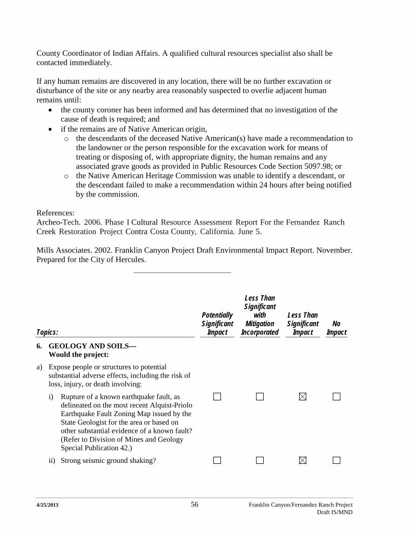
4/25/2013 56 Franklin Canyon/Fernandez Ranch Project Draft IS/MND
County Coordinator of Indian Affairs. A qualified cultural resources specialist also shall be contacted immediately. If any human remains are discovered in any location, there will be no further excavation or disturbance of the site or any nearby area reasonably suspected to overlie adjacent human remains until:
• the county coroner has been informed and has determined that no investigation of the cause of death is required; and
• if the remains are of Native American origin, o the descendants of the deceased Native American(s) have made a recommendation to
the landowner or the person responsible for the excavation work for means of treating or disposing of, with appropriate dignity, the human remains and any associated grave goods as provided in Public Resources Code Section 5097.98; or
o the Native American Heritage Commission was unable to identify a descendant, or the descendant failed to make a recommendation within 24 hours after being notified by the commission.
References: Archeo-Tech. 2006. Phase I Cultural Resource Assessment Report For the Fernandez Ranch Creek Restoration Project Contra Costa County, California. June 5. Mills Associates. 2002. Franklin Canyon Project Draft Environmental Impact Report. November. Prepared for the City of Hercules.
Topics:
Potentially Significant
Impact
Less Than Significant
with Mitigation
Incorporated
Less Than Significant
Impact No
Impact
6. GEOLOGY AND SOILS— Would the project:
a) Expose people or structures to potential substantial adverse effects, including the risk of loss, injury, or death involving:
i) Rupture of a known earthquake fault, as delineated on the most recent Alquist-Priolo Earthquake Fault Zoning Map issued by the State Geologist for the area or based on other substantial evidence of a known fault? (Refer to Division of Mines and Geology Special Publication 42.)
ii) Strong seismic ground shaking?
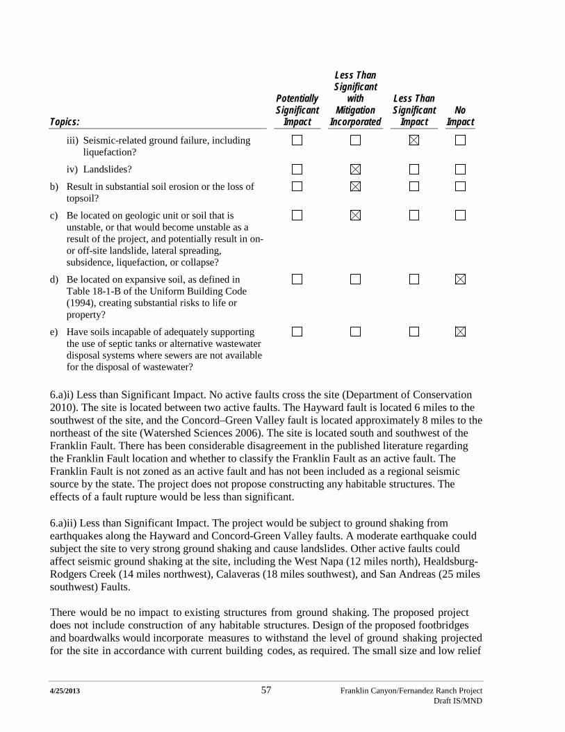
4/25/2013 57 Franklin Canyon/Fernandez Ranch Project Draft IS/MND
Topics:
Potentially Significant
Impact
Less Than Significant
with Mitigation
Incorporated
Less Than Significant
Impact No
Impact
iii) Seismic-related ground failure, including liquefaction?
iv) Landslides?
b) Result in substantial soil erosion or the loss of topsoil?
c) Be located on geologic unit or soil that is unstable, or that would become unstable as a result of the project, and potentially result in on- or off-site landslide, lateral spreading, subsidence, liquefaction, or collapse?
d) Be located on expansive soil, as defined in Table 18-1-B of the Uniform Building Code (1994), creating substantial risks to life or property?
e) Have soils incapable of adequately supporting the use of septic tanks or alternative wastewater disposal systems where sewers are not available for the disposal of wastewater?
6.a)i) Less than Significant Impact. No active faults cross the site (Department of Conservation 2010). The site is located between two active faults. The Hayward fault is located 6 miles to the southwest of the site, and the Concord–Green Valley fault is located approximately 8 miles to the northeast of the site (Watershed Sciences 2006). The site is located south and southwest of the Franklin Fault. There has been considerable disagreement in the published literature regarding the Franklin Fault location and whether to classify the Franklin Fault as an active fault. The Franklin Fault is not zoned as an active fault and has not been included as a regional seismic source by the state. The project does not propose constructing any habitable structures. The effects of a fault rupture would be less than significant.
6.a)ii) Less than Significant Impact. The project would be subject to ground shaking from earthquakes along the Hayward and Concord-Green Valley faults. A moderate earthquake could subject the site to very strong ground shaking and cause landslides. Other active faults could affect seismic ground shaking at the site, including the West Napa (12 miles north), Healdsburg-Rodgers Creek (14 miles northwest), Calaveras (18 miles southwest), and San Andreas (25 miles southwest) Faults. There would be no impact to existing structures from ground shaking. The proposed project does not include construction of any habitable structures. Design of the proposed footbridges and boardwalks would incorporate measures to withstand the level of ground shaking projected for the site in accordance with current building codes, as required. The small size and low relief
4/25/2013 58 Franklin Canyon/Fernandez Ranch Project Draft IS/MND
of the boardwalks and foot bridges would also limit any potential impacts to users should the structures fail during an extreme seismic event. Fencing and the corral could collapse during a large seismic event; temporary loss of fencing and/or the corral would not result in any potentially significant impacts. Stock pond dams could fail during a large seismic event, and water could be released from the stock ponds. Because the stock ponds would be set into the ground, the amount of water that could be released during a large seismic event would be limited. The effects of ground shaking would be less than significant. 6.a)iii) Less than Significant Impact. The Contra Costa General Plan classifies the Franklin Canyon property as having “generally low” liquefaction potential (Mills 2002). There are no known locations of artificial fill or sandy soil at the project site. Due to the predominantly clayey subsurface soils and low groundwater level observed during field exploration of the Fernandez Ranch property, the impact from liquefaction and ground failure are not expected to be significant (Watershed Sciences 2006). Design of the footbridges and boardwalks would incorporate current building code standards regarding liquefaction potential, if required. The effects of liquefaction would be less than significant. 6.a)iv) Less than Significant with Mitigation Incorporated. Natural deep-seated earth flow, shallow debris slides, slumps, and channel failure have been noted at the site. The Franklin Canyon site showed 35 landslides on the USGS Landslide Map (Mills 2002). Soils at the project site have a relatively high potential for slides (Vollmar 2006 and Vollmar 2013). Grazing practices at the project site would be managed to minimize future slides. Proposed grazing would be reviewed by MHLT on an annual basis. The following mitigation measure has been applied to the Fernandez Ranch portion of the project and would also be incorporated into the proposed cattle operation on the Franklin Canyon portion of the site. With the inclusion of this mitigation measure as part of the project, the potential impact would be less than significant. Mitigation Measure GEO-1: Grazing practices shall be implemented to minimize and, if feasible, reduce the impacts from grazing to the site’s soils and slope stability. 6.b) Less than Significant with Mitigation Incorporated. The proposed project includes measures to minimize soil erosion. The project would have temporary impacts due to grading that could result in erosion of hillside areas. Construction would occur during the dry season (between April 15th and October 15th). Erosion control plans would be included in the Stormwater Pollution Prevention Plan (SWPPP) required for any grading permit or activity that may take place at the site. Some re-vegetation work would extend into the late fall beyond October 15th to take advantage of the rainy season to establish plantings without irrigation. The following mitigation measure would be incorporated during the construction and operation of the project to reduce the impact. With the inclusion of this mitigation measure as part of the project, the impact would be less than significant. Mitigation Measure GEO-2: Soil erosion and landslides from the project shall be minimized through the design and location of the proposed trails.

4/25/2013 59 Franklin Canyon/Fernandez Ranch Project Draft IS/MND
6.c) Less than Significant with Mitigation Incorporated. The proposed project is located on soils that are not subject to significant lateral spreading, subsidence, liquefaction, or collapse. The project would undertake measures to avoid off-site or on-site landslides. Landslides could occur if grading and other construction activities occur that do not conform to applicable construction standards. Implementation of Mitigation Measure GEO-2 would reduce the impact to less than significant. 6.d) No Impact. The project does not propose construction of any structures that would be subject to the Uniform Building Code (1994) and would not create substantial risks to life or property. 6.e) No Impact. The project does not propose constructing septic systems or alternative waste disposal systems. References: City of Hercules. 2010. Initial Study/Mitigated Negative Declaration for the Project: Franklin Canyon/East Panhandle Annexation. August. Department of Conservation. 2013. Alquist-Priolo Earthquake Fault Zone Maps. Mare Island Quadrangle 1/1/82. http://www.quake.ca.gov/gmaps/ap/ap_maps.htm. Accessed January 30, 2013. Mills Associates. 2002. Franklin Canyon Project Draft Environmental Impact Report. November. Prepared for the City of Hercules. Watershed Sciences. 2006. Geomorphic and Hydrologic Assessment of Fernandez Ranch. July 16.
Topics:
Potentially Significant
Impact
Less Than Significant
with Mitigation
Incorporated
Less Than Significant
Impact No
Impact
7. GREENHOUSE GAS EMISSIONS— Would the project:
a) Generate greenhouse gas emissions, either directly or indirectly, that may have a significant impact on the environment?
b) Conflict with any applicable plan, policy, or regulation adopted for the purpose of reducing the emissions of greenhouse gases?
4/25/2013 60 Franklin Canyon/Fernandez Ranch Project Draft IS/MND
7.a) Less than Significant Impact. New greenhouse gas emissions (GHGs) would primarily be generated during project construction (trail construction, and construction of features required for grazing). No change in operational emissions is anticipated from recreational use of the property because the number of vehicles traveling to the site is expected to be the same before and after construction of the new trails. Increases in current operational emissions would occur due to the addition of cattle to the site, maintenance of the cattle fence and related facilities, and slight increases in patrols and trail maintenance activities. Construction of the trails, stock ponds, and the fencing at the site would generate small quantities of greenhouse gases. The estimated maximum project construction duration involving use of motorized equipment (i.e., equipment that could emit GHGs) is a total of 60 days. The project construction effort is likely to occur over a period to 3 to 5 years; however, for the purposes of the GHG evaluation in this CEQA document, the most intense construction duration (i.e., assuming all construction requiring motorized equipment occurs in one year) has been analyzed. Three trail crews of 10 to 20 workers each would be required to fully utilize the motorized trail-building equipment. The crews would likely carpool to the Staging Area, and then be transported on-site using small trucks or large vans. Construction would most likely involve the use of a flatbed truck to haul equipment and supplies, 2 small trucks or large diesel-powered vans to transport each trail crew, and a SWECO trail building machine or a small bulldozer of equivalent horsepower. The estimated carbon dioxide (CO2) emissions associated with the use of this equipment over a period of 60 days, and the estimated commute-related emissions over a period of 270 days, are approximately 1.55 metric tons2
(MT) combined of GHGs/day (0.32 MT/day for non-motorized construction), or 160.7 MT for the maximum construction period. CO2 emissions from vehicles and construction equipment were estimated using the URBEMIS model (URBEMIS 2007 version 9.2.4). Trail building crews are assumed to commute from an average distance of 30 miles one way. Mobile equipment also emits other GHGs, primarily methane and nitrous oxide (N2O), which have global warming potentials equal to 21 times and 310 times that of CO2, respectively (USEPA 2013b,c). GHG emissions are measured in CO2 equivalents (CO2e). Projected emissions of methane and nitrous oxide from construction equipment are small and would increase the maximum estimated CO2e emissions for the entire construction period to 161.1 MT. For comparison, the Bay Area as a whole emitted an estimated 95.8 million MT of CO2e in 2007 (BAAQMD 2010), and the estimated emissions in unincorporated Contra Costa County were 1,667,070 MT of CO2e in 2005 (CCC 2012).
Maintenance of the trails would require no more than one work day per week year round by MHLT (i.e., 52 days per year), and would require a pick-up truck. Occasionally, a flatbed truck could be required to deliver supplies and equipment for repairs. The grazing lessee would be expected to travel to the site approximately one day per week. Any necessary repairs of the fencing and corral are estimated to require no more than one day per week throughout the year, and would be conducted as part of the routine site visits by the grazing lessee. The routine site visits by the grazing lessee would require a pick-up truck; repairs of fencing and corrals may 2 One metric ton is equivalent to approximately 2,200 lbs.
4/25/2013 61 Franklin Canyon/Fernandez Ranch Project Draft IS/MND
periodically require a flatbed truck to deliver supplies and equipment for repairs. Thus, yearly maintenance would require 104 pick-up truck trips and an estimated 24 flatbed truck trips. The total average annual CO2e emissions associated with these maintenance operations are 0.19 MT. The largest potential source of operational GHGs as measured in MT of CO2e are the cattle that would be brought to the site. Cattle produce methane gas as a result of their digestion process; US EPA estimates that an average cow emits 80 to 110 kg of methane per year (USEPA 2013a). Using the middle of the range provided by US EPA, 30 cattle would result in an estimated generation of 2.85 MT of methane or 60 MT CO2e per year. Improved grazing management would likely lead to increased carbon storage (carbon sequestration) in the soil in the grazed areas that would partially off-set the increased GHG emissions from the cattle. Grasses allocate a high proportion of their photosynthate belowground to roots leading to greater soil carbon pools. Estimates of increased carbon sequestration achievable with improved range management range from 0.12 to 0.52 MT/acre/year (Private Landowner Network 2013). The higher rates are generally achieved in areas with higher precipitation and active management of grasslands, including seeding and fertilization. Assuming a sequestration rate at the low of the range, improved grazing management on 200 acres of land would sequester approximately 24 MT of CO2e per year; using a mid-range value the same 200 acres would sequester approximately 64 MT of CO2e per year. Following construction, total net GHG emissions from the proposed project would therefore range from approximately 0 to 36 MT CO2e, taking into the consideration the carbon sequestration benefits provided by improved rangeland management. Thus both construction and potential annual operational GHG emissions attributable to the project are less than significant. With the exception of very large projects, GHG from individual projects are typically less than significant at the project scale; however, GHG emissions cumulatively have a substantial environmental impact. The revisions to the CEQA guidelines adopted December 30, 2009 (Section 15064 (h)(3)) provide the basis for assessing cumulative impacts of GHG emissions. Section 15064 indicates that a “…lead agency may determine that a project’s incremental contribution to a cumulative effect is not cumulatively considerable if the project will comply with the requirements in a previously approved plan or mitigation program (including, but not limited to, water quality control plan, air quality attainment or maintenance plan, integrated waste management plan, habitat conservation plan, natural community conservation plan, plans or regulations for the reduction of greenhouse gas emissions) that provides specific requirements that will avoid or substantially lessen the cumulative problem within the geographic area in which the project is located.” The guidance also encourages lead agencies to quantify GHG emissions where possible. The City of Hercules does not have a Climate Action Plan; therefore the most directly applicable plan for the entire property is the Draft Climate Action Plan for unincorporated Contra Costa County, in that part of the property is located within the unincorporated portion of the County. The proposed project is consistent with Contra Costa County Climate Action Plan GHG Reduction Strategy Measure LUT 1, Mobility and Land Uses: Maintain and expand access to good, services, and other destinations by increased transportation alternatives (mobility improvements) and improved proximity (land use improvements) and LUT 5, Vehicle Miles Traveled Reduction: Reduce vehicle miles traveled (CCC 2012). This project
4/25/2013 62 Franklin Canyon/Fernandez Ranch Project Draft IS/MND
provides land use improvement as it places opportunities for recreation in proximity to local residents, and thus may reduce vehicle miles traveled for recreational access. Furthermore, total estimated annual GHG emissions are very small compared to both Bay Area and Contra Costa County total annual CO2e emissions. Therefore potential cumulative impacts associated with project-related GHG emissions are less than significant. 7.b) No Impact. The proposed project would not conflict with any applicable policy or regulation adopted for the purpose of reducing the emissions of greenhouse gases. Providing local recreational opportunities could have an indirect effect on greenhouse gas emissions by reducing trip lengths for individuals seeking recreational opportunities. Well-managed range lands can also serve to sequester carbon in the soil as described above. References: Bay Area Air Quality Management District (BAAQMD). 2010. Source Inventory of Bay Area Greenhouse Gas Emissions. February. Contra Costa County (CCC). 2012. Contra Costa County Climate Action Plan – Draft. December. Private Land Owner Network. 2013. Rangeland Soil Carbon Management Offsets Program. http://privatelandownernetwork.org/yellowpages/resource.aspx?id=13174. Accessed March 1. Silver, Whendee L. and Ryals, Rebecca. 2009. Soil Carbon Sequestration: A Low-Cost, High-Benefit Approach to Climate Change Mitigation. Presented at: California Climate Change Research Symposium. September 10. http://www.climatechange.ca.gov/events/2009_symposium/presentations/2009-09-10_Thursday/Track_01/Session_03/Talk2_Session3_307_Thurs_Silver.pdf. Accessed March 1, 2013. United States Environmental Protection Agency (USEPA). 2013a. Ruminant Livestock Frequent Questions. http://www.epa.gov/ruminant.html/faq.html. Accessed February 24, 2013. USEPA. 2013b. Greenhouse Gas Emissions – Methane Emissions. http://epa.gov/climatechange/ghgemissions/gases/ch4.html. Accessed February 24, 2013. USEPA. 2013c. Greenhouse Gas Emissions – Nitrous Oxide Emissions. http://epa.gov/climatechange/ghgemissions/gases/n2o.html. Accessed February 24, 2013.

4/25/2013 63 Franklin Canyon/Fernandez Ranch Project Draft IS/MND
Topics:
Potentially Significant
Impact
Less Than Significant
with Mitigation
Incorporated
Less Than Significant
Impact No
Impact
8. HAZARDS AND HAZARDOUS MATERIALS— Would the project:
a) Create a significant hazard to the public or the environment through the routine transport, use, or disposal of hazardous materials?
b) Create a significant hazard to the public or the environment through reasonably foreseeable upset and accident conditions involving the release of hazardous materials into the environment?
c) Emit hazardous emissions or handle hazardous or acutely hazardous materials, substances, or waste within one-quarter mile of an existing or proposed school?
d) Be located on a site which is included on a list of hazardous materials sites compiled pursuant to Government Code Section 65962.5 and, as a result, would it create a significant hazard to the public or the environment?
e) For a project located within an airport land use plan or, where such a plan has not been adopted, within two miles of a public airport or public use airport, would the project result in a safety hazard for people residing or working in the project area?
f) For a project within the vicinity of a private airstrip, would the project result in a safety hazard for people residing or working in the project area?
g) Impair implementation of or physically interfere with an adopted emergency response plan or emergency evacuation plan?
h) Expose people or structures to a significant risk of loss, injury or death involving wildland fires including where wildlands are adjacent to urbanized areas or where residences are intermixed with wildlands?
4/25/2013 64 Franklin Canyon/Fernandez Ranch Project Draft IS/MND
8.a) No Impact. The proposed project does not involve routine transport, use, or disposal of hazardous materials, and therefore no impact would occur. 8.b) Less than Significant with Mitigation Incorporated. The proposed project would not include operations or maintenance that would result in the release of hazardous materials to the environment, and therefore no impact would occur. During construction there would be limited heavy equipment and supplies on the site that could result in a release of hazardous materials such as fuel and lubricants. The project site is also crossed by an underground high-pressure gas line that passes through the grasslands and hillsides (Figure 2). Though the gas line is marked with signs, accidental damage to the line could result during construction if the location and depth are not properly identified and the pipeline is not adequately protected. The pipeline would cross the proposed Woodland Trail in one location, and it would also cross the proposed Summit Trail in one location. With the inclusion of Mitigation Measures HAZ-1 and HAZ-2 as part of the project, this potential impact would be reduced to a less than significant level. Mitigation Measure HAZ-1: The project sponsor shall implement a spill prevention plan, including management and protective measures, emergency response measures as necessary, methods to capture fuel spills, providing a staging area for heavy construction vehicles that prevents leaks into the soil or water, and requiring that maintenance of heavy construction vehicles be conducted off-site. Mitigation Measure HAZ-2: The MHLT and its contractors shall verify, through underground service alert (USA) services or private utility locator, on plans and in the field the precise location of the high-pressure gas line in areas that could be affected by any construction activities (including incidental staging, transportation, grading and planting). In addition, MHLT shall coordinate with the owner of the gas pipeline, Kinder Morgan, to ensure that the owner is aware of the proposed work, and has had an opportunity to review the proposed plans. Information regarding the precise location and depth of the high-pressure gas line shall be provided to all parties involved via plans and field markings. All work within 100 feet of the pipeline shall be closely supervised to ensure protection of personnel and the line at all times. The MHLT and its contractors shall coordinate on-going monitoring of construction activities within 100 feet of the pipeline with the pipeline owner/operator throughout the life of the project. 8.c) No Impact. The proposed project would neither create hazardous emissions nor involve hazardous or acutely hazardous materials, substances, or waste, and therefore no impact would occur. 8.d) No Impact. The project is not included on a list of hazardous materials sites compiled pursuant to Government Code Section 65962.5, and therefore no impact would occur. 8.e) No Impact. The project is not included within an airport land use plan or within two miles of a public airport or public use airport, and therefore no impact would occur. 8.f) No Impact. The project is not within the vicinity of a private airstrip, and therefore no impact would occur.
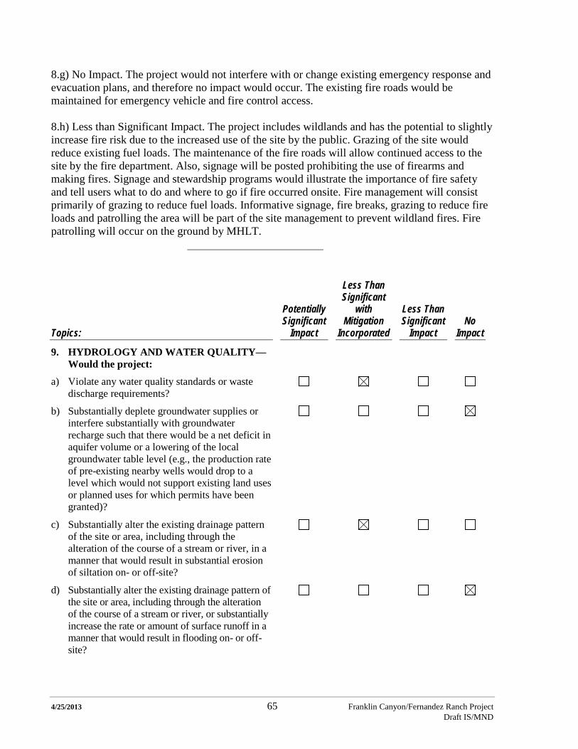
4/25/2013 65 Franklin Canyon/Fernandez Ranch Project Draft IS/MND
8.g) No Impact. The project would not interfere with or change existing emergency response and evacuation plans, and therefore no impact would occur. The existing fire roads would be maintained for emergency vehicle and fire control access. 8.h) Less than Significant Impact. The project includes wildlands and has the potential to slightly increase fire risk due to the increased use of the site by the public. Grazing of the site would reduce existing fuel loads. The maintenance of the fire roads will allow continued access to the site by the fire department. Also, signage will be posted prohibiting the use of firearms and making fires. Signage and stewardship programs would illustrate the importance of fire safety and tell users what to do and where to go if fire occurred onsite. Fire management will consist primarily of grazing to reduce fuel loads. Informative signage, fire breaks, grazing to reduce fire loads and patrolling the area will be part of the site management to prevent wildland fires. Fire patrolling will occur on the ground by MHLT.
Topics:
Potentially Significant
Impact
Less Than Significant
with Mitigation
Incorporated
Less Than Significant
Impact No
Impact
9. HYDROLOGY AND WATER QUALITY— Would the project:
a) Violate any water quality standards or waste discharge requirements?
b) Substantially deplete groundwater supplies or interfere substantially with groundwater recharge such that there would be a net deficit in aquifer volume or a lowering of the local groundwater table level (e.g., the production rate of pre-existing nearby wells would drop to a level which would not support existing land uses or planned uses for which permits have been granted)?
c) Substantially alter the existing drainage pattern of the site or area, including through the alteration of the course of a stream or river, in a manner that would result in substantial erosion of siltation on- or off-site?
d) Substantially alter the existing drainage pattern of the site or area, including through the alteration of the course of a stream or river, or substantially increase the rate or amount of surface runoff in a manner that would result in flooding on- or off-site?
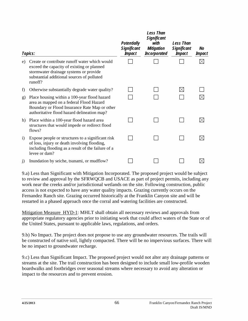
4/25/2013 66 Franklin Canyon/Fernandez Ranch Project Draft IS/MND
Topics:
Potentially Significant
Impact
Less Than Significant
with Mitigation
Incorporated
Less Than Significant
Impact No
Impact
e) Create or contribute runoff water which would exceed the capacity of existing or planned stormwater drainage systems or provide substantial additional sources of polluted runoff?
f) Otherwise substantially degrade water quality?
g) Place housing within a 100-year flood hazard area as mapped on a federal Flood Hazard Boundary or Flood Insurance Rate Map or other authoritative flood hazard delineation map?
h) Place within a 100-year flood hazard area structures that would impede or redirect flood flows?
i) Expose people or structures to a significant risk of loss, injury or death involving flooding, including flooding as a result of the failure of a levee or dam?
j) Inundation by seiche, tsunami, or mudflow? 9.a) Less than Significant with Mitigation Incorporated. The proposed project would be subject to review and approval by the SFRWQCB and USACE as part of project permits, including any work near the creeks and/or jurisdictional wetlands on the site. Following construction, public access is not expected to have any water quality impacts. Grazing currently occurs on the Fernandez Ranch site. Grazing occurred historically at the Franklin Canyon site and will be restarted in a phased approach once the corral and watering facilities are constructed. Mitigation Measure HYD-1: MHLT shall obtain all necessary reviews and approvals from appropriate regulatory agencies prior to initiating work that could affect waters of the State or of the United States, pursuant to applicable laws, regulations, and orders. 9.b) No Impact. The project does not propose to use any groundwater resources. The trails will be constructed of native soil, lightly compacted. There will be no impervious surfaces. There will be no impact to groundwater recharge. 9.c) Less than Significant Impact. The proposed project would not alter any drainage patterns or streams at the site. The trail construction has been designed to include small low-profile wooden boardwalks and footbridges over seasonal streams where necessary to avoid any alteration or impact to the resources and to prevent erosion.

4/25/2013 67 Franklin Canyon/Fernandez Ranch Project Draft IS/MND
9.d) No Impact. The project site is not currently subject to flooding. Restoration work completed in 2010 at Rodeo Creek improved the flood capacity at the Fernandez Ranch site. 9.e) Less than Significant Impact. The project would include minor amounts of grading for trail construction and improvements, the corral, and construction of stock ponds. Any runoff from this grading or material spilled during construction would be minor and addressed by the SWPPP incorporated into the project and described in mitigation measure HAZ-1. After construction the project would not contribute to polluted water runoff and there are no storm water systems associated with the site. 9.f) Less than Significant Impact. There would be no substantial degradation of the water quality. The construction at the site is minor and limited to trail, corral, fence, and stock pond construction. BMPs would be used to avoid water quality impacts. The site management plan would include measures to preserve and potentially enhance the site’s water quality, including use of exclusion in sensitive riparian areas, distribution of livestock water to reduce livestock effects on riparian areas, and revegetation (with native plants) of trail margins to reduce erosion. Cattle are presently excluded from Rodeo Creek and stretches of Fern and Slot Creeks by interior livestock fencing. 9.g) No Impact. Residential development is not part of the project, and therefore there is no impact. 9.h) No Impact. No structures are proposed that would impede or redirect flow within the 100-year flood hazard area. 9.i) No Impact. There are no levees or dams currently on the site or proposed as part of the project. The project is not expected to pose any risk from flooding to adjacent properties. Up to four new stock ponds are proposed but these ponds would be small and shallow, and the majority of the pond water capacity would be held within an excavated area contour-graded into the natural contours of the site. Thus, the stock ponds are unlikely to breach. The management plan for the site would include periodic inspection and maintenance of these stock ponds. 9.j) No Impact. The site is not located near any ocean or bodies of water where a tsunami or seiche could occur. There is no evidence of past mudflows at the site, and it is unlikely that any of the construction from the project would increase the risk of mudflows.
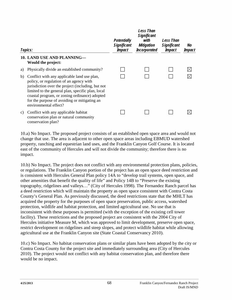
4/25/2013 68 Franklin Canyon/Fernandez Ranch Project Draft IS/MND
Topics:
Potentially Significant
Impact
Less Than Significant
with Mitigation
Incorporated
Less Than Significant
Impact No
Impact
10. LAND USE AND PLANNING— Would the project:
a) Physically divide an established community?
b) Conflict with any applicable land use plan, policy, or regulation of an agency with jurisdiction over the project (including, but not limited to the general plan, specific plan, local coastal program, or zoning ordinance) adopted for the purpose of avoiding or mitigating an environmental effect?
c) Conflict with any applicable habitat conservation plan or natural community conservation plan?
10.a) No Impact. The proposed project consists of an established open space area and would not change that use. The area is adjacent to other open space areas including EBMUD watershed property, ranching and equestrian land uses, and the Franklin Canyon Golf Course. It is located east of the community of Hercules and will not divide the community; therefore there is no impact. 10.b) No Impact. The project does not conflict with any environmental protection plans, policies, or regulations. The Franklin Canyon portion of the project has an open space deed restriction and is consistent with Hercules General Plan policy 14A to “develop trail systems, open space, and other amenities that benefit the quality of life” and Policy 14B to “Preserve the existing topography, ridgelines and valleys…” (City of Hercules 1998). The Fernandez Ranch parcel has a deed restriction which will maintain the property as open space consistent with Contra Costa County’s General Plan. As previously discussed, the deed restrictions state that the MHLT has acquired the property for the purposes of open space preservation, public access, watershed protection, wildlife and habitat protection, and limited agricultural use. No use that is inconsistent with these purposes is permitted (with the exception of the existing cell tower facility). These restrictions and the proposed project are consistent with the 2004 City of Hercules initiative Measure M, which was approved to limit development, preserve open space, restrict development on ridgelines and steep slopes, and protect wildlife habitat while allowing agricultural use at the Franklin Canyon site (State Coastal Conservancy 2010). 10.c) No Impact. No habitat conservation plans or similar plans have been adopted by the city or Contra Costa County for the project site and immediately surrounding area (City of Hercules 2010). The project would not conflict with any habitat conservation plan, and therefore there would be no impact.
4/25/2013 69 Franklin Canyon/Fernandez Ranch Project Draft IS/MND
References: City of Hercules. 1998. General Plan. September 22. http://www.ci.hercules.ca.us/index.aspx?page=196. Accessed on February 3, 2013.
City of Hercules. 2010. Initial Study/Mitigated Negative Declaration for the Project: Franklin Canyon/East Panhandle Annexation. August. http://www.ci.hercules.ca.us/index.aspx?page=600. Accessed on February 3, 2013.
State Coastal Conservancy. 2010. Staff Recommendation Franklin Canyon Acquisition. April 1.
scc.ca.gov/.../20100401Board05_Franklin_Canyon_Acquisition.pdf.
Topics:
Potentially Significant
Impact
Less Than Significant
with Mitigation
Incorporated
Less Than Significant
Impact No
Impact
11. MINERAL RESOURCES—Would the project:
a) Result in the loss of availability of a known mineral resource that would be of value to the region and the residents of the state?
b) Result in the loss of availability of a locally-important mineral resource recovery site delineated on a local general plan, specific plan or other land use plan?
11.a) No Impact. There have been no significant mineral resources identified in the City of Hercules by the state (City of Hercules 1998 and Contra Costa County 2005).
11.b) No Impact. There are no locally important mineral resource recovery sites identified at the project site.
References: City of Hercules. 1998. General Plan. September 22. http://www.ci.hercules.ca.us/index.aspx?page=196. Accessed on February 3, 2013. Contra Costa County. 2005 (Reprint 2010). Contra Costa County General Plan 2005-2020. July 18.

4/25/2013 70 Franklin Canyon/Fernandez Ranch Project Draft IS/MND
Topics:
Potentially Significant
Impact
Less Than Significant
with Mitigation
Incorporated
Less Than Significant
Impact No
Impact
12. NOISE—Would the project result in:
a) Exposure of persons to or generation of noise levels in excess of standards established in the local general plan or noise ordinance, or applicable standards of other agencies?
b) Exposure of persons to or generation of excessive groundborne vibration or groundborne noise levels?
c) A substantial permanent increase in ambient noise levels in the project vicinity above levels existing without the project?
d) A substantial temporary or periodic increase in ambient noise levels in the project vicinity above levels existing without the project?
e) For a project located within an airport land use plan area, or, where such a plan has not been adopted, in an area within two miles of a public airport or public use airport, would the project expose people residing or working in the area to excessive noise levels?
f) For a project located in the vicinity of a private airstrip, would the project expose people residing or working in the project area to excessive noise levels?
12.a) Less than Significant Impact. The closest residential receptor (closest home in the Refugio Heights subdivision) to any construction activity will be about 800 feet from the work, and work in this area (along the West Trail) will occur for no more than three weeks. There would be a short term, localized, intermittent increase in the noise level during construction due to heavy equipment use. Earth-moving activities can often be noisy with equipment noise periodically ranging up to about 90 dB at 50 feet from the source (when the equipment is operating at full load). Noise levels decrease with distance from the noise source. Specifically, spherically radiating point sources of noise emissions are atmospherically attenuated by a factor of 6 dB per doubling of distance, or about 24 dB in 800 feet of propagation. Exterior noise levels of 58 to 70 dB are considered conditionally acceptable by the State of California for new residential construction; thus, the potential short-term, periodic increase in noise due to construction at the West Trail would be a less-than-significant impact. Other construction activities would be far removed from potential sensitive receptors and thus would not have a noise impact on sensitive receptors. Internal combustion engines and tools would have a muffler per the manufacturer’s specification.
4/25/2013 71 Franklin Canyon/Fernandez Ranch Project Draft IS/MND
Also, several additional vehicles may travel along Christie Road during week days during the construction period. Up to sixty additional daily (morning and evening) vehicle trips would occur along Christie Road to bring trail crews, their supervisor, and potentially materials and equipment to the project site. There are few residences and no sensitive uses along Christie Road, and it is expected that the very minor increase in noise levels associated with the project would not be significant. Use of the Franklin Canyon property by horseback riders, hikers, other recreational users and cattle grazing maintenance vehicles is not expected to increase the noise significantly above current ambient noise levels. These vehicle and recreational use-related increases in ambient noise would be less than significant. 12.b) Less than Significant Impact. Grading, excavation, and fence installation may intermittently increase groundborne vibration in the immediate vicinity of the work area. The work would be of short duration, highly localized, and infrequent and would not be expected to be noticeable in the surrounding open space, agricultural uses, and golf course. 12.c) Less than Significant Impact. The only new uses for the site would be to reestablish grazing on portions of the Franklin Canyon property and to add 5.0 miles of multi-use trails on the entire project site. Vehicular access to the established Christie Road Staging Area for recreational purposes is not expected to increase over current levels. There would be a minor, infrequent increase in maintenance vehicles, including those for livestock management. These uses would not be expected to create a substantial increase in the ambient noise level. 12.d) Less than Significant Impact. During construction there may be a temporary, localized, intermittent increase in noise levels, but it will be infrequent and would be expected to have minimal impact on sensitive noise receptors. As stated above, the closest residence is in the Refugio Heights subdivision approximately 800 feet away from the nearest construction activity. There are no other residential uses or other sensitive noise receptors in the area where construction will occur for the trails, bridge, and corrals. The increased noise levels associated with construction could occur over an approximately 90-day period each year for up to three years of project construction. Construction noise would be associated with vehicle travel to and within the site and periodic use of heavy equipment (trail building machine). Heavy equipment use would occur during approximately 60 days total over the construction period. It is expected that with the exception of construction at the western portion of the West Trail previously discussed, the noise levels experienced by sensitive receptors would not be noticeable due to their distance from the work areas. 12.e) No Impact. The project is not located within an airport land use plan or within two miles of a public airport. 12.f) No Impact. The project is not located within the vicinity of a private airstrip, and therefore there would be no impact.
4/25/2013 72 Franklin Canyon/Fernandez Ranch Project Draft IS/MND
Reference: City of Hercules.1998. General Plan Noise Element Part 2. September 22. http://www.ci.hercules.ca.us/index.aspx?page=196. Accessed February 18, 2013.
Topics:
Potentially Significant
Impact
Less Than Significant
with Mitigation
Incorporated
Less Than Significant
Impact No
Impact
13. POPULATION AND HOUSING— Would the project:
a) Induce substantial population growth in an area, either directly (for example, by proposing new homes and businesses) or indirectly (for example, through extension of roads or other infrastructure)?
b) Displace substantial numbers of existing housing units, necessitating the construction of replacement housing?
c) Displace substantial numbers of people, necessitating the construction of replacement housing elsewhere?
13.a) No Impact. The project would not induce substantial population growth and does not propose new home, business, or infrastructure, and therefore there is no impact.
13.b) No Impact. The project would not displace any existing housing, and therefore there is no impact.
13.c) No Impact. The project would not displace any people, and therefore there is no impact.
4/25/2013 73 Franklin Canyon/Fernandez Ranch Project Draft IS/MND
Topics:
Potentially Significant
Impact
Less Than Significant
with Mitigation Incorporated
Less Than Significant
Impact No
Impact
14. PUBLIC SERVICES— Would the project:
a) Result in substantial adverse physical impacts associated with the provision of new or physically altered governmental facilities, need for new or physically altered governmental facilities, the construction of which could cause significant environmental impacts, in order to maintain acceptable service ratios, response times, or other performance objectives for any public services: such as fire protection, police protection, schools, parks, or other services?
Fire protection?
Police protection?
Schools?
Parks?
Other public services? 14.a) Less than Significant Impact. The proposed project was reviewed by the Rodeo–Hercules Fire District. Contra Costa County contacted the Fire District about the project, and received a response on April 2, 2013, indicating that the Fire District had no comments. Emergency access to the Fernandez property is through the Christie Road Staging Area off Christie Road and the EBMUD/Bay Area Ridge Trail fire road at the top of the Windmill Trail fire road. Access to the Franklin Canyon property will be through the same Staging Area and fire road to the EBMUD/Bay Area Ridge Trail gate. From this Fernandez Ranch property access gate, emergency vehicles will use the EBMUD/Bay Area Ridge Trail fire road to access Franklin Canyon. Other emergency access points include the series of restricted fire road access points around the Franklin Canyon property: from the Franklin Canyon Golf Course, at Grissom Street, and the upper end of Refugio Valley Road. Signage will be posted regarding fire prevention for trail users. Fire roads would continue to be maintained on the project site. MHLT would patrol the entire project site on the ground. Although there is the potential for a slight increase in the fire hazard due to the increased public usage at the site, the increased need for any associated fire protection services is expected to be less than significant, and may be partially off-set through the reduced fuel load resulting from the reintroduction of grazing. 14.a) No Impact. MHLT would patrol the site. Trespassing would be addressed by posting signs on the Franklin Canyon property and maintaining fencing of the property consistent with agricultural requirements. Occasional vandalism has occurred at the Christie Road Staging Area since it opened in 2010, and no changes would be expected as a result of this project, because the project would use the same staging area. No additional police coverage is anticipated to be required, and therefore there would be no impact to the City of Hercules police service or the Contra Costa County Sheriff’s Department. 14.a) No Impact. The project does not propose any residential development, and therefore would not affect the number of students attending public schools.
4/25/2013 74 Franklin Canyon/Fernandez Ranch Project Draft IS/MND
14.a) No Impact. The proposed project would increase access to open space and provide additional recreational area. Maintenance of the additional facilities would be the responsibility of MHLT and would not place any added burden on the City of Hercules or Contra Costa County. 14.a) No Impact. There would be no impact to other public facilities.
Topics:
Potentially Significant
Impact
Less Than Significant
with Mitigation
Incorporated
Less Than Significant
Impact No
Impact
15. RECREATION—
a) Would the project increase the use of existing neighborhood and regional parks or other recreational facilities such that substantial physical deterioration of the facilities would occur or be accelerated?
b) Does the project include recreational facilities or require the construction or expansion of recreational facilities that might have an adverse physical effect on the environment?
15.a) No Impact. The proposed project would not affect existing neighborhood or regional parks or recreational facilities. The project would provide new open space for local and regional users and connect to the Bay Area Ridge Trail. 15.b) Less than Significant with Mitigation Incorporated. The proposed project would increase the available recreational/open space areas and provide multi-use trails, including a connection to the Bay Area Ridge Trail. The project would therefore provide increased access to open space. The project would have a positive effect on the environment by protecting existing habitat and improving the condition of degraded grasslands through targeted grazing. Trail construction and use could have a potential adverse impact on the environment. With the inclusion of the mitigation measures incorporated into this document, the impact would be less than significant.
4/25/2013 75 Franklin Canyon/Fernandez Ranch Project Draft IS/MND
Topics:
Potentially Significant
Impact
Less Than Significant
with Mitigation
Incorporated
Less Than Significant
Impact No
Impact
16. TRANSPORTATION AND TRAFFIC— Would the project:
a) Conflict with an applicable plan, ordinance or policy establishing measures of effectiveness for the performance of the circulation system, taking into account all modes of transportation including mass transit and non-motorized travel and relevant components of the circulation system, including but not limited to intersections, streets, highways and freeways, pedestrian and bicycle paths, and mass transit?
b) Conflict with an applicable congestion management program, including but not limited to level of service standards and travel demand measures, or other standards established by the county congestion management agency for designated roads or highways?
c) Result in a change in air traffic patterns, including either an increase in traffic levels or a change in location that results in substantial safety risks?
d) Substantially increase hazards due to a design feature (e.g., sharp curves or dangerous intersections) or incompatible uses?
e) Result in inadequate emergency access?
f) Conflict with adopted policies, plans, or programs regarding public transit, bicycle, or pedestrian facilities, or otherwise decrease the performance or safety of such facilities?
16.a) No Impact. The project is not expected to increase vehicle travel during operations. Construction-related vehicle use would be extremely low (no more than an estimated 60 vehicle trips per day, and typically 10 trips per day, or less), including light-duty vehicles and the occasional movement of a single flatbed truck and/or small bulldozer on a truck on public roads. This level of activity would not affect or conflict with any measures of effectiveness established for any mode of transportation for the area. There would be no impact from the project. 16.b) No Impact. The project is not expected to increase vehicle travel during operations. Construction-related vehicle use would be low, as described above. This level of activity would not conflict with any congestion management plans for the area. There would be no impact.
4/25/2013 76 Franklin Canyon/Fernandez Ranch Project Draft IS/MND
16.c) No Impact. Implementation of the project would not involve any changes in air traffic. Existing aerial patrols by EBRPD would be maintained. There would be no impact from the project. 16.d) No Impact. Implementation of the project would not result in any changes to existing roads. There would be no impact from the project. 16.e) No Impact. Implementation of the project would have no effect on emergency access. All existing access will be maintained, and there would be no modifications to existing access that could reduce access for emergency vehicles. There would be no impact from the project. 16.f) No Impact. Implementation of the project would have no effect on adopted policies, plans, or programs regarding public transit, bicycle, or pedestrian facilities, and therefore there would be no impact from the project.
Topics:
Potentially Significant
Impact
Less Than Significant
with Mitigation
Incorporated
Less Than Significant
Impact No
Impact
17. UTILITIES AND SERVICE SYSTEMS— Would the project:
a) Exceed wastewater treatment requirements of the applicable Regional Water Quality Control Board?
b) Require or result in the construction of new water or wastewater treatment facilities or expansion of existing facilities, the construction of which could cause significant environmental effects?
c) Require or result in the construction of new storm water drainage facilities or expansion of existing facilities, the construction of which could cause significant environmental effects?
d) Have sufficient water supply available to serve the project from existing entitlements and resources, or new or expanded entitlements?
e) Result in a determination by the wastewater treatment provider which serves or may serve the project that it has inadequate capacity to serve the project’s projected demand in addition to the provider’s existing commitments?
4/25/2013 77 Franklin Canyon/Fernandez Ranch Project Draft IS/MND
Topics:
Potentially Significant
Impact
Less Than Significant
with Mitigation
Incorporated
Less Than Significant
Impact No
Impact
f) Be served by a landfill with sufficient permitted capacity to accommodate the project’s solid waste disposal needs?
g) Comply with federal, state, and local statutes and regulations related to solid waste?
17a) No Impact. The project would not have any wastewater discharge. There would be no impact from the project. 17.b) No Impact. The project would not require or result in the construction of new water or wastewater treatment facilities or expansion of existing facilities. There would be no impact from the project. 17.c) No Impact. The project would not require or result in the construction of new stormwater drainage facilities or expansion of existing facilities. There would be no impact from the project. 17.d) No Impact. The project has sufficient water supplies to meet the needs of grazing. No potable water would be provided as part of the project. No new or expanded entitlements would be required. There would be no impact from the project. 17.e) No Impact. The project would not need wastewater treatment services. There would be no impact from the project. 17.f) No Impact. The project would not generate significant additional solid waste for disposal at a landfill. A trash receptacle would be located at the main trailhead. All incidental waste materials would be removed from the site under contract with a municipal or commercial service provider. There would be no impact from the project. 17.g) No Impact. The project would comply with all statues and regulations related to solid waste disposal. There would be no impact from the project.
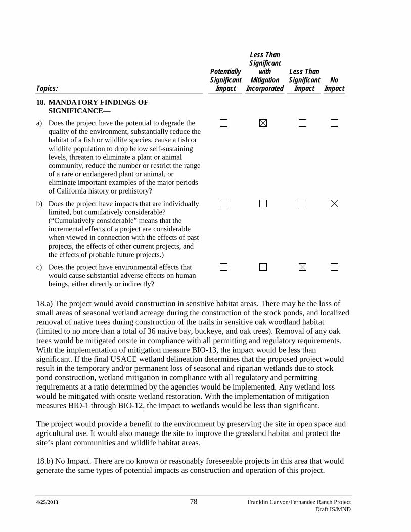
4/25/2013 78 Franklin Canyon/Fernandez Ranch Project Draft IS/MND
Topics:
Potentially Significant
Impact
Less Than Significant
with Mitigation
Incorporated
Less Than Significant
Impact No
Impact
18. MANDATORY FINDINGS OF SIGNIFICANCE—
a) Does the project have the potential to degrade the quality of the environment, substantially reduce the habitat of a fish or wildlife species, cause a fish or wildlife population to drop below self-sustaining levels, threaten to eliminate a plant or animal community, reduce the number or restrict the range of a rare or endangered plant or animal, or eliminate important examples of the major periods of California history or prehistory?
b) Does the project have impacts that are individually limited, but cumulatively considerable? (“Cumulatively considerable” means that the incremental effects of a project are considerable when viewed in connection with the effects of past projects, the effects of other current projects, and the effects of probable future projects.)
c) Does the project have environmental effects that would cause substantial adverse effects on human beings, either directly or indirectly?
18.a) The project would avoid construction in sensitive habitat areas. There may be the loss of small areas of seasonal wetland acreage during the construction of the stock ponds, and localized removal of native trees during construction of the trails in sensitive oak woodland habitat (limited to no more than a total of 36 native bay, buckeye, and oak trees). Removal of any oak trees would be mitigated onsite in compliance with all permitting and regulatory requirements. With the implementation of mitigation measure BIO-13, the impact would be less than significant. If the final USACE wetland delineation determines that the proposed project would result in the temporary and/or permanent loss of seasonal and riparian wetlands due to stock pond construction, wetland mitigation in compliance with all regulatory and permitting requirements at a ratio determined by the agencies would be implemented. Any wetland loss would be mitigated with onsite wetland restoration. With the implementation of mitigation measures BIO-1 through BIO-12, the impact to wetlands would be less than significant. The project would provide a benefit to the environment by preserving the site in open space and agricultural use. It would also manage the site to improve the grassland habitat and protect the site’s plant communities and wildlife habitat areas. 18.b) No Impact. There are no known or reasonably foreseeable projects in this area that would generate the same types of potential impacts as construction and operation of this project.
4/25/2013 79 Franklin Canyon/Fernandez Ranch Project Draft IS/MND
18.c) No Impact. The project would provide a local and regional open space recreational area and would return the site to agricultural-grazing use. There is not expected to be a substantial adverse impact on human beings.

4/25/2013 80 Franklin Canyon/Fernandez Ranch Project Draft IS/MND
Project Description References Bay Area Air Quality Management District (BAAQMD). 1999. BAAQMD CEQA Guidelines: Assessing the Air Quality Impacts of Projects and Plans. December.
Contra Costa County. 2008. The Fernandez Ranch Public Access and Creek Restoration Project. June 2.
California Department of Fish and Wildlife. 2003. Draft Wildlife Friendly Fencing Guidelines. Prepared by Allan Buckmann, Associate Wildlife Biologist, Central Coast Region.
Ford, Lawrence D., Ph.D., 2006. Fernandez Ranch Property Management Plan: Preliminary Assessments and Recommendations for Grazing Management-Final. July 17.
Natural Resources Conservation Service (NRCS). 2012. Wildlife Friendly, Conservation Practice 382D – Job Sheet, May 2012.
Vollmar Natural Land Consulting (Vollmar). 2006. Biological Resources Report Fernandez Ranch, Contra Costa County. November.
Vollmar. 2013. Biological Resources Report Franklin Canyon, Contra Costa County. February. Report Preparation This Initial Study and Mitigated Negative Declaration was prepared by a team of consultants including: GAIA Consulting Inc. for CEQA preparation; project design and erosion, drainage, and restoration analysis by Restoration Design Group; biological resources analysis and property management planning by Vollmar Consulting; and trails alignment by John Aranson, Bay Area Ridge Trail Council.

4/25/2013 Franklin Canyon/Fernandez Ranch Project Draft IS/MND
APPENDIX A
SUMMARY OF BIOLOGICAL RESOURCES AT THE FRANKLIN CANYON PROPERTY

4/25/2013 Franklin Canyon/Fernandez Ranch Project Draft IS/MND
THIS PAGE INTENTIONALLY LEFT BLANK
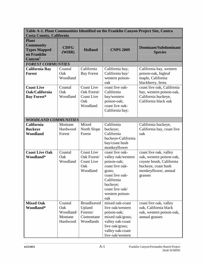
4/25/2013 A-1 Franklin Canyon/Fernandez Ranch Project Draft IS/MND
Table A-1. Plant Communities Identified on the Franklin Canyon Project Site, Contra Costa County, California Plant Community Types Mapped on Franklin Canyon1
CDFG (WHR) Holland CNPS 2009 Dominant/Subdominant
Species
FOREST COMMUNTIES California Bay Forest
Coastal Oak Woodland
California Bay Forest
California bay; California bay/ western poison-oak
California bay, western poison-oak, bigleaf maple, California blackberry, ferns
Coast Live Oak/California Bay Forest*
Coastal Oak Woodland
Coast Live Oak Forest/ Coast Live Oak Woodland
coast live oak-California bay/western poison-oak; coast live oak-California bay;
coast live oak, California bay, western poison-oak, California buckeye, California black oak
WOODLAND COMMUNITIES California Buckeye Woodland
Montane Hardwood Forest
Mixed North Slope Forest
California buckeye; California buckeye-California bay/coast bush monkeyflower
California buckeye, California bay, coast live oak
Coast Live Oak Woodland*
Coastal Oak Woodland
Coast Live Oak Forest/ Coast Live Oak Woodland
coast live oak-valley oak/western poison-oak; coast live oak-grass; coast live oak- California buckeye; coast live oak/ western poison-oak
coast live oak, valley oak, western poison-oak, coyote brush, California buckeye, coast bush monkeyflower, annual grasses
Mixed Oak Woodland*
Coastal Oak Woodland/ Montane Hardwood
Broadleaved Upland Forests/ Cismontane Woodlands
mixed oak-coast live oak/western poison-oak; mixed oak/grass; valley oak-coast live oak/grass; valley oak-coast live oak/western
coast live oak, valley oak, California black oak, western poison-oak, annual grasses

4/25/2013 A-2 Franklin Canyon/Fernandez Ranch Project Draft IS/MND
Table A-1. Plant Communities Identified on the Franklin Canyon Project Site, Contra Costa County, California Plant Community Types Mapped on Franklin Canyon1
CDFG (WHR) Holland CNPS 2009 Dominant/Subdominant
Species
poison-oak;
Valley Oak Woodland*
Valley Oak Woodland
Valley Oak Woodland
valley oak/grass valley oak, coast live oak, annual grasses
SCRUB COMMUNITIES California Sagebrush Scrub*
Coastal Scrub
Diablan Sage Scrub
California sagebrush-coast bush monkeyflower
California sagebrush, coast bush monkeyflower
Coyote Brush Scrub*
Coastal Scrub
Northern Coyote Brush Scrub
coyote brush; coyote brush-creeping wildrye; coyote brush/annual grass-herb; coast live oak/chaparral
coyote brush, creeping wildrye, coast live oak, western poison-oak
Coyote Brush/Poison Oak Scrub*
Mixed Chaparral
Northern Coyote Brush Scrub
coyote brush-western poison-oak
coyote brush, western poison-oak, coast live oak
Poison Oak Scrub*
Mixed Chaparral
Coastal Sage-Chaparral Scrub
western poison-oak coyote brush
western poison-oak, coyote brush, coast live oak
GRASSLAND COMMUNTIES Coastal Prairie* (Remnant)
Perennial Grassland
Coastal Terrace Prairie
California oatgrass California oatgrass; annual grasses; western rush; perennial ryegrass
Creeping Wildrye Grassland*
Perennial Grassland
Valley Wildrye Grassland
creeping wildrye-bromes- oats
creeping wildrye, annual grasses
Non-Native Annual Grassland
Annual grassland
Valley and Foothill Grasslands
bromes-oats Annual grasses
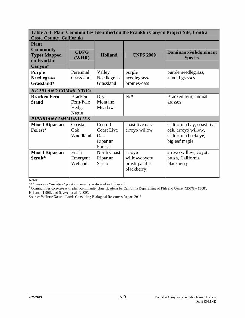
4/25/2013 A-3 Franklin Canyon/Fernandez Ranch Project Draft IS/MND
Table A-1. Plant Communities Identified on the Franklin Canyon Project Site, Contra Costa County, California Plant Community Types Mapped on Franklin Canyon1
CDFG (WHR) Holland CNPS 2009 Dominant/Subdominant
Species
Purple Needlegrass Grassland*
Perennial Grassland
Valley Needlegrass Grassland
purple needlegrass-bromes-oats
purple needlegrass, annual grasses
HERBLAND COMMUNTIES Bracken Fern Stand
Bracken Fern-Pale Hedge Nettle
Dry Montane Meadow
N/A
Bracken fern, annual grasses
RIPARIAN COMMUNITIES Mixed Riparian Forest*
Coastal Oak Woodland
Central Coast Live Oak Riparian Forest
coast live oak-arroyo willow
California bay, coast live oak, arroyo willow, California buckeye, bigleaf maple
Mixed Riparian Scrub*
Fresh Emergent Wetland
North Coast Riparian Scrub
arroyo willow/coyote brush-pacific blackberry
arroyo willow, coyote brush, California blackberry
Notes: “*” denotes a “sensitive” plant community as defined in this report 1 Communities correlate with plant community classifications by California Department of Fish and Game (CDFG) (1988), Holland (1986), and Sawyer et al. (2009). Source: Vollmar Natural Lands Consulting Biological Resources Report 2013.
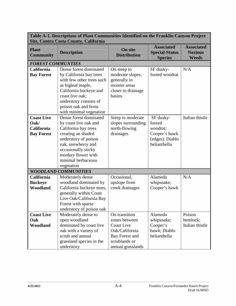
4/25/2013 A-4 Franklin Canyon/Fernandez Ranch Project Draft IS/MND
Table A-1. Descriptions of Plant Communities Identified on the Franklin Canyon Project Site, Contra Costa County, California
Plant Community Description On site
Distribution
Associated Special-Status
Species
Associated Noxious Weeds
FOREST COMMUNTIES California Bay Forest
Dense forest dominated by California bay trees with few other trees such as bigleaf maple, California buckeye and coast live oak; understory consists of poison oak and ferns with minimal vegetation
On steep to moderate slopes, generally in moister areas closer to drainage basins
SF dusky-footed woodrat
N/A
Coast Live Oak/ California Bay Forest
Dense forest dominated by coast live oak and California bay trees creating an shaded understory of poison oak, snowberry and occasionally sticky monkey flower with minimal herbaceous vegetation
Steep to moderate slopes surrounding north-flowing drainages
SF dusky-footed woodrat; Cooper’s hawk (edges); Diablo helianthella
Italian thistle
WOODLAND COMMUNITIES California Buckeye Woodland
Moderately dense woodland dominated by California buckeye trees, generally within Coast Live Oak/California Bay Forest with sparse understory of poison oak
Occasional, upslope from creek drainages
Alameda whipsnake; Cooper’s hawk
N/A
Coast Live Oak Woodland
Moderately dense to open woodland dominated by coast live oak with a variety of scrub and annual grassland species in the understory
On transition zones between Coast Live Oak/California Bay Forest and scrublands or annual grasslands
Alameda whipsnake; Cooper’s hawk; Diablo helianthella
Poison hemlock; Italian thistle
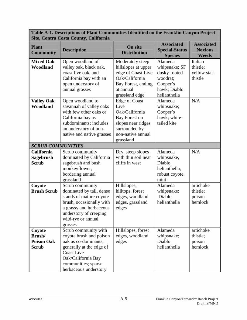
4/25/2013 A-5 Franklin Canyon/Fernandez Ranch Project Draft IS/MND
Table A-1. Descriptions of Plant Communities Identified on the Franklin Canyon Project Site, Contra Costa County, California
Plant Community Description On site
Distribution
Associated Special-Status
Species
Associated Noxious Weeds
Mixed Oak Woodland
Open woodland of valley oak, black oak, coast live oak, and California bay with an open understory of annual grasses
Moderately steep hillslopes at upper edge of Coast Live Oak/California Bay Forest, ending at annual grassland edge
Alameda whipsnake; SF dusky-footed woodrat; Cooper’s hawk; Diablo helianthella
Italian thistle; yellow star-thistle
Valley Oak Woodland
Open woodland to savannah of valley oaks with few other oaks or California bay as subdominants; includes an understory of non-native and native grasses
Edge of Coast Live Oak/California Bay Forest on slopes near ridges surrounded by non-native annual grassland
Alameda whipsnake; Cooper’s hawk; white-tailed kite
N/A
SCRUB COMMUNITIES California Sagebrush Scrub
Scrub community dominated by California sagebrush and bush monkeyflower, bordering annual grassland
Dry, steep slopes with thin soil near cliffs in west
Alameda whipsnake, Diablo helianthella; robust coyote mint
N/A
Coyote Brush Scrub
Scrub community dominated by tall, dense stands of mature coyote brush, occasionally with a grassy and herbaceous understory of creeping wild-rye or annual grasses
Hillslopes, hilltops, forest edges, woodland edges, grassland edges
Alameda whipsnake; Diablo helianthella
artichoke thistle; poison hemlock
Coyote Brush/ Poison Oak Scrub
Scrub community with coyote brush and poison oak as co-dominants, generally at the edge of Coast Live Oak/California Bay communities; sparse herbaceous understory
Hillslopes, forest edges, woodland edges
Alameda whipsnake; Diablo helianthella
artichoke thistle; poison hemlock
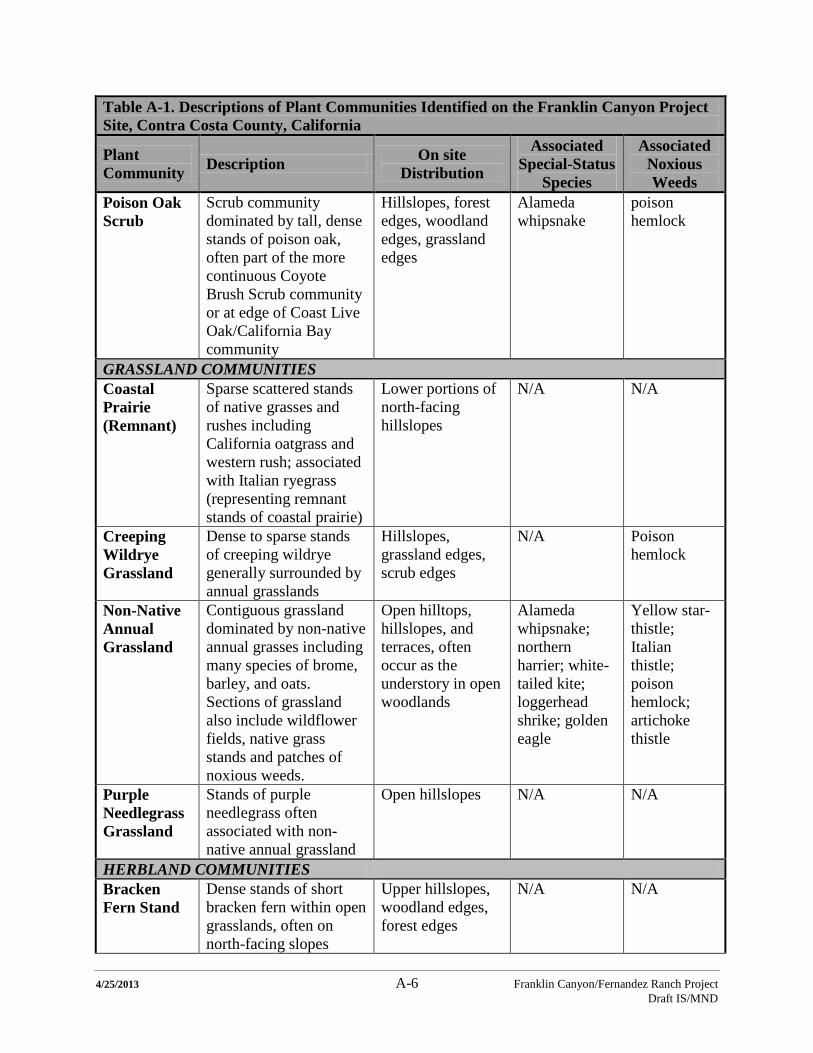
4/25/2013 A-6 Franklin Canyon/Fernandez Ranch Project Draft IS/MND
Table A-1. Descriptions of Plant Communities Identified on the Franklin Canyon Project Site, Contra Costa County, California
Plant Community Description On site
Distribution
Associated Special-Status
Species
Associated Noxious Weeds
Poison Oak Scrub
Scrub community dominated by tall, dense stands of poison oak, often part of the more continuous Coyote Brush Scrub community or at edge of Coast Live Oak/California Bay community
Hillslopes, forest edges, woodland edges, grassland edges
Alameda whipsnake
poison hemlock
GRASSLAND COMMUNITIES Coastal Prairie (Remnant)
Sparse scattered stands of native grasses and rushes including California oatgrass and western rush; associated with Italian ryegrass (representing remnant stands of coastal prairie)
Lower portions of north-facing hillslopes
N/A N/A
Creeping Wildrye Grassland
Dense to sparse stands of creeping wildrye generally surrounded by annual grasslands
Hillslopes, grassland edges, scrub edges
N/A Poison hemlock
Non-Native Annual Grassland
Contiguous grassland dominated by non-native annual grasses including many species of brome, barley, and oats. Sections of grassland also include wildflower fields, native grass stands and patches of noxious weeds.
Open hilltops, hillslopes, and terraces, often occur as the understory in open woodlands
Alameda whipsnake; northern harrier; white-tailed kite; loggerhead shrike; golden eagle
Yellow star-thistle; Italian thistle; poison hemlock; artichoke thistle
Purple Needlegrass Grassland
Stands of purple needlegrass often associated with non-native annual grassland
Open hillslopes N/A N/A
HERBLAND COMMUNITIES Bracken Fern Stand
Dense stands of short bracken fern within open grasslands, often on north-facing slopes
Upper hillslopes, woodland edges, forest edges
N/A N/A
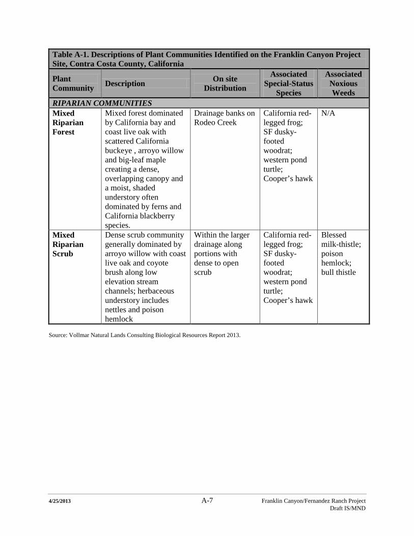
4/25/2013 A-7 Franklin Canyon/Fernandez Ranch Project Draft IS/MND
Table A-1. Descriptions of Plant Communities Identified on the Franklin Canyon Project Site, Contra Costa County, California
Plant Community Description On site
Distribution
Associated Special-Status
Species
Associated Noxious Weeds
RIPARIAN COMMUNITIES Mixed Riparian Forest
Mixed forest dominated by California bay and coast live oak with scattered California buckeye , arroyo willow and big-leaf maple creating a dense, overlapping canopy and a moist, shaded understory often dominated by ferns and California blackberry species.
Drainage banks on Rodeo Creek
California red-legged frog; SF dusky-footed woodrat; western pond turtle; Cooper’s hawk
N/A
Mixed Riparian Scrub
Dense scrub community generally dominated by arroyo willow with coast live oak and coyote brush along low elevation stream channels; herbaceous understory includes nettles and poison hemlock
Within the larger drainage along portions with dense to open scrub
California red-legged frog; SF dusky-footed woodrat; western pond turtle; Cooper’s hawk
Blessed milk-thistle; poison hemlock; bull thistle
Source: Vollmar Natural Lands Consulting Biological Resources Report 2013.
4/25/2013 A-8 Franklin Canyon/Fernandez Ranch Project Draft IS/MND
Table A-2. Special-Status Wildlife Species Known or with Potential to Occur on the Franklin Canyon Project Site, Contra Costa County, California Common/Scientific Name1
Status1
Preferred Habitat(s)2
Occurrence On site
INVERTEBRATES Vernal pool fairy shrimp (Branchinecta lynchi)
FT
Vernal pools and other seasonal pools with sparse vegetation
Not Expected: No seasonal pools on site
AMPHIBIANS California tiger salamander (Ambystoma californiense)
FT CT CSC
Grasslands and lowest foothill regions; breeds in long-lasting rain pools.
Not Expected: The site is outside of the known range of the species (USFWS 2005); no seasonal pools or stock ponds on site.
California red-legged frog (Rana draytonii)
FT CSC
Still or slow-moving water sources such as ponds, lakes, reservoirs and streams with emergent vegetation and adjacent riparian woodlands.
Presumed to Occur: The species has been documented along Rodeo and Refugio Creeks, a pond in the Franklin Canyon Golf Course and within a stock pond in the south-central portion of Fernandez Ranch.
REPTILES Western pond turtle (Emys marmorata)
CSC Slack or slow-moving water (ponds, streams, ditches) with basking sites and nesting areas of open unshaded slopes in the vicinity
Presumed to Occur: The species is known to occur within Rodeo Creek and in a pond in the Franklin Canyon Golf Course
Alameda whipsnake (Masticophis lateralis euryxanthus)
FT CT
Chaparral, scrub, grassland, and oak woodland habitats.
Presumed to Occur: Observed in eastern scrub habitat during 2002 surveys by Karen Swaim
BIRDS Cooper’s hawk (Accipiter cooperi)
CWL Nests in conifer and deciduous riparian forests near open woodland and habitat edges for hunting
Presumed to Occur: Record of nest on site, as well as suitable nesting and foraging habitat present
Tricolored blackbird (Agelaius tricolor)
BCC CSC
Nests in freshwater marshes, thistle fields and riparian scrub near open water
Not Expected: Marginal habitat present due to limited extent of riparian scrub and emergent vegetation.
4/25/2013 A-9 Franklin Canyon/Fernandez Ranch Project Draft IS/MND
Table A-2. Special-Status Wildlife Species Known or with Potential to Occur on the Franklin Canyon Project Site, Contra Costa County, California Common/Scientific Name1
Status1
Preferred Habitat(s)2
Occurrence On site
Western burrowing owl (Athene cunicularia)
BCC CSC
Forages and nests in grasslands and open scrub with mammal burrows.
Not Expected: Potential burrow sites are limited as no ground squirrel burrows were observed.
Golden eagle (Aquila chrysaetos)
BCC CFP
Nests on cliffs and large trees in a variety of habitats with nearby open terrain for hunting.
Potential: Suitable foraging habitat present; cliffs not suitable for nesting site.
Northern harrier (Circus cyaneus)
CSC CFP
Forages in open grasslands, marsh, and emergent wetlands; nests on the ground in shrubby vegetation.
Observed: Individuals observed foraging on open grasslands during 2012VNLC surveys; limited nesting habitat present.
Yellow warbler (Dendroica petechia brewsteri)
CSC FSC
Nests in riparian vegetation and wet meadows.
Potential: Suitable nesting and foraging habitat present; not observed on the site but known to nest in the area.
White-tailed kite (Elanus leucurus)
CFP Nests in oak woodlands or trees along marsh with open foraging habitat.
Observed: One individual observed foraging in open grasslands of southwest; another observed perched in coast live oak tree at scrub/grassland ecotone.
Loggerhead shrike (Lanius ludovicianus)
BCC CSC
Found in open canopy hardwood, conifer or riparian forests. Prefers perches within open grassland for hunting.
Potential: Suitable nesting and foraging habitat present; not observed on the site but known to nest in the area.
MAMMALS Pallid bat (Antrozous pallidus)
CSC
Associated with grasslands, shrublands, woodland and forests. Roosts in tree cavities, rock crevices and man-made structures.
Potential: Suitable roosting and foraging habitat present; not observed on site but known to nest in the area.
San Francisco dusky-footed woodrat (Neotoma fuscipes annectens)
CSC Builds nest within moderate-canopy forest with brushy understory at the base of a tree, shrub or hill.
Observed: Many nests found in the shaded, open understory woodlands and forests.
4/25/2013 A-10 Franklin Canyon/Fernandez Ranch Project Draft IS/MND
Table A-2. Special-Status Wildlife Species Known or with Potential to Occur on the Franklin Canyon Project Site, Contra Costa County, California Common/Scientific Name1
Status1
Preferred Habitat(s)2
Occurrence On site
American badger (Taxidea taxus)
CSC Burrows within grassland and savannah with friable soils and burrowing rodents in vicinity.
Presumed to Occur: An individual badger was observed on Fernandez Ranch in 2006 VNLC surveys.
Notes: Source: Vollmar Natural Lands Consulting Biological Resources Report 2013. 1. Nomenclature and status from DFG 2011 2. CDFG 2012 and VNLC experience
FE: Federally Endangered FT: Federally Threatened BCC: Bird of Conservation Concern CE: California Endangered
CT: California Threatened CFP: California Fully Protected CSC: California Species of Special Concern CWL: California Watch List Species
4/25/2013 A-11 Franklin Canyon/Fernandez Ranch Project Draft IS/MND
Table A-3. Potential Special-status Plant Species on Franklin Canyon Project Site, Contra Costa County, California
Common/Scientific Name
Status (CNPS List.Rank) Preferred Habitat Potential for Occurrence
MUSKROOT FAMILY/ ADOXACEAE Oval-leaved viburnum/ Viburnum ellipticum
CNPS 2.3 Chaparral, Cismontane woodland, Lower montane coniferous forest; 215-1400 m (705-4590 ft)
Moderate: Only highest elevations are within range; some of habitat present
CARROT FAMILY/ APIACEAE Bolander’s water-hemlock/ Cicuta maculata var. bolanderi (Lithophragma bolanderi)
CNPS 2.1 Marshes and swamps, Coastal, fresh or brackish water 0-200 m (0-655 ft)
Low: Observed on Fernandez Ranch; limited wetland habitat on site
SUNFLOWER FAMILY/ ASTERACEAE Big-scale balsamroot/ Balsamorhiza macrolepis
CNPS 1B.2 Chaparral, Cismontane woodland, Valley and foothill grassland/sometimes serpentinite; 90-1555 m (295-5100 ft)
High: abundant grassland habitat
Big tarplant/ Blepharizonia plumosa
CNPS 1B.1 Valley and foothill grassland/Usually clay; 30-505 m (100-1655 ft)
Moderate: No preferred substrate; abundant grassland habitat
Congdon’s tarplant/ Centromadia parryi ssp. congdonii
CNPS 1B.2 Valley and foothill grassland (alkaline); 0-230 m (0-755 ft)
Moderate: No alkali substrate; abundant grassland habitat
Franciscan thistle/ Cirsium andrewsii
CNPS 1B.2 Broadleaf upland forest, Coastal bluff scrub, Coastal prairie, Coastal scrub/mesic, sometimes serpentinite; 0-150 m (0-490 ft)
Moderate: abundant coastal scrub, small area with remnant coastal prairie
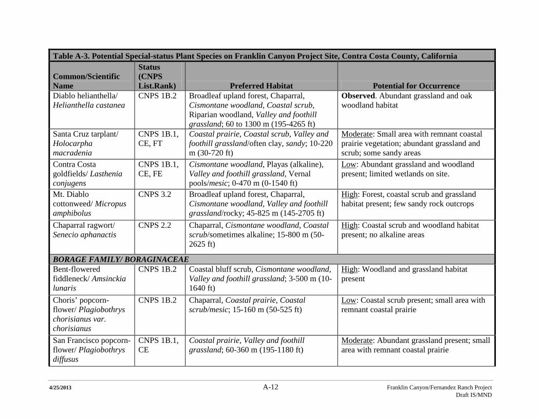
4/25/2013 A-12 Franklin Canyon/Fernandez Ranch Project Draft IS/MND
Table A-3. Potential Special-status Plant Species on Franklin Canyon Project Site, Contra Costa County, California
Common/Scientific Name
Status (CNPS List.Rank) Preferred Habitat Potential for Occurrence
Diablo helianthella/ Helianthella castanea
CNPS 1B.2 Broadleaf upland forest, Chaparral, Cismontane woodland, Coastal scrub, Riparian woodland, Valley and foothill grassland; 60 to 1300 m (195-4265 ft)
Observed. Abundant grassland and oak woodland habitat
Santa Cruz tarplant/ Holocarpha macradenia
CNPS 1B.1, CE, FT
Coastal prairie, Coastal scrub, Valley and foothill grassland/often clay, sandy; 10-220 m (30-720 ft)
Moderate: Small area with remnant coastal prairie vegetation; abundant grassland and scrub; some sandy areas
Contra Costa goldfields/ Lasthenia conjugens
CNPS 1B.1, CE, FE
Cismontane woodland, Playas (alkaline), Valley and foothill grassland, Vernal pools/mesic; 0-470 m (0-1540 ft)
Low: Abundant grassland and woodland present; limited wetlands on site.
Mt. Diablo cottonweed/ Micropus amphibolus
CNPS 3.2 Broadleaf upland forest, Chaparral, Cismontane woodland, Valley and foothill grassland/rocky; 45-825 m (145-2705 ft)
High: Forest, coastal scrub and grassland habitat present; few sandy rock outcrops
Chaparral ragwort/ Senecio aphanactis
CNPS 2.2 Chaparral, Cismontane woodland, Coastal scrub/sometimes alkaline; 15-800 m (50-2625 ft)
High: Coastal scrub and woodland habitat present; no alkaline areas
BORAGE FAMILY/ BORAGINACEAE Bent-flowered fiddleneck/ Amsinckia lunaris
CNPS 1B.2 Coastal bluff scrub, Cismontane woodland, Valley and foothill grassland; 3-500 m (10-1640 ft)
High: Woodland and grassland habitat present
Choris’ popcorn-flower/ Plagiobothrys chorisianus var. chorisianus
CNPS 1B.2 Chaparral, Coastal prairie, Coastal scrub/mesic; 15-160 m (50-525 ft)
Low: Coastal scrub present; small area with remnant coastal prairie
San Francisco popcorn-flower/ Plagiobothrys diffusus
CNPS 1B.1, CE
Coastal prairie, Valley and foothill grassland; 60-360 m (195-1180 ft)
Moderate: Abundant grassland present; small area with remnant coastal prairie
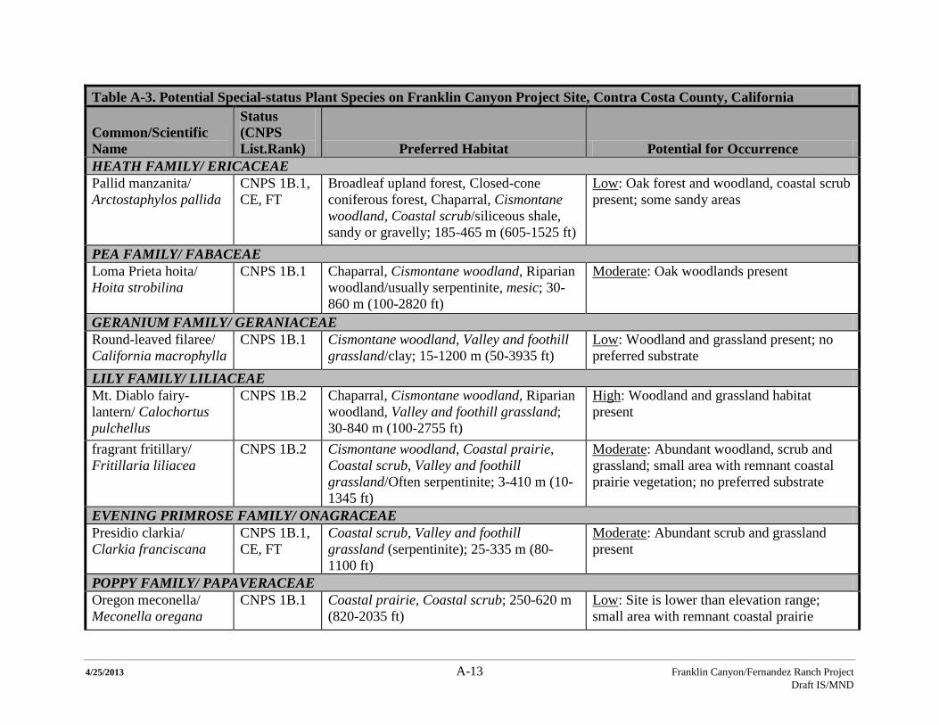
4/25/2013 A-13 Franklin Canyon/Fernandez Ranch Project Draft IS/MND
Table A-3. Potential Special-status Plant Species on Franklin Canyon Project Site, Contra Costa County, California
Common/Scientific Name
Status (CNPS List.Rank) Preferred Habitat Potential for Occurrence
HEATH FAMILY/ ERICACEAE Pallid manzanita/ Arctostaphylos pallida
CNPS 1B.1, CE, FT
Broadleaf upland forest, Closed-cone coniferous forest, Chaparral, Cismontane woodland, Coastal scrub/siliceous shale, sandy or gravelly; 185-465 m (605-1525 ft)
Low: Oak forest and woodland, coastal scrub present; some sandy areas
PEA FAMILY/ FABACEAE Loma Prieta hoita/ Hoita strobilina
CNPS 1B.1 Chaparral, Cismontane woodland, Riparian woodland/usually serpentinite, mesic; 30-860 m (100-2820 ft)
Moderate: Oak woodlands present
GERANIUM FAMILY/ GERANIACEAE Round-leaved filaree/ California macrophylla
CNPS 1B.1 Cismontane woodland, Valley and foothill grassland/clay; 15-1200 m (50-3935 ft)
Low: Woodland and grassland present; no preferred substrate
LILY FAMILY/ LILIACEAE Mt. Diablo fairy-lantern/ Calochortus pulchellus
CNPS 1B.2 Chaparral, Cismontane woodland, Riparian woodland, Valley and foothill grassland; 30-840 m (100-2755 ft)
High: Woodland and grassland habitat present
fragrant fritillary/ Fritillaria liliacea
CNPS 1B.2 Cismontane woodland, Coastal prairie, Coastal scrub, Valley and foothill grassland/Often serpentinite; 3-410 m (10-1345 ft)
Moderate: Abundant woodland, scrub and grassland; small area with remnant coastal prairie vegetation; no preferred substrate
EVENING PRIMROSE FAMILY/ ONAGRACEAE Presidio clarkia/ Clarkia franciscana
CNPS 1B.1, CE, FT
Coastal scrub, Valley and foothill grassland (serpentinite); 25-335 m (80-1100 ft)
Moderate: Abundant scrub and grassland present
POPPY FAMILY/ PAPAVERACEAE Oregon meconella/ Meconella oregana
CNPS 1B.1 Coastal prairie, Coastal scrub; 250-620 m (820-2035 ft)
Low: Site is lower than elevation range; small area with remnant coastal prairie
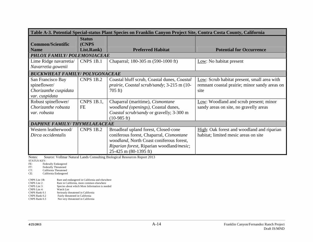
4/25/2013 A-14 Franklin Canyon/Fernandez Ranch Project Draft IS/MND
Table A-3. Potential Special-status Plant Species on Franklin Canyon Project Site, Contra Costa County, California
Common/Scientific Name
Status (CNPS List.Rank) Preferred Habitat Potential for Occurrence
PHLOX FAMILY/ POLEMONIACEAE Lime Ridge navarretia/ Navarretia gowenii
CNPS 1B.1 Chaparral; 180-305 m (590-1000 ft) Low: No habitat present
BUCKWHEAT FAMILY/ POLYGONACEAE San Francisco Bay spineflower/ Chorizanthe cuspidata var. cuspidata
CNPS 1B.2 Coastal bluff scrub, Coastal dunes, Coastal prairie, Coastal scrub/sandy; 3-215 m (10-705 ft)
Low: Scrub habitat present, small area with remnant coastal prairie; minor sandy areas on site
Robust spineflower/ Chorizanthe robusta var. robusta
CNPS 1B.1, FE
Chaparral (maritime), Cismontane woodland (openings), Coastal dunes, Coastal scrub/sandy or gravelly; 3-300 m (10-985 ft)
Low: Woodland and scrub present; minor sandy areas on site, no gravelly areas
DAPHNE FAMILY/ THYMELAEACEAE Western leatherwood/ Dirca occidentalis
CNPS 1B.2 Broadleaf upland forest, Closed-cone coniferous forest, Chaparral, Cismontane woodland, North Coast coniferous forest, Riparian forest, Riparian woodland/mesic; 25-425 m (80-1395 ft)
High: Oak forest and woodland and riparian habitat; limited mesic areas on site
Notes: Source: Vollmar Natural Lands Consulting Biological Resources Report 2013 STATUS KEY: FE: Federally Endangered FT: Federally Threatened CT: California Threatened CE: California Endangered CNPS List 1B: Rare and endangered in California and elsewhere CNPS List 2: Rare in California, more common elsewhere CNPS List 3: Species about which More Information is needed CNPS List 4: Watch List CNPS Rank 0.1 Seriously threatened in California CNPS Rank 0.2 Fairly threatened in California CNPS Rank 0.3 Not very threatened in California
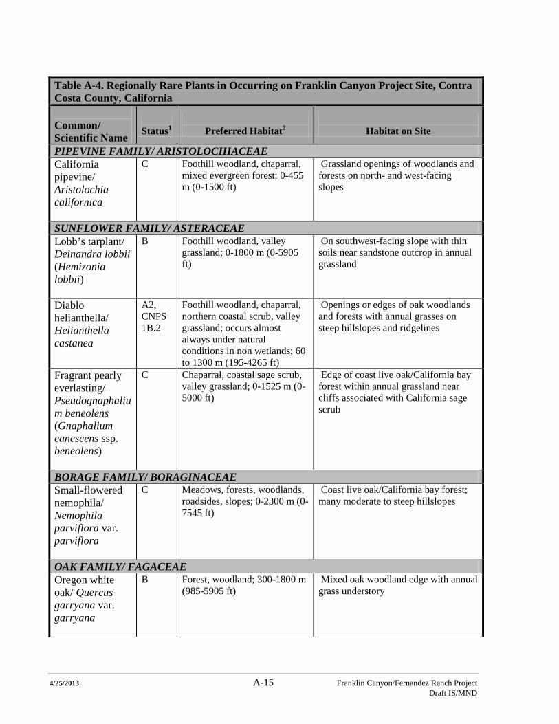
4/25/2013 A-15 Franklin Canyon/Fernandez Ranch Project Draft IS/MND
Table A-4. Regionally Rare Plants in Occurring on Franklin Canyon Project Site, Contra Costa County, California Common/ Scientific Name
Status1
Preferred Habitat2
Habitat on Site
PIPEVINE FAMILY/ ARISTOLOCHIACEAE California pipevine/ Aristolochia californica
C Foothill woodland, chaparral, mixed evergreen forest; 0-455 m (0-1500 ft)
Grassland openings of woodlands and forests on north- and west-facing slopes
SUNFLOWER FAMILY/ ASTERACEAE Lobb’s tarplant/ Deinandra lobbii (Hemizonia lobbii)
B Foothill woodland, valley grassland; 0-1800 m (0-5905 ft)
On southwest-facing slope with thin soils near sandstone outcrop in annual grassland
Diablo helianthella/ Helianthella castanea
A2, CNPS 1B.2
Foothill woodland, chaparral, northern coastal scrub, valley grassland; occurs almost always under natural conditions in non wetlands; 60 to 1300 m (195-4265 ft)
Openings or edges of oak woodlands and forests with annual grasses on steep hillslopes and ridgelines
Fragrant pearly everlasting/ Pseudognaphalium beneolens (Gnaphalium canescens ssp. beneolens)
C Chaparral, coastal sage scrub, valley grassland; 0-1525 m (0-5000 ft)
Edge of coast live oak/California bay forest within annual grassland near cliffs associated with California sage scrub
BORAGE FAMILY/ BORAGINACEAE Small-flowered nemophila/ Nemophila parviflora var. parviflora
C Meadows, forests, woodlands, roadsides, slopes; 0-2300 m (0-7545 ft)
Coast live oak/California bay forest; many moderate to steep hillslopes
OAK FAMILY/ FAGACEAE Oregon white oak/ Quercus garryana var. garryana
B Forest, woodland; 300-1800 m (985-5905 ft)
Mixed oak woodland edge with annual grass understory
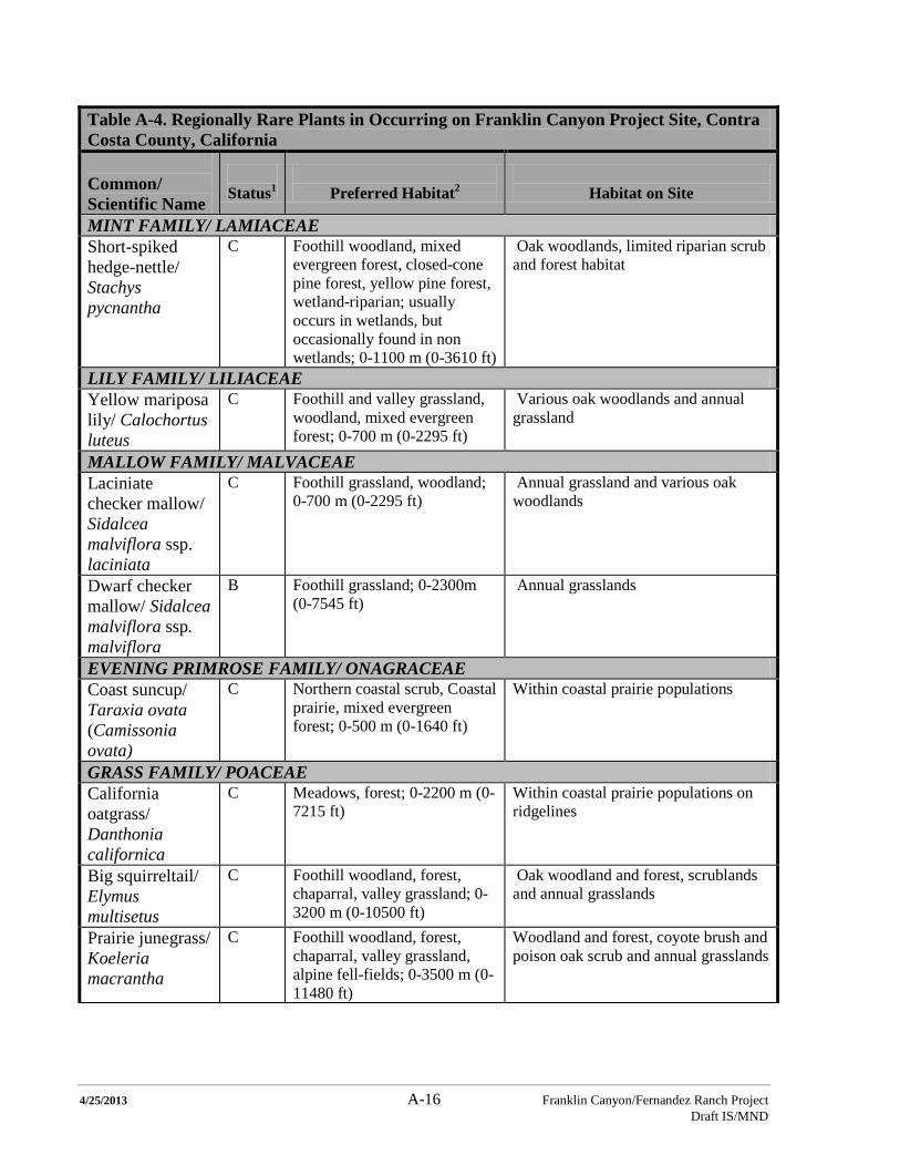
4/25/2013 A-16 Franklin Canyon/Fernandez Ranch Project Draft IS/MND
Table A-4. Regionally Rare Plants in Occurring on Franklin Canyon Project Site, Contra Costa County, California Common/ Scientific Name
Status1
Preferred Habitat2
Habitat on Site
MINT FAMILY/ LAMIACEAE Short-spiked hedge-nettle/ Stachys pycnantha
C Foothill woodland, mixed evergreen forest, closed-cone pine forest, yellow pine forest, wetland-riparian; usually occurs in wetlands, but occasionally found in non wetlands; 0-1100 m (0-3610 ft)
Oak woodlands, limited riparian scrub and forest habitat
LILY FAMILY/ LILIACEAE Yellow mariposa lily/ Calochortus luteus
C Foothill and valley grassland, woodland, mixed evergreen forest; 0-700 m (0-2295 ft)
Various oak woodlands and annual grassland
MALLOW FAMILY/ MALVACEAE Laciniate checker mallow/ Sidalcea malviflora ssp. laciniata
C Foothill grassland, woodland; 0-700 m (0-2295 ft)
Annual grassland and various oak woodlands
Dwarf checker mallow/ Sidalcea malviflora ssp. malviflora
B Foothill grassland; 0-2300m (0-7545 ft)
Annual grasslands
EVENING PRIMROSE FAMILY/ ONAGRACEAE Coast suncup/ Taraxia ovata (Camissonia ovata)
C Northern coastal scrub, Coastal prairie, mixed evergreen forest; 0-500 m (0-1640 ft)
Within coastal prairie populations
GRASS FAMILY/ POACEAE California oatgrass/ Danthonia californica
C Meadows, forest; 0-2200 m (0-7215 ft)
Within coastal prairie populations on ridgelines
Big squirreltail/ Elymus multisetus
C Foothill woodland, forest, chaparral, valley grassland; 0-3200 m (0-10500 ft)
Oak woodland and forest, scrublands and annual grasslands
Prairie junegrass/ Koeleria macrantha
C Foothill woodland, forest, chaparral, valley grassland, alpine fell-fields; 0-3500 m (0-11480 ft)
Woodland and forest, coyote brush and poison oak scrub and annual grasslands
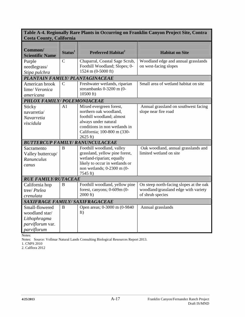
4/25/2013 A-17 Franklin Canyon/Fernandez Ranch Project Draft IS/MND
Table A-4. Regionally Rare Plants in Occurring on Franklin Canyon Project Site, Contra Costa County, California Common/ Scientific Name
Status1
Preferred Habitat2
Habitat on Site
Purple needlegrass/ Stipa pulchra
C Chaparral, Coastal Sage Scrub, Foothill Woodland; Slopes; 0-1524 m (0-5000 ft)
Woodland edge and annual grasslands on west-facing slopes
PLANTAIN FAMILY/ PLANTAGINACEAE American brook lime/ Veronica americana
C Freshwater wetlands, riparian streambanks 0-3200 m (0-10500 ft)
Small area of wetland habitat on site
PHLOX FAMILY/ POLEMONIACEAE Sticky navarretia/ Navarretia viscidula
A1 Mixed evergreen forest, northern oak woodland, foothill woodland; almost always under natural conditions in non wetlands in California; 100-800 m (330-2625 ft)
Annual grassland on southwest facing slope near fire road
BUTTERCUP FAMILY/ RANUNCULACEAE Sacramento Valley buttercup/ Ranunculus canus
B Foothill woodland, valley grassland, yellow pine forest, wetland-riparian; equally likely to occur in wetlands or non wetlands; 0-2300 m (0-7545 ft)
Oak woodland, annual grasslands and limited wetland on site
RUE FAMILY/RUTACEAE California hop tree/ Ptelea crenulata
B Foothill woodland, yellow pine forest, canyons; 0-609m (0-2000 ft)
On steep north-facing slopes at the oak woodland/grassland edge with variety of shrub species
SAXIFRAGE FAMILY/ SAXIFRAGACEAE Small-flowered woodland star/ Lithophragma parviflorum var. parviflorum
B Open areas; 0-3000 m (0-9840 ft)
Annual grasslands
Notes: Notes: Source: Vollmar Natural Lands Consulting Biological Resources Report 2013. 1. CNPS 2010 2. Calflora 2012

4/25/2013 A-18 Franklin Canyon/Fernandez Ranch Project Draft IS/MND
THIS PAGE INTENTIONALLY LEFT BLANK

4/25/2013 Franklin Canyon/Fernandez Ranch Project Draft IS/MND
APPENDIX B
BIOLOGY RESOURCES AT THE FERNANDEZ RANCH PROPERTY

4/25/2013 Franklin Canyon/Fernandez Ranch Project Draft IS/MND
THIS PAGE INTENTIONALLY LEFT BLANK
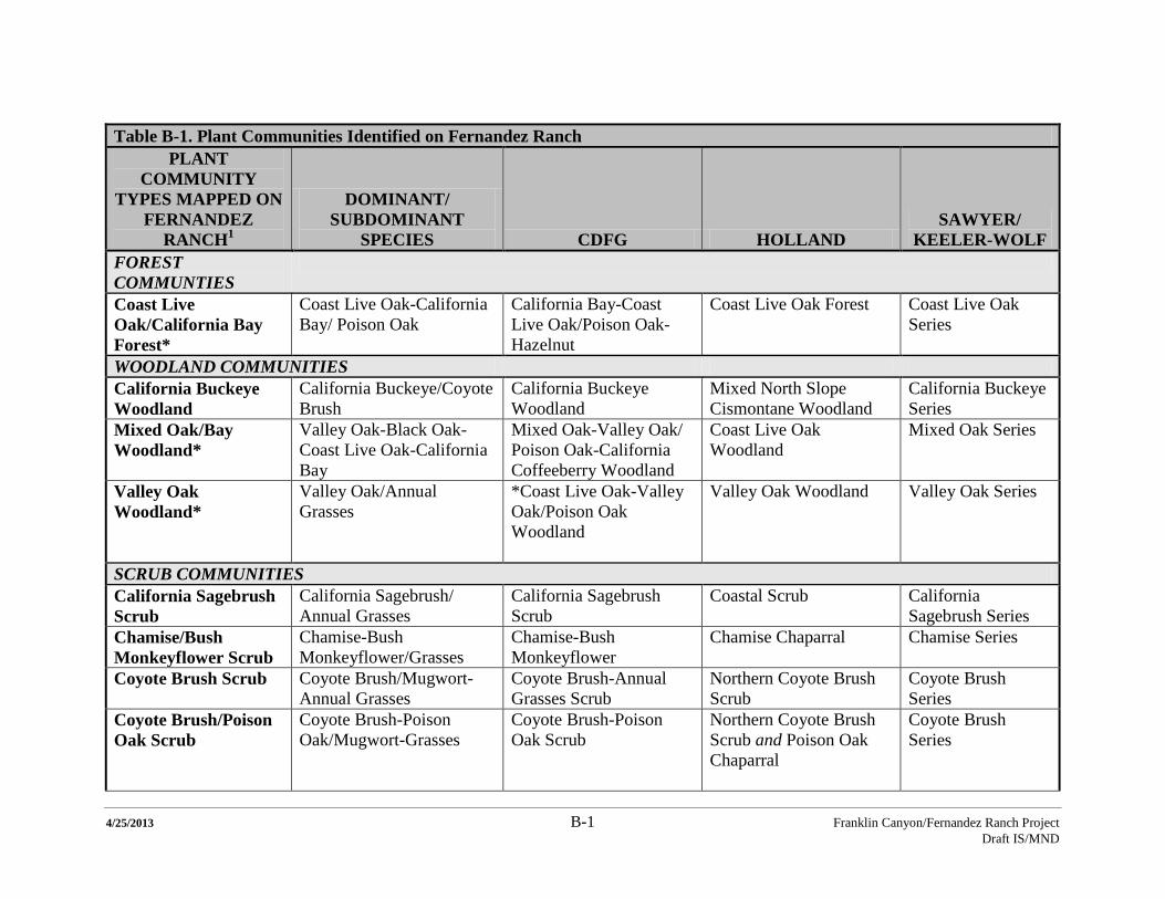
4/25/2013 B-1 Franklin Canyon/Fernandez Ranch Project Draft IS/MND
Table B-1. Plant Communities Identified on Fernandez Ranch
PLANT COMMUNITY
TYPES MAPPED ON FERNANDEZ
RANCH1
DOMINANT/ SUBDOMINANT
SPECIES CDFG HOLLAND SAWYER/
KEELER-WOLF FOREST COMMUNTIES
Coast Live Oak/California Bay Forest*
Coast Live Oak-California Bay/ Poison Oak
California Bay-Coast Live Oak/Poison Oak- Hazelnut
Coast Live Oak Forest Coast Live Oak Series
WOODLAND COMMUNITIES California Buckeye Woodland
California Buckeye/Coyote Brush
California Buckeye Woodland
Mixed North Slope Cismontane Woodland
California Buckeye Series
Mixed Oak/Bay Woodland*
Valley Oak-Black Oak-Coast Live Oak-California Bay
Mixed Oak-Valley Oak/ Poison Oak-California Coffeeberry Woodland
Coast Live Oak Woodland
Mixed Oak Series
Valley Oak Woodland*
Valley Oak/Annual Grasses
*Coast Live Oak-Valley Oak/Poison Oak Woodland
Valley Oak Woodland Valley Oak Series
SCRUB COMMUNITIES California Sagebrush Scrub
California Sagebrush/ Annual Grasses
California Sagebrush Scrub
Coastal Scrub California Sagebrush Series
Chamise/Bush Monkeyflower Scrub
Chamise-Bush Monkeyflower/Grasses
Chamise-Bush Monkeyflower
Chamise Chaparral Chamise Series
Coyote Brush Scrub
Coyote Brush/Mugwort-Annual Grasses
Coyote Brush-Annual Grasses Scrub
Northern Coyote Brush Scrub
Coyote Brush Series
Coyote Brush/Poison Oak Scrub
Coyote Brush-Poison Oak/Mugwort-Grasses
Coyote Brush-Poison Oak Scrub
Northern Coyote Brush Scrub and Poison Oak Chaparral
Coyote Brush Series
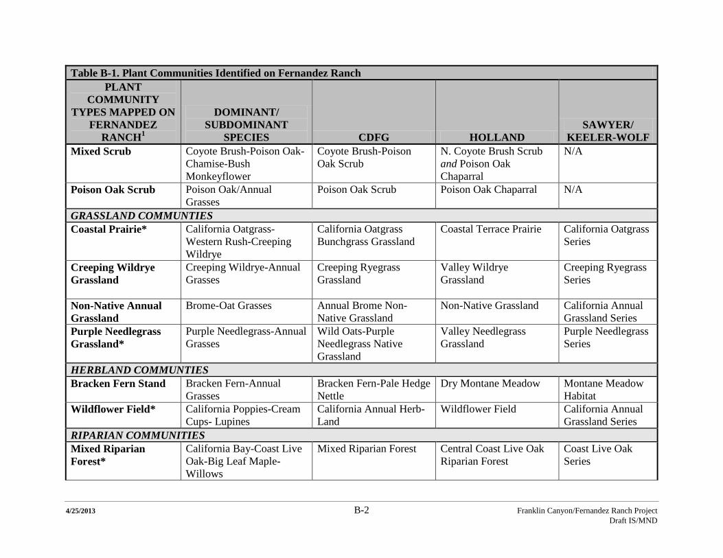
4/25/2013 B-2 Franklin Canyon/Fernandez Ranch Project Draft IS/MND
Table B-1. Plant Communities Identified on Fernandez Ranch PLANT
COMMUNITY TYPES MAPPED ON
FERNANDEZ RANCH1
DOMINANT/ SUBDOMINANT
SPECIES CDFG HOLLAND SAWYER/
KEELER-WOLF Mixed Scrub Coyote Brush-Poison Oak-
Chamise-Bush Monkeyflower
Coyote Brush-Poison Oak Scrub
N. Coyote Brush Scrub and Poison Oak Chaparral
N/A
Poison Oak Scrub
Poison Oak/Annual Grasses
Poison Oak Scrub Poison Oak Chaparral N/A
GRASSLAND COMMUNTIES Coastal Prairie*
California Oatgrass-Western Rush-Creeping Wildrye
California Oatgrass Bunchgrass Grassland
Coastal Terrace Prairie California Oatgrass Series
Creeping Wildrye Grassland
Creeping Wildrye-Annual Grasses
Creeping Ryegrass Grassland
Valley Wildrye Grassland
Creeping Ryegrass Series
Non-Native Annual Grassland
Brome-Oat Grasses Annual Brome Non-Native Grassland
Non-Native Grassland California Annual Grassland Series
Purple Needlegrass Grassland*
Purple Needlegrass-Annual Grasses
Wild Oats-Purple Needlegrass Native Grassland
Valley Needlegrass Grassland
Purple Needlegrass Series
HERBLAND COMMUNTIES Bracken Fern Stand
Bracken Fern-Annual Grasses
Bracken Fern-Pale Hedge Nettle
Dry Montane Meadow Montane Meadow Habitat
Wildflower Field* California Poppies-Cream Cups- Lupines
California Annual Herb-Land
Wildflower Field California Annual Grassland Series
RIPARIAN COMMUNITIES Mixed Riparian Forest*
California Bay-Coast Live Oak-Big Leaf Maple-Willows
Mixed Riparian Forest Central Coast Live Oak Riparian Forest
Coast Live Oak Series

4/25/2013 B-3 Franklin Canyon/Fernandez Ranch Project Draft IS/MND
Table B-1. Plant Communities Identified on Fernandez Ranch PLANT
COMMUNITY TYPES MAPPED ON
FERNANDEZ RANCH1
DOMINANT/ SUBDOMINANT
SPECIES CDFG HOLLAND SAWYER/
KEELER-WOLF Mixed Riparian Scrub*
Willows-Coyote Brush-Poison Oak
North Coast Riparian Scrub
North Coast Riparian Scrub
Mixed Willow Series
Willow Riparian Scrub*
Willows/Manroot-Poison Oak
Willow Riparian Scrub North Coast Riparian Scrub
Mixed Willow Series
SEASONAL WETLAND COMMUNTIES Seasonal Creek*
Rush-Seep Monkeyflower-Water Cress
Rush Riparian Grassland N/A N/A
Seasonal Stock Pond*
Rush-Cocklebur-Pale Spikerush/Brass Buttons
N/A N/A N/A
Seasonal Wetland*
Clustered Dock-Italian Ryegrass-Toad Rush
Freshwater Seep Freshwater Seep N/A
Seasonal Pool*
Hyssop Loosestrife-Rough-fruited Popcorn Flower-Slender Hairgrass
Vernal Pool Vernal Pool Vernal Pool
Notes: Source: Vollmar Consulting (2006) “*” denotes a “sensitive” plant community as defined in this IS/MND 1 Communities correlate with plant community classifications by California Department of Fish and Game (CDFG) (2003), Holland (1986), and Sawyer and Keeler-Wolf (1995).
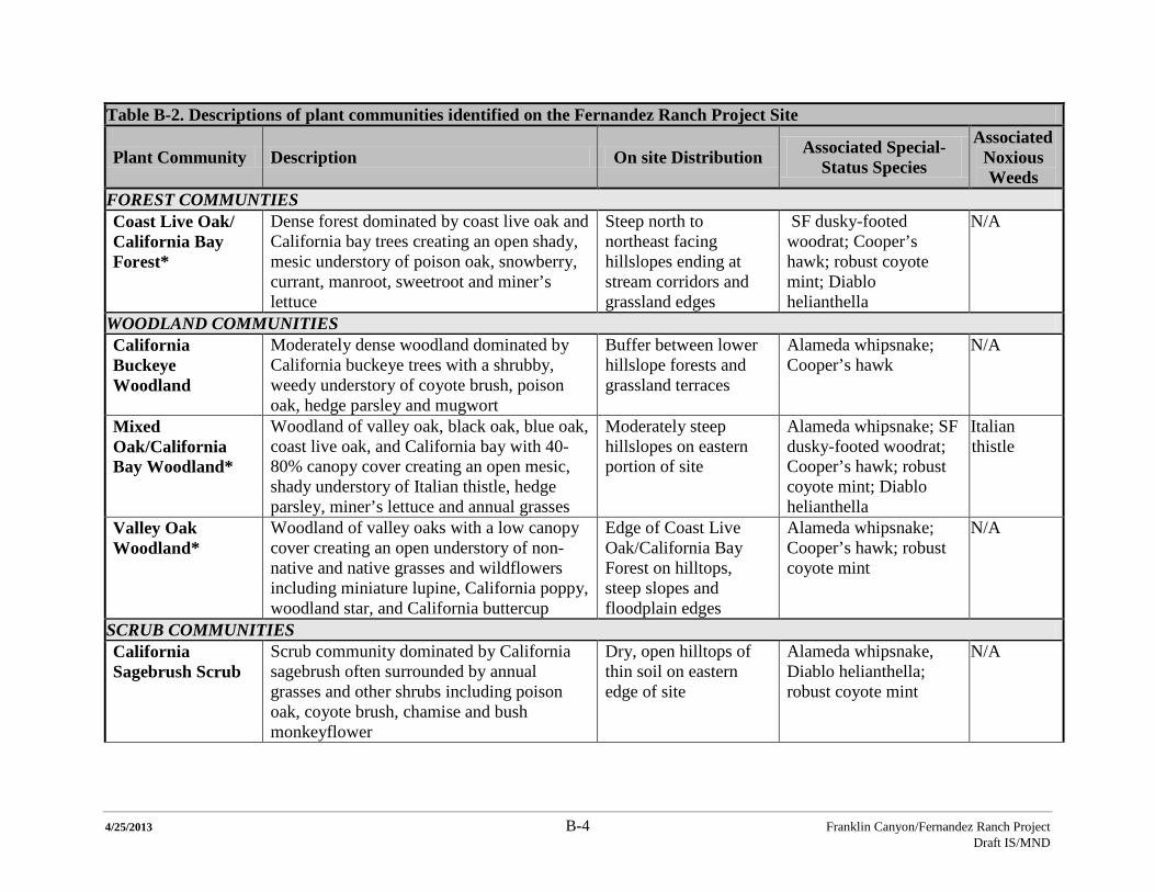
4/25/2013 B-4 Franklin Canyon/Fernandez Ranch Project Draft IS/MND
Table B-2. Descriptions of plant communities identified on the Fernandez Ranch Project Site
Plant Community Description On site Distribution Associated Special-Status Species
Associated Noxious Weeds
FOREST COMMUNTIES Coast Live Oak/ California Bay Forest*
Dense forest dominated by coast live oak and California bay trees creating an open shady, mesic understory of poison oak, snowberry, currant, manroot, sweetroot and miner’s lettuce
Steep north to northeast facing hillslopes ending at stream corridors and grassland edges
SF dusky-footed woodrat; Cooper’s hawk; robust coyote mint; Diablo helianthella
N/A
WOODLAND COMMUNITIES California Buckeye Woodland
Moderately dense woodland dominated by California buckeye trees with a shrubby, weedy understory of coyote brush, poison oak, hedge parsley and mugwort
Buffer between lower hillslope forests and grassland terraces
Alameda whipsnake; Cooper’s hawk
N/A
Mixed Oak/California Bay Woodland*
Woodland of valley oak, black oak, blue oak, coast live oak, and California bay with 40-80% canopy cover creating an open mesic, shady understory of Italian thistle, hedge parsley, miner’s lettuce and annual grasses
Moderately steep hillslopes on eastern portion of site
Alameda whipsnake; SF dusky-footed woodrat; Cooper’s hawk; robust coyote mint; Diablo helianthella
Italian thistle
Valley Oak Woodland*
Woodland of valley oaks with a low canopy cover creating an open understory of non-native and native grasses and wildflowers including miniature lupine, California poppy, woodland star, and California buttercup
Edge of Coast Live Oak/California Bay Forest on hilltops, steep slopes and floodplain edges
Alameda whipsnake; Cooper’s hawk; robust coyote mint
N/A
SCRUB COMMUNITIES California Sagebrush Scrub
Scrub community dominated by California sagebrush often surrounded by annual grasses and other shrubs including poison oak, coyote brush, chamise and bush monkeyflower
Dry, open hilltops of thin soil on eastern edge of site
Alameda whipsnake, Diablo helianthella; robust coyote mint
N/A
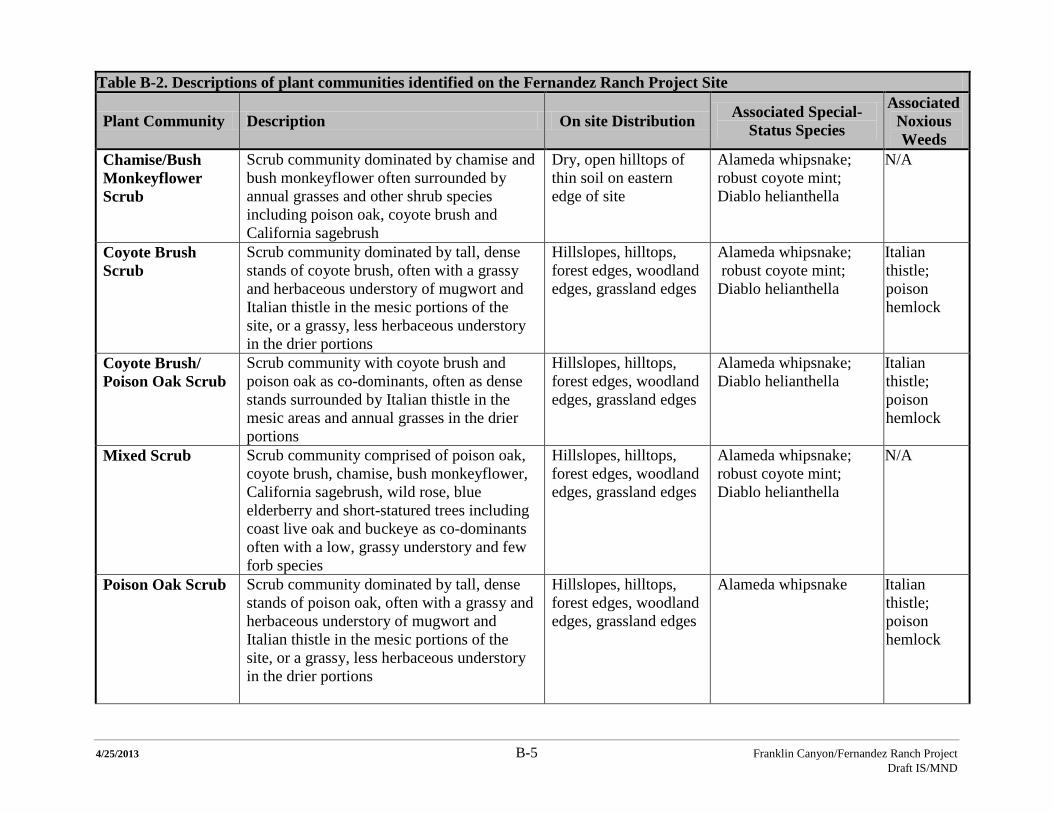
4/25/2013 B-5 Franklin Canyon/Fernandez Ranch Project Draft IS/MND
Table B-2. Descriptions of plant communities identified on the Fernandez Ranch Project Site
Plant Community Description On site Distribution Associated Special-Status Species
Associated Noxious Weeds
Chamise/Bush Monkeyflower Scrub
Scrub community dominated by chamise and bush monkeyflower often surrounded by annual grasses and other shrub species including poison oak, coyote brush and California sagebrush
Dry, open hilltops of thin soil on eastern edge of site
Alameda whipsnake; robust coyote mint; Diablo helianthella
N/A
Coyote Brush Scrub
Scrub community dominated by tall, dense stands of coyote brush, often with a grassy and herbaceous understory of mugwort and Italian thistle in the mesic portions of the site, or a grassy, less herbaceous understory in the drier portions
Hillslopes, hilltops, forest edges, woodland edges, grassland edges
Alameda whipsnake; robust coyote mint; Diablo helianthella
Italian thistle; poison hemlock
Coyote Brush/ Poison Oak Scrub
Scrub community with coyote brush and poison oak as co-dominants, often as dense stands surrounded by Italian thistle in the mesic areas and annual grasses in the drier portions
Hillslopes, hilltops, forest edges, woodland edges, grassland edges
Alameda whipsnake; Diablo helianthella
Italian thistle; poison hemlock
Mixed Scrub Scrub community comprised of poison oak, coyote brush, chamise, bush monkeyflower, California sagebrush, wild rose, blue elderberry and short-statured trees including coast live oak and buckeye as co-dominants often with a low, grassy understory and few forb species
Hillslopes, hilltops, forest edges, woodland edges, grassland edges
Alameda whipsnake; robust coyote mint; Diablo helianthella
N/A
Poison Oak Scrub Scrub community dominated by tall, dense stands of poison oak, often with a grassy and herbaceous understory of mugwort and Italian thistle in the mesic portions of the site, or a grassy, less herbaceous understory in the drier portions
Hillslopes, hilltops, forest edges, woodland edges, grassland edges
Alameda whipsnake Italian thistle; poison hemlock
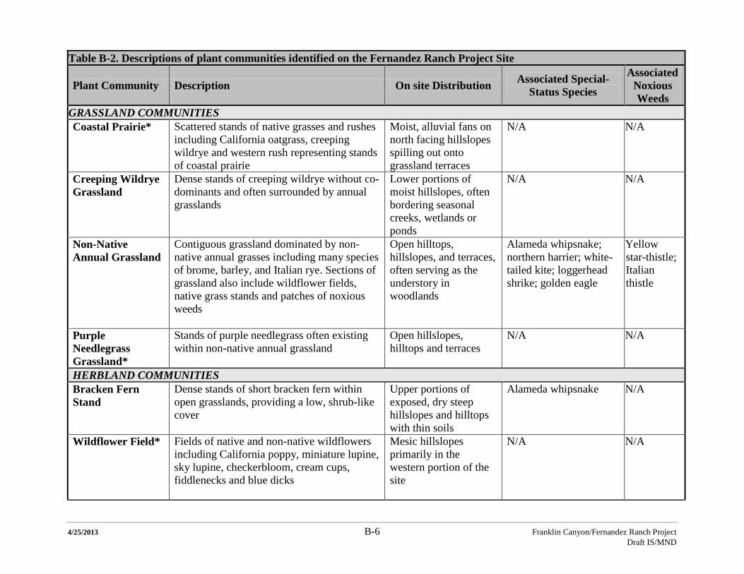
4/25/2013 B-6 Franklin Canyon/Fernandez Ranch Project Draft IS/MND
Table B-2. Descriptions of plant communities identified on the Fernandez Ranch Project Site
Plant Community Description On site Distribution Associated Special-Status Species
Associated Noxious Weeds
GRASSLAND COMMUNITIES Coastal Prairie* Scattered stands of native grasses and rushes
including California oatgrass, creeping wildrye and western rush representing stands of coastal prairie
Moist, alluvial fans on north facing hillslopes spilling out onto grassland terraces
N/A N/A
Creeping Wildrye Grassland
Dense stands of creeping wildrye without co-dominants and often surrounded by annual grasslands
Lower portions of moist hillslopes, often bordering seasonal creeks, wetlands or ponds
N/A N/A
Non-Native Annual Grassland
Contiguous grassland dominated by non-native annual grasses including many species of brome, barley, and Italian rye. Sections of grassland also include wildflower fields, native grass stands and patches of noxious weeds
Open hilltops, hillslopes, and terraces, often serving as the understory in woodlands
Alameda whipsnake; northern harrier; white-tailed kite; loggerhead shrike; golden eagle
Yellow star-thistle; Italian thistle
Purple Needlegrass Grassland*
Stands of purple needlegrass often existing within non-native annual grassland
Open hillslopes, hilltops and terraces
N/A N/A
HERBLAND COMMUNITIES Bracken Fern Stand
Dense stands of short bracken fern within open grasslands, providing a low, shrub-like cover
Upper portions of exposed, dry steep hillslopes and hilltops with thin soils
Alameda whipsnake N/A
Wildflower Field* Fields of native and non-native wildflowers including California poppy, miniature lupine, sky lupine, checkerbloom, cream cups, fiddlenecks and blue dicks
Mesic hillslopes primarily in the western portion of the site
N/A N/A
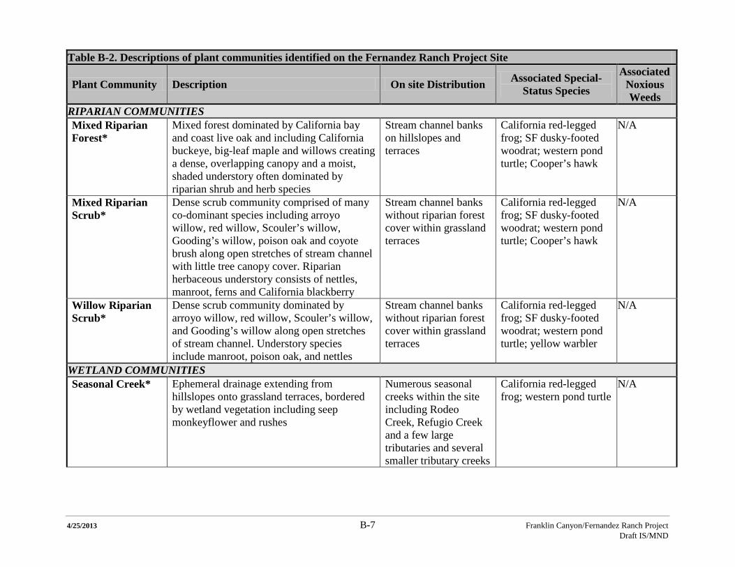
4/25/2013 B-7 Franklin Canyon/Fernandez Ranch Project Draft IS/MND
Table B-2. Descriptions of plant communities identified on the Fernandez Ranch Project Site
Plant Community Description On site Distribution Associated Special-Status Species
Associated Noxious Weeds
RIPARIAN COMMUNITIES Mixed Riparian Forest*
Mixed forest dominated by California bay and coast live oak and including California buckeye, big-leaf maple and willows creating a dense, overlapping canopy and a moist, shaded understory often dominated by riparian shrub and herb species
Stream channel banks on hillslopes and terraces
California red-legged frog; SF dusky-footed woodrat; western pond turtle; Cooper’s hawk
N/A
Mixed Riparian Scrub*
Dense scrub community comprised of many co-dominant species including arroyo willow, red willow, Scouler’s willow, Gooding’s willow, poison oak and coyote brush along open stretches of stream channel with little tree canopy cover. Riparian herbaceous understory consists of nettles, manroot, ferns and California blackberry
Stream channel banks without riparian forest cover within grassland terraces
California red-legged frog; SF dusky-footed woodrat; western pond turtle; Cooper’s hawk
N/A
Willow Riparian Scrub*
Dense scrub community dominated by arroyo willow, red willow, Scouler’s willow, and Gooding’s willow along open stretches of stream channel. Understory species include manroot, poison oak, and nettles
Stream channel banks without riparian forest cover within grassland terraces
California red-legged frog; SF dusky-footed woodrat; western pond turtle; yellow warbler
N/A
WETLAND COMMUNITIES Seasonal Creek* Ephemeral drainage extending from
hillslopes onto grassland terraces, bordered by wetland vegetation including seep monkeyflower and rushes
Numerous seasonal creeks within the site including Rodeo Creek, Refugio Creek and a few large tributaries and several smaller tributary creeks
California red-legged frog; western pond turtle
N/A
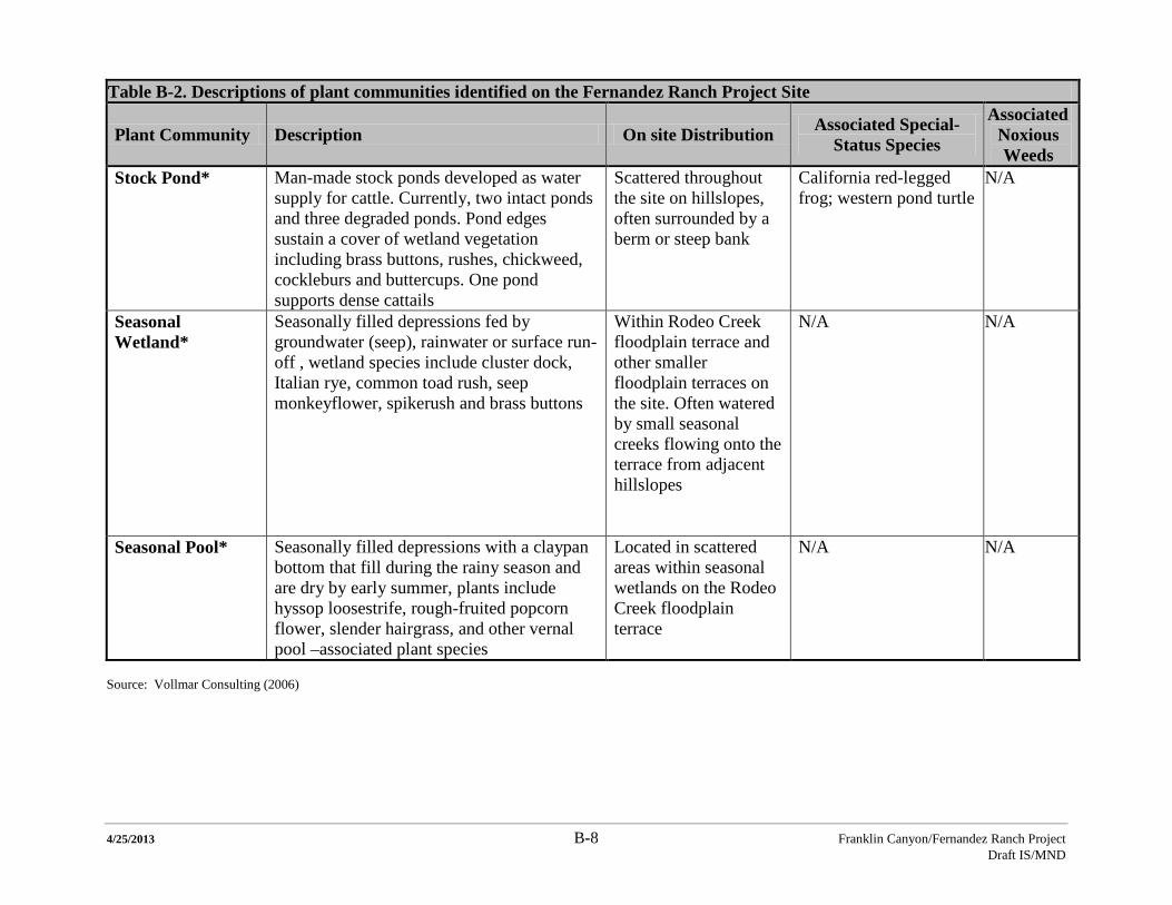
4/25/2013 B-8 Franklin Canyon/Fernandez Ranch Project Draft IS/MND
Table B-2. Descriptions of plant communities identified on the Fernandez Ranch Project Site
Plant Community Description On site Distribution Associated Special-Status Species
Associated Noxious Weeds
Stock Pond* Man-made stock ponds developed as water supply for cattle. Currently, two intact ponds and three degraded ponds. Pond edges sustain a cover of wetland vegetation including brass buttons, rushes, chickweed, cockleburs and buttercups. One pond supports dense cattails
Scattered throughout the site on hillslopes, often surrounded by a berm or steep bank
California red-legged frog; western pond turtle
N/A
Seasonal Wetland*
Seasonally filled depressions fed by groundwater (seep), rainwater or surface run-off , wetland species include cluster dock, Italian rye, common toad rush, seep monkeyflower, spikerush and brass buttons
Within Rodeo Creek floodplain terrace and other smaller floodplain terraces on the site. Often watered by small seasonal creeks flowing onto the terrace from adjacent hillslopes
N/A N/A
Seasonal Pool* Seasonally filled depressions with a claypan bottom that fill during the rainy season and are dry by early summer, plants include hyssop loosestrife, rough-fruited popcorn flower, slender hairgrass, and other vernal pool –associated plant species
Located in scattered areas within seasonal wetlands on the Rodeo Creek floodplain terrace
N/A N/A
Source: Vollmar Consulting (2006)
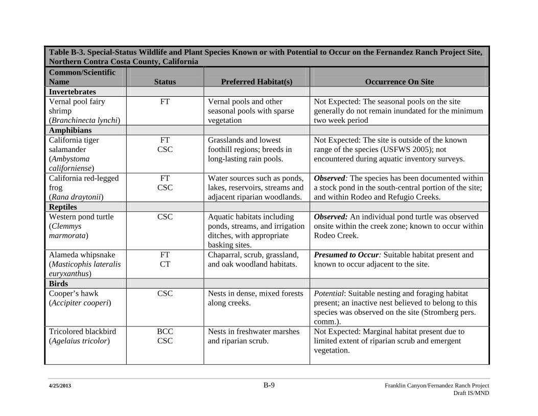
4/25/2013 B-9 Franklin Canyon/Fernandez Ranch Project Draft IS/MND
Table B-3. Special-Status Wildlife and Plant Species Known or with Potential to Occur on the Fernandez Ranch Project Site, Northern Contra Costa County, California Common/Scientific Name
Status
Preferred Habitat(s)
Occurrence On Site
Invertebrates Vernal pool fairy shrimp (Branchinecta lynchi)
FT
Vernal pools and other seasonal pools with sparse vegetation
Not Expected: The seasonal pools on the site generally do not remain inundated for the minimum two week period
Amphibians California tiger salamander (Ambystoma californiense)
FT CSC
Grasslands and lowest foothill regions; breeds in long-lasting rain pools.
Not Expected: The site is outside of the known range of the species (USFWS 2005); not encountered during aquatic inventory surveys.
California red-legged frog (Rana draytonii)
FT CSC
Water sources such as ponds, lakes, reservoirs, streams and adjacent riparian woodlands.
Observed: The species has been documented within a stock pond in the south-central portion of the site; and within Rodeo and Refugio Creeks.
Reptiles Western pond turtle (Clemmys marmorata)
CSC Aquatic habitats including ponds, streams, and irrigation ditches, with appropriate basking sites.
Observed: An individual pond turtle was observed onsite within the creek zone; known to occur within Rodeo Creek.
Alameda whipsnake FT (Masticophis lateralis euryxanthus)
CT Chaparral, scrub, grassland, and oak woodland habitats.
Presumed to Occur: Suitable habitat present and known to occur adjacent to the site.
Birds Cooper’s hawk (Accipiter cooperi)
CSC Nests in dense, mixed forests along creeks.
Potential: Suitable nesting and foraging habitat present; an inactive nest believed to belong to this species was observed on the site (Stromberg pers. comm.).
Tricolored blackbird (Agelaius tricolor)
BCC CSC
Nests in freshwater marshes and riparian scrub.
Not Expected: Marginal habitat present due to limited extent of riparian scrub and emergent vegetation.
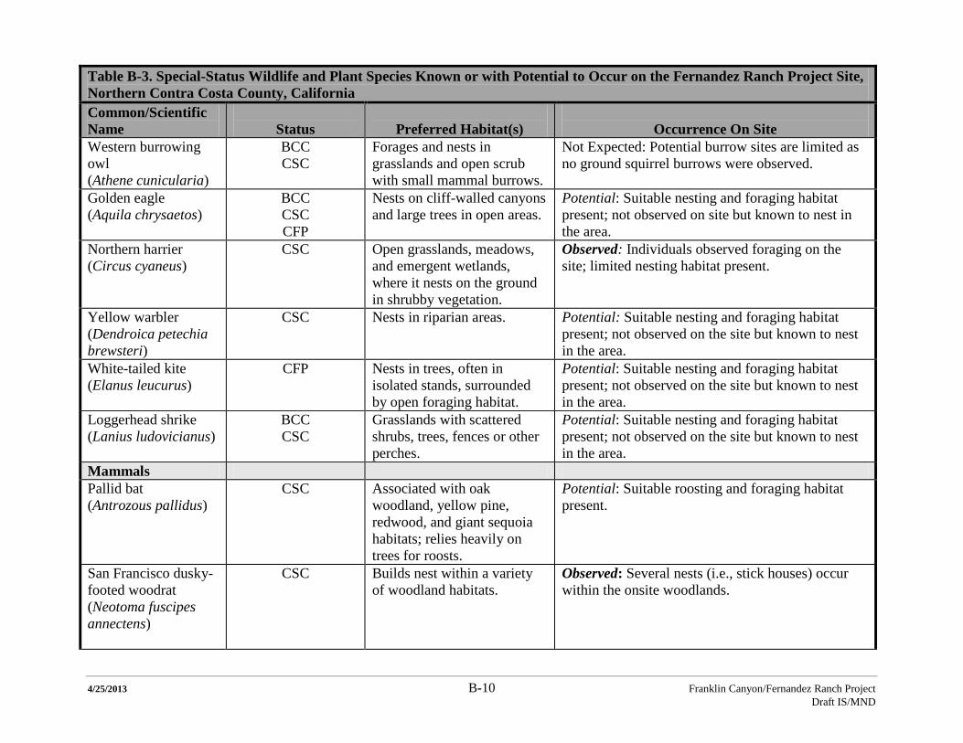
4/25/2013 B-10 Franklin Canyon/Fernandez Ranch Project Draft IS/MND
Table B-3. Special-Status Wildlife and Plant Species Known or with Potential to Occur on the Fernandez Ranch Project Site, Northern Contra Costa County, California Common/Scientific Name
Status
Preferred Habitat(s)
Occurrence On Site
Western burrowing owl (Athene cunicularia)
BCC CSC
Forages and nests in grasslands and open scrub with small mammal burrows.
Not Expected: Potential burrow sites are limited as no ground squirrel burrows were observed.
Golden eagle (Aquila chrysaetos)
BCC CSC CFP
Nests on cliff-walled canyons and large trees in open areas.
Potential: Suitable nesting and foraging habitat present; not observed on site but known to nest in the area.
Northern harrier (Circus cyaneus)
CSC Open grasslands, meadows, and emergent wetlands, where it nests on the ground in shrubby vegetation.
Observed: Individuals observed foraging on the site; limited nesting habitat present.
Yellow warbler (Dendroica petechia brewsteri)
CSC Nests in riparian areas. Potential: Suitable nesting and foraging habitat present; not observed on the site but known to nest in the area.
White-tailed kite (Elanus leucurus)
CFP Nests in trees, often in isolated stands, surrounded by open foraging habitat.
Potential: Suitable nesting and foraging habitat present; not observed on the site but known to nest in the area.
Loggerhead shrike (Lanius ludovicianus)
BCC CSC
Grasslands with scattered shrubs, trees, fences or other perches.
Potential: Suitable nesting and foraging habitat present; not observed on the site but known to nest in the area.
Mammals Pallid bat (Antrozous pallidus)
CSC
Associated with oak woodland, yellow pine, redwood, and giant sequoia habitats; relies heavily on trees for roosts.
Potential: Suitable roosting and foraging habitat present.
San Francisco dusky-footed woodrat (Neotoma fuscipes annectens)
CSC Builds nest within a variety of woodland habitats.
Observed: Several nests (i.e., stick houses) occur within the onsite woodlands.
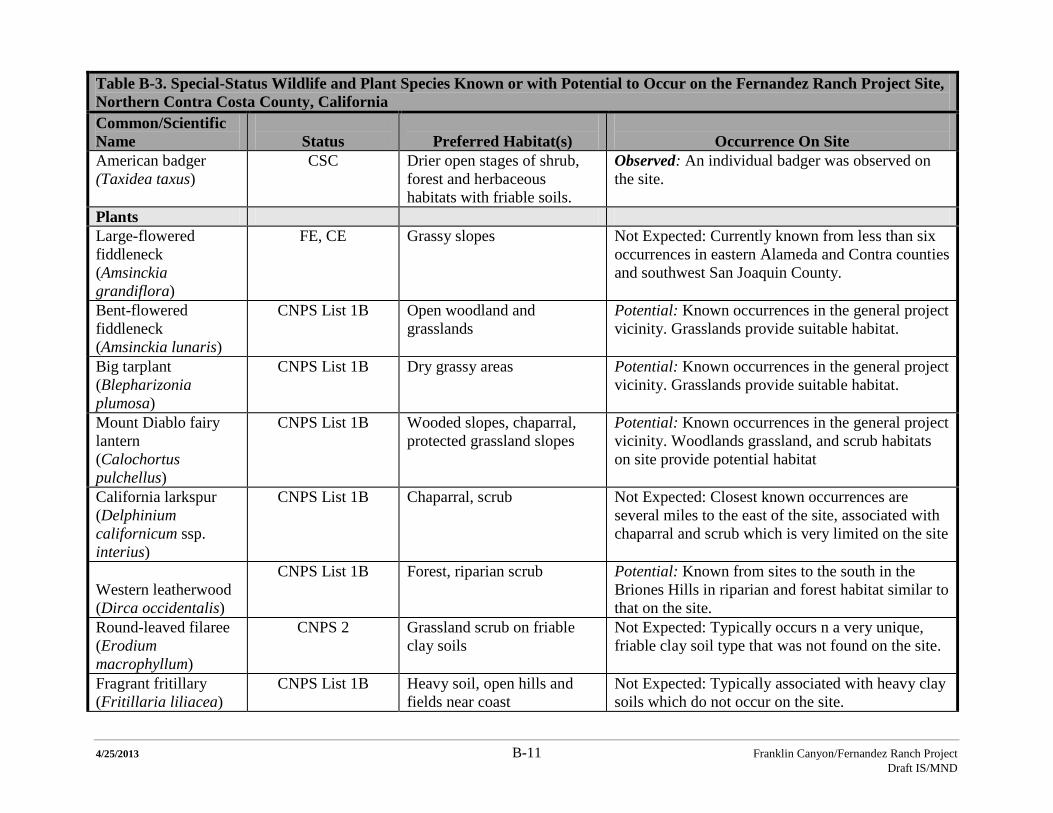
4/25/2013 B-11 Franklin Canyon/Fernandez Ranch Project Draft IS/MND
Table B-3. Special-Status Wildlife and Plant Species Known or with Potential to Occur on the Fernandez Ranch Project Site, Northern Contra Costa County, California Common/Scientific Name
Status
Preferred Habitat(s)
Occurrence On Site
American badger (Taxidea taxus)
CSC Drier open stages of shrub, forest and herbaceous habitats with friable soils.
Observed: An individual badger was observed on the site.
Plants Large-flowered fiddleneck (Amsinckia grandiflora)
FE, CE Grassy slopes Not Expected: Currently known from less than six occurrences in eastern Alameda and Contra counties and southwest San Joaquin County.
Bent-flowered fiddleneck (Amsinckia lunaris)
CNPS List 1B Open woodland and grasslands
Potential: Known occurrences in the general project vicinity. Grasslands provide suitable habitat.
Big tarplant (Blepharizonia plumosa)
CNPS List 1B Dry grassy areas Potential: Known occurrences in the general project vicinity. Grasslands provide suitable habitat.
Mount Diablo fairy lantern (Calochortus pulchellus)
CNPS List 1B Wooded slopes, chaparral, protected grassland slopes
Potential: Known occurrences in the general project vicinity. Woodlands grassland, and scrub habitats on site provide potential habitat
California larkspur (Delphinium californicum ssp. interius)
CNPS List 1B Chaparral, scrub
Not Expected: Closest known occurrences are several miles to the east of the site, associated with chaparral and scrub which is very limited on the site
Western leatherwood (Dirca occidentalis)
CNPS List 1B Forest, riparian scrub Potential: Known from sites to the south in the Briones Hills in riparian and forest habitat similar to that on the site.
Round-leaved filaree (Erodium macrophyllum)
CNPS 2 Grassland scrub on friable clay soils
Not Expected: Typically occurs n a very unique, friable clay soil type that was not found on the site.
Fragrant fritillary (Fritillaria liliacea)
CNPS List 1B Heavy soil, open hills and fields near coast
Not Expected: Typically associated with heavy clay soils which do not occur on the site.
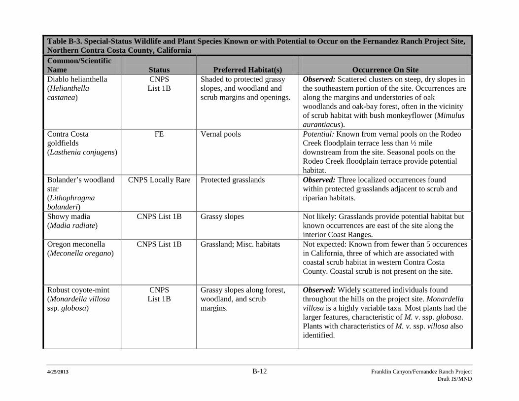
4/25/2013 B-12 Franklin Canyon/Fernandez Ranch Project Draft IS/MND
Table B-3. Special-Status Wildlife and Plant Species Known or with Potential to Occur on the Fernandez Ranch Project Site, Northern Contra Costa County, California Common/Scientific Name
Status
Preferred Habitat(s)
Occurrence On Site
Diablo helianthella (Helianthella castanea)
CNPS List 1B
Shaded to protected grassy slopes, and woodland and scrub margins and openings.
Observed: Scattered clusters on steep, dry slopes in the southeastern portion of the site. Occurrences are along the margins and understories of oak woodlands and oak-bay forest, often in the vicinity of scrub habitat with bush monkeyflower (Mimulus aurantiacus).
Contra Costa goldfields (Lasthenia conjugens)
FE Vernal pools Potential: Known from vernal pools on the Rodeo Creek floodplain terrace less than ½ mile downstream from the site. Seasonal pools on the Rodeo Creek floodplain terrace provide potential habitat.
Bolander’s woodland star (Lithophragma bolanderi)
CNPS Locally Rare Protected grasslands Observed: Three localized occurrences found within protected grasslands adjacent to scrub and riparian habitats.
Showy madia (Madia radiate)
CNPS List 1B Grassy slopes Not likely: Grasslands provide potential habitat but known occurrences are east of the site along the interior Coast Ranges.
Oregon meconella (Meconella oregano)
CNPS List 1B Grassland; Misc. habitats
Not expected: Known from fewer than 5 occurences in California, three of which are associated with coastal scrub habitat in western Contra Costa County. Coastal scrub is not present on the site.
Robust coyote-mint (Monardella villosa ssp. globosa)
CNPS List 1B
Grassy slopes along forest, woodland, and scrub margins.
Observed: Widely scattered individuals found throughout the hills on the project site. Monardella villosa is a highly variable taxa. Most plants had the larger features, characteristic of M. v. ssp. globosa. Plants with characteristics of M. v. ssp. villosa also identified.
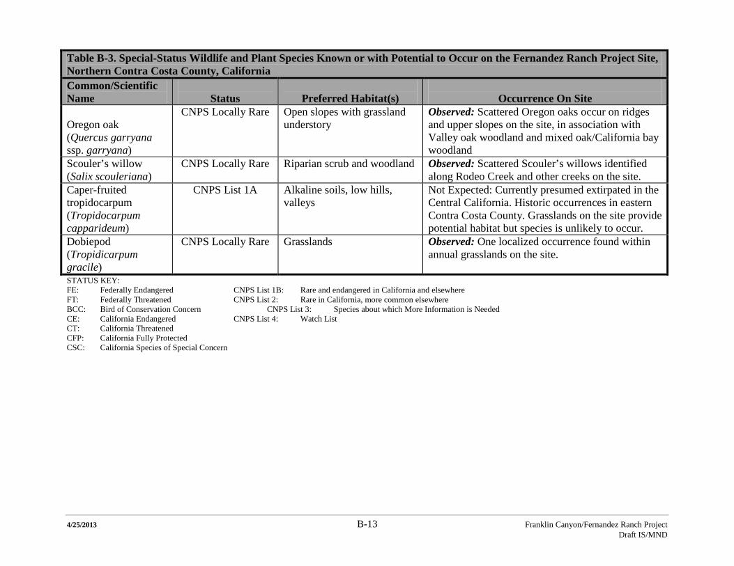
4/25/2013 B-13 Franklin Canyon/Fernandez Ranch Project Draft IS/MND
Table B-3. Special-Status Wildlife and Plant Species Known or with Potential to Occur on the Fernandez Ranch Project Site, Northern Contra Costa County, California Common/Scientific Name
Status
Preferred Habitat(s)
Occurrence On Site
Oregon oak (Quercus garryana ssp. garryana)
CNPS Locally Rare Open slopes with grassland understory
Observed: Scattered Oregon oaks occur on ridges and upper slopes on the site, in association with Valley oak woodland and mixed oak/California bay woodland
Scouler’s willow (Salix scouleriana)
CNPS Locally Rare Riparian scrub and woodland Observed: Scattered Scouler’s willows identified along Rodeo Creek and other creeks on the site.
Caper-fruited tropidocarpum (Tropidocarpum capparideum)
CNPS List 1A Alkaline soils, low hills, valleys
Not Expected: Currently presumed extirpated in the Central California. Historic occurrences in eastern Contra Costa County. Grasslands on the site provide potential habitat but species is unlikely to occur.
Dobiepod (Tropidicarpum gracile)
CNPS Locally Rare Grasslands Observed: One localized occurrence found within annual grasslands on the site.
STATUS KEY: FE: Federally Endangered CNPS List 1B: Rare and endangered in California and elsewhere FT: Federally Threatened CNPS List 2: Rare in California, more common elsewhere BCC: Bird of Conservation Concern CNPS List 3: Species about which More Information is Needed CE: California Endangered CNPS List 4: Watch List CT: California Threatened CFP: California Fully Protected CSC: California Species of Special Concern
4/25/2013 B-14 Franklin Canyon/Fernandez Ranch Project Draft IS/MND
THIS PAGE INTENTIONALLY LEFT BLANK