Embed Size (px)
Citation preview

The Fundamental Laws of GIScienceThe Fundamental Laws of GIScience
Michael F. GoodchildUniversity of California
Santa Barbara
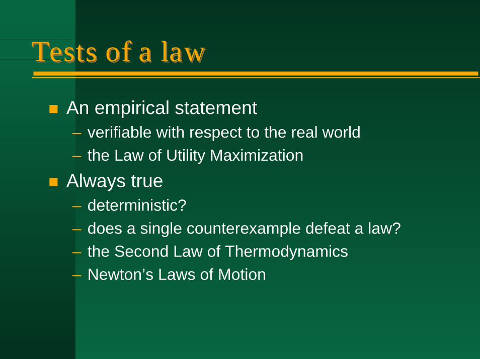
Tests of a lawTests of a law
An empirical statement– verifiable with respect to the real world– the Law of Utility Maximization
Always true– deterministic?– does a single counterexample defeat a law?– the Second Law of Thermodynamics– Newton’s Laws of Motion

Can there be laws in the social sciences?Can there be laws in the social sciences?
Not if a single counterexample can defeat a lawErnest Rutherford: “The only result that can possibly be obtained in the social sciences is: some do, and some don’t”– a candidate for the First Law of Social
Science

Proposed tests of laws inGIScienceProposed tests of laws inGIScience
Based on empirical observation– observed to be generally true– with sufficient generality to be useful as a norm– deviations from the law should be interesting
Dealing with geographic form rather than process– to distinguish laws of GIScience from laws of
geography, ecology, hydrology, …

"On laws in geography""On laws in geography"
Golledge and Amadeo (1968) Annals of the Association of American Geographers 58(4): 760-774.– cross-section laws– equilibrium laws– historical laws– developmental laws– statistical laws

The value of lawsThe value of laws
Teaching– laws allow courses to be structured from
first principlesSystem design– laws provide the basis for predicting
performance, making design choicesPhysics envy– an asset of a strong, robust discipline

Tobler’s First LawTobler’s First Law
“All things are related, but nearby things are more related than distant things”– W.R. Tobler, 1970. A computer movie
simulating urban growth in the Detroit region. Economic Geography 46: 234-240
– implies process as much as form– “nearby things are more similar than
distant things”

ValidityValidity
“Nearby things are less similar than distant things”– negative spatial autocorrelation– possible at certain scales
• the checkerboard• retailing
– but negative a/c at one scale requires positive a/c at other scales
– smoothing processes dominate sharpening processes

FormalizationFormalization
Geostatistics– variogram, covariogram– measuring how similarity decreases with
distance– parameters vary by phenomenon
• does this make TFL less of a law?

UtilityUtility
Representation– GI is reducible to statements of the form
<x,z>– the atomic form of GI is unmanageable,
encountered only in point samples– all other GI data models assume TFL
Spatial interpolation– IDW and Kriging implement TFL

If TFL weren’t trueIf TFL weren’t true
GIS would be impossible– a point sample is useful only with
interpolationLife would be impossible

Expanding the horizonsExpanding the horizons
Other spaces– are there spaces for which TFL is not true?– digits of π– genome
Other laws of GIScience

Candidate lawsCandidate laws
All important places are at the corners of four map sheetsMontello and Fabrikant, “The First Law of Cognitive Geography”– “People think closer things are more
similar”

A second (first) lawA second (first) law
TFL describes a second-order effect– properties of places taken two at a time– a law of spatial dependence– is there a law of places taken one at a
time?Spatial heterogeneity– non-stationarity– uncontrolled variance

Corollaries of the second lawCorollaries of the second law
There is no average place on the Earth’s surfaceSampling is problematic– one must visit or map all of it to understand its full
complexityResults depend explicitly on the bounds of the studyThe Noah effect– there is a finite probability of an event of any
magnitude– to observe an event of a given magnitude it is
simply necessary to wait long enough

A GIScientist’s Noah effectA GIScientist’s Noah effect
The Eden effect– El Dorado– to find a feature of any magnitude it is sufficient to
look far enough• but unlike time, the Earth’s surface is limited
The Pareto distribution or rank-size rule– plot log rank against log size– a model of the extreme upper tail of distributions– fits well to the world’s largest:
• cities by population• lakes by area
– but not mountains by elevation

Practical implications of the second lawPractical implications of the second law
A state is not a sample of the nation– a country is not a sample of the world
Classification schemes will differ when devised by local jurisdictionsFigures of the Earth will differ when devised by local surveying agenciesGlobal standards will always compete with local standards

Implications for analysisImplications for analysis
Strong argument for place-based analysis, local statistics, geographically weighted regression– a middle ground in the
nomothetic/idiographic debate


Possible corollary of the heterogeneity lawPossible corollary of the heterogeneity law
For every conceivable pattern in two (three) dimensions there exists an instance on the Earth's surface– for every GIS algorithm/indexing scheme/data
model there exists a data set for which that algorithm/indexing scheme/data model is optimal
– "There are more things in Heaven and earth, Horatio, than are dealt with in your philosophy"

3) A fractal principle3) A fractal principle
The closer you look the more you see– and for many natural phenomena the rate
is orderly– Richardson plots– lengths of national boundaries
• Spain and Portugal• context of 1920s


Practical implicationsPractical implications
Indexing schemes, quadtrees– partitioning of information at different scales
Length is a function of spatial resolution– and variously under-estimated in GIS– as are many other properties
• slope• soil class• land cover class
– spatial resolution should always be explicit in GIS analysis
• easy in raster• much more difficult in vector

4) Objects and fields4) Objects and fields
There are two ways of conceptualizing geographic variation– as discrete, countable objects littering an
otherwise empty table-top– as a collection of continuous fields,
functions of location


5) The uncertainty principle5) The uncertainty principle
No representation of the Earth’s surface can be complete– no measurement of position can be perfect– a GIS will always leave doubt about the
true nature of the Earth’s surface


Practical implicationsPractical implications
Store measurements not coordinates– measurement-based GIS
Allow topology to trump geometryNever test for equality of position

Derivative principlesDerivative principles
Principles that can be derived by combining fundamental onesTFL and the principle of uncertainty– errors will be spatially autocorrelated– relative accuracy will be better than absolute
accuracy– a map whose absolute positional accuracy is no
better than 50m will still show objects in their correct relative location
– elevations that are accurate to no better than 7m can still be used to estimate slope

ConclusionsConclusions
Laws exist in GIScience– and should be stated– formally or informally?
Generalizations about the geographic world can be blindingly obvious– but stating them is important
Laws have practical value in GIScienceLaws have pedagogic value– the nature of geographic information– how special is spatial?