Embed Size (px)
Citation preview
THE GEOLOGICAL NEWSLETTER
G.EOLOGICAL SOCIETY OF THE OREGON· COUNTRY
GEOLOGICAL SOCIETY OF THE OREGON COUNTRY
P.O. BOX 907 PORTLAND, OR 97207
Non-Profit Org. U.S. POSTAGE
PAID Portland, Oregon
Permit No. 999
. :,
'•
GEOLOGICAL SOCIETY OF THE OREGON COUNTRY 1992-1993 ADMINISTRATION
President Eveyln Pratt 2971 Canterbury Lane Portland, OR 97201
President Elect Esther Kennedy 6124 NE 28th Ave. Portland, OR 97211
Secretary
~oaRD OF DIRECTORS
223-2601
287-3091
Directors Dr. Donald Botteron (3 years)
Betty Turner (2 years) Donald Barr (1 year)
Immediate Past Presidents Dr. Walter Sunderland, M.D. DR. Ruth Keen
THE GEOLOGICAL NEWSLETTER Editor: Donald Barr
Shirley O'Dell 245-6339 Calendar: Reba Wilcox Business Mgr: Rosemary Kenney Assist.:M~~~t Steere
3038 SW, Florida Ct. Unit D Portland, OR 97219
Treasurer Archie Strong 6923 SW 2nd Ave. Portland, OR 97219
Calligrapher Clay Kelleher
Field Trips Alta B. Fosback
Geology Seminars Richard Bartell
Historian Charlene Holzwarth
Hospitality (Luncheon) Shirley O'Dell (Evening) Shirley O'Dell
Library Frances Rusche
Past Presidents Panel Dr. Walter Sunderland, M.D.
Programs (Luncheon) Clay Kelleher (Evening) Esther Kennedy
244-1488
~CTIVITIES CHAIR~
775-6263
641-6323
292-6939
284-3444
245-6339 245-6339
654-5975
625-6840
775-6263 287-3091
Properties and PA System (Lur1cheon) Clay Kelleher (Evenings) Booth Joslin
Publications Margaret Steere
Publicity Ruby Turner
Refreshments (Friday evenings)
Volunteer (Geology Seminar)
Dorothy Barr Telephone
Connie Newton Volunteer Speakers Bureau
Bob Richmond Annual Banquet
Susan Barrett Lois Sato
ACTIVITIES
245-6251 246-3192 246-2785
625-6840 222-1430
246-2785 684-7831 221-0757 246-1670
775-6263 636-2384
246-1670
234-8730
246-2785
255-5225
282-3817
639-4583 654-7671
ANNUAL EVENTS: President's campout-summer. Picnic-August. Banquet-March. Annual Meeting February. FIELD TRIPS: Usually one per month, via private car, caravan or chartered bus. GEOLOGY SEMINARS: ·Third Wednesday, except June, July, August,8:0o p.m. Room S17 in Cramer Hall, PSU.LIBRARY: Room 57, open 7:30p.m. prior to evening meeting. PROGRAMS: Evenings: Second and Fourth Fridays each month, a:oo p.m.Room 371, Cramer Hall,Portland State University, SW Broadway at Mill Street, Portland, Oregon. Luncheons: First and third Fridays each month, except holidays, at noon, Stand~rd Plaza Cafeteria, third floor, Room A, 1100 SW Sixth Ave. Portland, Oregon. MEMBERSHIP: per year from January 1: Individual, $15.00, Family,$25.00, Junior (under 18),$6.00. Write or call Secretary for membership applications. PUBLICATIONS: THE GEOLOGICAL NEWSLETTER (ISSN 0270 5451) published monthly and mailed to each member. Subscriptions available to libraries and organizations at $10.00 a year (add $3.00 postage for foreign subscribers). individual subscriptions at $13.00 a year. Single copies $1.00. Order from Geological Society of the Oregon Country,PO Box 907, Portland, 97207 TRJ..£.. .. 1Q.G._S_:__- Write to same address for price list.
THE GEOLOGICAL NEWSLETTER The Geological Society of the Oregon Country
P.O. Box 907 • Portland, OR 97207
VISITORS WELCOME INFORMATION PHONE 284-4320
VOLUME 59, NO. 1
CALENDAR OF ACTIVITIES FOR JANUARY, 1993
FRIDAY NIGHT LECTURES (Cramer Hall, PSU~ Robm-371; 8:60P.M.).
Jan. 8
Jan. 22
"Mount Robson, Pride of the Canadian Rockies" Slide presentation by Evelyn Pratt, President GSOC.
"Exotic Terranes, Blue Mountains of Oregon". A video tape presentation. Introduction by .Clay Kelleher, GSOC member.
FRIDAY LUNCHEONS (Standard Plaza, 1100 SW 6th Avenue, Rooms A & B. Third Floor Cafeteria. Programs at 12:00 Noon).
Jan 1
Jan. 15
NEW YEARS DAY - N~ luncheon.
"South Australia'', A slide presentation by Frances Rusche, GSOC·member.
GEOLOGY SEMINAR (Cramer Hall, PSU, Room S-17~ 8:00P.M.)
Wednesday Jan. 20 "Geology of the Black Hills", A slide presentation
and discussion by Richard Bartels.
GSOC LIBRARY (Cramer Hall, Portland State University, Room S-7. Open 7:00- 8:00P.M. prior to evening meetings.)
FIELD TRIPS Due to minimal response to last month's inquiry regarding your wishes, no trips are scheduled. Call Alta Fosback at 641-6323 for further information.
EXTREA-EXTRA****OPEN HOUSE**** An OPEN HOUSE January 31, 1993. An OPEN HOUSE well be held to celebrate the wedding of Alta Fosback and Harold Stauffer at the home of Charle~e Holzwarth, 2524 NE 34th from 2 to 6 pm. All Gsocs and their- famlies' are invited. Bring your favorite cookies or !!!!No gifts please.
EARTHWATCH- VOLUNTEERS NEEDED FOR WORLDWIDE GEOLOGICAL RESEARCH
Earthwatch a non-profit organization that provides fimding to field scientists world-wide, is is recruiting volunteers for a wrlque, hands-on experience assisting geological research.
EARTIIWATCH is a tax-exempt, non profit institution that sponsors scholarly research by finding paying volunteers to help scientists on research expeditions armmd the world. The organization is a public charity under sections 50l(c)3 and 509(a)2 of the Internal Revenue Code for charitable, educational, and scientific activities (Federal #23-7169440. TURN TO PAGE 6 on EARTIIW ARCH for further details.
' . - . . .~ ' .
January 1993 1
COMPLEFED FUCI"URED GEOLOGY EVELYN AND RALPH PRATf
1. Country Rock: music for drwns, washboard, or geetar.
2. Benioff zone: a place where Benny is forbidden to go. 3. Mantle plume: one rose, daisy, etc., over the
fireplace. 4. Fades: What folksies have in front of their headies. 5. Qwu1Dte: land purchased for a building to house s
judge and jury; where quietroom is located. 6. Concordant: one or two places where the
Revolutionazy War started, Lexington being the other. 7 Nuee ardente: one's latest boyfriend or girl1iiend. 8. Ffreshock: a hank of hair~ hangs over a person's
eyebrows. 9. Lltbology: the scierice o(how to become more limber.
1 o: Aureole: what you ask when the powel's been off "Aureole right no ? SEE PAGE 6 FOR REALDEFJNITIONS
1_1111111111.11111111111111111111111
THE GEOLGICAL HISTORY OF CATS IN OREGON
Robert L.Gamer, Member of the Society of Vertebrate Paleontology .
PARTll-THESABERTOOTHCOR STABBING) CATS
Editors Note: This is the second and last part of the geological histoty of cats in Oregon. It is an account of the saber tooth cats. An earlier issue of GSOC Newsletter, Vol 58, No. 5, pages 28-30 contains Part One of the history of Oregon's biting cats. ~ ·
The second great division of the cat fiunily is the saber tooth group. This group of Cats an had long (4 and 1/2 to 12 inch) cannie teeth called sabers. They also had well developed camassa1 teeth.
The ancient bones of Oregon's earliest sabber tooth cat, Hoplophoneus, are found in the Turtle Cove and Haystack Valley members of the John Day FOIIDation. Both are of late Oligocene to early Miocene age. Hoploponeus iS also found in the still earlier Oligocene beds in Nebraska. It is thought to be the ancestor of all the saber tooth cats that appeared in later times. It was a sleek preditor. Hoploponeus was laiger than a lynx and heavier than Dinictis. Its canines were long, thin, stabbing blades that were sermted on both-edges. Hopolphoneus had a flange on its lower jaw for sheathing the sabers. This flange covered and protected the sabers when Hoplophoneus closed its mouth the same way that a scabbard protects a sheathed sword The bones of Maichairodus, an early descent of Hoplophoneus, was found in the Hays1ack
2
Valley beds of the John Day FOIIDation and the Drinkwater and McKay members of the Deschutes FoiiDation mrther to the east The Deschutes FOIIDation is made up of volcanic and continental sediments of lower Miocene age. Machairodus is also called the scimetar-tooth cat because its canine teeth were iazor slwp like the scimeter of a Turkish sultan. It had long forelegs but short hind legs. Like most saber tooth cats Marchairodus was not a fast runner. It generally stalked unsuspecting bu1ky animals. Then it would nish in and stab them. They would die once the saber teeth cut into their neck arteries. Then Marchairodus would make a meal of them.
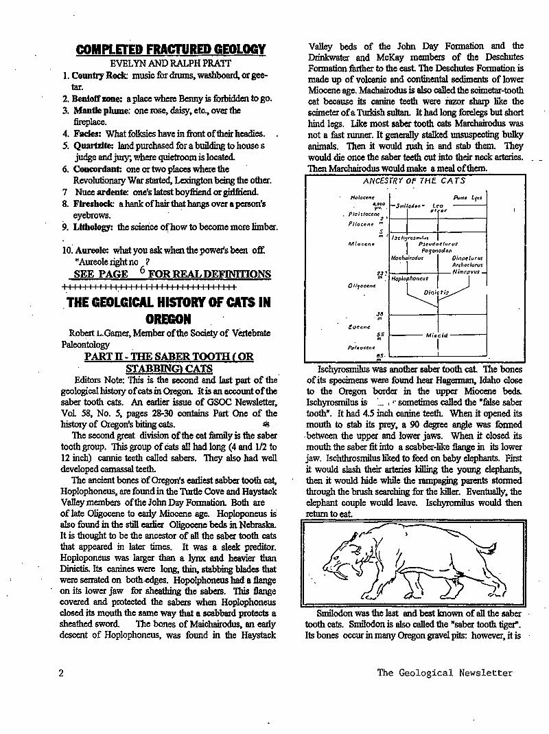
ANCESrRY OF THE CATS
H"loctne Pum1 Lyn• •• ooo
t-Smitl•n- LC'O · yrJ • • til oi' I
• Plcistoc~ne 2.
P/iocen~ .. 1 s "'' I SC h!Jt'OSrrulvt
Miocene I PJ~udtJt:turus
Pa<Jonodon Mo~hjirodus OinaPiurus
Archo<lurus
2J: Nimrovus-m Hoplophontus
OI,.JOC~nt
DinictiS'
.J6 ·m
euccne 55 Miocid .,
I Pt~l•ocent:
es. _l
"' lschyrosmilus was another saber tooth cat The bones
of its specimens were fotmd hear Hagemtan, Idaho close to the Oregon border in the upper Miocene beds. Ischyrosmilus is· ·__ , ,. sometimes called the "false saber tooth". It had 4.5 inch canine teeth. When it opened its mouth to stab its prey, a 90 degree angle was fOIIDed . between the upper and lower jaws. When it closed its mouth the saber fit into a scabber-like flange in its lower jaw. Ischthrosmilus liked to feed on baby elephants. First it would slash their arteries killing the yoWtg elephants, then it would hide while the rampaging parents stonned through the brush searching for the killer. Eventually, the elephant couple would leave. Ischyromilus would then return to eat
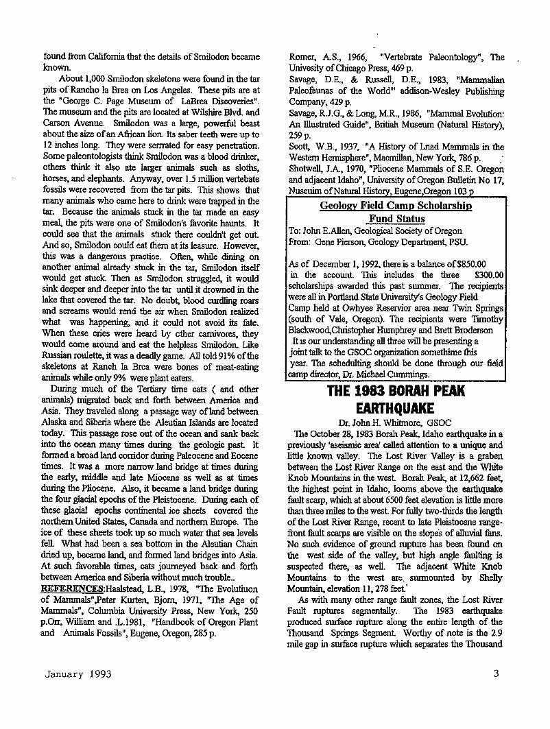
Smilodon was the last and best known of all the saber tooth cats. Smilodon is also called the "saber tooth tiger". Its bones occur in many Oregon gravel pits: however, it is
The Geological Newsletter
found from California that the details of Smilodon became known.
About 1,000 Smilodon skeletons were found in the tar pits of Rancho la Brea on Los Angeles. These pits are at the "George C. Page Museum of LaBrea Discoveries". The museum and the pits are located at Wilshire Blvd. and Carson Avenue. Smilodon was a large, powerful beast about the size of an African lion. Its saber teeth were up to 12 inches long. They were serrrated for easy penetration. Some paleontologists think Smilodon was a blood drinker, others think it also ate larger animals such as sloths, horses, and elephants. Anyway, over 1.5 million vertebate fossils were recovered from the tar pits. TlUs shows that many animals who came here to drink were trapped in the tar. Because the animals stuck in the tar made an easy meal, the pits were one of Smilodon's favorite haunts. It could see that the animals stuck there couldn't get out. And so, Smilodon could eat them at its Ieasure. However, this was a dangerous practice. Often, while dining on another animal already stuck in the tar, Smilodon itself would get stuck. Then as Smilodon struggled, it would sink deeper and deeper into the tar until it drowned in the lake that covered the tar. No doubt, blood curdling roars and screams would rend the air when Smilodon realized what was happening, and it could not avoid its fate. When these cries were heard Ly other carnivores, they would come around and eat the helpless Smilodon. Like Russian roulette, it was a deadly game. All told 91% of the skeletons at Ranch 1a Brea were bones of meat-eating animals while only 9% were plant eaters.
During much of the Tertiary time cats ( and other animals) migrated back and forth between America and Asia. They traveled along a passage way of land between Alaska and Siberia where the Aleutian Islands are located today. T1Us passage rose out of the ocean and sank back into the ocean many times during the geologic past It formed a broad land corridor during Paleocene and Eocene times. It was a more narrow land bridge at times during the early, middle and late Miocene as well as at times during the Pliocene. Also, it became a land bridge during the four glacial epochs of the Pleistocene. During each of these glacial epochs continental ice sheets covered the northern United States, Canada and northern Europe. The ice of these sheets took up so much water that sea levels fell. What had been a sea bottom in the Aleutian Chain dried up, became land, and formed land bridges into Asia. At such favomble times, cats journeyed back and forth between America and Siberia without much trouble .. REFERENCES:Haalstead, L.B., 1978, "The Evolutiuon of Mammals" .Peter Kurten, Bjorn, 1971, "The Age of Mammals", Columbia University Press, New York, 250 p.Orr, William and .L.1981, "Handbook of Oregon Plant and Animals Fossils", Eugene, Oregon, 285 p.
January 1993
Romer, A.S., 1966, "Vertebmte Paleontology", The Univesity of Chicago Press, 469 p. Savage, D.E., & Russell, D.E., 1983, "Mammalian Paleofaunas of the World"' addison-Wesley Publishing Company, 429 p. Savage, R.J.G., & Long, M.R., 1986, "Mammal Evolution: An illustrated Guide", Britiah Museum (Natural History), 259p. Scott, W.B., 1937, "A History of Lnad Mammals in the Western Hemisphere", Macmillan, New York, 786 p. . Shotwell, J.A, 1970, "Pliocene Mammals of S.E. Oregon and adjacent Idaho", University of Oregon Bulletin No 17, Nuseuim ofNatural Histo , E ene,Ore on 103
Geology Field Camp Scholarship Fund Status
To: John E.Allen, Geological Society of Oregon From: Gene Pierson, Geology Department, PSU.
As of December 1, 1992, there is a balance of$850.00 in the account. This includes the three $300.00 scholarships awarded this past summer. The recipients were all in Portland State University's Geology Field Camp held at Owhyee Reservior area near Twin Springs (south of Vale, Oregon). The recipients were iunothy Blackwood, Christopher Humphrey and Brett Broderson It IS our understanding all t.'lree will be presenting a
joint talk to the GSOC organization somethime this year. The schedulting should be done through our field camp director, Dr. Michael Cummings.
THE 1983 BORAH PEAK EARTHQUAKE
Dr. John H. Whitmore, GSOC The October 28, 1983 Borah Peak, Idaho earthquake in a
previously 'aseismic area' called attention to a unique and little known valley. The Lost River Valley is a graben between the Lost River Range on the east and the White Knob Mountains in the west Borah Peak, at 12,662 feet, the highest point in Idaho, looms. above the earthquake fault scarp, which at about 6500 feet elevation is little more than three miles to the west. For fully two-thirds the length of the Lost River Range, recent to late Pleistocene rangefront fault scarps are visible on the slopeS of alluvial fans. No such evidence of ground rupture has been found on the west side of the valley, but high angle faulting is suspected there, as well. The adjacent White Knob Mountains to the west art;, surmounted by Shelly Mountain, elevation 11, 278 feet.·
As with many other range fault zones, the Lost River Fault ruptures segmentally. The 1983 earthquake produced surface rupture along the entire length of the Thousand Springs Segment. Worthy of note is the 2.9 mile gap in surface rupture which separates the Thousand
3
Springs Segment from the Wann Springs Segment. Although no ground rupture occurred here in 1983, Quaternary fault scarps show that there was rupture here in earlier earthquakes. This 'gap' is thought to result from a 'barrier' to propagation of slippage on the fault plane. Perhaps the fault was locked here. This gap is in line with the major cross structure between the White Knob Range and the Lost River Range, the lowest portion of which is Willow Creek Pass, between the drainages of the Lost River and the Salmon River. The other segment boundaries are characterized by alignment with bed rock ridges projecting from the White Knob Mountains to narrow the Lost River Valley, or by major change in direction of the Lost River Range. Bartlett Point and Chilly Buttes constitute the projecting ridge pointing to the boundary between the Thousand Springs Segment and the Mackay (pronounced 'Mackey') Segment. A ridge from Mackay Peak points to the juncture of the Mackay Segment and Pass Creek Segment. Sheep Mountain and Appendicitis Hill project eastward into Lost River Valley, where sharp change in direction in the axis of Lost River Range marks the junction of the Pass Creek Segment and the Area Segment.
No vestiges of Late Pleistocene or Holocene faulting occur on the Pass Creek Segment Fault scarps 50 to 74 feet high break the slopes of Late Pleistocene alluvial fans in the Area Segment In the Mackay Stlgment, a fault scarp about 38 feet high cuts the late Pleistocene alluvium at the mouth of Lower Cedar Creek Canyon.
The hypocenter of the October 28, 1983 earthquake was located about 6 miles beneath the surface, near the southern edge of Thousand Springs Valley. Fault movement propagated from the southeast to northwest in the Thousand Springs Segment A 11.6 miles surface rupture occurred on that segment, with a maximum throw of 8 feet nine inches. The movement was primarily dipslip, with the valley side down-thrown. There was approximately 17% left lateral slip as well. This movement generated a magnitude 7.3 earthquake. The 'barrier' between that segment and the Wann Springs segment apparently deflected fault rupture to the west, to form the 8.5long Western Segment. The nature of that segment is poorly understood. A rupture 4.9 miles long occurred along the Wann Springs Segment, with maximum dip-slip throw of 3.25 feet , also with a left lateral slip component Rupture here is believed to have been triggered by the earthquake, and not representing an extension of the Thousand Springs Seglnent rupture. Geod!!tic measurements indicate that the Lost River Range rose about 8 inches, while the Thousand Springs Valley dropped about 48 inches during the quake. (Stein,l985.)
The fault scarp is most readily accessible via the MayPatterson (Doublesprings Pass) Road. For most of its length, it cuts the colluvium . It is a bed-rock scaq> on the
4
flank of Dickey Peak, but scrambling on steep slopes is required. to reach it there. Typical of Rocky Mountain fault scarps, it has a small graben at its foot, from one to 300 feet wide, and from an inch to three or four feet deep. If you walk along the trace of the fault you will find it has a right-stepping en enchelon pattern.
A most remarkable consequence of the earthquake was the torrential outpouring of ground water from the fissure system in the limestone of the North Chilly Butte and Thousand Springs Valley. This fissure is thought tO be a high-angle fault, trending Nl5 degrees W. There was no movement on that fault in the 1983 earthquake, but it served as a conduit for ground water to escape after the valley floor dropped and drastically increased the pore pressure. A torrent of water poured from a lmge crack on to east side of the north butte, moving angular limestone boulders up to 3 feet on a side, trenching the road and covering it with debris. At least 47 craters were left on the valley floor, to the east and the north of the butte. Warer fountains as high as 20 feet had sprouted from these craters, and from fissures between them, covering the plain with sand aprons from these craters. The largest of the craters was 72 feet in diameter and 16 feet deep. Some were only a foot or two in diameter, but 6 to 8 feet deep. Water issued from these vents for at least 48 homs, although diminished mte after an hour or two. The only eye-witness reported that a torrent of water came from the side of the butte first, then sand and dust erupted from cracks on the valley floor, appear toapparently propelled by air to an height of 12 to 18 inches for a few minutes. before water came forth from the lowland. Small amounts of water flowed from cracks on the top of the north ann of the butte, almost 100 feet above the valley floor. In addition, an astounding system of tunnels and collapse pits developed in the alluvium on the north slope of the butte.
About 1.2 miles north of the junction of Highway 93 with Trail Creek Road is Whisky Springs, where earthquake liquefuction of soil of the toe of an alluvial fan caused an extensive area of lateral spread which disrupted the highway. Although the highway has been repaired, the head-scarp and down-slope bulge of the earth flow remain.
A three mile drive on the Borah Peak-Cedar Road (4.5 ,lies north of the Trail Creek Road Junction) takes you to the fault scaq>. About 340 feet southeast of the road is a scar of a complex rotational slump-debris flow which crosses the fault scarp. Triggered by the earthquake, it slid after the fault scarp was established. After examining the landslide, and its relation to the fault scarp, you can walk to the northwest, along the trace of the fault and see fine xamples of grabens and of en echrlon, right stepping fault scarps.
It is too late to see structural damage in the town. Most damaged buildings have been removed. However, houses
The Geological Newsletter
still stand at the foot of a fresh talus slope in Challis, beneath beetling cliffs of Challis Formation. Since the earthquake, a large berm has been built at the foot of the slope The laigest rockfull caused by the earthquake is located in the canyon of the Salmon River, about 5 miles upstreamfrom the junction of Highway 93 with Highway 75. Some 13,000 cubic yards of Challis Volcanics fell from the cliffs there.
About 12 miles south or' Challis, near the mouth of Granview Canyon, a large, warm spring feeds the Wanns Spring Creek. The flow of that spring increased so abundantly following the earthquake that there has been chronic excess stream flow in the creek ever since. The landowner has addressed that problem by building a hydro-electric plant with an intake canal about two miles long. It remains to be seen whether the spring will continue to provide enough water to drive the tJ,lrbine.
In the headwaters of Antelope Cr~ alluviwn in a small tnoutary became saturated owing to new springs and increased water discharge consequent to the earthquake. Two days later, it formed a 272,000 cubic yard mudflow which moved 1.8 miles dow n valley on a slope of less than 8 degrees. Near it distal end, it broke aspen trees eight inches in diameter.
A trench has been excavated across the fault, enabling geologists to mfl.ke detailed !Ileasurements and diagm!ns of the fault plane and the deposits on the down-thrown block. The fault plane has been carefully dissected out, revealing the SC8IS of previous earthquakes in addition to those of the 1983 event
It is obvious that movement has occurred repeatedly on the same planes, both on the main mult and on secondary planes associated· with small grabens and horsts downslope from the main scarp. Since material is unconsolidatld sand and gravel, it is remarkable that the fracture plane remain so consistent · Stein, R.G. & Banienttos, S.E., HIGH ANGLE FAULTING IN TilE INTERMOUNTAIN SEISMIC BELT: GEODETIC INVESTIGATION OF THE 1983 BORAH PEAK EARTIIQUAKE, IDAHO. Abstracts with programs, Geological Society of America (Rocky Mountain Section) ,vo117,# 4: p 226, March,l985 , Rocky Mountain Section, The Geological Society of America, Boise State University, Boise, Idaho, April22-24, 1985. FIELD GUIDE, THE BORAH PEAK EARTIIQUAKE OF OCfOBER 28, 1983. SURFACE FAULTINGH, MASS MOVEMENT AND QUATERNARY TECTONIC SETTING. 11111111111111111111111111111111111111111
DEFINITIONS FOR COMPLETELY GEOLOGY
1. Country rock: any rock older than and intruded by an
January 1993
eousbody. 2. Benioff zOile: the probable upper boundary of a litho
. sphereic plate, where it dips at an agle· under another plate toward the mantle; earthquakes tend to cluster along it
3. Mantle plume: a narrow colwn of hot magma rising from earth's mantle through its crust
4. Fades: general appearence or nature of one part of a rock body as contrasted with other parts.
5. QuartDte: metanorphosed sandstone. 6. Concordant: said of strata or of the contact between
igneous and country rock, where bedding or structure. are parallel to each other. .
7. Nuee ardente: a cloud of red-hot ash and dust caused by very explosive volcanic activity. main one.
8. FOI'elhock: a small earthquake that precedes a main one.
9. Lltltology: physical character of a rock. 10. Aureole: zone of contact metamorohism next to a
luton. pl
THE EDITOR NEEDS ARTICLES AND OTHER ITEMS OF GEOLOGIC INTEREST FOR TilE NEWSLEITER.TIBS IS YOUR CHANCE TO GET YOUR NAME IN PRINT.IF YOU SEE A GEOLOGIC ARTICLE OF INTEREST. PLEASE SEND IT JN.
PROPOSAL TO DESIGNATE A OREGON STATE FOSSIL AND A PROPOSAL TO PROTECT
FOSSILS ON PUBLIC LANDS. A letter 1hat was passed on to the Editor and his wife from Dr. Lanny H. Fisk, PhD. via Mel Ashwill, GSOC from Madras regarding disignating a Oregon state fossil and a bill to protect and preserve fossils on public lands in Oregon. Dear Mel:
Enclosed are the first drafts of a joint resolution to designate an Oregon state fossil and a bill to protect and . preserve fossils on public lands. Please look over critically and give me some help. Feel free to share a copy with anyone else who may be interested in comments on how willing to help. I am particularly intereSted in comments on how effective the language of the first draft is, on one hand,protecting fossils and , on the other hand, not eXcluding collecting by "professional amateurs" like yoll1'SC1( and even hobby collectors. Please look over the curren~ draft with these things in mind. -In other word, answer the question: How would this legislation affect me and other paleontologists like me? I would be grateful for any all comments. I expect the bill will go through at least a dozen drafts before we go looking for sponsors in preparing a final draft. ·
5
EDITOR: These two proposals were written by Dr. Lanny H.Fisk, Ph.D, President and CEO, F & F GeoResource Associates, Inc. 66928 West Highway 20, Bend, Oregon mo1 THESE TWO DRAFTS OF PROPOSED STATE FOSSIL AND BILL TO PROTECT FOSSILS WILL BE IN TilE GSOC LIBRARY. 11111111111111111111111111111111111111
OREGON SUNSTONE-OFFICIAL STATE GEMSTONE
. Oregon SWl.Stone has been made the official State Gemstone by proclamation of Governor Neil Goldschmit
. 8nd by a Joint Resolution of the Oregon State Assembly. Oregon sunstohe, a rare gem variety of the feldspar group, occur ih Lake and Harney Counties where they are dug from the soil and the underlying lava flows. Oregon ·sunstones are uncommon in therf'COIIlposition, clarity, and range of col~ and occur in sufficient abundance to permit sustained production of faceted gems.
Feldspazs usually occur in a lmge variety of rocks 'types, generally as small crystals that. are typically opaque with rather dull colors of white and gray. Oregon sunstone, however, are laige, brightly colored, transparent gem feldspazs. They crystallized in molten rock as it slowly cooled deep in the earth's crust This cooling and unique composition of these particular czysta1s permitted the fonnation of gem-grade crystals, which were later erupted with the lava flow and frozen in place as the lava cooled. Finally, disintegration of the lava by weathering freed the sunstones from the surrounding lava. -·
Sunstone crystals are as laige as 3 inches across have been found. In color, the gems range from water clear through pale yellow, soft pink, and blood red to deep blue and green. Some ofthe deeper colored stones have bands of varying color. A few of the sunstone crystals show two different colors when viewed from different directions, but when they are observed from just the right direction, a pink to red metallic shimmer flashes from within the stone, as if from a collection of small spots or front a mirror surface. These color variation and shimmer (often called "schiJler") are caused by tiny crystals of copper metal
. contained in varying amounts and sizes of stone. The datker stone contain laiger amounts of copper.
For many years , collectors have p~ sunstones from eastern Lake County, near Plush, Oregon, where the U.S. Bureau of Land Man8gement has eStablished as free, collecting area. Until recently, this was the only known occurrence. Two more occurrences in northern and southeastern Harney County have been discovered· recently, allowing the mining of more marketable gems, and the geology of the area is favomble for the discovezy of more deposits. Except for the BLM public collecting
6
areas, all these producing are are held by mining claims and are not available for collecting without permission of the claim owners.
The collecting and mining of Oregon sunstones has had a positive effect on Oregon's tourism and gemstone industiy. The retail value of cut stones cmrently ranges from $15 to over $100 per carat Higher prices are for red, blue or green colors, for 1aiger or clearer stones, and for elabomte cuts. A one-carat sunstone in a traditional
. round brilliant cut would be about the size of the emser at · the end of a pencil.
SOME ARTICLES ON SUNS'IPNES The Ore Bin. v.34no. 12, (Dec.1972: Oregon "sunstone". (N.V.Peterson) . Oregon Geology, v. 49, no. 2 (Feb. 1978), p. 23-24: Oregon sunstones, (R.P.Geitgey). U.S. Bureau of Mines. Infonnation Circular 6533 (1931); Feldspar gems (Amazone stone, moon stone, sunstone), 10 p. (I.Aitkens) Americari Mineralogist v. 51 (1966). p 177-197: Physical properties of calcio labmdorite from Lake County, Oregon, (D.B.Stewart and others). Joi.unal of Gemology. vol 18, no. 6 (1983, p 503=514: Heliolite, a transparent, facetable phase of calcic labmdorite, (F.H.DPough). Geology, v. 13(1985), p. 644-647: Exsolution of metallic copper from Lake County labmdorite (AM. Hofineister and G.R.Rossman). The article written from DOGAMI. No author mentioned. 11111111111111111111111111111111 i IIIli
EARTHW ATCH continued: These EARTIIWATCH expeditions include 157
projects around the world. There are 24 projects in Geoscience, 19 projects in Marine Studies, 37 projects in Art and Archeology and 11 projects in Rain Forest Conservation and Ecology to name a few. Several projects closer to home(Oregon) are Big Bend Volcanoes, Big Bend National Park, TexaS, Monitoring Volcanoes of the American West, Ye11owstone Caldem, Wyoming, and Florida's Underground , Tallahassee, Florida. A couple of others some distance away are China's Holy Mountain, Mt Huangshan, China and Mt Olympus, Mt Olympus, Greece. ·
All projects are led by scientists and are 10 days to three weeks in length. Volunteers are trained in the field: special skills are welcome but not necessary. Anyone over the age of 16 is eligible to apply. All project contributions
. which mnge from $500 to $2.200 are tax deducllble. Volunteer contributions cover food, lodging and field equipment Airfare is additional. For further infonnation, call Andy Hudson at 800-776-0188, extl82 or write EARTIIWATCH , P.O.Box 403GP, Watertown, MA 02272
The Geological Newsletter
THE GEOLOGICAL NEWSLETTER INDEX Compiled by Dorothy R. Waists
Volume 58
January february March
pp 1--6 April pp 7-12 May
13-20 June
21-26 27-34 35-40
ARTICLES AND REPORTS Also see: BANQUET and PRESIDENT'S fiELD TRIP
BOOK REVIEWS: Cataclysms on the Columbia by Allen,
Burns, Sargent By Walter Sunderland • • • • • •
Economic Geology by Gluskoter, Rice, Taylor
By John Eliot Allen, Ph.D. • • Geology of Oregon (4th Ed.) by Orr and Baldwin
By John Eliot Allen, Ph.D. • • • New fossil Discoveries from the Late Cretaceous of Central Utah •
Rocks and Minerals by Arem By Walter Sunderland • • • • •
Central Oregon fossil Leaves By Melvin s. Ashwill • • • • • • •
Columbia River Basalt By John H. Whitmer • • • e • • • •
34
37
69
18
18
2,9
36 Completely fractured Geology
By Evelyn and Ralph Pratt Copper Canyon, Mexico
51,54,63, 76
By Rosemary Kenney • • • • • • • • Current Assess~ent of Earthquake
Hazard in Oregon
63
By Robert s. Yeats • • • • • • • 4B Darwin's Three Mistakes
By John Whitmer • • • • • • • o • 14 Decade of North American Geology--1983 Geologic Time Scale • • • • • 20
The 18 Most Significant Earthquakes in u.s. History
from Oregon Geology, Vol. 51, No. 4, July 1989 • • • • • • • • • • • 51
Geo~ogic History of Cats in· qregon By Robert.L. Gamer •• o • • • • • 28
Geothermal Exploration of Ascension Island, South Atlantic Ocean
By D. Nielson & s. G. Stiger • • 64 Geothermal Exploration in Central
Oregon, 197~-1992 By Larry Chitwood •• o • • • • • 73
Get Busy and Prepare for the Unpredictable
By Jim B~la ••••••••• o· 50 New ·Fin·ds ·in Paleontology
By Connie Hofferber Jones • • • • 42 New· fossil Rhino Stirs Intere·st · By Ellen Morris Bishop • • o • • 43
1
1992
July PP August September
41-46 47-52 53-58
October November December
PP
Oregon Nonfuel Mineral Production up in 1991
By George Hladky, DOGAMI •••• Paleozoic Pornography
By Chlovena Metzer • • • • • • • • Papua - New Guinea
By Rosemary Kenney • • • • • • • , Pintaubo Generates More Brilliant Sunrises and Sunsets - May Cause Cooler Temperatures and High SkinCancer Risks
By Evelyn M. VandenDoler • • • • The Quake Northwest
59-64 65-70 71-78
57
. 3B
58
By Jim Bela • • • • • • • • • • • Reflections on the Ecology of Science by·a field geologist
22
By John Eliot Allen • • • • • • • Rock Drawings of the Coso Range, California
By Don Barr Shooting Stars
• • :t • ..
• • • • • •
By Gordo~ Gilbertson • • • • • • • Sri Lanka
By Rosemary Kenney • • • • • • • • Tectonic History of the Gulf of California
By Wallace R. McClung • • • • • • Teenage fossil finder Discusses Discovery
By Randy Hill • • • • • • ~ • • •
BANQUET
Banquet Notice • • • • • • • • •' • Incoming President's Speech '
By Evelyn Pratt • • • • • • • • • 1992 Annual Banquet-Exhibit~
By Don Parks • • • • • • • • • • Photos
60
25
45
54
16
40
8 ..
-~ 31
33
By Robert Richmond • • • • • • • • . 32 President's farewell Address
By Walta~ A •. Sunderland • • • • • 30
MEMORIALS
Gladys D. Baldwin • • • • • • • • • Beverly Ann Bock • • • • • • • • • Irma Greisel • • • • • • • • • • • Dr. Clyde B. Hutt •••••••• Hugh Owen • • • • • • . . . . . . .
70 75
6 70
6
PRESIDENT'S FIELD TRIP
Quiz for Field Trip • • • • • • • • 36 Quiz & Pun-Session • • • o • • 43 Tentative Itinerary • • • • • • 48 President's Field Trip, Nine Days, to Oregon Caves, Crescent City, CA, Arcata, CA, Oregon Coast, Dunes
Reports by: Evelyn Pratt, Don Turner, Walt Sunderland, Don Parks, Susy Sudbrock, Margaret Giddin, Rosemary Kenney, Fran Pearson, Helen Nelson, Bob Richmond, Archie Strong 66-70,72,76
SOCIETY BUSINESS AND AFFAIRS
Annual Business Meeting Report By Walter Sunderland • • • • • • • 26
Annual Meeting Notice • • • • • • • 12 Financial Statement
By Archie Strong • • • • • • • • 16 GSOC Chart of Committees • • • • • 19 New Members ••••••••• 42,64,70 Nominating Committee • • • • • • • 72 Nominees for 1993 • • • • • • • • • 72 Past Presidents' Panel By-Laws
By John Eo Allen • • c • • • • o • 75 Proposed Budget - 1992 • • • • • • 46 Proposed Changes in By-Laws • • • • 78 Treasurer's Report
By Archie Strong • • • • • • • • • 6
AUTHORS ALLEN, JpHN ELIOT, Ph.D.
Book Reviews: Economic Geology Gluskoter, Rice, Taylor • • • • • Geology of Oregon (4th Ed.) by Orr, Orr, Baldwin • • • • • • •
Past Presidents' Panel By-Laws •• Reflections on the Ecology of Science by a field geologist • •
ASHWILL, MELVIN S. Central Oregon Fossil Leaves
BARR, DON Rock Drawings of the Coso Range, California . . . • • • • . . .
BELA, JIM Get Busy and Prepare for the Unpredictable • • • • • • • • •
BISHOP, ELLEN MORRIS New Fossil Rhino Stirs Interest •
CiHTWOOD, LARRY Geothermal Exploration in Central
Oregon, 1974-1992 • • • • • • • • GAMER, ROBERT Geologic History of Cats in Oregon
GIDDIN, MARGARET President's Field Trip, Day 6 ••
GILBERTSON, GORDON Shooting Stars . . . . . • • • •
37
69 75
60
2,9
25
50
43
73
28
68
45 2
HILL, RANDY Teenage Fossil Finder Discusses Discovery • • • • • • • • • • •
HLADKY, GEORGE Oregon Nonfuel Mineral Production
Up in 1991 • • • • • • • • • • • JONES, CONNIE HOFFERBER
New Finds in Paleontology •••• KENNEY, ROSEMARY Copper Canyon, Mexico •••••• Papua, New Gvinea • • • • • • • • President's Field Trip, Day 7 •• Sri Lanka • • • • • • • • • • • •
McCLUNG, WALLACE R. Tectonic History of the Gulf of California • • • • • • • • • • •
METZER, CHLOVENA Paleozoic Pornography • • • • • •
NELSON, HELEN President's Field Trip, Day 9 ••
NIELSON, DENNIS and STIGER, SUSAN Geothermal Exploration of Ascension
Island, South Atlantic • • • • • PARKS, DON
1992 Annual Banquet Exhibits ••• President's Field Trip, Day 4 ••
PEARSON, FRAN President's Field Trip, Day 8 ••
PRATT, EVELYN and RALPH
40
57
42
63 38 68 54
16
73
69
64
33 67
68
Incoming President's Speech ••• Completely Fractured Geology
31 51,54 63,76
President's Field Trip, Day 1 • • 66 ~ICHMOND, ROBERT
Banquet photos • • • • • • • • • President's Field Trip, Day 3 ••
SUDBROCK, SUSY President's Field Trip, Day 5 ••
SUNDERLAND, WALTER Annual Business Meeting Report • • Book Review: Cataclysms on the Columbia by John Eliot Allen • •
Farewell Address • • • • • • • • • President's Field Trip, Day 3 ••
STRONG, ARCHIE . Financial Statement - 1991 •••• President's Field Trip -Oregon Caves • • • • • • • • • • • • •
Treasurer's Report, 1/91-12/91 •• TURNER, DON President's Field Trip, Day 2 ••
VANDENOOLER, EVELYN M. Pintaubo Generates More Brilliant Sunrises and Sunsets ~ May Cause Cooler Temperatures and High Skin-Cancer Risks • ·• • • • • • •
WHITMER, JOHN . Columbia River Basalt • • • • • • Darwin's Three Mistakes •••••
YEATS, ROBERT S. Current Assessment of Earthquake
Hazard in Oregon • • • • • • • •
32 72
67
26
34 30 67
16
76 6
66
58
36 14
48
THE GEOLOGICAL NEWSLETTER
FEB 9~
GEOLOGICAL SOCIETY OF THE OREGON COUNTRY
GEOLOGICAL SOCIETY OF THE OREGON COUNTRY
P.O. BOX 907 PORTLAND, OR 97207
Non-Profit Org. U.S. POST AGE
PAlO Portland, Oregon
Permit No. 999
GEOLOGICAL SOCIETY OF THE OREGON COUNTRY 1992-1993 ADMINISTRATION
President Eveyln Pratt ·. 2971 Canterbury Lane Portland, OR 97201
President Elect Esther Kennedy 11925 SW Center St. Beaverton, OR 97005
Secretary Shirley O'Dell 3038 SW, Florida Ct. Unit 0 Portland, OR 97219
Treasurer Archie Strong 6923 SW 2nd Ave. Portland,. OR 97219
Calligrapher Clay Kelleher
Field Trips Alto. B. Fosback
Geology Seminars Richard Bartell
Historian Charlene Holzwarth
Hospitality . (Luncheon) Shirley O'Dell (Evening) Shirley O'Dell
Library Frances Rusche
Past Presidents Panel Dr. Walter Sunderland, H.D.
Progr-ams (Luncheon) Cl~y ~@lloher (Evening) Esther Kennedy
223-2601
9.45-6882
244-1488
Directors Dr. Donald Botteron (3.years)
Betty Turner (2 years) . Donald Barr (1 year)
Immediate Past Presidents Dr. Walter Sunderland, H.D. DR. Ruth Keen
THE GEOLOGICAL NEWSLETTER Editor: Donald Barr
Calendar: Reba Wilcox Business Mgr: Rosemary Kenney Assist.:M~aret Steere
ACTIVITIES CHAIRS
775-6263
641-6323
292-6939
284-3444
245-6882 2·!5-6882
654-5975
625-6840
775-6263 626-2374
Properties and PA System (Luncheon) Clay Kelleher (Evenings) Booth Joslin
Publications Margaret Steere
Publicity Ruby Turner
Refreshments (Friday evenings)
Volunteer . (Geology Seminar)
Dorothy Barr Telephone
Connie Newton Volunteer Speakers Bureau
BoQ Richmond AnP.ual Banquet
Chairman - Lois Sato - Roberta Wa1 ter - Susan :Barrett
ACTIVITIES
245-6251 246-3192 246-2785
625-6840 222-1430
246-2785 684-7831 221-0757 246-1670
775-6263 636-2384
246-1670
2.)4-8730
246-2785
255-5225
282-3817
654-7671 235-3579 639-4583
ANNUAL EVENTS: President's campout-summer. Picnic-August. Banquet-March. Annual Meeting February. FIELD TRIPS: Usually one per month, via private car, caravan or chartered bus. GEOLOGY SEMINARS: ·Third Wednesday, except June, July, August,8:oo p.m. Room S17 in Cramer Hall, PSU.LIBRARY: Room 57, open 7:30p.m. prior to evening meeting. PROGRAMS: Evenings: Second and Fourth Fridays each month, a:oo.p.m.Room 371, Cramer Hall,Portland State University, SW Broadway at Hill Street, Portland, Oregon. Luncheons: First and third Fridays each month, except holidays, at noon, Standard Plaza Cafeteria, third floor, Room A, 1100 SW Sixth Ave. Portland, Oregon. MEMBERSHIP: per year from January 1: Individual, $15.00, Family,$25.00, Junior (under 18),$6.00. Write or call Secretary for membership applications. PUBLICATIONS: THE GEOLOGICAL NEWSLETTER.(ISSN 0270 5451) published monthly and mailed to each member. Subscriptions available to libraries and organizations at $10.00 a year (add $3.00 postage for foreign subscribers). individual subscriptions at $13.00 a year. Single copies $1.00. Order from Geological Society of the Oregon Country,PO Box 907, Portland, 97207 TRIP LOGS: - Write to same address for price li~~-
THE GEOLOGICAL NEWSLETTER ·The Geological Society of the Oregon Country
P.O. Box 907 • Portland, OR 97207
VISITORS WELCOME ·INFORMATION PHONE 284-4320
VOLUME 59, NO. 2
CALENDAR··· OF ACTIVITIES FOR FEBRUARY, 1993
FRIDAY NIGHT LECTURES (Cramer Hall, PSU, Room 371, 8:00P.M.)
Feb. 12
Feb 26
"Hart Mountain Detachment Zone". Illustrated lecture by Dr. John Whitmer, GSOC Member.
Review of student field work in the Owyhee area. Portland State University Geology student whose work was assisted by funds from GSOC.
FRIDAY LUNCHEONS (Standard Plaza, 1"100 SW 6th Avenue, Rooms A & B.
Feb 5
Feb. 19
Third Floor Cafeteria. Programs at 12:00 Noon).
"Sea, Mountains and Climate". Presented by Jack Capell, Meteorologist for KGW TV.
"Mount Robson, Pride of the Canadian Rockies". Presentation by Evelyn Pratt, President, GSOC.
GEOLOGY SEMINAR (Cramer Hall, PSU, Room S-17, 8:00P.M.)
Wednesday "Origin of Magmas". Illustrations and discussion Feb. 17 pertaining to Plate Tectonics.
GSOC LIBRARY (Cramer Hall, Portland State University, Room S-7. Open 7:00- 8:00P.M. prior to evening meetings.)
FIELD TRIP
Wednesday OMNIMAX Theatre (Ring of Fire). 1945 SE Water Ave. Feb. 3 Meet at the theatre at 12:45 P.M •• Presentation
begins at 1:00 P.M. Free parking. Carpool if possible.
58th ANNUAL BANQUET
March 12 Be sure to mark your calendar for this special occasion - the Annual Ba-nquet. See page _a. for details.
*******~DUES ARE DUE JANUARY 1, 1993 .•••. DUES ARE DUE JANUARY 1, 1993********
February 1993 7
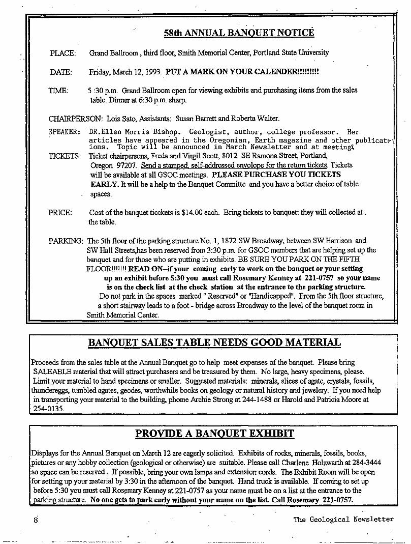
58th ANNUAL BANQUET NOTICE
PLACE: Grand Ballroom , third floor, Smith Memorial Center, Portland State University
DATE: Friday, March 12, 1993. PUT A MARK ON YOUR CALENDER!!!!!!!!!
TIME: 5 :30 p.m. Grand Ballroom open for viewing exhibits and purchasing items from the sales table. Dinner at 6:30 ~.m. sharp.
CHAIRPERSON: Lois Sato, Assi~tants: Susan Barrett and Roberta Walter.
SPEAKER: DR.Ellen Morris Bishop. Geologist, author, college professor. Her articles have appeared in the Oregonian, Earth magazine and other publicat~·· ions. Topic will be announced in March Newsletter and at meetin~
TICKETS: Ticket chairpersons, Freda and Virgil Scott, 8012 SE Ramona Street, Portland,
PRICE:
Oregon 97207 .. Send a stamped, self-addressed envelope for the return tickets. Tickets will be available at all GSOC meetings. PLEASE PURCHASE YOU TICKETS EARLY. It will be a help to the Banquet Committe and you have a better choice of table spaces.
Cost of the banquet ticckets is $14.00 each. Bring tickets to banquet: they will collected at. the table.
PARKING: The 5th floor of the parking structure No. 1, 1872 SW Broadway, between SW Harrison and SW Hall Streets,has been reserved from 3:30 p.m. for GSOC members that are helping set up the banquet and for those who are putting in exhibits. BE SURE YOU PARK ON TilE FIFTH FLOOR!!!!!!! READ ON-if your coming early to work on the banquet or your setting
up an exhibit before 5:30 you must call Rosemary Kenney at 221-0757 so your name is on the check list at the check station at the entrance to the parking structure.
Do not park in the spaces marked" Reserved" or "Handicapped". From the 5th floor structure, a short stairway leads to a foot - bridge across Broadway to the level of the banquet room in
Smith Memorial Center.
BANQUET SALES TABLE NEEDS GOOD MATERIAL
Proceeds from the sales table at the Annual Banquet go to help meet expenses of the banquet. Please bring SALEABLE material that will attract purchasers and be treasured by them. No large, heavy specimens, please. Limit your material to hand specimens or smaller. Suggested materials: minerals, slices of agate, crystals, fossils, thundereggs, tumbled agates, geodes, worthwhile books on geology or natural history and jewelery. If you need help in transporting your material to the building, phorne Archie Strong at 244-1488 or Harold and Patricia Moore at 254-0135.
PROVIDE A BANQUET EXIDBIT
Displays for the Annual Banquet on March 12 are eagerly solicited. Exhibits of rocks, minerals, fossils, books, pictures or any hobby collection (geological or otherwise) are suitable. Please call Charlene Holzwarth at 284-3444 so space can be reserved . If possible, bring your own lamps and extension cords. The Exhibit Room will be open for setting up your material by 3:30 in the afternoon of the banquet. Hand truck is available. If corning to set up before 5:30 you must call Ros~mary Kenney at 221-0757 as your name must be on a list at the entrance to the parking structure. No one gets to park early without your name on the list. Call Rosemary 221-0757.
8 The Geological Newsletter
WELCOME NEW MEMBERS
Dr. Harold Stauffer 4904 NE Clackamas Street
Portland, OR 97213 Phone 287-1708
Rose Reiter 908 SW Gaines, #24 Portland, OR 97201
JohnTeskey 13880 SW Burlwood Street
Beaverton, OR , Phone 641-7746
Carolyn Mattews & Bruce Nelson 4922 NE Going Street
Portland, OR
·MEMORIAL
Hebert SUcker, retired Oregon State Geologist, fi:iend and trip leader for some interesting GSOC trips
Mrs. Kenneth PhllUps, GSOC, wife of Kenneth Phillips and a charter member of the Geological Society of the
Oregon Country.
Margery Robertson, GSOC member. A faithful and helpful member of the organization. She attended many of the
Hancock Field Station spring activities.
TilE ANNUAL SPRING HANCOCK FIELD STATION RETREAT WILL BE ON MAY 14-17, FRIDAY TIIROUGH MONDAY. MORE INFORMATION IN THE MARCH AND APRIL NEWSLETTER. PUTTIIE DATES ON YOUR CALENDAR. ALL GSOCS INVITED.
COMPLETELY FRACfURED GEOLOGY ~
Ralph and Eveyln Pratt This is will be the last of these, unless there are great numbers of requests (5 or 6?!) to continue this column. Do GSOC'ers like this sort of thing, or would you prefer that the space be used for more serious articles?
1. Stoplng: past tense of "to lean over," as hi "I was stoping down to pick up a rock"
2. Modified MercaiU Scale: a set of notes invented by an opera director for his singers to"use.
3. Marine terrace: a deck outside of a naval officers' club.
4. Foreshore: (a) eighty years, as in "Foreshore and seven years ago ... " (b) an affirmative exclamation, as in "I'll be there foreshore!"
February 1993
5. Syenite: a poisonous chemical that is used to leach gold from its ore.
6. Self: a metal box for storing yaluables. 7. Berm: a painful skin condition, as in "I sat out in
the sun too long and got a bad berm." 8. Syncline: an inclination to be evil. 9. Saurtschlan: the way you describe a spot that you
want to scratch but can't because it hurts. 10.Phylllte: the kind of lo caloric beer made in
Philadelphia
Answers to COMPLETELY FRACTURED GEOLOGY, will be found on page 11 .
COAL- BED METHANE GAS A NEW ENERGY SOURCE
by Andy Corcoran, Past President GSOC
In the past few years, coal- bed methane production in the U.S. has skyrocketed, reaching about 340 billion cubic feet in 1991. According to the Chicago-based Gas Research Institute that is up from 200 bcf in 1990, and only 160 bcf in 1988. This year, production could go as high as 600 bet: which is almost half of Canada's gas exports to the U.S. The sharp increase is the result of at least two things, notes John Shiry of the Financial Post, a Canadian journal- tax credits and technological advances. At the present time, coal-bed methane, a gas produced by drilling directly into a coal bed, is being produced commercially in the San Juan Basin of Colorado and New Mexico, and in the Warrior Basin in Alabama and Mississippi. The increased interest has caused exploration companies to study other areas in the country as possible future producers into a coal bed methane, including he Pacific Northwest
Geologic and Hydrologic Criteria for Coal-bed Methane Production
All coal beds contain methane, which is a colorless, orderless gas produced by decomposing organic matter. It is the principal constituent of natural gas; however , methane from coal beds is generally higher quality. Whether methane is present in commercial quantities depends upon several geologic and hydrologic factors. The most important influence is the grade of the coal Coal beds that have been subjected to considerable heat and pressure during the geologic past generally produce a higher grade of coal and can have a heat value of 14,000 B1Us (British Thermal Units) per pound or greater.
Another important criterion is whether the coal beds have remained water-saturated throughout the geologic past. When· the coal is formed, methane gas is absorbed into the microscopic pores of the coal structure and is retained because · of water in the coal bed. If the coal bed loses its ~ater, the
9
methane may then dissipate into adjacent rock layers or be lost into the atmosphere.
·All coals have a natural set of fractures called "cleats". The face cleat can extend for miles in one direction. A well developed cleat system is important for commercial production of coal-bed methane. The fractures serves as "plumbing" through which the coal-gas and water can flow.
Coal-bed Methane Production
A coal-bed methane production well is ·similar to a natural gas production well. After a hole is drilled and cased with steel pipe, a submersible pump is placed in the bottom to remove coal-bed production water. Production water is residual water trapped in the cleat system soon after the coal was formed. The casing is perforated at the level of the coal beds to allow the water and methane to enter. As the water in the coal bed is depleted the gas fraction is released and flows to the wellhead by following the network of cleat channels. The methane is then collected at the surface and transported by pipeline in a manner similar to conventional natural gas.
Marketing and Use of Coal-bed Methane
Coal-bed methane is used primarily for electric power generation and space heating in residential and commercial buildings. Several natural gas pipe lines connect the production wells in the Warrior Basin to the eastern and western United States. These pipelines are an important factor in the marketing and use of commercial quantities of coal-bed methane. The Forest City Basin in Missouri, not yet in production, also has extensive natural gas pipelines to various parts of~e COWltry. These could be utilized once the drilling and delivery and development phase has been completed. The lack of pipelines in San Juan Basin in the southwestern United States has hampered production of the coal-bed methane reserves in that region, although there are now 1,100 wells in operation, and new pipelines are Wlder construction.
Coal- bed Methane Potential in the Pacific Northwest
Coals that contain significant amoWlts of methane are foWld in two large areas ofWestem Washington: Puget Lowlands province southeast of Seattle and the Bellingham Basin near the Canadian border. All of the coal beds are associated with sedimentary rocks of Eocene age.
Puget Lowlands
Coal has been mined for more than 100 years in the Green River district of southern King CoWlty near the town of Black Diamond. The coals occur in the Puget Group, which is estimated to be at least 6,500 feet thick.
In 1911, a well drilled on he bank of the Green River encoWltered gas in a white sandstone at a depth of about 850 feet According to records of the Washington Department of Conservation and Development, the ~ell produced gas at
10
pressures as high as 600 poW1ds per square foot After the drill_ · penetiated the sandstone it "blew in" and eventually filled with
water through which gas bubbled furiously and flared to a height of 18 feet The well became known as the "Flaming Geyser" and was still flaring gas as late as 1927. Between 1928 and 1983, fifteen other wells were drilled within 10 miles of the Flaming Geyser, but none was successful. However, a Voyager Petroleum well, drilled a few years ago with a modem mud log and gas analyzer recorded numerous metha.1e "kicks", even though the tests indicated that it would not be sufficient to produce commercial amoWlts.
' . Bellingham Basin
In 1934 there were five producing gas wells in the Old North Bellingham Basin with a combined production of7,183,000 cubic feet per day. The depth of these wells varied from 166
, feet to as much as 1,100 feet Although these shallow wells were very prolific, they declined rapidly and soon "watered out". Some minor production, however, was maintained for several years and served a small local market Many more shallow gas wells were discovered while drilling for water and were us~d for domestic pwposes.
The gas was thought to be from conventional marine sources and that oil might be present A Washington State Geological Report written in 1934 attributed it, instead' to a non-marine series of Tertiary sediments consisting of sandstones, shales and coal beds believed to be more than 12,000 feet thick The coal beds were considered to be the only source rock present, which was clearly shown by the gas analysis: 93%-97% methane with no petroleum fractions. These old wells normally produced from Quaternary surficial deposits which lay directly on top of the Tertiary sequence. There is no doubt that the coal gas tapped in these shallow porous water-laden sands originally came from the older sedimentary sequence that lies below. The early wells were doomed to fail for many reasons, but they did demonstrate the amoWlt of gas that could be generated by these coals.
Production Technology
In order to enhance methane production, the coal beds have to be fractured, creating additional passageways for the gas to migrate into the drill hole. The fracturing technique is similar to that used to stimulate oil and gas wells. Special fluids are forced down the well Wlder high pressure which causes fracturing outward from the well holes. Once the well is cleaned up for production, gas migrates along these stress fractures.
Canadian and Amerirm engineers have recently developed new techniques for increasing gas production, particularly in areas where normal fracturing methods have not been successful. One of the most promising is a method called "Cavity stress relief" Water is circulated rapidly to wash out particles of coal. A room-sized cavity can be produced within the coal formation relatively quickly. Once the water circulation stops, and the hole is cleaned up, the natural WldergroWld tensions ~ause.~e.region aroWld the cavity to
The Geological Newsletter
becom~ honeycombed with stress fractures, releasing m!!thane.
Fiscal Incentives for Coal-bed Methane Production
Several years ago, the Federal Government provided a tax credit of about 85 cents per thousand cubic feet of production as an incentive to develop "unconventional" energy sources. Although the tax credits are scheduled to expire for wells drilled after 1992, coal-bed methane has truly become "big business."
The subsidies have had the desired effect of driving technology development. Coal-bed methane is no longer an "unconventional" source of nature gas, at least in the two main producing basins.
Interest in the exploration and development of the coal-bed methane potential in Western Washington is continuing even if the tax credits have expired. It seems likely that the Pacific Northwest will have a new source of thermal energy to meet the ever-increasing demands of our industrial and domestic market sometime before the end 9fthis decade.
References:
Quarterly Review of Methane from Coal Seams Technology, Feb. 199l.in" Western Washington", p. 3.
Missouri Department ofNatural Resources. Outlook: Fall 1992, Forest City Basin- Potential For A new .tmergy
Sm1fCe?, Vol. 5, No.1. The Financial Post, June 4, 1992, "Coal-Bed Methane Gas
Explodes on U S Market"
CORRECT ANSWERS TO COMPLETELY FRACfURED GEOLOGY
1. Stoping: extraction of ore in an underground mine by working laterally into a vein.
2. Modified Men:alli scale: a scale expressing the amount of damage done, or intensities, of earthquakes expressed in Roman numerals.
3. Marine terrace: a broad, gently sloping platform that may be exposed at low tide.
4. Foreshore: zone that is regularly covered and uncovered by the rise and fall of the tides.
5. Syenite: a group of mafic rocks lacking quartz. 6. Self: a large symmetrical ridge of sand parallel to the
wind direction. 7. Berm: a platform of wave-deposited sediment that is flat
or slopes slightly landward. · 8. Syncline: a downward fold of rock strata. 9. Suarlschlan: a dinosaur with lizard-like hips. as
opposed to omithisc~ a dinosaur with bird-like hips. lO.Phylllte: a wrinkled- and si1ky-looking metamorphic rock
intermediate between slate and mica schist
FebrU:ary 1993
THE FISHER FORMATION by
Rosemary Kenney, GSOC
The Fisher formation was named by Schenk, from Fisher Butte, 8 miles west of Eugene Oregon. The fonnation is
. appro:xllnately 1500 feet thick, composed of a series of gravels and sands and fresh water clay, together with tuffs and
. agglomerates, entirely of continental origin. In some places ' the formation makes bold outcrops and in others, where the
finer tuffs have weathered to clay, the hillside is covered by landslides. The fonnation rests unconformable upon upper Eocene sandstone (where the Spencer fonnation becomes gritty in the upper part and may grade upward into the Fisher) and unconformably beneath the sandstone of the Eugene formation. The contact with the Eugene fonnation is marked in places by the presence of much fossil wood. In places the Fisher formation rests on Eocene formation containing marine invertebrate fauna characteristic of the Cowlitz fonnation which is similar in age to the Spencer formation.
The age of the Fisher fonnation is told largely by the flora, for it appears to be non-marine in origin. Leaves collected near the base of the fonnation at Comstock by Sanborn decided that they are late Eocene, the terrestrial equivalent of the Spencer fonnation. The beds are known to extend southward where they appear to be continuous with the Calapooya volcanics and the Celestin fonnatlon. Zircon in tuffs along the southeast of the Cottage Grove reservoir yielded a reservior fission track age of39 million years.
The Comstock flora from the lower portion of the Fisher formation of west central Oregon reflects a warm, moist, tropical climate found in association with marine late Eocene shallow water molluscs. The most common plant genera are the tropical Cinnamonurn(camphorwood), which comprises nearly one-fourth of the total specimens, Aralia (aralia)Magnolia (magnolia). Astroniurn (cashew family). Lonchocarpus (legume family), and Allophylus (soapbeny family). .
The Goshen flora is typical of a low latitude, tropical to sub-tropical rain forest in an inland protected situation. The flora was deposited near sea level as is shown by association with marine molluscs. Of the 49 species represented, Meliosrna (sabina family). Allophylus (soapberry) Nectandra (laurel family). Ficus (fig) are the most common. Tetracera (Iiana vine) and Aristolochina (liana vine) are among the most abundant genera.
Chaney and Sanborn (1933) regard the flora as late Eocene/early Oligocene interval Brown (1959) regards the Goshen flora as late Oligocene and correlative with the Rujada flora.
I. The subtropical character of the Goshen flora marks it as definitely of older Tertiary age; it is made up of genera and families which are common in the Cretaceous and Eocene of North America and many other parts of the world, and which are rare or absent in beds of younger than the upper Oligocene to lower Miocene. Its climatic implications indicate a relationship with Eocene rather than with Oligocene miuine faunas." ·
11
· 2The Goshen flora shows its closest relationship to the Wilcox flora of the southeastern U.S., which is oflower Eocene age. situated much nearer the neotropical source of Eocene distribution the southeastern U.S. would have been occupied by a flora from the south J>efore it reached OregoiL The moderating effects Qfthe climatic changes which appear to have been responsible for the northward movements of the flora during the early Tertiary would have been felt much sooner in the southwestern U.S. than in central Oregon. The ymmger age of the deposits containing the Goshen flora may, therefore, be due to the greater amount of time required for their migration to Oregon.
3.The Goshen flora shows a closer relation to the Eocene floras of Europe than to those of Oligocene age.
4.The stratigraphic position of the beds containing the Goshen flora are upper Eocene or lowennost Oligocene age.
As with all amphibians, the fragile nature of frog and toad skeletons makes them among the rarest of fossil vertebrates. An Oligocene Fisher fonnation locality near Goshen in Lane County periodically yields complete salamander remains in association with fossil leaves. A detailed description and illustrated paper by Van Frank (1955) deals with one such salamder , Paleotaricha oligoceniea. The skeleton is just under 5 inches long and occurs In an articulated condition in a remarkably well-preserved state
References:. E.M. Balwin, 1981. Geology of Oregon. 3rd ed. Kendall/Hunt
Pub., 170p. Hoover, L., 1963. Geology of the Anlauf and Drain
QEadrangles, Douglas and Lane Counties,Oregon. U.S. Geol. Surv., Bull. 1122-D., 62p.
Lowry, W.D., 1947. The Extent of the Oligocene Sea in Northwesten Oregon. Geological Society of the Oregon Country, Newsl. v. 13, no.l, p. 2-7.
Orr, W.N. and Orr, E.L., 1981. Handbook of Oregon plant and Animal Fossils, Eugene, Oregon. 285p.
Sanborn, E.I., 1937. The Comstock flora of West Central Oregon:Eocene flora of Western America. Carnegie Inst. Washington Pub. 465, p. 1-28 Co.
Schenk, H.G., 1927. Marine Oligocene of Oregon. Univ. Calif. Dept. Geological Science, Bull., v. 16, p. 449-60.
Snavely, P.D. and Wagner, H.C .. 1963. Tertiary Geologic History of Western Oregon and Fossil Localities of the
Eugene Area, Washington. Wash.(State) Div. of Mines. Rept. of Invest., no.33, 25p.
Steere, M.L., 1958. Fossil Localities of the Eugene Area. Oregon. OreBin.v.20, no.6, p.51-59.
Turner, F.E., 1938. Stratigraphy and Mllusca of the Eocene of the Eocene ofWestern OregoiL Geol Society America.,·
################################################
A Mark Twain Comment On Geology*
Since my own day on the Mississippi, cut-offs have been made at Hurricane Island, at Island 100, at Napoleon, Arkansas, at Walnut Bend,. and at Council Bend. These shortened the river, in the aggregate, 67 miles. In my own time
).2
a cut-off was made at American Bend, which shortened the river 10 miles or more.
Therefore, the Mississippi between Cairo and New Orleans was 1215 miles long 176 years ago. It was 1180 after the cutoff of 1722. It was 1040 after the American Bend cut-off It has lost 67 miles since. Consequently, its length is only 973 miles at present.
Now, if I wanted to be one of those ponderous scientific people, and "let on" to prove what had occurred in the remote past by what had occurred in a given time .Jt the recent past, or what will occur in the far future by what hds occurred in late years, what an opportunity is here: Geoloey never had such a chance, nor such exact data to argue from! Nor "development of species," either! Glacial epochs are great things, but they are vague -vague. Please observe: ·
In the space of 176 years the Lower Mississippi has shortened itself242 miles. That is an average of a trifle over one mile and a third per year. Therefore, any calm person, who is not blind or idiotic, can see that in the Old Oolitic Silurian Period, just a million years ago next November the lower Mississip River was upward of 1,300,000 miles long, and stuck out over the Gulf ofMexioo like a fishing rod. And by the same token any person can see that the _742 years from now the Lower Mississippi will be only a mile and threequarters long, and Cario and New Orleans will have joined their streets together , and be plodding comfortable along under the single mayor and mutual board of aldennen. There is something fascinating about science. One gets such wholesale returns of conecture out of such a trifling investment of fact.
*Taken from Life on the Mississippi . Article submitted by Andy Cocoran, GSOC.
DID YOU KNOW .
How Many Minerals Go Into A Computor?
It takes more than 33 elements to make a computor! Those vital computor ingredients are: aluminum, antimony, barite, beryllium, colbalt, columbium, copper, galium, gennanium, gold, indium, iron, lanthanides, lithium, manganese, mercury mica, quatz crystals, mercury, rhenium, selenium, silver, sytontium, tantalum, tellurium, tin, tungsten, vanadi].llTI, yttrium, zinc, zinc, and zirconium. And we can't forget the petroleum industry's role in the computor-many of the components noted above are housed in plastic. '
From the Bulletin of the Northwest Mining Association,
Fall, 1991
·The Geological Newsletter
THE GEOLOGICAL NEWSLETTER
GEOLOGICAL SOCIETY OF THE OREGON COUNTRY
GEOLOGICAL SOCIETY OF THE OREGON COUNTRY
P.O. BOX 907 PORTLAND. OR 97207
"-Non-Profit Org. U.S. POST AGE
PAID Portland, Oregon
Permit No. 999
GEOLOGICAL SOCIETY OF THE OREGON COUNTRY 1993-1994 ADMINISTRATION
BOARD OF DIRECTORS President
Esther Kennedy 626-2374 11925 SW Center Beverton, Oregon 97005
VicePresident Dr. Donald Botteron 245-6251 2626 Luradel Street Portland, Oregon 97219
Secretary Shirley O'Dell 245-6882 3038 SW Flordia Ct. Unit D Portland, Oregon 97219
Treasurer Phyllis Thorne 292-6134
Directors Booth Joslin(3 years) Arthur Springer (2 years Betty Turner
Immediate Past· Presidents Evelyn Pratt Dr. Walter Sunderland
THE GEOLOGICAL NEWSLETTER Editor: Donald Barr
Calender: Reba Wilcox
636-2384 236-6367 246-3192
223-2601 625-6840
246-2785 684-7831
Business Mgt. Rosemary Kenney 221-o757
Assist: Margaret Steere 246-1670
ACTIVITIES CHAIRS Calligrapher
Clay Kelleher' Field Trips
Alta Stauffer Geology Seminars
Richard Bartell Historian
Charlene Holzwarth Hospitality
775-6263
287-1708
292-6939
284-3444
(Luncheons)Shirley O'Dell 245-6882 (Evenings) Elinore Olson 244-3374
Library Frances Rushe
Past President's Panel Eveyln Pratt
Programs
654-5975
223-2601
Luncheons)Clay Kelleher 775-6263 Evening) Dr. Donald Botteron245-6251
ACTIVITIES
Properties and PA System (Luncheon) Clay Kelleher 775-6263 (Evenings)
Publications Margaret Steer~ 246-1670
Publicity Eveyln Pratt 223 2601
Refreshments Friday Evenings-Volunteers Geology Seminar Volunteers
Telephone · Cecelia Crater 235-5158
Volunteer Speakers Bureau Bob Richmond 282-3817
Annual Banquet Chairperson: Susan Barrett 639-4583
ANNUAL EVENTS: President's Field Trip-summer, Picnic-August. Banquet-March • Annual Meeting-February. FIELD TRIPS: Usually one per month, via private car, caravan or chartered bus. GEOLOGY SEMINARS: Third Wednesday, except June, July, August, 8:00 p.m. Room S17 in Cramer Hall, PSU. LIBRARY:Room S7, open 7:30p.m. prior to evening meeting. PROGRAMS: Evenings: Second and Fourth Fridays EACH MONTH, 8:00p.m •• Room 371, Cramer Hall, Portland State University, SW Broadway at Mill Street, Portland, Oregon. LUNCHEONS: First and third Fridays each month, except holidays. at noon, Standard Plaza
. Cafeteria, third floor, Room A, 1100 SW Sixth Ave. Portland, Oregon. MEMBERSHIP: per year from January 1: Individual, $15.00, Family, $25.00, Junior (under 18) $6.00. Write or call Secretary for membership applications. PUBLICATIONS: THE GEOLOGICAL NEWSLETTER (ISSN 0270 5451) published monthly and mailed to each member. Subscriptions available to libraries and organizations at $10.00 a year (add $3.00 postage for foreign sibscribers). Individual subscriptions at $13.00 a year. Single copies $1.00. Order from Geological Society of the Oregon Country, P.O. Box 90?, Portland, Oregon 97207 TRIP LOGS: Write to same address for price list.
THE GEOLOGICAL NEWSLETTER The Geological Society of the Oregon Country
P.O.Box 907 * Portland, Oregon 97207
VISITORS WELCO:tv.ffi INFORMATION PHONE 284-4320
VOLUJME 59, NO. Mar. 23
CALENDER OF ACTIVITIES FOR MARCH, 1993
' FRIDAY NIGHT LECTIJRES (Cramer Hall, PSU. Room 371. 8:00P.M.)
Mar.12 58th ANNUAL BANQUET. Grand Ballroom, Smith Memorial Center, Portland State University .. Speaker: Dr. Ellen Morris Bishop, Geologist, author and college professor. Published articles in the Oregonian under title ofTimeffravel and EARTH magazine. The title of her presentation is TRACKING THE ARC CONTINUNING THE DISCOVERY OF EASTERN OREGON'S PAST.
Mar. 26 "Mount Robson, Pride of the Canadian Rockies". Slide presentation by Evelyn Pratt, Past President, GSOC.
FRIDAY LUNCHEONS (Staandard Plaza, 1100 SE 6th Avenue, Rooms A & B. Third Floor Cafeteria. Programs at 12:00 noon.
Mar. 5 Plate Tectonics, Earthquakes and Volcanoes. Speaker, Don Barr, Past Pres. GSOC
Mar. 19 Earthquake --Are you prepared? Speaker, Vern Cope. "The Oregon Earthquake Handbook."
GEOLOGY SENIINAR (Cramer Hall, PSU, Room S-17, 8:00P.M.)
Mar. 17, Wednesday. "Geology of Minnesota". illustrations and discussion pertaining to general geology of the of Minnesota. Seminars lead by Richard Bartels, geologist
GSOC LIBRARY (Cramer Hall, Portland State University, Room S-7. Open 7:00-8:00 P.M. prior to evening meetings.
FJELD TRIP
Apr.17 Lincoln City to Tillamook. LEADER: Dr. Paul Hammond. Travel by car. Meet at Shilo hm, Lincoln City at 9:00 A.M. More information in the April .
May 14-17 Hancock Field Station Retreat We'll review the geology of this area, view a great flower display , happy hour each afternoon and enjoy good companionship. Set these dates aside. More information in A pril Newsletter.
Wed. 3/24
March 1993
OMNIMAX Theater (Ring of Fire; ends 3/31). 1945 SE water St. Meet 6:30 PM for 7 PM show. Park free.
13
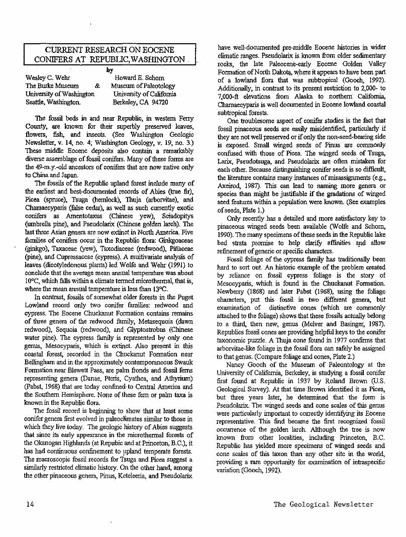
CURRENT RESEARCH ON EOCENE CONIFERS AT REPUBliC, WASIDNGTON .
Wesley C. Wehr The Burke Museum & University ofWashington Seattle, Washington.
by Howard E. Schorn
Museum ofPaleotology University of California Berkeley, CA 94720
The fossil beds in and near Republic, in western Ferry County, are known for their superbly preserved leaves, flowers, fish, and insects. (See Washington Geologic Newsletter, v. 14, no. 4; Washington Geology, v. 19, no. 3.) These middle Eocene deposits also contain a remarkably diverse assemblage of fossil conifers. Many of these forms are the 49-m.y.-old ancestors of conifers that are now native only to China and Japan.
The fossils of the Republic upland forest include many of the earliest and best-documented records of Abies (true fir), Picea (spruce), Tsuga · (hemlock), Thuja (arborvitae), and Chamaecyparis (false cedar), as well as such currently exotic conifers as Amentotaxus (Chinese yew), Sciadopitys (umbrella pine), and Pseudolarix (Chinese golden larch). The last three Asian genera are now extinct in North America Five fumili.es of conifers occur in the Republic flora: Ginkgoaceae (ginkgo), Taxaceae (yew), Taxodiaceae (redwood), Pifiaceae (pine), and Cupressaceae (cypress). A muitivariate analysis of leaves (dicotyledonous plants) led Wolfe and Wehr (1991) to conclude that the average mean annual temperature was about 1 0°C which falls within a climate tenned micro thermal, that is, wher~ the mean annual temperature is less than l3°C.
In contrast, fossils of somewhat older forests in the Puget Lowland record only two conifer families: redwood and cypress. The Eocene Chuckanut Formation contains remains of three genera of the redwood family, Metasequoia (dawn redwood), Sequoia (redwood), and Glyptostrobus (Chinese water pine). The cypress family is represented by only one genus, Mesocyparis, which is extinct. Also present in this coastal forest, recorded in the Chuckanut Formation near Bellingham and in the approximately contemporaneous Swauk Formation near Blewett Pass, are palm fronds and fossil ferns representing genera (Danae, Pteris, Cyathea, and Athyrium) (Pabst, 1968) that are today confined· to Central America and the Southern Hemisphere. None of these fern or palm taxa is known in the Republic flora.
The fossil record is beginning to show that at least some conifer genera first evolved in paleoclimates similar to those in which they live today. The geologic history of Abies suggests that since its early appearance in the microthermal forests of the Okanogan Highlands (at Repubic and at Princeton, B.C.), it has had continuous confinement to ppland temperate forests. The macroscopic fossil records for Tsuga and Picea suggest a similarly restricted climatic history. On the other hand, among the other pinaceous genera, Pinus, Keteleeria, and Pseudolarix
14
have well-documented pre-middle Eocene histories in wider climatic ranges. Pseudolarix is known from older sedimentary rocks, the late Paleocene-early Eocene Golden Valley Formation of North Dakot.Q., v.;here it appears to have been part of a lowland flora that was subtropical (Gooch, 1992). Additionally, in contrast to its present restriction to 2,000- to 7 000-ft elevations from Alaska to northern California, Chamaecyparis is well documented in Eocene lowland coastal subtropical forests.
One troublesome aspect of conifer studies is the fact that fossil pinaceous seeds are easily misidentified, particularly if they are not well preserved or if only the non-seed-bearing side is exposed. Small winged seeds of Pinus are commonly confused with those of Picea. The winged seeds of Tsuga, Larix, Pseudotsuga, and Pseudolarix are often mistaken for each other. Because distinguishing conifer seeds is so difficult, the literature contains many instances of misassigrunents (e.g., Axeirod, 1987). This can lead to naming more genera or species than might be justifiable if the gradations of winged seed features within a population were known. (See examples of seeds, Plate 1.)
Only recently has a detailed and more satisfactory key to pinaceous winged seeds been available (Wolfe and Schorn, 1990). The many specimens of these seeds in the Republic lake bed strata promise to help cla.rify !!ffinities ll!ld allow refinement of generic or specific characters.
Fossil foliage of the cypress family has traditionally been hard to sort out. An historic example of the problem created by reliance on fossil cypress foliage is the story of Mesocyparis, which is found in the Chuckanut Formation. Newberry (1868) and later Pabst (1968), using the foliage characters, put this fossil in two different genera, but examination of distinctive cones (which are commonly attached to the foliage) shows that these fossils actually belong to a third, then new, genus (Mciver and Basinger, 1987). Republics fossil cones are providing helpful keys to the conifer taxonomic puzzle. A Thuja cone found in 1977 confirms that arborvitae-like foliage in the fossil flora can safely be assigned to that genus. (Compare foliage and cones, Plate 2.)
Nancy Gooch of the Museum of Paleontology at the University of California, Berkeley, is studying a fossil conifer first found at Republic in 1937 by Roland Brown (U.S. Geological Survey). At that time Brown identified it as Picea, but three years later, he determined that the form is Pseudolarix. The winged seeds and cone scales of this genus were particularly important to correctly identifying its Eocene representative. This find became the first recognized fossil occurrence of the golden larch. Although the tree is now known from other localities, including Princeton, B.C. Republic has yielded more specimens of winged seeds and cone scales of this taxon than any other site in the world, providing a rare opportunity for examination of intraspecific variation (Gooch, 1992).
The Geological Newsletter
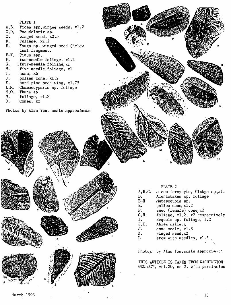
PLATE 1 A,B. Picea spp.winged seeds, xl.2 C,D, Pseudolarix sp. C. winged seed, x2.5 D. Foliage, xl.2 E. Tsuga sp. winged seed (below
leaf fragment. F-K, Pinus spp. F. two-needle foliage, xl.2 G. ~four~needle,f6liag~1 x1 H. five-needle foliage, x1 I. cone, x6 J. pollen cone, x1.2 K. hard pine seed wing, x1.75 L,M. Chamaecyparis sp. foliage N,O. Thuja sp. N. foliage, x1.3 0. Cones, x2
Photos by Alan Yen, scale approximate
K
March 1993
A,B,C. D. E-H E. F. G,H I. J,K. J. K. L.
PLATE 2 a coniferophyte, Ginkgo sp.r1. Amentotaxus sp. foliage Hetasequoia sp. pollen con~ xl.2 seed (female) con~x2 foliage, x1.2, x2 respectively Sequoia sp. foliage, 1.2 Abies milleri cone scale, xl.3 winged seed,x2 stem with needles, x1.5
Photo_;:, by Alan Yen: scale approxi rn_:--~::
THIS ARTICLE IS TAKEN FROM WASHINGTON GEOLOGY, vol.20, no 2. with permission
15
A multidisciplinary approach to the geologic histozy of Tsuga is under way by University of Washington palynologist Estella Leopold, her students Cindy Updegrave and Katie Maier, and paleobotanists Wehr and Schorn. Work to date on the pollen and winged seeds suggests that this genus may have originated in the Eocene Okanogan highlands. The Thuja cone also assists in detennining what some of the poorly preserved Thuja-like pollen might have come from. Samples from a locality known as One Mile Creek, in the Allenby Fonnation in British Columbia, which is of the same age as the Republic rocks, are yielding some well-preserved pollen that is confinning the presence of genera identified by macrofossils as well as hinting at others not yet found. These samples are also helping the work at Republic by offering excellent material for comparison.
Republic's fossils are also helping to change an old paleobotanical practice of identifying ancient plants to fit a preconceived paleoenvironment Berry (1935) noted "It seems that Thuja fits into my picture of the environmental conditions better than Libocedrus." This thinking has led to some strained reconstructions of fossil forest floras, such as Chaney's redwood forest (Chaney, 1925), which consisted of trees assigned to genera that would be found in an equivalent modern forest. The "redwood" was actually Metasequoia whose foliage and cones are easily distinguished from Sequoia, and the paleoecological models based on this erroneous identification were therefore flawed. The amount of material available to Berry and Chaney was significantly less than is now known, and diagnostic techniques seem primitive in comparison to what is possible today. Work on the Republic material is directed toward refining both taxonomy and techniques.
References Cited
Arnoki C. A. 1955. Tertiary conifers from the Princeton coalfield of British Columbia: University of Michigan Museum ofPaieontology Contributions, v. 12, no. 12, p. 245-
258. Axelrod, D. I., 1987, The late Oligocene Creede flora,
Colorado:University of California Publications In Geological Sciences.
Berzy, E. W., 1935, A preliminary contribution to the floras of the Whitemud and Ravenscrag Fonnations: Geological Survey of Canada, Memoir 182, 107 p.
Chaney, R. W., 1925, A comparative study of the Bridge Gee flora and the modern redwood forest: Carnegie institute of Washington Publication 349, p. 1-22.
Gooch, N. L., 1992, Two new species ofPseudolarix Gordon Pinaceae from Eocene of the Pacific Northwest: PaleoBios, v
14, no. 1, p. 13-19. Mciver, E. E.; Basinger, J.'F., 1987, Mesocyparis borealis gen. et sp. nov.; Fossil Cupressaceae from the early Tertiary of
16
Saskatchewan, Canada: Canadian Journal of _Botany, v. 65, no. ll,p. 2338-2351. Miller, C. N., Jr., 1976, Early evolution in the Pinaceae: Review of Palaeobotany and Palynology, v. 21, no. 1, p. 101-117.
Miller, C. N., Jr., 1977, Mesozoic conifers: Botanical Review, v. 43 no. 2, p. 217-280.
Newberzy, J. S., 1868, Note on the later extinct floras ofNorth America with descriptions of some new species offossil plants from the Cretaceous and Tertiary strata: Lyceum of Natural Histozy ofNew York Annals, v. 9, p. 1-76.
Pabst, M. B., 1968, The flora of the Chuckanut Fonnation of northwestern Washington-The Equietals, Filicales, Coniferales: University of Caiifomia Publications in Geologicail Sciences, v. 76, 85 p.
Schorn, H. E.; Wehr, W. C., 1986, Ables mllleri, sp. nov., from the middle Eocene Klondike Mounbin Fonnation, Republic, Feny Countv, Washington: Thomas Burke Memorial Washington State Museum Contributions in Anthropology and Natural Histozy 1, 7 p.
Wolfe, J. E.; Schorn, H. E., 1990, Taxonomic revision of the spennatophidia of the Oligocene Creede flora, southern Colorado: U.S. Geologicai Survey Bulletin 1923,40 p., 13 . plates.
Wolfe, J. E.; Wehr, W. C., 1987, Middle Eocene dicotyledonous plants from Republic, northeastern Washington: U.S. Geologicai Survey Bulletin 1597, 25 p., 16 plates.
To visit the Republic site, first check in with the Stonerose Interpretive Center, just downhlll from the site near the cltv park. After registering at the Center, visitors can dig at the site Tuesday-Sunday, 10:00 a.m.-5:00p.m. Bring a cold chisel and hammer. Take your finds to the Center for Identlflcatlon.
***************~~*******************************
OREGON MUSEUM OF SCIENCE AND INDUSTRY
(better known as OMS!) Compiled by
John Eliot Allen
OMSI is located at 1945 S.E. Water Avenue, Portland, 97214-3354. Phone numbers: 797-4000 (Main number); 797-5600 (advance ticket sales), 1-800-957-6654 (long distance calls) 797-0MSI (hours, rates and events by recording). Seven other numbers give recordings on various theatres. shows, and events, etc.
Summer hours (from Memorial Day to Labor Day) Saturday through Wednesday 9:30am to 7 pm, Thursday and Friday 9:30 am to 5:30 pm. Winter hours, Saturday through Wednesday 9:30am to 5:30 Thursday and Friday 9:30am to 9 pm.
""
The Geological Newsletter
Basic admission is $6.50 for adults, $4.00 for children and $5.50 for senior citizens. The 70mm supermovie OMNIMAX (Sky separate outside entrance) costs the same. The planetarim (Sky Theatre) is $4, $3 and $3.50. Combination tickets reduce total cost. · Annual mernbersnips range from $50 for single to $85 for families, and give free museum admission with reduced prices for OMNIMA.X, Sky Theater (planetarium) and Laser Light Show.
The museum was designed for 100,000 visitors a year, but recently has handled 600,000 visitors. In February of 1991, construction began on a new $40 million, 210,000 square feet facility at a new 18 112 acre site on the east bank of the Willamette River in downtown Portland, and opened with great fanfare on 18 October 1992. It is expected that annual visitors will exceed a million in 1993.
This remarkable "next generation" museum is three times the size of the old one and contains, beside the $6 million OMNIMAX and a new $2 million planetarium called Sky Theater, 5 exhibit halls ranging from 6,000 to 14,000 square feet, a restaurant, science store, and, importantly, 800 spaces for parking in 2 lots. The renovated power plant building and the new additions give a feeling of openness and spaciousness cornpetely lacking in the old OMSI building. OMSI can easily accomodate parties of up to 4,300 for conventions, weddings, etc. The annual banquet and meeting of the Portland Chapter of Sigma Xi will be held at OMSI.
In its near 50-year long history, OMSI has never received any government subsidies. It has always operated on memberships, sales, admissions and private donations. The fund drive for the new facility was kicked off by the donation by Portland General Electric Company of itS 82-year old steam generating station and the land around it. Several trusts and the National Science Foundation then each donated more than a million dollars, and many thousand private contributors gave from $25 to $100 each.
The goal ofOMSI has alway been to draw television's nonthinking viewers and observers deeper into science, giving them an enjoyable eduacational experience as it makes them think. Classes and summer camps have always been parts of OMSI's program and the museum is now becoming more "customer-service oriented".
As much as possible, the exhibits in the six large areas of earth science, life science, information science, physical science, and changing or visiting exhibits are "interactive", which is now considered to be much more than just pushing a button. Visitors can de~ign· (llld try out model'aucks, windmills and pape r airplanes using !our wind tunnf.'ls. They can see how their own building designs react to siml'lated earthquakes with vibrating shaking tables. Both children and adults can load and unload simulated cargo with a 1-ton 15-foot steel crane. In the electronics lab, they can construct circuits and radios. In another area they can make their own holograms. Many of the exhibits in the old building have been renovated
March 1993
and moved to the new facility, but overall, 70 percent of the exhibits are new.
The new human embryology exhibit, when finished will be the most extensive of its kind in the world. It will display between 40 and 50 human embryo and fetus specimens (from old European university collections), representing different stages of developernent in the womb. In the new information science area, visitors can beam messages into space with a 20 foot tower, experiment with video telephones and learn how satellites work. They will be able to walk about with cellular phones in different simulate geographic areas.
The travelling exhibits, now being cooperatively built and shown by a consortium of seven museums, occupy their own area, and they're what makes the new OMSI a world-class museum. Each exhibit may cost from $100,000 to $1,000,000 (cost of "Star Trek", and the last built by OMSI). Some of those now on tour include Super Heros: a High-Tech Adventure, Nature's Fury, Designer Genes and 1492: Two Worlds of Science. , Science Circus will arrive soon.
The 330-seat OMNIMAX Theater is a five-story domed screen with a 6-channel state-of-the-art audio system that surrounds you as you experience the world's latest 70 rnm film cinematic technology. The first showing is "Ring of Fire", illustrating the destructive volcanic activity of the Pacific Rim The new 200-seat Murdock Sky Theater's first showing is "Cosmic Fury", a 35-minute show narrated by James DePriest, the director ofthe Oregon Symphony.
+++++++++++++++++++++++++++++++++++++++++
OREGON TRAIL by
Rosemary Kenney, Past President, GSOC
The Oregon Trail is celebrating its 150th anniversary in 1992 and 1993. It has been said that there is no record in the world's history when so many people traveled so long a distance in such a short time. Some carne to Oregon "because it was there", others to seek a more healthy place to live, and some left their homes to escape the law; but most came for free land.
The Trail was not surveyed or built under auspices of the government but originated with the spontaneous use of travelers. No transit ever located a foot of it; no level established its grades; no engineer sought out the fords or built any bridges or surveyed the mountain passes. There was no grading to speak of nor any attempt at metalling the road bed. The quality of this highway seems extraordinary.
Nearly all roads started out as trails - for game, for Indians, military, wagon trains or cattle. They are located where they are for convenience and not by chance. The first people to cross the plains generally traveled the path of least resistance,
17
often sticking to hilltops or ridges or river bottoms where the ground was less rugged and the travel a little faster. · ·The Oregon Trail was used from early 1830 to mid-1870's, although peak use was 1842 to 1860. 50,000 people traveled over it in 1852. It covers over 2,000 miles from Independence, Missouri, to Oregon City, Oregon, and traverses six states: from Independence, Missouri, across northeast comer of Kansas, along the Big Blue River into Nebraska, where it followed the Platt River, then crossed the North Platt River across Wyoming to the Sweet River and South Pass. At Fort Bridger, the trail headed north to Fort Hall, Idaho, followed the Snake River to 3-Island Crossing to Fort Boise, Farewell Bend, Baker City, Oregon, over the Blue Mountains to the Columbia River and The Dalles, where the people either rafted down the Columbia River or took the Barlow Road to Oregon City.
It was not just one trail leading west but several trails: Oregon Trail, California Trail, Santa Fe Trail, Mormon Trail, Pony Express Trail, Overland Stage Road, all started at Independence, Missouri, and followed the same tracks before branching to different directions. Sometimes the Oregon Trail was one rut Wide, sometimes five or six miles wide. The trip from Missouri to Oregon took four to five months, if they were lucky, with approximately twenty-three graves per mile. Most denths were from cholera or accidents, less than one percent from Indian raids.
Geology played the most important part of where the Trail went A shallow sea covered most of Kansas and Nebraska during Mississippian, Pennsylvanian and Permian Periods. This sea left behind layers of shale and limestone occasional coal. In the Cretaceous Period, chalk was deposited along with animal fossils. When the seas disappeared, there was deposition by wind and rivers, which built up an alluvial plain hundreds of feet deep. Then glaciers came down from the north, leaving clay, silt and large red quartzite boulders when they retreated. Winds came again and whipped up sediments of dust and sand into huge clouds fornring vast blankets of loess and dunes of sand. The Platte River winds through this flat area, wide, shallow, and murky with sand. The river was difficult to ford because of its sandy bottom "Too thick to drink, too thin to plow." As the emigrants traveled west, the Trail began to rise. The Great Plains slope upward from 1500 feet above sea level in eastern Nebraska to more than 4000 feet in the western part.
When the Trail reached Wyoming, to the south lay the impenetrable walls of the Colorado Rockies; to the north lay the forbidding mountains in Montana and Idaho. The "Wyoming Basin" provided a natural pass for the wagons to cross the backbone of the Rocky Mountains. After this Basin was discovered in 1824, it virtually opened up the west 'because now wagons could cross the Rockies. But west of South Pass, the land became more rugged and difficult.
In the Paleozoic Era, the Rocky Mountain states were part of a broad submerged shallow continental sheJ..t: the western
18
edge of the inland sea. Marjne waters periodically transgressed over this shet.t: depositing sandstone, shale and limestone. The Rocky Mountains were uplifted during late Cretaceous and early Tertiary Periods. There were volcanic eruptions of rhyolitic ash in Nevada and Utah; and the ash was carried by winds and deposited in Wyoming. The entire intermountain region has been arched upwards, causing rivers to down-cut their channels, sometimes cutting across mountains instead of flowing around them.
The Eastern Snake River Plain of Idaho, is underlain mostly by lava with only a local and thin cover of sedimentary material. It is a wide lowland, dotted in places by hills and trenched by canyons of the river and its tributaries.
The Western Snake River Plain trends northwest and differs from the Eastern Snake River Plain. It is a Basin and Range fault block valley that fi.lled with white rhyolite ash, black basalt lava flows, lake bed and vailey-fi.ll sediments as it dropped between faults.
The Eastern Blue Mountains in Oregon were the second most rugg¢ area of the Trail. The mountains consist of sedimentary and volcanic rocks that ·were deposited on dry land or in freshwater lakes on top of older rocks after they had moved across some unknown breadth of ocean and had become part of the continent Most of the rocks were severly defmmed by folding and faulting. Columbia River basalt is wide spread along the northern slope of the Blue Mountains and form the range between Pendeleton and LaGrande. Block faulting has caused the rivers to carve narrow valleys in the uplifted resistant rocks.
After descending the Blue Mountains of Oregon, traveling was easier to The Dalles across the Deschutes-Umatilla Plateau which consists of beds of conglomerates, tuffaceous sedimentary rocks, sand, gravel, and silt overlying the Columbia River Basalt groups.
After the emigrants reached The Dalles, they still had the Cascades to cross before reaching the Willamette Valley. The final 100 miles was the most difficult and dangerous segment of their journey. From The Dalles, the Barlow Road went south across open and roiling country to Tygh Yalley, west along Barlow Creek to Summit Meadows, Laurel Hill, Sandy River, then on to Oregon City.
The Cascades originated as a volcanic arc which extended across continental and oceanic crust and may have been generated by subduction of the Pacific Plate. The present topography is the result of volcanic upbuilding. Sam Barlow stated that "God did not create a mountain that a man could not go over or around it." He blazed a road that had long steep climbs, steeper descend.;, huge boulders, towering trees, and swift rivers to ford. The- most difficult hill on the 2,000 mile Trail was Laurel Hill, on the western slope of Mt. Hood. It was a 60% grade down. Rope snubs and tree drags were used to lower wagons and oxen the 300-foot drop. For many years the Barlow Road was a one-way road, all travel went west because
The Geological Newsletter
no one was foolhardy- enough to attempt to ascend Big and Little Laurel Hills with wagons.
They finally reached Oregon City. Some wagons had been on the Trail for nine months. The 300,000 people who made it were a hardy group. Just imagine cramming up to a ton and a half of worldly goods into a 1 Ox4 foot canvas-topped wagon and starting out to the unknown. Travelers faced the unpredictable weather, violent winds, quicksands, floods, dust, and disease. Geology made it better or worse.
BIBLIOGRAPHY: Alt, D.D. and Hyndman, D.W., Roadside Geology ofldaho,
Mountain Press Publishing Co., 1989, p. 387. Brooks, H.C., Plate Tectonics and the Geological History of the Blue Mountains, Oregon Geology, Oregon Department of Geology and Mineral Industries, 1979, vol. 41, no. 5, pp. 71-80.
Buchanan, R.C. and Me Cauley, J.R., Roadside Kansas University Press of Kansas, 1987, p. 348.
Dicken, S.N. and Dicken, E.F., The Making of Oregon, Oregon Historical Society, Portland, Oregon, 1979, p. 197.
Lageson, D.R. and Spearing, D.R., Roadside Geology of Wyoming, Mountain Press Publishing Co., 1988, p. 265.
Lavender, D.S., The Overland Migrations, National Park Service, t}.S. Dept of Interior, Washington, D.C., 1980, p. 109.
Meeker, E., The Story of the Lost Trail to Oregon, Ye Galleon Press, Fairfield, Washington, 1984, p. 46.
Ruth, K., Landmarks of the West University ofNebraska Press, 1963, p. 295. Wasco Couty Historical Society and
Clackamas County Historical Society, Barlow Road, 1975, p 90.
Winther, 0.0., The Old Oregon Country, University of Nebraska Press, 1969, p. 323.
1992 President's Field Trip Wednesday, September 14, 1992
Coos Bay Region by Dr. Ruth Keen
On this Wednesday morning we met Dr. Don Stensland at the Coos Bay Community College for a short session of color slides and lecture on the geology of the region we were to visit that day. Dr. Stensland is the most enthusiastic geologist He teaches geology at the college and leads many field trips.
From there we went to Coos Bay Beaches: Charlston, Bastendorfl: Sunset, Shore Acres, and North, Middle and South Cove.
This brought back many memories to me, because I grew up at Marshfield (now Coos Bay) and graduated from Marshfield High School.
March 1993
My family moved from Oklahoma to Marshfield in 1910. We stayed in Portland for a month, then my father went by sea to Marshfield on the Breakwater. My mother would not go on the ocean. After my father found a house for us to live in, my mother, brother and I went by train to Drain, then by six horse stage coach to Scottsberg. When we climbed the steep roads over the high coast range the men got out and walked. They left my mother, brother and me to bounce around in the stage coach.
From Scottsberg we went down the Umpqua River on a river launch to Gardiner. At Gardiner there were no wharfs, so we transferred to a row boat, but it could not land either. Some of the men put on hip boots and carried each passenger ashore. My mother did not want to be carried, so she said to give her a pair of boots and she would wade ashore. But a man picked her up anyway and carried her ashore.
The next morning we somehow crossed the Umpqua River . We went by beach wagon that had wide wheels, along the wet sand beach at low tide to North Slough on Coos Bay. From there we took another launch to Marshfield where my father met us. My mother said she was not leaving until there was a train, and we did not. The railroad arrived my freshman year in high school.
When I first saw the Coos Bay beaches, an old growth Sitka Spruce forest came all the way to the sand of the beaches, and the Louis Simpsons lived at Shore Acres.
I never learned about the fascinating geology that surrounds those beaches until much later in college. Here there are text book examples of marine terraces, anticlines, synclines, faults, unconformities, conglomerates, sandstones, mudstones, fossils and most of the section of the geologic column from the Eocene to present. This is what we went to see under the direction of Dr. Stensland.
We spent most of the afternoon on the Whisky Run terrace that was formed approximately 83,000 years ago. This is the lowest terrace in the Coos bay area except for the one that is forming now. The elevations of all the terraces vary from place to place as the uplift during the Pleistocene was uneven.
For the geologic column of this area see Fourth Edition of the Geology of Oregon by Elizabeth L. Orr, William N. Orr, and Ewart M. Baldwin page 175.
The rocks at Sunset Bay are Lower Coaledo. At minus tides one can walk out to the island.
At Shore Acres, tipped beds of sandstone and mudstone are tnuicated and capped by flat lying upper Pleistocene beds. This is the major unconformity with about 60 million years mis~ing:_
Anoilier. outstanding feature at Shore Acres is the large round con~retions. These occur in rows along the bedding plains. They are locally called cannon balls. Here Dr. Stensland told us about salt weathering which is the main force in exposing these concretions. From the salt water crystals crystals foffil between the grains of sandstone and
19
press them apart. When the crystals dissolve the loosened grains fall away. . .
We observed a nwnber of faults at this stop. From Shore Acres we started toward . the Coves, but
stopped where a group of small islands were covered with sea lions that were calling continuously. It was high tide so we could see the many turbidity channels that are conspicuous there at low tide. At a beach near here I saw an area of sand that was all red garnets.
We continued on to the North, Middle and South Coves. These are in the Coaledo Formation. I collected a good fossil sand dollar at ocean level at South Cove many years ago. I still have it. At the foot of the cliff at either Middle or South Cove there used to be piles of concretions that looked like baseballs. They may have been picked up by now. Most of these concretions contain fossils. Sand dollars are common in this formation. From one of the view points looking south we can see several of the higher and older marine terraces. We did not have time to hike down to the beaches below these coves.
On the way back some of us walked out to Yokam Point where we observed a small scam of coal. This is Lower Coaledo . Coal occurs in the Upper and Lower Coalecfo but not in the Middle. During the Upper Eocene when this was formed the coast was low and swampy with lagoons.
We did a quick drive aruund BastendorffBeach where the BastendorffFormation is found. Beyond this beach is Tunnel Point Formation. We did not stop to see the Empire Formation at Fossil Point. Here this formation is a coarse conglomerate and completely filled ~ith fossil clams and snails. When I was working on my Masters Degree at the University of Oregon, I collected and identified twenty some species from this location.
One summer I attended the swnmer session at the University of Oregon marine Biological Station at Charleston.
Under Dr. Earl Packard we studied marine shelles and fossils. Dr. Packard had located a fossil whale near Fossil Point. It was only exposed at low tide. We worked to excavate it but most had to be left. I have near heard whether any more work was ever done on it. By now it has probably weathered away.
I would like to tell you a few other things about the early days in Marshfield. The town was well named. About 1912 when we lived on Central Avenue where the Myrtle Arms Apartment is now, a slough ran behind our house. This is where I learned to row a boat.
To fill these marshes sand and mud was dredged up from the bay and spread out over the marsh. It was a good place to pick up shells of the clams and snails that came With the dredged sand and mud. It was weeks before we could walk on it as it was almost like quick sand. No one thought of the ecology that was being disturbed.
For many years the road to the beaches was two planks on each side over the sand. If you got off you were stuck. This is where I learned to drive a car.
Marshfield and North Bend were always rivals .• When Marshfield changed its name to Coos Bay, it was hoped that North Bend would join in. It did not
All the marine terraces contain gold, platinwn, magnatite, . garnets and other minerals. Along in the twenties prospectors were working at extracting the gold, usually by hydraulic mining methods. They were unhappy when a white mineral stayed behind with the gold. It was hard to get rid of it. That mineral was planinwn. During this time i remember seeing a man working at a small hydraulic setup on the Whiskey Run Terrace near Charleston.
Thanks to Dr. Don Stensland for a wonderful day at the Coos Bay beaches.
APPLICATION FOR MEMBERSHIP THE GEOLOGICAL SOCIETY OF THE OREGON COUNTRY
Date -------------Name --------------------------------- Spouse-----~~----------------------
Children under age 18 --------------------------------------------------------
Address --·-·····--·-- .... __ --------·-----------__ _ Phone ---------S~a~e~-------- Zip ------------------
City-__ _ Occupation---·~- _ Geological in~rests and hobbies Individual $.i5."00 ___________ Family $.25.00. ---------Junior, under age 18, not included with family Irelllbership $6.00 ··---------..!--
Make Check payable to: The Geological Society of the Oregon Country P.O. Box 907 Portland, Oregon 97207
20 The Geological Newsletter
THE GEOLOGICAL NEWSLETTER
APR 93
GEOLOGICAL SOCIETY OF THE OREGON COUNTRY
GEOLOGICAL SOCIETY OF THE OREGON COUNTRY
P.O. BOX 907 PORTLAND, OR 97207
Non-Profit Org. U.S. POST AGE
PAID Portland, Oregon
Permit No. 999
GEOLOGICAL SOCIETY OF THE OREGON COUNTRY 1993-1994 ADMINISTRATION
BOARD OF DIRECTORS
President Esther Kennedy 626-2374 11925 SW Center Beavertom, Oregon 97005
Vice-President Dr. Donald Botteron 245-6251 2626 SW Luradel Street Portland, Oregon 97219
Secretary Shirley O'Dell 3038 SW Florida Ct.,Unit 0 245-6882 Portland, Oregon 97219
Treasurer Phyllis Thorne 292-6134 9035 SW Monterey Place Portland, Oregon 97225
Directors Booth Joslin(3 years) Arthur Springer(2 years) Betty Turner(1 year)
Immediate Past Presidents Evelyn Pratt Dr. Walter Sunderland
THE GEOLOGICAL NEWSLETTER Editor: Donald Barr
Calender: Reba Wilcox Business Manager:
636-2384 236-6367 246-3192
223-2601 625-6840
246-2785 684-7831
Rosemary Kenney 221-0757 Assistant: Margaret Steere
246-1670
ACTIVITIES CHAIRS
Calligrapher Clay Kelleher 775-6263
Field Trips Alta Stauffer 287-1708
Geology Seminars Richard Bartels 292-6939
Historian Charlene Holzwarth 284-3444
Hospitality (Luncheons)Shirley O'Dell245-6882 (Evenings)Elinore Olson 244-3374
Library Frances Rusch 654-5975
Programs (Luncheons) Clay Kelleher775-6263 (Evenings) Dr. D.Botteron245-6251
Past President's Panel Evelyn Pratt 223-2601
ACTIVITIES
Properties and PA System (Luncheon) Clay Kelleher 775-6263 (Evenings) Booth Joslin 636-2384
Publications Margaret Steere 246-1670
Publicity Evelyn Pratt 223-2601
Refreshments (Friday Evenings) Volunteers (Geology Seminars) Volunteers
Telephone Cecelia Crater 235-5158
Volunteer Speakers Bureau Bob Richmond 282-3817
Annual banquet Chairperson:Susan Barrett639-4583
ANNUAL EVENTS: President's Field Trip-summer, Picnic-August,Banquet-March, Annual Meeting-February. FIELD TRIPS: Usually one per month, via private car, caravan or chartered bus. GEOLOGY SEMINARS: Third Wednesday, except June, July, August. a:oo pm, Rm. S17, in Cramer Hall, PSU. Library: Room 57, Open 7:30 P.M. prior to meetings. PROGRAMS: Evenings: Second and Fourth Fridays each month, 8:00pm, Rm. 371, Cramer Hall, PSU, SW Broadway at SW Mill street, Portland, Oregon. LUNCHEONS: First and Third Fridays each month, except holidays at noon. Bank of California Tower, 707 SW Washington, 4th floor Cafeteria, California Room, Portland, Oregon MEMBERSHIP: per year from January 1: Individual, $15.00, Family, $25.00, Junior (under 18) $6.00. Write or call Secretary for membership applications. PUBLICATIONS: THE GEOLOGICAL NEWSLETTER (ISSN 0270 5451) published monthly and mailed to each member. Subscriptions available to libraries and organizations at $10.00 a year. Individual subscriptions at $13.00 a year. Single copies $1.00. Order from Geological 5ociety of the Oregon Country, P.O.Box 907, Portland, Oregon. TRIP LOGS: Write to the same address for price list.
""' THE GEOLOGICAL NEWSLETTER The Geological Society of the Oregon Country
P.O. Box 907 - Portland, OR 97207
VISITORS WELCOME INFORMATION PHONE 284-4320
VOLUME 59, NO. 4
CALENDAR OF ACTIVITIES FOR APRIL, 1993 . ·. .
FRIDAY NIGHT LECTURES (Cramer Hall. PSU, Room 371, 8:00P.M.)
April 9 "Galapagos Islands- Following Darwin's Footsteps." Illustrated lecture by Bernie Torrey, photographer. Will cover Quito, Capitol of Ecuador.
April 23 "Ethiopia and the Great Rift." Illustrated lecture by Bill Walters, retired civil engineer, US. government.
FRIDAY LUNCHES (Bank of California Tower, 707 SW Washington, 4th floor. Social Hr cafeteria 11 :30AM. Program in California Rm. at 12:00)
April 2 "Railroading in Alaska." Presented by Frank Dennis, GSOC member.
April 16 "Wetlands and Society." Speaker, John Marshall, DOGAMI.
GEOLOGY SEMINAR (Cramer Hall, PSU, RoomS- 17, 8:00P.M.)
Wednesday April 21
"Glacial Geology of Minnesota." Illustrations and discussion led by Richard Bartels.
GSOC LIBRARY (Cramer Hall, Portland Sta~e University, RoomS- 7. Open 7:00 - 8:00P.M. prior to evening meetings).
FIELD TRIP
April 17 Lincoln Citv to Tillamook led by Dr. Paul Hammond. Travel by car. Meet at Shilo Inn, Lincoln City, 9:00AM. .. . .
BE prepared for weather. Bring lunch, thermos( coffee, tea, milk etc), rain gear, cameras, and what ever else you might need for this trip. There wiD be 9 stops on this trip. When the trip is over we'll head back to the Shilo at Linco~ City-getting there between 4:00 an~ 4:~0 pm.
May 14-17
May 1993
Hancock Field Station Retreat. We'll review the geology of this area, view a great flower display, happy hour each afternoon and enjoy good companionship. Set these dates aside. See page '26for details.
21
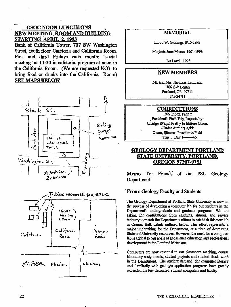
GSOC NOON LUNCHEONS . NEW MEETING ROOM AND BUILDING STARTING APRIL 2, 1993 Bank of California Tower, 707 SW Washington Street, fouth floor Cafeteria and California Room. First and third Fridays each month: "social meeting" at 11:30 in cafeteria, program at noon in the California. Room. (J/e ~requested NOT to bring food or drinks into the California Room) SEE MAPS BELOW
I 1~/j~ ~G?oc )
.ID ~ ,Jed• ~ R.,.,.~ '
Co.fete.r: 'i Co..l ~tor"~ .. o~..:Jo"'
R.ooM. Ito c."'\
]. ·-Jffhfl~ t<le..~a.-br\ tz1~., ... +c,,>
22
MEMORIAL
Lloyd W. Giddings 1915-1993
Marjorie June Mason 1901-1993
IvaLavel 1993
NEW MEMBERS
Mr. and Mrs. Nicholas Lehmann 1802 sw Logan
Portland, OR 97211 245-34711
CORRECETIONS 1992 Index, Page 2
:-President's Field Trip, Reports by: Change Evelyn Pmtt y to Elinore Olson.
-Under Authors Add: Olson, Elinore: President's Field
Trip , Day 1-66
GEOLOGY DEPARTMENT PORTLAND STATE UNIVERSITY, PORTLAND,
OREGON 97207-0751
Memo To: Fnends' of the PSU Geology Department
·From: Geology Faculty and Students
The Geology Department at Portland State University is now in the process of developing a computer lab for om students in the Department's 'lUldergraduate and graduate programs. We are asking for contributions from students, alumni, and private industry to match the Departments efforts to establish this new lab in Cramer Hall, details outlined below. This effort represents a major undertaking for the Department, at a time of decreasing State and University resources. However, the need for a computer lab is critical to om goals of geoscience education and professional development in the Portland Metro aiea.
Computers are now essential in our classroom teaching, course laboratory assignments, student projects and student thesis work in the Department The student demand for computer literacy and fiuniliarity with geologic application programs have greatly exceeded the few dedicated student computers and faculty
THE GEOLOGICAL NEWSLETTER
o:flic\lab computors. Furthennore our advanced comses for graduate students and returning professionals require increasing computor support for ground water modeling, geologic database analysis, graphics presentation an computer-aided draftinWmapping (CAD,GIS,STRAT-100, etc.). In summary, we believe 1hat an investment in a fimcti.onal computer lab is critical to the educational development of our stu.dents, and to our ongoing service to the professional communty.
The Department is remodeling the old Museum space· on the ground flQO!" in Cmmmer Hall around the comer from. the .the Department office to house the new computer lab. Department and student volunteers moved the specimen collections and central display cabinents to the new Museum of Natural History. Ondine Building on SW 6th and Hall, over the Chris1mas break. The remodeling of the lab should be completed by the end of the winter tenn. The computer lab is presently designed to accomodate 10 ffiM computers, 2 Macintoshes and 2 digitizing CAD/GIS workstations. The Department will add to this minimum number of computers (13 new machines) as student use and resources increase in future years ( up to 25 students) and for individual work on a drop-in basis (days and evenings).
The Geology Department is contn"buting $20,000 for the lab ($13,279 already committed) and is seeking matching suppotrt of $34,500 from outside sources. We will be sending out individual letters, making personal phone calls, and sponsoring an 'open lab' get-together with s<>ftware demonstration to kick-off the fimd raising for the new computer lab. Please contact Gene Pierson (Staff Geologist. (725-3377) or any of the Geology Department faculty support phone (725-3022) for additional information on planned hardware/software components, and (2) detailed budget oflab remodel and computer equipment
We would greatly appreciate any contnbuti.ons that you can make at this time for this very worthy cause. Please make checks payable to: Geology Development Fund, PSU Foundation, and mail to: Gene Pierson, Geology Depai1ment, Portland State University, Portland, Oregon 97207-0751. We intend to formally acknowledge all contn"buti.ons, 1.U1less anonymity is requested. Thank you very much for assisting us in this endeavor. 111111111111111111111111111111111111111111111
EDITOR NEEDS ARTICLES FOR THE NEWS LETTER. PLEASE SUBMIT ARTICLES YOU nDNKWOULDBEOF~RESTTOTBE SOCIE1Y. MY SUPPLY IS RUNNING LOW
A table for the projector at the Noon Luncheons is needed. If have hav~ one you don't anymore-donate it to GSOC. Call Clay Kelleher- 775-6263.
"?Bay 1993
The U.S. Bureau of Mines valued pr~ ·11~ made in the United States from non:fuel raw materials a1 $297 billion in 1991. U.S. mining of raw non:fue minerals such as iron ore and stone totalled $ 31 billion, with recycled scrap materials adding $14 billion. Subsequent processing to form iron, stee~ and cemen1 resulted in domesti.c nonfuel mineral products to .n: _
$297 billion. . Present in every aspect of our lives, minerals and mineral-based materials are the life-blood of our industrializcd economy.
mSTORY OF THE GEOLOGICAL SOCIETY OF THE OREGON COUNTRY
The First Fifty Years 1935-1985
by John Eliot Allen and Viola Oberson, Editors
A book titled "Histoiy of the Geological Society, The First Fifty Years" was planned by the Editors John Eliot Allen and Viola L. Oberson . The various chapters were assigned to some members of the Society. A completion data was set to correspond with the Societies 50th (Golden Anniversary). For a variety of reasons the book was not completed. The following article is an introduction to the book with background histoty of the Societies beginnings.
CHAPTER I INTRODUCTION
The Geological Society of the Oregon Country (familiarly known as "Geesock") is a unique institution in many ways. Its membership has always been dominantly non-professional and it has always been field-oriented with monthly field trips dwing much of the year. Many of the field trips have had road logs and extensive write-ups published in the Geological News Letter (later changed to Newsletter).
The Society has built up and maintained a voluminous h"brary of geological publications on the Oregon Country and many books on earth sciences in general It has conducted a twice-a-month evening meeting schedule with talks by members and visiting scientists . Many of these lectures were written up later and published in the Newsletter.
Luncheon mee~ also have been held twice a month since the first year . The early bmcheons were ozganized so that the "City
. 23
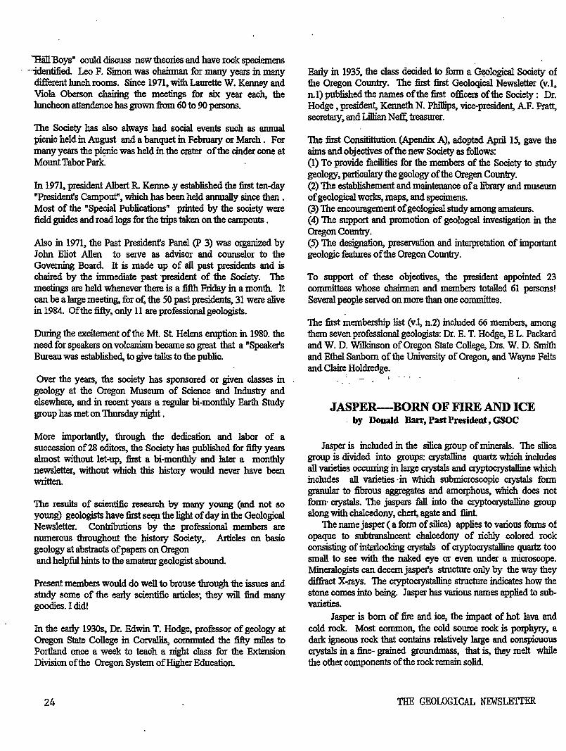
"Ban Boys" could discuss new theories and have rock speciemens · -·identified. Leo F. Simon was chainnan for many years in many
different lunch rooms. Since 1971, with Laurette W. Kenney and Viola Oberson chairing the meetings for six year each, the luncheon attendence has grown from 60 to 90 persons.
The Society has also always had social events such as annual picnic held in August and a banquet in February or March . For many years the piC?Jric was held in the crater of the cinder cone at Motmt Tabor Park
In 1971, president Albert R. Kenneo .y established the first ten-day "Presidenfs Campout", which has been held annually since then . Most of the "Special Publications" printed by the society were field guides and road logs for the trips taken on the campouts .
Also in 1971, the Past Presidenfs Panel (P 3) was organized by John Eliot Allen to serve as advisor and counselor to the Governing Board It is made up of all past presidents and is chaired by the immediate past president of the Society. The meetings are held whenever there is a fifth Friday in a month. It can be a large meeting. for ot: the 50 past presidents, 31 were alive in 1984. Of the fifty, only 11 are professional geologists.
During the excitement of the Mt. St Helens eruption in 1980. the need for speakers on volcanism became so great that a "Speaker's Bureau was established, to give talks to the public.
Over the years, the society has sponsored or given classes in geology at the Oregon Museum of Science and Industry and elsewhere, and in recent years a regular bi-monthly Earth Study group has met on Thursday night .
More importantly, through the dedication and labor of a succession of28 editors. the Society has published for fifty years almost without let-up, first a bi-monthly and later a monthly newsletter, without which this history would never have been written.
The results of scientific research by many young (and not so young) geologists have first see;n the light of day in the Geological Newsletter. Contn"butions by the professional members are numerous throughout the history Society,. Articles on basic geology at abstracts of papers on Oregon and helpful hints to the amateur geologist abound
Present members would do well to brouse through the issues and study some of the early scientific articles; they will :find many goodies. I did!
In the early 19~ Dr. Edwin T. Hodge, professor of geology at Oregon State College in Corvallis, commuted the fifty miles to Portland once a week to teach a night class for the Extension Division of the Oregon System ofHigher Education.
24
Early in 1935, the class decided to fonn a ~logical Society of the Oregon Country. The first first Geoloqical Newsletter (v.1, n.1) published the names of the first officers of the Society: Dr. Hodge , president. Kenneth N. Phillips, vice-president, AF. Pratt, secretary, and Lillian Neff: treasurer.
The first Consitittu1ion (Apendix A), adopted Apri115, gave the aims and objectives of the new Society as follows: (1) To provide :fucilities for the members of the Society to study geology, particulary the geology of the Oregen Country. (2) The establishement and maintenance of a h"brary and museum of geological works. maps, and specimens. (3) The encouragement of geological study among amateurs. (4) The support and promotion of geologcal. investigation in the Oregon Country. (5) The designation, preservation and interpretation of important geologic features of the Oregon Country.
To support of these objectives, the president appointed 23 committees whose chaD:men and members totalled 61 persons! Several people served on more than one committee.
The first membership list (v .1, n.2) included 66 members, among them seven professional geologists: Dr. E. T. Hodge, E L. Packard and W. D. Wllkinson of Oregon State College, Drs. W. D. Smith and Ethel Sanborn of the University of Oregon, and Wayne Felts and Claire Holdredge.
' ....
JASPER-BORN OF FIRE AND ICE . by Donald Barr, Past President, GSOC
Jasper is included in the silica group of minerals. The silica group is divided into groups: crysta1line quartz which includes all varieties occurring in 1aige crystals and cryptocrystalline which includes all varieties ·in which submicroscopic crystals form grannlar to fibrous aggregates and amorphous, which does not fonn· crystals. The jaspers fall into the cryptocrystalline group along with chalcedony, chert, agate and flint
The name jasper (a form of silica) applies to various fonns of opaque to subtranslucen.t chalcedony of richly colored rock consisting of int¢ocking crystals of cryptocrystalline quartz too small to see with the naked eye or even under a microscope. Mineralogists can decem jasper's structure only by the way they diffract X-rays. The cryptocrystallin~ s1ructure indicates how the stone comes into being. Jasper has various names applied to subvarieties.
Jasper is born of fire and ice, the impact of hot Java and cold rock. Most common, the cold source rock is porphyry, a dark igneous rook that contains relatively laJ:ge and conspicuous crystals in a :fine- grained groundmass, that is, they melt while the other components of the rock remain solid
THE GEOLOGICAL NEWSLETTER
This produces a silica-laden fluid that flows into cracks in the porphyry where it quickly cools and crystallizes. It is the rapid cooling that prevents the growth of large crystals and thus promotes the formation of jasper. Jasper may also form in sedimentary parent rock, again with lava as the heating agent.
Jasper is often found near deposits of iron ore, and often it contains iron compounds as impurities. These impurities usually give a red and brown color to the jasper, but there are also yellow and green jaspers. Red, brown and yellow come from different forms of iron oxide. The mossy green tones come from chlorites (mineral containing magnesimn), almninmn and silicon) as well as iron and oxygen. It is rare if anyone finds a single color jasper. More often the stone displays deep hues in indistinct ribbons. One variety appears to have pictures of ruined buildings embedded within the stone. It is given the name of ruin marble. Such evocative shapes contributed to jaspers ancient popularity but also to its modem downfall. Many people nowadays find the pattern in the rock too garnish for their tastes.
Jasper has been popular in the Middle East and Europe for over 5,000 years. In ancient Egypt, Greece and Rome craftsmen worked the jasper into magic symbols, secret signs and large polished tablets. The Russian's czars winter palace in St. Petersburg had a beautiful collection of carved jasper. The maharajahs of India had many beautiful ornaments made of it. Present-day rockhound still work with this beautiful rock
lt is the cryptocrystalline structure of jasper with its tiny crystals, its density and hardness that enables the craftsmen to work the jasper nnd get H high ]u<;ter polish.
REFERENCES:
Earth, January 1993, "Earth" Kalmbach Publishing Company, Waukesha, Wl
"Dictionary of Geological Tern1s" 1976, 111e American Geological Institute, Anchor Press, C'nrrden
City, N.Y. GEOLOGICAL SOOIETY OF TilE OREGOt~ COUNTRY
~-LI!:E.ROf\T . .2¥. .. T_!IT.I\I! PAS.'l.O.~ .I~Al'~, ~S:I!:.!!'.hl:~ Toto.l Co.oh lhlMcc On llt'nd, Jru .• lot 1992 $7,156.22
Dnl:mce Dcc.3l.:Jt 1991 4,607.64 Intoront F.t'rncd,Yerr 199?. 162.36
Totnl nolrutco Doc.3lotLl992 4,9!TCf;tlO B:1nlt Amer. Snv. Acct. 121164-0095
Ba1er.ce Dec. 31st,1~!:1 2.350,"56 Bo.lance Dec. 31st, 1!:9?. i._OOOg·'-.4 e
0 Surplno , Income Versus Expet•diturea --;'2: ::1 Intercot Earned In 1992 162.~6 Totnl Bnr.nocl llurpluo l'or 1992 912,'~6
ll.!'l ,l.r•.t, lln11lt Chocl:1.n;:: ~cot, ;!1025,-319 Toto.l Oaeh Bnlnnoo On lland,Doc. 3lot,l992 10,070.46
REPORT OF TOTAL RECEITTS,Jo.n.lat-Dec.3let,l992 Intereot:DAAit A!llerica Acct' No 21164-o<l695
11embershirs: Race pte !or Yc~r 1992 Receipts for Ye~r 1993
Total ~Icr:berohips Neweletter Subscriptions: Publication So.lce: Hospitality Rebntea: Luncheona:
Annual DOll'lUet: Ticket Sales,Dinner So.lea Table,Donatione · Total
Preaidenta Trip:
TOTAl• AJOL RECEIP'l!S FOR 1992
GSOC Treasurers Report for 1992,(~ of 2 pages)
162.36
12,265.30 140.00
"2";40575{) 145.00
45.23 166.25
42.50
1,456.00 214.95
1,6'70.95 1,260.00
15,917.79
t2¥c/~ 1(. ~_,?-Archie x. Strong,Tre\<'eurer
May 1993
Sinkankas, John, " Mineralology, A First Course", D.Van Nostrand Co. Inc. Princeton, New Jersey, 1967.
BOOK REVIEW
Cope, Vern, THE OREGON EARTHQUAKE HANDBOOK, ' Vern Cope, Portland, Oregon 150pp. 1993.
This book reviews the geology of plate tectonics as related to the Pacific Northwest. The past history of earthquakes in the Pacific Northwest is disccussed putting the time between major quakes at about 300 years. A time frame for the next earthquake is proposed based on past earthquake infonnation.
A good part of the book deals with being prepared for any natural disaster and particuarly an earthquake that is predicted for the Nortl1west sometime in the next 100 years. The author discusses everything from building codes, preparing the horne such as securing the water heater to a wall, having as earthquake prepardness kit of items from first aid kit, clothing, blankets, where all the family would meet, food, water etc. Also the value of earthquake insurance is discussed. The author stresses the fact that an individual or family should have on hand a survival kit that would sustain the family for at least three days or longer..
1be book is well written, providing step by step advice on preparing for an earthquake or any other natural disaster. TI1is amnaul should be in every home. The book can be obtained from Vern Cope. Address Vern Cope, THE OREGON EARTHQUAKE HANDBOOK, P.O.Box 19843, Portland, Oregon 97280. Each book is $11.95. The book is available in some bookstores also.
by Don Barr
OEOr.DGIOAL SOCIETY Ot TilE OR"E:GON COUNTRY
REPORT OF TOTAJ, EXPEIWITURES,Jan.3let-Deo, 31Bt,l992 Newsletter:
Printina Bullt ~llliling,No.999 Pormit Editorn Exponoo & Hinc. Buainooa Monaaore Exponae
Total Permito & Foool Poot Office Dox Ronto.l: Portland Stata Rento.l: Insurance,Liability & Feducio.ry: Scholarship,:PSU Geol. Summer Field: Equipment Purchase & Repair:
Audio-Vieuo.l Equipment Caee Projector Tubea & Hiocellaneoua
Toto.l Lunoheona1
rnrkinc: Other Mieco1leneoua
Total.
1747.50 300.00
54.39 32.23
ifrn:T2 160,0<?
94l00 56.00
556.00 400,00
eo.ee
rlHt-
Stationery Oupplia• & Hioo. Po•taKtl 144.10 Ouest Speokera & Relnted Expenat All Mtttin111 •i65,00 Adminiatrativo,Prootdent 1l: llemberohip Directory: 169.23 Annuo.l Banquet: 1, 346.27 Annuo.l President a Trip: 556.72
. !I!OTAL ALL EXmiDITURES, Jan.l-Dec .31 vs;::aor.!5, *No Expendituree For Library Or Annual Picnic,
In 1992. · osoo Treaaurera Report ror 1992(Pc.2 o! two Pga.)
~1(.6~ Archie x. Strong, T;e~suYer
25
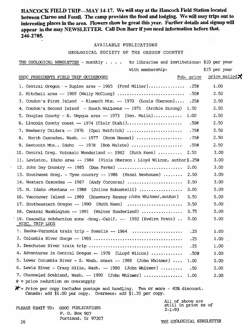
HANCOCK FIELD TRIP---MAY 14-17. We will stay at the Hancock Field Station located between Clarno and Fossil. The camp provides the food and lodging. We will may trips out to interesting places in the area. Flowers show be great this year. Further details and signup will appear in the may NEWSLETTER. Call Don Barr if you need information before that. 246-2785.
AVAILABLE PUBLICATIONS
GEOLOGICAL SOCIETY OF THE OREGON COUNTRY
THE GEOLOGICAL NEWSLETTER - monthly . . • . to libraries and institutions: $10 per year
with membership:
GSOC PRESIDENTS FIELD TRIP GUIDEBOOKS
$15 per year
Pub. price ~rice maileq~
1. Central Oregon ·- Suplee area - 1965 (Fred Miller) .............. .
2. Mitchell area -- 1969 (Wally McClung)
3. Condon's First Island -Klamath Mts. -- 1970 (Louis Oberson) ....
4. Condon's Second Island -South Wallowas -- 1971 (Archie Strong)
5. Douglas County- N. Umpqua area-- 1973 (Geo. Malin) ........... .
6. Lincoln Cotmty coast-- 1974 (Clair Stahl) •........•.............
7. Newberry Caldera-- 1976 (Opal Helfrich) ...................... .
8. North Cascades, Wash. -- 1977 (Norm Hessel) .................. .
.25#
.50#
.25#
1.50
1.00
.50#
.75#
. 75#
1.00
2.50
2.50
2.50
2.50
2.50
2.50
2.50
9. Sawtooth Mts., Idaho -- 1978 (Bob Waiste) ..................... .50# 2.50
10. Central Oreg. Volcanic Wonderland-- 1982 (Ruth Keen) ......•... 2.50 3.00
11. Lew·iston, Idaho area -- 1984 (Viola Oberson ·: Lloyd Wilcox, author )1. 25# 3. 00
12. John Day Country-- 1985 (Don Parks) ...........•............... 2.00 3.00
13. Southwest Oreg.- Tyee country-- 1986 (Hazel Newhouse) ........ 2.50 3.00
14. Western Cascades-- 1987 (Andy Corcoran) ...•..•......•..•..•... 2.50 3.00
15. N. Idaho -Montana-- 1988 (Joline Robustelli) .................. 3.00 5.00
16. Vancouver Island -- 1989 (Rosemary Kenney ;John Whitmer,author) 3.50 5.00
17. Southeastern Oregon-- 1990 (Ruth Keen) ..•..•.............•.•. 3.50 5.00
18. Central Washington-- 1991 (Walter Sunderland) ..•..•........... 3.75 5.00
' 19. Cascadia subduction zone -Oreg.-Calif. -MISC. TRIP LOGS
!. Banks-Vernonia train trip- fossils-- 1964
1992 (Ev~lyn Pratt) ..
2. Columbia River Gorge -- 1965 ...............•.............•.......
3. Deschutes River train trip .............•..... · ...•.•.•.•..•••...•..
4. Adventures in Central Oregon-- 1978 (LLoyd Wilcox) ............ .
5. Lower Columbia River-S. Wash. coast-- 1988 (John Whitmer) •...
6. Lewis River- Crazy Hills, Wash. -- 1990 (John Whitmer) •........
7. Channeled Scabland, Wash. -- 1990 (John Whitmer) .•••....•..•.•.. # = price reduction on oversupply
3.00
.25
.25
.25
.50#
1.00
.50
1.00
>~-'= Price per copy includes postage and handling. Ten or more - 40% discount. Canada: add $1.00 per copy. OVerseas: add $1.35 per copy.
PLEASE REMIT TO: GSOC PUBLICATIONS P. 0. Box 907
All of above are still in print as of 2-1-93
5.00
1.00
1.00
1.00
1.00
2.00
2.00
2.00
26 Portland,·or 97207
THE GEOLOGICAL NEWSLETTER
THE GEOLOGICAL NEWSLETTER
-... ·· -'·-·
MAY 93
.
GEOLOGICAL SOCIET'Y-OF THE OREGON COUNTRY
GEOLOGICAL SOCIETY OF THE OREGON COUNTRY
P.O. BOX 907 PORTLAND, OR 97207
'·
Non-Profit Org. U.S. POST AGE
PAID Portland, Oregon Permit No. 999
GEOLOGICAL SOCIETY OF THE OREGON COUNTRY 1993-1994 ADMINISTRATION
BOARD OF DIRECTORS
President Esther Kennedy 11925 SW Center Beavertom, Oregon 97005
Vice-President Dr. Donald Botteron 2626 SW Luradel Street Portland, Oregon 97219
Secretary Shirley ·O'Dell 3038 SW Florida Ct.,Unit Portland, Oregon 97219
Treasurer Phyllis Thorne 9035 SW Monterey Place Portland, Oregon 97225
626-2374
245-6251
.! .. -•' "":'·
II"~ I
D 245-6882
292-6134
Directors Booth Joslin(3 years) Arthur Springer(2 years) Betty Turner(l year)
Immediate Past Presidents Evelyn Pratt Dr. Walter Sunderland
THE GEOLOGICAL NEWSLETTER Editor: Donald Barr
Calender· Reba Wilcox Business Manager:
636-2384 236-6367 246-3192
223-2601 625-6840
246-2785 684-7831
Rosemary Kenney 221-0757 Assistant: Margaret Steere
246-1670
ACTIVITIES CHAIRS
Calligrapher Clay Kelleher 775-6263
Field Tri?S Alta Stauffer 287-1708
Geology Seminars Richard Bartels 292-6939
Historian Charlene Holzwarth 234-3444
Hospitality (Luncheons)Shirley O'Dell245-6882 (Evenings)Elinore Olson 244-3374
Library Frances Rusch 654-5975
Programs (Luncheons) Clay Kelleher775-6263 (Evenings) Dr. D.Botteron245-6251
Past President's Panel Evelyn Pratt 223-2601
ACTIVITIES
Properties and PA System (Luncheon) Clay Kelleher (Evenings) Booth Joslin
Publications
775-6263 636-2384
Margaret Steere 246-1670 Publicity
Evelyn Pratt 223-2601 Refreshments
(Friday Evenings) Volunteers (Geology Seminars) Volunteers
Telephone Cecelia Crater 235-5158
Volunteer Speakers Bureau Bob Richmond 282-3817
Annual banquet Chairperson:Susan Barrett639-4583
ANNUAL EVENTS: President's Field Trip-summer, Picnic-August,Banquet-March, Annual Meeting-February. FIELD TRIPS: Usually one per month, via private car, caravan or chartered bus. GEOLOGY SEMINARS: Third Wednesday, except June, July, August. a:oo pm, Rm. 517, in Cramer Hall, PSU. Library: Room 57, Open 7:30 P.M. prior to meetings. PROGRAMS: Evenings: Second and Fourth Fridays each month, 8:00pm, Rm. 371, Cral'ler'-Hall, PSU, SW Broadway at SW Mill street, Portland, Oregon. LUNCHEONS: First and Third Fridays each month, except holidays at noon. Bank of California Tower, 707 SW Washington, 4th floor Cafeteria, California Room, Portland, Oregon 1 1
MEMBERSHIP: per year from January 1: Individual, $15.00, Family, $25.00, Junior (under 18) $6.00. Write or call Secretary for membership applications. PUBLICATIONS: THE GEOLOGICAL NEWSLETTER (ISSN 0270 5451) published monthly and mailed to each member. Subscriptions available to libraries and organizations at $10.00 a year. Individual subscriptions at $13.00 a year. Single copies $1.00. Order from Geological Society of the Oregon Country, P.O.Box 907, Portland, Oregon. TRIP LOGS: Write to the same address for price list.
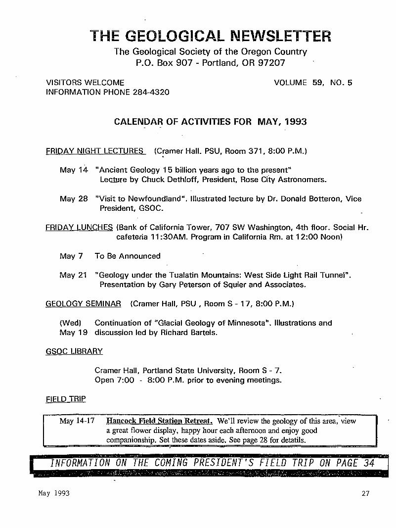
THE GEOLOGICAL NE\JVSlETTER The Geological Society of the Oregon Country
P.O. Box 907 - Portland, OR 97207
VISITORS WELCOME INFORMATION PHONE 284-4320
VOLUME 59, NO. 5
CALENDAR OF ACTIVITIES FOR MAY, 1993
FRIDAY NIGHT LECTURES (Cramer Hall. PSU, Room 371, 8:00P.M.) . May 14 "Ancient Geology 1 5 billion years ago to the present"
Lecture by Chuck Dethloff, President, Rose City Astronomers.
May 28 "Visit to Newfoundland". Illustrated lecture by Dr. Donald Botteron, Vice President, GSOC.
FRIDAY LUNCHES (Bank of California Tower, 707 SW Washington, 4th floor. Social Hr. cafeteria 11 :30AM. Program in California Rm. at 12:00 Noon)
May 7 To Be Announced
May 21 "Geology under the Tualatin Mountains: West Side Light Rail Tunnel". Presentation by Gary Peterson of Squier and Associates.
GEOLOGY SEMINAR (Cramer Hall, PSU, RoomS- 17, 8:00P.M.)
(Wed) Continuation of "Glacial Geology of Minnesota". Illustrations and May 19 discussion led by Richard Bartels.
GSOC LIBRARY
FIELD TRIP
Cramer Hall, Portland State University, RoomS- 7. Open 7:00 - 8:00P.M. prior to evening meetings.
' May 14-17 Hancock Field Station Retreat. We'll review the geology of this area, \dew
a great flower display, happy hour each afternoon and enjoy good companionship. Set these dates aside. See page 28 for detatils.
TION ON THE C DENT'S FIELD TRIP ON PAGE 3
May 1993 27
WELCOME NEW MEMBERS Doris Manley
6610 NE 75th Street VancouverWA 98661
K.H. Lindsay 272 Greenwood Road
Lake Oswego Oregon 97034
Bill Greer
HANCOCK FIELD STATION ANNUAL TRIP MAY 14-17.
LOCATION: HANCOCK FIELD STATION: located between the towns of Antelope and Fossil on Highway 218. It is two miles east of Clarno after you cross the John Day River. Watch for the Hancock Field Station sign on the north side of the road.
1 TIME: Meet at the Station any time in the afternoon of the 14th. First meal will be the evening ofthe 14th.
COST: $26.00 &. clay . Meals include Friday evening the 14th, three meals Saturday and Sunday, the 15th and 16th, and two meal on the 17th. All checks if you pay by check are to be made to OMS!. INSTRUCTIONS: Bring warm sleeping bags, extra blanket, flashlight, sunglasses, G-pick, binoculars and clothing for any kind of weather. We plan for gieat weather, but this is Oregon. Don't forget your soap, towels, toothbrush and anything else you need for comfort.
ACTMTIES: Some walking and some car travel to see the geology and spring flowers. This should be a great year for flowers.: They have had plenty of rain this year.
IMPORTANT:: IF YOU PLAN TO GO ON THIS FIELD TRIP, PLEASE CALL DON BARRAT246-2785 BY May 11 AS I NEED TO INFORM THE STATION THE NUMBERS ATI'ENDING.:
' Evelyn PraH, Retiring President; -1992:
Farewell speech
A little over two years ago I joined GSOC. Someone - probably Don Turner - asked if! knew any good speakers on geologic topics. 1 admitted that I did. Before I
28
knew quite how it happened, I was Vice-President. This led, the following year, to becoming President.
It's been a most rewarding experience. People such as Alta Fosback Stauffer, Walter Sunderland, Rosemary Kenney, Don Barr, Esther Kennedy, and many others helped me learn how GSOC worked and who the dedicated people are that make it work. If I named you all, we'd be here at least an extra hour.
Last spring and summer I took two field trips to prepare forleading the 1992 President's Field Trip. One field trip, led by Dr. K.ays of the U of 0, opened my eyes to the intricate geology of the Klamath Mountains. The other, with Drs. Bud Burke and Gary Carver of Humboldt State Univ., focused on earthquake geology of N Calif.'s Triple Junction. When the time came to write the President's Field Trip Guide, Dr. John Eliot Allen, Clair Stahl, Dr. John Whitnrer, and nearly a dozen others gave generously of their time and knowledge. From this I've learned a tremendous amount about geology, about leading a group, and about the willingness and helpfulness of people who care.
Esther Ke1medy, your incomiHg pret:ident, is wellimov.n to GSOC'en;. She has set up tht: Annual B<mquet foi over a dec:J.de. In 1992 and 1993 she presented us with more· than a dozen interesting and informative speakers. Already she has appointed her committee members and found a place to stay for the 1993 Pres1denfs Field Trip. She knows our organization and the people in it.
Although ifs really been a privilege to work with her, I do have one complaint. I wonder how many other GSOC'ers besides me have a hard time restraining them: selves from gorging on the absolutely scrumptious cookies she brings to meetings. Esther, do you know what you're doing to my willpower- and my diet?
Once again, thanks for letting me serve as your president. Ifs been interesting, fun, and a pleasure mee~g and working with all you geology buffs. Here's looking forward to a great year, with Esther leading us! Let's give her a big hand! ***********************************************
COMPLETELY FRACTURED GEOLOGY Ralph & Eve!yn' Pratt
1. MAFIC (adj): refers to actions of the type performed by Sicilian-based criminal group
2. MORAINE: (a) the fluffy white stuff on top of a lemon pie (b) a girl's name, popular in Ireland.
THE GEOLOGICAL NEWSLETTER
3. SLICKENSIDE: a comedy duo in the Icecapades.
4. FISSURE : someone trying to catch a trout
5. SPHALERITE: a long-legged wading bird in the title of a well-known book, "Too Late the Sphalerite"
6. PIN GO TERRAIN: a good location for a Chinese table-tennis tournaent.
7. RADIOLARIA: a funny DJ on KBOO
8. GYPSUM: said of a con man - "He sure gypsum!"
9. PORPHYRY: a crime which involves lying while under oath; "When the butler said he hadn't murdered the
victim, he committed porphyry."
10. GEOCOSMOLOGY: the science of making the earth look beautiful.
CORRECT ANSWERS TO "COMPLETELY FRACTURED" GEOLOGY ON PAGE 31
************k**************•*~*****
SW OREGON COMMUNITY COLLEGE FIELD TRIPS
Lead by Dr. Don Stensland, 888-2525, Ext. 253
April8: Powers, Agness, Gold Beach; a few seats available; transportation fee $15.
April22: Newport, Lincoln City, Cascade Head, Cape Kiwanda; a few seats available; transp.
fee $13.
May 13-16: Central Oregon; a few seats available; Smith Rock, John Day Fossil Beds, Painted Hills
Palisades, Fort Rock, etc. . fee $90.
~
PRESIDENT ESTHER KENNEDY'S INTRODUCTORY ADDRESS
Since I did not campaign for this position, I have no promises to keep!! Instead I'm asking all ofyou to help me make this a good year with many interesting happenings. Share your ideas for programs and field trips. Attend luncheons, evening meetings and seminars. Bring a friend
May 1993
with you to meetings and on field trips. Perhaps a visitor with encouragement from you will become a member.
The President's Field Trip begins Saturday, September 25th and ends on October l. Headquarters will be in Mount Vernon, Washington for five nights. We will stay overnight in Tacoma our first night out. We have exciting excursions planned and we hope all of you will participate.
Thank you for giving me the opportunity to serve this wonderful organizations as President.
Esther Kennedy . +++H-Ill I I I I II I I I I I I I 1111+++1++1 I I I I II I II
NORTHWEST MUSEUM OF NATURAL HISTORY ASSOCIATION based at Portland State Univ:ersity is an association that GSOCs would find interesting. The following is from the Association News , December 1992. regarding an update on how the Museum is corning with its program and new facilities. Dr. Dave Taylor has spoken to the Society several times in the past couple of years.
The Mission Statement of the Museum is as follows~ The Nortl1west Museum of Natural History was conceived to engage curiosity and to inspire appreciation for our natural historic heritage - as well as to explain and interpret the research methods tr.rough which professional scientists learn about the naruraJ. world. The Museum, a non-profit educational and cultural insitution will be a community resource for an informed citize!1!:.'&
Letter from the Director
Dear Friends: This has been an exciting year for the Museum
Association. Negotiations with Portland State University culminated with an agreement allowing the Association to occupy the ground floor of the Ondine Building on the Portland State Campus. Located at S.W. Sixth Avenue and Hall Street, the building is easily accessible by public transportation or automobile. We are delighted to have a home for the Museum. The Association Board of Trustees would like to thank Portland State University President Judith Ramaley; Dr. William Paudler, previous Dean of the College of Liberal Arts and Sciences; and Lindsay Ann Desrochers, Vice President of Finance and Administration along with her assistant Steve Sivage for making this arrangement possible. We also thank our members and friends who have given their support to this project.
We are anxious now to operate as a Museum, but first things first. We now need to focus on remodeling our space and establishing a Development Office. To do so, we must increru;e our operating revenues, expand our membership, and seek new revenue sources. We will need to increase the
29

•.-·
community's awareness of our organization, involve more individuals and continue to identify community resources.
But let us look ahead for just a minute and jump to an overvj.ew of our first exhibit themes designed to show our breadth of interest in natural history. One will naturally center on our Triceratops dinosaur skeleton, another will focus on our own human origins in East Afiica, while the third will examine the plight of the Pacific Northwest salmon. Topics such as these on the cutting edge of research will be presented and - where appropriate - a worker in the field will
•. be profiled. Through our exhibits, we will capture the excitement of the investigative process and allow Museum visitors to form their own conclusions about sensitive environmental issues facing us today.
As we begin the new year, once again we thank our supporters. We are rolling up our sleeves to work on development, but we will also take time out for a field trip or two or a lecture on natural history. We invite you to join us at work or play.
Sincerely, Dave Taylor
Of you interested in becoming a member of the Northwest Museum of Natural Histo!Y Association you can call 725-5900 for membeshin categories. There are a numbe1 of membershi~ categories, but two that would be of interest to most ~eo~le are Friend/Family is ~25.00 and Contributing/Individual is $15.00.]
***********************************************
PALEOMAGNETISM TECTONICS OF THE CRESENT FORMATION NORTHERN
OLYMPIC MOUNTAINS WASHINGTON
The following is the short summary of the research on the Olympic Penninsula by Andrew C. Warnock, recipient of the 1989-90 AFMS Scholarship Award.
Use of a small-diameter drill has allowed the paleomagnetic sampling of rims of fractured pillow basalts of the lower Crescent Formation in the northern Olympic Mountains. The pillows selected have spherical to slightly oblate morphologies which typically develop on horizontal or gently-dipping surfaces. Pillow keels and sedimentary interbeds were used to obtain bedding attitudes and top directions for use in structural corrections. All specimens were subjected to progressive thermal demagnetization. After removal of a low blocking-temperature recent overprint, stable end-points were reached by 580°C in 12 of the 34 sites sampled (large within-site; scatter was commonly observed in the remaining sites). Among the accepted sites, within-site scatter was small and correction for bedding tilt significantly
30
reduced the scatter between sites. The mean paleomagnetic pole for this investigation (86.4° north latitude, 170.0° east longitude, ~5_16.5°) is indistinguishable from the early to middle Eocene pole expected for North America. When combined with previous results from subaerial basalt exposures of the upper Cresceqt Forma!ion in and near the eastern Olympic Mountains, \h.ese results (80.7° north latitude 192.0° east longitude, A9.)8.0°, N=46) show no significant rotation (0.80 + 14.4 or poleward displacement (-3.6 + 8.5). Analysis of the magnetic mineralogy suggests that tht> remanence is early, probably primary. ·nr~ pole, therefore, should be valid for tectonic interpretation of the region. A circular distribution virtual geomagnetic poles after comection for bedding tilt supports the hypothesis that the northern Crescent Formation experienced deformation due to the rise, in a dome-like fashion, of the sediments of the Olympic Core terrane. Erosion of a partial dome open to the west could have produced the curvature seen in the outcrop pattern of the Crescent Formation. The lack of significant rotation of the northernmost Coast Ranges contrasts with the net clockwise rotation seen to the south. The difference could be that irrotational northward translation, driven by oblique convergence, was accomodated by the north-south trending strike-slip faults to th~ east of the Olympic Mountains.N\\o' NEWSLEITER, vol. 9303, March 1993 I I I I I I I I I I I! I I I I I I+++++ I I I I I I I I I I++++++++++
MINING GIANTS JOIN GREAT DIAMOND RUSH
by Lain Jenkins
This article was taken from NORTIIWEST NEWSLETTER, Volume 9303, March 1993 with permission.
A land rush on a scale overshadowing anything since the Alaskan gold rush of the 1890's is underway in northern Canada. But instead of private prospectors, global corporate giants, including Britain's RTZ, Australia's BHP and south African De Beers, are racing to stake out huge areas of the frozen north for diamonds
A century ago, lone explorers trudged on snowshoes through the semi-Artie wastes. Today's rush is based on technology.
The mining multinationals are fighting for space on the limited number of helicopters available to drop stakes onto the snow-covered land to mark their concessions. -
"There have' ~een amazing scenes" said Roger Chaplin, -· mining analyst at the roker Credit Lyonnais Laing, which has just completed a report on the rush.
Diamond analysts estimate that more than 23,000 square miles have been staked out so far. Within four years, it is
· suggested, the area could account for 20% of the world diamond production and 30% of gemstone production.
THE GEOLOGICAL NEWSLETTER
-These expectations, if realized, would firrther damage the established diamond market, already suffering from the effects of the recession, a mining scramble in Angola and moves by Russia to leak diamonds on to the world market.
The excitment is based on an exploratory drilling by Dia Met, a tiny Caadian compaany. Its small sample showed the presence of an unusually large number of good quality diamonds. This set off the rush, with companies racing to get there before De Beers, the South African company which controls 80% of the world's diamonds.
A consortium of BHP and Dia Met is in the forefront of the race while RTZ, through its American arm Kennecott, in alliance with smaller companies, is fighting to catch up. Dia Met's shares have rocketed from under $1.00 to $19.25 on the Canadian stock exchange on the back of land rush.
De Beers is using its name and muscle to grab as much land as possible. Privately, it is skeptical that the area will yield as many diamonds as some geologists predict. However, it wants to cover itself just in case.
If the experts are right, Canada could, within four years, overtake Zaire as the world's largest producer of diamonds. Zaire accounts for 19% of the world production, with Botswana in second place with 16%, Russia wiuth 13%, south Africa with 8% a.'ld Namibia 2%.
t++++T+++++++++++I I I I I I 1++++++++++1 I I I I IiI+
COMPLETELY FRACTURE GEOLOGY by Evelyn and Ralph Pratt
1. MAFIC (adj): describes an igneous rock composed chiefly of dark magnesium- and iron-rich minerals.
2. MORAINE: a mound or ridge of unstratified till deposited by direct action of glacier ice.
3. SLICKENSIDE: a polished and striated rock surface, resulting from friction along a fault plane.
4. FISSURE : an extensive crack in the rocks; sometimes contains minerals
5. SPHALERITE, Zn, Fe)S, with perfect cleavage. 6. PIN GO TERRAIN an Arctic area with many long
lasting rounds of soil-covered ice up to 50 m high and 400m wide.
7. RADIOLARIAa: single-celled marine organisms with silica skeletons; their remains make up extensive areas of seafloor ooze .
8. GYPSUM: hydrous calcium sulfate, the most common sulfate mineral, with a hardness of 2 on Moh's scale; used in cement and plasterboard.
9. PORPHYRY: an igneous rock with conspicuous chunks in a fine-grained groundmass.
10 .GEOCOSMOLOGY: the science that deals with the origin and geologic history of the earth's a planet in space.
May 1993
DID YOU KNOW?????? With earthquakes in the news, we hear a lot of the Richter Scale to denote the strength of the quake. This scale was developed by Charles Richter, in 1935. Each number is ten tmes more powerful than the previous one. Thus a measurement of five would be ten times more powerful than a four, which is ten times more than a three. So a five would be 10 x 10 , that is 100 times more than a three. A quake of five can cause minor damage, while over 8 means total destruction.
-.a r .;•
I I I I I I I I I I I I I I I I ++++++++++++++++++t+++++-1+: .
DAZZLING DISPLAYS AT BANQUET by Charlene Holsworth
To celebrate the Oregon Trail Anniversary, a special display of all items available in Oregoii.!'rail Information Booths and Made in Oregon Stores was the center of our bevy of beguiling banquet offerings this year. Member Teddy Pendergrass brougt Indian drums, minature prairie schooners and other historical items.
Phyllis Thome brought many little Teasel People from West Virginia travels. Her colorfully dressed figures stood on tie1s sc each could be admired.
Dr. John Allen displayed 4 sets of his brightly polished bookends with his photo card.
Past President Evelyn Pratt had time to bring a box of rocks and photos from the May convention.
Kenneth Ross brought 2 fine boxes of Agates even though he was not able to stay for the banquet.
Don Thmer brought a rninature train with several gondolas filled with various rock samples.
Rosemary Kenney's slides were displayed by Robert Richmond as he showed his slides of the National Parks.
Esther Kennedy showed her slides of the FosbackStauffer party. Esther also had her microscope set up to show some of her micromounts, and Emily Delano planned to show unidentified photos of the Oregon Country.
Frank Dennis brought two large books full of enlargements of photos he has taken on various trips throughout the world. .
Elinore Olson showed her box ornamented with colorful feathers and hair ornaments collected from when she had taveled.
Bradford Kenyon brought his displays and Dorothy Barr showed fossils from her extensive collection.
Phyllis Bonebrake showed many of the place favors from previous banquets which brought back many good memories to all of us.
Richard Bartels joined us in our entertaining and educating endeavors. We are grateful for these memb~rs who went to extra effort to add to the pleasure of the fine banquet
31
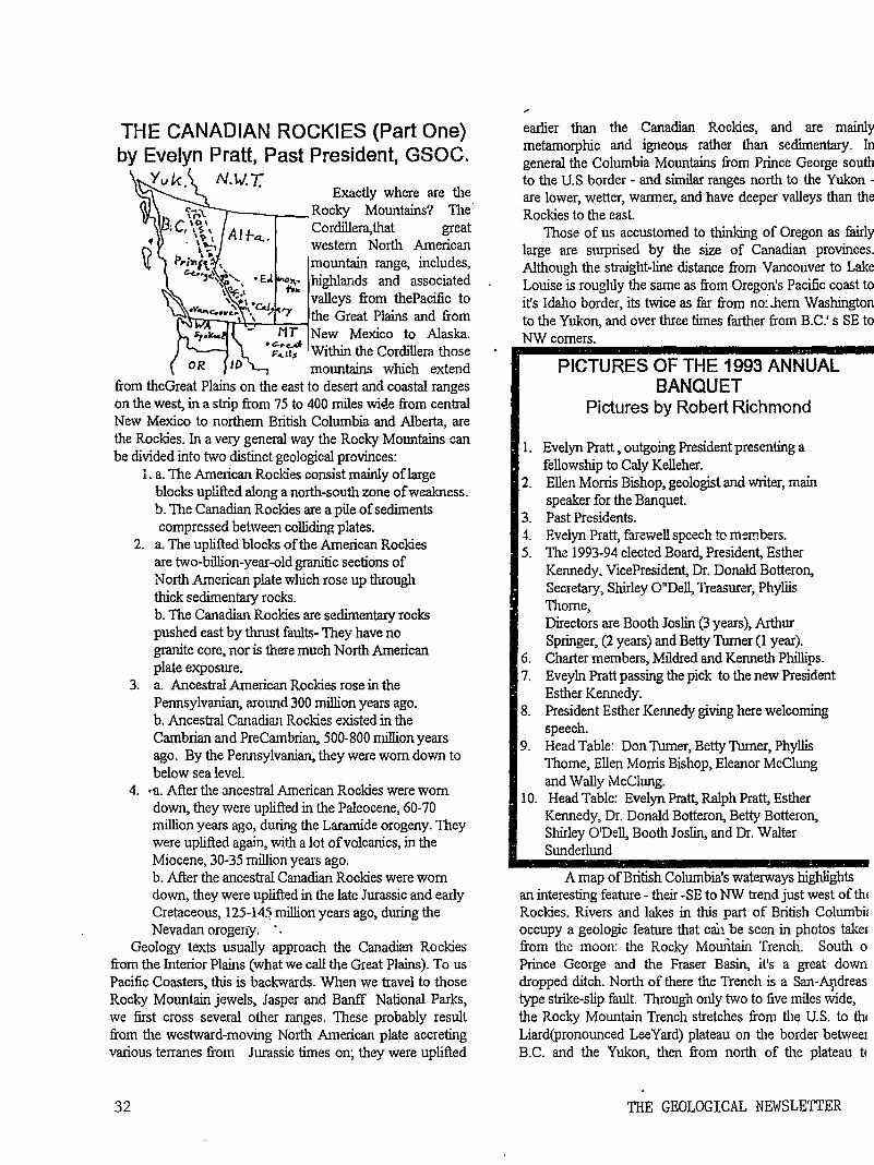
THE CANADIAN ROCKIES (Part One) by Evelyn Pratt, Past President, GSOC.
Yvk. N.W.T. Exactly where are tl1e
r----,..-- Rocky Mountains? The· Cordillera,that great western Nortl1 American mountain range, includes, highlands and associated valleys from thePacific to
I"'S'D.r--r:~~.L..,-,..-..-1 the Great Plains and from New Mexico to Alaska. Within the Cordillera those mountains which extend
from theGreat Plains on the east to desert and coastal ranges on the west, in a strip from 75 to 400 miles wi4e from central New Mexico to northern British Columbia and Alberta, are the Rockies. In a very general way the Rocky Mountains can be divided into two distinct geological provinces:
1. a. The American Rockies consist mainly oflarge blocks uplifted along a north-south zone of weakness. b. TI1e Canadian Rockies are a pile of sediments compressed betwee:1 colliding plates.
2. a. The uplifted blocks of the American Rockies are two-billion-year-old granitic sections of North American plate which rose up through thick sedi..rnentary rocks. b. The Canadian Rockies are sedimentary rocks pushed east by thrust faults- They have no granite core, nor is there much North American plate exposure.
3. a. Ancestral American Rockies rose in the Pennsylvanian, around 300 million years ago. b. Ancestral Canadian Rockies existed in the Cambrian and PreCambrian, 500-800 million years ago. By the Pennsylvanian, they were worn down to below sea level.
4. •a. After the ancestral American Rockies were worn down, they were uplifted in the Paleocene, 60-70 million years ago, during the Laramide orogeny. They were uplifted again, with a lot of volcanics, in the Miocene, 30-35 million years ago. b. After the ancestral Canadian Rockies were worn down, they were uplifted in the late Jurassic and early Cretaceous, 125-14.1 million years ago, during the Nevadan orogeri:y. ·.
Geology texts usually approach the Canadian Rockies from the Interior Plains (what we call the Great Plains). To us Pacific Coasters, this is backwards. When we travel to those Rocky Mountain jewels, Jasper and Banff National Parks, we first cross several other ranges. These probably result from the westward-moving North American plate accreting various terranes from Jurassic times on; they were uplifted
32
earlier than the Canadian Rockies, and are mainly metamorphic and igneous rather than sedimentary. In general the Columbia Mountains from Prince George south to tl1e U.S border - and similar ranges north to the Yukon -are lower, wetter, warmer, and have deeper valleys than the Rockies to the east.
Those of us accustomed to thinking of Oregon as fairly large are surprised by the size of Canadian provinces. Although the straight-line distance from Vancouver to Lake Louise is roughly the same as from Oregon's Pacific coast to it's Idallo border, its twice as far from no:.hem Washington to the Yukon, and over three times farther from B.C.' s SE to NWcomers.
PICTURES OF THE 1993 ANNUAL BANQUET
Pictures by Robert Richmond
1. Evelyn Pratt , outgoing President presenting a fellowship to Caly Kelleher.
2. Ellen Morris Bishop, geologist and writer, main speaker for the Banquet.
3. Past Presidents. -1. Evelyn Pratt, farc:v;.rell speech to mer!!bers. 5. The 1993-94 elected Board, President, Esther
Kennedy, VicePresident, Dr. Donald Botteron, Secretary, Shirley O"Dell, Treasurer, Phyllis TI10me, Directors are Booth Joslin (3 years), Arthur Springer, (2 years) and Betty Turner (1 year).
6. Charter members, Mildred and Kenneth Phillips. 7. Eveyln Pratt passing the pick to the new President
Esther Kennedy. 8. President Esther Kennedy giving here welcoming
speech. 9. Head Table: Don Turner, Betty Turner, Phyllis
Thome, Ellen Morris Bishop, Eleanor McClung and Wally McClung.
10. Head Table: Evelyn Pratt, Ralph Pratt, Esther Kennedy, Dr. Donald Botteron, Betty Botteron, Shirley O'Dell, Booth Joslin, and Dr. Walter Sunderlund
A map of British Columbia's waterways highlights an interesting feature - their -SE to NW trend just west of tht Rockies. Rivers and lakes in this part of British Columbi~ occupy a geologic feature that can be seen ir1 photos taket from the moon: the Rocky Mountain Trench. South o Prince George and the Fraser Basin, it's a great down dropped ditch. North of there the Trench is a San-Ar,tdreas type strike-slip fault. Tirrough only two to five miles wide, the Rocky Mountain Trench stretches from tl1e U.S. to th1 Liard(pronounced Lee Yard) plateau on tl1e border betweet B.C. and the Yukon, then from north of tl1e plateau t<
THE GEOLOGICAL NEWSLETTER
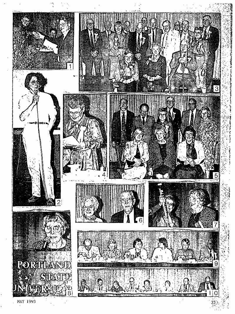
Alaska. Its been around for over 45 million years, so some major earth .movement must be taking place here.
This trench marks the western border of the Canadian Rockies. Into it pour meltwaters from the icefields and glaciers that now even, 10,000 years after the end of Pleistocene, mantle the heights of the northern Rockies. Headwaters of three oftlte continents's mightiest rivers flow through the Trench. Near Banff and Lake Louise, the Columbia and its great tributary, the Kootenay, are so close that in the 1890's an enterprising chap dug a canal between them to k~ep the unruly Kootenay from flooding land he wanted to sell. TI1en Canadian Pacific Railroad demanded a lock to take care of 20-odd feet of elevation difference between the two rivers. Shortly after he built the lock a boat bashed into it. No funds for repairs meant no more canal.
A few miles north of where the Columbia flows westward out of the Trench lies the settlement ofTete Juane Cache (called TAY-wan by nor.•·French-speaking locals). From here the Fraser River heads northwest toward Prince George, where it leaves the Rocky Mountai.:1 Trench to flow south, then west to the Pacific. Up this river for countless millenia the salmon came to spawn, 600 miles from the ocean to Rearguard and Overland Falls by Mt. Robson. And
. ./ .. ' --·
--· .
Between the Rocky Mountl!ffi Trench and the Interior Plains, from U.S. Glacier National Park to the south to the Liard River by British Columbia's northern border, rise the Canadian Rockies. (to be continued in the June issue of the Newsletter)
II PRESIDENT'S FIELD TRIP PREVIEW I It is time to start planning for another exciting geological
adventure PRESIDENT'S FIELD TRIP. We leave Portland Saturday, September 25, staying the first night in Tacoma. The next five nights will be at the CottonTree in Mount Vernon. We return to Portland on Frictay, October I. Schedule for the trip is not firm yet but will include glacial deposits, rivers tllat changed courses, coal deposits, North Cascades, a short trip across the border to Canada, Mount Baker , Mount Shuksan, ferry trip to Friday Harbor in the San Juan =and much more.
Price for the 6 nights and 6 days which includes all meals except the evening meal in Tacoma is $562.00 per person twin, and $692 single. Ferry trip to Friday Harbor is $10.00 extra.
Make your plans to go on this great President's Field Trip in September. Again the dates are September 25
I th!'oug..~ Octc~er I. Fu.-thPT details and a schedule of daiiy I events will appear in the June GEOLOGICAL 1 NEWSLETIER. 1
Esther Kennedy, President, GSOC
A VALUABLE MINE The lead from which "pencil points" are made comes
from the principle plumbago mine in the world at Barrowdalc, Cumberland, Englartd (plumbago is a form of lead of graphite commonly known as black lead),
It is situated on a hill and instead of being worked constantlv like other mines, it is opened only once a year, when a s~fficient quanity is taken out to supply the world a year to come. Then it is closed with strong doors and locks until the next armual supply is required. From the time of Queen Elizabeth , it is said that all fine pencils in the world
==~~::::::::::::-=:::::=::::~~:;~~~~~~==~~~ have been made of the black lead from this mine. >< >< .l< .x x .><: x -x: .x. x. r.< ">< x X K .k via The Rock Chipper.
d R k . : ++++++++++++++++++++++++++++++++++++ Ca.. 'YJ B'- j a. )11 O'C 1e..s ABLE TO LIFT TALL BUITJ)INGS
f:...-.. m. •11-/ e<.-ad bt>cU of flte Co..Vttt.J~u. One of the buildings of the General Electric
Roc.k;e./; {3 e.."' G.a..dd (Co r-a..x Prc.ss, t "l 'if c.) Laboratory at Nela Park, near Cleveland, Ohio, was
down the river in the 1800's floated canoes, barges and steamboats taking the forests firs and logs and the mountains' gold and copper ore to the sea.
Some 25 years ago, still farther north in the Trench, dan1ming of the Peace River created what is probably the world's largest man-made lake. Water from 225-mile-long Lake Williston eventually flows into the Mackenzie, the second largest river system in North America.
34
built upon a layer of iron pyrite. When the mineral was exposed to air it began to oxidize into rust. This rust was created at such a rate that the basement floors were lifted 15 inches in J,S years , an inch per year.
. I
The rust occupies more space than pyrite and the chemical action taking place has enough power to lift a building.-Via-Hy Grader
THE GEOLOGICAL NEWSLETTER
THE GEOLOGICAL NEWSLETTER
JUN 99
GEOLOGICAL SOCIETY OF THE OREGON COUNTRY
GEOLOGICAL SOCIETY OF THE OREGON COUNTRY
P.O. BOX 907 PORTLAND. OR 97207
Non-fltoelit Org. U.S. POSTAGE
PAID PorUand, Oregon
Permit No. 999
GEOLOGICAL SOCIETY OF THE ·oREGON COUNTRY 1993-1994 ADMINISTRATION
BOARD OF DIRECTORS
President Esther Kennedy 626-2374 11925 SW Center Beavertom, Oregon 97005
Vice-President Dr. Donald Botteron 245-6251 2626 SW Luradel Street Portland, Oregon 97219
Secretary Shirley O'Dell 3038 SW Florida Ct.;Unit D 245-6882 Portland, Oregon 97219
Treasurer Phyllis Thorne 292-6134 9035 SW Monterey Place Portland, Oregon 97225
Directors Booth Joslin(3 years) Arthu~ Springer(2 years) Betty Turner(1 year)
Immediate Past Presidents Evelyn Pratt Dr. Walter Sunderland
THE GEOLOGICAL NEWSLETTER Editor: Donald Barr
Calender: Reba Wilcox Business Manager:
636-2384 236-6367 246-3192
223-2601 625-6840
246-2785 684-7831
Rosemary Kenney 221-0757 Assistant: Margaret Steere
246-1670
ACTIVITIES CHAIRS
Calligrapher Clay Kelleher 775-6263
Field Trips Alta Stauffer 287-1708
Geology Seminars Richard Bartels 292-6939
Historian Charlene Holzwarth 284-3444
Hospitality (Luncheons)Shirley O'Dell245-6882 (Evenings)Elinore Olson 244-3374
Library Frances Rusch 654-5975
Programs (Luncheons) Clay Kelleher775-6263 (Evenings) Dr. D.Botteron245-6251
Past President's Panel Evelyn Pratt -223-2601
ACTIVITIES
Properties and PA System (Luncheon) Clay Kelleher 775-6263 (Evenings) Booth Joslin 636-2384
Publications Margaret Steere 246-1670
Publicity Evelyn Pratt 223-2601
Refreshments (Friday Evenings) Volunteers (Geology Seminars) Volunteers
Telephone Cecelia Crater 235-5158
Volunteer Speakers Bureau Bob Richmond 282-3817
Annual banquet Chairperson:susan Barrett639-4583
ANNUAL EVENTS: President's Field Trip-summer, Picnic-August,Banquet-March, Annual Meeting-February. FIELD TRIPS: Usually one per month, via private car, caravan or chartered bus. GEOLOGY SEMINARS: Third Wednesday, except June, July, August. a:oo pm, Rm. S17, in Cramer Hall, PSU. Library: Room 57, Open 7:30 P.M. prior to meetings. PROGRAMS: Evenings: Second and Fourth Fridays each month, 8:00pm, Rm. 371, Cramer Hall, PSU, SW Broadway at SW Hill street, Portland, Oregon. · LUNCHEONS: First and Third Fridays each month, except holidays
1at noon. Bank
of California Tower, 707 SW Washington, 4th floor Cafeteria, California Room, Portland, Oregon MEMBERSHIP: per year from January 1: Individual, $15.00, Family, $25.00, Junior (under 18) $6.00. Write or call Secretary for membership applications. PUBLICATIONS: THE GEOLOGICAL NEWSLETTER (ISSN 0270 5451) published monthly and mailed to each member. Subscriptions available to libraries and organizations at $10.00 a year. Individual subscriptions at $13.00 a year. Single copies $1.00. Order from Geological Society of the Oregon Country, P.O.Box 907, Portland, Oregon. TRIP LOGS: Write to the same address for price list.
THE GEOLOGICAL NEWSLETTER The Geological Society of the Oregon Country
P.O. Box 907 - Portland, OR 97207
VISITORS WELCOME INFORMATION PHONE 284-4320
VOLUME 59, NO. 6
CALENDAR OF ACTIVITIES FOR JUNE, 1993
FRIDAY NIGHT LECTURES (Cramer Hall. PSU, Room 371, 8:00P.M.)
June 11 "The West Side Tunnel" presented by Joe Gildner, Tri-Met.
June 25 "Madagascar, The Big Red Island", Illustrated presentation by Rosemary Kenny, member GSOC.
FRIDAY LUNCHEONS (Bank of Calif. Tower, 707 SW Washington, 4th floor. Social Hr., cafeteria 11:30 AM. Program, Calif. Rm. 12:00 Noon)
June 4 To be announced
June 1 8 To be announced
GEOLOGY SEMINAR (Cramer Hall, PSU , RoomS- 17, 8:00P.M.)
NO SEMINARS UNTIL SEPTEMBER
GSOC LIBRARY
FIELD TRIP
June 1993
Cramer Hall, Portland State University, Room S - 7. Open 7:00 - 8:00P.M. prior to evening meetings.
35
ADDITION TO THE M4Y 1993 GEOLOGICAL NEWSLETI'EER. PLEASE ADD DR. WALTER SUNDERLUND TO THE NAMES OF THE I993-1994 ELECTED BOARD. PAGE 30, ITEM 5. SORRY WALT.
COMPLETELY FRACTURED GEOLOGY Evelyn & Ralph Pratt
1. Country Rock: music for drums, washboard. and gee-tar.
2. Benioff Zone: a place where Benny is forbidden to go.
3. Mantle Plume: one rose, daisy, etc., over the fireplace.
4. Facies: what folksies have in front of their headies.
5. Quartzite: land purchased for a building to house a judge and july, where the quartroom is located.
6. Concordant: one of two places where the Revolutionary War started, Lexington being the other.
7. Nuee Ardente: one's latest boyfriend or girlfriend
8 Foreshock: a hank of hair that hangs over a person's eyebrows.
9. Lithology: study that teaches the science of how to become more limber.
10. Aureole: what you ask when the power's been off"Aureole right now?"
ANSWERS TO FRACTURED GEOLOGY ARE ON PAGE_37_
CENTRAL OREGON COAST FIELD TRIP by Don Barr. GSOC Past Pres.
The April 17th field trip led by Dr. Paul Hammond Professor of Geology, PSU along the central Oregon coast from Lincoln City to Cape Mears introduced the 18 GSOCers to the bed-rock geology of the area. Meeting at Shilo Inn with coffee in hand Dr. Hammond gave an introduction to the geology of the area and told of the plans for the dav. At our first stop at the Kaufman Quarry we viewed the clo"se-packed amygdaloidal pillow lavas in the upper part of the Siletz River Volcanics. These volcanics are interbedded with basaltic sandstone and siltstone containing shallow coccoliths. The second stop was to view the lower Salmon
36
River Formation that includes calcareous ledges and concretions and some fossils. The group observed fingerlings being raised the Salmon River Fish Hatchery and the Otis Formation containing lithic and basaltic sandstone and siltstones. Lunch stop was at Cape Kiwanda which is made up of Miocene Astoria Formation. After lunch the group was led down the beach to the large hills of sand In this part of the Astoria Formation there was a 3 foot dike of Depoe Bay basalt cut through the sandstone. Another stop was at a high point where the view to the south included Sand Lake, Cape Kiwanda and Cascade Head. Further on another viewpoint gave a view to the north that included Netarts Spit , Three Arch Rocks. Cape Mears and Netarts bay. It was pointed out that Netarts Spit is slowly eroding away. The stop at Netarts included a walk to an out cropping showing faults that may be related to a record of episodic, rapid Holocene subsidence of coastal estuaries in Oregon and Washington. This has been interpreted to represent deformation during a large subduction zone earthquakes along the convergent boundary. A breather stop at Wee Willies for coffee, pie and ice-cream was a welcome pause for the GSOCs. The last stop on the trip was at Cape Mears to view the middle Miocene basaltic flows and breccia. Here, too, the gang walked to the lighthouse and then to the large spruce tree known as the Octopus tree because it takes over the whole area around it. It was a wonderful geology trip led by Dr. Paul Hammond. He does a fantastic job of presenting geology. Thanks, Dr. Paul, for a great trip.
Nepheline Syenite: Toilet Bowls and Beer Bottles
by Virginia T. McLemore Economic Geologist, NMBM&MR.,
James Guilinger. Geologist. Addwest Minerals, Inc., Arvada Colorado.
What do nepheline syenite. toilet bowls. and beer bottles have in common? Did you know that everyone uses products made from nepheline syenite every day? Nepheline syenite is used in manufacturing glass, pottery, and ceramics. Someday nepheline syenite mined from the Comudas Mountains. southern OteroCounty,New Mexico, may be used in making toilet bowls and amber-colored glass for beer and soda bottles. Other uses of nepheline syenite are in paints. rubber, plastics, stains, "soft" abrasives, metal primers. and sealers, and in foam backed carpet. Nepheline syenite is a product known only by a few. but used by many.
What is nepheline syenite? Nepheline syenite is an igneous or plutonic rock predominantly composed of feldspar and nepheline with varying amounts of other silicate minerals. Nepheline syenite. unlike many igneous rocks, does not
The Geological Newsletter
contain any quartz. Commerical deposits of nepheline of greater than 60% of feldspar, 20-25% nepheline, and normally less than 0.5% dark-colored minerals. Because a small amount of iron results in colored glass or ceramics, a commerical deposit usually must contain small amounts of iron minerals. In addition, the deposit must be near the Earth's surface so that cheaper open-pit mining can be used. Commerical deposits must be large, containing thousands of tons of nepheline syenite.
Recently Addwest Minerals, Inc., from Arvada, Colorado, discovered that nepheline syenite in the Comudus Mountains, Otero County, is suitable for making dark-colored ceramics and amber beverage bottles. The Comudas nephine syenite is one of several plutons in southern Otero County, but is the only one that tests show contains material suitable for glass and ceramics. The Comudas nepheline syenite consists of nepheline, feldspar and up to 100/o iron-magnesium-rich, dark-colored minerals. These dark-colored minerals form an mineral aggregate that contains magnetite. The entire aggregrate can be separated from the crushed rock by a very strong magnet.
Once the dark minerals are removed, additional testing of rock characterestics such as the ability to melt under low temperatures, hardness, and tensile strength is necessary. Test results will be used to determine which market can utilize the nepheline syenite. Marketing studies are also necessary to determine how much to produce and at what price the nepheline syenite can be sold
Finding and testing the nepheline syenite is only the first step in starting a mine. State and Federal permits must be obtained An archeologist must examine the area to be mined. Archeological sites, such as Indian shelters and areas of broken pottery and arrowheads. indicating evidence of early inhabitants' activities will be protected from mining so that they can be studied by future generations. After marketing studies are finalized, a mine plan is developed based on the amount of nepheline syenite that can be sold If all criteria are met, Addwest Minerals. Inc. will start mining. In a few years the toliet bowl in your house or some of you beverage bottles may be made from nepheline syenite mined right here in New Mexico.
Glossary of Mineral Terms. Aluminosilicate--A compound containing Aluminum. silica, and oxygen. Feldspar--A group of abundant rock-forming minerals found in all types of rocks. They are usually white to colorless to pink. and occur as lath-like crystals. Feldpathoid-- Rare rock-forming minerals consisting of aluminosilicates and having relatively low silica contents.
June 1993
Magnetite-- A black. opaque mineral that is strongly magnetic (attracted by a magnet) relative to other minerals. Magnetite is composed of iron and oxygen. Nepheline-- A mineral of the feldspathoid group with the chemical formula (Na, K) AlSi04. Nepheline occurs as glassy-looking crystals or grains. Nepheline syenite- A plutonic igneous crystaline rock composed of feldspar and nepheline. Pluton-An igneous intrusion Silicate--A compound consisting, in part, of silica and oxygen. Quartz--A silicate mineral with the chemical formula Si02. References: Minnes, D.G., Lefond, S.J., and Blair, R, 1983, Nepheline Syenite; in Lefond, S.J., ed, Industrial minerals and rocks: American Insitute of Mining, Metallurgical and Petroleum Engineers, Inc., New York, pp. 931-960 Harben, P., 1979, Nepheline syenite: Industrial Minerals, September 1979, pp. 71-77 Robbins, J., 1986, Feldspar and nepheline syenite, filling a need? Industrial Minerals, September 1986, pp. 69-101. Harben, P.W., and Bates, RL., 1990, Indusdtrail minerals-geology and workd deposits: Industrial Minerals Division, Metal Bulletin, PLC, London The above article appeared in "Lite Geology" New Mexico Bureau of Mines and Mineral Resources, Winter, 1992.
DEFINffiONS FOR "COMPLETELY FRACTURED GEOLOGY"
1. Country Rock: any rock older than and intruded by an igneous body.
2. Benioff Zone: the probable upper boundary of a lithospheric plate. where it dips down under another plate toward the mantle; earthquakes tend to cluster long it ..
3. Mantle Plume: a narrow column of hot magma rising from earth's mantle through its crust.
4. Facies: general appearance or nature of one part of a rock body as contrasted with other parts.
5. Quartzite: metamorphosed sandstone.
6. Concordant: said of strata or of the contact between igneous and country rock, where bedding or structures are parallel to each other.
7. Nuee Ardente: a cloud of red-hot ash and dust caused by explosive volcanic activity.
37
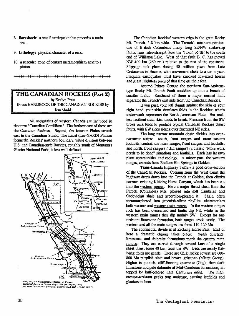
8. Foreshock: a small earthquake that precedes a main one.
9. Lithology: physical character of a rock.
10. Aaureole: zone of contact metamorphism next to a pluton.
I II I I I I I II I I I I I I I II I I I I I I II I I I I I I I I I II I I II I
THE CANADIAN ROCKIES (Part 2) by Evelyn Pratt
(From HANDBOOK OF THE CANADIAN ROCKIES by BenGadd
All mountains of western Canada are included in the term "Canadian Cordillera." The farthest east of these are the Canadian Rockies. Beyond, the Interior Plains stretch east to the Canadian Shield The Liard (Lee-YARD) Plateau forms the Rockies' northern boundary, while division between U.S. and Canadian-style Rockies, .roughly south of Montana's Glacier National Park, is less well-defined
38
NORTHWEST
Modi/itd /rom Physiosraph1c Regions of Canada Geological Surrey of Canada Map 115-IA (m DoutiflS. /970) and from lnttrnallonal Gtologrcal Congrtss Guzdtbook Al5·Cl5 (1972)
The Canadian Rockies' western edge is the great Rocky Mt. Trench. 3-8 km wide. The Trench's northern portion. one of British Columbia's many long SE/NW strike-slip faults, runs ruler-straight from the Yukon border to the south end of Williston Lake. West of that fault B. C. has moved NW 400 km (250 mi.) relative to the rest of the continent. Slippage took place during 50 million years from Late Cretaceous to Eocene, \\'ith movement close to a em a year. Frequent earthquakes must have knocked fox-sized horses and giant flightless birds of that time off their feet.
Around Prince George the northern San-Andreastype Rocky Mt Trench Fault muddies up into a bunch of smaller faults. Southeast of there a major normal fault separates the Trench's east side from the Canadian Rockies.
If you push your left thumb against the skin of your right hand, your skin simulates folds in the Rockies; what's underneath represents the North _American Plate. But rock, less resilient than skin, tends to break. Pressure from the SW broke rock folds to produce typical Canadian Rockies thrust faults, with SW sides riding over fractured NE sides.
The long narrow mountain chain divides into evennarrower strips: south, front ranges and more eastern foothills; central, the main ranges, front ranges, and foothills; and north, front ranges? main ranges? (a classic "More work needs to be done" situation) and foothills. Each has its own plant communities and ecology. A minor part, the western ranges, extends from Radium Hot Springs to Golden.
Trans-Canada Highway I offers a good cross-section of the Canadian Rockies. Coming from the West Coast the highway drops down into the Trench at Golden, then climbs narrow, twisting Kicking Horse Canyon, which has been cut into the western ranges. Here a major thrust sheet from the Purcell (Columbia) Mts. plowed into soft Cambrian and Ordovician shale and accordion-pleated it. Shale, often metamorphosed into greenish-silver phyllite, characterizes both western and western main ranges. In the western ranges rock has been overturned and faults dip NE, while in the western main ranges they dip mainly SW. Except for one resistant limestone formation, both ranges erode easily. The western and all the main ranges are about 110-120 Ma.
The continental divide is at Kicking Horse Pass. East of here a dramatic change takes place: tough quartzite, limestone, and dolomite formations mark the eastern main ranges. They are carved through several kms of a single sheet thrust some 40 Ian from the SW. Beds are nearly flatlying; folds are gentle. These are OLD rocks; lowest are 600-800 Ma purplish slate and brown gritstone (Miette Group). Higher is pinkish. cliff-forming quartzite (Gog); then dark limestone and pale dolomite of Mid-Cambrian formations; all topped by buff-colored Late Cambrian units. The high, erosion-resistant peaks trap moisture, causing icefields and glaciers to form.
The Geological Newsletter
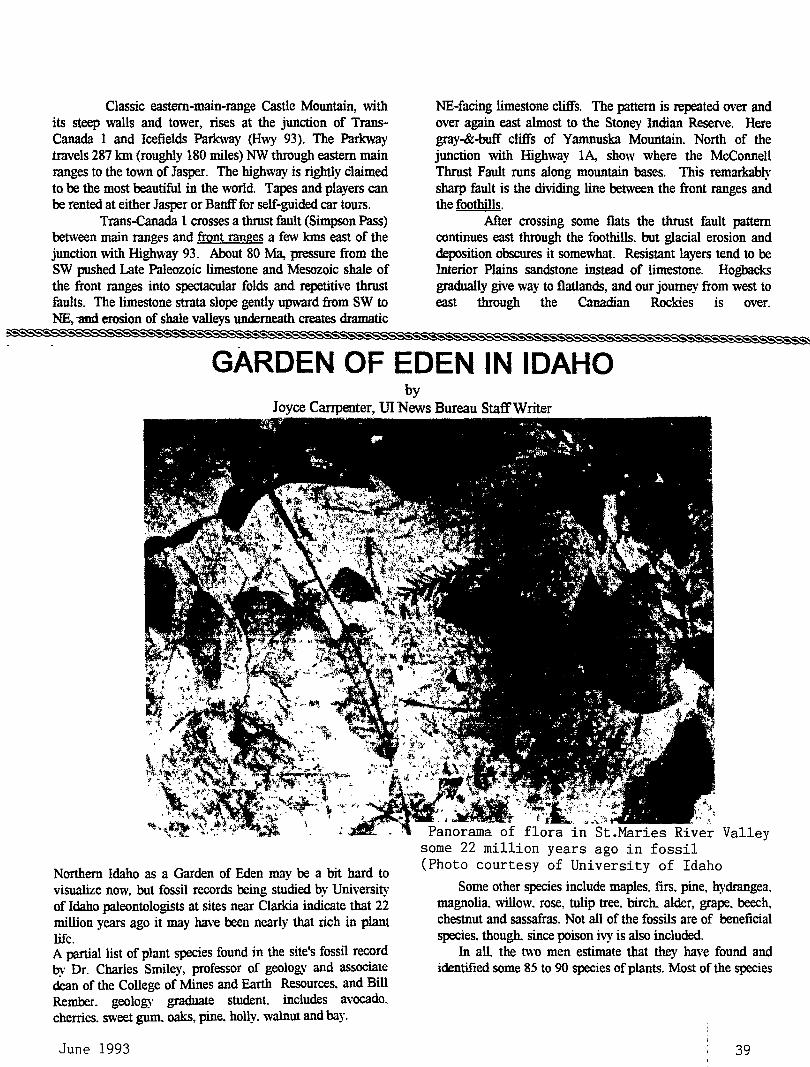
Classic eastern-main-range Castle Mountain, with its steep walls and tower, rises at the junction of TransCanada 1 and Icefields Parkway (Hwy 93). The Parkway travels 287 km (roughly 180 mileS) NW through eastern main mnges to the town of Jasper. The highway is rightly claimed to be the most beautiful in the world. Tapes and players can be rented at either Jasper or Banff for self-guided car tours.
Tmns-Canada 1 crosses a thrust fault (Simpson Pass) between main ranges and front ranges a few kms east of the junction with High\\'ay 93. About 80 Ma, pressure from the SW pushed Late Paleozoic limestone and Mesozoic shale of the front ranges into spectacular folds and repetitive thrust faults. The limestone strata slope gently upward from SW to NE, -and erosion of shale valleys underneath creates dramatic
NE-facing limestone cliffs. The pattern is repeated over and over again east almost to the Stoney Indian Reserve. Here gray-&-buff cliffs of Yamnuska Mountain. North of the junction with Highway 1A, show where the McConnell Thrust Fault runs along mountain bases. This remarkably sharp fault is the dividing line between the front ranges and the foothills.
After crossing some flats the thrust fault pattern continues east through the foothills. but glacial erosion and deposition obscures it somewhat. Resistant layers tend to be Interior Plains sandstone instead of limestone. Hogbacks gradually give way to flatlands, and our journey from west to east through the Canadian Rockies is over.
GARDEN OF EDEN IN IDAHO by
Joyce Carrpenter, UI News Bureau Staff Writer
Northern Idaho as a Garden of Eden may be a bit hard to visualize now, but fossil records being studied by University of Idaho paleontologists at sites near Clarkia indicate that 22 million years ago it may have been nearly that rich in plant life. A partial list of plant species found in the site's fossil record bv Dr. Charles Smiley, professor of geology and associate ~n of the College of Mines and Earth Resources. and Bill Rember. geology graduate student. includes avocado. cherries. sweet gum. oaks, pine. holly. walnut and bay.
June 1993
. ~
Panorama flora in St.Maries River Valley some 22 million years ago in fossil (Photo courtesy of University of Idaho
Some other species include maples. firs. pine, hydrangea. magnolia. willow. rose, tulip tree. birch. alder, grape. beech. chestnut and sassafras. Not all of the fossils are of beneficial species. though. since poison ivy is also included.
In all. the two men estimate that they have found and identified some 85 to 90 species of plants. Most of the species
39
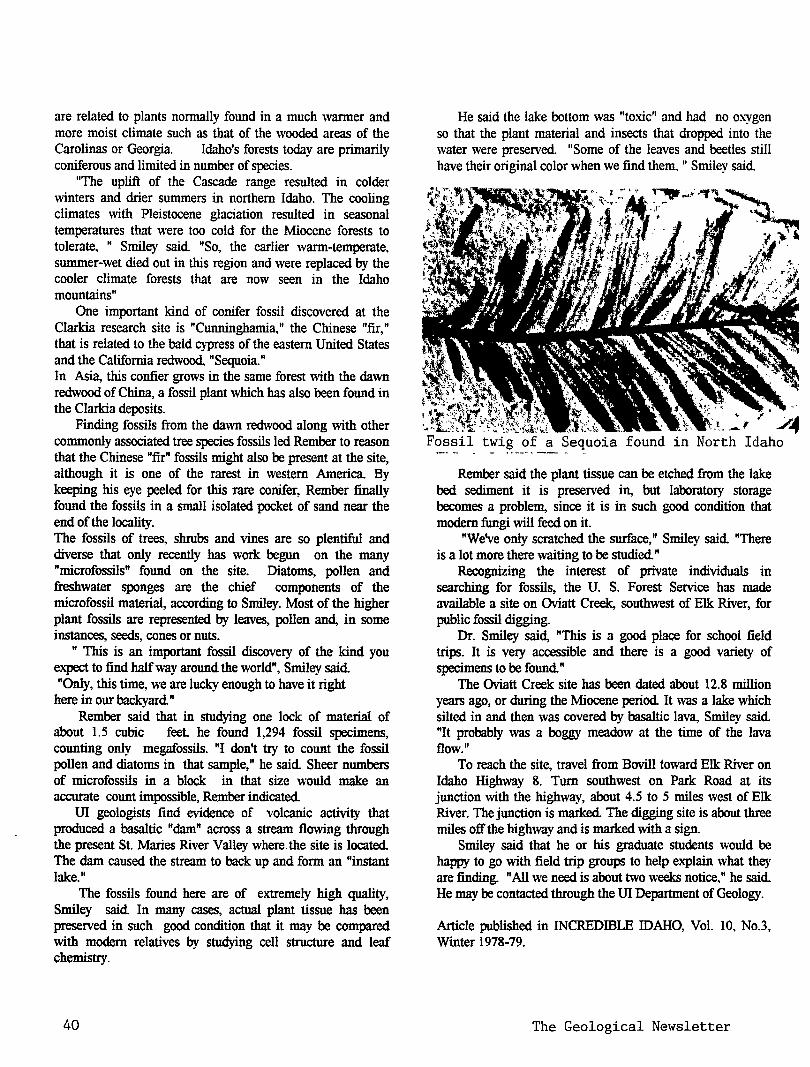
are related to plants normally found in a much warmer and more moist climate such as that of the wooded areas of the Carolinas or Georgia. Idaho's forests today are primarily coniferous and limited in number of species.
"The uplift of the Cascade range resulted in colder winters and drier summers in northern Idaho. The cooling climates with Pleistocene glaciation resulted in seasonal temperatures that were too cold for the Miocene forests to tolerate, " Smiley said "So, the earlier warm-temperate, summer-wet died out in this region and were replaced by the cooler climate forests that are now seen in the Idaho mountains"
One important kind of conifer fossil discovered at the Clarkia research site is "Cunninghamia," the Chinese "fir," that is related to the bald cypress of the eastern United States and the California redwood, "Sequoia." In Asia, this confier grows in the same forest with the dawn redwood of China, a fossil plant which has also been found in the Clarkia deposits.
Finding fossils from the dawn redwood along with other commonly associated tree species fossils led Rember to reason that the Chinese "fir" fossils might also be present at the site, although it is one of the rarest in western America. By keeping his eye peeled for this rare conifer, Rember finally found the fossils in a small isolated pocket of sand near the end of the locality. The fossils of trees, shrubs and vines are so plentiful and diverse that only recently has work begun on the many "microfossils" found on the site. Diatoms, pollen and freshwater sponges are the chief components of the microfossil material, according to Smiley. Most of the higher plant fossils are represented by leaves, pollen and, in some instances, seeds, cones or nuts.
" This is an important fossil discovery of the kind you expect to find half way around the world", Smiley said "Only, this time, we are lucky enough to have it right
here in our backyard" Rember said that in studying one lock of material of
about 1.5 cubic feet. he found 1,294 fossil specimens, counting only megafossils. "I don't try to count the fossil pollen and diatoms in that sample," he said Sheer numbers of microfossils in a block in that size would make an accurate count impossible, Rember indicated
UI geologists find evidence of volcanic activity that produced a basaltic "dam" across a stream flowing through the present St. Maries River Valley where. the site is located The dam caused the stream to back up and form an "instant lake."
The fossils found here are of extremely high quality, Smiley said In many cases, actual plant tissue has been preserved in such good condition that it may be compared with modem relatives by studying cell structure and leaf chemistry.
40
He said the lake bottom was "toxic" and had no ox-ygen so that the plant material and insects that dropped into the water were preserved. "Some of the leaves and beetles still have their original color when we find them. " Smiley said
twig of a Sequoia found in
Rember said the plant tissue can be etched from the lake bed sediment it is preserved in, but laboratory storage becomes a problem, since it is in such good condition that modem fungi will feed on it.
"We've only scratched the surface," Smiley said "There is a lot more there waiting to be studied"
Recognizing the interest of private individuals in searching for fossils, the U. S. Forest Service has made available a site on Oviatt Creek, southwest of Elk River, for public fossil digging.
Dr. Smiley said, "This is a good place for school field trips. It is very accessible and there is a good variety of specimens to be found"
The Oviatt Creek site has been dated about 12.8 million years ago, or during the Miocene period It was a lake which silted in and then was covered by basaltic lava, Smiley said "It probably was a boggy meadow at the time of the lava flow."
To reach the site, travel from Bovill toward Elk River on Idaho Highway 8. Tum southwest on Park Road at its junction with the highway, about 4.5 to 5 miles west of Elk River. The junction is marked The digging site is about three miles off the highway and is marked with a sign.
Smiley said that he or his graduate students would be happy to go with field trip groups to help explain what they are finding. "All we need is about two weeks notice." he said. He may be contacted through the UI Department of Geology.
Article published in INCREDIDLE IDAHO, Vol. 10, No.3, Winter 1978-79.
The Geological Newsletter
THE GEOLOGICAL NEWSLETTER
JUL 93
GEOLOGICAL SOCIETY OF THE OREGON COUNTRY
GEOLOGICAL SOCIETY OF THE OREGON COUNTRY
P.O. BOX 907 PORTLAND, OR 97207
Non-PI'efit Org. U.S. POSTAGE
PAID Portland, Oregon
Permit No. 999
GEOLOGICAL SOCIETY OF THE OREGON COUNTRY 1993-1994 ADMINISTRATION
BOARD OF DIRECTORS
President Esther Kennedy 626-2374 11925 SW Center Beavertom, Oregon 97005
Vice-President Dr. Donald Botteron 245-6251 2626 SW Luradel Street Portland, Oregon 97219
Secretary Shirley O'Dell 3038 SW Florida Ct.,Unit D 24~-6882 Portland, Oregon 97219
Treasurer Phyllis Thorne 292-6134 9035 SW Monterey Place Portland, Oregon 97225
Directors Booth Joslin(3 years) Arthur Springer(2 years) Betty Turner(1 year)
Immediate Past Presidents Evelyn Pratt Dr. Walter Sunderland
THE GEOLOGICAL NEWSLETTER Editor: Donald Barr
Calender: Reba Wilcox Business Manager:
636-2384 236-6367 246-3192
223-2601 625-6840
246-2785 684-7831
Rosemary Kenney 221-0757 Assistant: Margaret Steere
246-1670
ACTIVITIES CHAIRS
Calligrapher Clay Kelleher 775-6263
Field Trips Alta Stauffer 287-1708
Geology Seminars Richard Bartels 292-6939 ·
Historian Charlene Holzwarth 284-3444
Hospitality . (Luncheons)Shirley O'Dell245-6882 (Evenings)Elinore Olson 244-3374
Library Frances Rusch 654-5975
Programs (Luncheons) Clay Kelleher775-6263 (Evenings) Dr. D.Botteron245-6251
Past President's Panel Evelyn Pratt 223-2601
ACTIVITIES
Properties and PA System (Luncheon) Clay Kelleher 775-6263 (Evenings) Booth Joslin 636-2384
Publications Margaret Steere 246-1670
Publicity Evelyn Pratt 223-2601
Refreshments (Friday Evenings) Volunteers (Geology Seminars) Volunteers
Telephone Cecelia Crater 235-5158
Volunteer Speakers Bureau Bob Richmond 282-3817
Annual banquet Chairperson:Susan Barrett639-4583
ANNUAL EVENTS: President's Field Trip-summer, Picnic-August,Banquet-March, Annual Meeting-February. FIELD TRIPS: Usually one per month, via private car, caravan or chartered bus. GEOLOGY SEMINARS: Third Wednesday, except June, July, August. 8:00 pm, Rm. 517, in Cramer Hall, PSU. Library: Room 57, Open 7:30 P.M. prior to meetings. PROGRAMS: Evenings: Second and Fourth Fridays each month, 8:00pm, Rm. 371, Cramer Hall, PSU, SW Broadway at SW Hill street, Portland, Oregon. LUNCHEONS: First and Third Fridays each month, except holidays1 at noon. Bank of California Tower, 707 SW Washington, 4th floor Cafeteria, California Room, Portland, Oregon MEMBERSHIP: per year from January 1: Individual, $15.00, Family, $25.00, Junior (under 18) $6.00. Write or call Secretary for membership applications. PUBLICATIONS: THE GEOLOGICAL NEWSLETTER (ISSN 0270 5451) published monthly and mailed to each member. Subscriptions available to libraries and organizations at $10.00 a year. Individual subscriptions at $13.00 a year. Single copies $1.00. Order from Geological Society of the Oregon Country, P.O.Box 907, Portland, Oregon. TRIP LOGS: Write to the same address for price list.
THE GEOLOGICAL NEWSLETTER The Geological Society of the Oregon Country
P.O. Box 907 • Portland, OR 97207
VISITORS WELCOME INFORMATION PHONE 284-4320
VOLUME 59, NO. 7
CALENDAR OF ACTIVITIES FOR JULY, 1993
FRIDAY NIGHT LECTURES (Cramer Hall, PSU, Room 371, 8:00P.M.).
July 9
July 23
"Cruising the Sea of Cortez", Slide presentation by Frances Rusche, GSOC member.
"Hawaii: Geology, Sociology and Law'', Presentation by Tom Matauda, local attorney,
FRIDAY LUNCHEONS (Bank of California Tower, 707 SW Washington, 4th floor. Social Hr~ cafeteria 11:30 A.M.; Program, California Rm. at 12:00 noon),
July 2
July 16
To be announced,
To be announced,
GEOLOGY SEMINAR (Cramer Hall, PSU, Room S-17, 8:00P.M.),
No Seminars Until September.
GSOC LIBRARY (Cramer Hall, Portland State University, Room S-7. Open 7:00- 8:00P.M. prior to evening meetings.)
FIELD TRIP: JULY 24. SATURDAY, MT. ST.HELENS COLDWATER RIDGE VISITORS CENTER TRANSFORATION: BUS COST: $28.00 includes picnic lunch at a park and coffee on the bus. TIME: Leave from Harold and Alta Stauffer's house at 4904 NE Clackamas at 8:00 A.M.
and return about 4:00P.M. Stauffer's phone 287-1708. Further information--- call Esther Kennedy at 626 2374. Make check out to Tourists to Anywhere and send to Alta Stauffer by July 16th at the lastest.THE TRIP NEEDS 30 PEOPLE
TO SIGN UP FOR THE TRIP AND THE CLOSING DATE IS JULY 16TH.
PRESIDENT'S FIELD TRIP: September 25, October 1, 1993. At this point in time the trip is full. If your interested in going, please call Esther Kennedy, 626 2374 to get on a standby list.
I I I I I I I I I I I I I I I I I I I I I I I I I I I I I I I I I I I I I I I I I I I I I I I I I I I I I I I I I I I I I I I I I I I I I I I I I I I I I I
P3 MEETING on Friday, July 30, 1993. Call Eveyln Pratt, Past President Chairperson at 223-2601. Meeting at lone Plaza. Three food choices, $10.95 includes tip.
July 1993 41
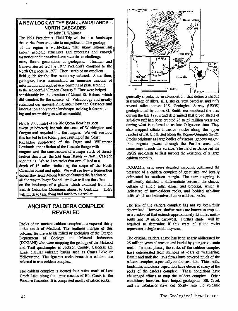
A NEW LOOK AT THE SAN JUAN ISLANDS -NORTH CASCADES
by John H. Whitmer The 1993 President's Field Trip will be in a landscape that varies from exquisite to magnificent. The geology of the region is world-class, with many astonishing
known geologic structures and processes and enough mysteries and unresolved controversies to challenge ~y future generations of geologists. Norman and Geneva Hessel led the 1977 President's campout to the North Cascades in 1977. They asembled an excellent field guide for the fine route they selected. Since then, geologists have accumulated an immense amount of information and applied new concepts of plate tectonic to the wonderful "Oregon Country." They were helped considerably by the eruption of Mount St. Helens. which did wonders for the science of Volcanology and greatly enhanced our undersanding about how the Cascades and information apply to the landscape, making it fascinat-ing and astonishing as well as beautiful.
Nearlv 7000 miles of Pacific Ocean floor has been swept. (subducted) beneath the coast of Washington and Oregon and recycled into the magma. We will see how this has led to the folding and faulting of the Coast Range,the subsidence of the Puget and Willamette Lowlands, the inflation of the Cascade Range with magma, and the construction of a major stack of thrustfaulted sheets in the San Juan Islands -- North Cascade Mountains. We will see rocks that crystallized at a depth of 15 miles, indicating the scope of the North Cascades burial and uplift. We will see how a tremendous debris flow from Mount Rainier changed the landscape all the way to Puget Sound And we will see the effect on the landscape of a glacier which extended from the British Columbia Mountains almost to Centralia. There will much to talk about and much to marvel at.
ANCIENT CALDERA COMPLEX REVEALED
Rocks of an ancient caldera complex are exposed thirty miles north of Medford The southern margin of this volcanic feature was identified by geologists of the Oregon Department of Geology and Mineral Industries (DOG ANI) who were mapping the geology of the McLeod and Trail quadrangles in Jackson County. Calderas are large, circular volcanic basins such as Crater Lake or Yellowstone. The igneous rocks beneath a caldera are referred to as a caldera complex.
The caldera complex is located four miles north of Lost Creek Lake along the upper reaches of Elk Creek in the Western Cascades. It is comprised mostly of silicic rocks,
42
generally rhyodacitic in composition. that define a chaotic assemblage of dikes. sills, stocks, vent breccias, and tuffs several miles across. U.S. Geological Survey (USGS) geologists led by James G. Smith reconnoitered the area during the late 1970's and determined that broad sheets of ash-flow tuff had been erupted 28 to 25 million years ago during what is referred to as late Oligocene time. They also mapped silicic intrusive stocks along the upper reaches of Elk Creek and along the Rogue-Umpqua divide. Stocks originate as large bodies of viscous igneous magma that migrate upward through the Earth's crust and sometimes breach the surface. The field evidence led the USGS geologists to first suspect the existence of a large caldera complex.
DOGAMI's new, more detailed mapping confirmed the presence of a caldera complex of great size and locally delineated its southern margin. The new mapping is sufficiently detailed to differentiate between the chaotic collage of silicic tuffs, dikes, and breccias, which is indicative of intra-caldera rocks, and bedded ash-flow tuffs, which are indicative of extra-caldaera rocks.
The size of the caldera complex has not yet been fully determined However, similar rocks are known to crop out in a crude oval that extends approximately 15 miles northsouth and 10 miles east-west. Further study will be required to determine if this tract of silicic rocks represents a single caldera system.
The original caldera shape has been nearly obliterated by 25 million years of erosion and burial by younger volcanic rocks. In most places, the rocks of the caldera complex have deteriorated from millions of years of weathering. Basalt and andesite lava flows have covered much of the caldera complex, especiually on the east side. Thick soils, landslides and dense vegetation have obscured many of the rocks of the caldera complex. These conditions have challenged efforts to map the caldera complex. Other conditions, however, have helped geologists: Elk Creek and its tributaries have cut deeply into the volcanic
The Geological Newsletter
structure for perhaps millions of years; the Burnt Peak forest fire of 1987 removed large tracts of vegetation north of Burnt Peak; and logging roads have cut into soilcovered mountain slopes.
Caldera complexes often contain bodies of metal ore, originally deposited from hydrothermal fluids. USGS geochemists sampled the area during the late 1970s and early 1980s and determined that many of the rocks within the caldera complex were mineralized. DOGAMI geologists have found evidence of hydrothermal alteration in the rocks of the caldera complex.. this time near the old Burnt Peak lookout. Eight miles northeast of Burnt Peak, the old AI Sarena gold and silver mine is thought to lie within the caldera complex. The AI Sarene Mine produced precious metals between 1909 and 1918, which were then valued at $24,000. Two years ago, the AI Sarene Mine was re-drilled and sampled by the FisherWatt Gold Company. Although the company decided not to pursue further exploration. company geologists did identify as much as 2 million tons of low-grade ore containing gold, silver. and lead
The article above is a news release by DOGAMI on May 10, 1993. I I I I I I I I I I I I II I I I II I I I II I I I I I I I I I I I I I I I I I
HANCOCK FIELD STATION FIELD TRIP, GSOCs, May 14-17,
1993
A group of GSOC'ers 29 strong invaded Hancock Field Station for a three day rendez-vous with nature. The three days were taken up with field trips to look at the geology of the area and the best display of flowers in many years. About 4:30 each day the group.gathered at the camp's first aid station for pre-dinner snacks, relaxation, and plenty of talk After the evening meal some walked in the area and some participated in folk dancing. Later in the evening there was a slide show on geology and plants of different areas. One evening one of the camp teachers brought the telescope out for the GSOCS. During he three days at Hancock the GSOCs visited and sampled the above described geology. Because of the wet spring the hills were very green and the flora was outstanding. A lot of film was used
The pre-dinner gathering was headed up by Gale and Manuel with the rest of the group providing more goodies. In fact it could be said there was enough goodies the 29 participants could have eaten for a week and still had lots left over. All 29 GSOCs contributed to a wonderful weekend of interesting geology, beautiful flowers and great companionship. Next year we'll gather
July 1993
the GSOC's at the at the Hancock Field Station as we have done for the last 15 years. All are invited to attend.
The following information about the Field Station area was taken from AN INTRODUCTION TO THE NATURAL HISTORY OF HANCOCK FIELD STATION AND THE CLARNO BASIN. NORTH CENTRAL OREGON. Oregon Museum of Science and Industry Research Center. Third Edition. 1979. Editor . Bruce Hanson Permission granted to use the material.
Hancock Field Station is near the western border of Wheeler County. which is mostly range land too rough. steep or rocky to cultivate. This area supports a growth of shrubs. some dominant, with an understory of forbes (nongrass like herbs) and grasses.
GEOLOGYOFTHECAMPHANCOCK (HANCOCK FIELD STATION) AREA
by Steve Manchester
The "Clarno Basin" is a broad lowland approximately 207 square miles, surrounded by lava-capped highlands which have been formed by the John Day River and its tributary , Pine Creek. Camp Hancock is situated approximately in the center of the basin. Here, exposed in stratigraphic succession, are the Eocene to Early Oligocene Clarno Formation, the mid-Oligocene to Early Miocene John Day Formation and the Miocene Columbia River Basalt Formation. Although no rocks older than Eocene outcrop in the Camp Hancock area, drill cores from two oil prospects in the camp area and stratigraphic relationships elsewhere in the Clarno Basin indicate that Cretaceous marine sediments exist about 3,400 feet below the surface at the camp. These sediments are tilted and eroded off to form an angular unconformity with the overlying Clarno Formation.
CLARNO FORMATION The Clarno Formation is well exposed in the basin. Hancock sits on tuffs and clays belonging to the Clarno Formation. The Clarno was deposited during times of widespread volcanism and consists mainly of tuffs, mudstones, volcanic breccias, mudflows and andesitic lava flows. Points of particular interest in the camp area which illustrate the nature of the Clarno Formation include the Nut Beds. the Palisades, Red Hill and the Ignimbrite.
THE NUT BEDS Located about one-fourth mile northwest of camp is a deposit of light, buff-colored sediments kno\\n among fossil collectors as the Nut Beds. These sediments consist of well-bedded tuffaceous siltstones. sandstones and conglomerated, standing out from the encasing Clarno tuffs because of their superior hardness. The abundance
43
and distribution of fossil plant debris within the site, coupled with the stratigraphy, suggest that a lake delta deposit is represented.
Although older than most of the Clarno sediments in the Camp Hancock vicinity, the Nut Beds are higher in elevation than adjacent mudflow outcrops. An anticline has apparently uplifted the Nut Bed deposit to its present position above the younger mudflows (Bruce Hanson, oral communication, 1975).
THE PALISADES MUDFLOW Heterogeneous mixtures of large and small rock fragments in volcanic ash area very constant and distinctive lithologic feature of the Clarno Formation. These units, know as mudflows, are generally lithified, commonly forming cliffs.
As a result of volcanic activity during the Clarno times, thick mantles of ash and other volcanic debris probably covered much of the terrain. One can imagine the saturation of such surface layers by tropical rains resulting in tremendous down-slope earth flows. These mudflows were very viscous, bouying up boulders and toppling large trees in their paths.
One such mudflow, or a series of mudflows, formed the beautiful wind-swept cliffs known as the Palisades about a mile southeast of camp. The same flows also outcrop thoughout most of Hancock Canyon. In these exposures can be found huge boulders that were carried along and large tree branches and trunks now fossilized, oriented as they were when carried by the mudflow more than 40 million years ago
RED HILL Red Hill is the name given to a red-colored hill overlying the Nut Beds deposit. It is composed of mudstone and conglomerates in various shades of red, gray and green, now largely altered to clay. The red color of a thick upper layer has been washed over the surface of the lower layers, giving the entire hill a red color. Although best exposed in Red Hill, the same sequence of mudstones and conglomerates has also been found in Hancock Canyon (C.Bruce Hanson, written communication, 1976). The environment for deposition was apparently a quiet lake, a situation quite different from that existing at the time of earlier mudflows and lavas.
THE CLARNO IGNIMBRITE The youngest unit of the Clarno Formation is a hard, flinty welded tuff, or ignimbrite. It is a common cliff former and is easily mapped Because of its wide extent and relatively uniform thickness, it is used as a marker bed in interpreting stratigraphy.
44
Ignimbrites are formed from the cooling of hot, gaseous ash clouds released from volcanoes. Unlike normal volcanic ash eruption, the super heated material fuses together and flows when it reaches the ground, giving the superficial appearance of a lava flow, when weathered. Hand samples of ignimbrite may easily be identified from the presence of flattened pumice fragments.
The ignimbrite appears to represent the last major event of the Clarno Formation. A period of erosion ·without considerable deposition preceded deposition of the overlying John Day beds.
JOHN DAY FORMATION The John Day Formation is perhaps the most colorful formation in the Pacific Northwest. Characterized by greens, reds, whites, and yellows. it is this formation that is responsible for the vari-colored strata of the Painted Hills Park, some 30 miles southeast of Camp Hancock. In the Camp Hancock area, John Day Formation is exposed along the lower slopes of Iron Mountain about two and a half miles north and below Black Butte about five miles west. The John Day Formation consists mostly of waterlaid ashes or tuffs, with some welded tuffs and basalts. The fine grained nature of the volcanic ash, coupled with relatively fast burial, probably accounts for the abundance of well preserved fossils in the John Day Tuffs. The John Day Formation is overlain unconformably by the Columbia River Basalts.
COLUMBIA RIVER BASALT FORMATION
The youngest formation in the Clarno Basin is the Columbia River Basalt, which consists of a thick series of Miocene basalt flows. Extrusion of the Columbia River Basalts began about 20 million years ago and continued intermittently for several million years. These flows are unusual in their mode of origin. They are a plateau basalt, formed not by violent eruption, but by quiet, rapid flowing from fissures. The wide area covered by the lavas (approximately 150,000 square miles) indicates that such fissures occurred in many areas of eastern Oregon and Washington and western Idaho at various times during the Miocene.
Seventeen separate flows forming a total thickness of about 1,000 feet may be counted on Iron Mountain three miles north of the camp. No feeder dikes are known to occur in the Clarno Basin. However, a complex of multiple basalt dikes are exposed in ·Butte Creek, about eight miles north of Iron Mountain (Taylor, 1961)
SELECTED BIBLIOGRAPHY: Hanson, C.B., in progress. A dissertation for the
University of California at Berkeley on geology and
The Geological Newsletter
paleontology for the Camp Hancock area (nearing completion. (Now complete)
Taylor, E.M., 1960. Geology of the Clarno Basin, Mitchell Quadrangle, Oregon. Oregon State University Master's Thesis. 173 pp. (An excellent reference to general geology and petrology of the area. Photo copies for sale by the Oregon Department of Geology and Mineral industries, Portland
I Ill I Ill I IIIII II II I II I Ill I I I I I I I II 1111111
QUARTZ CRYSTAL PHANTOMS AND INCLUSIONS
by Rock H. Currier, Northwest Newsletter, March 1993
In the most simple terms a phantom or inclusion forms when dirt falls on a quartz aystaJ. as it-continues to grow. Of course the "dirt" was actually a coating of dust size aystal.s of another mineral or impurity that CiyStallized with silica at that particular moment If the quartz that covers over the mineral "dust" is transparent you can look into the ccystal and see he coating. The amount of dirt in the ccystal is often quite small and not seen distinctly. In other words the outlined ccystal often looks ghost-like, a "phantom".
If the ccystal is standing straight up when the dust is deposited, the pyramid faces (roof) of the crystal are heavily coated and the prosms (sides) faintly coated Usually the .ctyStals are lying at an angle while the minerals are deposited In that case the top or up faces of the CiyStal receive the bulk of the material. Quite often you see two or three prism faces and part of the termination dusted while the other parts of the earlier crystal can not be seen. This is because the other faces were on the bottom side and were protected from the mineral dust as it ~ed
Sometimes the crystal growth cycle, mineral dust settling and continued crystal growth, repeats dozens of times. This can produce crystals with spectacular inclusions. Over time the mineral dust settling on a crystal changes in composition, leading to quartz crystal with multiple phantoms of different colors. Sometimes the dust that settles on a growing aystal is larger, visually distinct crystals of another mineral. At times the mineral dust that falls on a crystal does so when the aysta1 is very small and or it falls in large enough quantities to obscure the original crystal or crystals. These circumstances can give rise to "gardens" or "landscapes" of inclusions that may mimic the outline of the original crystal. If only one pure mineral comprises the inclusion, the garden color will be the color of that mineral. The color range possible with just one mineral, like hematite, can be remarkable. To the eye, visible hematite crystals are black but in fine
July 1993
particles they can be many shades of brown and red When several minerals are found in a phantom or garden, each growing or being deposited in different sized crvstaiS at the same time or different times, truly colorful and multicolored inclusion can result.
Other types of phantoms can result when dissolved impurities become included in as growing crystal. These tend to form on all sides of the crvsta1 and not be so dependent on the angle in which the ~ is growing. If aluminum, as only one example, becomes included in a growing crystal at a particular time, it may tum that portion of the crystal smoky colored if the crystal encounters enough radiation in the ground Amethysts and zoning in amethyst crystals are caused by similar phenomenon. Some times these impurities concentrate on only certain faces of the quartz crystal because the atomic structure of a particular crystal face will provide conditions that provide a better "home" for the impurities. You can now begin to comprehend the vast number of phantoms and inclusions possible in quartz crystals.
Phantoms are not the exclusive domain of quartz crystals but are found in all minerals. Even opaque mineral crystals have them. Phantoms are the rule rather than the exception. Even in absolutely clear quartz crystals you can usually find large numbers of phantoms if you study them carefully with sensitive scientific equipment.
Most of our phantom quartz crystals came from a mine that we worked in the mountains near a little town of Joaquim Felicio, State of Minas Gerais, Brazil. Almost all of the material has been identified as the mineral clinochlore which is often dark green in color. Red and yellow coloration is more likely caused by small amounts of various iron minerals. ta The Rock Chi r)
HANCOCK FIELD STATION, MAY 14-17,1993
Pictures of the area and some of the activities of the GSOCs. 1. Clarno Formation, NUT BEDS and RED IID..L.
2. Hancock Field Station .
3. Afternoon Happy Hour and pre-dinner eating.
4. Gale guarding the Happy Hour Food
5. Clarno Formation, Palisades, Part of the John Day National Monument.
6. Columbia River Basalt on the west end of the town of Fossil.
45

THE GEOLOGICAL NEWSLETTER
GEOLOGICAL SOCIETY OF THE OREGON COUNTRY
GEOLOGICAL SOCIETY OF THE OREGON COUNTRY
P.O. BOX 907 PORTLAND, OR 97207
~CE1~
Non-PYofit Org. U.S. POSTAGE
PAID Portland, Oregon
Permit No. 999
tEOLOGICAL SOCIETY OF THE OREGON COUNTRY 1993-1994 ADMINISTRATION
BOARD OF DIRECTORS
President Esther Kennedy 626-2374 11925 SW Center Beavertom, Oregon 97005
Vice-President Dr. Donald Botteron 245-6251 2626 SW Luradel Street Portland, Oregon 97219
Secretary Shirley O'Dell 3038 SW Florida ct.,Unit D 245-6882 Portland, Oregon 97219
Treasurer Phyllis Thorne 292-6134 9035 SW Monterey Place Portland, Oregon 97225
Directors Booth Joslin(3 years) Arthur Springer(2 years) Betty Turner(1 year)
Immediate Past Presidents Evelyn Pratt Dr. Walter Sunderland
THE GEOLOGICAL NEWSLETTER Editor: Donald Barr
Calender: Reba Wilcox Business Manager:
636-2384 236-6367 246-3192
223-2601 625-6840
246-2785 684-7831
Rosemary Kenney 221-0757 Assistant: Margaret Steere
246-1670
ACTIVITIES CHAIRS
Calligrapher Clay Kelleher 775-6263
Field Trips Alta Stauffer 287-1708
Geology Seminars Richard Bartels 292-6939 :
Historian Charlene Holzwarth 284-3444
Hospitality (Luncheons)Shirley O'Dell245-6882 (Evenings)Elinore Olson 244-3374
Library Frances Rusch 654-5975
Programs (Luncheons) Clay Kelleher775-6263 (Evenings) Dr. D.Botteron245-6251
Past President's Panel Evelyn Pratt 223-2601
ACTIVITIES
Properties and PA System (Luncheon) Clay Kelleher 775-6263 (Evenings) Booth Joslin 636-2384
Publications Margaret Steere 246-1670
Publicity Evelyn Pratt 223-2601
Refreshments (Friday Evenings) Ros~ Kenney (Geology Seminars) Volunteers
Telephone Cecelia Crater 235-5158
Volunteer Speakers Bureau Bob Richmond 282-3817
Annual banquet Chairperson:Susan Barrett639-4583
ANNUAL EVENTS: President's Field Trip-summer, Picnic-August,Banquet-March, Annual Meeting-February. FIELD TRIPS: Usually one per month, via private car, caravan or chartered bus. GEOLOGY SEMINARS: Third Wednesday, except June, July, August. 8:00 pm, Rm. S17, in Cramer Hall, PSU. Library: Room 57, Open 7:30 P.M. prior to meetings. PROGRAMS: Evenings: Second and Fourth Fridays each month, 8:00pm, Rm. 371, Cramer Hall, PSU, SW Broadway at SW Mill street, Portland, Oregon. · LUNCHEONS: First and Third Fridays each month, except holidays1 at noon. Bank of California Tower, 707 SW Washington, 4th floor Cafeteria, California Room, Portland, Oregon MEMBERSHIP: per year from January 1: Individual, $15.00, Family, $25.00, Junior (under 18) $6.00. Write or call Secretary for membership applications. PUBLICATIONS: THE GEOLOGICAL NEWSLETTER (ISSN 0270 5451) published monthly and mailed to each member. Subscriptions available to libraries and organizations at $10.00 a year. Individual subscriptions at $13.00 a year. Single copies $1.00. Order from Geological Society of the Oregon Country, P.O.Box 907, Portland, Oregon. TRIP LOGS: Write to the same address for price list.
THE GEOLOGICAL NEWSLETTER The Geological Society of the Oregon Country
P.O. Box 907 • Portland, OR 97207
VISITORS WELCOME INFORMATION PHONE 28h-4320
VOLUME 59, NO. 8
CALENDAR 0? ACTIVITIES FOR AUGUST, 1993
ANNUAL PICNIC N 0 T I C E ! ! ! ! !
August 13 LOCATION: Picnic will be held at the SUNDERLANDS. See enclosed map for directions on how to get there.
TIME: Come any time after 3:30 P.M. We wil eat at 6:30 P.M.
BRING: Hot dish, salad or dessert for three or ----- more people and yourself. Bring your own
table service including serving utensil. Coffee and juice will be provided,
FRIDAY NIGHT LECTURES (Cramer Hall, PSU, Room 371, 8:00P.M.).
August 27 No meeting.
FRIDAY LUNCHEONS (Bank of California Tower, 707 SW Washington, 4th floor, . Social Hr. , cafeteria 11:30 A, M, ; Program, California Rm. at 12:00 noon),
August 6 "Thirty-four years of Engineering in Alaska", Presented by John Bonebrake, GSOC member,
August 20 No meeting - Clay and family on camping trip.
GEOLOGY SEMINAR (Cramer Hall, PSU, Room S-17, 8:00P.M.),
No seminars until September.
GSOC LIBRARY (Cramer Hall, Portland State University, Room S-7. Open 7:00 - 8:00 P.M. prior to evening meetings,)
PRESIDENT'S FIELD TRIP: September 25, October 1, 1993. At this time the trip is full, but if you are interested in going, please call Esther Kennedy, 626-2374 to put your name on the standby list,
Recommended reading in preparation for the trip: (1) "Cascadia" by Bates McKee, (2) "Cascade-Olympic Natural History". A Trailside
Reference by Danial Mathews. (3) "Fire and Ice" by Stephen L, Harris. (4) "Geologic History and Rocks and Minerals" by
Vaughn Livingston. (5) "Washington Geologic Newsletter" Vol. 18, #1, 3/90
Vol, 19, #4, 12/91 Additional reading available at GSOC library.
August 1993 47
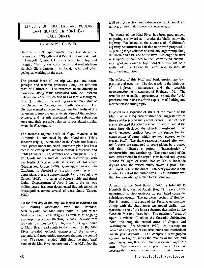
EFFECTS OF HOLOCENE AND MODERN EARTHQUAKES IN NORTHERN
CALIFORNIA
BY WENDY J. GERSTEL
On June 5. 1992 approximately 175 Friends of the Pleistocene (FOP) gathered at Patrick's Point State Park m Humbolt County. CA for a 3-day field trip and meeting. The trip was led by faculty and students from Humbolt State University in Arcata. CA and other geologists \VOrking in the area.
The general focus of the trip was past and recent geologic and tectonic processes along the northern coast of California. The processes relate directlY to movement along faults associated with the Casc~dia Subduction Zone .. which also lies west of Washington. (Fig. 1 ). I attended the meeting as a representative of the Division of Geology and Earth Sciences. The Division wanted someone to examine the results of this tectonism to improve our understanding of the geologic e\idence and hazards associated with the subduction zone and their possible relation to postulated similar events in Washington.
The tectonic regime north of Cape Mendocino in California is dominated by the Mendocino Triple Junction (Fig. 1). Subduction ofthe Gorda and Juan de Fuca plates under the North American plate has left a record of earthquake induced coastal subsidence and uplift (Atwater. 1987: Atwater and Yamaguchi. 1991). The Gorda and the Juan de Fuca plates converge with the North American plate at a rate of 3-4 cm/vr (Minster and Jordon. 1978). Convergence in northe~ California is absorbed by crustal shortening of the upper plate, at a rate approximately 3 cmi}T (Clark and Can·er. 1992). in a series of oblique folds and thrust faults. Displacement of about 1 km in the last one million years has been documented through trenching investigations across several of these faults (Carver. 1987).
On the first day of the trip. we looked at evidence for the faulting associated with the Trinidad. McKinleyville. and Mad River faults. all part of the Mad River Fault Zone (Fig.2). as well as at ongoing geomorphic processes affecting the coast. A walk from the \ista overlook on U.S. Highway 101 (Fig.2) down to Clam Beach and south to the mouth of the Mad River revealed te;...1.book examples of the tectonic. geologic. and geomorphic processes shaping the coastal area. The recently eroded cliffs along the right (east) bank of the Mad River expose part of the McKinl~'\ille
48
fault in cross section and sediments of the Clam Beach terrace. a raised late Holocene marine terrace.
The mouth of the Mad River has been progressively migrating northward as it erodes the bluffs below the highway. We looked at the attempts of California's highway department to halt this northward progression by placing large volumes of sand and large riprap along the north and east side of the river. Although the river is temporarily confined to the constructed channel. most geologists on the trip thought it \\ill just be a matter of time before the river re-establishes its northward migration.
The effects of this bluff and bank erosion are both positive and negative. The down side is the high cost of highway maintenance and the possible reconstruction of a segment of Highway 101. The benefits are scientific--opportunities to study the fluvial processes and to obsen·e fresh exposures of faulting and marine terrace stratigraphy
Exposed in a sequence of strata at the mouth of the Mad River is a sequence of strata that suggests two or three sudden (coseismic ) uplift events. Each of these events elevated the active wave-cut platform and at the same time displaced the shoreline westward. The newly exposed seafloor became the source for the construction of dunes, which are now e:>.-posed in the coastal bluff. The dune sequences created after each uplift event are separated in some places by a buried soil that indicates a period (interseismic) of nondeposition and weathering. The outer wood of the fossil trees rooted in the upper- most buried soillavered yielded 14C ages of about 300 )T BP. A landslide deposit near the raised dunes covers a peat that developed behind the dunes. The peat provided a date similar to that of the buried trees. The landslide was therefore probably generated by the same uplift.
A visit to the Mad River Slough, a tributary to Humbolt Bay. west of Arcata (Fig. 2) gave us the opportunity to view evidence for postulated coseismic subsidence events. The northern portion of Humbolt Bay is located in the axis of the Freshwater svncline. Along with the fault zones mentioned earli~r. this syncline is one of the largest features that make up the Cascadia fold and thrust belt. The relation of areas of uplift is evident all along the Cascadia Subduction Zone. including the coastal areas of Oregon and Washington. (See Shipman. 1990). At this stop. we looked at a sequence of estuarine muds and interbedded marsh peat deposits. The composite stratigraphic column in Fig. 5b sho,vs the relation of the peat and mud layers. together with their associated ages 14C ages. The existence of a peat layer does not necessarily represent a subsidence event: however.
The Geological Newsletter
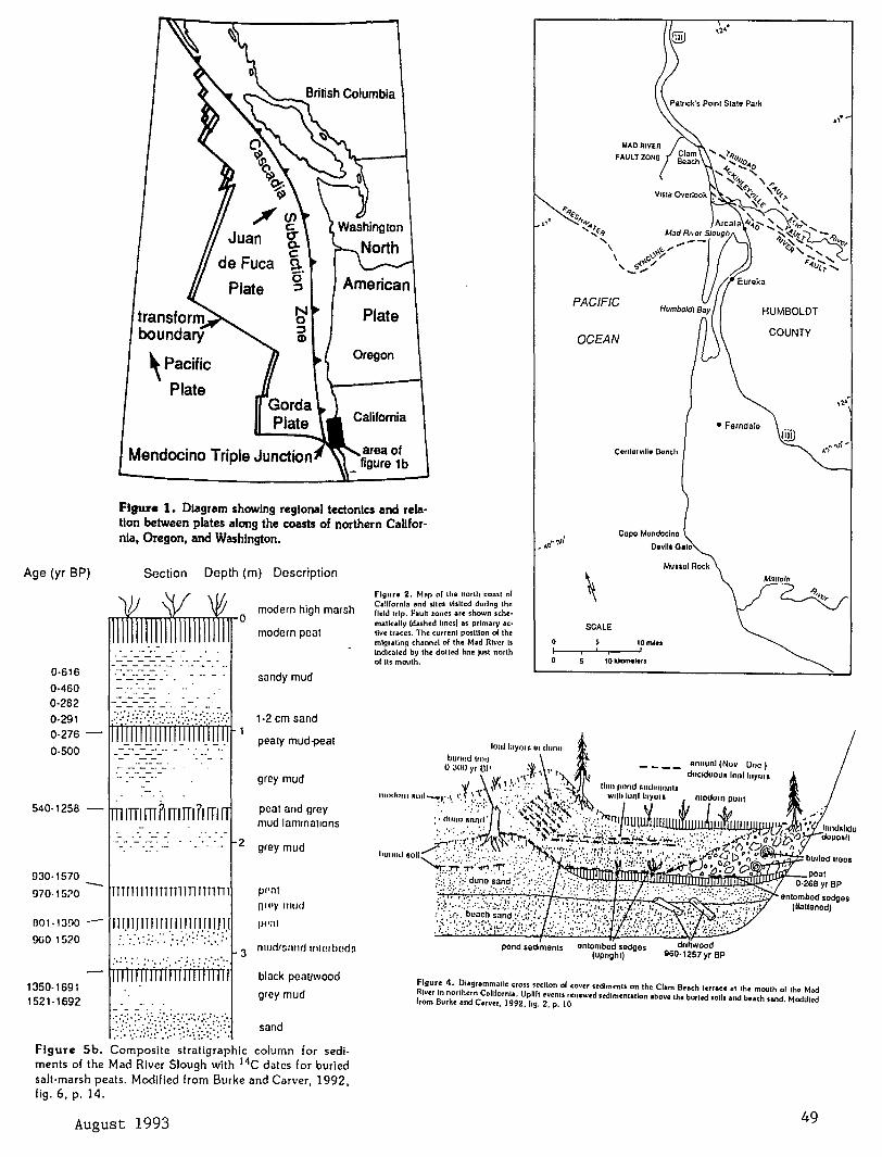
Age (yr BP)
0-616
0-460 0-282
0·291 0-276
0-500
930-1570
970-15:>0
001· 1300
9UO 1520
-
\Pacific Plate
Mendocino Triple Junction
Plate
Oregon
California
Figure 1. Diagram showing regional tectonics and relation between plates along the coasts of northern Callfornia, Oregon, and Washington.
Section Depth (m) Description
----- ·------ ·-- -
TTTTTTTTTTTTTTTliTTTTllll
11111 J1111lllll111lllllll : .··:: ·.: .:.:.:·. ·.: ·• :-.:·: :" :: ::.~ .: :
2
modern high marsh
modern peat
sandy mud
1·2 em sand
peaty mud-peat
grey mud
peat nnd grey mud lammnuons
grey mud
pPnl
O"'Y IIIIJd
j)l':tl
3 mud15;md rntorbeds
figure 2. Mnp of the north coast of California and sllcs visited during the field trip. Fault zones are shown sche· matlcally (dashed lmcs) as primary ac· Uve traces, The current position of the migrating channel of the Mad River Is Indicated by the dotted line just north of Its mouth.
pond sed1men1s
PACIFIC
OCEAN
Contorvlllu Oonth
Capo Mondocino
Oovllo Galo
SCALE
tO miles
10kikmeters
enlombod sedges (upnghl)
Muuol Rock
• Ferndale
.,.
COUNTY
Mmtoln
~
onlombod sedges (llallenod)
1350-1691 1521·1692
black peauwood
grey mud Flgur~ 4. Diagrammatic cross sccllon ol cover stdlmmts on the Clam Brach terrae~ at the mouth of the Mod River In northern California, Uplift events rcnew~d sedimentation above the burled soils and beach lAnd. Modiflrd from Burke and Carver, 1992,11g. 2, p. 10
:_::/\):}/}:~:~~;{(/;;~~:·~·: sand
Figure Sb. Composite stratigraphic column for sediments of the Mad River Slough with 14C dates for buried salt·marsh peats. Modified from Burke and Carver, 1992, fig. 6, p. 14.
August 1993 49
Subsequent stops provided us with a variety of views of the surface expression and stratigraphy of the fold and fault systems. A highlight of the trip was the visit to the most recently affected coastal area. Here we saw the results of three earthquakes (magnitudes 7.0. 6.0. and 6.5. respectively that occurred on April 25 and 26. 1992. In the Cape Mendocino area. the earthquakes triggered land slides and rock falls: damaged and destroyed buildings. roads and bridges: and caused liquefaction of soils. In addition. the earthquakes created a spectacular stretch of coastline that has been raise at least 1 m. Analysis of the seismic data from the April 1992 earthquakes has led the trip leaders and other scientists to believe that the first of the April earthquakes might have been the first historic earthquake along Cascadia Subduction Zone. The data suggest that slip actually occurred along the boundary between the subducting and overriding plates. rather than being absorbed along faults within the upper (or lower) plate. This would support the argument that the plates are indeed locked during the time between earthquakes and not sliding past each other aseismically. However. the precise location of the earthquake's epicenter is difficult to determine, and each may. instead, have occurred on any one of the numerous northeast-dipping thrust faults in the area.
The stretch of the coast line that experienced maximum uplift during the most recent earthquakes lies between Devil's Gate and Mussel Rock north of the Matttole River Fig.2) . This stretch of beach offered an opportunity to view the active processes that formed the buried dunes and soils we saw at the mouth of the Mad River. A strong northwest wind was blowing during our visit to the beach site. Coarse sand from the recently exposed swash zone was being transported landward and deposited on top of the pre-existing finer beach sands. This created the unusual grain-size contrast .
As previously mentioned. further evidence of the most recent uplift is visible. The seaweed was killed when lifted out of the tidal zone; it has since turned white. The tide-line is now about 1 m lower, relative to the rocks. than its pre-earthquake position. Dead sea urchins. possibly shaken loose from their perches and washed rip in a subsequent tsunami or other wave surge. litter the beach at the edge of the waves. Dead mussel beds have been recorded in the area.
A final series of stops related to the fluvial terraces along the Mattole River to the region's tectonic activity. Here. Dorothy Merritts. of Franklin and Marshall College in Lancaster. PA discussed a proposed new model for the intricate relation that exists between stream gradient and tectonically and climatically induced base-level changes occurring in the mouths of coastal rivers. Some of the questions addressed by the model of Merritts and other
50
(1992) include: How are strath terraces. which are cut into bedrock. fonned and abandoned'! Can terrace remnants be correlated along a river's longitudinal profile? and How far upstream are the effects of baselevel changes transmitted?
Basing their model on the results of ex1ensive detailed surveys of channels.bars. floodplains. and terraces of three large rivers near Mendocino Triple Junction. they concluded that. in contrast to classical fluvial response models. it is incorrect to assun1e ( 1) fluvial terraces merge with marine terraces. (2) strath surfaces form at times of sea-level highstand. and (3) abandonment due to vertical incision must occur during times of falling base level. In general. the model of Merritts and others proposes that the size and power of the river. and consequently the valley width. control the formation and preservation (Or lack of) of strath and fill terraces.
Although most current studies in Washington focus on evidence for coseismic subsidence (Atwater.l987: Atwater and Yamaguchi. 1991 ). areas of coastal uplift are also documented (Shipman. 1990) . Viewing first hand the consequences of coseismic uplift. subsidence. and ground shaking in northern California will help Washington geologists interpret the local stratigraphic record and more effectively evaluate and mitigate potential earthquake hazards in the Pacific Nothwest.
REFERENCES CITED: Atwater. B.F .. Evidence for great Holocene
earthquakes along the outer coast of Washington State: Science, v. 236, no. 4804-, p. 942-944.
Atwatrer, B.F.: Yamaguchi,D.K.. 1991, Sudden. probably coseismic submergence ofHolocene trees and grass in coastal Washington State: Geology. v. 19, no. 7. p. 706-709.
Burke, R.M.; Carver. G.A.. coordinators. 1992. Pacific celL Friends of the Pleistocene guidebook for the field trip to northern coastal California: Friends of the Pleistocene. 265 p. For information contact R.M.Burke. Geology Department. Humbolt State University. Arcata, CA 95521).
California Geology. March!April1992: California Department of Conservation. Division of Mines and Geology, 64 p.
Carver. G.A. 1987. Late Cenozoic tectonics of the Eel River basin region. coastal northern California. In Schymiczek. Herman. Suchland. Reinhard. editors. Tectonics. sedimentation and evolution of the Eel River and associated coastal basins of northern California: San Joaquin Geological Society Miscellaneous Publications 37, p. 61-72.
Clark. S.H .. Jr.: Carver. G.A.. 1992. Late Holocene tectonics and paleoseismicity. southern
The Geological Newsletter
evolution of the Eel River and associated coastal basins of northern California: San Joaquin Geological Society Miscellaneous Publications 37. p. 61-72.
Clark. S.H .. Jr.: Carver. G.A.. 1992. Late Holocene tectonics and paleoseismicity . southern Cascadia subduction zone: Science. v.255. no. 5041. p. 199-192.
Merritts. D.J.: Dunklin. T.B.: Vincent. Kirk: Wahl. Ellen: Bull. W.B. 1992. Quaternary tectonics and topography. Mendocino Triple Junction. In Burke. R.M.: Carver. G.A.. coordinators. 1992. Pacific cell. Friends of the Pleistocene guidebook for the field trip to northern coastal California: Friends of the Pleistocene, p. 119-169.
Minster. J.B.: Jordon. T.H .. 1978. Present day plate motions: Journal of Geophysical Research. v. 83, no. Bll, p. 5331-5354.
Shipman. Hugh, 1990, Vertical land movement in coastal Washington: Washington Geologic Newsletter. v. 18. no. 1, p. 26-33.
The above article was taken from WASHINGTON GEOLOGY. Vol.20, No.4. December 1992 with permission. Some pictures not printed due to space limitation.
I Ill I I II I I II I I I I I I I I I I I I I I I I I I I I I I I I I
COMPLETELY FRACTURED GEOLOGY
by Ralph & Evelyn Pratt
1. Tufa: not near, as in "That's tufa away."
2. Patina: what you say to a stubborn toddler- "If you don't get moving, I'll give you a patina rear."
3. Rodule: time for a Christmas nap
4. Alate: the reason Al's not hungry
5. Intrusive: when two warring factions declare temporary peace; opposed to extrusive, when they're battling
6. Phreatic: no rent charged for the top floor
7. Aggradation: what teenagers in a family cause a lot of
8. Magma: Latin for "Big Marna"
9. Phylum: answer to "What should I do with last year's canceled checks?"
August 1993
I 0. Tectonic: a local electronics firm needs this to pep it up
***CORRECT ANSWERS TO FRACTURED GEOLOGY ON P. 52.*** I I I I I I I I I I I I I I I I I I I I I I I I I I I I I I I I I I I
AFTER 87 YEARS, QUARREL OVER WHITE RIVER MAY END.
by Jill Leavy. This article taken from The Seattle Times, Tuesday,
April 13, 1993 and reprinted with permission. Pictures not printed. Proposal would end payment from King County
Auburn - This could be the year that Pierce and King counties would put to rest the 87-year old quarrel over a river neither wanted. But the lingering suspicions may be as eternal as the river
If the quarrel is patched, King County would no longer pay thousands of dollars in annual flood -control cost to Pierce County - money it has been paying since the two feuding governments come to an uneasy agreement in 1914.
The rift dates back to one morning in 1906, after days of dreadful floods, when north Auburn settlers awake to an astonishing sight: The mighty White River - cause of so much of their woe had disappeared.
Instead of roaring north through Auburn to join the Green and Duwamish rivers, the river was flowing south- and was to do so forever after.
It didn't take long for flood weary Auburnites to • decide the new landscape was good. To make sure it
stayed that way, they built a dike. No more were King County's farmers to be
tormented by relentless floods of the White River. Instead, they had a brand new strip of gravel on which to build Main Street. I I II I I I I I I I I I I I I II I I I I I II II I I I I I II II I I I
++'I couldn't get a straight story on it.' Josie Emmons, author of a history of Auburn, on what caused the White River to change course. I I I I I I I I I I I I I I I I II I I I I I I I Ill I I I I I I I I I
But down south, in Pierce County, that strange day took lives and transformed cropland into vast, shallow lakes. There, farmers seethed, even as neighbors to the north rejoices.
What cause the diversion? Rumors of foul play still bubble. But most hold to the story that a log jam of debris from upstream blocked the river's course and sent spilling down a new channel to the south.
What's clear is that diversion forever changed the history of Auburn Valley, said Gary Reese, local historian and manager of special collection at Tacoma
51
Since 1906, the White River has flowed mostly within the borders of Pierce County. It has doubled the volume of water in Puyallup River Basin and has prompted considerable diking and grooming downstream. said Tim Ramsaur, of Pierce County's river systems management.
Under the 1914 compromise, which was the outcome of court battles and legislation. King County was to pay a larger share of the costs of flood control on the river. But if the proposed amendment to the so-called InterCounty River Improvement agreement passes this year as planned, 70 years of payment will come to an end.
Though some cooperative efforts would continue, for the most part the two counties would part ways - King would manage its three miles of river north of the border, leaving Pierce to handle its 11 to the south, said David Clark, section manager of King County river program.
In some way, the amendment would close the book on the historic feud.
But dispute over how the cataclysm come to pass in the first place may never be settled.
"I couldn't get a straight story on it," said Josie Emmons, who wrote a history of Auburn for its centennial two years ago.
Emmons said conventional wisdom is that the logjam alone was enough to force the river southward where it joined the smaller Stuck River and flowed into the Puyallup. But retired Auburn schoolteacher, Edith Peterson-who was 11 at the time- said she remembers differently.
"It was done purposefully," she said, a little slyly. Peterson said several young men from Auburn, sick of floods, dynamited a hillside and blocked the river. How does she know? Her father told her, she said.
Historian Reese said the truth is clouded by folklore. It's common to try to blow up logjams to release them, so dynamiting may not have been done for mischievous ends, he said.
Reese, though, won't rule out human intervention: "There was a lot of pushing and shoving at the time"
Perhaps the rumors contributed to what King County's Clark calls acrimonious relations between the two counties following the 1914 agreement.
Such things cast a long shadow: Although both sides claim relations are much better than they were, disputes persist.
In recent years, for example, Pierce County has accused King County of shirking its bills. King County paid about 3.3 million of the 6.1 million spent on the White River flood control between 1914 and 1986-somewhat less than the 60 percent it owes, said Ramsaur. And for the past several years, King County has declined to pay its bills, period.
"We were asking them (Pierce County) to document how they were spending it and they never did," explained David Clark.
52
Both Clark and Ramsaur seem hopeful that the whole issue will go away soon with the approval of the amended agreement by each county's council. And that would probably suit those Auburn fanners just fine.
According to schoolteacher, Peterson, they never really wanted to say much about the radical ne\v course of the area's largest river. "Would you?" she asked.
CORRECT ANSWERS TO "COMPLETELY FRACTURED GEOLOGY"
Modified from Dictionary of Geological Terms, 3rd Ed., AGI, Bates & Jackson
1. Tufa: calcareous & siliceous deposits of springs. lakes, & ground water
2. Patina: thin layer producedon surface of rock or on copper, formed by weathering
3. Nodule: small lump of mineral in a rock matrix of differing composition; also, manganese lumps on the ocean floor
4. Alate: winged or winglike; said of some fossil brachiopod shells
5. Intrusive: having to do with the emplacement of magma in pre-existing rock; extrusive describes igneous rock erupted onto earth's surface
6. Phreatic: pertains to ground water
7. Aggradation: the process of building up a surface by deposition
8. Magma: molten rock within the earth
9. Phylum: one of the broad categories used in the classification of living things
10. Tectonic: having to do with major structural features nd deformations of the outer part of the earth
The Geological Newsletter

THE GEOLOGICAL NEWSLETTER
SEP 93
GEOLOGICAL SOCIETY OF THE OREGON COUNTRY
GEOLOGICAL SOCIETY OF THE OREGON COUNTRY
P.O. BOX 907 PORTLAND, OR 97207
Non-Profit Org. U.S. POSTAGE
PAID Portland, Oregon
Permit No. 999
GEOLOGICAL SOCIETY OF THE OREGON COUNTRY 1993-1994 ADMINISTRATION
BOARD OF DIRECTORS
President Esther Kennedy 626-2374
11925 SW Center Beavertom, Oregon 97005
Vice-President Dr. Donald Botteron 245-6251 2626 SW Luradel Street Portland, Oregon 97219
Secretary Shirley O'Dell 3038 SW Florida Ct.,Unit D 245-6882 Portland, Oregon 97219
Treasurer Phyllis Thorne 292-6134 9035 SW Monterey Place Portland, Oregon 97225
Directors Booth Joslin(3 years)
Arthur Springer(2 years) Betty Turner(1 year)
Immediate Past Presidents Evelyn Pratt Dr. Walter Sunderland
THE GEOLOGICAL NEWSLETTER
636-2384 236-6367 246-3192
223-2601 625-6840
Editor: Donald Barr 246-2785 Calender: Reba Wilcox 684-7831
Business Manager: Rosemary Kenney 221-0757 Assistant: Margaret Steere
246-1670
ACTIVITIES CHAIRS
Calligrapher Clay Kelleher 775-6263
Field Trips Alta Stauffer 287-1708
Geology Seminars Richard Bartels 292-6939
Historian Charlene Holzwarth 284-3444
Hospitality (Luncheons)Shirley O'Dell245-6882 (Evenings)Elinore Olson 244-3374
Library Frances Rusch 654-5975
Programs (Luncheons) Clay Kelleher775-6263
(Evenings) Dr. D.Botteron245-6251 Past President's Panel
Evelyn Pratt 223-2601
ACTIVITIES
Properties and PA System (Luncheon) Clay Kelleher 775-6263 (Evenings) Booth Joslin 636-2384
Publications Margaret Steere 246-1670
Publicity Evelyn Pratt 223-2601
Refreshments (Friday Evenings) Volunteers (Geology Seminars) Volunteers
Telephone Cecelia Crater 235-5158
Volunteer Speakers Bureau Bob Richmond 282-3817 Annual banquet
Chairperson:Susan Barrett639-4583
ANNUAL EVENTS: President's Field Trip-summer, Picnic-August,Banquet-March, Annual Meeting-February. FIELD TRIPS: Usually one per month, via private car, caravan or chartered bus. GEOLOGY SEMINARS: Third Wednesday, except June, July, August. 8:00pm, Rm. S17, Cramer Hall, PSU. Library: Room S7, Open 7:30P.M. prior to meetings. PROGRAMS: Evenings: Second and Fourth Fridays each month, 8:00pm, Rm. 371, cramer Hall, PSU, sw Broadway at sw Mill street, Portland, Oregon. LUNCHEONS: First and Third Fridays each month, except holidays at noon. Bank of California Tower, 707 sw Washington, 4th floor Cafeteria, California Room, Portland,Oregon MEMBERSHIP: per year from January 1: Individual, $15.00, Family, $25.00, Junior (under 18) $6.00. Write or call Secretary for membership applications. PUBLICATIONS: THE GEOLOGICAL NEWSLETTER (ISSN 0270 5451) published monthly and mailed to each member. Subscriptions available to libraries and organizations $10.00 a year. Individual subscriptions at $13.00 a year. Single copies $1.00. Order from Geological Society of the Oregon Country,P.O.Box 907, Portland, oregon 97207. TRIP LOGS: Write to the same address for price list.
THE GEOLOGICAL NEWSLETTER The Geological Society of the Oregon Country
P.O. Box 907 • Portland, OR 97207
VISITORS WELCOME VOLUME 59, NO. 9 INFORMATION PHONE 284-4320
CALENDAR OF ACTIVITIES FOR SEPTEMBER, 1993
~RI~~!_NIGH!_LEC!~RES (Cramer Hall, PSU, Room 371, 8:00P.M.)
Sept. 10 "Costa Rica- Land of Peace and Beauty", A slide :presentation by Lois Sato, GSOC member,
Sept. 24 No meeting.
FRIDAY LUNCHEONS (Bank of California Tower, 707 SW Washington, 4th floor. Social Hr., cafeteria 11:30 A.M.; Program, California Rm. at 12:00 noon).
Sept. 3 No meeting.
Sept. 17 "Two Sides of the Baltic Sea", A slide :presentation by Helen Nelson, GSOC member.
GEOLOGY SEMINAR (Cramer Hall, PSU, Room S-17, 8:00P.M.).
Sept. 15 "Geologic Time - Relative and Absolute Dating Methods", An illustrated :presentation by Richard Bartels,
GSOC LIBRARY (Cramer Hall, Portland State University, Room S-7. Open 7:00- 8:00P.M. :prior to evening meetings,)
PRESIDENT'S FIELD TRIP: September 25 through October 1,
September 1993
The trip is in the final stages of :planning! A letter of information will be mailed to each person or ·couple, One thing to start thinking about is, the bus is full which makes it imperative to limit baggage. No trunks £!! this triE_!
If anyone did not register in time and still is interested in going, get your name on the waiting list. Who knows I may not go!
Any questions? Call Alta Stauffer 287-1708 or Esther Kennedy 626-2374.
53
CITIES AND GEOLOGY by Robert F. Legget
Review by Rosemary Kenney. Past President GSOC
Most cities have developed in too much of a rush to pay regard to the natural environment. particularly to geologic conditions. It is very often forgotten that the geological history of land is so important as a guide to city planning. Without accurate knowledge of subsurface conditions beneath the land that is to be used for city gro\\th. sound planning cannot be carried out. Neglect of geological structure can lead to serious economic loss.
Rome was thought to have a population of 1 million people bv A.D. 100. then declined. In 1800. there was no more than 50 cities in the world with a population of more than 100.000. and only one city with more than 1 million inhabitants - The City of London. In 1900. there were only 12 cities with over 1 million population. Today, there are more than 100 cities with more than 1 million people, 27 with more than 3 million. and a few with 5-7 million.
Hammurabi of Babylon (2067-2025 B.C.) stated "If a builder build a house for a man and do not make its construction firm and the house which he built collapse and cause the death of the ov.ner of the house. that builder shall be put to death... If it destroy property, he shall restore whatever it destroyed and because he did not make the house which collapsed at his mm expense." The Code of Hammurabi was probably the first set of building regulations ever recorded They date back almost 4000 years.
Ancient cities grew from small settlements. founded for clearly recognizable reasons: near the sea coast, near the mouth of a river. near conenvient crossings for fords of rivers, supply of good drinking water, site for natural defense security. supply of good building material, and the development of mines are all results of local geological conditions.
Some cities just grew, with no planning of any sort. With others. building was carried out in defiance of nature of which time has taken its toll. The major part of city planning is to have a balance in the distribution of industries and population, both within cities and between cities and county districts. transportation facilities. community facilities, public utilities. housing and public buildings. aesthetic values. and natural environment are all considered Geology is one of the most vital parts of this complex process. Knowledge of what the surface ground looks like. what lies beneath the surface. character of the materials that make up the land on which the city is to grow and the position and nature of the water in the ground beneath the site are all very important.
54
A new city can never be planned or designed in total disregard of its environment. Flood plains appear to be ideal areas for building but they provide difficult and e:\.-pensive problems for building foundations. and there is always the potential hazard of flooding. Sloping ground that appears to be stable may be underlain by clay or are scars of old landslides. Limestone regions may have natural caves beneath the surface. Leaching of salt beds by ground \Vater may cause settlement of ground surface.
Great Britain contains more varied geological conditions for its size than any other part of the world. Many cathedrals of England have suffered from foundation trouble. The towers of Winchester, Gloucester. and Worcester fell in the 12th century. York Minster. one of the largest medieval buildings in northern Europe. has serious cracks in the superstructure. and there is differential settling due to a stratum of brown clay,
The Tower of Pisa has its foundation problems. New York City developed from a small Indian settlement of Manhattan that was founded on the rocky island between Hudson River and Long Island Sound. Skyscrapers arc proof of sound and strong foundations beds.
Some geological hazards are man-made. Venice is located at the head of the Adriatic Sea. Three local river were diverted, a sea-protection wall was built. and the city gradually developed by building upon the mud of the lagoon. There is now a progressive subsidence of the bed of the lagoon due to the pumping of ground water from the aquifers beneath it. There are many examples of subsidence due to mining. In England, a steam locomotive suddenly disappeared into old coal workings. Pittsburgh, Pennsylvania has problems with old coal mining shafts. People in Helena. Montana. have to be careful when digging basements for home because. of old gold mines.
When earlv man was unable to use caves for shelters, he was forced to find building material: wood, grass, soil to make adobe and bricks, and stone. Metals are obtained by the refining of ores mined from the ground. Trees that supply lumber are grown in soil, asphalt used in road construction comes from natural asphaltic deposits or from refining crude oil.
Everv structure transfers the load it carried to the ground ben~th it. Beneath every building. roadway, bridge. airport, railroad. there must be geological strata that is adequate to support the loads that these structures have to carry.
Geological conditions at any building site may be one of three general types: I. Solid rock may be exposed at the surface or lie close to it so that structures can be built upon rock with minimum excavation. New York city is a good example.
The Geological Newsletter
2. Bedrock may lie below the surface at such a distance that piles or caissons can be used. Chicago is built on Niagara dolomite 30 m below ground surface. 3. Bedrock may be so far below the surface that it would be uneconomical. sometimes impossible to transfer loads to it. so all foundations must rest upon overlying strata. Bedrock at Saskatoon. Canada. is 1000 m below the surface of the ground.
Water supply and installation of the necessary pipes or tunnels in proper relation with the street layouts: the interrelationship of roadway arrangements to give convenience and efficiency to traffic. installation of necessary traffic controls at critical locations before roadways are finished location of bridges so that they don't interfere with later installation of services. whether electrical pov;er-supply cables are to be buried or suspended from poles. all depend on geological conditions underlying the site.
Tunnels, old mines. underground quarries. large underground excavations are not all bad. Many are used for other purposes: underground factories. underground storage areas. mushroom farms. underground marine docks. underground security systems. and underground power houses and pumping stations of hydroelectric projects are just a few.
So. \\-ithout good geological planning. there are many hazards to cities: landslides: volcanic action; geologically active faults and slides: earthquakes: tsunamis; floods; mud flows: rock falls and slides; avalanches: sink holes; subsidence due to mining: soils: extraction of ground fluids; swelling of soils and rocks; changing sea levels; and permafrost and other temperature changes.
This is a fascinating book. I would recommend it to everyone, not just city planners. (1.
WESTSIDE MAX FACTS GEOLOGY
The following material taken from WESTSIDE MAX FACTS: Going Underground: Design moves forward for the West Hill Tunnel.
GEOLOGY Tri-Met has drilled more than one hundred holes. some
more than 300 feet deep. to sample the subsurface soil. rock, and groundwater conditions that will be encountered during tunnel construction
This geotechnical exploration revealed the geology of the West Hills tunnel to be widely varied. Conditions range from hard rock to soft silt deposits. with abrupt changes in geology within short distances.
September 1993
For about two miles. from the east tunnel portal to the Sylvan area. the tunnel will pass layers of Columbia River Basalt. a rock unique to the Pacific Northwest that dates back 13 to 17 million years.
West of Sylvan the sum·surface changes to Sandy River Mudstone. a finely grained silty clay. and Boring Lava. a harder and more stable rock. Along the alignment. Sandy River Mudstone is layered "ith Boring Lava. recording the turbulent volcanic activity that took place in the West Hills mi.llons of years ago. Rock conditions change in the Sylvan area, presenting tunnelers with "mixed face" conditions-rock types of different tex"ture. age and density combined with soil layers \'rithin the tunnel area. m
WHAT ABOUT COPPER
Those pretty blue and green stains you often see on rock outcrops when on a field trip are kno\'rn as "copper bloom" and they can be a guide to finding copper and its associated minerals. Copper is usually found in rather distorted perhaps rounded and complex crystals. The predominant crystal forms are cubes. Dodecahedrons and octahedons. however. sometimes they are hackly masses which are interesting. for there are unusual shapes---sometimes a man laughing. a dog or any other identification you might choose to make.
Everyone is familiar with the lovely color of pure copper; in fact, it is often used as an identifying term for associated colors. It can have a metallic luster, and while the hardness is only 2.5-3.0, it is very heavy, with a gravity of8.9 and like silver and gold is malleable and ductile. Copper will !ose the lovely " copper-red" color when exposed to air. in much the same way copper penny dulls after time. but you can always clean it and restore the beauty.
Copper is extremely important today as it has been since the earliest recorded history. Because of its excellence as an electrical conductor it is used in much of the electrical equipment so prevalent today. Can you imagine what it would be like not to have copper available for the power lines which bring the electricity into your homes from the generating source. How much we take for granted?
When copper is alloyed with zinc, you have brass. and for bronze you combine copper and tin. Much of the popular magnesium metal is alloyed with small amounts of copper because it makes it more desirable. There are really too many uses for copper to attempt to name them all. but it can be fun for a Trivial Pursuit sort of game to see just how many you can name.
The most famous area for large amounts of native copper is the Keweenaw Peninsula in Michigan. It has been mined for over a hundred years along the shores of Lake Superior. One
55
huge mass was found which weighed about ·1-20 tons. Native copper can also be found in shale in the Michigan area.
"Copper glance" chalcocite. is valuable copper ore. (Chalcocite in ore deposits. contain approximately 2 - 3 % copper. and when in pure form. such as crystal aggregates. the copper may be as high as 80%. Editor) However. when processed on a large scale. a tremendous amount of rock must be minted to obtain even a pound.
Most everyone has heard of peacock copper. but how about purple copper ore or variegated copper ore? All of these names describe Bornite, which is named for the Austrian mineralogist Von Born. This is easily identified by the bright iridescence. that often brings exclamations of pleasure at seeing such beauty.
If you haven't seen a Half Breed, you should ! ! True. some of them are more like nuggets. but when you see a truly lovely Half-Breed, you will see copper crystals combined with silver crystals. and they are something to behold Even those who claim to only like cutting material will appreciate such beauty. and perhaps even want to decorate a shelf or table ·with a specimen.
Copper is widespread, and is always associated with various copper sulfides, which can interesting in themselves.
The article on What About Copper appeared in the Northwest Newsletter, Northwest Federation of Minerlalogical Societies,May 1993. No author mentioned)(
THE BOILING JAM THEORY OF PLATE TECTONICS
(I thank Rolly Reid, geology professor at the University of Idaho, for introducing me to this concept.) author:
John H. Whitmer, M.D. Those who were blessed with mothers who made jam have
no trouble comprehending sea-floor spreading and subduction. We need only to visualize that wonderful sight of boiling jam with its restless bubbling and diverging currents. We remember how the hot jam rose in the center of the pan, causing an elevation of the surface of the fluid, with current moving swiftly away from that center of activity. The turbulence and bubbling made a foamy scum which floated persistently and accumulated in nearby depressions where surface currents converged Those of us who were interested in physics, later learned with delight that these were convection cells, powered by the heat of the stove. Hot jam expanded and became less dense, rose to the surface, where it cooled, and moved away as the rising current displaced it and as gravity pulled it down the subtle surface slope. After traveling only an inch or two it cooled enough to become more dense than the hot jam beneath it, and it sank into a
56
downwelling zone. The sewn was too buoyant to sink: it accumulated in a light-colored mass where the surface currents converged.
The same process of physics operated in our earth on a gigantic scale. Earth's core severs as the stove which heats the mantle. causing convection currents. Thermal ex-pansion causes the actual elevation of the surface of the mantle in the zone of upwelling. Cooling at the surface occurs: the cooled mantle becomes more dense and is drawn by gravity toward a downwelling zone. where it sinks rapidly. The continental crust. which averages 21 miles thick, corresponds to the scum on the jam. It formed by separation of the less dense minerals. those rich in silica. which are too buoyant to sink with the mantle convection currents. Mantle currents diverge from the upwelling zone ( the oceanic rift) and converge at the downwelling zones, which are actually depressions on the mantle surface. Any silica-rich material which floats on the mantle will be carried inexorably to the depressions at the downwelling zones to accumulate there. This is what causes continents to form. Continents continue to grow as new "scum" is rafted toward them on the surface of the mantle and "accrete" or are "docked" upon the new continental margins. The rocks which result are not only lighter in density than oceanic rocks, but they are also lighter in color, having a smaller proportion of heavier, darker minerals. This process continues until the locations of the convection cells change. There have been super continents (Pangea; Gandwana) in ages past. However, when a continent reaches a certain critical size, it impedes release of heat from the underlying mantle, which increases in temperature and buoyancy until it begins to rise. What had for hundreds of millions of years been a downwelling zone becomes an upwelling zone and a spreading center. Then, diverging mantle currents tear the continents apart in a process which can be seen today in the Great Rift of Africa and in the Rio Grande Rift in Colorado and New Mexico.
Although we depict sea-floor crust as rigid plates, it is a mere surface membrane on the mantle when its average· thickness (about 3.6 miles) is compared to the size of the earth. It moves with the mantle and is dragged beneath continents when mantle convection cells take it that way. The farther it travels from a spreading center (ridge) , the cooler it becomes, therefore more dense and inclined to sink. Ocean depth tends to be least at the ridges (spreading centers) where the crust and mantle are the hottest, most buoyant and most expanded With increasing distance from the spreading center, oceans depth increases as mantle/crust temperature, buoyancy and expansion decrease. 1n some places, e.g., Iceland, an oceanic ridge rises above sea level. The depth of the old ocean basins is typically about 16,000 feet. However, the sea floor a(ljacent to the continental margin of Washington and Oregon is 9,000 feet below seal level and considerably warmer because of its shorter distance from the oceanic (Juan de Fuca ) ridge. This makes our Cascadia Subduction Zone an unusual one and our Oregon Country unique. ~
The Geological Newsletter
T~t; PLt;ASURt;S Ot= AGt; Our Writer counts the ways
by Robert MacKenzie.
The pleasures of age are not less than the pleasures of youth, according to Somerset Maugham. who noted this when he had a lot of rings on his mm tree. The novelist and playwright did allow. though. the pleasures of age are different from those of youth.
Assembling my own list of the pleasures one experiences with accrued mileage, I include the following: 1. You get to learn how everyone turns out. If life is sometimes like a slow movie, it's only by living a while that you see the plot play itself out. You watch the vitues, flaws and foibles of your friends, relatives and enemies lead to their consequences, good and bad You find out whether it's true that nice guys finish last and how many cooks it takes to spoil the broth. And. of course, you are witness to your own unfolding drama or comedy. With any luck, by the time the fat lady sings, you have seen quite a show.
2. You stop doing things you don't enjoy, to please people you don't like. If standing around at a cocktail parties listening to strangers and distant acquaintances talk about the properties they have bought for a song is no longer you idea of fun, one day you simply stop doing it. If squeezing onto a jammed dance floor to gyrate to viciously overamplified music is something you stopped enjoying sometime in your youth but kept doing it because you thought that you were supposed to ... well, sometime in maturity you wake up to the blessed revelation that you never have to do that again. Drop that invitation gently into the circular file, step out onto the porch and enjoy the sunset. Ah, Silence.
3. You learn you don't have to win the arguments. Hildy, a friend in her late 60s, said it this way: "I still have passionate opinions, but I'm not longer interested in arguing with all the people who aren't smart enough to see it my way. Let them rant. When they're bellowing away at some totally wrongheaded notion as though their entire ego structure depends on being right, I just smile and say, 'Hmmm'. It drives them crazy, and saves my breath" 4. You start choosing comfort over style. After a life time of aching feet, there comes a moment in a woman's life, when she packs her high-heeled shoes into a cardboard box and happily sends them off to the Salvation Army-keeping a pair or two for the occasional party. My mother, who used to say " You might as well be dead as out of style," arrived at great wisdom later in life-she kept only a few chic outfits in the closet, mainly for morale purposes, and opted for an old sweater and a pair of sneakers. Finally , you reach the highest fashion plateau of all, that realm of serene enlightenment in which you know how comfort is style.
September 1993
5. You start getting a lot of help. Theaters. thrift shops and bus lines begin offering discounts long before your decrepit. The children who were so much work to raise actually start doing some work. For their parents. Sometimes. And even strangers pitch in 11 All I have to do is look a little helpless. 11
says Hildy. 11 a bit stooped and confused. you know. and there are people wanting to carry my bags, drive me to the store and do my laundry. It's wonderful. 11
6. You learn about love---the long-haul kind that gets deeper and richer as the years pile up. It can be a friendship that outlasts the strains and the changes. "A friend is someone who knows all about you and still likes you. 11 as the saying goes. And for the luckiest of us. it can be an enduring relationship with someone of the opposite sex. We all know widows and \\-idowers who aren't interested in mafl}ing again because they got and gave enough love in their marriages to last a lifetime. 7. You get the irreplaceable satisfaction of having been there. of having fought the fights and bitten the bullets and learned the lessons. Even if we only get partway up the mountains. we can look back and see the valley. smog and all. I'm thinking of the 97-year old grandfather of a good friend He is confined to a nursing home these days but is sharp as a razor and a delight to visit. He is pleased to have done what he did and been where he has been. But ask him how the rest of us can get to 97, and he just grins. :Stay out of traffic, he says The above article was sent in by Dr. John E. Allen, PSU. It is not geologic , but should be of interest to many intheSoci~
GEOLOGY DICT.A..TED TRAVEL
ROUTS by Jim Evans , of the Baker City Herald
Permission to reprint this article was given by the Editor, Dean Brickay.
Pioneers and settlers learned early that geology determines where you can travel, camp, farm, or build cities and roads.
These factors were especially important as emigrants following the Oregon Trail crossed Eastern Oregon mountains, forded its streams and skirted its rock outcrops and wetlands.
Geologic maps show that mountains in America generally run north-south. Migrants headed west had trouble finding suitable passageways through those ranges.
But in the Northwest, the Columbia River has for eons been cutting through the Coast Range and the Cascades, opening areas east of the mountains to the Pacific Ocean via the river's gorge.
Land in the Willamette Valley was relatively flat and wellwatered, and thus attractive to farmers and trappers.
57
But look now at Northeastern Oregon. Mountains here developed not always a North-South orientation. Pioneers had to pick their way through the rugged country however they could. Geology dictated their route. evidenced by modern Interstate 84 which follows basically the pioneer route. Wagons and cars had the same problem.
Travelers then and now enter Oregon near Ontario in the Snake River Valley. Pioneers left the river there to avoid the dramatic but rugged Hells Canyon country. a route still too tough for major roadways.
Northeastern Oregon has 14 valleys and several mountain ranges with peaks in the 8,000- to nearly 10.000 foot class.
Malheur County Geologically. this sprawling county is largely an old lake
bed. which explains the many hundreds of level farm acres. Mark Ferns. head of the state geology office in Baker City,
said increasing numbers of America and foreign geologists are studying the area.
Traditionally Eastern Oregon gold mining has centered on placer or hard rock mining operations, but Malheur County is the site of a proposed open pit mine.
Wallowa County Wallowa County is known for its mountains, canyons and
scenery. The Wallowa Mountains are often called "The Switzerland of America."
A popular attraction is the gondola that rises from near Wallowa Lake to 8000-foot Mount Howard.
Deep in Hells Canyon is the historic site of Chief Joseph's crossing of the Snake River during the Nez Perce tribe's dramatic flight from the "Land of Winding Waters" during the 1877 war.
In Joseph, visitors can see the internationally famous Valley Bronze foundry.
Other attractions include Wallowa Lake and the loop road over the mountains to Halfway. The lake was formed when a dam of glacial ice debris blocked the Wallowa River.
Grant, Umatilla and Union counties each have varied geology and many attractive features.
Roads are often paved. but given the high elevations weather can change dramatically in a short time.
A picture that accompanied this article wouldn't print good enough to in be included. The information included with the picture describes: The ruggedness of the Elkhorn Mountains offer a good example of how geology dictated travel routes for the pioneers. Because waterways always follow the easiest path downhilL early western explorers generally followed streams and rivers uphill and down. Pioneers followed the trails blazed by the explorers m
I ANCiENT USES JFOR MiNERALS I It is always interesting to learn about the stange ways in which minerals have been used. TIN, for instance, has been mined for thousands of years. The Phoenicians and other ancient people mined tin at the famous mines at Cornwall,
58
England. and from that time till this. tin has been an important metal in the progress of civilization. Perhaps the most unusual use of tin was additive to put rustle in silk cloth. The luxurious swish of a lady's skirt in the era of elaborate clothes at the turn of the century was produced by a silk that was up to 25% tin by weight.
One of the strangest uses of lead ever recorded is found in the story of the Hanging Gardens of Babylon. Tllis wonder of the ancient world was contained in a square four hundred feet on each side and built as several large terraces wllich attained the height of the city walls. The whole pile was supported by arches. one above the other, strengthened bv a wall twentytwo feet thick surrounding it on all sides. On the top we~e first laid large flat stones, sixteen feet long and four feet wide. Over these was laid a layer of reeds mixed with a great quanity of bitumen upon which were set two rows of bricks cemented closely together. The whole garden was covered with thick sheets of lead upon which laid the mold of the garden and soil deep enough to take roots of the biggest trees. Amyitis. the wife of Nebuchadnezzar. longed for the hills and forest of her native land and her husband to please her. built this magnificant structure. The ancient garden with its lead shielding suggests a plan for a modern bomb shelter.
We are all familiar with the crystal ball of the fortune teller, cut from flawless quartz. Another more practical use for these smooth spheres was discovered by the oriental needle workers. These woman, skilled in the art of embroidery. used the balls to cool their hands and prevent moisture from soiling the fine silks on which they worked. The long slender crystals of selenite from the Cave of the Swords at Naica in Chihuahua, Mexico are beautiful to look at but they also have been put to practical use. Some of the crystals retain the water of crystallization in the form of a bubble in which the water moves to and fro. These crystals have been used as hand level by the native miners.
Obsidian is today one of the favorite cutting materials of lapidaries. and many interesting things can be done with it. One of the projects of the early Aztec stone worker was a mirror for his lady. Pieces of obsidian were so perfectly polished and fitted together there was no distortion in the reflected image, which of course, was very dark or black. Mirrors of the ancient Greek and Inca craftsmen were made of copper, silver, or bits of pyrite or marcasite, neatly fitted into wooden frames and then smoothed and polished. This
Archaeopteryx
The Geological Newsletter
THE GEOLOGICAL NEWSLETTER
--- - ....
ocr 98
GEOLOGICAL SOCIETY OF THE OREGON COUNTRY
GEOLOGICAL SOCIETY OF THE OREGON COUNTRY
P.O. BOX 907 PORTLAND, OR 97207
Non-Profit Org. U.S. POSTAGE
PAID Portland, Oregon
Permit No. 999
GEOLOGICAL SOCIETY OF THE OREGON COUNTRY 1993-1994 ADMINISTRATION
BOARD OF DIRECTORS
President Esther Kennedy 626-2374 11925 sw center Beavertom, Oregon 97005
Vice-President Dr. Donald Botteron 245-6251 2626 sw Luradel Street Portland, oregon 97219
Secretary Shirley O'Dell 3038 SW Florida Ct.,Unit D 245-6882 Portland, oregon 97219
Treasurer Phyllis Thorne 292-6134 9035 sw Monterey Place Portland, oregon 97225
Directors Booth Joslin(3 years) Arthur Springer(2 years) Betty Turner(! year)
Immediate Past Presidents Evelyn Pratt Dr. Walter Sunderland
THE GEOLOGICAL NEWSLETTER
636-2384 236-6367 246-3192
223-2601 625-6840
Editor: Donald Barr 246-2785 Calender: Reba Wilcox 684-7831
Business Manager: Rosemary Kenney 221-0757 Assistant: Margaret Steere
246-1670
ACTIVITIES CHAIRS Calligrapher
Clay Kelleher 775-6263 Field Trips
Alta stauffer 287-1708 Geology Seminars
Richard Bartels 292-6939 Historian
Charlene Holzwarth 284-3444 Hospitality
(Luncheons)Shirley O'Dell245-6882
(Evenings)Elinore Olson 244-3374 Library
Frances Rusch 654-5975 Programs (Luncheons) Clay Kelleher775-6263
(Evenings) Dr. D.Botteron245-6251 Past President's Panel
Evelyn Pratt 223-2601 ACTIVITIES
Properties and PA System (Luncheon) Clay Kelleher 775-6263 (Evenings) Booth Joslin 636-2384
Publications Margaret Steere 246-1670
Publicity Evelyn Pratt 223-2601
Refreshments (Friday Evenings)
Rosemary Kenney 221-0757 {Geology Seminars) Volunteers
Telephone Cecelia Crater 235-5158
Volunteer Speakers Bureau Bob Richmond 282-3817
Annual banquet Chairperson:Susan Barrett639-4583
ANNUAL EVENTS: President's Field Trip-summer, Picnic-August,Banquet-March, Annual Meeting-February. FIELD TRIPS: Usually one per month, via private car, caravan or chartered bus. GEOLOGY SEMINARS: Third Wednesday, except June, July, August. 8:00pm, Rm. S17, Cramer Hall, PSU. Library: Room S7, Open 7:30P.M. prior to meetings. PROGRAMS: Evenings: Second and Fourth Fridays each month, 8:00pm, Rm. 371, Cramer Hall, PSU, SW Broadway at SW Mill street, Portland, Oregon. LUNCHEONS: First and Third Fridays each month, except holidays at noon. Bank of California Tower, 707 SW Washington, 4th floor Cafeteria, California Room, Portland,Oregon MEMBERSHIP: per year from January 1: Individual, $15.00, Family, $25.00, Junior (under 18) $6.00. Write or call Secretary for membership applications. PUBLICATIONS: THE GEOLOGICAL NEWSLETTER (ISSN 0270 5451) published monthly and mailed to each member. Subscriptions available to libraries and organizations $10.00 a year. Individual subscriptions at $13.00 a year. Single copies $1.00. Order from Geological Society of the Oregon Country,P.O.Box 907, Portland, Oregon 97207. TRIP LOGS: Write to the same address for price list.
THE GEOLOGICAL NEWSLETTER The Geological Society of the Oregon Country
P.O. Box 907 • Portland, OR 97207
VISITORS WELCOME INFORMATION PHONE 284-4320
VOLUME 59, NO. 10
CALENDAR OF ACTIVITIES FOR OCTOBER, 1993
FRIDAY NIGHT LECTURES (Cramer Hall, PSU, Room 371, 8:00P.M.)
Oct. 8 ,·Geological Nature of the Bonneville Dam Area". Presented by Jim Griffiths of the Army Corps of Engineers.
Oct. 22 "The ·Shifting Oregon Coastline". Presented by Dr. Kenneth Ames, ·Department of Anthropology, Portland State University.
FRIDAY LUNCHEONS (Bank of California Tower, 707 SW Washington, 4th floor. Social Hr., cafeteria 11:30 A.M.; Program, California Rm. at 12:00 noon).
Oct. 1 No meeting.
Oct. 15 "Geomorphology and Stratigraphy of Soils in the Willamette Valley". Presented by Frank Reckendorf, Sedimentation Geologist, Soil Conservation Service, West National Technical Center.
GEOLOGY SEMINAR (Cramer Hall, PSU, Room S-17, 8:00 P.M.).
Oct. 20 Slide presentation of the Grand Canyon.
GSOC LIBRARY (Cramer Hall, Portland State University, Room S-7. Open 7:00 - 8:00 P.M. prior to evening meetings.)
FIELD TRIPS
No trips scheduled for October.
NOMINATING COMMITTEE APPOINTED AT LAST BOARD MEETING:
Don Parks Gale Rankin Charlene Holzwarth gargaret Steere Rosemary Kenney i
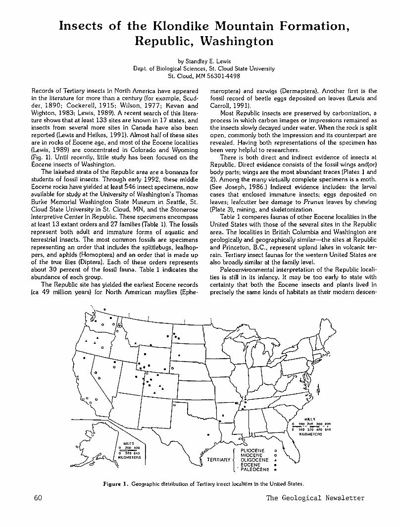
Insects of the Klondike Mountain Formation, Republic, Washington
by Standley E. Lewis Dept. of Biological Sciences, St. Cloud State University
St. Cloud, MN 56301-4498
Records of Tertiary insects in North America have appeared in the literature for more than a century (for example, Scudder, 1890; Cockerell, 1915; Wilson, 1977; Kevan and Wighton, 1983; Lewis, 1989). A recent search of this literature shows that at least 133 sites are known in 17 states, and insects from several more sites in Canada have also been reported (Lewis and Heikes, 1991). Almost half of these sites are in rocks of Eocene age, and most of the Eocene localities (Lewis, 1989) are concentrated in Colorado and Wyoming (Fig. 1). Until recently, little study has been focused on the Eocene insects of Washington.
The lakebed strata of the Republic area are a bonanza for students of fossil insects. Through early 1992, these middle Eocene rocks have yielded at least 546 insect specimens, now available for study at the University of Washington's Thomas Burke Memorial Washington State Museum in Seattle, St. Cloud State University in St. Cloud, MN, and the Stonerose Interpretive Center in Republic. These specimens encompass at least 13 extant orders and 27 families (Table 1). The fossils represent both adult and immature forms of aquatic and terrestrial insects. The most common fossils are specimens representing an order that includes the spittlebugs, leafhoppers, and aphids (Homoptera) and an order that is made up of the true flies (Diptera). Each of these orders represents about 30 percent of the fossil fauna. Table 1 indicates the abundance of each group.
The Republic site has yielded the earliest Eocene records (ca 49 million years) for North American mayflies (Ephe-
Mnrs ~~0 0 320 6<0 l<llOMETEI\S
• .. ..
• • ••
.. • 0
meroptera) and earwigs (Dermaptera). Another first is the fossil record of beetle eggs deposited on leaves (Lewis and Carroll, 1991).
Most Republic insects are preserved by carbonization, a process in which carbon images or impressions remained as the insects slowly decayed under water. When the rock is split open, commonly both the impression and its counterpart are revealed. Having both representations of the specimen has been very helpful to researchers.
There is both direct and indirect evidence of insects at Republic. Direct evidence consists of the fossil wings and(or) body parts; wings are the most abundant traces (Plates 1 and 2). Among the many virtually complete specimens is a moth. (See Joseph, 1986.) Indirect evidence includes: the larval cases that enclosed immature insects; eggs deposited on leaves; leafcutter bee damage to Prunus leaves by chewing (Plate 3), mining, and skeletonization.
Table 1 compares faunas of other Eocene localities in the United States with those of the several sites in the Republic area. The localities in British Columbia and Washington are geologically and geographically similar-the sites at Republic and Princeton, B.C., represent upland lakes in volcanic terrain. Tertiary insect faunas for the western United States are also broadly similar at the family level.
Paleoenvironmental interpretation of the Republic localities is still in its infancy. It may be too early to state with certainty that both the Eocene insects and plants lived in precisely the same kinds of habitats as their modern descen-
•
Figure 1. Geographic distribution of Tertiary Insect localities ln the United States.
60 The Geological Newsletter
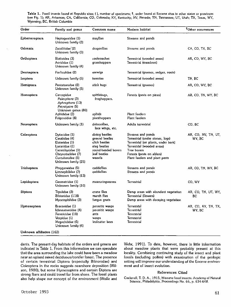
Table 1. Fossil insects found at Republic sites; ( ), number of specimens; t, order found at Eocene sites in other states or provinces (see Fig. 1); AR, Arkansas; CA, California; CO, Colorado; KY, Kentucky; NV, Nevada; TN, Tennessee; UT, Utah; TX, Texas, WY, Wyoming; BC, British Columbia
Order Family and genus Common name
Ephemeroptera Heptageniidae (1) mayflies Unknown family (3)
Odonata Zacallitidae · (2) dragonflies Unknown family (3)
Orthoptera Blattoidea (3) cockroaches Acrididae (1) grasshoppers Unknown family (4)
Dermaptera Forficulidae (2) earwigs
lsoptera Unknown family (5) termites
Hemiptera Pentatomidae (2) stink bugs Unknown family (5)
Homoptera Cercopidae spittlebugs, Palecphora (3) froghoppers. Aphrophora (13) Petrolystra (5) Unknown genus (80)
Aphididae (2) aphids Fulgoroidea (8) plant hoppers
Neuroptera Unknown family (1) dobsonflies, lace wings, etc.
Coleoptera Dytiscidae (1) diving beetles Carabidae (4) ground beetles Elateridae (1) click beetles Lucanidae (1) stag beetles Cerambycidae (1) round·headed borers Chrysomelidae (7) leaf beetles Curculionidae (5) weevils Unknown family (25)
Trlchoptera Phryganeidae (5) caddisflies Limnephilidae (7) caddisflies Unknown family (13)
Lepidoptera Geometridae (1) measuringworms Unknown family (10)
Dlptera Tipulidae (3) crane flies Bibionidae (118) march flies Mycetophilidae (3) fungus gnats
llymenoptera Braconidae (1) parasitic wasps lchneurnonidilc (4) pilrilsitlc wasps Formicldae (1 0) 11nts Vespidile (1) wasps Mcg<~chilidile (5) le<~fcutter bees Unknown family (4)
Unknown affiliation (162)
dants. The present-day habitats of the orders and genera are indicated in Table 1. From this information we can speculate that the area surrounding the lake could have been a meadow near an upland mixed deciduous/conifer forest. The presence of certain terrestrial Diptera (especially Bibionidae) and Coleoptera in the rocks suggests nearshore deposition (Wilson, 1980), but some Hymenoptera and certain Diptera are strong fliers and could travel far from shore. The fossil plants also help shape our concept of the environment (Wolfe and
October 1993
Modern habitat tother occurrences
Streams and ponds
Streams and ponds CA,CO, TX, BC
Terrestrial (wooded areas) AR, CO, WY, BC Terrestrial (meadows)
Terrestrial (grasses, sedges, roots)
Terrestrial (wooded areas) TN, BC
Terrestrial (grasses) AR, CO, WY, BC
Forests (pests on pines) AR, CO, TN, WY, BC
Plant feeders Plant f ceders
Adults terrestrial CO,BC
Streams and ponds AR, CO, NV, TN, UT, Terrestrial (under stones, logs) WY, BC Terrestrial (on plants, under bark) Terrestrial (wooded areas) Tree borers Forests (pests on alders) Plant feeders and plant pests
Streams and ponds AR, CO, TN, WY, BC Streams and ponds
Terrestrial CO, WY
Damp areas with abundant vegetation AR, CO, TN, UT, WY, Terrestrial (flowers) BC Damp areas with decaying vegetation
Terrestrial AR, CO, KY, TN, TX, Terrestrial WY,BC Terrestrlill Terrestrial T errestriill
Wehr, 1991). To date, however, there is little information about meadow plants that were probably present at this locality. Combining continuing study of the insect and plant fossils (including pollen) with examination of the geologic setting will improve our understanding of the Eocene environ· ment and of insect evolution.
References Cited Cockerell, T. D. A., 1915, Miocene fossil insects: Acndemy of Naturni
Science, Philndelphia, Proceedings No. 66, p. 634-648.
61
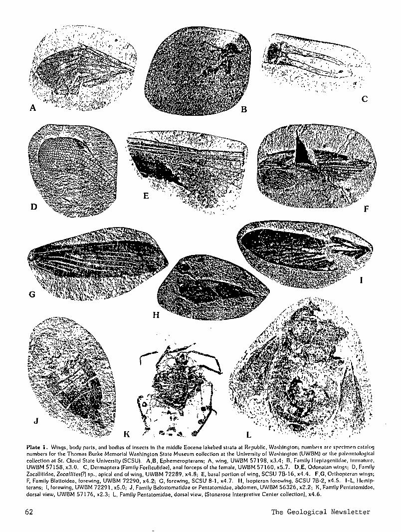
.. : .. , .. :· ., : ..
·~. :. '
, .. .. . . ~f · .
c
Plate 1. Wings, body pi!rts, ilnd bodies of Insects In the middle Eocene lilkebed striltil at Rl'public, Wa~hlngton; numbl'rs ilH' spl'cltnl'n catalog numbers for the Thomns Burke Memorl<~l W<~shlngton State Museum collection at the University of Wi!~hlngton (UWBM) or the p<~lrontok>!Jical collection at St. Cloud Stnte University (SCSU). A,B, Ephemeroptemns; A, wing, UWBM 57198, x3.4; B, Filmily Hcptagcnlld.1c, hnmnturc, UWBM 5 7158, x3.0. C, Dermaptera (Family Forficulidac), anal forceps of the female, UWBM 5 7160, x5. 7. D,E, Odonatan wings; D, Family Zac<~llitid<~e, Zacallitcs(?) sp., apical end of wing, UWBM 72289, x4.8; E. basal portion of wing, SCSU 7B·16, x4.4. F,G, Orthoptcrnn wings; F, Filmily Blilttoidea, forewing, UWBM 72290, x4.2; G, forewing, SCSU 8·1, x4.7. II, lsopteran forewing, SCSU 78-2, x4.5. 1-l, llemlp· terans; I, forewing, UWBM 72291, x5.0; J, Family Belostomatidae or Pentatornidae, abdomen, UWBM 56326, x2.2; K, Family Pentatomldae, dorsal view, UWBM 57176, x2.3; L, Family Pentatomidile, dorsal view, (Stonerose Interpretive Center collection), x4.6.
62 The Geological Newsletter
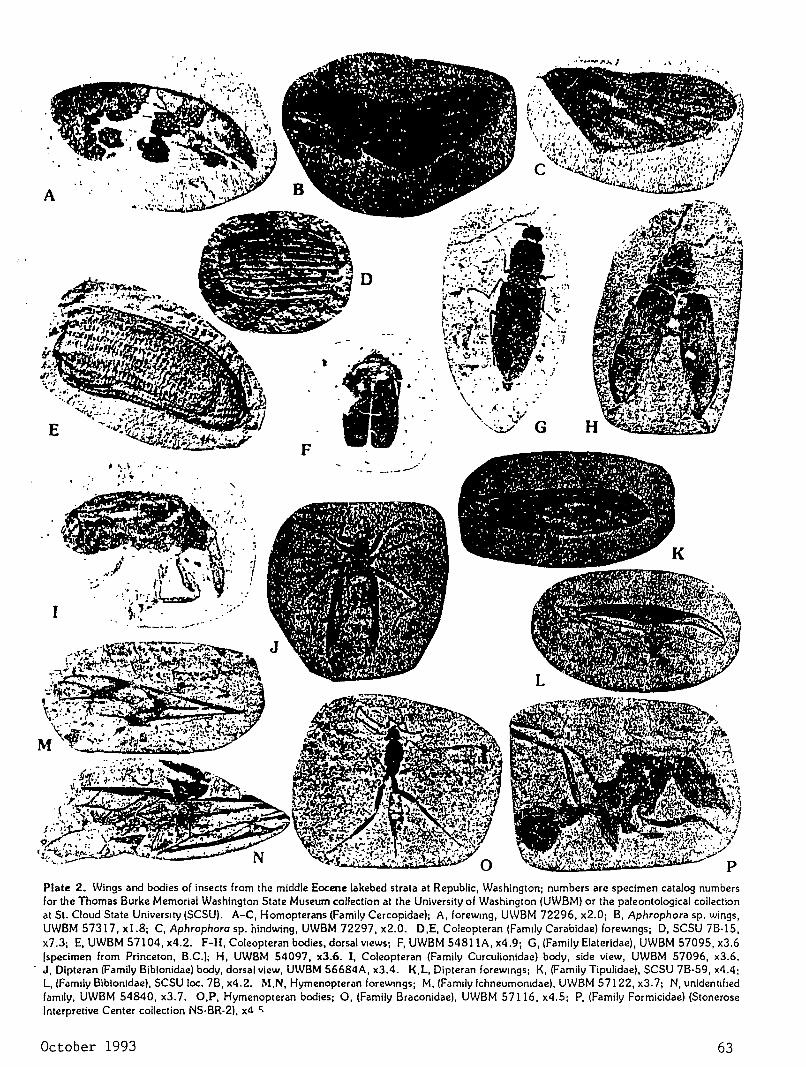
.'
--·-~"·
I
Plate 2. Wings and bodies of insects from the middle Eocene lakebed strata at Republic, Washington; numbers are specimen catalog numbers for the Thomas Burke Memorial Washington State Museum collection at the University of Washington (UWBM) or the paleontological collection at St. Cloud State University (SCSU). A-C, Homopterans (Family Cercopidae); A, forewmg, UWBM 72296, x2.0; B, Aphrophora sp. wings, UWBM 57317, xl.8; C, Aphrophora sp. hindwing, UWBM 72297, x2.0. D,E, Coleopteran (Fam1ly Carabidae) forewmgs; D, SCSU 78·15, x7.3; E, UWBM 57104, x4.2. F-H, Coleopteran bodies, dorsal VIews; F, UWBM 54811A, x4.9; G, (Family Elaterldae), UWBM 57095, x3.6 [specimen from Princeton, B.C.); H, UWBM 54097, x3.6. I, Coleopteran (Family Curculionidae) body, side view, UW8M 57096, x3.6. J, Dipteran (Family 8iblonidae) body, dorsal view, U\VBM 56684A, x3.4. K,L, Dipteran forewmgs; K, (Family Tipulidae), SCSU 78-59, x4.4; L, (Fam1ly 8iblonidae), SCSU loc. 78, x4.2. M,N, Hymenopteran forewmgs; M, (Fam1ly lchneumomdae), UW8M 57122, x3. 7; N, unidentified family, UW8M 54840, x3.7. O,P, Hymenopteran bodies; 0, (Family Braconidae), UWBM 57116, x4.5; P, (Family Formicidae) (Stonerose Interpretive Center collection NS·BR-2). xd C.
October 1993 63
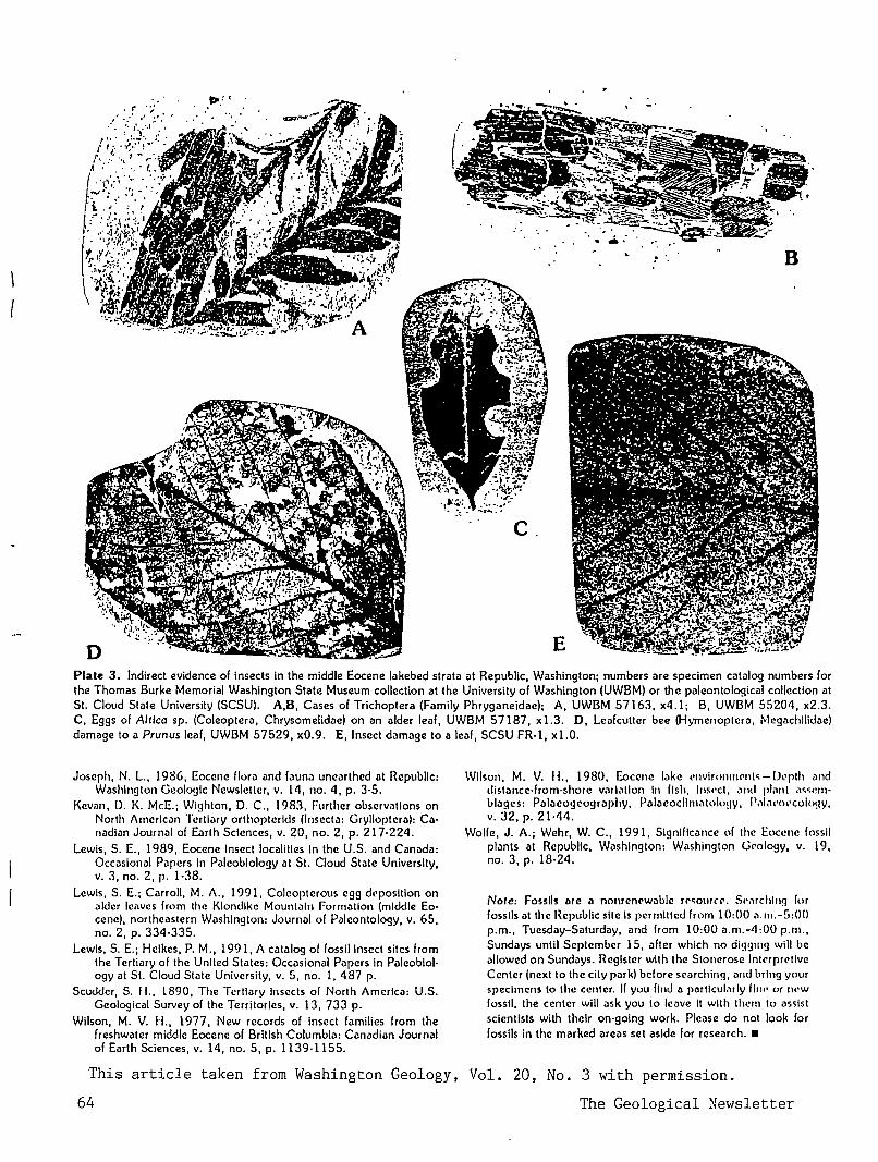
: 8
c
Plate 3. Indirect evidence of insects in the middle Eocene lakebed strata at Republic, Washington; numbers are specimen catalog numbers for the Thomas Burke Memorial Washington State Museum collection at the University of Washington (UWBM) or the paleontological collection at St. Cloud State University (SCSU). A,B, Cases of Trichoptera (Family Phryganeidae); A, UWBM 57163, x4.1; B, UWBM 55204, x2.3. C, Eggs of A/Ilea sp. (Coleoptera, Chrysomelidae) on an alder leaf, UWBM 57187, x1.3. D, Lcafcutter bee (Hymenoptera, Megachilidae) damage to a Prunus leaf, UWBM 57529, x0.9. E, Insect damage to a leaf, SCSU FR-1, xl.O.
Joseph, N. L., 1986, Eocene llora and fauna unearthed at Hepubllc: Washington Geologic Newsletter, v. 14, no. 4, p. 3·5.
Kevan, D. K. McE.; Wighton, D. C., 1983, Further obscrv<~tlons on North Amerlc<~n Tertl<~ry orthoptcrlds (Insecta: Grylloptcra): Ca· nadliln Journ<~l of Earth Sciences, v. 20, no. 2, p. 217·224.
Lewis, S. E., 1989, Eocene Insect localities In the U.S. Jnd CanildJ: Occasional Papers In Paleobiology at St. Cloud State University, v. 3, no. 2, p. 1-38.
Lewis, S. E.; Carroll, M. A., 1991, Coleopterous egg dl•posltlon on alder leaves from the Klondike Mountain Formation (middle Eocene), northeastern Washington: Journal of Paleontology, v. 65, no. 2, p. 334-335.
Lewis, S. E.; Heikes, P.M., 1991, A Ciltillog of fossil Insect sites from the Tertiary of the United States: OccJsional Papers In Paleoblol· ogy at St. Cloud State University, v. 5, no. I, 487 p.
Scudder, S. II., 1890, The Tertiary Insects of North America: U.S. Geological Survey of the Territories, v. 13, 733 p.
Wilson, M. V. H., 1977, New records of Insect f<~milies from the freshwater middle Eocene of British Columbia: Canadian Journal of Earth Sciences, v. 14, no. 5, p. 1139-1155.
Wilson, M. V. H., 1980, Eocene lake l'nvirnnml'nl~-lkpth Jnd distJncc·from·shore Vilrl.1llon In fish, lm•·ct, ilnd plmll ol«Crn·
biJges: Pillileogcogr<~phy, PJiaeocllmiltolo!JY, p,,l,w<ll'cology, v. 32, p. 21-44.
Wolfe, J. A.; Wehr, W. C., 1991, Signlflc<~nce of the Eocene fossil plilnts at Republic, W<!shlngton: W<1shington Gl'ology, v. 19, no. 3, p. 18-24.
Note: Fossils arc a nonrenewable rl'<ourcl'. s,•,rchlng lor fossils at the Republic site Is permitted from 10:00 a.m.-5:00 p.m., Tuesday-Saturday, and from 10:00 a.m.-4:00p.m., Sundays until September 15, alter which no digging will be allowed on Sundays. Register with the Stoncrosc lntrrpr<:'llve Center (next to the city park) before searching, and bring your specimens to the center. If you ftnd a parllcul.111y fin•• or IH'W
fossil, the center will ask you to leave It with them to assist scientists with their on·going work. Please do not look for fossils in the marked areas set aside for reseJrch. •
This article taken from Washington Geology, Vol. 20, No. 3 with permission.
64 The Geological ~ewsletter
THE GEOLOGICAL NEWSLETTER
NOV 93
GEOLOGICAL SOCIETY OF THE OREGON COUNTRY
GEOLOGICAL SOCIETY OF THE OREGON COUNTRY
P.O. BOX 907 PORTLAND. OR 97207
Non-Prof1t Org. U.S. POST AGE
PAID Portland. Oregon
Permit No. 999
Q GEOLOGICAL SOCIETY OF THE OREGON COUNTRY 1993-1994 ADMINISTRATION
BOARD OF DIRECTORS President
Esther Kennedy 626-2374 11925 sw Center Beavertom, Oregon 97005
Vice-President Dr. Donald Botteron 245-6251 2626 sw Luradel Street Portland, Oregon 97219
Secretary Shirley O'Dell 3038 SW Florida Ct.,Unit D 245-6882 Portland, Oregon 97219
Treasurer Phyllis Thorne 292-6134 9035 sw Monterey Place Portland, Oregon 97225
Directors Booth Joslin(3 years) Arthur Springer(2 years) Betty Turner(1 year)
Immediate Past Presidents Evelyn Pratt Dr. Walter Sunderland
THE GEOLOGICAL NEWSLETTER
636-2384 236-6367 246-3192
223-2601 625-6840
Editor: Donald Barr 246-2785 Calender: Reba Wilcox 684-7831
Business Manager: Rosemary Kenney 221-0757 Assistant: Margaret Steere
246-1670
ACTIVITIES CHAIRS Calligrapher
Clay Kelleher Field Trips
Alta Stauffer Geology Seminars
Richard Bartels Historian
775-6263
287-1708
292-6939
Charlene Holzwarth Hospitality
(Luncheons)Shirley
284-3444
O'Dell245-688
(Evenings)Elinore Olson 244-3374
Library
Programs (Luncheons) Clay
(Evenings) Dr. Past President's
Evelyn Pratt
Kelleher775-6263 D.Botteron245-6251 Panel
223-2601 ACTIVITIES
Properties and PA System (Luncheon) Clay Kelleher 775-6263 (Evenings) Booth Joslin 636-2384
Publications Margaret Steere
Publicity Evelyn Pratt
Refreshments (Friday Evenings)
Rosemary Kenney (Geology Seminars)
Dorothy Barr Telephone
Cecelia Crater Volunteer Speakers Bureau
Bob Richmond Annual banquet
246-1670
223-2601
221-0757
246-2785
235-5158
282-3817
Chairperson:Susan Barrett639-4583
ANNUAL EVENTS: President's Field Trip-summer, Picnic-August,Banquet-March, Annual Meeting-February. FIELD TRIPS: Usually one per month, via private car, caravan or chartered bus. GEOLOGY SEMINARS: Third Wednesday, except June, July, August. 8:00pm, Rm. S17, Cramer Hall, PSU. Library: Room S7, Open 7:30P.M. prior to meetings. PROGRAMS: Evenings: Second and Fourth Fridays each month, 8:00pm, Rm. 371, cramer Hall, PSU, sw Broadway at sw Mill street, Portland, Oregon. LUNCHEONS: First and Third Fridays each month, except holidays at noon. Bank of California Tower, 707 SW Washington, 4th floor Cafeteria, California Room, Portland,Oregon MEMBERSHIP: per year from January 1: Individual, $15.00, Family, $25.00, Junior (under 18) $6.00. Write or call Secretary for membership applications. PUBLICATIONS: THE GEOLOGICAL NEWSLETTER (ISSN 0270 5451) published monthly and mailed to each member. Subscriptions available to libraries and organizations $10.00 a year. Individual subscriptions at $13.00 a year. Single copies $1.00. Order from Geological Society of the Oregon country,P.O.Box 907, Portland, Oregon 97207. TRIP LOGS: Write to the same address for price list.
THE GEOLOGICAL NEWSLETTER The Geological Society of the Oregon Country
P.O. Box 907 • Portland, OR 97207
VISITORS WELCOME INFORMATION PHONE 284-4320
VOLUME 59, NO. I I
CALENDAR OF ACTIVITIES FOR NOVEMBER, 1993
FRIDAY NIGHT LECTURES (Cramer Hall, PSU, Room 371, 8:00P.M.)
Nov. 12
Nov. 26
"James Hall Giant of Geology", A slide presentation by Andy Corchoran, GSOC member.
Thanksgiving - No Meeting.
FRIDAY LUNCHEONS (Bank of California Tower, 707 SW Washington, 4th floor. Social Hr., cafeteria 11:30 A.M.; Program, California Rm. at 12:00 noon).
Nov. 5
Nov. 19
"Geology of the Union Pacific Railroad Proposed Blue Mountain Tunnel Site", Speaker: Bill Burgel.
"Geologic Practice in Puerto Rico'', Speaker: Ed Stearns.
GEOLOGY SEMINAR (Cramer Hall, PSU, Room S-17, 8:00P.M.)
Nov. 17 "Earthquakes and Earthquake Prepardness" by Beverly Vcgt and Richard Bartells.
GSOC LIBRARY (Cramer Hall, Portland State University, Room S-7. Open 7:00- 8:00P.M. prior to evening meetings.)
FIELD TRIPS
No Field Trips scheduled for November. ~~~~~~~~~~~~~~~~~~~~~~T~~~~~~~~~~~~TTTTTTTTTTTTTTTTTTTTT
mEmORIAL
A dear friend Frances Rusche, Librarian for the Geological Society of the Oregon Country, died on September 3, 1993. A world traveler, she photographed the many exotic places she visited then shared her adventures with beutiful slide programs.
She was an avid gardener , and a collector of crystals and rock specimens. Her lovely hand work, needlepoint stitchery and stained glass graced the walls of her home.
She is gone but will be remembered as a gentle talented lady. We will miss you, Frances.
Esther Kennedy President, GSOC 1993
++++11111111111111111111111111111111111111111111111111111111111111111++111111
65 The Geological Newsletter
AN OLIVINE LOCATION IN WASHINGTON STATE
by Jim Forester. Belle,ue Rock Club
We have a big producer of olivine near Bellingham- a mine in the Twin Sisters area of the Cascade Mountains. east of Bellingham.
What is olivine? A green mineral. a silicate of iron and magnesium. running from all magnesium and no iron to all iron and no magnesium. The Twin Sisters mine is an important producer. In the last year it produced 82.000 tons of crushed olivine. Uses? Crushed it's used as a refractory lining for kilns and foundry molds. Much of it is shipped overseas, but the Olivine Corporation also builds kilns for export.
Olivine is hard (6 1\2 to 7) and alters easily to serpentine, which is also a magnesium silicate but with water (hydrO;\.'yl) added. The transparent variety is called peridot. Olivine is also lmown as chysolite, not to be confused with chvsotilc which is fibrous, asbestos variety of serpentine. ·
When you see dark colored rocks like gabbro, peridotite and basalt, they most likely contain some olivine. Crystals of the latter are found in the lava of Mount Vesuvius and crystals that have been altered to serpentine have been found in Norway.O
COMPLETELY FRACTURED GEOLOGY
by Ralph and Evelyn Pratt. GSOC
1. Dacite: to make a choice, as in "I just can't dacite which dress to wear.
2. Roche mountonnee: fancy French term for baked old sheep.
3. Pegmatite: part of title from old romantic old song: "Pegmatite Heart."
4. Albite: what we say when we can't guess the answer to a riddle, "OK, albite. what is it'?"
5. Adit: one way trip to a restaurant: "Just adit on to the bill. II
6. Ammonite: after-dark sale at a gun shop.
7. Caldera: what Dera's husband is supposed to do if he'll be late for supper.
66
8. Vesicle: a small boat used on a lake. as opposed to a vessel. a large ocean-going ship.
J I
9. Pyroclast: a place where one learns to line up pastries.
10. Sinter: a persoJ who has done something evil or \\Tong. \
CORRECT ANSWERS ON P. 67
THE OREGOn COASTU()E USED TO BE fiA()f2 fiiC..ES FARTHER UJEST by Dr. Kenneth M. Ames, Anthropology Department.
Portland State University
Documenting sea-level changes is one of the most difficult tasks facing the geologists and archaeologists who work along the world's coastlines. including Washington and Oregon.
If sea levels have fallen. then what was once the shore manv not be a long way back from the modern shoreline: if the se~ levels have risen. then the old shoreline may now be underwater.
As sea levels rise or fall, environments along the coast change. Estuaries. tidal flats, salt water marshes and rockv foreshores may dry up. or be dro\\ned. Rivers must shift their courses. In some cases. entire coastlines disappear.
Seal levels change for a variety of reasons. One of the most important is the activity of glaciers. As glaciers expand they take on water and the ocean shrink. resulting in lowered sea level. About 17.000 years ago. at the height of the most recent glaciation. the world's oceans were lower by about 300 to 500 feet. Britain was connected to Europe. North America and Asia were connected by a broad plain between Alaska and Siberia. and the Oregon Coast line was many miles west of Cannon Beach. The Columbia Gorge extended out past Astoria. As the glaciers melted the seas rose.
But it's not quite that simple. Sea levels also appear to rise and fall because the land is acturally rising or falling. If the land falls-- subsides -- sea levels appear to rise; if the land rises. sea levels appear to fall.
The land may rise or fall as the result of changes in the Earth's crust as tectonic plates grind past. over or under each other. raising mountains and causing earthquakes.
Glaciers can affect the crust. As glaciers increase in size. their weight depresses the surface, and coastlines near a major glacial front will be lower. As the ice melts. and the weight is released the crust rebounds upward.
The Geological Newsletter
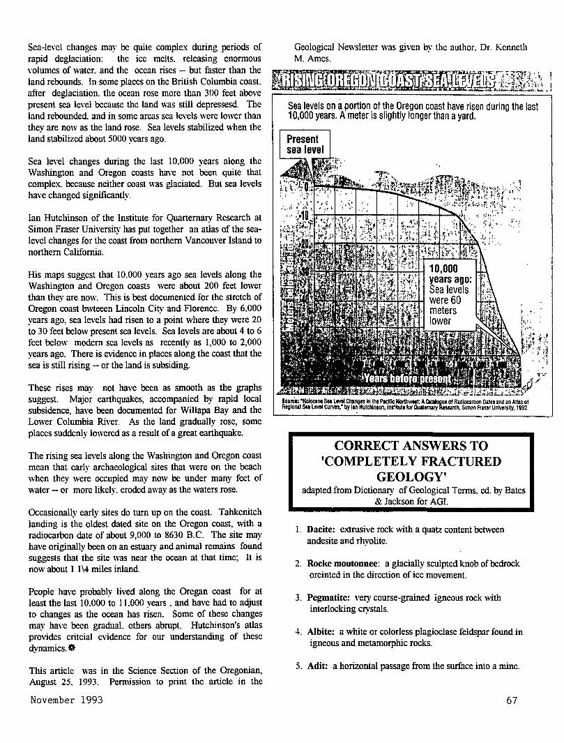
Sea-level changes may be quite complex during periods of rapid deglaciation: the ice melts. releasing enormous volumes of water. and the ocean rises -- but faster than the land rebounds. In some places on the British Columbia coast. after deglaciation. the ocean rose more than 300 feet above present sea level because the land was still depressesd. The land rebounded and in some areas sea levels were lower than they are now as the land rose. Sea levels stabilized when the land stabilized about 5000 years ago.
Sea level changes during the last 10.000 years along the Washington and Oregon coasts have not been quite that complex. because neither coast was glaciated. But sea levels have changed significantly.
Ian Hutchinson of the Institute for Quarternary Research at Simon Fraser University has put together an atlas of the sealevel changes for the coast from northern Vancouver Island to northern California.
His maps suggest that 10.000 years ago sea levels along the Washington and Oregon coasts were about 200 feet lower than they are now. This is best documented for the stretch of Oregon coast bwteeen Lincoln City and Florence. By 6.000 years ago, sea levels had risen to a point where they were 20 to 30 feet below present sea levels. Sea levels are about 4 to 6 feet below modern sea levels as recently as 1,000 to 2,000 years ago. There is evidence in places along the coast that the sea is still rising -- or the land is subsiding.
These rises may not have been as smooth as the graphs suggest. Major earthquakes, accompanied by rapid local subsidence, have been documented for Willapa Bay and the Lower Columbia River. As the land gradually rose, some places suddenly lowered as a result of a great earthquake.
The rising sea levels along the Washington and Oregon coast mean that early archaeological sites that were on the beach when they were occupied may now be under many feet of water -- or more likely. eroded away as the waters rose.
Occasionally early sites do turn up on the coast. Tahkenitch landing is the oldest dated site on the Oregon coast, with a radiocarbon date of about 9,000 to 8630 B.C. The site may have originally been on an estuary and animal remains found suggests that the site was near the ocean at that time; It is now about 1 1\4 miles inland.
People have probably lived along the Oregan coast for at least the last 10.000 to 11.000 years . and have had to adjust to changes as the ocean has risen. Some of these changes may have been gradual. others abrupt. Hutchinson's atlas provides critcial evidence for our understanding of these dynamics. Ct
This article was in the Science Section of the Oregonian, August 25. 1993. Permission to print the article in the
November 1993
Sea levels on a portion of the Oregon coast have risen during the last 10,000 years. A meter is slightly longer than a yard.
Present sea level
.,
Iauria: "Holoctnt Soa LMI Chanoos In tho Plcll1c NolthWMt: A Cllalooue 01 Radiocarbon Dates and an Atlas of Regional SU LMI CuNH." by tan Hutchlnson,ln~ltuta lor Clulttnwy Research, S1mon Fraser University, 1992
CORRECT ANSWERS TO 'COMPLETELY FRACTURED
GEOLOGY' adapted from Dictionary of Geological Terms, ed. by Bates
& Jackson for AGI.
1. Dacite: extrusive rock with a quatz content between andesite and rhyolite.
2. Rocke moutonnee: a glacially sculpted knob of bedrock oreinted in the direction of ice movement.
3. Pegmatite: very course-grained igneous rock \vith interlocking crystals.
4. Albite: a white or colorless plagioclase feldspar found in igneous and metamorphic rocks.
5. Adit: a horizontal passage from the surface into a mine.
67
6. Ammonite: an extinct mollusk similar to a nautilus.
7. Caldera: a large basinlike depression usually resulting from the collapse or explosion of a volcano.
8. Vesicle: a hardened gas-bubble cavity in a cooled igneous rock.
9. Pyroclast: an individual particle ejected during a volcanic eruption.
10. Sinter: spring-deposited kcalcite. or opal-type silica precipitated by geysers or hot springs.
WELCOME NEW MEMBERS
Joesph W. McGee 3939 N. Overlook Blvd
Portland, Oregon 97227
June Anderson 1469 Branch Ave.
Simi Valley, California 93063
CENOZOIC LAVAS OF THE WESTERN GRAND CANYON
by Otis Willoughby, Geologist, Environmental Health Scientist, Utah Department of Environmental Quality,
Dhision of Solid Waste
On the walls of the western Grand Canyon. is recorded a history of at least twelve major volcanic events that flowed into the canyon and dammed the Colorado River. These basaltic flows represent some of the most recent geologic events that have shaped the canyon as we know it today.
Using relative and radiometric dating methods, geologists have been able to unravel the history of these dams. Each event produced basalt \\ith unique lithology and morphology. The largest of the dams rose to a height of 2330 feet above the river. The lake that formed behind this dam reached well past Lake Powell. Shoreline sediments from these lakes can be seen above the shores of Lake Powell and in the Lee's Ferry area.
Each of these dams lasted only a relatively short time. Downcutting by the river and its sediments and undercutting by river hydraulics soon removed all but slivers of dam
68
remnants on the canyon walls. These remnants record flows that ravels as much as 80 miles downstream. In the Buried Canyon area. the river changed course around the basaltic flows and eroded the less resistant sedimentary rocks in the canyon.
Other volcanic features in this area include Vulcan's Anvil, a volcanic neck located directly in the middle of the Colorado River. shows basaltic dikes. and sills. It sits perched on the north rim of the canyon.
The study of this area has greatly increased geologist's knowledge of the history and age of the Grand Canyon. Rates of erosion, slope retreat, and canyon downcutting can be extrapolated. It has also provided information as to the state of our man-made dams. How long we expect them to last and how quickly they can fill \\ith sediments.
This article appeared in the Utah Geological Association Newsletter, Volume 24, No.2. February 1993. *
THUNDEREGG COLLECTING XI\' OREGON
by Paul F. Lawson, mineral collector and retired Supervisor, Mined Land Reclamation Program, Oregon Department of Geology and Mineral Industries.
The Thunderegg was designated Oregon's official state rock by the Oregon Legislature in 1965. It selection was supported by a 2 to 1 vote by members of the mineral and gems clubs of Oregon and by the patrons of the Oregon Museum of Science and Industry (OMSI). HISTORY The Thunderegg has long been important to Oregonians. According to ancient Indian legend, when the Thunder Spirits living in the highest recesses of snowcapped Mount Hood and Mount Jefferson became angry with one another, amid violent thunder and lightening storms they would hurl masses of these spherical rocks at each other. The hostile gods obtained these weapons by robbing the nests of the Thunderbirds of their eggs, thus the source of the name "Thundereggs." The mountains are still key landmarks in the beautiful High Cascade Range, and millions of Thundereggs are on the lower lands as evidence of the legend and for all to enjoy.
The Thunderegg has been highly prized by collectors, lapidarists, jewelry makers. and interior decorators for nearly 100 years. In 1893, Dr. George F. Kunz. Tiffany's famed gem authority, estimated that as much as $20.000 worth of opal-filled eggs from one Oregon deposit had been marketed in 1892. Since the mid-1930's thousands of visitors from every state in the Union and many overseas countries have
The Geological Newsletter
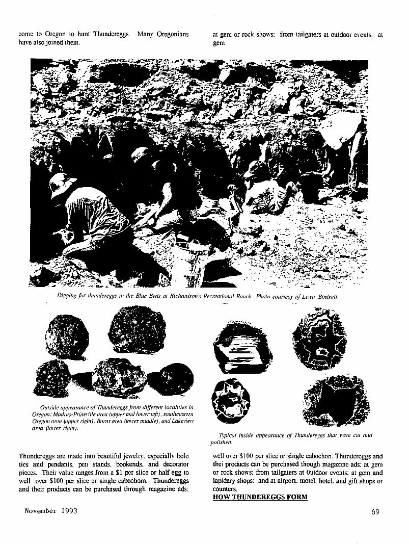
come to Oregon to hunt Thundereggs. Many Oregonians have also joined them.
at gem or rock shows: from tailgaters at outdoor e,·ents: at gem
Digging for tlwndereggs in the Blue Beds at Ric/umlson :1· Recreational Ranch. Photo courtesy 1!( Lell'i.l Birdsall.
Owside appearance tif Thundereggs from di.fferem localities in Oregon: Madras-Prineville area (upper and loll'er left), sowheastem Oregon area (upper right), Bums area (loll'er middle), and Lakeviell' area (loll'er right).
Thundereggs arc made into beautiful jewelry, especially bolo ties and pendants, pen stands. bookends. and decorator pieces. Their value ranges from a $1 per slice or half egg to well over $100 per slice or single cabochom. Thundereggs and their products can be purchased through magazine ads:
November 1993
Typical inside appearance of 71wndereggs that ll'ere cw and polished.
well over $100 per slice or single cabochon. Thundereggs and thei products can be purchased though magazine ads: at gem or rock shows: from tailgaters at Outdoor events: at gem and lapidary shops: and at airport. motel. hotel. and gift shops or counters. HOW THUNDEREGGS FORM
69
Although the Thunderegg is an hororary rock by Legislative decree. it actually is not a rock. It is a structure. sometimes a nodule. sometimes a geode. occurring in rhyolite. welded tuff. or perlitic rocks. However. without question. the Thunderegg is by far the most popular "rock" in Oregon.
Scientists do not agree on the processes forming Thundereggs. Some insist that the characterestic and unique internal pattern of typical Thundereggs is due to e~-pansion and rupture of the rock by gases. Others claim the pattern is due to desiccation (drying) of a colloid or gel. Whatever the process, however, after the cavity that contains the egg is formed. further development is extremely variable in the amount of time needed to complete the egg. in the degree and type of infilling, and in other characterestics. Thundereggs range in size and weight from less than a inch and under an ounce to over a yard in diameter and over a ton in weight. Most eggs collected are between 2 and 6 inches in diameter. HOW THUNDEREGGS LOOK Typically. an egg has a russet-colored outer shell that is often knobby. and often has a characteristic ribbed pattern. Frequently. the inside of the outer shell has a relatively thin intermediate or transitional lining. This is sometimes composed of an iron or manganese compound. often with a thin coating of opal or chalcedony. Sometimes only opal or chalcedony is apparent. Finally. the center of the egg is usually filled with chalcedony or opal and may or may not have inclusions, patterns. or crystals. In some variants, the egg may be hollow or may have a thin layer of chalcedony coating the interior. This layer sometimes is topped with a coating of small quartz crystals.
Growths of algae-like tubes. or plumes, or "moss" of manganese or iron compounds or of clay may be freestanding or partially or wholly embedded in chalcedony. Some eggs with plumes ("flowers") in chalcedony are among the most valuable specimens. Several zeolites have been observed or reported in Thundereggs. clinopitolite is fairly common, and mordenite. natrolite. and mesolite have also
been reported.
Thundereggs are sometimes found with fortification banding just inside the shell, then an area of horizontal layering. with the remaining central area filled with chalcedony or inward pointing crystals. Banding and layering vary in color. thickness. and content. Some layers are composed of a fibrous cristobalite (lussatite). Other eggs have partial botryoidal filling of an opal form of lmv cristobalite. This opal is often fluorescent because of the low content of uranium salts.
One collecting site in Oregon has eggs filled with carnelian. At another. the filling may contain cinnabar. which colors it pastel to intense red. Some eggs are filled with pastel jaspers. Other may have any one of a variety of opal fillings that may be opaque blue. opaque red. translucent pastel blue,
70
translucent yellow. translucent red. white. or colorless. Some of the opal may be faceted. and a small percentage is true precious opal.
Some eggs have well-developed calcite crystals encased in chalcedony. and others contain pseudomorphs of chalcedony after calcite. Some eggs have layering that is fanned from one edge. because the egg was rotated by earth movement while the filling was deposited. This and other features suggest that the complete development of some eggs may have taken considerable time. and the filling-in of the egg may have recorded a series of geologic events. Some eggs contain brecciated rock fragments. while others show faulting. offset. and healing. One of the most unusual Thunderegg variants is up to 3 feet long and 2 to 3 inches in diameter and looks like a fat gray worn1. In some areas. it is common to find the characterestic chalcedony core weathered out to its shell. If a complete egg is sawed in the right orientation. one or more conduits through which the filing materials flowed may be found. The beauty and complexities of many of the cut and polished eggs explain why Oregon rockhounds have long been fascinated by Thundereggs. WHERE TO FIND THUNDEREGGS IN OREGON Thundereggs may be collected at many sites in Oregon. Some localities occur in beautiful forested hill country. others in dry, desert-like terrain. It should be understood that Thundereggs have been eagerly collected in Oregon for fifty years. Therefore, on "free sites"' collectors must expect to dig and work for Thundereggs. Proper equipment, including shovel, pick. and bar makes the job easier. The "fee" site will almost always have some preparatory work (overburden removal) done. Also, eggs may usually be purchased at the site office. Some places may have tools for rent. LOCATIONS Madras-Prineville area White Fir Spring (Natioanl Forest Land: free site) Whistler Spring (National Forest land: free site( For current information on these sites contact:
Prineville Ranger District 2321 East Third Prineville. OR 97754 (503)447-3825
White Rock (or Wildcat Mountain)( National Forest land; free site)
Big Suntmit Ranger District 348855 Ochoco Ranger Station Prineville. OR 97754 (503) 447-3845
A map of the area's free collecting sites (including sites for other rockbound materials) is available from:
Prim ille Chamber of Commerce 390 North Fairview
Prineville. OR 97754 (503) 447-6304
This article appeared in Oregon Geology. Vol.51. No.4 July 1989
The Geological Newsletter
THE GEOLOGICAL NEWSLETTER
DEC 93
GEOLOGICAL SOCIETY OF THE OREGON COUNTRY
' I
GEOLOGICAL SOCIETY OF THE OREGON COUNTRY
P 0. BOX 907 PORTLAND, OR 97207
Non-Profit Org. U.S. POSTAGE
PAID Portland, Oregon
Permit No. 999
GEOLOGICAL SOCIETY OF THE OREGON COUNTRY 1993-1994 ADMINISTRATION
BOARD OF DIRECTPRS President
Esther Kennedy 626-2374 11925 SW Center Beavertom, Oregon 97005
Vice-President Dr. Donald Botteron 245-6251 2626 SW Luradel Street Portland, Oregon 97219
Secretary Shirley O'Dell 3038 SW Florida Ct.,Unit D 245-6882 Portland, Oregon 97219
Treasurer Phyllis Thorne 292-6134 9035 sw Monterey Place Portland, Oregon 97225
Directors Booth Joslin(3 years) Arthur Springer(2 years) Betty Turner(1 year)
Immediate Past Presidents Evelyn Pratt Dr. Walter Sunderland
THE GEOLOGICAL NEWSLETTER
636-2384 236-6367 246-3192
223-2601 625-6840
Editor: Donald Barr 246-2785 Calender: Reba Wilcox 684-7831
Business Manager: Rosemary Kenney 221-0757 Assistant: Margaret Steere
246-1670
ACTIVITIES CHAIRS Calligrapher
Clay Kelleher Field Trips
Alta Stauffer Geology Seminars
Richard Bartels Historian
Charlene Holzwarth Hospitality
(Luncheons)Shirley
775-6263
287-1708
292-6939
284-3444
O'Dell245-688
(Evenings)Elinore Olson 244-3374
Library
Programs (Luncheons) Clay
(Evenings) Dr. Past President's
Evelyn Pratt
Kelleher775-6263 D.Botteron245-6251 Panel
223-2601 ACTIVITIES
Properties and PA System (Luncheon) Clay Kelleher 775-6263 (Evenings) Booth Joslin 636-2384
Publications Margaret Steere
Publicity Evelyn Pratt
Refreshments (Friday Evenings)
Rosemary Kenney (Geology Seminars)
Dorothy Barr Telephone
Cecelia Crater Volunteer Speakers Bureau
Bob Richmond Annual banquet
246-1670
223-2601
221-0757
246-2785
235-5158
282-3817
Chairperson:Susan Barrett639-4583
ANNUAL EVENTS: President's Field Trip-summer, Picnic-August,Banquet-March, Annual Meeting-February. FIELD TRIPS: Usually one per month, via private car, caravan or chartered bus. GEOLOGY SEMINARS: Third Wednesday, except June, July, August. 8:00pm, Rm. S17, Cramer Hall, PSU. Library: Room S7, Open 7:30P.M. prior to meetings. PROGRAMS: Evenings: Second and Fourth Fridays each month, 8:00pm, Rm. 371, Cramer Hall, PSU, SW Broadway at SW Mill street, Portland, Oregon. LUNCHEONS: First and Third Fridays each month, except holidays at noon. Bank of California Tower, 707 SW Washington, 4th floor Cafeteria, California Room, Portland,Oregon MEMBERSHIP: per year from January 1: Individual, $15.00, Family, $25.00, Junior (under 18) $6.00. Write or call Secretary for membership applications. PUBLICATIONS: THE GEOLOGICAL NEWSLETTER (ISSN 0270 5451) published monthly and mailed to each member. Subscriptions available to libraries and organizations $10.00 a year. Individual subscriptions at $13.00 a year. Single copies $1.00. Order from Geological Society of the oregon country,P.O.Box 907, Portland, Oregon 97207. TRIP LOGS: Write to the same address for price list.
THE GEOLOGICAL NEWSLETTER The Geological Society of the Oregon Country
P.O. Box 907 • Portland, OR 97207
VISITORS WELCOME INFORMATION PHONE 284-4320
VOLUME 59, NO. 12
CALENDAR OF ACTIVITIES FOR DECEMBER, 1993
FRIDAY NIGHT LECTURES (Cramer Hall, PSU, Room 371, 8:00P.M.)
Dec. 10
Dec. 24
Slide presentation by Evelyn Pratt covering the President's Field Trip in Western Washington, Sept. 25 to Oct. 1, 1993. Prints will also be displayed.
Meeting canceled for Christmas holiday.
FRIDAY LUNCHEONS (Bank of California Tower, 707 SW Washington, 4th floor. Social Hr., cafeteria 11:30 A.M.; Program, California Rm. at 12:00 noon.)
Dec. 3 Slide presentation by Esther Kennedy covering the President's Field Trip in Western Washington, Sept. 25 to Oct. 1, 1993. Prints will also be displayed.
Dec. 17 "Geologic Practice in Puerto Rico". Speaker: Ed Stearns.
GEOLOGY SEMINAR (Cramer Hall, PSU, Room S-17, 8:00P.M.)
Dec. 15 No Seminar in December.
GSOC LIBRARY (Cramer Hall, Portland State University, Room S-7. Open 7:00 - 8:00 P.M. prior to evening meetings)
FIELD TRIPS
t-JHERE: OT_,YMPIC. PENINSULA DATE : February 19, 20,21 LEADERS: Esther Kennedy, arrangements. More infomation, 626-2374
John Whitmer, Field trip leader. DETAILS: February 19, Forks, Washington, February 20, Port Angeles, February 21
continue field trip on way home. COST: $230.00 DBL, $290~.00 SGL •. Includes. motel- ar.d. ..three box lunches.
DUES ARE DUE JANUARY 1994-----DUES ARE DUE JANUARY 1994----DUES ARE DUE JANUARY 1994 ------------------------------------------------------------------------------------
December 1993 71
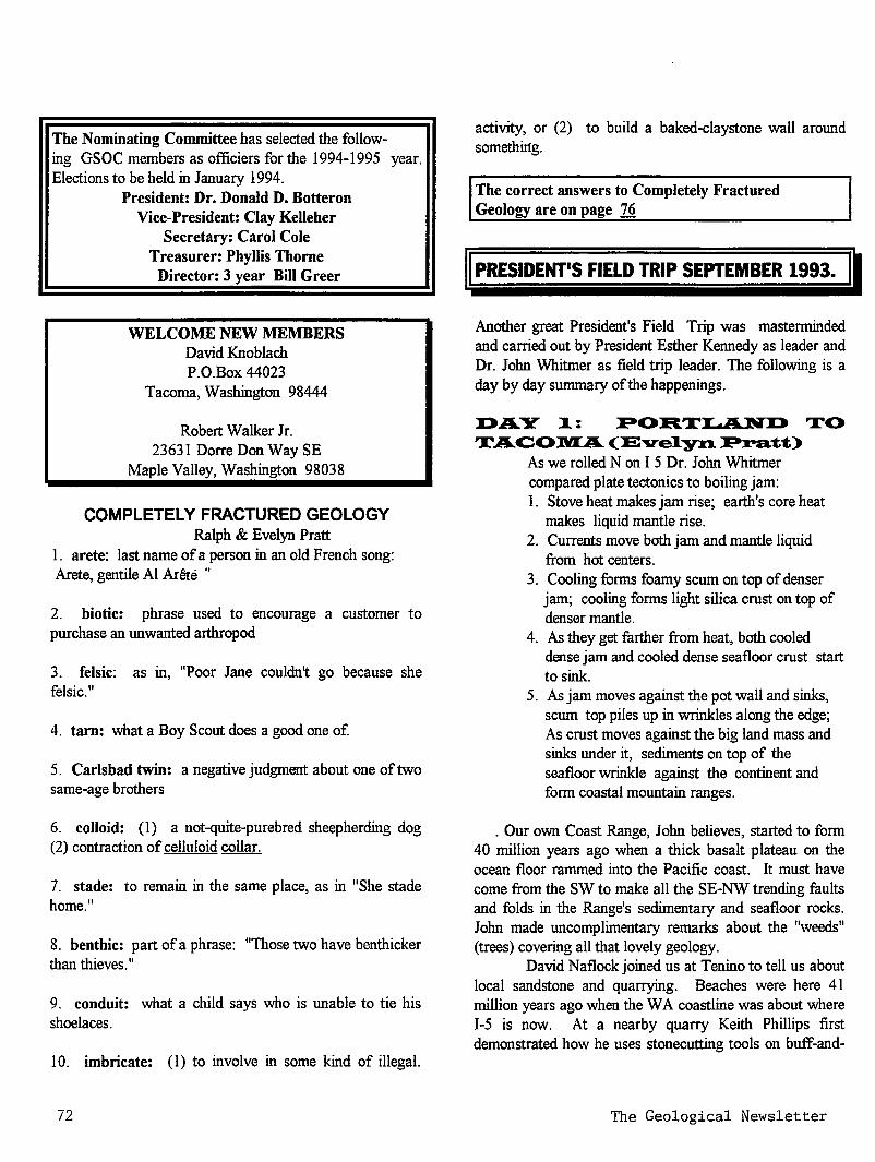
The Nominating Committee has selected the follow-ing GSOC members as officiers for the 1994-1995 year. Elections to be held in January 1994.
President: Dr. Donald D. Botteron Vice-President: Clay Kelleher
Secretary: Carol Cole Treasurer: Phyllis Thorne
Director: 3 year Bill Greer
WELCOME NEW MEMBERS David Knoblach P.O.Box 44023
Tacoma, Washington 98444
Robert Walker Jr. 23631 Dorre Don Way SE
Maple Valley, Washington 98038
COMPLETELY FRACTURED GEOLOGY Ralph & Evelyn Pratt
1. arete: last name of a person in an old French song: Arete, gentile AI Ar6te "
2. biotic: phrase used to encourage a customer to purchase an unwanted arthropod
3. felsic: as in, "Poor Jane couldn~ go because she felsic."
4. tarn: what a Boy Scout does a good one of.
5. Carlsbad twin: a negative judgment about one of two same-age brothers
6. colloid: (I) a not-quite-purebred sheepherding dog (2) contraction of celluloid collar.
7. stade: to remain in the same place, as in "She stade home."
8. benthic: part of a phrase: "Those two have benthicker than thieves."
9. conduit: what a child says who is unable to tie his shoelaces.
10. imbricate: (I) to involve in some kind of illegal.
72
activity, or (2) to build a baked-claystone wall around something.
The correct answers to Completely Fractured Geology are on page 76
II PRESIDENT'S FIELD TRIP SEPTEMBER 1993. II Another great President's Field Trip was masterminded and carried out by President Esther Kennedy as leader and Dr. John Whitmer as field trip leader. The following is a day by day summary of the happenings.
DAY ~: PORT~ TO T..A.COl.VI..A... (E"Ve1yn.. P:ra;t1;)
As we rolled Non I 5 Dr. John Whitmer compared plate tectonics to boiling jam: 1. Stove heat makes jam rise; earth's core heat
makes liquid mantle rise. 2. Currents move both jam and mantle liquid
from hot centers. 3. Cooling forms foamy scum on top of denser
jam; cooling forms light silica crust on top of denser mantle.
4. As they get farther from heat, both cooled dense jam and cooled dense seafloor crust start to sink.
5. As jam moves against the pot wall and sinks, scum top piles up in wrinkles along the edge; As crust moves against the big land mass and sinks under it, sediments on top of the seafloor wrinkle against the continent and form coastal mountain ranges.
. Our own Coast Range, John believes, started to form 40 million years ago when a thick basalt plateau on the ocean floor rammed into the Pacific coast. It must have come from the SW to make all the SE-NW trending faults and folds in the Range's sedimentary and seafloor rocks. John made uncomplimentary remarks about the "weeds" (trees) covering all that lovely geology.
David Naflock joined us at Tenino to tell us about local sandstone and quarrying. Beaches were here 41 million years ago when the W A coastline was about where I-5 is now. At a nearby quarry Keith Phillips first demonstrated how he uses stonecutting tools on buff-and-
The Geological Newsletter
gray Tenino Sandstone, then in traditional stonecutter's apron and dashing derby hat, played the bagpipe as we pulled out.
At Wilkeson David introduced us to Mr. Walker, this sandstone quarry's third-generation ex-owner. Vista House on the Columbia and WA's 15,000 ton state capitol dome are made ofwhite Wilkeson sandstone. It often caps seams of soft coal from ancient swamps where Renton, Issaquah, and Black Diamond are now. We see the sandstone because it's been folded into anticlines; otherwise it would be buried under thousands of feet of glacial till produced by the last 2 million years of continental ice sheets. And why is sandstone so little used today? Concrete's cheaper and easier to work with.
Mt. Rainier is covered with easily-eroded volcanic blast products and huge volumes of ice. When the volcano is active, melting ice mixes with tephra to produce giant mudflows. Of all the products of an eruption, these mudflows are the most dangerous. 5000-year-old Osceola Mudflow, one of Mt. Rainier's largest, is 30' deep under Enumclaw and may have filled in an arm of Puget Sound. Around Wilkeson five mudflows hundreds of feet thick were under us. Moral: Think twice when looking at real estate near a glacier-covered volcano! 0
D.A..Y 2: TA.C:Ol.VI.A.. TO l.VIT. VERNON (E-ve1yn. P:ra:tt)
Poor Tacoma! It is outrivaled by Big Brother Seattle, crime-ridden, and has a massive industrial waste problem. But what a setting! Homes built on Vashon Glacier drumlins have views of Commencement Bay, which continuing glacial outwash and mudflow sediments have failed to fill; of bluffs and beaches reflected in Tacoma Narrows' blue-green water; and of magnificent Mt. Rainier to the SE.
On this summery day Esther & John opted to head for the Bremerton ferry. Crossing the Tacoma Narrows Bridge we heard "The gospel according to John": When the Strait of Juan de Fuca iced in, water poured through the Narrows in an under-the-glacier tunnel. It reached the sea via the Chehalis, whose valley today is much too large for its river. More of "John's gospel": Structure is everything. Streams and glaciers follow structure. Glaciers don't gouge, they pluck; under-the-ice meltwater with its rock and sediment does the real work of digging out landscapes.
As the ferry ran a narrow passage between Bainbridge Is. and the Kitsap Peninsula, John pointed out a "bathtub ring" terrace resulting from an earthquake 1000
December 1993
years ago which uplifted shorelines 15'. S of the Seattle Fault land rose; N of the fault it dropped, taking an Indian village with it. The deeply-buried, still-active fault is believed to be E-W reverse striking.
Puget Sound Lowland sinks from crustal movement faster than glacial sediment can fill it in. Water is 400' deep at the Narrows and 1600' deep by the ferry route. Terrain here is like cardboard with SE-NW-running corrugations. Bays fill the downs and bedrock mantled by glacial till forms the ups. "Structure is all." Our route E through Seattle and N of the Fault crossed the corrugations. We passed Beacon Hill, an anticlinal fold with a sandstone core veneered by till, with a huge hospital atop the steep N end. Down into Rainier Valley glacial trough we drove, through a tunnel in another anticline, across Lake Washington on the Floating Bridge, up onto Mercer Island drumlin, and across another channel toward Issaquah, the Whitmers' present home.
Out past Lake Sammamish we viewed the "Issaquah Alps" (very scenic, but alpine??). NE of I 90 gravel is quarried from a huge delta where N Fork Issaquah Channel emptied into Glacial Lake Sammamish. On a hilltop farther E we R&R'ed by the Snoqualmie Winery's lawns and flowers, seeing low glacially-deposited hills to the NE, mid-height Pre-Tertiary Melange, and Eocene plutons on the skyline (and buying much wine). Photographic Mt. Si, a 3400' knocker of metagabbro on metamorphosed muds, rose across the valley.
Last major stop was Snoqualmie Falls - very crowded on a sunny fall Sunday - where torrents of water drop from a high ledge of Cascade volcanics. On we drove to Mt. Vernon through glacial outwash channels, by kettle lakes and drumlins and high rugged peaks. We're convinced, John - the Puget Sound Lowland was really glaciated! •
Da.ya, l.VIo"Un.li Ba.k.e:r Ha.:r:riso::n. Lake , B:riliish. C:o1UI'D.bia.(Ellza.be1ih. Kin.g)
"Dr. John, leads for fun; Shows formations on the run; With Nooksak, Chilliwak, thrusting faults along; Twin Sisters started our North Cascades song."
From our Mount Vernon departure we immediately began to hear and view ongoing melange of plutons, strikeslips, buttons, thrust-faulting, shearing, dunite, landsliding, "Raisin-pudding", multi-rocks rafted from the ocean floor
73
onto the Jaun de Fuca plate - Wrangellia. This is a new concept of our North Pacific geologic beginnings.
Beautiful lowland rural scenes gave way to ample time to enjoy the colorful autumn leaves, with ongoing views of the dunite formations of the Twin Sisters Ridge on our right; impressive pure olivine, a world class outcrop, although many "weeds" prevented intimate observations of their structures.
Following Dr. John's promotion of the Dutch Valley rawmilk cheese we stopped at "Everybody's Store" behind a (76) service station. What a treat we had enjoying cheese tasting and purchasing cheese and other delicious snacks. We had difficulity getting Dr. John away from the cheese tasting and John King from taking pictures of the gasoline pumps. On we drove toward the shining mountains, Komo Kulshan and Mount Shuksan. "According to the Gospel of Dr. John" (Dr. John Whitmer), Peter Misch , University of Washington Geology Professor, explains much of these tremendous geologic activities. However, as we drove along we were grateful to Dr. John for his knowledge as well as his non-ending descriptions of the formations.
Stopping at Austin Pass and Picture Lake enroute to our destination of Artists Point at 6,000 feet, we all thrilled at the unforgettable views everwhere. Collective member opinions nominated this area as the most impressive and incredible experience ofthe day.
On the return trip off the mountain an ailing diesel engine on the bus required a stop at Starving Sam's service station and convenience store where we enjoyed ice cream cones and other treats. However, the handicapped bus took us onward into Canada following the North Cascades to a final stop at Cultus Lake in the Fraser Valley graben which at one time was filled with 6,000 feet of ice leaving a terminal morraine. Returning across the border into a U.S. a recalcitrant bee precipitated a shortened inspection due to its landing on the inspectors head as he started toward the bus.
After a late dinner at Mount Vernon Cotton Tree Inn, Dr. E.H. (Ned) Brown, geology professor at Western Washington State University delivered an excellent lecture on he North Cascades Mountains. This was truly a day never to be forgotten, perfect weather and perfect scenery. A thought from one person who submitted written comments - " the most wonderful day I've ever spent. "0
74
Day 4, A.n.a.cortes, Fida.Igo Is1a.n.d 1;o Friday harbor, San. Ju.a.n.. Is1a.n.d , Bi11 Greer
Our tour bus was not well. On Monday, 9/27/ 93, the diesel engine in our RAZ bus had a major mechanical failure (broken piston, broken valves and broken cylinder liner). This failure occurred shortly after we left on our return from the Summit Parking lot on Kulshan Ridge, at Mt. Baker area. The magnitude of this mechanical failure was not known until later in the week. Sometimes ignorance is bliss.
On Tuesday our friend and RAZ bus driver Jim Armson, using the sick bus, delivered the group to the Anacortes Ferry Terminal. Jim took the bus to Seattle for engine repair. Our group rode the ferry system as walk-on passengers. We all had box lunches. We had good visibility for about the first 15 minutes of our trip and then hit a fog bank for about 15 minutes. The rest ofthe trip the visibility was excellent.
For details of the geology of the San Juan Islands, please refer to the excellent notes: President's Field Trip in Western Washington From Puget Lowlands to Cascade Highlands; September 25-0ctober 1, 1993, complied by John H. Whitmer. Dr. Whitmer notes that it has been only in the last ten years or so that the growth of this part of the northwest has been better understood.
One of the models for the San Juan Islands: material from the ocean floor, some of it from island arcs, has moved hundreds of miles, been shoved in a trench, cooked at high temperature and pressure, and elevated after being accreted to the North American continent. It is now proposed that this part of North America was accreted to the main North American land mass about the end of the Mesozoic Era 70 million years ago.
During the most recent ice age the San Juans were covered by Glacier Ice about 5000 feet thick.
The map ofthe San Juan Islands, Fig. 17, page 32, of Dr. Whitmer's notes show the major thrust faults and thrust sheets. These thrust sheets or nappes are presently dipping from the northwest down to the southwest and are layered like shingles, one on top of another. Long after the thrust faulting, the area was folded into synclines and anticlines.
The San Juan thrust sheets, thrust faults, and the local folding. Most recently the whole area was modified and shaped by glacial action.
Evelyn Pratt - GSOC prepared a two dimensional model of the San Juan thrust faults and local folding.
The Geological Newsletter
Most recently the whole area was modified and shaped by glacial action.
We had excellent weather. We toured the dock for views of marine life, pleasure boats, float planes and boat traffic. Many had lunch at a picnic shelter adjacent to the boat harbor. An excellent whale museum was visited by part of our group. Some of the party took a van tour of other areas of San Juan Island.
A replacement bus from Seattle was at the dock to meet us and we were returned to our motel in Mt. Vernon, Washington. It was a beautiful day for a field trip. We were not to see our driver friend Jim Arrnson until late in the day Thursday. He stayed with our RAZ bus in Seattle while it was repaired. •
Day 3, Fi.d.a.l.go Is1a.n..d.Decep1ii.on. Pass- "'W'h.idbey I&1a.n..d. Ro&e:J:D.a.rY K:en.n.ey
We started out slightly foggy and with an explanation of one of the geologic maps in our guide book. "If you know how to read a geologic map, you can know more about the rocks than the man who made the map".
The San Juan Islands contain rocks that were stuffed into an oceanic trench by the sinking of the ocean floor probably during Jurassic time, about 150 million years ago. The San Juan islands include large slabs of oceanic crust along with severely deformed and recrystallized sedimentary rocks. The trench contains a chaotic assortment of limestone, mudstone, chert, sandstone, pebble conglomerates and scrapes of oceanic crust. The rocks vary in age by at least 200 million years.
We spent most of the day on Fidalgo and Whidbey Islands, with the first stop at Washington park on the western shore of Anacortes. After a short walk through the park, admiring the tall fir and cedar trees and the madrone with its red, yellowish and brown peeling bark and masses of brilliant red berries, we arrived at the wavecut terrace which is made up of serpentine, a hydrated slab of mantle rock. Major jointing is nearly vertical, with chromite layers, relict pyroxenes and original duniteperidotite contacts. There are outcrops of gabbro cut by dikes, then basalts, breccias, tuffs, tuffaceous argillites and graywacke.
At Rosario's Head is an outcrop of pillow basalt overlain by ribbon chert in unfaulted contact. Ribbon chert consists of radiolarian chert alternating with layers of shale or slate and accumulates at the rate of a meter per million years.
December 1993
The graywacke of the Fidalgo Ophiolite at Deception Pass is thought to be more that 1650 feet thick. This bedrock chasm at Deception Pass bridge was possibly cut by torrents of water in a sub-glacial tunnel. When we looked down at it, the tide was coming in very swiftly and strong. All of this, through mantle rock through gabbro, dikes, pillow basalt, ribbon cherts and graywacke gave us a good understanding ofthe ophiolite sequence.
We saw different rocks near Coupeville and Penn Cove. They are mostly glacial boulders and glaical till. After a refreshing and delicious ice cream stop in Coupeville we progressed north and east, past Mount Erie which is the highest point on Fidalgo Island to Fir Island. Fir Island was tidelands between the North Fork and South Fork of the Skagit River, but is now a true island completely surrounded by the two rivers and high leeves and converted to rich farmland. About two years ago the two rivers rose and flooded the island for several months. Now most of the buildings are built on high foundations. The hills near Conway were islands until the Skagit Delta deposits filled in the surrounding areas. Now there are tulip and dahlia farms and potato fields, even a Burma -Shave.
The Broccoli was unruly: The Cauliflower Misbehaved.
They are good now, Since Burma-Shave.
DAY&, NORTH: C::.A.SC::.A..DES, BETTY
TURNER
On the sixth day the fog was thick in Mt. Vernon, but we left it behind as we traveled up the Skagit river valley. Esther's predictions of another beautiful day came true.
The valley is filled with alluvium and glacial deposits, burying a thrust fault which separates the Shuksan Greenschist (South) from the Chilliwack group rock (North). At Marblemount, Shuksan Greenschist is north and south of the valley. To the east, the Skagit Metamorphic Suite is the cystalline core ofthe Northwest Cascade mountain system. The tectonic processes which brought this up are not fully understood. They are the subject of much controversy. The crystalline core is in contact with many fault systems and extends 200 miles north to the British Columbia Cordillera. Mountains to the east were imported from Canada in the late Cretaceous period.
At Newhalem, where we stopped to examine Skagit
75
Gneiss the rest rooms were closed, so we made a side trip to the Forest Service center- a new and modern facility. Off-season travel may require spending an inordinate amount of time searching for open facilities.
Diablo Lake viewpoint features a geological display of rock found in the area, also a migmatite outcrop across the highway. Other outcrops were not convenient bus stops.
Ross Lake Overlook provides a view of the Ross Lake Fault zone - a strike-slip complex trending north, northwest. Beyond the overlook we followed the Ruby Creek, across Panther Creek on to the Golden Hom batholith to Washington Pass. The batholith is Eocene granodiorite. In June a debris torrent from a small stream covered the highway, and closed it.
At Washington Pass Overlook we had lunch with Liberty Bell Peak. Early Winter Spires and other features were in view. They are in the Methow Graben, the east side of the North Cascades uplift.
Returning the way we came, there was not enough time for a side trip to Baker Dam and Lake. We stopped for ice cream, but the store had burned down. Geological forces provided the soil for the crops we saw enroute, but Dr. Whitmer likes bare rocks. 0
76
"93 President's Campout Song (to the turn of "This Old Man")
Dr. John leads for fun, Shows formations on the run,
Nooksak, Chilliwack, thrust a fault along, Sunshines as we sing this song.
Baker looms, Shuksan too, Give a tremendous view,
Phyllite, andesite, autumn leaves of red Cultus lake in the land of Zed.
Chuck-a-nut, anti-i-clines, Raw cheese stop but none for wines,
Kames, moraines, and one Canadian bee, Tour of Nugent, thrown in for free.
It's quite clear, that Esther dear, Has planned this trip and brought us hear,
So we'd look and learn, and even have some wine, And all her plans turned out fine.
And so we Kids, we forty-two, Have spent this week with much to do,
We thank Alta, for her smiles and words and deeds, She's clearly handled all our needs.
So now it's time, to say goodby, To friends we made and were not shy,
Lets plan to do this once again next year, For all our leaders let's Cheer, Cheer, Cheer,
Correct answers to "COMPLETELY FRACTURED GEOLOGY " adapted from AGI's Dictionary of Geological Terms, 3rd Ed.
1. arete: a sharp-edged rock ridge between cirques in glacier- sculptured mountains.
2. biotic: refers to animal and plant life of a region.
3. felsic: refers to an igneous rock with a lot of light colored minerals, or these minerals.
4. tam: a lake in a cirque.
5 Carlsbad twin: situation where one crystal grows parallel to and pentrates into a similar-sized crystal; common in orthoclase feldsar.
6. colloid; extremely fine, insoluble particles in a stable suspension: smake, jelly, foam, clay.
7. stade: a substage of a glacial stage, when glaciers are advancing (a time when they're retreating is an interstade).
8. benthic: pertaining to the ocean bottom
9. conduit: a passage filled with water under pressure
10. imbricate: to overlap, like singles on a roof.
DUES DUES DUES DUES DUES ARE DUE AS OF JANUARY 1,1994
The Geological Newsletter
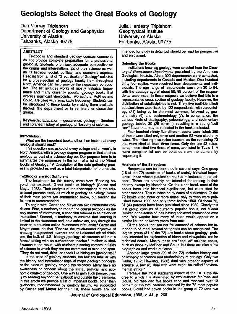
Geologists Select the Great B'ooks of Geology
Don ~:~urray Triplehorn Department of Geology and Geophysics University of Alaska Fairbanks, Alaska ggns
ABSTRACT Textbooks and standard geology courses commonly
do not provide complete preparation for a professional geologist Students often lack adequate perspective on the origins and Interrelationships of their science as well as its broader social, political, and economic aspects. Reading from a list of "Great Books of Geology" selected by a cross-section of geology faculty from throughout North America can help provide the necessary perspective. The list includes works of mostly historical importance and many currently popular g_eology books that express significant viewpoints. Two authors, McPhee and Gould, are cited with remarkable frequency. Students can be introduced to these books by making them available through the department or in seminars or discussion groups.
Keywords: Education - geoscience; geology - literature and libraries; history of geology; philosophy of science.
Introduction What are the important books, other than texts, that every
geologist should read? This question was asked of every college and university in
North America with a geology-degree program or that teaches geology as part of a science degree. Our purpose here is to summarize the responses In the form of a list of the "Great Books of Geology." A description of the data-gathering process is provided as well as a brief interpretation of the results.
Julia Hardesty Triplehorn Geophysical Institute University of Alaska Fairbanks, Alaska 99n5
intended for study in detail but should be read for perspective and enjoyment.
Selecting the Books Institutions teaching geology were selected from the Direc
tory of Geoscience Departments published by the American Geological Institute. About 900 departments were contacted, including departments in Canada and Mexico. One hundred thirty-four replies were received from departments and Individuals. The age range of respondents was from 30 to 84, with the average age of about 50; 89 percent of the respondents were male. In these respects we believe that this Is a representative cross section of geology faculty. However, the distribution of subdisciplines is not. Thirty-five (self-Identified) subdisciplines were listed by 122 respondents, with paleontology (21) being by far the most common, followed by geochemistry (9) and sedimentology (7). In combination, the various kinds of stratigraphy, paleontology, and sedirrtentary geology totaled 30 (25 percent), resulting in a strong "soft rock" flavor that may be reflected In the books selected.
Four hundred ninety-five different books were listed; 360 of these were cited only once and another 63 were cited only twice. The following discussion focuses on the remaining 72 that were cited at least three times. Only the top 42 selections, those cited five times of more, are listed In Table 1. A more complete list can be obtained from the authors by requesting it.
An~~lysis of the Selections Responses can be interpreted In several ways. One group
(18 of the 72) consisted of books of mainly historical lmpor-Textbooks •re not Sufficient tance, those whose publication marked milestones in the sci-
The Inspiration for this survey carne from "Reading be- ence. These are probably not Intended for reading In their yond the textbook: Great books of biology": (Carter and entirety except by historians. On the other hand, most of the Mayer, 1988). Their analysis of the shortcomings of the edu- books have little historical significance, but were cited for cational process apply as much to geology as biology. Some other reasons. This is indicated by dates of publication. Of the of their main points are summarized below, but reading the 72 books cited three or more times, only thirteen were pub-full text is recommended. lished before 1900 and only three before 1800. Of these 72,
To begin with, Carter and Mayer cite two unfortunate con- 31 (43 percent) have been published since 1980. Clearly this ditlons. Arst, a tendency to regard the course textbook as the last group consists of currently popular books, not "Great only source of Information, a condition referred to as "textbook Books" in the sense of their having achieved prominence over Infatuation." Second, a tendency to assume that learning is time. We wonder how many of these would appear on a limited to the classroom and, as a subsidiary, only through the similar list ten or twenty years from now. teacher, a situation called "classroom infatuation." Carter and Of the books that are not "milestones" of science but in-Mayer conclude that "Despite the much-touted objective of tended to be read, several categories can be recognized. The creating independent learners and self-directed critical think- largest group (31 of the 72) are books about geology, prob-ers, the bulk of U.S. biology [geology] classrooms still are a ably intended for exploration of ideas and viewpoints, not for formal setting with an authoritarian teacher." Intellectual shal- technical details. Mostly these are "popular" science books, lowness is the result, with students planning careers in fields such as those by McPhee and Gould, but there are also a few of science to which they are not committed In mind and spirit. biographies and works of fiction. "They do not read, think, or speak like biologists [geologists]." Another large group (20 of the 72) includes history and
In the case of geology students, too few are familiar with philosophy of science and methodology of geology. Only two the history and interrelationships of major geologic concepts (Kuhn, 1962; Hawking, 1988) deal with broader aspects of or the place of geology among the sciences. Many have no science. A few (3) deal with what might be called "environ-awareness or concern about the social, political, and eco- mental ethics." nomic context of geology. One way to gain such perspectives Perhaps the most surprising aspect of the list is the de-is by reading beyond the textbook and outside the classroom. gree to which it is dominated by two authors: McPhee and In this article we provide a list of important books, other than Gould. McPhee had five books cited and received over 13 textbooks, recommended by geology faculty. As suggested percent of the total citations received by the 72 most popular by Carter and Mayer for their list, these books are not books. Gould had seven books in the group of 72 (and two
Journal of Geological Education, 1993, v. 41, p. 260
December 1993 77
Geologists Select the Great Books of Geology
(29)* 1. Principles of Geology, Lyell, 1830-1833
(28) 2. Wonderful Ufe, Gould, 1989 (23) 3. Origin of Species, Darwin, 1859
(22) 4. In Suspect Terrain, McPhee, 1983 (21) 5. Basin and Range, McPhee, 1981 (20) 6. Origins of Continents and Oceans, Wegener, 1912 (17) 7. /1/ustrations of the Huttonian Theory, Playfair, 1802 (16) 8. Rising from the Plains, McPhee, 1986
(15) 9. Great Geological Controversies, Hallam, 1983 (14) 10. Control of Nature, McPhee, 1989
11. Principles of Physical Geology, Holmes, 1945
12. Time's Arrow, Time's Cycle, Gould, 1987 (13) 13. The Evolution of the Igneous Rocks, Bowen, 1928
14. The Fabric of Geology, Albritton, 1963
(11) 15. The Meaning of Fossils, Rudwlck, 1972 (10) 16. The Structure of Scientific Revolutions, Kuhn, 1962
17. The Voyage of the Beagle, Darwin, 1836 ?? (9) 18. The Birth and Development of the Geological
Sciences, Adams, 1954 19. Exploration of the Colorado River, Powell, 1875 20. Theory of the Earth with Proofs and /1/ustrations,
Hutton, 1775 (8) 21. The Nature of the Stratigraphic Record, Ager, 1973
22. De Re Metal/ica, Agricola, 1556
(7) 23. The Founders of Geology, Geikle, 1897 24. Giants of Geology, Fenton, 1952 25. Language of the Earth, Rhodes, 1981 26. An Ocean of Truth, Menard, 1986
27. Report on Geology of the Henry Mountains, Gilbert, 1887
(6) 28. Conversations with the Earth, Cloos, 1953
29. The Dinosaur Heresies, Baaker, 1986
30. The Great Devonian Controversy, Rudwick, 1985 31. Ice Ages, Solving the Mystery, Imbrie, 1979
32. It Began with a Stone, Faul, 1983 33. Studies on Glaciers, Agassiz, 1840 34. System of Mineralogy, Dana, 1837
(5) 35. Adventures in Earth History, Cloud, 1970 36. The Behavior of the Earth, Allegro, 1983 37. Chaos, Making of a New Science, Gerick, 1987 38. The Immense Journey, Eiseley, 1957
39. Principles of Stratigraphy, Grabau, 1913 40. Prodromes De Solido ... , Stano, 1669 41. The Road to Jaramillo, Glen, 1982
42. Sand County Almanac, Leopold, 1949
*Numbers in parentheses are number of times each book was listed by respondents.
these two authors is even greater than shoW'l here because some respondents listed •anything by ... " McPh€'9 or Gould without citing specific titles that could be ~abulaMd In our survey. It seems unlikely that the popular reading of any other discipline is _so dominated by only two authors, including one (McPhee) who is not even a member of that profession.
What Do We Do with this List? Recall that our purpose here was to direct the attention of
students to books important to their professional development but not likely to be encountered in the usual classes.
The simplest approach would be to make some form of the list widely available to students, but an explanation of why these books are important also seems necessary. The best answers to this question in our opinion were provided by Individual faculty members. To c.onvey the significance of each book (why many geologists thought it was important), we are preparing annotations, Including a brief description of content supplemented by our subjective opinions and comments by respondents to our survey. When this annotated list is complete, we will announce its availability In JGE. It would also be relatively easy for departments to maintain a small collection of recommended books, to be circulated with the encouragement of the faculty. A more substantial step would be to use these books as a basis for discussion among students and faculty, perhaps in small seminars as issues arise. The most formal and structured approach would be to offer credit courses involving extensive readings from the list, with scheduled debates, lectures, term papers, and so forth.
In the course of the survey, we discovered that a small number of schools already have such courses based, at least in part, on the Great Books of Geology, usually in the guise of a course on the history and philosophy of geology. Perhaps it would be useful to compile a summary of reading lists and · formats along with suggestions as to what works and what doesn't. This shared experience could be used as a point of departure and means of encouragement for other geology departments. Readers are encouraged to contact the authors to express their interest or make suggestions regarding such a proposal.
Acknowledgements Thanks are extended to all of the respondents. Many, too
many to recognize individually, provided lengthy and thoughtful discussions that were greatly appreciated.
References Cited Carter, Jack L, and Mayer, William V., 1988, Reading beyond
the textbook: Great books of biology: Bioscience, v. 38, no. 7, p. 490-492.
About the Authore :5· . ~-: .. (~~--~~.~~~ . '\'' ~- ;·/ '• --~ ~<~·:.;'~"-~·>~~.,n~ >~.{~:.
'. ' Don M. Triplehorn Is. a Professor of Geology at' the'_University of Alaska, Fairbanks. Following his earning a · PhD In clay mineralogy from the UniversitY of Illinois, he , worked nine years In Tulsa with Sfnclair Research before, coming to Alaska m 1969. Hls research has focUsed on'· volcanic ash layers 8ssociated With "coal as well as the··, related K·T lmpaa Jayer"(dustls dust). ·;_:., .;. :· ·, _. __ ,:, ,· '?.;}, :< .,-·_ · Julia H. Triplehorn received an MA In Ubi'ary Science ,
Table 1. The Great Books of Geology. from the University of Illinois and ls'an Associate Profes- i
others cited less than three times) for a total of 9 percent of sor of Ubrary Science and Ubrarlan at the Keith B. Mather-:: the total citations. The second most popular book, Gould's Ubrary of the Geophyslcallnstltute, University of Alaska,', Wonderful Ufe, was listed almost as often as the most popular ~~a~ :t~ ~u!!,~lon,Jt!: ::. book (28 versus 29). Even more startling, four of the top ten ....... ~ ........ , , """"V'Iilf"""''"' , (neglecting a tie at tenth place) are by McPhee, including lng those on coal in Alaska, the aurora borealra, and earth··." fourth, fifth, and eighth places. Actually, the popularity of quakes.·~- ' . .;.-.·.-,·~, , .. ',: . '~.: .,,,_._.,(,'
Journal of Geological Education, 1993, v. 41, p. 261
7~ The Geological ~!cwslctter