Embed Size (px)
Citation preview
ECMWF Seminar on Data assimilation for atmosphere and ocean, 6 - 9 September 2011 1
The Global Observing System in the Assimilation Context
M. Rienecker, R. Gelaro, S. Pawson, R. Reichle, W. McCarty
NASA/GSFC/Global Modeling and Assimilation Office Greenbelt, USA
Abstract
Weather and climate analyses and predictions all rely on the global observing system. However, the observing system, whether atmosphere, ocean, or land surface, yields a diverse set of incomplete observations of the different components of Earth’s environment. Data assimilation systems are essential to synthesize the wide diversity of in situ and remotely sensed observations into four-dimensional state estimates by combining the various observations with model-based estimates. Assimilation, or associated tools and products, are also useful in providing guidance for the evolution of the observing system of the future. This paper provides a brief overview of the global observing system and information gleaned through assimilation tools, and presents some evaluations of observing system gaps and issues.
1. Introduction
Global networks that observe the Earth provide a huge variety of observations of the state of the atmosphere, ocean and land surface from in situ, airborne, and space-based sensors. The inter-connectedness of the different components of the Earth’s environment and the use of individual observing networks in a variety of applications have led to an increasing consolidation and coordination within and across organizations responsible for the observing networks. For example, the World Meteorological Organization (WMO) has established the WMO Integrated Global Observing System (WIGOS, see http://www.wmo.int/pages/prog/www/wigos/) to improve and evolve the current WMO global observing systems into an integrated, comprehensive and coordinated system. Many governments and international organizations are building a Global Earth Observation System of Systems (GEOSS) by coordinating observation assets and plans through the intergovernmental Group on Earth Observations (GEO, see http://www.earthobservations.org). GEOSS aims to achieve comprehensive, coordinated and sustained observations of the Earth system to improve monitoring of the state of the Earth, increase understanding of Earth processes, and enhance prediction of the behavior of the Earth system. The GEOSS implementation plan advocates harmonization of observations and integration of observational information through data assimilation, inter alia.
The Global Climate Observing System (GCOS, see http://www.wmo.int/pages/prog/gcos/), which consists of the climate relevant components of all established environmental observing networks and systems, serves as the climate observation component of the GEOSS; the Global Ocean Observing System (GOOS, see http://www.ioc-goos.org/) is the oceanographic component of GEOSS. GCOS and GOOS are both sponsored by the WMO, the Intergovernmental Oceanographic Commission (IOC) of UNESCO, the United Nations Environment Programme (UNEP), and the International Council for Science (ICSU). Space based components of the GCOS are coordinated by the Committee
https://ntrs.nasa.gov/search.jsp?R=20120008249 2018-05-15T22:18:17+00:00Z
RIENECKER, M: THE GLOBAL OBSERVING SYSTEM
2 ECMWF Seminar on Data assimilation for atmosphere and ocean, 6 - 9 September 2011
on Earth Observation Satellites (CEOS) and the Coordination Group for Meteorological Satellites (CGMS).
Details of different observing systems can be found at the web sites above and their links. As part of the development of the observing system, reviews, such as the WIGOS Rolling Review of Requirements (RRR), are undertaken and an observing system gap analysis is prepared. One of the outcomes of the WMO RRR is a Statement of Guidance (SoG) that provides an assessment of the adequacy of observations to fulfill requirements. SoGs were recently issued for global numerical weather prediction (NWP) (June 2011) and high resolution NWP (August 2011) (see http://www.wmo.int/pages/prog/www/OSY/GOS-RRR.html). From the climate perspective, the August 2010 report from GCOS (GCOS-138) specifies the actions required to implement a comprehensive observing system for the Essential Climate Variables (ECVs) and presents the need for observational records to improve seasonal-to-interannual climate predictions. Thus, some part of these reviews is generally conducted with the view to using the observations in an assimilation context – to provide analyses of the current state of the Earth’s environment for both weather and climate applications and to provide initial conditions for weather and climate predictions.
The corollary is that the machinery of assimilation systems can be brought to bear on evaluations of the optimality of the current observing system and of future observations proposed to address gaps identified in other ways. Ancillary calculations (such as observation impacts estimated with adjoint tools), observing system experiments (OSEs, also referred to as data denial experiments) and Observing System Simulation Experiments (OSSEs) have all been used to evaluate the impact of different observations in NWP. With the increasing costs of launching new satellites and of maintaining research satellites that have lasted beyond their planned life, information on impacts is increasingly being sought to justify sustaining and/or advancing space-based observations.
This paper briefly summarizes observations incorporated into operational (or quasi-operational) assimilation systems and some of the recent observing system reviews before presenting examples of information gained on the observing system and issues identified through assimilation. The discussions and examples are limited to global assimilation systems and the physical environment. Atmosphere, ocean, and land surface are treated in turn.
2. Atmosphere
WIGOS identifies about 11,000 land stations that provide observations of meteorological parameters (atmospheric pressure, wind speed and direction, air temperature and relative humidity) at least every three hours; of approximately 4,000 volunteer observing ships (VOS), 1,000 provide reports (atmospheric pressure, wind speed and direction, air temperature and relative humidity, sea surface temperature, wave height and period) daily; about 1,200 drifting buoys that provide about 14,000 sea level pressure (SLP) observations and 27,000 sea surface temperature (SST) observations daily. There are about 1,300 stations that provide about 1,500 upper air reports (pressure, wind velocity, temperature and humidity from just above ground to heights of up to 30km) daily and there are about 300,000 aircraft reports daily of pressure, winds and temperature during flight.
A WMO dossier (http://www.wmo.int/pages/prog/sat/gos-dossier_en.php) for the space-based global observing system, released in September 2011, notes that there are about 268 Earth observation
RIENECKER, M: THE GLOBAL OBSERVING SYSTEM
ECMWF Seminar on Data assimilation for atmosphere and ocean, 6 - 9 September 2011 3
satellites with over 400 different instruments, including operational meteorological satellites and research platforms. Of course, not all of these observations are assimilated in today’s operational global assimilation systems. Satellites for operational meteorology exploit two types of orbits: geostationary (for high frequency viewing of a fixed area centered on a particular equatorial longitude) and sun-synchronous (for global coverage at a fixed Local Solar Time (LST) determined by the orbit altitude and the high (near-polar) inclination). The two orbit types serve complementary requirements: frequent observations of highly evolutionary phenomena outside of the high latitudes, and infrequent, global coverage. The current operational geostationary and polar-orbiting satellites are an international fleet:
Geostationary satellites Polar-orbiting satellites o European Meteosat o USAʼs civilian POES o USAʼs GOES o USAʼs military DMSP o Japanese Himawari (formerly GMS, currently MTSAT) o EUMETSAT Polar System o Russian Electro (formerly GOMS) o Russian Meteor o Chinese FY-2 to be replaced by FY-4 o Chinese FY-1 being replaced by FY-3 o Indian INSAT and Kalpana (formerly MetSat) o Korean COMS
The WMO “Vision for the GOS in 2025” is a system of operational meteorological satellites in geostationary and sun-synchronous orbits that should include: at least six geostationary satellites, separated by no more than 70°; satellites in three sun-synchronous orbital planes (AM, PM and Early Morning); and comparable quality across systems through inter-calibration.
2.1. NWP
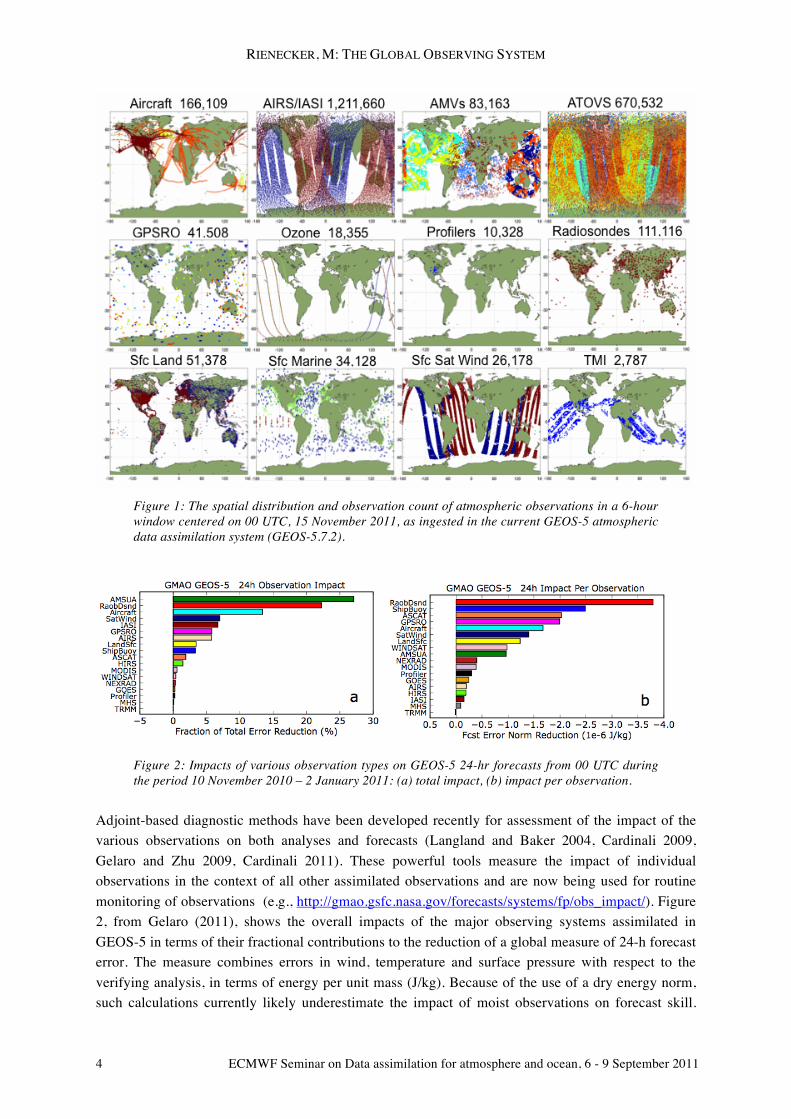
The observational requirements for global NWP are based on the need to provide an accurate analysis of the atmosphere’s complete meteorological state and the Earth’s surface at regular intervals (typically every 6 hours). Current operational (or, in the case of the GMAO’s system, quasi-operational) assimilation systems take advantage of both operational and research observations such as hyperspectral radiances from AIRS on EOS-Aqua and TMI-derived precipitation. Figure 1 shows the spatial distribution of observations in a 6-hour window of the current GEOS-5 assimilation system (GEOS-5.7.2). Clearly, assimilation is needed to provide a synthesis of the different observations, which are incomplete, of different quality, and of different variables. Quality control and data thinning are essential elements in the assimilation procedure (e.g., Rabier 2011) for quality as well as computational viability. Even though progress is being made in the assimilation of cloud- and rain-affected radiances, quality control procedures in operational systems generally reject such observations so that only about 20% of radiance observations are actually assimilated.
In addition to the “contamination” by clouds and rain, other influences in radiative transfer algorithms impact the ability of current assimilation systems to make full use of satellite observations. For example, Andersson (2011) notes that sounding data from satellites are currently under-utilized over land; and both microwave and infrared radiance data containing information on lower-tropospheric temperature are under-utilized due to surface emissivity and land-surface temperature uncertainties.
RIENECKER, M: THE GLOBAL OBSERVING SYSTEM
4 ECMWF Seminar on Data assimilation for atmosphere and ocean, 6 - 9 September 2011
Figure 1: The spatial distribution and observation count of atmospheric observations in a 6-hour window centered on 00 UTC, 15 November 2011, as ingested in the current GEOS-5 atmospheric data assimilation system (GEOS-5.7.2).
Figure 2: Impacts of various observation types on GEOS-5 24-hr forecasts from 00 UTC during the period 10 November 2010 – 2 January 2011: (a) total impact, (b) impact per observation.
Adjoint-based diagnostic methods have been developed recently for assessment of the impact of the various observations on both analyses and forecasts (Langland and Baker 2004, Cardinali 2009, Gelaro and Zhu 2009, Cardinali 2011). These powerful tools measure the impact of individual observations in the context of all other assimilated observations and are now being used for routine monitoring of observations (e.g., http://gmao.gsfc.nasa.gov/forecasts/systems/fp/obs_impact/). Figure 2, from Gelaro (2011), shows the overall impacts of the major observing systems assimilated in GEOS-5 in terms of their fractional contributions to the reduction of a global measure of 24-h forecast error. The measure combines errors in wind, temperature and surface pressure with respect to the verifying analysis, in terms of energy per unit mass (J/kg). Because of the use of a dry energy norm, such calculations currently likely underestimate the impact of moist observations on forecast skill.
RIENECKER, M: THE GLOBAL OBSERVING SYSTEM
ECMWF Seminar on Data assimilation for atmosphere and ocean, 6 - 9 September 2011 5
The results show that AMSU-A radiances have the largest overall impact, providing roughly 27% of the total error reduction due to the assimilation of all observations. On a per-observation basis, though, radiosondes are still an essential component of the observing system, not the least because they are needed to help calibrate the use of some satellite data (Andersson 2011). The recently added GPSRO radio-occultation data also have a very high impact on tropospheric forecast skill, providing roughly 5% of the total error reduction, even from observations in the lower stratosphere.
Consistent with Figure 2a, the SoG for global NWP notes the strong positive impact on NWP skill from advanced microwave sounding instruments (such as AMSU-A), from high spectral resolution sounders with improved vertical resolution (such as AIRS and IASI), and from radio-occultation measurements, which complement other systems in both temperature and moisture profile information for 10-200 hPa. It also lists critical atmospheric and surface variables that are not adequately measured by current or planned systems (in order of priority):
o Wind profiles at all levels o Temperature and humidity profiles of adequate vertical resolution in cloudy areas o Precipitation o Snow mass.
The report notes further that NWP centers would benefit from further increased coverage of aircraft data, particularly from ascent/descent profiles in the tropics, from several types of in situ measurements that are made but not currently disseminated globally (e.g., ozone from sondes), and from near-real time in situ soil moisture measurements with global coverage.
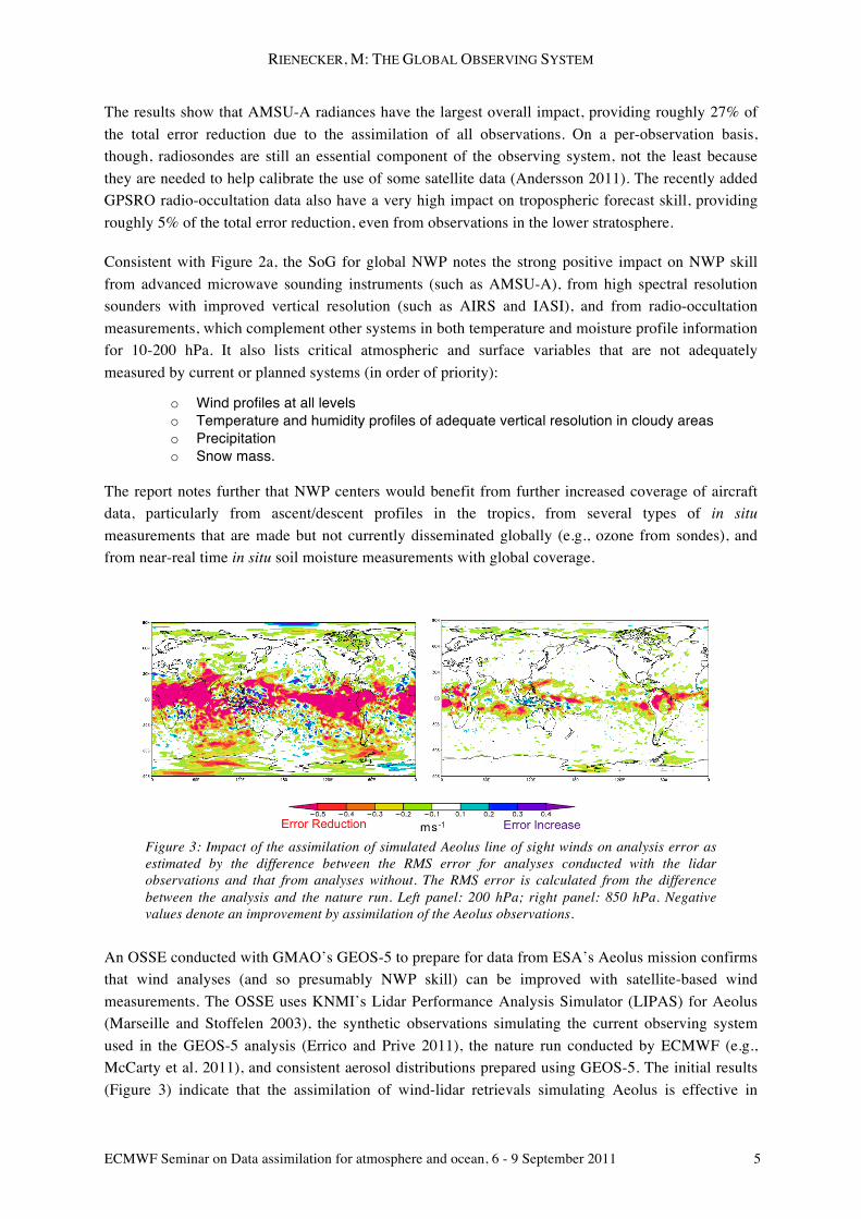
Figure 3: Impact of the assimilation of simulated Aeolus line of sight winds on analysis error as estimated by the difference between the RMS error for analyses conducted with the lidar observations and that from analyses without. The RMS error is calculated from the difference between the analysis and the nature run. Left panel: 200 hPa; right panel: 850 hPa. Negative values denote an improvement by assimilation of the Aeolus observations.
An OSSE conducted with GMAO’s GEOS-5 to prepare for data from ESA’s Aeolus mission confirms that wind analyses (and so presumably NWP skill) can be improved with satellite-based wind measurements. The OSSE uses KNMI’s Lidar Performance Analysis Simulator (LIPAS) for Aeolus (Marseille and Stoffelen 2003), the synthetic observations simulating the current observing system used in the GEOS-5 analysis (Errico and Prive 2011), the nature run conducted by ECMWF (e.g., McCarty et al. 2011), and consistent aerosol distributions prepared using GEOS-5. The initial results (Figure 3) indicate that the assimilation of wind-lidar retrievals simulating Aeolus is effective in
RIENECKER, M: THE GLOBAL OBSERVING SYSTEM
6 ECMWF Seminar on Data assimilation for atmosphere and ocean, 6 - 9 September 2011
reducing analysis errors for zonal wind, especially in the tropics where the mass-wind balance fails and in the Southern Hemisphere where there are fewer conventional observations. The largest impacts from Aeolus, which will retrieve clear-sky winds, are seen in upper levels where there is less lidar signal attenuation by clouds and therefore a larger number of retrieved winds.
2.2. Reanalyses
Atmospheric reanalyses, conducted for climate diagnostics purposes, bring to light other issues regarding observations in the assimilation context. Many of these are mentioned in Dee and Uppala (2009), Dee et al. (2011) and Rienecker et al. (2011). As for NWP, of particular importance is the need to correct the biases in the observations. Correction of biases in the radiosonde temperature sensors is an essential part of the pre-processing of observations (Rabier 2011). Major advances in the assimilation of satellite radiances have been achieved because of variational bias correction. Reanalyses can take advantage of the inter-calibration of sensors (e.g., Zou et al. 2006) prior to assimilation. Although the data still have to be bias-corrected, there may be an advantage to using inter-calibrated data in times when there is no observation to serve as an anchor for the bias correction. Reanalyses have also highlighted the impact of the increasing number of aircraft observations over time – the warm bias in those observations leads to an offset in the analysis relative to the radiosonde data because of the greater volume of aircraft observations in later years.
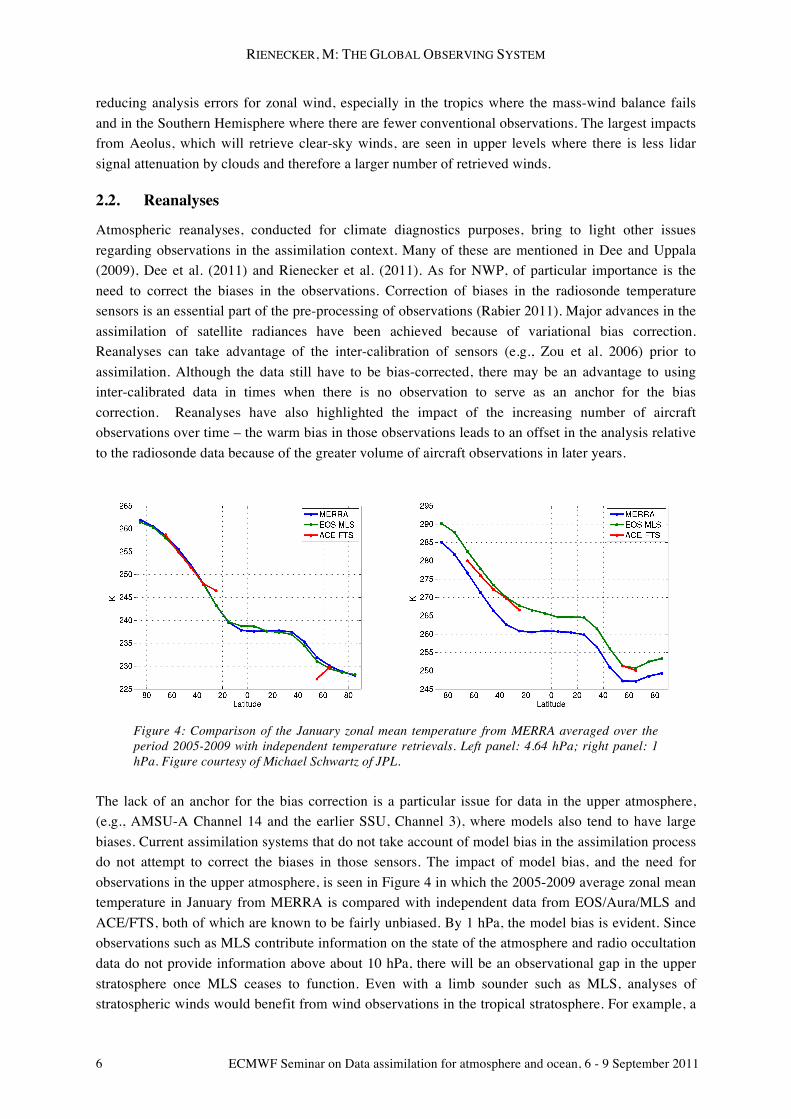
Figure 4: Comparison of the January zonal mean temperature from MERRA averaged over the period 2005-2009 with independent temperature retrievals. Left panel: 4.64 hPa; right panel: 1 hPa. Figure courtesy of Michael Schwartz of JPL.
The lack of an anchor for the bias correction is a particular issue for data in the upper atmosphere, (e.g., AMSU-A Channel 14 and the earlier SSU, Channel 3), where models also tend to have large biases. Current assimilation systems that do not take account of model bias in the assimilation process do not attempt to correct the biases in those sensors. The impact of model bias, and the need for observations in the upper atmosphere, is seen in Figure 4 in which the 2005-2009 average zonal mean temperature in January from MERRA is compared with independent data from EOS/Aura/MLS and ACE/FTS, both of which are known to be fairly unbiased. By 1 hPa, the model bias is evident. Since observations such as MLS contribute information on the state of the atmosphere and radio occultation data do not provide information above about 10 hPa, there will be an observational gap in the upper stratosphere once MLS ceases to function. Even with a limb sounder such as MLS, analyses of stratospheric winds would benefit from wind observations in the tropical stratosphere. For example, a
RIENECKER, M: THE GLOBAL OBSERVING SYSTEM
ECMWF Seminar on Data assimilation for atmosphere and ocean, 6 - 9 September 2011 7
comparison of MERRA and ERA-Interim reveals that although the Quasi-Biennial Oscillation (QBO) in stratospheric winds is constrained well by the current observations, the Semi-Annual Oscillation (SAO) above is not (Rienecker et al. 2011).
Thus, in addition to the observational gaps in the troposphere noted for NWP, there are observing system issues and gaps that are important for both upper atmosphere and climate analyses.
3. Ocean
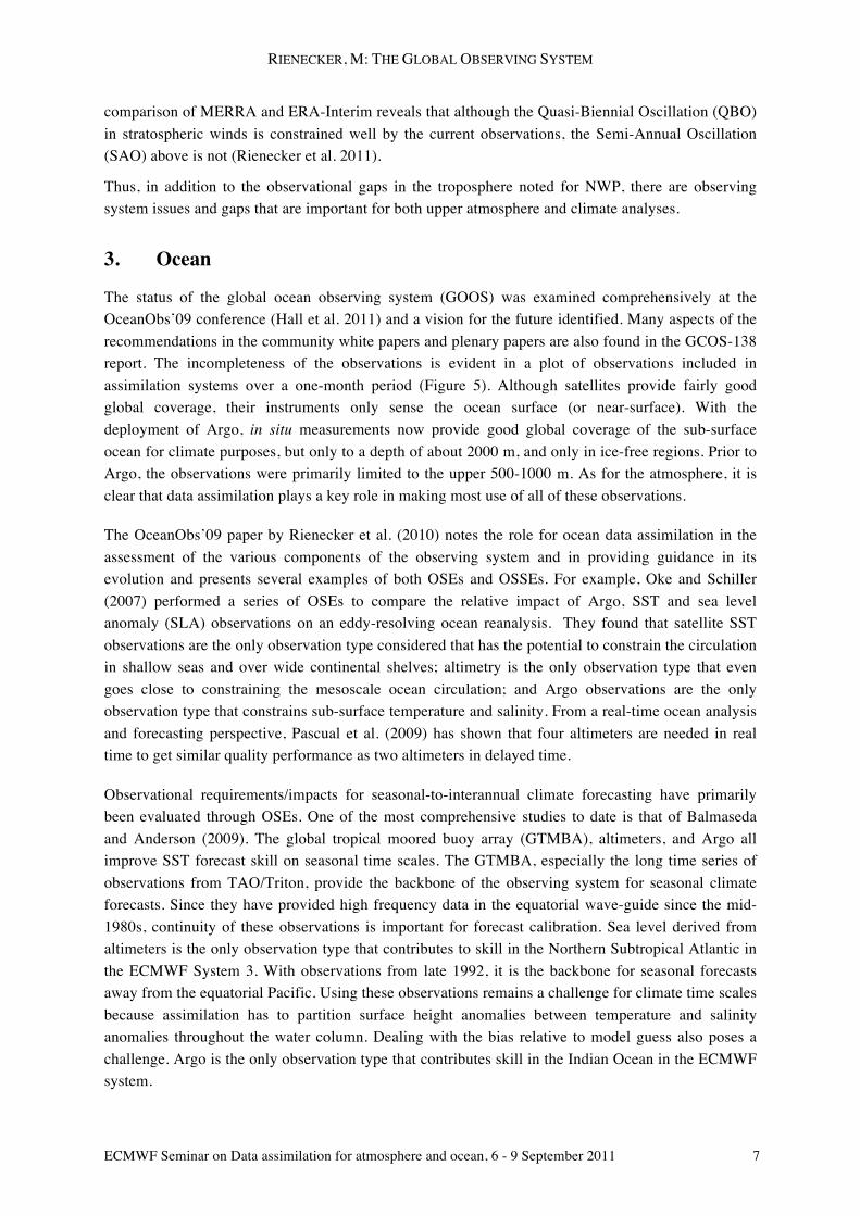
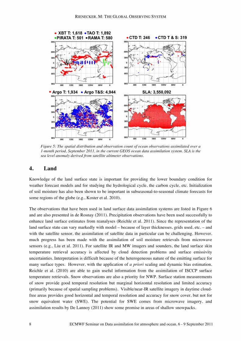
The status of the global ocean observing system (GOOS) was examined comprehensively at the OceanObs’09 conference (Hall et al. 2011) and a vision for the future identified. Many aspects of the recommendations in the community white papers and plenary papers are also found in the GCOS-138 report. The incompleteness of the observations is evident in a plot of observations included in assimilation systems over a one-month period (Figure 5). Although satellites provide fairly good global coverage, their instruments only sense the ocean surface (or near-surface). With the deployment of Argo, in situ measurements now provide good global coverage of the sub-surface ocean for climate purposes, but only to a depth of about 2000 m, and only in ice-free regions. Prior to Argo, the observations were primarily limited to the upper 500-1000 m. As for the atmosphere, it is clear that data assimilation plays a key role in making most use of all of these observations.
The OceanObs’09 paper by Rienecker et al. (2010) notes the role for ocean data assimilation in the assessment of the various components of the observing system and in providing guidance in its evolution and presents several examples of both OSEs and OSSEs. For example, Oke and Schiller (2007) performed a series of OSEs to compare the relative impact of Argo, SST and sea level anomaly (SLA) observations on an eddy-resolving ocean reanalysis. They found that satellite SST observations are the only observation type considered that has the potential to constrain the circulation in shallow seas and over wide continental shelves; altimetry is the only observation type that even goes close to constraining the mesoscale ocean circulation; and Argo observations are the only observation type that constrains sub-surface temperature and salinity. From a real-time ocean analysis and forecasting perspective, Pascual et al. (2009) has shown that four altimeters are needed in real time to get similar quality performance as two altimeters in delayed time.
Observational requirements/impacts for seasonal-to-interannual climate forecasting have primarily been evaluated through OSEs. One of the most comprehensive studies to date is that of Balmaseda and Anderson (2009). The global tropical moored buoy array (GTMBA), altimeters, and Argo all improve SST forecast skill on seasonal time scales. The GTMBA, especially the long time series of observations from TAO/Triton, provide the backbone of the observing system for seasonal climate forecasts. Since they have provided high frequency data in the equatorial wave-guide since the mid-1980s, continuity of these observations is important for forecast calibration. Sea level derived from altimeters is the only observation type that contributes to skill in the Northern Subtropical Atlantic in the ECMWF System 3. With observations from late 1992, it is the backbone for seasonal forecasts away from the equatorial Pacific. Using these observations remains a challenge for climate time scales because assimilation has to partition surface height anomalies between temperature and salinity anomalies throughout the water column. Dealing with the bias relative to model guess also poses a challenge. Argo is the only observation type that contributes skill in the Indian Ocean in the ECMWF system.
RIENECKER, M: THE GLOBAL OBSERVING SYSTEM
8 ECMWF Seminar on Data assimilation for atmosphere and ocean, 6 - 9 September 2011
Figure 5: The spatial distribution and observation count of ocean observations assimilated over a 1-month period, September 2011, in the current GEOS ocean data assimilation system. SLA is the sea level anomaly derived from satellite altimeter observations.
4. Land
Knowledge of the land surface state is important for providing the lower boundary condition for weather forecast models and for studying the hydrological cycle, the carbon cycle, etc. Initialization of soil moisture has also been shown to be important in subseasonal-to-seasonal climate forecasts for some regions of the globe (e.g., Koster et al. 2010).
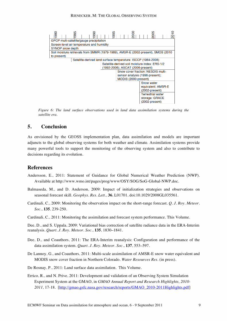
The observations that have been used in land surface data assimilation systems are listed in Figure 6 and are also presented in de Rosnay (2011). Precipitation observations have been used successfully to enhance land surface estimates from reanalyses (Reichle et al. 2011). Since the representation of the land surface state can vary markedly with model – because of layer thicknesses, grids used, etc. – and with the satellite sensor, the assimilation of satellite data in particular can be challenging. However, much progress has been made with the assimilation of soil moisture retrievals from microwave sensors (e.g., Liu et al. 2011). For satellite IR and MW imagers and sounders, the land surface skin temperature retrieval accuracy is affected by cloud detection problems and surface emissivity uncertainties. Interpretation is difficult because of the heterogeneous nature of the emitting surface for many surface types. However, with the application of a priori scaling and dynamic bias estimation, Reichle et al. (2010) are able to gain useful information from the assimilation of ISCCP surface temperature retrievals. Snow observations are also a priority for NWP. Surface station measurements of snow provide good temporal resolution but marginal horizontal resolution and limited accuracy (primarily because of spatial sampling problems). Visible/near-IR satellite imagery in daytime cloud-free areas provides good horizontal and temporal resolution and accuracy for snow cover, but not for snow equivalent water (SWE). The potential for SWE comes from microwave imagery, and assimilation results by De Lannoy (2011) show some promise in areas of shallow snowpacks.
RIENECKER, M: THE GLOBAL OBSERVING SYSTEM
ECMWF Seminar on Data assimilation for atmosphere and ocean, 6 - 9 September 2011 9
Figure 6: The land surface observations used in land data assimilation systems during the satellite era.
5. Conclusion
As envisioned by the GEOSS implementation plan, data assimilation and models are important adjuncts to the global observing systems for both weather and climate. Assimilation systems provide many powerful tools to support the monitoring of the observing system and also to contribute to decisions regarding its evolution.
References Andersson, E., 2011: Statement of Guidance for Global Numerical Weather Prediction (NWP).
Available at http://www.wmo.int/pages/prog/www/OSY/SOG/SoG-Global-NWP.doc.
Balmaseda, M., and D. Anderson, 2009: Impact of initialization strategies and observations on seasonal forecast skill. Geophys. Res. Lett., 36, L01701, doi:10.1029/2008GL035561.
Cardinali, C., 2009: Monitoring the observation impact on the short-range forecast. Q. J. Roy. Meteor. Soc., 135, 239-250.
Cardinali, C., 2011: Monitoring the assimilation and forecast system performance. This Volume.
Dee, D., and S. Uppala, 2009: Variational bias correction of satellite radiance data in the ERA-Interim reanalysis. Quart. J. Roy. Meteor. Soc., 135, 1830–1841. Dee, D., and Coauthors, 2011: The ERA-Interim reanalysis: Configuration and performance of the
data assimilation system. Quart. J. Roy. Meteor. Soc., 137, 553–597.
De Lannoy, G., and Coauthors, 2011: Multi-scale assimilation of AMSR-E snow water equivalent and MODIS snow cover fraction in Northern Colorado. Water Resources Res. (in press).
De Rosnay, P., 2011: Land surface data assimilation. This Volume.
Errico, R., and N. Prive, 2011: Development and validation of an Observing System Simulation Experiment System at the GMAO, in GMAO Annual Report and Research Highlights, 2010-2011, 17-18. [http://gmao.gsfc.nasa.gov/research/reports/GMAO_2010-2011Highlights.pdf]
RIENECKER, M: THE GLOBAL OBSERVING SYSTEM
10 ECMWF Seminar on Data assimilation for atmosphere and ocean, 6 - 9 September 2011
Gelaro, R., 2011: Measuring the global impact of ASCAT observations. JCSDA Quarterly, 35, 1-2.
Gelaro, R., and Y. Zhu, 2009: Examination of observation impacts derived from observing system experiments (OSEs) and adjoint models. Tellus, 61A, 179–193.
Hall, J., D.E. Harrison, and D. Stammer (Eds), 2010: Proceedings of OceanObs'09: Sustained Ocean Observations and Information for Society, Venice, Italy, 21-25 September 2009, ESA Publication WPP-306. doi:10.5270/OceanObs09.
Koster, R. D., and Coauthors, 2010: Contribution of land surface initialization to subseasonal forecast skill: First results from a multi-model experiment. Geophys. Res. Lett., 37, L02402, doi:10.1029/2009GL041677.
Langland, R.H., and N.L. Baker, 2004: Estimation of observation impact using the NRL atmospheric variational data assimilation adjoint system. Tellus, 56A, 189–201.
Liu, Q., and Coauthors, 2011: The contributions of precipitation and soil moisture observations to the skill of soil moisture estimates in a land data assimilation system. J. Hydrometeorol., 12, 750-765.
Marseille, G. J., and A. Stoffelen, 2003: Simulation of wind profiles from a space-borne Doppler wind lidar. Quart. J. Roy. Meteor. Soc., 129, 3079-3098.
McCarty, W., R. Errico, and R. Gelaro, 2011: Cloud coverage in the joint OSSE nature run. Mon. Wea. Rev. (submitted).
Oke, P. R., and A. Schiller, 2007: Impact of Argo, SST and altimeter data on an eddy-resolving ocean reanalysis. Geophys. Res. Lett., 34, L19601, doi:10.1029/2007GL031549.
Pascual A., C. Boone, G. Larnicol, and P.-Y. Le Traon, 2009: On the quality of real time altimeter gridded fields: Comparison with in situ data. J. Atmos. Ocean. Tech., 26, 556-569.
Rabier, F., 2011: Pre- and post-processing in data assimilation. This Volume.
Reichle, R. H., S. V. Kumar, S. P. P. Mahanama, R. D. Koster, and Q. Liu, 2010: Assimilation of satellite-derived skin temperature observations into land surface models. J. Hydrometeorol., 11, 1103-1122.
Reichle, R. H., R. D. Koster, G. J. M. De Lannoy, B. A. Forman, Q. Liu, S. P. P. Mahanama, and A. Toure, 2011: Assessment and enhancement of MERRA land surface hydrology estimates, J. Clim., in press, doi:10.1175/JCLI-D-10-05033.1.
Rienecker, M., and Coauthors, 2010: Synthesis and Assimilation Systems - Essential Adjuncts to the Global Ocean Observing System in Proceedings of OceanObs’09: Sustained Ocean Observations and Information for Society (Vol. 1), Venice, Italy, 21-25 September 2009, Hall, J., Harrison, D.E. & Stammer, D., Eds., ESA Publication WPP-306, doi:10.5270/OceanObs09.pp.31.
Rienecker, M.M., and Coauthors, 2011: MERRA - NASA's Modern-Era Retrospective Analysis for Research and Applications. J. Climate, 24, 3624-3648.
Zou, C., M.D. Goldberg, Z. Cheng, N.C. Grody, J.T. Sullivan, C. Cao, and D. Tarpley, 2006: Recalibration of microwave sounding unit for climate studies using simultaneous nadir overpasses. J. Geophys. Res., 111, D19114, doi:10.1029/2005JD006798.