Embed Size (px)
Citation preview

10/13/2015 GEO327G/386G, UT Austin 5-1
The Global Positioning System IIField Experiments

10/13/2015 GEO327G/386G, UT Austin 5-2
Mexico DGPS Field Campaign
Cenotes in Tamaulipas, MX, near Aldama

10/13/2015 GEO327G/386G, UT Austin 5-3
Are Cenote Water Levels Related?
10/13/2015 GEO327G/386G, UT Austin 5-4
DGPS Static Survey of Cenote Water Levels

10/13/2015 GEO327G/386G, UT Austin 5-5
Determining Orthometric Heights
• Ortho. Height = H.A.E. – Geoid Height
Earth Surface
Ellipsoid Geoid
Height
Height above MSL
(Orthometric height)H.A.E.
Geoid height
= H.A.E.
Geoid

10/13/2015 GEO327G/386G, UT Austin 5-6
Determining Orthometric Heights
• Ortho. Height = (H.A.E. – Geoid Height)
Need:
1) Ellipsoid model – GRS80 – NAVD88• reference stations: HARN (+ 2 cm), CORS (+ ~2 cm)
2) Geoid model – GEOID99 ( + 5 cm for US)
Procedure: Base receiver at reference station, rover at point of interest
a) measure HAE, apply DGS corrections
b) subtract local Geoid Height

10/13/2015 GEO327G/386G, UT Austin 5-7
Sources of Error
• Geoid error – model less well constrained in areas of few gravity measurement
• NAVD88 error – benchmark stability, measurement errors
• GPS errors – need precise ephemeri, tropospheric delay model, equipment (antennae should be same for base and rover)

10/13/2015 GEO327G/386G, UT Austin 5-8
Static Carrier-phase solutions obtained by:
• Commercial post-processing software
• e.g. Trimble Pathfinder office
• Web-based services
• Automated Gipsy – JPL/NASA - global
• SCOUT – Scripps, UCSB - global
• OPUS – NGS (US and territories)
• All services require files in RINEX format

10/13/2015 GEO327G/386G, UT Austin 5-9
Results
• Horizontal accuracies of <1 cm
• Vertical accuracies of 2-5 cm for 4 hrs of data

GPS Applications Today
• Surveying – Tectonics, Cadastre, Geodesy
• Map Making – georeferencing, field studies
• Navigation – vehicles, missiles, robots, etc.
• Tracking – people, vehicles, pets
• “Geotagging” – apply coordinates to digital data (photos, etc.)
• Clock Synchronization (+ 10 ns)
10/13/2015 GEO327G/386G, UT Austin 5-10

GPS and Geologic Mapping
Two techniques:
• GPS receiver and separate, gridded paper maps
• “Mapping-grade” receiver with mapping software and interactive touch screen
10/13/2015 GEO327G/386G, UT Austin 5-11

Low-Tech Mapping
Gridded maps/photos, pencil, GPS receiver
71
990
0
72
000
0
72
010
0
72
020
0
72
030
0
72
040
0
72
050
0
72
060
0
72
070
0
72
080
0
72
090
0
72
100
0
72
110
0
72
120
0
72
130
0
72
140
0
72
150
0
72
160
0
72
170
0
72
180
04948300
4948400
4948500
4948600
4948700
4948800
4948900
4949000
4949100
4949200
4949300
4949400
4949500
4949600
71
990
0
72
000
0
72
010
0
72
020
0
72
030
0
72
040
0
72
050
0
72
060
0
72
070
0
72
080
0
72
090
0
72
100
0
72
110
0
72
120
0
72
130
0
72
140
0
72
150
0
72
160
0
72
170
0
72
180
04948300
4948400
4948500
4948600
4948700
4948800
4948900
4949000
4949100
4949200
4949300
4949400
4949500
4949600
200 0 200 400 600
Meters
Contour Interval = 20 feet
UTM NAD83 13NSpence 7.5 ' Quad. Õ16 degrees
True N is ~1 degreesEast of grid N.
1:12,002
MN
10/13/2015 12GEO327G/386G, UT Austin
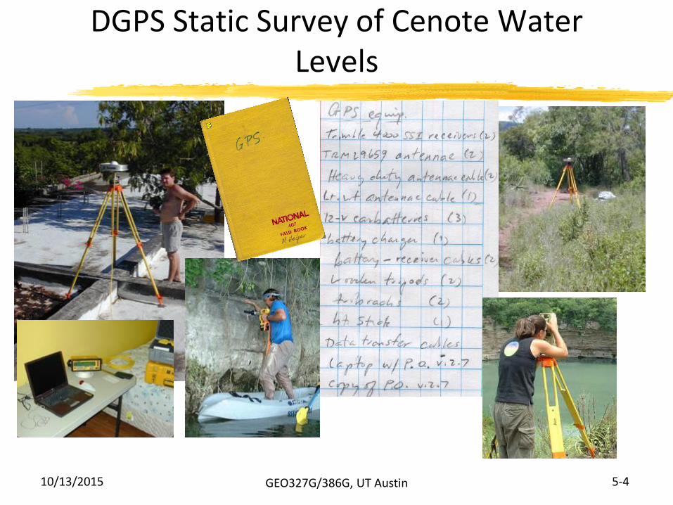
High-Tech Mapping Tools
Field Hardware
Windows CE or PocketPC devices
Outdoor tablet computers – Win XP
Field GIS/GPS Software
ESRI Software
ArcPad
ArcMap
10/13/2015 13GEO327G/386G, UT Austin

GPS-equipped Windows Mobile Devices
• Small, low res., color screens
• Limited CPU
• Resistive stylus pen
• Up to 12 hrs. battery life
• Light, portable
• Variably rugged
10/13/2015 14GEO327G/386G, UT Austin

Small, low res., color screens
10/13/2015 15GEO327G/386G, UT Austin
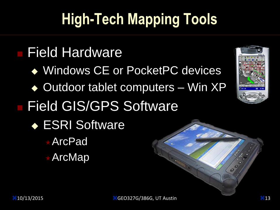
Outdoor Tablet Computers
• Large, outdoor-viewable,
high res. color screens
• Inductive stylus pen
• 3-4 hr. battery life
• Heavy, rugged
10/13/2015 16GEO327G/386G, UT Austin
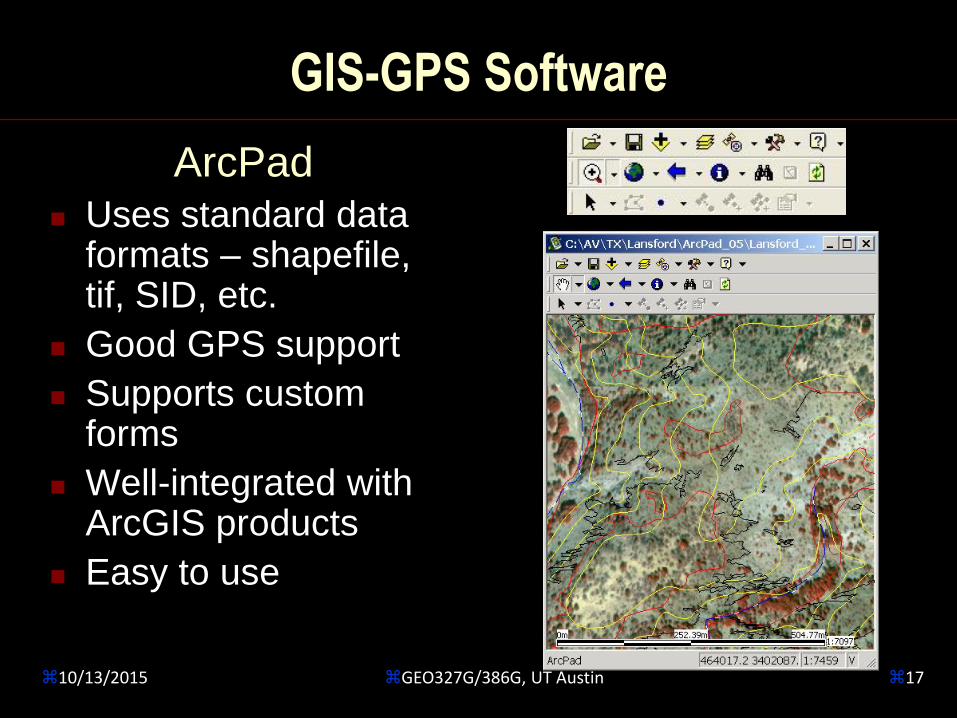
GIS-GPS Software
ArcPad
Uses standard data formats – shapefile, tif, SID, etc.
Good GPS support
Supports custom forms
Well-integrated with ArcGIS products
Easy to use
10/13/2015 17GEO327G/386G, UT Austin

Tablet Running ArcPad
GPS Location
pCcm
pCdmQal
10/13/2015 18GEO327G/386G, UT Austin

ArcGIS - ArcMap Software
Desktop software in the field
Powerful Drawing tools – best feature
Edit Geodatabases in the field
Minimal GPS capture tools
10/13/2015 19GEO327G/386G, UT Austin
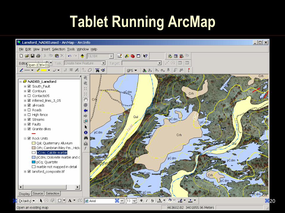
Tablet Running ArcMap
10/13/2015 20GEO327G/386G, UT Austin

High-Tech Mapping Tools
Field Hardware
Mobile Phones
Ipad or other tablet
Field GIS/GPS Apps.
Apple OS, Android OS
Surveying Apps.
10/13/2015 21GEO327G/386G, UT Austin

High-Tech Mapping Tools
iOS AppsPDF Maps
iGIS
10/13/2015 22GEO327G/386G, UT Austin

High-Tech Mapping Tools
App DistinctionsWill maps work offline?
Will GPS work offline?
Does it drop pins, geotag photos, notes etc.? E.g.
PDFMaps and many others free Apps
Does it allow capture of lines and polygons too? E.g.
iGIS, FieldMove, a few others; free to $$
ArcGIS Collector App
10/13/2015 23GEO327G/386G, UT Austin

10/13/2015 GEO327G/386G, UT Austin 5-24
Assisted GPS (A-GPS)
Mobile Devices with GPS and WiFi or Cellular Service, e.g. LBS (location-based services)-capable phone
1. GPS Almanac provided from Server; TTFFfaster – position found by phone (Mobile Station Assisted: “MSA GPS”)
2. GPS data sent to server, position sent back (Mobile Station Based: “MSB GPS”)
10/13/2015 GEO327G/386G, UT Austin 5-25
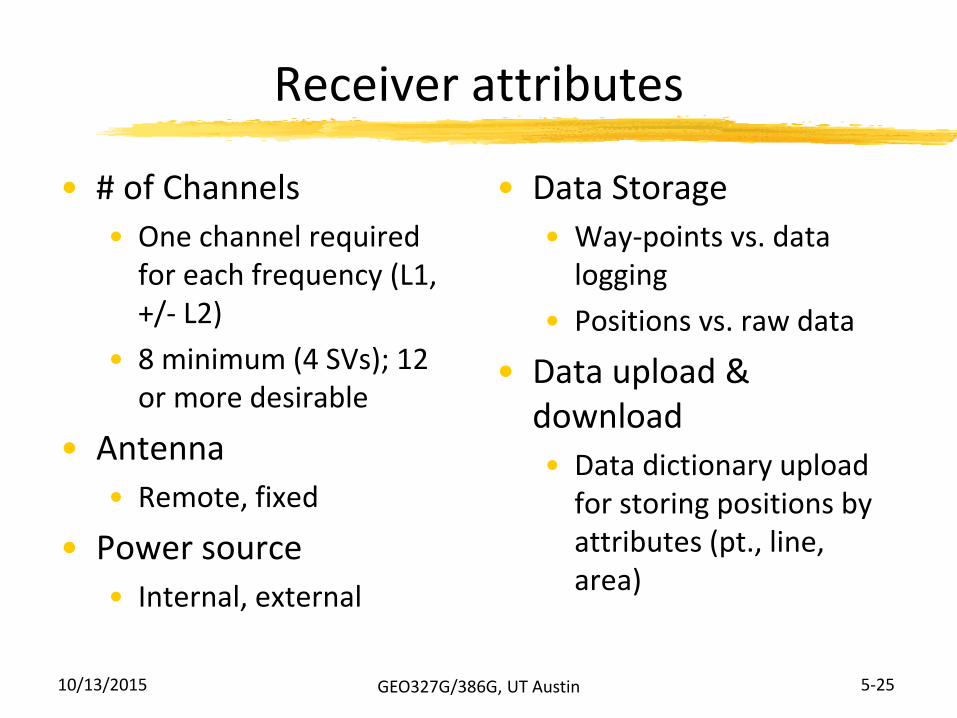
Receiver attributes
• # of Channels
• One channel required for each frequency (L1, +/- L2)
• 8 minimum (4 SVs); 12 or more desirable
• Antenna
• Remote, fixed
• Power source
• Internal, external
• Data Storage
• Way-points vs. data logging
• Positions vs. raw data
• Data upload & download
• Data dictionary upload for storing positions by attributes (pt., line, area)
10/13/2015 GEO327G/386G, UT Austin 5-26
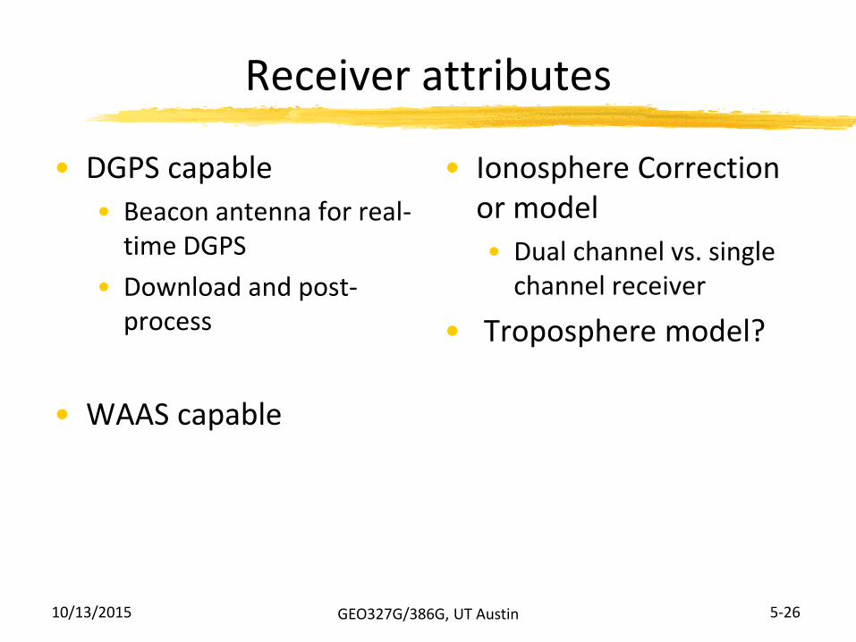
Receiver attributes
• DGPS capable
• Beacon antenna for real-time DGPS
• Download and post-process
• WAAS capable
• Ionosphere Correction or model
• Dual channel vs. single channel receiver
• Troposphere model?

10/13/2015 GEO327G/386G, UT Austin 5-27
GPS Equipment
Hand-helds $100-$450 – navigation instruments
Garmin
Magellan
GPS for PDAs
• Way Points collection
• Manual entry into GIS,
no attribute info. stored
• “Differential ready” but
no post-processing
For survey apps.:
+/- ~15 meters

10/13/2015 GEO327G/386G, UT Austin 5-28
GPS Equipment
Sub Meter (x, y) Accuracy, Hand-helds: $1000-$5000
Trimble
Ashtech
Topcon
Sokkia
others
Datalogging with “data dictionary” to upload/store attribute info.
GPS signal data collection for later post-processing
Custom RTK and beacon antennae feasible

10/13/2015 GEO327G/386G, UT Austin 5-29
GPS Equipment
Geodetic-quality Instruments
• Trimble
• Ashtech
• Sokkia
• Others
Cm – mm in x and y; 2 cm in z
Stationary Antenna
Large memory for continuous data collection
10/13/2015 GEO327G/386G, UT Austin 5-30
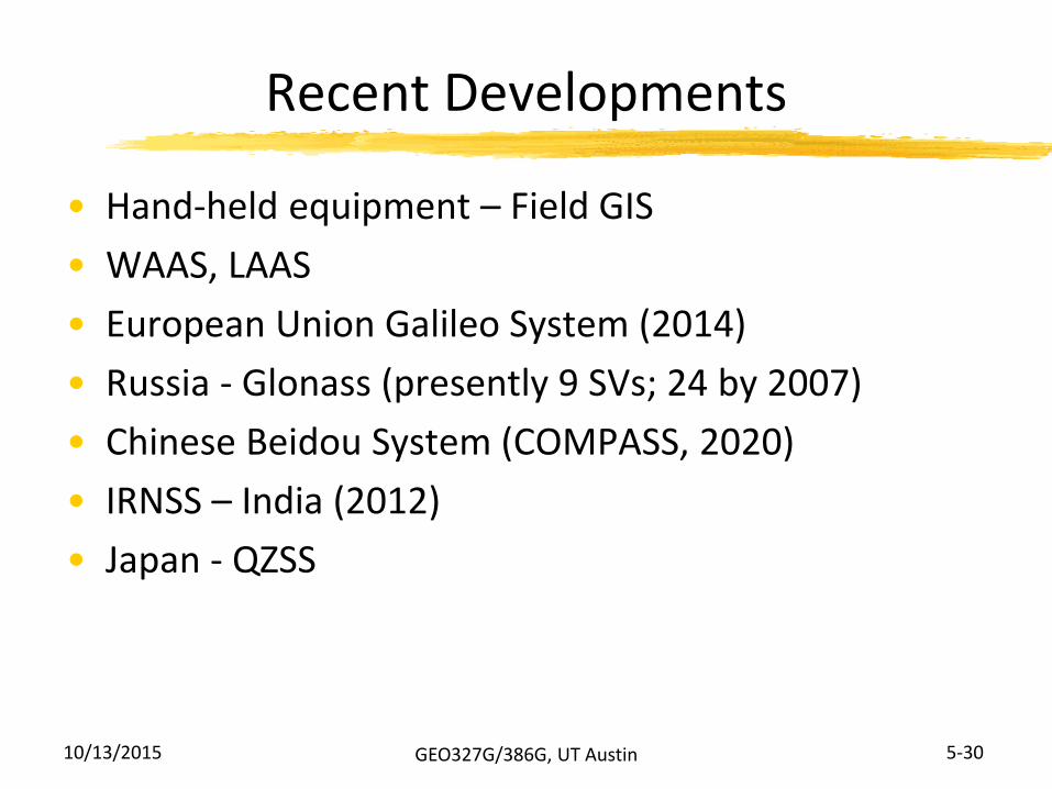
Recent Developments
• Hand-held equipment – Field GIS
• WAAS, LAAS
• European Union Galileo System (2014)
• Russia - Glonass (presently 9 SVs; 24 by 2007)
• Chinese Beidou System (COMPASS, 2020)
• IRNSS – India (2012)
• Japan - QZSS