Embed Size (px)
Citation preview
Romney Marsh: Environmental Change and Human Occupation in a Coastal Lowland (ed. J. Eddison, M. Cardiner and A. Long), OUCA Monograph 46, 1998, 45-63
4. The Holocene Depositional History of Romney Marsh Proper
Antony Long, Martyn Wallel: Paul Hughes and Christopher Spencer
Comparatively little information is available on the deeper sediments of the area known as Romney Marsh proper. As a result the eastern extent, age and depositional history of the well-studied sedimentary units found on Walland Marsh, such as the main marsh peat, are unknown. Without such information regional models of coastal development can at best be regarded as provisional. To address this problem we have collected new stratigraphic data from Romney Marsh proper, in the form of two borehole transects extending from the upland edge to the coast. Peat was only recorded in situ in the area north of Newchurch, though both bio- and lithostratigraphic evidence suggest it formerly occurred more extensively over north-east Romney Marsh. Elsewhere, near-continuous spreads of sand, silt and clay were found which are interpreted as representing the remnants of extensive intertidal and subtidal sand and mudflats. Peat cores from two locations north of Newchurch were examinedfor their pollen, diatom, and plant macrofossils, and six radiocarbon dates provide a chronology for deposition. These data show that the Romney Marsh peat formed under a variety of environments, including saltmarsh, transitional reedswamp and fen carr. Synthesis with data previously collected from Walland Marsh enable, for the first time, maps to be constructed showing the timing of peat expansion and the subsequent marine inundation across the marshland. These reconstructions show that a tidal inlet in the north-eastern part of Romney Marsh exerted strong control on the development of the region from the mid Holocene onwards. Peat growth expanded in an easterly direction across Walland Marsh to Romney Marsh from c. 6000 cal. yrs BP onwards, reaching its maximum extent at c. 3000 cal. yrs BP. Thereafter, a progressive westward expansion of the Romney Marsh tidal inlet occurred, drowning and in places eroding the peat. By c. 1700 cal. yrs BP intertidal conditions had returned to most of Romney and Walland Marshes. These new data necessitate revision of earlier models of coastal development in the region, particularly the inferred patterns of barrier behaviour. The end of peat formation appears not to have been caused by barrier breaching, as previously thought, but by a change in size of an inlet in the barrier (and hence barrier dynamics) caused by a renewed rise in late Holocene relative sea-level.
Introduction Sampling strategies in sea-level studies vary enormously, depending on the particular research question and the challenges and opportunities provided by the environ- ments under consideration. In some instances a single borehole may suffice, its intensive analysis providing data representative of a much wider area. A good example of this is provided by studies concerned with vertical changes in sea level, where effort is typically concentrated on a handful of cores which contain critical stratigraphic transitions at particular elevations and hence ages (e.g. Tooley 1978; Shennan 1986). In other situations, such as
in spatial and temporal macroscale studies of coastal development, extensive stratigraphic data are required together with detailed palaeoenvironmental analysis of samples from a large number of boreholes from a multitude of sites. Because of these demanding requirements, there are few areas of the UK for which meaningful macroscale coastal reconstruction is possible. Recent wetland projects, such as that in the Fenland of East Anglia (Waller 1994a), have generated palaeogeographic maps for different periods of the Holocene, but this type of study is few and far between (Long and Roberts 1997).

46 Antony Long, Martyn Waller, Paul Hughes and Christopher Spencer
0 kilometres 5 U
@ Sample cores described in this paper
Stratigraphic transect
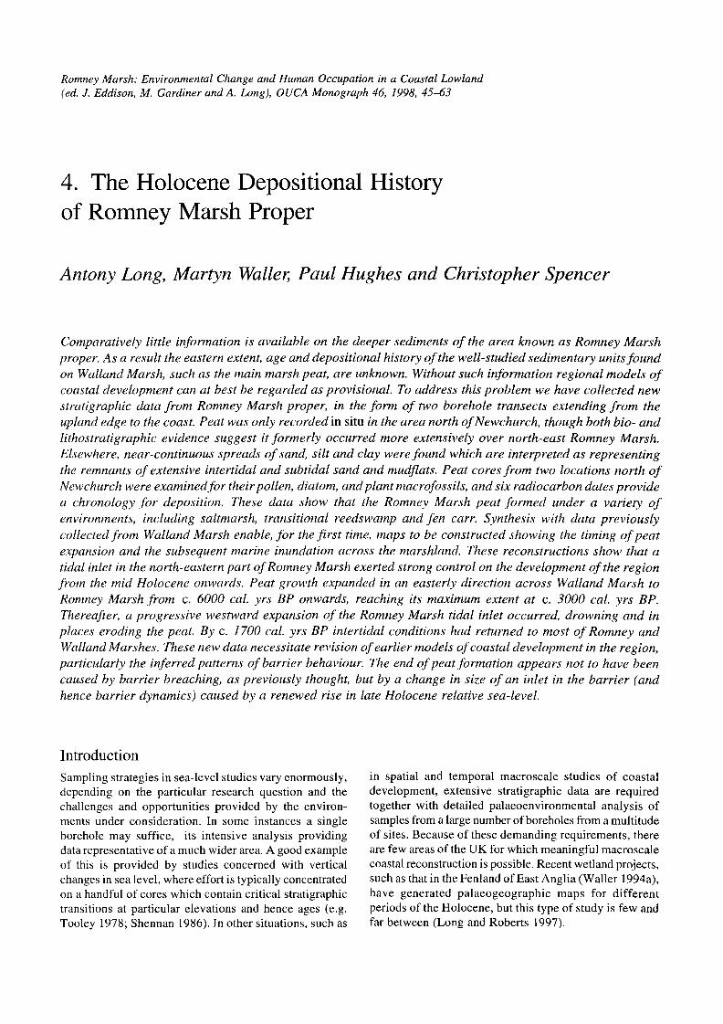
Fig. 4.1. Location map showing the position of stratigraphic transects I and 2.
Romney Marsh is the third largest coastal wetland in the UK and over recent years the collection of a combination of intensive and extensive stratigraphic data have provided a good foundation for a macroscale analysis of Holocene coastal evolution. Located beside the eastern English Channel, Romney Marsh (in its widest sense including Walland Marsh and the adjoining valleys of the Rother, Brede, and Pannel) lies protected from the power of the open sea by massive shingle barriers, including the corrugated beach ridge plain of Dungeness Foreland (Fig. 4.1). Following the comprehensive review of the soils of Romney Marsh by Green (1968), subsequent stratigraphic investigations of the marshland tended to be local in scale. For example, Tooley and Switsur (1988) and Long and Innes (1993) described local stratigraphic sequences and presented a handful of new radiocarbon dates and bio- stratigraphic data from widely separated sites. At that time an integrated stratigraphic framework for the area could not be developed because of the significant differences recorded between these sites. However, a more extensive approach to data collection had been begun by Waller et al. (1988), who worked in the south-western corner of the area, in the valleys of the Pannel, Brede, and Rother, as well as across Pett Level and parts of Walland Marsh. Subsequently, Long and Innes (1995) undertook a 12 km stratigraphic transect across the heart of Walland Marsh, extending from close to Horsemarsh Sewer in the north towards Broomhill at the south (Fig. 4.1). These, combined
with other investigations near Rye (Long et al. 1996) and Lydd (Spencer et al. 1998a), have begun to provide a broad stratigraphic framework for the Walland Marsh area.
Research questions Despite this proliferation of research, the Rhee Wall has generally demarcated the north-eastern boundary of strati- graphic and palaeoenvironmental studies. Romney Marsh proper has remained terra incognita, apart from the deep stratigraphic studies of Tooley and Switsur (1988), Long and Innes (1995) and Wass (1995) which were limited to the north-west corner of that area. New research has now been carried out in the eastern area of Romney Marsh, in an attempt to answer a number of important questions about the evolution of the Romney MarshIDungeness depositional complex as a whole.
The first question concerns the spatial extent of the main peat bed and associated stratigraphic units across the north-eastem part of the back-barrier complex. Existing stratigraphic data shows that the main organic unit thins towards the middle of Walland Marsh and also towards the east (Long and Innes 1995). For example, at Horse- marsh Sewer the peat is c. 2.5 m thick, whereas at Brookland it is only c. 1.2 m. Further east, at Midley Church bank, it thins to less than 1 m. The deposit also varies in age: it accumulated first in the protected marginal locations of the valleys, and becomes progressively
The Holocene Depositional History of Romney Marsh Proper 47
younger towards the east (Long and Innes 1995; Waller et al. in press; Spencer et al. 1998~1, 1998b).
The apparent easterly thinning of the main peat bed suggests that organic deposits may be limited or lacking altogether in Romney Marsh proper. Certainly Green (1968) thought this was the case, although his studies were restricted primarily to near-surface stratigraphic investigations, and recent work on Walland Marsh has proved that some aspects of his stratigraphic model are incorrect (Innes and Long 1992; Long and Innes 1993). It is important to establish the limits of the peat, since its spatial distribution would cast light on the palaeo- environments of Romney Marsh proper during the mid- Holocene and provide a macroscale stratigraphic frame- work for both marshes. This is necessary before the potential link between the marsh sediments and simul- taneous evolution of coastal barriers could be established. For instance, the existence of extensive peat beds across Romney Marsh proper would provide strong support for a substantial barrier extending north-east towards Hythe during the mid-Holocene. Further interest relates to the processes which accompanied the end of peat formation. The upper contact of the peat has been dated at sites across Walland Marsh from c. 2800 to c. 1000 cal. yrs BP, with a cluster of dates around c. 1700 cal. yrs BP (Waller et al. in press). There appear to have been several phases of inundation (Plater et al. in press), though no clear spatial pattern has emerged. Can the sources of the tidal waters which caused these phases be established? Did marine conditions return during certain periods through a long- established inlet in the north-east, on Romney Marsh proper, while at other times they originated from a breach in the gravel barrier in the south, near Rye?
The second main question concerns the nature of the peat-forming vegetation communities on Romney Marsh proper. Important spatial and temporal patterns exist in the former vegetation on Walland Marsh (Waller et al. in press), but how did these communities relate to those existing on Romney Marsh proper?
The removal of the marine influence and peat initiation across Walland Marsh fromc. 5300 to c. 4900 cal. BP was accompanied by thereplacement of saltmarsh by freshwater fen. At sites close to the northern edge of the Marsh (Horsemarsh Sewer and The Dowels) fen carr with Alnus glutinosa as the dominant component developed sub- sequently and persisted for c. 2000 cal. years. In contrast, at Little Cheyne Court (10 km from the northern edge of the Marsh), following a poor fen stage with Betula, acidic communities with Sphagna, Ericaceae and Eriophorum prevailed. Sphagnum imbricatum spp. austinii remains were recorded from the final stages of peat formation (from c. 2600 cal. yrs BP onwards), indicating the development of raised (ombrotrophic) bog. At Hope Farm and Brookland, intermediate sites, alder-dominated fen carr was replaced at c. 4000 cal. yrs BP by acidophilous vegetation with Myrica gale. This spatial pattern, with eutrophic communities occurring near the northern edge
of the Marsh and acidophilous vegetation further out, is likely to have been produced by the input of base-rich waters draining from the Wealden catchment, which preferentially affected the northern sites. The shift towards acidophilous vegetation at the intermediate sites at c. 4000 cal. yrs BP coincides with a decline in the rate of relative sea-level rise (Long and Innes 1993), while climate change (increased wetness) is implied by the development of the Sphagnum imbricatum community at Little Cheyne Court, at the Sub-boreal / Sub-atlantic boundary.
A third question is whether there is any stratigraphic evidence for the former course of the Rother river andlor estuary across Romney Marsh proper? Although many authors have discussed the location and age of the Rother, stratigraphic evidence for its former course across Romney Marsh is scant. Wass (1995) demonstrated that a proposed course running along under the northern upland was untenable, and indicated that the channel in this area mapped by Green (1968) was nothing more than the headwaters of a tidal creek. Other authors such as Green (1988) have suggested a course of the Rother arching south in a great crescent towards Rye, across the south of the present Walland Marsh, and then north-east behind Lydd and on towards Hythe. This channel has been identified in the southern section of the Long and Innes (1995) transect, where the feature is c. 800 m wide and contains impenetrable sequences of laminated sands extending to a depth of at least -7 m OD (Tooley 1990). Green's (1968) soil survey indicates an extensive area of decalcified marshland across much of Romney Marsh proper, which suggests a major inlet existed in this area up until shortly before reclamation took place sometime before late 1 1 th century. Whether this contained a former course of the Rother is not clear. What evidence, therefore, is there in the deeper stratigraphic record for this type of channel feature across Romney Marsh proper?
These are among the number of unanswered questions whose resolution depends, in the first instance at least, on establishing the stratigraphic architecture of Romney Marsh proper.
Sampling Strategy and Techniques of Data Collection A similar sampling strategy to that used by Long and Innes (1995) was adopted, with two long lithostratigraphic transects completed running north-south across the north- east of Romney Marsh proper (Fig. 4.1). Their placement and orientation was deliberate; each transect started near the upland/marshland border and finished close to the back- barrierlbarrier interface, and each covered the full range of soil types identified by Green (1968). Subsequently, representative sites were selected for detailed field and laboratory investigations.
Lithostratigraphic data were collected using a hand- operated gouge corer and sediment descriptions were based
48 Antony Long, Martyn Waller, Paul Hughes and Christopher Spencer
on the Troels-Smith (1955) scheme of sediment descrip- tion. The altitudes of all cores were levelled to the UK Ordnance Datum (equivalent to mean sea level, Newlyn). Lithostratigraphic sections have been plotted in a simpli- fied form (Figs 4.2 and 4.3). Sample cores for laboratory analyses were collected using a modified piston-corer and the cores were stored in sealed plastic tubes under refriger- ated conditions. Core depths have been adjusted to take account of compaction occurring during their collection.
Pollen analysis was undertaken from samples with a volume of 1 cm3 extracted from a cleaned peat surface. The preparation of pollen samples followed standard procedures described by Moore et al . (199 1 ) . All samples received at least one treatment of potassium hydroxide and three minutes of acetolysis. Where necessary, samples were subjected to a second treatment of potassium hydroxide and a treatment of hot hydrofluoric acid, but this was only required for samples which originated from peattclay contacts. Pollen was recovered from the clay with the aid of a 10 pm mesh sieve, followed by one treatment of hot hydrofluoric acid, boiled for 30 minutes and one of hydrochloric acid, simmered for 10 minutes.
Preparations were stained with the alcohol soluble 'Safranin' stain and mounted in silicone fluid.
Pollen grains were examined at x400 magnification using a Nikon Optiphot microscope. Pollen counts generally exceeded a total of 300 land pollen grains. Pollen frequencies are expressed as a percentage of total land pollen (TLP). The pollen diagrams were zoned using CONISS (Grimm 1987) and drawn using the TILIA program of Grimm (1993). Pollen types and plant nomen- clature follow Bennett (1994) and Stace (1991) respect- ively. A preliminary analysis of the macrofossil content of the peat in core RM18 involved sieving 2 cm3 slices of sediment through a 200 pm mesh sieve under a light water jet. Identifications were made with reference to Grosse- Brauckmann (1972), Katzet al. (1965,1977) and Berggren (1969, 1982), using a low-powered Nikon binocular microscope. Frequencies are presented using a five-point scale (rare to abundant). Diatom preparation followed standard procedures (Palmer and Abbot 1986) and nomenclature is after Hartley (1986).
Six bulk samples of peat (4-5 cm thick) were cut from undisturbed piston-core samples for radiocarbon dating.
Table 4.1. Radiocarbon ages from Romney Marsh cores RM7 and RM18.
Calibrated Age (cal. yrs BP * 20) max (mean) min
4825 (4530) 4407
4409 (3910) 3477
2718 (2330) 1990
3692 (3470) 3253
3364 (2960) 2745
3259 (3050) 2855
Age (14C yr BP * 10)
4070*70
3620*80
2290*60
3250%100
2870*70
291W70
Site
RM 7
RM 7
RM 7
RM 18
RM 18
RM 18
Grid Reference
TR05003392
TR05003392
TR05003392
TR05023280
TR05023280
TR05023280
Lab. Code
Beta-109576
Beta-109577
Beta-109578
Beta-109579
Beta-109580
Beta-109581
Altitude (m OD)
-0.55 to -0.51
-0.34 to -0.30
0.23 to 0.18
-0.14 to -0.95
0.25 to 0.29
0.415 to 0.47
Tendency
-ve
None
+ve
-ve
None
+ve
Stratigraphic Context
Regressive contact
LPAZ RM7- 2/RM7-3
Transgressive contact
Regressive contact
LP AZ RM18-41 RM18-5
Transgressive contact
Sediment Description
Brown well-humified peat with a trace of clay. Sh4, As+. Nig 3+, Strf 0, Elas 0, Sicc 2, Lim. sup 0.
Dark grey organic rich clay. Asl, Sh3, Dl+ Nig 3+, Strf 0, Elas 0, Sicc 2, Lim. sup 4.
Brown grey clay-rich humified peat. Sh3, Asl, Th2+. Nig 3, Strf 0, Elas 0, Sicc 2; Lim. sup 1.
Brown well-humified wood peat. Sh3, D1 1, Dg+, Dh+, Th2+. Nig 3+, Strf 0, Elas I , Sicc 2, Lim. sup 0.
Brown humified turfa with some Phragmites. Sh2, Th21, Th2(Prag) 1. Nig 3, StrfO, Elas 1, Sicc 2, Lim. sup 0.
Brown well-humified peat with rare turfa. Sh4, Th2+, Ag+. Nig 3+, Strf 0, Elas 1, Sicc 2, Lim. sup 1.
The Holocene Depositional History of Romney Marsh Proper 49
Visible plant macrofossils, which may be intrusive, were removed from the samples and the remaining material was submitted to Beta Analytic for analysis. The resulting radiocarbon and two-sigma calibrated ages (in cal. yrs BP) are given in Table 4.1. Dates were calibrated using the bidecadal dataset and intercept method (Stuiver and Reimer 1993).
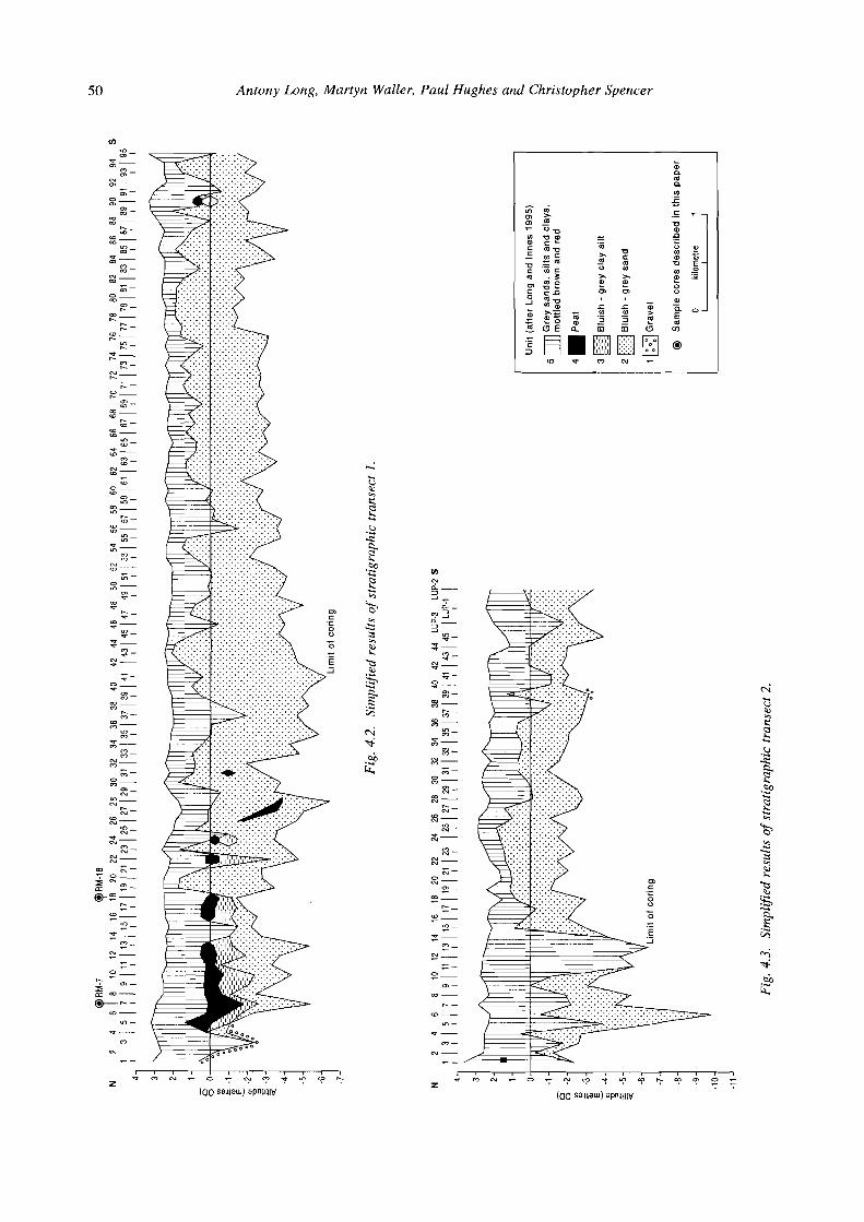
Results Lithostratigraphy Transect l , Bilsington to Hammonds Corner Transect 1 (Figs 4.1 and 4.2) starts c. 1 km east of Bilsington at the foot of the slope below Gorsedown Farm (TR04803455), crosses the Military Canal and continues south past Newchurch. It finishes close to Hammonds Corner, c. 1 km west of New Romney (TR05002481). Cores were completed ate. 100 m intervals, except where access difficulties made wider sampling intervals neces- sary. The transect crosses a range of soil types, as mapped in the Soil Survey (Green 1968). Towards its northern limit the transect passes over the decalcified soils of the Dymchurch and Ivychurch Series, but north of Newchurch it crosses an abrupt boundary between those deposits and
an extensive tract of relatively homogeneous calcified soils of the Newchurch-Walland Complex. In the south, between St Mary-in-the-Marsh and Hammonds Corner, the soils are varied and belong to the Romney-Agney Series with localized pockets of the Finn and Guldeford Series. The ground-surface elevation across the transect shows little variation, rising and falling between approximately 2 and 3 m OD.
To the north of the Military Canal (boreholes 1-4) only minerogenic deposits were recorded (Fig. 4.2). Impenetrable sediments, including gravel (presumably marking the pre-Holocene surface), were encountered at depths of between c. 0.7 and -2.3 m OD. In borehole 5, just south of the Military Canal, gravel is overlain by silty clays followed by an organic clay (at between c. 0 and 1.5 m OD) with further silty clays forming the near-surface sediment. South of borehole 5 the deepest sediment recorded was generally a grey sand. Between boreholes 5 and 18 a four-part sequence could generally be distin- guished. The grey clays are overlain by silty clays and, after gradual transitions, by peat. The peat unit (found between c. 1.5 and -1.5 m OD) typically becomes more humified upwards and consists of detrital matter - mainly fragments of herbaceous material and some wood. The upper contact of the peat appears transitional in some boreholes. The uppermost sediment consists mainly of
Table 4.2. Lithostratigraphy of Romney Marsh Transect l , core RM7.
Unit Description
111
I1
I
Depth (cm)
Altitude (m OD)
abundant. Nig 3+, Strf 0, Elas 0, Sicc 2, Lim. sup 4; Sh3, As l , D1+.
Brown well-humified peat with a trace of clay. Nig 3+, Strf 0, Elas 0, Sicc 2, Lim. sup 0; Sh4, As+.
Brown grey organic silt clay. Finely laminated. Nig 3, Strf 1, Elas 0, Sicc 2, Lim. sup 0; As2, Agl, Shl , Ga+.
Light grey sandy silt with iron staining. Nig 2, Strf 0, Elas 0, Sicc 2, Lim sup. 0; Ag3, Gal, As+, Lf+.
3 19-3 11
325-319
330-325
-0.56 to -0.48
-0.62 to -0.56
-0.67 to -0.62
m V ) m - *- m - m
S- z -
0- m m - m m-
m h - m
(D- m 9 - --
m m - m N- m
6 - 0- m
i? - m- h
h - h (D-
h "7 - -
*- h
O h - N- h -
h - E-
- m- -
h ro -
z - "7 '0 - *-
(D a - N- (D
z - 0- (D
3 - m- "7
G; - W- -
Y) "7 - S-
O V) -
,"- z -
0- "7
m * - m- *
h - * (D- * - - v -3-
7 m - -? N-
*
Antony Long, Martyn Waller, Paul Hughes and Christopher Spencer
I I
O N C 0 - ; N 3 ' T Y ? ' P ? ((10 s a ~ ~ a u r ) apni!llv
m CU Q-
3 , n -
3 3 Q-
3 V) - *
z- m - *
2- F -
S - 3 -
S- h - m
R- - - m
X- R -
S- ;? -
W- - - N
m- N
z - $3-
"7 - N
S- O - N
M- - 0- N
0) - 7
m- - F'-
'0- - "7 - - *- - m -
N- - - .- 0- -
m - m -
h - (D-
u.) - *-
m - N- - -
r Z
*
The Holocene Depositional History of Romney Marsh Proper
Table 4.3. Lithostratigraphy of Romney Marsh Transect I, core RM18.
grey and orange-grey silty clays, though some sand layers were recorded. Between boreholes 19 and 31 the peat only occurs intermittently, and there is evidence to suggest post-depositional disturbance of the top of it. The upper contact is frequently abrupt, suggesting it has been eroded. Between boreholes 22 and 28 the peat unit is found at progressively lower elevations, falling from c. 0 to -4 m OD. These differences may be the result of post- depositional compaction: some of the deeper peats were extremely difficult to penetrate due to their compact nature, to the extent that retrieval of the gouge sampler became problematic. The post-peat sediments are generally coarser and, where the peat is absent, coarse sands which probably represent sandflat or channel sediments predominate.
An important change in the stratigraphy occurs c. l km to the south of Newchurch, south of borehole 32. Minero- genic sediments comprising varying quantities of clay, silt and sand dominate. Most boreholes ended in a grey sand. These lowermost sands vary in their composition, with some of the coarsest sediments (containing at least 25% Grana saburralia) occurring between boreholes 57 and 68. The overlying sediments, sands and silts with some clay, extend to the present surface. These finer sediments decrease in thickness from a maximum of c. 3 m close to Newchurch to c. 0.5m at the southern end of the transect. Organic sediments were not recorded in most of the boreholes, although thin organic layers are present
in borehole 39 and between boreholes 84 and 90. Of these, only that in borehole 90 (0.4 m thick) appears to be in situ, and there it is underlain by a distinct fining-upwards sequence. The general absence of peat in this area echoes the findings of Green (1968, 34) who also only reported sporadic near-surface deposits, many or all of which he suspected had been redeposited.
Material for laboratory analyses was collected from two sites along transect 1. The first, to the south of borehole 7 (TR05003392), is referred to henceforth as RM7 (Table 4.2), and the second, at borehole 18 (TR05023280), as RM18 (Table 4.3). These sites were chosen because they contained apparently undisturbed organic layers from situations close to the northern and southern limits of the peat deposit.
Unit
VIII
V11
V1
V
V1
111
I1
I
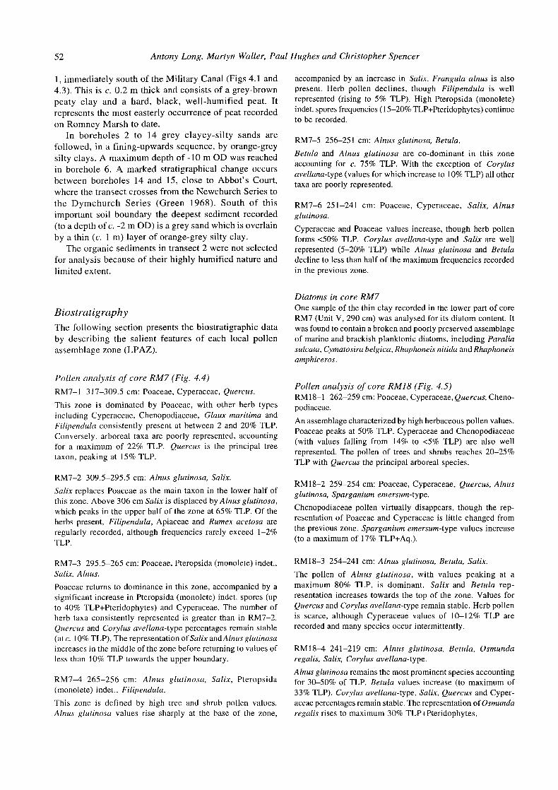
Trartsect 2, Port Lyrnpne Zoo to Dymchurch The second transect (Figs 4.1 and 4.3) extends south from the Military Canal at Aldergate Bridge (TR 10133428) via Burmarsh to Dymchurch (TR10252986). The transect initially crosses the calcified soils of the Newchurch Series before, south of Abbot's Court, moving on to the decalci- fied soils of the Dymchurch-Brenzett Series (Green 1968). Ground-surface elevations vary between c. 2 and 3 m OD, and are similar to those in transect 1.
Organic sediments are absent from most of this transect. The only significant organic layer was recorded in borehole
Depth
above 183cm
189-183
199-189
209-199
220-209
260-220
263-260
272-263
Description
Grey brown silt with rare charcoal. Nig 2, Strf 0, Elas 0, Sicc 2; Ag3, Asl, Ga+, Anth+.
Burnt red brown silt clay with abundant charcoal. Nig 2, Strf 0, Elas 0, Sicc 3, Lim. sup. 3; As3, Agl, Anth+, Lf+.
Grey silt clay with organic inclusions. Nig 2, Strf 0, Elas 0, Sicc 3, Lim. sup 1; As3, Agl, Sh+.
Brown well-humified peat with rare turfa. Nig 3+, Strf 0, Elas 1, Sicc 2, Lim. sup 1; Sh4, ThZ+, Ag+.
Brown humified turfa with some Phragmites. Nig 3, Strf 0, Elas 1, Sicc 2, Lim. sup 0; Sh2, Th21, ThZ(Phrag) l .
Brown well-humified wood peat. Wood content increase below 58cm. Nig 3+, Strf 0, Elas 1, Sicc 2, Lim. sup 0; Sh3, DI1, Dg+, Dh+, ThZ+. Wood pieces (Alnus glutinosa): 247 cm and 242 cm.
Grey sandy silt with organic inclusions. Nig 2, Strf 0, Elas 0, Sicc 3, Lim. sup 0; Ag2, Gal, Shl, As+, Lf+, Th".
Grey silty clay with organic inclusions. Nig 2, Strf 0, Elas 0, Sicc 3, Lim sup. 0; As3, Agl, Sh+, Ga+.
Altitude (m OD)
above 0.63
0.57 to 0.63
0.47 to 0.57
0.37 to 0.47
0.26 to 0.37
-0.14 to 0.26
-0.17 to -0.14
-0.26 to -0.17
52 Antony Long, Martyn Waller, P a u l Hughes a n d Christopher Spencer
1, immediately south of the Military Canal (Figs 4.1 and 4.3). This is c. 0.2 m thick and consists of a grey-brown peaty clay a n d a hard, black, well-humified peat. I t represents the mos t easterly occurrence of peat recorded on Romney Marsh t o date.
I n boreholes 2 t o 14 g r e y clayey-si l ty sands a r e followed, in a fining-upwards sequence, by orange-grey silty clays. A maximum depth o f -10 m OD was reached i n borehole 6. A marked stratigraphical change occurs between boreholes 14 and 15, close to Abbot's Court, where the transect crosses f rom the Newchurch Series t o t h e D y m c h u r c h Ser ies ( G r e e n 1968). S o u t h o f this important soil boundary the deepest sediment recorded (to a depth of c. -2 m OD) is a grey sand which is overlain by a thin (c. 1 m ) layer of orange-grey silty clay.
T h e organic sediments in transect 2 were not selected for analysis because o f their highly humified nature and limited extent.
Biostratigraphy T h e following section presents the biostratigraphic data by describing the salient features o f each local pollen assemblage zone (LPAZ).
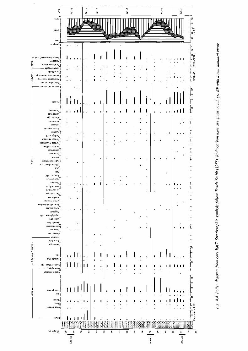
Pollen analysis of c o r e RM7 (Fig. 4.4)
RM7-l 3 17-309.5 cm: Poaceae, Cyperaceae, Quercus.
This zone is dominated by Poaceae, with other herb types including Cyperaceae, Chenopodiaceae, Glaux maritima and Filipendula consistently present at between 2 and 20% TLP. Conversely, arboreal taxa are poorly represented, accounting for a maximum of 22% TLP. Quercus is the principal tree taxon, peaking at 15% TLP.
RM7-2 309.5-295.5 cm: Alnus glutinosa, Salix.
Salix replaces Poaceae as the main taxon in the lower half of this zone. Above 306 cm Salix is displaced by Alnus glutinosa, which peaks in the upper half of the zone at 65% TLP. Of the herbs present, Filipendula, Apiaceae and Rumex acetosa are regularly recorded, although frequencies rarely exceed 1-2% TLP.
RM7-3 295.5-265 cm: Poaceae. Pteropsida (monolete) indet., Salix, Alnus.
Poaceae returns to dominance in this zone, accompanied by a significant increase in Pteropsida (monolete) indet. spores (up to 40% TLP+Pteridophytes) and Cyperaceae. The number of herb taxa consistently represented is greater than in RM7-2. Quercus and Corylus avellana-type percentages remain stable (at c. 10% TLP). The representation of Sa1i.x andAlnus glutinosa increases in the middle of the zone before returning to values of less than 10% TLP towards the upper boundary.
RM7-4 265-256 cm: Alnus glutinosa, Salix, Pteropsida (monolete) indet., Filipendula.
This zone is defined by high tree and shrub pollen values. Alnus glutinosu values rise sharply at the base of the zone,
accompanied by an increase in Salix. Frangula alnus is also present. Herb pollen declines, though Filipendula is well represented (rising to 5% TLP). High Pteropsida (monolete) indet. spores frequencies (1 5-20% TLP+Pteridophytes) continue to be recorded.
RM7-5 256-251 cm: Alnus glutinosa, Betula.
Betula and Alnus glutinosa are CO-dominant in this zone accounting for c. 75% TLP. With the exception of Corylus avellana-type (values for which increase to 10% TLP) all other taxa are poorly represented.
RM7-6 251-241 cm: Poaceae, Cyperaceae, Salix, Alnus glutinosa.
Cyperaceae and Poaceae values increase, though herb pollen forms <50% TLP. Corylus avellana-type and Salix are well represented (5-20% TLP) while Alnus glutinosa and Betula decline to less than half of the maximum frequencies recorded in the previous zone.
Diatoms in core RM7 One sample of the thin clay recorded in the lower part of core RM7 (Unit V, 290 cm) was analysed for its diatom content. It was found to contain a broken and poorly preserved assemblage of marine and brackish planktonic diatoms, including Paralia sulcata, Cymatosira belgica, Rhaphoneis nitida and Rhaphoneis amphiceros.
Pollen analysis of c o r e RM18 (Fig. 4.5) RM18-1 262-259 cm: Poaceae, Cyperaceae, Quercus, Cheno- podiaceae.
An assemblage characterized by high herbaceous pollen values. Poaceae peaks at 50% TLP. Cyperaceae and Chenopodiaceae (with values falling from 14% to 4 % TLP) are also well represented. The pollen of trees and shrubs reaches 20-25% TLP with Quercus the principal arboreal species.
RM 18-2 259-254 cm: Poaceae, Cyperaceae, Quercus, Alnus glutinosa. Sparganium emersum-type.
Chenopodiaceae pollen virtually disappears, though the rep- resentation of Poaceae and Cyperaceae is little changed from the previous zone. Sparganium emersum-type values increase (to a maximum of 17% TLP+Aq.).
RM 18-3 254-241 cm: Alnus glutinosa, Betula, Salix.
The pollen of Alnus glutinosa, with values peaking at a maximum 80% TLP, is dominant. Salix and Betula rep- resentation increases towards the top of the zone. Values for Quercus and Corylus avellana-type remain stable. Herb pollen is scarce, although Cyperaceae values of 10-12% TLP are recorded and many species occur intermittently.
RM 18-4 241-219 cm: Alnus glutinosa, Betula, Osmunda regalis, Salix, Corylus avellana-type.
Alnus glutinosa remains the most prominent species accounting for 30-50% of TLP. Betula values increase (to maximum of 33% TLP). Corylus avellana-type, Salix, Quercus and Cyper- aceae percentages remain stable. The representation of Osmunda regalis rises to maximum 30% TLP+Pteridophytes.
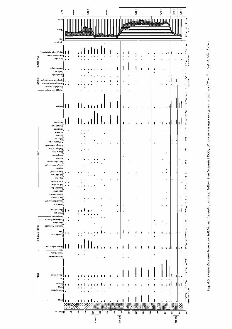
The Holocene Depositional History of Romney Marsh Proper 55
RM18-5 219-200 cm: Cyperaceae, Poaceae, Pteropsida (monolete) indet.
Herb pollen at c. 70% TLP is dominant. Poaceae and Cyper- aceae are both well represented, although frequencies for both taxa fluctuate. Several other herbaceous pollen types are consistently recorded including Filipendula, Plantago lanceo- lata and Rubiaceae. The aquatics Potamogeton natans-type, Sparganium emersum-type and Typha latifolia are also present. Pteropsida (monolete) indet. spores occur in some abundance above 217 cm.
RM18-6 200-193 cm: Corylus avellana-type, Pteropsida (monolete) indet., Chenopodiaceae.
Corylus avellana-type is the most prominent taxon (rising to 50% TLP). Cyperaceae values steadily decline, while Culluna vulgaris and Myrica gale are now consistently represented and Chenopodiaceae percentages increase to 14% TLP at 194 cm. Pteropsida (monolete) indet. spores remain abundant and Sphagnum is also present (with values rising to a maximum of 7.5% TLP+Sphagnum).
RM 18-7 193-1 8 lcm: Cyperaceae, Poaceae, Corylus avellana- type, Chenopodiacae, Potamogeton natans-type.
Herb pollen dominates this zone. Cyperaceae and Poaceae account for 60% TLP and Chenopodiaceae is well represented. Amongst the other herb taxa regularly present are Calluna vulgaris, Glaux maritima, Plantago maritima and Rubiaceae. Corylus avellana-type, at 20-22% TLP, is the principal shrub taxon.
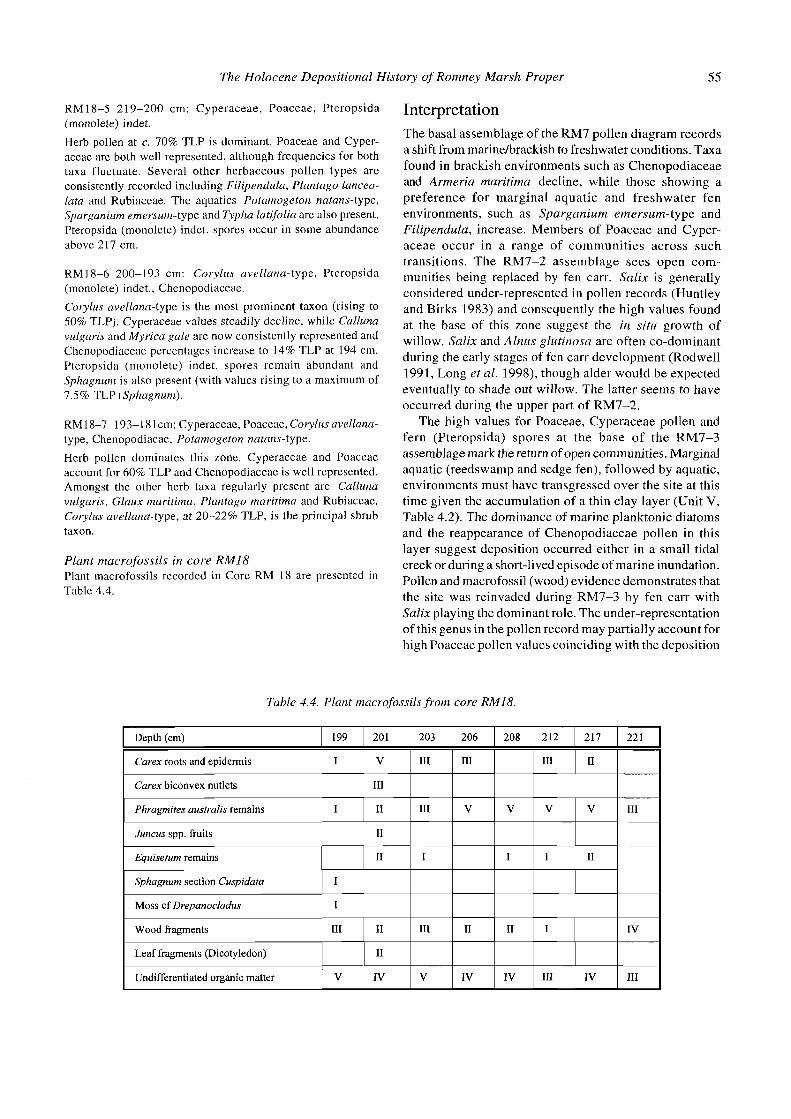
Plant macrofossils in core RM18 Plant macrofossils recorded in Core RM 18 are presented in Table 4.4.
Interpretation The basal assemblage of the RM7 pollen diagram records a shift from marinelbrackish to freshwater conditions. Taxa found in brackish environments such as Chenopodiaceae and Armeria maritima decline, while those showing a preference for marginal aquatic and freshwater fen environments, such as Sparganium emersum-type and Filipendula, increase. Members of Poaceae and Cyper- aceae occur in a range of communities across such transitions. The RM7-2 assemblage sees open com- munities being replaced by fen carr. Salix is generally considered under-represented in pollen records (Huntley and Birks 1983) and consequently the high values found at the base of this zone suggest the in situ growth of willow. Salix and Alnus glutinosa are often CO-dominant during the early stages of fen carr development (Rodwell 1991, Long et al. 1998), though alder would be expected eventually to shade out willow. The latter seems to have occurred during the upper part of RM7-2.
The high values for Poaceae, Cyperaceae pollen and fern (Pteropsida) spores at the base of the RM7-3 assemblage mark the return of open communities. Marginal aquatic (reedswamp and sedge fen), followed by aquatic, environments must have transgressed over the site at this time given the accumulation of a thin clay layer (Unit V, Table 4.2). The dominance of marine planktonic diatoms and the reappearance of Chenopodiaceae pollen in this layer suggest deposition occurred either in a small tidal creek or during a short-lived episode of marine inundation. Pollen and macrofossil (wood) evidence demonstrates that the site was reinvaded during RM7-3 by fen carr with Salix playing the dominant role. The under-representation of this genus in the pollen record may partially account for high Poaceae pollen values coinciding with the deposition
Table 4.4. Plant macrofossils from core RM18.
Depth (cm)
Carex roots and epidermis
Carex biconvex nutlets
Phragmites australis remains
Juncus spp. fruits
Equisetum remains
Sphagnum section Cuspidata
206
I11
V
Moss cf Drepanocladus
Wood fragments
Leaf fragments (Dicotyledon)
Undifferentiated organic matter
199
I
I
1
208
V
I
111
V
201
V
111
I1
I1
I1
203
111
111
212
111
V
I1
I1
I V
I
217
I1
V
111
V
221
111
I
I1
IV
I I1
I1
IV
I
111 I V
I V
111

56 Antony Long, Martyn Waller, Paul Hughes and Christopher Spencer
of a woody peat. However, with Poaceae values exceeding 50% TLP towards the top of RM7-3, open communities appear to have persisted close to the site.
The increase in Alnus glutinosa, Salix and Filipendula and the decline in Poaceae pollen suggest the widespread re-establishment of fen c m at the onset of RM7-5. The rise in Betula during RM7-5 indicates a shift in com- position of the fen carr vegetation, with birch replacing willow. Betula has been recorded as a frequent component of the fen carr vegetation of Walland Marsh, where it is associated with acidic conditions (Waller et al. in press).
The final assemblage from this core, RM7-6, is marked by a decline in fen carr taxa and a rise in Poaceae and Cyperaceae, indicating the development of transitional reedswamplsedge fen communities prior to flooding and the deposition of the upper clays. A marinelbrackish origin for the latter sediments is supported by the presence of Chenopodiaceae andPotamogeton natans-type (including Triglochin) pollen in the uppermost sample.
The vegetation changes occurring during the early stages of peat formation at Rh418 appear very similar to those of RM7. Marinelbrackish conditions, with declining Chenopodiaceae values in RMI 8-1, are replaced by marginal aquatic and freshwater fen environments (Spar- ganium emersum-type pollen peaks during RMI 8-Z), prior to the development of fen carr. Salix was less abundant at RM 18, with the fen carr vegetation initially dominated by Alnus glutinosa, in RM18-3, and with Betula subsequently becoming CO-dominant, in Rh41 8-4. The latter assemblage also contains high frequencies of Osmunda regalis, a taxon strongly associated with fen cam on Walland Marsh and in the neighbouring valleys (Long et al. 1998). As at RM7, fen carr was followed by vegetation dominated by Poaceae, Cyperaceae and ferns (during RM18-5). Macrofossils from this core (Table 4.4) demonstrate the local presence of reedswamp, with Phragmites, sedges (Carex) and Equisetum recorded.
The presence of Sphagnum section Cuspidata macro- fossils, Myrica gale and Calluna vulgaris pollen and Sphagnum spores at the top of RM18-5 suggests the development of a poor fen. This phase seems to have been short-lived, as the RM18-5/6 boundary coincides with the deposition of a grey silty clay (Unit VI) which contains Chenopodiaceae and Plantago maritima pollen and therefore appears to be of marinelbrackish origin. How- ever, several lines of evidence suggest that the surface of the peat has been truncated by erosion (see Discussion). Corylus avellana-type pollen increases in RM18-6. This may be the result of the inclusion of pollen grains of uncertain Myrica galelCorylus avellana origin, though it is more likely to reflect a proportional decline in locally- produced pollen during deposition of the clays. Pollen is absent from the charcoal-rich layer, Unit VII. The final assemblage (RM18-7) again contains taxa such as Cheno- podiaceae, Plantago maritima and Asteroideae, indicative of the marinelbrackish environments in which the upper silts and clays were deposited.
Discussion
Comparison of the vegetation history of Romney and Walland Marshes Although not beginning to develop until 1000 cal. years later, the early stages of peat formation over north-eastern Romney Marsh were accompanied by similar vegetation changes to those recorded on Walland Marsh, some distance to the south-west (Waller et al. in press). Open freshwater communities were replaced by fen carr with Alnus glutinosa present. The distribution of the latter community on Walland Marsh indicates it was promoted by the presence of base-rich water draining from the river catchments and its occurrence on Romney Marsh suggests the eastward flow of such waters. Salix values at RM7 exceed those recorded from the early stages of peat formation on Walland Marsh. Unfortunately, it is difficult to draw environmental inferences from the presence of this genus as the ecological requirements of Salix species differ. However, at Hope Farm, one of the Walland Marsh sites, and at Pannel Bridge (Waller 1993) high Salix pollen values precede acidification. Their occurrence at RM7, along with high Betula values at RM18, suggests that the fen carr communities of north-eastern Romney Marsh represent a nutrient-deficient facies of the communities found to the south-west (Long et al. 1998).
The development of open communities at the beginning of RM7-3, at c. 3900 cal. yrs BP, coincides with broadly similar vegetation changes occurring on Walland Marsh. At Brookland and Little Cheyne Court (mid and southern Walland Marsh sites) the establishment of communities with Myrica gale, Sphagnum and Calluna vulgaris suggest acidification occurred c. 4000 cal. yrs BP (Waller et al. submitted). In contrast, at RM7 transitional aquatic communities and marine conditions are indicated. How- ever, given the reduction in the rate of sea-level rise at this time (Long and Innes 1993), the change recorded at RM7 is probably a local phenomenon, perhaps due to the lateral movement of a watercourse linked to the continued presence of tidal conditions to the south and east. Peat formation had yet to commence at RM18.
Peat formation and the development of fen carr at RM 18 is probably contemporaneous with the re-establishment of fen carr at RM7 (during RM7-4), though the radio- carbon chronology at the latter site is insufficient to confirm this. The development of fen carr at RM18 after c. 3470 cal. yrs BP represents the maximum withdrawal of marine conditions from northern Romney Marsh. Their return is probably indicated by the development of reedswamp during RM18-5 (c. 2960 cal. yrs BP), though similar vegetation trends cannot be detected at RM7 or from the sites on Walland Marsh. To the west and south of RM18 acidic communities were well established by c. 3000 cal. yrs BP. The pollen and macrofossil data from the top of RM18-5 suggest poor fen vegetation also developed during the later stages of peat formation on Romney Marsh. The evidence for this community has
The Holocene Depositional History of Romney Marsh Proper 57
probably largely disappeared as a result of erosion of the upper surface of the peat, though as on Walland Marsh Myrica gale and Cyperaceae are likely to have been important constituents.
The former course of the Rother river or estuary across Romney Marsh The stratigraphic data presented above provides an opportunity to examine the evidence for the former course of the Rother across Romney Marsh proper. Hitherto the only firm evidence for a large tidal channel in the region is the stratigraphic data presented by Long and Innes (1995) and Spencer et al. (1998b) relating to the former Wainway in the south-eastern part of Walland Marsh, and also the Soil Survey of Green (1968, Fig. 14) which suggested a broad funnel-shaped estuary across Romney Marsh, as delimited by the spatial extent of decalcified soils.
Considering first the organic sediments of Romney Marsh proper, there is no clear evidence for the course of the Rother in the areas where these deposits accumulated. The thin clay unit (V) in core RM7-3 has been discussed above and seems to have originated in a small tidal creek or as a result of a short-lived episode of marine inundation. However, the biostratigraphic data presented above suggests that the waters of the Weald drained across the northern margins of Walland and Romney Marshes, although this may have been in the form of a diffuse network of small watercourses rather than a single large channel.
Evidence for the former course of the Rother might also have been obtained from the minerogenic sediments of Romney Marsh proper. The majority of sediments recorded in transects 1 and 2 are sands, silts and clays. In general the coarsest sediments, which might indicate a major channel, occur between boreholes 57 and 68 in transect 1. However, the distribution, depth and com- position of these sediments do not suggest a single distinctive channel; they are more similar to extensive sheets of sand and silt which one might expect across a wide intertidal sandflat and mudflat (Evans 1965). The thickest accumulation of fine-grained material was recorded in transect 2 between cores 4 and 7, where sandy silts extend to a depth of -10 m OD. Such sediments are exceptional, both on Romney Marsh and Walland Marsh, where impenetrable sands are generally found at depths of c. -2 to -4 m OD. They coincide with a northern tidal inlet shown by Green (1968, Fig. 14) debouching into the English Channel south of Hythe.
In summary, our findings support the well-rehearsed arguments of Green (1968) and others that a large tidal inlet once existed across Romney Marsh proper. There is little evidence for the former course of the Rother, and though the deep fine-grained sediments recorded in transect 2 probably represent the final phase of infilling of a channel, the dimensions of this are uncertain.
The spatial and temporal extent of the peat- forming communities on Romney Marsh proper The stratigraphic data from transects 1 and 2 largely support previous estimates of the spatial extent of peat- forming communities across Romney Marsh proper. Our findings agree with Green's map (1968, Fig. 6) of surficial and near surface sediments of the area. However, although both surveys show the peat on Romney Marsh proper as being spatially limited, two reasons lead us to conclude that peat once extended over a greater area than at present.
Firstly, we observed widespread erosion and reworking of the peat in transect 1 between boreholes 19 and 31. Also, remnants of peat remain in the south of transect 1, the most clear example being the island of peat and associated sediments recorded in borehole 90. Long and Innes (1995) also recorded erosion across Walland Marsh but this was less intense, and was limited to disturbance of the upper peat contact and the local removal of the peat and the underlying fine-grained sediments by creeks. Moreover, Green (1968, Fig. 6) maps a significant (c. 1 km diameter) circular area of near-surface peat between Burmarsh and Newchurch, but boreholes we completed in this area (not presented here) revealed no evidence for such deposits. Together these findings suggest that the peat was formerly more extensive than our borehole data indicate.
Secondly, if the ragged edge of the peat south of RM18 records the maximum extent of peat growth, one would expect that the pollen record from that core would be dominated by saltmarsh and transitional freshwater communities. However, the RM18 pollen diagram shows that this is not the case, as fen carr communities (con- firmed by the presence of Alnus glutinosa macrofossils) were established for a period of c. 500 cal. years.
The timing of peat accumulation across Walland and Rornrtey Marshes Together with previously published data from Walland Marsh, the new data from Romney Marsh proper allow us to attempt a macroscale reconstruction of peat accumu- lation across the depositional complex as a whole. Previous dating strategies have tended to concentrate on the transgressive and regressive overlaps of this deposit, and it is on these two stratigraphic boundaries that we now concentrate.
The mean calibrated ages (rounded to the nearest 100 cal. years) for the transgressive and regressive contacts of the main peat bed recorded on Walland and Romney Marshes are plotted on Figs 4.6 and 4.7. Where multiple dates exist from a single location for the regressive contact, the oldest date has been selected as a maximum estimate for the timing of peat formation. For the transgressive contacts, the youngest date has been selected so as to minimize the possible influence of erosion which, as noted above, is widespread across the area. Two dates obtained
5 8 Antony Long, Martyn Waller, Paul Hughes and Christopher Spencer
previously for minimum ages of peat accumulation have also been included: that of 6385-5931 cal. yrs BP (5400 + 80 BP, Long et al. 1998) for the base of the basal peat at Shirley Moor, and that of 6480-5619 cal. yrs BP (5300 ? 100 BP) from the submerged forest on the foreshore of Pett Level (Welin et al. 1972).
Before describing and interpreting the maps, it is important to draw attention to their possible limitations. Firstly, despite extensive data collection in recent years, they are based on a relatively small number of radiocarbon dates. There are areas for which data are obviously lacking, such as the Rother valley, western Walland Marsh, and also along the axis occupied by the Rhee Wall. Dates from these areas would improve the resolution of the maps. In addition, the maps are based on mean estimates of the calibrated dates, which do not reflect the true age uncertainty accompanying each date (typically c. 200 to 400 cal. years). This problem does not detract from the large age gradients found in some instances, but where changes occurred relatively rapidly, particularly at the end of peat formation, many of the ages overlap at the two sigma age range. This makes definition of individual isochrones difficult and has encouraged us to define them at 1000 cal. yr intervals only. Finally, in a number of areas such as Midley Church bank, Broomhill and Scotney Court, multiple ages for the regressive and transgressive contacts provide a large age range for each event. All these three are located close to the gravel beaches of Dungeness, where processes connected to the dynamics of the barrier as well as the back-barrier tidal channels provide potential complications to the patterns observed. For all these reasons the maps represent a provisional attempt to reconstruct the temporal and spatial dynamics of peat accumulation across Walland and Romney Marshes. Each map is described in turn.
Peat initiation on Walland and Romney Marshes (Fig. 4.6) This map is based on 15 radiocarbon dates, 12 of which are from the regressive overlap of the main peat bed. Other dates referred to above, from Shirley Moor, Pett Level and Pannel Bridge, provide additional minimum estimates for the onset of peat accumulation. The resulting map shows a strong west-east asymmetry in the timing of peat formation across the area. The earliest dates are found in the protected valleys of the Brede, the Pannel and also on Pett Level, all of which indicate the onset o i peat formation prior to c. 6000 cal. yrs BP. The date for peat initiation at Shirley Moor, 6385-593 1 cal. yrs BP (Long et al. 1998), confirms that peat initiation was widespread in the valleys adjoining Walland Marsh by 6000 cal. yrs BP.
Peat-forming communities spread rapidly out from the valleys towards the centre of Walland Marsh between 6000 and 5000 cal. yrs BP, and dates from Horsemarsh Sewer and The Dowels suggest accumulation began there a few hundred years earlier compared with areas further
south. In this thousand-year interval, the shoreline advanced towards the centre of Walland Marsh at an estimated rate of up to I km per hundred years. Between 5000 and 4000 cal. yrs BP, peat formation began along the northern edge of Romney Marsh (for example 4825- 4407 cal. yrs BP at RM7). The freshwaterlmarine inter- face seems to have stabilized on Romney Marsh (as indicated by the RM7-3 pollen assemblage) between 4000 and 3500 cal. yrs BP. Thin peats began to accumulate during this interval at Broomhill (Tishy's Sewer), Scotney Court (Spencer et al. 1998a, 1998b) and also at Midley Church bank (Long and Innes 1993). However, Broomhill and Scotney Court are located immediately behind the gravel barrier and are separated from the main back- barrier peat of Walland Marsh by the extensive tidal channel known as the Wainway (Long and Innes 1995; Spencer et al. 1998b). Peat accumulation in these areas from c. 4000 to 3500 cal. yrs BP indicates that marine influence continued to decline. The period from 3500 to 3000 cal. yrs BP, when peat formation and fen carr development occurred at RM18 (3692-3253 cal. yrs BP), probably represents the maximum contraction of marine conditions from the depositional complex prior to re- inundation.
Peat cessation in Walland and Romney Marsh (Fig. 4.7) The 12 dates available to construct this map show an east- west age gradient in the timing of the end of peat formation and marine inundation across Romney and Walland Marshes. The earliest dates, at c. 3000 cal. yrs BP, are from the northern fringes of Romney Marsh. However, both the dates of 3259-2855 cal. yrs BP from RM18 and 3456-2993 cal. yrs BP from Horsemarsh Sewer (Waller et al. in press) may be anomalous. Both palynological and lithostratigraphic evidence from RM18 points to the erosion of the upper peat contact. The former includes the absence of any indications of the imminent return of marine conditions in the peat, the sudden changes in pollen stratigraphy at the Rh41 8-617 boundary and indications that, as on Walland Marsh, a poor fen stage (now largely missing) developed during the later stages of peat formation. The lithostratigraphic evidence includes widespread indications from transect 1 of peat disturbance to the south of RM18, and the presence of peat inclusions in the overlying clay, Unit VI. In addition, there is the age discrepancy with RM7 only l km to the north. At Horsemarsh Sewer, well to the west of transects 1 and 2, there is no evidence from the pollen diagram or the overlying sediment that peat formation was brought to a close by marine inundation. The early cessation of peat growth there, as at other sites around the periphery of the marshland (for example, Shirley Moor at 3829-3465 cal. yrs BP) can be attributed to a dramatic decline in the sediment accumulation rate after c. 4000 cal. yrs BP which is coincident with a sharp reduction in the rate of relative sea-level rise (Long et al. 1998).
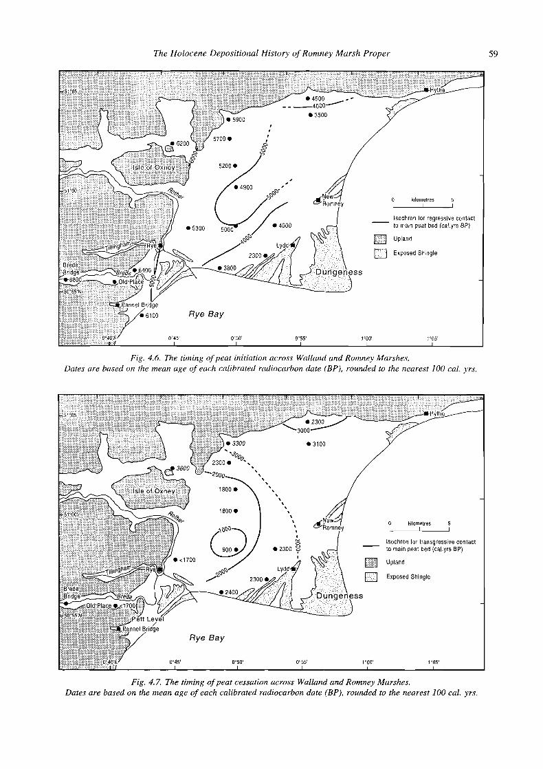
The Holocene Depositional History of Rornrley Marsh Proper 59
0 kilometres 5 - lsochron for regressive contact to matn peat bed (cal yrs BP)
Fig. 4.6. The timing of peat initiation across Walland and Romney Marshes. Dates are based on the mean age of each calibrated radiocarbon date (BP), rounded to the nearest 100 cal. yrs.
0 k~lometres 5 - lsochron lor transgresslve contact to maln peat bed (cal yrs BP)
Fig. 4.7. The timing of peat cessation across Walland and Romney Marshes. Dates are based on the mean age of each calibrated radiocarbon date (BP), rounded to the nearest 100 cal. yrs.

60 Antony Long, Martyn Waller, Paul Hughes and Christopher Spencer
A series of dates c. 2300 to 2100 cal. yrs BP occur in an arcuate scatter from The Dowels in the north to Midley Church bank, Scotney Marsh and Broomhill in the south, and provide the first secure evidence for marine inunda- tion. The distribution of dates younger than 2000 cal. yrs BP, which are restricted to Walland Marsh and the valleys in the west of the study area, suggest progressive inunda- tion from the east. The 1000-year isochron embraces a single date from the transgressive contact at Little Cheyne Court, where the drowning of a raised bog occurred significantly later than elsewhere on the marsh. This case is discussed in detail in Waller et al. (in press), but it is clear that Little Cheyne Court was an island of ombro- trophic bog which stood clear of the surrounding brackish and marine tidal mudflats and saltmarshes for perhaps a thousand years before its eventual inundation.
Macroscale patterns of coastal development, 6000-900 cal. yrs BP The two maps described above allow previous models of coastal development in the study area to be revised. Firstly, they suggest a broad west-east gradient in both the timing of peat initiation and its cessation, implying that the back- barrier estuary was first infilled from the west and subsequently expanded again westwards. This chrono- logical pattern is supported by lithostratigraphic data. The peat is at its thickest in the western valleys and pro- gressively thins across Walland Marsh towards Romney Marsh proper. Although it may once have been more extensive across the latter area than suggested by Green (1968, Fig. 6), any peat there was almost certainly thin (and therefore susceptible to erosion) and relatively short- lived (c. 2000 cal. years or less). We have no evidence to contradict the hypothesis that the eastern portion of Romney Marsh remained open to the sea from the mid- Holocene until reclamation took place. This in turn implies that the barrier which protected much of this area never totally excluded tidal waters from the back-barrier area, and that the waters of the Wealden rivers flowed across Romney Marsh during peat accumulation. The bio- stratigraphic data presented above from Romney Marsh proper and also by Waller et al. (in press) from The Dowels (see below) support a northerly flow of this water across the marshland towards an outlet in the north-east of the barrier.
Previously, it has been suggested (e.g. Long and Innes 1995; Long et al. 1996) that the end of peat accumulation reflects the beginning of a break-down phase in the local barrier (terminology follows Orford et al. 1991), with reworking of the updrift portion of the barrier, and breaching resulting from an accelerated rise in sea-level andlor a reduction in sediment supply. However, the arguments presented above suggest that this model requires re-appraisal.
A number of authors have noted that the end of peat formation on Walland Marsh was associated with a gradual
change in sea-level tendency (Long and Innes 1993; Long and Innes 1995; Spencer et al. 1998a, 1998b), whilst Spencer et al. (199%) suggest that at Lydd (Scotney Court) this was caused by an expansion of the barrier estuary at that time. Therefore, the simplest expIanation for inunda- tion of the peat is that it resulted from progressive flooding from an expanding estuary and associated creek network in the east, rather than from barrier breaching. This is not to say that barrier breaching did not occur during the late Holocene. Indeed a wealth of geomorphological data (Long and Hughes 1995; Waller et al. in press) indicates that the barrier was breached near Rye about 700-1000 years ago, and historical data (Eddison 1998) shows that this occurred in the 13th century AD. But this was some time after the initial inundation of the back-barrier area.
What was the configuration, composition and behavi- our of the barrier in the north-east portion of the barrier complex during the late Holocene? Firstly, the stratigraphic data presented here provide little evidence of the dimen- sions or composition of a barrier inlet in this area. Buried gravel beneath the Dymchurch Wall at c. 1 m OD (Elliott 1847), although not dated is presumed to be of late Holocene age as these deposits underlie Roman ones (Green 1968). It probably represents a remnant of the original structure flanking the southern side of the inlet. Buried gravel deposits are also recorded in boreholes from south-west of Hythe (Eddison 1983). It seems clear that the inlet was widening at this time to accommodate the increased flux of tidal waters into and out of the back- barrier area. This in turn implies that the inlet was sensitive to external forcing by relative sea-level rise, perhaps because of the low rates of sediment supplied to this portion of the barrier complex during the preceding mid- Holocene when relative sea-level rise was sluggish. Although the return of marine conditions was gradual and not accompanied by barrier breaching, changes in inlet dynamics are likely to have been important (Orford et al. 1996). Therefore, this inundation should be viewed in the context of overall barrier dynamics during the late Holocene.
The expansion of a large barrier estuary and its associated creek network from Romney Marsh across Walland Marsh may explain some of the spatial and temporal variations in the timing of the end of peat formation observed in Fig. 4.7. Moreover, a rise in sea level and an accompanying increase in the tidal prism of this estuary would have been accompanied by an expan- sion of an invasive creek network across the study area. This in turn would have promoted erosion of the upper levels of the peat as tidal waters flooded across the marsh surface, with the removal of the entire peat sequence at the position of the creeks themselves. Rates of coastal advance during this period were perhaps double the rate observed for peat expansion during the mid-Holocene. That is, it took c. 2500 cal. years for the peat to extend across the marsh to its maximum extent but less than c. 1300 cal. years to revert back to saltmarsh or mudflat conditions.

The Holocene Depositional History of Ronlney Marsh Proper 61
C O ~ C ~ U S ~ O ~ S coastal lowlands of southern England during the late
Green's (1968) meticulous observations of the soils of Romney Marsh have rightly provided the foundation for subsequent analysis, much of which has tended to add to, rather than fundamentally revise, his work. For example, the lithostratigraphic data presented here and elsewhere (Waller et al. 1988; Long and Innes 1995) largely support Green's (1968, Fig. 6) map showing the distribution of peat across Walland and Romney Marshes. However, when Green (1968) completed his investigations almost nothing was known of the depositional history andlor the age of the peat, which is today regarded as one of the most important coastal deposits in southern England. The three significant advances made since Green's (1968) work relate to the now well-developed radiocarbon chronology for peat accumulation, the information relating to the depositional history of the marshland sediments provided by biostratigraphic analyses, and the definition of a local relative sea-level history (Long and Innes 1993).
Maps for the ages of regressive and transgressive contacts of the main peat show a west-east asymmetry (Figs 4.6 and 4.7), suggesting that processes operating in the hitherto little-studied north-eastern part of Romney Marsh were critical in controlling the development of the marshland as a whole. The easterly inlet and associated barrier estuary must initially have been broad, allowing extensive tidal influx and accumulation of the sand-flat sediments which underlie so much of the marshland. Between c. 6000 and 3000 cal. yrs BP, this barrier estuary contracted as the peat spread out from the valleys in the west across first Walland and then Romney Marsh. The final episode of barrier estuary expansion occurred as sea level rose once more during the late Holocene, and involved the development of a rapidly-expanding, invas- ive creek network which caused widespread erosion of the peat and, across Romney Marsh, its removal. It was only comparatively recently, in the last 1000 cal. years or so, that the inlet was closed by gravel drifting across its entrance.
These arguments bring back into focus the broader regional processes which controlled the development of the barrier and back-barrier estuary. The fluctuating rate of sea-level rise during the Holocene has clearly been a dominant regional driving mechanism behind the changes which have been recorded (Long and Innes 1993; Long et al. 1998). For example, the initial decrease in the rate of sea-level rise between c. 6000 and 5000 cal. yrs BP coincided with the rapid expansion of peat across Walland and Romney Marshes. As the rate of sea-level rise decreased further, so freshwater communities spread to reach their maximum extent. The pollen diagrams from a number of sites across the marsh show evidence for drier conditions from c. 4000 cal. yrs BP onwards, which broadly coincides with the period of maximum peat expansion in the back-barrier area. In addition, the return of marine conditions and the end of peat formation reflects a change in coastal stratigraphy found throughout the
Holocene, with the replacement of freshwater coastal wetlands by estuarine and saltmarsh sedimentation (Jennings and Smyth 1990; Devoy 1979: Long and Tooley 1995). Current opinion suggests that the rate of crustal subsidence in southern England can be summarized by a linear trend during the last c. 4000 years (Shennan 1989) and, if this is valid, we must find an alternative explanation for an acceleration in sea-level rise during the late Holocene. Possible hypotheses include a regional change in wind or wave climate in southern England, a change in oceanographic circulation as recently suggested by van Geel et al. (1996), or an increase in ice sheet or glacier melting.
The work presented here also provides some clear pointers as to the direction which future work should take in this area. One important task is to use the two chrono- logical maps to develop a sampling strategy for further radiometric dating. Emphasis should be placed on collect- ing new data from the Rother valley and out across the western margin of Walland Marsh, as well as along the axis of the Rhee Wall. Extensive new biostratigraphic data are not required since the data presented here have established, in conjunction with other recently published information, a robust regional and local record of Holocene vegetation development (Waller 1993, 1994b; Long and Innes 1993, 1995; Long et al. 1996; Spencer et al. 1998a, 1998b; Long et al. 1998; Waller et al. in press). However, limited analyses will be needed to confirm that the dated horizons have not been affected by erosion. Another important question concerns the factors which may have controlled the spatial variations in the thickness of the post-peat sediments. In many areas there appears to be an inverse relationship between the age of the transgressive contact and the thickness of the overlying sediment. Does this relate to historic patterns of reclamation, to changes in sediment distribution pathways across the marshland as the tidal inlets opened and closed, or to sediment released from the Wealden catchment? Lastly, much of this story has been told with little or no reference to the human impact on the landscape of the Weald and of Romney and Walland Marshes during and after peat formation, and this remains a subject which requires further research. Answering these questions will require the close co- operation of, and academic stimuli provided by, colleagues working across a range of disciplines - a challenge which the Romney Marsh Research Trust is well placed to meet.
Acknowledgements We acknowledge gratefully the support of the Romney Marsh Research Trust during the completion of this and much of the other research on which this paper is based. Martin Allen gave considerable assistance during the programme of coring. Many landowners willingly granted us access to their land, and we owe our thanks to each and everyone of them, as well as to Dorothy and Robert Beck
62 Antony Long, Martyr1 Waller, Paul Hughes and Christopher Spencer
f o r their help, a s always, i n this area. Finally, w e are preparation of pollen samples and David Hulme, Steven grateful t o o u r colleagues i n the Department of Geography Allen and Arthur Corner with the production of the figures. a t the University o f Durham. Frank Davies helped i n the The three referees made helpful improvements t o the text.
References Bennett, K.D. 1994. Annotated catalogue of pollen and
pteridophyte spore types of the British Isles. Unpublished manuscript (University of Cambridge, Department of Plant Sciences).
Berggren, G. 1969. Atlas of Seeds and Small Fruits of North West European Plant Species with Morphological Descrip- rioris, Part 2 Cyperaceae. Stockholm.
Berggren, G. 1982. Atlas of Seeds and Stnall Fruits of North West European Plant Species with Morphological Descrip- tions, Part 3. Stockholm.
Devoy, R.J.N. 1979. Flandrian sea-level changes and vegetation history of the lower Thames Estuary, Philosophical Trans- actions of the Royal Society of London B285, 355-407.
Eddison, J. 1983. The evolution of the barrier beaches between Fairlight and Hythe, Geographical Journal 149, 39-53.
Eddison, J. 1998. Catastrophic changes: a multidisciplinary study of the evolution of the barrier beaches of Rye Bay, in J. Eddison, M. Gardiner and A. Long (eds), Romney Marsh: Environmental Change and Human Occupation in a Coastal Lowland (Oxford University Committee for Archaeology 46), 64-87. Oxford.
Elliott, J. 1847. Account of the Dymchurch Wall, which forms the sea defences of Romney Marsh, Minutes of the Proceed- ings of the Institute of Civil Engineers 6, 466-84.
Evans, G. 1965. Intertidal flat sediments and their environments of deposition in The Wash, Quarterly Journal of the Geological Society 121, 209-45.
Green, C. 1988. Palaeogeography of marine inlets of the Romney Marsh area, in J. Eddison and C. Green (eds), Romney Marsh: Evolution, Occupation, Reclamation (Oxford University Committee for Archaeology 24), 167-74. Oxford.
Green, R.D. 1968. Soils ofRomney Marsh (Soil Survey of Great Britain, Bulletin 4), Harpenden.
Grimm, E. 1987. CONISS: a Fortran 77 program for strati- graphically constrained cluster analysis by the method of incremental sum of squares, Computing Geoscience 13, 13-35.
Grimm, E. 199j. TILIA: a Pollen Program for Analysis and Display. Springfield (Illinois).
Grosse-Braukmann, G. 1972. Uber Pflanzliche Macrofossilen Mittel-Europaischer Torfe I Gewegereste Krautiger Pflanzen und ihre Merkmale, Telma 2, 19-25.
Hartley, B. 1986. A checklist of the freshwater, brackish and marine diatoms of the British Isles and adjoining coastal waters, Journal of the Marine Biological Association 66, 531-610.
Huntley, B. and Birks, H.J.B. 1983.AnAtlas of Past and Present Pollen Maps for Europe: 0 - 13000 Years Ago. Cambridge.
Innes, J.B. and Long, A.J. 1992. A preliminary investigation of the 'Midley Sand' deposit, Romney Marsh, Quaternary Newsletter 67, 32-9.
Jennings, S. and Smyth, C. 1990. Holocene evolution of the gravel coastline of East Sussex, Proceedings of the Geolo- gists' Association 101, 2 13-24.
Katz, N.J., Katz, S.V. and Kipiani, M.G. 1965. Atlas and Keys of Fruits and Seeds occurring in the Quaternary Deposits of the USSR. Moscow.
Katz, N.J., Katz, S.V. and Skobeyeva, E.I. 1977. Atlas ofplant Remains in Peat. Moscow.
Long, A.J. and Hughes, P.D.M. 1995. Mid- and late-Holocene evolution of the Dungeness foreland, U.K., Marine Geology 124, 253-71.
Long, A.J. and Innes, J.B. 1993. Holocene sea-level changes and coastal sedimentation in Romney Marsh, southeast England, UK, Proceedings of the Geologists' Association 104, 223-37.
Long, A.J. and Innes, J.B. 1995. The back-barrier and barrier depositional history of Romney Marsh, Walland Marsh and Dungeness, Kent, England, Journal of Quaternary Science 10, 267-83.
Long, A.J., Plater, A.J., Waller, M.P. and Innes, J.B. 1996. Holocene coastal sedimentation in the eastern English Channel: new data from the Rornney Marsh region, United Kingdom, Marine Geology 136, 97-120.
Long, A.J. and Roberts, D. 1997. Sea-level change, in M. Fulford, T. Champion and A.J. Long (eds), England's Coastal Heritage: A Survey for English Heritage and the RCHME (English Heritage and the Royal Commission on the Historical Monuments of England, Archaeological Report IS), 25-49. London.
Long, A.J. and Tooley, M.J. 1995. Holocene sea-level and crustal movements in Hampshire and Southeast England, United Kingdom, Journal of Coastal Research Special Issue 17, 299-3 10.
Long, D.J., Waller, M.P. and McCarthy, P. 1998. The vegetation history of the lower Rother valley. Stratigraphy and pollen data from the Shirley Moor region, in J. Eddison, M. Gardiner and A. Long (eds), Romney Marsh: Environmental Change and Human Occupation in a Coastal Lowland (Oxford University Committee for Archaeology 46), 31-44. Oxford.
Moore, P.D., Webb, J.A. and Collinson, M.E. 1991. Pollen Analysis. 2nd edn. Oxford.
Orford, J.D., Carter, R.W.G. and Jennings, S.C. 1991. Coarse clastic barrier environments: evolution and implications for Quaternary sea level interpretation, Quaternary International 9, 87-104.
Orford, J.D., Carter, R.W.G. and Jennings, S. 1996. Control domains and morphological phases in gravel-dominated coastal barriers of Nova Scotia, Journal of Coastal Research 12, 589-604.
Palmer, A.J.M. and Abbott, W.H. 1986. Diatoms as indicators of sea-level change, in 0. van de Plassche (ed.), Sea-Level Research: A Manual for the Collection and Evaluation of Data, 457-88. Norwich.
Plater, A.J., Long, A.J., Spencer, C.D. and Delacour, R.A.P. in press. The stratigraphic record of sea-level change and storms during the last 2000 years: Romney Marsh, south-east England. Quaternary International.
The Holocene Depositional History of Romney Marsh Proper 63
Rodwell, J.S. 199 1 . British Plant Communities. Vol. I , Woodlands and Scrub. Cambridge.
Shennan, I. 1986. Flandrian sea-level changes in Fenland. 11: Tendencies of sea-level movement, altitudinal changes, and local and regional factors, Journal of Quaternary Science 1, 155-79.
Shennan, I. 1989. Holocene crustal movements and sea-level changes in Great Britain, Journal of Quaternary Science 4, 77-89.
Spencer, C.D., Plater, A.J. and Long, A.J. 1998a. Rapid coastal change during the mid- to late-Holocene: The record of barrier estuary sedimentation in the Romney Marsh region, south-east England, The Holocene 8, 143-63.
Spencer, C.D., Plater, A.J. and Long, A.J. 1998b. Holocene barrier estuary evolution: the sedimentary record of the Walland Marsh region, in J. Eddison, M. Gardiner and A. Long (eds), Romney Marsh: Environmental Change and Human Occupation in a Coastal Lowland (Oxford Univer- sity Committee for Archaeology 46), 13-29. Oxford.
Stace, C.A. 1991. New Flora of the British Isles. Cambridge. Stuiver, M. and Reimer, P.J. 1993. Extended C14 data base and
revised CALIB 3.0 Cl4 age calibration program, Radiocarbon 35, 215-30.
Tooley, M.J. 1978. Sea-Level Changes in North-west England during the Flandrian Stage. Oxford.
Tooley, M.J. 1990. Sea level and coastline changes during the last 5000 years, in S. McGrail (ed.), Maritime Celts, Frisians and Saxons (Council for British Archaeology Research Report 71), 1-16. London.
Tooley, M.J. and Switsur, V.R. 1988. Water level changes and sedimentation during the Flandrian Age in the Romney Marsh area, in J. Eddison and C. Green (eds), Romney Marsh: Evolution, Occupation, Reclamation (Oxford University Committee for Archaeology 24), 53-7 1. Oxford.
Troels-Smith, J. 1955. Karakterisaring af Lose jordarter (Characterisation of Unconsolidated Sediments), Danmarks Geologiske Undersogelse, Series 1Vl3, 10, 1-73.
Van Geel, B., Buurman, J. and Waterbolk, H.T. 1996. Archae- ological and palaeoecological indications of an abrupt climate change in the Netherlands, and evidence for climatological teleconnections around 2650 BP, Journal of Quaternary Science 11, 451-60.
Waller, M.P. 1993. Flandrian vegetational history of south- eastern England. Pollen data from Pannel Bridge, East Sussex, New Phytologist 124, 345-69.
Waller, M.P. 1994a. The Fenland Project, Number 9: Flandrian Environmental Change in Fenland (East Anglian Archae- ology monograph number 70).
Waller, M.P. 1994b. Flandrian vegetational history of south- eastern England. Stratigraphy of the Brede valley and pollen data from Brede Bridge, New Phytologist 126, 369-92.
Waller, M.P., Burrin, P.J. and Marlow, A. 1988. Flandrian sedimentation and palaeoenvironments in Pett Level, the Brede and lower Rother valleys and Walland Marsh, in J. Eddison and C. Green (eds), Romney Marsh: Evolution, Occupation, Reclamation (Oxford University Committee for Archaeology 24), 3-30. Oxford.
Waller, M., Long, A.J., Long, D. and Innes, J.B. in press. Patterns and processes in the development of coastal mire vegetation: multi-site investigations from Walland Marsh, south-east England, Quaternary Science Reviews.
Wass, M. 1995. The proposed northern course of the Rother: a sedimentological and microfaunal investigation, in J. Eddison (ed.), Romney Marsh: The Debatable Ground (Oxford University Committee for Archaeology 41), 5 1-77. Oxford.
Welin, E., Engstrand, L. and Vaczy, S. 1972. Institute of Geological Sciences Radiocarbon dates 111, Radiocarborz 14, 331-5.