Embed Size (px)
Citation preview
Catena xxx (2011) xxx–xxx
CATENA-01583; No of Pages 19
Contents lists available at ScienceDirect
Catena
j ourna l homepage: www.e lsev ie r.com/ locate /catena
The influence of paleofloods on archaeological settlement patterns duringA.D. 1050–1170 along the Colorado River in the Grand Canyon, Arizona, USA
Kirk C. Anderson a,⁎, Ted Neff b
a Northern Arizona University and Museum of Northern Arizona, United Statesb Museum of Northern Arizona, United States
⁎ Corresponding author. Fax: +1 928 779 1527.E-mail address: [email protected] (K.C. And
0341-8162/$ – see front matter © 2011 Elsevier B.V. Aldoi:10.1016/j.catena.2010.12.004
Please cite this article as: Anderson, K.C., Nalong the Colorado River in the Grand Can
a b s t r a c t
a r t i c l e i n f oArticle history:Received 17 November 2009Received in revised form 27 October 2010Accepted 16 December 2010Available online xxxx
Keywords:PaleofloodGrand CanyonColorado RiverPueblo IIGeomorphologyGeoarchaeology
Excavations at four archaeological sites consisting of the material remains of A.D. 1050–1170 era farmersalong the Colorado River in Grand Canyon National Park, yield geomorphic information used to addressquestions related to settlement patterns. Archaeological excavation units, test pits, feature fill, and naturalexposures contain sediments used to interpret geomorphic history that can, in turn, shed light onarchaeological site selection in a challenging environment. The Grand Canyon experiences dramaticgeomorphic events such as catastrophic floods and destructive debris flows that are preserved in thestratigraphic record, and can be used to understand cultural/landscape interactions. By combining newgeomorphic, stratigraphic, and archaeological data collected during recent excavations with results fromprevious geomorphic and sediment transport studies, observed trends can be interpreted regarding thepossible influence of paleofloods on past settlement patterns. For example, at each of the four sites,reconstructed paleoflood elevations (from existing HEC-RAS virtual shorelines), flood recurrence intervals,site layout, and site stratigraphy/geomorphic setting suggests a temporal trend in site location. The two earlysites (Early Pueblo II period: A.D. 1050–1080) contain habitation features located above the approximately 6–8 year high flood (3500 cubic meters per second [cms]) recurrence interval; larger floods (4800 to 5900 cms)of a longer recurrence interval between 40 and 80 years inundate these features. The two later sites in thesample (Late Pueblo II; A.D. 1080–1170) contain habitation features located well above the 40–80 yearrecurrence high flows. We suggest that early farmers (Early Pueblo II period: A.D. 1050–1080) may not havehad adequate experience with flood magnitudes and frequencies and therefore their habitation structureswere located in risk-prone areas relatively close to the river. Later habitations (Late Pueblo II; A.D. 1080–1170) were positioned in more protected areas further from the river, perhaps reflecting an acquiredknowledge of river dynamics. These trends, although currently based on a limited data set, provide insightsinto site selection decisions and settlement patterns of early farmers along the Colorado River through GrandCanyon.
erson).
l rights reserved.
eff, T., The influence of paleofloods on archaeoyon, Arizona, USA, Catena (2011), doi:10.101
© 2011 Elsevier B.V. All rights reserved.
1. Introduction
The Colorado River through the Grand Canyon is perhaps one ofthe most intensively studied river systems in the world, partlybecause of the influence of Glen Canyon Dam on the delicateecosystem of Grand Canyon National Park (Fig. 1; Webb, 1996;Gloss et al., 2005). Interest in the downstream ecosystem intensifiedwhen the dam became operational in 1964, with much of the focus onstream dynamics and sediment transport because the now sediment-starved system negatively influences the biological and culturalresources along the river corridor (Beus et al., 1985; Carothers andBrown, 1991; Webb et al., 1999; Fairley, 2003). Specifically,
geomorphic studies strongly suggest that the erosion of archaeolog-ical sites is related to the lack of sediment. The dam also prevents thelarge seasonal floods, as well as the extreme events, from depositinghuge volumes of sediment along the river corridor, in contrast to pre-dam times when each spring runoff produced enormous amounts ofsediment. The paucity of sediment coming into the system preventsreplenishment of sand bars, and this has been linked to erosion of pre-dam fluvial terraces containing archaeology sites (Schmidt and Graf,1987; Schmidt, 1990; Rubin et al., 1998; Hazel et al., 1999; Toppinget al., 2003). Eolian re-working of flood sediments is also sediment-starved, thereby limiting the potential for site burial by eolianprocesses. Recent stratigraphic studies document the importance ofeolian sediment transport on the burial and preservation of culturalresources (Draut et al., 2008). Therefore, the documented erosion ofarchaeological sites in Grand Canyon and the accompanying loss ofvaluable data are themotivations for the excavation and data recoveryresults presented here.
logical settlement patterns during A.D. 1050–11706/j.catena.2010.12.004
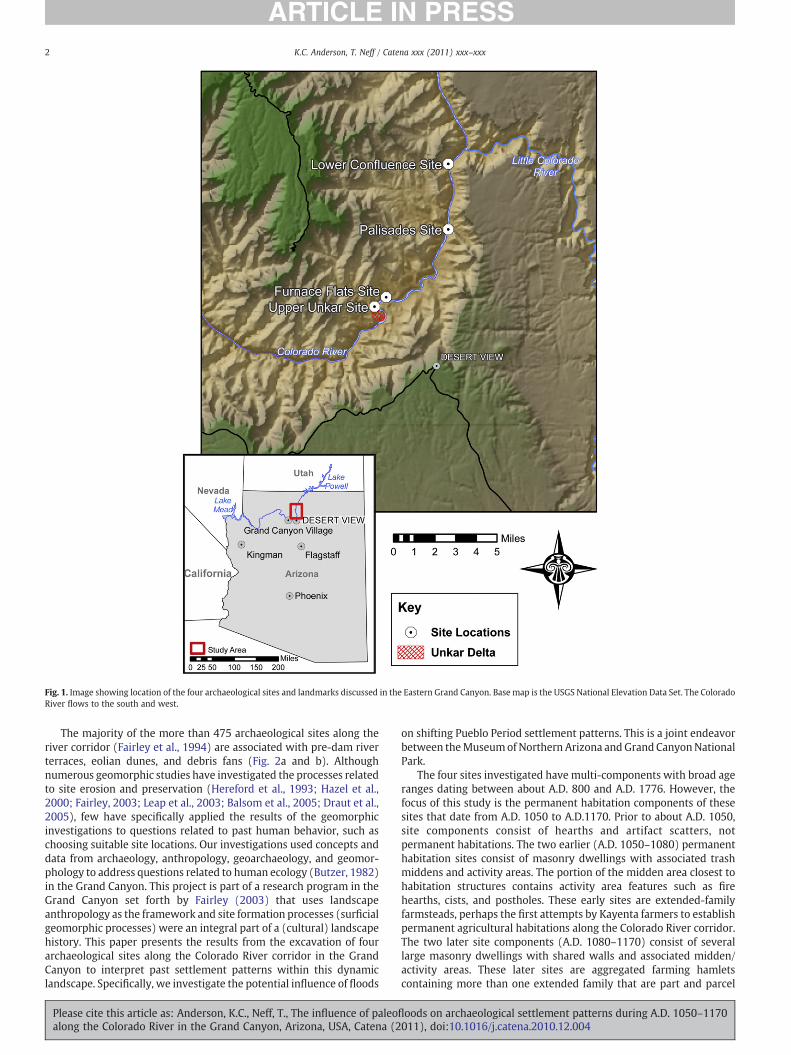
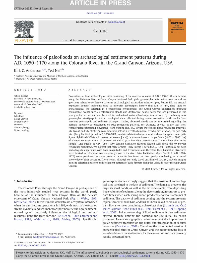
Fig. 1. Image showing location of the four archaeological sites and landmarks discussed in the Eastern Grand Canyon. Base map is the USGS National Elevation Data Set. The ColoradoRiver flows to the south and west.
2 K.C. Anderson, T. Neff / Catena xxx (2011) xxx–xxx
The majority of the more than 475 archaeological sites along theriver corridor (Fairley et al., 1994) are associated with pre-dam riverterraces, eolian dunes, and debris fans (Fig. 2a and b). Althoughnumerous geomorphic studies have investigated the processes relatedto site erosion and preservation (Hereford et al., 1993; Hazel et al.,2000; Fairley, 2003; Leap et al., 2003; Balsom et al., 2005; Draut et al.,2005), few have specifically applied the results of the geomorphicinvestigations to questions related to past human behavior, such aschoosing suitable site locations. Our investigations used concepts anddata from archaeology, anthropology, geoarchaeology, and geomor-phology to address questions related to human ecology (Butzer, 1982)in the Grand Canyon. This project is part of a research program in theGrand Canyon set forth by Fairley (2003) that uses landscapeanthropology as the framework and site formation processes (surficialgeomorphic processes) were an integral part of a (cultural) landscapehistory. This paper presents the results from the excavation of fourarchaeological sites along the Colorado River corridor in the GrandCanyon to interpret past settlement patterns within this dynamiclandscape. Specifically, we investigate the potential influence of floods
Please cite this article as: Anderson, K.C., Neff, T., The influence of paleoalong the Colorado River in the Grand Canyon, Arizona, USA, Catena (2
on shifting Pueblo Period settlement patterns. This is a joint endeavorbetween theMuseumof Northern Arizona and Grand CanyonNationalPark.
The four sites investigated have multi-components with broad ageranges dating between about A.D. 800 and A.D. 1776. However, thefocus of this study is the permanent habitation components of thesesites that date from A.D. 1050 to A.D.1170. Prior to about A.D. 1050,site components consist of hearths and artifact scatters, notpermanent habitations. The two earlier (A.D. 1050–1080) permanenthabitation sites consist of masonry dwellings with associated trashmiddens and activity areas. The portion of the midden area closest tohabitation structures contains activity area features such as firehearths, cists, and postholes. These early sites are extended-familyfarmsteads, perhaps the first attempts by Kayenta farmers to establishpermanent agricultural habitations along the Colorado River corridor.The two later site components (A.D. 1080–1170) consist of severallarge masonry dwellings with shared walls and associated midden/activity areas. These later sites are aggregated farming hamletscontaining more than one extended family that are part and parcel
floods on archaeological settlement patterns during A.D. 1050–1170011), doi:10.1016/j.catena.2010.12.004
Fig. 2. Photographs illustrating the general landscape setting and examples of excavated habitation features. a. Overview of the Palisades debris fan looking downstream. b. Overviewof the Furnace Flats reach with Dox Sandstone cliffs. Small patch of white sand in lower left part of photograph is the Furnace Flats site. Colorado River flowing to the left.c. Archaeologist is standing on the unexcavated habitation structure shown in d. where eolian, fluvial, and debris fan materials coalesce. d. Excavated Feature 12 at Palisades. Noteriver cobble construction materials and central slab hearth. e. Excavated Feature 49 at Furnace Flats. Note large sandstone slabs for wall construction. Feature was buried byapproximately 2 m of hillslope and eolian deposits shown above and behind archaeologist.
3K.C. Anderson, T. Neff / Catena xxx (2011) xxx–xxx
of the overall river corridor populations. The later aggregated hamletsoccur higher on the landscape than earlier farmsteads. Even slightlyhigher elevations provide a greater margin of safety during floodevents.
Our research emphasizes the interconnectedness of archaeologicaldeposits and natural site formation processes, specifically focusing onhow large floods may have influenced past site location decisionmaking. This places equal emphasis on the interpretation of thearchaeological record, rather than solely on the geomorphic processes.We use the term “site formation processes” to include surficialgeomorphic processes that influence an archaeological site from thetime prior to occupation of the landform, during occupation of thelandform, and post-occupational processes (Schiffer, 1987). Siteformation processes at each site include Colorado River fluvial activity,eolian reworking of the fluvial deposits, distal debris fan, and colluvialactivity. We present three general lines of investigation related to thecultural use of the area and associated site formation processes. The
Please cite this article as: Anderson, K.C., Neff, T., The influence of paleoflalong the Colorado River in the Grand Canyon, Arizona, USA, Catena (2
first line of investigation relates to the analysis of geomorphic settingand site stratigraphy, providing a chronostratigraphic framework forinterpreting the history of geomorphic processes related to the periodof occupation.
The second line of investigation focuses on the sedimentary depositsrecorded during the excavation of large subterranean habitationstructures at each of the four sites (Fig. 2c,d,e). The habitation structuresare essentially closed basins that preserve a record of surficial processesat each site, thereby representing, for example, a history offloods, debrisflows, and eolian activity. This record was then used to infer naturalprocesses that past peoples experienced during their tenure at the site.Specifically, the geomorphic position of habitation structures relative tohigh flood elevations allowed us to evaluate the inferred risk of floodingto the inhabitants.
The third line of investigation links data from previous studieswith our own research, allowing us to synthesize the results. Weinferred that the relations between the following four parameters
oods on archaeological settlement patterns during A.D. 1050–1170011), doi:10.1016/j.catena.2010.12.004
Table 1Cultural chronology in the Grand Canyon.
Historic perioda A.D. 1776–1950
Late Prehistoric/Protohistoric Perioda A.D. 1250–1776Pueblo III Periodb A.D. 1150–1250Pueblo II Periodb A.D. 1000–1150Pueblo I Periodb A.D. 800–1000Basketmaker III Periodb A.D. 500–800Late Archaic/Early Agricultural Periodc 1000 B.C.–A.D. 500Late Archaic Perioda 3000–1000 B.C.Middle Archaic Perioda 5000–3000 B.C.Early Archaic Perioda 8000–5000 B.C.Paleoindian Perioda 12,000–8000 B.C.
a Fairley (2003).b Jones (1986).c Huckell (1996).
4 K.C. Anderson, T. Neff / Catena xxx (2011) xxx–xxx
provide insights into temporally significant trends in settlementpatterns related to past flooding: (1) Colorado River paleoflooddischarge reconstructions and recurrence intervals (Topping et al.,2003); (2) reconstructed “virtual shorelines” from the paleoflood dataand the HEC-RAS modeling (Magirl, et al., 2008); (3) site/featurestratigraphy and sedimentology; and (4) site elevation and age. Wealso suggest that periods of high discharge along the Colorado Riverduring the middle to late Pueblo II period (A.D. 1080–1150) may havebeen a driver of late Pueblo II (A.D. 1130–1170) movement to higherlandscape positions (Meko et al., 2007).
2. Background: geomorphic setting and archaeological context
The Colorado River drains approximately 632,000 km2 of theRocky Mountains, Basin and Range, and Colorado Plateau of thewestern United States. The river flows 450 km through the GrandCanyon from Glen Canyon Dam to Lake Mead, the reservoirimpounded behind Hoover Dam (Fig. 1). The Grand Canyon is anarea of extremes with the elevation at the northern rim measuring2440 m above sea level (masl) while the river elevation is about800 masl in the project area. This dramatic relief creates a situationwhereby intense summer thunderstorms become highly destructiveflash flood events. Although rainfall generally does not exceed 25 cmannually, much of that comes during the brief summer rainy season.Two generalized processes control the geomorphology of the rivercorridor. The first is the annual floods that, during pre-dam time,commonly exceeded 2700 cms. Such large flows have a dramaticinfluence on sediment distribution, both depositing large amounts ofsediment in the creation of paleoflood-constructed terraces, as well ascausing extensive erosion. Annual flood processes are countered bythe lateral tributary system that contributes enormous amounts ofsediment to the main river channel during debris flow events (Meliset al., 1994; Griffiths et al., 2004; Yanites et al., 2006). Even the largestmain-stem floods cannot remove portions of debris flow events. Mainchannel debris remnants change the river's gradient creating thefamous cataracts (rapids) that are enjoyed by thousands of riverrunners each year. These debris fans form a pool-and-riffle sequence(Kieffer, 1987). River eddies formed on the downstream side of thedebris fans create a zone of deposition of fine-grained river sediments.Stream terraces, sometimes the only relatively flat locations forarchaeology sites, are commonly found downstream from debris fans.
Hereford et al. (1996, 1998) related the ages of debris fans withthose of stream terraces and associated archaeological sites. Theyidentified discreet alluvial deposits related to different culturalperiods, naming older deposits with Archaic cultural remains as the“stripped alluvium,” intermediate age deposits with Puebloanremains as the “alluvium of Pueblo II age,” and younger pre-damdeposits as the “mesquite terrace.” The majority of depositsinvestigated here correlate with Hereford's “alluvium of Pueblo IIage,” though it includes fluvial, eolian, debris fan, and colluvialdeposits.
Many of the archaeological sites along the river corridor arelocated on/in these debris fan/flood sediment/dune complexes.Generally, though, the landscape inhabited by Puebloan-era peoplealong the river corridor consisted of steep cliffs bounding a narrowzone with limited flat areas. Elsewhere in the Grand Canyon areasettlements are located up tributaries, on bedrock ridges, or on the rimof the canyon. The sites we investigated are those within the narrowriver corridor, below the estimated highest prehistoric flood–8500 cms.
General temporal and socio-economic trends in the archaeologicalrecord of the Grand Canyon area are similar to those of the largerNorth American Southwest (Table 1; see also Fairley, 2003; Huckell,1996; Jones, 1986). Paleoindian groups used the canyon from about12,000–8000 B.C. with an adaptation oriented to big game hunting.The longest period of human occupation in the Grand Canyon area
Please cite this article as: Anderson, K.C., Neff, T., The influence of paleoalong the Colorado River in the Grand Canyon, Arizona, USA, Catena (2
was the Archaic Period, running from 8000 B.C. to A.D. 500. Duringthis interval the canyon was inhabited by people who utilized a morebroad-spectrum foraging and hunting adaptation. Sometime duringthe later part of the Archaic Period agriculture spread into the GrandCanyon area. This era of transition to more agriculture-basedadaptations is designated as the Late Archaic/Early Agricultural Periodfrom 1000 B.C. to A.D. 500. The Basketmaker III (A.D. 500–800) andPueblo I periods (A.D. 800–1000) in Grand Canyon are represented bya relatively small number of sites. Along the river corridor in GrandCanyon, Basketmaker III (BM III) and Pueblo I (PI) sites are generallyburied by some combination of fluvial, eolian, distal debris fan, andsheetwash sediments, and commonly underlie the later Pueblo II (A.D.1000–1150) and Pueblo III (A.D. 1150–1250) Period sites. The BMIIIand PI sites generally consist of thermal features and artifactconcentrations. During the BMIII–PI interval in the North AmericanSouthwest generally agriculture-oriented adaptations were the norm.However, BMIII–PI Grand Canyon river corridor sites representtransient resource procurement and processing activities in contrastto more permanent agriculture-oriented loci that were commonelsewhere. Because these earlier sites are not permanent or semi-permanent agriculture-oriented habitations and do not representrelatively greater investments of energy focused on a site locus, theyare not used in our paleoflood/settlement analysis.
At the start of the Pueblo II period (ca. A.D. 1000–1075), use of thecanyon began to undergo a rather dramatic shift. Just as in other partsof the North American Southwest, people began to inhabit moreniches, as populations grew and settlement expanded (Cordell andGumerman, 1989). In the canyon, we saw the first evidence ofpermanent habitations in the form of small agriculture-orientedhabitations consisting of both above ground and semi-subterraneanmasonry structures. While the earlier PI groups along the rivercorridor used ceramics inferred to be affiliated with Cohoninaarchaeological culture centered immediately south of Grand Canyon(Colton, 1939; McGregor, 1967; Schwartz et al., 1980; Fairley,2003:93), the Pueblo II and Pueblo III people utilized ceramicsinferred to be affiliated with the Kayenta archaeological culturecentered to the southeast and east (Colton, 1939; Schwartz et al.,1980; Ambler, 1985; Jones, 1986; Fairley, 2003:93).
The cultural changes initiated at the beginning of the Pueblo IIperiod accelerated and expanded during the latter half of the period(ca. A.D. 1075–1170), both along the Grand Canyon river corridor andelsewhere in the North American Southwest. During this time theNorth American Southwest witnessed the establishment of largeregional systems centered on Chaco Canyon and along the Salt andGila River valleys (Cordell and Gumerman, 1989). During the ca. A.D.1075–1170 interval, the most extensive concentration of archaeolog-ical sites along the Colorado River in Grand Canyon developed withinwhat is called the Furnace Flats Reach, encompassing 16 miles of rivercorridor terrain below the Colorado/Little Colorado River confluence(Fairley et al., 1994; Fairley, 2003). The four sites discussed in this
floods on archaeological settlement patterns during A.D. 1050–1170011), doi:10.1016/j.catena.2010.12.004
5K.C. Anderson, T. Neff / Catena xxx (2011) xxx–xxx
paper are located in the Furnace Flats Reach (Fig. 1), as well as thelargest concentration of sites along the Grand Canyon river corridor atUnkar Delta (Schwartz et al., 1980; Schmidt and Graf, 1988; Fairleyet al., 1994; Fairley, 2003). The majority of the Unkar Delta sites wereoccupied between A.D. 1130 and 1170 (Schwartz et al., 1980), andattest to a period of increased population similar to the general trendin the North American Southwest.
The final period of relevance for this paper is the Late Prehistoric/Protohistoric Period, approximately A.D. 1250–1776. Buried thermalfeatures from the Late Prehistoric/Protohistoric period aided indefining the more recent extent of our chronostratigraphic record.In 1776 the Spanish explorers Escalante and Dominguez entered theregion, thus beginning the historic period.
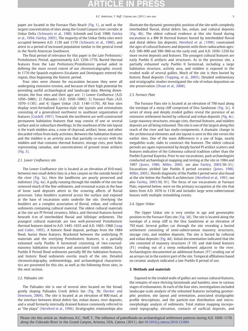
Four sites were chosen for excavation because they were allundergoing extensive erosion, and because of their high potential forproviding useful archaeological and landscape data. Moving down-stream, the four sites and their ages are: 1) Lower Confluence (A.D.1050–1080); 2) Palisades (A.D. 1050–1080); 3) Furnace Flats (A.D.1070–1130); and 4) Upper Unkar (A.D. 1140–1170). All four sitesdisplay semi-formalized Kayenta-style site layouts and orientationsconsisting of a generalized northwest to southeast organization offeatures (Cordell, 1997). Towards the northwest are well-constructedpermanent habitation features that may consist of one or severalsurface and/or subsurface dwellings. In the southeast of the site layoutis the trash midden area, a zone of charcoal, artifact, bone, and otherdiscarded refuse from daily activities. Between the habitation featuresand the midden is an activity area that partially co-occurs with themidden and that contains thermal features, storage cists, post holesrepresenting ramadas, and concentrations of ground stone artifacts(Fig. 3).
2.1. Lower Confluence site
The Lower Confluence site is located at an elevation of 810 masl,between two small debris fans in a box canyon on the outside bend ofthe river (Fig. 3a). Here the landforms are poorly preserved andindistinct (Fig. 4a). A gully running through the middle of the site hasremoved much of the fine sediments, and erosional scarps at the baseof loose sand deposits attest to the scouring affects of fluvialprocesses. Talus boulders scattered across the surface and exposedat the base of excavation units underlie the site. Overlying theboulders are a complex association of fluvial, eolian, and colluvialsediments containing cultural material. The oldest cultural materialsat the site are PI Period ceramics, lithics, and thermal features buriedbeneath 4 m of interbedded fluvial and hillslope sediments. Theyoungest cultural materials are two well-preserved Protohistoricthermal features dated to A.D. 1445–1655 and A.D. 1665–1960 (Leapand Coder, 1995). A historic flood deposit, perhaps from the 1884flood, buries these features. Bracketed between the underlying PImaterials and the overlying Protohistoric features, is a partiallyexhumed early Pueblo II farmstead consisting of two-coursed-masonry habitation structures and associated trash midden. EarlyPueblo II Period flood sediments partially fill the habitation features,and historic flood sediments overlie much of the site. Detailedchronostratigraphy, sedimentology, and archaeological characteris-tics are presented for this site, as well as the following three sites, inthe next section.
2.2. Palisades site
The Palisades site is one of several sites located on the broad,gently sloping Palisades Creek debris fan (Fig. 3b; Dierker andDownum, 2004). The site is located at an elevation of 800 masl, atthe interface between distal debris fan, eolian dunes, river deposits,and a small formerly internally drained feature commonly referred toas “the playa” (Hereford et al., 1996). Stratigraphic relationships also
Please cite this article as: Anderson, K.C., Neff, T., The influence of paleoflalong the Colorado River in the Grand Canyon, Arizona, USA, Catena (2
illustrate the dynamic geomorphic position of the site with complexlyinterbedded fluvial, distal debris fan, eolian, and cultural deposits(Fig. 4b). The oldest cultural evidence at this site found duringexcavation is a BM III thermal feature buried by interbedded fluvialand distal debris fan deposits. Hereford et al. (1996) constrainedthe ages of cultural features and deposits with three radiocarbon ages:A.D. 390–890 and 390–960 on the early end, and A.D. 1030–1250 formore recent deposits and features. The youngest cultural features areearly Pueblo II artifacts and structures. As in the previous site, apartially exhumed early Pueblo II farmstead, including a largehabitation structure, activity area, and midden is exposed in theeroded walls of several gullies. Much of the site is then buried byhistoric flood deposits (Topping, et al., 2003). Detailed sedimentaryand stratigraphic studies investigated the role of eolian deposition onsite preservation (Draut et al., 2008).
2.3. Furnace Flats
The Furnace Flats site is located at an elevation of 790 masl alongthe toeslope of a steep cliff comprised of Dox Sandstone (Fig. 3c). Aseries of steep and deeply eroded gullies reveal the presence of anextensive settlement buried by colluvial and eolian deposits (Fig. 4c).Large masonry structures, storage cists, thermal features, and middendeposits are all being exhumed. This site is one of the largest along thisreach of the river and has multi-components. A dramatic change inthe architectural elements and site layout is seen in this site verses theearlier sites. One of the main differences is a use of huge, nearlymegalithic-scale, slabs to construct the features. The oldest culturalperiods are again represented by deeply buried PI artifact scatters andfeatures indicative of the Cohonina cultural tradition rather than thePueblo II period Kayenta. Prior to our excavations, park archaeologistsconducted archaeological mapping and testing at the site in 1984 and1997 (Jones, 1986; Miller, 2005; see also Fairley, 2003:50–51).Excavations yielded late Pueblo II period ceramics (Jones, 1986;Miller, 2005). Sherds diagnostic of the Pueblo I periodwere also foundat the site below the Pueblo II architecture (Hereford et al., 1991; seealso Fairley, 2003:50, 91). The focus of our excavations at FurnaceFlats, reported below, were on the primary occupation at the site thatdates from A.D. 1070 to 1130 and includes large semi-subterraneanhouses with multiple remodeling events.
2.4. Upper Unkar
The Upper Unkar site is very similar in age and geomorphicposition to the Furnace Flats site (Fig. 3d). The site is located along thetoeslope of a steep cliff in the Dox Sandstone at an elevation of792 masl. Several gullies cut through the site revealing a buriedsettlement consisting of semi-subterranean masonry structures,storage cists, and midden deposits. The site is buried by colluvialand eolian deposits (Fig. 4d). Initial documentation indicated that thesite consisted of masonry structures (F 10) and slab-lined features(F1) eroding out of a steep embankment adjacent to the river.Archaeologists documented an additional feature (F7) eroding out ofan arroyo cut in the eastern part of the site. Temporal affiliations basedon ceramic analysis indicated a late Pueblo II period of use.
3. Methods and materials
Exposed in the eroded walls of gullies are various cultural features,the remains of once thriving farmsteads and hamlets, now in variousstages of exhumation. At each of the four sites, investigations includedlandscape-scale analysis of the exhumed features including geomor-phic position, site layout and orientation, associated stratigraphicprofile descriptions, and the particle-size distribution and micro-morphologic analysis of sediments. Total station mapping incorpo-rated topography, elevation, contacts of surficial deposits, and
oods on archaeological settlement patterns during A.D. 1050–1170011), doi:10.1016/j.catena.2010.12.004
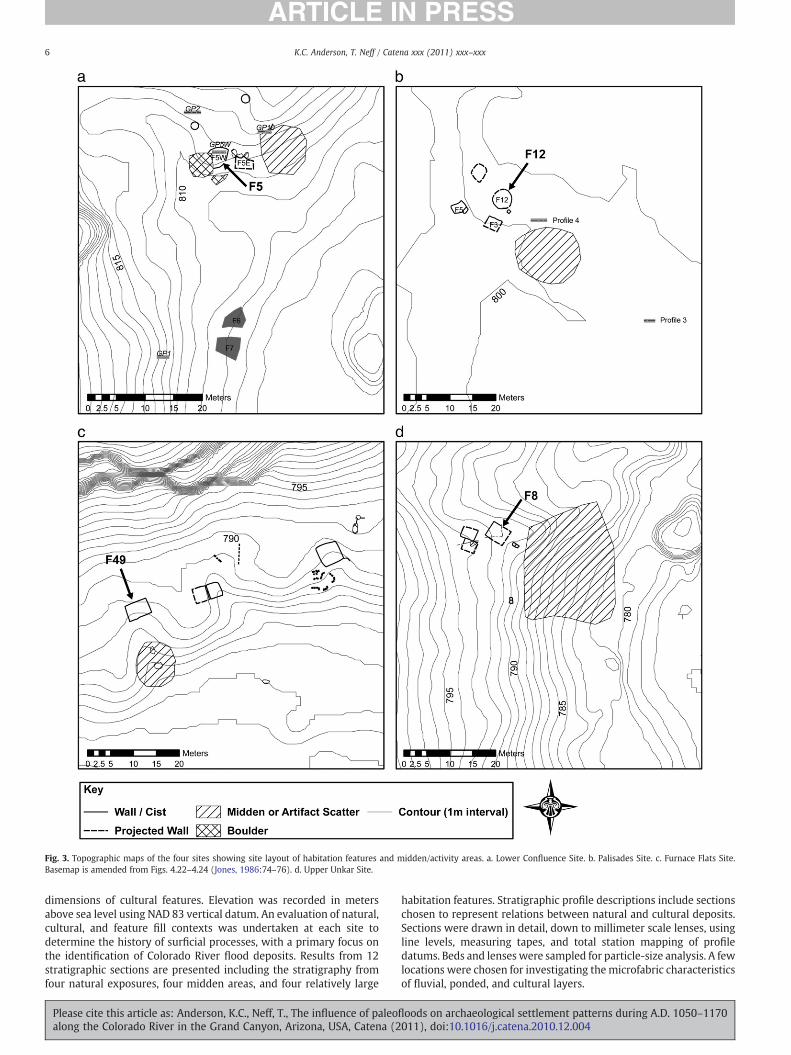
Fig. 3. Topographic maps of the four sites showing site layout of habitation features and midden/activity areas. a. Lower Confluence Site. b. Palisades Site. c. Furnace Flats Site.Basemap is amended from Figs. 4.22–4.24 (Jones, 1986:74–76). d. Upper Unkar Site.
6 K.C. Anderson, T. Neff / Catena xxx (2011) xxx–xxx
dimensions of cultural features. Elevation was recorded in metersabove sea level using NAD 83 vertical datum. An evaluation of natural,cultural, and feature fill contexts was undertaken at each site todetermine the history of surficial processes, with a primary focus onthe identification of Colorado River flood deposits. Results from 12stratigraphic sections are presented including the stratigraphy fromfour natural exposures, four midden areas, and four relatively large
Please cite this article as: Anderson, K.C., Neff, T., The influence of paleoalong the Colorado River in the Grand Canyon, Arizona, USA, Catena (2
habitation features. Stratigraphic profile descriptions include sectionschosen to represent relations between natural and cultural deposits.Sections were drawn in detail, down to millimeter scale lenses, usingline levels, measuring tapes, and total station mapping of profiledatums. Beds and lenses were sampled for particle-size analysis. A fewlocations were chosen for investigating themicrofabric characteristicsof fluvial, ponded, and cultural layers.
floods on archaeological settlement patterns during A.D. 1050–1170011), doi:10.1016/j.catena.2010.12.004
Fig. 4. Aerial photographs illustrating geomorphic relations of various bedrock and surficial deposits of the four sites. a. Lower Confluence Site. b. Palisades Site. c. Furnace Flats Site.d. Upper Unkar Site.
7K.C. Anderson, T. Neff / Catena xxx (2011) xxx–xxx
At each of the four sites we encountered habitation features about4 m in diameter and 2 m deep, filled by 2 m of post-occupationaldeposition, and buried underneath 1 to 2 m of additional sediments.
The habitation structures are closed basins that preserve sedi-ments representative of post-occupational surficial processes. Al-
Please cite this article as: Anderson, K.C., Neff, T., The influence of paleoflalong the Colorado River in the Grand Canyon, Arizona, USA, Catena (2
though the sediments in the fill sequence only represent post-occupation activity, comparison of other natural and cultural depositsat each site indicates that feature fill material accurately representsdepositional processes at each site during occupation, such assheetwash, distal debris fan, colluvial, eolian, and fluvial.
oods on archaeological settlement patterns during A.D. 1050–1170011), doi:10.1016/j.catena.2010.12.004
Table 2Discharge, recurrence interval, and deposition for various historic and modern floods.
Year (A.D.) Discharge(cms)
Discharge(cfs)
Recurrenceinterval
Flood deposits
Seasonal 708 25,000 Seasonal Along edge of river1996 1270 45,000 Only two years
(1996, 2004)Sand bars, lowermostportion of gully mouth
1983 2700 97,000 Largest post-damdischarge
Sand bars, fill gullymouths
1957 3500 125,000 6–8 yrs. 4–5 m in lower partsof gullies
1921 4800 170,000 40 yrs. N5 m in parts of gullies1884 5900 210,000 80 yrs. Completely fill many
gullies
Data source: Topping et al. (2003).
8 K.C. Anderson, T. Neff / Catena xxx (2011) xxx–xxx
Hundreds of sites comprise the Grand Canyon river corridorarchaeology site database. Of these, the vast majority are known fromonly surface data (Fairley et al., 1994; Fairley, 2003; Grand CanyonNational Park site files). For certain research questions, surface dataare sufficient, whereas other research questions require excavationdata. However, very few river corridor sites have been subject toarchaeological or geoarchaeological excavations to date (Damp et al.,2009; Jones, 1986; Miller, 2005; Schwartz et al., 1979, 1980). Due tothe types of sites previously excavated, the varying research interestsand differing archaeological/geoarchaeological methodologies, welimited our analysis to include only the data derived from sitesexcavated during the present NPS-MNA collaborative project. Theresearch questions determined our data collection strategies andfocus, specifically, addressing the following: (1) excavation atPuebloan-era sites with permanent masonry habitation structures;(2) attention to complete site layout, orientation, and landformposition, importantly including features and deposits extramural tomasonry habitation features; (3) detailed spatially representativeexcavations to obtain well-contextualized, from the geomorphic andchronostratigraphic perspectives, ceramic assemblages necessary forprecise ceramic and radiocarbon dating. For example, among thekinds of information that our model requires are the discernment ofearly Pueblo II (ca. A.D. 1050–1080) from Late Pueblo II (ca. A.D.1080–1170) site components, landform-scale geomorphic descrip-tion, and excavations with sufficient extent to provide numerouscleaned stratigraphic profiles that clearly illustrate the depositionalenvironments of sediments that underlie, overlie, and are containedwithin cultural features. Admittedly our data set of four excavatedsites is limited and thuswe present ourmodel as a testable frameworkto compare to future excavated sites along the river corridor.
Particle-size analysis on 100 samples at the Northern ArizonaUniversity Soil and Sediment Laboratory used a Coulter LS230 laserparticle-size analyzer that determines particle-size distributionbetween 0.002 mm and 2 mm clay to very coarse sand. In ouranalysis, we used the b0.1 mm (very fine sand, silt, and clay) tocharacterize and differentiate the fluvial, eolian, ponded, colluvial, anddebris fan sediments (see Rubin, 1987; Rubin and Hunter, 1987; Rubinet al., 1990; Draut et al., 2005, 2008).
Six oriented, intact, sediment samples were taken for analysis ofthe microscopic fabric of depositional units, three from feature fill andfloor contexts, and three from playa (ponded) and fluvial context.Samples were collected using plastic rain gutters cut into 7.5 cm by5.0 cm by 5.0 cm sections. The samples were carefully packed withpaper to cushion the collected matrix and they were impregnated andmade into thin sections at Quality Thin Sections, in Tucson, Arizona.Both oversized and regular slides were made. Slides were viewedusing a Leica petrographicmicroscope and imageswere capturedwitha Canon digital camera. Ceramics found in the natural and culturaldeposits are used to determine ages and cultural affiliations.
Dating of features and stratigraphy is integral to developing achronostratigraphic reconstruction. In the North American Southwest,the ceramic chronology has a resolution of about 25 years, based onsystematic variations in temper, paste, and decoration style. Theceramic chronology is pegged to dendrochronology through cross-dating of trees in structures with associated ceramics. Ceramic typesinclude Black Mesa Black-on-white indicating that the primaryoccupation at Lower Confluence and Palisades dates to the A.D.1050–1080 period, Sosi Black-on-white indicating the primaryoccupation at Furnace dates to the A.D. 1070–1130, and Sosi Black-on-white and Flagstaff Black-on-white indicating that the primaryoccupation at Upper Unkar dates to A.D. 1140–1170. Additional datingincludes radiocarbon on charcoal samples collected from archaeolog-ical features. Samples were sent to Beta Analytic, Inc. (Miami, FL;http://www.radiocarbon.com/).
Total station maps were incorporated into a GIS database thatcontained elevational data of known historic floods at each of the four
Please cite this article as: Anderson, K.C., Neff, T., The influence of paleoalong the Colorado River in the Grand Canyon, Arizona, USA, Catena (2
sites along the river corridor. Topping et al. (2003) calculated historicdischarges with the largest flood being 5900 cubic meters per second(cms), the next largest 4800 cms, and the next at 3500 cms, occurringin 1884, 1921, and 1957, respectively. The 5900 cms has a recurrenceinterval (RI) of 80 years, the 4800 cms an RI of 40 years, and the3500 cms an RI of 6–8 years. For comparison, we include elevations ofthe highest post-dam flood of 2750 cms that occurred in 1983, thehighest controlled post-dam discharge of 1270 cms, and the highestsustained post-dam releases averaging about 708 cms. The elevationsof these floods were modeled for the entire river corridor by Magirlet al. (2008), providing a valuable database for visualizing floodelevations on the landscape at each site. The flood elevations weresuperimposed on site maps and aerial photos to create “virtualshorelines” of known high magnitude floods. Our analysis comparesthe “virtual shoreline” elevations to the geomorphic positions ofvarious cultural features, including habitation structures, activityareas, and middens. Flood elevations, magnitudes, and recurrenceintervals are used to compare the elevations of the cultural featureswith the elevations of the highest floods to evaluate susceptibility ofeach site to potential flood risks. The virtual shoreline maps wereproduced using the HEC-RAS model, which is a one-dimensional,steady statemodel that uses channel cross section,flowvelocity,waterviscosity, and Manning's roughness value, to estimate water surfaceelevations at various discharges (Magirl et al., 2008). Discharges usedin the model, and flood recurrence intervals used for culturalinterpretations, were determined from historic hydrograph data andmodeling using a step-back analysis (Table 2) (Topping et al., 2003). Atthe four sites, four habitation features and associated activity area/middens were used in the comparison of archaeological featureelevations to flood elevations.
Thefinal part of the landscape analysis uses the long-term temporaltrend in prehistoric streamflow for the Colorado River at Lees Ferry forthe A.D. 1000–1200 period.Weuse these data to evaluate the potentialimpact of retrodicted discharges of the Colorado River to past sitelocation decision making (Meko et al., 2007).
4. Results and analyses
Below we present the results of our field investigations andlaboratory analysis, including landscape studies, stratigraphic profiles,particle-size distribution, micromorphology, and virtual shoreline/paleodischarge data for each site. The results and analysis are organizedaccording to site. The subsequent section, “Discussion and Conclusions,”presents a synthesized evaluation of the site formation processes andculture history of the Canyon to arrive at a new understanding oftemporal trends in settlement patterns along the river corridor.
4.1. Lower Confluence
Results of the archaeological excavations and geomorphic profiledescriptions at the Lower Confluence exhumed farmstead provide
floods on archaeological settlement patterns during A.D. 1050–1170011), doi:10.1016/j.catena.2010.12.004
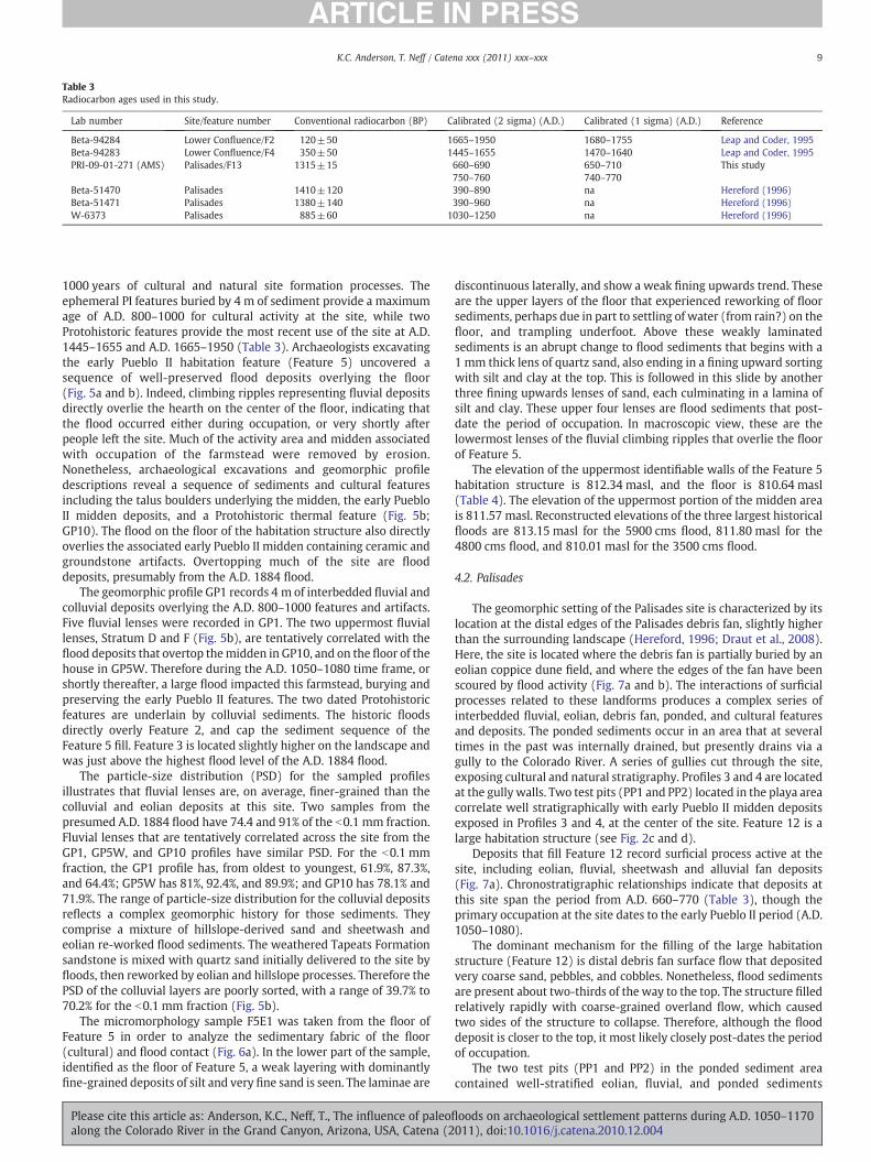
Table 3Radiocarbon ages used in this study.
Lab number Site/feature number Conventional radiocarbon (BP) Calibrated (2 sigma) (A.D.) Calibrated (1 sigma) (A.D.) Reference
Beta-94284 Lower Confluence/F2 120±50 1665–1950 1680–1755 Leap and Coder, 1995Beta-94283 Lower Confluence/F4 350±50 1445–1655 1470–1640 Leap and Coder, 1995PRI-09-01-271 (AMS) Palisades/F13 1315±15 660–690 650–710 This study
750–760 740–770Beta-51470 Palisades 1410±120 390–890 na Hereford (1996)Beta-51471 Palisades 1380±140 390–960 na Hereford (1996)W-6373 Palisades 885±60 1030–1250 na Hereford (1996)
9K.C. Anderson, T. Neff / Catena xxx (2011) xxx–xxx
1000 years of cultural and natural site formation processes. Theephemeral PI features buried by 4 m of sediment provide a maximumage of A.D. 800–1000 for cultural activity at the site, while twoProtohistoric features provide the most recent use of the site at A.D.1445–1655 and A.D. 1665–1950 (Table 3). Archaeologists excavatingthe early Pueblo II habitation feature (Feature 5) uncovered asequence of well-preserved flood deposits overlying the floor(Fig. 5a and b). Indeed, climbing ripples representing fluvial depositsdirectly overlie the hearth on the center of the floor, indicating thatthe flood occurred either during occupation, or very shortly afterpeople left the site. Much of the activity area and midden associatedwith occupation of the farmstead were removed by erosion.Nonetheless, archaeological excavations and geomorphic profiledescriptions reveal a sequence of sediments and cultural featuresincluding the talus boulders underlying the midden, the early PuebloII midden deposits, and a Protohistoric thermal feature (Fig. 5b;GP10). The flood on the floor of the habitation structure also directlyoverlies the associated early Pueblo II midden containing ceramic andgroundstone artifacts. Overtopping much of the site are flooddeposits, presumably from the A.D. 1884 flood.
The geomorphic profile GP1 records 4 m of interbedded fluvial andcolluvial deposits overlying the A.D. 800–1000 features and artifacts.Five fluvial lenses were recorded in GP1. The two uppermost fluviallenses, Stratum D and F (Fig. 5b), are tentatively correlated with theflood deposits that overtop themidden in GP10, and on the floor of thehouse in GP5W. Therefore during the A.D. 1050–1080 time frame, orshortly thereafter, a large flood impacted this farmstead, burying andpreserving the early Pueblo II features. The two dated Protohistoricfeatures are underlain by colluvial sediments. The historic floodsdirectly overly Feature 2, and cap the sediment sequence of theFeature 5 fill. Feature 3 is located slightly higher on the landscape andwas just above the highest flood level of the A.D. 1884 flood.
The particle-size distribution (PSD) for the sampled profilesillustrates that fluvial lenses are, on average, finer-grained than thecolluvial and eolian deposits at this site. Two samples from thepresumed A.D. 1884 flood have 74.4 and 91% of the b0.1 mm fraction.Fluvial lenses that are tentatively correlated across the site from theGP1, GP5W, and GP10 profiles have similar PSD. For the b0.1 mmfraction, the GP1 profile has, from oldest to youngest, 61.9%, 87.3%,and 64.4%; GP5W has 81%, 92.4%, and 89.9%; and GP10 has 78.1% and71.9%. The range of particle-size distribution for the colluvial depositsreflects a complex geomorphic history for those sediments. Theycomprise a mixture of hillslope-derived sand and sheetwash andeolian re-worked flood sediments. The weathered Tapeats Formationsandstone is mixed with quartz sand initially delivered to the site byfloods, then reworked by eolian and hillslope processes. Therefore thePSD of the colluvial layers are poorly sorted, with a range of 39.7% to70.2% for the b0.1 mm fraction (Fig. 5b).
The micromorphology sample F5E1 was taken from the floor ofFeature 5 in order to analyze the sedimentary fabric of the floor(cultural) and flood contact (Fig. 6a). In the lower part of the sample,identified as the floor of Feature 5, a weak layering with dominantlyfine-grained deposits of silt and very fine sand is seen. The laminae are
Please cite this article as: Anderson, K.C., Neff, T., The influence of paleoflalong the Colorado River in the Grand Canyon, Arizona, USA, Catena (2
discontinuous laterally, and show a weak fining upwards trend. Theseare the upper layers of the floor that experienced reworking of floorsediments, perhaps due in part to settling of water (from rain?) on thefloor, and trampling underfoot. Above these weakly laminatedsediments is an abrupt change to flood sediments that begins with a1 mm thick lens of quartz sand, also ending in a fining upward sortingwith silt and clay at the top. This is followed in this slide by anotherthree fining upwards lenses of sand, each culminating in a lamina ofsilt and clay. These upper four lenses are flood sediments that post-date the period of occupation. In macroscopic view, these are thelowermost lenses of the fluvial climbing ripples that overlie the floorof Feature 5.
The elevation of the uppermost identifiable walls of the Feature 5habitation structure is 812.34 masl, and the floor is 810.64 masl(Table 4). The elevation of the uppermost portion of the midden areais 811.57 masl. Reconstructed elevations of the three largest historicalfloods are 813.15 masl for the 5900 cms flood, 811.80 masl for the4800 cms flood, and 810.01 masl for the 3500 cms flood.
4.2. Palisades
The geomorphic setting of the Palisades site is characterized by itslocation at the distal edges of the Palisades debris fan, slightly higherthan the surrounding landscape (Hereford, 1996; Draut et al., 2008).Here, the site is located where the debris fan is partially buried by aneolian coppice dune field, and where the edges of the fan have beenscoured by flood activity (Fig. 7a and b). The interactions of surficialprocesses related to these landforms produces a complex series ofinterbedded fluvial, eolian, debris fan, ponded, and cultural featuresand deposits. The ponded sediments occur in an area that at severaltimes in the past was internally drained, but presently drains via agully to the Colorado River. A series of gullies cut through the site,exposing cultural and natural stratigraphy. Profiles 3 and 4 are locatedat the gully walls. Two test pits (PP1 and PP2) located in the playa areacorrelate well stratigraphically with early Pueblo II midden depositsexposed in Profiles 3 and 4, at the center of the site. Feature 12 is alarge habitation structure (see Fig. 2c and d).
Deposits that fill Feature 12 record surficial process active at thesite, including eolian, fluvial, sheetwash and alluvial fan deposits(Fig. 7a). Chronostratigraphic relationships indicate that deposits atthis site span the period from A.D. 660–770 (Table 3), though theprimary occupation at the site dates to the early Pueblo II period (A.D.1050–1080).
The dominant mechanism for the filling of the large habitationstructure (Feature 12) is distal debris fan surface flow that depositedvery coarse sand, pebbles, and cobbles. Nonetheless, flood sedimentsare present about two-thirds of the way to the top. The structure filledrelatively rapidly with coarse-grained overland flow, which causedtwo sides of the structure to collapse. Therefore, although the flooddeposit is closer to the top, it most likely closely post-dates the periodof occupation.
The two test pits (PP1 and PP2) in the ponded sediment areacontained well-stratified eolian, fluvial, and ponded sediments
oods on archaeological settlement patterns during A.D. 1050–1170011), doi:10.1016/j.catena.2010.12.004
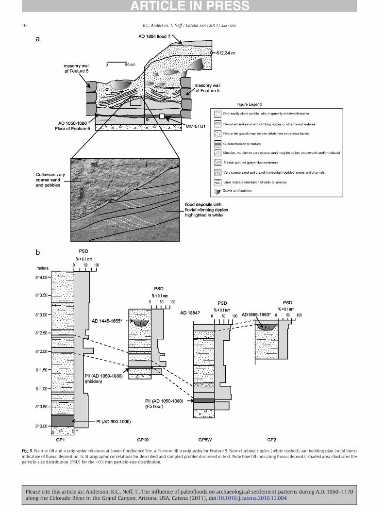
Fig. 5. Feature fill and stratigraphic relations at Lower Confluence Site. a. Feature fill stratigraphy for Feature 5. Note climbing ripples (white dashed) and bedding plan (solid lines)indicative of fluvial deposition. b. Stratigraphic correlations for described and sampled profiles discussed in text. Note blue fill indicating fluvial deposits. Shaded area illustrates theparticle-size distribution (PSD) for the b0.1 mm particle-size distribution.
10 K.C. Anderson, T. Neff / Catena xxx (2011) xxx–xxx
Please cite this article as: Anderson, K.C., Neff, T., The influence of paleofloods on archaeological settlement patterns during A.D. 1050–1170along the Colorado River in the Grand Canyon, Arizona, USA, Catena (2011), doi:10.1016/j.catena.2010.12.004
Fig. 6. a–f. Photomicrographs in plane polarized light illustrating the microscopic fabric of cultural and natural deposits. See text for discussion.
11K.C. Anderson, T. Neff / Catena xxx (2011) xxx–xxx
(Fig. 7b). Based on elevation and stratigraphic correlations, depositsrelated to the cultural period are also present. These pits reveal thatthemodern surface, which dominates drainage patterns, is a relativelyrecent layer that, in places, underlies eolian and fluvial deposits.
As revealed in Profile 3, the lowest stratum at the site significantlypredates the primary A.D. 1050–1080 occupation of the early Pueblo IIinhabitants. Fluvial sands occur at the base of all of the unitsinvestigated, and they are overlain by the “early playa” that predatesthe site occupation. Profile 3 reveals significant periods of alluvial fanactivity at the distal edges of the Palisades debris fan, represented byrelatively thick sequences of loose, channel-fill alluvial sands andgravels, as well as matrix-supported debris flows. A thermal feature
Please cite this article as: Anderson, K.C., Neff, T., The influence of paleoflalong the Colorado River in the Grand Canyon, Arizona, USA, Catena (2
overlying a matrix-supported debris flow returned a radiocarbon ageindicative of A.D. 660–770–late Basketmaker III period. Middendeposits revealed in Profile 3 are directly overlain by fluvial sands,which are in turn overlain by ponded playa-like deposits. Overlyingthese are other fluvial deposits correlated with the uppermost fluvialdeposits in the PP2 playa profile. As at the Lower Confluence site, flooddeposits directly overlie a midden stratum.
Particle-size analysis aids in characterizing and differentiating thevarious deposits at Palisades (Fig. 7b). Particle-size data also illustratethe relatively complex lateral changes in depositional processes thatreflect the position of the site on a landscape where playa, fluvial,eolian, and debris fan deposition interact. Even though the two pits,
oods on archaeological settlement patterns during A.D. 1050–1170011), doi:10.1016/j.catena.2010.12.004

Table 4Cultural feature type, age, and elevation differences between different flood elevations.
Elevation of 4,800 cmsflood at each site
Elevation of 5,900 cmsflood at each site
Feature no.(type)
Featureage (A.D.)
Feature elevation(meters)
Meters above (+) or
4,800 cms
Meters above (+) or
5,900 cms
storage cistf 784.82 0.69
Site name(river mile1)
811.80 813.15F5 (habitation)f 812.34 0.54LowerF10 (midden)f 811.57Confluencehearthf 810.00(62.78)
801.47 802.70F1 (midden)f 800.39PalisadesF12 (habitation)f 800.18(66.08)
784.13 785.02F49 (habitation) 786.28 2.15 1.26Furnacemidden 783.50(71.97)
783.42 784.27F8 (habitation) 790.82 7.4 6.55Uppermiddenf 788.96 5.54 4.69Unkar
(72.54)
Notes:1. River miles downstream from Lees Ferry.f - Features contain or are buried by Colorado River fluvial deposits.Shaded cells indicate features that are under water at given flood elevation.
12 K.C. Anderson, T. Neff / Catena xxx (2011) xxx–xxx
PP1 and PP2, were excavated in the playa, only 25 m apart, thestratigraphy preserved is quite different. PP1 contains only threefluvial layers and is dominated by finely laminated sequences ofponded sediments. Fluvial layers have between 85% and 92.6% of theb0.1 mm fraction and the ponded layers have between 92% and 98% ofthe b0.1 mm fraction. In contrast, the PP2 is dominated by fluvialsands, at the same elevation, with only a few ponded lenses. Inaddition, fluvial sands here are significantly coarser than elsewhere,with the b0.1 mm fraction ranging from 29.9% to 82.5%.
Particle-size distributions for the P3 and P4 sections also help tocorrelate and differentiate deposits (Fig. 7b). Fluvial deposits in P3have relatively coarse fraction, ranging from a mere 11.4% of theb0.1 mm fraction at the base, to 91.7% near the top. The uppermostfluvial lens has 12.3% of the b0.1 mm fraction, indicating higherenergy deposits. This uppermost deposit might well be the A.D. 1884flood (see below). In P4, particle-size distributions help to character-ize a sequence of fining-upwards fluvial deposits where the floodsands range from 6.8% of the b0.1 mm fraction, to 43.9%. Several ofthese floods end in silt lenses that have between 88.1 and 91.0% of theb0.1 mm fraction. Fluvial deposits found in the feature fill sequence ofFeature 12 contain 94.5% of the b0.1 m fraction.
Micromorphology at the Palisades site reveals characteristics ofponded (playa), fluvial, and floor contexts (Fig. 6b, c, d, e). SampleF5TU1 was analyzed because it was from the floor context. The floorwas rather unique, consisting of a natural clay and silt-rich deposit,exhibiting distinct, 5 cm diameter mudcracks across the entire floor.The structure is interpreted as a surface brush-and-mud structure(locally known as jacal). The microscopic fabric of these deposits ischaracterized by relatively weak horizontal layering with occasionallyvery weak fining upwards sequences, and poorly sorted grain sizes.Elongated grains are horizontally oriented, indicating settling parallelto the ground surface. The original nature of these deposits is fromplaya-like deposition, and the elevation and stratigraphic relation-ships to the “early playa” (Fig. 7b) supports this interpretation.However, the fabrics seen in Fig. 6b indicated reworking of thesediments into the weak laminations representative of sorting byrainfall and small puddling events in an open cultural feature. Thenature of these deposits is similar to those from the floor of Feature 5at Lower Confluence, as previously discussed.
The playa deposits, as seen in samples PP1MM2 and PP1MM3(Fig. 6c and d) illustrate distinctly laminated, fining upwardssequences representing ponding processes after rainfall events andhillslope runoff fill the playa area. Many of the grains are elongatedrock fragments from the Dox Sandstone that are horizontally oriented.Quartz-rich sand underlying the red laminae probably originate from
Please cite this article as: Anderson, K.C., Neff, T., The influence of paleoalong the Colorado River in the Grand Canyon, Arizona, USA, Catena (2
windblown sand across the playa surface prior to reworking andsettling in a ponded environment. As can be seen in Fig. 6c, sevenponding events are recorded whereas in Fig. 6d, there are thirteenevents recorded, each within a 1.5 mm thick section.
In the P3MM1 photomicrograph, we can see the contact betweenthe underlying ponded playa laminae and the overlying fluvial quartzsands (Fig. 6e). This contact is very abrupt, representing a floodingevent from the Colorado River burying the “early playa.” This floodrepresents the culmination of playa-like processes, at this specificlocation, until after the early Pueblo II occupation.
The elevation of the uppermost identifiable walls of the Feature 12habitation structure is 800.18 masl, and the floor is 798.75 masl(Table 4). The elevation of the uppermost portion of the midden areais 800.65 masl, whereas the lowest recorded part of the midden is800.00 masl. Reconstructed elevations of the two largest historicalfloods are 802.70 masl for the 5900 cms flood, 801.47 masl for the4800 cms flood, and799.98 masl for the 3500 cms flood.
4.3. Furnace Flats
The geomorphic setting of the Furnace Flats site differs from that ofthe two previous sites in that it is situated along the toeslope of a steepbedrock cliff of Dox Sandstone. The dominant depositional processesat the site are colluvial, with significant eolian reworking of fluvialsands. Detailed investigations were undertaken of the Feature 49 fillsequence which revealed structure filling by dominantly hillslopegravels and sands derived from the Dox Sandstone and fromreworked eolian processes (Fig. 8a and b). No fluvial deposits werefound in the Feature 49 fill sequence. The A6 profile was a 15-m-longand 4-m-high section that revealed extensive cultural and hillslopedeposits (Fig. 8b). Fluvial deposits in this area were limited to thelower parts of the profile and the lower parts of the site.
Particle-size distributions from the feature-fill deposits at theFurnace site are limited because themajority ofmaterialsfilling featuresare composed of reddish-brown sand and gravel derived from hillslopeprocesses. Based on the presence of climbing fluvial ripples, the onlydefinitivelyfluvial deposit here is at the base of theA6profile, where theb0.1 mm fraction is 37.6%, indicating a coarse-textured fluvial facies forthis deposit. Other deposits above this fluvial lens range from 33.9 to52.4% of the b0.1 mm fraction. Because there were no fluvial deposits inF49, no sediments were analyzed from feature fill contexts.
The elevation of the uppermost identifiable walls of the Feature 49habitation structure is 786.28 masl, and the floor is 785.25 masl(Table 4). The elevation of the uppermost portion of the midden areais 784.50 masl and the lower portion of the midden is 782.50 masl.
floods on archaeological settlement patterns during A.D. 1050–1170011), doi:10.1016/j.catena.2010.12.004
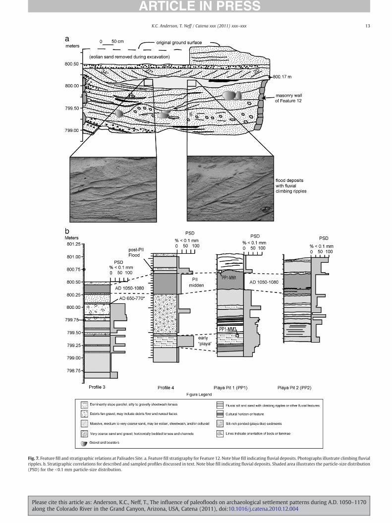
Fig. 7. Feature fill and stratigraphic relations at Palisades Site. a. Feature fill stratigraphy for Feature 12. Note blue fill indicating fluvial deposits. Photographs illustrate climbing fluvialripples. b. Stratigraphic correlations for described and sampled profiles discussed in text. Note blue fill indicating fluvial deposits. Shaded area illustrates the particle-size distribution(PSD) for the b0.1 mm particle-size distribution.
13K.C. Anderson, T. Neff / Catena xxx (2011) xxx–xxx
Please cite this article as: Anderson, K.C., Neff, T., The influence of paleofloods on archaeological settlement patterns during A.D. 1050–1170along the Colorado River in the Grand Canyon, Arizona, USA, Catena (2011), doi:10.1016/j.catena.2010.12.004
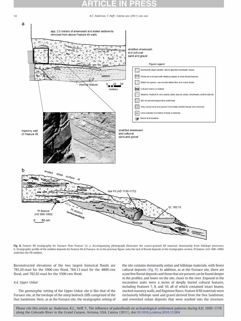
Fig. 8. Feature fill stratigraphy for Furnace Flats Feature 12. a. Accompanying photograph illustrates the coarse-grained fill material, dominantly from hillslope processes.b. Stratigraphic profile of the midden deposits for Feature 49 at Furnace. As in the previous figure, note the lack of fluvial deposits in the stratigraphic section. PI feature (A.D. 900–1000)underlies the PII midden.
14 K.C. Anderson, T. Neff / Catena xxx (2011) xxx–xxx
Reconstructed elevations of the two largest historical floods are785.20 masl for the 5900 cms flood, 784.13 masl for the 4800 cmsflood, and 782.92 masl for the 3500 cms flood.
4.4. Upper Unkar
The geomorphic setting of the Upper Unkar site is like that of theFurnace site, at the toeslope of the steep bedrock cliffs comprised of theDox Sandstone. Here, as at the Furnace site, the stratigraphic setting of
Please cite this article as: Anderson, K.C., Neff, T., The influence of paleoalong the Colorado River in the Grand Canyon, Arizona, USA, Catena (2
the site contains dominantly eolian and hillslope materials, with fewercultural deposits (Fig. 9). In addition, as at the Furnace site, there arescant fewfluvial deposits and those that are present canbe founddeeperin the profiles, and lower on the site, closer to the river. Exposed in theexcavation units were a series of deeply buried cultural features,including Features 7, 8, and 10, all of which contained intact beams,stackedmasonrywalls, andflagstonefloors. Feature 8fillmaterialswereexclusively hillslope sand and gravel derived from the Dox Sandstone,and reworked eolian deposits that were washed into the structure.
floods on archaeological settlement patterns during A.D. 1050–1170011), doi:10.1016/j.catena.2010.12.004
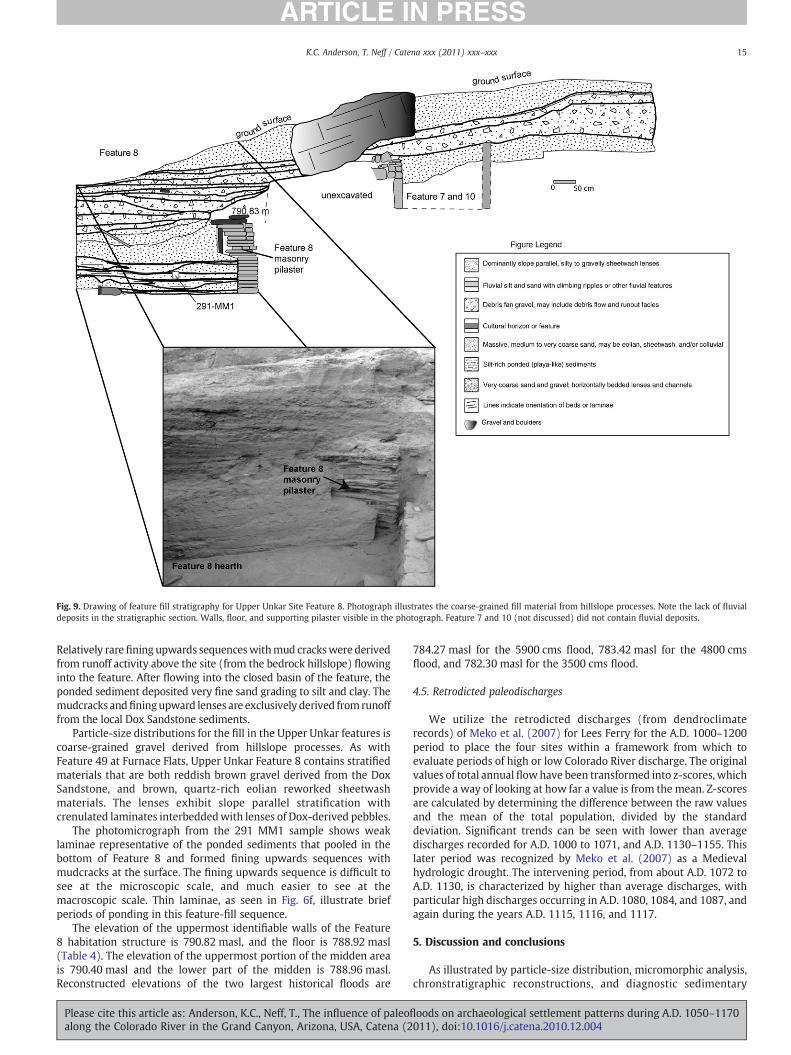
Fig. 9. Drawing of feature fill stratigraphy for Upper Unkar Site Feature 8. Photograph illustrates the coarse-grained fill material from hillslope processes. Note the lack of fluvialdeposits in the stratigraphic section. Walls, floor, and supporting pilaster visible in the photograph. Feature 7 and 10 (not discussed) did not contain fluvial deposits.
15K.C. Anderson, T. Neff / Catena xxx (2011) xxx–xxx
Relatively rare fining upwards sequenceswithmud crackswere derivedfrom runoff activity above the site (from the bedrock hillslope) flowinginto the feature. After flowing into the closed basin of the feature, theponded sediment deposited very fine sand grading to silt and clay. Themudcracks andfiningupward lenses are exclusively derived fromrunofffrom the local Dox Sandstone sediments.
Particle-size distributions for the fill in the Upper Unkar features iscoarse-grained gravel derived from hillslope processes. As withFeature 49 at Furnace Flats, Upper Unkar Feature 8 contains stratifiedmaterials that are both reddish brown gravel derived from the DoxSandstone, and brown, quartz-rich eolian reworked sheetwashmaterials. The lenses exhibit slope parallel stratification withcrenulated laminates interbeddedwith lenses of Dox-derived pebbles.
The photomicrograph from the 291 MM1 sample shows weaklaminae representative of the ponded sediments that pooled in thebottom of Feature 8 and formed fining upwards sequences withmudcracks at the surface. The fining upwards sequence is difficult tosee at the microscopic scale, and much easier to see at themacroscopic scale. Thin laminae, as seen in Fig. 6f, illustrate briefperiods of ponding in this feature-fill sequence.
The elevation of the uppermost identifiable walls of the Feature8 habitation structure is 790.82 masl, and the floor is 788.92 masl(Table 4). The elevation of the uppermost portion of the midden areais 790.40 masl and the lower part of the midden is 788.96 masl.Reconstructed elevations of the two largest historical floods are
Please cite this article as: Anderson, K.C., Neff, T., The influence of paleoflalong the Colorado River in the Grand Canyon, Arizona, USA, Catena (2
784.27 masl for the 5900 cms flood, 783.42 masl for the 4800 cmsflood, and 782.30 masl for the 3500 cms flood.
4.5. Retrodicted paleodischarges
We utilize the retrodicted discharges (from dendroclimaterecords) of Meko et al. (2007) for Lees Ferry for the A.D. 1000–1200period to place the four sites within a framework from which toevaluate periods of high or low Colorado River discharge. The originalvalues of total annual flowhave been transformed into z-scores, whichprovide a way of looking at how far a value is from the mean. Z-scoresare calculated by determining the difference between the raw valuesand the mean of the total population, divided by the standarddeviation. Significant trends can be seen with lower than averagedischarges recorded for A.D. 1000 to 1071, and A.D. 1130–1155. Thislater period was recognized by Meko et al. (2007) as a Medievalhydrologic drought. The intervening period, from about A.D. 1072 toA.D. 1130, is characterized by higher than average discharges, withparticular high discharges occurring in A.D. 1080, 1084, and 1087, andagain during the years A.D. 1115, 1116, and 1117.
5. Discussion and conclusions
As illustrated by particle-size distribution, micromorphic analysis,chronstratigraphic reconstructions, and diagnostic sedimentary
oods on archaeological settlement patterns during A.D. 1050–1170011), doi:10.1016/j.catena.2010.12.004
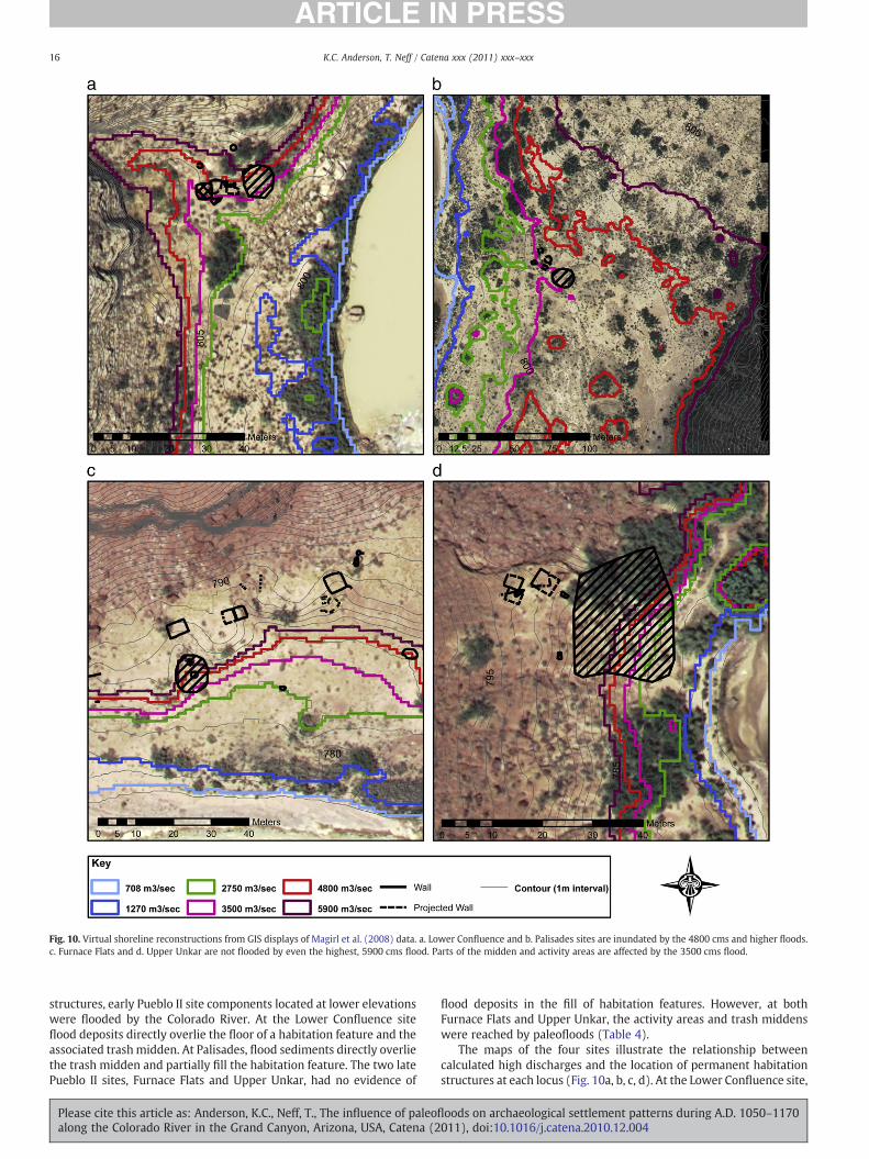
Fig. 10. Virtual shoreline reconstructions from GIS displays of Magirl et al. (2008) data. a. Lower Confluence and b. Palisades sites are inundated by the 4800 cms and higher floods.c. Furnace Flats and d. Upper Unkar are not flooded by even the highest, 5900 cms flood. Parts of the midden and activity areas are affected by the 3500 cms flood.
16 K.C. Anderson, T. Neff / Catena xxx (2011) xxx–xxx
structures, early Pueblo II site components located at lower elevationswere flooded by the Colorado River. At the Lower Confluence siteflood deposits directly overlie the floor of a habitation feature and theassociated trashmidden. At Palisades, flood sediments directly overliethe trash midden and partially fill the habitation feature. The two latePueblo II sites, Furnace Flats and Upper Unkar, had no evidence of
Please cite this article as: Anderson, K.C., Neff, T., The influence of paleoalong the Colorado River in the Grand Canyon, Arizona, USA, Catena (2
flood deposits in the fill of habitation features. However, at bothFurnace Flats and Upper Unkar, the activity areas and trash middenswere reached by paleofloods (Table 4).
The maps of the four sites illustrate the relationship betweencalculated high discharges and the location of permanent habitationstructures at each locus (Fig. 10a, b, c, d). At the Lower Confluence site,
floods on archaeological settlement patterns during A.D. 1050–1170011), doi:10.1016/j.catena.2010.12.004
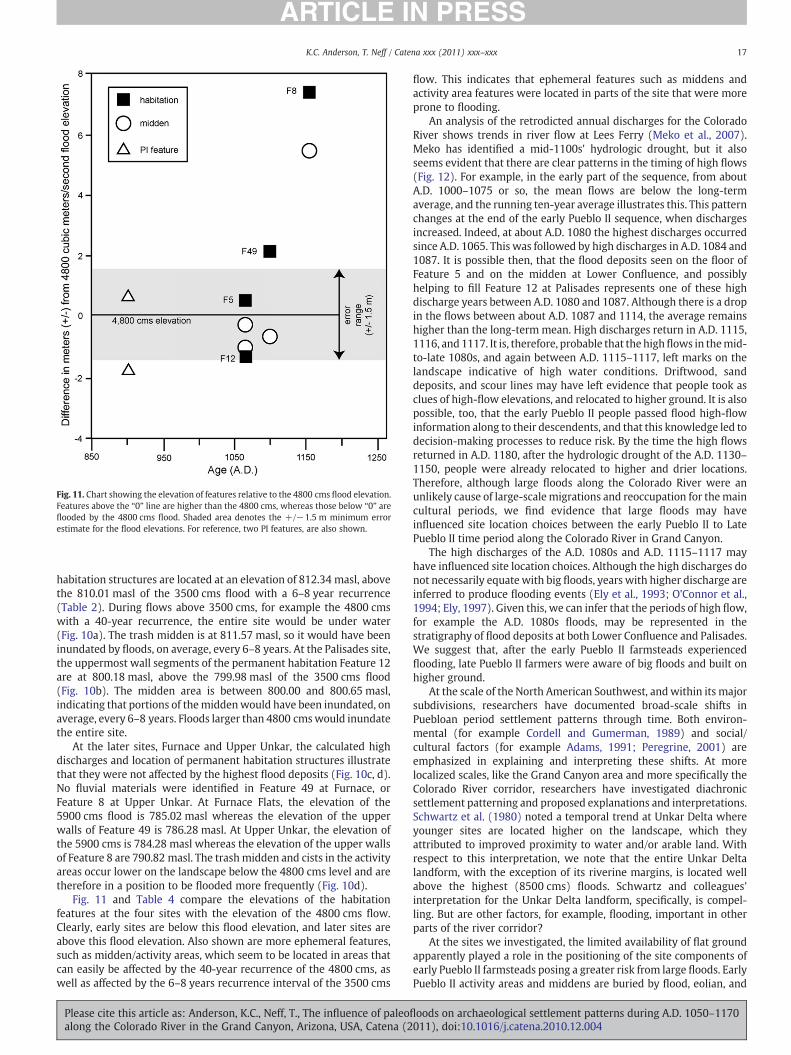
Fig. 11. Chart showing the elevation of features relative to the 4800 cms flood elevation.Features above the “0” line are higher than the 4800 cms, whereas those below “0” areflooded by the 4800 cms flood. Shaded area denotes the +/−1.5 m minimum errorestimate for the flood elevations. For reference, two PI features, are also shown.
17K.C. Anderson, T. Neff / Catena xxx (2011) xxx–xxx
habitation structures are located at an elevation of 812.34 masl, abovethe 810.01 masl of the 3500 cms flood with a 6–8 year recurrence(Table 2). During flows above 3500 cms, for example the 4800 cmswith a 40-year recurrence, the entire site would be under water(Fig. 10a). The trash midden is at 811.57 masl, so it would have beeninundated by floods, on average, every 6–8 years. At the Palisades site,the uppermost wall segments of the permanent habitation Feature 12are at 800.18 masl, above the 799.98 masl of the 3500 cms flood(Fig. 10b). The midden area is between 800.00 and 800.65 masl,indicating that portions of themiddenwould have been inundated, onaverage, every 6–8 years. Floods larger than 4800 cmswould inundatethe entire site.
At the later sites, Furnace and Upper Unkar, the calculated highdischarges and location of permanent habitation structures illustratethat they were not affected by the highest flood deposits (Fig. 10c, d).No fluvial materials were identified in Feature 49 at Furnace, orFeature 8 at Upper Unkar. At Furnace Flats, the elevation of the5900 cms flood is 785.02 masl whereas the elevation of the upperwalls of Feature 49 is 786.28 masl. At Upper Unkar, the elevation ofthe 5900 cms is 784.28 masl whereas the elevation of the upper wallsof Feature 8 are 790.82 masl. The trashmidden and cists in the activityareas occur lower on the landscape below the 4800 cms level and aretherefore in a position to be flooded more frequently (Fig. 10d).
Fig. 11 and Table 4 compare the elevations of the habitationfeatures at the four sites with the elevation of the 4800 cms flow.Clearly, early sites are below this flood elevation, and later sites areabove this flood elevation. Also shown are more ephemeral features,such as midden/activity areas, which seem to be located in areas thatcan easily be affected by the 40-year recurrence of the 4800 cms, aswell as affected by the 6–8 years recurrence interval of the 3500 cms
Please cite this article as: Anderson, K.C., Neff, T., The influence of paleoflalong the Colorado River in the Grand Canyon, Arizona, USA, Catena (2
flow. This indicates that ephemeral features such as middens andactivity area features were located in parts of the site that were moreprone to flooding.
An analysis of the retrodicted annual discharges for the ColoradoRiver shows trends in river flow at Lees Ferry (Meko et al., 2007).Meko has identified a mid-1100s' hydrologic drought, but it alsoseems evident that there are clear patterns in the timing of high flows(Fig. 12). For example, in the early part of the sequence, from aboutA.D. 1000–1075 or so, the mean flows are below the long-termaverage, and the running ten-year average illustrates this. This patternchanges at the end of the early Pueblo II sequence, when dischargesincreased. Indeed, at about A.D. 1080 the highest discharges occurredsince A.D. 1065. This was followed by high discharges in A.D. 1084 and1087. It is possible then, that the flood deposits seen on the floor ofFeature 5 and on the midden at Lower Confluence, and possiblyhelping to fill Feature 12 at Palisades represents one of these highdischarge years between A.D. 1080 and 1087. Although there is a dropin the flows between about A.D. 1087 and 1114, the average remainshigher than the long-term mean. High discharges return in A.D. 1115,1116, and 1117. It is, therefore, probable that the highflows in themid-to-late 1080s, and again between A.D. 1115–1117, left marks on thelandscape indicative of high water conditions. Driftwood, sanddeposits, and scour lines may have left evidence that people took asclues of high-flow elevations, and relocated to higher ground. It is alsopossible, too, that the early Pueblo II people passed flood high-flowinformation along to their descendents, and that this knowledge led todecision-making processes to reduce risk. By the time the high flowsreturned in A.D. 1180, after the hydrologic drought of the A.D. 1130–1150, people were already relocated to higher and drier locations.Therefore, although large floods along the Colorado River were anunlikely cause of large-scalemigrations and reoccupation for themaincultural periods, we find evidence that large floods may haveinfluenced site location choices between the early Pueblo II to LatePueblo II time period along the Colorado River in Grand Canyon.
The high discharges of the A.D. 1080s and A.D. 1115–1117 mayhave influenced site location choices. Although the high discharges donot necessarily equate with big floods, years with higher discharge areinferred to produce flooding events (Ely et al., 1993; O'Connor et al.,1994; Ely, 1997). Given this, we can infer that the periods of high flow,for example the A.D. 1080s floods, may be represented in thestratigraphy of flood deposits at both Lower Confluence and Palisades.We suggest that, after the early Pueblo II farmsteads experiencedflooding, late Pueblo II farmers were aware of big floods and built onhigher ground.
At the scale of the North American Southwest, andwithin its majorsubdivisions, researchers have documented broad-scale shifts inPuebloan period settlement patterns through time. Both environ-mental (for example Cordell and Gumerman, 1989) and social/cultural factors (for example Adams, 1991; Peregrine, 2001) areemphasized in explaining and interpreting these shifts. At morelocalized scales, like the Grand Canyon area and more specifically theColorado River corridor, researchers have investigated diachronicsettlement patterning and proposed explanations and interpretations.Schwartz et al. (1980) noted a temporal trend at Unkar Delta whereyounger sites are located higher on the landscape, which theyattributed to improved proximity to water and/or arable land. Withrespect to this interpretation, we note that the entire Unkar Deltalandform, with the exception of its riverine margins, is located wellabove the highest (8500 cms) floods. Schwartz and colleagues'interpretation for the Unkar Delta landform, specifically, is compel-ling. But are other factors, for example, flooding, important in otherparts of the river corridor?
At the sites we investigated, the limited availability of flat groundapparently played a role in the positioning of the site components ofearly Pueblo II farmsteads posing a greater risk from large floods. EarlyPueblo II activity areas and middens are buried by flood, eolian, and
oods on archaeological settlement patterns during A.D. 1050–1170011), doi:10.1016/j.catena.2010.12.004
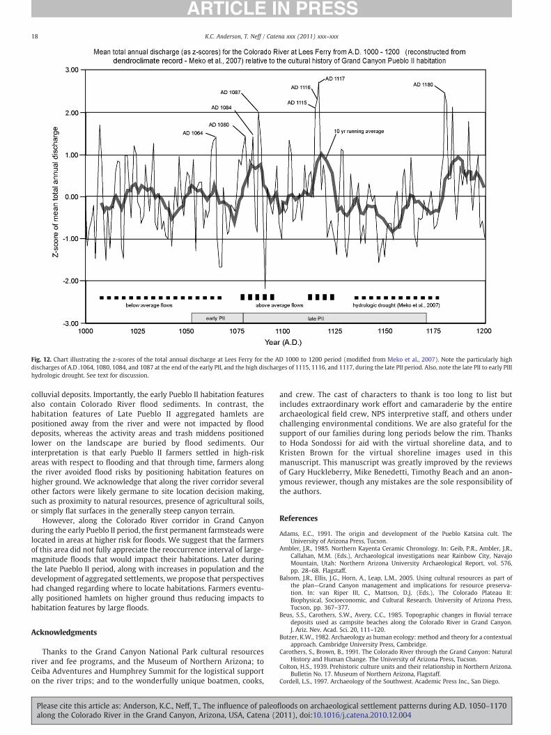
Fig. 12. Chart illustrating the z-scores of the total annual discharge at Lees Ferry for the AD 1000 to 1200 period (modified from Meko et al., 2007). Note the particularly highdischarges of A.D .1064, 1080, 1084, and 1087 at the end of the early PII, and the high discharges of 1115, 1116, and 1117, during the late PII period. Also, note the late PII to early PIIIhydrologic drought. See text for discussion.
18 K.C. Anderson, T. Neff / Catena xxx (2011) xxx–xxx
colluvial deposits. Importantly, the early Pueblo II habitation featuresalso contain Colorado River flood sediments. In contrast, thehabitation features of Late Pueblo II aggregated hamlets arepositioned away from the river and were not impacted by flooddeposits, whereas the activity areas and trash middens positionedlower on the landscape are buried by flood sediments. Ourinterpretation is that early Pueblo II farmers settled in high-riskareas with respect to flooding and that through time, farmers alongthe river avoided flood risks by positioning habitation features onhigher ground. We acknowledge that along the river corridor severalother factors were likely germane to site location decision making,such as proximity to natural resources, presence of agricultural soils,or simply flat surfaces in the generally steep canyon terrain.
However, along the Colorado River corridor in Grand Canyonduring the early Pueblo II period, the first permanent farmsteads werelocated in areas at higher risk for floods. We suggest that the farmersof this area did not fully appreciate the reoccurrence interval of large-magnitude floods that would impact their habitations. Later duringthe late Pueblo II period, along with increases in population and thedevelopment of aggregated settlements, we propose that perspectiveshad changed regarding where to locate habitations. Farmers eventu-ally positioned hamlets on higher ground thus reducing impacts tohabitation features by large floods.
Acknowledgments
Thanks to the Grand Canyon National Park cultural resourcesriver and fee programs, and the Museum of Northern Arizona; toCeiba Adventures and Humphrey Summit for the logistical supporton the river trips; and to the wonderfully unique boatmen, cooks,
Please cite this article as: Anderson, K.C., Neff, T., The influence of paleoalong the Colorado River in the Grand Canyon, Arizona, USA, Catena (2
and crew. The cast of characters to thank is too long to list butincludes extraordinary work effort and camaraderie by the entirearchaeological field crew, NPS interpretive staff, and others underchallenging environmental conditions. We are also grateful for thesupport of our families during long periods below the rim. Thanksto Hoda Sondossi for aid with the virtual shoreline data, and toKristen Brown for the virtual shoreline images used in thismanuscript. This manuscript was greatly improved by the reviewsof Gary Huckleberry, Mike Benedetti, Timothy Beach and an anon-ymous reviewer, though any mistakes are the sole responsibility ofthe authors.
References
Adams, E.C., 1991. The origin and development of the Pueblo Katsina cult. TheUniversity of Arizona Press, Tucson.
Ambler, J.R., 1985. Northern Kayenta Ceramic Chronology. In: Geib, P.R., Ambler, J.R.,Callahan, M.M. (Eds.), Archaeological investigations near Rainbow City, NavajoMountain, Utah: Northern Arizona University Archaeological Report, vol. 576,pp. 28–68. Flagstaff.
Balsom, J.R., Ellis, J.G., Horn, A., Leap, L.M., 2005. Using cultural resources as part ofthe plan—Grand Canyon management and implications for resource preserva-tion. In: van Riper III, C., Mattson, D.J. (Eds.), The Colorado Plateau II:Biophysical, Socioeconomic, and Cultural Research. University of Arizona Press,Tucson, pp. 367–377.
Beus, S.S., Carothers, S.W., Avery, C.C., 1985. Topographic changes in fluvial terracedeposits used as campsite beaches along the Colorado River in Grand Canyon.J. Ariz. Nev. Acad. Sci. 20, 111–120.
Butzer, K.W., 1982. Archaeology as human ecology: method and theory for a contextualapproach. Cambridge University Press, Cambridge.
Carothers, S., Brown, B., 1991. The Colorado River through the Grand Canyon: NaturalHistory and Human Change. The University of Arizona Press, Tucson.
Colton, H.S., 1939. Prehistoric culture units and their relationship in Northern Arizona.Bulletin No. 17. Museum of Northern Arizona, Flagstaff.
Cordell, L.S., 1997. Archaeology of the Southwest. Academic Press Inc., San Diego.
floods on archaeological settlement patterns during A.D. 1050–1170011), doi:10.1016/j.catena.2010.12.004
19K.C. Anderson, T. Neff / Catena xxx (2011) xxx–xxx
Cordell, L.S., Gumerman, G.J., 1989. Cultural interaction in the Prehistoric Southwest. In:Cordell, L.S., Gumerman, G.J. (Eds.), Dynamics of Southwest Prehistory. SmithsonianInstitution Press, Washington, D.C, pp. 1–17.
Damp, J.E., Pederson, J., O'Brien, G., 2009. Annual Report, 2008 Field Season, excavationsat four sites in Glen and Grand Canyons. Manuscript on file at Bureau ofReclamation, Salt Lake City, and at Grand Canyon National Park, Arizona.
Dierker, J.L., Downum, C.E., 2004. Excavations at four sites on and near the PalisadesDelta, Grand Canyon National Park: Northern Arizona University. ArchaeologicalReport 1216b. 80 pp.
Draut, A.E., Rubin, D.M., Dierker, J.L., Fairley, H.C., Griffiths, R.E., Hazel Jr., J.E., Hunter, R.E.,Kohl, K., Leap, L.M., Nials, F.L., Topping, D.J., Yeatts, M., 2005. Sedimentology andstratigraphy of the Palisades, Lower Comanche, and Arroyo Grande areas of theColorado River corridor, Grand Canyon, Arizona. U.S. Geological Survey ScientificInvestigations Report 2005–5072. 68 pp, (http://pubs.usgs.gov/sir/2005/5072/).
Draut, A.E., Rubin, D.M., Dierker, J.L., Fairley, H.C., Griffiths, R.E., Hazel Jr., J.E., Hunter, R.E.,Kohl, K., Leap, L.M., Nials, F.L., Topping,D.J., Yeatts,M., 2008. Application of sedimentary-structure interpretation to geoarchaeological investigations in the Colorado RiverCorridor, Grand Canyon, Arizona, USA. Geomorphology 101 (3), 497–503.
Ely, L.L., 1997. Response of extreme floods in the southwestern United States to climaticvariations in the late Holocene. Geomorphology 19 (3-4), 175–201 (July).
Ely, L.L., Enzel, Y., Baker, V.R., Cayan, D.R., 1993. A 5000-year record of extreme floodsand climate change in the southwestern United States. Science 262, 410–412.
Fairley, H.C., 2003. Changing river; time, culture, and the transformation of landscape inthe Grand Canyon—a regional research design for the study of cultural resourcesalong the Colorado River in lower Glen Canyon and Grand Canyon National Park,Arizona: Statistical Research, Inc., prepared for the U.S. Geological Survey, GrandCanyon Monitoring and Research Center, Flagstaff, Ariz., Technical Series 79,179 pp.
Fairley, H.C., Bungart, P.W., Coder, C.M., Huffman, J., Samples, T.L., Balsom, J.R., 1994. TheGrand Canyon river corridor survey project—archaeological survey along theColorado River between Glen Canyon Dam and Separation Canyon: Cooperativeagreement No. 9AA-40-07920, Grand Canyon National Park, prepared in cooper-ation with the Bureau of Reclamation, Glen Canyon Environmental Studies,Flagstaff, AZ, 276 pp.
Gloss, S.P., Lovich, J.E., Melis, T.S. (Eds.), 2005. The state of the Colorado River ecosystemin the Grand Canyon: U.S. Geological Survey Circular, vol. 1282. 220 pp.
Griffiths, P.G., Webb, R.H., Melis, T.S., 2004. Frequency and initiation of debris flows inGrand Canyon, Arizona. J. Geophys. Res. 109 14pp.
Hazel Jr., J.E., Kaplinski, M., Parnell, R., Manone, M., Dale, A., 1999. Topographic andbathymetric changes at thirty-three long-term study sites. In: Webb, R.H., Schmidt,J.C., Marzolf, G.R., Valdez, R.A. (Eds.), The Controlled Flood in Grand Canyon:Washington, D. C. American Geophysical Union: Geophysical Monograph, vol. 110,pp. 161–183.
Hazel, J.E., Kaplinski, M., Manone, M., Parnell, R., 2000. Monitoring arroyo erosion ofpre-dam river terraces in the Colorado River ecosystem, 1996–1999, Grand CanyonNational Park, Arizona. Northern Arizona University, Department of Geology, Draftfinal report to the Grand Canyon Monitoring and Research Center, cooperativeagreement CA 1425-98-FC-40-22630. 29 pp.
Hereford, R., 1996. Surficial geology and geomorphology of the Palisades Creek area,Grand Canyon National Park, Arizona. U.S. Geological Survey MiscellaneousInvestigations Series Map I-2449, scale 1:2000 (with discussion).
Hereford, R., Fairley, H.C., Thompson, K.S., K.J. Burke, and Balsom, J.R., 1991. The effect ofregulated flows on the erosion of archaeologic sites at four areas in the EasternGrand Canyon National Park, Arizona: a preliminary analysis. U.S.G.S. Manuscripton file at Glen Canyon Environmental Studies Program, Flagstaff.
Hereford, R., Fairley, H.C., Thompson, K.S., Balsom, J.R., 1993. Surficial geology,geomorphology, and erosion of archeological sites along the Colorado River,eastern Grand Canyon, Grand Canyon National Park, Arizona. U.S. GeologicalSurvey Open-File Report 93-517.
Hereford, R., Thompson, K.S., Burke, K.J., Fairley, H.C., 1996. Tributary debris fans andthe late Holocene alluvial chronology of the Colorado River, eastern Grand Canyon,Arizona. Geol. Soc. Am. Bull. 108, 3–19.
Huckell, B.B., 1996. The Archaic Prehistory of the North American Southwest. J. WorldPrehistory 10 (3), 305–373.
Jones, A.T., 1986. A cross-section of Grand Canyon Archaeology: excavations at five sitesalong the Colorado river. Western Archaeological and Conservation Center, vol. 28.Publications in Anthropology, Tucson.
Kieffer, S.W., 1987. The rapids and waves of the Colorado River, Grand Canyon, Arizona,U.S. Geol. Surv. Open-File Rep., 87-096. 69 pp.
Please cite this article as: Anderson, K.C., Neff, T., The influence of paleoflalong the Colorado River in the Grand Canyon, Arizona, USA, Catena (2
Leap, L.M., Coder, C.M., 1995. Erosion control project at Palisades delta along theColorado River corridor, Grand Canyon National Park: River Corridor MonitoringProject Report prepared for the Bureau of Reclamation, Salt Lake City, Utah, GrandCanyon National Park, River Corridor Monitoring Project, Report #29.
Leap, L.M., Dierker, J.L., Andrews, N.B., 2003. Fiscal year 2003 archaeological sitemonitoring and management activities along the Colorado River in Grand CanyonNational Park. Report prepared by Grand Canyon National Park and NorthernArizona University, submitted to the Bureau of Reclamation, Upper ColoradoRegion, Salt Lake City, Utah, Grand Canyon National Park, River Corridor MonitoringProject, Report #89.
Magirl, C.S., Breedlove, M.J., Webb, R.H., Griffiths, P.G., 2008. Modeling water-surfaceelevations and virtual shorelines for the Colorado river in Grand Canyon, Arizona.U.S. Geological Survey Scientific Investigations Report 2008-5075. 32 pp.
McGregor, J.C., 1967. The Cohonina culture of Mount Floyd, Arizona. Studies inAnthropology, vol. 5. University of Kentucky Press, Lexington.
Meko, D.M.,Woodhouse, C.A., Baisan, C.A., Knight, T., Lukas, J.J., Hughes,M.K., Salzer, M.W.,2007. Medieval drought in the upper Colorado River Basin. Geophys. Res. Lett. 34.doi:10.1029/2007GL029988.
Melis, T.S., Webb, R.H., Griffiths, P.G., Wise, T.G., 1994. Magnitude and frequency datafor historic debris flows in Grand Canyon National Park and vicinity, Arizona. U.S.Geol. Surv. Water-Resources Investigations Rep., 94-4214. 285 pp.
Miller, A., 2005. Selected Excavations at Furnace Flats (C:13:010) Final Report. NorthernArizona University Archaeological Report 1216c, Flagstaff.
O'Connor, J.E., Ely, L.L., Wohl, E.E., Stevens, L.E., Melis, T.S., Kale, V.S., Baker, V.R., 1994.4000-year record of large floods on the Colorado River in the Grand Canyon. J. Geol.102, 1–9.
Peregrine, P.N., 2001. Matrilocality, Corporate Strategy, and the Organization ofProduction in the Chacoan World. Am. Antiquity 66 (1), 36–46.
Rubin, D.M., 1987. Cross-bedding, bedforms, and paleocurrents: SEPM Concepts insedimentology and paleontology, vol. 1. Society of Economic Paleontologists andMineralogists, Tulsa, OK. 187 pp.
Rubin, D.M., Hunter, R.E., 1987. Field guide to sedimentary structures in the Navajo andEntrada Sandstones in southern Utah and northern Arizona. Bur. Geol. Miner.Technol. Spec. Pap. 5, 126–139.
Rubin, D.M., Schmidt, J.C., Moore, J.N., 1990. Origin, structure, and evolution of areattachment bar, Colorado River, Grand Canyon, Arizona. J. Sediment. Petrol. 60,982–991.
Rubin, D.M., Nelson, J.M., Topping, D.J., 1998. Relation of inversely graded deposits tosuspended sediment grain-size evolution during the 1996 flood experiment inGrand Canyon. Geology 26, 99–102.
Schiffer, M.B., 1987. Formation processes of the archaeological record formation processesof the archaeological record. University of New Mexico Press, Albuquerque.
Schmidt, J.C., 1990. Recirculating flow and sedimentation in the Colorado River in GrandCanyon, Arizona. J. Geol. 98, 709–724.
Schmidt, J.C., Graf, J.B., 1990. Aggradation and degradation of alluvial sand deposits,1965 to 1986, Colorado River, Grand Canyon National Park, Arizona. U.S. GeologicalSurvey Professional Paper 1493.
Schwartz, D.W., Marshall, M.P., Kepp, J., 1979. Archaeology of the Grand Canyon: TheBright Angel Site. Grand Canyon Archaeological Series, Vol. 1. School of AmericanResearch Press, Santa Fe.
Schwartz, D.W., Chapman, R.C., Kepp, J., 1980. Archaeology of the Grand Canyon: UnkarDelta. Grand Canyon Archaeological Series, Vol. 2. School of American ResearchPress, Santa Fe.
Topping, D.J., Schmidt, J.C., Vierra Jr., L.E., 2003. Computation and analysis of theinstantaneous-discharge record for the Colorado River at Lees Ferry, Arizona—May8, 1921 through September 30, 2000. U.S. Geological Survey Professional Paper1677. 118 pp.
Webb, R.H., 1996. Grand Canyon: a century of environmental change: rephotography ofthe 1889–1890 Stanton Expedition. University of Arizona Press, Tucson.
Webb, R.H., Wegner, D.L., Andrews, E.D., Valdez, R.A., Patten, D.T., 1999. Downstreameffects of Glen Canyon Dam on the Colorado River in Grand Canyon—a review. In:Webb, R.H., Schmidt, J.C., Marzolf, G.R., Valdez, R.A. (Eds.), The controlled flood inGrand Canyon: Washington, D.C., American Geophysical Union: GeophysicalMonograph, vol. 110, pp. 1–21. Washington, DC.
Yanites, B.J., Webb, R.H., Griffiths, P.G., Magirl, C.S., 2006. Debris flow deposition andreworking by the Colordo River in Grand Canyon, Arizona. Water Resour. Res. 42,1–16.
oods on archaeological settlement patterns during A.D. 1050–1170011), doi:10.1016/j.catena.2010.12.004