Embed Size (px)
Citation preview

CAPACITY BUILDING FOR GEO-INFORMATION MANAGEMENT
THE ITC PERSPECTIVE ON INTERNATIONAL COLLABORATION
Prof. Dr. Martien Molenaar¹ , Sjaak J.J. Beerens²
Through the development of geo-informatics and with that the GI-community over the last two decades there is a growing awareness of the role of Geospatial Data Infrastructure in civil society. This implies that organisations need several types of professionals to manage the production, dissemination and use of GI. Furthermore there is a growing need for capacity building including the education and training of professionals and policy makers developing new the institutional rearrangements that are required for the implementation of GDI’s under the constraints of the fast changing mutual roles of the public and private sector in this field. This is a global development, but the different regions and individual countries of the world have to formulate their own ideas and concepts how to deal with this issue, because GDI’s should be adapted to regional and local political, administrative and cultural contexts. ITC tries to answer these challenges by developing an educational network together with partners world-wide. In this network educational programs are provided as a collaborative effort between ITC and educational institutes, preferably universities in the home regions of ITC’s clients. The objective is to adapt programs to the local needs and reduce the time that students should spend in The Netherlands far away from their families and jobs. In the last four years the ITC educational programmes have been revised so that they better connect to these developments
¹ Rector, International Institute for Geo-Information Science and Earth Observation – ITC, Enschede, The Netherlands
² Director External Affairs, International Institute for Geo-Information Science and Earth Observation – ITC, Enschede, The Netherlands
GEO-INFORMATION MANAGEMENT DEVELOPMENT
Geo-information Science About thirty five years after the large-scale introduction of remote sensing for civil applications and about twenty five years after the brake through of GIS these techniques have matured. They are fully accepted as tools for spatial management and form structural components of information infrastructures in both the public and private sectors of society such as Geo-Spatial Data Infrastructures (GDI) that have emerged alongside these developments. With this a world-wide geo-information community has developed.
The scientific field of this community has shown fast professional and technological developments, which confront us with new problems and opportunities.
For the further discussions in this paper it will be good to specify what we mean with Geo-information Science:
“Geo-information Science (including Earth Observation) concerns the development of tools and methods for the collection, storage and processing of geo-spatial data, and for the dissemination and use of these data and of services based on these data.
This implies the development and application of concepts for spatial data modelling, for the information extraction from (measuring and) image data and for the
processing, analysis, dissemination, presentation and use of geo-spatial data.
� It also implies the development and implementation concepts for the structuring, organisation management and institutional arrangements of processes for geo-spatial production and the provision of geo-information services.”
(ITC, 2002)
Research and development within the context of geo-information science deals with two types of problem areas:
1, Problem areas where geo-information science and earth observation play an essential role in finding solutions,e.g. the management of space and resources.
2. Problem areas that need solutions to guarantee relevant, economic, timely and reliable information provision to society at large.
The information components of the GDIs are generally still based on the traditional map paradigm. But within this paradigm we see the development of new products and services. The old concept of maps has evolved into digital maps and from there into seamless databases and presently we see scale-less databases emerging, slowly but surely. The line map is more and more replaced by object-structured representations. The dimensionality evolves from 2D via 2.5D to 3D and 4 D

and users have access to data and services that allow them to create rectified or draped high-resolution images according to their own needs. Core data are also provided through new delivery mechanisms that support the present fast development of location based services and mobile GIS (Molenaar, 2004)
GEO-ICT environment The developments in the knowledge field of geo-information science combined with the developments in information communication technology (ICT) have resulted in repercussions for the professional organisations involved in the acquisition, processing, visualisation and dissemination of the data and information, such as National Mapping Agencies (NMA).
Planners and engineers developing physical (urban) infrastructures etc. require presentations with object information at multi-resolution levels rather then the traditional map data. Professional users will see spatial data as one component of an integrated set of data including administrative, management and planning data and like to see conformity in data standards and protocols. Such users will no longer need these data in map- but in digital form and increasingly so will they need that information rapidly and preferably by new forms of communication (the web) rather than by regular mail.
Institutional Arrangements
The institutional environment in which professional GI-organisations operate is also rapidly changing. The last two decades other providers in both (semi-) public and private sectors have merged. Governments are outsourcing many tasks especially production tasks and specific services. In this line many NMAs have outsourced activities like data acquisition and map data production and a new industry develops for the provision of geo-data based services and added value products. Furthermore we see that users of geo-data including geographical core data are required to pay for these data and services and this of course implies that they want to have a say in the specification of the products. This means a more intensive interaction between the different parties involved in geo-information infrastructures. We see a rapid transformation from a supply driven to a demand driven market.
Globalisation of Information Requirements Spatial information provision is no longer just a national issue. Regional and international initiatives to tackle cross boundary issues require the harmonisation and specification of production of geo-spatial core data as well as business models. Mapping is no longer a national but an international issue. Repercussions for professional GI-organisations Professional GI-organizations involved in spatial data management need to anticipate the technical, organizational and management issues they will have to face now and in the near future to meet the rapidly changing conditions in terms of GEO-ICT technology
and architecture, institutional environment and internationalization.
With the present developments of technology for data collection, representation and management and dissemination NMAs and other organizations involved in processes of spatial information production, dissemination and use will have to anticipate on the development of their position and role in this field in the coming ten years. (Dale, 2001), (Lawrence, 2001). The new opportunities offered by the modern technology, the new concepts of the role of government and the evolving new (global) economy will have an impact on the development of (national) geo-data infrastructures and hence the role professional GI-organisations have to play.
GI-organisations, incl. NMAs among them have to establish their roles in the modern evolving information society. Within this society a new business and Geo-ICT environment is emerging which forces GI-organisations to develop new business strategies. Consequently they have to adjust their Geo-ICT strategies and develop new Geo-ICT architectures and adjust their organizational structure.
This has been illustrated in Figure 1. The new business strategies require the elaboration of scenarios anticipating the opportunities offered by the new technology and the development new GDIs. These scenarios should also consider new paradigms for the definition core or reference data and for the new products and services that should be provided and the technological infrastructure required.
Figure 1: GI-Providers have to adjust their strategies, organizational structure and ICT architectures to meet the modern challenges of their Business and Geo-ICT environment (Courtesy of Dr Georgiadou,, ITC) MEETING CAPACITY REQUIREMENTS Changing roles, changing capacity requirements The changing role of professional GI-organizations has also repercussions for the skills and knowledge of their staff. Apart from technological and conceptual developments in the knowledge field geo-information,
Organisational infrastructure
Business strategy
Geo-ICT architecture
Geo-ICT strategy
Business & Geo-ICT environment Institutional Setting
GI PROVIDER
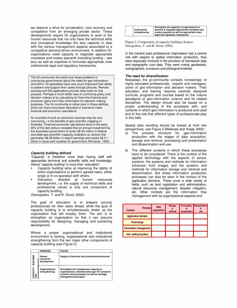
we observe a drive for privatization, cost recovery and competition from an emerging private sector. These developments require GI organizations to avail of the human resources that not only have the technical skills and conceptual knowledge but also capacity to deal with the various management aspects associated to a competitive demand-driven environment. In addition GI-organizations need capacity to negotiate appropriate mandates and modus operandi (including funding – see box) as well as expertise to formulate appropriate (new institutional) legal and regulatory frameworks. The GI-community the world over faces problems in convincing governments about the need for geo-information and GDI’s. GI specialists have very much improved their ability to present and support their cases through pictures. Remote sensing and GIS applications provide ideal tools for that purpose. Perhaps a much better way of convincing policy and decision makers is by calculating for them the financial and economic gains from Geo-information for decision making purposes. The GI-community is rather poor in those abilities, since not many have been educated or trained to make financial and economic calculations. An example of such an economic exercise may be very convincing, i.e the benefits of geo-scientific mapping in Australia. Financial-economic calculations done in the early 90’s of the last century revealed that an annual investment by the Australian government of some A$ 65 million in federal and state geo-scientific mapping underpins an activity that generates A$ 28 billion in export earnings and raises A$ 5.1 billion in taxes and royalties for government (Richards, 1993). Capacity building defined “Capacity” is therefore more than having staff with appropriate technical and scientific skills and knowledge. Hence “capacity building” is more than “education”. � Capacity building aims at improving the ability of
entire organisations to perform agreed tasks, either singly or in co-operation with others.
� Education, directed at human resources development, i.e. the supply of technical skills and professional values is only one component of capacity building
(Georgiadou, Y. and R. Groot, 2002). The goal of education is to prepare (young) professionals for their tasks ahead, while the goal of capacity building is to simultaneously shake up the organisation that will employ them. The aim is to strengthen an organisation so that it can assume responsibility for designing, managing and sustaining development. Where a proper organisational and institutional environment is lacking, organisational and institutional strengthening form the two major other components of capacity building (see Figure 2).
PURPOSE FOCUS Human resources development
Supply of technical and professional personnel
CA
PA
CIT
Y
BU
ILD
ING
FO
R
GE
OIN
FOR
MA
TIC
S
Organisational strengthening
Strengthen the management capacity of organisations; institutionalise geo-ICT solutions (systems and processes) as well as strategic management principles
Institutional strengthening
Strengthen the capacity of organisations to develop & negotiate appropriate mandates and modus operandi as well as appropriate (new) legal and regulatory frameworks
Figure 2. Components of capacity building (Source: Georgiadou, Y. and R. Groot, 2002) In the (recent) past professional mapmakers had a central role with respect to spatial information production, they were especially involved in the provision of framework data and topographic core data. They were mainly geodesists, cartographers, surveyors and photogrammetrists. The need for diversification Nowadays the gi-community consists increasingly of highly educated professionals., experts and managers, users of geo-information and decision makers. Their education and training requires carefully designed curricula, programs and courses based on the mature paradigms of geo-information science and its related disciplines. The design should also be based on a proper understanding of the processes with, and contexts in which geo-information is produced and used and of the role that different types of professionals play in this field. Spatial data handling should be looked at from two perspectives, see Figure 2 (Molenaar and Kraak, 2000) : a) The process structure for geo-information
production with the stages of data acquisition, storage and retrieval, processing and presentation and dissemination and use.
b) The different contexts in which these processes have to be considered. There is the context of the applied technology with the aspects of sensor systems, the systems and methods for information extraction from images and the systems and methods for information storage and retrieval and dissemination. But these information production processes can also be seen in the context of the application domains. These cover a wide variety of fields, such as land registration and administration, natural resources management, disaster mitigation, etc. Other contexts are the information flow management with its organisational aspects and
Dataacquisition
Dissemination&
use
Processing &
presentation
Storage &
retrieval
Inst. setting & policy
Information management
Technology
Application domain
ContextContextProcess

also the institutional and policy issues.
Figure 3 .The different aspects of geo-information handling processes and the perspectives from which these processes can be considered (Molenaar, M and M.J. Kraak, 2000) Experts from one specific disciplinary background can seldom address all aspects involved; therefore Geo-informatics should always be seen in an interdisciplinary setting. The Interaction of Education and Research Finally, the rapid technological developments, as well as developments in demand for information, imply the continuous upgrading of professionals as part of the “lifelong learning” principle observed throughout present-day society. This in turn challenges the education and training institutes themselves to keep up to date with scientific and technological developments while simultaneously dealing with the proliferating variety in demand. This requires a strong interaction between education and research.
ITC’S APPROACH TO CAPACITY BUILDING
Background ITC, the International Institute for Geo-Information Science and Earth Observation and Earth Sciences, was established in 1950 with the primary aim to build capacity in remote sensing techniques and applications for the purpose of economic development of the then still referred to as “developing world”. The main instrument to do so has been mainly by providing mid-career professionals between 30 and 40 years of age with post-graduate education and training (in English) through Academic degree programmes in the Netherlands and abroad, which address the capacity requirements in technical and conceptual skills and land-related applications. Unlike many other universities and educational institutions in the West, which in general have entirely different objectives to provide for the education needs of the developing world and which often purposely results in “brain drain” (Beerens, S. 2004b) ITC explicitly aims at building capacity for the developing countries and therefore engages into agreements with employer organizations for their return and use of the enhanced capacity. Achievements to date have been impressive. Since its founding, over 16,000 mid-career professionals from over 160 countries have graduated from ITC.
Figure 4 Countries of origin ITC alumni 1950-2003 ITC Educational Program Over the years the demand for ITC’s products and services has changed and ITC has changed its capacity building strategy and instruments accordingly. Over the years technician and technologist type of training were replace by advanced levels to include Master of Science Programmes (as from 1967) and PhD level (as from 1990), supported by capacity building through research and advisory services. ITC has accommodated changes in demand among others for the type of training. The ITC educational programmes currently comprise:
• An 18-month Master of Science programme that provides a scientific basis. Graduates are assumed to be able to develop, and assess the performance of new methods and techniques. These new methods and techniques are directed towards improving existing processes and enhancing/expanding applications;
• A 12-month Professional Master programme. Graduates are assumed to be able to operationalise new technologies and methods within their organisations;
• A 9 months Diploma course in Geo-informatics to address the specific needs for operational technologists of GI-organizations;
• A programme of short courses (2005: 35 courses) ranging in duration from 3 weeks to 3 months and based on separate components or modules of the MSc Programme;
• Besides academic degree programmes, ITC also caters for the needs of individual organisations through short tailor-made courses. These are carried out at ITC or on site;
• ITC annually organises refresher courses for alumni, employers and colleagues. These courses deal with new developments in geo-information science and earth observation, take about two weeks and are carried out in the home countries of our alumni in collaboration with local partner organisations.
A major step forward has been the introduction of a modular system, with each stream/specialisation consisting of three-week modules, all starting at the same time. This system includes elective modules, thus allowing course participants to select a subject/topic that best fits their own professional requirements. This modular system also allows participation in individual modules without the obligation to follow the entire course. To address the requirements resulting from technological developments (processes) and the incorporation as well as application of geo-spatial information management principles (context – see Figure 3) education has developed over the years into six separate streams covering a large range of specialisations. At this moment the educational programme at ITC consists of six separate streams: 1. Geo-informatics 2. Geo-Information Management

3. Urban Planning and Land Administration 4. Natural Resources Management 5. Water Resources and Environmental Management 6. Earth Resources and Environmental Geosciences Each of these streams give different levels of emphasis on the aspects of process and context. The Geo-informatics Stream for example concentrates on the technological aspects of spatial data handling. Core
issues are imaging systems and information extraction from images, spatial information systems and information processing and the dissemination and visualisation of spatial information. The technological knowledge and skills are complemented by topics on the management of spatial information in an organisational setting. Figure 4 indicates the emphasis that is given to the aspects and contexts.
Dataacquisition
Dissemination&
use
Processing &
presentation
Storage &
retrieval
Inst. setting & policy
Information management
Technology
Application domain
ContextContextProcess
Primary subject
Secundary subject
Tertiary subject
No subject
Figure 5: Geoinformatics (GFM)This program concentrates on the technological aspects of spatial data handling. Core issues are imaging systems and information extraction from images, spatial information systems and information processing and the dissemination and visualisation of spatial information. The technological knowledge and skills are complemented by topics on the management of spatial information in an organisational setting. The colours indicate for this program what emphasis is given to the aspects and contexts specified in Figure 3.

FROM “BUILDING CAPACITY” TO “BUILDING ON CAPACITY” Changing demand In the past fifty years students from all over the world used to travel to ITC in the Netherlands to stay there for 12 to 18 months to complete their studies. But recently ITC observes observed a growing reluctance of our customers (both organizations and individual course participants) to be away from work and family for such a long time. This has been the reason for ITC, starting some years ago, to embark on an ambitious programme of joint educational programmes with qualified partners across the world. This implies a major shift from “building capacity” to “building on the capacity” that has been built over the past decades. ITC has been transferring educational and training programmes to the developing world for many decades within the framework of institutional development projects (see box). Initially ITC’s efforts were directed at individual candidates (with a number of years of professional experience – so-called mid-career professionals). Efforts then gradually shifted to addressing the manpower requirements of entire professional organisations. It became rapidly clear, however, that the demand in terms of capacity requirements would never be met by limiting capacity building efforts to the Netherlands. Strengthening that capacity building capability in the recipient countries themselves then became a major focus of ITC’s activities. A first initiative in this direction was developed in India where in 1966 the Indian Photointerpretation Institute (IPI) was founded by the Indian Government with support from ITC (d’Audretsch 1973, Sinha 1976). This initiative actually originated from the personal contacts between ITC’s founding father (and former Dutch Prime Minister) Prof. Dr. W. Schermerhorn and India’s former Prime Minister Pt. Jawahar Lal Neru, who during a visit to the Netherlands in 1957 became so impressed with ITC that he decided to start a similar initiative in India. IPI, since renamed as Indian Institute of Remote Sensing (IIRS), is one of the best-known institutes in Asia that caters for the needs of both Indian organisations as well as those of other Asian countries. These efforts, however, were largely project-based, using external funding sources rather than being an integral component of ITC’s programme to fulfil its mission. Through these activities though the quality of educational institutes in different parts of the worlds increased considerably during the last decades. Furthermore there is the observation made in (InterAcademy Council, 2004) that “…that all nations, particularly the developing ones, require an increased level of S(cience) & T(echnology) capacity to enhance their ability to adopt new technologies …. And adapt them to local needs…”. See also (The Taskforce on Higher education and Society, 2000). These joint educational programmes address the increasing demand for flexibility and are reckoned to be more cost efficient and effective. Joint educational programmes within such a network be accredited by the partners responsible for implementation and quality control. These partners are also committed to continuing the collaboration, using their own core funding sources and scholarships/fellowships funded from external sources. Hence the relationship is not
based on temporary project funding and hence is more likely to be sustained. At this moment there are twenty educational partnerships in any stage between identification and operation, of which nine joint programmes operational.
Figure 6. ITC Joint Education Partnerships These joint programmes are not limited to exchanging students, allowing them to do part of their study in their home country and part at ITC in The Netherlands. It also involves the exchange of staff for quality assurance purposes, not only ITC staff visiting partner organisations but also the other way around, with staff of partner organisations to supervise students while studying at ITC. Moreover joint research and advisory services complement the human resources development activities. Modalities of collaboration: Joint educational programmes do not follow one fixed modality. Capabilities of the partners, financial conditions as well as legal aspects may play a role. They may be implemented entirely nationally or partly so with a component at ITC in the Netherlands. Quality assurance of joint educational programmes An international education network has the potential to improve the effectiveness, flexibility and productivity of the ITC educational system, (ITC, 2001). The real challenge in joint educational programmes appears to be quality assurance. Both partners have to apply quality standards to fulfil accreditation requirements applicable to each of them separately as well as jointly in each country. Although in the early stages of joint educational programmes, ITC criteria were considered as point of departure, it became quickly clear that partner organisations are bound by official regulations as well. Quality assurance of joint educational programmes is pursued in three ways: � Organisation of the collaboration: directed at
creating equal quality of the programmes offered by the partners:
� Management of the collaboration: directed at ensuring efficient and effective quality control; and
� Quality assurance instruments: both during the preparation, implementation and consolidation phase.
(Beerens, S. and I. ten Dam, 2002)
Sustainable partnerships Whatever attempts are made to strengthen local capacity building institutions, proper attention is paid to the sustainability of such initiatives. For this purpose a distinction is made between academic, institutional and financial sustainability: � The “academic sustainability” of a capacity building
programme refers to its capability to continuously upgrade its contents in correspondence with the requirements as defined by developments in the environment and society at large. This generally requires such a capacity building programme to be embedded in a research environment.
� With “institutional sustainability” is meant the institutional or legal environment in which the capacity building activities take place, or in other words the official mandate and legal position of the organisation concerned. This calls for such efforts to be undertaken by organisations firmly embedded in existing frameworks of higher education rather than project-approaches to capacity building involving new and/or temporary institutional frameworks.
� “Financial sustainability” generally refers to financial aspects. In other words, it deals with the question whether there will be financial resources to continue the capacity building efforts in future.
This requires an approach that integrates enhancing capacity of such institutions through joint research, education and training, as well as advisory services within the framework of a proper business strategy (Beerens, S.2004a) The role of ITC The previous observations do not imply that all educational activities of ITC are partly or entire “off-shore-oriented”. There are several reasons for doing so (Beerens, 2001): � Joint educational programmes cannot serve all
regions in which ITC is active; there will always be countries or organisations that prefer to send their staff to ITC rather than to another institute in our network. Furthermore, international exposure, and certainly exposure to the Western professional and scientific environment, will remain an important aspect of the education of high-level staff in many organisations.
� Educational programmes at ITC provide the experience ITC needs for its role in an educational network, including aspects of quality assurance.
� The programmes run at ITC serve as a vehicle for permanent educational innovation. This innovation relates to content, educational methods and tools.
From bilateral to multilateral relationships: GI-NET Up till now, ITC’s joint educational programmes were based on bilateral relations between ITC and individual partners. In a workshop organised at ITC in December 2003, attended by 27 representatives of 17 partner institutes on joint educational programmes, it was concluded that partnerships should be transferred from dependent bilateral relationships, where ITC acted as provider and engine, to bilateral equi-partnerships, where knowledge and experience are exchanged between partners through education, research and
advisory services and finally to multilateral equi-partnerships. The aim of the workshop was to find common ground for developing an international network of university-level human resources development programmes on geo-information science and earth observation in which partners each contribute from their own strength. The position of ITC in this network, although initially a central node in the network will gradually change to a node of equal importance compared to other partners. Eventually at this workshop, common ground was found and a name for the network accepted, i.e. called GI-NET, Geo-Information network for Education and Training (ITC, 2004). And it is exactly the possibility of multilateral relationships that provides opportunities for countries across the world to benefit from the expertise available elsewhere such as in India and China. CONCLUSIONS Developments in the GI Sector across the world have far-reaching implications for the professional GI-organisations operating in that sector. In terms of capacity and capability requirements these developments imply that GI organisations not only require technically and scientifically skilled and knowledgeable personnel but also capability to formulate business strategies and manage complex processes and GEO-ICT infrastructures. This in turn sets requirements on the design of capacity building programmes which comprise human resources development, organisational strengthening and institutional strengthening − of which education is part and parcel. We have seen that we should think in this context of coherent families of programs that cover the different aspects of the field; these programs should deal with the technology of the provision of spatial information, the institutional and information management aspects as well as the application issues of spatial information. The development of international educational networks facilitates the exchange of expertise available in the different regions of the world. Furthermore with these networks it will be easier for students from different countries or regions to have access to this expertise through a harmonised set of educational programs.

REFERENCES d’Audretsch, F.C. 1973, The establishment of the Indian
Photo-interpretation Institute at Dehra Dun 1965-1973. ITC Journal, 1973-4, pp. 678-726.
Beerens, S.J.J. 2001: “Capacity Building For Geo-Spatial
Information Handling in Africa,The ITC Perspective”. International Institute for Geo-Information Science and Earth Observation (ITC) ,Enschede, 2001, Paper presented at USA National Academy of Sciences Workshop, Washington, January 2001, 19 pp.
Beerens, S. & I. ten Dam, 2002: “Globalisation of International Education – ITC’s Challenge to Maintain Quality” Paper presented at Asian Conference on Remote Sensing, Kathmandu, Nepal, 2002 6 pp
Beerens, S.J.J 2004a: “From Building Capacity” to Building on Capacity” – Towards an international network for capacity building in geo-information and earth observation”, Paper presented at ISPRS Congress XX, Istanbul, Turkey, July 2004, 6 pp.
Beerens, S.J.J. 2004b: “Building capacity in geo-information handling for sustainable development in Africa”, Keynote address, African Association for Remote Sensing for the Environment, Nairobi, Kenya, October 2004, 10 pp.
Dale P. 2001: “Are National Mapping Agencies an Anachronism?”, Surveying World, 2001, pp28-29.
Ezigbalike, C. 2001: “The future orientation of geoinformation activities in Africa”. Commisioned by Committee on Development Information (Geo-Information Subcommittee) Development Information Services Division (DISD) United Nations Economic Commission for Africa. 37 pp.
Georgiadou, Y. and. R. Groot, 2002: "Beyond Education:
Capacity Building in Geoinformatics", GIM International, February 2002, Volume 16, pp. 40-43
ITC, 2001: “Strategic plan 2001-2004”. International Institute for Geo-information Science and Earth Observation (ITC), Enschede, 2001, 42 pp.
ITC, 2004: “Building a geo-information community for sustainable development: from bilateral to multilateral partnerships. ITC News, 2003 – 4, pp 6-8.
InterAcademy Council, 2004: “Inventing a better future: A strategy for building worldwide capacities in science and technology”. www.interacademycouncil.net, 2004, 144 pp.
Lawrence, V. 2001: “The e-volution of Ordnance Survey gathers Pace”. Geo-Informatics, 2001, pp34-36
Molenaar, M. and M. J. Kraak, 2000: Geoinformatica in de
ITC Context. Workshop on Education. Netherlands Commission for Geodesy. Delft, 2000, 10pp.
Molenaar, M. 2004: “Capacity building for Geoinformatics. An ITC Perspective”, Invited paper ISPRS Congress XX, Istanbul, Turkey, July 2004, 10pp
Richards, S.M. 1993, Review of Australian Geological Survey Organisation, Canberra, 127 pp.
Sinha, Col. J.N. 1976, The Indian Photo-interpretation Institute, Dehra Dun, India. ITC Journal 1976-4, pp. 713-721
The Taskforce on Higher education and Society, 2000:
Higher education in Developing Countries:peril and Promise. World Bank and UNESCO, ([email protected]), 135 pp.