Embed Size (px)
Citation preview

THE LAND BEFORE SYMBOL STONES | 125Proc Soc Antiq Scot 145 (2015), 125–151
The land before symbol stones: a geophysical survey of Rhynie, Aberdeenshire, and the excavation of a Middle Bronze Age structure near the Craw Stane, Barflat
Meggen Gondek* and Gordon Noble† with contributions from Susan Ramsay and Alison Sheridan
ABSTRACT
This article outlines the results of two related but distinct aspects of fieldwork: a geophysical survey of the Rhynie cropmark complex and a small targeted excavation conducted in 2005–6, which are both part of the Rhynie Environs Archaeological Project (REAP). The geophysical surveys included a substantial gradiometer and a smaller resistivity survey that aimed to characterise and explore the extent and survival of archaeology around the Craw Stane Pictish symbol stone (NJ42NE 35) and two other symbol stone findspots. The results showed several discrete anomalies; one of these was targeted by a small-scale excavation and proved to be a burnt Middle Bronze Age timber structure. This article describes the geophysical survey results and the excavation of the MBA structure and sets both within their landscape context.
* Department of History and Archaeology, University of Chester, Parkgate Road, Chester CH1 4BJ† School of Geosciences, University of Aberdeen, St Mary’s, Elphinstone Road, Aberdeen AB24 3UF
INTRODUCTION
The Rhynie Environs Archaeological Project (REAP) was initially started in 2005 as a three-year programme of research and fieldwork based in and around the village of Rhynie, Aberdeenshire; the main aim was to study the landscape context of an important group of Pictish symbol stones. Rhynie is the location of a distinct and unusual concentration of Class I symbol stones, which date from around the 5th to 7th centuries ad (Fraser 2008: 38–40). Eight symbol stones are known from the village, including one – the Craw Stane – which, although reset, is likely to be in its original position (NJ42NE 35; NJ 49749 26345; Fraser & Halliday 2007: 118). A series of cropmark features were identified by Aberdeenshire Archaeology Services surrounding the Craw Stane (Grieg & Shepherd 1979; Halliday 2007: 100; Gondek
& Noble 2010). The work was undertaken in 2005–6 as Phase One of the Rhynie Environs Archaeological Project, directed by Gordon Noble and Meggen Gondek.
Remarkably little modern invasive work or even non-invasive survey has specifically targeted the archaeological context of symbol stones, despite the attention they receive in art historical studies and as social and ideological markers of the early medieval period (Henderson & Henderson 2004: 167–74; cf Clarke 2007). Those found in recent archaeological investigations have largely come from investigations of settlement sites, where Class I stones are either built into, or possibly re-used in, structures such as at Pool, Sanday (Orkney), and at Old Scatness (Shetland) (Hunter 2007; Dockrill et al 2010). The symbol-carved bedrock outcrops at Dunadd (Argyll and Bute) and Trusty’s Hill (Dumfries and Galloway) are from fortified settlement sites,

126 | SOCIETY OF ANTIQUARIES OF SCOTLAND, 2015
which may also be the context of some of the Rhynie monuments (Lane & Campbell 2000; Toolis & Bowles 2013; Noble et al 2013). Class I stones also occur in association with burial cairns, such as at Ackergill, Dunrobin and Garbeg (all now Highland Council) (Ashmore 1980; Close-Brooks 1980; Ritchie 2011: 133–4). However, they also seem to have been used for other purposes, including cist covers (for example, at Inchyra (Perthshire)) and as landscape markers (Driscoll 2000: 249; Clarke 2007: 21–2).
Non-invasive, sometimes followed by invasive, work has been conducted at a handful of findspots of potentially in situ symbol stones
Illus 1 Aerial photograph showing the Craw Stane cropmark complex and location map of Rhynie (© Aberdeen Archaeology Service and Base map: Crown Copyright/database right 2013. An Ordnance Survey/EDINA supplied service)
(Classes I and II) sites. Excavations in the near vicinity of the symbol stone at Blackford Farm (Perthshire) in 2011 revealed Iron Age souterrains and early medieval cist graves, in addition to later activity (Dingwall 2011). Survey and excavation at Tillytarmont (Aberdeenshire) in the 1970s found stone platforms or cairns where five symbol stones have been recovered from the 19th century onwards (Woodham 1975). Geophysical survey around the Class II St Orland’s Stone (Angus) also suggested features of uncertain date or function where keyhole evaluation had previously identified potential survival of early medieval deposits (Murray 2008;

THE LAND BEFORE SYMBOL STONES | 127
O’Grady 2009). Keyhole excavations at both Sueno’s Stone (Moray) and the site of the Hilton of Cadboll stone (Highland) also highlighted how complex the archaeology around sculpture settings could be (McCullagh 1995; James 2008). On balance, these non-invasive surveys and limited excavations have shown potential, but have not been able to provide definitive contexts for the early medieval use and landscape of the carved stones.
The REAP project was established to instigate an archaeological approach to Pictish symbol stones that aimed to address the (long-term) landscape context of these iconic monuments at
a place where a number of symbol stones have been recovered. The overall aims of the project include promoting landscape and contextualised approaches to early medieval archaeology, interpreting the long-term evolution of the Rhynie area, and investigating the nature and date of the considerable cropmark evidence around the village. Fieldwork and excavation in 2005 began to uncover the context of the stones at Rhynie, and showed that these were part of a landscape populated with significant prehistoric remains as well as contemporary activity. More recent work by the REAP project (Phase Two) has revealed that the Craw Stane itself stood
Illus 2 Prehistoric activity in the Rhynie landscape. (Collated from records in the RCAHMS Canmore database. Base map: Crown Copyright/database right 2013. An Ordnance Survey/EDINA supplied service)

128 | SOCIETY OF ANTIQUARIES OF SCOTLAND, 2015
within a probably contemporary high status fortified settlement of the 5th to 6th century ad (Noble & Gondek 2011; Noble et al 2013). The following report outlines the results of the initial geophysical survey around the Craw Stane and examines the archaeological remains within the study area, focusing in particular on the prehistoric landscape to contextualise the report of the 2005 excavation of the Middle Bronze Age structure that follows.
THE RHYNIE LANDSCAPE
Extensive archaeological surveys of the area can be found in the RCAHMS chronological volume on Donside (2007), which highlights the depth of human activity in this region. This section will outline the known prehistoric to early medieval activity in the area, setting the symbol stones, the geophysical survey and the excavated Bronze Age structure into context. The following discussion focuses on a study area of 6.5km2, centred on The Craw Stane, roughly defined at its outer limits by the locations of hillforts: Tap o’Noth (NJ42NE 1; NJ 4845 2930), Cairnmore (NJ52SW 9; NJ 5035 2494) and Wheedlemont (NJ42NE 5; NJ 4729 2605) around the Water of Bogie.
A number of Neolithic, Chalcolithic and Bronze Age monuments occur in the immediate
Table 1Summary of general categories of site based on RCAHMS classifications and used in illus 2
General category Monument types
Ceremonial Standing stones, stone circles, recumbent stone circles
Findspot Any unallocated or generalised find(s) not associated with another site (such as ploughed-up carved stone balls or axeheads, stray metal finds, etc)
Funerary Recorded cairns (not clearance or field system), finds of urns or Beakers, recorded cist burials
Hoard Recorded hoards, any type
Rock-art Any cup – or cup and ring-marked monument (not part of standing stone or stone circle)
Settlement Hut circles or platforms, ring-ditch cropmarks, field systems, enclosure cropmarks of indeterminate date, possible activity on Tap o’Noth
environs of Rhynie. For ease of display these are grouped into general categories in illus 2 (and see Table 1).
The sites concentrate to the west of Rhynie nestled around a network of small burns between the hills of Tap O’Noth to the north and Wheedlemont the south, where several cup-marked stones and cairns have been located. This area forms a notable cluster of rock-art in Donside (Gannon et al 2007: 73; George Currie pers comm). A hoard of eight Bronze Age flat axeheads is recorded as coming from the base of Finglenny Hill to the northwest of Tap O’Noth, overlooked by the henge monument of probable Late Bronze Age date at Wormy Hillock (Coles 1969: 102; Cowie 2004: 258; Gannon et al 2007: 57, 76; Bradley 2011: 160–2). As is common for Donside, evidence for early settlement is relatively sparse. The evidence includes hut circle remains in upland areas, sometimes with accompanying field systems and cropmarks of ring-ditches; without excavation it is impossible to be certain these represent prehistoric settlement, but generally these structures are categorised as Bronze–Iron Age settlement features (Halliday 2007: 82–109). These features often occur as small unenclosed groups with ploughed-out ring-ditches occurring in the valleys and hut circle/platform remains surviving on the higher ground. Some ring-ditch cropmarks may represent ploughed-out barrows or cairns. Generally,

THE LAND BEFORE SYMBOL STONES | 129
these structures are between 7–11m in diameter and ring-ditches vary greatly in surviving depth (Halliday 2007: 82–3). In the immediate Rhynie area none of the hut circles, possible hut circles or ring-ditches has been excavated. Like the Rhynie example discussed below, other hut circles and ring-ditches nearby have been found on slightly elevated ground, often on slopes as is the case with the Lochrie hut circle/ring-ditch cropmarks to the north, on the slopes of Tap O’Noth, and the possible Stonedike hut circles to the south-east in the Correen Hills (Ralston 1989).
Immediately around Rhynie, other prehistoric remains are well represented. When Rhynie symbol stones nos 2 and 3 were found during
Illus 3 Iron Age to early medieval activity in the Rhynie landscape. (Collated from records in the RCAHMS Canmore database. Base map: Crown Copyright/database right 2013. An Ordnance Survey/EDINA supplied service)
road building, they were found in association with two apparently uncarved monoliths, which may be prehistoric standing stones (Fraser & Halliday 2007: 123). Amongst the symbol stones from Rhynie are two possible re-used prehistoric standing stones. Rhynie no 5 has cupmarks on its non-symbol face; as it was found in the foundations of the church, its original location cannot be mapped. The Craw Stane has no prehistoric carvings, but its general shape and large size has encouraged the (perhaps unprovable) assumption that this is a potential re-used prehistoric standing stone (Clarke 2007: 39). The REAP Phase Two excavations examining the cropmark complex around the

130 | SOCIETY OF ANTIQUARIES OF SCOTLAND, 2015
Craw Stane have not found any evidence of Neolithic or Bronze Age activity, apart from a redeposited Bronze Age faience bead in an upper fill of the inner ditch of the 5th–6th century ad complex (Gondek & Noble 2012). However, in 2005, an eroding cattle scrape to the north of the Craw Stane produced several sherds of an All Over Cord-decorated Beaker, which may indicate a grave in the vicinity (Cook 2005). In addition, there is a suspected Bronze Age cairn, the Bell Knowe, which stands about 200m to the north of the Craw Stane. The Bell Knowe is an unexcavated cairn that survives to 1.7m in height and extends to 19m in diameter, which was re-used in the medieval period as the base for a wooden support that held the church bell (Eeles & Clouston 1958: 102; Fraser & Halliday 2007: 121).
Iron Age remains in the study area are most spectacularly represented by the Tap O’Noth hillfort. The fort dominates the skyline and is a vitrified oblong type. Recent dating at Dunnideer, also in Aberdeenshire, suggests that this type of fort dates to the Middle Iron Age (c 500–200 bc); however, there is no Iron Age radiocarbon date, yet, from Tap O’Noth itself (RCAHMS 2007: 96–100, 101–5; Cook 2010: 87; Cook 2013: 335, 338). Tap O’Noth is the second highest hillfort in Scotland and occupies an imposing position. It has two main enclosures: the inner vitrified stone wall and an outer stone rampart set much further down the slope. The inner ramparts enclose an area approximately 85m × 30m and have no break for an entrance. Within the interior there is a possible well or cistern and foundations of a substantial roundhouse that may predate the ramparts (Halliday 2007: 103–5). The outer rampart now has many gaps, but it is has been heavily robbed; between the two enclosures are a number of possible trackways and house platforms (Halliday 2007: 105).
Building on the survey and classification work of the RCHAMS, the Hillforts of Strathdon Project (Cook 2011) targeted six smaller hillforts in the region, with the objective of exploring the relationships between – and sequences of – activity on unenclosed and enclosed later Iron Age–early medieval settlement. Within the Rhynie environs, Cook investigated the hillfort
at Cairnmore, a double-banked sub-oval fort. The inner rampart at Cairnmore consists of a thick stone wall enclosing a small area (64m × 48m) and the outer external ditch and rampart are found only on the south-east side of the fort, by the inner entrance (Cook 2011: 216–17; Halliday 2007: 101). Cook’s keyhole excavation of the fort’s ramparts produced a radiocarbon date suggesting the fort was active ad 410–630 (Cook 2011: 216–17). Evidence of non-ferrous metalworking was also found, including pin and brooch moulds, and this activity is often associated with sites of relatively high status. The date of Cairnmore corresponds to the floruit of the Rhynie Craw Stane fortified enclosure complex, excavated as part of REAP Phase Two, which also produced a series of radiocarbon dates focused on the 5th–6th centuries ad (Noble et al 2013). The enclosure at Wheedlement (Cnoc Cailliche) has not been subject to excavation, but may include both Iron Age and early medieval phases: morphologically the fort is similar to that at Cairnmore and the Craw Stane, but a fragment of putative Iron Age pottery has also been recorded from the site (PSAS 1974; Halliday 2007: 99–100).
Only one unenclosed settlement dated to the Iron Age has been investigated in the study area and this was found during evaluation of the Craw Stane complex. This consisted of a very truncated ring-ditch roundhouse measuring about 8m in diameter and dated to the 4th–3rd century bc (Gondek & Noble 2011). Some of the hut circles and ring-ditch cropmarks mentioned above may of course represent Iron Age structures in the study area (illus 2). Iron Age settlement is also represented within this area by the record of a souterrain, infilled before the 20th century, at Corsehill, but its exact location is unknown (Simpson 1932: 86). A number of other souterrains referenced in antiquarian accounts or recorded as cropmarks are found to the west and south of the study area, particularly to the south at Kildrummy (Halliday 2007: 88–9). A few cropmark sites of enclosures may also indicate Iron Age/early medieval settlement, but without excavation their function and date cannot be certain. One possible enclosed settlement site is an arc of substantial ditch on a hill near

THE LAND BEFORE SYMBOL STONES | 131
Castlehill, which suggests an oval enclosure (c 35–40m diameter) with possible interior pits or other features (Halliday 2007: 94; Greig 1995: 33). The other cropmark sites are close to Rhynie village, but are less suggestive of settlement. To the southwest of the village, Greig identified two oval/circular enclosures with possible internal features (Greig 1995: 32). Immediately south of the village, near the modern medical centre, are cropmarks of two large square enclosures. On morphological grounds, the best parallel for these features is a square enclosure excavated
Illus 4 Iron Age to early medieval activity centred on the symbol stone distribution. (Collated from records in the RCAHMS Canmore database. Base map: Crown Copyright/database right 2013. An Ordnance Survey/EDINA supplied service)
at Forteviot, Perthshire, which has been likened in form and character to later Iron Age ritual enclosures (Campbell & Gondek 2009). However, evaluative excavation of this area by REAP in 2013 identified a series of ring-ditch structures in this area as well as two square barrow burials, one with a cist grave. The chronological relationship between the ring-ditches, large square enclosures and the cemetery currently remains undefined (Gondek et al 2013).
By far the most elaborate early medieval settlement known from the region is the

132 | SOCIETY OF ANTIQUARIES OF SCOTLAND, 2015
complex around the Craw Stane, which is being investigated as part of REAP’s Phase Two (Noble et al 2013). Cropmarks (illus 1) indicated at least two concentric ditched enclosures, with the inner ditch encircling an area 32m × 20m, the outer c 50m in diameter, and an outer palisaded enclosure around 60m across (Shepherd 1979; Greig 1995; Halliday 2007: 100). The Craw Stane appears to stand at the entrance, on the east side, to the inner ditched enclosure. Outside the enclosure, a number of dark indistinct cropmarks to the north suggested activity, but were difficult to interpret.
Prior to excavation, the enclosure complex was considered unusual and traces of internal features such as pits or postholes suggested a complicated and multi-phase settlement (Halliday 2007: 122). Excavation in 2011 confirmed an early medieval date for the double-ditched enclosure and outer palisade, with an interior containing at least one timber hall structure; these have been discussed elsewhere in more detail (Noble & Gondek 2011; Noble et al 2013: 1145). The site has produced remarkable finds, such as the most northerly examples of Late Roman imported amphorae sherds (LRA1 and 2), as well as imported glass and substantial metalworking debris alongside pins and beads; these indicate a very high status, possibly royal, centre at Rhynie. The most likely interpretation of the placename ‘Rhynie’ is ‘a very royal place’, which further supports the identification of Rhynie as a key early medieval landscape of the northern Picts (Noble et al 2013).
Until the REAP excavations, the group of Class I symbol stones were the only definitive evidence of Pictish activity in the area. The motifs on this group of stones include abstract symbols such as the crescent and V-rod, and pictorial symbols such as the mirror and comb and the salmon on the Craw Stane. They also bear a preponderance of watery symbols, including three Pictish beasts and one animal head which appears to have flippers (Rhynie no 5). Two of the stones are unusually carved with lone armed men. The Rhynie Man, found near the Craw Stane, is particularly spectacular; it depicts an axe-hammer carrying, balding, bearded man wearing a tunic. The other figural stone (no 2) is
quite different; even though the stone is worn, the warrior here appears to carry a spear/shaft and shield. The stones’ distribution follows a rough linear north/south spread, beginning around the location of the Craw Stane and ending near the centre of the modern village. Rhynie nos 2 and 3 were removed during the construction of the turnpike road in the 1830s, and during their removal human remains were found (Allen & Anderson 1903, reprinted 1993: 182). The potential contemporaneity of these burials with the stones has recently been bolstered by the 2013 REAP excavations nearby, which uncovered two square barrows.
The parish, now Rhynie, was previously known as Kilrynie (Scott 1926: 329–30); the ‘kil’ name possibly indicates an early church, but evidence for early Christian activity is scarce. To date, no early medieval Christian carved stones have been found at Rhynie. The old parish church, St Luag’s, downslope from the Craw Stane complex, has a dedication suggestive of an early date and a probable 12th–13th century monolithic sarcophagus indicates an earlier establishment here (Macdonald & Laing 1970: 142; Dixon & Fraser 2007: 170). Luag (Lugaidh) is probably a version of the name Moluag. St Moluag founded the monastery at Lismore in Argyll, and his death is recorded in the Annals of Ulster in ad 592; there are a scattering of places dedicated to him in the region (AU 592.1, Mac Airt & Mac Niocaill 1983: 97; Dransart 2003). His name is also associated with a large natural boulder on the slopes of Tap O’Noth (Clochmaloo) (Macdonald & Laing 1970: 142; Simpson 1932: 86).
GEOPHYSICAL SURVEY OF THE CROPMARK COMPLEX
The initial stages of REAP involved a programme of geophysical survey, which was designed to help us understand the unusual enclosure complex visible in aerial photographs, discussed above, and the immediate landscape around the Craw Stane, potentially to provide a context for the erection and use of the stones here. A gradiometer survey, using a Bartington magnetic

THE LAND BEFORE SYMBOL STONES | 133
Illus 5 Geophysical survey results of the Craw Stane complex and location of 2005 excavation. A: Gradiometry. B: Resistivity. (Base map: Crown Copyright/database right 2013. An Ordnance Survey/EDINA supplied service)
gradiometer 601–2, and directed by Sam Roberts (then of Archaeology Services Durham University) covered an area almost 0.03km2, with readings taken at 0.5m × 0.25m intervals. The survey showed the three enclosures around the
Craw Stane, confirming the ditched nature of the inner enclosures. The entire complex encloses an area of around 60m × 50m (illus 5a). The ditched enclosures have entrances to the east, by the Craw Stane, which was confirmed by the

134 | SOCIETY OF ANTIQUARIES OF SCOTLAND, 2015
2012 excavations, although the outer enclosure ditch has different entrances in different phases. There were also indications in the survey of features inside the enclosure that were thought to represent buildings, pits and postholes (illus 5b). Excavations within the heart of the complex in 2011 and 2012 showed that there was indeed a series of structures, including an Iron Age ring-ditch and early medieval timber buildings, within the enclosure (illus 6; Noble & Gondek 2011).
The surveys also identified a number of potential sites to the north outwith the Craw Stane enclosure complex. Most apparent were two large sub-circular anomalies detected by magnetometry, some 60m to the north and 90m to the north-east of the Craw Stane, in areas where the cropmark evidence was diffuse (illus 5a). These anomalies produced very high magnetic readings. Targeted excavation in 2005 identified one of these anomalies as a Middle Bronze Age ring-ditch roundhouse (see below).
Overall, the plotting of NMRS records, the cropmark record and the geophysical surveys in the Rhynie environs indicate a very rich
Illus 6 Rhynie enclosure complex under excavation in 2012 indicating the key enclosures and internal features (© REAP)
landscape of settlement and monuments in the study area with potential for good preservation. The cropmarks and upstanding remains recorded in the NMRS and SMR represents only the tip of the iceberg, with further settlement remains now identified through geophysical survey. Key to understanding the development of the possible ‘royal’ site at Rhynie will be comprehending the development of the prehistoric landscape and using both invasive and non-invasive survey techniques to flesh-out the long-term history of this landscape.
THE EXCAVATION OF A MIDDLE BRONZE AGE RING-DITCH AT RHYNIE
As part of REAP Phase One, and to ground-truth the character of the geophysical anomalies, one strong anomaly was targeted for evaluative excavation. A 5m × 11m trench was situated over a large (c 8m diameter), circular, strongly magnetic anomaly to the north of the Craw Stane (illus 7). Topsoil was stripped under supervision

THE LAND BEFORE SYMBOL STONES | 135
Illus 7 Trench plan
by machine and the remaining overburden (hill wash) was removed by hand. The depth of hill wash differed across the trench, which was situated on sloping ground. A number of features were encountered upon cleaning back the topsoil, including a wide arc of burnt material representing a ring-ditch building C014, an inner arc of burnt material C035, two possible post-holes C032 and C037 within the interior, a shallow ditch C010 and two spreads of clay material C011 and C013 outside the building. None of the dug features intercut and thus no vertical stratigraphy survived; pottery and radiocarbon dates suggest that all the features are roughly contemporary. The edges of all features were considerably disturbed by animal burrowing, often blurring distinctive deposits. A short excavation season and unsettled weather also meant that not all features could be excavated fully, and lower deposits of the re-deposited sand in the ring-ditch had to be left unexplored.
LINEAR DITCH AND SPREADS
A linear ditch C009 was found in the western area of the trench, to the west of the ring-ditch building. The ditch was a north/south aligned shallow cut C009; at its maximum it was c 0.5m wide and c 0.2m deep, with a shallow bowl-shaped profile. It was filled with a loose mid-
brown silty sand with some fist-sized cobble inclusions C010 and charcoal. The fill C010 contained several sherds of prehistoric pottery (SF 5, 10, 11, 14, 37 and 38) representing six different vessels. The function of the ditch is not clear. It may have served as a soakaway or drain for the ring-ditch building, or defining a garden plot or enclosure near the house. Soil samples from the ditch suggested dumps of hearth waste (see Ramsay below). Three sherds of pottery (SF12 and SF13), representing two different vessels, were found in a shallow deposit C013 cut by the linear ditch C009.
THE RING-DITCH AND INTERIOR FEATURES
A mixed and disturbed shallow soil layer C002 overlay a black and reddish sand deposit C014, full of charcoal, that represented the upper fill of the circular foundation cut for the ring-ditch building. The cut formed an arc approximately 3.0–3.5m wide, covering a large portion of the cleaned area of the trench (illus 7). From the geophysical survey, the ring-ditch has a diameter of approximately 8.0m externally, and is open towards the south-east. The interior revealed few, very truncated, features, including a pit or posthole C032, approximately 0.3m in diameter and only 0.12m deep, filled with a charcoal-rich sandy fill C033,

136 | SOCIETY OF ANTIQUARIES OF SCOTLAND, 2015
and another possible posthole C037 about 1.0m to the south-west, which was not excavated. A curving arc of burnt material approximately 0.5m wide C034 was revealed in the south-east corner of the trench; its charcoal-rich sandy fill C035 was very similar to the upper fill of the ring-ditch C014.
Three sondages were dug across the ring-ditch, with a fourth only partially excavated (Sondage 2, not illustrated). The main evaluation of the ring-ditch C036 was in Sondages 1 and 4, located across the area of the most concentrated burning C014, which included large charred timbers C015. The fill of the ring-ditch included an upper mixed layer with a more densely packed, charcoal-rich fill below. The ring-ditch in this area reached a maximum depth of 0.4m and a width of 3.3m. The lowest fill C038 was a yellow re-deposited sand largely devoid of burnt material. The lower fill C039 consisted of mottled silty sand, varying between a discoloured yellow with small amounts of charcoal to mid-brown patches with larger pieces of charcoal to charcoal-rich areas of almost pure blue/black silty sand. C039 contained several lenses of sand and mixed deposits, suggesting the re-deposited destruction deposits of a burnt timber (and presumably turf)
Illus 8 Section of ring-ditch fill showing charcoal-rich fills and prehistoric pottery
building. The upper ring-ditch fills included large charred timbers, possibly part of the walls or roof supports of the building. One of these charred timbers C015 was a solid oak timber that had been completely carbonised (see below).
The profile of the ring-ditch suggested it had been constructed with revetted edges with the central hollow becoming filled with burnt material upon the destruction of the building. Sondage 3, for example, had concentric interior/exterior slots within the ring-ditch – perhaps a foundation for a timber revetment (illus 9). The fill of the ring-ditch became darker and included more charcoal and organic material towards the exterior edge, indicating that the focus of the burning was around the external wall. Sondage 2 was not fully excavated, but included spreads of flat slabs, which may originally have been part of cobbling or paving within the ring-ditch house. The profile of each sondage was heavily affected by animal burrowing.
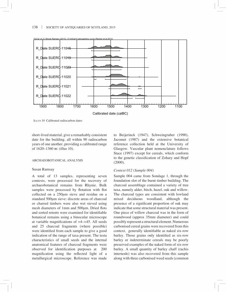
RADIOCARBON DATING
Five dates were obtained directly from the burnt deposits and a sixth from the linear ditch [009] (Table 2). The six radiocarbon dates, all from

THE LAND BEFORE SYMBOL STONES | 137
Tabl
e 2
Rad
ioca
rbon
dat
es f
rom
the
ring
-ditc
h. D
ates
cal
ibra
ted
with
OxC
al v
4.2.
3 B
ronk
Ram
sey
(201
3)
Sa
mpl
e M
ater
ial
Con
text
U
ncal
C
alib
rate
d 1
sigm
a C
alib
rate
d 2
sigm
a D
elta
-13C
%
SU
ER
C-1
1015
C
harc
oal:
Aln
us
039
3250
± 3
5 16
15–1
445
cal b
c 16
10–1
460
cal b
c –2
6.5
SU
ER
C-1
1019
C
harc
oal:
Prun
oide
ae
039
3245
± 3
5 16
15–1
445
cal b
c 16
10–1
450
cal b
c –2
7.0
SU
ER
C-1
1023
C
harc
oal:
Aln
us
010
3240
± 3
5 16
15–1
435
cal b
c 16
00–1
450
cal b
c –2
5.6
SU
ER
C-1
1020
C
harr
ed G
rain
: Hor
deum
vul
gare
var
nud
um
039
3200
± 3
5 16
00–1
405
cal b
c 15
00–1
435
cal b
c –2
3.6
SU
ER
C-1
1021
C
harc
oal:
Aln
us
039
3170
± 3
5 15
15–1
320
cal b
c 15
00–1
415
cal b
c –2
6.9
SU
ER
C-1
1022
C
harr
ed G
rain
: Hor
deum
vul
gare
var
nud
um
014
3140
± 3
5 15
00–1
300
cal b
c 14
90–1
320
cal b
c –2
5.0
Illu
s 9
Sect
ions
thro
ugh
the
ring
-ditc
h
138 | SOCIETY OF ANTIQUARIES OF SCOTLAND, 2015
short-lived material, give a remarkably consistent date for the building, all within 90 radiocarbon years of one another, providing a calibrated range of 1620–1360 bc (illus 10).
ARCHAEOBOTANICAL ANALYSIS
Susan Ramsay
A total of 13 samples, representing seven contexts, were processed for the recovery of archaeobotanical remains from Rhynie. Bulk samples were processed by flotation with flot collected on a 250µm sieve and residue on a standard 500µm sieve; discrete areas of charcoal or charred timbers were also wet sieved using mesh diameters of 1mm and 500µm. Dried flots and sorted retents were examined for identifiable botanical remains using a binocular microscope at variable magnifications of ×4–×45. All seeds and 25 charcoal fragments (where possible) were identified from each sample to give a good indication of the range of taxa present. The testa characteristics of small seeds and the internal anatomical features of charcoal fragments were observed for identification purposes at ×200 magnification using the reflected light of a metallurgical microscope. Reference was made
Illus 10 Calibrated radiocarbon dates
to Beijerinck (1947), Schweingruber (1990), Jacomet (1987) and the extensive botanical reference collection held at the University of Glasgow. Vascular plant nomenclature follows Stace (1997) except for cereals, which conform to the genetic classification of Zohary and Hopf (2000).
Context 012 (Sample 004)
Sample 004 came from Sondage 1, through the foundation slot of the burnt timber building. The charcoal assemblage contained a variety of tree taxa, namely alder, birch, hazel, oak and willow. The charcoal types are consistent with lowland mixed deciduous woodland, although the presence of a significant proportion of oak may indicate that some structural material was present. One piece of willow charcoal was in the form of roundwood (approx 35mm diameter) and could possibly represent a structural element. Numerous carbonised cereal grains were recovered from this context, generally identifiable as naked six-row barley. Those grains only identified as six-row barley or indeterminate cereals may be poorly preserved examples of the naked form of six-row barley. A small quantity of barley chaff (rachis internode) was also recovered from this sample along with three carbonised weed seeds (common
THE LAND BEFORE SYMBOL STONES | 139
hemp-nettle and club rush). However, this is not enough material to suggest that cereal processing waste was present in this sample. Three grains of emmer wheat were also identified, although it is impossible to say whether they represent grain from a separate crop to the barley or whether the wheat may have been grown as a mixed crop or simply occurred as weeds within the barley crop.
Context 014 (Samples 006 and 007)
Context 014 represented the upper fill of the ring-ditch in Sondage 1. Context 014 contained a range of charcoal types, including alder, birch, hazel, oak and willow. This assemblage is similar to that seen from sample 004 and may suggest that they contain carbonised material from the same origin. The charcoal recovered from sample 006 was generally in the form of large pieces, suggesting they may have had a structural origin rather than simply representing the remains of hearth fuel. Further evidence for structural material is provided by the fact that all the alder charcoal was in the form of roundwood (up to 60mm diameter) and may suggest the presence of upright alder poles forming part of the structure. Context 014 also yielded small quantities of naked six-row barley and some barley chaff, similar to C012. Two fragments of hazel nutshell were the only other evidence for food plant remains from this context.
Context 015 (Samples 005 and 010)
Context 015 represented a concentrated charcoal spread towards the exterior edge of the ring-ditch in Sondage 1. Sample 005 was similar in composition to those samples from C012 and C014 with a mixed charcoal assemblage of alder, birch, hazel and oak, along with a few cereal grains, including naked six-row barley. Carbonised weed seeds included individual examples of fathen and corn spurrey; both weeds of arable crops. Of particular note was the large size of many of the charcoal fragments. Some of the oak fragments showed up to 40 visible growth rings and probably came from large, mature trees. In addition, the birch charcoal also showed characteristics of having come from a large tree. The hazel charcoal was all roundwood (up to 25mm diameter and c 12 years old) and may
represent hazel rods used for structural purposes. In contrast, the charcoal from sample 010 was all oak and contained pieces up to 60mm in width, representing more than 50 years of growth. It was clear that these pieces of oak charcoal had come from very large timbers. Taken together, it would seem likely that the charcoal assemblage from C015 included the burnt remains of the superstructure of the building.
Context 039 (Samples 011, 014 and 015)
Context 039 represented a lower fill of ring-ditch in Sondage 1. Sample 011 was a general bulk sample, whilst sample 014 (SF036) and sample 015 (SF029) were thought to be individual stakes or timbers burnt in situ. The bulk sample 011 produced a similar charcoal assemblage to that seen elsewhere in the foundation slot. Most notable were the significant numbers of cereal grains present. A total of 825 cereal grains were recovered, with more than half identifiable as naked six-row barley and the rest either six-row barley or indeterminate cereal grains. Six-row barley chaff was also present, as were a few carbonised weed seeds; although, these were not in significant enough numbers to suggest that cereal processing was on site. The only other evidence for food plant remains in this sample was a single fragment of hazel nutshell. Sample 014 (SF036) was entirely composed of alder charcoal and probably represents the remains of a stake or timber burnt in situ. The largest fragments had a diameter of 65mm and had over 30 growth rings visible. Sample 015 (SF029) was entirely composed of cherry type and is probably also the remains of a stake or timber burnt in situ. The largest fragments had a diameter of 60mm and had at least 30 growth rings visible.
Timber use, woodland resources, cereals and other food plant use in the Middle Bronze Age structure
The archaeobotanical results from Rhynie support the hypothesis that this was a timber-built structure destroyed by fire. The carbonised botanical assemblage suggests that the structure was built from a variety of wood types, all of which would have been available from the local

140 | SOCIETY OF ANTIQUARIES OF SCOTLAND, 2015
native woodland. There is evidence for three posts/timbers that were charred through burning – albeit each was of a different wood type: oak, alder and cherry. Significant quantities of charcoal derived from large diameter roundwood from many of the contexts also indicates the burning of a structure. However, it is impossible to rule out the possibility that hearth waste forms a proportion of the charcoal identified from the site. The grain assemblage was dominated by naked barley; it was well preserved and had undergone a degree of processing prior to burning.
All the charcoal types identified are consistent with collection of material from locally available lowland mixed deciduous woodland present in this part of Aberdeenshire during prehistory. In other lowland parts of central Scotland, pollen analysis has shown that by the Bronze Age, people had already made a significant impact on the composition and spread of the native woodlands (Ramsay 1995). Oak, alder and cherry timbers appear to have been used in the superstructure of the building. It may be that a
Illus 11 Prehistoric pottery in the ring-ditch clustered to right of scale
significant effort had to be made to collect wood such as oak. Alder is not generally considered to be a good structural timber as it is soft and tends to rot quickly – unless kept permanently wet. However, when alder grows in a close canopy woodland it produces very long, straight, unbranched trunks. These would have been ideal for using as posts; although they would need to be frequently renewed. The third in situ post/timber was of cherry type (covering bird cherry, wild cherry and blackthorn). None of these species are particularly good for construction timbers, but rather are generally used for wood carving or turning (Gale & Cutler 2000). No evidence of carving was visible on the carbonised timber from Rhynie. Hazel and willow charcoal may be the remains of wattlework panelling associated with the structure, either forming the external walls or internal partitions. Birch could also have been used as a structural timber. However, much of the charcoal recovered from the ring-ditch may have been hearth waste and the range of species could be explained as fuel collected from local woodlands.

THE LAND BEFORE SYMBOL STONES | 141
Cereal grains were found in the majority of the contexts. Two contexts in particular, C012 and C039, contained significant numbers. Of the identifiable cereals, the vast majority were naked six-row barley, with a further significant proportion only identifiable as six-row barley. A large proportion of the indeterminate six-row barley grains were probably also naked barley, since the naked variety is harder to identify categorically than the hulled type when the grain is less well preserved. This bias towards naked barley is often associated with sites of Neolithic and Bronze Age date (Dickson & Dickson 2000). The grain may have been stored in the building or there may even have been a ritual association between the deposition of this grain and the burning of the building. There is no evidence that crop processing was occurring on site. The cereal assemblage is more indicative of a cleaned grain crop that was ready for storage or grinding. The apparent deliberate incorporation of this clean grain into foundation slots of a structure may have some ritual meaning rather than just accidental loss of grain during day-to-day activities. In an earlier context, an association of naked barley with building foundation slots was noted at the Neolithic mortuary structure excavated at Eweford, East Lothian, for example (Miller & Ramsay 2004).
THE PREHISTORIC POTTERY FROM THE RING-
DITCH AND LINEAR DITCH
Alison Sheridan
The prehistoric pottery assemblage comprises 92 sherds and 10 fragments (ie pieces smaller than 10mm in their greatest dimension) from 11 undecorated pots, the whole amounting to 2.79kg. The assemblage is dominated by the remains of two large vessels (Pots 1 and 2), which were found beside each other among burnt material in the ring-ditch fill (C014 and C015), illus 11; together these pots comprise 94% by weight and 75% by sherd number of the whole assemblage. One sherd from a thinner-walled and finer pot (Pot 3) was found at a higher level (C002). The rest of the assemblage (Pots 4 to 10) was found in and around the linear ditch (C009) to the west;
as with Pot 3, only a small part of each vessel is represented.
Pottery from the ring-ditch
Pot 1 (illus 12; C014, SF20, 39, 40; C015, SF17, 20, 22, 31, 34, 35 and 45) consists of 44 sherds and five fragments, weighing nearly 1.96kg and constituting 40–50% of a large, flat-based jar. Many of the sherds are large (with the largest, a section of rim and upper body, measuring c 125mm across), and several conjoining sherds have been refitted to form much of the profile on one side of the pot. Some of the conjoining fracture surfaces are abraded, others fairly fresh. The rim – with an estimated diameter of 290mm – is rounded and slightly inturned; below this the body swells to its maximum diameter of c 310mm a few centimetres below the rim, before sloping in to a narrow base 140mm in diameter. The exterior of the base is dished and its interior swells markedly towards the centre. The overall height had been 400mm, and the thickness varies from 9.6mm at the lower body to 26.1mm at the centre of the base; the wall is relatively thin given the large size of the vessel. The surfaces are uneven, despite having been coated with a thick slip. Surface colour is highly variable, with the exterior ranging from red-brown and buff to medium brown and dark grey-brown, with the lower wall and outside of the base a bright red. Core colour also varies, from pinkish, buff and yellow to grey-brown; and interior colour ranges from light brown to dark grey-brown. There is a patch of black carbonaceous material on the exterior, and part of the interior has a thin coating of similar material, but this is suspected to be unrelated to the pot’s original function (as discussed below). Some of the fracture surfaces run along ring joint lines, and it is clear that the base had been made as a single piece, with the wall above it being added to the outside of this piece. Several impressions of organic material are present on the outside of the base, including one possible grain impression. Angular and sub-

142 | SOCIETY OF ANTIQUARIES OF SCOTLAND, 2015
Illus 12 Pot 1. Illustration by Marion O’Neil

THE LAND BEFORE SYMBOL STONES | 143
angular fragments of a crushed, black and white speckled crystalline stone had been used as a filler; these occur at a density of c 10% and are up to 19mm × 11.5mm in size. In addition, the clay used to make and coat the pot contains tiny mica platelets, present naturally. Parts of the pot show obvious signs of burning, with the base, for example, having been oxidised to a bright red on its exterior and a bright yellow and buff in its core; the fabric has been softened due to the intensity of the burning. That this was not caused by the pot’s use for cooking is indicated by the fact that two conjoining rim panels differ significantly in colour, with one being oxidised to a buff and reddish colour, while the other had escaped this burning. The irregular distribution of the aforementioned black carbonaceous material is also likely to result from burning. This pot, like Pot 2,
had probably been used as a storage jar. It is impossible to tell how much of it had been destroyed through plough truncation, but to judge from the disposition of the sherds (and in particular the fact that the largest sherd was found inside up, and with the rim facing towards the base), it seems most likely that it was already broken and incomplete when deposited, presumably close to the wall of the house (on the inside or the outside). The incomplete lower part had evidently been deposited upright, and been smashed in situ.
Pot 2 (illus 13; C015, SF32) consists of 25 sherds (including several that conjoin and have been re-fitted), weighing 670g and constituting around 25% of a second large jar, found adjacent to the remains of Pot 1. Pot 2 is more incomplete than Pot 1, lacking the lower body and the base, and given the disposition
Illus 13 Pot 2. Illustration by Marion O’Neil

144 | SOCIETY OF ANTIQUARIES OF SCOTLAND, 2015
of the sherds – found with the exterior of the pot facing up, and with the rim pointing away from Pot 1 – it is likely that the pot had been incomplete when originally deposited, and partly smashed in situ. Nevertheless, a large section of the upper part of the vessel has been reconstructed, and most of the sherds are relatively large, measuring over 50mm in their greatest diameter. The pattern of fractures is, unusually, diagonal and does not appear to follow ring joint lines (although one vertical fracture may have been along a strap-end joint). The rim is flattish-rounded and minimally inturned; in places its inner edge projects slightly, from where it had been smoothed inwards. The estimated rim diameter is 320mm, so the pot would have been slightly wider at its top than Pot 1. The body swells out below, to a maximum estimated diameter of c 340mm, and will have narrowed towards the base, but a complete profile cannot be reconstructed. Wall thickness ranges from 10.7mm to c 14mm. The surfaces are uneven, with large angular lithic inclusions protruding. The surface texture is highly variable, with some areas heavily abraded; both surfaces had originally been covered in a thin slip. The exterior varies in colour from black-grey to buff-orange and, where the surface is abraded, bright orange. The core is yellow-buff; the interior varies from black to dark grey with yellow and buff patches. Parts of
the pot had been heavily burnt, oxidising the clay to a yellow-buff colour and making it soft and prone to spalling. A partial thin coating of blackish carbonaceous material, which extends over the fracture surfaces, relates to the conflagration in which the pot had been caught. The lithic inclusions consist of the same black and white speckly, crystalline stone as seen in Pot 1, together with at least one angular fragment of crushed quartz and fragments of a shiny black mineral; the fragments are angular and subangular, and up to 16.7mm × 5mm in size. These would have been added deliberately. In addition, the clay naturally contains minute flecks of mica. Like Pot 1, this pot is likely to have served originally as a storage jar.
Pot 3 (not illustrated; C002, SF15) is represented by a single, relatively small body sherd (c L: 28mm; W: 30mm; c 9g) representing less than 5% of the original extent of the pot. It had been thinner-walled than Pots 1 and 2, with a wall thickness of 7.4–8.5mm, and finer in fabric. Lithic inclusions comprise small angular and sub-angular fragments of rotten, soft speckled black and white crystalline stone, together with a black shiny mineral, and naturally occuring mica flecks. The overall inclusion density is less than 3%. The exterior is pitted from abrasion, but the interior had been carefully smoothed (probably by wet-smoothing). The vessel had probably been a
Illus 14 (a) Pot 4; (b) Pot 5
a b

THE LAND BEFORE SYMBOL STONES | 145
small jar; the estimated body diameter based on the sherd is c 90mm. There are no obvious signs of burning.
Pottery from in and around the linear ditch (C009)
The remaining vessels are represented either by just a single sherd, or a handful of sherds; in no case is more than 5% of any vessel represented. Sherd size is small, with the largest (from Pot 8) measuring L: 45mm; W: 52mm; Th: 11mm. Pot 7 stands out from the rest in being as coarse as Pots 1 and 2 and, like them, it shows signs of having been burnt. Most or all of the other pots could have been fairly small jars, some used for cooking; most are abraded, but several have a fairly hard, slightly sandy fabric. The black and white speckly crystalline stone as noted in Pots 1 and 2 (and, in a rotten variant, in Pot 3) is present in all the pots except 5 and 11. Mica flecks are present in most of the pots, being especially numerous in Pot 11. Summary descriptions are presented below.
Pot 4 (illus 14a; C010, SF11) is represented by what appears to be a rimsherd, lacking its top. It is likely to have had a flattish-rounded top and to have been minimally turned in. Thickness: 11.7mm. The sherd is too small to estimate rim diameter, but the vessel may have been used for cooking as there is a small patch of thin black encrustation on its interior. Some edge and surface abrasion.
Pot 5 (illus 14b; C010, SF5) consists of nine sherds (including a conjoining pair) and three fragments; several charcoal fragments, and two pieces of natural stone, were also found with these sherds. One small sherd seems to be from a flat, gently squared-off rim (illus 13), while a body sherd suggests a diameter at that point on the pot of c 120mm, indicating that this had been a fairly small pot. The presence of a very thin black encrustation on the interior suggests that it may have been used for cooking. Thickness: 10.5mm. Slightly abraded.
Pot 6 (not illustrated; C010, SF10). Heavily abraded body sherd from a fairly thin-walled (8.9mm), fairly fine-textured pot of indeterminate shape and size.
Pot 7 (not illustrated; C010, SF37). Four body sherds from a small cooking jar with splaying walls, fairly thin-walled (9mm) and fairly fine and hard. The diameter at the point where the walls splay is c 100mm.
Pot 8 (not illustrated; C010, SF38). Two heavily abraded body sherds from a coarse pot, thickness c 11mm. The body diameter extrapolated from these sherds is c 120mm, but it is unclear whether they were from a small pot, or from a narrow part of a larger pot. The oxidised exterior and softness of the fabric suggests that these sherds had been burnt.
Pot 9 (not illustrated; C010, SF14). Two conjoining (and re-fitted) body sherds, slightly abraded, probably from a small jar. Thickness c 10mm; fairly fine and hard fabric, slightly sandy.
Pot 10 (not illustrated; C013, SF12). Two conjoining (and re-fitted) body sherds, abraded, from a fairly thin-walled (9.3mm) pot with relatively large lithic inclusions.
Pot 11 (not illustrated; C013, SF13). Abraded body sherd from a thin-walled (8.5mm), fairly fine pot, probably a small jar. The clay is markedly micaceous.
The pottery in context
The radiocarbon dates from the ring-ditch house and the linear ditch suggest that the pottery from these two areas had probably been in contemporary use around the middle of the second millennium bc, and that the large coarse pots and the smaller, finer pots were part of the same ceramic repertoire. Stylistically it falls within a long-lived and very widespread tradition of undecorated pottery known by the unhelpful term of ‘flat-rimmed ware’ (and, in a funerary context, ‘bucket urns’; see Halliday 1988 for a discussion of the use

146 | SOCIETY OF ANTIQUARIES OF SCOTLAND, 2015
of the term ‘flat-rimmed ware’). This tradition is well represented in north-east Scotland and Tayside and Fife, being found, for example, in domestic contexts at Oldmeldrum, Aberdeenshire (White & Richardson 2010); at Deer’s Den, Kintore, Aberdeenshire (MacSween 2008); on the Culbin Sands, Moray (Coles & Taylor 1970); at Powmyre Quarry, Glamis, Angus (Sheridan 2011); and at Ormiston, Fife (Halliday 1988). Further north, a sizeable assemblage was found associated with roundhouses at Lairg, Highland (McCullagh & Tipping 1998). It has also been found in funerary contexts in north-east Scotland and Tayside, including a grave inside a stone circle at Sandy Road, Scone, Perth and Kinross (Sheridan 2007), and as secondary deposits in a number of Early Bronze Age monuments (as discussed in Bradley & Sheridan 2005). Many of these assemblages date a little later than the Rhynie assemblage, belonging within the 1200–800 bc bracket. However, assemblages that date nearer to the middle of the second millennium bc are growing in number, including that from Deer’s Den Roundhouses 25 and 26; from Houses 2 and 3 from Oldmeldrum (which date to the third quarter of the 2nd millennium); and from a Middle Bronze Age roundhouse settlement at Meadowend Farm (Upper Forth Crossing), Clackmannanshire (Sheridan 2009). The Meadowend Farm assemblage included a mixture of very large jars and smaller pots, with several vessels resembling Rhynie Pots 1 and 2. Similarly, there is a particularly close parallel for the rim form found on Pots 1 and 2 from House 3, Oldmeldrum (Johnson 2010: illus 14, pots P101 and P104).
DISCUSSION
THE RHYNIE RING-DITCH HOUSE
The structure excavated in 2005 indicates that the visible archaeological remains in the Rhynie landscape and that recorded in aerial photographs is likely to be only a small proportion of the surviving archaeology. The structure itself is
interpreted as a post-built ring-ditch house, a type which forms a major sub-group of later prehistoric, generally unenclosed, settlement architecture (Cook & Dunbar 2008: 373). The primary shared characteristic of these structures is the ring-ditch element itself, usually a penannular sunken feature contained within the building, towards the periphery of the structure (ibid: 12–13). Although a consistent feature of later prehistoric buildings, the ring-ditch element of individual houses can be highly variable. A number of ring-ditch houses have been excavated in Aberdeenshire, but this is the first excavated in the immediate Rhynie area. At Glengarioch, Oldmeldrum, three ring-ditch houses had entrances to the south and finds included prehistoric pottery similar to the Rhynie assemblage (White & Richardson 2010). Excavations at Deer’s Den also uncovered an example of a ring-ditch house c 10m in diameter with an entrance to the south, with similar Middle Bronze Age radiocarbon dates (1800–1400 bc) and prehistoric pottery to the one at Rhynie, although Deer’s Den included some metalworking debris and a greater range of cereal crops (Alexander 2000: 21–2). The three Middle Bronze Age houses excavated at Kintore showed evidence of outer post-rings subsumed within the ring-ditch itself. The Kintore structures sometimes had irregular ditch profiles and the ditches variably showed evidence of in situ burning and cobbling or stony deposits (Cook & Dunbar 2008: 94–5). In both morphology and material culture, the Rhynie ring-ditch house can be identified as part of this growing tradition of Bronze Age ring-ditches associated with assemblages comprising large coarse pots accompanied by smaller fine pots in north-east Scotland.
In terms of the appearance of the Rhynie building, the ring-ditch houses at Douglasmuir in Angus have formed the basis of many interpretations of the form and function of these structures (Kendrick 1995). Kendrick interpreted the ditch at the Iron Age Douglasmuir examples as an integral constructional element, allowing headroom at the perimeter of the house (Kendrick 1995: 61, illus 27). At other examples, including Kintore, the ring-ditch appears to be the product of erosion due to concentrated activities rather than a designed feature (Cook & Dunbar 2008:

THE LAND BEFORE SYMBOL STONES | 147
13, 94–5). At Rhynie, the origin of the ring-ditch element is uncertain – the suggestions of timber revetment at the sides of the ring-ditch may suggest it was an integral and architectural element of the building. Indeed, the presence of two storage pots that appear to have been caught in the conflagration that engulfed the building also suggest that the ring-ditch was a deliberate architectural feature of the house. However, in certain areas of the ring-ditch, such as in Sondage 4, there were suggestions of paving at a higher level than the base of the ring-ditch.
The burning of the house at Rhynie has given unusual detail on the construction materials used in the building. The distinctive feature of the botanical analysis is the variety of timbers present and apparently used as structural elements. These all survived in substantial fragments – including roundwood pieces – suggesting that elements of the house were burnt in situ. The charred remains of hazel and willow may suggest the presence of wattlework panelling, whereas the oak, birch and alder may have been used for larger structural elements (eg as at Kintore (Cook & Dunbar 2008: 94)). The hints of structural elements at Rhynie seen in the horizontally orientated burnt cherry-wood timber, as well as alder and other stakes, may suggest parallels to the impressive 16m diameter structure at Birnie, Moray (Trench AL), where fire preserved evidence of pairs of radially aligned timbers with smaller transverse timbers between them within the ring-ditch. This was interpreted as structural or collapsed roofing material (Hunter 2010: 10).
The Rhynie building clearly had quite a dramatic ending. Whether the fire was started accidentally, or perhaps as part of a ritualised end to the building, is uncertain. Sheridan suggests that the pots found in the ring-ditch may have already been partly broken when deposited, and Ramsay points to the potential symbolic dimensions of burning cereals during the destruction of the building. It could be that the building’s life was ended as part of a deliberate ceremonial act that marked the end of the household in that location. Whatever the case, the Rhynie structure adds important new detail to the growing corpus of excavated ring-ditch structures and on the nature
of Bronze Age settlement in Aberdeenshire and eastern Scotland.
LANDSCAPE BEFORE SYMBOLS
REAP Phase One has increased our under-standing not only of the landscape of Rhynie’s symbol stones, but also its pre-symbol landscape. The depth of activity of mixed settlement and ritual nature in the immediate environs of the Craw Stane is now becoming clear. In the Bronze Age, the area is the focus of apparently unenclosed settlement with at least one and possibly up to four structures, based on the geophysical survey. However, the landscape also appears to be shared with the dead, given the likely Bronze Age date of the Bell Knowe cairn and the potential for the Craw Stane to be a prehistoric monument. Within its wider landscape context, the Rhynie ring-ditch house helps to populate Strath Bogie itself, which previously had no clear evidence for later prehistoric lowland settlement, apart from some indeterminate enclosures around Rhynie village.
The geophysical surveys around the Craw Stane have successfully shown the potential of extensive non-invasive work around symbol stone sites. The lack of clear Pictish type burial structures in the Craw Stane field is significant and has contributed to the ongoing reappraisal of Class I stones and their potential to be monuments with multiple functions and settings. Non-invasive surveys are most powerful, however, when combined with targeted evaluations and sampling to provide datable materials. The small-scale excavation of the Bronze Age ring-ditch building, whose features are relatively well preserved by layers of hillwash, has shown the potential for investigation of this and the other possible ring-ditch structures nearby. With a more substantive excavation and environmental research programme, Rhynie may in future be able to contribute to key research questions about prehistoric settlement, including examining how buildings were built, used and destroyed and exploring the relationships between both the natural and the culturally constructed landscape of settlement and ceremony (ScARF 2012: 54,

148 | SOCIETY OF ANTIQUARIES OF SCOTLAND, 2015
61). Rhynie appears to have been located in a key area for both settlement and ritual activities, its importance partly based on its location at a natural routeway running north and south through an upland area. At the moment, there are only snapshots in time of how the landscape was used and how it developed. Key questions still remain, including whether a hiatus in settlement occurs here in the late Bronze–early Iron Age – as seen at Kintore – and what the relationship is between the settlement and funerary prehistoric features; and indeed, the later dominating site of Tap O’Noth. What is clear, even at this stage of research, is that the land before symbol stones at Rhynie played an important role in the creation of the later Iron Age and then early medieval high status site, and provided ritual focus, where memory and re-creation of the past was embedded into monumental practices – such as re-used prehistoric monoliths – as well as concepts of place, movement and transition.
REFERENCES
Alexander, D 2000 ‘Excavation of Neolithic pits, later prehistoric structures and a Roman temporary camp along the line of the A96 Kintore and Blackburn Bypass, Aberdeenshire’, Proc Soc Antiq Scot 130: 11–76.
Allen, J & Anderson, J 1903 (1993 reprint) Early Christian Monuments of Scotland. Balgavies: Pinkfoot Press.
Ashmore, P 1980 ‘Low cairns, long cists and symbol stones’, Proc Soc Antiq Scot 110: 346–55.
Beijerinck, W 1947 Zadenatlas der Nederlandsche Flora. Wageningen: Veenman & Zonen.
Bradley, R 2011 Stages and Screens: an Investigation of Four Henge Monuments in Northern and North-Eastern Scotland. Edinburgh: Society of Antiquaries of Scotland.
Bradley, R & Sheridan, A 2005 ‘Croft Moraig and the chronology of stone circles’, Proceedings of the Prehistoric Society 71: 269–81.
Bronk Ramsay, C 2013 Oxcal (Version 4.2.3) [Computer programme] Available at https://
c14.arch.ox.ac.uk/embed.php?File=oxcal.html. Accessed 1 March 2013.
Campbell, E & Gondek, M 2009 Forteviot, Perthshire: Excavations of a Pictish Cemetery and Iron Age Enclosure 2009. Interim and Data Structure Report. Available online at: http://www.gla.ac.uk/media/media_183909_en.pdf.
Clarke, D 2007 ‘Reading the multiple lives of Pictish symbol stones’, Medieval Archaeology 51: 19–39.
Close-Brooks, J 1980 ‘Excavations in the Dairy Park, Dunrobin, Sutherland, 1977’, Proc Soc Antiq Scot 110: 328–45.
Coles, J 1969 ‘Scottish Early Bronze Age Metalwork’, Proc Soc Antiq Scot 101: 1–110.
Coles, J & Taylor, J 1970 ‘The excavation of a midden in the Culbin Sands’, Proc Soc Antiq Scot 102: 87–100.
Cook, M 2005 Craw Stane, Rhynie, Aberdeenshire: Historic Scotland Human Remains Call Off Contract Excavation, unpublished Data Structure Report (HS/C/53031/3186), Edinburgh: AOC Archaeology Group.
Cook, M 2010 ‘New light on oblong forts: excavations at Dunnideer, Aberdeenshire’, Proc Soc Antiq Scot 140: 79–92.
Cook, M 2011 ‘New evidence for the activities of Pictish potentates in Aberdeenshire: the hillforts of Strathdon’, Proc Soc Antiq Scot 141: 207–29.
Cook, M 2013 ‘Open or Enclosed: Settlement Patterns and Hillfort Construction in Strathdon, Aberdeenshire, 1800 bc–ad 1000’, Proceedings of the Prehistoric Society 79: 327–52.
Cook, M & Dunbar, L 2008 Rituals, Roundhouses and Romans: Excavations at Kintore, Aberdeenshire 2000–2006, Vol 1, Forest Road. Edinburgh: Scottish Trust for Archaeological Research.
Cowie, T 2004 ‘Special places for special axes? Early Bronze Age metalwork from Scotland in its landscape setting’, in Shepherd, I A G & Barclay, G (eds) Scotland in Ancient Europe: The Neolithic and early Bronze Age of Scotland in their European context, 247–65. Edinburgh: Society of Antiquaries of Scotland.

THE LAND BEFORE SYMBOL STONES | 149
Dickson, C & Dickson, J 2000 Plants and People in Ancient Scotland. Stroud: Tempus.
Dingwall, K Peterhead Enclosure, Auchterarder. A9 Loaninghead Junction. Unpublished report PESM10/002. Edinburgh: Headland Archaeology.
Dixon, P & Fraser, I 2007 ‘The Medieval and Later Landscape’, in RCAHMS In the Shadow of Bennachie: A field Archaeology of Donside, Aberdeenshire, 137–214. Edinburgh: RCAHMS & Society of Antiquaries of Scotland.
Dockrill, S, Bond, J, Turner, V, Brown, L, Bashford, D, Cussans, J & Nicholson, R 2010 Excavations at Old Scatness, Shetland Vol 1: The Pictish Village and Viking Settlement. Lerwick: Shetland Heritage Publications.
Dransart, P 2003 ‘Saints, stones and shrines: the cults of Sts Moluag and Gerardine in Pictland’, in Cartwright, J (ed) Celtic Hagiography and Saints Cults, 232–48. Cardiff: University of Wales Press.
Driscoll, S 2000 ‘Christian monumental sculpture and ethnic expression in early Scotland’, in Frazer W & Tyrrell A (eds) Social Identity in Early Medieval Britain, 233–52. London: Leicester University Press.
Eeles, F C & Clouston, R 1958 ‘The Church and other Bells of Aberdeenshire’, Proc Soc Antiq Scot 91: 84–111.
Fraser, I (ed) 2008 The Pictish Symbol Stones of Scotland. Edinburgh: RCAHMS.
Fraser, I & Halliday, S 2007 ‘The Early Medieval Landscape’, in RCAHMS In the Shadow of Bennachie: A field Archaeology of Donside, Aberdeenshire, 115–35. Edinburgh: RCAHMS and Society of Antiquaries of Scotland.
Gale, R & Cutler, D 2000 Plants in Archaeology. Otley: Westbury Publishing.
Gannon, A, Halliday, S, Sherriff, J & Welfare, A 2007 ‘The Neolithic and Bronze Age Landscape’, in RCAHMS In the Shadow of Bennachie: A field Archaeology of Donside, Aberdeenshire, 45–78. Edinburgh: RCAHMS and Society of Antiquaries of Scotland.
Gondek, M & Noble, G 2010 ‘Together as one: the landscape of the symbol stones at Rhynie,
Aberdeenshire’, in Driscoll, S, Geddes, J & Hall, M (eds) Pictish Progress: Pictish Studies for the 21st Century, 281–306. Leiden: Brill.
Gondek, M & Noble, G 2011 REAP 2011: Excavation of cropmarks in association with the Craw Stane, Rhynie, Aberdeenshire. Data Structure Report. Available online at: http://reaparch.blogspot.co.uk/p/more-information.html.
Gondek, M & Noble, G 2012 REAP 2012: Excavation of a palisaded and ditched enclosure and timber buildings in association with the Craw Stane, Rhynie Aberdeenshire. Data Structure Report. Available online at: http://reaparch.blogspot.co.uk/p/more-information.html.
Gondek, M, Noble, G & Sveinbjarnarson, O 2013 REAP 2013: Excavation of two square enclosures, square barrows and other features at Rhynie Aberdeenshire Data Structure Report. Unpublished report, University of Aberdeen and University of Chester.
Greig, M 1995 ‘Sites identified by aerial reconnaissance undertaken by Grampian Region Archaeological Service’, Discovery and Excavation in Scotland 1995: 32–3.
Greig, M & Shepherd, I 1979 ‘Aerial reconnaissance’, Discovery & Excavation Scotland 1979: 12.
Halliday, S P 1988 ‘The pottery’, in Sherriff, J ‘A hut-circle at Ormiston Farm, Newburgh, Fife, 104–8’, Proc Soc Antiq Scot 118: 99–110.
Halliday, S 2007 ‘The Later Prehistoric Landscape’, in RCAHMS In the Shadow of Bennachie: A field Archaeology of Donside, Aberdeenshire, 79–114. Edinburgh: RCAHMS and Society of Antiquaries of Scotland.
Henderson, G & Henderson, I 2004 The Art of the Picts: Sculpture and Metalwork in Early Medieval Scotland. London: Thames & Hudson.
Hunter, F 2010 Excavations at Birnie, Moray, 2009. Department of Archaeology, National Museums Scotland (unpublished). Available online at: http://repository.nms.ac.uk/161.
Hunter, J with Bond, J & Smith, A 2007 Vol 1: Excavations at Pool, Sanday A Multi-period

150 | SOCIETY OF ANTIQUARIES OF SCOTLAND, 2015
Settlement from Neolithic to Late Norse Times. Edinburgh: Historic Scotland.
Jacomet, S 1987 Prähistorische Getreidefunde, Eine Anleitung zur Bestimmung prähistorischer Gersten- und Weizenfunde. Basel: published by author.
James, H 2008 ‘The Archaeological Investigations’, in James, H, Henderson, I, Foster, S & Jones, S A Fragmented Masterpiece: Recovering the Biography of the Hilton of Cadboll Pictish Cross-slab, 27–74. Edinburgh: Society of Antiquaries of Scotland.
Johnson, M 2010 ‘Prehistoric pottery’, in White, R & Richardson, P 2010 The Excavation of Bronze Age Roundhouses at Oldmeldrum, Aberdeenshire, 12–16. Edinburgh: SAIR 43. Access via Archaeology Data Service.
Kendrick, J 1995 ‘Excavation of a Neolithic enclosure and an Iron Age settlement at Douglasmuir, Angus’, Proc Soc Antiq Scot 125: 29–67.
Lane, A & Campbell, E 2000 Dunadd: an Early Dalriadic Capital. Oxford: Cardiff Studies in Archaeology and Oxbow Books.
Mac Airt, S & Mac Niocaill, G (eds) 1983 The Annals of Ulster. Dublin: Dublin Institute for Advanced Studies.
MacDonald, A & Laing, L 1970 ‘Early Ecclesiastical Sites in Scotland: a field survey, Part II’, Proc Soc Antiq Scot 102: 129–45.
MacSween, A 2008 ‘The prehistoric pottery’, in Cook, M & Dunbar, L 2008 Rituals, Roundhouses and Romans. Excavations at Kintore, Aberdeenshire 2000–2006. Vol 1: Forest Road, 173–89. Edinburgh: Scottish Trust for Archaeological Research.
McCullagh, R 1995 ‘Excavations at Sueno’s Stone, Forres, Moray’, Proc Soc Antiq Scot 125: 697–718.
McCullagh, R & Tipping, R 1998 The Lairg Project 1988–1996. The Evolution of an Archaeological Landscape in Northern Scotland. Edinburgh: Scottish Trust for Archaeological Research.
Miller, J & Ramsay, S 2004 Eweford, East Lothian: Archaeobotanical Report. GUARD 1434. Glasgow: University of Glasgow.
Murray, D 2008 ‘St Orland’s Stone, Glamis, Angus (Glamis Parish), excavation’, Discovery and Excavation in Scotland 9: 32.
Noble, G & Gondek, M 2011 ‘Symbol Stones in Context: Excavations at Rhynie, An Undocumented Pictish Power Centre of the 6th–7th Centuries ad?’, Medieval Archaeology 55: 317–21.
Noble, G, Gondek, M, Campbell, E & Cook, M 2013 ‘Between prehistory and history: the archaeological detection of social change among the Picts’, Antiquity 87 (338): 1136– 50.
O’Grady, O 2009 ‘St Orland’s Stone, Cossans, Angus (Glamis Parish), geophysical survey’, Discovery and Excavation in Scotland 10: 32.
PSAS 1974 ‘Donations to and purchases for the Museum and Library’, Proc Soc Antiq Scot 104 (1971–72): 316.
Ralston, I 1989 ‘Stonedike (Auchindoir and Kearn parish), hut circles’, Discovery and Excavation in Scotland 1989: 21.
Ramsay, S 1995 Woodland Clearance in West-Central Scotland During the Past 3000 Years. Unpublished PhD thesis, University of Glasgow.
RCAHMS 2007 In the Shadow of Bennachie: A Field Archaeology of Donside, Aberdeenshire. Edinburgh: RCAHMS and Society of Antiquaries of Scotland.
Ritchie, A 2011 ‘Cemeteries of platform cairns and long cists around Sinclair’s Bay, Caithness’, Proc Soc Antiq Scot 141: 125–43.
ScARF 2012 Downes, J (ed) Chalcolithic and Bronze Age Panel Report, Scottish Archaeological Research Framework: Society of Antiquaries of Scotland. Available online at http://www.scottishheritagehub.com/sites/default/files/u12/ScARF%20Bronze%20Age%20Sept%202012.pdf.
Schweingruber, F H 1990 Anatomy of European Woods. Bern: Paul Haupt.
Scott, H (ed) 1926 (new edition) Fasti ecclesiae Scoticanae: the succession of ministers in the Church of Scotland from the Reformation Vol 6 Synods of Aberdeen and Moray. Available online at http://archive.org/stream/fastiecclesiu06scotuoft/

THE LAND BEFORE SYMBOL STONES | 151
fastiecclesiu06scotuoft_djvu.txt. Last accessed 23/03/2015.
Shepherd, I 1979 ‘Aerial reconnaissance’, Discovery and Excavation in Scotland 1979: 12.
Sheridan, J A 2007 ‘Dating the Scottish Bronze Age: “There is clearly much that the material can still tell us”’, in Burgess, C, Topping, P & Lynch, F (eds) Beyond Stonehenge: Essays on the Bronze Age in Honour of Colin Burgess, 162–85. Oxford: Oxbow.
Sheridan, J A 2009 Upper Forth Crossing: pottery and other ceramic material. Unpublished specialist report supplied to Headland Archaeology Ltd.
Sheridan, J A 2011 The Pottery from Powmyre Quarry, Glamis (June–July 2007 Excavations). Unpublished specialist report supplied to Headland Archaeology Ltd.
Simpson, W D 1932 ‘Lesmoir Castle and the Church of Essie: With some further notes
on Auchindoir’, Proc Soc Antiq Scot 66: 86–101.
Stace, C 1997 New Flora of the British Isles, 2nd edn. Cambridge: Cambridge University Press.
Toolis, R & Bowles, C 2013 The Galloway Picts Project: Excavation and Survey of Trusty’s Hill, Gatehouse of Fleet Data Structure Report Project 3309. Report for The Dumfriesshire and Galloway Natural History and Antiquarian Society. Available online at: http://www.gallowaypicts.com.
White, R & Richardson, P 2010 The Excavation of Bronze Age Roundhouses at Oldmeldrum, Aberdeenshire. Edinburgh: SAIR 43. Access via Archaeology Data Service.
Woodham, A 1975 ‘Tillytarmont NJ 533472’, Discovery and Excavation in Scotland 1975: 6.
Zohary, D & Hopf, M 2000 Domestication of Plants in the Old World. 3rd edn. Oxford: Oxford University Press.

152 | SOCIETY OF ANTIQUARIES OF SCOTLAND, 2015