Embed Size (px)
Citation preview
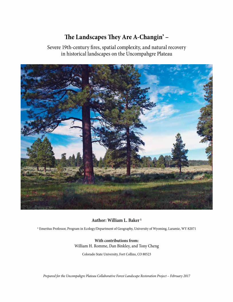
The Landscapes They Are A-Changin’ –Severe 19th-century fires, spatial complexity, and natural recovery
in historical landscapes on the Uncompahgre Plateau
Author: William L. Baker 11 Emeritus Professor, Program in Ecology/Department of Geography, University of Wyoming, Laramie, WY 82071
With contributions from: William H. Romme, Dan Binkley, and Tony Cheng
Colorado State University, Fort Collins, CO 80523
Prepared for the Uncompahgre Plateau Collaborative Forest Landscape Restoration Project – February 2017
This report is published by the Colorado Forest Restoration Institute, Warner College of Natural Resources at Colorado State University, Fort Collins, CO.
The Colorado Forest Restoration Institute (CFRI) was established in 2005 as an application-oriented program of the Department of Forest & Rangeland Stewardship in the Warner College of Natural Resources at Colorado State University. CFRI’s purpose is to develop, synthesize, and
apply locally- relevant science-based knowledge to achieve forest restoration and wildfire hazard reduction goals in Colorado and the Interior West. We do this through collaborative partnerships
involving researchers, forest land managers, interested and affected stakeholders, and communities. Authorized by Congress through the Southwest Forest Health and Wildfire Prevention Act of
2004, CFRI is one of three Institutes comprising the Southwest Ecological Restoration Institutes, along with centers at Northern Arizona University and New Mexico Highlands University.
The Colorado Forest Restoration Institute at Colorado State University receives financial support through the Cooperative and International Programs of the U.S. Forest Service, Department
of Agriculture, under the Southwest Forest Health and Wildfire Prevention Act. In accordance with Federal law and U.S. Department of Agriculture policy, this institution is prohibited from
discriminating on the basis of race, color, national origin, sex, age, or disability. To file a complaint of discrimination, write: USDA, Director, Office of Civil Rights Room 326-A, Whitten Building 1400
Independence Avenue, SW Washington, DC 20250-9410 or call (202) 720-5964 (voice & TDD).
1
Scientific consensus on recent ecological research on the Uncompahgre PlateauWilliam L. Baker1, William H. Romme2, Dan Binkley2, and Tony Cheng3
1 Emeritus Professor, Program in Ecology/Department of Geography, University of Wyoming, Laramie, WY2 Emeritus Professor, Ecosystem Science and Sustainability, Colorado State University, Fort Collins, CO
3 Professor, Forest and Rangeland Stewardship, Colorado State University, Fort Collins, CO
We met in 2016 to review and assess our joint confidence in findings from new sources of understanding about historical fire and vegetation on the Uncompahgre Plateau. Here we present our consensus about key findings relevant to the restoration program on the Plateau. These new
sources include: (1) tree-ring research on two mesas (Hasstedt 2013), (2) tree-ring dating of aspen origins across the Plateau (Binkley et al. 2014), (3) early historical photographs and documents about the Plateau discovered by David Bradford, formerly with the U.S. Forest Service’s Paonia Ranger District, and from other sources, which are reported and used in this document, and (4) findings from the land-survey study reported in this document. We rated our joint confidence in key findings from these sources as high, moderate, or low confidence.
High confidence in the following findings:
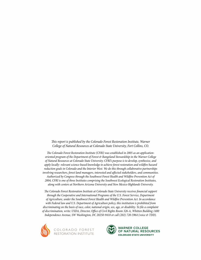
■ Tree density and basal area reconstructions from near A.D. 1900 show that historical forests were highly variable across the Plateau (Figure 1).
■ A frequent low-severity (Flagstaff type) fire regime was historically found in only limited areas in ponderosa pine and mixed-conifer forests.
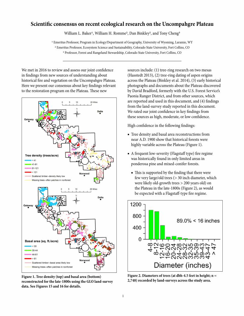
■ This is supported by the finding that there were few very large/old trees (> 30 inch diameter, which were likely old-growth trees > 200 years old) on the Plateau in the late-1800s (Figure 2), as would be expected with a Flagstaff-type fire regime.
Figure 2. Diameters of trees (at dbh-4.5 feet in height; n = 2,748) recorded by land-surveys across the study area.
Figure 1. Tree density (top) and basal area (bottom) reconstructed for the late-1800s using the GLO land-survey data. See Figures 15 and 16 for details.
2
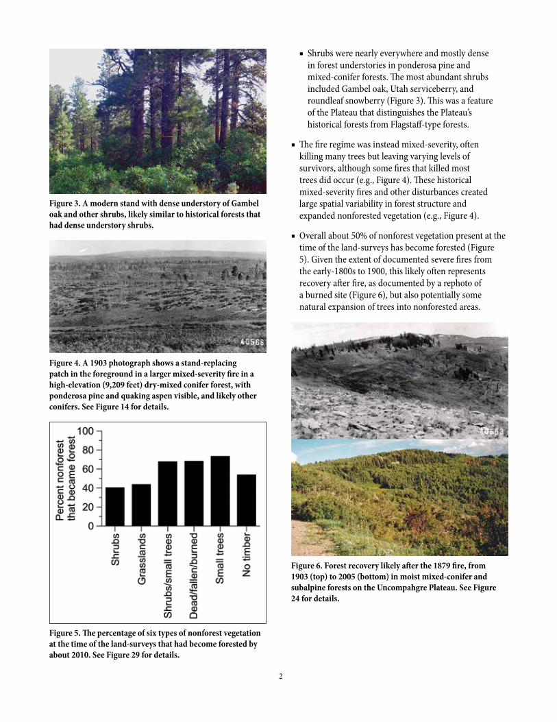
■ Shrubs were nearly everywhere and mostly dense in forest understories in ponderosa pine and mixed-conifer forests. The most abundant shrubs included Gambel oak, Utah serviceberry, and roundleaf snowberry (Figure 3). This was a feature of the Plateau that distinguishes the Plateau’s historical forests from Flagstaff-type forests.
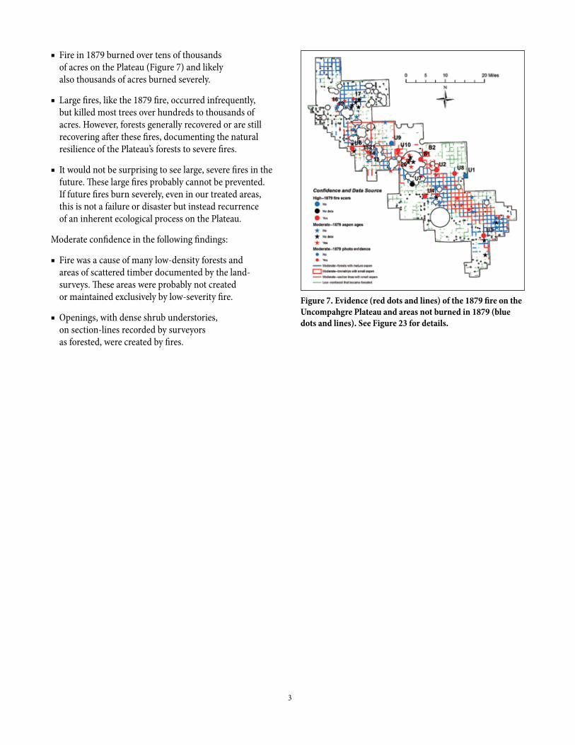
■ The fire regime was instead mixed-severity, often killing many trees but leaving varying levels of survivors, although some fires that killed most trees did occur (e.g., Figure 4). These historical mixed-severity fires and other disturbances created large spatial variability in forest structure and expanded nonforested vegetation (e.g., Figure 4).
■ Overall about 50% of nonforest vegetation present at the time of the land-surveys has become forested (Figure 5). Given the extent of documented severe fires from the early-1800s to 1900, this likely often represents recovery after fire, as documented by a rephoto of a burned site (Figure 6), but also potentially some natural expansion of trees into nonforested areas.
Figure 3. A modern stand with dense understory of Gambel oak and other shrubs, likely similar to historical forests that had dense understory shrubs.
Figure 4. A 1903 photograph shows a stand-replacing patch in the foreground in a larger mixed-severity fire in a high-elevation (9,209 feet) dry-mixed conifer forest, with ponderosa pine and quaking aspen visible, and likely other conifers. See Figure 14 for details.
Figure 5. The percentage of six types of nonforest vegetation at the time of the land-surveys that had become forested by about 2010. See Figure 29 for details.
Figure 6. Forest recovery likely after the 1879 fire, from 1903 (top) to 2005 (bottom) in moist mixed-conifer and subalpine forests on the Uncompahgre Plateau. See Figure 24 for details.
3
■ Fire in 1879 burned over tens of thousands of acres on the Plateau (Figure 7) and likely also thousands of acres burned severely.
■ Large fires, like the 1879 fire, occurred infrequently, but killed most trees over hundreds to thousands of acres. However, forests generally recovered or are still recovering after these fires, documenting the natural resilience of the Plateau’s forests to severe fires.
■ It would not be surprising to see large, severe fires in the future. These large fires probably cannot be prevented. If future fires burn severely, even in our treated areas, this is not a failure or disaster but instead recurrence of an inherent ecological process on the Plateau.
Moderate confidence in the following findings:
■ Fire was a cause of many low-density forests and areas of scattered timber documented by the land-surveys. These areas were probably not created or maintained exclusively by low-severity fire.
■ Openings, with dense shrub understories, on section-lines recorded by surveyors as forested, were created by fires.
Figure 7. Evidence (red dots and lines) of the 1879 fire on the Uncompahgre Plateau and areas not burned in 1879 (blue dots and lines). See Figure 23 for details.

4
AcknowledgmentsThis project was made possible by financial support from the Colorado Forest Restoration
Institute and the Uncompahgre Collaborative Forest Landscape Restoration Project. I appreciate the interest and encouragement of the Collaborative in this project. Dr. Bill Romme, Colorado State University, and Dr. Dan Binkley, Northern Arizona University,
generously shared their data and knowledge of the ecology of the Plateau. Thanks to David Bradford, the Paonia Ranger District, and the Grand Mesa, Uncompahgre, and Gunnison National Forest for permission to scan and reprint Dave Bradford’s rephotographs of the 1903 Riley photos here. Staff at the National Archives and Records Administration and
the U.S. Geological Survey Library were very helpful. I especially appreciate the excellent field assistance provided by Dr. Ted Bartlett, Emeritus Professor, Fort Lewis College,
Durango. I greatly appreciate the many hours of useful discussion, review, and interactions about the ecology of the Plateau with Drs. Bill Romme, Dan Binkley, and Tony Cheng.
This report was made possible with financial support from USDA NIFA Hatch Funds, Accession No. 1003273, Project No. COL00671A, USDA Forest Service Agreement No. 12-CS-11020400-049, and USDA Forest Service Agreement No. 16-DG-11031600-014.
5
Table of contentsScientific consensus on recent ecological research on the Uncompahgre Plateau . . . . . . . . . . . . . . . . . . . . . . . . . . . . . . . . . . . . . . 1
Summary . . . . . . . . . . . . . . . . . . . . . . . . . . . . . . . . . . . . . . . . . . . . . . . . . . . . . . . . . . . . . . . . . . . . . . . . . . . . . . . . . . . . . . . . . . . . . . . . . . 6
Background on large, severe fires in landscapes and on the Uncompahgre Plateau. . . . . . . . . . . . . . . . . . . . . . . . . . . . . . . . . . . . . 8
Approach of the land-survey study . . . . . . . . . . . . . . . . . . . . . . . . . . . . . . . . . . . . . . . . . . . . . . . . . . . . . . . . . . . . . . . . . . . . . . . . . . . . 11
EuroAmerican land uses on the Uncompahgre Plateau at the time of the surveys . . . . . . . . . . . . . . . . . . . . . . . . . . . . . . . . . . . . 15
Using ancillary early photographs and documents, and recent scientific research . . . . . . . . . . . . . . . . . . . . . . . . . . . . . . . . . . . . 15
Findings across landscapes and vegetation types . . . . . . . . . . . . . . . . . . . . . . . . . . . . . . . . . . . . . . . . . . . . . . . . . . . . . . . . . . . . . . . . 18
Findings for types of forest landscapes from the land-surveys . . . . . . . . . . . . . . . . . . . . . . . . . . . . . . . . . . . . . . . . . . . . . . . . . . . . . 43
Findings for ponderosa pine landscapes from the land-surveys. . . . . . . . . . . . . . . . . . . . . . . . . . . . . . . . . . . . . . . . . . . . . . . . . . . . 44
Findings for dry mixed-conifer landscapes from the land-surveys . . . . . . . . . . . . . . . . . . . . . . . . . . . . . . . . . . . . . . . . . . . . . . . . . 49
Findings for moist mixed-conifer landscapes from the land-surveys . . . . . . . . . . . . . . . . . . . . . . . . . . . . . . . . . . . . . . . . . . . . . . . 50
Ponderosa pine and mixed-conifer landscapes linked by a history of severe fires . . . . . . . . . . . . . . . . . . . . . . . . . . . . . . . . . . . . . 53
Findings for piñon-juniper landscapes from the land-surveys . . . . . . . . . . . . . . . . . . . . . . . . . . . . . . . . . . . . . . . . . . . . . . . . . . . . . 54
Findings for subalpine landscapes from the land-surveys . . . . . . . . . . . . . . . . . . . . . . . . . . . . . . . . . . . . . . . . . . . . . . . . . . . . . . . . . 54
Slow natural recovery after severe fires from the early 1800s to 1900 . . . . . . . . . . . . . . . . . . . . . . . . . . . . . . . . . . . . . . . . . . . . . . . 55
Discussion. . . . . . . . . . . . . . . . . . . . . . . . . . . . . . . . . . . . . . . . . . . . . . . . . . . . . . . . . . . . . . . . . . . . . . . . . . . . . . . . . . . . . . . . . . . . . . . . . 58
Conclusion . . . . . . . . . . . . . . . . . . . . . . . . . . . . . . . . . . . . . . . . . . . . . . . . . . . . . . . . . . . . . . . . . . . . . . . . . . . . . . . . . . . . . . . . . . . . . . . . 62
Literature cited. . . . . . . . . . . . . . . . . . . . . . . . . . . . . . . . . . . . . . . . . . . . . . . . . . . . . . . . . . . . . . . . . . . . . . . . . . . . . . . . . . . . . . . . . . . . . 63
Appendix 1. Vegetation and land-use information in township descriptions . . . . . . . . . . . . . . . . . . . . . . . . . . . . . . . . . . . . . . . . . 66
Appendix 2. Large surveying errors on the Uncompahgre Plateau. . . . . . . . . . . . . . . . . . . . . . . . . . . . . . . . . . . . . . . . . . . . . . . . . . 69
Appendix 3. Surveyor common names and the likely Latin names for trees . . . . . . . . . . . . . . . . . . . . . . . . . . . . . . . . . . . . . . . . . 70
Appendix 4. Surveyor common names and the likely Latin names for shrubs. . . . . . . . . . . . . . . . . . . . . . . . . . . . . . . . . . . . . . . . 71
Appendix 5. Results of the small accuracy trial in piñon-juniper and spruce-fir . . . . . . . . . . . . . . . . . . . . . . . . . . . . . . . . . . . . . . 72
6
SummaryFew ecological sources provide spatially extensive knowledge of historical landscapes that can help in managing large land areas for people and nature. The original land surveys, which laid out section lines and corners for land allocation, also provided systematic ecological information, including measurements of bearing trees used to mark corners and descriptions of dominant trees and shrubs along section lines. Data from surveys, mostly from 1881-1902, have been digitized and analyzed for Forest Service land on the Plateau. Early historical documents were found that add photographs and scientific descriptions. Key findings from this new information include:
■ A 1904 scientific document said burns in the early 1800s “largely denuded the Uncompahgre Plateau” (Riley 1904a p. 30). Muriel Marshall (1998 p. 36) quoted an early resident’s observation that fires on the Plateau in 1879 “had burned it slick.” A 1901 scientific paper said that, in 1900, fires on the Plateau “were burning fiercely ... practically destroying all the timber growing on the divide between the Uncompahgre and the San Miguel Rivers” and “the whole region was swept bare of trees” (Michelsen 1901 p. 58). These reports suggested large, severe fires, that killed many trees, strongly shaped the Plateau’s historical landscapes.
■ The land-survey data were studied to help clarify these reported severe fires and to provide more information for restoration. The surveys cover about 561,000 acres on the Plateau after removing 88,000 acres possibly affected by human disturbances around early roads, trails, fences, and a few logging operations. The range was described in 1904, as mostly “in good condition throughout” (Riley 1904b p. 24). Survey data are thus from a period and from the parts of the Plateau where EuroAmerican land uses had not dramatically altered landscapes.
■ Reconstructions of historical forest structure from land surveys and stand-level data (Matonis et al. 2014) both show large variability in historical tree density and basal area across landscapes. Open, low-density forests (< 41 trees/acre) covered about 28% of ponderosa pine, 14% of dry mixed-conifer, and 36% of moist mixed-conifer forests, including surprisingly extensive areas of “scattered timber” with very low tree density, particularly in ponderosa pine forests. However, very dense forests (> 121 trees/
acre) also covered about 9% of ponderosa pine, 30% of dry mixed-conifer, and 34% of moist mixed-conifer landscapes. Basal area was low (< 30 sq. ft./acre) in parts of the northern Plateau, but higher (> 61 sq. ft./acre) in scattered areas in the southern Plateau.
■ Surveyors recorded diameters for 2,748 trees and a surprising 89% of them were < 16" in diameter at breast height, which in ponderosa and mixed-conifer forests would have averaged less than about 100 years old at the time of the surveys. In contrast, very large “heritage” ponderosa pines (≥ 31" diameter) > 200 years old were rare, only about 2% of total ponderosa, with very low average density of less than about 1.5 trees/acre. Both of these are consistent with the reported large, severe fire in the early 1800s that may have killed many trees, leaving scattered survivors that became today’s heritage conifers.
■ The early-1800s severe fire reported by Riley to have denuded the Plateau was possibly in 1818, a documented fire year at three of nine fire-scar sampling sites on the Plateau (Brown and Shepperd 2003), but other years are possible. The size of many aspens and conifers recorded by surveyors was consistent with an origin after severe fire in this period, and dated tree regeneration also increased on two mesas after this period (Hasstedt 2013).
■ The reported severe fire year of 1879 has extensive supporting evidence. This fire year was recorded at six of eight fire-scar sampling sites on the Plateau (Brown and Shepperd 2003). Of 51 aspen-dating plots (Binkley et al. 2014), 18 have tree ages consistent with origins after the 1879 fire. Six photographs from 1903 and 1905 show resprouting aspen, standing dead and fallen trees, damaged trees, open forests, shrub patches, and other evidence consistent with the 1879 fire. Surveyors recorded extensive areas of dense, small aspen in large patches and also in the understory of forests with surviving trees. Together this evidence suggests the 1879 fire was severe, killing many or most trees, over about 185,000-221,000 acres on the Plateau. Fires reportedly burned millions of acres in Colorado in 1879, a major drought year.
■ The reported 1900 fire year remains unclear, as no corroborating evidence has been found for it, and it was not reported by scientists or other observers who were on the Plateau a few years later. Land-surveys have little evidence; 2/3 of the Plateau was surveyed before 1900.

7
■ Episodes of infrequent large, severe fires were followed by interludes with smaller fires, which leads to fluctuating landscapes. Episodes of severe fire in the early 1800s and in 1879 produced open, low-density forests, more nonforest vegetation, extensive resprouting aspen, and reduced conifers. Interludes after these fires were followed by natural recovery with infill in forests, trees regenerating in nonforest, and increasing height and diameter of conifers and aspen, likely to continue until the next severe fire again suddenly resets the landscape.
■ The Plateau’s vegetation can recover successfully after large, severe fires like the 1879 fire. Small trees were widespread on about 1/3 of nonforest area within 23 years after 1879, about half the area of nonforest has now become forested, and trees have filled in scattered timber. Three rephotographs show increased size and density of aspen and conifers. Conifers have only increased a little in more expansive aspen areas, suggesting severe fires at intervals of < 150 years can and may continue to maintain extensive aspen dominance across the Plateau.
■ The Plateau’s historically shrubby understory vegetation, semi-arid climate prone to episodic droughts, orientation perpendicular to prevailing southwesterly winds, and topography with few barriers to fire spread all promote continuing episodes of infrequent large, severe fires.
■ Restoration is more complex in fluctuating landscapes. Structures associated with episodes, such as open forests, mini-meadows, and extensive nonforest can be restored by these events or intentionally restored, while denser and older forests with more conifers and shade-tolerant trees that develop in the interludes can only be restored by long periods of recovery.
■ The vegetation of a large part of the Plateau is likely still recovering from the 1879 fire, and an essential part of ecological restoration is to facilitate and enhance, certainly not retard, this natural recovery during the current interlude between large, infrequent fires.
■ Given the likelihood of continuing or increased severe fires, droughts, and insect outbreaks, one restoration approach is to enhance resistance and resilience of tree populations to all these risks. This bet-hedging approach would retain both large trees, that can resist fire and best provide post-fire seed, along with abundant and diverse smaller trees that better resist droughts and insect outbreaks and can recover relatively quickly after these events. This was a common historical forest structure that likely helped foster long-term forest persistence.
■ People need to know that, whether forests are or are not restored, the Plateau will likely continue to have infrequent, large severe fires that could be fast-moving and difficult to control, thus significant protection of all infrastructure and property is highly advisable.
■ Restoration of forests and fire on the Plateau, congruent with fluctuating landscapes, could include expanding agency capacity and experience with managed fire for resource benefit, encouraging preparation for severe fire reaching private property and public infrastructure, increasing forest structures (e.g., large trees) that foster ecological resilience, facilitating natural recovery, and maintaining historical bet-hedging structures in forest stands.
■ The Plateau provides an opportunity to restore a beautiful place that serves both people and nature, if we can adapt to a fluctuating landscape with infrequent large, severe fires.
8
Background on large, severe fires in landscapes and on the Uncompahgre PlateauZoom out to the landscape scale, the scale of miles to tens of miles, by flying in an airplane or by acquiring satellite imagery, and we begin to see patterns of patchiness across landscapes, including patches of aspen on north-facing slopes, ribbons of riparian areas with cottonwoods, or perhaps an area of burned trees. It is at this scale that collaborative forest landscape restoration is needed and yet difficult. Spatially extensive scientific data are often lacking about historical forests across large landscapes. Detailed data and restoration are also needed at a finer stand scale (e.g., Matonis et al. 2014). Yet, the landscape scale is the scale at which land uses and large disturbances, such as major wildfires, can leave legacies with enduring ecological effects.
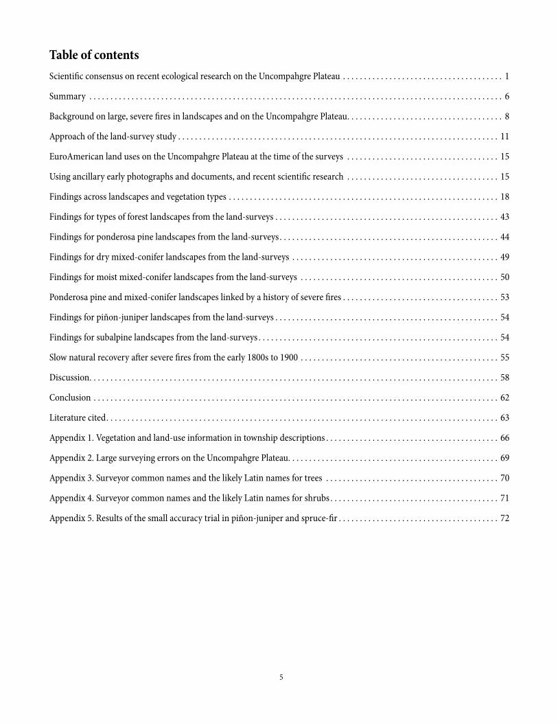
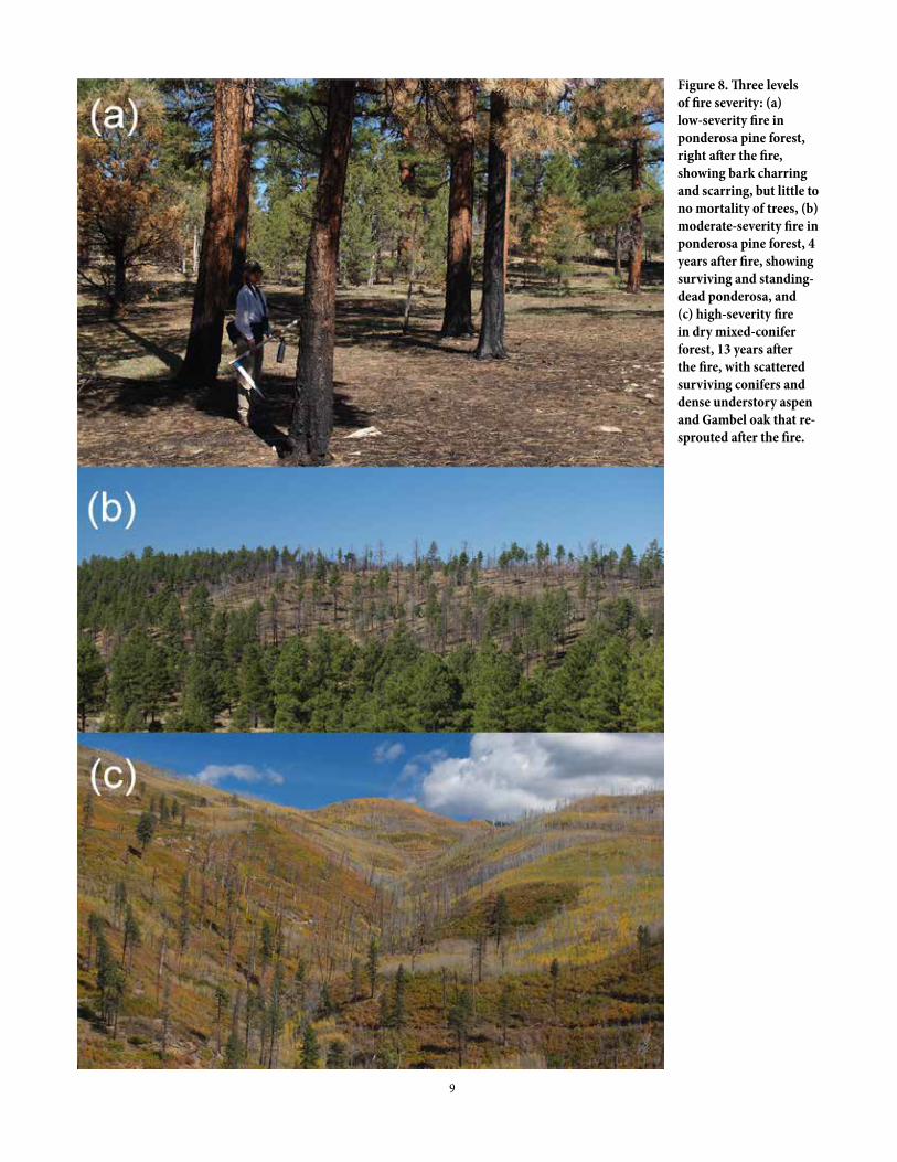
In most fire regimes that have been studied on earth, a large fraction of total burned area comes from the small fraction of fires that are large (Baker 2009). In the Rocky Mountains, for example, recent fires that were larger than about 37,000 acres were only 0.1% of total fires but made up about half the total burned area (Baker 2009). Large fires do most of the ecological renewal by fire across landscapes, but large, severe wildfires (moderate- to high-severity fires that kill ≥ 20% of the basal area of trees) leave the most legacies and are followed by the most spatially extensive and slowest recovery. Usually, low-severity fire is considered a fire that burns through the understory of a forest, killing only up to about 20% of the basal area (cross-sectional area) of trees (Figure 8a), a moderate-severity fire, also sometimes called mixed-severity fire, kills about 20-70% of the basal area (Figure 8b), and a high-severity fire often burns partly or entirely in the forest canopy, and kills > 70% of the basal area (Agee 1993), often leaving only scattered surviving trees or groups of trees (Figure 8c).
Not all large fires are very severe. For example, the 2011 Wallow fire in Arizona burned about 564,000 acres, mostly in ponderosa pine and mixed-conifer forests, with only about 10% high-severity fire. However, more severe wildfires, that are typically infrequent, can kill most conifers over substantial areas, greatly expanding nonforest vegetation, such as grasslands, shrubfields, and sagebrush openings, and substantially reducing the density of conifers, leaving scattered surviving, often larger trees to re-seed after fire. In the aftermath, aspen may resprout and expand extensively, shrubs can also, conifers that do not resprout may or may not slowly re-seed, and the forest can recover, increasing in density
and shade, eventually allowing shade-tolerant conifers to grow and overtop aspen and pines (e.g., Smith and Smith 2005). After a century or more, perhaps another severe fire occurs and recovery begins again. However, other events (e.g., droughts, disease, insect outbreaks) can alter pathways, leading to other outcomes (Kashian et al. 2007).
Infrequent large, severe fires create an inherently fluctuating landscape, alternating rapidly between the maturity of recovered forests and the sudden renewal of early-successional forests after fires, with usually a century or more of slow natural recovery and other possible events between fires. This fluctuating dynamic of disturbance, recovery, other events, and maturity requires thinking beyond our own lives during part of this dynamic, at the scales of multiple centuries and large landscapes.
The Uncompahgre Plateau was reportedly subject to several large, severe fires in the period from the early 1800s to 1900. The first was apparently in the early 1800s. In the Gunnison forest-reserve report, prepared before it became a National Forest, Riley (1904a) mentioned severe early-1800s fires similar to fires that he said had denuded the Uncompahgre Plateau:
“Many disastrous fires occurred here, particularly on the watershed of the North Fork, before the whites came in, and were caused presumably by Indians. These burns are very old, at least 80 or 90 years, and apparently occurred at the same time as those which largely denuded the Uncompahgre Plateau” (Riley 1904a p. 30).
Another reported large, severe fire year on the Plateau was 1879. Muriel Marshall (1998) explained that fires were thought by some to have been set on the Plateau in 1879 as retribution by Indians forced, by treaties, to leave the Plateau. Marshall quoted (p. 36) a local resident, J. D. Dillard, who trailed cattle on the Plateau in 1899: “Indians had burned it slick. You could see cattle and deer as far away as your eyesight could make them out.” Others who knew Chief Ouray thought Indians loved the Plateau too much to burn it up in retribution (Marshall 1998). Dillard’s description may have been increased by the fact that by about two decades after severe fire, most dead trees may have fallen over, greatly increasing visibility (e.g., Figure 4).
The last reported severe fire year on the Plateau was in 1900. The September issue of The Forester, from the American Forestry Association, reported from Montrose on August 16, 1900:
“Forest fires are burning fiercely in all directions. To the east there is a big blaze on the Black Mesa, to the north huge volumes of smoke go up from the Grand Mesa and
9
Figure 8. Three levels of fire severity: (a) low-severity fire in ponderosa pine forest, right after the fire, showing bark charring and scarring, but little to no mortality of trees, (b) moderate-severity fire in ponderosa pine forest, 4 years after fire, showing surviving and standing-dead ponderosa, and (c) high-severity fire in dry mixed-conifer forest, 13 years after the fire, with scattered surviving conifers and dense understory aspen and Gambel oak that re-sprouted after the fire.
10
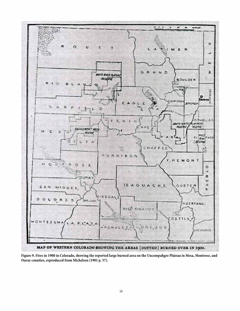
Figure 9. Fires in 1900 in Colorado, showing the reported large burned area on the Uncompahgre Plateau in Mesa, Montrose, and Ouray counties, reproduced from Michelsen (1901 p. 57).
11
the Uncompahgre Plateau to the west is ablaze in three different places. Thousands of acres of valuable timber have thus far been destroyed...” (The Forester 6:226-227).
In 1901, Henry Michelsen, Vice President of the Colorado Forestry Association, presented data on 1900 fires, which he reported to have burned roughly 500,000 acres in Colorado (Figure 9), although the report suggests this is an underestimate (Michelsen 1901). The burned area mapped on the Uncompahgre Plateau appears to have included most of the top of the Plateau (Figure 9). The overall effect of the 1900 fire on the Plateau was also described by Michelsen (1901 p. 58):
“From August 16th, until well into September, forest fires were burning fiercely in all directions upon the Black Mesa and the Uncompahgre Plateau, practically destroying all the timber growing on the divide between the Uncompahgre and San Miguel Rivers. Efforts to extinguish them were unavailing, the whole region was swept bare of trees.”
Infrequent severe fires, such as the reported early-1800s fire, 1879 fire, and 1900 fire on the Plateau, are difficult to appreciate at the time they occur, as they initially appear to be natural disasters. However, severe fires nonetheless provide many ecosystem services that are ecologically important and socially desirable. These fires create or renew shrubfields, sagebrush, and grasslands, as well as areas with dense small aspen and conifers, and conifer forests with reduced or only scattered surviving trees. Abundant small aspen that resprouted after 1879 likely naturally led to many of today’s dense middle-aged forests, including the mature and beautiful aspen forests of the Plateau (Smith and Smith 2005, Binkley et al. 2014). Severe fires not only rejuvenate aspen, reducing the conifers that may otherwise overtop them, but also reduce forest pests, and create biodiverse post-fire landscapes including snag-rich patches and coarse down wood. These fires also restore key nonforest vegetation important to wildlife, such as sagebrush and grassland openings important to grouse, mixed shrubfields that provide forage for deer, and travel corridors for bighorn sheep (Baker 2009).
During the first ten years of restoration on the Plateau, new scientific evidence has expanded understanding of these historically severe fires on the Plateau, even in ponderosa pine and mixed-conifer landscapes. Tree-ring reconstructions for the Plateau’s ponderosa pine and mixed-conifer forest stands (Matonis et al. 2014) did not explicitly reconstruct fire severity, but the historical fire regime was described as mixed-severity fire, meaning a mixture of all fire severities (Figure 8). Hasstedt (2013)
found evidence of mixed-severity fire in these forests on two mesas on the Plateau. More recent spatially extensive research on aspen (Binkley et al. 2014) found evidence of moderate- and high-severity fire in 1879 across a substantial part of aspen forests on the Plateau, including in mixed-conifer and subalpine forests. A mixed- or variable-severity fire regime is also known to have been historically common in most similar forests in ponderosa pine and mixed-conifer forests in the Rocky Mountains (Baker 2009, Romme et al. 2009). This fire regime created spatially complex landscapes with forests in diverse stages of recovery after fires that varied in the amount and pattern of tree mortality (e.g., Figures 6, 8). This may be a good time to consider this new evidence of more severe fires, and spatially complex recovering forests, and its implications for landscape-scale restoration on the Plateau. More information is needed about the landscapes we inherited after the large, severe fires of the early 1800s, 1879, and 1900, which motivated a look at land-survey records and other early historical documents.
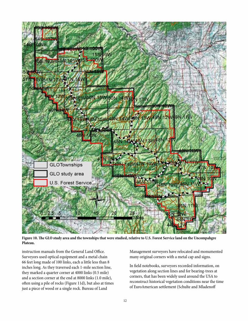
Approach of the land-survey studyThe purpose of this project was to use records from the original land-surveys, those conducted by the U.S. General Land Office (GLO) primarily on Forest Service lands on the Uncompahgre Plateau. The goal was to reconstruct historical forest structure and fire across ponderosa pine and mixed-conifer landscapes, to help further inform landscape-scale restoration on the Plateau. The study area included most of the U.S. Forest Service land on the Plateau, but some had to be omitted because of poor survey records, and adjoining areas were added to compensate (Figure 10). The resulting study area initially was 648,485 acres. Most of the focus is on ponderosa pine, dry mixed-conifer, and moist mixed-conifer landscapes and associated nonforest vegetation, but some partial initial results are also presented for piñon-juniper and subalpine-forest landscapes.
The original land-surveys
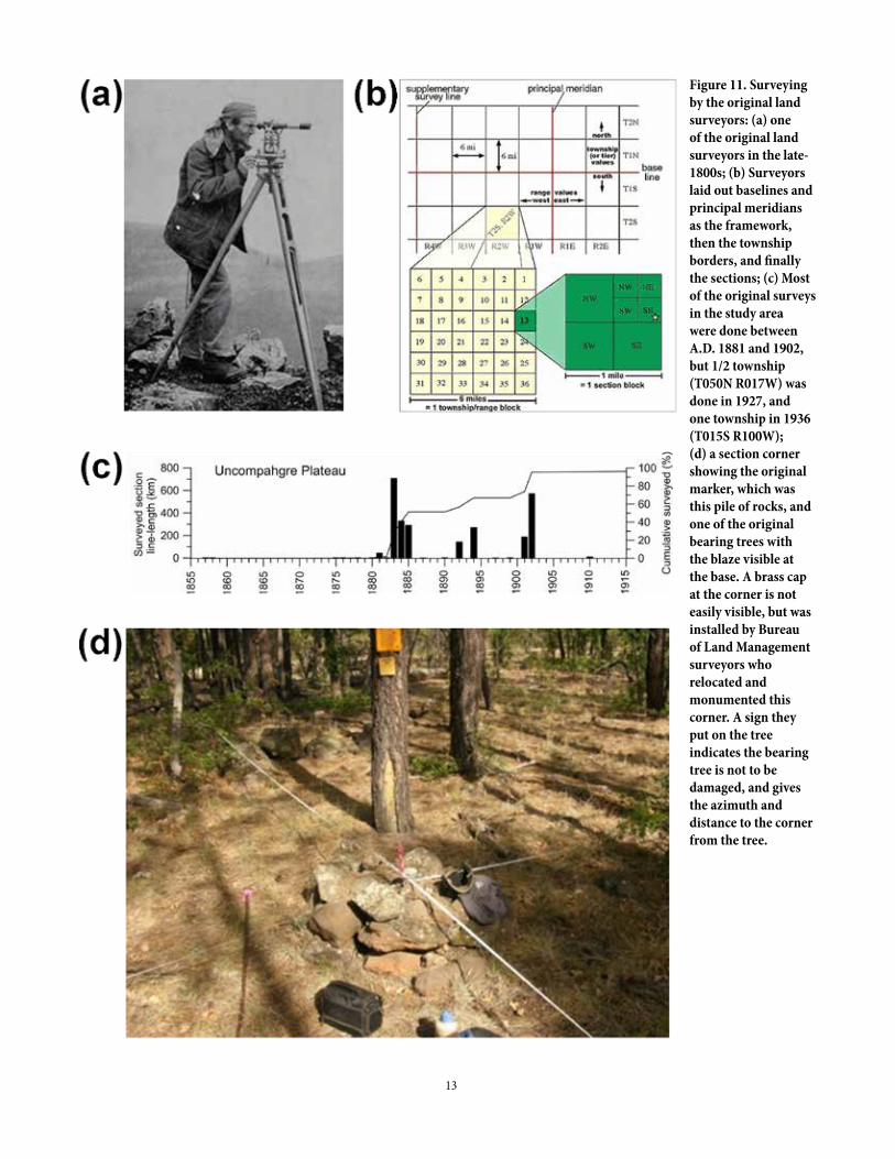
In the late 1800s, surveyors (Figure 11a) employed by the U.S. General Land Office (GLO), first laid out section lines and corners that created townships containing 36 sections, each 1-mile X 1-mile (Figure 11b), to enable accurate location and management of property boundaries. In the study area, the original surveys were completed between 1881 and 1936, with most completed between 1881-1902 (Figure 11c). Surveyors were contracted, trained, and supervised, and had to follow detailed
12
instruction manuals from the General Land Office. Surveyors used optical equipment and a metal chain 66 feet long made of 100 links, each a little less than 8 inches long. As they traversed each 1-mile section line, they marked a quarter corner at 4000 links (0.5 mile) and a section corner at the end at 8000 links (1.0 mile), often using a pile of rocks (Figure 11d), but also at times just a piece of wood or a single rock. Bureau of Land
Figure 10. The GLO study area and the townships that were studied, relative to U.S. Forest Service land on the Uncompahgre Plateau.
Management surveyors have relocated and monumented many original corners with a metal cap and signs.
In field notebooks, surveyors recorded information, on vegetation along section lines and for bearing-trees at corners, that has been widely used around the USA to reconstruct historical vegetation conditions near the time of EuroAmerican settlement (Schulte and Mladenoff
13
Figure 11. Surveying by the original land surveyors: (a) one of the original land surveyors in the late-1800s; (b) Surveyors laid out baselines and principal meridians as the framework, then the township borders, and finally the sections; (c) Most of the original surveys in the study area were done between A.D. 1881 and 1902, but 1/2 township (T050N R017W) was done in 1927, and one township in 1936 (T015S R100W); (d) a section corner showing the original marker, which was this pile of rocks, and one of the original bearing trees with the blaze visible at the base. A brass cap at the corner is not easily visible, but was installed by Bureau of Land Management surveyors who relocated and monumented this corner. A sign they put on the tree indicates the bearing tree is not to be damaged, and gives the azimuth and distance to the corner from the tree.
14
2001). Surveyors recorded the predominant vegetation along the section lines, including the dominant canopy trees in forests, and dominant shrubs in openings, in order of abundance, using common names. In forests, they also recorded, in order of abundance, the dominant understory trees and shrubs, occasionally also forbs and grasses, and often the grass abundance or quality. They often used qualitative terms to describe vegetation density and the quality of timber, including dense, scattered, heavily timbered, poor timber, or stunted. Whenever they entered or exited distinct vegetation (e.g., burned timber, shrublands, grasslands), they were required to record the new vegetation and its location in links. Similarly, when they encountered human land uses, (e.g., buildings, roads, trails, mines, sawmills) they recorded the location in links.
At the quarter corner, at 4000 links, they marked and recorded information for two bearing trees, one in each adjoining section. At the section corner, at 8000 links, they recorded the same information for four bearing trees, one for each section that met at the corner. For each bearing tree, surveyors recorded its species, using common names, the azimuth or angle to the tree, the distance to the tree in links, and the diameter of the tree in inches, usually at about 12 inches above the base (Williams and Baker 2011). Often they blazed the tree with an axe and marked the township and section on the tree. With this information, it is often possible to return to the corner more than a century later and relocate original bearing trees or their remains (Figure 11d). We place our tapes north-south and east-west, to help relocate bearing trees. After completing each township, surveyors recorded a summary of its vegetation and land uses (Appendix 1).
Computer analysis of the land-survey data
The section-line and bearing-tree data are the main information sources used here. I obtained all scanned surveyor field notes from the Bureau of Land Management, Denver, then I extracted the information from the field notes and entered it into ArcGIS 10.4. This is computer software, called a geographical information system (GIS), designed for analysis of detailed geographical data. I used the NAD83 datum and UTM Zone 12 projection for maps.
A fraud syndicate was active with land-surveys in some parts of the West (Livermore 1991). I checked for fraud using standard methods before including a township in the study. I found no fraud, but did find some discrepancies, likely reflecting difficult surveying conditions in steep terrain, and three townships were left out of the study: T45N R12W, T48W R15W, and T51N R15W. I also found scattered large positional errors
exceeding 450 feet in some townships where errors were otherwise generally low, averaging about 50-170 feet, fairly low given the optical surveying technology of the time. The large errors appear to also be in steep terrain (Appendix 2). I flagged these lines in the datasets and omitted them in overlays with non-survey data.
Bearing-tree and section-line data allow statistically valid reconstructions of tree density, basal area, diameter distributions, and fire severity across large landscapes at the time of the surveys. I followed the methods of Williams and Baker (2011, 2012). I converted the GLO diameters, measured at about 12" above the base, to diameter-at-breast-height (about 4.5 feet above the base), using a regression equation, before using tree diameters to estimate basal area, diameter distributions, and fire severity. Section-line data are used directly, but bearing-tree data must be pooled to increase sample size and accuracy: (1) across about two sections and six corners (about 1,280 acres) to estimate tree density with errors of about 14-23%, (2) across three sections and nine corners (about 1,920 acres) to estimate basal area with errors of about 21-25%, and (3) across four sections and twelve corners (about 2,560 acres) to estimate diameter distributions, which were about 87-88% accurate. Accuracy and error estimates are based on a large modern test (Williams and Baker 2011). Smaller pools (e.g., 3 corners) generally have accuracy too low to be usable (Williams and Baker 2011). I focused bearing-tree pools to best represent each of the Plateau’s major forest types, omitting pools that would have contained mixtures of forest types. This reduced the area covered by the reconstructions, but provided better results for each forest type. Fire severity was reconstructed from indicators of fire in section-line descriptions and from combinations of tree density and tree diameters from bearing-tree data, following the methods of Williams and Baker (2012). Reconstructions for moist mixed-conifer forests are preliminary, as the methods are fully calibrated and validated only for ponderosa and dry mixed-conifer forests.
Strengths and limitations of the GLO reconstructions
These reconstructions have strengths and limitations, as do all methods of reconstructing the past. Section-line data can provide detail at, or well below the section scale (1 mile), but pooling of bearing-tree data means that there is no information about tree density, basal area, and fire at a finer scale than the pool. Finer-scale data on tree density and basal area are available in Matonis et al. (2014). However, broad patterns across large
15
landscapes can be reconstructed, not feasible previously. Also, GLO data provide direct records for tree diameters, including aspen, not requiring estimation of historical tree diameters from trees that remain today, as in Matonis et al. (2014). However, there have been critiques of GLO-based reconstructions of fire and tree density (e.g., Fulé et al. 2014). We think we effectively refuted them (e.g., Williams and Baker 2014), as critics often did not recognize that GLO methods were extensively validated and corroborated with evidence from early scientific reports and inventories, other reconstructions, as well as the modern accuracy trial (Williams and Baker 2011). However, there is ongoing scientific debate about merits and limitations of all methods, including GLO methods and tree-ring methods. It is not easy to reconstruct the details of the past; we are fortunate to have scientific reconstructions and early documents for the Plateau. All warrant respect and use with healthy caution in mind, which includes a recognition that all reconstructions are models of the past that may fail at times, and have reasonable, but also inherently limited accuracy.
EuroAmerican land uses on the Uncompahgre Plateau at the time of the surveysFur traders were active near the Uncompahgre Plateau by 1828 (Public Lands Partnership 2014). However, the Plateau was not extensively settled or used by EuroAmericans until Ute Indians were removed to a Utah reservation in 1881 (Rockwell 1965, Marshall 1998). Livestock grazing may have begun after 1872 (Mehls 1988), but intensified after 1882 (Rockwell 1965, Marshall 1998). The arrival of the railroad nearby in 1882 facilitated livestock expansion (Mehls 1988). By the time of the surveys, mostly in 1881-1902 (Figure 11c), roads, trails, and fences were common, and a few logging operations, including sawmills, were in place (Table 1). The Uncompahgre forest-reserve report (Riley 1904b) said that logging had only been underway since about 1893, with 15,545 acres listed as cut-over and seven small steam mills operating in 1903. Township descriptions as late as 1901-1902 mention summer camps, but permanent settlers were few, usually only one or two per township (Appendix 1).
Also, grass was described as still good, from the standpoint of grazing, in 1885 (Appendix 1: 5), after only 4 years of livestock grazing, when the majority of surveys had been completed (Figure 11c). By 1903, when all but 1 1/2 (1927, 1936) townships were surveyed, about 35
livestock operators were active on the Plateau, but the range was described as “in good condition throughout, with the exception of that which has been sheeped” (Riley 1904b p. 24). Sheep areas included headwaters of Spring and Dry Creek and some of the Horsefly Creek Watershed. The township descriptions support this, as they suggest that by 1901-2, when almost all the surveys were done, grass was still good, even described as abundant, excellent, or luxuriant (Appendix 1: 17, 19, 20, 26, 29, 31, 32), suggesting that grazing effects had not reached levels that would have widely altered fire spread and behavior. EuroAmerican land uses were underway by the time of the surveys, but had not dramatically altered the Plateau’s landscapes.
However, to further reduce effects from EuroAmerican land uses in the study area, I assigned circular buffers, varying in radius (Baker 2014), to each recorded land use (Table 1), then removed the 87,705 acres inside the buffers, leaving 560,780 acres of relatively unaffected area for the study. Removed area is visible as empty circles; the largest were sawmills (Figure 12).
Using ancillary early photographs and documents, and recent scientific researchDavid Bradford, formerly with the Paonia Ranger District of the U.S. Forest Service, found two Forest-reserve reports at the National Archives and Records Administration
Table 1. Land uses recorded by surveyors on the Uncompahgre Plateau, based on section-line data. Buffers were originally estimated in metric units (e.g., 3280 feet = 1000 meters).
Land use Buffer radius (feet) Number recordedBuilding 3280 25Campground 3280 1Corral 3280 3Ditch 328 3Fence 3280 108Logging 13123 3Pasture 3280 1Power line 328 2Reservoir 328 1Road 656 217Stock tank 3280 1Trail 656 178TOTAL NO. 543
16
(NARA) in Broomfield, Colorado. These reports, for the Gunnison and Uncompahgre National Forests, were published in 1904 by Smith Riley (1904a, b), who completed fieldwork on the Uncompahgre Plateau in 1903. These forest-reserve reports were scientific assessments of the vegetation, physiography, disturbances, and land uses (e.g., logging, livestock grazing) on the Plateau needed before formal government designation of a forest reserve as a National Forest. Quotes and information from the Uncompahgre and Gunnison forest-reserve reports are used directly here. The original copy of the Uncompahgre forest-reserve report (Riley 1904b) at NARA contained prints of all 30 photographs in the report. I scanned
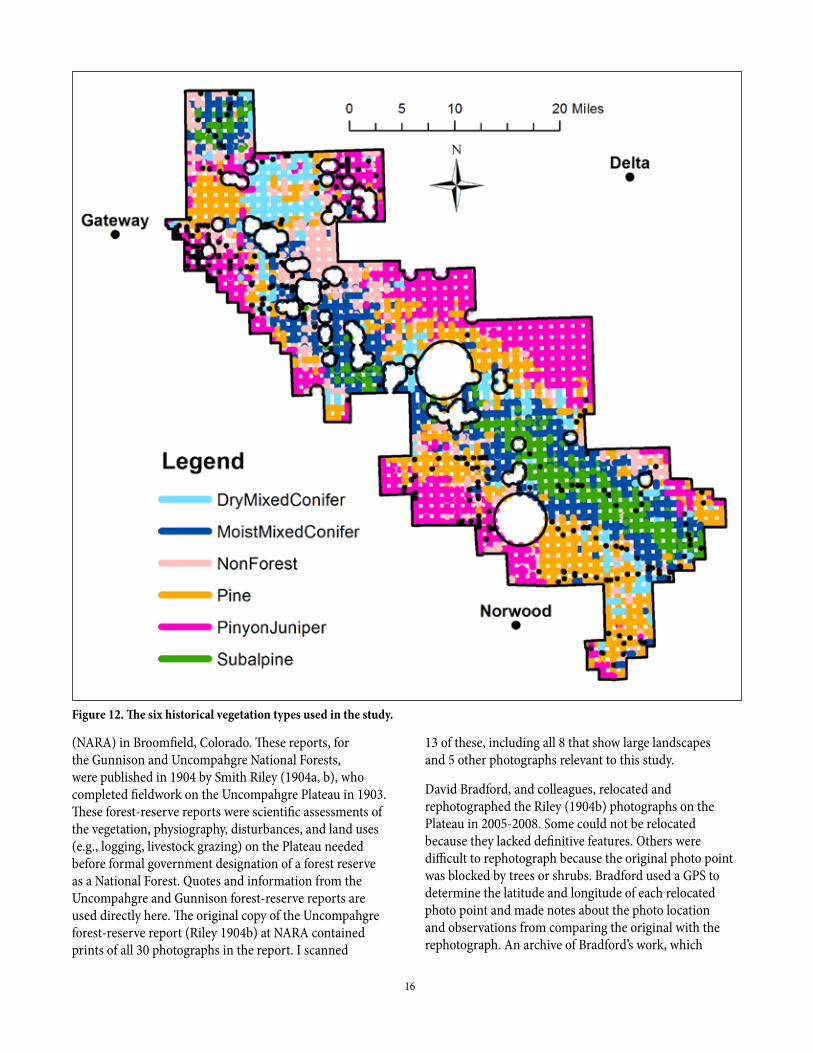
Figure 12. The six historical vegetation types used in the study.
13 of these, including all 8 that show large landscapes and 5 other photographs relevant to this study.
David Bradford, and colleagues, relocated and rephotographed the Riley (1904b) photographs on the Plateau in 2005-2008. Some could not be relocated because they lacked definitive features. Others were difficult to rephotograph because the original photo point was blocked by trees or shrubs. Bradford used a GPS to determine the latitude and longitude of each relocated photo point and made notes about the photo location and observations from comparing the original with the rephotograph. An archive of Bradford’s work, which
17
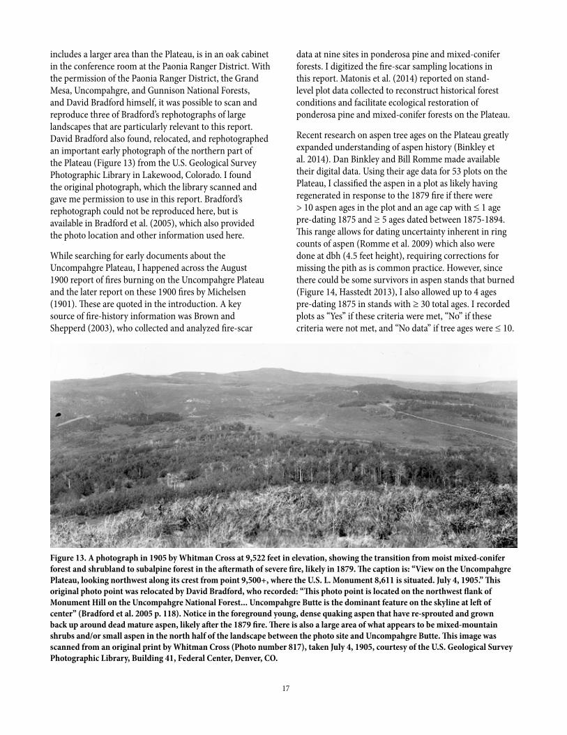
Figure 13. A photograph in 1905 by Whitman Cross at 9,522 feet in elevation, showing the transition from moist mixed-conifer forest and shrubland to subalpine forest in the aftermath of severe fire, likely in 1879. The caption is: “View on the Uncompahgre Plateau, looking northwest along its crest from point 9,500+, where the U.S. L. Monument 8,611 is situated. July 4, 1905.” This original photo point was relocated by David Bradford, who recorded: “This photo point is located on the northwest flank of Monument Hill on the Uncompahgre National Forest... Uncompahgre Butte is the dominant feature on the skyline at left of center” (Bradford et al. 2005 p. 118). Notice in the foreground young, dense quaking aspen that have re-sprouted and grown back up around dead mature aspen, likely after the 1879 fire. There is also a large area of what appears to be mixed-mountain shrubs and/or small aspen in the north half of the landscape between the photo site and Uncompahgre Butte. This image was scanned from an original print by Whitman Cross (Photo number 817), taken July 4, 1905, courtesy of the U.S. Geological Survey Photographic Library, Building 41, Federal Center, Denver, CO.
includes a larger area than the Plateau, is in an oak cabinet in the conference room at the Paonia Ranger District. With the permission of the Paonia Ranger District, the Grand Mesa, Uncompahgre, and Gunnison National Forests, and David Bradford himself, it was possible to scan and reproduce three of Bradford’s rephotographs of large landscapes that are particularly relevant to this report. David Bradford also found, relocated, and rephotographed an important early photograph of the northern part of the Plateau (Figure 13) from the U.S. Geological Survey Photographic Library in Lakewood, Colorado. I found the original photograph, which the library scanned and gave me permission to use in this report. Bradford’s rephotograph could not be reproduced here, but is available in Bradford et al. (2005), which also provided the photo location and other information used here.
While searching for early documents about the Uncompahgre Plateau, I happened across the August 1900 report of fires burning on the Uncompahgre Plateau and the later report on these 1900 fires by Michelsen (1901). These are quoted in the introduction. A key source of fire-history information was Brown and Shepperd (2003), who collected and analyzed fire-scar
data at nine sites in ponderosa pine and mixed-conifer forests. I digitized the fire-scar sampling locations in this report. Matonis et al. (2014) reported on stand-level plot data collected to reconstruct historical forest conditions and facilitate ecological restoration of ponderosa pine and mixed-conifer forests on the Plateau.
Recent research on aspen tree ages on the Plateau greatly expanded understanding of aspen history (Binkley et al. 2014). Dan Binkley and Bill Romme made available their digital data. Using their age data for 53 plots on the Plateau, I classified the aspen in a plot as likely having regenerated in response to the 1879 fire if there were > 10 aspen ages in the plot and an age cap with ≤ 1 age pre-dating 1875 and ≥ 5 ages dated between 1875-1894. This range allows for dating uncertainty inherent in ring counts of aspen (Romme et al. 2009) which also were done at dbh (4.5 feet height), requiring corrections for missing the pith as is common practice. However, since there could be some survivors in aspen stands that burned (Figure 14, Hasstedt 2013), I also allowed up to 4 ages pre-dating 1875 in stands with ≥ 30 total ages. I recorded plots as “Yes” if these criteria were met, “No” if these criteria were not met, and “No data” if tree ages were ≤ 10.
18
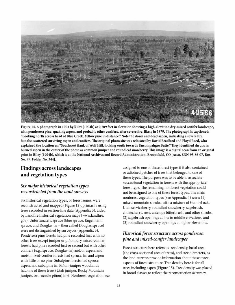
Figure 14. A photograph in 1903 by Riley (1904b) at 9,209 feet in elevation showing a high-elevation dry-mixed conifer landscape, with ponderosa pine, quaking aspen, and probably other conifers, after severe fire, likely in 1879. The photograph is captioned: “Looking north across head of Blue Creek. Yellow pine in distance.” Note the down and dead aspen, indicating a severe fire, but also scattered surviving aspen and conifers. The original photo site was relocated by David Bradford and Floyd Reed, who explained the location as: “Southwest flank of Wolf Hill, looking south towards Uncompahgre Butte.” They identified shrubs in burned aspen in the center of the photo as common juniper and roundleaf snowberry. This image is a digital scan from an original print in Riley (1904b), which is at the National Archives and Record Administration, Broomfield, CO [Accn. 8NN-95-86-07, Box No. 77, Folder No. 344].
Findings across landscapes and vegetation types
Six major historical vegetation types reconstructed from the land-surveys
Six historical vegetation types, or forest zones, were reconstructed and mapped (Figure 12), primarily using trees recorded in section-line data (Appendix 3), aided by Landfire historical vegetation maps (www.landfire.gov). Unfortunately, spruce (blue spruce, Engelmann spruce, and Douglas-fir – then called Douglas spruce) were not distinguished by surveyors (Appendix 3). Ponderosa pine forests had pine recorded first with no other trees except juniper or piñon, dry mixed-conifer forests had pine recorded first or second but with other conifers (e.g., spruce, Douglas-fir) and/or aspen, and moist mixed-conifer forests had spruce, fir, and aspen with little or no pine. Subalpine forests had spruce, aspen, and subalpine fir. Piñon-juniper woodlands had one of these trees (Utah juniper, Rocky Mountain juniper, two-needle piñon) first. Nonforest vegetation was
assigned to one of these forest types if it also contained or adjoined patches of trees that belonged to one of these types. The purpose was to be able to associate successional vegetation in forests with the appropriate forest type. The remaining nonforest vegetation could not be assigned to one of these forest types. The main nonforest vegetation types (see Appendix 4) were: (1) mixed-mountain shrubs, with a mixture of Gambel oak, Utah serviceberry, roundleaf snowberry, sagebrush, chokecherry, rose, antelope bitterbrush, and other shrubs, (2) sagebrush openings at low to middle elevations, and (3) roundleaf snowberry openings at higher elevations.
Historical forest structure across ponderosa pine and mixed-conifer landscapes
Forest structure here refers to tree density, basal area (the cross-sectional area of trees), and tree diameters, as the land-surveys provide information about these three aspects of forest structure. Tree density here is for all trees including aspen (Figure 15). Tree density was placed in broad classes to reflect the reconstruction accuracy,
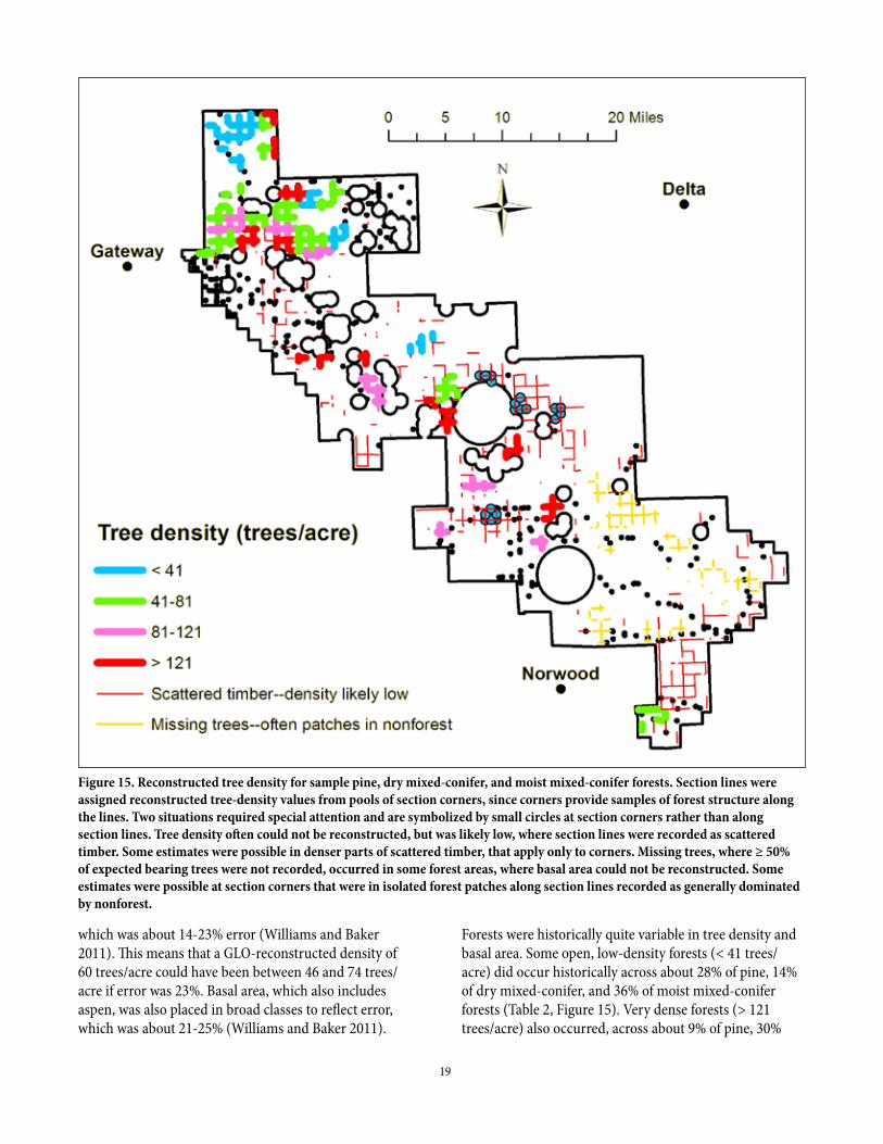
19
Figure 15. Reconstructed tree density for sample pine, dry mixed-conifer, and moist mixed-conifer forests. Section lines were assigned reconstructed tree-density values from pools of section corners, since corners provide samples of forest structure along the lines. Two situations required special attention and are symbolized by small circles at section corners rather than along section lines. Tree density often could not be reconstructed, but was likely low, where section lines were recorded as scattered timber. Some estimates were possible in denser parts of scattered timber, that apply only to corners. Missing trees, where ≥ 50% of expected bearing trees were not recorded, occurred in some forest areas, where basal area could not be reconstructed. Some estimates were possible at section corners that were in isolated forest patches along section lines recorded as generally dominated by nonforest.
which was about 14-23% error (Williams and Baker 2011). This means that a GLO-reconstructed density of 60 trees/acre could have been between 46 and 74 trees/acre if error was 23%. Basal area, which also includes aspen, was also placed in broad classes to reflect error, which was about 21-25% (Williams and Baker 2011).
Forests were historically quite variable in tree density and basal area. Some open, low-density forests (< 41 trees/acre) did occur historically across about 28% of pine, 14% of dry mixed-conifer, and 36% of moist mixed-conifer forests (Table 2, Figure 15). Very dense forests (> 121 trees/acre) also occurred, across about 9% of pine, 30%

20
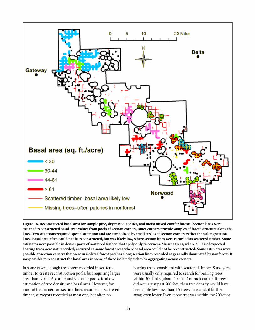
of dry mixed-conifer, and 34% of moist mixed-conifer forests (Table 2, Figure 15). Similarly, some forests with relatively low basal area occurred, as in the northern Plateau, along with patches of higher basal area in the southern Plateau (Figure 16). Basal area appears to have been a little less variable (Table 3, Figure 16) than tree density (Figure 15), but this is likely primarily because reconstruction pools are larger. Tree density and basal area varied from low to high over short distances, in some cases, as in parts of the northern Plateau (Figures 15,
16). Of course, tree density and basal area varied among forest types, covered later. Previous work (Matonis et al. 2014) showed that tree density and basal area also varied substantially at a finer scale than the GLO pools.
One of the surprises was how commonly surveyors recorded “scattered timber” in the section-line descriptions (Figure 15), mostly in ponderosa pine, but also mixed-conifer forests, much more than we have found in other GLO reconstructions in dry-forest landscapes.
Table 2. Variability in reconstructed historical tree density by forest type.
Variable Piñon-juniper Pine Dry mixed conifer Moist mixed conifer SubalpineTree-density sample Number of polygons 33.0 13.0 12.0 7.0 4.0 Line length (miles) 132.4 56.3 49.3 31.0 9.6Tree density (trees/acre) Mean (trees/acre) 106.0 68.0 79.0 171.0 223.0 SD (trees/acre) 57.0 32.0 38.0 166.0 172.0 CV (%) 54.2 47.3 48.7 97.4 77.1 Minimum (trees/acre) 43.0 26.0 34.0 26.0 29.0 1st quartile (trees/acre) 72.0 39.0 45.0 36.0 69.0 Median (trees/acre) 91.0 77.0 71.0 115.0 209.0 3rd quartile (trees/acre) 136.0 93.0 118.0 401.0 391.0 Maximum (trees/acre) 357.0 124.0 143.0 404.0 446.0Percentage of area by density class < 41 trees/acre (%) – 28.0 14.4 35.7 – > 81 trees/acre (%) – 47.8 38.5 52.0 – > 121 trees/acre (%) – 9.0 30.4 34.1 –
Table 3. Variability in reconstructed historical basal area by forest type.
Variable Piñon-juniper Pine Dry mixed conifer Moist mixed conifer SubalpineBasal area sample Number of polygons 20.0 9.0 7.0 8.0 3.0 Line length (miles) 170.6 71.9 46.8 64.5 40.3Basal area Mean (ft2/acre) 36.6 45.3 27.9 54.9 110.6 SD (ft2/acre) 12.6 27.4 11.3 42.2 14.8 CV (%) 34.5 60.6 40.6 77.0 13.4 Minimum (ft2/acre) 19.2 17.4 17.0 4.4 95.4 1st quartile (ft2/acre) 24.8 24.8 20.9 14.8 95.4 Median (ft2/acre) 35.7 41.8 22.6 50.1 112.4 3rd quartile (ft2/acre) 45.3 51.4 41.4 81.0 124.6 Maximum (ft2/acre) 62.3 110.2 46.6 131.1 124.6Percentage of area by basal-area class < 30 ft2/acre (%) – 27.5 69.8 20.3 – > 61 ft2/acre (%) – 9.2 0.0 42.8 –
21
Figure 16. Reconstructed basal area for sample pine, dry mixed-conifer, and moist mixed-conifer forests. Section lines were assigned reconstructed basal-area values from pools of section corners, since corners provide samples of forest structure along the lines. Two situations required special attention and are symbolized by small circles at section corners rather than along section lines. Basal area often could not be reconstructed, but was likely low, where section lines were recorded as scattered timber. Some estimates were possible in denser parts of scattered timber, that apply only to corners. Missing trees, where ≥ 50% of expected bearing trees were not recorded, occurred in some forest areas where basal area could not be reconstructed. Some estimates were possible at section corners that were in isolated forest patches along section lines recorded as generally dominated by nonforest. It was possible to reconstruct the basal area in some of these isolated patches by aggregating across corners.
In some cases, enough trees were recorded in scattered timber to create reconstruction pools, but requiring larger area than typical 6-corner and 9-corner pools, to allow estimation of tree density and basal area. However, for most of the corners on section-lines recorded as scattered timber, surveyors recorded at most one, but often no
bearing trees, consistent with scattered timber. Surveyors were usually only required to search for bearing trees within 300 links (about 200 feet) of each corner. If trees did occur just past 200 feet, then tree density would have been quite low, less than 1.5 trees/acre, and, if farther away, even lower. Even if one tree was within the 200-foot
22
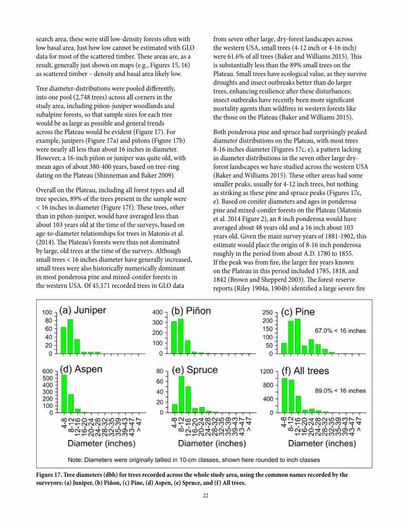
Figure 17. Tree diameters (dbh) for trees recorded across the whole study area, using the common names recorded by the surveyors: (a) Juniper, (b) Piñon, (c) Pine, (d) Aspen, (e) Spruce, and (f) All trees.
search area, these were still low-density forests often with low basal area. Just how low cannot be estimated with GLO data for most of the scattered timber. These areas are, as a result, generally just shown on maps (e.g., Figures 15, 16) as scattered timber – density and basal area likely low.
Tree diameter-distributions were pooled differently, into one pool (2,748 trees) across all corners in the study area, including piñon-juniper woodlands and subalpine forests, so that sample sizes for each tree would be as large as possible and general trends across the Plateau would be evident (Figure 17). For example, junipers (Figure 17a) and piñons (Figure 17b) were nearly all less than about 16 inches in diameter. However, a 16-inch piñon or juniper was quite old, with mean ages of about 380-400 years, based on tree-ring dating on the Plateau (Shinneman and Baker 2009).
Overall on the Plateau, including all forest types and all tree species, 89% of the trees present in the sample were < 16 inches in diameter (Figure 17f). These trees, other than in piñon-juniper, would have averaged less than about 103 years old at the time of the surveys, based on age-to-diameter relationships for trees in Matonis et al. (2014). The Plateau’s forests were thus not dominated by large, old trees at the time of the surveys. Although small trees < 16 inches diameter have generally increased, small trees were also historically numerically dominant in most ponderosa pine and mixed-conifer forests in the western USA. Of 45,171 recorded trees in GLO data
from seven other large, dry-forest landscapes across the western USA, small trees (4-12 inch or 4-16 inch) were 61.6% of all trees (Baker and Williams 2015). This is substantially less than the 89% small trees on the Plateau. Small trees have ecological value, as they survive droughts and insect outbreaks better than do larger trees, enhancing resilience after these disturbances; insect outbreaks have recently been more significant mortality agents than wildfires in western forests like the those on the Plateau (Baker and Williams 2015).
Both ponderosa pine and spruce had surprisingly peaked diameter distributions on the Plateau, with most trees 8-16 inches diameter (Figures 17c, e), a pattern lacking in diameter distributions in the seven other large dry-forest landscapes we have studied across the western USA (Baker and Williams 2015). These other areas had some smaller peaks, usually for 4-12 inch trees, but nothing as striking as these pine and spruce peaks (Figures 17c, e). Based on conifer diameters and ages in ponderosa pine and mixed-conifer forests on the Plateau (Matonis et al. 2014 Figure 2), an 8 inch ponderosa would have averaged about 48 years old and a 16 inch about 103 years old. Given the main survey years of 1881-1902, this estimate would place the origin of 8-16 inch ponderosa roughly in the period from about A.D. 1780 to 1855. If the peak was from fire, the larger fire years known on the Plateau in this period included 1785, 1818, and 1842 (Brown and Shepperd 2003). The forest-reserve reports (Riley 1904a, 1904b) identified a large severe fire

23
year near 1813, which I discuss later was more likely in 1818, and this year would be consistent with this pine diameter peak. The spruce, also with an 8-16 inch peak, could have been different species growing at different elevations, making it difficult to estimate their ages.
Historical ponderosa pine and mixed-conifer forests in the West often were thought to have been dominated by widely-spaced large, old trees, because these forests were thought to have been subject to primarily low-severity fires that did not kill many canopy trees (e.g., Covington and Moore 1994), but the GLO data suggest this was rare on the Uncompahgre Plateau. Larger ponderosa pines (> 16" diameter) were 33.0% of total pines (Figure 17c), but likely old-growth trees were rarer. Based on the diameter-age relationship in Matonis et al. (2014), 16" trees would have averaged about 100 years old at breast height, and a 200-year old ponderosa pine would have been about 30 inches diameter, a little less than the ≥ 31" diameter of trees that Hasstedt (2013) termed “heritage trees.” Hasstedt’s (2013) data showed a density of only 0.14 heritage trees/acre, a very low historical density and likely also a small percentage of the total historical tree density on the two unharvested mesas he studied. Heritage ponderosas were only 2.0% of total pines across the overall ponderosa pine GLO sample on the Plateau (Figure 17c). Based on reconstructed mean tree density (Table 2), heritage ponderosa pines may have averaged ≤ 1.4 trees/acre (2% of 68 trees/acre, but not all were pines) in ponderosa and ≤ 1.6 trees/acre (2% of 79 trees/acre) in dry mixed-conifer forests. Thus, on average, ponderosa pine and dry mixed-conifer forests on the Plateau were not dominated by large, old ponderosa pines, which were instead relatively rare, in a matrix of generally moderate-aged to young trees (about 98% < 200 years old on average and about 2/3 < 100 years old on average).
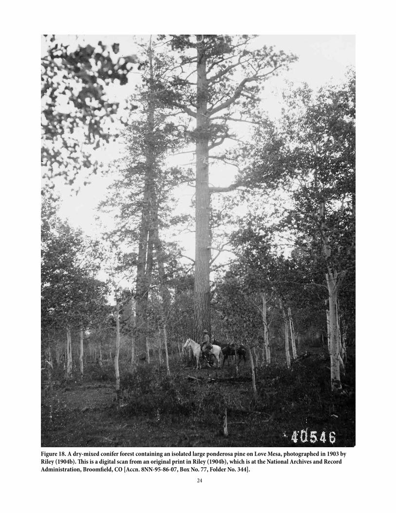
Hasstedt (2013) identified the rare heritage trees as survivors of severe fires, including the 1879 fire. Riley (1904b), in the Uncompahgre forest-reserve report, did not note abundant areas of these large, old trees, but he did show a picture of a large, isolated ponderosa that appears, like Hasstedt’s heritage trees, to have been a survivor of severe fires (Figure 18). However, some old-growth dry forests with more old trees likely did occur on the Plateau. Very large ponderosa were noted in some land-survey township descriptions (Appendix 1: 10, 12, 16, 17, 19, 20, 24, 26) including ponderosa up to 54-60 inches in diameter (Appendix 1:17). Only three sawmills and logging operations (Table 1) were noted by surveyors,
and by 1904 only seven were in operation (Riley 1904b), which also suggests large timber was not abundant. In contrast, 45 sawmills were found in a similar area and time period in the western Sierra Nevada (Baker 2014).
Overall, across the 45,171 trees recorded in seven dry-forest landscapes across the West in which we analyzed GLO data (Baker and Williams 2015), about 10% of trees were larger than about 28" in diameter, 3" less than the size of a heritage tree, whereas only 2% on the Plateau were heritage size. This suggests that, except in piñon-juniper, the Uncompahgre Plateau had a relative deficiency of old trees (> 200 years old) at the time of the surveys, unlike dry-forest landscapes in the western USA where old forests were more common (e.g., Baker 2012, 2014). The lack of old trees, and Hasstedt’s (2013) observation that very large trees were survivors of severe fires, are consistent with the reported occurrence of large, severe fires from the early 1800s to 1900.
Landscape variability in aspen, scattered timber, and nonforest across all vegetation types
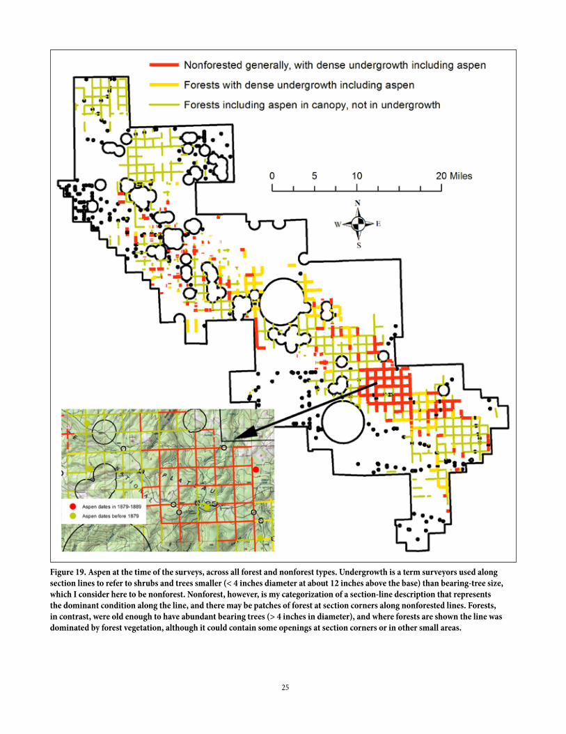
Surveyors recorded abundant small aspen (red lines in Figure 19). This map is for all forest types that had aspen, so includes subalpine forests. These small aspens were recorded on section-lines as “undergrowth of dense scrub aspen” or with similar phrases. Undergrowth just means the trees were not large enough (usually < 4" diameter at about 12" above the base) to be considered forest. Small aspen was often listed first or second, but sometimes third after oak (Gambel oak) or other small trees or shrubs. Small aspen were abundant over some large areas, approaching the township scale of about 23,000 acres (Figure 19). Section-line descriptions characterize the predominant vegetation along the line as small aspen, but bearing-tree data show that these areas did, in places, include small patches of “forest” with larger trees. As discussed later, many areas of small aspen likely originated after the 1879 fire. Small aspen are visible in Figure 13.
Substantial areas of mixed-conifer forests also were recorded on the Plateau as having dense undergrowth that included aspen (yellow lines in Figure 19). These likely represent forests in which fire burned severely enough to kill existing aspen and some but not all conifers, a pattern of mixed-severity fire documented by tree-ring dating on part of the Plateau (Hasstedt 2013). These areas, too, in some cases likely burned in the 1879 fire or possibly other late-1800s fires.
24
Figure 18. A dry-mixed conifer forest containing an isolated large ponderosa pine on Love Mesa, photographed in 1903 by Riley (1904b). This is a digital scan from an original print in Riley (1904b), which is at the National Archives and Record Administration, Broomfield, CO [Accn. 8NN-95-86-07, Box No. 77, Folder No. 344].
25
Figure 19. Aspen at the time of the surveys, across all forest and nonforest types. Undergrowth is a term surveyors used along section lines to refer to shrubs and trees smaller (< 4 inches diameter at about 12 inches above the base) than bearing-tree size, which I consider here to be nonforest. Nonforest, however, is my categorization of a section-line description that represents the dominant condition along the line, and there may be patches of forest at section corners along nonforested lines. Forests, in contrast, were old enough to have abundant bearing trees (> 4 inches in diameter), and where forests are shown the line was dominated by forest vegetation, although it could contain some openings at section corners or in other small areas.

26
Finally, there were historical forests on the Plateau that likely were not severely burned in late-1800s fires and still contained aspen in the canopy or were pure aspen forests at the time of the surveys (green lines in Figure 19). These were forests, so had trees > 4 inches diameter. Undergrowth aspen was lacking, did not stand out from larger aspen, or not enough occurred for the surveyors to record it. Most aspen were 4-8 inches in diameter and nearly all aspen were less than about 16 inches in diameter (Figure 17d). Based on the diameter-age relationship in Binkley et al. (2014), aspen 4-8 inches diameter would have been about 47-97 years old, possibly originating in the same roughly 1780-1855 period, consistent with the early-1800s fire, as was also suggested by the 8-16 inch ponderosa peak (Figure 17c). Aspen > 8 inches diameter likely originated before roughly 1780-1800. This is supported a little by some agreement between pre-1879 aspen dates (Binkley et al. 2014) and where these forests were recorded (Figure 19 inset). These forests were in contiguous patches scattered across the Plateau, interrupted by areas, with more dense undergrowth including aspen, that likely originated after late-1800s fires, particularly the 1879 fire (Figure 19)
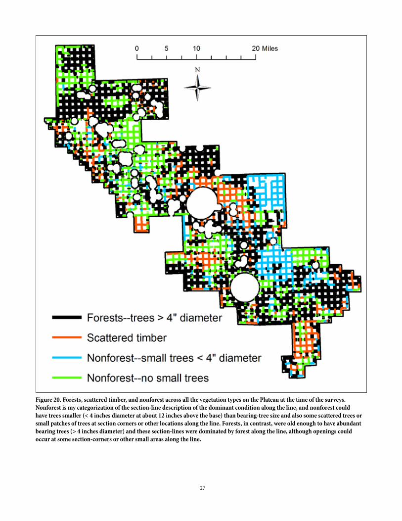
A map that is complementary to the aspen map, but for all the forest types on the Plateau, shows areas mapped by the surveyors as forests, scattered timber, and nonforest along section lines (Figure 20). “Forests” means that trees > 4" diameter were abundant, “scattered timber” was usually forest with few bearing trees and very low tree density, and nonforest was shrub-dominated vegetation or grasslands, usually with only a few trees or a few patches of trees. Since it takes about 47 years for an aspen to reach 4" diameter (Binkley et al. 2014) and about 20 years for a conifer to reach 4" diameter (Matonis et al. 2014), it is likely that the forests on the map (Figure 20) did not burn severely in 1879, since most surveys were done < 23 years later, by 1902 (Figure 11c), but could have burned earlier. In contrast, it is plausible, even likely, that scattered timber and substantial nonforest (Figure 20) did burn in 1879 or in other fires known on the Plateau in the 1800s (e.g., 1842, 1851, 1855, 1863; Brown and Shepperd 2003).
Evidence of the early-1800s, 1879, 1900, and other fires on the Plateau from multiple sources
This preceding information about the Plateau’s landscape variability can be used, with other evidence from the early photographs and documents, and the aspen-dating study (Binkley et al. 2014) to better assess the three fires reported
in the introduction to have severely burned the Plateau. These fires were described as very severe and the Plateau as relatively treeless, the early-1800s fire having “largely denuded the Uncompahgre Plateau” (Riley 1904a p. 30). The 1879 fire was described similarly: “Indians had burned it slick. You could see cattle and deer as far away as your eyesight could make them out” (Marshall 1998 p. 36). The 1900 fire was also described as having removed most trees: “...practically destroying all the timber growing on the divide between the Uncompahgre and San Miguel Rivers...the whole region was swept bare of trees” (Michelsen 1901 p. 58). The early photographs confirm that these fires did cumulatively reduce or help maintain the conifer fraction at low levels, perhaps providing the feeling of a denuded landscape, though some patches of conifers did survive and aspen was common (Figures 24, 18, 21).
In the Uncompahgre forest-reserve report, Riley (1904b) further described evidence for the early-1800s fire or fires that he reported (Riley 1904a) had denuded the Uncompahgre Plateau:
“The indications are that this region was universally burned at some early period. Bits of charred stump and old logs are found throughout and on a large portion of the second growth area occasional old trees may be seen on fireproof rocky slopes or on the edges of low cliffs, showing clearly that there must have been once an older stand which was replaced by the present growth...Throughout the pine districts the indications are that the fire was very long ago, the one remaining outward sign being the charred surface of the bark showing in the fissures around the base of the large trees. A very slow period of growth about 90 years ago is also shown on the stumps of nearly all trees cut. The commercial spruce of the reserve is an immature stand about 90 years old, which apparently followed these fires.” (Riley 1904b p. 26-27)
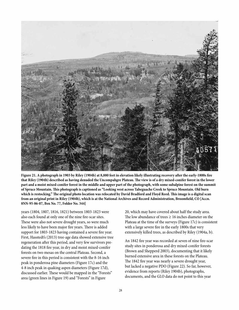
A photograph in Riley (Figure 21) is labeled an “old burn” and appears to illustrate recovery after the early-1800s fire he described. The estimate from Riley would place this early fire or fires at about 1813 (1903 minus 90 years). Fire-scar records from ponderosa pine and dry mixed-conifer forests on the Plateau show that the largest fire within 10 years on either side of 1813 was in 1818, when 3 of 9 fire-scar sites recorded this fire year (Brown and Shepperd 2003). The year 1818 was close to, but not quite a severe drought year, as were 1806, 1813, 1820 and 1824 (Figure 22). These latter four years, except 1813 at one site, were not years recorded at fire-scar sites, leaving 1818 the more likely severe fire year. Other known fire
27
Figure 20. Forests, scattered timber, and nonforest across all the vegetation types on the Plateau at the time of the surveys. Nonforest is my categorization of the section-line description of the dominant condition along the line, and nonforest could have trees smaller (< 4 inches diameter at about 12 inches above the base) than bearing-tree size and also some scattered trees or small patches of trees at section corners or other locations along the line. Forests, in contrast, were old enough to have abundant bearing trees (> 4 inches diameter) and these section-lines were dominated by forest along the line, although openings could occur at some section-corners or other small areas along the line.
28
years (1804, 1807, 1816, 1821) between 1803-1823 were also each found at only one of the nine fire-scar sites. These were also not severe drought years, so were much less likely to have been major fire years. There is added support for 1803-1823 having contained a severe fire year. First, Hasstedt’s (2013) tree-age data showed extensive tree regeneration after this period, and very few survivors pre-dating the 1818 fire year, in dry and moist mixed-conifer forests on two mesas on the central Plateau. Second, a severe fire in this period is consistent with the 8-16 inch peak in ponderosa pine diameters (Figure 17c) and the 4-8 inch peak in quaking aspen diameters (Figure 17d), discussed earlier. These would be mapped in the “Forests” area (green lines in Figure 19) and “Forests” in Figure
Figure 21. A photograph in 1903 by Riley (1904b) at 8,880 feet in elevation likely illustrating recovery after the early-1800s fire that Riley (1904b) described as having denuded the Uncompahgre Plateau. The view is of a dry mixed-conifer forest in the lower part and a moist mixed-conifer forest in the middle and upper part of the photograph, with some subalpine forest on the summit of Spruce Mountain. This photograph is captioned as “Looking west across Tabeguache Creek to Spruce Mountain. Old burn which is restocking.” The original photo location was relocated by David Bradford and Floyd Reed. This image is a digital scan from an original print in Riley (1904b), which is at the National Archives and Record Administration, Broomfield, CO [Accn. 8NN-95-86-07, Box No. 77, Folder No. 344]
20, which may have covered about half the study area. The low abundance of trees ≥ 16 inches diameter on the Plateau at the time of the surveys (Figure 17c) is consistent with a large severe fire in the early 1800s that very extensively killed trees, as described by Riley (1904a, b).
An 1842 fire year was recorded at seven of nine fire-scar study sites in ponderosa and dry mixed-conifer forests (Brown and Shepperd 2003), documenting that it likely burned extensive area in these forests on the Plateau. The 1842 fire year was nearly a severe drought year, but lacked a negative PDO (Figure 22). So far, however, evidence from reports (Riley 1904b), photographs, documents, and the GLO data do not point to this year
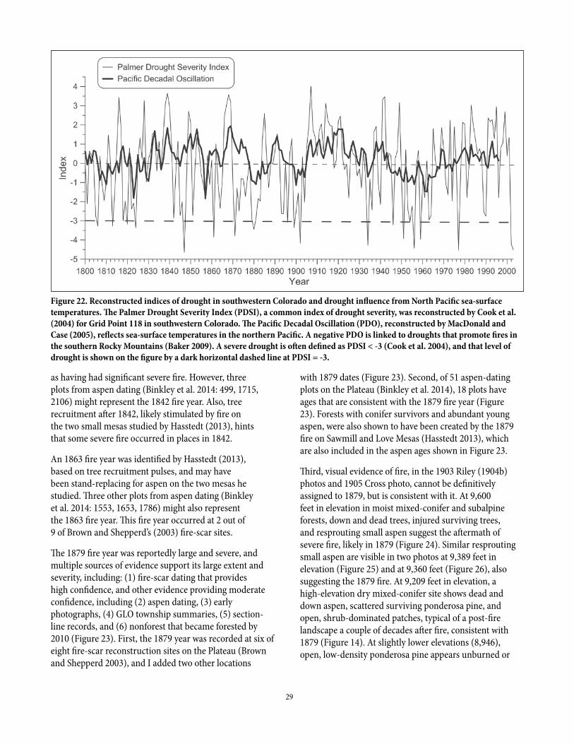
29
Figure 22. Reconstructed indices of drought in southwestern Colorado and drought influence from North Pacific sea-surface temperatures. The Palmer Drought Severity Index (PDSI), a common index of drought severity, was reconstructed by Cook et al. (2004) for Grid Point 118 in southwestern Colorado. The Pacific Decadal Oscillation (PDO), reconstructed by MacDonald and Case (2005), reflects sea-surface temperatures in the northern Pacific. A negative PDO is linked to droughts that promote fires in the southern Rocky Mountains (Baker 2009). A severe drought is often defined as PDSI < -3 (Cook et al. 2004), and that level of drought is shown on the figure by a dark horizontal dashed line at PDSI = -3.
as having had significant severe fire. However, three plots from aspen dating (Binkley et al. 2014: 499, 1715, 2106) might represent the 1842 fire year. Also, tree recruitment after 1842, likely stimulated by fire on the two small mesas studied by Hasstedt (2013), hints that some severe fire occurred in places in 1842.
An 1863 fire year was identified by Hasstedt (2013), based on tree recruitment pulses, and may have been stand-replacing for aspen on the two mesas he studied. Three other plots from aspen dating (Binkley et al. 2014: 1553, 1653, 1786) might also represent the 1863 fire year. This fire year occurred at 2 out of 9 of Brown and Shepperd’s (2003) fire-scar sites.
The 1879 fire year was reportedly large and severe, and multiple sources of evidence support its large extent and severity, including: (1) fire-scar dating that provides high confidence, and other evidence providing moderate confidence, including (2) aspen dating, (3) early photographs, (4) GLO township summaries, (5) section-line records, and (6) nonforest that became forested by 2010 (Figure 23). First, the 1879 year was recorded at six of eight fire-scar reconstruction sites on the Plateau (Brown and Shepperd 2003), and I added two other locations
with 1879 dates (Figure 23). Second, of 51 aspen-dating plots on the Plateau (Binkley et al. 2014), 18 plots have ages that are consistent with the 1879 fire year (Figure 23). Forests with conifer survivors and abundant young aspen, were also shown to have been created by the 1879 fire on Sawmill and Love Mesas (Hasstedt 2013), which are also included in the aspen ages shown in Figure 23.
Third, visual evidence of fire, in the 1903 Riley (1904b) photos and 1905 Cross photo, cannot be definitively assigned to 1879, but is consistent with it. At 9,600 feet in elevation in moist mixed-conifer and subalpine forests, down and dead trees, injured surviving trees, and resprouting small aspen suggest the aftermath of severe fire, likely in 1879 (Figure 24). Similar resprouting small aspen are visible in two photos at 9,389 feet in elevation (Figure 25) and at 9,360 feet (Figure 26), also suggesting the 1879 fire. At 9,209 feet in elevation, a high-elevation dry mixed-conifer site shows dead and down aspen, scattered surviving ponderosa pine, and open, shrub-dominated patches, typical of a post-fire landscape a couple of decades after fire, consistent with 1879 (Figure 14). At slightly lower elevations (8,946), open, low-density ponderosa pine appears unburned or
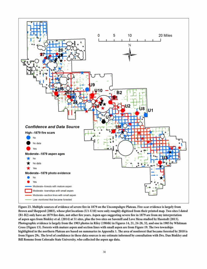
30
Figure 23. Multiple sources of evidence of severe fire in 1879 on the Uncompahgre Plateau. Fire-scar evidence is largely from Brown and Shepperd (2003), whose plot locations (U1-U10) were only roughly digitized from their printed map. Two sites I dated (B1-B2) only have an 1879 fire date, not other fire years. Aspen ages suggesting severe fire in 1879 are from my interpretation of aspen ages from Binkley et al. (2014) at 51 sites, plus the two sites on Sawmill and Love Mesa studied by Hasstedt (2013). Photographic evidence is largely from the 1903 photos in Riley (1904b) in Figures 14, 21, 24-28, 32, and one in 1905 by Whitman Cross (Figure 13). Forests with mature aspen and section lines with small aspen are from Figure 19. The two townships highlighted in the northern Plateau are based on summaries in Appendix 1. The area of nonforest that became forested by 2010 is from Figure 29c. The level of confidence in these data sources is my estimate informed by consultation with Drs. Dan Binkley and Bill Romme from Colorado State University, who collected the aspen age data.
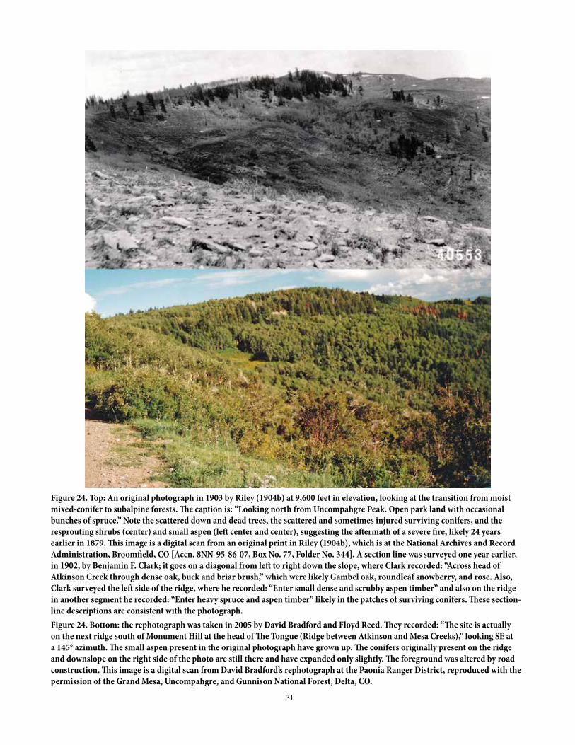
31
Figure 24. Top: An original photograph in 1903 by Riley (1904b) at 9,600 feet in elevation, looking at the transition from moist mixed-conifer to subalpine forests. The caption is: “Looking north from Uncompahgre Peak. Open park land with occasional bunches of spruce.” Note the scattered down and dead trees, the scattered and sometimes injured surviving conifers, and the resprouting shrubs (center) and small aspen (left center and center), suggesting the aftermath of a severe fire, likely 24 years earlier in 1879. This image is a digital scan from an original print in Riley (1904b), which is at the National Archives and Record Administration, Broomfield, CO [Accn. 8NN-95-86-07, Box No. 77, Folder No. 344]. A section line was surveyed one year earlier, in 1902, by Benjamin F. Clark; it goes on a diagonal from left to right down the slope, where Clark recorded: “Across head of Atkinson Creek through dense oak, buck and briar brush,” which were likely Gambel oak, roundleaf snowberry, and rose. Also, Clark surveyed the left side of the ridge, where he recorded: “Enter small dense and scrubby aspen timber” and also on the ridge in another segment he recorded: “Enter heavy spruce and aspen timber” likely in the patches of surviving conifers. These section-line descriptions are consistent with the photograph.Figure 24. Bottom: the rephotograph was taken in 2005 by David Bradford and Floyd Reed. They recorded: “The site is actually on the next ridge south of Monument Hill at the head of The Tongue (Ridge between Atkinson and Mesa Creeks),” looking SE at a 145° azimuth. The small aspen present in the original photograph have grown up. The conifers originally present on the ridge and downslope on the right side of the photo are still there and have expanded only slightly. The foreground was altered by road construction. This image is a digital scan from David Bradford’s rephotograph at the Paonia Ranger District, reproduced with the permission of the Grand Mesa, Uncompahgre, and Gunnison National Forest, Delta, CO.
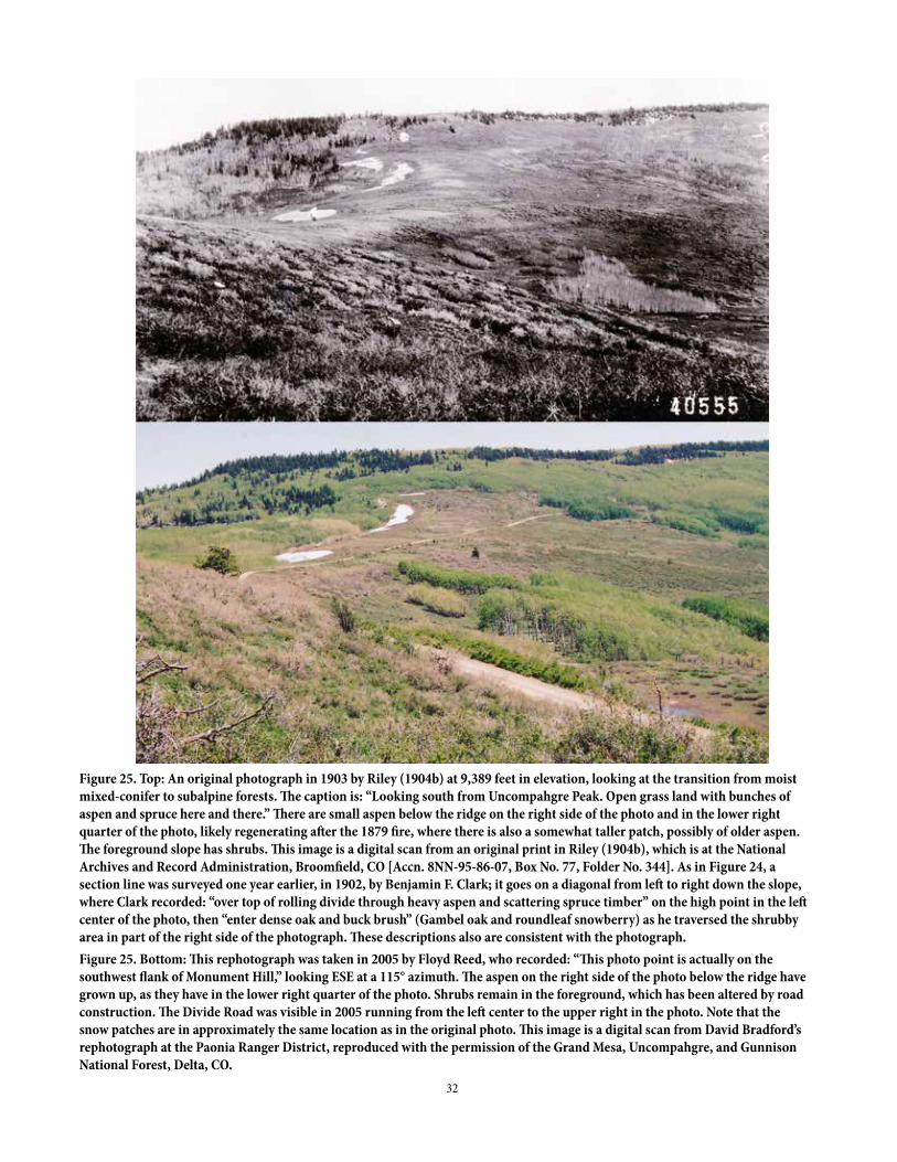
32
Figure 25. Top: An original photograph in 1903 by Riley (1904b) at 9,389 feet in elevation, looking at the transition from moist mixed-conifer to subalpine forests. The caption is: “Looking south from Uncompahgre Peak. Open grass land with bunches of aspen and spruce here and there.” There are small aspen below the ridge on the right side of the photo and in the lower right quarter of the photo, likely regenerating after the 1879 fire, where there is also a somewhat taller patch, possibly of older aspen. The foreground slope has shrubs. This image is a digital scan from an original print in Riley (1904b), which is at the National Archives and Record Administration, Broomfield, CO [Accn. 8NN-95-86-07, Box No. 77, Folder No. 344]. As in Figure 24, a section line was surveyed one year earlier, in 1902, by Benjamin F. Clark; it goes on a diagonal from left to right down the slope, where Clark recorded: “over top of rolling divide through heavy aspen and scattering spruce timber” on the high point in the left center of the photo, then “enter dense oak and buck brush” (Gambel oak and roundleaf snowberry) as he traversed the shrubby area in part of the right side of the photograph. These descriptions also are consistent with the photograph.Figure 25. Bottom: This rephotograph was taken in 2005 by Floyd Reed, who recorded: “This photo point is actually on the southwest flank of Monument Hill,” looking ESE at a 115° azimuth. The aspen on the right side of the photo below the ridge have grown up, as they have in the lower right quarter of the photo. Shrubs remain in the foreground, which has been altered by road construction. The Divide Road was visible in 2005 running from the left center to the upper right in the photo. Note that the snow patches are in approximately the same location as in the original photo. This image is a digital scan from David Bradford’s rephotograph at the Paonia Ranger District, reproduced with the permission of the Grand Mesa, Uncompahgre, and Gunnison National Forest, Delta, CO.
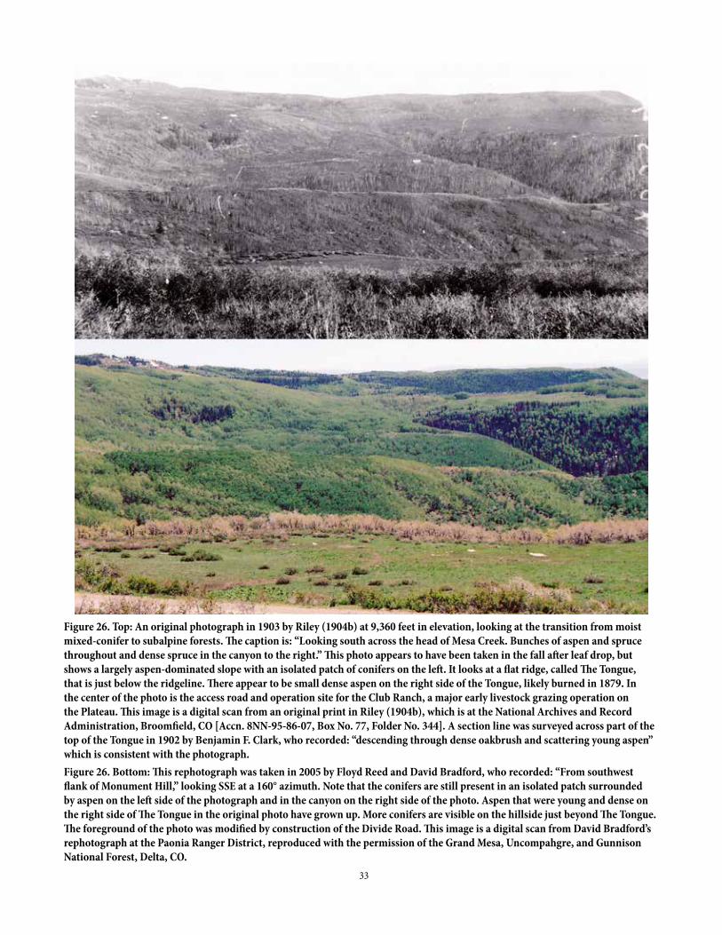
33
Figure 26. Top: An original photograph in 1903 by Riley (1904b) at 9,360 feet in elevation, looking at the transition from moist mixed-conifer to subalpine forests. The caption is: “Looking south across the head of Mesa Creek. Bunches of aspen and spruce throughout and dense spruce in the canyon to the right.” This photo appears to have been taken in the fall after leaf drop, but shows a largely aspen-dominated slope with an isolated patch of conifers on the left. It looks at a flat ridge, called The Tongue, that is just below the ridgeline. There appear to be small dense aspen on the right side of the Tongue, likely burned in 1879. In the center of the photo is the access road and operation site for the Club Ranch, a major early livestock grazing operation on the Plateau. This image is a digital scan from an original print in Riley (1904b), which is at the National Archives and Record Administration, Broomfield, CO [Accn. 8NN-95-86-07, Box No. 77, Folder No. 344]. A section line was surveyed across part of the top of the Tongue in 1902 by Benjamin F. Clark, who recorded: “descending through dense oakbrush and scattering young aspen” which is consistent with the photograph.Figure 26. Bottom: This rephotograph was taken in 2005 by Floyd Reed and David Bradford, who recorded: “From southwest flank of Monument Hill,” looking SSE at a 160° azimuth. Note that the conifers are still present in an isolated patch surrounded by aspen on the left side of the photograph and in the canyon on the right side of the photo. Aspen that were young and dense on the right side of The Tongue in the original photo have grown up. More conifers are visible on the hillside just beyond The Tongue. The foreground of the photo was modified by construction of the Divide Road. This image is a digital scan from David Bradford’s rephotograph at the Paonia Ranger District, reproduced with the permission of the Grand Mesa, Uncompahgre, and Gunnison National Forest, Delta, CO.
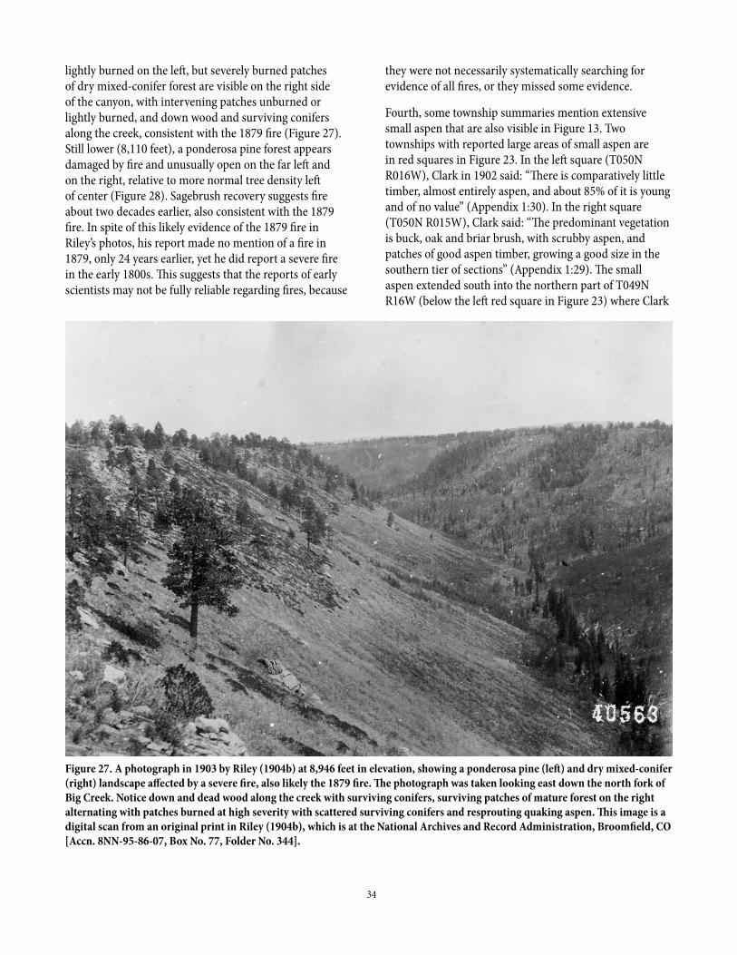
34
Figure 27. A photograph in 1903 by Riley (1904b) at 8,946 feet in elevation, showing a ponderosa pine (left) and dry mixed-conifer (right) landscape affected by a severe fire, also likely the 1879 fire. The photograph was taken looking east down the north fork of Big Creek. Notice down and dead wood along the creek with surviving conifers, surviving patches of mature forest on the right alternating with patches burned at high severity with scattered surviving conifers and resprouting quaking aspen. This image is a digital scan from an original print in Riley (1904b), which is at the National Archives and Record Administration, Broomfield, CO [Accn. 8NN-95-86-07, Box No. 77, Folder No. 344].
lightly burned on the left, but severely burned patches of dry mixed-conifer forest are visible on the right side of the canyon, with intervening patches unburned or lightly burned, and down wood and surviving conifers along the creek, consistent with the 1879 fire (Figure 27). Still lower (8,110 feet), a ponderosa pine forest appears damaged by fire and unusually open on the far left and on the right, relative to more normal tree density left of center (Figure 28). Sagebrush recovery suggests fire about two decades earlier, also consistent with the 1879 fire. In spite of this likely evidence of the 1879 fire in Riley’s photos, his report made no mention of a fire in 1879, only 24 years earlier, yet he did report a severe fire in the early 1800s. This suggests that the reports of early scientists may not be fully reliable regarding fires, because
they were not necessarily systematically searching for evidence of all fires, or they missed some evidence.
Fourth, some township summaries mention extensive small aspen that are also visible in Figure 13. Two townships with reported large areas of small aspen are in red squares in Figure 23. In the left square (T050N R016W), Clark in 1902 said: “There is comparatively little timber, almost entirely aspen, and about 85% of it is young and of no value” (Appendix 1:30). In the right square (T050N R015W), Clark said: “The predominant vegetation is buck, oak and briar brush, with scrubby aspen, and patches of good aspen timber, growing a good size in the southern tier of sections” (Appendix 1:29). The small aspen extended south into the northern part of T049N R16W (below the left red square in Figure 23) where Clark
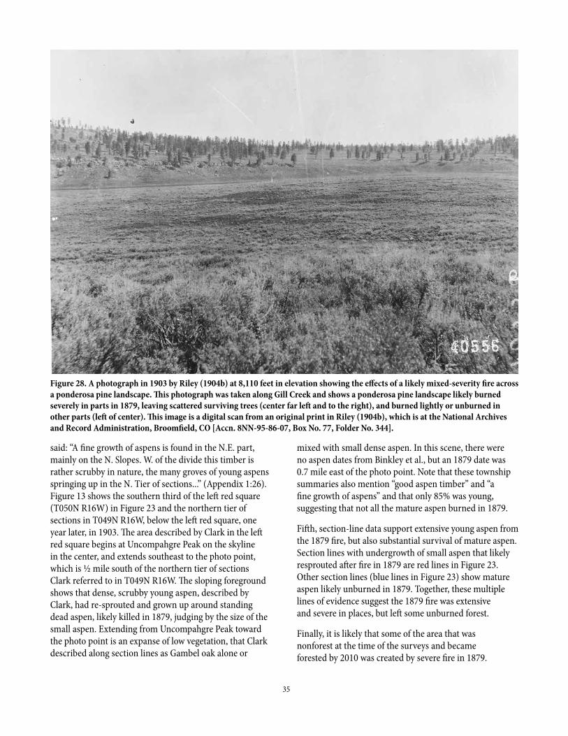
35
Figure 28. A photograph in 1903 by Riley (1904b) at 8,110 feet in elevation showing the effects of a likely mixed-severity fire across a ponderosa pine landscape. This photograph was taken along Gill Creek and shows a ponderosa pine landscape likely burned severely in parts in 1879, leaving scattered surviving trees (center far left and to the right), and burned lightly or unburned in other parts (left of center). This image is a digital scan from an original print in Riley (1904b), which is at the National Archives and Record Administration, Broomfield, CO [Accn. 8NN-95-86-07, Box No. 77, Folder No. 344].
said: “A fine growth of aspens is found in the N.E. part, mainly on the N. Slopes. W. of the divide this timber is rather scrubby in nature, the many groves of young aspens springing up in the N. Tier of sections...” (Appendix 1:26). Figure 13 shows the southern third of the left red square (T050N R16W) in Figure 23 and the northern tier of sections in T049N R16W, below the left red square, one year later, in 1903. The area described by Clark in the left red square begins at Uncompahgre Peak on the skyline in the center, and extends southeast to the photo point, which is ½ mile south of the northern tier of sections Clark referred to in T049N R16W. The sloping foreground shows that dense, scrubby young aspen, described by Clark, had re-sprouted and grown up around standing dead aspen, likely killed in 1879, judging by the size of the small aspen. Extending from Uncompahgre Peak toward the photo point is an expanse of low vegetation, that Clark described along section lines as Gambel oak alone or
mixed with small dense aspen. In this scene, there were no aspen dates from Binkley et al., but an 1879 date was 0.7 mile east of the photo point. Note that these township summaries also mention “good aspen timber” and “a fine growth of aspens” and that only 85% was young, suggesting that not all the mature aspen burned in 1879.
Fifth, section-line data support extensive young aspen from the 1879 fire, but also substantial survival of mature aspen. Section lines with undergrowth of small aspen that likely resprouted after fire in 1879 are red lines in Figure 23. Other section lines (blue lines in Figure 23) show mature aspen likely unburned in 1879. Together, these multiple lines of evidence suggest the 1879 fire was extensive and severe in places, but left some unburned forest.
Finally, it is likely that some of the area that was nonforest at the time of the surveys and became forested by 2010 was created by severe fire in 1879.
36
This area is shown (green lines in Figure 23) as low confidence, since how much is recovery after 1879, or other fire years, is uncertain. Higher confidence can be attached to the almost 1/3 of nonforest vegetation that already had small trees at the time of surveys (Figures 29b, c), which is more likely to have burned in 1879, and begun recovering via tree regeneration, as is not uncommon 24 years after fire (Baker 2009).
The area burned in 1879 can be roughly estimated from these multiple sources of evidence (Figure 23). First, my interpretation of the aspen dating (Binkley et al. 2014) suggests 18 of 51 plots plus the two areas studied by Hasstedt (2013), so 20 of 53 sites or about 38% of the aspen area on the Plateau originated in response to the 1879 fire (this is in red in Figure 23). Second, Figure 19 shows that less than half the aspen area at the time of the surveys, which is roughly consistent with the aspen dating, was dense undergrowth, including aspen either in nonforested or forested areas, that is likely the result of the 1879 fire. Third, in a 1901 report on fires in 1900 in Colorado, Michelsen (1901) reported that 200 square miles in Mesa County, 105 square miles in Montrose County, and 40 square miles in Ouray county were “Fire wasted” from fires before the 1900 fires, totaling about 221,000 acres. These areas were not mapped, and may not have been on the Plateau and could have been from unknown fires before 1879. However, the whole 221,000 acres could have been on the Plateau in 1879, which sets an upper limit for area burned severely in 1879, as severe effects of that fire year would still be somewhat visible in 1903-1905 (e.g., Figure 13). The 1903 photographs are also consistent with substantial 1879 fire. Overall, using these multiple lines of evidence, severe parts of the 1879 fire may have burned perhaps 38-45% of the aspen area, and up to about 1/3 of the total study area on the Plateau (about 185,000 acres), but if the area that was nonforest and became forest was added, then the total area burned severely was likely more than 1/3, perhaps approaching the 221,000 acres reported by Michelsen (1901), so that the range of area possibly burned severely is estimated at about 185,000-221,000 acres. The total area burned in 1879 at any severity is not known, but also likely more.
The evidence of severe fire is scattered across the study area (Figure 23), suggesting that much of the Plateau had some fire nearby in 1879. Some substantial forest patches did not burn severely (blue areas in Figure 23) including large patches in the northern Plateau, central Plateau, and southern Plateau. Forests that likely did not burn severely in 1879 are most visible in Figure 20 (black lines), which
includes all forest types. Likely severe fire in 1879 appears concentrated in a large patch on the southern Plateau, in the two townships in the northern Plateau, and around the northern and eastern perimeter of the sawmill area (large empty circle) in the central Plateau (Figure 23). This latter area was likely larger, including the whole body of scattered timber north and east of the sawmill area (Figure 20). Often, there was complexity to the pattern, with unburned and burned in a mosaic at the section scale (Figure 23). This finer-scale complexity cannot be fully revealed by the land-surveys, but more detailed tree-ring reconstructions also show substantial variability among stands (Matonis et al. 2014) consistent with this pattern.
The 1879 fire year was notable in other areas of Colorado and the southern Rocky Mountains. Hough (1882 p. 196) said, in a government report on forestry and fires in Colorado: “Extensive fires also occurred in the western part of the State in 1879 ... Hundreds of square miles were burned over and immense damages done to the timber.” Another government report about Colorado (Egleston 1884 p. 183) said: “At least one-half of the woodlands have been injured by forest fires. In 1879 the Ute Indians burnt millions of acres of timber on the western slope.” Early settlers and scientists did not understand that lightning could ignite fires, and often reasoned incorrectly that, if settlers did not ignite fires, then Indians must have (Baker 2009). Tree-ring reconstructions and early documents support these reports that 1879 fires burned many parts of the southern Rocky Mountains severely, including in northern New Mexico (Margolis et al. 2007), southwestern Colorado (Paulson and Baker 2006), and northern Colorado (Baker 2009).
Regarding the reported 1900 severe fire on the Plateau (Michelsen 1901), no other fire is shown in Mesa, Montrose, or Ouray counties (Figure 9), and a table in Michelsen (1901) shows the burned areas in 1900 in these counties to have been 0, 135, and 34 square miles, respectively, a total of about 108,000 acres. The report of 0 acres burned in Mesa County must be a mistake, as considerable burned area is shown in this county on the map (Figure 9). I estimate this might have been 50 square miles, bringing the total on the Plateau to very roughly 140,000 acres. The map and table, of course, are likely also quite roughly estimated, given the difficulty in accessing and mapping on the Plateau in 1900, but it is clear this was reported to be a very large fire on the Plateau. Surprisingly, the Uncompahgre forest-reserve report (Riley 1904b) does not mention fire on the Plateau in 1900, but instead says: “The only two recent burns
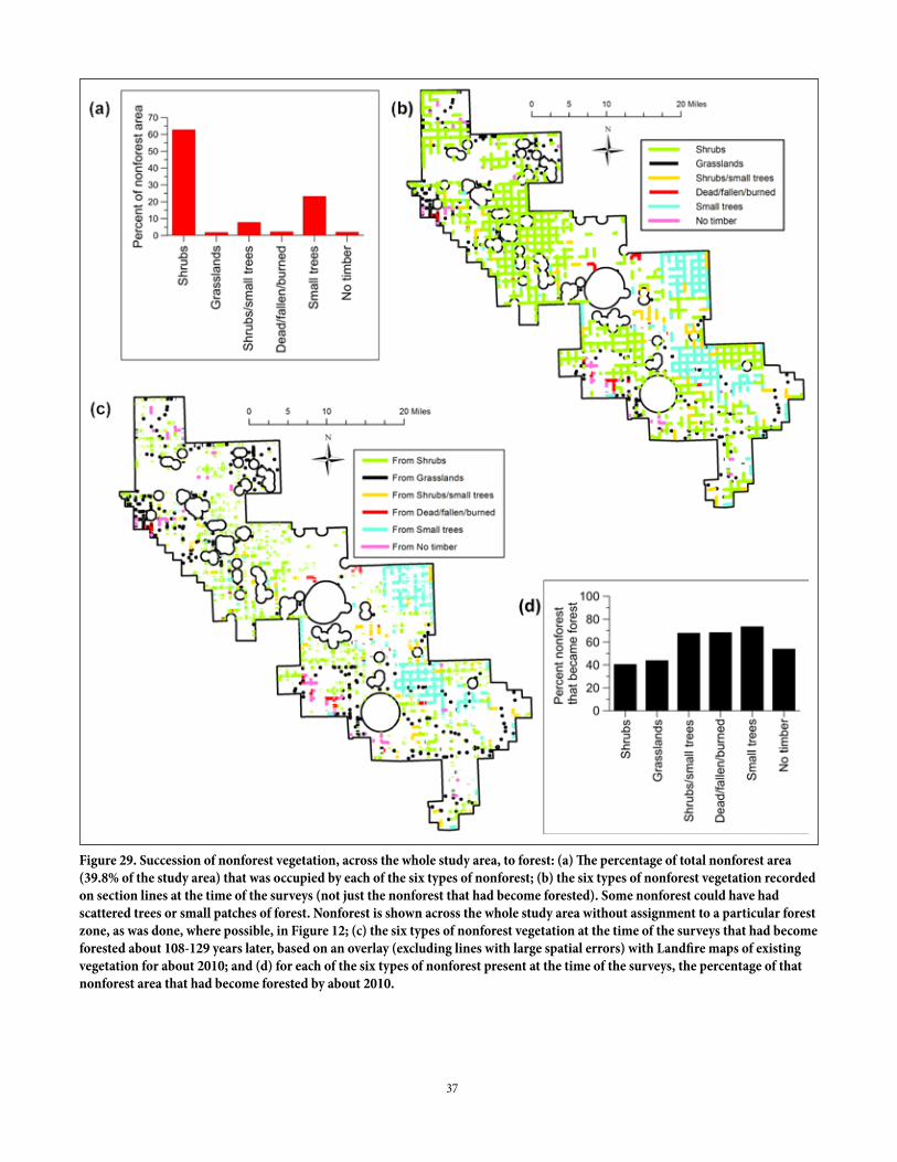
37
Figure 29. Succession of nonforest vegetation, across the whole study area, to forest: (a) The percentage of total nonforest area (39.8% of the study area) that was occupied by each of the six types of nonforest; (b) the six types of nonforest vegetation recorded on section lines at the time of the surveys (not just the nonforest that had become forested). Some nonforest could have had scattered trees or small patches of forest. Nonforest is shown across the whole study area without assignment to a particular forest zone, as was done, where possible, in Figure 12; (c) the six types of nonforest vegetation at the time of the surveys that had become forested about 108-129 years later, based on an overlay (excluding lines with large spatial errors) with Landfire maps of existing vegetation for about 2010; and (d) for each of the six types of nonforest present at the time of the surveys, the percentage of that nonforest area that had become forested by about 2010.
38
within the area occurred during the summers of 1901 and 1902 in Township 47 North, Range 12 West, and covered about 420 acres” (Riley 1904b p. 27). However, Riley also did not mention the 1879 fire, even though his 1903 photos (Figures 14, 21, 24-28, 32) likely show effects of this fire that should have been evident to him. The 1900 fire year was also not recorded at six fire-scar reconstruction sites that had some records extending past 1900. Unfortunately, these records are limited to ponderosa pine and dry mixed-conifer forests at mid- to lower elevations of the Plateau (Brown and Shepperd 2003), whereas Michelsen (1901) suggests it was on the divide itself that the fire was most severe. Also, Marshall (1998) does not mention a 1900 fire, instead discussing only the 1879 fire.
It is difficult to explain these omissions by Riley and Marshall if the 1900 fire really was as large and severe as reported by Michelsen. It also seems implausible that a second very large and severe fire would have burned in 1900, only 21 years after the very large 1879 fire. If it did, possibly the 1879 fire left such a disturbed landscape (Figure 23) that effects of the 1900 fire were somehow not obvious to Riley (1904b) or recalled by the early residents that Marshall interviewed. Or, possibly, the 1900 fire burned severely in parts of the Plateau not in these photographs or visited by Riley (1904b). Two plots from the aspen dating (Binkley et al. 2014, plots 457, 2021) might plausibly have originated after a 1900 fire. Finally, it is possible that local observers who contributed to the 1901 report (Michelsen 1901) could not map actual area burned on the Plateau and just overestimated it, but such a large overestimation is hard to understand. The GLO surveys, unfortunately, provide limited evidence, as about 2/3 of the Plateau was surveyed before 1900. This reported severe fire year remains an enigma, but currently has no substantial corroborating evidence for having been a large fire as was reported.
Climatic conditions likely helped set the stage for reported severe fires. Tree-ring reconstruction of a common drought index, the Palmer Drought Severity Index (PDSI), in southwestern Colorado (Cook et al. 2004) shows that severe droughts (< -3 PDSI) occurred about 15 times since 1800 (Figure 22). A negative Pacific Decadal Oscillation (PDO) is linked to droughts that promote fires in the southern Rocky Mountains (Baker 2009). The known severe fire on the Plateau in 1879 and reported one in 1900 were in years with PDSI less than about -2.5 and a negative PDO, suggesting a role for fairly severe drought. Fire in 1842, a fairly severe drought year, but without a negative PDO, was likely extensive, found at 7 of 9 fire-
scar sites in ponderosa and dry mixed-conifer forests (Brown and Shepperd 2003). However, other fairly severe droughts with negative PDO occurred in 1806, 1813, 1820, 1824, 1845, 1851, 1880, 1881, 1896, 1899, and 1902 (Figure 22), but are not known to have led to large, severe fires on the Plateau. Fire was recorded in 1813 and 1845 at only one site each, and not in 1806, 1820, 1824, 1880, 1881, 1896, or 1899 on the Plateau (Brown and Shepperd 2003). There was a small fire in 1902 (Riley 1904b). Fairly severe droughts are associated with the 1879 and 1900 fires on the Plateau, but only perhaps 10-20% of fairly severe droughts led to large, severe fires.
Fire severity across ponderosa pine and mixed-conifer landscapes
Fire severity is a measure of the physical and biological effects of fire, and, in forests, is often placed in three classes, described earlier: low-severity fire, moderate or mixed-severity fire, and high-severity fire (Figure 8). The fire-severity reconstructions show several patterns. The reconstructions apply only to roughly the century before the time of the surveys, from about 1780-1800 up to the time of the surveys, mostly done in 1881-1902. The first finding is that there was no area reconstructed to have had just low-severity fire in pine or mixed-conifer forests (Figure 30, Table 4). Some exclusive low-severity fire could have occurred in the small areas of large timber, mentioned when discussing tree diameters, not all of which may have been included in the sample. Low-severity fire certainly occurred in places, as is suggested by fire-scar evidence (Brown and Shepperd 2003). This contrasts with our reconstruction on the Mogollon Plateau, northern Arizona, where we found 62.4% of the landscape had evidence of only low-severity fire in the century preceding the late-1800s surveys (Williams and Baker 2012). The Colorado Front Range, however, was similar to the Uncompahgre Plateau, in having evidence of exclusive low-severity fire across only 2.5% of the landscape, with moderate amounts of mixed-severity fire, and abundant high-severity fire (Williams and Baker 2012).
Second, areas of the Plateau with mixed-severity fire were patchy and scattered, covering from 23.1% of the area of dry mixed-conifer forests to 29.2% of the area of ponderosa pine forests (Table 4) in a prevailing matrix showing evidence of high-severity fire (Figure 30). High-severity fire was dominant across all three major forest types of interest, covering from 70.8% of ponderosa pine forest area to 76.9% of dry mixed-conifer forest area (Table 4).
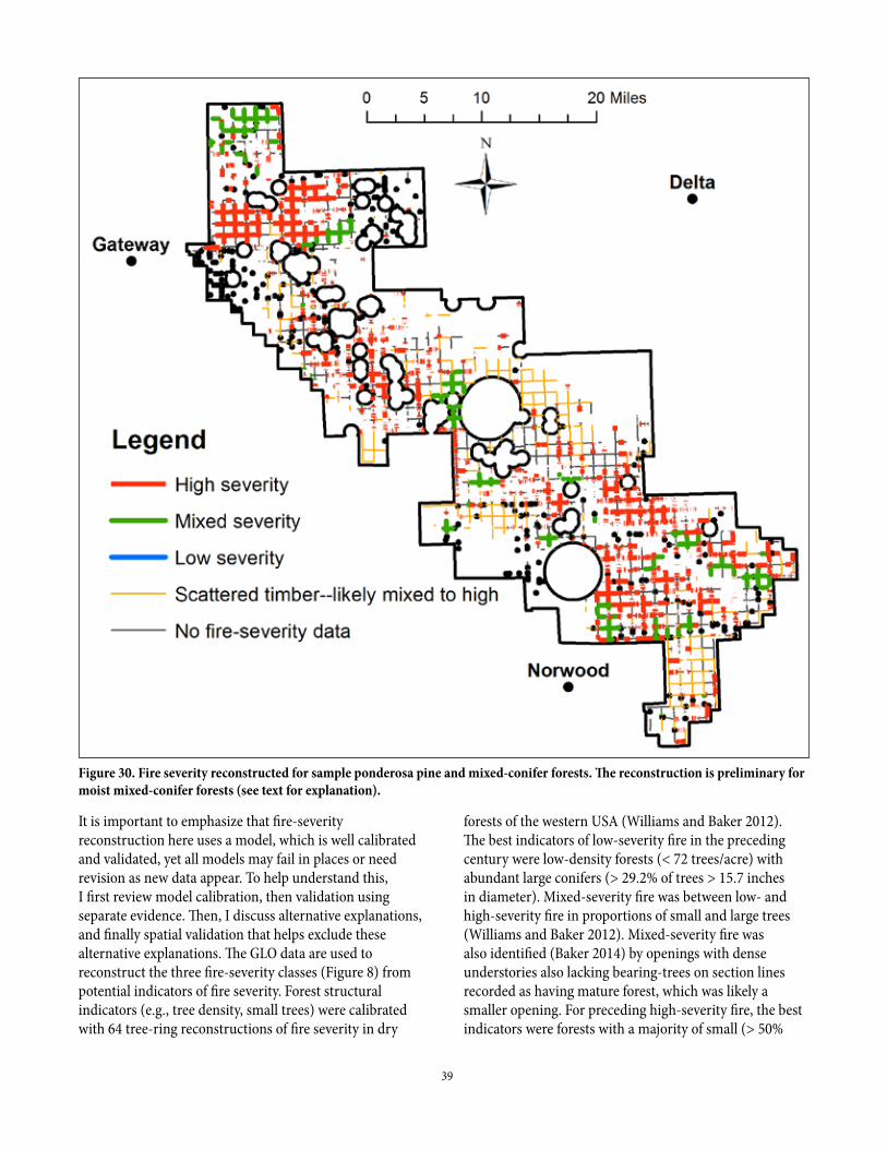
39
It is important to emphasize that fire-severity reconstruction here uses a model, which is well calibrated and validated, yet all models may fail in places or need revision as new data appear. To help understand this, I first review model calibration, then validation using separate evidence. Then, I discuss alternative explanations, and finally spatial validation that helps exclude these alternative explanations. The GLO data are used to reconstruct the three fire-severity classes (Figure 8) from potential indicators of fire severity. Forest structural indicators (e.g., tree density, small trees) were calibrated with 64 tree-ring reconstructions of fire severity in dry
forests of the western USA (Williams and Baker 2012). The best indicators of low-severity fire in the preceding century were low-density forests (< 72 trees/acre) with abundant large conifers (> 29.2% of trees > 15.7 inches in diameter). Mixed-severity fire was between low- and high-severity fire in proportions of small and large trees (Williams and Baker 2012). Mixed-severity fire was also identified (Baker 2014) by openings with dense understories also lacking bearing-trees on section lines recorded as having mature forest, which was likely a smaller opening. For preceding high-severity fire, the best indicators were forests with a majority of small (> 50%
Figure 30. Fire severity reconstructed for sample ponderosa pine and mixed-conifer forests. The reconstruction is preliminary for moist mixed-conifer forests (see text for explanation).
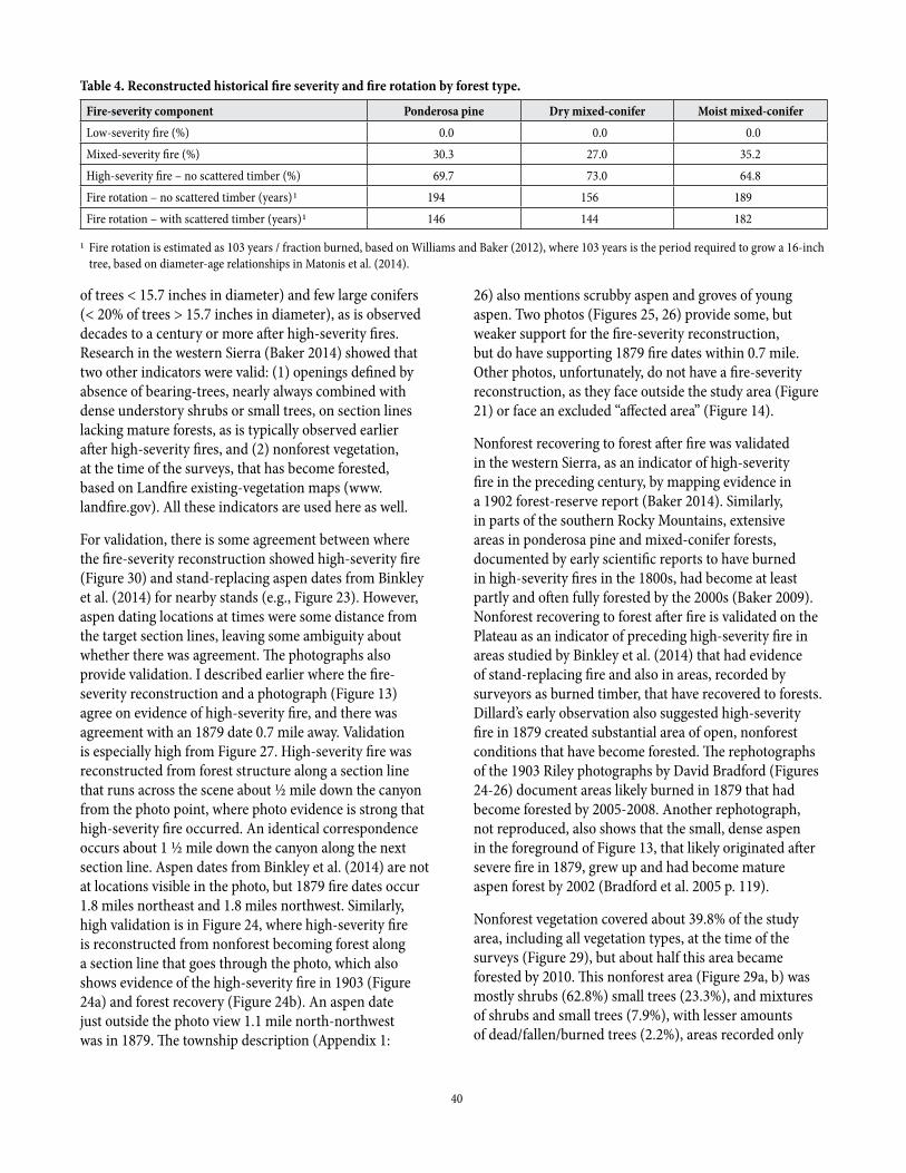
40
of trees < 15.7 inches in diameter) and few large conifers (< 20% of trees > 15.7 inches in diameter), as is observed decades to a century or more after high-severity fires. Research in the western Sierra (Baker 2014) showed that two other indicators were valid: (1) openings defined by absence of bearing-trees, nearly always combined with dense understory shrubs or small trees, on section lines lacking mature forests, as is typically observed earlier after high-severity fires, and (2) nonforest vegetation, at the time of the surveys, that has become forested, based on Landfire existing-vegetation maps (www.landfire.gov). All these indicators are used here as well.
For validation, there is some agreement between where the fire-severity reconstruction showed high-severity fire (Figure 30) and stand-replacing aspen dates from Binkley et al. (2014) for nearby stands (e.g., Figure 23). However, aspen dating locations at times were some distance from the target section lines, leaving some ambiguity about whether there was agreement. The photographs also provide validation. I described earlier where the fire-severity reconstruction and a photograph (Figure 13) agree on evidence of high-severity fire, and there was agreement with an 1879 date 0.7 mile away. Validation is especially high from Figure 27. High-severity fire was reconstructed from forest structure along a section line that runs across the scene about ½ mile down the canyon from the photo point, where photo evidence is strong that high-severity fire occurred. An identical correspondence occurs about 1 ½ mile down the canyon along the next section line. Aspen dates from Binkley et al. (2014) are not at locations visible in the photo, but 1879 fire dates occur 1.8 miles northeast and 1.8 miles northwest. Similarly, high validation is in Figure 24, where high-severity fire is reconstructed from nonforest becoming forest along a section line that goes through the photo, which also shows evidence of the high-severity fire in 1903 (Figure 24a) and forest recovery (Figure 24b). An aspen date just outside the photo view 1.1 mile north-northwest was in 1879. The township description (Appendix 1:
26) also mentions scrubby aspen and groves of young aspen. Two photos (Figures 25, 26) provide some, but weaker support for the fire-severity reconstruction, but do have supporting 1879 fire dates within 0.7 mile. Other photos, unfortunately, do not have a fire-severity reconstruction, as they face outside the study area (Figure 21) or face an excluded “affected area” (Figure 14).
Nonforest recovering to forest after fire was validated in the western Sierra, as an indicator of high-severity fire in the preceding century, by mapping evidence in a 1902 forest-reserve report (Baker 2014). Similarly, in parts of the southern Rocky Mountains, extensive areas in ponderosa pine and mixed-conifer forests, documented by early scientific reports to have burned in high-severity fires in the 1800s, had become at least partly and often fully forested by the 2000s (Baker 2009). Nonforest recovering to forest after fire is validated on the Plateau as an indicator of preceding high-severity fire in areas studied by Binkley et al. (2014) that had evidence of stand-replacing fire and also in areas, recorded by surveyors as burned timber, that have recovered to forests. Dillard’s early observation also suggested high-severity fire in 1879 created substantial area of open, nonforest conditions that have become forested. The rephotographs of the 1903 Riley photographs by David Bradford (Figures 24-26) document areas likely burned in 1879 that had become forested by 2005-2008. Another rephotograph, not reproduced, also shows that the small, dense aspen in the foreground of Figure 13, that likely originated after severe fire in 1879, grew up and had become mature aspen forest by 2002 (Bradford et al. 2005 p. 119).
Nonforest vegetation covered about 39.8% of the study area, including all vegetation types, at the time of the surveys (Figure 29), but about half this area became forested by 2010. This nonforest area (Figure 29a, b) was mostly shrubs (62.8%) small trees (23.3%), and mixtures of shrubs and small trees (7.9%), with lesser amounts of dead/fallen/burned trees (2.2%), areas recorded only
Table 4. Reconstructed historical fire severity and fire rotation by forest type.
Fire-severity component Ponderosa pine Dry mixed-conifer Moist mixed-coniferLow-severity fire (%) 0.0 0.0 0.0Mixed-severity fire (%) 30.3 27.0 35.2High-severity fire – no scattered timber (%) 69.7 73.0 64.8Fire rotation – no scattered timber (years)1 194.0 156.0 189.0Fire rotation – with scattered timber (years)1 146.0 144.0 182.0
1 Fire rotation is estimated as 103 years / fraction burned, based on Williams and Baker (2012), where 103 years is the period required to grow a 16-inch tree, based on diameter-age relationships in Matonis et al. (2014).
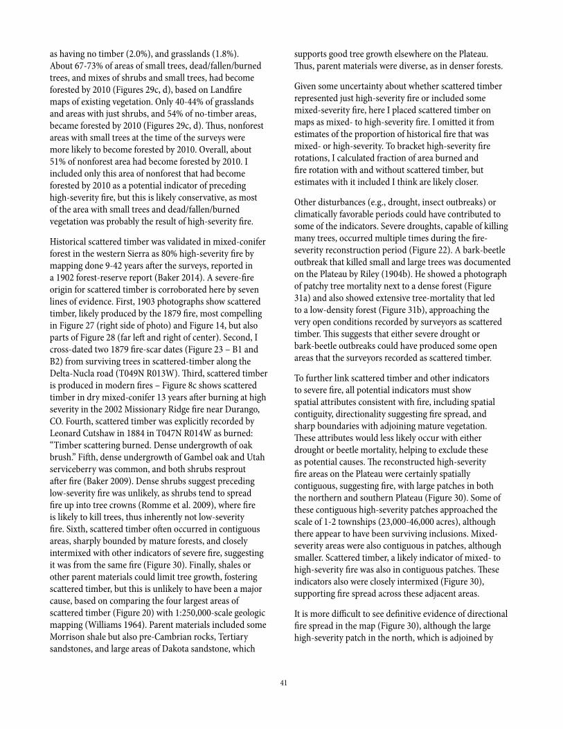
41
as having no timber (2.0%), and grasslands (1.8%). About 67-73% of areas of small trees, dead/fallen/burned trees, and mixes of shrubs and small trees, had become forested by 2010 (Figures 29c, d), based on Landfire maps of existing vegetation. Only 40-44% of grasslands and areas with just shrubs, and 54% of no-timber areas, became forested by 2010 (Figures 29c, d). Thus, nonforest areas with small trees at the time of the surveys were more likely to become forested by 2010. Overall, about 51% of nonforest area had become forested by 2010. I included only this area of nonforest that had become forested by 2010 as a potential indicator of preceding high-severity fire, but this is likely conservative, as most of the area with small trees and dead/fallen/burned vegetation was probably the result of high-severity fire.
Historical scattered timber was validated in mixed-conifer forest in the western Sierra as 80% high-severity fire by mapping done 9-42 years after the surveys, reported in a 1902 forest-reserve report (Baker 2014). A severe-fire origin for scattered timber is corroborated here by seven lines of evidence. First, 1903 photographs show scattered timber, likely produced by the 1879 fire, most compelling in Figure 27 (right side of photo) and Figure 14, but also parts of Figure 28 (far left and right of center). Second, I cross-dated two 1879 fire-scar dates (Figure 23 – B1 and B2) from surviving trees in scattered-timber along the Delta-Nucla road (T049N R013W). Third, scattered timber is produced in modern fires – Figure 8c shows scattered timber in dry mixed-conifer 13 years after burning at high severity in the 2002 Missionary Ridge fire near Durango, CO. Fourth, scattered timber was explicitly recorded by Leonard Cutshaw in 1884 in T047N R014W as burned: “Timber scattering burned. Dense undergrowth of oak brush.” Fifth, dense undergrowth of Gambel oak and Utah serviceberry was common, and both shrubs resprout after fire (Baker 2009). Dense shrubs suggest preceding low-severity fire was unlikely, as shrubs tend to spread fire up into tree crowns (Romme et al. 2009), where fire is likely to kill trees, thus inherently not low-severity fire. Sixth, scattered timber often occurred in contiguous areas, sharply bounded by mature forests, and closely intermixed with other indicators of severe fire, suggesting it was from the same fire (Figure 30). Finally, shales or other parent materials could limit tree growth, fostering scattered timber, but this is unlikely to have been a major cause, based on comparing the four largest areas of scattered timber (Figure 20) with 1:250,000-scale geologic mapping (Williams 1964). Parent materials included some Morrison shale but also pre-Cambrian rocks, Tertiary sandstones, and large areas of Dakota sandstone, which
supports good tree growth elsewhere on the Plateau. Thus, parent materials were diverse, as in denser forests.
Given some uncertainty about whether scattered timber represented just high-severity fire or included some mixed-severity fire, here I placed scattered timber on maps as mixed- to high-severity fire. I omitted it from estimates of the proportion of historical fire that was mixed- or high-severity. To bracket high-severity fire rotations, I calculated fraction of area burned and fire rotation with and without scattered timber, but estimates with it included I think are likely closer.
Other disturbances (e.g., drought, insect outbreaks) or climatically favorable periods could have contributed to some of the indicators. Severe droughts, capable of killing many trees, occurred multiple times during the fire-severity reconstruction period (Figure 22). A bark-beetle outbreak that killed small and large trees was documented on the Plateau by Riley (1904b). He showed a photograph of patchy tree mortality next to a dense forest (Figure 31a) and also showed extensive tree-mortality that led to a low-density forest (Figure 31b), approaching the very open conditions recorded by surveyors as scattered timber. This suggests that either severe drought or bark-beetle outbreaks could have produced some open areas that the surveyors recorded as scattered timber.
To further link scattered timber and other indicators to severe fire, all potential indicators must show spatial attributes consistent with fire, including spatial contiguity, directionality suggesting fire spread, and sharp boundaries with adjoining mature vegetation. These attributes would less likely occur with either drought or beetle mortality, helping to exclude these as potential causes. The reconstructed high-severity fire areas on the Plateau were certainly spatially contiguous, suggesting fire, with large patches in both the northern and southern Plateau (Figure 30). Some of these contiguous high-severity patches approached the scale of 1-2 townships (23,000-46,000 acres), although there appear to have been surviving inclusions. Mixed-severity areas were also contiguous in patches, although smaller. Scattered timber, a likely indicator of mixed- to high-severity fire was also in contiguous patches. These indicators also were closely intermixed (Figure 30), supporting fire spread across these adjacent areas.
It is more difficult to see definitive evidence of directional fire spread in the map (Figure 30), although the large high-severity patch in the north, which is adjoined by
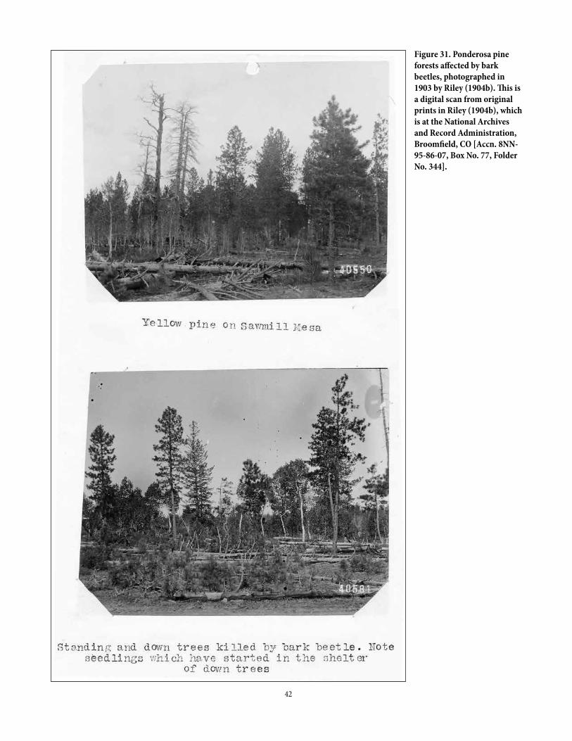
42
Figure 31. Ponderosa pine forests affected by bark beetles, photographed in 1903 by Riley (1904b). This is a digital scan from original prints in Riley (1904b), which is at the National Archives and Record Administration, Broomfield, CO [Accn. 8NN-95-86-07, Box No. 77, Folder No. 344].
43
mixed-severity fire on two sides, could indicate west-east spread bounded by lower fire severity on the sides, as expected. Similarly, the large patch in the south could have spread southwest to northeast. These patterns are also evident on the maps of aspen (Figure 19) and all forest types (Figure 20). The evidence regarding directionality is plausible, but not compelling for or against fire spread, but this could be because fire years other than the early 1800s, 1879, and 1900 contributed to the complex pattern evident in forest (Figures 19, 20) and fire-severity reconstructions (Figure 30).
It is also difficult to see sharp boundaries on the fire-severity map except between severities. However, on the map of aspen (Figure 19), nonforest areas with dense undergrowth including aspen, likely to have burned at high severity in 1879, have sharp boundaries with forests including aspen in the canopy, that likely did not burn in high-severity fires at the same time (Figure 19), as suggested above in the aspen section. Surveyors in the northern Plateau often recorded walking through mature aspen forests, described as heavily timbered or other terms indicating maturity, and suddenly entering dense small aspen. Similarly, sharp boundaries are evident and compelling between forests and nonforest or scattered timber (Figure 20). These spatial attributes increase the likelihood that the indicators all represent fire.
Of course, all reconstructions would benefit from additional validation, but the GLO fire-severity reconstructions have reasonable validation from research in other areas and also on the Plateau itself. These reconstructions provide the best available evidence at this point about historical fire severity across the Plateau’s pine and mixed-conifer landscapes. As new evidence appears, these reconstructions can be improved, by revising the calibration and validation (Williams and Baker 2012) using the new evidence. New maps, analyses, and interpretations can be made, which is an advantage as well as a limitation of a model-based reconstruction.
Finally, it is puzzling, given the evidence of a large severe fire in 1879 and a reported severe fire in 1900, that surveyors recorded only a few patches as dead, fallen, or burned timber (Figure 29b). Riley (1904a, 1904b) also does not mention evidence of an 1879 or 1900 fire. Michelsen (1901) did report earlier burned area that could have been from the 1879 fire. A possible explanation is that the extensive area of nonforest (Figure 29b) and reduced conifer forests at the time of the surveys could have been mainly set in place by fires in the early 1800s, as suggested by Riley (1904b). If so, burned trees from
this period of early-1800s fire were already mostly down and partially decomposed by the 1879 fire, which may have mostly renewed nonforest areas and top-killed aspen that had resprouted, while burning up down wood. In mixed-conifer in Oregon, a second severe fire reduced dead wood from a first one by 45% (Donato et al. 2016).
Successive severe fires, possibly beginning with the early-1800s fire, are consistent with the aspen (Figure 19), general forest (Figure 20) and fire-severity reconstructions (Figure 30). Successive severe fires beginning in the early 1800s are also consistent with ponderosa pine diameters peaked in the 8-16" size classes (Figure 17c), that suggest origins between 1780-1855. This period includes the 1818 fire year found at 1/3 of fire-scar sites (Brown and Shepperd 2003). Landscape-scale photographs from 1903 (Riley 1904b), and one by Whitman Cross in 1905, are also consistent, except in ponderosa pine (Figures 28, 32), in showing large areas with few conifers in an expansive matrix of quaking aspen and no large areas of burned conifers (Figures 13, 14, 21, 24-28). Large areas of aspen forest have been found elsewhere, through detailed fire-history reconstructions, to have originated after high-severity fires in mixed-conifer and subalpine forests (Margolis et al. 2007, Romme et al. 2009).
Still, areas of burned aspen should have led the surveyors to mention standing dead trees over large areas. It is possible the surveyors saw so much burned timber that they considered it unworthy of recording. This omission did occur on the Plateau in one case, in a township with some ponderosa, but mostly piñon-juniper; see the piñon-juniper section later. Finally, a substantial area was not surveyed until 1901-1902, when burned aspen were mostly down, with some re-sprouting tall enough to obscure dead trees (Figure 13), contributing to omission. Also, 9 of 16 townships surveyed in 1881-1885, when evidence of the 1879 fire would have been most obvious, were surveyed in winter, between November and March, when snow could have obscured down wood and absence of leaves left it unclear whether aspen were alive or dead.
Findings for types of forest landscapes from the land-surveysFor each of the forest types, it is possible to show more detail from the reconstructions, including details and maps of reconstructed fire severity and forest structure (Tables 2, 3, Figures 30, 33-38). Section-line data provide qualitative estimates of the historical
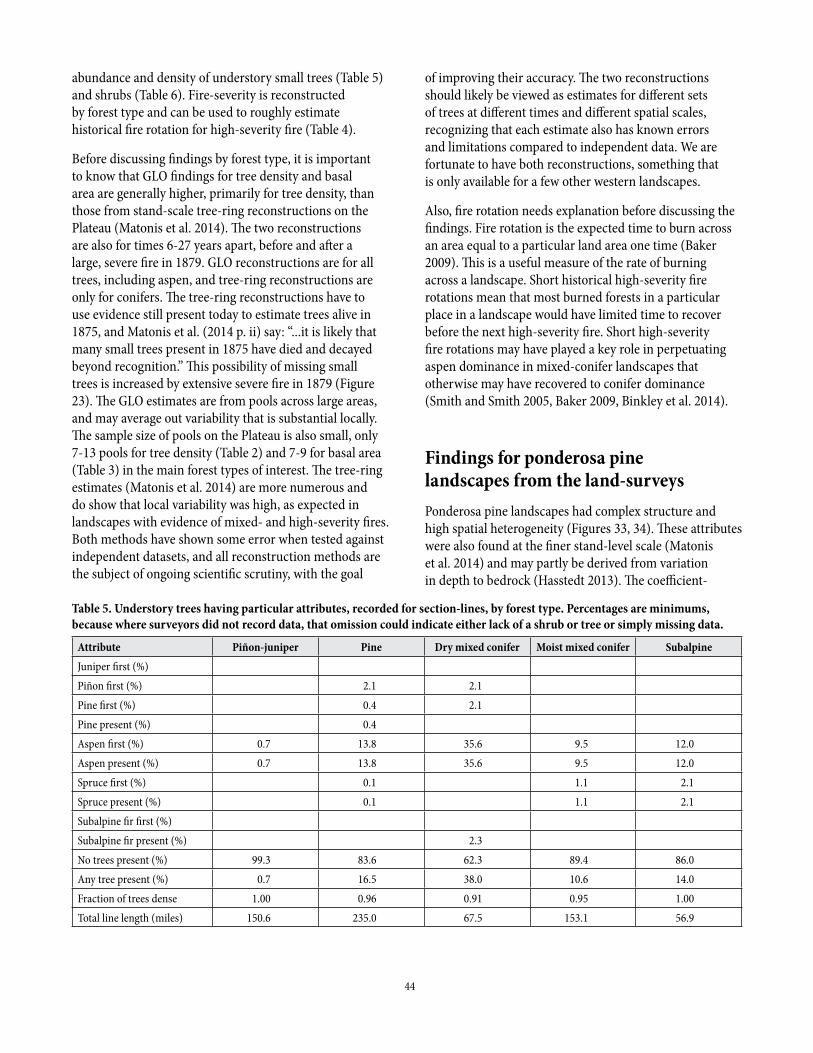
44
abundance and density of understory small trees (Table 5) and shrubs (Table 6). Fire-severity is reconstructed by forest type and can be used to roughly estimate historical fire rotation for high-severity fire (Table 4).
Before discussing findings by forest type, it is important to know that GLO findings for tree density and basal area are generally higher, primarily for tree density, than those from stand-scale tree-ring reconstructions on the Plateau (Matonis et al. 2014). The two reconstructions are also for times 6-27 years apart, before and after a large, severe fire in 1879. GLO reconstructions are for all trees, including aspen, and tree-ring reconstructions are only for conifers. The tree-ring reconstructions have to use evidence still present today to estimate trees alive in 1875, and Matonis et al. (2014 p. ii) say: “...it is likely that many small trees present in 1875 have died and decayed beyond recognition.” This possibility of missing small trees is increased by extensive severe fire in 1879 (Figure 23). The GLO estimates are from pools across large areas, and may average out variability that is substantial locally. The sample size of pools on the Plateau is also small, only 7-13 pools for tree density (Table 2) and 7-9 for basal area (Table 3) in the main forest types of interest. The tree-ring estimates (Matonis et al. 2014) are more numerous and do show that local variability was high, as expected in landscapes with evidence of mixed- and high-severity fires. Both methods have shown some error when tested against independent datasets, and all reconstruction methods are the subject of ongoing scientific scrutiny, with the goal
of improving their accuracy. The two reconstructions should likely be viewed as estimates for different sets of trees at different times and different spatial scales, recognizing that each estimate also has known errors and limitations compared to independent data. We are fortunate to have both reconstructions, something that is only available for a few other western landscapes.
Also, fire rotation needs explanation before discussing the findings. Fire rotation is the expected time to burn across an area equal to a particular land area one time (Baker 2009). This is a useful measure of the rate of burning across a landscape. Short historical high-severity fire rotations mean that most burned forests in a particular place in a landscape would have limited time to recover before the next high-severity fire. Short high-severity fire rotations may have played a key role in perpetuating aspen dominance in mixed-conifer landscapes that otherwise may have recovered to conifer dominance (Smith and Smith 2005, Baker 2009, Binkley et al. 2014).
Findings for ponderosa pine landscapes from the land-surveysPonderosa pine landscapes had complex structure and high spatial heterogeneity (Figures 33, 34). These attributes were also found at the finer stand-level scale (Matonis et al. 2014) and may partly be derived from variation in depth to bedrock (Hasstedt 2013). The coefficient-
Table 5. Understory trees having particular attributes, recorded for section-lines, by forest type. Percentages are minimums, because where surveyors did not record data, that omission could indicate either lack of a shrub or tree or simply missing data.
Attribute Piñon-juniper Pine Dry mixed conifer Moist mixed conifer SubalpineJuniper first (%)Piñon first (%) 2.1 2.1Pine first (%) 0.4 2.1Pine present (%) 0.4Aspen first (%) 0.7 13.8 35.6 9.5 12.0Aspen present (%) 0.7 13.8 35.6 9.5 12.0Spruce first (%) 0.1 1.1 2.1Spruce present (%) 0.1 1.1 2.1Subalpine fir first (%)Subalpine fir present (%) 2.3No trees present (%) 99.3 83.6 62.3 89.4 86.0Any tree present (%) 0.7 16.5 38.0 10.6 14.0Fraction of trees dense 1.00 0.96 0.91 0.95 1.00Total line length (miles) 150.6 235.0 67.5 153.1 56.9
45
of-variation (CV) in tree density of 47.3% (Table 2) was similar to the CV for tree density in related forests on the Mogollon Plateau (53.6%) and Coconino Plateau (45.6%) in northern Arizona (Williams and Baker 2013). High variation in tree density, likely from the 1879 fire, is visible in 1903 in Figure 28. There is some, but less variation in tree density visible in 1903 in Figure 32, which does not show visual evidence of the 1879 fire.
Overall, Uncompahgre ponderosa pine forests had lower mean tree density (68 trees/acre, Table 2) than reconstructed (Williams and Baker 2012) in the Colorado Front Range (88 trees/acre), about the same as in the Blue Mountains, Oregon (68 trees/acre), and a little higher than on the Mogollon Plateau, northern Arizona (57 trees/acre). Mean basal area of 45.3 ft2/acre in ponderosa pine on the Uncompahgre Plateau was similar to the 49.2 ft2/acre reconstructed for the Coconino Plateau, northern Arizona (Williams and Baker 2013). This suggests the Uncompahgre Plateau’s historical ponderosa pine landscapes do not stand out from other regional landscapes in terms of tree density, basal area, or heterogeneity across the landscape.
However, the Uncompahgre’s ponderosa pine landscapes were distinctive in several ways. Open, low-density ponderosa pine forests (e.g., < 41 trees/acre) with large, old trees and a history of low-severity fire, were often previously considered to have been the historical norm in western USA dry forests (Covington and Moore 1994). Low-density ponderosa pine forests did occur on the Uncompahgre Plateau over about 28.0% of the pine sample area (Table 2), primarily in
the central part of the Plateau (blue in Figure 33), but many low-density forests were small parts of areas of scattered timber (most visible in Figures 30, 33).
Overall, 40.0% of the ponderosa pine sample area had scattered timber (Figure 33), discussed earlier, likely indicating survivors after preceding mixed- to high-severity fire, as is visible in 1903 on the right side of Figure 14, and in parts of Figure 28. No other ponderosa landscape we have studied with GLO data (seven others) in the western USA (Baker and Williams 2015) had this high percentage of scattered timber. Most areas of scattered timber on the Plateau had few trees and likely very low tree density and basal area. Trees were abundant enough in a few parts of this scattered timber to allow tree density and basal area to be estimated. Some patches of just low tree density (< 41 trees/acre) were in scattered timber (Figure 33). Basal area was not low or especially high in these parts. Scattered timber at the southern end of the Plateau (Figure 34) had moderate basal area (44-61 ft2/acre), suggesting larger or denser surviving trees. This variability suggests severe fire created scattered timber with generally low tree density and basal area, but left some surviving smaller patches of forest with higher density and basal area.
In contrast, 47.8% of the ponderosa pine sample area had dense forests with > 81 trees/acre and 9.0% was very dense with > 121 trees/acre (Table 2). A dense, likely young forest affected by beetle mortality was illustrated on the Plateau in the Riley (1904b) forest-reserve report (Figure 31a). Dense forests (> 81 trees/acre) covered only 15.7-17.4% of the Mogollon Plateau and Coconino
Table 6. Understory shrubs having particular attributes, recorded for section-lines, by forest type. Percentages are minimums, because where surveyors did not record data, that omission could indicate either lack of a shrub or tree or simply missing data.
Attribute Piñon-juniper Pine Dry mixed conifer Moist mixed conifer SubalpineGambel oak first (%) 34.5 85.8 75.9 15.1 3.0Gambel oak present (%) 48.1 89.2 78.0 17.3 3.0Roundleaf snowberry first (%) 4.1 1.1 5.8 4.4Roundleaf snowberry present (%) 11.4 3.9 6.3 6.5 4.4Sagebrush first (%) 15.1 2.7 2.8 0.9Sagebrush present (%) 24.5 9.9 5.5 1.9Utah serviceberry first (%) 0.4Utah serviceberry present (%) 22.9 23.1 10.9 1.7Miscellaneous first (%) 0.8No shrub present (%) 45.9 10.4 21.5 77.4 93.0Any shrub present (%) 54.1 89.6 78.9 22.2 7.4Fraction of shrubs dense 0.62 0.96 0.81 0.9 0.4Total line length (miles) 200.6 131.9 47.4 84.4 22.5
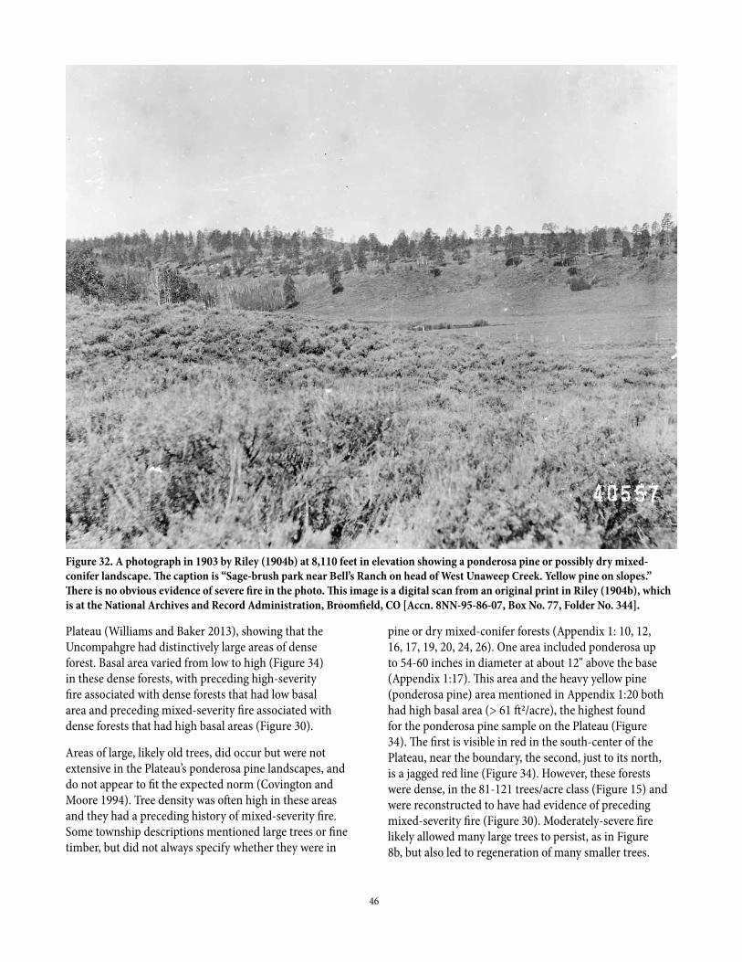
46
Plateau (Williams and Baker 2013), showing that the Uncompahgre had distinctively large areas of dense forest. Basal area varied from low to high (Figure 34) in these dense forests, with preceding high-severity fire associated with dense forests that had low basal area and preceding mixed-severity fire associated with dense forests that had high basal areas (Figure 30).
Areas of large, likely old trees, did occur but were not extensive in the Plateau’s ponderosa pine landscapes, and do not appear to fit the expected norm (Covington and Moore 1994). Tree density was often high in these areas and they had a preceding history of mixed-severity fire. Some township descriptions mentioned large trees or fine timber, but did not always specify whether they were in
pine or dry mixed-conifer forests (Appendix 1: 10, 12, 16, 17, 19, 20, 24, 26). One area included ponderosa up to 54-60 inches in diameter at about 12" above the base (Appendix 1:17). This area and the heavy yellow pine (ponderosa pine) area mentioned in Appendix 1:20 both had high basal area (> 61 ft2/acre), the highest found for the ponderosa pine sample on the Plateau (Figure 34). The first is visible in red in the south-center of the Plateau, near the boundary, the second, just to its north, is a jagged red line (Figure 34). However, these forests were dense, in the 81-121 trees/acre class (Figure 15) and were reconstructed to have had evidence of preceding mixed-severity fire (Figure 30). Moderately-severe fire likely allowed many large trees to persist, as in Figure 8b, but also led to regeneration of many smaller trees.
Figure 32. A photograph in 1903 by Riley (1904b) at 8,110 feet in elevation showing a ponderosa pine or possibly dry mixed-conifer landscape. The caption is “Sage-brush park near Bell’s Ranch on head of West Unaweep Creek. Yellow pine on slopes.” There is no obvious evidence of severe fire in the photo. This image is a digital scan from an original print in Riley (1904b), which is at the National Archives and Record Administration, Broomfield, CO [Accn. 8NN-95-86-07, Box No. 77, Folder No. 344].
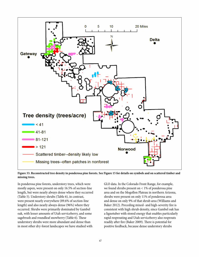
47
In ponderosa pine forests, understory trees, which were mostly aspen, were present on only 16.5% of section-line length, but were nearly always dense where they occurred (Table 5). Understory shrubs (Table 6), in contrast, were present nearly everywhere (89.6% of section-line length) and also nearly always dense (96%) where they occurred. Shrubs were primarily dominated by Gambel oak, with lesser amounts of Utah serviceberry, and some sagebrush and roundleaf snowberry (Table 6). These understory shrubs were more abundant and dense than in most other dry-forest landscapes we have studied with
GLO data. In the Colorado Front Range, for example, we found shrubs present on < 1% of ponderosa pine area and on the Mogollon Plateau in northern Arizona, shrubs were present on only 11% of ponderosa area and dense on only 9% of that shrub area (Williams and Baker 2012). Preceding mixed- and high-severity fire is consistent with high shrub density, since Gambel oak has a lignotuber with stored energy that enables particularly rapid resprouting and Utah serviceberry also resprouts readily after fire (Baker 2009). There is potential for positive feedback, because dense understory shrubs
Figure 33. Reconstructed tree density in ponderosa pine forests. See Figure 15 for details on symbols and on scattered timber and missing trees.
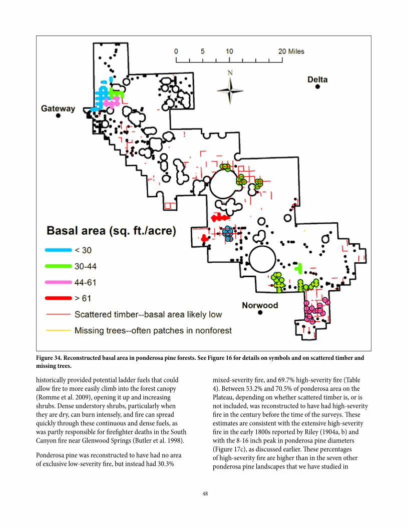
48
historically provided potential ladder fuels that could allow fire to more easily climb into the forest canopy (Romme et al. 2009), opening it up and increasing shrubs. Dense understory shrubs, particularly when they are dry, can burn intensely, and fire can spread quickly through these continuous and dense fuels, as was partly responsible for firefighter deaths in the South Canyon fire near Glenwood Springs (Butler et al. 1998).
Ponderosa pine was reconstructed to have had no area of exclusive low-severity fire, but instead had 30.3%
mixed-severity fire, and 69.7% high-severity fire (Table 4). Between 53.2% and 70.5% of ponderosa area on the Plateau, depending on whether scattered timber is, or is not included, was reconstructed to have had high-severity fire in the century before the time of the surveys. These estimates are consistent with the extensive high-severity fire in the early 1800s reported by Riley (1904a, b) and with the 8-16 inch peak in ponderosa pine diameters (Figure 17c), as discussed earlier. These percentages of high-severity fire are higher than in the seven other ponderosa pine landscapes that we have studied in
Figure 34. Reconstructed basal area in ponderosa pine forests. See Figure 16 for details on symbols and on scattered timber and missing trees.

49
the western USA. The corresponding estimated high-severity fire rotation of 146-194 years was also much shorter than in any other dry-forest landscape, where the range was 217-849 years (Baker 2015). Given that 53.2-70.5% of the ponderosa pine sample area likely burned at high-severity in the century before the surveys, it is also likely that ponderosa pine landscapes today have only partially recovered and are still undergoing natural recovery from 19th-century severe fires.
Findings for dry mixed-conifer landscapes from the land-surveysDry mixed-conifer landscapes also had complex spatial structure and high heterogeneity (Figures 35, 36) that appear similar to the Plateau’s ponderosa pine landscapes (Figures 33, 34). These do have similar coefficients of variation (CV) in tree density of 47-49% (Table 2). Dry mixed conifer had a lower CV for basal area, but that likely is just from larger reconstruction pools. The mean and median tree density and distribution of tree density across the quartiles were similar or only slightly different between ponderosa pine and dry mixed-conifer forests (Table 2).
The most distinctive difference was in basal area, as dry mixed-conifer forests had lower mean and median basal area than in ponderosa, and much less area with moderate and high basal area (Table 3). Also, 69.8% of the dry mixed-conifer forest area had < 30 ft2/acre of basal area, whereas ponderosa pine had only 27.5% of its area in that low basal-area class (Table 3). It is likely that extensive fires in the 1800s, including 1879, that killed many trees in dry mixed-conifer forests, led to these low basal areas. Dry mixed-conifer forests in 1903, likely with low basal area from the 1879 fire, are visible in burned areas on the right side of Figure 27 and in the bottom half of Figure 14. Another difference is that scattered timber only covered 16.3% of the dry mixed conifer, much less than the 40.0% scattered timber in ponderosa pine. Scattered timber in dry mixed-conifer forest in 1903 is visible on the right side of Figure 27 and in Figure 14.
Open, low-density (< 41 trees/acre) dry mixed-conifer forest did occur over 14.4% of the sample area, on the northern Plateau, but those forests had low tree density and low basal area (< 30 ft2/acre; Figures 35, 36), suggesting these were not generally old forests. They also had evidence of preceding mixed- and high-severity fire (Figure 30), as is evident elsewhere on the Plateau in 1903 (Figures 14 and 27). Evidence of mixed- and high-severity
fire in that area on the northern Plateau extended from the ponderosa on the west across into the whole area of dry mixed-conifer forest (Figure 30). This area of dry mixed-conifer forest had tree density varying from the lowest to the highest classes over roughly one township (about 23,000 acres), even though basal area was all in the lowest class (< 30 ft2/acre) except for a small part in the 30-44 ft2/acre class (Figure 36). This suggests severe fire killed many trees, leaving varying levels of survivors, accompanied also by variable tree regeneration that had filled openings. The only other patch of dry mixed-conifer forest in the sample, in the center of the Plateau, had moderate to high tree density (Figure 35) and higher basal area (44-61 ft2/acre class; Figure 36) than in the larger northern area.
Dense forests (> 81 trees/acre) also were abundant in the Uncompahgre’s dry mixed-conifer landscapes, covering 38.5% of its area, but a distinctive feature of the dry mixed-conifer forest was its 30.4% very dense forest (> 121 trees/acre), more than three times as much as in the ponderosa (9.0%; Table 2). This percentage of dense dry mixed-conifer forest on the Plateau was also very high relative to dry-forest landscapes in northern Arizona (Williams and Baker 2013), although those landscapes had comparatively little mixed-conifer forest area. Examples of historically dense dry mixed-conifer forest on the Plateau are visible in 1903 photos, the lower left quarter of Figure 21, and the two surviving forest patches right of center in Figure 27.
Understory trees were roughly twice as likely to be present, compared to ponderosa pine areas, but were also nearly always dense where they did occur, just as in the ponderosa, and aspen also was the main understory tree, with few others recorded (Table 5). Dense understory aspen was found across about 1/3 of dry mixed-conifer area. Understory shrubs were present over 78.9% of dry mixed-conifer area and dense on 81.0% of that shrub area, a little less presence and density than in the ponderosa, but with roughly the same set of shrubs (Table 6). Both dense understory aspen and shrubs are consistent with preceding severe fire.
Reconstructed fire-severity, with 27.0% mixed-severity and 73.0% high severity, was roughly similar in ponderosa and dry mixed-conifer, about 66-71% of the dry mixed-conifer having evidence of high-severity fire in the century preceding the surveys and a corresponding short high-severity fire rotation of 144-156 years (Table 4). Examples of high-severity fire in dry mixed conifer are visible in parts of Figures 14 and 27. The similarity in fire severity in the ponderosa and dry mixed-conifer may partly reflect
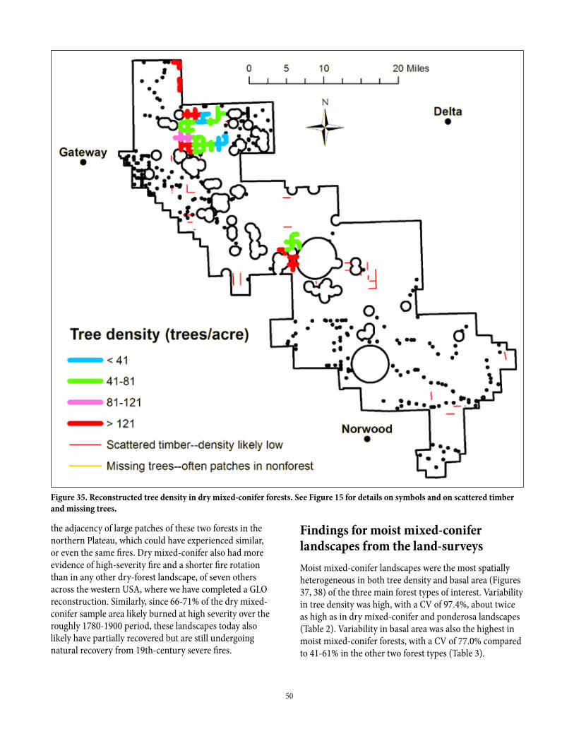
50
the adjacency of large patches of these two forests in the northern Plateau, which could have experienced similar, or even the same fires. Dry mixed-conifer also had more evidence of high-severity fire and a shorter fire rotation than in any other dry-forest landscape, of seven others across the western USA, where we have completed a GLO reconstruction. Similarly, since 66-71% of the dry mixed-conifer sample area likely burned at high severity over the roughly 1780-1900 period, these landscapes today also likely have partially recovered but are still undergoing natural recovery from 19th-century severe fires.
Findings for moist mixed-conifer landscapes from the land-surveysMoist mixed-conifer landscapes were the most spatially heterogeneous in both tree density and basal area (Figures 37, 38) of the three main forest types of interest. Variability in tree density was high, with a CV of 97.4%, about twice as high as in dry mixed-conifer and ponderosa landscapes (Table 2). Variability in basal area was also the highest in moist mixed-conifer forests, with a CV of 77.0% compared to 41-61% in the other two forest types (Table 3).
Figure 35. Reconstructed tree density in dry mixed-conifer forests. See Figure 15 for details on symbols and on scattered timber and missing trees.
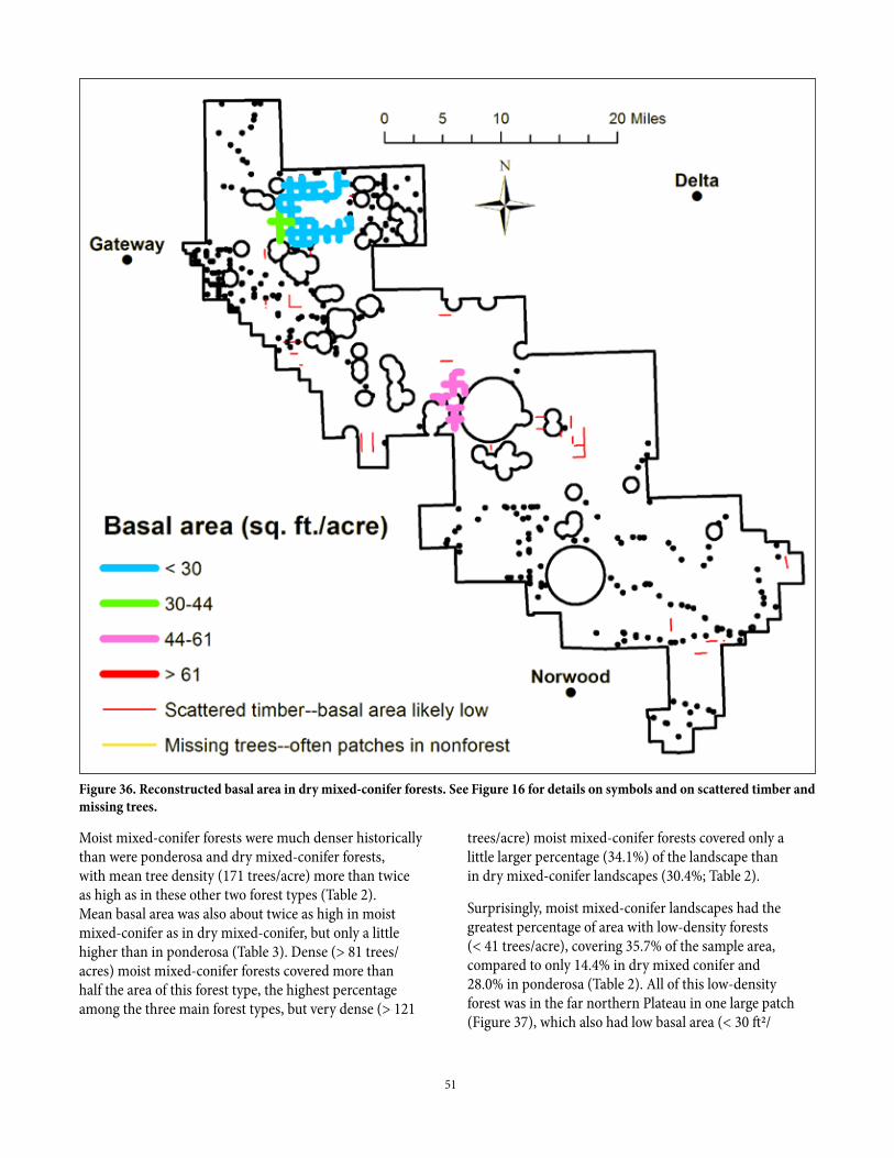
51
Figure 36. Reconstructed basal area in dry mixed-conifer forests. See Figure 16 for details on symbols and on scattered timber and missing trees.
Moist mixed-conifer forests were much denser historically than were ponderosa and dry mixed-conifer forests, with mean tree density (171 trees/acre) more than twice as high as in these other two forest types (Table 2). Mean basal area was also about twice as high in moist mixed-conifer as in dry mixed-conifer, but only a little higher than in ponderosa (Table 3). Dense (> 81 trees/acres) moist mixed-conifer forests covered more than half the area of this forest type, the highest percentage among the three main forest types, but very dense (> 121
trees/acre) moist mixed-conifer forests covered only a little larger percentage (34.1%) of the landscape than in dry mixed-conifer landscapes (30.4%; Table 2).
Surprisingly, moist mixed-conifer landscapes had the greatest percentage of area with low-density forests (< 41 trees/acre), covering 35.7% of the sample area, compared to only 14.4% in dry mixed conifer and 28.0% in ponderosa (Table 2). All of this low-density forest was in the far northern Plateau in one large patch (Figure 37), which also had low basal area (< 30 ft2/
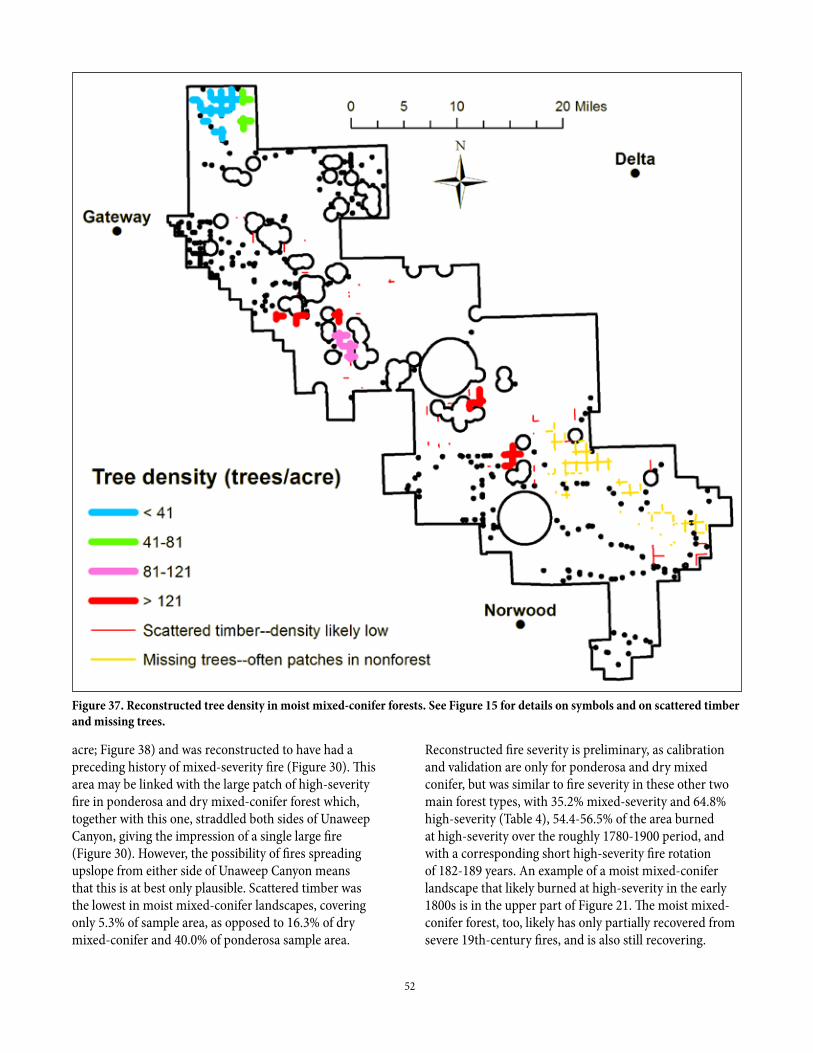
52
acre; Figure 38) and was reconstructed to have had a preceding history of mixed-severity fire (Figure 30). This area may be linked with the large patch of high-severity fire in ponderosa and dry mixed-conifer forest which, together with this one, straddled both sides of Unaweep Canyon, giving the impression of a single large fire (Figure 30). However, the possibility of fires spreading upslope from either side of Unaweep Canyon means that this is at best only plausible. Scattered timber was the lowest in moist mixed-conifer landscapes, covering only 5.3% of sample area, as opposed to 16.3% of dry mixed-conifer and 40.0% of ponderosa sample area.
Reconstructed fire severity is preliminary, as calibration and validation are only for ponderosa and dry mixed conifer, but was similar to fire severity in these other two main forest types, with 35.2% mixed-severity and 64.8% high-severity (Table 4), 54.4-56.5% of the area burned at high-severity over the roughly 1780-1900 period, and with a corresponding short high-severity fire rotation of 182-189 years. An example of a moist mixed-conifer landscape that likely burned at high-severity in the early 1800s is in the upper part of Figure 21. The moist mixed-conifer forest, too, likely has only partially recovered from severe 19th-century fires, and is also still recovering.
Figure 37. Reconstructed tree density in moist mixed-conifer forests. See Figure 15 for details on symbols and on scattered timber and missing trees.
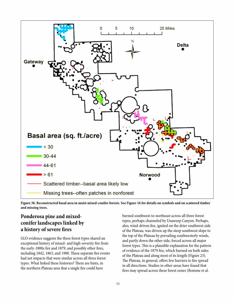
53
Ponderosa pine and mixed-conifer landscapes linked by a history of severe firesGLO evidence suggests the three forest types shared an exceptional history of mixed- and high-severity fire from the early-1800s fire and 1879, and possibly other fires, including 1842, 1863, and 1900. These separate fire events had net impacts that were similar across all three forest types. What linked these histories? There are hints, in the northern Plateau area that a single fire could have
burned southwest-to-northeast across all three forest types, perhaps channeled by Unaweep Canyon. Perhaps, also, wind-driven fire, ignited on the drier southwest side of the Plateau, was driven up the steep southwest slope to the top of the Plateau by prevailing southwesterly winds, and partly down the other side, forced across all major forest types. This is a plausible explanation for the pattern of evidence of the 1879 fire, which burned on both sides of the Plateau and along most of its length (Figure 23). The Plateau, in general, offers few barriers to fire spread in all directions. Studies in other areas have found that fires may spread across these forest zones (Romme et al.
Figure 38. Reconstructed basal area in moist mixed-conifer forests. See Figure 16 for details on symbols and on scattered timber and missing trees.
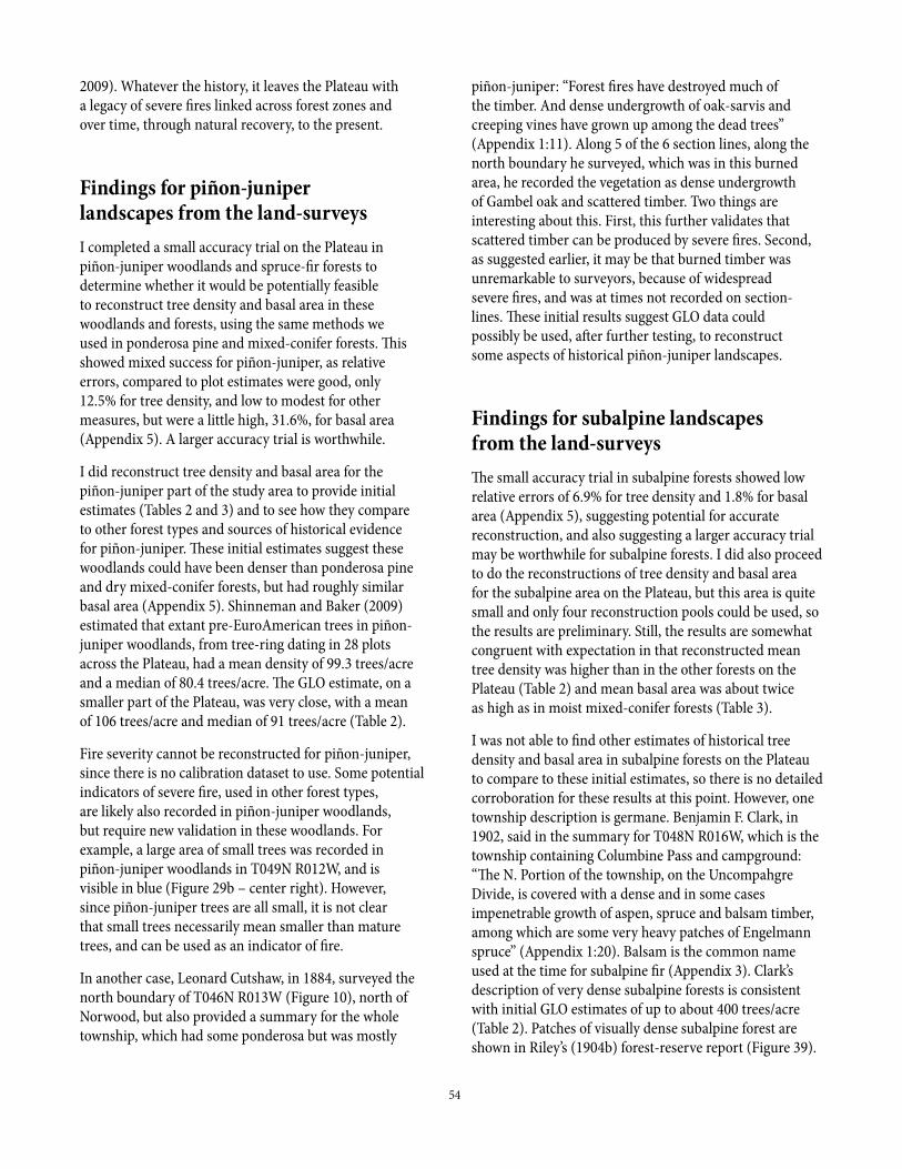
54
2009). Whatever the history, it leaves the Plateau with a legacy of severe fires linked across forest zones and over time, through natural recovery, to the present.
Findings for piñon-juniper landscapes from the land-surveysI completed a small accuracy trial on the Plateau in piñon-juniper woodlands and spruce-fir forests to determine whether it would be potentially feasible to reconstruct tree density and basal area in these woodlands and forests, using the same methods we used in ponderosa pine and mixed-conifer forests. This showed mixed success for piñon-juniper, as relative errors, compared to plot estimates were good, only 12.5% for tree density, and low to modest for other measures, but were a little high, 31.6%, for basal area (Appendix 5). A larger accuracy trial is worthwhile.
I did reconstruct tree density and basal area for the piñon-juniper part of the study area to provide initial estimates (Tables 2 and 3) and to see how they compare to other forest types and sources of historical evidence for piñon-juniper. These initial estimates suggest these woodlands could have been denser than ponderosa pine and dry mixed-conifer forests, but had roughly similar basal area (Appendix 5). Shinneman and Baker (2009) estimated that extant pre-EuroAmerican trees in piñon-juniper woodlands, from tree-ring dating in 28 plots across the Plateau, had a mean density of 99.3 trees/acre and a median of 80.4 trees/acre. The GLO estimate, on a smaller part of the Plateau, was very close, with a mean of 106 trees/acre and median of 91 trees/acre (Table 2).
Fire severity cannot be reconstructed for piñon-juniper, since there is no calibration dataset to use. Some potential indicators of severe fire, used in other forest types, are likely also recorded in piñon-juniper woodlands, but require new validation in these woodlands. For example, a large area of small trees was recorded in piñon-juniper woodlands in T049N R012W, and is visible in blue (Figure 29b – center right). However, since piñon-juniper trees are all small, it is not clear that small trees necessarily mean smaller than mature trees, and can be used as an indicator of fire.
In another case, Leonard Cutshaw, in 1884, surveyed the north boundary of T046N R013W (Figure 10), north of Norwood, but also provided a summary for the whole township, which had some ponderosa but was mostly
piñon-juniper: “Forest fires have destroyed much of the timber. And dense undergrowth of oak-sarvis and creeping vines have grown up among the dead trees” (Appendix 1:11). Along 5 of the 6 section lines, along the north boundary he surveyed, which was in this burned area, he recorded the vegetation as dense undergrowth of Gambel oak and scattered timber. Two things are interesting about this. First, this further validates that scattered timber can be produced by severe fires. Second, as suggested earlier, it may be that burned timber was unremarkable to surveyors, because of widespread severe fires, and was at times not recorded on section-lines. These initial results suggest GLO data could possibly be used, after further testing, to reconstruct some aspects of historical piñon-juniper landscapes.
Findings for subalpine landscapes from the land-surveysThe small accuracy trial in subalpine forests showed low relative errors of 6.9% for tree density and 1.8% for basal area (Appendix 5), suggesting potential for accurate reconstruction, and also suggesting a larger accuracy trial may be worthwhile for subalpine forests. I did also proceed to do the reconstructions of tree density and basal area for the subalpine area on the Plateau, but this area is quite small and only four reconstruction pools could be used, so the results are preliminary. Still, the results are somewhat congruent with expectation in that reconstructed mean tree density was higher than in the other forests on the Plateau (Table 2) and mean basal area was about twice as high as in moist mixed-conifer forests (Table 3).
I was not able to find other estimates of historical tree density and basal area in subalpine forests on the Plateau to compare to these initial estimates, so there is no detailed corroboration for these results at this point. However, one township description is germane. Benjamin F. Clark, in 1902, said in the summary for T048N R016W, which is the township containing Columbine Pass and campground: “The N. Portion of the township, on the Uncompahgre Divide, is covered with a dense and in some cases impenetrable growth of aspen, spruce and balsam timber, among which are some very heavy patches of Engelmann spruce” (Appendix 1:20). Balsam is the common name used at the time for subalpine fir (Appendix 3). Clark’s description of very dense subalpine forests is consistent with initial GLO estimates of up to about 400 trees/acre (Table 2). Patches of visually dense subalpine forest are shown in Riley’s (1904b) forest-reserve report (Figure 39).
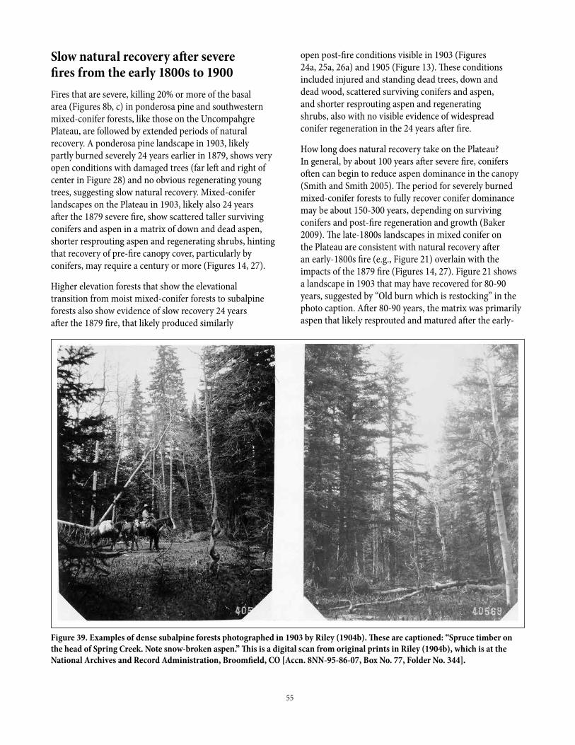
55
Slow natural recovery after severe fires from the early 1800s to 1900Fires that are severe, killing 20% or more of the basal area (Figures 8b, c) in ponderosa pine and southwestern mixed-conifer forests, like those on the Uncompahgre Plateau, are followed by extended periods of natural recovery. A ponderosa pine landscape in 1903, likely partly burned severely 24 years earlier in 1879, shows very open conditions with damaged trees (far left and right of center in Figure 28) and no obvious regenerating young trees, suggesting slow natural recovery. Mixed-conifer landscapes on the Plateau in 1903, likely also 24 years after the 1879 severe fire, show scattered taller surviving conifers and aspen in a matrix of down and dead aspen, shorter resprouting aspen and regenerating shrubs, hinting that recovery of pre-fire canopy cover, particularly by conifers, may require a century or more (Figures 14, 27).
Higher elevation forests that show the elevational transition from moist mixed-conifer forests to subalpine forests also show evidence of slow recovery 24 years after the 1879 fire, that likely produced similarly
open post-fire conditions visible in 1903 (Figures 24a, 25a, 26a) and 1905 (Figure 13). These conditions included injured and standing dead trees, down and dead wood, scattered surviving conifers and aspen, and shorter resprouting aspen and regenerating shrubs, also with no visible evidence of widespread conifer regeneration in the 24 years after fire.
How long does natural recovery take on the Plateau? In general, by about 100 years after severe fire, conifers often can begin to reduce aspen dominance in the canopy (Smith and Smith 2005). The period for severely burned mixed-conifer forests to fully recover conifer dominance may be about 150-300 years, depending on surviving conifers and post-fire regeneration and growth (Baker 2009). The late-1800s landscapes in mixed conifer on the Plateau are consistent with natural recovery after an early-1800s fire (e.g., Figure 21) overlain with the impacts of the 1879 fire (Figures 14, 27). Figure 21 shows a landscape in 1903 that may have recovered for 80-90 years, suggested by “Old burn which is restocking” in the photo caption. After 80-90 years, the matrix was primarily aspen that likely resprouted and matured after the early-
Figure 39. Examples of dense subalpine forests photographed in 1903 by Riley (1904b). These are captioned: “Spruce timber on the head of Spring Creek. Note snow-broken aspen.” This is a digital scan from original prints in Riley (1904b), which is at the National Archives and Record Administration, Broomfield, CO [Accn. 8NN-95-86-07, Box No. 77, Folder No. 344].
56
1800s fire. Conifers would have been about 14 inches in diameter (dbh), based on data in Matonis et al. (2014 Figure 2), so visible conifers likely were a mix of survivors and mid-sized post-fire trees. The GLO data show that partially recovered forests, as in this photo, dominated the Plateau, indicated by the peaks in aspen 4-8 inches in diameter and pine 8-16 inches in diameter, combined with some larger trees (Figures 17c, d), consistent with abundant recovery amid limited conifer survivors.
Similarly, the 2016 landscapes on the Plateau are, in general, consistent with remnant older forests, that recovered after fires earlier in the 1800s (the “forests” in Figures 19, 20, and 23), in a matrix of extensive naturally recovered aspen and conifers 137 years after the 1879 fire (parts of the red and green areas in Figure 23). Conifers 137 years old in the recovering forests in 2016 would be, on average, about 21 inches in diameter (dbh), based on data in Matonis et al. (2014 Figure 2). Aspen would be, on average, about 10-14 inches in diameter (dbh), based on Figure 2 in Binkley et al. (2014). Natural recovery since 1879 is documented in the transition between moist mixed-conifer and subalpine forests in the three rephotographs (Figures 24-26). Hasstedt’s age data for large trees on two mesas show a pulse of tree establishment for about 100 years, from the 1820s to the 1910s (Hasstedt 2013 Figure 2.5). Maps of tree ages show that few survived the 1818 fire that likely led to this 100-year pulse (Hasstedt 2013 Figure 2.8). If post-fire tree regeneration after 1879 also lasted a century, post-fire tree regeneration would have continued at least until 1980. After a century of tree regeneration, these newly established trees would continue to grow. Analysis of changes, from comparing aerial photos in 1937 and 1994 on the Plateau, supports that recovery was still underway, as there was a large increase in conifer cover in mixed-conifer landscapes, and conifers and aspen increased in shrublands, especially where management or fire did not occur (Manier et al. 2005).
A century of tree establishment and ongoing tree growth after severe fires, followed by another severe fire, is recognized as a natural process that maintains the Plateau’s aspen forests. Binkley et al. (2008 p. 5) said: “The UP forests in 1875 were shaped in part by previous fires (including widespread fires in 1842), and the fires of 1879 led to dramatic (natural) changes across the Plateau” and (p. 11) “...some of the apparent increase in basal area of conifers may be a natural result of decreasing aspen basal area during normal forest succession.” Later, Matonis et al. (2014 p. 3) said: “Widespread fires occurred in 1842 and 1879 across large swaths of the Plateau. Therefore, our historical estimates of forest structure
and composition might reflect ongoing recovery from large wildfires.” Based on dating of > 575 aspens and conifers in > 53 aspen and conifer stands in subalpine and dry mixed-conifer forests on the Plateau, Smith and Smith (2005 p. 346) said: “Within a century of stand establishment conifer height growth will equal or exceed that of aspen. The current shift in conifer dominance in mixed stands is likely to be the result of this change in competitive superiority from aspen to conifer stems...Since the last major fire events on the Plateau were recorded in 1879, the shifts in dominance measured 100 years later appear to be consistent with natural historic variation in vegetation cover for aspen forests in the western Rocky Mountains. Further, the successional cycle of aspen to conifers followed by stand-replacing fires is likely perpetuated by the nature of the fuels.” Reviewing mixed-conifer ecology in southwestern Colorado and northwestern New Mexico, Romme et al. (2009) emphasized the great diversity of possible outcomes of fire and the natural recovery process inherent in this zone.
Several studies suggested that short high-severity fire rotations maintain aspen abundance in mixed-conifer forests (reviewed in Smith and Smith 2005, Romme et al. 2009). The GLO estimate of historical fire rotations of 144-189 years (Table 4), combined with evidence that aspen dominated in historical mixed-conifer and subalpine forests on the Plateau (Figures 13, 14, 21, 24-28, 32), support this. Because of slow natural recovery, taking 150-300 years for conifers to fully overtop aspen, a sequence of severe fires with a fire rotation < 150 years favors aspen and limits conifers.
Land-use effects and natural recovery on the Plateau
Natural recovery likely remains a dominant process contributing to increased tree density and basal area across the Plateau’s ponderosa pine, mixed-conifer, and subalpine forest landscapes, and will likely remain so until the next severe fire. Two exceptions to a general landscape of recovery since EuroAmerican settlement are reduction in older ponderosas and other trees from logging and potentially enhanced survival of trees due to fire exclusion (Binkley et al. 2014, Matonis et al. 2014). Of course, some other management actions may have also affected these forests (Manier et al. 2005).
Binkley et al. (2014) considered two possibilities to explain high post-1879 aspen recruitment, either higher recruitment after 1880 due to fire exclusion from removal of grass and other fine fuels by excessive livestock grazing,

57
or stand-replacing fires in 1879. The evidence from the GLO surveys, early documents and reports, and the 1903-1905 photographs are more compelling that severe fire in 1879 was the cause of abundant post-1879 aspen recruitment, as reviewed earlier. Natural recovery is also supported by evidence in the township summaries, reviewed in the section on EuroAmerican land uses, that grass remained good for grazing and even abundant as late as 1902. This suggests that post-1879 aspen recruitment up to 1902 was unlikely to have been significantly increased by fire exclusion. Recovery likely proceeded after the 1879 fire in a generally natural way until at least 1902, although some impacts may have occurred.
An impact from fire exclusion is likely after 1902, but the actual effects are inherently difficult to detect or measure, in part because expected fire-exclusion effects are confounded with, and similar to some natural changes as forests recover from 1800s fires. By 1903, when Riley (1904b) examined the Plateau, access remained difficult, with the Divide Road in poor condition and few other main roads, limiting the effectiveness of intentional fire suppression. Intentional fire suppression was unlikely to have been very effective until after World War II, when aerial attack became more common (Baker 2009). Manier et al. (2005) also suggested that active fire suppression had less effect on the Plateau than in other western landscapes. However, indirect effects of livestock grazing could have had an earlier effect. Adverse livestock-grazing impacts likely reached a peak in the early 1900s, and, although grazing intensity declined substantially by the 1940s, legacies are still detectable (Paulson and Baker 2006). Reduced fine fuels and increased tree regeneration are some legacies that could affect fire in forests (Baker 2009).
Several features of the historical ecology of the Plateau’s forests suggest livestock grazing would have had some effect, but likely less than in Flagstaff-type forests with historically grassy understories and low-density forests. Shrubs were historically dominant and dense in most forest understories, although less so in moist mixed conifer (Table 6). Dense understory shrubs were found, through early historical accounts and photographs, to have historically dominated other parts of southwestern Colorado (Romme et al. 2009). Dense understory shrubs do not foster low-severity fires, as they competitively limit live fine fuels (e.g., grass) and are dense and tall enough to allow fire to move up into forest canopies, rather than remain as low-intensity fires (Romme et al. 2009). Since bunchgrasses were not dominant, reduction in grass would likely have had less effect on fire spread. Other fine fuels (e.g., small branchwood) could accumulate, as
shrubs do not prevent this, but rates of low-severity fire were likely low enough, given shrub dominance, that these fuels also accumulated historically. These historical characteristics do not prevent a fire-exclusion effect, but it would likely have been more limited than in other areas.
Fire exclusion does not have instantaneous effects, but instead spreads across a landscape as fires occur and are prevented, requiring roughly the low-severity fire-rotation to affect the whole landscape. Even after an effect has reached a location, it can take up to a few decades for tree regeneration to succeed (Baker 2009). Trees regenerating in the first few decades after the 1879 fire likely were not caused by fire exclusion, but their later survival could have been somewhat enhanced. Almost 1/3 of the nonforest vegetation at the time of the surveys, 2-23 years after 1879, already had small trees (Figure 29), suggesting trees from the period up to 1902, and even later, represent natural recovery after fire, not a fire-exclusion effect.
Evidence does not show that the large, infrequent fires, that likely most significantly shaped the Plateau’s forests over the last two centuries, have been generally suppressed so that the Plateau’s landscapes are consequently strongly affected by fire exclusion. First, evidence of historical intervals between large, severe fires is imprecisely known. The evidence in this report shows that the 1879 fire was extensive, but the actual extents of other likely large, severe fires are less well known. Even if these fires were better known, data for only two or three large fires would likely still be insufficient to precisely determine whether a particular period, like the 137-year period since the 1879 fire, occurred historically. Second, evidence from other areas suggests the Plateau experienced an exceptional period of severe fires in the period from the early 1800s to 1900, and this subsequent 137-year period or an even much longer period without severe fire was likely more typical. Estimated high-severity fire rotations for the Plateau’s ponderosa pine and dry mixed-conifer forests were 144-194 years (Table 4), which is unusually short. The previously known historical range of high-severity fire rotations across the ponderosa pine and dry mixed-conifer forests of the western USA was 217-849 years, based on other GLO studies, early historical records, and early aerial photographs, corroborated by charcoal in sediments (Baker 2015). This suggests the more likely explanation is that the Plateau experienced an unusual sequence of severe fires from the early 1800s to 1900 and is primarily naturally recovering from those fires, with only limited added indirect effects of fire exclusion. Romme et al. (2009 p. 98) similarly concluded for a larger area of southwestern Colorado: “Even though aspen cover has declined in
58
some areas...we view this trend as a natural successional process during a century of infrequent fire that followed the extensive fires of the second half of the 19th century.”
Discussion
Restoration approaches
The Plateau’s history of large, severe historical fires and impending increased fire from climate change together suggest more value in process and resilience approaches to restoration, and less in restoring specific structures, which were not all very stable in historical landscapes. Restoring and maintaining the historical fire process is key, as it will allow us to learn to live with fire, and will maintain and restore ecological resilience needed to foster recovery after severe fires.
However, restoring the fire process or resilience or specific structures can all contribute to restoration. The process approach seeks to restore fire itself, at rates and patterns guided by historical fires, because fire has been shown to most effectively re-create missing or altered historical structures and restore the natural resilience that characterized historical landscapes (van Wagtendonk and Lutz 2007). Managed fire for resource benefit is an example of process restoration. A resilience approach seeks to specifically restore structures that historically facilitated natural recovery, reducing changes in landscapes after disturbances (Angeler and Allen 2016). An example is restoring large trees more likely to survive and re-seed after fire. Restoring specific structures can be done by reversing effects of land uses, such as by protecting and enhancing growth of extant old trees to replace those logged, by reopening mini-meadows reduced by tree invasion, or by replanting bunchgrasses lost to overgrazing.
Historically infrequent large, severe fires on the Uncompahgre Plateau
The 1879 fire was a large, severe fire, based on GLO evidence, tree-ring dating, fire scars, and early photographs (Figure 23) as well as quotes from early residents. The evidence in Figure 23 shows the best that the available evidence can do to reconstruct the more severe parts of the 1879 fire. This severe area covered about 38-45% of the aspen area on the Plateau and perhaps 1/3 or more of the whole study area, possibly in the range of 185,000-221,000 acres. The 1879 fire was severe in the sense that it likely top-killed and thus regenerated
a large percentage of the aspen on the Plateau, killed many conifers, created considerable nonforest (e.g., grasslands, sagebrush, shrubfields) and maintained other existing nonforest. Although the ignition source for this fire is uncertain, and some EuroAmerican land uses had begun, this fire burned across what was largely a natural landscape relatively unaltered by EuroAmerican land uses. This large, severe 1879 fire represents part of the historical fire regime on the Plateau.
The early-1800s fire is less well known. Sources of evidence consistent with this fire include Riley’s (1904b) description, tree-ring dating, fire scars, a significant spike in tree diameters, and an early photograph showing forests likely recovered from this fire. The sharp peak in pine and spruce diameters and limited large aspen (Figure 17) support Riley’s (1904a) description of this fire or fires as having “largely denuded the Uncompahgre Plateau.” It would not be surprising if this early-1800s fire was very large, perhaps 1879 scale, based on this evidence. However, not enough evidence is available at this point to make it feasible to reconstruct more detail for this fire. The 1900 fire, as explained earlier, could have been large and severe, as it was reported, but other evidence is lacking, and it remains an enigma at this point.
Two large, severe fires in < 100 years may not seem “infrequent,” but the term provides a contrast to the term “frequent-fire,” which is often applied to low-intensity fires that have fire rotations of < 25 years (Baker 2009). Also, it is likely the 1800s had an exceptional period of these large, severe fires, as also occurred in other parts of the Rocky Mountains (Baker 2009).
Restoring the historical fire process
The historical evidence encourages preparation for future severe fires on the Plateau. No matter which restoration approaches are used, the infrequent severe fires that occurred historically will likely continue because of the Plateau’s climate, fuels, vegetation, and topography. Episodic severe droughts, that reduce fuel moisture to low levels, occurred many times over the last 200 years (Figure 22). And, as Smith and Smith (2005) explained, recovery after fires in the Plateau’s forests naturally increases fuel loads, that eventually facilitate another severe fire. Dense, tall understory shrubs, a striking feature of the Plateau’s historical forests (Table 6), naturally allow fire to climb relatively easily into forest canopies, where trees are killed. Also likely contributing are the Plateau’s topography, orientation, and limited barriers to fire spread. The Plateau appears vulnerable to large,
59
severe fires, attested by the expanse likely burned in 1879 (Figure 23). Restored landscapes, like those in the late 1800s, will probably continue to support severe fires.
Area burned severely also will likely increase if climate change continues as expected. Area burned in Rocky Mountain forests is projected to increase, assuming a moderate emissions scenario, by 1.71-2.69 times by 2046-2065 (Yue et al. 2013). Fires are not burning now with uncharacteristic severity or at rates exceeding historical rates, based on analysis of large fires from 1984-2012 across ponderosa pine and dry mixed-conifer forests in the western USA (Baker 2015). In the analysis polygons containing the Plateau, which were large and extended across southern Colorado and into northern New Mexico, ponderosa pine forests had a high-severity fire rotation of 1,816 years and dry mixed-conifer forests 926 years during 1984-2012. These are long relative to historical high-severity fire rotations on the Plateau of 144-194 years in these forests, so there was not excessive high-severity fire in the 1984-2012 period. High-severity fire also did not increase from 1984-2012 in ponderosa. It did in dry mixed-conifer forests, but the current low rates of high-severity fire indicate there is capacity to absorb more fire. We can continue to monitor the extent and severity of wildfires and their ecological effects on the Plateau itself, recognizing that infrequent severe fires likely will increase, but cannot be predicted very well.
Efforts already underway to expand the use of managed fire for resource benefit on the Plateau are even more important, given the historical record of severe fires and potential for increasing severe fire. These efforts include increasing agency experience and capacity for managing large wildfires, preparing public infrastructure (e.g., powerlines), and working with private owners to enhance Firewise treatments. I think it is also important to inform the public that high-intensity wildfires, possibly fast-moving, will likely continue to occur on the Plateau, so that people are aware that they likely need to better protect their homes and infrastructure from severe wildfires.
The vegetation of the Plateau has demonstrated it already has the capacity to survive, recover, and remain resilient after severe fires. This can be seen in the rephotographs and from the overlay of land-survey records by Landfire maps of existing vegetation. Moist mixed-conifer and subalpine forests appear to have partly recovered since 1879 (Figures 13, 24-26). Half the nonforest vegetation present at the time of the surveys, some of which was likely created or maintained by the 1879 fire, has recovered to forest (Figure 29). Scattered timber, likely
in part from mixed- to high-severity fire in 1879 has also filled in with post-fire trees. Open vegetation (e.g., grasslands, shrublands), present at the time of the surveys, that has not yet become forested, is providing habitat for wildlife and other biological diversity; other Rocky Mountain grasslands and shrublands are maintained in part by episodic fires (Baker 2009). Evidence is compelling that the forests of the Plateau are not permanently damaged and can generally recover after severe fires, although exceptional episodes of severe fires do require more than a century of recovery.
A complementary part of process restoration is facilitating this natural recovery after fire. Much of the Plateau’s forest area is still recovering after the severe fires of the early 1800s to 1900, particularly after the 1879 fire, and this recovery is roughly synchronized across a large land area (Figure 23). Forest recovery includes both infill, in forests where trees survived but density and basal area were reduced (e.g., parts of Figure 28), and forests returning to the grasslands and shrublands produced by severe fire (Figures 24-26, 29). Severe fire itself can enhance ponderosa regeneration, which is favored on mineral soils (Baker 2009). In mixed-conifer forests, aspen and ponderosa regeneration are favored in the more open conditions in the first two decades after these fires, while more shade-tolerant Douglas-fir and blue spruce are favored later in recovery as canopy cover and shade redevelop and basal area and tree density increase (Wu 1999). There is no ecological reason to favor aspen or ponderosa over the shade-tolerant trees, or low tree density or basal area over denser forests, as it is natural for the abundance of trees and structure of forests to change as recovery occurs (e.g., Smith and Smith 2005, Romme et al. 2009). The recovery process is an essential part of process restoration, because natural recovery restores forest structures that provide resilience to ongoing fires and other disturbances, in addition to many other ecosystem services provided by recovered forests. Old-growth forests, for example, require long periods of natural recovery if they are severely burned.
A source of complexity in restoring landscapes where large, infrequent severe fires create disturbed areas, that recover over time, is that these landscapes inherently fluctuate. We will not fully restore these landscapes if we focus only on early-post fire or later more-mature parts of the fluctuation, and we need both the episodes of severe fire and the interludes with primarily low-intensity fires. The details of the landscape in the late 1800s after the 1879 fire (e.g., mini-meadows, open forests, scattered timber) are ecologically important, but these structures have

60
naturally declined over a century later as forests recovered and matured during the interlude. This is when conifers, more shade-tolerant trees, and denser forests have their time, before the next large, severe fire. The full cycle of fluctuating fires and recovering forests needs restoration.
Restoring specific structures in a historically fluctuating landscape affected by land uses
Some criteria may help prioritize structure-restoration actions in fluctuating landscapes, which is sensible since severe fires and natural recovery mean that structures can be ephemeral. First, time required to produce each structure differs. An old-growth tree takes 150-200 years of growth, whereas a burned, mineral soil favoring ponderosa regeneration requires only a few minutes of fire. Second, some structures have longer duration, because they are more resistant to disturbance and recovery. Open, low density ponderosa pine patches, for example, are likely more resistant to change from approaching severe fires than are denser forests, and also may resist change during recovery after these fires. Third, the next large, infrequent severe fire is likely to effectively restore some structures that have naturally declined during post-fire recovery (e.g., meadows, scattered timber, snag jackpots), diminishing the value of intentional treatments now. Finally, some structures (e.g., old-growth forest patches) have been more altered by land uses than have others (e.g., middle-aged forest patches with few merchantable trees). Using these principles, restoration treatments in naturally fluctuating landscapes make the most sense for structures that take a long time to produce, have the greatest expected duration, are unlikely to be widely produced by the next infrequent severe fire, and have been most altered by land uses.
A few examples may illustrate these principles. Low-density old-growth ponderosa and dry mixed-conifer forest patches, or remnants of these, stand out as generally meeting all these criteria and would be high priority for restoration and/or maintenance treatments, particularly since they may have been rare on the Plateau. Middle-aged future replacements for these old-growth patches, particularly those initiated after the 1879 fire that could reach the 150-200 year old-growth age in a few decades, also would be a high priority. In contrast, meadows, shrublands, and other openings, as well as smaller ones (e.g., mini-meadows) can be restored across large land areas by the next infrequent severe fire, an ecologically natural approach, suggesting a low priority. However, where native bunchgrasses are reduced or nonnative plants increased, physical treatments
and replanting may be needed first, increasing their priority. Early postfire openings in severely burned forests, that provide snag jackpots important to wildlife, can also be quickly created in a single severe wildfire, suggesting low priority for restoration treatments.
Of course, these suggested criteria are not the only considerations and it makes sense to also consider combined values. Wildlife needs could increase the value of treatments to create snag jackpots, for example, or other structures. Structure restoration might be directly warranted in some cases for its own sake, using criteria, but added value comes from meeting other needs. For example, structures that resist fire or lower fire severity, such as low-density open forests with large trees, could warrant restoration using criteria, but added value might come from restoring these particularly along roads, powerlines, adjacent to private property, or in other locations that also expand the area available for managed fire for resource benefits.
It is of course sensible, assuming that criteria support restoration, to directly restore known adverse effects of logging, livestock grazing, and fire exclusion that altered ponderosa pine and mixed-conifer forests, changing their structure and composition (e.g., Allen et al. 2002, Romme et al. 2009). Logged stands can often be identified by stumps, and the large trees and other effects of logging (e.g., increased tree density) can be targeted for restoration. Direct impacts of livestock grazing (e.g., reduced native bunchgrasses, increased weeds) can also be identified and restored. More difficult to identify and remedy are effects of fire exclusion, but the Plateau was likely less affected than forests with a Flagstaff-like fire history of frequent low-severity fires. So far, the recent evidence regarding high-severity fire in the region, reviewed earlier, does not indicate that fire exclusion has led to uncharacteristic or ecologically damaging fires in ponderosa pine or dry mixed-conifer forests on the Plateau. If some additional conifers survived because of fire exclusion, that could be viewed more positively, as these trees may now be reaching the size where they can begin to replace, at no cost, larger conifers that were logged.
Do stand-level undesirable structures (e.g., Matonis et al. 2014 Table 3) still make sense, now that there is evidence of historical severe fires on the Plateau? Matonis et al.’s Table 3 is mostly about characteristics at a fine scale that this report does not address, and I cannot evaluate whether these features rise to priority if structure-restoration criteria are used. GLO data are relevant only to the last three conditions (Table 3 of

61
Matonis et al. 2014) about basal area, tree density, and composition. GLO data do show, that over a larger spatial expanse, structures uncharacteristic at the stand scale did occur historically and some were even common (Tables 2, 3). Also, the recovery process after severe fires may naturally increase tree density and basal area, and shade-tolerant conifers. Neither GLO reconstructions nor stand-scale reconstructions sufficiently include this recovery component, since both are from within an exceptional period of severe fires. Infrequent severe fires and natural recovery provide such a large array of structures, it is difficult to identify uncharacteristic conditions, based on data from only a limited period.
Restoring and enhancing natural resilience to disturbance
Natural resilience is the ability of ecosystems to recover their pre-fire structure and function after disturbances (Walker et al. 2004). Resilience derives in part from adaptations (e.g., resprouting ability), but stand and landscape structure are the focus of ecological restoration. A common approach is to restore open, low-density old forests with grassy understories, that often can resist mortality in fires because of low fuel loads, thick bark, and elevated tree canopies, but the GLO data suggest these stand structures were rare on the Plateau. Moreover, drought and beetles, not fires, are now more significant risks to ponderosa and dry mixed-conifer forests, based on analysis of recent mortality across these forests in the western USA (Baker and Williams 2015). A broader approach to multiple potential disturbances is warranted.
Where structure restoration still makes sense, after using the criteria suggested above, a broader approach to enhance forest resilience at the stand scale is to restore and maintain tree populations that can best survive and recover after future disturbances spanning the main risks of fire, drought, and beetle outbreaks, an approach we call “bet-hedging” (Baker and Williams 2015). The essential stand elements are: (1) some to many large trees (> 16 inches dbh), but (2) numerical dominance by smaller trees (< 16 inches dbh), and (3) as much diversity of tree species as possible. Large trees, that better resist mortality in fires and provide seed for recovery after severe fires, may be needed every 50-100 m, based on tree regeneration patterns after severe fires (Chambers et al. 2016). Since large trees were reduced by logging, retaining and increasing large trees is needed. Smaller trees, in contrast, better survive both droughts and beetle outbreaks, providing advance regeneration that achieves forest
recovery faster than regeneration by seed. Since beetle species often attack a limited set of tree species, diverse small trees provide greater likelihood that some advance regeneration will survive that can also regrow the forest.
Relative to restoration approaches already done on the Plateau, bet-hedging requires limited, simple adjustments. Since larger trees are already often retained, the primary adjustment is to be sure that, after treatments (including any prescribed burning), there are enough remaining smaller trees (< 16 inches dbh) spread across as many species as possible, so that the stand is numerically dominated by small trees, as was the case historically across most forests on the Plateau (Figure 17f). Fire exclusion and logging likely also had the most effect after World War II, suggesting smaller post-1950 conifers are the most logical to reduce in restoration; these trees would average less than about 11 inches in diameter, based on the age-size relationship in Matonis et al. (2014 Figure 2). Larger conifers more likely represent natural recovery, less likely fire exclusion; these larger trees also provide future old trees that increase the chance that post-fire seed will be available after severe fire. Where ponderosa were logged in mixed-conifer forests, the firs may have increased, suggesting some removals would be restorative (Romme et al. 2009), but if bet-hedging is applied, it is important to retain many small and large firs. These approaches need not lead to uniform stands, as available forest structure and tree diversity vary, and it is congruent with historical forests to have variability in restored tree density and basal area, including stands within the ranges provided by Matonis et al. (2014) and Tables 2 and 3 here. A bet-hedging strategy, which was provided by historical forest structure, likely helps explain long-term forest recovery and persistence in the face of unpredictable disturbances (Baker and Williams 2015).
At the landscape scale, historical forests were also structurally diverse, which can shape and reduce disturbance spread, intensity, and severity, leaving complex and diverse post-fire legacies, mixed with older forests, that together foster resilience to future disturbances. Both the early photographs of Riley and Cross, and the GLO data, document a rich landscape diversity of survival and natural recovery about 25 years after the 1879 fire on the Plateau, and the rephotographs show successful recovery to more mature forest. Figure 27 shows a dry mixed-conifer landscape in 1903, 24 years after the 1879 fire, with a diversity of survival and recovery situations, including: (1) surviving open, low-density ponderosa pine forests likely with a recent history of only low- to moderate-severity fire,
62
(2) scattered surviving conifers in a matrix of regenerating aspen and ponderosa likely after high-severity fire in 1879, and (3) patches of unburned or lightly burned and much denser mixed-conifer forests, probably with more shade-tolerant trees, that likely had not burned severely in decades or more. Tables 2 and 3 show quantitatively the large spatial variability in forest structure (tree density and basal area) in the late 1800s soon after the 1879 episode of severe fire. Large, severe fires played a key historical role in providing initially diverse landscape structures (Romme et al. 2009). Also important to resilience are recovering, denser forests (> 81 trees/acre), which historically covered about 48% of ponderosa pine, 39% of dry mixed-conifer, and 52% of moist mixed-conifer area (Table 2). These have abundant smaller trees that are more resistant, than larger trees, to mortality in droughts and insect outbreaks (Baker and Williams 2015).
This mosaic of diverse post-fire and denser recovering forests provided landscape structure far too vast and complex to restore mechanically or with prescribed fires. The most feasible way to maintain and restore resilient landscapes is to retain essential features that require long periods to replace, such as denser recovering forests and older trees, and expand actions now underway that facilitate safe use of managed fire for resource benefit across large land areas on the Plateau. Use of managed fire is also congruent with restoring the historical fire process itself.
ConclusionEvidence from early historical accounts, photographs, scientific reports, and the GLO surveys shows that severe fires burned extensively on the Plateau between the early 1800s and 1900, limiting conifers and increasing aspen and nonforest vegetation. This was likely an exceptional period of severe fires. Since then, aspen has extensively regrown, conifers have increased, and about half the
nonforest has become forested. These extensive post-1900 changes likely mostly represent natural recovery, a central natural component of historical variability in landscapes subject to severe fires. Well-known effects also occurred from logging, livestock grazing, and fire exclusion, and are appropriate for ecological restoration, but landscapes subject to infrequent severe fires also include restoring the complementary processes of fire and natural recovery.
Severe fire is likely to recur and even increase, but drought and beetle outbreaks also are likely to increase, suggesting a primary ecological restoration need is not so much to restore specific historical structures, but to better prepare for continuing and increasing severe disturbances of all types. Several current efforts are congruent with this concern: (1) expanding agency capacity and area available for using managed fire for resource benefit, (2) encouraging better preparation for severe fire reaching private property and public infrastructure, and (3) increasing forest structures (e.g., large trees) that foster resilience. Trees that represent recovery after disturbance are natural components of historical forests that warrant retention or restoration, but these also can most easily replace logged large trees that once provided essential seed for recovery after severe fires. For resilience to droughts and beetle outbreaks, retaining historically dominant and diverse small trees in most stands is restorative, and small trees are more likely to survive, providing advance regeneration that can regrow forests. The most feasible approach to restoring landscape resilience is to retain older and denser forests and old trees hard to replace, while expanding managed fire for resource benefit. Public and private owners are advised to prepare for large severe fires, that likely cannot be prevented, by protecting property and infrastructure. This can also help facilitate expanded use of managed fire for resource benefit. These approaches can increase the resilience of the Plateau’s ecosystems and our ability to live with fire and other disturbances, while fostering restored and functioning landscapes with reduced need for ongoing maintenance.
63
Literature CitedAgee, J. K. 1993. Fire ecology of Pacific Northwest forests. Island Press, Washington, D.C.
Allen, C. D., M. Savage, D. A. Falk, K. F. Suckling, T. W. Swetnam, T. Schulke, P. B. Stacey, P. Morgan, M. Hoffman, and J. T. Klingel. 2002. Ecological restoration of southwestern ponderosa pine ecosystems: a broad perspective. Ecological Applications 12: 1418-1433.
Angeler, D. G. and C. R. Allen. 2016. Quantifying resilience. Journal of Applied Ecology 53: 617-624.
Baker, W. L. 2009. Fire ecology in Rocky Mountain landscapes. Island Press, Washington, D.C.
Baker, W. L. 2012. Implications of spatially extensive historical data from surveys for restoring dry forests of Oregon’s eastern Cascades. Ecosphere 3:article 23.
Baker, W. L. 2014. Historical forest structure and fire in Sierran mixed-conifer forests reconstructed from General Land Office survey data. Ecosphere 5(7), article 79.
Baker, W. L. 2015. Are high-severity fires burning at much higher rates recently than historically in dry-forest landscapes of the western USA? PLOS One 10(9), e0136147.
Baker, W. L. and M. A. Williams. 2015. Bet-hedging dry-forest resilience to climate-change threats in the western USA based on historical forest structure. Frontiers in Ecology and Evolution 2, article 88.
Binkley, D., A. Alsanousi, and W. H. Romme. 2014. Age structure of aspen forests on the Uncompahgre Plateau, Colorado. Canadian Journal of Forest Research 44: 836-841.
Binkley, D. A., B. Romme, and T. Cheng. 2008. Historical forest structure on the Uncompahgre Plateau: informing restoration prescriptions for mountainside stewardship. Colorado Forest Restoration Institute, Colorado State University, Fort Collins, Colorado.
Bradford, D., F. Reed, and R. B. LeValley. 2005. When the grass stood stirrup-high: facts, photographs and myths of west-central Colorado. Allen Press, Lawrence, KS.
Brown, P. M. and W. D. Shepperd. 2003. Preliminary fire history in ponderosa pine forests of the Uncompahgre Plateau. Unpublished report to the USDA Forest Service, Rocky Mountain Research Station, Fort Collins, Colorado.
Butler, B. W., R. A. Bartlette, L. A. Bradshaw, J. D. Cohen, P. A. Andrews. T. Putnam, and R. J. Mangan. 1998. Fire behavior associated with the 1994 South Canyon fire on Storm King Mountain, Colorado. USDA Forest Service Research Paper RMRS-RP-9, Rocky Mountain Research Station, Fort Collins, CO.
Chambers, M. E., P. J. Fornwalt, S. L. Malone, and M. A. Battaglia. 2016. Patterns of conifer regeneration following high severity wildfire in ponderosa pine-dominated forests of the Colorado Front Range. Forest Ecology and Management 378: 57-67.
Cook, E. R., C. A. Woodhouse, C. M. Eakin, D. M. Meko, and D. W. Stahle. 2004. Long-term aridity changes in the western United States. Science 306:1015-1018.
Covington, W. W. and M. M. Moore. 1994. Southwestern ponderosa forest structure: changes since Euro-American settlement. Journal of Forestry 92: 39-47.
Donato, D. C., J. B. Fontaine, and J. L. Campbell. 2016. Burning the legacy? Influence of wildfire reburn on dead wood dynamics in a temperate conifer forest. Ecosphere 7:article e01341.
Egleston, N. H. 1884. Report on forestry. U.S. Government Printing Office, Washington, D.C.
64
Fulé, P. F., Swetnam, T. W., Brown, P. M., Falk, D. A., Peterson, D. L., Allen, C. D., Aplet, G. H., Battaglia, M. A., Binkley, D., Farris, C., Keane, R. E., Margolis, E. Q., Grissino-Mayer, H., Miller, C., Sieg, C. H., Skinner, C., Stephens, S. L., and Taylor, A. 2014. Unsupported inferences of high severity fire in historical western United States dry forests: Response to Williams and Baker. Global Ecology and Biogeography 23: 825-830.
Hasstedt, S. C. M. 2013. Forest structure in unharvested old-growth: understanding the influence of soils on variability of long-term tree dynamics and fire history. PhD dissertation, Colorado State University, Fort Collins.
Hough, F. B. 1882. Report on forestry. U.S. Government Printing Office, Washington, D.C.
Kashian, D. M., W. H. Romme, and C. M. Regan. 2007. Reconciling divergent interpretations of quaking aspen decline on the northern Colorado Front Range. Ecological Applications 17:1296-1311.
Livermore, M. 1991. Fictitious surveys. P. O. B. Publishing Co., Canton, Michigan.
MacDonald, G. M. and R. A. Case. 2005. Variations in the Pacific Decadal Oscillation over the past millennium. Geophysical Research Letters 32:L08703.
Manier, D. J., N. T. Hobbs, D. M. Theobald, R. M. Reich, M. A. Kalkhan, and M. R. Campbell. 2005. Canopy dynamics and human caused disturbance on a semi-arid landscape in the Rocky Mountains. Landscape Ecology 20: 1-17.
Margolis, E. Q., T. W. Swetnam, and C. D. Allen. 2007. A stand-replacing fire history in upper montane forests of the southern Rocky Mountains. Canadian Journal of Forest Research 37:2227-2241.
Marshall, M. 1998. Uncompahgre: a guide to the Uncompahgre Plateau. Western Reflections, Ouray, Colorado.
Matonis, M. S., D. Binkley, M. Tuten, and T. Cheng. 2014. The forests they are a-changin’– ponderosa pine and mixed conifer forests on the Uncompahgre Plateau in 1875 and 2010-13. Technical Brief. Colorado Forest Restoration Institute, Colorado State University, Fort Collins.
Mehls, S. F. 1988. The valley of opportunity, a history of west-central Colorado. Bureau of Land Management, Colorado State Office, Denver, Colorado. 2nd printing.
Michelsen, H. 1901. Colorado forest fires in nineteen hundred. The Forester 7:56-61.
Paulson, D. D. and W. L. Baker. The nature of southwestern Colorado: recognizing human legacies and restoring natural places. University Press of Colorado, Boulder.
Public Lands Partnership. 2014. A story of people and landscapes in transition, the Uncompahgre Plateau 1880 to the present. Public Lands Partnership, Montrose, Colorado.
Riley, S. 1904a. The proposed Gunnison forest reserve, Colorado. Bureau of Forestry, U.S. Department of Agriculture, National Archives and Records Administration, Broomfield, Colorado [Retyped version, Paonia District of the Grand Mesa, Uncompahgre, and Gunnison National Forest, online at: http://www.fs.usda.gov/detail/gmug/landmanagement/ resourcemanagement/?cid=stelprdb5378367].
Riley, S. 1904b. The proposed Uncompahgre forest reserve. Bureau of Forestry, U.S. Department of Agriculture, National Archives and Records Administration, Broomfield, Colorado [Accn. 8NN-95-86-07, Box No. 77, Folder No. 344].
Rockwell, W. 1965. Uncompahgre country. Sage Books, Denver.
Romme, W. H., M. L. Floyd, and D. Hanna. 2009. Historical range of variability and current landscape condition analysis: south central highlands section, southwestern Colorado & northwestern New Mexico. Colorado Forest Restoration Institute, Colorado State University, Fort Collins, CO.
Schulte, L. A. and D. J. Mladenoff. 2001. The original US public land survey records: their use and limitations in reconstructing presettlement vegetation. Journal of Forestry 99: 5-10.
65
Shinneman, D. J. and W. L. Baker. 2009. Historical fire and multidecadal drought as context for piñon-juniper woodland restoration in western Colorado. Ecological Applications 19: 1231-1245.
Smith, A. E. and F. W. Smith. 2005. Twenty-year change in aspen dominance in pure aspen and mixed aspen/conifer stands on the Uncompahgre Plateau, Colorado, USA. Forest Ecology and Management 213: 338-348.
van Wagtendonk, J. W. and J. A. Lutz. 2007. Fire regime attributes of wildland fires in Yosemite National Park, USA. Fire Ecology, Special Issue 3: 34-52.
Walker, B., C. S. Holling, S. R. Carpenter, and A. Kinzig. 2004. Resilience, adaptability and transformability in social-ecological systems. Ecology and Society 9(2), article 5.
Williams, M. A. and W. L. Baker. 2011. Testing the accuracy of new methods for reconstructing historical structure of forest landscapes using GLO survey data. Ecological Monographs 8:63-88.
Williams, M. A. and W. L. Baker. 2012. Spatially extensive reconstructions show variable-severity fire and heterogeneous structure in historical western United States dry forests. Global Ecology and Biogeography 21: 1042-1052.
Williams, M. A. and W. L. Baker. 2013. Variability of historical forest structure and fire across ponderosa pine landscapes of the Coconino Plateau and south rim of Grand Canyon National Park, Arizona, USA. Landscape Ecology 28: 297-310.
Williams, M. A. and W. L. Baker. 2014. High-severity fire corroborated in historical dry forests of the western United States: response to Fulé et al. Global Ecology and Biogeography 23: 831-835.
Williams, P. L. 1964. Geology, structure, and uranium deposits of the Moab quadrangle, Colorado and Utah. U.S. Geological Survey Miscellaneous Geologic Investigations Map I-360, U. S. Geological Survey, Washington, D. C.
Wu, R. 1999. Fire history and forest structure in the mixed conifer forests of southwest Colorado. M. S. Thesis, Colorado State University, Fort Collins, Colorado.
Yue, X., L. J. Mickley, J. A. Logan, and J. O. Kaplan. 2013. Ensemble projections of wildfire activity and carbonaceous aerosol concentrations over the western United States in the mid-21st century. Atmospheric Environment 77: 767-780.
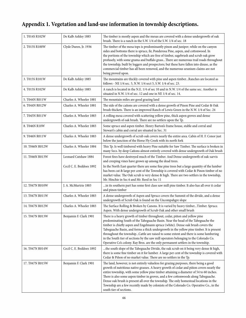
66
Appendix 1. Vegetation and land-use information in township descriptions.
1. T014S R102W De Kalb Ashley 1885 The timber is mostly aspen and the mesas are covered with a dense undergrowth of oak brush. There is a ranch in the S.W. 1/4 of the S.W. 1/4 of sec. 18
2. T015S R100W Clyde Duren, Jr. 1936 The timber of the mesa tops is predominantly pinon and juniper; while on the canyon sides and bottoms there is spruce, fir, Ponderosa Pine, aspen, and cottonwood. In the portions of the township which are free of timber, sagebrush and scrub oak grow profusely, with some grama and buffalo grass...There are numerous trail roads throughout the township, built by loggers and prospectors; but these have fallen into disuse, as the commercial timber has all been removed, and the numerous uranium claims are not being proved upon.
3. T015S R101W De Kalb Ashley 1885 The mountains are thickly covered with pine and aspen timber...Ranches are located as follows - NE 1/4 sec. 5, N.W. 1/4 sect 5, S.W. 1/4 of sec. 23.
4. T015S R102W De Kalb Ashley 1885 A ranch is located in the N.E. 1/4 of sec 10 and in N.W. 1/4 of the same sec. Another is situated in N.W. 1/4 of sec. 12 and one in NE 1/4 of sec. 14.
5. T044N R011W Charles A. Wheeler 1881 The mountain miles are good grazing land6. T044N R012W Charles A. Wheeler 1881 The side of the cañons are covered with a dense growth of Pinon Pine and Cedar & Oak
brush thickets. There is an improved Ranch of Lewis Green in the N.W. 1/4 of Sec. 247. T045N R011W Charles A. Wheeler 1883 A rolling mesa covered with scattering yellow pine, thick aspen groves and dense
undergrowth of oak brush. There are no settlers upon the Tp.8. T046N R10W Charles A. Wheeler 1883 Some spruce and aspen timber. Henry Barton’s frame house, stable and corral and
Stewart’s cabin and corral are situated in Sec. 319. T046N R011W Charles A. Wheeler 1883 A dense undergrowth of scrub oak covers nearly the entire area. Cabin of H. F. Conor just
below the junction of the Horse Fly Creek with its north fork10. T046N R012W Charles A. Wheeler 1884 This Tp. Is well timbered with heavy Pine suitable for Saw Timber. The surface is broken in
many Secs. by deep Cañons almost entirely covered with dense undergrowth of Oak brush11. T046N R013W Leonard Cutshaw 1884
Cecil C. E. Beddoes 1892
Forest fires have destroyed much of the Timber. And Dense undergrowth of oak-sarvis and creeping vines have grown up among the dead trees.In the North East quarter there are some fine pine trees but a large quantity of the lumber has been cut & large per cent of the Township is covered with Cedar & Pinon timber of no market value. The Oak scrub is very dense & high. There are two settlers in the township, Mr. Hinchie in Sec 6 and Mr. Reed in Sec 11
12. T047N R010W J. A. McMurtrie 1883 ...in its southern part has some first class saw mill pine timber. It also has all over it cedar and pinon timber
13. T047N R011W Charles A. Wheeler 1883 A dense undergrowth of Aspen and Spruce covers the Summit of the divide, and a dense undergrowth of Scrub Oak is found on the Uncompahgre slope
14. T047N R012W Charles A. Wheeler 1883 The Surface Rolling & Broken by Canons. It is varied by heavy timber...Timber. Spruce. Aspen. With dense undergrowth of Scrub Oak and other small brush
15. T047N R013W Benjamin F. Clark 1901 There is a heavy growth of timber throughout, cedar, piñon and yellow pine predominating South of the Tabeguache Basin. Near the head of the Tabeguache the timber is chiefly aspen and Engelmann spruce (white). Dense oak brush covers the Tabeguache Basin, and forms a thick undergrowth in the yellow pine timber. It is present throughout the township...Cattle are raised to some extent and there is some lumbering in the South tier of sections by the saw mill operators belonging to the Colorado Co. Operative Co’s colony. Ray Bros. are the only permanent settlers in the township.
16. T047N R014W Cecil C. E. Beddoes 1892 ...the south slope of the Tabeguache Divide, the oak scrub on it being very dense & high, there is some fine timber on it for lumber. A large per cent of the township is covered with Cedar & Piñon of no market value. There are no settlers in the Tp.
17. T047N R015W Benjamin F. Clark 1901 The land, however, is not entirely valueless for grazing purposes, there being a good growth of nutritious native grasses. A heavy growth of cedar and piñon covers nearly the entire township, with some yellow pine timber attaining a diameter of 54 to 60 inches. There is also some aspen timber in groves, and a few cottonwoods along Tabeguache. Dense oak brush is present all over the township. The only homestead locations in the Township are a few recently made by colonists of the Colorado Co. Operative Co., in the south tier of sections.

67
18. T048N R012W Charles A. Wheeler 1884 Heavy Aspen and spruce, with dense undergrowth of scrub oak and other small brush19. T048N R013W Benjamin F. Clark 1901 There is a very heavy growth of timber, consisting chiefly of yellow pine in the Tabeguache
Basin, with Engelmann spruce and aspen occurring all over the township. Much of the timber in the central part is marketable, being large enough for saw logs...The township is covered with nutritious native grasses in such luxuriance as to make it an excellent summer range for cattle, of which a large number are pastured here annually
20. T048N R014W Benjamin F. Clark 1902 The southern and central portions, in Tabeguache Basin, are covered with dense oak undergrowth, patches of aspen on the benches rising from Tabeguache Cañon, North Fork, and some heavy yellow pine timber of commercial value. The N. Portion of the township, on the Uncompahgre Divide, is covered with a dense and some cases almost impenetrable growth of aspen, spruce and balsam timber, among with are some very heavy patches of Engelmann spruce. Throughout the township, and particularly in the timber, flourishes a luxuriant growth of wild grasses and pea-vines.
21. T048N R016W Albert W. Archibald 1885 There are several cattle campers, corrals and tents of stockmen, but not a single dwelling house in the township...The land is covered with a heavy growth of savin and piñon except within two miles of the North boundary Northward where a considerable portion of the surface is covered with dense undergrowth of scrub oak and aspen
22. T049N R012W Charles A. Wheeler 1884 It is heavily wooded with Pinon & Cedar with dense undergrowth of same23. T049N R013W Robert W. Waddell 1894 The upper or Southern portions are covered with spruce, pine and aspen and the Northern
with piñon and cedar, with dense undergrowth of scrub oak and other brush...James Haley has a cabin about ten chains south of the south line of sec. 34...Robert Roberts pasture runs into sec. 30
24. T049N R014W Robert W. Waddell 1894 The southern portion of this Township is covered with heavy pine and spruce Timber large enough to cut into saw logs for lumber. The Northern portion has heavy cedar and piñon mixed with pine and dense undergrowth of scrub oak
25. T049N R015W Benjamin F. Clark 1902 There is a heavy growth of aspen, spruce, and yellow pine timber all over the northern portion of the township...South of the divide the country is broken and densely covered with matted undergrowth of oak, service, and buck brush
26. T049N R016W Benjamin F. Clark 1902 Dense oak and buck brush occurs all over the township, but least in the heavy piñon and cedar timber, which covers the entire S.W. portion and occurs elsewhere mainly on the steep S. slopes. Yellow pine timber of fine quality occurs on the sharp ridge forming the S. Rim of Mesa Cr. Cañon, and on the benches and higher ridges N.W. of Atkinson Cr. Cañon. This timber also exists in a very fine body over the table-land in the N.W. cor. of the Tp. A fine growth of aspens is found in the N.E. part, mainly on the N. Slopes. W. of the divide this timber is rather scrubby in nature, the many groves of young aspens springing up in the N. Tier of sections bid fair to be of good quality. Very little spruce occurs and that scattering, mainly of the Douglas variety...The whole Tp. being well covered with native grasses...The Club Cattle Co. Is located in sec. 13, that camp being their headquarters, with two other locations in the N.E. portion. Charles Templeton is located in sec. 34.
27. T050N R013W Robert W. Waddell 1894 It is covered with cedar pinon some oak and sagebrush28. T050N R014W Robert W. Waddell 1894 The general character of this township is a rough upland, covered with piñon, cedar and
scrub oak. Though in the valley of the Rio Escalante, there are several ranches where they raise hay, grain and vegetables. John Musser has a ranch in sec. 2. A small corner of Kenneth Campbell’s ranch is also in sec. 2. Ward and Missler have a ranch in Secs. 2 and 11 and Rich Blumberg in Sec. 4 and 5.
29. T050N R015W Benjamin F. Clark 1902 The predominant vegetation is buck, oak and briar brush, with scrubby aspen, and patches of good aspen timber, growing a good size in the southern tier of sections. There is also some Douglas spruce of poor quality mixed with the aspen timber and appearing with it all over the S. sides of the cañons. The No. sides are usually wooded in cedar and piñon timber, rather poor in quality...excellent growth of nutritious grasses existing in all parts...there are a number of permanent summer camps [for stockmen].
30. T050N R016W Benjamin F. Clark 1902 There is comparatively little timber, almost entirely aspen, and about 85% of it is young and of no value. Some yellow pine of fine quality but scattering in growth occurs in the N.W. part of the Tp. There is little spruce, and always on the steep N. Slopes. Dense oak and buck undergrowth appears all over the township. There are numerous summer camps.

68
31. T050N R017W Leonard Cutshaw 1902
Albert B. Rich 1927
There has been no attempt at settlement in this Tp...There is no sawing timber in the Tp. The grazing upon the higher portions is better than in the former Tp.The eastern part is covered with forests of pine with some aspen and spruce, and the western part with heavy cedar and pinon timber. The higher slopes are covered with dense, high undergrowth of oak, service and buck brush. There is one settler occupying lands in sections 30 and 31.
32. T051N R015W Benjamin F. Clark 1902 This township is but sparsely wooded, the main body being on or near the brush mountain in the southern part, and is yellow pine of fine quality. There is some heavy piñon and cedar on the N. Side of the cañon of Big Dominguez Creek. The aspen is dwarfed and scrubby. There is dense undergrowth all over the Township, making chaining very difficult....there being plenty of good grass everywhere...and there are several summer camps belonging to stockmen from Delta and Whitewater. There are no permanent settlers as yet.
33. T051N R016W Benjamin F. Clark 1902 There is comparatively little timber, the aspen being sparse and scattering are on the few abrupt N. Slopes, and the heavy yellow pine timber just beginning in the N. Sections. This is being cut by the Peniston and other mills situated N. of the 3rd Correction S...For grazing purposes this township is unequalled, there being a fine growth of native grasses...
34. T051N R017W Leonard Cutshaw 1902 There are two cattle camps in the N.E. cor. of this Tp. but no cultivated lands. There is some Pine timber of fair size in Eastern part of the Tp.
35. T051N R018W Leonard Cutshaw 1902 No township description found
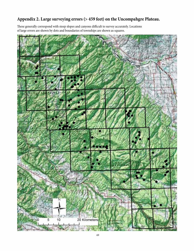
69
Appendix 2. Large surveying errors (> 459 feet) on the Uncompahgre Plateau.These generally correspond with steep slopes and canyons difficult to survey accurately. Locations of large errors are shown by dots and boundaries of townships are shown as squares.

70
Appendix 3. Surveyor common names and the likely Latin name for trees.Where a common name was uncertain, I visited section-lines containing an abundance of the plant.
Common name used in this study Surveyor Common Names Likely Latin NamesAlder Alder, black alder Alnus incana (L.) Moench subsp. tenuifolia (Nutt.) BreitungAsh Ash Fraxinus anomala Torr. Ex S. Watson Cottonwood Cottonwood, poplar Populus angustifolia James, but can include some Populus ×
acuminata Rydb. (pro sp.) [angustifolia × deltoides] or possibly at lower elevations some Populus deltoides W. Bartram ex Marshall ssp. wislizeni (S. Watson) Eckenwalder
Douglas-fir Douglas fir, red spruce Pseudotsuga menziesii (Mirb.) Franco var. glauca (Beissn.) Franco Fir Fir Uncertain, possibly Pseudotsuga menziesii (Mirb.) Franco var.
glauca (Beissn.) Franco as Abies concolor (Gord. & Glend.) Lindl. ex Hildebr. may not occur on the Plateau (W. Romme, personal communication).
Gambel oak Oak Quercus gambelii Nutt.Juniper Cedar, juniper Mostly Juniperus osteosperma (Torr.) Little, but J. scopulorum
Sarg. in upper elevations of piñon-juniper and lower elevations of ponderosa pine
Pine Pine Pinus ponderosa Lawson & C. Lawson var. scopulorum Engelm., possibly some scattered Pinus strobiformis Engelm. or Pinus flexilis James
Ponderosa pine Ponderosa pine, yellow pine, black pine, black’s pine, pitch pine
Pinus ponderosa Lawson & C. Lawson var. scopulorum Engelm.
Quaking aspen Aspen, quaking aspen Populus tremuloides Michx.Spruce Spruce Pseudotsuga menziesii (Mirb.) Franco var. glauca (Beissn.) Franco or
Picea pungens Engelm. or Picea engelmannii Parry ex Engelm.Subalpine fir Fir, balsam Abies lasiocarpa (Hook.) Hutt.; also known as Abies bifoliaTwoneedle pinyon Pinion, pinon, piñon Pinus edulis Engelm.Willow Willow, willow timber Salix spp.; including Salix scouleriana, which can be large

71
Appendix 4. Surveyor common names and the likely Latin name for shrubs.Where a common name was uncertain, I visited section-lines containing an abundance of the plant.
Common name used in this study Surveyor Common Names Likely Latin NamesAntelope bitterbrush Laurel Purshia tridentata (Pursh) DC.Black sagebrush Black brush Artemisia nova A. NelsonChokecherry Cherry, cherry brush Prunus virginiana L.Common juniper Savin Juniperus communis L. or possibly another JuniperusGambel oak Oak, oak brush, oak scrub, oakscrub,
scrub oakQuercus gambelii Nutt., possibly some Q. x pauciloba Rydb. (pro sp.) [gambelii x turbinella] or Q. turbinella Greene in places
Greenleaf manzanita Manzanita Arctostaphylos patula GreeneKinnikinnick Kinnikinnick brush Arctostaphylos uva-ursi (L.) Spreng.Rabbitbrush Rabbit brush Chrysothamnus spp. Nutt.; Ericameria spp. Nutt.Rose Briar, briar brush, brier, brier brush,
rose briar, rose brush, thorn brushRosa spp. L. – several possible species
Roundleaf snowberry Buck, buck brush Symphoricarpos rotundifolius A. GraySagebrush Sage, sagebrush, sage brush Artemisia bigelovii A. Gray on lower-elevation rocky canyon sides,
Artemisia cana Pursh ssp. viscidula (Osterh.) Beetle in higher-elevation swales, Artemisia nova A. Nelson on calcareous rocks, Artemisia tridentata Nutt. ssp. tridentata on ephemeral drainages, Artemisia tridentata Nutt. ssp. vaseyana (Rydb.) Beetle in upper montane, Artemisia tridentata Nutt. ssp. wyomingensis Beetle & Young in lower montane and lower elevations
Skunkbush sumac Squawbush Rhus trilobata Nutt.Utah serviceberry Sarvis, sarvis brush, service, service
brushAmelanchier utahensis Koehne, possibly some A. alnifolia (Nutt.) Nutt. Ex M. Roem. in places
Willow Willow, willow brush Salix spp. L. – many possible species
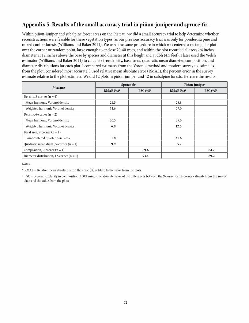
72
Appendix 5. Results of the small accuracy trial in piñon-juniper and spruce-fir.Within piñon-juniper and subalpine forest areas on the Plateau, we did a small accuracy trial to help determine whether reconstructions were feasible for these vegetation types, as our previous accuracy trial was only for ponderosa pine and mixed conifer forests (Williams and Baker 2011). We used the same procedure in which we centered a rectangular plot over the corner or random point, large enough to enclose 20-40 trees, and within the plot recorded all trees ≥4 inches diameter at 12 inches above the base by species and diameter at this height and at dbh (4.5 feet). I later used the Welsh estimator (Williams and Baker 2011) to calculate tree density, basal area, quadratic mean diameter, composition, and diameter distributions for each plot. I compared estimates from the Voronoi method and modern survey to estimates from the plot, considered most accurate. I used relative mean absolute error (RMAE), the percent error in the survey estimate relative to the plot estimate. We did 12 plots in piñon-juniper and 12 in subalpine forests. Here are the results:
MeasureSpruce-fir Piñon-juniper
RMAE (%)1 PSC (%)2 RMAE (%)1 PSC (%)2Density, 3-corner (n = 4) Mean harmonic Voronoi density 21.5 28.8 Weighted harmonic Voronoi density 14.6 27.0Density, 6-corner (n = 2) Mean harmonic Voronoi density 20.5 29.6 Weighted harmonic Voronoi density 6.9 12.5Basal area, 9-corner (n = 1) Point centered quarter basal area 1.8 31.6Quadratic mean diam., 9-corner (n = 1) 9.9 5.7Composition, 9-corner (n = 1) 89.6 84.7Diameter distribution, 12-corner (n = 1) 93.4 89.2
Notes
1 RMAE = Relative mean absolute error, the error (%) relative to the value from the plots.
2 PSC = Percent similarity in composition, 100% minus the absolute value of the differences between the 9-corner or 12-corner estimate from the survey data and the value from the plots.