Embed Size (px)
Citation preview

NOTE The London Road, presented here as a stand-alone text, will be incorporated into a history of Mountfield, currently in prepa-ration. This electronic version, incorporating the cover map but not all subsequent minor revisions, has been provided for the Battle and District Historical Society website.
The London Road

The London Road
Copyright © Peter Miles 2015. All rights reserved.
The London Road The biography of a superhighway
Peter Miles
The Darwell Area Conservation Society 2015

For Fidget, who heard it first.
The London Road The London Road is a piece of national history that runs
through the parish of Mountfield. It makes a dramatic ex-clamation mark down the local map between John’s Cross and Battle. It deliberately avoids the village but remains cent-ral to Mountfield’s life. And, 180 years ago, it simply didn’t exist; until then, it was woods and fields, hills and ghylls1, heaths, streams and a river.
Today, we take it for granted — it’s a rather straight, char-acterless, loud and fast road — but it embodies a lot of his-tory, is eloquent about the local landscape, demonstrates pioneering engineering techniques that laid the foundations for both our railways and the road building of the 20th and 21st centuries, and is a daisy chain of historical interest be-tween Mounfield and Battle. Also, once you get your eye in, it is magnificent.
So welcome to the London Road: the main road between Battle and John’s Cross or, in more modern terms, the A2100.
* * * The London Road’s historical claim to fame is that it was
enabled by one of the very last turnpike acts passed by Par-liament in England.
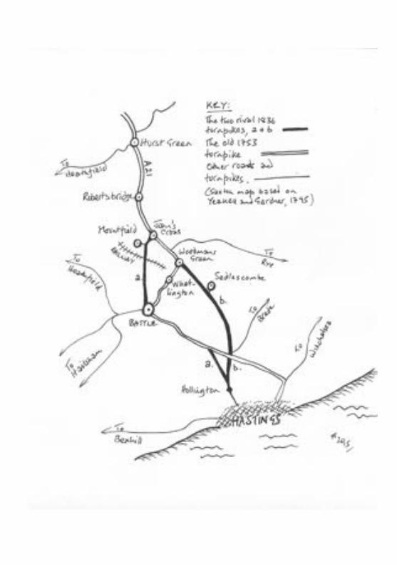
Previously, the main route to London from Hastings ran north-west from Ore along the Ridge, up the A2100 Hastings Road to Battle, east along Mount Street through Whatling-ton to the Royal Oak at Woodmans Green. This route was turnpiked in 1753 but that could not alter the fact that the
road tangled with Battle and the villages en route and was either very winding, very steep or both, over the entire dis-tance. As a result, two new rival turnpike schemes were pro-posed which sought to considerably improve on the old turnpike.
The first proposed to bulldoze a brand new road from the newly built town of St. Leonards, past where Claremont School is now, through Kent Street, avoiding Sedlescombe at Blackbrook2, to John’s Cross.
This bold scheme, however, would obviously by-pass parts of Hastings and all of Battle and the surrounding area thereby threatening the businesses and vested interests of the old turnpike. So, after much horse trading failed to produce an acceptable compromise, a rival scheme was put in hand to drive a road up from the centre of Hastings to Silverhill and northwards to Battle. The final part of the scheme was a completely new superhighway which lanced due north from Battle to John’s Cross. (The rival schemes might now be de-scribed as Sainsbury’s versus Asda.)
Both schemes were enacted in 1836 and construction be-gan immediately.3
Aside from being a footnote in history, there were a num-ber of consequences of these roads’ late date but, before we consider the London Road (and its turnpike twin), it’s worth a quick résumé of the background to the turnpike roads.
* * * Very simply, turnpike roads were designed to overcome the
paradox that economically key transport effectively destroyed the key roads on which it depended. The concept of turnpike roads or, for so much of its history, the “turnpiking” of exist-ing roads, was developed in the late 17th century, spread na-tionally during the 18th century, came to an apogee in the
first decades of the 19th century and then fatally collapsed financially.4
They were termed “turnpikes” from the old, anti-cavalry defences which consisted of sharpened pikes, attached to horizontal bars, which could be laid flat to allow the passage of horses or raised to a 45° angle to maim oncoming cavalry. The tollgates on the turnpike roads traditionally had metal spikes along the top bar although these tended to become increasingly ornamental as the turnpike movement devel-oped.
Every turnpike road was enabled by an act of parliament (generically known as the Turnpike Acts). They trundled through Parliament in their hundreds, undiscussed and rub-ber-stamped. Most of the acts enabled existing roads to be “turnpiked” though, towards the end of the turnpike era, en-tirely new roads were bulldozed completely afresh. Both the London Road, and its twin, the St. Leonard’s turnpike, fell into this latter category.
Each turnpike road was constituted as, and managed by, a trust, usually comprised of the investors. The investors typi-cally consisted of local landowners and businessmen — a sort of precursor of PFI5. The business model was that the mem-bers of the consortium financed the construction of the new or improved roads and would then derive the return on their investment from the markedly improved access for their goods and raw materials.
This may seem a tenuous financial model until you read things like this from Professor Roy Porter:
The England of 1799 was, of course, a society whose communications were sluggish and often ar-duous. By road, the haul from Newcastle to Lon-don was (“God willing”, as advertisements said) nine days; from Chester, six days. Defoe thought a
tree trunk might take three years to be dragged from Sussex to its dockyard destination in Chat-ham (it seasoned itself en route). Ox-waggons were common. Celia Fiennes, riding side saddle along the great North Road, simply lost it…6
Fiennes is a much more down-to-earth observer than Daniel Defoe. As Jeremy Hodgkinson wrote:
Celia Fiennes, writing in the early eighteenth cen-tury noted that it sometimes took as long as two years for a tree trunk to reach Chatham from the Weald, it only being possible to move such loads when it was frosty or dry.7
Turnpike roads aimed to overcome these problems by means of four key improvements: route, surface, regulations, and gradient.
* * * As the turnpike movement developed, wherever possible
the new roads deliberately avoided any villages along the way. The St. Leonard’s turnpike did not go to or through Sed-lescombe; it went past it. In the same way, the London Road didn’t go to or through Mountfield; it went past it.
As the turnpike movement developed, there was often a move away from using existing roads in favour of more direct routes and the London Road is as good an example as you will find. From the evidence of old maps, it certainly didn’t use any existing roads and probably did not use existing tracks or even paths either. Both the St. Leonards and Lon-don Roads were conceived as improvements designed to cut out more circuitous routes dictated by mostly existing roads.
The surface was absolutely key to the development of turnpike roads. They pioneered cambers and drainage, as well as the composition of the surface itself where the key
names are John Metcalf, Thomas Telford and John Maca-dam. The tolls levied on users of the road were not deemed a source of income but as a means of financing the mainte-nance and repair of the new highways. In a world where the traffic consisted of horse shoes, oxen cues8, and the thin (by today’s standard) metal tyres of the coach, wagon and cart wheels, the road surface was under perpetual attack which threatened any possible return on the huge private invest-ment, hence the rôle of the tolls to protect that investment.
Usually, the enabling acts of parliament specified the minimum width of the road, typically three carriage widths so that everyone stood a chance of avoiding local areas which had become cut up. Often, the turnpike acts specified that there should be clearly readable milestones at set intervals. These produced most of our surviving milestones. Every turn-pike road displayed the tariff. These were levied variously according to the type of vehicle and/or the number (and spe-cies) of draft animals. But turnpike roads also produced one other small detail of our current, modern life. Most laid down rules about what users could or could not do, usually in terms of potential damage to the road, but they also regu-larly specified that traffic should keep to the left…
The other key improvement of turnpike roads was the con-trol of gradient. As we have seen from the comments of Daniel Defoe and Celia Fiennes, the roads of the Weald were notorious, and much of that notoriety stemmed from the steep hills. One, Silver Hill above Robertsbridge, was particu-larly notorious:
The roads grew bad beyond all badness, the night dark beyond all darkness, our guide frightened be-yond all frightfulness. However, without being at all killed, we got up, or down — I forget which, it was so dark, — a famous precipice called Silver
Hill, and about ten at night arrived at a wretched village called Rotherbridge. We had still six miles hither, but determined to stop, as it would be a pity to break our necks before we had seen all we had intended. Horace Walpole, letter to Robert Bentley, 5th
August 1752
As the turnpike road engineering became more sophisti-cated, the surveyors and engineers made extraordinary efforts to avoid situations such as Silver Hill. And the engineering methods they developed were ones that we take for granted now because, having been pioneered in the construction of the late turnpike roads, those techniques went on to be used in the building of the railways across the nation, and then in the construction of our major arterial roads, bypasses, motorways and link roads, right up to the present day. One of the significant results of the very late date of the London Road and the St. Leonards turnpike is that they showcase these engineering techniques at their peak, before they were re-employed in the railways of the nineteenth century and the roads of the twentieth century.
Both roads run north-south which means they both have to cross the prevailing east-west geological corrugations of the Weald. These corrugations can be seen in the larger scale in the river valleys of the Rother, Tillingham and Brede and the great ridges between them but are just as apparent on a more local scale as for example in Mountfield with the River Line, Taylor’s Stream, the Darwell Stream and Glottenham Stream, again with ridges in between them. The London Road, quite simply, cut across the grain of the landscape and, in doing so, maximised the problems of gradient.
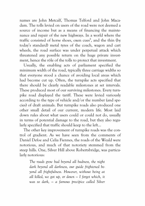
The solution is perfectly simple on paper but very challen-ging in practice. The highest points are reduced by cuttings;
the lowest points are raised by embankments; and any signifi-cant differences in height over any distance are reduced by a combination of the two. (Figure 1)
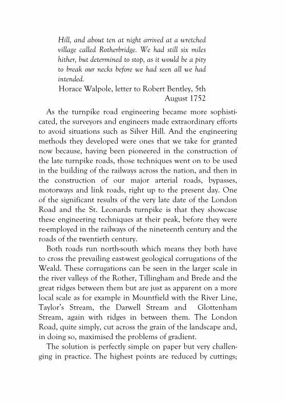
It’s only when you get your eye in and start to see these processes on the ground as you walk, cycle or drive the roads that you begin to see just what extraordinary achievements they are. The trick is to be in the passenger seat. First, it’s a simple matter of looking to see whether land on one or both sides of the road rises (cuttings) or falls away (embankments). Then the trick is to work out the original level of the land on each side of the road.
You quickly learn to look up in a cutting and find the ori-ginal land surfaces on either side and to mentally join them to recreate the original lie of the land. This really brings home the sheer depth of some of the cuttings, the engineer-ing involved, and the vast amount of material removed: the area of the road itself plus whatever it took to produce the safely sloped embankments on either side. (Figure 2)
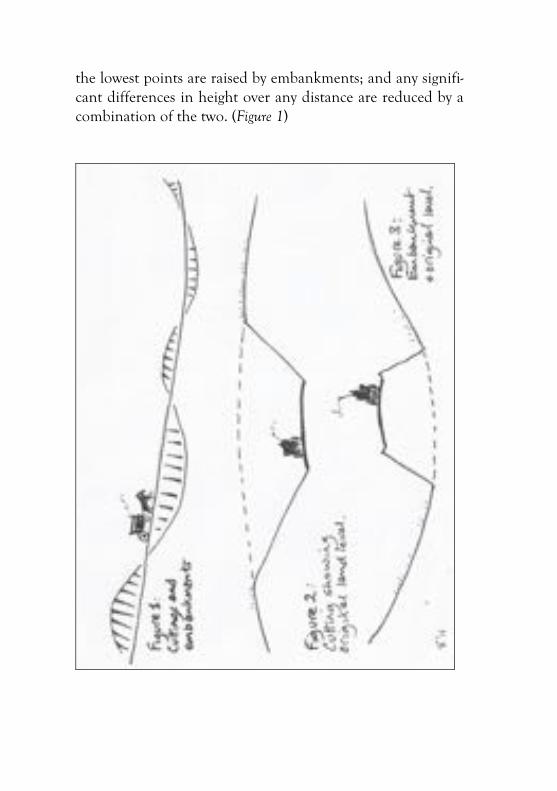
Equally, if the land falls away from the side of the road, it is because it has been embanked to raise it. Look at the origi-nal land levels, fill in the original land profile and you then get a real understanding of the extent to which the road has been built up at that point. (Figure 3)
Common sense dictates that much of the material re-moved from cuttings will have been employed to create the embankments but the quantities will not always have matched and the material, such as topsoil or softer Wadhurst Clay, may not always have been suitable and this explains the numerous roadside quarries, large and small, along the road from which structurally stronger sandstone will have been extracted.
All of this makes the drive between Mountfield and Battle much more interesting (and potentially more dangerous if you are driving along trying to take all this in). Every journey adds a new insight and a deeper admiration. But if you want to see all of this at its most extreme and magnificent, go to Sainsbury’s!
The route of the St. Leonard’s turnpike (“New Road”) has more extreme challenges. Going southwards, it emerges from the Brede valley at the end of Marley Lane and is then faced with the steep, sharp ridge of Whydown Hill, immediately south of Blackbrook, crosses several major streams through Kent Street, before scaling the north scarp of The Ridge it-self. What the road does between Moat Lane and the deep cutting at the crest in Baldslow is astonishing. Having taken out the worst of The Ridge with the cutting, the surveyors and engineers still had to cope with steep cross-ghylls and the rest of the scarp face. Going south up Ebden Hill, the em-bankment is extraordinary before you get to Claremont School. After the school, it becomes literally precipitous.9
This is all amazing and can shake us out of the compla-cency borne of these same techniques having being used for the next two centuries in the building of railways and roads.
One way to bring home the magnificence of the gradient control on both the London Road and its terrible twin is to compare them with the Beech Down to Heathfield Turnpike of 1813, a mere twenty-five years earlier. The new section of this road between South Lodge on Battle’s North Trade Road and Netherfield starts with an acute S bend and then, without the cuttings and embankments of the London Road, quickly becomes a downright switchback, with dangerous lengths of dead ground for the modern motorist, hence the overtaking restrictions. And the old section between Nether-field and Dallington suffers from all the extremes inherited from the existing ancient ridgeway route. It is dramatically different from either the St. Leonards or London Road turn-pikes.
It’s interesting to reflect that there is very little difference in severity between the hill on the A2096 between Darwell Hole and Netherfield and the northern scarp of the Ridge on
the A21 and yet Ebden’s Hill is a much gentler slope for cars now and for the original coaches and wagons.
There was one later turnpike act, five years later, which was directly related to these and which finally closed the turnpike era, which we will touch on later.
* * * So this pinnacle of engineering is the first of the conse-
quences of the late date of these roads mentioned at the out-set. The other is the irony that the very engineering tech-niques developed in the building of the later turnpikes such as the London Road then went on to be used in the con-struction of the railways which outperformed the turnpike roads and destroyed their economic basis.
The London Road was authorised by Act of Parliament in 1836. Construction started immediately after and will prob-ably have been complete in 1839.3 Only six years later, the railway track from London had reached Tunbridge Wells and, also in 1845, South Eastern Railway was granted per-mission to build a line from Ashford to St Leonards. The first tentacle of the railways reached St. Leonards from Brigh-ton in 1846. And the main Hastings line from London had reached Robertsbridge by 1851, Battle by 1852 and Bo-Peep junction in St Leonards later that same year.10
It is an absolute economic fact of life with major infra-structure projects that any return on capital is a very long term income. The Channel Tunnel (Eurotunnel) for example paid its first dividends 26 years after opening and modern PFI contracts5 are typically for a twenty-five year period. So those railway construction dates spelt financial disaster for the London Road investors. Trains could carry a vastly greater tonnage of freight, much more quickly, and could even do it several times a day. The freight trains ran accord-ing to schedule, regardless of whether there was a reciprocal
load to underwrite the return journey. The freight service was also bolstered by an equivalent superiority in terms of pas-senger transport. Never before had there been such capacity to transport such large numbers of people over such dis-tances. The resorts, including Hastings and the new St. Leo-nards, flourished; travelling and tourism became unrecognis-able ventures compared with the experiences of Daniel De-foe, Celia Fiennes, Horace Walpole or, later, William Cob-bett and Arthur Young; and commuting was born.
Steve Peak writes:
The St. Leonards – Woodmans Green trustees saw the danger coming, so in 1841 they obtained from Parliament the last of its turnpike Acts. They had already built a branch road that ran through Sed-lescombe to Cripps Corner, which opened in 1839, and the 1841 Act allowed them to extend this to Hawkhurst, from where travellers could reach what was then the nearest railway station, Staplehurst, on the London – Dover line.3
This extension to the turnpike system smacks of despera-tion: it is nearly ten miles from Hawkhurst to Staplehurst.
Sir Charles Lamb was the main funder of the Sed-lescombe – Hawkhurst road. The Cripps Corner – Hawkhurst section opened in 1843, but three years later the railways had reached west St. Leo-nards from Brighton, fatally wounding all the turnpike roads in and around Hastings and St. Leonards.3
There is one detail of the irony which is particularly poig-nant. The surveyors, engineers and workforce who built the final turnpike roads like the London Road, then went on to re-use their expertise in building precisely the infrastructure
that spelt the end, financially at least, of the turnpike roads, even at their most magnificent.
When they had finished with the London Road, the “navi-gators” — the navvies, undoubtedly went on to build the rail-ways. They will have taken their tough, itinerant way of life with them, together with their expertise. So this is a good moment to just look at the work of the navvies.
We have seen the magnificent surveying (i.e. the designing of the late turnpike roads), and we have seen the work of the engineers who turned those designs into reality, but after that it all comes down to the motive power required to construct these fine roads.
There were no JCBs, no cranes with buckets big enough to pick up a small car11, graders, dumper trucks, or other roar-ing, road building machines. There were oxen, horses and ponies but the main motive force was pure manpower. The London Road was built with picks, shovels, sledges, baskets and barrows, by the navvies. And their skill and brawn did as much as anything else to end the turnpike era.
By the late 1880s, the last turnpikes were being dismantled nationally but the London Road from Battle to John’s Cross and the “New Road” from St. Leonards to Woodmans Green are still with us nearly two hundred years later.
Along the way… To round off this little book on such an unlikely subject,
here is a brief gazetteer of a few points of interest along the way. Our direction of travel is north to south, from John’s Cross to Battle.
The first noteworthy detail is the John’s Cross junction it-self. So successful was the London Road that it was the origi-nal A21 to Battle with the current road to Hastings via Vine-
hall as the side turning.12 Slowly the emphasis and import-ance shifted and the current London Road became the A2100. Finally, in 2004, the junction was completely remo-delled as a roundabout.
The first turning off the London Road is New Cut. Al-though this was a relatively modern construction to link the new turnpike to the old village roads, it does follow, at least approximately, a portion of a very ancient track known as the Rye–Uckfield Ridgeway. The historian and authority on Brit-ish Roman roads, I.D. Margary wrote:
This ridgeway follows one of the main ridges of the Weald and can be traced continuously for 28 miles on a course so direct that it never wanders more than a mile from a straight line between its ter-mini; moreover, until it reaches the River Ouse at Uckfield it only has to cross two quite insignificant streams in the whole of that distance [including the stream under New Cut]. Thus it is certain that its importance as a thoroughfare must have been re-cognised in very early times, and it would doubtless have continued in use during the Roman period…13
Today, we know most of this route as the B2089 through Udimore, Broad Oak, and Cripp’s Corner. It cut through what are now the grounds of Vinehall School to emerge al-most exactly opposite the end of New Cut.
Also on New Cut, there is evidence of rather more recent history. Just a few yards down New Cut, in the trees on the left, there is a nest of Second World War movable obstruc-tions, covered in moss and looking for all the world like some gigantic egg box. They are not strictly tank traps but would have been used to create an ambush. On the other side of the road, there is another obstruction: an iron girder set into the bank. And behind the hedge are the remains of old Home
Guard fox holes and slit trenches which older people in Mountfield remember playing in as kids.
Further on from New Cut, the London Road cuts across a much older road which survives as Solomon’s Lane to the right and used to continue on the left as Jarvis Lane. This was at least partly adopted as one of the drives up to Vinehall which was built circa 1838. The lodge house is still there with the splendid brick wall and piers of the gates. The matching pair to this lodge is opposite the entrance to Vinehall School but is now stranded on the wrong side of the rerouted A21.
Just before the railway crossing, the London Road cuts across another much older road at the lay-by. This road was almost certainly constructed circa 1560-70 to link the Tudor industrial complex of Mountfield Furnace and Forge to the east with the older road network. The furnace and forge were water powered and the River Line which runs under the London Road just by the lay-by was dammed so that the field immediately to the north of the wood was once a long ex-panse of ‘hammer pond’. At its height, this industrial site smelted and processed well over 200 tons of cast iron per annum. The old track is visible now as a public right of way through the wood on the left. Crossing the road from the lay-by, its continuation is clearly fenced across the middle of the field to Eatenden Lane at Riverhall Bridge.
As we have seen, the railway to Battle was completed by 1852 so within a few yards of each other you have a newly constructed Tudor road, the London Road turnpike, and the railway that finally killed it economically.
Looking south across the level crossing, it is worth remem-bering that the still elegantly sloped banks on either side of the road date from the London Road’s original construction. This is true of all the vistas along the London Road. The height of the original land contours on either side is remark-able and shows the sheer extent of the engineering.
Just south of the British Gypsum turning on the right there is Lodge Gate Kennels which was the lodge at the end of an Ashburnham estate road built in the 19thC to link the estate with the London Road. The elegant little lodge is still standing and one of the original gate piers can still be seen beside the road.
Next is a minor crossroads at Archerwood Cottage at al-most the exact midway point down the London Road. (Archerwood is, itself, an interesting corruption of Orchard Wood.) To the left is a drive (and public right of way) which leads to a fine, mid-16th century house. At the bottom of its garden it has some ponds or lakes which are visible from an adjoining public footpath. These are the remains of Hodes-dale Forge, another Tudor iron forge. It is thought that this was managed by Richard Weekes who was the ironmaster at Mountfield Furnace and it is likely that he built this house for himself. It was originally called Woodsdale which is an attractive corruption of Hodesdale (Old English: heathy-valley). At some point towards the end of the 20th century, the owners decided to change its name to Ittington manor, after Ittington/Eatenden which had been one of the four Norman manors of Mountfield parish. I am pleased to say that the Ordnance Survey continues to ignore this piece of pretension on its maps.14
Going back to the London Road at Archerwood Cottage, there is a track off to the right (also a public right of way) which is only visible on foot. It strikes off into the woodland past a number of lime pits which are quite obviously of very different vintage. The oldest probably date back to the eight-eenth century and the early days of ‘agricultural improve-ment’. Others, such as the first couple on the left of the track which still have vestigial shoring timber in situ, may be as late as the first decade of the 20th century when the lime stone was still dug as road stone.15
This track off the London Road is also remarkable for some astonishing, giant honeysuckle bines clambering into trees of the same or even younger vintage.
Next, and no great distance from the London Road, the (wellied) walker will meet two extraordinary local features. The first is an amazing pollarded beech which is, from its girth probably between 180 and 200 years old. It was prob-ably a marker tree on an old boundary between Battle and Mountfield parishes and is worth a visit all on its own.
The second is a small, man-made lake known locally as The Flood — nobody seems to know why. For many years, it was used as the British Gypsum fishing lake but its history is much more extraordinary. The story still needs to be told in full but we can touch on the bare outlines here.
Towards the end of the eighteenth century, the second Lord Ashburnham, a great agricultural improver, noted that beneath the deposits of grey limestone there was a much bet-ter quality stratum of blue limestone. He ordered the open-ing of two underground limestone mines: one at Poundsford in Burwash and the first at what was originally known as Or-chard Wood Mine and later as corrupted to Archerwood Mine. Water from The Flood provided the motive power for an underground waterwheel, somewhere between sixty and a hundred feet underground. This waterwheel powered two pumps in the main shaft which kept dry the underground mine at Archerwood — water power to eliminate water.
The final twist to the extraordinary tale is that, faced with a shortage of local mining expertise, and having a Derbyshire-born agent, the Earl sanctioned the seasonal employment of over twenty Derbyshire lead miners to open the mine and work it in its early years. The most complete account of the enterprise remains Derbyshire Miners in Sussex by Adrian Pearce16 who writes that “the decision to use Derbyshire lead
miners to develop Orchard Wood Mine was quite under-standable” as the geology and methodology were similar.
The mine was worked from about 1786 to at least 1806 — thus predating the first excavations of gypsum by the Sub-Wealden Gypsum Company by ninety years.17 The Derby-shire men worked the mine, managed the mine, brought down sons and wives, or married local girls, and several are buried in pauper’s graves in Mountfield churchyard. It’s an extraordinary story and a suitable note on which to end this little book. REFERENCES I have researched few primary sources in preparing this little book so have depended on the scholarship of others from Ernest Straker and others to the present day. I particularly acknowledge and recommend Steve Peak’s 2011 piece for the excellent Hast-ings Chronicle website which he edits.3
1 Ghyll or gill — both spellings are legitimate — comes from a
Scandinavian word for a stream or deeply cut ravine. Ghylls are a distinctive feature of the High Weald landscape. If noth-ing else recommended them to the modern imagination, the ghylls of the High Weald contain an extraordinary range of flora including the enchantingly named hay scented buckler fern.
2 Interestingly, the current garden centre’s address is “New Road, Sedlescombe”.
3 For much of the historical background, I am much indebted to Steve Peak’s article on the Hastings Chronicle website: www.hastingschronicle.net. Search for “turnpike roads”.
4 Wikipedia has an excellent potted history of the turnpike movement under “Turnpike trusts”.
5 PFI: Private Finance Initiative, an immoral mechanism used to finance modern infrastructure such as new hospitals which
increases the debt burden while keeping the debt off the gov-ernment’s books. See Private Eye Special Report by Paul Foot, 19th March 2004.
6 The Penguin Social History of Britain: English Society in the Eight-eenth Century, Roy Porter, 2001.
7 The Wealden Iron Industry, Jeremy Hodgkinson, 2008, p. 103. 8 When taken to the smithy to be shod a farm boy and the black-
smith’s apprentice had to be on hand, for the ox could not be taught to lift one foot at a time like a horse. The bullock was thrown down, usually on the grass patch outside the smithy, and the boys sat on its neck to keep it from struggling, while its four feet were tied to a tri-pod of iron poles. The nails were first greased by being pushed into a piece of pork fat. Shoeing the ox-team was one of the treats for the village children. Once on the ground, the beast submitted quietly; when it was over, the children warned to get back, the ropes were un-tied and the assistants rolled off the massive neck (incidentally smell-ing strongly of ox and with greasy coats), then the great animal would rise slowly, almost majestically with no loss of dignity, shake itself and immediately commence to graze as if nothing had happened.
Life and Tradition in the Cotswolds, Edith Brill, 1973, p. 169. 9 Steve Peak reminds that the inherited lore is that the turn-
pike’s ascent of Ebden Hill was constructed using material from the extraordinary slag heap generated by the huge Ro-man iron works in Beauport Park. The earliest record of this is by the antiquary, James Rock, in 1879 which is worth quot-ing at length:
The Cinder-beds at Sedlescomb [at Footland Farm] have been thor-oughly worked out. For many years they were the chief source of sup-ply for roadmaking material to the turnpike and parish roads through Sedlescomb to John’s Cross and Hawkhurst. On the exhaustion of these beds some large mounds of scoriæ in Beauport Park, the prop-erty of Sir Archibald Lamb, Bart., in the low lying part towards Bat-tle, and in that parish, have been worked, and these in their turn are rapidly disappearing. Another year or two will probably see them ex-hausted, and unless one or two other deposits, difficult of access, be utilised, or others, at present unknown, should be discovered, the use
of iron “cinders” as a roadmaking material will become extinct in this part of England.
“Ancient Cinder-Heaps in East Sussex” in Sussex Archæological Collections, Vol. 29 (1879), pp. 168-169.
10 The Wikipedia entry for “Hastings Line” is a splendidly read-able and fascinating twenty pages which transcends anorak-ism.
11 There is lovely local story about the great winter of 1962-63 when the country was paralysed by snow for months. A big mechanical beast with a formidable front bucket, working its way up from Darwell Hole towards the centre of Brightling, picking up huge volumes of snow with every bucket, unwit-tingly picked up one of the then trendy Austin Minis and dumped it over the hedge. (Source: pers. comm. the late Eric Watson.)
12 This is well captured by photograph in Mountfield Meanderings, Volume 2, Trish Jones, p. 66. These two volumes show the Parish of Mountfield in old and not so old photographs and are essential local reading.
13 Roman Ways in the Weald, I.D. Margary, 1948, p. 262. 14 There is one lovely detail about Woodsdale. The Mountfield/
Whatlington boundary once passed through middle of the house. One of the late Betty Stace’s first jobs was as a general maid at Woodsdale. Bet’s husband, Fred, told me that she would come home from work saying that she’d worked in Whatlington for most of the morning but spent the after-noon back in Mountfield… (Source: pers. comm. the late Fred Stace.)
15 Hastings & St. Leonards Observer, Oct 26th 1918 quoted in www.aditnow.co.uk/community/viewtopic.aspx?t=10121.
16 Derbyshire Miners in Sussex, A.J. Pearce, Bulletin of the Peak District Mines Historical Society, Volume 11, Number 2, Winter 1990. Available online.
17 Interestingly, just as Archer Wood Mine required expertise imported from Derbyshire, the Sub Wealden Gypsum Com-pany also had to import expertise in the form of Cornish miners.

Envoi
Suggestions, comments, additions or corrections for a future editions of this text are most welcome. For example, I have no date for the
construction of New Cut, Mountfield. Please contact me at [email protected]