Embed Size (px)
Citation preview
42 Headwaters to Estuaries: Advances in Watershed Science and Management
New Insights into Studies on Long-term Experimental Watersheds to Address Contemporary Emerging Issues (Part 1)
Citation for proceedings: Stringer, Christina E.; Krauss, Ken W.; Latimer, James S., eds. 2016. Headwaters to estuaries: advances in watershed science and management—Proceedings of the Fifth Interagency Conference on Research in the Watersheds. March 2-5, 2015, North Charleston, South Carolina. e-Gen. Tech. Rep. SRS-211. Asheville, NC: U.S. Department of Agriculture Forest Service, Southern Research Station. 302 p.
THE LONG TERM AGROECOSYSTEM RESEARCH NETWORK – SHARED RESEARCH STRATEGY
Jean L. Steiner, Timothy Strickland, Peter J.A. Kleinman, Kris Havstad, Thomas B. Moorman, M. Susan Moran, Phil Heilman,
Ray B. Bryant, David Huggins, and Greg McCarty1
Abstract—While current weather patterns and rapidly accelerated changes in technology often focus attention on short-term trends in agriculture, the fundamental demands on modern agriculture to meet society food, feed, fuel and fiber production while providing the foundation for a healthy environment requires long-term perspective. The Long-Term Agroecoystem Research Network was established by USDA to ensure sustained crop and livestock production and ecosystem services from agriculture, as well as to forecast and verify the effects of environmental trends, public policies, and emerging technologies. The LTAR Network is comprised of 18 locations across the US, whose shared research strategy is to employ common measurements to advance four areas of foundational science: (1) agro-ecosystem productivity; (2) climate variability and change; (3) conservation and environmental quality; and (4) socio-economic viability and opportunities. Each Network location is engaged in a local adaptation of the “common experiment” which contrasts conventional production systems with innovative systems that optimize services. Protocols and services are being developed for collection, verification, organization, archives, access, and distribution of data associated with Network activities.
INTRODUCTIONChallenges to agriculture have never been greater. The American Society of Agronomy’s Grand Challenge for the 21st Century (ASA 2011) is “to double global food, feed, fiber, and fuel production on existing farmland … with production systems that enable food security; use resources more efficiently; enhance soil, water, and air quality, biodiversity, and ecosystem health; and are economically viable and socially responsible.” Long-term research is essential to understanding how agriculture has and will adapt to changes in technologies, consumer demands (food, fuel, fiber and other ecosystem services), policy, resource availability and environmental stresses (Walbridge and Shafer 2011). Existing networks, such as the National Ecological Observatory Network (NEON), Long-Term Ecological Research (LTER) network and Smart Forest initiative (U.S. Forest Service) reflect the established recognition of the need for coordination and consistency in land management research programs.
Agriculture faces tremendous challenges in meeting multiple, diverse societal goals, including a safe and plentiful food supply, climate change adaptation/mitigation, supplying sources of bioenergy, improving water/air/soil quality, and maintaining biodiversity. The Long Term Agroecosystem Research network (LTAR) was developed in 2012 to enable long-term, trans-disciplinary science across farm resource regions to address these challenges (Walbridge and Shafer 2011). The goal of this research network is to ensure sustained crop and livestock production and ecosystem services from agro-ecosystems, and to forecast and verify the effects of environmental trends, public policies, and emerging technologies. The LTAR shared research strategy (SRS) is a living document, founded on the basic goals of the LTAR Network and designed to capitalize on the strengths of the 18 LTAR sites. The LTAR SRS creates common geographically- and temporally-scalable databases that deliver knowledge and applications within priority areas of concern: agro-ecosystem productivity; climate
1Jean Steiner, Soil Scientist, USDA Agricultural Research Service, El Reno, OK 73036Timothy Strickland, Soil Scientist, USDA Agricultural Research Service, Tifton, GA 37194 Peter Kleinman, Hydrologist, USDA Agricultural Research Service, University Park, PA 16802 Kris Havstad, Range Scientist, USDA Agricultural Research Service, Las Cruses, NM 88003 Thomas Moorman, Microbiologist, USDA Agricultural Research Service, Ames, IA 50011 M. Susan Moran, Hydrologist, USDA Agricultural Research Service, Tucson, AZ 85719 Phil Heilman, Hydrologist, USDA Agricultural Research Service, Tucson, AZ 85719 Ray Bryant, Soil Scientist, USDA Agricultural Research Service, University Park, PA 16802 David Huggins, Soil Scientist, USDA Agricultural Research Service, Pullman, WA 99164Greg McCarty, Soil Scientist, USDA Agricultural Research Service, Beltsville, MD 20705
Proceedings of the Fifth Interagency Conference on Research in the Watersheds 43
New Insights into Studies on Long-term Experimental Watersheds to Address Contemporary Emerging Issues (Part 1)
variability and change; conservation and environmental quality; and socio-economic viability and opportunities.
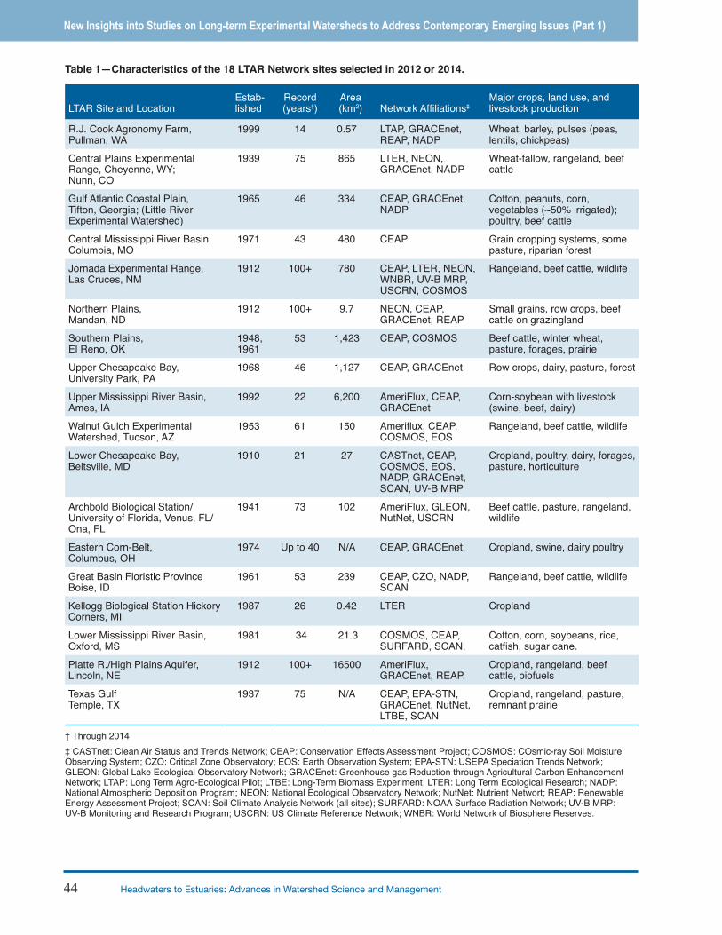
SITESThere are eighteen sites representing major agroecoregions of the US in the LTAR network, and flexibility to add additional sites to fill in critical gaps. The first 10 sites were selected in 2012, all from long-term watershed, rangeland, or cropping system locations within the Agricultural Research Service (ARS). In 2014, eight additional sites were selected; some led by ARS, universities and private research foundation. During both selection cycles, sites were evaluated on representation of a major agroecosystem, a history of long-term research and existence of historic data, demonstration of critical mass with strong collaborative partnerships, and a record of scientific leadership and productivity as a team. The diversity of sites is summarized briefly in Table 1.
PROCEDURES
Research CommitteeThe Shared Research Strategy and implementation for elements within that strategy have been developed and coordinated through the LTAR Research Committee, consisting of a chair from ARS’s Office of National Programs and the site leads. Site leaders engage members of their site teams, as needed, to advance LTAR planning and implementation. The work of the Research Committee has been conducted through monthly teleconferences, working groups, and annual meetings.
Working GroupsFollowing initial teleconference discussions, the Research Committee established a writing team to draft the SRS. The writing team developed a draft and engaged the broader LTAR community, ARS leadership, and an external review panel for feedback and refinement. The first edition of the LTAR-SRS was posted to the LTAR website (Bryant et al. 2013). After addition of 8 sites to the network, another working group was established to update the SRS which is in final review by ARS leadership.
As the work of the SRS writing team progressed additional teams were established to develop a research plan for a Common Experiment. The LTAR Core Measurements and shared protocols are being developed by working groups with expertise in the various areas essential to LTAR research efforts. Additionally, teams are compiling historical data from multiple locations for analysis of precipitation intensity and biomass productivity.
Annual Meetings Periodic face-to-face meetings have been essential toward building shared understanding across the LTAR network. The first LTAR Annual Meeting was held in conjunction with the 2012 LTER All-Scientists Meeting in Estes Park, Colorado, and the subsequent joint LTAR/NEON workshop at NEON HQ in Boulder, Colorado. Discussions at these meeting focused on the SRS and Core measurements. The next Annual Meeting was retreat style, held at the Central Plains Experimental Range in Nunn, Colorado. A key output of that meeting was development of the concept and basic outline of a Common Experiment that would be implemented at all sites. The team met again in conjunction at the 2014 American Geophysical Union fall meeting where a Union Session was presented on The Long-Term Agro-Ecosystem (LTAR) Network: A New In-Situ Data Network for Agriculture. The LTAR Research Committee met and determined the need for a LTAR Team planning meeting, focused on the LTAR Core Measurements and Shared Protocols, which has been scheduled in Beltsville, Maryland in spring of 2015.
DISCUSSIONThe LTAR’s SRS is built upon a progressive approach that (1) focuses on priority research questions, (2) reviews measurement variables and protocols used by sites to confirm comparability and identify a core set of variables and protocols for the network to adopt, (3) develops shared data sets from across network sites, (4) initiates new monitoring and experimentation efforts in conjunction with other networks, and (5) conducts retrospective analyses of trends across LTAR sites and modeling studies to generalize locally-derived observations and forecast future outcomes. Successful implementation of LTAR’s SRS is based on the commitment to the SRS across all network sites, energetic leadership from each participant in the network, and the engagement of producers, partners and policymakers. The LTAR research is being structured to address four societal concerns: 1) Agroecosystem productivity and sustainability; 2) Climate variability and change; 3) Conservation and environmental quality; and 4) Socio-economic viability and opportunities.
LTAR’s Shared Research PrinciplesFoundational science addresses the key societal concerns through research questions that are targeted toward development of improved understanding, tools, and products that enhance productivity and sustainability of agricultural systems (Fig. 1, Table 2). A key expectation of the LTAR Network is the application of research results to solve critical challenges facing agriculture. Because research based applications and their outcomes
44 Headwaters to Estuaries: Advances in Watershed Science and Management
New Insights into Studies on Long-term Experimental Watersheds to Address Contemporary Emerging Issues (Part 1)
LTAR Site and LocationEstab-lished
Record
(years†)Area (km2) Network Affi liations‡
Major crops, land use, and livestock production
R.J. Cook Agronomy Farm, Pullman, WA
1999 14 0.57 LTAP, GRACEnet, REAP, NADP
Wheat, barley, pulses (peas, lentils, chickpeas)
Central Plains Experimental Range, Cheyenne, WY; Nunn, CO
1939 75 865 LTER, NEON, GRACEnet, NADP
Wheat-fallow, rangeland, beef cattle
Gulf Atlantic Coastal Plain, Tifton, Georgia; (Little River Experimental Watershed)
1965 46 334 CEAP, GRACEnet, NADP
Cotton, peanuts, corn, vegetables (~50% irrigated); poultry, beef cattle
Central Mississippi River Basin, Columbia, MO
1971 43 480 CEAP Grain cropping systems, some pasture, riparian forest
Jornada Experimental Range, Las Cruces, NM
1912 100+ 780 CEAP, LTER, NEON, WNBR, UV-B MRP, USCRN, COSMOS
Rangeland, beef cattle, wildlife
Northern Plains, Mandan, ND
1912 100+ 9.7 NEON, CEAP, GRACEnet, REAP
Small grains, row crops, beef cattle on grazingland
Southern Plains, El Reno, OK
1948, 1961
53 1,423 CEAP, COSMOS Beef cattle, winter wheat, pasture, forages, prairie
Upper Chesapeake Bay, University Park, PA
1968 46 1,127 CEAP, GRACEnet Row crops, dairy, pasture, forest
Upper Mississippi River Basin, Ames, IA
1992 22 6,200 AmeriFlux, CEAP, GRACEnet
Corn-soybean with livestock (swine, beef, dairy)
Walnut Gulch Experimental Watershed, Tucson, AZ
1953 61 150 Amerifl ux, CEAP, COSMOS, EOS
Rangeland, beef cattle, wildlife
Lower Chesapeake Bay,Beltsville, MD
1910 21 27 CASTnet, CEAP, COSMOS, EOS, NADP, GRACEnet, SCAN, UV-B MRP
Cropland, poultry, dairy, forages, pasture, horticulture
Archbold Biological Station/University of Florida, Venus, FL/Ona, FL
1941 73 102 AmeriFlux, GLEON, NutNet, USCRN
Beef cattle, pasture, rangeland, wildlife
Eastern Corn-Belt, Columbus, OH
1974 Up to 40 N/A CEAP, GRACEnet, Cropland, swine, dairy poultry
Great Basin Floristic Province Boise, ID
1961 53 239 CEAP, CZO, NADP, SCAN
Rangeland, beef cattle, wildlife
Kellogg Biological Station Hickory Corners, MI
1987 26 0.42 LTER Cropland
Lower Mississippi River Basin, Oxford, MS
1981 34 21.3 COSMOS, CEAP, SURFARD, SCAN,
Cotton, corn, soybeans, rice, catfi sh, sugar cane.
Platte R./High Plains Aquifer, Lincoln, NE
1912 100+ 16500 AmeriFlux, GRACEnet, REAP,
Cropland, rangeland, beef cattle, biofuels
Texas GulfTemple, TX
1937 75 N/A CEAP, EPA-STN, GRACEnet, NutNet, LTBE, SCAN
Cropland, rangeland, pasture, remnant prairie
† Through 2014‡ CASTnet: Clean Air Status and Trends Network; CEAP: Conservation Effects Assessment Project; COSMOS: COsmic-ray Soil Moisture Observing System; CZO: Critical Zone Observatory; EOS: Earth Observation System; EPA-STN: USEPA Speciation Trends Network; GLEON: Global Lake Ecological Observatory Network; GRACEnet: Greenhouse gas Reduction through Agricultural Carbon Enhancement Network; LTAP: Long Term Agro-Ecological Pilot; LTBE: Long-Term Biomass Experiment; LTER: Long Term Ecological Research; NADP: National Atmospheric Deposition Program; NEON: National Ecological Observatory Network; NutNet: Nutrient Networt; REAP: Renewable Energy Assessment Project; SCAN: Soil Climate Analysis Network (all sites); SURFARD: NOAA Surface Radiation Network; UV-B MRP: UV-B Monitoring and Research Program; USCRN: US Climate Reference Network; WNBR: World Network of Biosphere Reserves.
Table 1—Characteristics of the 18 LTAR Network sites selected in 2012 or 2014.
Proceedings of the Fifth Interagency Conference on Research in the Watersheds 45
New Insights into Studies on Long-term Experimental Watersheds to Address Contemporary Emerging Issues (Part 1)
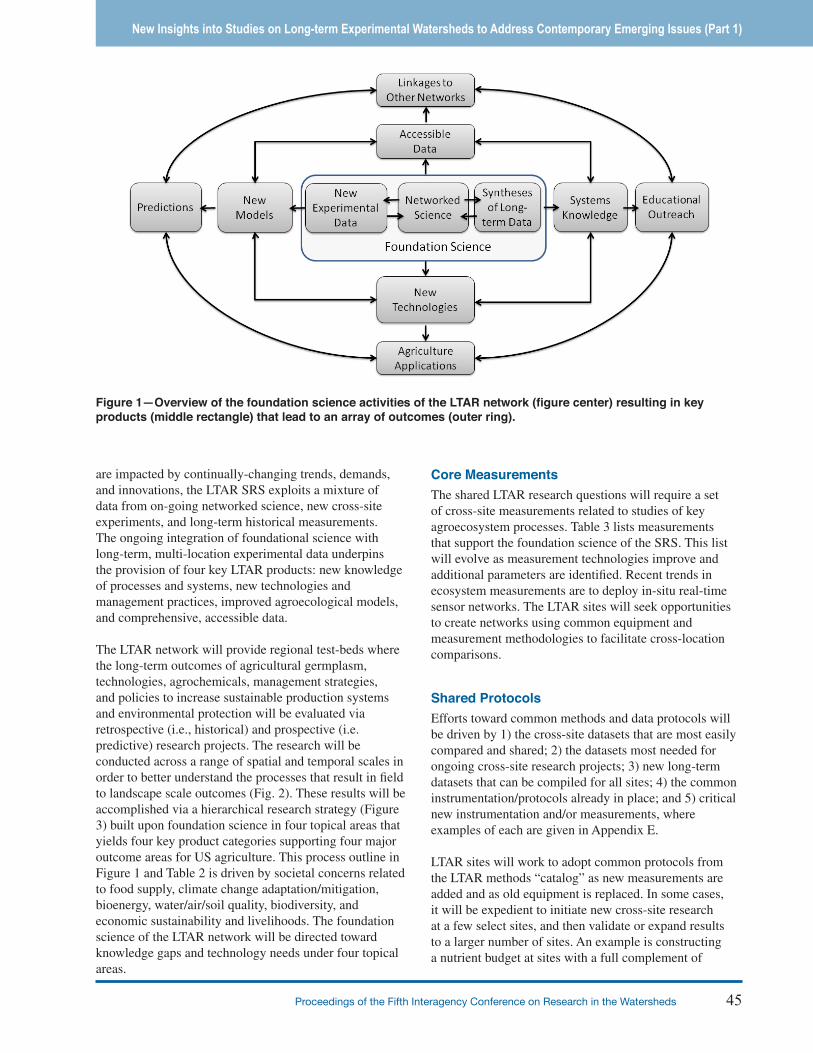
are impacted by continually-changing trends, demands, and innovations, the LTAR SRS exploits a mixture of data from on-going networked science, new cross-site experiments, and long-term historical measurements. The ongoing integration of foundational science with long-term, multi-location experimental data underpins the provision of four key LTAR products: new knowledge of processes and systems, new technologies and management practices, improved agroecological models, and comprehensive, accessible data.
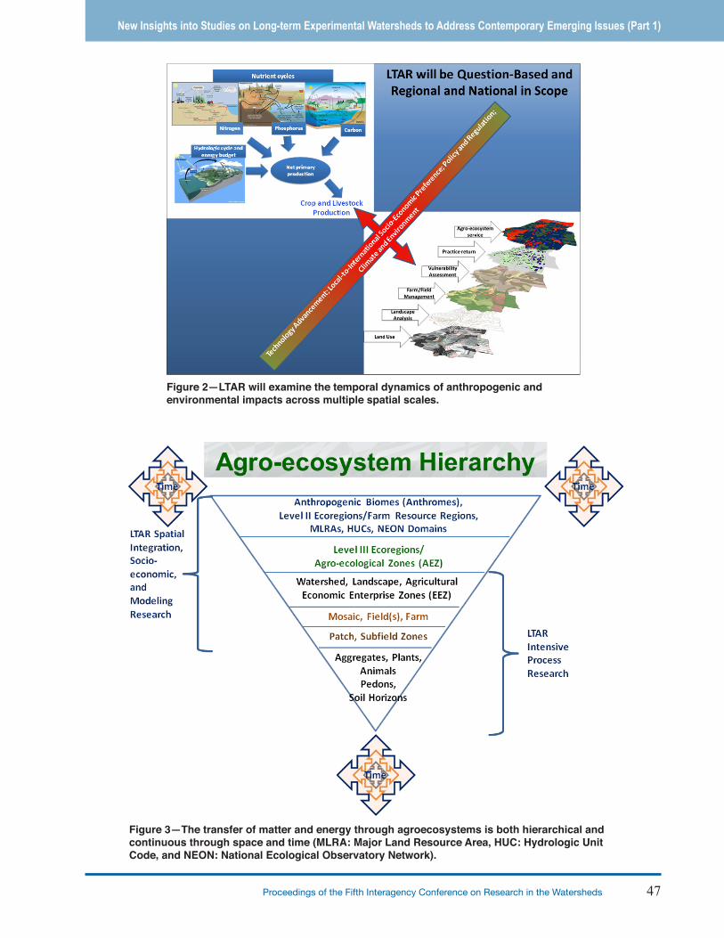
The LTAR network will provide regional test-beds where the long-term outcomes of agricultural germplasm, technologies, agrochemicals, management strategies, and policies to increase sustainable production systems and environmental protection will be evaluated via retrospective (i.e., historical) and prospective (i.e. predictive) research projects. The research will be conducted across a range of spatial and temporal scales in order to better understand the processes that result in field to landscape scale outcomes (Fig. 2). These results will be accomplished via a hierarchical research strategy (Figure 3) built upon foundation science in four topical areas that yields four key product categories supporting four major outcome areas for US agriculture. This process outline in Figure 1 and Table 2 is driven by societal concerns related to food supply, climate change adaptation/mitigation, bioenergy, water/air/soil quality, biodiversity, and economic sustainability and livelihoods. The foundation science of the LTAR network will be directed toward knowledge gaps and technology needs under four topical areas.
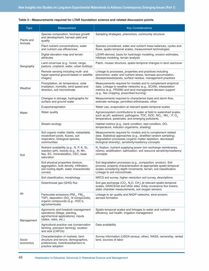
Core MeasurementsThe shared LTAR research questions will require a set of cross-site measurements related to studies of key agroecosystem processes. Table 3 lists measurements that support the foundation science of the SRS. This list will evolve as measurement technologies improve and additional parameters are identified. Recent trends in ecosystem measurements are to deploy in-situ real-time sensor networks. The LTAR sites will seek opportunities to create networks using common equipment and measurement methodologies to facilitate cross-location comparisons.
Shared ProtocolsEfforts toward common methods and data protocols will be driven by 1) the cross-site datasets that are most easily compared and shared; 2) the datasets most needed for ongoing cross-site research projects; 3) new long-term datasets that can be compiled for all sites; 4) the common instrumentation/protocols already in place; and 5) critical new instrumentation and/or measurements, where examples of each are given in Appendix E.
LTAR sites will work to adopt common protocols from the LTAR methods “catalog” as new measurements are added and as old equipment is replaced. In some cases, it will be expedient to initiate new cross-site research at a few select sites, and then validate or expand results to a larger number of sites. An example is constructing a nutrient budget at sites with a full complement of
Figure 1—Overview of the foundation science activities of the LTAR network (figure center) resulting in key products (middle rectangle) that lead to an array of outcomes (outer ring).
46 Headwaters to Estuaries: Advances in Watershed Science and Management
New Insights into Studies on Long-term Experimental Watersheds to Address Contemporary Emerging Issues (Part 1)
Societal Concerns
Foundation Science Research Questions Expected Products
Food, fi ber and fuel production, resource sustainability and system resilience
→ Agroecosystem productivity →
How can production systems be intensifi ed so that inputs decrease and/or outputs increase?
• New strategies to improve net primary production and crop yields;
• Improved nutrient and water use effi ciencies of US food, fi ber and bioenergy production systems;
• Quantifi cation of greenhouse gas and water footprints and life cycle analyses of production systems;
• Better methods to evaluate economic value of ecosystem services.
Climate variability and change
→
Climate variability and change
→
How can agroecosystems increase production with climate change?What strategies will help mitigate greenhouse gas emissions?How can agriculture improve water supply and quality in the face of climate change?
• Improved understanding of recovery processes/lags from drought, fl oods or other extreme events;
• Carbon or greenhouse gas mitigation credits and markets;
• Monitoring and assessment tools that support adaptive management.
Water supply and quality
→
→
Agricultural conservation and environmental quality
→
How can production systems be made sustainable for both on and off-site effects?How can management changes improve resource use effi ciency?
• Indicators of soil quality and function;• Valuation of ecosystem services;• Scientifi c understanding to underpin
conservation planning and agricultural land management;
• Monitoring and assessment tools (models) to support adaptive management.
Ecological integrity and ecosystem health
→
Economic sustainability and livelihoods
→
Socio-economic ties to productivity, climate and environment
→
How can new or improved commodities be incorporated into agroecosystems to sustain ecological integrity, ecosystem health, and economic opportunity?How do economic incentives and public policy affect the design and adoption of new production systems?
• Linkage of georeferenced socioeconomic data bases (US Census, ERS-ARMS, Ag Census) with biophysical modeling;
• Better understanding of motivation, incentives, and barriers to adoption or change;
• Better understanding of interactions between farm structure and supply of agroecosystem goods and services.
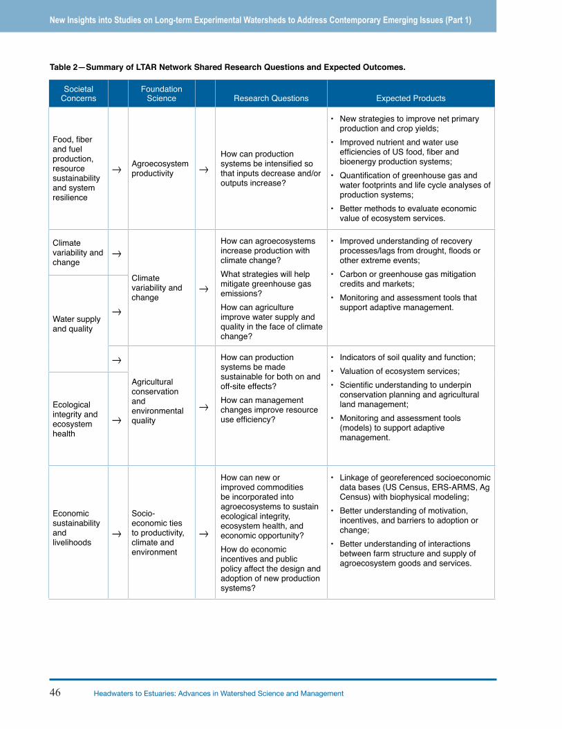
Table 2—Summary of LTAR Network Shared Research Questions and Expected Outcomes.
Proceedings of the Fifth Interagency Conference on Research in the Watersheds 47
New Insights into Studies on Long-term Experimental Watersheds to Address Contemporary Emerging Issues (Part 1)
Figure 3—The transfer of matter and energy through agroecosystems is both hierarchical and continuous through space and time (MLRA: Major Land Resource Area, HUC: Hydrologic Unit Code, and NEON: National Ecological Observatory Network).
Figure 2—LTAR will examine the temporal dynamics of anthropogenic and environmental impacts across multiple spatial scales.
48 Headwaters to Estuaries: Advances in Watershed Science and Management
New Insights into Studies on Long-term Experimental Watersheds to Address Contemporary Emerging Issues (Part 1)
Type Measurement Key Considerations
Plants and Animals
Species composition, biomass growth and development, harvest yield and quality
Sampling strategies, phenomics, community structure
Plant nutrient concentrations, water and nutrient use effi ciencies
Species considered, water and nutrient mass balances, cycles and fl ows, spatio-temporal scales, measurement technologies
Geography
Digital elevation map and terrain attributes
LiDAR-derived, basis for hydrologic modeling, erosion estimates, hillslope modeling, terrain analysis
Land cover/use (e.g., forest, range, pasture, cropland, water, urban buildup)
Patch, mosaic structure, spatio-temporal changes in land use/cover
Remote sensing including multi- and hyper-spectral ground-based or satellite imagery
Linkage to processes, properties and practices including phenomics, water and nutrient stress, biomass accumulation, disease/weeds/pests, surface residue, management practices
WeatherPrecipitation, air temperature, solar irradiation, humidity, wind speed and direction, soil microclimate
Measurements required for models and to complement empirical data. Linkage to weather networks (e.g., SCAN), interpolation metrics (e.g., PRISM) and land management decision support (e.g., fl ex cropping, prescribed burning)
Water
Changes in storage, hydrographs for surface and ground water
Measurements required to characterize base and storm fl ow, estimate recharge, permitted withdrawals, other
Evapotranspiration Water use, evaporation at relevant spatio-temporal scales
Water quality Agroecosystem contributions to water at fi eld to watershed scales, such as pH, sediment, pathogens, TOC, DOC, NO3
-, NH4+, P, O2,
temperature, pesticides, and emerging pollutants.
Stream ecology Habitat metrics (e.g., bank condition, bed condition, DO, temperature, indicator organisms, shading)
Soil
Soil organic matter (labile, metastable, recalcitrant pools, fl uxes), soil respiration, biological species, communities
Measurements required for models and to complement related data. Statistical approaches (e.g., stratifi ed random sampling). Degradation processes (organic matter depletion, decreased biological diversity), sensitivity/resiliency concepts
Nutrient availability (e.g., N, P, K, S), reaction (pH), toxicity (e.g., Al, Mn, Na), EC, mineralization, CEC, base saturation
N2 fi xation, nutrient supplying power (ion exchange membranes, resins), acidifi cation, salinization, soil resource sensitivity/resiliency concepts
Soil physical properties (texture, aggregation, bulk density, infi ltration, soil rooting depth, water characteristic curves)
Soil degradation processes (e.g., compaction, erosion). Soil process, property characterization at appropriate spatio-temporal scales considering depth increments, terrain, soil classifi cation. Linkage to soil microclimate.
Soil classifi cation, morphology NRCS soil survey, higher resolution soil survey, descriptions
Air
Greenhouse gas (GHG) fl ux Soil gas exchange (CO2, N2O, CH4) at relevant spatio-temporal scales, GRACEnet and other sites. Eddy covariance fl ux towers, static chamber measurements, soil oxygen sensors
Particulate emissions (PM10, PM2.5, TSP), deposition (SO2, N compounds), organic compounds (e.g., VOC’s, agrochemicals)
Linkage to air quality and NADP networks, wind erosion, aerosol formation
Management
Agronomic and livestock management operations (tillage, planting, agrichemical applications), inputs (dates, rates, etc.)
Spatio-temporal scales and linkages to water and nutrient use effi ciency, soil health, irrigation management
Agricultural practice use (conservation farming, precision farming), location and size (CAFOs)
Data availability
Socio-economics
Characterization of markets, farm structure and tenure, demographics, preferences, incentives/barriers to practice adoption
Survey information (USDA census, other), NASS, ownership, rented land, sources of labor
Table 3—Measurements required for LTAR foundation science and related discussion points.
Proceedings of the Fifth Interagency Conference on Research in the Watersheds 49
New Insights into Studies on Long-term Experimental Watersheds to Address Contemporary Emerging Issues (Part 1)
measurements, and augmenting this with partial budgets at other sites. To better understand drought, flood, erosion, vegetation and the impacts of climate change, 16 sites have been instrumented with new sensors to monitor soil moisture at multiple depths and locations in the past two decades. Ideally, shared measurements would be made with protocols common not only to LTAR sites, but also common to LTER, NEON, and other networks.
Since most LTAR sites have valuable continuous data records extending back decades, it may be unrealistic to consider changing all methods to a common protocol. In these cases, we will document that methods are nearly common, and use various QA/QC techniques to validate and compare those methods. Good laboratory practices and chain of custody for samples and data will be documented. Uncertainty introduced by different equipment, sampling and/or analytical methodologies (e.g., differentiating forms of phosphorus), sampling design (e.g., flume geometry), and scale of observation (plot, field, watershed, basin, airshed, etc.) will be documented and acknowledged. Though a common LTAR analytic center is not envisioned, a funded LTAR coordination of methods and protocols is a requirement for LTAR success.
The Common ExperimentThe LTAR common experiment will underscore sustainable production systems, practices, and strategies that conserve the nation’s natural resources and enhance environmental quality. In combination with the long-term historical data, data from the common experiment will provide a basis for objective evaluation of social, ecological and economic factors affecting the viability of alternative management strategies for US agriculture. A key outcome of this LTAR network common experiment is to develop and disseminate multi-regional, science-based information that will enable implementation of sustainable agriculture production systems that promote food security, environmental values, and climate change mitigation and adaption.
The objectives of the LTAR network common experiment will include:
Develop and evaluate sustainable, profitable production systems or management strategies that optimize production and/or reduce use of resources while enhancing delivery of ecosystem services through a) altered plant or animal management systems, land use strategies, and production systems, b) adoption of intensified management, and/or c) employing alternative inputs including improved germplasm.
Develop and employ coordinated, rigorous measurements of indices of productivity; water, nutrient and energy use efficiency; plant productivity; soil erosion; soil health; water and air quality; water availability; and greenhouse gases. Provide regional/national report cards comparing production efficiencies and ecosystem services. Utilize resulting long-term data sets to detect chronic and threshold changes in ecosystem services provided by agricultural ecosystems.
Identify, quantify, and understand the ecological mechanisms underlying the costs and benefits associated with traditional and alternative food/fuel/fiber production and the provisioning of other ecosystem services from agriculture across the Nation.
Use long-term measurements and experimental observations to model how ecosystem services from traditional and alternative management scenarios respond to climate projections years into the future and develop management recommendations for adapting to climate variability and change. Provide site-specific calibrations and sensitivity analyses for LTAR core models predicting outcomes.
Multi-Site Analysis of Historic DataLTAR sites already perform many common measurements, albeit with some differences in specific variables and protocols. Measurements are being made of temporally continuous and spatially extensive meteorological conditions and precipitation events at all 18 sites. There are decadal records of basin-scale vegetation dynamics at 12 sites. Thirteen sites support the high-investment, high-maintenance equipment required to make continuous measurements of runoff, sediment yield and water quality. Analyses are underway or planned in the following areas:
Agroecosystem productivity and sustainability: The LTAR network includes grassland sites across the southern U.S. During the early 21st century drought, a satellite-based record of above-ground net primary production (ANPP) at all sites could be used to generalize the functional response of grasslands to predicted climate change. Retrospective analysis in a natural setting at the regional scale could play a role in future grassland research, management and policy.
Climate variability and change: The long-term climate records of LTAR sites permit coordinated quantification of the magnitude of temperature, humidity, and precipitation changes across agricultural regions of North America over at least
50 Headwaters to Estuaries: Advances in Watershed Science and Management
New Insights into Studies on Long-term Experimental Watersheds to Address Contemporary Emerging Issues (Part 1)
four decades. For a multi-decadal analysis period, LTAR sites could be used to establish universal climatic descriptors and response variables (e.g., productivity, watershed runoff/erosion, pest severity). From this continental-scale assessment, we can begin to understand the sensitivity of agricultural systems to changes in the hydro-climatic conditions across the US and North America.
Conservation and environmental quality: Historical advocacy for soil conservation and the evolution of cropping systems, planting technologies, pest control options and tillage practices have produced gradual, but profound, changes in US farming systems. The diverse soil, water, air, pest, and environmental quality data sets of LTAR offer a unique opportunity for retrospective analysis of the beneficial and unintended consequences of conservation practices and programs, from no-till to nutrient and pest management. Ecosystem services can be evaluated as a result of long-term landscape changes, such as, agriculture to urban use, natural ecosystems to agriculture, and restoration of natural ecosystems on former agricultural lands.
Socio-economic viability and opportunities: There is increasing interest in the potential for use of market forces to encourage producers and landowners to adopt new systems or practices to protect water, soil, and atmospheric resources. LTAR data sets can be used to quantify impacts of practices on the desired endpoints and to improve and validate models that are a part of environmental marketing and trading programs in the government or private sector.
LTAR Information Management System (IMS) The LTAR IMS provides protocol and services for collection, verification, organization, archives, access, bases for analyses, and distribution of data associated with LTAR network activities. Access to all LTAR information will be organized through a web-based LTAR portal (Fig. 4). The goal of information management is to build and maintain an archive of LTAR data files that are fully documented, error free, and organized in useful ways. Our protocol for data collection and processing seeks maximum interaction between researchers and any data users. Development and implementation of the LTAR IMS system will occur under the currently constituted USDA Big Data and Computing Initiative.
Site and data management involvement will begin with the completion of a site-based research metadata survey
by researchers; this will alert the LTAR network regarding any specific study and potential LTAR data sets. Once the LTAR IMS is implemented, researchers will then complete the required metadata documentation. All metadata documentation must be provided with any data set made available through our Web-based LTAR data portal. The final responsibility for quality assurance (both in data and documentation content) will rest with the principal investigator who submits the data for inclusion in the LTAR IMS.
CONCLUSIONSA key expectation of LTAR is application of research results to solve critical challenges facing agriculture. Because research-based applications and their outcomes are impacted by continually-changing trends, demands, and innovations, the LTAR SRS exploits a mixture of data from on-going networked science, new cross-site experiments, and long-term historical measurements. The long-term integration of foundational science with long-term, multi-location experimental data underpins the provision of key LTAR products: new knowledge of processes and systems, new technologies and management practices, improved agro-ecological models, and comprehensive, accessible data. Ultimately, LTAR is expected to provide a wide array of clients, partners, and stakeholders with four basic outcomes: applications of new technologies, predictions of resource responses to system drivers, linkages to other networks, and educational outreach.
This brief overview of the development and content of the LTAR Shared Research Strategy is intended to give conference participants a broad understanding of the scope and direction of the LTAR network. For more detailed discussions, the readers are referred to the full LTAR-SRS document (Bryant et al. 2013).
ACKNOWLEDGMENTSNumerous scientists from all LTAR sites, as well as anonymous reviewers, have contributed to development of the LTAR Shared Research Strategy. Their contributions are gratefully acknowledged by the authors of this proceedings paper.

Proceedings of the Fifth Interagency Conference on Research in the Watersheds 51
New Insights into Studies on Long-term Experimental Watersheds to Address Contemporary Emerging Issues (Part 1)
LITERATURE CITED American Society of Agronomy. 2011. Grand challenge. https://www.
agronomy.org/files/science-policy/asa-grand-challenge-2011.pdf.
Bryant, R.; Havstad, K.; Heilman, P.; Kleinman, P.; Moorman, T.B.; Moran, M.S.; Steiner, J.L.; Strickland, T. 2013. Long Term Agroecological Research Network, shared research strategy. USDA–ARS. http://ars.usda.gov/ltar (accessed 24 February 2015).
Peters, D.P.C. 2010. Accessible ecology: synthesis of the long, deep, and broad. Trends in Ecology and Evolution 25: 592-601.
Walbridge, M.R.; Shafer, S.R. 2011. A long-term agro-ecosystem research (LTAR) network for agriculture. In: Proceedings 4th Interagency Conference on Research in the Watersheds, Fairbanks, AK, 26-30 Sept 2011.
Figure 4—A conceptual model for a data portal framework of LTAR Information Management System providing public access to source data, integrated data, derived data products and data interpretations (adapted from Peters, 2010).