Embed Size (px)
Citation preview
1
Image captions/credits on Page 2.
o c e a n
Expl ration & Research
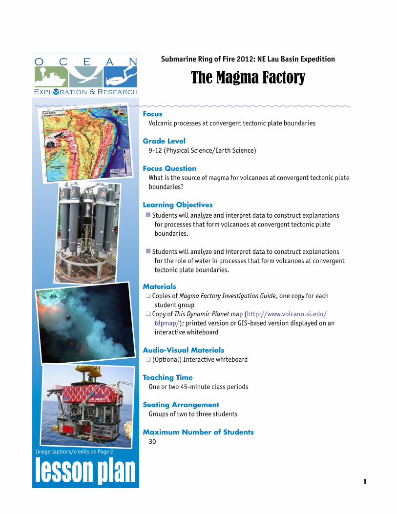
Submarine Ring of Fire 2012: NE Lau Basin Expedition
The Magma Factory
FocusVolcanic processes at convergent tectonic plate boundaries
Grade Level9-12 (Physical Science/Earth Science)
Focus QuestionWhat is the source of magma for volcanoes at convergent tectonic plate boundaries?
Learning Objectivesn Students will analyze and interpret data to construct explanations
for processes that form volcanoes at convergent tectonic plate boundaries.
n Students will analyze and interpret data to construct explanations
for the role of water in processes that form volcanoes at convergent tectonic plate boundaries.
Materialsq Copies of Magma Factory Investigation Guide, one copy for each
student groupq Copy of This Dynamic Planet map (http://www.volcano.si.edu/
tdpmap/); printed version or GIS-based version displayed on an interactive whiteboard
Audio-Visual Materialsq (Optional) Interactive whiteboard
Teaching TimeOne or two 45-minute class periods
Seating ArrangementGroups of two to three students
Maximum Number of Students30
2
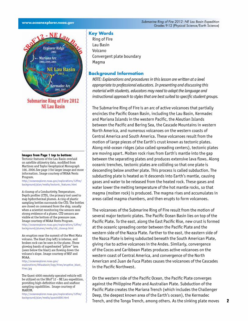
www.oceanexplorer.noaa.gov Submarine Ring of Fire 2012: NE Lau Basin ExpeditionGrades 9-12 (Physical Science/Earth Science)
Key WordsRing of FireLau BasinVolcanoConvergent plate boundaryMagma
Background InformationNOTE: Explanations and procedures in this lesson are written at a level appropriate to professional educators. In presenting and discussing this material with students, educators may need to adapt the language and instructional approach to styles that are best suited to specific student groups.
The Submarine Ring of Fire is an arc of active volcanoes that partially encircles the Pacific Ocean Basin, including the Lau Basin, Kermadec and Mariana Islands in the western Pacific, the Aleutian Islands between the Pacific and Bering Sea, the Cascade Mountains in western North America, and numerous volcanoes on the western coasts of Central America and South America. These volcanoes result from the motion of large pieces of the Earth’s crust known as tectonic plates. Along mid-ocean ridges (also called spreading centers), tectonic plates are moving apart. Molten rock rises from Earth’s mantle into the gap between the separating plates and produces extensive lava flows. Along oceanic trenches, tectonic plates are colliding so that one plate is descending below another plate. This process is called subduction. The subducting plate is heated as it descends into Earth’s mantle, causing gases and water to be released from the heated rock. These gases and water lower the melting temperature of the hot mantle rocks, so that magma (molten rock) is produced. The magma rises and accumulates in areas called magma chambers, and then erupts to form volcanoes.
The volcanoes of the Submarine Ring of Fire result from the motion of several major tectonic plates. The Pacific Ocean Basin lies on top of the Pacific Plate. To the east, along the East Pacific Rise, new crust is formed at the oceanic spreading center between the Pacific Plate and the western side of the Nazca Plate. Farther to the east, the eastern side of the Nazca Plate is being subducted beneath the South American Plate, giving rise to active volcanoes in the Andes. Similarly, convergence of the Cocos and Caribbean Plates produces active volcanoes on the western coast of Central America, and convergence of the North American and Juan de Fuca Plates causes the volcanoes of the Cascades in the Pacific Northwest.
On the western side of the Pacific Ocean, the Pacific Plate converges against the Philippine Plate and Australian Plate. Subduction of the Pacific Plate creates the Mariana Trench (which includes the Challenger Deep, the deepest known area of the Earth’s ocean), the Kermadec Trench, and the Tonga Trench, among others. As the sinking plate moves
Images from Page 1 top to bottom:Tectonic features of the Lau Basin overlaid on satellite altimetry data, modified from Martinez and Taylor Geophysical Monograph 166, 2006.See page 3 for larger image and more information. Image courtesy of NOAA Vents Program.http://oceanexplorer.noaa.gov/explorations/12fire/background/plan/media/tectonic_features.html
A closeup of a Conductivity, Temperature, Depth profiler (CTD), the primary tool used to map hydrothermal plumes. A ring of plastic sampling bottles surrounds the CTD. The bottles are closed on command from the ship, usually when a scientist monitoring the sensors sees strong evidence of a plume. CTD sensors are visible at the bottom of the pressure case. Image courtesy of NOAA Vents Program.http://oceanexplorer.noaa.gov/explorations/12fire/background/plumes/media/ctd_closeup.html
An eruption near the summit of the West Mata volcano. The blast (top left) is intense, and broken rock can be seen in the plume. Three glowing bands of superheated “pillow” lava (seen below the blast) are flowing down the volcano’s slope. Image courtesy of NSF and NOAA.http://oceanexplorer.noaa.gov/explorations/09laubasin/logs/hires/eruptive_blast_hires.jpg
The Quest 4000 remotely operated vehicle will be utilized on the SRoF’12 – NE Lau expedition, providing high-definition video and seafloor sampling capabilities. Image courtesy of MARUM.http://oceanexplorer.noaa.gov/explorations/12fire/background/plan/media/quest4000.html

3
www.oceanexplorer.noaa.gov Submarine Ring of Fire 2012: NE Lau Basin ExpeditionGrades 9-12 (Physical Science/Earth Science)
deeper into the mantle, new magma is formed as described above, and erupts along the convergent boundary to form volcanoes.
The movement of the Pacific Ocean tectonic plate has been likened to a huge conveyor belt on which new crust is formed at the oceanic spreading ridges, and older crust is recycled to the lower mantle at the convergent plate boundaries of the western Pacific.
This illustration shows the Pacific plate in the east colliding with the Indo-Australian plate in the west. A consequence of this collision is subduction with the down going slab comprised of oceanic crust, or lithosphere, and a thin veneer of pelagic sediment. This causes extension behind the subduction zone, which is represented by backarc basins forming behind the arc front. At certain depths, usually around 200 kilometers (~100 nautical miles), there is melting of the subducted materials. The melting produces magmas that rise buoyantly to pond in the overlying mantle wedge and periodically erupt on Earth’s surface as lavas, forming arc volcanoes. Image courtesy of GNS Science.http://oceanexplorer.noaa.gov/explorations/12fire/background/plan/media/pacific_plate.html
Tectonic features of the Lau Basin overlaid on satellite altimetry data, modified from Martinez and Taylor Geophysical Mono-graph 166, 2006. The Spreading centers and ridges are shown with black solid lines: Valu Fa Ridge (VFR), Central Eastern Lau Spreading Center (C-ELSC), Intermediate Lau Spreading Center (ILSC), Central Lau Spreading Center (CLSC), Lau Extensional Transform Zone (LETZ), Peggy Ridge (PR), North-West Lau Spreading Center (NWLSC), Niuafo’ou Spreading Center (NSC), Futuna Spreading Center (FSC), Mangatolu Triple Junction (MTJ), Fonualei Rift and Spread-ing Center (FRSC), North-East Lau Spread-ing Center (NELSC). Tonga Trench, ridges and tectonic plates are also noted. Image courtesy of NOAA Vents Program.http://oceanexplorer.noaa.gov/explorations/12fire/background/plan/media/tectonic_features.html

4
www.oceanexplorer.noaa.gov Submarine Ring of Fire 2012: NE Lau Basin ExpeditionGrades 9-12 (Physical Science/Earth Science)
The Northeastern Lau Basin is very unusual, because in addition to volcanic activity associated with the subduction of the Pacific Plate beneath the Indo-Australian Plate, there are also areas in which the Indo-Australian Plate seems to be pulling apart; and these areas are also rich in volcanic and hydrothermal activity. Preliminary surveys of the area between 2008 and 2011 have shown that the Northeastern Lau Basin is one of the most concentrated areas of active submarine volcanism and hot springs anywhere on Earth. For additional discussion, please see the Expedition Education Module for the Submarine Ring of Fire 2012: NE Lau Basin Expedition.
Beginning in 2002, NOAA Ocean Exploration expeditions have undertaken systematic mapping and study in previously unexplored areas of the Submarine Ring of Fire. Visit
• http://oceanexplorer.noaa.gov/explorations/02fire/logs/magicmountain/;
• http://www.oceanexplorer.noaa.gov/explorations/03fire/;• http://www.oceanexplorer.noaa.gov/explorations/04fire/;• http://www.oceanexplorer.noaa.gov/explorations/05fire/; and• http://oceanexplorer.noaa.gov/explorations/06fire/welcome.html• http://oceanexplorer.noaa.gov/explorations/07fire/welcome.html
for more information about the many discoveries, as well as still and video imagery, from these expeditions. The primary objective of the Submarine Ring of Fire 2012: NE Lau Basin Expedition is to explore and characterize the unique ecosystems in the NE Lau Basin through examination of their geology, chemistry, and macro- and microbiology.
In this lesson, students will investigate processes that form volcanoes at convergent tectonic plate boundaries, and the role of water in these processes.
Learning Procedure1. To prepare for this lesson, read the mission plan and Volcanology
background essay for the Submarine Ring of Fire 2012: NE Lau Basin Expedition at http://oceanexplorer.noaa.gov/explorations/12fire/background/laubasin/laubasin.html. You may also want to review 3D imagery and video fly-throughs, also linked from this page.
2. Briefly introduce the Submarine Ring of Fire 2012: NE Lau Basin Expedition. If necessary, review the concepts of plate tectonics. Be sure students understand the distinction between mid-ocean ridges and subduction zones. You may want to show students Multimedia Discovery Missions [http://oceanexplorer.noaa.gov/edu/learning/welcome.html]Lessons 1, 2 and 4, which include interactive multimedia presentations and Learning Activities on Plate Tectonics, Mid-Ocean Ridges, and Subduction Zones.
5
www.oceanexplorer.noaa.gov Submarine Ring of Fire 2012: NE Lau Basin ExpeditionGrades 9-12 (Physical Science/Earth Science)
3. Show students the This Dynamic Planet map, preferably on an interactive whiteboard using the GIS-based version linked from http://www.volcano.si.edu/tdpmap/. Call attention to the western Pacific region, and point out some of the tectonic plate boundaries to emphasize the complexity of plate interactions in this region. Ask students what images come to mind when they think of volcanoes (you may want to show one or more images of erupting volcanoes, such as http://www.noaa.gov/features/protecting_0808/images/volcanoimage1.jpg). “Lava” or “magma” will probably be among the responses. Call students’ attention to the red triangles that indicate the location of volcanoes, and ask whether volcanoes occur everywhere on Earth. From the map, it is evident that volcanoes are concentrated in certain areas, which suggests that magma or lava is only produced in certain areas as well. Tell students that their assignment is to find out where magma is produced, and what conditions are needed for this to happen.
4. Provide each student group with a copy of the Magma Factory Investigation, and specify when students are expected to have completed this investigation.
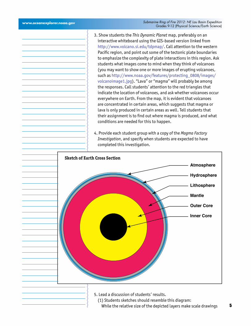
5. Lead a discussion of students’ results.(1) Students sketches should resemble this diagram: While the relative size of the depicted layers make scale drawings
Atmosphere
Hydrosphere
Lithosphere
Mantle
Outer Core
Inner Core
Sketch of Earth Cross Section
6
www.oceanexplorer.noaa.gov Submarine Ring of Fire 2012: NE Lau Basin ExpeditionGrades 9-12 (Physical Science/Earth Science)
impractical, sketches should reflect that the mantle and core are much larger than crustal layers.
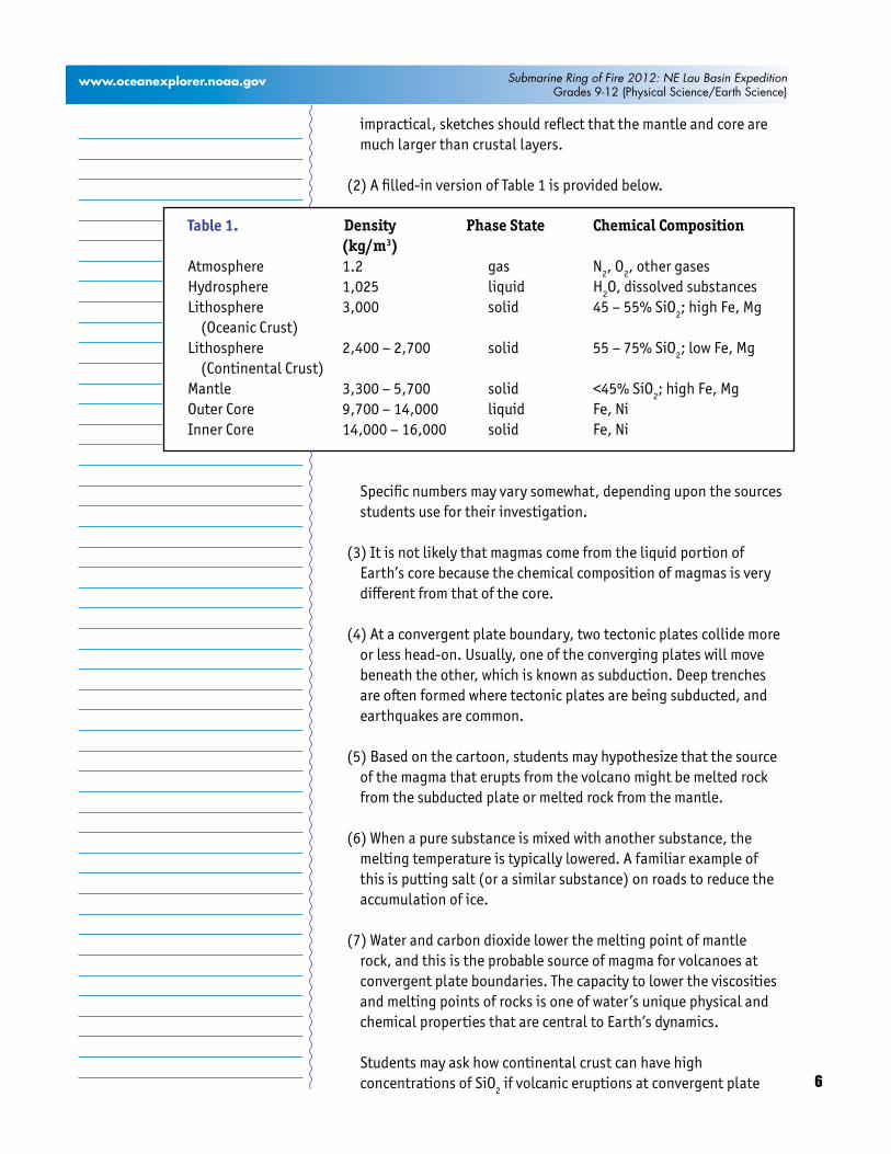
(2) A filled-in version of Table 1 is provided below.
Specific numbers may vary somewhat, depending upon the sources students use for their investigation.
(3) It is not likely that magmas come from the liquid portion of Earth’s core because the chemical composition of magmas is very different from that of the core.
(4) At a convergent plate boundary, two tectonic plates collide more or less head-on. Usually, one of the converging plates will move beneath the other, which is known as subduction. Deep trenches are often formed where tectonic plates are being subducted, and earthquakes are common.
(5) Based on the cartoon, students may hypothesize that the source of the magma that erupts from the volcano might be melted rock from the subducted plate or melted rock from the mantle.
(6) When a pure substance is mixed with another substance, the melting temperature is typically lowered. A familiar example of this is putting salt (or a similar substance) on roads to reduce the accumulation of ice.
(7) Water and carbon dioxide lower the melting point of mantle rock, and this is the probable source of magma for volcanoes at convergent plate boundaries. The capacity to lower the viscosities and melting points of rocks is one of water’s unique physical and chemical properties that are central to Earth’s dynamics.
Students may ask how continental crust can have high concentrations of SiO2 if volcanic eruptions at convergent plate
Density Phase State Chemical Composition (kg/m3)Atmosphere 1.2 gas N2, O2, other gasesHydrosphere 1,025 liquid H2O, dissolved substancesLithosphere 3,000 solid 45 – 55% SiO2; high Fe, Mg (Oceanic Crust)Lithosphere 2,400 – 2,700 solid 55 – 75% SiO2; low Fe, Mg (Continental Crust)Mantle 3,300 – 5,700 solid <45% SiO2; high Fe, MgOuter Core 9,700 – 14,000 liquid Fe, NiInner Core 14,000 – 16,000 solid Fe, Ni
Table 1.
7
www.oceanexplorer.noaa.gov Submarine Ring of Fire 2012: NE Lau Basin ExpeditionGrades 9-12 (Physical Science/Earth Science)
boundaries are the result of melted mantle rock, which has a low concentration of SiO2. The answer is that the chemical composition of magma can be changed by processes that operate while magma is transported toward the surface or while it is stored in Earth’s crust. These processes are known as magmatic differentiation. One way this can happen takes place when magma passes through cooler rock on its way to the surface, and partially melts the surrounding rock. Partial melting produces liquids that contain silicon, and when these liquids are incorporated into the magma, they increase the magma’s silicon content. This process is called assimilation. Another process that increases silicon concentration takes place when magma begins to crystallize. Because different minerals crystallize at different temperatures, this process can change the chemical composition of the magma. This processes is called magmatic differentiation by fractional crystallization.
The BRIDGE Connectionwww.vims.edu/bridge/ – In the menu on the left, scroll over “Ocean Science Topics,” then click “Geology,” for links to resources about plate tectonics and volcanoes.
The “Me” ConnectionHave students write a brief essay describing how exploration of deep-sea volcanoes could be of personal importance.
Connections to Other SubjectsEnglish Language Arts
AssessmentStudents’ responses to Investigation Guide questions and class discussions provide opportunities for assessment.
ExtensionsVisit http://oceanexplorer.noaa.gov/explorations/12fire/background/laubasin/laubasin.html. for more information and resources related to the Submarine Ring of Fire 2012: NE Lau Basin Expedition.
Multimedia Discovery Missions http://oceanexplorer.noaa.gov/edu/learning/welcome.html Lessons 1, 2, and 4 for interactive multimedia presentations and Learning Activities on Plate Tectonics, Mid-ocean Ridges, and Subduction Zones
8
www.oceanexplorer.noaa.gov Submarine Ring of Fire 2012: NE Lau Basin ExpeditionGrades 9-12 (Physical Science/Earth Science)
Other Relevant Lesson Plans from NOAA’s Ocean Exploration Program
What’s the Difference? (from the New Zealand America Submarine Ring of Fire 2007 Expedition) http://oceanexplorer.noaa.gov/explorations/07fire/background/edu/media/difference.pdf
Focus: Volcanic processes at convergent and divergent tectonic plate boundaries (Earth Science)
Students compare and contrast volcanoes at convergent and divergent plate boundaries; identify three geologic features that are associated with most volcanoes on Earth; and explain why some volcanoes erupt explosively while others do not.
Where There’s Smoke, There’s ... (from the New Zealand America Submarine Ring of Fire 2007 Expedition) http://oceanexplorer.noaa.gov/explorations/07fire/background/edu/media/smoke.pdf
Focus: Hydrothermal vent chemistry at subduction volcanoes (Chemistry)
Students use fundamental relationships between melting points, boiling points, solubility, temperature, and pressure to develop plausible explanations for observed chemical phenomena in the vicinity of subduction volcanoes.
It Looks Like Champagne (from the New Zealand America Submarine Ring of Fire 2007 Expedition) http://oceanexplorer.noaa.gov/explorations/07fire/background/edu/media/champagne.pdf
Focus: Deep ocean carbon dioxide and global climate change (Chemistry/Earth Science)
Students interpret phase diagrams, and explain the meaning of “critical point” and “triple point”; define “supercritical fluid,” and describe two practical uses of supercritical carbon dioxide; and discuss the concept of carbon dioxide sequestration.
9
www.oceanexplorer.noaa.gov Submarine Ring of Fire 2012: NE Lau Basin ExpeditionGrades 9-12 (Physical Science/Earth Science)
Going to Extremes (from the New Zealand America Submarine Ring of Fire 2007 Expedition) http://oceanexplorer.noaa.gov/explorations/07fire/background/edu/media/extremes.pdf
Focus: Archaea (Biology)
Students define “lipid biomarkers,” and explain what the presence of certain biomarkers signifies; describe Archaea and explain why these organisms are often considered to be unusual; contrast Archaea with bacteria and eukaryotes; define methanogen and methanotroph, explain the relevance of these terms to Archaea; and discuss the potential significance of Archaea in hydrothermal communities of the Kermadec Arc.
Where Did They Come From? (from the Submarine Ring of Fire 2006 Expedition)http://oceanexplorer.noaa.gov/explorations/06fire/background/edu/media/ROF06.WhereFrom.pdf
Focus: Species variation in hydrothermal vent communities (Life Science)
Students will define and describe biogeographic provinces of hydrothermal vent communities; identify and discuss processes contributing to isolation and species exchange between hydrothermal vent communities; and discuss characteristics that may contribute to the survival of species inhabiting hydrothermal vent communities.
Hydrothermal Vent Challenge (from the Submarine Ring of Fire 2006 Expedition)http://oceanexplorer.noaa.gov/explorations/06fire/background/edu/media/ROF06.VentChallenge.pdf
Focus: Chemistry of hydrothermal vents (Chemistry)
Students define hydrothermal vents and explain the overall processes that lead to their formation; explain the origin of mineral-rich fluids associated with hydrothermal vents; explain how “black smokers” and “white smokers” are formed; and hypothesize how properties of hydrothermal fluids might be used to locate undiscovered hydrothermal vents.
Roots of the Mariana Arc (from the Submarine Ring of Fire 2006 Expedition)http://oceanexplorer.noaa.gov/explorations/06fire/background/edu/media/ROF06.Roots.pdf
10
www.oceanexplorer.noaa.gov Submarine Ring of Fire 2012: NE Lau Basin ExpeditionGrades 9-12 (Physical Science/Earth Science)
Focus: Seismology and geological origins of the Mariana Arc (Earth Science)
Students explain the processes of plate tectonics and volcanism that resulted in the formation of the Mariana Arc and describe, compare, and contrast S waves and P waves; explain how seismic data recorded at different locations can be used to determine the epicenter of an earthquake, and infer a probable explanation for the existence of ultra-low velocity zones.
Mystery of the Megaplume (from the Submarine Ring of Fire 2006 Expedition)http://oceanexplorer.noaa.gov/explorations/06fire/background/edu/media/ROF06.Megaplume.pdf
Focus: Hydrothermal vent chemistry (Chemistry, Earth Science, Physical Science)
Students describe hydrothermal vents and characterize vent plumes in terms of physical and chemical properties; describe tow-yo operations and how data from these operations can provide clues to the location of hydrothermal vents; and interpret temperature anomaly data to recognize a probable plume from a hydrothermal vent.
Other Resources The Web links below are provided for informational purposes only. Links outside of Ocean Explorer have been checked at the time of this page’s publication, but the linking sites may become outdated or non-operational over time.
http://oceanexplorer.noaa.gov - Web site for NOAA’s Ocean Exploration program
http://oceanexplorer.noaa.gov/explorations/12fire/background/laubasin/laubasin.html - Web page for the Submarine Ring of Fire 2012: NE Lau Basin Expedition
http://www.pmel.noaa.gov/vents/index.html - NOAA’s hydrothermal vent Web site
http://pubs.usgs.gov/gip/dynamic/dynamic.html - Online version of “This Dynamic Earth,” a thorough publication of the U.S. Geological Survey on plate tectonics written for a non-technical audience
11
www.oceanexplorer.noaa.gov Submarine Ring of Fire 2012: NE Lau Basin ExpeditionGrades 9-12 (Physical Science/Earth Science)
http://www.volcano.si.edu/tdpmap/ - “This Dynamic Planet,” map and explanatory text showing Earth’s physiographic features, plate movements, and locations of volcanoes, earthquakes, and impact craters
http://oceanexplorer.noaa.gov/explorations/03fire/logs/subduction_vr.html - 3-dimensional “subduction zone” plate boundary video
http://volcano.oregonstate.edu/ - Volcano World Web site from Oregon State University
Relationship to A Framework for K-12 Science Education: Practices, Crosscutting Concepts, and Core Ideas
The objectives of this lesson integrate the following Practices, Crosscutting Concepts, and Core Ideas:Objective: Students will analyze and interpret data to construct explanations for processes that form volcanoes at convergent tectonic plate boundaries.
Practices: 4. Analyzing and interpreting data6. Constructing explanations
Crosscutting Concepts: 2. Cause and effect4. Systems and system models
Core Ideas: ESS2.A: Earth Materials and SystemsESS2.B: Plate Tectonics and Large-Scale System Interactions
Objective: Students will analyze and interpret data to construct explanations for the role of water in processes that form volcanoes at convergent tectonic plate boundaries.
Practices: 4. Analyzing and interpreting data6. Constructing explanations
Crosscutting Concepts2. Cause and effect
Core Ideas: ESS2.A: Earth Materials and SystemsESS2.B: Plate Tectonics and Large-Scale System InteractionsESS2.C: The Roles of Water in Earth’s Surface Processess

12
www.oceanexplorer.noaa.gov Submarine Ring of Fire 2012: NE Lau Basin ExpeditionGrades 9-12 (Physical Science/Earth Science)
Correlations to Common Core State Standards for English Language Arts
RI.4 – 4. Determine the meaning of words and phrases as they are used in a text, including figurative, connotative, and technical meanings; analyze the impact of a specific word choice on meaning and tone.
W.1 – Write arguments to support claims with clear reasons and relevant evidence.
SL.1 – Engage effectively in a range of collaborative discussions (one-on-one, in groups, and teacher-led) with diverse partners on grades 9 -10 (or 11-12) topics, texts, and issues, building on others’ ideas and expressing their own clearly.
Ocean Literacy Essential Principles and Fundamental Concepts
Essential Principle 1. The Earth has one big ocean with many features.
Fundamental Concept a. The ocean is the dominant physical feature on our planet Earth—covering approximately 70% of the planet’s surface. There is one ocean with many ocean basins, such as the North Pacific, South Pacific, North Atlantic, South Atlantic, Indian and Arctic.
Fundamental Concept b. An ocean basin’s size, shape and features (such as islands, trenches, mid-ocean ridges, rift valleys) vary due to the movement of Earth’s lithospheric plates. Earth’s highest peaks, deepest valleys and flattest vast plains are all in the ocean.
Essential Principle 5. The ocean supports a great diversity of life and ecosystems.
Fundamental Concept b. Most life in the ocean exists as microbes. Microbes are the most important primary producers in the ocean. Not only are they the most abundant life form in the ocean, they have extremely fast growth rates and life cycles.
Fundamental Concept g. There are deep ocean ecosystems that are independent of energy from sunlight and photosynthetic organisms. Hydrothermal vents, submarine hot springs, and methane cold seeps rely only on chemical energy and chemosynthetic organisms to support life.
Essential Principle 7. The ocean is largely unexplored.
Fundamental Concept a. The ocean is the last and largest unexplored place on Earth—less than 5% of it has been explored. This is the great frontier for the next generation’s explorers and researchers, where they will find great opportunities for inquiry and investigation.
13
www.oceanexplorer.noaa.gov Submarine Ring of Fire 2012: NE Lau Basin ExpeditionGrades 9-12 (Physical Science/Earth Science)
Fundamental Concept b. Understanding the ocean is more than a matter of curiosity. Exploration, inquiry and study are required to better understand ocean systems and processes.
Fundamental Concept d. New technologies, sensors and tools are expanding our ability to explore the ocean. Ocean scientists are relying more and more on satellites, drifters, buoys, subsea observatories and unmanned submersibles.
Fundamental Concept f. Ocean exploration is truly interdisciplinary. It requires close collaboration among biologists, chemists, climatologists, computer programmers, engineers, geologists, meteorologists, and physicists, and new ways of thinking.
Send Us Your FeedbackIn addition to consultation with expedition scientists, the development of lesson plans and other education products is guided by comments and suggestions from educators and others who use these materials. Please send questions and comments about these materials to: [email protected].
For More InformationPaula Keener, Director, Education Programs NOAA Office of Ocean Exploration and ResearchHollings Marine Laboratory331 Fort Johnson Road, Charleston SC 29412843.762.8818 843.762.8737 (fax) [email protected]
AcknowledgementsThis lesson was developed and written for NOAA’s Office of Ocean Exploration and Research (OER) by Dr. Mel Goodwin, Science and Technology Consultant to OER’s Education Team.Design/layout: Coastal Images Graphic Design, Mt. Pleasant, SC.
CreditIf reproducing this lesson, please cite NOAA as the source, and provide the following URL: http://oceanexplorer.noaa.gov

14
Submarine Ring of Fire 2012: NE Lau Basin ExpeditionGrades 9-12 (Physical Science/Earth Science)
www.oceanexplorer.noaa.gov
Factory Investigation Guide
1. Draw a sketch of a cross-section of Earth that includes the following layers:AtmosphereHydrosphereLithosphere (Oceanic Crust)Lithosphere (Continental Crust)MantleOuter Core
2. Fill in Table 1, which lists some physical properties of Earth’s layers.
Density Phase State Chemical Composition (kg/m3)
Atmosphere
Hydrosphere
Lithosphere
(Oceanic Crust)
Lithosphere
(Continental Crust)
Mantle
Outer Core
3. When volcanoes erupt, magma is expelled onto Earth’s surface, either on land or on the ocean floor. The chemical composition of magmas varies, but all magmas contain silicon dioxide (SiO2), in concentrations that range from 45% to 75% by weight. Based on this information, and the information you found for Table 1, is it likely that magmas come from the liquid portion of Earth’s core?
4. What happens at a convergent tectonic plate boundary?
Table 1.

15
Submarine Ring of Fire 2012: NE Lau Basin ExpeditionGrades 9-12 (Physical Science/Earth Science)
www.oceanexplorer.noaa.gov
5. Magma is melted rock. Here is a cartoon of a volcano at a convergent plate boundary. Considering this diagram, what might be the source of the magma that erupts from the volcano?
6. Most solid substances will change to a liquid at a specific temperature called the melting temperature. What usually happens to the melting temperature when a pure substance is mixed with another substance?
7. The subducted plate in Figure 1 contains water and carbon dioxide, in addition to crustal rock. Considering your answer to Question 6, what might be the effect of water and carbon dioxide on the melting point of rock in Earth’s mantle? HINT: What is “flux melting?”
Mantle
Pacific Plate
Indo-Australian PlateMagma
Pacific OceanFigure 1.