Embed Size (px)
Citation preview
The Make-Up of the City’s Fabric:
Layered Topography of Hong Kong Creates a Unique Urban Condition and a Connected City
Carolina Cardoza
August 3, 2015

Introduction
Bernard Rudofsky in his book Streets for People: A Primer for Americans (1969)
describes how American cities turned into non-cities. He claims that American cities then were
“inconvenient, dirty, lacking in charm and beauty because the individual landowner has been
permitted to plan it…” (16). This was the result of “a lack of city sense that Americans have”
which in turn created a sense of “nothing to awaken love, affection, interest… The city has
neglected the people and the people in turn have neglected the city” (16-17). Rudofsky argues
that the city has to take its people into consideration in order for the people to not neglect the
city. He quotes Frederic Clemson How, an American political scientist, who said “Our
[American] cities are what they are because we have no thought of the city as a city, of the town
as a town, of the right of everybody as to the rights of anybody” (16). Cities should not be
inconvenient and thus people will see it as a city in which they will participate in, “Our cities
have been permitted to grow with no concern for the future and with no thought of the
community or the terrible costs which this uncontrolled development creates” (Rudofsky 16). So
then what creates a thriving city? A city that is successfully connected for its people needs. What
kind of urban planning is needed?
According to Walkable City, Living Streets, global best practices are by those cities who
deal with cities for pedestrians, use public transportation to support pedestrians, wayfinding, and
have greenery. Cities that offer a “reliable and comprehensive public transit, make
neighborhoods more walkable, and who accommodate pedestrians and bike traffic” (Cooney
Web) are cities that create a connected city. Building an interconnected urban transport system is
what makes a city’s urban planning thrive. Many cities have charge ahead with different
initiatives and innovative ideas for tackling their own issues and meeting their citizens’’

aspirations. (Walkable City, Living Streets 42). Toronto is becoming a great walking city by
devising a Walking Strategy and a Pedestrian Charter. Barcelona has integrated various transport
modes into a sustainability-minded transport plan. In cities like New York, London, and
Melbourne, the concept of ‘shared space’ is strongly promoted. (Walkable City, Living Streets
98). Another city that has much to offer in regards to its urban planning is Hong Kong.
Background
Why is Hong Kong a candidate to look at its urban planning? At a lecture at the Hong
Kong University of Science and Technology by Betty S.F. Ho titled Town Planning and Design
in Hong Kong, I learned that Hong Kong has developed greatly over the years in regards to
urban planning. “In just over a century and a half, Hong Kong has evolved from a small fishing
village on the southern coast of China to one of the most renowned metropolitan cities in the
world” (Walkable City, Living Streets 25). Because Hong Kong is an island there is limited space
to build. “With a shortage of natural land on which to build, Hong Kong has engaged in
reclamation from the earliest days of British settlement” (The Making of Hong Kong 132). In an
area of about 1,100 square kilometers and a population of 7.24 million (Mid 2014) with a
population density of 6,690/sq. km, the built up area is 46%. The population growth began with
an influx of Chinese Mainland Immigrants after World War II. In 1939 a Town Planning
Ordinance was established in Hong Kong in order to promote health, safety, convenience, and
general welfare to the community. Some of the major planning issues where to either plan on
concentration or decentralization or for further reclamation. Thus urban design guidelines
developed into a height/layered profile. In result, “The desire to keep Hong Kong moving has
driven the city over the last few decades to invest heavily in reliable, safe and efficient transport
systems that have become the envy of the world” (Walkable City, Living Streets 25).

Observations Upon Arrival
Upon arriving in Hong Kong, my observations are that short distance travel will be easier
than long distance traveling because of the highly density and compact of the city. Commercial
areas have a mix of heavy traffic volume and dense pedestrian flow. At a glance, HK looks
inadequate for people with disabilities. I have not seen any bike lanes and I think these should be
implemented. Looking at all these aspects will determine if HK is a connected city. With all that
taken into consideration, is there an ease at arriving at a desired destination? I think Hong Kong
is a city that offers convenience of being a connected city.
Literature Review
How can Hong Kong a highly dense populated city in a small footprint urban system
offer convenience? Or does it really offer convenience? According to Adam Frampton, Jonathan
D. Solomon, and Clara Wong in Cities Without Ground, “To a visitor, Hong Kong appears at
first confounding in its complexity and seemingly chaotic organization. After a few weeks, the
city gradually reveals itself to be remarkably functional” (Cities Without Ground 6). It is
“remarkably functional” because the vast distances turn out to be compacted geographically.
Apart from Hong Kong being a compact city, “innumerable buses and trains arrive and depart
with such remarkable dependability that you always end up just where you need to be” (Cities
Without Ground 6). This is where the city creates connectivity to such a degree that there is no
need to reference the ground, “Hong Kong is a city without ground” (Cities Without Ground 6).
Because “Hong Kong manifests a vision of continual figure-to figure relationships, Hong Kong
is a template for public space within future cities undergoing intense densification” (Cities
Without Ground 10). Hong Kong is extremely dense with such limited space. Barrie Shelton,
Justyna Karakiewicz and Thomas Kvan in The Making Of Hong Kong: From Vertical to
Volumetric, argue that Hong Kong is an effective urban assemblage of form, use and movement
that many cities seek for (Preface vi). Tall buildings extend across most of the city, “these
characteristics are born out of unusual geography: from a tight island (Hong Kong Island) and
peninsula (Kowloon Peninsular) location where peaks are plentiful and flat land scarce” (Preface
vi). Because of its constrained setting, the skyward rise of buildings became necessary, “from the
outset reclamation displaced sea, hillsides were stepped to replace slopes, and some hills were
removed altogether to gain useful land” (Preface vi). Then the concept of “multiple grounds”
became a planning strategy: the packing of all kinds of retail, commercial, and other services into
massive volumes; the stacking of homes in towers above and beside those packed town centres;
and the integration of a first-class public transport system (with tunneled and elevated routes) to
link these tall and massive centres. Roofs were then used as ground, ground that connected
buildings to other buildings across levels. Hong Kong was become “The world’s most
concentrated and vertical city” (The Making Of Hong Kong: From Vertical to Volumetric 7). But
because of the density of the city, there must be a way of connecting to create an easy flow,
“HK’s functioning as a dense city depends on most people making almost all their journeys on
public transport or on publicly regulated private vehicles. It includes train, ‘tube’, subway, bus,
mini bus, several types of ferry boat, taxi, tram, bicycles…” (The Making Of Hong Kong: From
Vertical to Volumetric 6). Public transport is a necessity to create connectivity thus public
transport is built onto infrastructure to integrate it as a part of the connectivity. “The result is that
90 per cent of journeys are made on vehicles providing public passenger services” (The Making
Of Hong Kong: From Vertical to Volumetric 6). “Jeff Kenworthy, urban transport and energy use
analyst, was able to proclaim Hong Kong’s ‘remarkably successful transit system and very low
car usage’ as a model to the world in his ‘Model Cities: Asia’ paper (Kenworthy, 2001)” (The

Making Of Hong Kong: From Vertical to Volumetric 6). This means that people are using public
transport and if it is integrated onto the infrastructure then transportation aids connectivity. In a
comparison to Los Angeles, Kenworthy cited a HK per capita increase in car use over the decade
1981-1991 of just 146 km, compared to 2,584 for Los Angeles. He noted that half of Hong
Kong’s residents lived within 500 m of a Mass Transit Rail station, and that 70% of users of this
intensively used system walked to and from their origin and destination stations when making
their trips. Only 3% of passengers used some other form of transport at both ends of their train
rides to connect to other places. Meaning that in Hong Kong the transport system is much more
integrated with the infrastructure. Yet public transport means much more than just railway, “To
think of HK’s ‘public transport’ only in terms of conventional vehicles is too limiting and should
rightly be extended to include ‘public movement infrastructure services’, for lifts, and escalators
play crucial roles in the compendium of interdependent systems that keep this city mobile” (The
Making Of Hong Kong: From Vertical to Volumetric 6). Aside from all the public transport that
aides connectivity, this is so as a result of a planning strategy of integration. In the Kowloon and
Canton Railway Company’s Linear City Project Report (2004-2005), the company states in its
Mission and Vision that it “is one of the world’s most successful railway operators: each day it
carries about 1.5 million passengers…further enhance(s) the network’s reach and connectivity.
The Corporation’s 113-kilometre network now links much of the New Territories to Hong
Kong’s urban areas” (3). The mission is to integrate a railway network that “meets the increasing
demand for territorial, cross-boundary and intercity railway services” (4). Yet, public transport is
not the only way to connect a city. In Walkable City, Living Streets (October 2012) Simon Ng,
Wilson Lau, Fred Brown, Eva Tam, Mandy Lao and Veronica Booth claim that

“Hong Kong as a layered city has some excellent examples of good walkability. For
instance, there is an extensive elevated footbridge system that connects major commercial
buildings, shopping malls, and public transport nodes in Central. There is also a well-
developed underground pedestrian networks stemming from main MTR stations. In some
transit oriented development sites, integration between transport and land use has
enhanced the vertical and horizontal movements of people” (7).
Walkability also aides connectivity in Hong Kong. Although “multiple grounds” and public
transportation and in some cases walkability can aid convenience and connectivity in Hong
Kong, “Unfortunately, there are also complaints about the urban pedestrian environment-
difficult wayfinding, lack of at-grade crossings, over-crowding, inadequate universal access, lack
of seating, and unattractive street aesthetics” (Walkable City, Living Streets 7). Because of urban
planning focusing on “multiple grounds” the streets become forgotten: “Apart from their
transport function, streets are also public spaces for interaction, and access to quality public
space is a right for everyone, not a privileged for a chosen few” (Walkable City, Living Streets
7). Street walkability also aides the City’s connectivity and should be improved in order to
enhance pedestrian movement. A walkable Hong Kong will result in more people walking and
walking for longer distances. Walkability also has many factors that if improved upon could
“enrich social life and strengthen community bonding” (Walkable City, Living Streets 7).
Another problem is that low-income groups, who have limited options for transport, cannot
benefit from the City’s connectivity therefore, improved accessibility and public space in the
streets will enhance the connectivity of those who cannot afford anything else. “In other words,
better walkability will act as a social equalizer to improve social justice and equity in Hong
Kong” (Walkable City, Living Streets 7). In an online article published in the South China

Morning Post, Christopher DeWolf in “Urban Planner Marks Hong Kong Down” (12 September,
2014) interviews Peter Cookson Smith, who is an urban planner in HK since 1977. Smith
contests that “Hong Kong urban planning with ‘ridiculous’ public consultations that don’t
amount to anything and little concern for what citizens actually want.” Smith is critiquing public
consultations for planning what will benefit themselves for example building shops, restaurants,
etc. on “multiple grounds”. Yet he claims that the interest of the people is not taken into
consideration. There is a comment on this article by “Caractacus” (13 September 2014) in which
this person claims that “We can’t even get bicycle lanes” aiding the claim made by Smith that
the people are not taken into consideration. Hong Kong is a city that has much to offer in regards
to urban planning and the connectivity it provides for people, yet it has areas to improve on. It is
important to consider the challenges faced by the setting of HK and how urban planning has
created a vibrant city that functions in such limited space and with such a dense population. In
comparison to Los Angeles, HK can learn from some of the problems it faces such as not having
bike lanes, pedestrian environment and street aesthetics. Not one city is perfect and thus Los
Angeles can also benefit from the integration HK has of its public transport which aides
connectivity and also from the urban planning.
Methodology
I will be using photography, I will be interviewing people, doing observations/ site
surveys. The photography will be used to show the infrastructure and the connectivity. For the
interviews, I have found some people who have been to Los Angeles and can compare both
cities. Also I will be interviewing people/ residents to see how they are aided by connectivity, if
so or if not and why and how do they get around. For the observations/ site surveys I will be
Mapping out routes: Local surveys: A handful of sample routes are to be picked to highlight the

merits of the current walking environment/ environment. I will keep a Score card which will be
based on A) Connectivity B) Obstacles C) Wayfinding D) Physical Features E) Conditions. For
the sample route there will be 4 sites. These routes will be considered Visitor Walks because
they will be conducted by myself, someone who does not know the area. Outsiders will rely on
maps, signage for directions and navigation. (This method was used in Walkable City, Living
Streets).
Case Studies
HKUST Minibus 11M
I use this minibus to get to the train station. It is just outside the entrance of the Hong
Kong University of Science and Technology. The minibus stops at the Hang Hau MTR Station
Public Transport Interchange. The route the bus takes is via University Road, Clear Water Bay
Road, Hang Hau Road, Po Ning Road, Sheung Ning Road, Chung Wa Road, and Pui Shing Road
to get to Hang Ha MTR Station Public Transport Interchange. Coming back to the University,
the route is via L38A Road, Sheung Ning Road, Po Ning Road, Clear Water Bay Road and
University Road. The route is a residential area so there aren’t many pedestrians. Sometimes the
sidewalks just disappear and ground level becomes just for cars and underground is where the
walkways are for pedestrians. There are more cars in Hang Hau compared to other places
because it is more residential. Much of the route are mountains/ slopes with greenery and homes/
houses and apartment buildings but not tall. Also because much of the route is composed by
mountains, sidewalks become erased.


Then the minibus drops me off at Hang Hau Bus Hub/MTR Station Public Transport
Interchange. Once arriving there, there is no way to get lost because there is sinage directing to
Hang Hau MTR station. There are pedestrian crosswalks from all sides of the bus stops. The bus
stops are clearly labeled as are their destinations. At the entrance/exit of the Transport
Interchange there is a map of all the different destinations and all the buses that go that route.
This bus hub is composed of mini buses, double decker buses, and New Territory taxis. There
are arrows that indicate the exit and the entrance to the MTR station. Once closer to the exit,
there are arrows and signs that indicate where the elevators are.

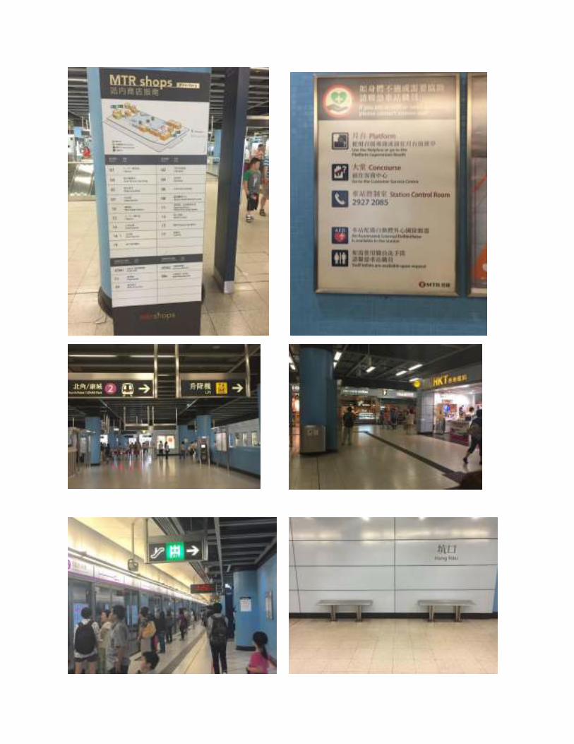
Hang Hau Station
Outside the station there is seating. There are escalators leading up to the MTR mall.
There are elevated walkways from the MTR station Building that connect the malls across the
streets. There are Carparks at the bottom of the MTR Mall. Across the street are malls but also
residential buildings. Residence parking is available and car park for the malls. There are signs
indicating where to get to the MTR Station. Right upon entering there was a map of the station in
braille. There are stores within the station. There are many signaling of where elevators and
escalators are located. There is also a directory of MTR shops within the station. Street Map/
Exit information/tourist sites are available throughout the station. There is a MTR system map
with local tourist attractions. Each exit has a letter and there is a list for each letter that lists the
places, there is clear signaling of exits. There are information desks, customer service desks. The
name of the station is everywhere. There are arrows pointing to the direction to enter the train.
There is an uneven set of tiles that signals that you’re close to the train.


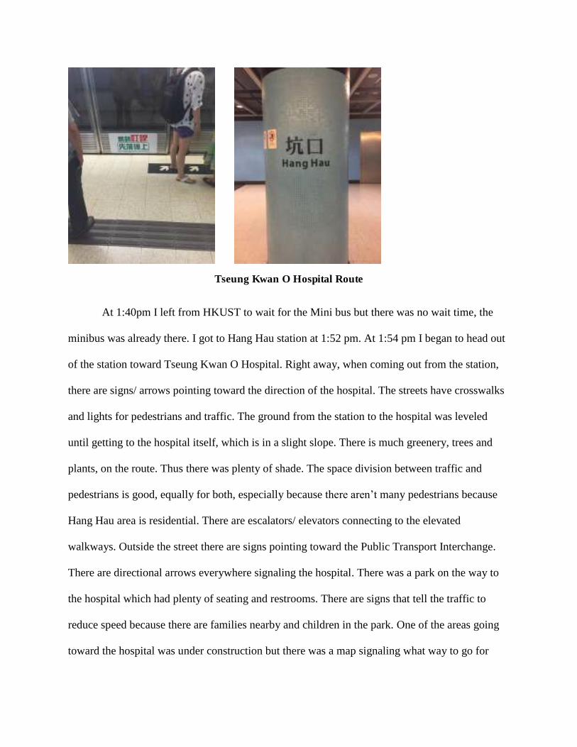
Tseung Kwan O Hospital Route
At 1:40pm I left from HKUST to wait for the Mini bus but there was no wait time, the
minibus was already there. I got to Hang Hau station at 1:52 pm. At 1:54 pm I began to head out
of the station toward Tseung Kwan O Hospital. Right away, when coming out from the station,
there are signs/ arrows pointing toward the direction of the hospital. The streets have crosswalks
and lights for pedestrians and traffic. The ground from the station to the hospital was leveled
until getting to the hospital itself, which is in a slight slope. There is much greenery, trees and
plants, on the route. Thus there was plenty of shade. The space division between traffic and
pedestrians is good, equally for both, especially because there aren’t many pedestrians because
Hang Hau area is residential. There are escalators/ elevators connecting to the elevated
walkways. Outside the street there are signs pointing toward the Public Transport Interchange.
There are directional arrows everywhere signaling the hospital. There was a park on the way to
the hospital which had plenty of seating and restrooms. There are signs that tell the traffic to
reduce speed because there are families nearby and children in the park. One of the areas going
toward the hospital was under construction but there was a map signaling what way to go for

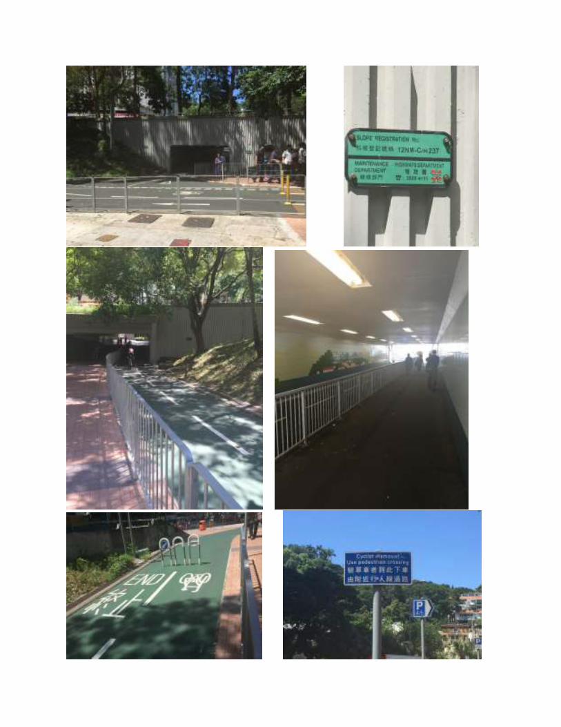
alternative routes. There was a bit of a slope but there were signs for it. There are signs posted
toward the bike parking area and bike access. There are bike lanes, there is no traffic space, it is
just for bikes. Next to this, there is an underground Tunnel with a fence dividing the pedestrian
sidewalk and bike lanes. There are signs signaling the end of bike lanes and telling riders the
must park their bike, “Cyclist dismount Use pedestrian crossing”. Right in front of the hospital
entrance/exit, there is a path so that “Wheelchair users can go along this access to all Hospital
Departments.” This area includes a map signaling the dead ends and there is seating and
greenery. The end of this area leads to many bus stops in the street and to the parking lot. Finally
at 2:10pm I arrived at the Hospital. I then left the hospital and got back to the station at 2:27pm.


Conclusion
Going to Tseung Kwan O Hospital I was always on ground floor and it was very easy to
arrive there. This ease at arriving at my destination was aided by the amount of signs pointing to
the direction of the hospital and the maps that were on many of the streets. Something that I
found on this route was that on some crosswalks that did not have any lights, written on the street
says which way to look at traffic when crossing. I found this to be very helpful especially
because as a tourist and being from Los Angeles, we drive on the opposite side. All signs are
bilingual which became important especially for those signs indicating Barrier Free Access. The
accessibility for people with disabilities and those who need barrier free access was successful in
this route and I think this has to do especially because it is a hospital and thus everything needs
to be barrier free access. The route was along a residential area and thus it was not crowded and
the atmosphere in this route was very green and the park created an easy flow onto walking
across it to get to the hospital. The bike lanes that were in this route is something I have never
seen in any other part of Hong Kong. Something that was made clear by the signs telling riders

to dismount and signaling the end of the bike route and the parking next to this, is a sign that
bikes are not allowed onto many spaces other than those that have been set aside for them. I have
not seen many people riding bikes in Hong Kong, I have only seen the bikes parked. Hong Kong
is very hilly and most people use public transportation. Overall this route was a very accessible
one and proved satisfactory in terms of its connectivity and accessibility of arriving at ease at
Tseung Kwan O Hospital.
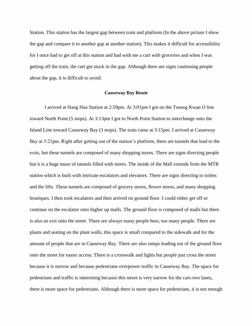
Tai Po Market Route
At 2:38pm I arrived at the train Tseung Kwan O Line waiting area going toward Yau
Tong (3 stops). The train arrived at 2:40pm. I waited for the next train to see how long it would
take, it arrived at 2:43 pm. I waited for the next train and it came five minutes later at 2:48 pm.
Inside the train there were certain seats that are marked off and have signs saying to give up
seats to anyone in need. The train was not as full, as this train always is and so there was plenty
of places to sit or stand and grab onto. There are maps inside the train with lights that signals
which stop heading toward and which stop leads to connections. At 2:53pm the train arrived at
Yau Tong Station. Here I had to interchange to the Kwun Tong Line toward Kowloon Tong (9
stops). The train arrived at 2:54pm. I arrived at 3:15pm at Kowloon Tong Station in which I had
to interchange to the East Rail line toward Tai Po Market (5stops). In this station I saw signs
signaling toilets, there were maps everywhere, and signs leading to the exits. There are stores in
this station and the tunnels are more packed with people. This line is always more full than many
of the other lines. At 3:23pm I got to the platform waiting for train. It came at 3:26pm. This train
is also different from most of the other lines because it is not completely underground. Many
stops are above ground floor. Because of this reason, there are no protecting doors that stop
people from going into the rails/tracks. Some of these stations have workers on the platform

looking out for passengers. I got off at 3:47pm from this train, I arrived at the Tai Po Market
station. At this station I noticed that the entrances and exits, where you must go through in order
to pay, have space which is bigger for strollers and wheelchairs to go through. This station’s exit
is a walkway that leads straight onto the street. At this walkway there was a tourism signboard
and signs that had directions. Across from this walkway there is a bus hub. There are not that
many plants and trees and thus the shade is provided by some tiles above people. Tai Po is
mostly a residential area and the market is located near many other markets, the markets and the
residential areas share space. Markets are underneath and residential buildings are on top. There
is shared space between traffic and pedestrians. There are crosswalks and lights. The light poles
have aids for visually impaired persons so they can cross safely. After crossing the street there
was a construction site in the sidewalk but it was fenced with many signs and enough sidewalk
space for pedestrian so it did not create chaos. I arrived at Tai Po Market at 4:02pm. Because this
is a residential area there are many cars and so there were parking garages. When I entered the
market there are elevators which have maps and a braille map of where what is in the market.
When I reached the floor of my destination there are directional arrows pointing to where things
are located. I knew exactly where everything was because of all the signage. Once going out the
market, there is seating. On my way back to the train station, I noticed all the bus stations and
how they were all clearly marked with their destinations. I got to the Tai Po Market Platform at
4:26pm waiting for the East Rail line train towards Kowloon Tong. It came one minute later. The
stop next to Tai Po Market is University Station which is where the Chinese University is. Once
the doors open for this station, you can notice the large gap between the train and the platform.
There are signs warning people about the gap but even then it is difficult when people have
grocery strollers or any other carrying item. At 4:47pm I got off the East Rail Line to transfer to
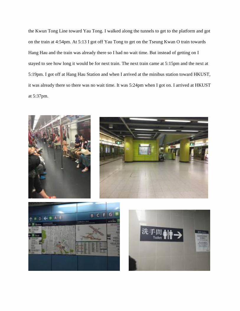
the Kwun Tong Line toward Yau Tong. I walked along the tunnels to get to the platform and got
on the train at 4:54pm. At 5:13 I got off Yau Tong to get on the Tseung Kwan O train towards
Hang Hau and the train was already there so I had no wait time. But instead of getting on I
stayed to see how long it would be for next train. The next train came at 5:15pm and the next at
5:19pm. I got off at Hang Hau Station and when I arrived at the minibus station toward HKUST,
it was already there so there was no wait time. It was 5:24pm when I got on. I arrived at HKUST
at 5:37pm.


Conclusion
This route to Tai Po Market has great ease at arriving at my destination. After getting off
the MTR I was always on ground floor and curiously enough this train is not completely
underground, there are stops that are above ground level. Because of this, there are no doors
protecting people from going into the rails like all underground trains have, thus there are
workers on these platforms looking after people. This creates a barrier free access in this route.
The trains always come fast and the longest wait time has been about five minutes. There is
accessibility in the train seating in which there are seats marked off for people who are in the
need for them and there are also signs saying to give up seat when others need them. The train
exits and entrances are accessible to everyone because there is a section big enough for strollers,
wheelchairs, etc. Crossing the street to get to the market there are aids for visually impaired
people plus in the market there are braille maps and elevators. This route was successful in
regards to accessibility for barrier free access. The interchange between trains at Yau Tong and
Kwun Tong was very easy because the platforms are across from each other. The East Rail
station is packed with people and there are also grocery stores and stores that sell food which
make it easy to grab a bite. Sinage was clear all around this route and there were even Tourism
Signboards. There were also many maps and signs in the market which allowed for me to not get
lost and know where I was and where everything is. In this route there is much shared space
between residential building and many markets, the same goes for the traffic, there is public
transportation but there are also many cars making it accessible to residents. This route was
successful in accessibility and connectivity, ease at arriving at Tai Po market. Yet, there was no
shade when walking from the station to the market and not many trees. Another problem I
stumbled upon was when I was on the train, East Rail Line, and the doors opened at University
Station. This station has the largest gap between train and platform (In the above picture I show
the gap and compare it to another gap at another station). This makes it difficult for accessibility
for I once had to get off at this station and had with me a cart with groceries and when I was
getting off the train, the cart got stuck in the gap. Although there are signs cautioning people
about the gap, it is difficult to avoid.
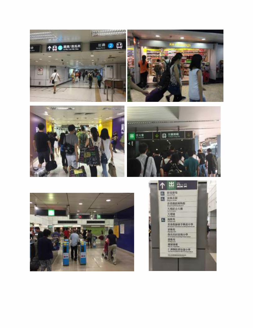
Causeway Bay Route
I arrived at Hang Hau Station at 2:59pm. At 3:01pm I got on the Tseung Kwan O line
toward North Point (5 stops). At 3:13pm I got to North Point Station to interchange onto the
Island Line toward Causeway Bay (3 stops). The train came at 3:15pm. I arrived at Causeway
Bay at 3:21pm. Right after getting out of the station’s platform, there are tunnels that lead to the
exits, but these tunnels are composed of many shopping stores. There are signs directing people
but it is a huge maze of tunnels filled with stores. The inside of the Mall extends from the MTR
station which is built with intricate escalators and elevators. There are signs directing to toilets
and the lifts. These tunnels are composed of grocery stores, flower stores, and many shopping
boutiques. I then took escalators and then arrived on ground floor. I could either get off or
continue on the escalator onto higher up malls. The ground floor is composed of malls but there
is also an exit onto the street. There are always many people here, too many people. There are
plants and seating on the plant walls, this space is small compared to the sidewalk and for the
amount of people that are in Causeway Bay. There are also ramps leading out of the ground floor
onto the street for easier access. There is a crosswalk and lights but people just cross the street
because it is narrow and because pedestrians overpower traffic in Causeway Bay. The space for
pedestrians and traffic is interesting because this street is very narrow for the cars-two lanes,
there is more space for pedestrians. Although there is more space for pedestrians, it is not enough

because there are so many people here. People walk onto the street. In the street there are signs
directing to MTR, there is no way to get lost finding MTR. Across the street there are many more
malls. At 3:30pm I got to the mall across the street, Times Square. Crossing the street is the only
time that I touched ground floor. There are signs everywhere telling pedestrians which way to go
within the crowdedness. There are many advertisements in the buildings; there are huge screens
with neon advertisements. There are even advertisements all around the tunnels of the MTR
Station. The streets were full of commercial activities as there were shops everywhere
(pharmacies, cosmetics, boutiques, etc.).


Conclusion
Causeway Bay’s shopping is probably Hong Kong’s most intense shopping experience.
There is not another place where there are more shops and more people squeezed together.
Causeway Bay is an intricate maze, beginning right after getting off the station’s platform there
are already many advertisements and shops. The pedestrian network stemming from the rail
station flows onto the ground floor, above and beyond. There are endless boutiques and markets
in the streets and then there are the department stores and malls in the layered urban planning.
The main shopping mall and one of the biggest is Times Square with 16 floors and 230 shops
showcasing Hong Kong’s layered topography. Thus the only time that I touched ground level
was only to cross the street to get to Times Square Mall. There are neon advertisements
everywhere, in the MTR tunnels, in the buildings on screens and inside the malls. Causeway Bay
is extremely packed with pedestrians due to all the commercial activities happening in this space.
Because there are too many people, pedestrians overpower traffic. The division of space in
Causeway Bay is to benefit pedestrians. One of my initial observations upon arriving in Hong
Kong was that commercial areas have a mix of heavy traffic volume and dense pedestrian flow
but Causeway Bay shows that this is not true. In Causeway Bay there is a dense pedestrian flow
but there is not a mix of heavy traffic volume and this is due to the narrow streets which allow a
less heavy traffic volume. Therefore, Causeway Bay Route was easy to arrive at and the
connectivity was successful.
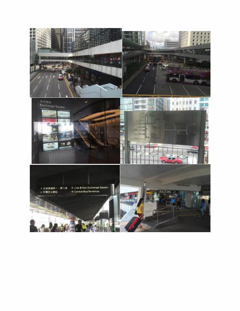
The Hong Kong Observation Wheel via Central Route
I got to the Causeway Bay Station towards Central Station at 4:22pm. The train got there
two minutes later. The train was completely full. At 4:30pm I got off to Central Station. This
station is particularly bigger and with more exits than other stations but all exits were clearly

marked. There are many elevated walkways in Central thus I only touched ground level for about
2 minutes before getting to the elevated walkways. There are elevators and escalators and stairs
leading to the walkways. The walkways connect different buildings. Although there are shops
many of these buildings are businesses. There are many buses right outside the station. There is
equal space for traffic and pedestrians. There are different modes of transportation: cars, taxis,
double decker buses. There are ramps for people with luggage and people who need, even in the
elevated walkways. There was a construction but it was signaled and blocked off. It was in the
street, in the lane for the bus stops. This caused some commotion. There were trucks unloading
merchandise and thus caused the pedestrian sidewalk to be extremely busy. Many of the
merchandise took up space in the sidewalk. Plus one of the buildings was being worked on and it
caused bamboo to be on the sidewalk. Pedestrians have to watch out and move for these
obstacles. There were many people waiting for busses at their stops. There was a map in the
elevated walkways telling me where I was and all nearby destinations. There are billboards on
buildings not as much as Causeway Bay. All the bus stops are clearly marked. Even though I
thought I knew where I was going I did not find the Ferris Wheel. I decided to get off the
elevated walkway to walk on ground floor to get back to the MTR Station. At 4:53pm I got onto
the train platform and only waited one minute before it came. Central is such a big station that
has many exits but there are “Central Station exit information” maps. At 5:09pm I changed
trains. I arrived at Hang Hau Station at 5:23pm. Three minutes later I arrived at the minibus stop
toward HKUST. The Minibus got there 2 minutes later.


Conclusion
There were many obstacles in pedestrian’s way. The construction, unloading boxes, and
the bamboo from the building construction site cause much traffic, not only for pedestrians but
also for the roads. These obstacles create a route that is not accessible to many people and they
also create congestion. There are many people in Central and that is also due to all the people
coming and going from work as many businesses/ corporations are located here. Very busy, a lot
of people but the elevated walkways alleviate pedestrian congestion on ground level. This
layered topography allows pedestrians to arrive at their destinations by avoiding and alleviating

ground traffic. Because this commercial area has a dense pedestrian flow and heavy traffic
volumes, pedestrians have the capability to walk on all the elevated walkways in Central in order
to get to their destination rather than being on ground level. Besides trying to alleviate pedestrian
congestion, Central also tries to alleviate traffic congestion. Many ramps for traffic flow exit and
enter Central. These ramps are on slopes which helps create less congestion in the streets because
there are more ramps coming in and out from different directions beside streets. Before I had
found my way to the Ferris Wheel but that was because I had a GPS. This time was different and
I believe that I did not find it because I got disoriented with all the people and elevated
walkways. Although I did not find my way to the Ferris Wheel, Central proves that using
elevated walkways is better than being on ground floor because of all the traffic.
Case Studies’ Conclusion
Does the layered topography of Hong Kong create a connected city? These survey routes
specifically Hang Hau Malls and Central demonstrate that layered topography (elevated
walkways, escalators, and elevators) create a connected city. In Hang Hau, walkways connect
malls and residents’ homes: connect commercial and residential life. In Central layered
topography is very much needed, “Although Hong Kong has a comparatively low number of
vehicles for its population, the need to move these through the congested areas and across
challenging topographies has led to inventive solutions” (The Making of Hong Kong 140). In
Central, these inventive solutions are elevated walkways and many of the ramps in the street that
exit and enter at different streets helps alleviate pedestrian and traffic congestion. Urban planning
in Central helps make Hong Kong a connected city that offers convenience of travel, “On the
Central district’s elevated walkway network, it is possible to walk east-west for 1.3 Km and
almost as far north-south. This is a substantial area across which the public can eat and shop

without descent to ‘real’ ground” (The Making of Hong Kong 160). Layered topography in Hong
Kong is an “inventive solution” to the City’s compact density. Not only does the urban planning
create a connected city, but it also creates easiness of arriving and of the accessibility of stores,
trains, and bus hubs. Hong Kong has also implemented a system, the Octopus Card, which
allows for people to pay for transportation and to pay in stores, it has become a form of currency.
Connectivity becomes easier with the use of the Octopus Card because it can be used mostly
everywhere and it is convenient when travelling.
One of my initial observations right upon my arrival was that the city looks inadequate
for people with disabilities and people who need barrier free access. After the survey to Tsueng
Kwan O Hospital, I learned that when looking for it, there are barrier free access such as
elevators and signs that lead people to barrier free routes. There were many braille maps in MTR
stations and at Tai Po Market and the trains and much ground are made with uneven tiles to
make people realize they are close to an end. This observation of mine was proven wrong.
Causeway Bay proved that commercial areas that have a dense pedestrian flow does not
necessarily mean that there will be a mix of heavy traffic volume. Another initial observation
that I made was that short distance is easier than long distance travel because of the high density
and compact of the city would make it difficult for long distance travel. Yet Tai Po Market route
and Causeway Bay proved this wrong. While long-distance movements between districts come
at greater ease, travel at short distances ironically gets more difficult. “Structures such as
residential complexes and shopping malls are built to match the scale and pace of transport
development, but they become monoliths that dominate the landscape, and overshadow those of
a more human scale” (Walkable City, Living Streets 25). Causeway Bay is an example of how
shopping malls dominate the landscape and thus it was easier to travel to Tai Po Market even if it
was further but it was more spread out than Causeway Bay. At the neighborhood level like Tai
Po Market, transportation and people can cut through the district to get to places but in
Causeway Bay “the needs of pedestrian and cyclists, the ideal travel mode in short distances, get
drowned out” (Walkable City, Living Streets 25) and that is because there are so many people
there. I also learned that Hong Kong does not need bike lanes because people do not really use
them and use public transportation instead plus the geographical location of the Island makes it
difficult for riders. In the end, does Hong Kong provide ease at arriving at destinations?
Hong Kong offers convenience of being a connected city and ease for arriving at
destinations. Wayfinding in Honk Kong is overall satisfactory because signs are consistent city-
wide, to help support users of public transportation and pedestrians. Although there is greenery
integrated into urban landscapes, especially in the park near the Hospital, parks should be
integrated as well because “Parks at the center of a neighborhood can provide a focal open space
that enables walkers to take short cuts, and support a sense of community” (Walkable City,
Living Streets 43). Parks can provide people with shortcuts but there are not many parks in the
routes I did surveys on. Another reason why Hong Kong offers convenience of travel is because
each train station has a bus hub that connects people to many other places. Right after getting of
the MTR there are many other options already awaiting for people to get on to reach their
destination.
In Perspective: Surveys
I conducted some surveys to see what perspectives people in Hong Kong have in regards
to their urban planning and connectivity of the City. Out of thirteen people who were surveyed,
twelve use public transportation and only one uses private transportation, a car. Those twelve
people who use public transportation use it every day. Eight people were asked how often they

walk/ are on ground level, six people said they only touch ground to get to public transportation,
where there are nearby places to go to, or places near where they live. Two people said they
often do not touch ground level because they mostly walk on high rise buildings. When asked if
bike lanes are needed in Hong Kong, out of eleven people, three said yes and eight said no.
People commented that “Hong Kong’s city center is too crowded to benefit from bike lanes”,
that “they would be nice but the Island is very hilly and not sure if people would be willing to
ride bikes everyday”. One person mentioned that “practically speaking, bike lanes are not
needed”. When asked what you suggest Honk Kong needs improvement on, one person
responded “roads need to be wider” and “building planners should not make buildings with glass
windows because it creates more heat for pedestrians”. One person commented that the vast
network of underground connections between districts is really convenient, “MTR allows me to
get between districts fast and at a low cost”.
From these surveys, I learned that many people use MTR, all public transportation is a
part of peoples’ lives because it is very efficient. One person mentioned “I almost take public
transport every day, which includes minibuses, buses, and the MTR.” Public transportation is
important because of the limited space Hong Kong has due to its geography. One person
mentioned that “On Sunday my dad would drive us around, but where we go is always restricted
by how easy it is to find a parking spot, which is always a struggle in downtown areas.” Because
of this many people use public transportation, to avoid the struggles. Something else I learned
from these surveys is that many people do not touch ground floor too often unless they are
traveling to nearby places or going to get transportation. In Hong Kong it is easy to not touch
ground floor because of the efficiency of connecting to places through the layered topography.
Something else that a person mentioned and I had to experience was the buildings with glass

windows. These building are complete glass and thus the sunlight reflects off of them and creates
more heat for pedestrians. This is something that should be thought about when planning a
building.
In Perspective: What Can Los Angeles Learn From Hong Kong
Four people were asked what you think Los Angeles can learn from Hong Kong. There
were many valuable perspectives to take into consideration. One point is in regards to the land
use of LA versus that of HK which is due to its geographical location. One person said, “Hong
Kong is away from earthquake zone which allows it to build buildings a lot taller and firmer, on
the other hand, LA is the opposite which buildings have to be shorter for earthquakes.” Because
of the limited space, HK has to maximize land use to serve the needs of fitting such a population
density which results in building upwards. LA has much more land thus land use can be more
spread out. Because everything in LA is much more spread out than in HK, “In HK we can go
from one shopping mall to another on foot but we can’t do the same in LA” (Survey). Because
LA is more spread out it needs to improve upon its transportation system to create a convenience
for people traveling.
Two people mentioned the subway/ public transport system which creates convenience
for people in Hong Kong in regards to connection is something LA can learn from Hong Kong.
Someone said “I noticed the trains are quite old and people seem to prefer to drive. Train stations
aren't very accessible either, making driving the more convenient option. I think by increasing
connectivity of mass transit, you can get more cars off the road.” “From my impression of LA,
getting between places relies very much on private vehicles. But because there’s so much more
space in between buildings and 'districts' compared to HK, it feels much more natural and
comfortable to drive.” LA should enhance its public transportation system and learn from HK
and how there are connecting buses next to every station. In LA there are only bus hubs right
next to Union Station and the rest of the other stations either have no bus stations around or have
some bus stops around but within walking distance. “The city is very inconvenient for people
without cars (like me). It should at least enhance its bus system by, e.g. making more bus-stops
and improving the bus schedule. I often had to wait for over 30 minutes for a bus when I was
there.” LA is more care dependent and because of this traffic busses and trains are far less slow
than in HK. The longest I ever had to wait for a bus or train in HK was 5 minutes. In LA it is
only when I am lucky that I will wait five minutes. Connections to other trains are only available
in Union Station in LA compared to HK which has connections to other lines in every stop. LA
can definitely learn from HK’s transit system but also LA is currently expanding their
transportation system so that it can reach many more places.
Some other suggestions were in regards to the Octopus Card and bike lanes. One person
mentioned the octopus card saying that “Hong Kong is very unique in its topography and
population density. The Octopus card integration is something other cities can learn.” In LA,
METRO implemented the TAP card which would be LA’s equivalent to HK’s Octopus card. Yet
they are not equal at all, the Octopus card can be used for so much more than the TAP card. TAP
card is only for use to pay METRO transit only. There are other transit that will not accept the
TAP payment for example the DOT buses and Amtrack and Metrolink trains. LA can learn from
HK and adopt the TAP card for so much more than just transportation, this would create a more
connected city. In regards to bike lanes someone mentioned, “if we can just provide a suitable
environment I think it’d have been beneficial to cultivate this healthy trend of bike lanes.” This
is an interesting perspective because this is an area that Hong Kong can learn from LA’s bike
lanes.

Conclusion IntenCity
There are many factors that determine whether a city and its’ urban planning create a
connected city which is accessible to all people. All parts of Hong Kong are all very well
connected by public transport, there’s nowhere you can’t reach with public transport with the
extensive reach of the MTR and connecting buses, minibuses, and trams. Roads and highways
are very well constructed, constructions and diversions are always on going in an attempt to at
least try lessening traffic congestion. Elevated walkways, escalators, and elevators connect
people with no need to touch the ground and create congestion. “With its island origins,
skyscraper skyline and world city status, Hong Kong is often likened to other cities. Comparison
soon falters with the realization that Hong Kong’s skyscrapers are only the more visible aspect of
a far more complex urban condition. A steep and contorted terrain has ensured that built-up areas
are compact, rich in spatial experience, rarely far from hills and water; and connected by an array
of public transport that is second to none” (Preface The Making of Hong Kong). Upon arriving in
Hong Kong as a foreigner, the city seemed chaotic but soon after I came to the realization that
Hong Kong is very efficient and a connected city. It’s complex urban condition and layered
topography creates accessibility in a city where land use is limited because of its geographical
location.
Works Cited
Cooney, Scott. “How Sustainable Urban Planning Will Help Cities Thrive for
Generations to Come”. EcoLocalizer. 8 July 2015.
http://ecolocalizer.com/2015/05/08/how-sustainable-urban-planning-cities-thrive-
generations/.
DeWolf, Christopher. "Urban Planner Marks Hong Kong Down". South China Morning Post. 12
Sept. 2014. Web. 8 July 2015. <http://www.scmp.com/lifestyle/arts-
culture/article/1590219/urban-planner-marks-hong-kong-down>.
Frampton, Adam, and Clara Wong. Cities Without Ground: A Hong Kong Guidebook. Print.
Kowloon and Canton Railway Company’s Linear City Project Report. 2004-2005. Print.
Ng, Simon, Wilson Lau, Fred Brown, Eva Tam, Mandy Lao and Veronica Booth. Walkable City,
Living Streets. October 2012. Print.
Rudofsky, Bernard. Streets For People: A Primer for Americans. Garden City, N.Y. Doubleday.
1969. Print.
Shelton, Barrie, and Justyna Karakiewicz. The Making of Hong Kong: From Vertical to
Volumetric. New York, NY: Routledge, 2011. Print.
Special thanks to Tiffany Chau and Charmaine Chong for translating surveys.


![00 Protoselida 1-4neo - Α.Ε.Ι. ΠΕΙΡΑΙΑ Τ.Τ. - ΚΕΝΤΡΙΚΗ … · · 2015-06-25ure of the fabric spirality [Stevens, 1985]. Figure 1: Spirality of a knitted fabric](https://img.pdfslide.net/doc/110x75/5b0c29357f8b9a02508bc452/00-protoselida-1-4neo-of-the.jpg)


![FabricDefectDetectionUsingModifiedLocalBinaryPatterns · 2017-08-25 · Fabric Dot patterned fabric Figure 1: Classification of fabrics [23]. Gabor filters which needs a large](https://img.pdfslide.net/doc/110x75/5e9428903949bf79e601a2c4/fabricdefectdetectionusingmodiiedlocalbinarypatterns-2017-08-25-fabric-dot-patterned.jpg)