Embed Size (px)
Citation preview
�������� ����� ��
The Masaya Triple Layer: A 2100 year old basaltic multi-episodic Plinianeruption from the Masaya Caldera Complex (Nicaragua)
W. Perez, A. Freundt, S. Kutterolf, H.-U. Schmincke
PII: S0377-0273(08)00565-9DOI: doi: 10.1016/j.jvolgeores.2008.10.015Reference: VOLGEO 4164
To appear in: Journal of Volcanology and Geothermal Research
Received date: 9 January 2008Revised date: 17 September 2008Accepted date: 16 October 2008
Please cite this article as: Perez, W., Freundt, A., Kutterolf, S., Schmincke, H.-U., TheMasaya Triple Layer: A 2100 year old basaltic multi-episodic Plinian eruption from theMasaya Caldera Complex (Nicaragua), Journal of Volcanology and Geothermal Research(2008), doi: 10.1016/j.jvolgeores.2008.10.015
This is a PDF file of an unedited manuscript that has been accepted for publication.As a service to our customers we are providing this early version of the manuscript.The manuscript will undergo copyediting, typesetting, and review of the resulting proofbefore it is published in its final form. Please note that during the production processerrors may be discovered which could affect the content, and all legal disclaimers thatapply to the journal pertain.
ACC
EPTE
D M
ANU
SCR
IPT
ACCEPTED MANUSCRIPT
The Masaya Triple Layer: a 2100 year old basaltic multi-episodic 1 Plinian eruption from the Masaya Caldera Complex (Nicaragua) 2
3 4
W. Pérez*, A. Freundt, S. Kutterolf, H.-U. Schmincke 5 Sonderforschungsbereich (SFB) 574, University of Kiel 6 IFM-GEOMAR, Wischhofstr. 1-3, 21148 Kiel, Germany 7
8
Abstract 9
The Masaya Caldera Complex has been the site of three highly explosive basaltic eruptions within the 10 last six thousand years. A Plinian eruption ca. 2 ka ago formed the widespread deposits of the Masaya 11 Triple Layer. We distinguish two facies within the Masaya Triple Layer from each other: La 12 Concepción facies to the south and Managua facies to the northwest. These two facies were previously 13 treated as two separated deposits (La Concepción Tephra and the Masaya Triple Layer of Pérez and 14 Freundt, 2006) because of their distinct regional distribution and internal architectures. However, 15 chemical compositions of bulk rock, matrix and inclusion glasses and mineral phases demonstrate that 16 they are the product of a single basaltic magma batch. Additionally, a marker bed containing fluidal-17 shaped vesicular lapilli allowed us to make a plausible correlation between the two facies, also 18 supported by consistent lateral changes in lithologic structure and composition, thickness and grain 19 size. 20 We distinguish 10 main subunits of the Masaya Triple Layer (I to X), with bulk volumes ranging 21 between 0.02 and 0.22 km3, adding up to 0.86 km3 (0.4 km3 DRE) for the entire deposit. Distal 22 deposits identified in two cores drilled offshore Nicaragua, at a distance of ~170 km from the Masaya 23 Caldera Complex, increase the total tephra volume to 3.4 km3 or ~1.8 km3 DRE of erupted basaltic 24 magma. 25 Isopleth data of five major fallout subunits indicate mass discharges of 106 to 108 kg/s and eruption 26 columns of 21 to 32 km height, affected by wind speeds of <2 m/s to ~20 m/s which increased during 27 the course of the multi-episodic eruption. Magmatic Plinian events alternated with phreatoplinian 28 eruptions and phreatomagmatic explosions generating surges that typically preceded breaks in activity. 29 While single eruptive episodes lasted for few hours, the entire eruption probable lasted weeks to 30 months. This is indicated by changes in atmospheric conditions and ash-layer surfaces that had 31 become modified during the breaks in activity. The Masaya Triple Layer has allowed to reconstruct in 32 detail how a basaltic Plinian eruption develops in terms of duration, episodicity, and variable access of 33 external water to the conduit, with implications for volcanic hazard assessment. 34
35 Keywords: Masaya Caldera Complex; Nicaragua; basaltic Plinian eruptions; Tephrostratigraphy; 36 Volcanic hazards 37 38 * Corresponding author. Tel.: +49 431 6002139; fax: +49 431 6002924 39 Email address: [email protected] 40

ACC
EPTE
D M
ANU
SCR
IPT
ACCEPTED MANUSCRIPT
1. Introduction 41
42 Plinian eruptions of basaltic composition are thought to be rare because basaltic magma 43
mostly erupts as lava flows and in Strombolian, Hawaiian and Surtseyan fashion when 44
fragmented. Nevertheless, several examples of widely dispersed basaltic tephra deposits with 45
Plinian characteristics have been reported during the last two decades (Williams, 1983; Bice, 46
1985; Wehrmann et al., 2006; Coltelli et al., 1998; McPhie et al., 1990; Dzurisin et al., 1995; 47
Mastin, 1997; Walker et al., 1984; Sable et al., 2006; Carey et al., 2007; Costantini et al., 48
2008). The first account of this type of tephra by Williams (1983) addressed two deposits 49
thought to have been erupted from the Masaya Caldera Complex in west-central Nicaragua: 50
the San Judas Formation, later named the Masaya Triple Layer by Bice (1985), and the 51
Fontana Lapilli, later shown by Wehrmann et al. (2006) to have been derived from a vent 52
outside Masaya caldera consistent with its age of ca. 60 ka (Kutterolf et al., 2008a). 53
Pérez and Freundt (2006) have shown that the Masaya caldera produced three widespread 54
basaltic tephras during the last 6 ka: the San Antonio Tephra, the Masaya Triple Layer, and 55
the Masaya Tuff, a huge hydroclastic surge deposit covered by the Plinian Ticuantepe Lapilli. 56
Here we reconstruct the ~2.1 ka Plinian eruption of the Masaya caldera which produced the 57
Masaya Triple Layer. We distinguish two facies within the Masaya Triple Layer: La 58
Concepción facies to the south and the Managua facies to the northwest. These two facies 59
were previously treated as two separated deposits (Pérez and Freundt, 2006) because of their 60
distinct regional distribution and internal architectures. However, here we use geochemical 61
and petrographic characteristics to stratigraphically correlate the two facies and to document 62
their origin from a single basaltic magma batch. We reconstruct the evolution of this long-63
lasting multi-episode eruption based on the revised stratigraphy. Such case studies are needed 64
to better constrain the presently poorly understood processes that force basaltic magmas to 65
erupt in a Plinian fashion. 66
67
1.1 Geologic setting 68
69
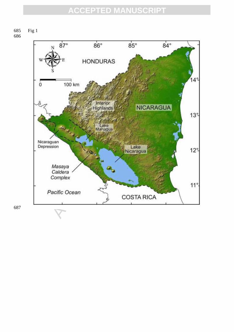
Nicaragua is part of the Central American isthmus, where the subduction of the Cocos plate 70
under the Caribbean Plate at a convergence rate of 70-90 mm/year (Barckhausen et al., 2001; 71
DeMets, 2001) results in the NW-SE trending Central American Volcanic Arc (CAVA). The 72
arc volcanoes lie inside the Nicaraguan depression, which is a NW-SE striking flat depression 73
occupied by Lake Managua and Lake Nicaragua and bordered in the east by the interior 74
highlands (Fig. 1). 75
ACC
EPTE
D M
ANU
SCR
IPT
ACCEPTED MANUSCRIPT
The area between the two lakes is the economical and demographic center of the country, 76
where all large cities are located. The capital Managua is surrounded by several highly 77
explosive basaltic to rhyolitic volcanic complexes. Major volcanic threats to the Managua 78
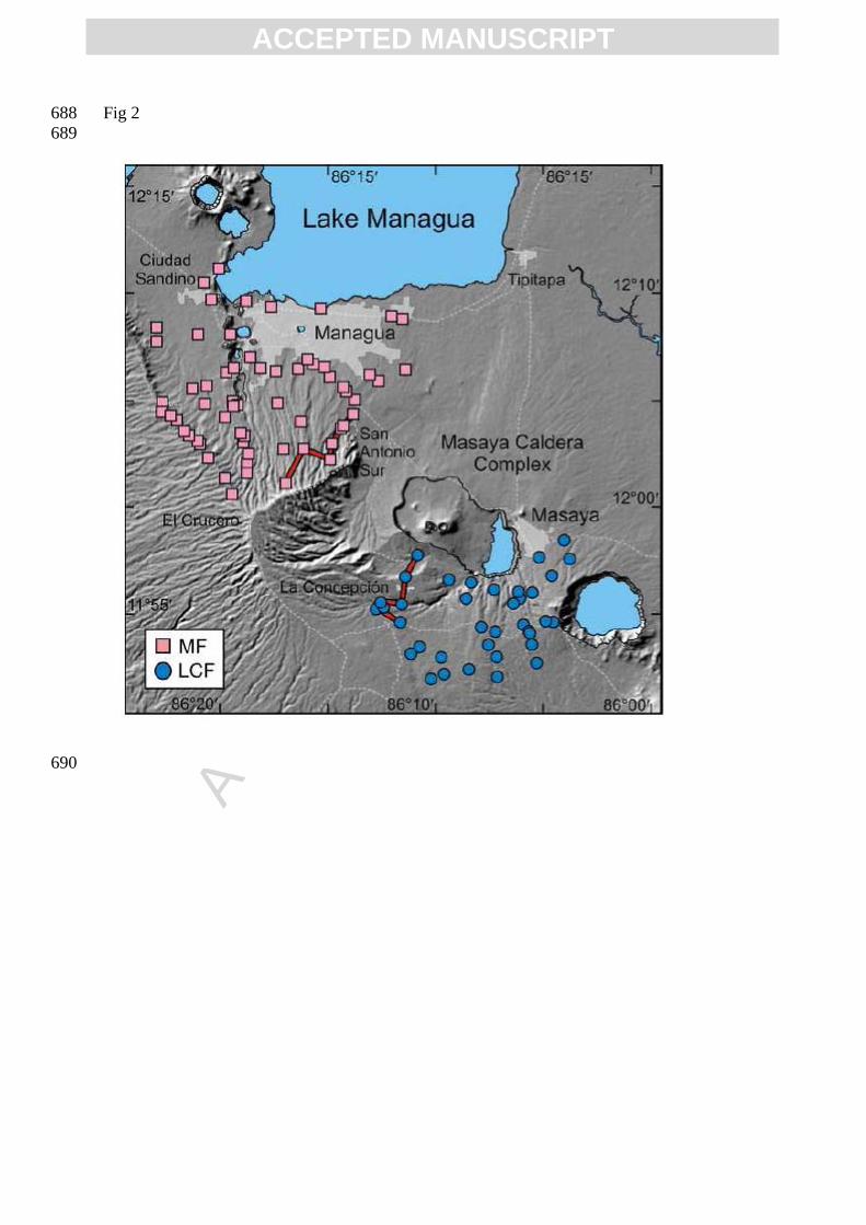
area and its ~1.8 million inhabitants are centered in the Masaya Caldera Complex (Fig. 2), a 79
volcanic system that repeatedly generated highly explosive basaltic eruptions in the past. 80
The complex consists of a NW-SE elongated caldera 11 km long and 6 km wide, containing 81
Lake Masaya at the SE rim and the post-collapse volcanic edifice in the western half, 82
composed of the Masaya and Nindirí cones with their pit craters Masaya, Santiago, Nindirí 83
and San Pedro (e.g. McBirney, 1956; Rymer et al., 1998). Masaya is one of the most active 84
volcanoes in Central America and has been the object of several geophysical (e.g. Metaxian et 85
al., 1997; Lewicki et al., 2003), gas-chemical (e.g., Stoiber et al., 1986; Horrocks et al., 1999; 86
Duffell et al., 2003) and geochemical (Walker et al., 1993) investigations. 87
Three widespread pyroclastic deposits that originated at Masaya were previously identified: 88
the Fontana Lapilli, the Masaya Triple Layer or San Judas Formation and the Masaya Tuff or 89
El Retiro Tuff (Bice, 1985; Williams 1983). We have additionally identified the ca. 6 ka old 90
San Antonio Tephra (Pérez and Freundt, 2006). A recent detailed study of the Fontana Tephra 91
by Wehrmann et al. (2006) showed that the source vent of this basaltic Plinian lapilli fallout 92
did not lie within the Masaya caldera as previously interpreted (Williams, 1983) but a few 93
kilometers outside to the NW, where it would be part of the older Las Nubes caldera (Girard 94
and van Wyk de Vries, 2005). The Fontana Tephra age of ~60 ka documented in Kutterolf et 95
al. (2007, 2008a) supports this result. The ~6 ka San Antonio Tephra is thus the oldest known 96
product of a basaltic Plinian eruption from the Masaya caldera. 97
The second Plinian eruption at Masaya caldera produced the Masaya Triple Layer (Williams, 98
1983; Bice, 1985). Re-investigation by Pérez and Freundt (2006) identified two basaltic 99
tephra deposits overlying the San Antonio Tephra which differ in regional distribution and 100
internal architecture: the Masaya Triple Layer with a radiocarbon age of 2.1 ka to the NW, 101
and La Concepción Tephra south of the caldera (Fig. 2). These deposits are the subject of this 102
paper. The last large eruption from the Masaya caldera produced the Masaya Tuff, a huge 103
phreatomagmatic pyroclastic surge deposit (Bice, 1985; Williams, 1983). This large-104
magnitude Surtseyan eruption terminated in a third Plinian eruption that produced the 105
widespread Ticuantepe Lapilli, a stratified succession of well-sorted fallouts of vesicular 106
scoria immediately overlying the Masaya Tuff (Pérez and Freundt, 2006). Kutterolf et al. 107
(2008a) estimated that this eruption occurred 1.8 ka ago, based on stratigraphic relationships 108
in offshore sediment cores. Younger products of Masaya volcanism formed the intra-caldera 109
ACC
EPTE
D M
ANU
SCR
IPT
ACCEPTED MANUSCRIPT
Santiago-Masaya volcanic cone and numerous smaller cones and lava flows within, and partly 110
outside the caldera (McBirney, 1956; Williams, 1983; Walker et al., 1993). 111
112
1.2 Methodology 113
114
Our stratigraphic subdivisions and correlations are based on 108 logged outcrops around the 115
Masaya caldera. Correlations between outcrops are based on lithological criteria as well as 116
compositional data. Tephra volumes are derived from isopachs maps applying the methods of 117
Pyle (1989) and Fierstein and Nathenson (1992). Erupted magma masses were calculated by 118
subtracting the average volume fraction of pores and lithic fragments from the tephra volumes 119
for each subunit, and then multiplying by a density of 2500 kg/m3. Distal thickness data and 120
isopachs of the total deposit are from marine gravity cores collected offshore Nicaragua 121
during research cruises M54/2, M66/3a (RV METEOR) and SO173/3 (RV SONNE) 122
(Kutterolf et al., 2008a). Geometric measures from isopleth maps, based on the average of the 123
five largest juvenile or lithic clasts, are used to estimate eruption column heights and 124
discharge rates from comparison with model results of Carey and Sparks (1986), Wilson and 125
Walker (1987), Woods (1988) and Sparks et al. (1992). 126
Bulk rock major and trace element compositions were determined by X-Ray Fluorescence 127
(XRF) analyses carried out at IFM-GEOMAR and Inductively Coupled Plasma Mass 128
Spectrometry (ICP-MS) at the University of Kiel. Mineral, matrix and inclusion glass 129
compositions were determined by electron microprobe at IFM-GEOMAR. Laser Ablation 130
Inductively Coupled Plasma Mass Spectrometry (LA-ICP-MS) at Frankfurt University was 131
used for the trace element chemistry of glass samples. 132
133
2. The Masaya Triple Layer 134
135
Pérez and Freundt (2006) distinguished two deposits that differ in internal architecture and 136
regional distribution but occur in the same stratigraphic position: La Concepción Tephra to 137
the south of Masaya caldera and Masaya Triple Layer to the northwest and across Managua 138
city (Fig. 2). Here, we re-name these deposits as La Concepción facies and Managua facies, 139
respectively, while applying the name Masaya Triple Layer (MTL) to the entire deposit. 140
Numerous exposures of MTL exist to the NW and S of Masaya caldera, but no trace was 141
found in the lowlands NE of the caldera although stratigraphically underlying and overlying 142
units do occur, as well as on the mountainous Las Sierras ridge to the SW where strong 143
ACC
EPTE
D M
ANU
SCR
IPT
ACCEPTED MANUSCRIPT
erosion has removed younger deposits (Fig. 2). The MTL is separated from the underlying 144
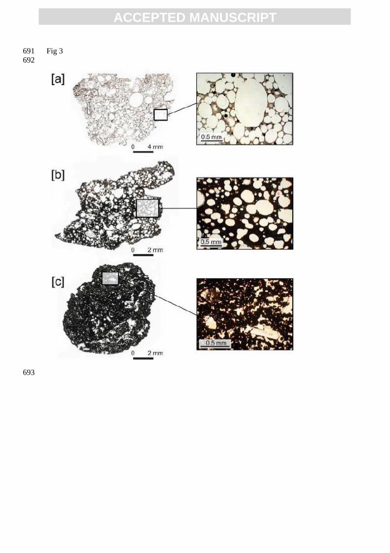
San Antonio Tephra by a paleosol and an erosional unconformity. A yellowish massive 145
reworked tuffaceous deposit separates the MTL from the overlying Chiltepe Tephra in the 146
Managua area while the MTL is directly overlain by the Masaya Tuff in the south, with a 147
locally intervening erosional unconformity. 148
Both facies of the MTL consist of well-sorted black lapilli beds, coarse ash layers and grayish 149
indurated tuffs, some with desiccation cracks at the top. The well-sorted layers consist mostly 150
of juvenile scoria lapilli to coarse-ash and minor (~1-3 vol. %) lithic fragments mainly of 151
basaltic lava and rare gabbro. The scoria fragments vary from highly vesicular (up to 80 vol. 152
% vesicles) to dense juvenile lapilli (<5 vol. % vesicles; using the vesicularity index of 153
Houghton and Wilson, 1989). The matrix of the scoriae varies from sideromelane with 154
abundant round vesicles through dark brown to black tachylite with rare irregularly shaped 155
vesicles (Fig. 3). Phenocrysts are mainly plagioclase with abundant melt inclusions and minor 156
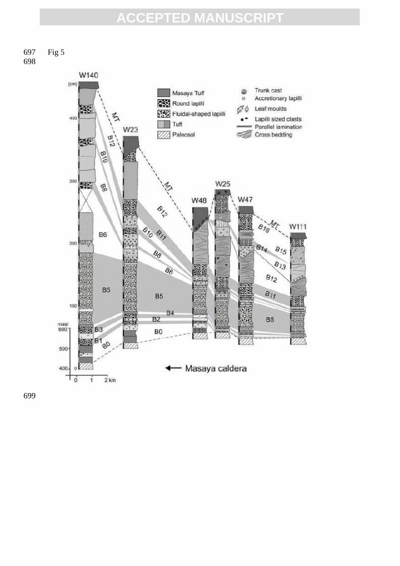
olivine and clinopyroxene; groundmass microlites are plagioclase and olivine. The bulk-rock 157
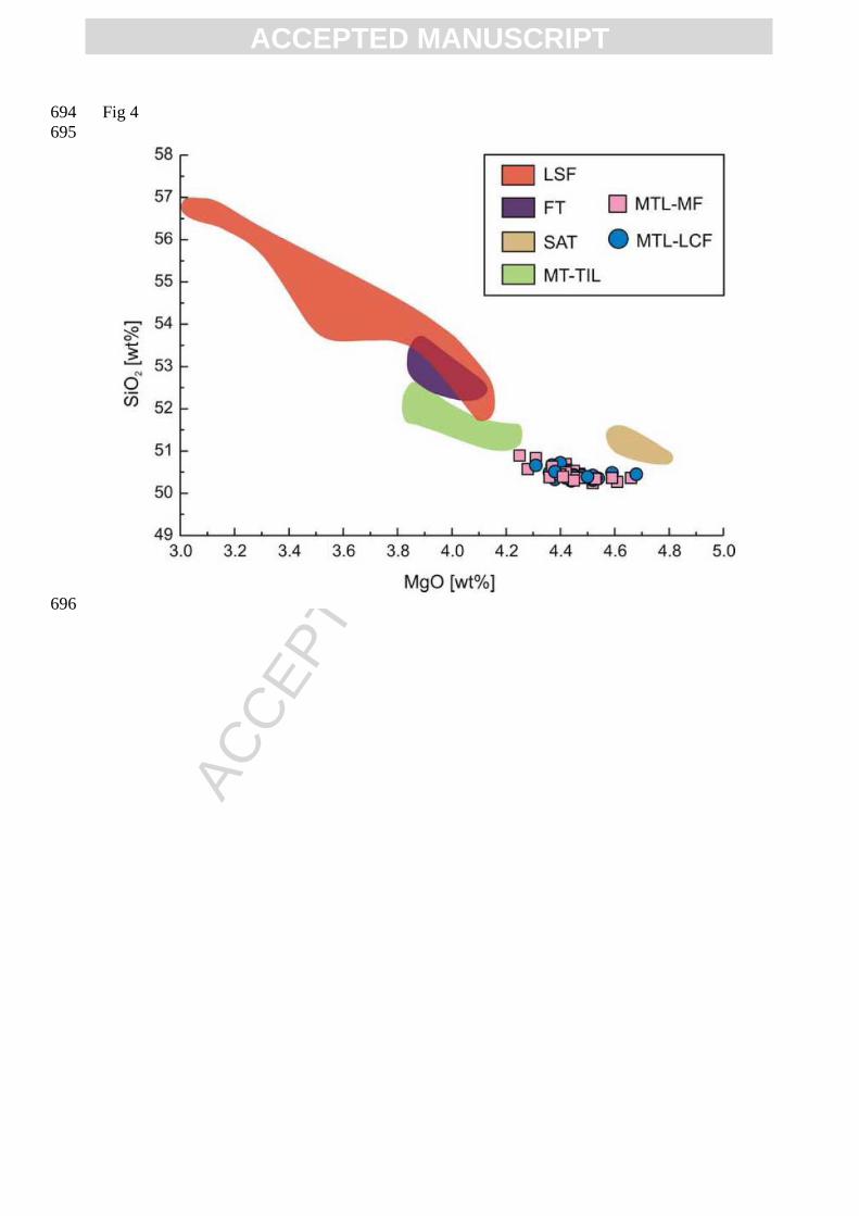
composition is basaltic (50.2-51 wt% SiO2 and 3.5-4.0 wt% alkalis; Fig. 4). 158
159
2.1 La Concepción facies 160
161
La Concepción facies (LCF) is composed of 17 layers (B0-B16) of well-sorted scoria lapilli 162
to coarse-ash intercalated with tuffs (Pérez and Freundt, 2006). The upper contact of the 163
deposit is variably eroded. At some localities it is overlain by a thick overburden of a clayey 164
sediment, while at other places it is separated from the Masaya Tuff by a deeply incised 165
erosional unconformity. 166
Most exposures show the succession from B1 to B11 and part of B12 but only a few outcrops 167
show the complete sequence shown in figure 5. The lowermost layer B0 crops out only in 168
three exposures <6 km south of the caldera rim and consist of two basal fine ash layers and a 169
cemented accretionary lapilli-bearing tuff at the top containing hydrothermally altered lithic 170
clasts and plant remains. 171
Subunit B5 the thickest lapilli layer of the LCF and most distinctive by being composed of 172
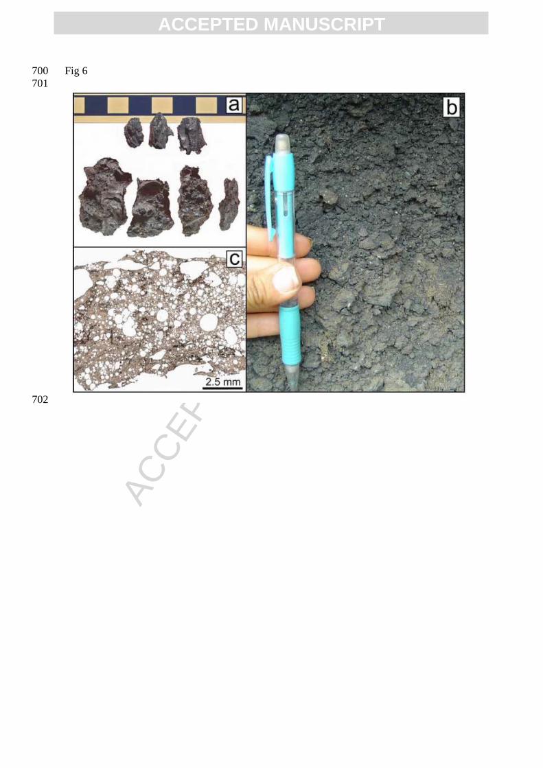
fluidal-textured achnelith lapilli and ash (Fig. 6). Hence it is a useful marker bed in all 173
outcrops. The total thickness of B5 decreases from 115 cm at 1 km south from the vent to 12 174
cm at 10 km, where it appears as a single thin layer of achnelith-shaped fine lapilli. In 175
proximal sections, where the well-sorted, black lapilli fallout is vaguely stratified by vertically 176
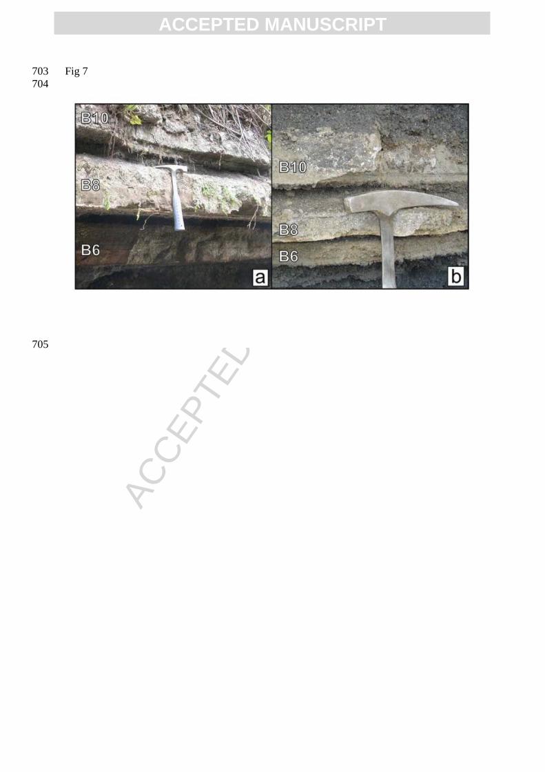
alternating grain size and interrupted by a thin light yellowish layer of fine ash, we distinguish 177
ACC
EPTE
D M
ANU
SCR
IPT
ACCEPTED MANUSCRIPT
5 levels from bottom to top: [a] a highly vesicular, glassy, faintly laminated, moderately well-178
sorted lapilli layer with minor amount of juvenile ash and very few lithics. Most of the 179
juvenile fragments have elongated or contorted shapes, [b] is a yellowish fine ash layer 180
commonly 1 cm thick but reaching 4 cm at 1 km from the caldera rim. [c] is the thickest level 181
reaching 90 cm in the proximal areas. The juvenile particles are similar to [a] but grain size is 182
larger, size-sorting is better particularly at the top, and the content of lithic fragments is 183
slightly higher (~1 vol. %). The base of this layer is weakly stratified and consists of fine 184
lapilli to coarse ash. [d] is a weakly stratified medium-ash layer of glassy scoria that is 185
slightly cemented and [e] is a scoria lapilli layer similar to [a]. 186
The tuff triplet B6, B8, B10 are also characteristic of the LCF and they thin rapidly 187
southwards away the caldera rim (Fig. 7). The grayish indurated B6 tuff is in proximal 188
exposures composed of a lower fine-grained part with accretionary lapilli and an overlying 189
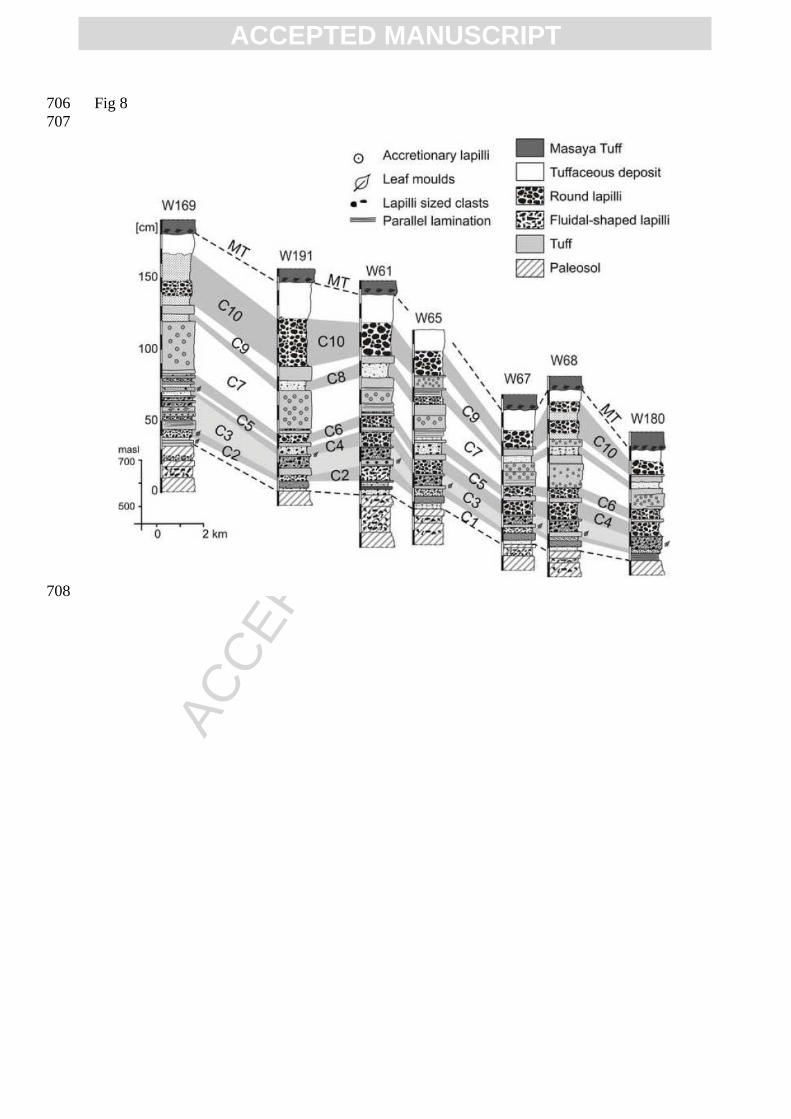
cross-bedded layer of fine lapilli to coarse ash. In medial exposures, this unit is condensed to 190
an indurated tuff with vesicular lapilli at the bottom and a laminated medium to fine ash layer 191
with scarce accretionary lapilli at the top. 192
B8 is an indurated tuff up to 60 cm thick at proximal locations (~1 km from the vent). Its 193
lower part is cross-bedded with dune structures of alternating coarse and fine lapilli layers. In 194
the medial facies, B8 is a 20 cm thick tuff with a 1 cm yellowish fine ash at the bottom, 195
overlain by an indurated fine tuff with accretionary lapilli and dispersed glassy scoria clasts. 196
A strongly cemented light gray fine tuff layer forms the top. 197
B10 is proximally stratified, poorly-sorted, coarse ash with dispersed lapilli at the base, fine to 198
medium ash with dune structures in the middle portion, and a highly indurated tuff at the top. 199
At medial exposures S or SE from the caldera rim, B10 consists of an indurated grayish cross-200
bedded tuff with coarse ash and fine lapilli at the bottom and a fine ash with accretionary 201
lapilli at the top (Fig. 7). At distal exposures to the S and SW, it appears as a thin indurated 202
tuff with accretionary lapilli, slightly laminated at the bottom. 203
204
2.2 Managua facies 205
206
The Managua facies of the MTL north and northwest of the caldera consists of 10 layers (C1 207
to C10), 7 of them are scoria lapilli to coarse-ash layers and the others are tuffs (Fig. 8, table 208
2). No outcrops could be found close to the Masaya caldera rim, the most proximal are those 209
located at 7 to 7.5 km distance, along the road from San Antonio Sur to El Crucero, where the 210
ACC
EPTE
D M
ANU
SCR
IPT
ACCEPTED MANUSCRIPT
facies reaches its maximum observed thickness. Here we describe four characteristic layers of 211
the MF, brief descriptions of all subunits are given in table 2. 212
Layer C2 is a well-sorted fine lapilli layer of highly vesicular scoria containing <1 vol. % of 213
lithic fragments and reaching a maximum thickness of 5 cm. Towards >13 km to the NW of 214
Masaya caldera, C2 grades into a ~1 cm thick black ash layer. C2 is a useful marker bed due 215
to the fluidal morphology and high vesicularity of the glassy scoria. 216
At the most proximal exposures, C3 consists of several intercalated tuff and lapilli beds. 217
Three main layers can be distinguished across the medial range: a fine yellowish indurated 218
tuff with leaf molds at the base, a moderately well-sorted normal-graded layer of scoria lapilli 219
and a relatively large fraction of lithic angular dense aphyric basaltic lava fragments (~5-15 220
vol. %, some hydrothermally altered) in a matrix of coarse ash (~30 vol. %), and a topmost 221
thin hard tuff with desiccation cracks at the surface. All particles are coated with brownish 222
fine ash. Plant remains from the basal tuff have been radiocarbon dated to 2,120 ± 120 years 223
BP (Pérez and Freundt, 2006). 224
C7 is >40 cm thick yellowish tuff with abundant accretionary lapilli (diameters 2-10 mm) and 225
scarce armored lapilli, is stratified by horizons enriched in lapilli or coarse-ash fragments, or 226
accretionary lapilli. The quality of this texture varies between outcrops from apparently 227
massive to well bedded; different degrees of induration locally emphasize the bedding. 228
C10 is the thickest and coarsest lapilli layer of the Managua facies, with a maximum observed 229
thickness of 36 cm at 10 km to the NW of the caldera, decreasing to 3 cm near Ciudad 230
Sandino (~25 km from the Masaya caldera). This well-sorted deposit of scoria lapilli is 231
typically reversely graded at medial exposures but grading patterns are more variable at 232
proximal outcrops, with two reversely graded horizons or symmetrical grading with largest 233
grain size near the center. 234
235
3. Correlation between the facies 236
237
The different internal architectures of La Concepción and Managua facies do not allow to 238
easily correlate individual layers, especially because there are no linking outcrops southwest 239
and northeast the caldera. Yet both facies occur in the same stratigraphic position (Pérez and 240
Freundt, 2006). Here we use chemical compositions to show that they are derived from the 241
same magma batch. Based on that supposition, we then use petrographic and lithologic 242
criteria to propose a layer-by-layer correlation. 243
244
ACC
EPTE
D M
ANU
SCR
IPT
ACCEPTED MANUSCRIPT
3.1 Chemical compositions 245
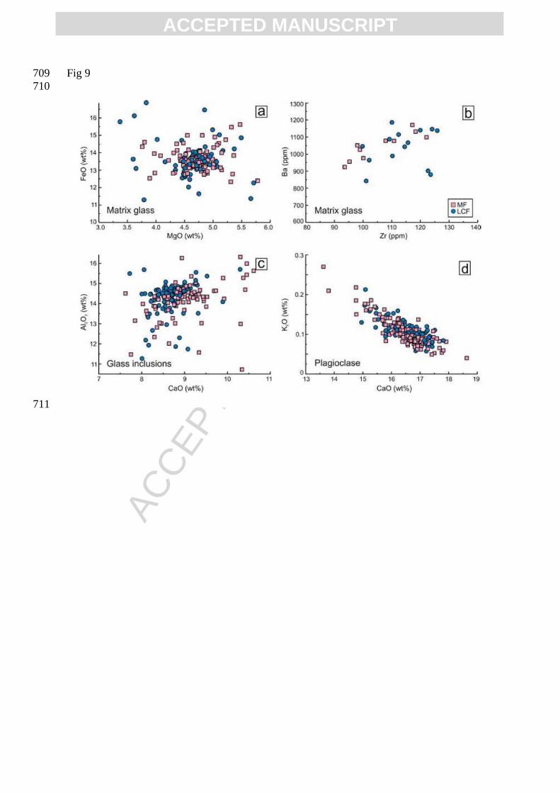
246
A detailed stratigraphic sampling of several exposures at variable distances and directions 247
from the Masaya caldera allowed us to compare the chemical compositions of bulk rock, 248
matrix and inclusion glasses and mineral phases. Both, La Concepción and the Managua 249
facies, are tholeiitic basalts and have completely overlapping bulk rock major and trace 250
element compositions (Figs. 4, 9). These compositions are the least evolved of, and hence 251
distinct from, the compositions of the other mafic tephras produced by the Masaya system 252
(Fig. 4). They also differ in composition and by their young age from the Las Sierras 253
Formation tephras. 254
The basaltic-andesitic compositions of the matrix glasses from both facies overlap completely 255
in both major and trace elements (Fig. 9a, b); their displacement from whole-rock 256
compositions largely reflects the abundance of plagioclase crystals in the latter. Moreover, the 257
basaltic to basaltic andesitic glass inclusions, mostly hosted in plagioclase phenocrysts, show 258
no compositional differences between the facies (Fig. 9c). 259
Likewise, the minerals in the scoriae of both facies are compositionally identical (Fig. 9d). 260
The dominant mineral phase is calcic plagioclase ranging from An73 to An89, and the 261
microlites in the groundmass are at the calcic end of this range. The olivines of the LCF have 262
Mg-numbers between 0.72-0.74, while those of the MF have a wider range of 0.70-0.82. 263
Augites of Wo39-41 En45–48 Fs11-15 compositions with 0.47-0.57 wt% TiO2 and 2.2 to 3.9 wt% 264
Al2O3 are the same in both facies. 265
All these chemical criteria demonstrate that the two facies represent the deposit of one 266
eruption of a single basaltic magma. Vertical changes show that this magma was somewhat 267
heterogeneous in composition. Bulk-rock scoria compositions slightly increase in Al2O3 and 268
decrease in TiO2, Ba, FeO and alkalis upward through the deposit. An-contents of plagioclase 269
phenocrysts increase upward and layers C1, C4 and C10 contain olivines with the widest 270
range in Mg-numbers. The vertical compositional changes, however, are too subtle to be used 271
for a detailed correlation of the two facies successions. Correlations must thus be based on 272
lithologic characteristics such as scoria texture. 273
274
3.2 Proposed correlation 275
276
Two well-sorted layers, B5 of the LCF and C2 of the MF, are prominent in their respective 277
facies because they consist entirely of highly vesicular, fluidally-textured elongate achneliths 278
ACC
EPTE
D M
ANU
SCR
IPT
ACCEPTED MANUSCRIPT
(see Fig. 7). Masaya volcano has repeatedly produced such scoria particles in eruptions 279
ranging from the ~6 ka San Antonio Tephra (Pérez and Freundt, 2006) to the recent products 280
of active Santiago crater. In the MTL, however, their dominant occurrence is limited to two 281
layers. We therefore use the correlation B5=C2 as a starting point to merge the layers of the 282
two facies into 10 correlated depositional units (I-X) based on similar lithologic and 283
petrographic properties. The combined stratigraphy agrees with the overall upward increase in 284
less vesicular scoria particles and hydrothermally altered lithics observed in both facies. Each 285
new subunit has been checked for consistency of the resulting areal thickness and grain-size 286
distributions. The most plausible correlation scheme between La Concepción and Managua 287
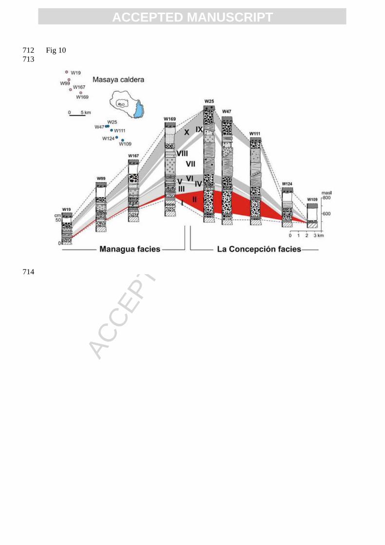
facies is illustrated in figure 10. The major well-sorted lapilli fallout layers of both facies are 288
correlated resulting in subunits II (B5, C2), IV (B9, C4), VI (B11, C6), VIII (B14, C8) and X 289
(B16, C10). The areal distributions of these fallouts and their volcanological significance are 290
discussed below. First, we summarize the implications for the tuff deposits. 291
Subunit I consists of layers B0 to B4 which thin to the NW and merge into layer C1, which 292
contains a horizon rich in plant material resembling B2. The opening phase of the MTL 293
eruption represented by subunit I began with minor phreatomagmatic ash fallouts (B0) 294
followed by a more intense eruption emplacing the first lapilli fallout B1, which is interrupted 295
by a weak ash surge (B2) before a weaker column is re-established (fallout B3) that finally 296
collapsed when a wet surge (B4) was erupted. The distal fallout of B1 and B3 is combined in 297
layer C1. 298
Subunit III includes the two surge layers B6 and B8, which are separated by the lapilli fallout 299
B7. This tri-partite structure is preserved in a condensed fashion in the distal layer C3 in the 300
NW. 301
Subunit V combines the tuffs B10 and C5 and represents the deposit of a major, energetic wet 302
surge event. 303
Subunit VII is a surge deposit (B12) capped by a tuff rich in accretionary lapilli (B13) that 304
forms a single thick accretionary-lapilli-rich tuff (C7) distally in the NW, probably the deposit 305
of wind-driven ash clouds of the surges. 306
Subunit IX (B15, C9) has characteristics of an ash-rich surge that –in contrast to the earlier 307
surges– expanded more strongly to the NW and was weaker to the S. The deposit is 308
everywhere capped by an indurated thin fine-ash layer, the final wet fallout from the surge 309
cloud. 310
Desiccation cracks at the tops of subunits III, V and IX indicate significant breaks in the 311
eruptive activity and dry warm weather conditions as also supported by the absence of 312
ACC
EPTE
D M
ANU
SCR
IPT
ACCEPTED MANUSCRIPT
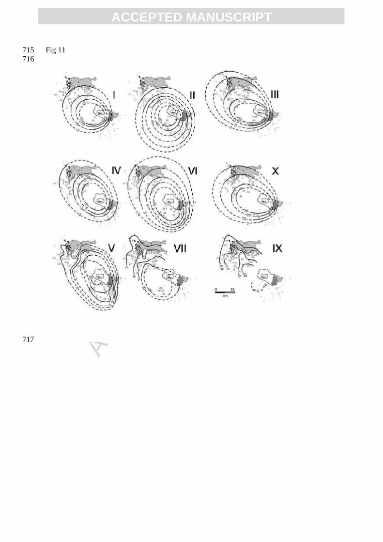
erosion. The areal thickness distribution of the tuff subunits is controlled by topography, as 313
shown by the isopach maps of subunits V, VII and IX (Fig. 11). However, the major 314
pyroclastic surges were not restricted to low flat areas but surmounted the Las Sierras hills 315
west of the Masaya caldera to produce significant deposits on their lee flanks. 316
317
4. The major fallout deposits 318
319
Preliminary estimates of eruption parameters for the entire deposit, based on separate 320
treatment of the LCF and MF fallout data, have been given by Pérez and Freundt (2006) and 321
Kutterolf et al. (2007). Here we re-interpret the data using isopach and isopleth maps of the 322
major fallout subunits defined by the proposed correlation between the facies. These isopach 323
and isopleth maps remain poorly constrained southwest and northeast of the caldera where 324
MTL outcrops are lacking. Thickness data for subunit VII to X to the south are scarce due to 325
post-emplacement erosion of the top of the MTL. Vent positions cannot be determined 326
precisely because proximal outcrops are restricted to the area close to the southern caldera 327
rim. Nevertheless, all isopach maps indicate a vent inside the Masaya caldera, possibly 328
beneath the modern Masaya intra-caldera cone. 329
330
4.1 Dispersal characteristics 331
332
The isopach maps for the correlated fallout subunits I, III, IV, VI, and X all show a dispersion 333
towards the NW, in direction to Managua city (Fig. 11). In detail, however, there are 334
differences in the isopach elongation and axis orientation between subunits, indicating 335
changing wind conditions. For example, the concentric circular pattern of subunit II isopachs 336
indicates calm conditions whereas a strong wind blowing toward the NW generated the 337
elongated isopachs of subunit IV. 338
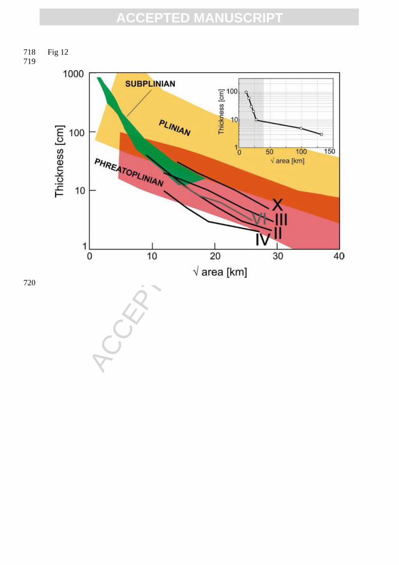
All major fallout subunits show a gradual decay in thickness with distance, typical for 339
Plinian-type deposits (Fig. 12). Minor variations in thickness decrease between the subunits 340
reflect variations in eruption intensity. Moreover, values of thickness half-distance (bt) and 341
clast half-distance (bc) for these deposits of 2.6-3.9 km and 6-18 km, respectively, are in the 342
ranges typical for Plinian eruptions (Pyle, 1989). 343
The frequent interruption of the Plinian-type eruptions by phreatomagmatic, typically surge-344
producing events, suggests that external water affected all eruptive pulses but to variable 345
extent. Subunits II and IV are relatively lithic-poor, well-sorted, and contain a large fraction 346
ACC
EPTE
D M
ANU
SCR
IPT
ACCEPTED MANUSCRIPT
of highly vesicular scoria lapilli. We interpret these as mainly magmatic Plinian eruptions 347
(while noting that the presence of partially quenched lapilli indicates access of some water to 348
the conduit). On the other hand, subunits III, VI and X are moderately sorted (σ>1.5), more 349
lithic-rich and most of the scoriae are poorly vesicular; moreover, scoria lapilli in subunit III 350
are ash-coated and proximally intercalated with tuff layers. We interpret these eruptive events 351
as Phreatoplinian since they were clearly more strongly affected by magma-water interaction. 352
Fallout subunit VIII shows locally variable faint parallel or cross-bedding; this may be due to 353
surge-blast expansion contemporaneous with fallout emplacement but may also have been 354
caused by strong near-surface wind. 355
356
4.2 Eruption column heights and wind speed 357
358
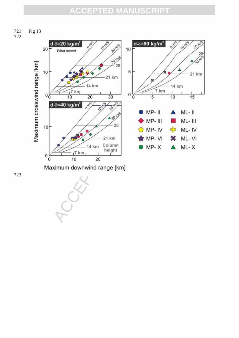
We use downwind and crosswind ranges obtained from isopleth maps of maximum juvenile 359
(MP) and lithic fragments (ML) of the fallout subunits II, III, IV, VI, VIII and X for 360
comparison with eruption-column modeling results of Carey and Sparks (1986) to estimate 361
eruption column heights and wind speeds (Fig. 13). The resulting overall range in column 362
heights is 15 to 32 km. The best-constrained values suggest 22-24 km for subunit II, 22-28 km 363
for subunit III, 21-23 km for subunits IV and VI, and 26-32 km for subunit X. Magma mass 364
discharge rates can be estimated from eruption column heights by comparison with the model 365
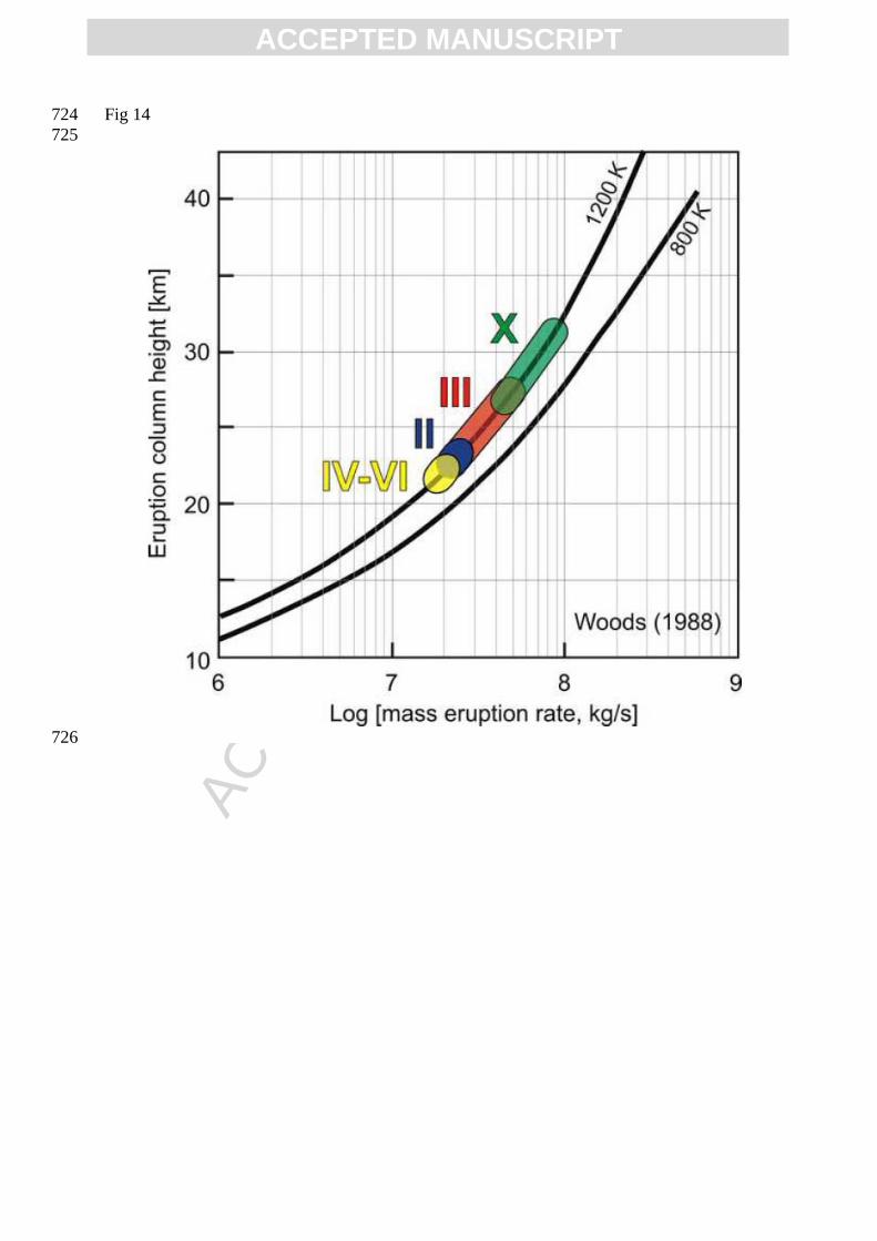
results of Woods (1988). Resulting discharge rates for the fallout subunits lie between 107 to 366
108 kg/s (Fig. 14), with subunit X having the highest discharge close to 108 kg/s. 367
Estimated wind speeds are <2 m/s for subunit II in agreement with its concentric circular 368
isopach and isopleth patterns, around 10 m/s for subunits III, IV and VI, and ~20 m/s for the 369
topmost subunit X. These differences reflect changes in wind strength both with time and 370
with height in the atmosphere. The data in figure 13 suggest that the coarser material 371
emplaced within 5-10 km from vent never reached the stratosphere and that its dispersal was 372
controlled by tropospheric winds. Different tropospheric and stratospheric wind directions 373
and strengths caused bends in dispersal axes of some fallout deposits. The isopach pattern of 374
subunit III extends proximally westward before turning toward NW, and subunit VI 375
proximally extends to the S while the main fan is directed to the NW. On the other hand, the 376
distal fallouts from wind-driven surge clouds all extend to the NW; this may suggest that 377
near-surface wind directions were more constant than those in the higher troposphere. 378
Present-day winds at the surface and in the stratosphere (cf. Kutterolf et al., 2007) blow 379
westward throughout the year but change in the upper troposphere from northeastern 380
ACC
EPTE
D M
ANU
SCR
IPT
ACCEPTED MANUSCRIPT
directions during the dry season to southwestern directions during the rainy season. If similar 381
conditions prevailed 2 ka ago, subunits V and VI, with proximally southerly dispersal, would 382
have been erupted during the rainy season. On the other hand, desiccation cracks at the 383
surface of subunits III, V and IX suggest dry and hot weather. The different transport and 384
wind conditions, indications of breaks in volcanic activity, as well as the changes in eruption 385
style support that the MTL eruption consisted of numerous separate episodes that occurred 386
over an extended period of time, possibly several months. Individual fallout episodes may 387
have lasted 1-3 hours judging from mass discharge rates and erupted masses discussed in the 388
next section. 389
390
4.3 Volume 391
392
The subunit tephra volumes range from 0.02 to 0.22 km3 (Table 3) and are equivalent to 393
erupted magma masses between 1010 and 1011 kg. The fallout subunits II, III and X represent 394
the eruptive episodes with the largest magnitudes. The added-up total tephra volume of the 395
Masaya Triple Layer is 0.86 km3, a minimum estimate based on land outcrops. 396
Two ash layers found in sediment cores drilled at the continental slope ~170 km away from 397
the Masaya caldera have been correlated with the Masaya Triple Layer based on their 398
identical major and trace element chemical compositions, as well as other criteria, e.g. 399
stratigraphic position of other dated and correlated ash layers in the core, mineral assemblages 400
and texture of the glass shards (Kutterolf et al., 2008a). The ash layer in core M54/2 is 6 cm 401
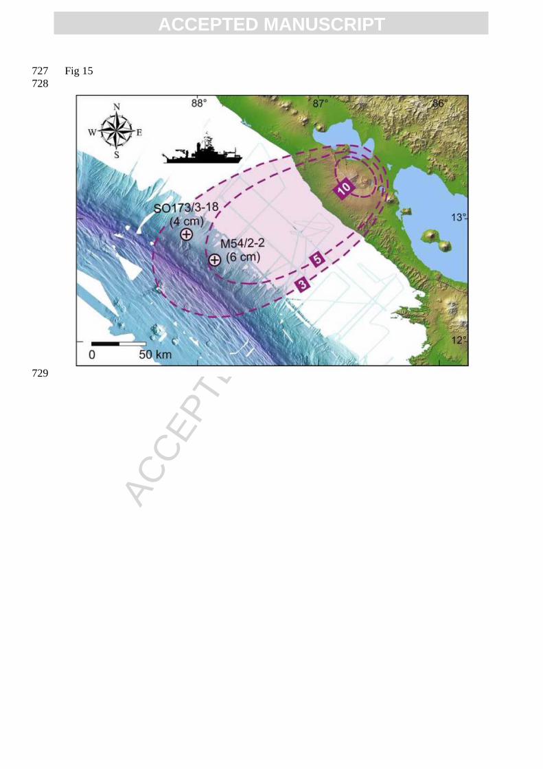
thick, the one in core SO173/3-18 4 cm (Fig. 15). These data imply a much flatter thickness 402
decay distally than on land (see inset in Fig. 12) and hence yield a significantly increased 403
tephra volume of the MTL of 3.4 km3 (~1.8 km3 DRE, after Kutterolf et al., 2008b). The 404
additional distal volume must be attributed to the major fallout events because the intercalated 405
tuffs from phreatomagmatic pulses do not reach that far. 406
The land isopachs show a major dispersion axis towards the northwest, whereas the distal 407
isopachs suggest transport to the west, reflecting wind directions changing with height. This 408
decoupling in transport direction has been reported for several eruptions around the world 409
(e.g. Sarna-Wojcicki et al., 1981; van den Bogaard and Schmincke, 1984; Adams et al., 410
2001). A similar pattern to that of the MTL is exhibited by the 25 ka Upper Apoyo Tephra 411
(Kutterolf et al., 2007, 2008a), coinciding with stratospheric winds to the west above 27 km 412
height and lower tropospheric winds to the west-northwest (see Kutterolf et al., 2007). 413
414
ACC
EPTE
D M
ANU
SCR
IPT
ACCEPTED MANUSCRIPT
5. The Masaya Triple Layer eruption 415
416
Two facies of volcanic deposits that occur in different areas to the N and S of Masaya caldera 417
at the same stratigraphic position have identical magmatic compositions and are thus the 418
deposit of a single eruption although they differ in internal architectures. La Concepción 419
facies of the Masaya Triple Layer is the more proximal facies of the eruption south of the 420
caldera, deposited in an area where fallout was still controlled by tropospheric rather than 421
stratospheric winds and where a rougher topography controlled the flow paths of the surges. 422
The Managua facies of the MTL, on the other hand, includes the medial and distal deposits in 423
the direction of fallout dispersion by stratospheric wind and of fine-ash fallout from surge-424
related ash-clouds driven by near-surface wind. Using the proposed correlation between the 425
two facies (Fig. 10), we summarize the evolution of the MTL eruption in figure 16. The MTL 426
eruption consisted of many episodes separated by time breaks sufficiently long for 427
atmospheric wind conditions to change and for desiccation cracks to form on the surface of 428
ash emplaced wet. The eruption style varied between phreatomagmatic explosions and 429
sustained Plinian and Phreatoplinian eruption columns that reached high into the stratosphere. 430
The eruption started with phreatomagmatic precursor activity, producing ash fall (B0, subunit 431
I) limited to proximal areas south of the caldera. The first main eruptive episode began with 432
minor phreatomagmatic fallout (B1) and minor surges that ripped off vegetation, then became 433
more magmatic with fallout B3 but terminated with another phreatomagmatic eruption of ash 434
fallout (B4). Opening and widening of the vent probably contributed to the relatively high 435
lithic contents of these deposits. The next episode (subunit II) was the first major magmatic 436
Plinian eruption that evacuated 0.038 km3 of fresh non-degassed magma and formed an 437
eruption column of 22-24 km height lasting for ~1 h (derived by dividing DRE mass by mass 438
flux). Vertical grain-size variations suggest the eruption to have fluctuated in intensity while 439
fallout dispersal was concentric under calm wind conditions. The characteristic fluidal shapes 440
of the lapilli (achneliths) indicate eruption of a hot low-viscosity magma that remained 441
unaffected by contact with external water. 442
The next episode (subunit III) was mostly phreatomagmatic, forming surges that destroyed 443
and carried along the vegetation. Intermittent ~22-28 km high eruption columns were unstable 444
and collapsed to form minor surges. A break in activity (desiccation cracks on tuff surface) 445
preceded the second major Plinian eruption (subunit IV), during which water access to the 446
conduit was largely inhibited and which took a couple of hours to eject 0.025 km3 of magma 447
in an eruption column rising to 21-23 km. When water regained access to the conduit, the 448
ACC
EPTE
D M
ANU
SCR
IPT
ACCEPTED MANUSCRIPT
following phreatomagmatic episode (subunit V) formed surges that flowed mainly towards 449
the south, whereas their ash-clouds were driven towards the NW by near-surface wind. 450
Desiccation cracks at the top of the tuff indicate another major break after this episode. The 451
MTL eruption started again with a Phreatoplinian eruption column (subunit VI) of similar 452
dimensions than during the subunit-IV episode but more strongly affected by external water 453
as evidenced by the higher fraction of hydrothermally altered lithics and poorly vesicular 454
scoriae. Increasing flux of water into the conduit then resulted in the largest phreatomagmatic 455
episode of the entire eruption (subunit VII) that produced thick surge deposits to the S and 456
associated ash-cloud deposits rich in accretionary lapilli to the NW. A low-intensity 457
phreatomagmatic episode (subunit VIII) followed and formed a fine-grained, relatively well-458
sorted deposit with faint cross bedding, suggesting fallout with a minor lateral transport 459
component possibly from a low drifting ash cloud. The next episode had regained higher 460
intensity and mainly generated phreatomagmatic surges of widespread distribution (subunit 461
IX). Another significant break in activity allowed for desiccation cracks to form on the 462
surface of this deposit. The terminal episode of the MTL eruption (subunit X) was the most 463
vigorous event with a 26-32 km high Phreatoplinian eruption column fed by a relative high 464
magma discharge rate. The fallout dispersal of the ~0.1 km3 of magma was mainly controlled 465
by strong stratospheric winds. The nature of the juvenile fragments and the high fraction of 466
lithic clasts, some hydrothermally altered, suggest intense magma-water interaction. 467
468
6. Conclusions 469
470
The Masaya Triple Layer provides an example of the complex evolution of a basaltic Plinian 471
eruption. The repeated alternation between clearly phreatomagmatic tuffs and fallout deposits 472
ranging from “magmatic” to “phreatomagmatic” characteristics suggests that external water to 473
some extent controlled the eruptive style of all eruption events such that even the explosivity 474
of the apparently magmatic events may have been increased by water vaporization. Peaks in 475
water access generating phreatomagmatic explosions were followed by breaks in eruptive 476
activity (desiccation cracks at the top of tuff layers), perhaps due to exhaustion of the water 477
reservoir and the necessity for the magma system to build up pressure for the next eruption. 478
Therefore, the MTL Plinian eruption was not only unsteady but multi-episodic, lasting for 479
weeks or months with intervening extended periods of inactivity. This is a critical issue for 480
hazard assessments, because major break during an eruption may be mistaken for the end of 481

ACC
EPTE
D M
ANU
SCR
IPT
ACCEPTED MANUSCRIPT
the eruption while, as shown for the MTL eruption, the most powerful event may still be 482
coming. 483
484
Acknowledgments 485
486
This publication is contribution No. 140 of the Sonderforschungsbereich (SFB) 574 “Volatiles 487
and Fluids in Subduction Zones” at Kiel University. This work was part of W. Pérez PhD 488
thesis, which was partly supported by the German Academic Exchange Service (DAAD). We 489
thank the Instituto Nicaragüense de Estudios Territoriales (INETER) for logistic support in 490
the field. S. da Silva and J. Fierstein provided constructive revisions that improved this paper. 491
492 493 References 494 495 Adams, N.K., de Silva, S.L., Self, S., Salas, G., Schubring, S., Permenter, J.L., Arbesman, K., 496
2001. The physical Volcanology of the 1600 eruption of Huaynaputina, southern Peru. 497 Bull. Volcanol. 62, 493-518. 498
Barckhausen, U., Ranero, C.R., von Huene, R., Cande, S.C. and Roeser, H.A., 2001. Revised 499 tectonic boundaries in the Cocos plate off Costa Rica: Implications for the 500 segmentation of the convergent margin and for plate tectonic models. J. Geophys. Res. 501 106, 19207-19220. 502
Bice, D.C., 1985. Quaternary volcanic stratigraphy of Managua, Nicaragua: Correlation and 503 source assignment for multiple overlapping plinian deposits. Geol. Soc. Amer. Bull. 504 96, 553-566. 505
Carey, S., Sparks, R.S.J., 1986. Quantitative models of fallout and dispersal of tephra from 506 volcanic eruption columns. Bull. Volcanol. 48, 109-125. 507
Carey, R., Houghton, B.F., Sable, J.E., Wilson, C.J.N., 2007. Contrasting grain size and 508 componentry in complex proximal deposits of the 1886 Tarawera basaltic Plinian 509 eruption. Bull. Volcanol. 69, 903-926. 510
Coltelli, M., Del Carlo, P., Vezzoli, L., 1998. Discovery of a Plinian basaltic eruption of 511 Roman age at Etna volcano, Italy. Geology 26, 1095-1098. 512
Costantini, L., Bonadonna, C., Houghton, B.F., Wehrmann, H., 2008. New physical 513 characterization of the Fontana Lapilli basaltic Plinian eruption, Nicaragua. Bull. 514 Volcanol (in press). 515
DeMets, C., 2001. A new estimate for present-day Cocos-Caribbean plate motion: 516 Implications for slip along the Central American volcanic arc. Geophys. Res. Lett. 28, 517 4043-4046. 518
Duffell, H.J., McGonigle, A.J.S., Burton, M.R., Oppenheimer, C., Pyle, D.M., and Galle, B., 519 2003. Changes in gas composition prior to a minor explosive eruption at Masaya 520 volcano, Nicaragua. J. Volcanol. Geotherm. Res. 126, 327-339. doi:10.1016/S0377–521 0273(03)00156–2. 522
Dzurisin, D., Lockwood, J.P., Casadevall, T.J. and Meyer, R., 1995. The Uwekahuna Ash 523 Member of the Puna Basalt: product of a violent phreatomagmatic eruptions at Kilauea 524 volcano, Hawaii, between 2800 and 2100 14C years ago. J. Volcanol. Geotherm. Res. 525 66, 163-184. 526
ACC
EPTE
D M
ANU
SCR
IPT
ACCEPTED MANUSCRIPT
Fierstein, J., Nathenson, M., 1992. Another look at the calculation of fallout tephra volumes. 527 Bull. Volcanol. 54, 156-167. 528
Girard, G., van Wyk de Vries, B., 2005. The Managua Graben and Las Sierras-Masaya 529 volcanic complex (Nicaragua); pull-apart localization by an intrusive complex: results 530 from analogue modeling. J. Volcanol. Geotherm. Res. 144, 37-57. 531
Houghton, B.F., Wilson, C.J.N., 1989. A vesicularity index for pyroclastic deposits. Bull. 532 Volcanol. 51, 451-462. 533
Houghton, B.F., Wilson, C.J.N. and Pyle, D.M., 2000. Pyroclastic fall deposits. In: H. 534 Sigurdsson, B.F. Houghton, S. McNutt, H. Rymer, J. Stix (Editors), Encyclopedia of 535 volcanoes, Academic Press, San Diego, pp 555–570. 536
Horrocks, L., Burton, M., Francis, P., Oppenheimer, C., 1999. Stable gas plume composition 537 measured by OP-FTIR spectroscopy at Masaya volcano, Nicaragua, 1998-1999. 538 Geophys. Res. Lett. 26, 3497-3500. 539
Kutterolf, S., Freundt, A., Peréz, W., Mörz, T., Schacht, U., Wehrmann, H., Schmincke, H.-540 U., 2008a. The Pacific offshore record of Plinian arc volcanism in Central America: 1. 541 Along-arc correlations. Geochemistry, Geophysics, Geosystems 9. 542 doi:10.1029/2007GC001631 543
Kutterolf, S., Freundt, A., Peréz, W., 2008b. The Pacific offshore record of Plinian arc 544 volcanism in Central America: 2. Tephra volumes and erupted masses. Geochemistry, 545 Geophysics, Geosystems 9. doi:10.1029/2007GC001791. 546
Kutterolf, S., Freundt, A., Pérez, W., Wehrmann, H. and Schmincke, H.-U., 2007. Late 547 Pleistocene to Holocene temporal succession and magnitudes of highly-explosive 548 volcanic eruptions in west-central Nicaragua. J. Volcanol. Geotherm. Res. 163, 55-82. 549
Lewicki, J.L., Connor, C., St-Amand, K., Stix, J., Spinner W., 2003. Self-potential, soil CO2 550 flux, and temperature on Masaya volcano, Nicaragua. Geophys. Res. Lett. 30, 1817. 551 doi:10.1029/2003GL017731 552
Mastin, L.G., 1997. Evidence for water influx from a caldera lake during the explosive 553 hydromagmatic eruption of 1790, Kilauea volcano, Hawaii. J. Geophys. Res. 102, 554 20093-20109. 555
McBirney, A.R., 1956. The Nicaraguan volcano Masaya and its caldera. Amer. Geophys. 556 Union Transactions 37, 83-96. 557
McPhie, J., Walker, G.P.L., Christiansen, R.L., 1990. Phreatomagmatic and phreatic fall and 558 surge deposits from explosions at Kilauea volcano, Hawaii, 1790 A.D.: Keanakakoi 559 Ash Member. Bull. Volcanol. 52, 334-354. 560
Métaxian, J.-Ph., Lesage, Ph., Dorel, J., 1997. The permanent tremor of Masaya volcano, 561 Nicaragua: Wave field analysis and source location. J. Geophys. Res. 102, 22,529-562 22,545. 563
Pérez, W., Freundt, A., 2006. The youngest highly explosive basaltic eruptions from Masaya 564 Caldera (Nicaragua). In: W.I. Rose, G.J.S. Bluth, M.J. Carr, J.W. Ewert, L.C. Patino, 565 J.W. Vallance (Editors), Volcanic hazards in Central America. Geol. Soc. Am. Spec. 566 Pap. 412, pp 189-207. 567
Pyle, D.M., 1989. The thickness, volume and grain-size of tephra fall deposits. Bull. 568 Volcanol. 51, 1-15. 569
Rymer, H., van Wyk de Vries, B., Stix, J., Williams-Jones, G., 1998. Pit crater structure and 570 processes governing persistent activity at Masaya Volcano, Nicaragua. Bull. Volcanol. 571 59, 345-355. 572
Sable, J.E., Houghton, B.F., Wilson, C.J.N., Carey, R.J., 2006. Complex proximal 573 sedimentation from Plinian plumes: the example of Tarawera 1886. Bull. Volcanol. 574 69, 89-103. 575
ACC
EPTE
D M
ANU
SCR
IPT
ACCEPTED MANUSCRIPT
Sarna-Wojcicki, A.M., Shipley, S., Waitt, J.R., Dzurisin, D., Wood, S.H., 1981. Areal 576 distribution, thickness, mass, volume and grain-size of air-fall ash from the six major 577 eruptions of 1980. U. S. Geol. Surv. Prof. Pap. 1250, 577- 600. 578
Sparks, R.S.J., Bursik, M.I., Ablay, G.J., Thomas, R.M.E., Carey, S.N., 1992. Sedimentation 579 of tephra by volcanic plumes. Part 2: controls on thickness and grain-size variations of 580 tephra fall deposits. Bull. Volcanol. 54, 685-695. 581
Stoiber, R.E., Williams, S.N., 1986. Sulfur and halogen gases at Masaya caldera complex, 582 Nicaragua: Total flux and variations with time. J. Geophys. Res. 91, 12,215-12,231. 583
van den Bogaard, P., Schmincke, H.-U., 1984. The eruptive center of the Late Quaternary 584 Laacher See Tephra. Geol. Rdsch. 73, 933-980. 585
van Wyk de Vries, B., 1993. Tectonics and magma evolution of Nicaraguan volcanic systems. 586 Ph.D. Thesis. Open Univ., UK. 587
Walker, G.P.L., Self, S., Wilson, L., 1984. Tarawera 1886, New Zealand - A basaltic Plinian 588 fissure eruption. J. Volcanol. Geotherm. Res. 21, 61-78. 589
Walker, J.A., Williams, S.N., Kalamarides, R.I., Feigenson, M.D., 1993. Shallow open-590 system evolution of basaltic magma beneath a subduction zone volcano: the Masaya 591 Caldera Complex, Nicaragua. J. Volcanol. Geotherm. Res. 56, 379-400. 592
Wehrmann, H., Bonadonna, C.B., Freundt, A., Houghton, B.F., Kutterolf, S., 2006. A 593 basaltic-andesitic plinian eruption revisited: case study of Fontana Tephra, Nicaragua. 594 In: W.I. Rose, G.J.S. Bluth, M.J. Carr, J.W. Ewert, L.C. Patino, J.W. Vallance 595 (Editors), Volcanic hazards in Central America. Geol. Soc. Am. Spec. Pap. 412, pp. 596 209-223. 597
Wehrmann, H., 2005. Volatile degassing and Plinian eruption dynamics of the mafic Fontana 598 Tephra, Nicaragua. Ph.D. Thesis. Kiel Univ., Germany. 599
Williams, S.N., 1983. Plinian airfall deposits of basaltic composition. Geology 11, 211-214. 600 Wilson, L., Walker, G.P.L., 1987. Explosive volcanic eruptions: VI. Ejecta dispersal in 601
plinian eruptions: the control of eruption conditions and atmospheric properties. 602 Geophys. J. R. Astron. Soc. 89, 657–679. 603
Woods, A.W., 1988. The fluid dynamics and thermodynamics of eruption columns. Bull. 604 Volcanol. 50, 169-193. 605
ACC
EPTE
D M
ANU
SCR
IPT
ACCEPTED MANUSCRIPT
Figure Captions 606 607 Figure 1: Digital elevation model of Nicaragua showing the two large lakes, the position of 608 the volcanic front and the location of the Masaya Caldera Complex. The black stippled line 609 marks the boundary of the Nicaraguan depression after van Wyk de Vries (1993). 610 611 Figure 2: Facies distribution of the Masaya Triple Layer, with La Concepción facies (LCF) to 612 the south of the caldera and the Managua facies (MF) to the northwest. The open circles and 613 squares represent the studied localities and the red lines connect the proximal profiles shown 614 in figures 4 and 7. Note the lack of MTL outcrops to the west (direction to El Crucero) and 615 northeast (towards Tipitapa). 616 617 Figure 3: End-member types of juvenile fragments of the Masaya Triple Layer in thin section: 618 [a] highly vesicular sideromelane (∼80 vol. % porosity), [b] moderately vesicular tachylite 619 with ∼40 vol. % round vesicles and [c] incipiently vesicular tachylite, where the vesicularity 620 consists of irregular-shaped voids (∼16 vol. %). 621 622 Figure 4: Diagram SiO2 vs. MgO comparing the composition of the two facies of the Masaya 623 Triple Layer (La Concepción facies -LCF- and Managua facies -MF- ) with the composition 624 fields of other major tephra units from Masaya caldera (SAT=San Antonio Tephra, 625 MT=Masaya Tuff, TIL=Ticuantepe Lapilli) and the older Las Sierras volcanic system 626 (FT=Fontana Tephra, LSF=Las Sierras Formation; data from Wehrmann (2005) and own 627 unpublished data). 628 629 Figure 5: Proximal stratigraphy of La Concepción facies, south of the caldera. The profile line 630 is shown in Fig. 2. Gray shading correlates lapilli beds between outcrops. Note the different 631 degrees of erosion at the top of the outcrops, with the Masaya Tuff lying unconformably 632 above. 633 634 Figure 6: Photographs of the juvenile particles of layer B5. [a] Selected particles with fluidal 635 shapes and glassy surfaces. [b] Whole deposit as it looks in the outcrops. [c] Highly vesicular 636 brown sideromelane glass in thin section. 637 638 Figure 7: Photographs of the tuff sequence B6-B10 with intercalated well-sorted fall deposits. 639 [a] At an outcrop 3 km S from the caldera rim where the layers are several cm thick. [b] The 640 three tuffs at 7.5 km S of the caldera rim. 641 642 Figure 8: Stratigraphy of the Managua facies at the most proximal exposures NW of the 643 caldera. The profile line and location of the outcrops are shown in Fig. 2. Correlations 644 between outcrops are indicated by gray shading. 645 646 Figure 9: Variation diagrams showing the complete overlap in: [a] major element (FeO vs. 647 MgO) and [b] trace-element (Ba vs. Zr) compositions of matrix glass, [c] Al2O3 vs. CaO 648 concentrations of melt inclusion glasses, and [d] K2O vs. CaO concentrations in plagioclase 649 phenocrysts from the Managua facies (MF) and La Concepción facies (LCF). 650 651 Figure 10: Proposed correlation between La Concepción and the Managua facies based on the 652 marker beds B5 and C2 (subunit II, correlation in red). As indicated, the left profile -MF- is 653 towards the NW of the caldera and the right profile -LCF- is to the S of Masaya caldera. 654 655
ACC
EPTE
D M
ANU
SCR
IPT
ACCEPTED MANUSCRIPT
Figure 11: Isopach maps for the main fallout subunits I, II, III, IV, VI, X and the surge-tuff 656 subunits V, VII and IX of the Masaya Triple Layer. Isopach contours are in cm and the 657 dashed lines are estimated in areas with no data. The cities of Managua and Masaya are 658 shown in gray. 659 660 Figure 12: Diagram of isopach thickness vs. square root of isopach area for the MTL fallout 661 subunits. The fields of Plinian, Subplinian and Phreatoplinian eruptions are from Houghton et 662 al. (2000). The inset at the top right corner shows the same diagram on a bigger scale for the 663 entire MTL including the thickness data from the distal marine tephra layers. 664 665 Figure 13: Crosswind range versus maximum downwind range of the MP and ML isopleths 666 for subunits II, III, IV, VI and X of the MTL. The model curves are from Carey and Sparks 667 (1986). Most of the MTL data locate between 20 and 28 km column height and indicate 668 different winds speeds for the subunits. 669 670 Figure 14: Eruption column height versus log of the mass eruption rate with the lines for 671 different eruption temperatures of Woods (1988). The colored oval areas locate column 672 heights for the fallout subunits II, III, IV, VI and X on the 1200 K line (eruption temperature 673 for basaltic magmas). The eruption temperature of the poorly phyric basaltic MTL magma 674 was probably 200 degrees higher such that mass eruption rates estimated from this figure are 675 maximum estimates. 676 677 Figure 15: Isopachs in centimeters (dotted line) for the Masaya Triple Layer total thickness. 678 The cross-circle symbols give the location of sediment gravity cores drilled offshore 679 Nicaragua; labels indicate the core number and the thickness of the ash layer. 680 681 Figure 16. Schematic model of the Masaya Triple Layer eruption as discussed in the text, 682 showing the main Plinian and Phreatoplinian eruptions interrupted by surge-forming 683 phreatomagmatic activity. Blue lenses represent ground water accessing the conduit. 684
ACC
EPTE
D M
ANU
SCR
IPT
ACCEPTED MANUSCRIPT
Fig 1 685 686
687
ACC
EPTE
D M
ANU
SCR
IPT
ACCEPTED MANUSCRIPT
Fig 2 688 689
690
ACC
EPTE
D M
ANU
SCR
IPT
ACCEPTED MANUSCRIPT
Fig 3 691 692
693
ACC
EPTE
D M
ANU
SCR
IPT
ACCEPTED MANUSCRIPT
Fig 4 694 695
696
ACC
EPTE
D M
ANU
SCR
IPT
ACCEPTED MANUSCRIPT
Fig 5 697 698
699
ACC
EPTE
D M
ANU
SCR
IPT
ACCEPTED MANUSCRIPT
Fig 6 700 701
702
ACC
EPTE
D M
ANU
SCR
IPT
ACCEPTED MANUSCRIPT
Fig 7 703 704
705
ACC
EPTE
D M
ANU
SCR
IPT
ACCEPTED MANUSCRIPT
Fig 8 706 707
708
ACC
EPTE
D M
ANU
SCR
IPT
ACCEPTED MANUSCRIPT
Fig 9 709 710
711
ACC
EPTE
D M
ANU
SCR
IPT
ACCEPTED MANUSCRIPT
Fig 10 712 713
714
ACC
EPTE
D M
ANU
SCR
IPT
ACCEPTED MANUSCRIPT
Fig 11 715 716
717
ACC
EPTE
D M
ANU
SCR
IPT
ACCEPTED MANUSCRIPT
Fig 12 718 719
720
ACC
EPTE
D M
ANU
SCR
IPT
ACCEPTED MANUSCRIPT
Fig 13 721 722
723
ACC
EPTE
D M
ANU
SCR
IPT
ACCEPTED MANUSCRIPT
Fig 14 724 725
726
ACC
EPTE
D M
ANU
SCR
IPT
ACCEPTED MANUSCRIPT
Fig 15 727 728
729
ACC
EPTE
D M
ANU
SCR
IPT
ACCEPTED MANUSCRIPT
Fig 16 730 731
732
ACC
EPTE
D M
ANU
SCR
IPT
ACCEPTED MANUSCRIPT
Table 1. Characteristics of the subunits of La Concepción facies. Most sorting values were estimated in the field but are supported by selected grain-size analyses. Vesicularity estimated in thin sections and calculated from measured clast bulk densities. ND means “not determined”.
Correl. subunit
LCF Subunit Type of deposit Sorting Juvenile fragments Density
(g/cm3) Vesicularity
(vol.%) Type of glass Lithic fragments (vol.%, type)
B0 Two basal loose fine ash layers and an indurated tuff at the top with accretionary lapilli and plant remains. Present only in proximal areas
B1 Scoria lapilli σ~1.5 Incipiently to moderately vesicular lapilli, round, bread-crust shaped 0.8-1.35 7-17
40-50 Tachylite ~5 vol.%, hydrothermally altered lavas, plutonics,
B2 Yellowish faintly laminated indurated fine tuff containing very fine accretionary lapilli and molds of grass leaves
B3 Fine scoria lapilli σ~1.5 Poorly to incipiently vesicular lapilli, round shaped ~1.5 ND ND 1-2 vol.%, mostly
hydrothermally altered
I
B4 Laminated weakly-cemented tuff with coarse-ash base to very fine top. Consists mostly of poorly to non-vesicular glass shards and a minor fraction (~3-5 vol.%) of highly vesicular achnelith-shaped fragments. Load structures locally disturb the parallel lamination.
II B5 Scoria lapilli σ~1 Glassy, fluidal-shaped achneliths 0.25-1 45-80 Sideromelane <<1 vol.%, small, hydrothermally altered
B6 Grayish indurated tuff with a fine-grained lower part containing accretionary lapilli and a cross-bedded top of fine lapilli to coarse ash
B7 Scoria fine lapilli to coarse ash σ~1.5-2 Moderately vesicular lapilli, ~5-10
vol.% poorly to incipiently vesicular 0.9-1 ~1.5 50-60 Sideromelane
and tachylite <1 vol.% some hydrothermally altered III
B8 Indurated tuff showing dune structures and cross bedding at proximal facies; accretionary lapilli-rich tuff at medial-distal facies
IV B9 Scoria lapilli, some ash coated σ~1.5 ~90 vol.% incipiently vesicular,
~10 vol.% moderately vesicular 1.20-1.35
0.9-1.1 ~18
40-44
Sideromelane, tachylite, mingled
~1 vol.% lava, mostly reddish altered
V B10 Indurated grayish tuff, coarser and showing dunes and cross bedding at proximal areas, at distal is fine-grained with accretionary lapilli
VI B11 Scoria lapilli σ~1.7-2 Moderately - poorly vesicular lapilli,
incipiently vesicular lapilli, ~20 vol.% moderately vesicular
~0.8 1.2-1.6 ~0.65
17-20 30-45
Tachylite, minor
sideromelane
~3-5 vol.% vesicular lava, plutonics, reddish lithics
B12 Two indurated tuff beds, the lowermost of lapilli and coarse-ash with cross-bedding and dune structures containing plant molds, the upper one is finer-grained (ash) with low-angle cross-bedding. Contains armored lapilli with lava and scoria cores. VII
B13 Grayish accretionary lapilli-rich fine tuff containing dispersed scoria lapilli.
VIII B14 Lapilli to coarse ash, faint cross-bedding
σ~2.5 Poorly to moderately vesicular,
incipiently vesicular lapilli, coated with fine ash
ND 35-50 ~8 Tachylite ND
IX B15 Gray to yellowish indurated fine tuff with scattered accretionary lapilli, cross-bedding and lapilli-rich lenses
X B16 Scoria lapilli σ~2 ~80 vol.% moderately vesicular, ~15 vol.% highly vesicular, ~5 vol.% dense
~0.4, 0.6-0.7, 1.1-1.5
20-30 Tachylite ~5 vol.% basaltic lavas, some hydrothermally altered
ACC
EPTE
D M
ANU
SCR
IPT
ACCEPTED MANUSCRIPT
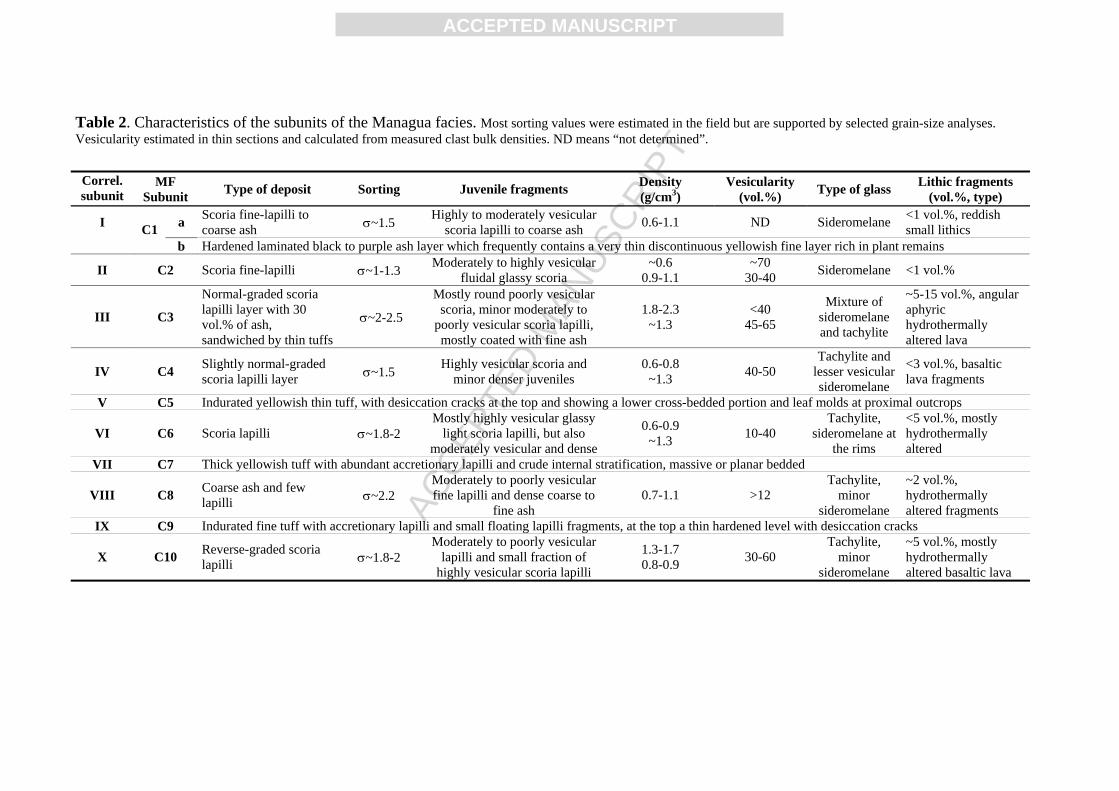
Table 2. Characteristics of the subunits of the Managua facies. Most sorting values were estimated in the field but are supported by selected grain-size analyses. Vesicularity estimated in thin sections and calculated from measured clast bulk densities. ND means “not determined”.
Correl. subunit
MF Subunit Type of deposit Sorting Juvenile fragments Density
(g/cm3) Vesicularity
(vol.%) Type of glass Lithic fragments (vol.%, type)
I a Scoria fine-lapilli to coarse ash σ~1.5 Highly to moderately vesicular
scoria lapilli to coarse ash 0.6-1.1 ND Sideromelane <1 vol.%, reddish small lithics
C1
b Hardened laminated black to purple ash layer which frequently contains a very thin discontinuous yellowish fine layer rich in plant remains
II C2 Scoria fine-lapilli σ~1-1.3 Moderately to highly vesicular fluidal glassy scoria
~0.6 0.9-1.1
~70 30-40 Sideromelane <1 vol.%
III C3
Normal-graded scoria lapilli layer with 30 vol.% of ash, sandwiched by thin tuffs
σ~2-2.5
Mostly round poorly vesicular scoria, minor moderately to
poorly vesicular scoria lapilli, mostly coated with fine ash
1.8-2.3 ~1.3
<40 45-65
Mixture of sideromelane and tachylite
~5-15 vol.%, angular aphyric hydrothermally altered lava
IV C4 Slightly normal-graded scoria lapilli layer σ~1.5 Highly vesicular scoria and
minor denser juveniles 0.6-0.8
~1.3 40-50 Tachylite and
lesser vesicular sideromelane
<3 vol.%, basaltic lava fragments
V C5 Indurated yellowish thin tuff, with desiccation cracks at the top and showing a lower cross-bedded portion and leaf molds at proximal outcrops
VI C6 Scoria lapilli σ~1.8-2 Mostly highly vesicular glassy
light scoria lapilli, but also moderately vesicular and dense
0.6-0.9 ~1.3 10-40
Tachylite, sideromelane at
the rims
<5 vol.%, mostly hydrothermally altered
VII C7 Thick yellowish tuff with abundant accretionary lapilli and crude internal stratification, massive or planar bedded
VIII C8 Coarse ash and few lapilli σ~2.2
Moderately to poorly vesicular fine lapilli and dense coarse to
fine ash 0.7-1.1 >12
Tachylite, minor
sideromelane
~2 vol.%, hydrothermally altered fragments
IX C9 Indurated fine tuff with accretionary lapilli and small floating lapilli fragments, at the top a thin hardened level with desiccation cracks
X C10 Reverse-graded scoria lapilli σ~1.8-2
Moderately to poorly vesicular lapilli and small fraction of
highly vesicular scoria lapilli
1.3-1.7 0.8-0.9 30-60
Tachylite, minor
sideromelane
~5 vol.%, mostly hydrothermally altered basaltic lava
ACC
EPTE
D M
ANU
SCR
IPT
ACCEPTED MANUSCRIPT
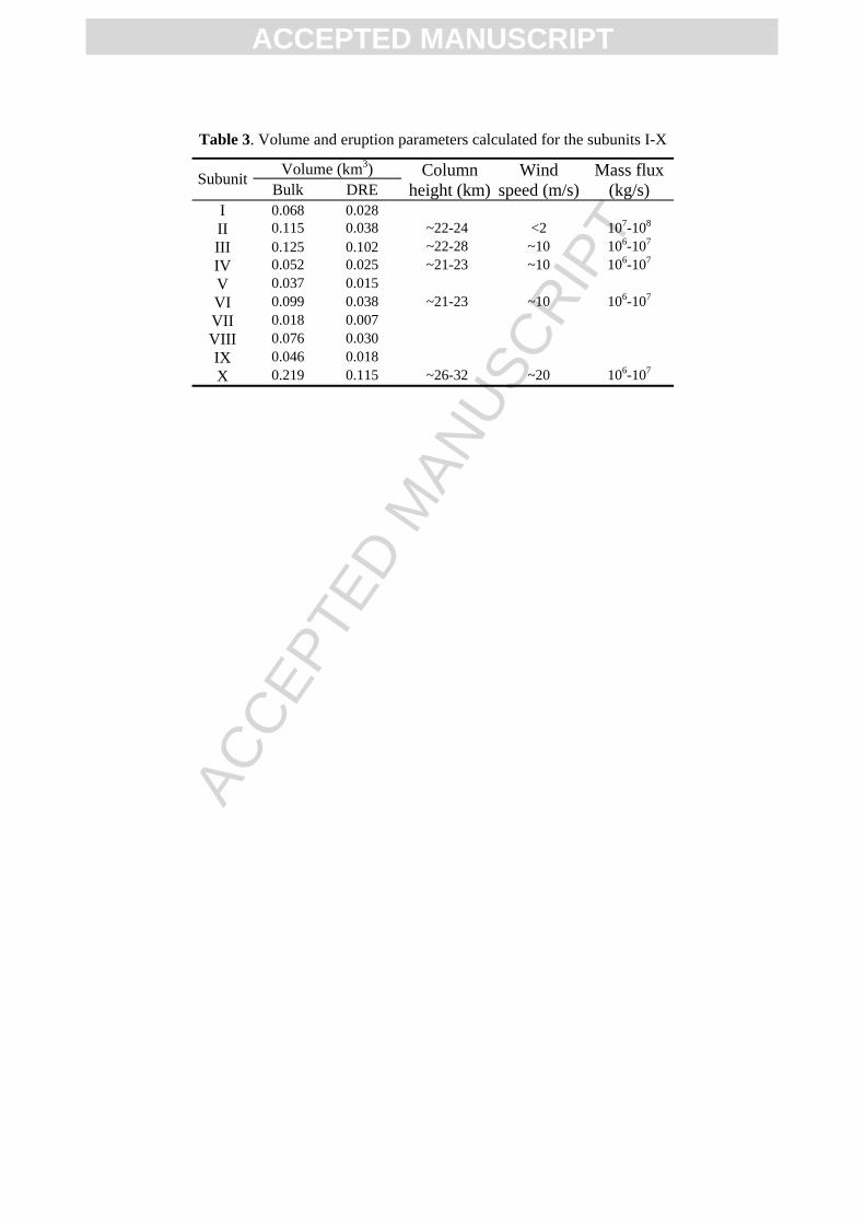
Table 3. Volume and eruption parameters calculated for the subunits I-X
Volume (km3) Subunit Bulk DRE
Column height (km)
Wind speed (m/s)
Mass flux (kg/s)
I 0.068 0.028 II 0.115 0.038 ~22-24 <2 107-108 III 0.125 0.102 ~22-28 ~10 106-107 IV 0.052 0.025 ~21-23 ~10 106-107 V 0.037 0.015 VI 0.099 0.038 ~21-23 ~10 106-107 VII 0.018 0.007 VIII 0.076 0.030 IX 0.046 0.018 X 0.219 0.115 ~26-32 ~20 106-107

![Understanding basaltic Plinian activity at Masaya caldera ...Basaltic Plinian Eruptions Some examples: [1] Fontana Lapilli (60 ka), Las Sierras- Masaya complex, Nicaragua [2] Masaya](https://img.pdfslide.net/doc/110x75/604495657a572664f11f81b6/understanding-basaltic-plinian-activity-at-masaya-caldera-basaltic-plinian-eruptions.jpg)