Embed Size (px)
Citation preview

GEOSCIENCE AUSTRALIA
ISSUE 80 December 2005
ISSUE 80 December 2005
Geoscience Australia’s contribution to understanding one of the least known parts of Australia’s marine jurisdiction.
George Bernardel and Jim Colwell
In January–February 2005, Geoscience Australia used the National Facility research vessel Southern Surveyor to study the Mellish Rise and adjoining Kenn Plateau in the Coral Sea, east of Queensland (figure 1). Ship time was provided by the Steering Committee of the National Facility Southern Surveyor. The voyage was led by Dr Neville Exon of Geoscience Australia, who led an earlier survey to the Kenn Plateau in May 2004 (see AusGeo News 75 at www.ga.gov.au/ausgeonews/archive/200410.jsp).
The shipboard team consisted of a core of Geoscience Australia technicians and scientists supported by scientists from the Geological Survey of Queensland, the Australian National University and the University of Sydney. CSIRO provided technical support, and P&O Australia provided the vessel’s crew.
Regional settingMost of the work was undertaken on the Mellish Rise, a large, complex, northeast-elongated, dissected block. It is believed to have separated from the Australian continental margin as a result of extension between the Australian, Lord Howe Rise and Louisiade Plateau crustal elements from about 52 to 62 million years ago.
The Mellish Rise’s northwest margin is separated from the Louisiade Plateau by the Louisiade Trough, which may have been the prolongation of a Townsville Trough rift system before evolving into an arm of a triple junction developed between the rise and Marion Plateau (figure 1). The arcuate south-eastern margin, bordering the Kenn and Bellona Plateaus, may have formed as a strike-slip fault between the triple junction to the west and the seafloor-spreading system along the Rise’s eastern margin.
Lying mainly in water depths between 500 and 3000 metres, the Mellish Rise’s total area is about 200 000 km2, of which about 150 000 km2—an area twice as large as Tasmania—is under Australian jurisdiction. The eastern part of the Rise is French (New Caledonian) territory, and the northern section is Solomon Islands territory (figure 1).
Acquisition programPrevious geophysical surveys over the Coral Sea, largely undertaken as part of the Continental Margins Program by the former Bureau of Mineral Resources in the early 1970s, did not include rock sampling to enable dating and determination of the nature of the sedimentary strata and basement rocks. The latest survey (figures 1 to 3) acquired 40 dredge hauls of rocks (14 over the Kenn Plateau and 26 over the Mellish Rise), ~1200 km of multichannel seismic profiles, ~2000 km of magnetic profiles and ~7000 km of multibeam sonar data (i.e. ~18,000 km2 of seabed coverage). The dredging of the Mellish Rise largely completes the geological sampling of all major plateaus off Australia, at least to reconnaissance level.
The Mellish Rise — A BIG PIECE OF THE CORAL SEA GEOLOGICAL JIGSAW PUZZLE
GEOSCIENCE AUSTRALIA
GEOSCIENCE AUSTRALIA
ISSUE 80 December 2005
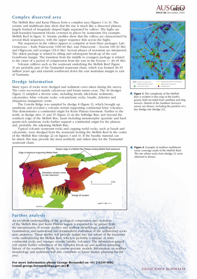
Complex dissected areaThe Mellish Rise and Kenn Plateau form a complex area (figures 1 to 3). The seismic and multibeam data show that the rise is much like a dissected plateau, largely formed of irregularly shaped highs separated by valleys. The highs are fault-bounded basement blocks crowned in places by seamounts (for example, Mellish Reef in figure 3). Seismic profiles show that the valleys are characterised by several thick sequences, with the upper sequence thin across the highs.
The sequences in the valleys appear to comprise at least three packages: Late Cretaceous – Early Palaeocene (100–60 Ma), Late Palaeocene – Eocene (60–34 Ma) and Oligocene and younger (33–0 Ma). Several phases of tectonism are interpreted. The oldest package is related to rifting and subsequent break-up of the east Gondwana margin. The transition from the middle to youngest package is related to the onset of a period of compression from the east in the Eocene (~ 40–45 Ma).
Volcanic edifices such as the seamount underlying the Mellish Reef (figure 3) are probably part of the Tasmantid seamount chain, which was formed 30–35 million years ago and extends southward down the east Australian margin to east of Tasmania.
Dredge informationMany types of rocks were dredged and sediment cores taken during the survey. The cores recovered mainly calcareous and foram nanno ooze. The 40 dredges (figure 1) sampled a diverse suite, including mostly siliciclastic sediments, calcarenites, felsic volcanic rocks, volcaniclastic rocks, basalts, dolerites and ubiquitous manganese crusts.
The Coriolis Ridge was sampled by dredge 8 (figure 2), which brought up sandstone and revealed a volcanic terrain supporting continental felsic volcanics. This demonstrates a continental origin for Kenn Plateau basement. Further to the north, at dredge sites 11 and 35 (figure 2) on the Selfridge Rise, just beyond the southern edge of the Mellish Rise, hauls including metamorphic quartzite and hard quartz-rich sandstone rocks further support a continental origin for the plateau and, probably, the adjoining Mellish Rise.
Typical volcanic seamount rocks and capping reefal rocks, such as basalt and calcarenite, were dredged from the seamount hosting the Mellish Reef in the centre of the Mellish Rise (dredge 22 on figures 3 and 4). If the basaltic material can be dated, this may provide the most northerly and oldest date for the Tasmantid seamount chain.
Further analysisAn excellent understanding of the geological composition and evolution of the Mellish Rise and Kenn Plateau region is expected to be gained from the interpretation of seismic profiles and seafloor morphology, petrological examination, and nannofossil and foraminiferal evaluation of the sedimentary rocks now underway. These studies will provide insight into the nature of the basement rocks underpinning the Mellish Rise, which is probably a mixture of older continental rocks and younger oceanic basaltic volcanics. The information gained will enable further refinement of the complex break-up and seafloor-spreading history of the southwest Pacific in current tectonic models. Information on seafloor morphology and sediments will also contribute to future marine planning for the area.
For more information phone George Bernardel on +61 2 6249 9682 (email [email protected])
GEOSCIENCE AUSTRALIA


![The problem of the coral reefs (Preface). Pacific Geological Surveys [Reports]](https://img.pdfslide.net/doc/110x75/568c39971a28ab0235a2e918/the-problem-of-the-coral-reefs-preface-pacific-geological-surveys-reports.jpg)