Embed Size (px)
Citation preview

The Mesozoic of Southwestern OregonAuthor(s): George Davis LouderbackSource: The Journal of Geology, Vol. 13, No. 6 (Sep. - Oct., 1905), pp. 514-555Published by: The University of Chicago PressStable URL: http://www.jstor.org/stable/30067946 .
Accessed: 19/05/2014 06:57
Your use of the JSTOR archive indicates your acceptance of the Terms & Conditions of Use, available at .http://www.jstor.org/page/info/about/policies/terms.jsp
.JSTOR is a not-for-profit service that helps scholars, researchers, and students discover, use, and build upon a wide range ofcontent in a trusted digital archive. We use information technology and tools to increase productivity and facilitate new formsof scholarship. For more information about JSTOR, please contact [email protected].
.
The University of Chicago Press is collaborating with JSTOR to digitize, preserve and extend access to TheJournal of Geology.
http://www.jstor.org
This content downloaded from 193.104.110.147 on Mon, 19 May 2014 06:57:56 AMAll use subject to JSTOR Terms and Conditions
THE MESOZOIC OF SOUTHWESTERN OREGON'
GEORGE DAVIS LOUDERBACK San Francisco, Cal.
CONTENTS INTRODUCTION.
HISTORICAL.
AREAS STUDIED.
PRESENT KNOWLEDGE OF THE MEZOZOIC OF THE REGION.
The Myrtle formation. Outline of the Mesozoic and related history.
THE HETEROGENEITY OF THE MYRTLE FORMATION.
THE LITHOLOGIC CHARACTERS OF THE SEDIMENTARY ROCKS.
The lower series.
General composition. The sandstones. The shales.
Conglomerates. Cherts. Limestone.
The upper group. General composition and comparison with lower series. Shales. Sandstones.
Conglomerates.
THICKNESS OF THE SEDIMENTS. The upper division.
The lower division.
PALEONTOLOGIC CHARACTERS. The upper division. The lower division.
TERMS USED. Definition of the Myrtle group or series. The Dillard series.
' This study was made as research assistant of the Carnegie Institution of Wash- ington, and is published by permission of the Institution. Read before the Cordilleran Section of the Geological Society of America, December, 1904.
514
This content downloaded from 193.104.110.147 on Mon, 19 May 2014 06:57:56 AMAll use subject to JSTOR Terms and Conditions

MESOZOIC OF SOUTHWESTERN OREGON
IGNEOUS AND METAMORPHIC ROCKS.
Associated with the Dillard series. General characters.
The basic series. The greenstones The feldspathic granular rocks
The ultrabasic rocks.
The docite-andesite group. Glaucophane and associated schists.
Relations to the Myrtle group. General relations. General comparison with the Dillard.
The Myrtle conglomerates. Other evidence.
Summary.
ECONOMIC RELATIONS.
Purpose of the discussion. The Myrtle group. The Dillard series.
General contrast.
Quartz veins. Effects of structure. Copper. Nickel. Chrome iron. Platinum. Limestone. Sandstone and cherts.
AREAL DISTRIBUTION IN THE REGION STUDIED.
General method of determination. The interior quadrangles.
General distribution in Roseburg quadrangle. The Dillard area. The Myrtle Creek area. Smaller areas between the Dillard and Myrtle Creek areas. Contrast between close-lying areas of Dillard and Myrtle. The Days Creek area.
The coastal quadrangles. The Coos Bay quadrangle. The Port Orford quadrangle.
THE DISCONTINUITY OF THE DILLARD AND THE MYRTLE.
COMPARISON WITH THE STANDARD CALIFORNIA TYPE FORMATIONS.
The Myrtle group. Identity with the Shasta.
515
This content downloaded from 193.104.110.147 on Mon, 19 May 2014 06:57:56 AMAll use subject to JSTOR Terms and Conditions

GEORGE DAVIS LOUDERBACK
The Dillard series. General characteristics of the Franciscan. Identity with the Franciscan. The Whitsett limestone fossils. The Jurassic question.
EXTENSION OF THE FRANCISCAN.
THE SHASTA (LOWER CRETACEOUS) SEA.
THE BOUNDARY OF THE KLAMATH MOUNTAINS.
NOMENCLATURE.
SUMMARY OF RESULTS.
INTRODUCTION
During the summer of 1904 the writer, in the course of an inves- tigation of the glaucophane schists of California, made a trip into southern Oregon for the purpose of comparing the geological relations of the schists reported as occurring there with those of similar rocks in California. In particular, the Oregon schists were said to occur
in a formation corresponding to the Knoxville and Horsetown of California, and were considered as contact products of irruptives which were intruded into the formation, and were therefore con- sidered at least post-Horsetown in age. In California, on the other hand, similar schists are found in the Franciscan, a thick and impor- tant series of formations which underlies the Knoxville unconformably, and the greater part of whose basic intrusives, if not all, are pre- Knoxville in age. No schists have yet been found in the California Knoxville or later rocks. It would be of considerable interest, then, to the student of petrographical provinces, if such rocks, which are apparently due to rather uncommon conditions, and which in the United States are, so far as known, limited to this coastal (Cali- fornia and Oregon) region, had been developed in different parts of this territory in formations which differ both in age and in lithologic characters, and in relation to igneous rocks of apparently different ages of intrusion.
The study of the field relations of the Oregon schists, however, have led to the conclusion that they were developed in formations of the same age and lithologic characters, and have the same asso- ciations and relationships, as the corresponding schists in California. At the same time, certain important features of the Mesozoic stratig-
516
This content downloaded from 193.104.110.147 on Mon, 19 May 2014 06:57:56 AMAll use subject to JSTOR Terms and Conditions
MESOZOIC OF SOUTHWESTERN OREGON
raphy and history of the region were recognized, and a closer corre- lation between the geological conditions and sequence in southwestern Oregon, and those of the California Coast Ranges, made possible. To set forth these general results is the purpose of the present paper.
HISTORICAL
The region under discussion lies in southwestern Oregon, and is included from east to west between the western foothills of the Cascade Range (long. i230 west), and the Pacific Ocean (about 1240 20' to 1240 30' west); and from north to south between the latitude of Roseburg or the head of Coos Bay (about lat. 430 15' north), and
the Klamath' Mountains (about 420 30' north). This field has been studied by few.geologists. Dana and later Newberry, in their exploration work in the early days, saw but little of the country, and were hardly in position to arrive at any definite conclusions as to even the major events in the geological history of the region. Mr. G. F. Becker,2 about 1890, studied some of this country in the vicinity of Riddles in conjunction with Mr. W. Q. Brown, and arrived at certain conclusions that were important in extending the knowledge of the Pacific coast Cretaceous. It is to Mr. J. S. Diller, however, that we owe by far the greater part of our present knowledge of southwestern Oregon. He has spent a number of years in the investigation and mapping of considerable areas, and his studies have covered all parts of the region outlined above. His general results are presented most systematically and with the greatest detail in the texts accompanying the Roseburg, Coos Bay, and Port Orford folios3 of the Geologic Atlas of the United States, although certain features are more particularly treated in various memoirs, a number of which will be referred to in the body of this paper.
AREAS STUDIED
The index map, page 518, shows the relative positions of the three geologically mapped quadrangles of southwestern Oregon- the Coos Bay and Port Orford lying in contact on the coast, and
1 For use of this term see p. 552. 2 Bulletin of the Geological Society of America, Vol. II (1891), pp. 201-6.
3 U. S. Geological Survey, Geologic Atlas of the United States, Folios Nos. 49
(1898), 73 (1901), and 89 (1903).
517
This content downloaded from 193.104.110.147 on Mon, 19 May 2014 06:57:56 AMAll use subject to JSTOR Terms and Conditions

GEORGE DAVIS LOUDERBACK
the Roseburg somewhat inland and in the latitude of the Coos Bay area. Of the Riddles quadrangle which adjoins the Roseburg on the south, and corresponds in latitude to the Port Orford, only a topographic sheet has been issued. It will be noted that these two
INDEX MAP OF SOUTHWESTERN OREGON
The areas of the Geological Survey quadrangles are inclosed in h avy broken lines.
pairs of quadrangles are separated by a strip, one quadrangle in width. This unmapped area represents what is known as the Oregon Coast Range which runs north and south, and is broad enough to occupy the unmapped strip and extend its foothills a short distance into the Roseburg area on the east, and into the Coos Bay and Port
518
This content downloaded from 193.104.110.147 on Mon, 19 May 2014 06:57:56 AMAll use subject to JSTOR Terms and Conditions

MESOZOIC OF SOUTHWESTERN OREGON
Orford areas on the west. Within this region the Coast Range is made up almost entirely of Eocene rocks, and is, therefore, not of particular interest in the present investigation; but in the country both east and west of this range the Eocene sediments have been largely stripped off, and considerable areas of the pre-Tertiary rocks exposed. These in general have a trend from northeast to south- west, cutting obliquely across the Roseburg quadrangle, passing under the Eocene sediments of the Coast Range, emerging with a similar trend on the west side of the range, and continuing to the ocean. The writer's studies were practically confined to the south. ern parts of the two northern quadrangles and the northern parts of the two southern quadrangles.
PRESENT KNOWLEDGE OF THE MESOZOIC OF THIS REGION THE MYRTLE FORMATION
Diller has included most of the Mesozoic of this region in the "Myrtle formation." This name was originally given by him to
the Mesozoic of the Roseburg quadrangle (published in 1898), because of the fact that it is most typically developed along Myrtle Creek in the southern part of that area, and because in that vicinity was found the greatest range of fossils. The lower part of the Myrtle formation at that locality is stated to be characterized by Aucella piochi and A. crassicollis, and to correspond, therefore, to the Knoxville (a part of the Lower Cretaceous) formation of Cali- fornia. The upper part is said to be characterized by Pecten oper- culiformis, Trigonia cequicostata, and other forms of diagnostic value, indicating that it is of the same geological horizon as the Horsetown beds of California (Lower Cretaceous), including the uppermost horizons immediately below the base of the Chico.
Certain rocks lying southwest of the limits of the Roseburg quad- rangle are provisionally referred to the Jurassic, with the statement that they may possibly extend onto the quadrangle; and some cherts occurring within the quadrangle are also made doubtfully Jurassic; but these are both distinctly separated from the Myrtle formation and discussed under a different heading. Moreover, a considerable gap is noted between the Myrtle and the Umpqua (Eocene) forma- tions, and is said to correspond to the Chico (Upper Cretaceous) of California and other parts of Oregon.
519
This content downloaded from 193.104.110.147 on Mon, 19 May 2014 06:57:56 AMAll use subject to JSTOR Terms and Conditions
GEORGE DAV IS LOUDERBACK
It would appear, then, that the "Myrtle formation" as originally described has very definite limits, running from the base of the Knoxville to the top of the Horsetown-an interval named in Cali- fornia the Shasta group by Whitney as early as 1869.
In 1901, Diller referred the pre-Eocene rocks of the southern part of the Coos Bay quadrangle to the Myrtle formation, although no fossils were found in them within the limits of the quadrangle. The nearest fossil localities are some miles south of the southern boundary, and indicate a Knoxville age. Cherts with the same relationships as those of the Roseburg quadrangle are here referred doubtfully to the Cretaceous, but they are not included in the Myrtle formation.
In the Port Orford folio (1903) considerable areas are mapped as Myrtle. This term, in general, has the same significance as in the former publications, and is treated under the Cretaceous. The occurrence of some small areas of Jurassic within the areas mapped as Myrtle is indicated by fossils found in float material, but their occurrence in situ could not be determined. There were also some small patches of rock found which contain Chico (Upper Cretaceous) fossils. Almost the whole of the area mapped as Myrtle, however, is described as corresponding to the Myrtle of the original localities in the Roseburg quadrangle, that is, to the Shasta group of California. The wording of some parts of the text, however, make it doubtful whether Diller intended to retain the same limits for the Myrtle formation as was determined in the type locality, or whether he would extend the term to include whatever Upper Cretaceous (Chico) were present, and make it equivalent to the Shasta-Chico series of California. If such had been the intention, it might be expected that the term "Myrtle series" would have been used as comprehend- ing so many groups of formations. It may be added that the cherts of the Port Orford quadrangles, which have the same geological relations as those in the other two quadrangles, are here included in the lower (or Knoxville) part of the Myrtle, so that even with the original limits the term "formation" seems very inadequate, and is likely to produce an incorrect conception of the complexity of the Myrtle.
As the Chico areas are but one or two small spots in the Port
520
This content downloaded from 193.104.110.147 on Mon, 19 May 2014 06:57:56 AMAll use subject to JSTOR Terms and Conditions
MESOZOIC OF SOUTHWESTERN OREGON
Orford area, none having been yet reported for the other two quad- rangles, we may consider the Myrtle formation of Diller, as defined by its original limits, to include those strata from the basal Knoxville to the uppermost Horsetown, that is, to be equivalent to the Shasta group of the California Cretaceous.
OUTLINE OF MESOZOIC AND RELATED HISTORY
In the text accompanying the Port Orford folio Diller gives a general sketch of the events of the -geological history of that and related areas, and, as the most recent summary of our knowledge of this region, it may be well to consider in outline the chief events there given which relate to the Mesozoic history, its beginning and end. Arranged in historical order, these are:
I. Ancient sea in which Colebrooke schists were Pre-Cretaceous. deposited Pre-Devonian ?
2. Interval between Colebrooke deposition and that} In part Jurassic, including. of the "Lower Cretaceous Myrtle formation."
2.a (Upper Jurassic deposition indicated, the Kla- Late Jurassic math Mountains probably submerged.)ate
3. Upraising of Klamath region; coast moved west- Post-Jurassic. ward beyond present position (probably to mar- Pre-Myrtle. gin of continental plateau); important mountain- (Pre-Knoxville.) forming epoch.
4. Subsidence, the sea advancing inland until most Lower Cretaceous. or all of Klamath Mountains were covered, and (Myrtle) period. waves swept the foot of the Blue Mountains in (Shasta.) eastern Oregon, and the Sierra Nevada of Cali- Continued into Chico. fornia.
5. Folding, crushing, intrusion of igneous rocks, and whole raised above the sea; extensive ero- Chico in part? and Cre- sion, the Chico being removed except one or two taceous-Eocene interval. small patches.
6. Subsidence and marine deposition. Eocene.
THE HETEROGENEITY OF THE MYRTLE FORMATION
It will be noted that in the above outline the Myrtle formation is considered as representing a period of continuous marine sedimen- tation, and the igneous intrusives with which it is so abundantly supplied are considered post-Myrtle, indeed post-Chico; that is, post-Cretaceous. And this is the idea which underlies all the descrip- tions of the Myrtle, both of this and the other quadrangles. The results of the writer's field studies, however, are to the effect that
521
This content downloaded from 193.104.110.147 on Mon, 19 May 2014 06:57:56 AMAll use subject to JSTOR Terms and Conditions
GEORGE DA VIS LOUDERBACK
the formations mapped as Myrtle, sensu stricto, may be separated into two chief groups or series, each representing quite an extent of geological history, and separated from each other by a distinct inter- val during which there were various intrusions of igneous rocks, and a period of considerable erosion. In other words, the Myrtle forma- tion is a sort of complex, consisting of heterogeneous parts. Its lower division shows more marked variations in characters and geological history, and probably represents the greater period of time. No word short of "series" seems to represent its thickness and variations. The upper part, if we define the top of the Myrtle as the top of the Shasta group, might very properly be called a group, but if we extend it to include the Chico, it would better also be called a series.
The lithologic characters of the two divisions differ considerably and will be described first.
THE LITHOLOGIC CHARACTERS OF THE SEDIMENTARY ROCKS
THE LOWER SERIES
General composition.-The lower series is made up of the following marine deposits in order of their relative abundance: sandstone, shale, conglomerate, chert, and limestone.
The sandstone.-Sandstone is by far the most abundant rock in this series, and is generally a gray, well-lithified rock, which, on account of its silicious cement, breaks across the grains in such a way that they do not stand in relief on a freshly fractured surface. The material of the grains is of an arkose nature, showing abundant. feldspar, etc., and this, combined with its degree of lithification, makes it sometimes, to the naked eye, have a remarkable likeness to an igneous rock. This may be further augmented by the fact that the sandstones have suffered considerable squeezing and crush- ing, the bedding planes being frequently very difficult to determine,. and, if determinable at some point, can generally be traced but a short distance. Large exposures often occur where the sandstone has a thick-bedded or massive appearance, and the only planes determinable are numerous irregular ones of fracture. Not infre- quently the pressure to which they have been subjected has flattened the grains along definite planes and caused some recrystallization of
522
This content downloaded from 193.104.110.147 on Mon, 19 May 2014 06:57:56 AMAll use subject to JSTOR Terms and Conditions

MESOZOIC OF SOUTHWESTERN OREGON
the constituents, and occasionally an actual schist has been locally produced.
Besides the development of a silicious cement, much of the sand- stone is intersected by small and irregular quartz veinlets. These are sometimes quite abundant, and occasionally larger veins some inches across, or irregular bunches of quartz, are developed. Sec- ondary calcite in small veins or irregular grains, etc., is also found.
Some of the more silicified sandstone stands out in hard and rather fresh exposures, while other parts weather down, assuming a brownish color. Its general massiveness, folded and crushed condition, and other properties make the determination of structural features and measurements of sections exceedingly difficult. Occa- sionally thin and distinctly bedded sandstones are found which may be considerably less altered than those above described. They are not characteristic, and are generally not traceable any great distance.
The shales.-Shale occurs in subordinate amount associated with the sandstone. It varies in color, being usually a rather pure gray, more rarely greenish-gray, and is generally much crumpled, crushed, broken, and slickensided, although exposures of less disturbed material do occur. Occasionally it takes on a hard, slate-like habit and shows distinct cleavage planes; again, it is so crushed as to show no planes at all. Some parts show irregular secondary silicification, while others seem very slightly altered.
Conglomerates.-Conglomerate lenses are met at a number of places and at apparently different horizons, but they can rarely be traced very far and seem to be of little value in subdividing the series into groups. They are frequently of jasper, quartz, and some other pebbles. These pebbles are generally firmly cemented, so much so occasionally that a fragment broken off by a hammer will show a rather even fracture face passing through both pebbles and matrix, the pebbles neither protruding nor breaking out, and leaving rounded depressions. Faulted pebbles are quite common.
Cherts.-Lenses and irregular masses of radiolarian chert are very characteristic of the lower series. Along the coast quadrangles they may be more abundant than the conglomerates, but in the Roseburg quadrangle they are apparently less so. On account of their hard silicious character, bright colors, and great resistance to weathering,
523
This content downloaded from 193.104.110.147 on Mon, 19 May 2014 06:57:56 AMAll use subject to JSTOR Terms and Conditions

GEORGE DA VIS LOUDERBACK
they form very prominent exposures, and are likely to appear more abundant than they really are.
These cherts are of a prevailing red color, but may be perfectly white or green, brown, yellow, or gray-sometimes variegated. They are generally distinctly stratified, the silicious layers varying from an inch or two to a foot or more-two to four inches being the more common values. These are separated by a peculiar, generally dark red ferruginous shale, varying in thickness from little more than a film between the chert layers up to an inch or more. Several hundred alternations of cherty and shaly layers may occur in a single exposure. These layers are sometimes badly crumpled, and not infrequently, in the smaller masses, the stratification may be almost or entirely obliterated.
Small, clear chalcedonic spots are frequent indications of original radiolaria, and sometimes more or less of the structure or ornamen- tation of the original test is preserved. The bulk of the silicious layers are, however, apparently recrystallized and are very fine- grained (microcrystalline) quartz aggregates. These layers are also traversed in all directions by minute quartz veins.
The cherts occur either as lenses in the sandstones or as inclusions in the basic igneous rocks which cut the lower series.
Limestone.-The only limestone noted occurs in a series of lenses described in the text of the Roseburg folio as the Whitsett limestone lentils. These are in general gray and massive, showing more or less the effects of crushing, and, while some recrystallization is pres- ent, there has not been any noteworthy development of a phanero- crystalline-granular structure in the larger lenses at least. Some of the smaller areas appear to be more altered and to have developed a fine-grained to compact crystalline structure. The more altered ones show an abundance of calcite veinlets up to about two inches in thickness. They are also traversed irregularly by a secondary pink chert which shows the effects of fracturing since its formation. The matrix is sometimes colored variously, yellow, brown, etc.; the veins are generally white. In some parts oblitic structures were observed, and in some the more or less abundant remains of micro- scopic organisms-foraminifera in the calcareous parts, and, in the associated chert, apparently radiolaria.
524
This content downloaded from 193.104.110.147 on Mon, 19 May 2014 06:57:56 AMAll use subject to JSTOR Terms and Conditions

MESOZOIC OF SOUTHWESTERN OREGON
THE UPPER GROUP
General composition.-In lithologic characters the upper group differs considerably from the lower. The most abundant and characteristic rock type is shale, then sandstones and conglomerates. No trace of radiolarian cherts or cherts of any type, occurs in this
group, nor do foraminiferal limestones corresponding in general character to the Whitsett lenses, although there are calcareous shales.
The most striking general difference between the lower and upper divisions is the markedly inferior lithification of the latter. Although it has been compressed into large folds, and to some extent faulted, and even locally crushed, especially where it has been thrust against the more massive older rocks in the course of its folding, yet, in general, its lithologic characters have been comparatively little altered.
Shales.-The shales, which are the predominating rock type, are characteristically of a greenish-gray color, sometimes pure gray, and their stratification and lamination, except occasionally where locally crushed, are always readily discernible, and the dip and strike meas urable, and the beds and structures may be traced for considerable distances without great effort. No slaty structures are developed, and hardened facies are rare. A spheroidal structure is not uncom- mon, but the original lamination is always distinct. Moist samples of these shales smell strongly of clay.
The shales are commonly more or less calcareous, and some are highly so and may be called argillaceous limestones.
Sandstones.-Interbedded with these shales are rather thin- bedded sandstones from two or three inches up to not generally over several feet thick, though occasionally heavier beds occur. They are commonly brown, sometimes buff or greenish, and never show the peculiar gray compact facies so often seen in the sandstones of the lower series. In some parts of the series the shales greatly pre- ponderate over the sandstones; in others they may be in about equal quantity, or occasionally the sandstones may actually prevail. On account of their general thin-bedded character and the regularity of the bedding, the attitude of these sandstones can generally be readily determined and measured.
The material of which the sandstones are composed is, as in the
525
This content downloaded from 193.104.110.147 on Mon, 19 May 2014 06:57:56 AMAll use subject to JSTOR Terms and Conditions

GEORGE DAVIS LOUDERBACK
lower series, rather arkose, but, while some of the beds may be quite hard, the induration, in general, has been much less than in the lower sandstones. On a surface of fracture the grains stand out in relief and the clastic character is always readily recognizable. The excessive fracturing and crushing found in the lower sandstones is absent, and the beds maintain their individuality and distinctness for considerable distances, although the thin beds, being lens-like in nature, are less persistent than the structures-folds, etc.-which latter may be traced for many miles. With the absence of the abundant fracturing and of the cementation characteristic of the lower series may be associated the practical non-existence of quartz veins, veinlets, or masses in the upper group. Small calcite stringers are sometimes found, but only rarely a slight local development of secondary silicious material in small veinlets. Phases where the individual grains are flattened into an incipient schistose structure, and actual development of recrystallized facies, were nowhere observed.
Conglomerates.-Conglomerates are rather more common than in the lower series, and are quite indurated and show faulted pebbles. With the exception of showing less the effects of squeezing and crushing, they have very much the general appearance of the con- glomerates of the lower series. While very largely made up of chert pebbles, they frequently carry pebbles of some of the other rocks which occur in the lower series, as will be explained later.
The conglomerates occur chiefly in the lower part of the upper group. It is possible that one may be found that marks the begin- ning of the Horsetown epoch of deposition. However, no attempt was made to discover such a stratigraphic boundary for those beds. Of great interest in determining the relationships of the two major divisions is the heavy basal conglomerate of the upper group-over a thousand feet thick-which in the vicinity of Myrtle Creek can be traced for probably twenty miles or more. This will be more fully described later on.
THICKNESS OF THE SEDIMENTS
The upper division.-The thickness of the upper division is per- haps most simply and satisfactorily measured in the vicinity of Myrtle Creek. It is here folded into a syncline which may be traced
526
This content downloaded from 193.104.110.147 on Mon, 19 May 2014 06:57:56 AMAll use subject to JSTOR Terms and Conditions
MESOZOIC OF SOUTHWESTERN OREGON
for many miles. The lowest horizon for a number of miles is a conglomerate, and the range of fossils indicates that the complete series is represented up to the top of the Horsetown horizon. Diller has estimated the thickness at about 6,000 feet, and the writer's observations confirm this figure as a good approximation.
The lower division.-Unfortunately, the lower series is so broken, and its stratigraphy so obscure, that it was not found practicable to measure its thickness, but the fact that it has been more strongly disturbed than the upper division, and yet covers larger areas in which it has been deeply dissected by streams without exposing the underlying rocks, would seem to indicate that it is at least as thick as, and probably thicker than, the upper group.
PALEONTOLOGIC CHARACTERS
The upper division.-The upper group has yielded a considerable amount of fossil material. Its lowest beds are characterized by the presence of Aucella piochi, the characteristic fossil of the lower Knoxville in California, and, as higher beds are examined, they show, in order, fossils of the upper Knoxville and of the Horsetown, as already described on p. 519. In fact, all of the fossils described in the texts of the Roseburg and of the Port Orford folios (no Mesozoic fossils were found in the Coos Bay quadrangle) as characteristic of the Myrtle formation, indeed all fossils described as occurring in the Myrtle formation except the radiolaria of the cherts and the imperfect shells in the Whitsett limestones, occur in the upper group of formations.
The lower division.--The lower or semi-metamorphic series is almost destitute of fossils, except the minute remains of radiolaria, etc., in the cherts and limestones, and these do not definitely indicate the horizon. In the limestone lentils Diller has found a "few, gen- erally imperfect fossils" in which Mr. T. W. Stanton has recognized Opis calijornica and "a species of Hoplites, either closely related to
or identical with Hoplites dilleri." As there is apparently some doubt about the determinations, and as the range of the above fossils is not known, it cannot be said that they indicate the age of these beds with any definiteness, although we may accept them as showing that the limestones are probably Jurassic or Lower Cretaceous. The position of this series, however, stratigraphically below the base of the upper
527
This content downloaded from 193.104.110.147 on Mon, 19 May 2014 06:57:56 AMAll use subject to JSTOR Terms and Conditions

GEORGE DAVIS LOUDERBACK
group, whose range is rather definitely determined by the contained fossils, fixes its upper limit and places the whole series below the base of the Knoxville-the zone of Aucella piochi-from which it is sepa- rated, as will be shown later, by an unconformity.
TERMS USED
Definition of the Myrtle group.-In discussing and describing further the characteristics of the two well-defined and distinctly separable groups of formations, it would conduce to simplicity and clearness to give them names. If we define the Myrtle in terms of the stratigraphic limits set by Diller and determined by characteristic fossils, as that continuous sequence of beds whose base is the zone of the Aucella piochi, and whose summit corresponds to the topmost beds of the Horsetown group, then the Myrtle corresponds exactly to the upper group above described. It is proposed, therefore, to use the name "Myrtle group" for the formations so described, and this term is particularly appropriate, as a most simple and complete development of the Myrtle group occurs along Myrtle Creek and about the town of that name-Diller's type locality. If it should seem better to extend the limits of the Myrtle to include the Chico equivalents, as is perhaps Diller's intention in the Port Orford area, the term "Myrtle series" would seem more appropriate.
The Dillard series.-For the lower series, which, while it has been mapped*as Myrtle, is entirely below the stratigraphic limits set for that group, the name, "Dillard series" will be used, after a village, on the railroad, situated in the midst of the largest area of this series on the Roseburg quadrangle. This series has already been charac- terized stratigraphically and lithologically, and will be more concisely defined later.
IGNEOUS AND METAMORPHIC ROCKS ASSOCIATED WITH DILLARD SERIES
General characters.-The Dillard series is abundantly supplied with igneous rocks which are found at frequent intervals, especially in the areas of the coast quadrangles, cutting it irregularly in all directions. Most of these rocks are quite different from the igneous rocks of any of the later formations and are, indeed, characteristic of the Dillard series. They are so varied and irregularly mixed, and
528
This content downloaded from 193.104.110.147 on Mon, 19 May 2014 06:57:56 AMAll use subject to JSTOR Terms and Conditions
MESOZOIC OF SOUTHWESTERN OREGON
commonly so badly weathered, that their detailed study, especially that of the basic series, would require considerable time. Only their more striking characteristics and more evident field groupings are given here.
The basic series.-The igneous rocks included under this heading are the most abundant, the most varied, and the most difficult to study of any in the region. In the text of the Roseburg folio they have been described under the title of metagabbro. In the Coos Bay map they.are incorrectly grouped with the Eocene basalts, and given the same color and letter symbol, although in the text it is stated that certain of the areas are "more highly altered than those already noted, and are associated with the Myrtle formation. They are probably of greater age than those found in the Pulaski formation' and are the product of eruptions occurring at the close of the Creta- ceous." In the text of the Port Orford folio they are separated into two groups, and described as gabbros and basalts, respectively.
Within the basic series are rocks that are petrographically different, but are probably genetically related. On the other hand, there are included rocks that are not closely related. The briefness of the writer's study does not allow of a satisfactory genetic subgrouping or a complete detailed description of these rocks, but certain general characteristics and more obvious groupings may be given.
The greenstones.-A very characteristic field type in the Dillard series is rather fine-grained, frequently compact, the grain generally not being discernible to the naked eye, and of a dull green color weathering to brown. While sometimes producing prominent out- crops, these rocks frequently weather down to a brownish earth, resembling on superficial examination the weathering products of the sandstones, and the boundaries of their areas then become fre- quently difficult, or at least require considerable time, to determine; indeed, small areas may easily be overlooked entirely. In texture these rocks vary from compact-perhaps sometimes originally glassy-to fine granular or fine diabasic. The normal or average type may be called basaltic, consisting essentially of pyroxene and
x A division of the Eocene of the Coos Bay quadrangle.
2 Cretaceous was there used as a synonym for Myrtle, and should now read Dillard, as they were undoubtedly erupted before the deposition of the basal beds of the Myrtle group.
529
This content downloaded from 193.104.110.147 on Mon, 19 May 2014 06:57:56 AMAll use subject to JSTOR Terms and Conditions
GEORGE DAVIS LOUDERBACK
basic soda-lime feldspars with magnetite, etc. This is varied, how- ever, by the partial or even complete substitution of more or less hornblende for the pyroxene, or by the more or less complete dis- appearance of the feldspar. Alteration is generally very marked, chlorite, calcite, limonite, and kaolin, being common products of the changes; and the rocks are frequently crushed, sheared, slicken- sided, and traversed by calcite veinlets.
The exact relationship of these rocks to the Dillard series can, in the majority of cases, not be determined, and some of the bodies may represent contemporaneous lava flows. Proof of this was not found in any individual case, but in many areas the fact of intrusion into the sandstones, and especially the cherts, with small apophyses breaking through and spreading between the layers, is perfectly evident. All of these rocks may therefore be intrusive. Some, however, apparently have an original clastic structure and may be tuffs. They are called basalts in the text of the Port Orford folio, but as they vary so much in texture and mineral composition, and as their textures, mineral composition, and exact geological relations are frequently indeterminable in the field, and, finally, as the almost uniform green coloration, especially on a fracture surface, is so universal, the writer has used the comprehensive field term "green- stone" as more expressive of these characters and variations.
The feldspathic granular rocks.-The rocks discussed under this broad title include those described as "metagabbros" in the text of the Roseburg folio (except such as have been described above as greenstones), and the "gabbros" of the Port Orford quadrangle. This is evidently a genetically heterogeneous group, which the brief- ness of the writer's study has left in a very unsatisfactory state. We may distinguish, however:
a) A group of basic gabbros which are genetically related to the serpentines (altered peridotites, to be described later). These rocks are generally essentially coarse granular holocrystalline aggregates of diallage and a very basic soda-lime feldspar, with various acces- sory minerals, and from their close association with the serpentines in the field, and the habit of their component minerals and the inter- mediate forms which exist, they have presumably been derived from the same magma which gave rise to the serpentines.
53°
This content downloaded from 193.104.110.147 on Mon, 19 May 2014 06:57:56 AMAll use subject to JSTOR Terms and Conditions

MESOZOIC OF SOUTHWESTERN OREGON
b) A group corresponding in range to the greenstones described above. They include granular and coarse diabasic rocks made up essentially of pyroxene and a moderately basic soda-lime feldspar, which may perhaps be taken as the average or normal type. The pyroxene is in some forms replaced by hornblende, giving rise to dioritic rocks. These are apparently, sometimes at least, differentia- tion products, and they may sometimes be due to secondary alteration of the original pyroxenes, as indicated by the term "metagabbro" used in the Roseburg folio. The limit of variation in this group- considered as a genetic group-has not been determined. It may, and probably does, include more acid and more basic members than above described.
This group of coarse-grained rocks may be genetically related to the greenstones already described, and it parallels them very closely in mineral composition, and also in bulk chemical constitution, as shown by the analyses given in the text of the Port Orford folio. Types of intermediate grain also exist and may be considered as physical gradations between the coarse-grained and the greenstone series.
The members of this group are, as far as observed, all intrusive in the Dillard series.
c) A third group, which is probably genetically distinct from the one just described, may be called the quartz-diorite-diorite group. These rocks are granitic in habit and structure, and have as their essential constituents a more acid soda-lime feldspar, hornblende, commonly quartz, and sometimes biotite. Chemically, according to the analyses given for the Port Orford material, they appear to vary from perhaps 50 to 60 per cent. in silica, to be rather low in lime and magnesia (from about 4 to 6 per cent. and 2 to 3 per cent. respec- tively), and high in alkalies (about 7 per cent. or over). The abun- dance of original quartz in some of the sections studied would indicate that the maximum silica percentage is above that given in the analyses, and the rocks are very decidedly quartz-diorites-the quartz some- times making up a third or more of the section. They are classed as acid types of the gabbro group in the text of the Port Orford folio, but in habit, texture, mineral, and chemical composition appear to be more closely related to the diorites and quartz-diorites which are
531
This content downloaded from 193.104.110.147 on Mon, 19 May 2014 06:57:56 AMAll use subject to JSTOR Terms and Conditions
GEORGE DAV IS LOUDERBACK
so abundant and well known in various parts of northern and central California. They are therefore provisionally placed in a group by themselves. Their relationship to the Dillard series was not definitely determined. As typical pebbles were found in the Myrtle con- glomerate, they are undoubtedly pre-Myrtle.
The ultrabasic rocks.-Serpentines occur abundantly in all of the major areas of the Dillard, sometimes in large masses or elongated areas traceable for miles, frequently in small patches or dikes down to exposures a few yards across, scattered irregularly through different parts of the series. The small dikes do not appear to have any close spacial relationship to any larger or more central masses, but occur sporadically and independently at any point of the areas. Where not badly disturbed, or on fresh fracture of less altered masses, these rocks are dark--almost black, with a brown or green tinge. Most of the material has undergone considerable movement, and is filled with shear zones and slickensided surfaces, with bowlder-like residual masses in greater or less abundance which show the real texture on breaking. The serpentine has generally a more or less massive structure to the eye and was largely derived from olivine. Fresh fractures show, as a rule, a generous sprinkling of foliated crystals, with a pearly to almost metallic luster, and with the appearance of phenocrysts in the compact-looking ground. These are sometimes distinctly bastite, and then presumably derivatives of enstatite or a similar rhombic pyroxene; at other times the more or less altered original pyroxenes-enstatite or diallage. These pyroxenes may locally make up the entire mass and produce pyroxenites. Other transitions occur to a feldspathic rock, and the gabbros described above under (a) appear to be differentiation products of the magma which gave rise to these serpentines.
As the serpentines are very resistant to weathering, and give rise to very little soil in situ, the greater masses are generally bare of vegetation, and the larger areas, which frequently form hills or ridges, give striking exposures easily traceable by the eye at a dis- tance. The small dikes, however, frequently cause sliding in their vicinity, and are more or less covered with debris from topographically overlying formations, so that they produce very inconspicuous expo- sures, and their presence and extent may become very difficult to determine.
532
This content downloaded from 193.104.110.147 on Mon, 19 May 2014 06:57:56 AMAll use subject to JSTOR Terms and Conditions

MESOZOIC OF SOUTHWESTERN OREGON
The serpentine dikes cut into and through the members of the basic series-both coarse-grained rocks and greenstones. This relationship has been observed at a number of different places both in the Roseburg area and in the coast quadrangles.
The dacite-andesite group.-The rocks of the dacite-andesite group are much less abundant than any of the above described igneous series, but they occur at intervals on the Roseburg, Riddles, and Port Orford quadrangles, and show but a comparatively small range of characters throughout these areas. They present in general a rather compact groundmass, which differs from the other fine- grained rocks associated with the Dillard series in its usual pale colors, light yellowish, slightly pink, or white, and in its superior hardness. The most common type shows phenocrysts of quartz corroded by the magma, and a soda-lime feldspar, usually more abundant than the quartz. Ferromagnesian minerals are rare as phenocrysts and of very subordinate development (usually hornblende) in the groundmass. One common type has a fine, even grain, appearing to the eye as if without porphyritic structure. In general appearance it resembles quartzite. Under the microscope, however, its relationship to the distinctly porphyritic types is readily recog- nized. Analyses given in the text of the Port Orford folio show about 70 to 75 per cent. silica, 4 to 7 per cent. soda, and 2 to 2 per cent. potash. Both chemically and in mineral composition they belong with the dacites.
A number of the specimens examined exhibit the same structures and general appearance as described above, but with no visible phenocrysts of quartz. In thin sections made of some of these no quartz could be found either as phenocrysts or in the groundmass. Although none of these were analyzed chemically, they may be referred to the andesites. As they are closely related to the dacites in the field, and show gradational forms carrying varying proportions of quartz, the two mineralogical types are considered to be genetically related and placed in a dacite-andesite group.
The rocks of this group occur in small irregular bunches and in elongated, dike-like masses in the Dillard series, and not uncommonly within the serpentines which they appear to cut. They are described and mapped in the Roseburg folio as "dacitic rocks," and in the
Port Orford folio as dacite-porphyry.
533
This content downloaded from 193.104.110.147 on Mon, 19 May 2014 06:57:56 AMAll use subject to JSTOR Terms and Conditions

GEORGE DAVIS LOUDERBACK
Glaucophane and associated schists.-A striking feature of the Dillard series is the irregular and sporadic occurrence of small bodies of schists, certain types of which are characterized by the presence of glaucophane. The variations in these schists, due to the presence or absence or varying proportions of quartz, mica, glaucophane, actinolite, and other amphiboles, garnets, epidote, chlorite, and many other minerals, is very great, and it would lead too far, for the present purpose, even briefly to characterize the different petro- graphical types which are rather numerous in comparison with the areal importance of the rocks. These schists are generally associated with various more or less basic igneous rocks, and have been con- sidered as products of contact metamorphism. The fact of prime importance for the present consideration is that no outcrop of these schists has yet been discovered in the Myrtle areas, while small patches are of frequent occurrence in all areas of the Dillard.
RELATIONS TO THE MYRTLE GROUP
General relations.-While the rocks of the Myrtle group frequently lie in contact with the different groups of igneous rocks just described, careful search failed to bring to light any definite evidence of an intrusive relationship. In every case the beds in contact with the intrusives were apparently deposited upon the surface of the latter, which must have been previously exposed by erosion. No traces of tuff beds or lava flows were found anywhere in this group.
General comparison with the Dillard.-If the areas of the Dillard had been mapped separately from those of the Myrtle, probably the most striking differential characteristics that would have been evi- dent to a student of the folios are the practically entire lack of igneous exposures within the lines of the Myrtle group, while the Dillard areas are broken up and cut through again and again by dikes and masses of the most variable shapes and sizes. The Myrtle area most particularly studied by the writer is the type locality lying along Myrtle Creek and extending a number of miles down through the Riddles quadrangle. Here, as far as observed, igneous rocks are entirely absent from the Myrtle area, except along its edges, where they form the contact for a number of miles. Occasionally near the edge of the syncline a small area of igneous rock appears within the Myrtle boundaries and elongated in the direction of the axis of
534
This content downloaded from 193.104.110.147 on Mon, 19 May 2014 06:57:56 AMAll use subject to JSTOR Terms and Conditions
MESOZOIC OF SOUTHWESTERN OREGON
folding. No trace of contact phenomena was observed in the soft shales or the conglomerates, and these exposures appear to be due to faulting along the line of the structural axis, bringing some of the "rim" rock to the surface.
The Myrtle conglomerate.-In this area the lowest beds carry fossils that are characteristic of the base of the Myrtle and a heavy basal conglomerate rests on the surrounding igneous rocks. This conglomerate is evidently the result of long-continued grinding together of the component rock fragments, for the material of the Dillard formation has been worked over to such an extent that the rock types appear in no wise in proportion to their relative areal abundance, but apparently mainly in proportion to their relative resistance to abrasion.
The cherts are the most abundant pebbles, the dacites (and andesites) next. In some localities the latter are more abundant than the former. They show the same textures, mineral composition, range of variation of characters, and general appearance as the Dillard dacites and andesites, and are undoubtedly the same. The characteristic Dillard sandstone is but sparingly present, as also are the types of the granular basic rocks. Some characteristic quartz- diorite pebbles were found, but greenstone pebbles are exceedingly rare, and glaucophane schist, serpentine, and shale were not found at all. Of these it may be remarked that the greenstones are usually badly decomposed and crushed; the schists occur only in small quantity and are readily disintegrated on account of their fissility; and the serpentine and shales are more or less soft and generally friable.
Other evidence.-The relationships of the above-described igne- ous rocks are in general so evident that even without the testimony of the Myrtle conglomerate they would be referred to pre-Myrtle eruptions. The serpentines, however, are rather noncommittal. They lie on the Myrtle contact for several miles, and yet are unrep- resented in the basal conglomerate. But their absence from this conglomerate appears to be satisfactorily accounted for by the con- siderations presented in the last paragraph. They are here referred to the pre-Myrtle because they occur so frequently as dikes and masses throughout the Dillard, while they are found only on the
535
This content downloaded from 193.104.110.147 on Mon, 19 May 2014 06:57:56 AMAll use subject to JSTOR Terms and Conditions
GEORGE DAVIS LOUDERBACK
border of the Myrtle areas without any evidence of contact action on the practically unaltered shales; and more particularly because they are apparently intruded by the dacites and andesites which are abundantly represented in the Myrtle basal conglomerate and which are evidently pre-Myrtle. The intrusion of the serpentines by the dacitic rocks is claimed by Diller both in the Roseburg and the Port Orford areas, and such observations as the writer was able to make are in accord with his results.
The absence of glaucophane and other related schists from the Myrtle areas, which was stated above on the basis of field observa- tions, may be theoretically correlated with the pre-Myrtle age of the igneous rocks with which they are so frequently associated.
SUMMARY
We may conclude, then, that the time represented by the inter- Dillard-Myrtle interval (perhaps including part or even all of Dillard time) was a period of great igneous activity. On the other hand, during Myrtle time the practically continuous sedimentation was uninterrupted by volcanic eruptions, and even the inter-Myrtle- Arago time interval, although representing a period of uplift and considerable erosion, shows no evidence, in the areas studied, of igneous activity. Vulcanism apparently lay dormant in this province until the Tertiary, when, in the Arago (Eocene), the period of quies- cence was terminated by the intrusion and outpouring of basalts and diabases.
ECONOMIC RELATIONS
Purpose of the discussion.-A discussion of the economic geology of this province per se would be inappropriate to the purpose of the present paper, but a brief statement of the economic relations may be of some value in bringing out more clearly the contrast in characters between the Myrtle and the Dillard, and the difference in the geologi- cal agents and processes to whose activities they have been subjected.
THE MYRTLE GROUP
As far as known to the writer, nothing in the way of ore deposits, veins, mineralized zones, contact areas, or other like phenomena has been observed in the rocks of the Myrtle group. Sedimentary products of special economic value, such as coal, gypsum, iron ores,
536
This content downloaded from 193.104.110.147 on Mon, 19 May 2014 06:57:56 AMAll use subject to JSTOR Terms and Conditions

MESOZOIC OF SOUTHWESTERN OREGON
etc., have practically not developed at any point. At the time of the writer's visit an oil well was being sunk near the village of Myrtle Creek, and not far from the median line of the Myrtle Creek syncline; but it had not yet proved of any value. Similar formations in Cali- fornia have yielded some oil, but are not economic producers.
The sandstones, on account of their general regularity of bedding and fair amount of induration, lend themselves to quarrying and building, and have been used to some extent. The majority are too thin-bedded for this purpose.
As the conglomerates of the Myrtle were formed after the veination of the Dillard and of the Klamath Mountains schists, it is quite probable that in places they carry placer gold, etc. However, on account of the induration of these conglomerates, the concentration of values may never be found high enough to prove of economic value.
THE DILLARD SERIES
General contrast.-In contrast to the above, the Dillard series carries a considerable variety of economic products, especially the results of secondary agents, even though the actual quantities are apparently nowhere in such proportions as to allow of the develop- ment of large properties.
Quartz veins.-As has already been said, quartz veins and veinlets
are rather characteristic of the Dillard series. The veinlets are very common in the cherts, and in the sandstones, especially near igneous rocks. In general, these are not known to carry "values," although in the sandstones and the igneous rocks they grade into veins which do.
On South Myrtle Creek veins in the "metagabbro" have been found to carry gold, etc., in sulphuret-bearing quartz, and one or two small mining properties have been operated there. A more important field occurs about the headwaters of North Myrtle Creek and some of its tributaries. Placer-mining has been carried on there for years and with quite a satisfactory yield. In the vicinity the basic granular rocks are traversed (as so commonly elsewhere) by small quartz veins, and these are considered the source of the gold in the placers.
Veins occur in the basic igneous rocks of the Port Orford quad- rangle, and assume some economic importance in the district in which head Sixes River, and Salmon and Johnson Creeks, and in a
537
This content downloaded from 193.104.110.147 on Mon, 19 May 2014 06:57:56 AMAll use subject to JSTOR Terms and Conditions

GEORGE DAVIS LOUDERBACK
few other places. These deposits are described with some detail in the text of the Port Orford folio. In general, they may be characterized as quartz veins-more rarely calcite-bearing-carrying some gold, and frequently stained by iron oxides or iron and manganese oxides. The less oxidized portions carry pyrites-in some cases a little galena and arsenopyrite. They occur chiefly in the granular intrusives, but are sometimes found in the sedimentary rocks-slates and sand- stones. Occasionally they are associated with serpentine or dacite.
Economically more important have been the placer mines of this region, which have been worked since the early fifties. The chief areas on the Port Orford quadrangle are along Sixes River and the creeks above mentioned, corresponding closely to the distribution of the best-developed veins in the Dillard and the associated intrusives. It seems quite reasonable, therefore, to consider the gold as derived from these formations.
Effects of structure.-The minor economic importance of the aurif- erous veins associated with the Dillard and its related intrusives, is in large measure dependent on the character of the earth movements to which these rock masses have been subjected. While the changes they have undergone have been considerable, they have not been of such a character as to favor the production of great lodes. Instead of great fissures, there are innumerable fractures and faults of minute, small, and medium proportions, very local crushing, schistification, or slate production. Minute veinlets and small veins are therefore common. Rarely, however, does a vein maintain a uniform trend or even its existence for any great distance, and the various irregular small veins and "stringers" cannot be grouped into systems with regular attitudes. The mapping shows that intrusive dikes and masses exhibit the same characteristics. The only regularity to be observed in the mapping seems to have been brought about by the post-Cretaceous foldings which affected all the formations together.
If the quartz-diorites shall later be shown to be older than the Dillard, it may follow that some of the above deposits are pre- Dillard.
Copper.-Copper prospects have been found along the ridge near Dodson Mountain southeast of Roseburg. The metal occurs in chalcopyrite and malachite, in disseminated grains or bunches in
538
This content downloaded from 193.104.110.147 on Mon, 19 May 2014 06:57:56 AMAll use subject to JSTOR Terms and Conditions

MESOZOIC OF SOUTHWESTERN OREGON
both the gabbro and serpentine. While some prospecting work has been carried on, no actual mine has yet been developed.
Nickel.-A considerable development of nickel silicate ores has taken place in the serpentine a few miles west of Riddles. This is part of the serpentine belt which extends through the Roseburg quadrangle continuously for over twelve miles, commencing near Dodson Mountain, where the above-mentioned copper prospects occur. There is strong evidence to prove that the nickel in these deposits was secondarily concentrated from the olivines of the ser- pentine.' Nickel in small quantity is a normal constituent of all the serpentines associated with the Dillard.
Chrome iron.--Chrome iron occurs in, or closely associated with, the serpentines at various places, either as disseminated grains or as masses, sometimes of large size. Several deposits occur west of Riddles in the same hills where the nickel is found.
Platinum.-The vicinity of the Klamath Mountains is a well- known American locality for platinum and iridosmine. According to Diller, these materials have been found in noteworthy propor- tions in the placer mines along Sixes River, being equal to 5 per cent. or more of the gold content. While the platinum has not been found in its original matrix, we may, from the position of the placers, conclude that it is derived from some of the formations that we have under consideration, and by analogy with other occurrences it may be referred to the serpentines.
Limestone.-The Whitsett limestone lentils are of sufficient purity to yield a good lime, and have been more or less used for that purpose. Certain parts have yielded variegated marbles which were cut in slabs and polished; but at present these are not being worked.
Sandstones and cherts.--Despite their superior lithification, the Dillard sandstones are so crushed and irregularly veined and frac- tured-especially those which have experienced the greater amount of cementation-that they are only occasionally suitable for quarry- ing or for the purposes of building. Cherts, such as occur here, have in other parts of the coast proved excellent road metal, but the devel- opment of this part of the country has not yet produced a demand for good macadamized roads.
' See, further, Clarke, "Some Nickel Ores from Oregon," American Journal of Science, 3d series, Vol. XXXV, pp. 483-88.
539
This content downloaded from 193.104.110.147 on Mon, 19 May 2014 06:57:56 AMAll use subject to JSTOR Terms and Conditions
GEORGE DA VIS LOUDERBACK
AREAL DISTRIBUTION IN THE REGION STUDIED
General method of determination.-The writer has determined the distribution of the Dillard and the Myrtle over considerable areas by actual field studies. In certain areas not visited, but which have been mapped and described in the various folios, the relative distri- bution may be approximately arrived at from an interpretation of the mapping and descriptions by means of the characteristic features which have been described above for each set of formations. The exposition of these field relations is probably best made by consider- ing the folios seriatim as published by the Geological Survey, and indicating which of the areas there mapped as the " Myrtle formation" are occupied by the formations of the Dillard series, and which by the members of the Myrtle group, at the same time referring to their occurrence in neighboring, but as yet unmapped, areas.
THE INTERIOR QUADRANGLES
General distribution in Roseburg quadrangle.-If one turn to the "Historical Geology Sheet" of the Roseburg folio he will see that these formations occur only in the southern half of the quadrangle. The sedimentary rocks occur as three main areas, elongated in a northeast-southwest direction. The northernmost or largest may be called the Dillard area from the village of that name situated in its midst; the second may be referred to as the Myrtle Creek area, and the southernmost, in the southeast corner of the quadrangle, as the Days Creek area, for obvious reasons. There are also a number of small disconnected patches.
The Dillard area.-A large part of the Dillard area was studied by the writer, with the result that everywhere formations character- istic of the Dillard series were found, while no representative of the Myrtle group was recognized. It is probable that this whole area belongs to the lower series, although a more complete study may show subordinate patches or infoldings of the lower members of the Myrtle group. All of the members of the sedimentary series, all of the main types of igneous rocks, and the peculiar schists, described as characteristic of the Dillard series, occur within this area. The Whitsett foraminiferal limestone lentils crop out at intervals from about four miles directly east of Dillard to the northeast extremity of the area.
540
This content downloaded from 193.104.110.147 on Mon, 19 May 2014 06:57:56 AMAll use subject to JSTOR Terms and Conditions
MESOZOIC OF SOUTHWESTERN OREGON
The Dillard area extends southwest beyond the limits of the map, into the vicinity of Olalla, and finally passes under the later rocks of the Coast Range. On the north also it is limited by the Eocene sediments and volcanics. In common with all the other pre-Tertiary rocks of this and the Riddles quadrangle, the Dillard series and its associated igneous rocks are bounded on the east by the lavas and tuffs of the Cascade Range, which, in the same direction, are followed by the lavas, etc., of the interior plateau region. The area under consideration is the most northern exposure of the Dillard series known.
The structure of the Dillard area cannot be definitely stated, except that the rocks have a general northeast-southwest strike, which, however, is locally varied without limit. In the section D-D of the Roseburg folio, across the strike of the series, it is represented as a succession of folds-three synclines and two anticlines-the whole forming a sort of synclinorium. The section C-C, six or seven miles farther northeast, represents the structure as monoclinal with a northwest dip. No suggestion is offered as to the manner in which the one structure passes into the other.
The Myrtle Creek area.-In contrast with the Dillard area, the Myrtle Creek area is made up almost entirely of the members of the Myrtle group. These occupy all of the area included in the Rose- burg quadrangle except a small patch in the upper northeast corner near the head of Bilger Creek. In that corner the characteristic light gray, highly cemented, veined sandstones of the Dillard series occur, with irregular and indefinite structure; and, nearby, the regularly bedded, comparatively unaltered, fossiliferous shales and other members of the Myrtle group. The actual contact between the sedimentary members of the two groups was not observed, but they were exposed within 100oo yards of each other.
The Myrtle Creek area has, in general, a simple structure. The strata strike and the area extends in a northeast-southwest direction, and the rocks have been folded into a simple syncline about three miles across as now exposed. This synclinal structure extends throughout the area that is included in the Roseburg quadrangle, and continues to the southwest into the Riddles quadrangle. It there lies on both sides of the Umpqua River, which it leaves in the
541
This content downloaded from 193.104.110.147 on Mon, 19 May 2014 06:57:56 AMAll use subject to JSTOR Terms and Conditions

GEORGE DA VIS LOUDERBACK
vicinity of Riddles, and continues along Cow Creek. The writer traced it a few miles above Riddles on Cow Creek, but cannot state how far it extends in that direction.
The boundary contacts of the Myrtle Creek area are generally formed by a heavy conglomerate which usually rests directly on the pre-Myrtle intrusives, sometimes on the Dillard sediments. This conglomerate, along the northwest border of the area, is very thick- over i,ooo feet near the village of Myrtle Creek. It was traced by the writer continuously for over fourteen miles, and, according to Mr. Will Q. Brown,' is traceable without a break for over twenty miles. The basal conglomerate is also found on the southeast border of the area, where it is considerably thinner, and was studied only along four or five miles of contact, about three of the miles near Myrtle Creek, and the rest near Riddles. The lithologic characters of this conglomerate have been described in a previous section."
At the northeast extremity of the Myrtle Creek area the conglom- erate does not appear to be basal, but is underlain by Aucella-bearing shales (and very thin-bedded sandstone) which rest directly on the igneous rocks without noticeable alteration. This may mean that the syncline represents a trough of deposition, and that along the median line the conglomerate may not be strictly basal, but may be underlain by a deposit of shale, which has been overlapped along the sides by the later deposited conglomerate.
As noted earlier, conglomerates occur at various horizons in the Myrtle group, and may some day serve to delimit its various members, as, for example, the beds corresponding to the Horsetown from those corresponding to the Knoxville. No attempt so to use them has been possible in this investigation.
Smaller areas between the Dillard and Myrtle Creek areas.- Between the Dillard and the Myrtle Creek areas are mapped several smaller ones. The largest of these is about six and one-half miles long, and from about a quarter to a third of a mile wide. It lies partly in the "metagabbro," and partly between the serpentine and the other intrusive. It is also penetrated by small dikes of serpentine and by small masses of greenstone (chiefly intrusive basalts) not shown on the map. Associated with this area at one point is a patch
1 Quoted by Becker, Geological Society of America Bulletin, Vol. II (1891), p. 203.
2 See p. 534.
542
This content downloaded from 193.104.110.147 on Mon, 19 May 2014 06:57:56 AMAll use subject to JSTOR Terms and Conditions

MESOZOIC OF SOUTHWESTERN OREGON
of the same nature, about three-quarters of a square mile in area, entirely inclosed in the serpentine, and apparently torn from the main area by the act of serpentine intrusion. Another small area lies entirely in the "metagabbro" along the Umpqua River (near the railroad), and is also associated with serpentine dikes not shown on the map.
All of these smaller areas are composed of Dillard sandstone, etc., which show their characteristics very distinctly, and are, in general, considerably altered. The form of each of these areas is rather long and narrow, and it can be distinctly seen in the field that they do not merely lie on the intrusives, but in them as included or partially sub- merged masses.
Contrast between close-lying areas of Myrtle and Dillard.-The strong contrast and abrupt change (i. e., not gradational) between the Myrtle and the Dillard can be well observed on ascending the ridge a few miles southwest of Dodson Mountain, going up from Bilger Creek so as to reach the Dillard areas as close to the Myrtle as possible. After leaving the Myrtle shales, one passes onto the basal conglomerates which are regularly bedded with a very uniform strike for miles, along the higher flanks of the ridge. Leaving these conglomerates, one passes onto the serpentine, and then shortly onto the disconnected area of Dillard. This shows no trace of con- glomerate, but is chiefly of hard gray sandstone, well cemented, and not infrequently traversed by quartz veins and stringers. The strike is irregular. At one point near the border, it is perpendicular to the regular strike of the Myrtle, which is only some 200 or 300 yards distant across the serpentine. The characters of the Dillard would seem to be largely dependent on its intrusion, while in the Myrtle nothing that could be definitely referred to intrusive action was observed.
To the south, in the vicinity of Canyonville, sedimentary rocks of the Dillard group are found on the southeast side of the Myrtle Creek syncline. Their extent was not determined, nor their con- tact with the Myrtle studied.
The Days Creek area.-The writer did not visit the Days Creek area, but from the statement in the text of the Roseburg folio, which refers to the Horsetown horizon, that "fossils of this horizon have been found . . . . throughout the area along Days Creek," we may
infer that it is entirely Myrtle, perhaps all Upper Myrtle.
543
This content downloaded from 193.104.110.147 on Mon, 19 May 2014 06:57:56 AMAll use subject to JSTOR Terms and Conditions
GEORGE DAVIS LOUDERBACK
THE COASTAL QUADRANGLES
The Coos Bay quadrangle.-On the Coos Bay quadrangle there are two main areas mapped as "Myrtle formation," both of which are in the most southern part of the quadrangle, besides some disconnected rocks and small bunches along the coast near Bandon. These are apparently all Dillard. The writer studied the large area in the vicinity of Myrtle Point, and found it made up entirely of typical Dillard formations. No trace of the Myrtle group was found. That all of the areas are Dillard, with no Myrtle, may be inferred from the descriptions and mapping of the folio. No fossils (other than pro- tozoan) were found, and in every small area, radiolarian cherts, greenstones, glaucophane schists, alone or together, are distinctly in evidence, while the semi-metamorphic sandstones make up the main mass.
The Port Orford quadrangle.-Considerable areas have been mapped as the "Myrtle formation" in the Port Orford quadrangle. The writer found time to examine only the northeastern portion within about ten miles of its northern boundary. All of that portion examined is distinctly Dillard, which is covered directly by the Arago (Eocene) without the intervention of the Myrtle. The unconformity between these two formations is well seen on Salmon Creek, about a half-mile above its junction with the South Fork of the Coquille River. The creek there flows on the contact, and the Eocene beds on the east dip off regularly (at about 31° E.) from the highly inclined (740 E. and over) and irregular Dillard beds. Pebbly layers in the Eocene sandstones carry detritus derived from the neighboring Dillard.
Judging from the abundance of basalt, chert, small serpentine dikes, and masses of amphibole schists, it may be inferred that most, if not all, of the northern part of the Port Orford quadrangle is Dillard, as far down perhaps as Sixes River. A considerable area below this, through the midst of which runs Elk River, appears, on the map, remarkably free from these diagnostic rock types, which, however, again appear in part in the southwest corner, and in a north-south belt just east of Iron Mountain.
According to the text of the Port Orford folio, Horsetown and Upper Knoxville fossils are found in the Rogue River section in the
544
This content downloaded from 193.104.110.147 on Mon, 19 May 2014 06:57:56 AMAll use subject to JSTOR Terms and Conditions
MESOZOIC OF SOUTHWESTERN OREGON
southeast corner of the quadrangle. This section is estimated as 1,500 feet thick, and is said to be made up of "much shale mixed with the relatively thin-bedded sandstone, and although the rocks are highly tilted, their stratification is well preserved." Further- more, "the base of the series on Rogue River below Agnes is a heavy conglomerate, best exposed perhaps in a prominent bluff near the trail one and one-half miles northwest of Agnes. A. crassicollis, which is the later form, characterizes this portion of the section where it is separated from the Colebrooke schist by a belt of serpentine." This is evidently a section of the Myrtle group, and we may infer a gradually depressed sea bottom as the Upper Knoxville horizon has overlapped the lower, and lies directly on the pre-Myrtle rocks with a basal conglomerate.
The most extensive fossiliferous section described is on "Elk River, beginning to the east in Copper Mountain with large masses of conglomerate and sandstone overlying shales and sandstones, the whole containing A. piochii." Farther down the river, "shales and sandstones are well exposed and contain numerous fossils in place." These are referred to the Upper Knoxville by T. W. Stanton. The Elk River section is, therefore, as already inferred from inspection of the map, chiefly, if not wholly, of the Myrtle group.
In the northwestern part of the quadrangle occurs an outlier of the Klamath Mountains schists, upon which the Myrtle group lies, "and the basal portion is a conglomerate containing many fragments of the schist. The conglomerate commonly contains Aucella crassi- collis." We had thus repeated the phenomena of overlap of the Upper Knoxville horizon over the lower and onto the schists, as already described for the Rogue River section, which is about twenty- five miles distant.
THE DISCONTINUITY OF THE DILLARD AND THE MYRTLE
Where the exposures of the Myrtle group have been observed in close proximity to those of the Dillard series, there was found no gradation from the lower to the higher formations, but a distinct break in lithologic character and structure. The evidence already pre- sented is to the effect that this break represents a period during which many events were brought to pass which we may believe required
545
This content downloaded from 193.104.110.147 on Mon, 19 May 2014 06:57:56 AMAll use subject to JSTOR Terms and Conditions

GEORGE DAVIS LOUDERBACK
considerable time for their accomplishment. To bring this more distinctly before the mind, we may summarize the more important events connected with this interval.
I. There were at least three distinct periods of igneous activity, in each of which rocks of more or less variety and in considerable abundance were produced. These three periods have not been found to overlap, but everywhere have a definite order of eruption over large areas, and probably represent distinct intervals of time.
If these three groups are in any way genetically connected, they must represent deep-seated and general differentiation, and we may note that the basic (to intermediate) group appeared first and in greatest abundance, followed later by the ultrabasic and the com- paratively acid groups, apparently in the order named. Within each group there has been distinct and often considerable differentiation, the products being related in lithological characters and by grada- tional forms. Compared with the hypothetical differentiation between the groups, this intra-group differentiation is more local, less com- plete, more evident, and does not make the same time demand upon the period under discussion.
The basic series may have been in part contemporaneous with the deposition of the members of the Dillard series.
2. The degree of lithification of the Dillard, which is one of its most marked characteristics, is considerably higher than that of the Myrtle. The Dillard type of alteration, the cementation and quartz- veining, could only have been produced at some depth, and the abrupt change on passing to the Myrtle, and the absence of com- parable alteration in the lowest Myrtle, show not only that the altera- tion was pre-Myrtle, but that the upper unaltered layers of the Dillard had been removed before the deposition of the basal beds of the Myrtle group.
3. The general strike and the elongation of the Dillard area are the same as those of the Myrtle Creek area. This is apparently due to the orogenic disturbances in post-Myrtle time (including pre- Eocene and post-Eocene movements), which affected both groups in the same way. But the marked irregularities of attitude in the Dillard near the base of the Myrtle, and its divergence from the latter within short distances at places where, within the Myrtle, the
546
This content downloaded from 193.104.110.147 on Mon, 19 May 2014 06:57:56 AMAll use subject to JSTOR Terms and Conditions

MESOZOIC OF SOUTHWESTERN OREGON
structural uniformity may be traced for miles, indicate crustal dis- turbances and folding in the Dillard series before the deposition of the Myrtle.
A further argument for such physical activities during the Dillard- Myrtle interval may be gathered from a consideration of the frac- turing and crushing produced. These are characteristically present in the Dillard exposures and are often excessive. In the Myrtle, however, they are only locally in evidence to any marked degree, as, for example, along an occasional fault plane or where the shales have been folded against hard or massive formations. In the Dillard we may connect this fracturing and crushing in part with the various intrusions, in part with the swelling and moving of the solidified serpentines, but a certain amount can be referred only to crustal movement that was post-Dillard and pre-Myrtle.
We may conclude, therefore, that the Myrtle group was deposited unconformably upon the Dillard series after an interval of varied igneous activity, earth movement, and erosion.
COMPARISON WITH THE STANDARD CALIFORNIA TYPE FORMATIONS
THE MYRTLE GROUP
Identity with the Shasta.-In describing the paleontologic limits' and characters2 of the Myrtle group, and its nomenclature,3 it has been shown that it corresponds to the Shasta group of California, and that the succession of horizons-Lower Knoxville group, Upper Knoxville, Horsetown-is the same as in the Shasta group, and characterized by the same fossils. It remains to be pointed out that the lithological characteristics are identical, and, considering its dis- tribution in connection with the known distribution of the Shasta group, which is so strongly developed over large areas in northern California, we may safely conclude that it is strictly Shasta, and was deposited in the same sea, during the same period, and under the same conditions of erosion and deposition as the Shasta of Cali- fornia.
THE DILLARD SERIES
General characteristics of the Franciscan.-One familiar with California Coast Range geology will already have anticipated the
' See p. 519. 2 See p. 522. 3 See p. 520.
547
This content downloaded from 193.104.110.147 on Mon, 19 May 2014 06:57:56 AMAll use subject to JSTOR Terms and Conditions

GEORGE DAVIS LOUDERBACK
correlation of the Dillard with the Franciscan series. The Franciscan is a thick series of rock formations which is widely scattered over the coastal portion of California and which bears the record of an impor- tant part of Californian geological history. Its stratigraphic bound- aries so far known are the marked unconformity at its summit, sepa- rating it from the base of the Knoxville (zone of the Aucella piochi), and the striking unconformity at its base separating it from the older holocrystalline terranes (crystalline limestones, schists, and Coast Range granites, etc.). Lithologically it is characterized by its mas- sive, arkose sandstones and radiolarian cherts-besides which shales, conglomerates, and foraminiferal limestones occur-and by its degree of lithification, which is, as far as known, unique in the coast region. This latter alone separates it from all later and earlier formations with which it has yet been found associated. It is also characterized by being intersected by an abundance of igneous rocks-greenstones, diabases, etc.: serpentines and gabbros; and more acid porphyritic types-and by the presence of glaucophane and related schists. Paleontologically it is characterized by a general absence of fossils, those which have been found leaving the age indefinitely determined, but indicating, in a general way, that they may belong anywhere from the Lower Cretaceous to the Jurassic inclusive.
Identity with the Franciscan.-In all of its characteristics and peculiarities the Dillard series is practically identical with the Fran- ciscan,' and it fits into the same stratigraphic position, and it may be concisely defined by the brief description of the preceding paragraph. It was evidently formed under the same peculiar series of physical conditions, has been subjected to very similar series of igneous erup- tions, to practically the same degree of lithification, and to about the same amount and character of disturbance and erosion.
The Whitsett limestone fossils.-The two fossils reported by Stanton as occurring in the limestone of the Roseburg quadrangle
' For further comparison of the characteristics and peculiarities of the Dillard with those of the Franciscan, reference may be made to the description of the Francis- can type locality by Professor A. C. Lawson, U. S. Geological Survey, Fifteenth Annual Report (1895), pp. 415-35; and to the description of the San Luis quadrangle by Dr. H. W. Fairbanks (U. S. Geological Survey, Geologic Atlas of the United States, Folio No. o101), who has mapped a considerable area of Franciscan in the southern Coast Ranges of California, about 80 of latitude south of the Dillard area, but in which the peculiarities are closely the same throughout.
548
This content downloaded from 193.104.110.147 on Mon, 19 May 2014 06:57:56 AMAll use subject to JSTOR Terms and Conditions
MESOZOIC OF SOUTHWESTERN OREGON
cannot be accepted as throwing much light on the definite age of the Franciscan. The forms were rather imperfect. The Hoplites was said to be identical with or near to H. dilleri which has been found in the Knoxville. Whether the Franciscan includes representatives of the Lower Cretaceous, Jurassic, or (and) intermediate time, there is no reason why some forms should not range from the Franciscan into the Knoxville with the same, or with but slightly different, characters. Indeed, considering that the Mariposa beds of the Sierra Nevada, now for some time accepted as Jurassic, were believed by White,' in the eighties, to be contemporaneous with the Knoxville on paleontological evidence, and both were referred to the Lower Cretaceous by Becker,2 we have good reason to expect that some faunal similarities would exist.
In connection with the Opis californica found in the Whitsett limestone, it may be pointed out that an imperfect fossil from the base of the Franciscan on the northeast slope of Montana Mountain- part of the Franciscan type area-was also referred by Stanton to the genus Opis.3
In general, it may be added that, as several geologists have at times confused the Knoxville and the Franciscan in various localities, considering the latter a metamorphosed facies of the former, it is possible that certain "Knoxville" localities credited to some of the fossils are, in reality, Franciscan.
The Jurassic question.-At several localities in the region under discussion fossils have been found which have been referred to the Jurassic. At Bucks Peak, some miles southwest of the Roseburg quadrangle, a sandstone carries fossil leaves which have been referred to the Jurassic by Professor Fontaine; and, in the bed of Elk River in the Port Orford quadrangle, loose pieces of shale were found containing plants which he considers of the same age-Lower O6lite. The shales were not recognized in place. On Johnson Creek Diller found fragments of shale containing Aucella, which Stanton refers to the Upper Jurassic-Mariposa beds. According to Diller, "the Jurassic sediments closely resemble those of the Myrtle formation,
' U. S. Geological Survey, Bulletin 15 (1885), pp. 24-26.
2 U. S. Geological Survey, Bulletin 19 (1885), pp. 18-20; also Bulletin of the Geological Society of America, Vol. II (1891), p. 206.
3 U. S. Geological Survey, Fifteenth Annual Report (1895), p. 443.
549
This content downloaded from 193.104.110.147 on Mon, 19 May 2014 06:57:56 AMAll use subject to JSTOR Terms and Conditions

GEORGE DA VIS LOUDERBACK
and in the field they were not separated." The same is true of the Bucks Mountain locality, although the sandstones there are said to be "somewhat metamorphosed." The "Jurassic" shales of the Port Orford area are sometimes referred to as "slaty shales." This partially metamorphosed character, the association with the Dillard formation, and the fact that they could not in the field at any locality be separated in characters or appearance from the "Myrtle formation," would suggest that they are really Dillard, or that the Dillard (Fran- ciscan) is, in part at least, Jurassic. It is possible, however, that these beds may lie stratigraphically (even unconformably) below the Fran- ciscan, and a careful examination of the field to determine this point is desirable.
EXTENSION OF THE FRANCISCAN
The Dillard not only may be looked upon as a northern extension of the Franciscan, but is of particular interest as extending the area in which obtained in toto that congeries of peculiar conditions of sedimentation, life, vulcanism, and diastrophism which characterizes the Franciscan of central California. According to Fairbanks, to whom chiefly we are indebted for statements of the distribution of these Franciscan conditions, "the farthest point to which it can be traced southward is southern Santa Barbara County, where it dis- appears beneath the Cretaceous."' Furthermore, "the series has been recognized by the writer from central Santa Barbara County northwestward through the Coast Ranges to the Klamath Mountains. On the western slope of these mountains it has been traced to the Oregon line, and it undoubtedly extends farther."' The present investigation has extended the limit of the Franciscan about eighty- five miles farther north and beyond the Klamath Mountain group, and there it is found to pass under the Eocene sediments at the edge of an extensive Tertiary province. It is possible that the Franciscan conditions will not be found north of the present boundary, but even with this limit, the known extent of this unique sequence of conditions -about 600 miles along the coast-is quite remarkable.
' Bulletin of the Geological Society of America, Vol. VI (1895), p. 83. It may be remarked that by "Cretaceous" Fairbanks means the Shasta-Chico series. He considers the Franciscan entirely pre-Cretaceous.
2 Journal of Geology, Vol. III (1895), p. 416.
55°
This content downloaded from 193.104.110.147 on Mon, 19 May 2014 06:57:56 AMAll use subject to JSTOR Terms and Conditions

MESOZOIC OF SOUTHWESTERN OREGON
THE SHASTA (LOWER CRETACEOUS) SEA
It has been shown that the Myrtle group terminates to the north (in the Myrtle Creek area) against a Franciscan territory, with a conglomerate over a thousand feet thick at its base. This con- glomerate contains abundant Franciscan detritus. Some of the chert may possibly be derived from pre-Franciscan terranes, but this remains to be proved. Almost nothing that must be referred to the pre-Franciscan was found. No pebble of any of the older schists was observed, and only a very rare one of granite. As this heavy conglomerate can be traced for over twenty miles on the northern limit of the Myrtle, and is thinner on the south flank of the syncline, it may be inferred that the shore-line of the early Knoxville sea was not far distant, with land, made up of Franciscan surface exposures to the north.
The occurrence of Horsetown overlapping the Knoxville and resting unconformably, often with basal conglomerate, directly on the pre-Knoxville terranes, indicates a subsidence and transgression of the sea during the Shasta period. This general relation has been pointed out by Diller, who has shown that in the northern California field, "everywhere beyond the limit of the Knoxville beds, the Horse- town beds rest with a marked unconformity, directly on the meta- morphics."' He has even been to able show, by the aid of fossils, that the upper part of the Horsetown overlaps the lower.
As the Shasta in the Oregon region here discussed is limited by the Klamath Mountains on the south, against whose older terranes it rests with basal conglomerates, we may conclude that the Knox- ville sea entered this region as an arm elongated in an east-west direction, and that with the passing of time the sea transgressed farther and farther, the arm becoming broader, especially toward the south and southeast, until it probably, as also believed by Diller, united with the waters encroaching from south across northern California around the other side of the Klamath Mountains.
The .present investigation has, in particular, made it possible to trace more closely the nature and boundaries of the Myrtle arm of the Shasta sea, and to infer the nature of the rocks which formed the coast line.
' Diller and Stanton, Bulletin of the Geological Society of America, Vol. IV (1893), p. 214.
551
This content downloaded from 193.104.110.147 on Mon, 19 May 2014 06:57:56 AMAll use subject to JSTOR Terms and Conditions

GEORGE DAV IS LOUDERBACK
THE BOUNDARY OF THE KLAMATH MOUNTAINS
In the vicinity of the Klamath River (in northwestern California) occurs a large area of crystalline rocks which bear, in many ways, resemblance to those of the Sierra Nevada, and which created con- siderable doubt, when first studied, as to whether this area should be considered part of the Coast Ranges, which topographic conti- nuity would suggest, or part of the Sierra Nevada, to which it appeared geologically related. The Gordian knot was cut by giving it the name Klamath Mountains, and' separating it from the Oregon Coast Range on the north, the Cascade Range on the northeast, the Sierra Nevada on the southeast, and the California Coast Ranges on the south and southwest. As this region has a geological individuality, and as the multiplicity and vagueness of local names for its parts tended to considerable confusion, it was a decided step in advance to characterize this province, delimit it, and give it a comprehensive name. For following up this idea and working out the details we are chiefly indebted to Mr. Diller.
The present investigation has shown that in southwestern Oregon, down to about the Rogue River, the geological formation, structures, and other conditions are such as prevail in the California Coast Ranges. The Franciscan series is particularly well developed to the southwest and south of the Klamath Mountains in Humboldt, Mendocino, and Lake Counties (lat. 4I°-39 N.), and beyond, in all respects like the Franciscan (Dillard) to the north of the Klamath Mountains in Oregon. It would seem most consistent, therefore, and satisfactory, to omit the Franciscan and Shasta areas on the north from the territory to be included under the title of Klamath Mountains. This would remove the northwest and the northeast lobes as represented on the various maps of the Klamath Mountains," and make the boundary cut across toward the west from near Jack- sonville and follow close to the Rogue River until a short distance below the mouth of the Illinois, then west to the coast. In other words, the Klamath Mountains would be that general uplifted region characterized by a nucleus of metamorphic (and associated igneous)
' See Powell, Physiographic Regions of the United States (1895), p. 96 (Mono- graph, National Geographical Society).
2 E. g., that published in Bulletin 196 (Plate I) of the U. S. Geological Survey.
552
This content downloaded from 193.104.110.147 on Mon, 19 May 2014 06:57:56 AMAll use subject to JSTOR Terms and Conditions
MESOZOIC OF SOUTHWESTERN OREGON
rocks.' The occurrence of metamorphic outliers-such as the Grous- lous Mountain area of the Port Orford quadrangle-and of small areas of unmetamorphosed inliers, cause but slight difficulty, which, however, exists whatever criteria of discrimination be used. It may be added that the two lobes which it seems logical on geological grounds to detach from the Klamath Mountains, are no more related to them topographically than other neighboring parts of the Coast Ranges.
NOMENCLATURE
In approaching this field of study, the term "Myrtle formation" was found applied to a number of formations which are naturally separable into two distinct groups, to the upper of which alone the term "Myrtle," as stratigraphically defined by its author, is appli- cable. It seemed best, for the development of the subject in this paper, to use a local term-" Dillard," recalling what is perhaps the most typical area in the region-for the lower series as the comple- ment of the existent local term, "Myrtle."
The writer, however, is not in sympathy with the unnecessary multiplying of local names. To correlate, to trace general conditions and relationships, are undoubtedly among the most important aims of science, and multiplicity of terms-especially synonyms-tends to obscure and conceal such relationships. In particular, in the case of geological formations and groups it would seem highly desirable that those which the best evidence indicates as contemporaneous, and which were ushered in and brought to a close by the same sets of physical changes, should be designated by the same name. This is especially true when they occupy the same relative position in closely similar stratigraphic sequences and were formed under the same general physical conditions. The rocks of the Myrtle group, for example, have the same characteristic fossils, and the same strati- graphic position and range, as the Shasta group of California. They occupy corresponding positions in remarkably similar stratigraphic sequences, and their upper and lower limits were apparently deter- mined by the same great diastrophic movements. Furthermore, the character of sedimentation is the same, and the distribution is such
' The term "Klamath Mountains" has been used in this sense throughout this paper.
553
This content downloaded from 193.104.110.147 on Mon, 19 May 2014 06:57:56 AMAll use subject to JSTOR Terms and Conditions
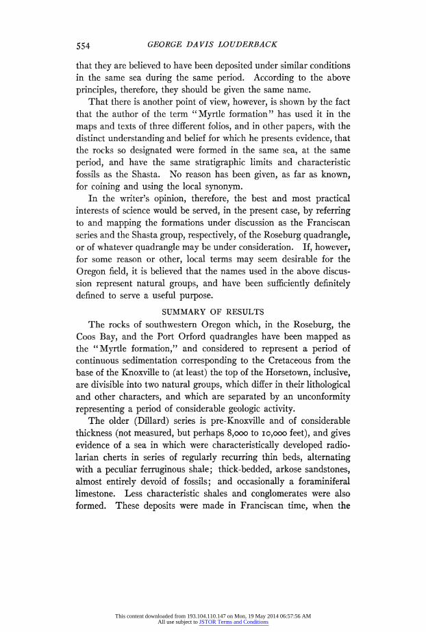
GEORGE DA VIS LOUDERBACK
that they are believed to have been deposited under similar conditions in the same sea during the same period. According to the above principles, therefore, they should be given the same name.
That there is another point of view, however, is shown by the fact that the author of the term "Myrtle formation" has used it in the maps and texts of three different folios, and in other papers, with the distinct understanding and belief for which he presents evidence, that the rocks so designated were formed in the same sea, at the same period, and have the same stratigraphic limits and characteristic fossils as the Shasta. No reason has been given, as far as known, for coining and using the local synonym.
In the writer's opinion, therefore, the best and most practical interests of science would be served, in the present case, by referring to and mapping the formations under discussion as the Franciscan series and the Shasta group, respectively, of the Roseburg quadrangle, or of whatever quadrangle may be under consideration. If, however, for some reason or other, local terms may seem desirable for the Oregon field, it is believed that the names used in the above discus- sion represent natural groups, and have been sufficiently definitely defined to serve a useful purpose.
SUMMARY OF RESULTS
The rocks of southwestern Oregon which, in the Roseburg, the Coos Bay, and the Port Orford quadrangles have been mapped as the "Myrtle formation," and considered to represent a period of continuous sedimentation corresponding to the Cretaceous from the base of the Knoxville to (at least) the top of the Horsetown, inclusive, are divisible into two natural groups, which differ in their lithological and other characters, and which are separated by an unconformity representing a period of considerable geologic activity.
The older (Dillard) series is pre-Knoxville and of considerable thickness (not measured, but perhaps 8,000 to o10,ooo feet), and gives evidence of a sea in which were characteristically developed radio- larian cherts in series of regularly recurring thin beds, alternating with a peculiar ferruginous shale; thick-bedded, arkose sandstones, almost entirely devoid of fossils; and occasionally a foraminiferal limestone. Less characteristic shales and conglomerates were also formed. These deposits were made in Franciscan time, when the
554
This content downloaded from 193.104.110.147 on Mon, 19 May 2014 06:57:56 AMAll use subject to JSTOR Terms and Conditions

MESOZOIC OF SOUTHWESTERN OREGON
Coast Range region of California was largely under water, at least so far south as about latitude 34°0 30' N. This sea invaded the
Oregon coast at least as far north as latitude 430 15' N. Following the deposition of these beds-perhaps in part during
it-at least three series of igneous rocks were intruded at separate intervals; a basic series (basalts, diabases, etc.); an ultrabasic series (serpentines, pyroxenites, gabbros); and an acid sodic series (dacites, andesites). There is also evidence of elevation of the Franciscan sediments to dry land, dislocation, fracturing, crushing, considerable cementation and veination, and, finally, a long period of erosion, which stripped the sediments from the granular intrusives over large areas. This whole course of events, of sedimentation, vulcanism, cementation, diastrophism, and erosion, follows closely, in sequence, characters, and intensity, the history of the corresponding time throughout the California Coast Range province, and extends the recognized limits of this province almost 100 miles, making the extreme length now known about 600 miles.
Following the period of erosion came another period of dominating subsidence, and the gradually transgressing sea, which deposited chiefly fine sediments with some sand and well-washed gravels, built up the upper (Myrtle) group of rocks, which reach the thickness of about 6,000 feet near Myrtle Creek. These are more or less fos- siliferous and contemporaneous-probably continuous-with the Shasta group of California. The sea entered this Oregon region apparently as an arm elongated in an east-west direction, with its south shore against the Klamath Mountains and its north shore about the latitude of Roseburg. The land to the north showed chiefly Franciscan exposures; that to the south, both Franciscan and the earlier crystalline schists, etc. With the progress of Shasta time this arm broadened, and finally united with the gulf which was advancing over northern California around the other side of the Klamath Mountains, making of this mountain group an island, which may possibly have been finally submerged.
The glaucophane and associated schists of southern Oregon were formed during the same period as the similar schists in California
(pre-Knoxville) and are associated with similar rocks of the same (Franciscan) series.
555
This content downloaded from 193.104.110.147 on Mon, 19 May 2014 06:57:56 AMAll use subject to JSTOR Terms and Conditions