Embed Size (px)
Citation preview
1 N.Valois. The Modern Landscape Architecture of the Université de Montréal Campus. 2015
© Nicole Valois, 2015
The Modern Landscape Architecture of the Université de Montréal Campus Nicole Valois The original French version of this article was published in Cahiers de géographie du Québec, Volume 56, No. 158, September 2012.
Translation by Nancy Dunton.
Introduction The landscape of the Université de Montréal campus, because of the way it is sited on the north flank of Mount Royal, is unique. The tower of the main building, situated on the mountain’s summit and surrounded by greenery, is one of the iconographic images of Montreal, imprinted on the minds of Montrealers and visitors alike. Undoubtedly because of the prestige that it evokes, the institution regularly uses this image for promotional purposes, as a way of signalling its status as one of the great research universities of Canada.1 Representing the university by promoting the main pavilion and its presence on Mount Royal does, however, push other components of the campus to the background. Buildings and landscape elements built at other times, because of their architectural quality and their ability to represent the evolution of architecture and landscape architecture in Quebec, have themselves a great deal of value (Cameron et al. 2008 and 2010). Therefore, from all the projects that have left their mark on the campus, certain ones deserve particular attention, most notably the open spaces that date from the 1960s.
There have been several publications about the architecture and the history of the campus, including Bizier (1993) and Gournay (1990), but until now no study has looked exclusively at the composition of exterior spaces - and this despite the fact that these spaces were the object of particular attention in the 1960s as the major components of the campus expansion. The reasons for this shortcoming are many. In the first place, there is very little documentation of exterior spaces in Canada apart from professional journals. This perhaps falls under the larger heading of how little we know about the profession of landscape architecture itself which contributed to the creation of these spaces. Secondly, as is the case for most large residential and institutional ensembles, it is difficult to separate the architectural elements from the open spaces of the campus that they form part of. The oldest are, moreover, the work of exclusively one designer. Nevertheless, Cameron et al. (2008 and 2010) have demonstrated that they can be looked at as se
parate entities, particularly those built in the 1960s. This view holds true when looking at the work of La Haye et associés, a renowned firm of urban planners who contributed to shaping today’s campus where the open spaces are components of the overall design, equal in
1 The tower of the Cormier building represents, according to certain authors, the freeing of the francophone intellectual community from the religious hegemony present in Quebec in that era and the desire to occupy the north flank of the mountain in direct opposition to McGill University on the southern slope (Gournay 1990).
2 N.Valois. The Modern Landscape Architecture of the Université de Montréal Campus. 2015
importance to the buildings, the roads and the wooded areas.2 The spaces surrounding the buildings of this period were, for the most part, designed independently of the buildings; consequently, their documentation lends itself readily to analysis.
This article looks at the open spaces of the modern era on the campus. By presenting the planning principles which guided their design as well as the context in which the master plan was devised (consolidation of the various disciplines, expansion of the campus and its sector, modifications to Quebec’s education system), this article will attempt to demonstrate that:
- the open spaces of the campus were part of an emerging American movement of campus planning and of urban planning and landscape architecture in Quebec;
- the open spaces are evidence of an aesthetic of the landscape architecture of open spaces of this period;
- the open spaces and the master plan were a means of inscribing the campus in its territory.
We will equally look at both the flaws and the qualities of the work that was done, most notably the importance accorded to the car and to traffic systems that created contradictions between the vision and the reality.
This article will not paint a complete portrait of this part of the campus history because it is intended to look principally at the master plan and at open spaces and not at the architecture, for example. It contends that, among the characteristic traits of the campus, the open spaces that derive from the master plan of the modern period have both historic and aesthetic value that deserve attention.3
Documentation For this article, in addition to the publications on the history of the Université de Montréal and other North American campuses, we examined the two reports by Jean-Claude La Haye dating from 1964 and 1968 which together constitute the master plan and the project to extend the campus – principally the parts dealing with open spaces.4 For a complete understanding of the two reports, we also examined the Jean-Claude La Haye archive at the Service des archives et de gestion des documents de l’UQÀM, more precisely, the part of lot 63P1 that includes the master plans for the Université de Montréal. Those parts of this collection that deal with specific projects were excluded 2 The term “open space” in this article means all exterior spaces of the Université de Montréal campus: squares, parks, wooded areas, paths, pedestrian network, spaces both for rest and for assembly, as well as the roads. This was the term used in both the 1964 and 1968 master plans for the Université de Montréal campus and by the City of Montreal administration from the middle of the 20th century until at least 1992. For more detailed information on this subject, see Landry (1992). 3 The content of this article follows on the work of Cameron, Déom and Valois compiled in two publications on the architectural and landscape values of the main campus. See Cameron et al. (2008 and 2010). It also draws from the author’s presentation as part of the conferences associated with the exhibition Modernisme menacé at the Faculté de l’aménagement in February 2011. 4 In fact, the master plan includes two reports and plans. The reasons for this are discussed later in this article.
3 N.Valois. The Modern Landscape Architecture of the Université de Montréal Campus. 2015
Modern campuses and the transformation of education in the 1960s
Throughout America as elsewhere in the western world, the post-war years were marked by major social, economic and cultural transformations that had consequences for teaching and for the planning of universities. Richard Dober, a Harvard graduate, was one of the first to establish planning principles, at exactly the same time as Université de Montréal was planning its expansion. In his book Campus Planning (Dober 1963), Dober explains the correlation between increasing population, economic growth, urban expansion and the creation of institutions and infrastructure that are the embodiment of the ideals of liberty, democracy, of better living and better habitation. The wealth of a country, according to Dober, is not measured by the number of its inhabitants, its capital and its wealth but rather by its capacity to produce and to set itself apart by its scientific advancements. As well, the technological advances of other countries pushed western countries to raise the level of learning and to relook at the system of higher education, including its accessibility which had until then been reserved for a certain élite of society.
At the beginning of the 1960s, Canada and the United States found themselves in the same situation. The university and college clientele was growing rapidly, forcing planners and those in charge of educational establishments to rethink both educational programmes and the spaces dedicated to them (Turner 1984). These needs quickly collided with the lack of space on campus, but also made very clear the lack of long term planning tools and techniques. In the United States, for example, one-third of all universities had no long term development planning. And yet, the size of their needs demands planning to ensure long term coherence between a vision, physical attributes and finances. Dober’s work (1963) demonstrates the complex conditions that planning has to work within and suggests assembling functions into modules to allow the university to adapt to changes. The physical aspect of the campus is not the only reality in planning, according to him. Planning draws from aspects as varied as financial management, the choice of vision and the role of the university with respect to society. An inventory of existing spaces and educational programmes and an analysis of both immediate and future needs are essential to proper operation. What seems very evident to us today was, however, very far from evident in this era. Then, drawings prepared for construction aimed at an architectural ideal that responded to the needs of the moment. It meant that from this point on, planning needed to think about structures that were flexible and adaptable to change, a major challenge in terms of design and of management, but feasible because of the new planning tools that were becoming available to planners.
While its demographic and ideological situation was the same as the rest of North America at the beginning of the 1960s, Quebec was living through some very particular social changes which had an impact on the universities. The fields of education, culture and health previously controlled by the Catholic Church, were now firmly in the hands of the State. The complete restructuring by the State, described as state socialism, also led to the creation of many financial institutions and to one of the most ambitious projects in Quebec, the nationalization of electricity. By taking control of one of its greatest resources, Quebec provided itself with the means to undertake the social programs which would modernize society and raise the level of education to that demanded by the scientific and technological revolution that was underway.
At the same time, the government was revising the province’s entire educational system so as to make education accessible to all. To do this - and conscious of the ever-mounting number of

4 N.Valois. The Modern Landscape Architecture of the Université de Montréal Campus. 2015
students - the province established the 1963 Royal Commission of Inquiry on Education in the Province of Quebec, which led to the Parent Report (1965-1966). Following a long consultation throughout the province, the government responded to the report’s recommendations and made education accessible to all, created new educational institutions and established the Ministry of Education. At the Université de Montréal, one of the consequences of this movement was the repatriation of programs previously administered by religious communities, most notably the cours classique and specialized schools. This was the case, for example, for the education of pre-school and primary school teachers as well as for nursing. To integrate these new programs, many new buildings were built while others were purchased from the religious communities, particularly the Pavillon Marie-Victorin, the Pavillon Marguerite d’Youville and the buildings of the Faculté de musique and the Faculté de l’aménagement.
The evolution of the use of open spaces on the Université de Montréal campus Each phase of development of the Université de Montréal campus is the result of much larger socio-economic movements that shaped its physical appearance. While each phase includes landscape, those developed in the 1960s stand out because of the progressive thinking about open spaces as well as the extent of the campus expansion at the time.
The first important landscape plans were part of the first phase of development, as the main building designed by Ernest Cormier was built on the mountain starting in 1923, distancing itself from the turbulence of the city.5
The courtyard of the main building defined by a circle of greenery, the east-west axis of car traffic, the wooden staircase linking what is now boulevard Édouard-Montpetit to the main building as well as the wooded areas were all part of the first open spaces. Aside from the natural areas, these are all spaces designed to “accompany”, either in a utilitarian way or as representation (figure 1)
Figure 1 This aerial view of the main building by Ernest Cormier shows how the symmetrical composition accentuates the main courtyard. Date of photo: July 25,1948. Source: Service de la gestion des documents et des archives, Université de Montréal, Fonds du Service des archives (D0036) 1FP1973. Photograph Surveys Limited.
The composition changes radically between 1960 and 1968 with the second phase of development when, in an effort to respond to the increase in population and the integration of
5 After an interruption, the construction of the main building was completed in 1943. The École Polytechnique building was built in 1958-1960, the Résidence A Pavilion in 1956 and the J.-A.-DeSève cultural centre in 1956, each accompanied by a landscape plan.
5 N.Valois. The Modern Landscape Architecture of the Université de Montréal Campus. 2015
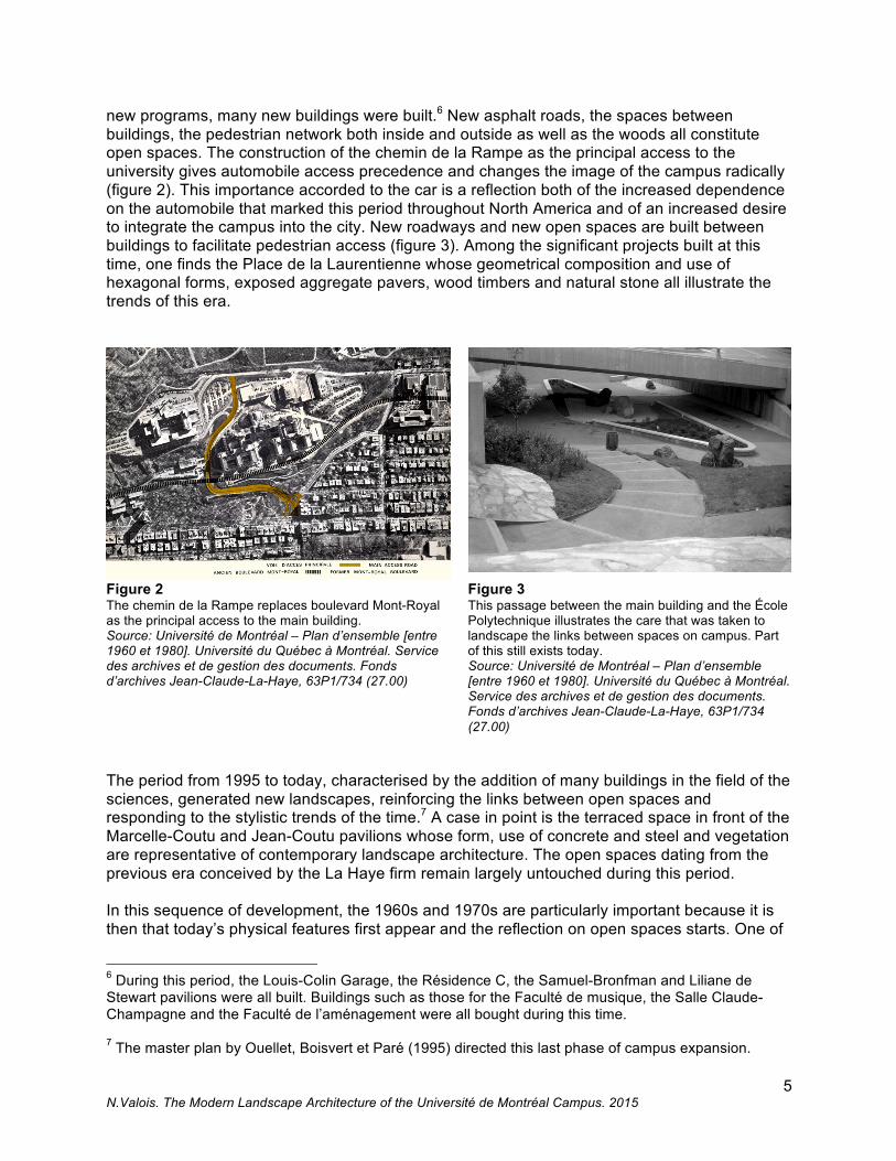
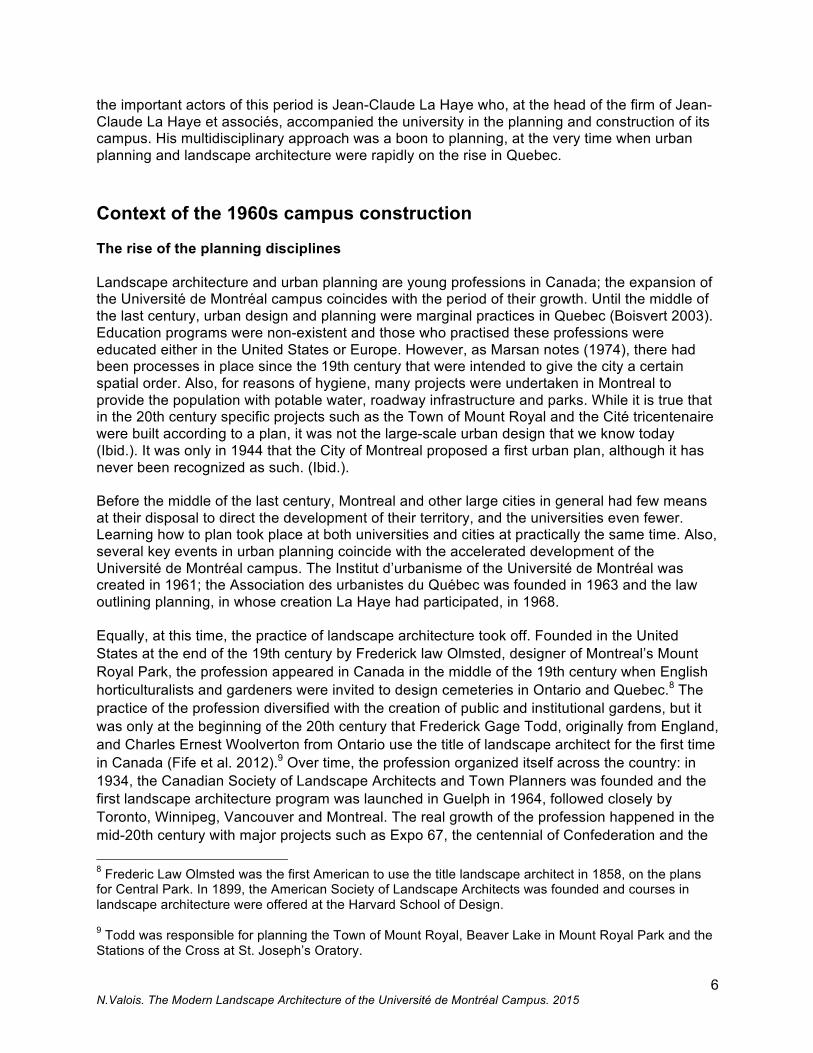
new programs, many new buildings were built.6 New asphalt roads, the spaces between buildings, the pedestrian network both inside and outside as well as the woods all constitute open spaces. The construction of the chemin de la Rampe as the principal access to the university gives automobile access precedence and changes the image of the campus radically (figure 2). This importance accorded to the car is a reflection both of the increased dependence on the automobile that marked this period throughout North America and of an increased desire to integrate the campus into the city. New roadways and new open spaces are built between buildings to facilitate pedestrian access (figure 3). Among the significant projects built at this time, one finds the Place de la Laurentienne whose geometrical composition and use of hexagonal forms, exposed aggregate pavers, wood timbers and natural stone all illustrate the trends of this era.
Figure 2 The chemin de la Rampe replaces boulevard Mont-Royal as the principal access to the main building. Source: Université de Montréal – Plan d’ensemble [entre 1960 et 1980]. Université du Québec à Montréal. Service des archives et de gestion des documents. Fonds d’archives Jean-Claude-La-Haye, 63P1/734 (27.00)
Figure 3 This passage between the main building and the École Polytechnique illustrates the care that was taken to landscape the links between spaces on campus. Part of this still exists today. Source: Université de Montréal – Plan d’ensemble [entre 1960 et 1980]. Université du Québec à Montréal. Service des archives et de gestion des documents. Fonds d’archives Jean-Claude-La-Haye, 63P1/734 (27.00)
The period from 1995 to today, characterised by the addition of many buildings in the field of the sciences, generated new landscapes, reinforcing the links between open spaces and responding to the stylistic trends of the time.7 A case in point is the terraced space in front of the Marcelle-Coutu and Jean-Coutu pavilions whose form, use of concrete and steel and vegetation are representative of contemporary landscape architecture. The open spaces dating from the previous era conceived by the La Haye firm remain largely untouched during this period. In this sequence of development, the 1960s and 1970s are particularly important because it is then that today’s physical features first appear and the reflection on open spaces starts. One of
6 During this period, the Louis-Colin Garage, the Résidence C, the Samuel-Bronfman and Liliane de Stewart pavilions were all built. Buildings such as those for the Faculté de musique, the Salle Claude-Champagne and the Faculté de l’aménagement were all bought during this time. 7 The master plan by Ouellet, Boisvert et Paré (1995) directed this last phase of campus expansion.
6 N.Valois. The Modern Landscape Architecture of the Université de Montréal Campus. 2015
the important actors of this period is Jean-Claude La Haye who, at the head of the firm of Jean-Claude La Haye et associés, accompanied the university in the planning and construction of its campus. His multidisciplinary approach was a boon to planning, at the very time when urban planning and landscape architecture were rapidly on the rise in Quebec. Context of the 1960s campus construction The rise of the planning disciplines Landscape architecture and urban planning are young professions in Canada; the expansion of the Université de Montréal campus coincides with the period of their growth. Until the middle of the last century, urban design and planning were marginal practices in Quebec (Boisvert 2003). Education programs were non-existent and those who practised these professions were educated either in the United States or Europe. However, as Marsan notes (1974), there had been processes in place since the 19th century that were intended to give the city a certain spatial order. Also, for reasons of hygiene, many projects were undertaken in Montreal to provide the population with potable water, roadway infrastructure and parks. While it is true that in the 20th century specific projects such as the Town of Mount Royal and the Cité tricentenaire were built according to a plan, it was not the large-scale urban design that we know today (Ibid.). It was only in 1944 that the City of Montreal proposed a first urban plan, although it has never been recognized as such. (Ibid.). Before the middle of the last century, Montreal and other large cities in general had few means at their disposal to direct the development of their territory, and the universities even fewer. Learning how to plan took place at both universities and cities at practically the same time. Also, several key events in urban planning coincide with the accelerated development of the Université de Montréal campus. The Institut d’urbanisme of the Université de Montréal was created in 1961; the Association des urbanistes du Québec was founded in 1963 and the law outlining planning, in whose creation La Haye had participated, in 1968. Equally, at this time, the practice of landscape architecture took off. Founded in the United States at the end of the 19th century by Frederick law Olmsted, designer of Montreal’s Mount Royal Park, the profession appeared in Canada in the middle of the 19th century when English horticulturalists and gardeners were invited to design cemeteries in Ontario and Quebec.8 The practice of the profession diversified with the creation of public and institutional gardens, but it was only at the beginning of the 20th century that Frederick Gage Todd, originally from England, and Charles Ernest Woolverton from Ontario use the title of landscape architect for the first time in Canada (Fife et al. 2012).9 Over time, the profession organized itself across the country: in 1934, the Canadian Society of Landscape Architects and Town Planners was founded and the first landscape architecture program was launched in Guelph in 1964, followed closely by Toronto, Winnipeg, Vancouver and Montreal. The real growth of the profession happened in the mid-20th century with major projects such as Expo 67, the centennial of Confederation and the 8 Frederic Law Olmsted was the first American to use the title landscape architect in 1858, on the plans for Central Park. In 1899, the American Society of Landscape Architects was founded and courses in landscape architecture were offered at the Harvard School of Design. 9 Todd was responsible for planning the Town of Mount Royal, Beaver Lake in Mount Royal Park and the Stations of the Cross at St. Joseph’s Oratory.
7 N.Valois. The Modern Landscape Architecture of the Université de Montréal Campus. 2015
construction of the St. Lawrence Seaway (Paine 1998). In Montreal, the landscape architecture program created in 1968 became autonomous in 1978 as the École d’architecture de paysage of the Faculté de l’aménagement. The Institut d’urbanisme having been already integrated into the faculty, one could reasonably assume that links were made between the two professions at the time of the campus expansion, a project that called on the expertise of many disciplines.
Urban planning at the City of Montreal
The idea of creating a system of open spaces at the Université de Montréal was preceded by a plan conceived some twenty years earlier by the City of Montreal as part of the first master plan for the city. This plan demonstrates that urban planning and landscape architecture – while still both relatively young professions – were interrelated from the end of the Second World War onwards.
Having created the City Planning Department in 1941, the City of Montreal issued its Plan Directeur de Montréal : urbanisation de Montréal. The importance accorded in this plan to open spaces as a means of linking significant places and of creating a better environment to live in is one of its most striking features. There is a drawing on the plan that shows a continuous green network linking green spaces, the riverbanks, the Miron quarry, Mount Royal and greenbelts as sites of future housing projects. Rue Rachel is shown as an important green link, uniting Parc Maisonneuve with Mount Royal. This green link is explained as a reflection of social life and the importance of closely linking open spaces, public buildings, parks and schools (City of Montreal 1944).
The importance accorded to green spaces is also evident in the Plan Directeur de Montréal : espaces libres, published in 1955 by the City Planning Department of the City of Montreal. This document analysed needs based on both territorial and population growth and recommended an equitable sharing of playgrounds, sports fields and other community spaces. During this period, more precisely in 1953, the City of Montreal hired André Lafontaine, the first landscape architect to work for the City. (Cormier 1990).
Urban planning and landscape architecture in the post-war years were presented by the City of Montreal as being inextricably linked. The 1944 plan advanced the idea later put forward by La Haye et associés to create a system of open spaces linked one to another and endorsed to a certain extent the firm’s approach to planning the campus, aimed at creating both informal meeting places and greenery for the benefit of campus users.
Jean-Claude La Haye
Among the very few urban planners active in this period, Jean-Claude La Haye, the head of the firm La Haye et associés and designer of the campus, stands out as a leader. Through his work and his teaching, his practice was based on a vision of the easing of the barriers between urban planning, architecture and landscape architecture. Born in 1923 in Kapuskasing in northern Ontario and educated in City Planning at Harvard University, Jean-Claude La Haye started his career in the Ministère des affaires municipales where his job was to work on the first amendments to the Lois sur les cites et villes (Tellier-Cohen 2003). He was among those responsible for the creation of the Institut d’urbanisme de l’Université de Montréal, where he taught for three years, and of the Corporation professionnelle des urbanistes du Québec, where he was founding president and held office until 1968 (Tellier-Cohen 2003). Author of many master plans, he had a long career punctuated by numerous contributions to the government as
8 N.Valois. The Modern Landscape Architecture of the Université de Montréal Campus. 2015
a consultant. He was head of the planning committee charged with commenting on the plan for Quebec City’s Parliament Hill, vice-president and president par interim of the Commission de la capitale nationale and president of the Commission des biens culturels from 1978 to 1980. One of his most important contributions was his involvement in the Commission provincial d’urbanisme, better known as the Commission La Haye, of which he was president in 1963 (La Haye1968b). The proposal to provide the government with a policy on urban development that would allow it to legislate on this development generated a series of laws, until the creation of the Loi sur l’aménagement et l’urbanisme in 1979.
The professional achievements of the firms he created were many. In addition to the campus of the Université de Montréal, these firms were responsible for the plan for the enhancement of the Mirabel region, as well as the master plan for Saint-Foy and its downtown. Jean-Claude La Haye’s perspective on urban design can be summed up by the following quote from an interview: “I think that we have to succeed in satisfying all of a man’s needs in life inside a neighbourhood, that microcosm of society at large” (Tellier-Cohen 2003,10). He founded the first multidisciplinary office about 1965 just as the first report and plans for the Université de Montréal had been submitted.
The 1960s expansion of the campus and the master plan The transformation of the education system, the rise of the planning disciplines including urban design as a means of controlling development in Quebec, both coincided with the major period of growth of Université de Montréal at the beginning of the 1960s. A favourable economy and unprecedented demographic growth fostered the spatial expansion necessary to welcome new programs and students. Between 1955 and 1965, the workforce tripled, operating budgets increased by a factor of six and research budgets by a factor of ten (Archives UQAM-1). Faculties were created and departments multiplied. To respond to the demand for higher education, those in charge felt the need for guidance in spatial development and looked for a plan that would be flexible and that would adapt to future needs. The Université de Montréal, in line with other major American and Canadian universities affected by the same phenomena, called for a master plan.
Jean-Claude La Haye, having learned of the project, offered his services to the university in a letter addressed to the rector, Mgr. Irené Lussier. He asserted his experience and his multi-disciplinary approach, citing the members of his team composed of the architects Jean Ouellet and Victor Lambert, the landscape architect Douglas Harper and the surveyor Raymond Archambault (Archives UQAM-2). An expansion project, he wrote, presupposed the establishment of a plan d’ensemble. He pointed out his experience, referring to the project for the Université de Sherbrooke campus that he was then working on. Several months later, he was awarded the contract and at the beginning of 1961, the program of work was sketched out. The plans were deposited at the Université de Montréal at the end of 1963, followed in March 1964 by the Rapport d’accompagnement du plan général d’aménagement de l’Université de Montréal (La Haye 1964). Several months later, Gilles Gratton, engineer and director of the buildings and grounds service for Université de Montréal, announced the work to be carried out. Amongst the projects were the construction of a building for the maintenance service, a building for classrooms, student residences, the Winter Stadium, access roads, the access ramp as well as connections to public utilities. Effectively, it had taken less than four years to plan the
9 N.Valois. The Modern Landscape Architecture of the Université de Montréal Campus. 2015
development of the campus of the modern era, one of the most significant in the university’s history.
Following the deposit of these plans and of the report, and after a first phase of construction, a second plan was drawn up in 1968. The existence of this second plan, presented in a report entitled Université de Montréal : le deuxième plan directeur, may seem strange as the plan actually re-presents some part of the content of the first and construction of much of it was well advanced in 1968. In fact, it is the result of criticism by the City of certain imprecisions in the first plan.10 The university, it said, “would commit formally to respecting it” and, moreover, it would have “the force of regulation, conforming to the new clauses of the Charter of Montreal” (Archives UQAM-3).11 In response to these comments, the second master plan was drawn up, both more extensive and more detailed. The number of drawings tripled and the analysis was more developed, particularly with respect to the availability of land and its capacity to absorb. The awareness of the urban context was strongly expressed by the intention to have a campus at an “urban scale” with an “aesthetic unity”, and to conserve the qualities of the mountain.
More specifically, the report went deeper into the principles concerning open spaces, circulation, parking and a unified architectural aesthetic by re-evaluating needs and by drawing more precise plans of the land available. As well, the idea of a “spine” along which all the functions are connected became a vision of development that could adjust according to need. The open spaces would play an important role and the pedestrian network would become in this way a major component, similar to circulation and the underground network for which the Comité consultative d’architecture for the university had formally requested a study.12
The master plan’s vision of open spaces The specific vision of open spaces was very explicit in the 1964 report – an entire chapter was devoted to it – but the same content appears again in the 1968 report.13 Entitled Organisation des espaces libres, the chapter defined the basic concepts and showed how the open spaces would provide the means to unify the campus and integrate it to the city.
10 In fact, the Service d’urbanisme’s report dated February 1967 describes the plan as imprecise - “without a programme” - and that it is difficult to form an opinion on it. (Archives UQAM-3). It focuses on the initial proposals made by the City and certain flaws in the La Haye plan, most notably the lack of links between the campus and the neighbourhood. Indeed, this last aspect constitutes “a new conclusion” in the 1964 report whereas the 1968 report proposes that the “campus expansion” be integrated into the city. 11 The modification to article 612 of the Charter of the City of Montreal in 1965 stipulated that, to obtain a permit to construct a major project, the owner had to submit a plan d’ensemble to the Service d’urbanisme. This, according to many sources, is the foreunner of the Programme particulier d’urbanisme that we know today. 12 In effect, it asked that “the possibility of a covered or interior circulation network between buildings or groups of buildings” be studied. 13 The content of the chapter on open spaces in the 1964 report is spread over different chapters in the 1968 report. Note that the expression “open spaces” refers to the “student space and pedestrian network” on the drawing.

10 N.Valois. The Modern Landscape Architecture of the Université de Montréal Campus. 2015
The intent was that the new campus distinguish itself from the original one by Cormier; the extent of the need for space and for infrastructure would make this possible. The general vision expressed is best summed up as a desire to create a more urban campus which would enhance the natural features of the site using an internal system that would include open spaces. This system would allow for distribution of programs and equipment along a pedestrian and automobile network fitted out with open spaces and linked to the city. The connection to the city would appear both literally and figuratively, linking the chemin de la Rampe and the chemin de la Polytechnique to city streets and opening access to the campus to neighbouring communities.
A unified system of spaces
La Haye and his team believed in the social and functional virtues of open spaces. Great importance was attached to the network made up of these and to their integration into the internal pedestrian and automobile network, in one unified system. On the other hand, these open spaces were presented as punctuation in the system, stops and transitions between buildings and meeting places that distribute and link the different functions.
Open spaces are not the residual elements from development; they have a positive value and functions to fulfill: extending the natural character of the mountain, transition with the urban surroundings, places to walk and to relax, sports grounds, meeting places. (La Haye 1968a, 17)
To create a network at the heart of the campus that would facilitate meetings and exchanges, “(…) distribute functions around a hub of activity which would force encounters and exchanges of ideas”, that is the aspiration (Ibid., 5).
The functions of open spaces
In the report, the importance accorded to the idea of function is notable for the vocabulary used to describe open spaces. The terms “transition”, “meeting place”, “gathering places” designate spaces very precisely. As well, transition areas include the park space around the actual metro entry; meeting and resting places are on the periphery of streets while gathering places include spaces around buildings and traffic lanes. Some spaces serve several functions:
The exterior space of a building has a function that is complementary to that of the interior space. It adds a positive value by providing circulation, welcome, meeting and waiting spaces or for integration of nature. (La Haye 1968a, 42)
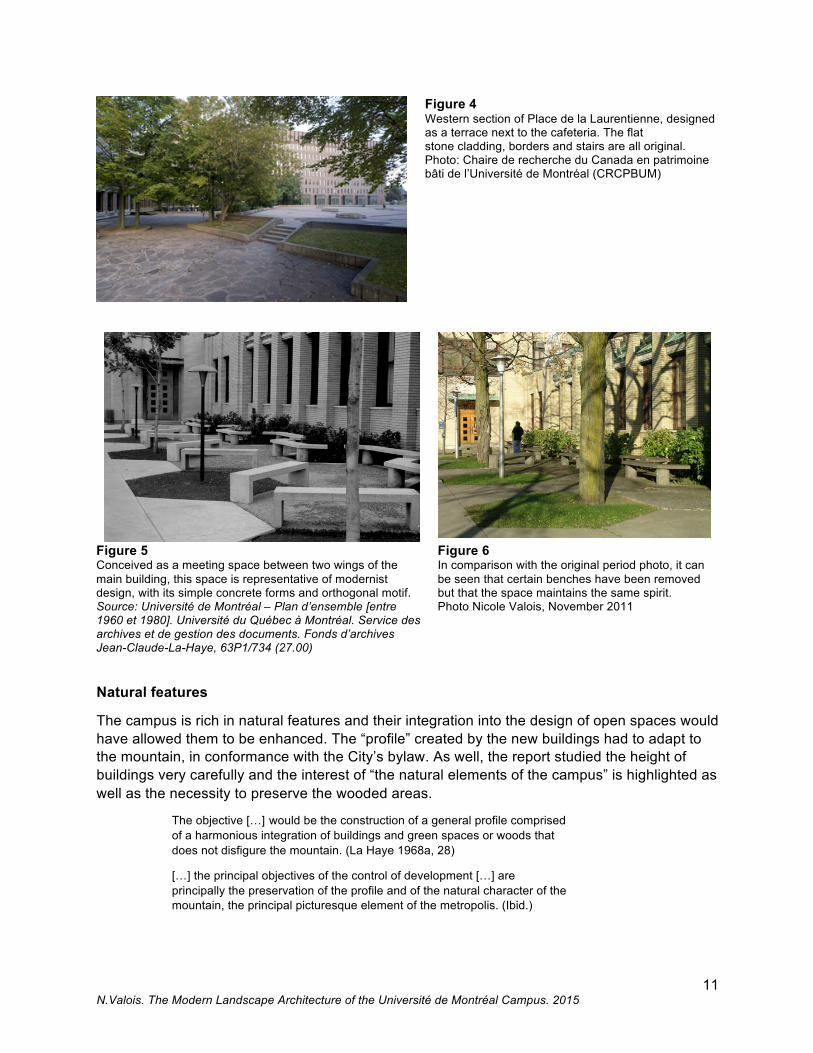
Place de la Laurentienne, the roof of the Louis-Colin garage, the courtyard of the main building by Cormier as well as the areas enclosed by the wings of the building all embody this principle of multi-functionalism. These are spaces for meeting, circulation and encounter, clearly identified as such from the beginning and continuing to fill that role today (figure 4). Varying the positions of the benches in front of the Roger-Gaudry pavilion wings, for example, encourages meetings of small groups of people in an area heavily used by those making use of the nearby moving ramp (figures 5 and 6).
11 N.Valois. The Modern Landscape Architecture of the Université de Montréal Campus. 2015
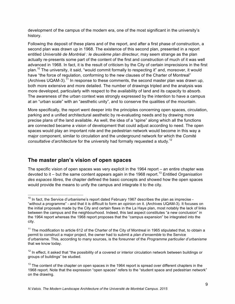
Figure 4 Western section of Place de la Laurentienne, designed as a terrace next to the cafeteria. The flat stone cladding, borders and stairs are all original. Photo: Chaire de recherche du Canada en patrimoine bâti de l’Université de Montréal (CRCPBUM)
Figure 5 Conceived as a meeting space between two wings of the main building, this space is representative of modernist design, with its simple concrete forms and orthogonal motif. Source: Université de Montréal – Plan d’ensemble [entre 1960 et 1980]. Université du Québec à Montréal. Service des archives et de gestion des documents. Fonds d’archives Jean-Claude-La-Haye, 63P1/734 (27.00)
Figure 6 In comparison with the original period photo, it can be seen that certain benches have been removed but that the space maintains the same spirit. Photo Nicole Valois, November 2011
Natural features
The campus is rich in natural features and their integration into the design of open spaces would have allowed them to be enhanced. The “profile” created by the new buildings had to adapt to the mountain, in conformance with the City’s bylaw. As well, the report studied the height of buildings very carefully and the interest of “the natural elements of the campus” is highlighted as well as the necessity to preserve the wooded areas.
The objective […] would be the construction of a general profile comprised of a harmonious integration of buildings and green spaces or woods that does not disfigure the mountain. (La Haye 1968a, 28)
[…] the principal objectives of the control of development […] are principally the preservation of the profile and of the natural character of the mountain, the principal picturesque element of the metropolis. (Ibid.)
12 N.Valois. The Modern Landscape Architecture of the Université de Montréal Campus. 2015
The preservation of the undergrowth by the planning of paths was part of the plan in the sense that “its enhancement and its regeneration are considerations which demand particular attention in the creation of the campus.” (La Haye 1964, 30). We will see elsewhere in this article that many of the paths through the wooded areas are still functioning, notably those that are below the main pavilion. The inventory of wooded areas on the illustration entitled Les espaces verts naturels et aménagés showing the dominant species (oak, maple, ash and locust), their general state and size attests to the interest in natural elements.
The role of vegetation in planning
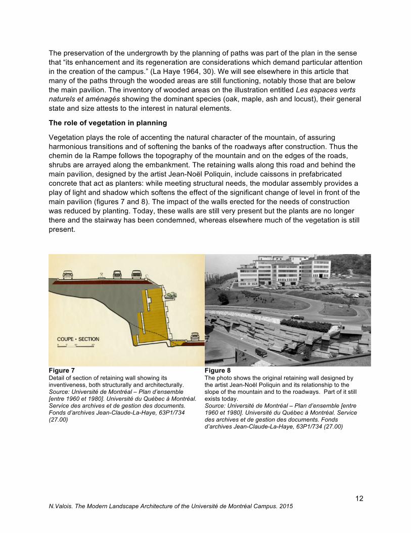
Vegetation plays the role of accenting the natural character of the mountain, of assuring harmonious transitions and of softening the banks of the roadways after construction. Thus the chemin de la Rampe follows the topography of the mountain and on the edges of the roads, shrubs are arrayed along the embankment. The retaining walls along this road and behind the main pavilion, designed by the artist Jean-Noël Poliquin, include caissons in prefabricated concrete that act as planters: while meeting structural needs, the modular assembly provides a play of light and shadow which softens the effect of the significant change of level in front of the main pavilion (figures 7 and 8). The impact of the walls erected for the needs of construction was reduced by planting. Today, these walls are still very present but the plants are no longer there and the stairway has been condemned, whereas elsewhere much of the vegetation is still present.
Figure 7 Detail of section of retaining wall showing its inventiveness, both structurally and architecturally. Source: Université de Montréal – Plan d’ensemble [entre 1960 et 1980]. Université du Québec à Montréal. Service des archives et de gestion des documents. Fonds d’archives Jean-Claude-La-Haye, 63P1/734 (27.00)
Figure 8 The photo shows the original retaining wall designed by the artist Jean-Noël Poliquin and its relationship to the slope of the mountain and to the roadways. Part of it still exists today. Source: Université de Montréal – Plan d’ensemble [entre 1960 et 1980]. Université du Québec à Montréal. Service des archives et de gestion des documents. Fonds d’archives Jean-Claude-La-Haye, 63P1/734 (27.00)
13 N.Valois. The Modern Landscape Architecture of the Université de Montréal Campus. 2015
The integration of the campus into the city
Throughout its history, the relationship between the campus and the city around it is tied to the development of the sector, but it is difficult at this stage of our research to determine which drove which. However, it is clear that at the beginning the university wanted a campus that was calm, far from the hustle and bustle of the city, and that the 1960s plans were intended to respond to the City’s desire to have a campus that was more integrated into the city. The choice of site, as we have seen, was a direct consequence of the administration’s desire to remove the campus from the city. The north flank of the mountain not having been much developed, and Côte-des-Neiges not having been much touched by Montreal’s development were therefore factors in choosing a site that would give the campus a rural character. Following the first stage of development, in the mid-1950s, the sector started to transform. The campus participated in this change with its expansion project and became an urban campus regardless of the fact that access and roadways were on the university’s property. Construction of residential towers and reconfiguration of the intersection of chemin Côte-des-Neiges and rue Queen Mary at the beginning of the 1960s, as well as the purchase of the adjoining streets by the university to build the social sciences pavilions meant the complete disappearance of the former village core and a major modification to the city’s fabric at the university’s perimeter (Garcia and Garcia 2006). La Haye recognized that, by building what he intended, the Cormier campus would start to transform at the same rate as the densification of the adjoining neighbourhood: “[it is] today at the geographic centre of metropolitan development” (La Haye 1968a, 24). The urban planner went so far as to suggest zoning changes for boulevard Édouard-Montpetit that would permit the operation of stores to serve the university community, a suggestion that was never carried out.14 The centrality of the campus, one can then reasonably deduce, is certainly because of its geographic position within the city. However, it also makes sense when looking at the development all around as well as the university’s own expansion. In a certain way, this quote on the centrality of the university presumes that the campus already was part of a spatial and social urban dynamic. The variety and accessibility of the spaces bordering boulevard Édouard-Montpetit, the access roads connected to the city’s network and the enhancement of the natural character of the mountain all make the argument that the integration of the campus into the city is, in fact, a reality. A very particular attention has been paid to the siting of buildings and green spaces so that they contribute to the ambience of the neighbourhood and align with the profile of the mountain. The siting of cultural and sports functions along boulevard Édouard-Montpetit is part of this intention as they attract the people who live close by. However, this integration has not, according to some, been a complete success in the sense that the university has not seized the opportunities that have presented themselves since its expansion. For these people, the campus remains closed on itself.15
While, for some, the campus is not completely integrated into the city, its modern urban character is very present in the design of its open spaces, including its internal road network.
14 Jean-Claude Marsan reiterates this in his proposal to densify the campus in many articles, notably the one published in Forum (Marsan 2009). 15 On this subject see the article by Jacques Trudel (2011) in which he points out the autonomy of the university in terms of development, a fact which has prevented true integration of the campus into the city. It should be noted that the author participated in discussions between the City and the university in the 1960s, when he was an urban planner working in the Service d’urbanisme of the City of Montreal.
14 N.Valois. The Modern Landscape Architecture of the Université de Montréal Campus. 2015
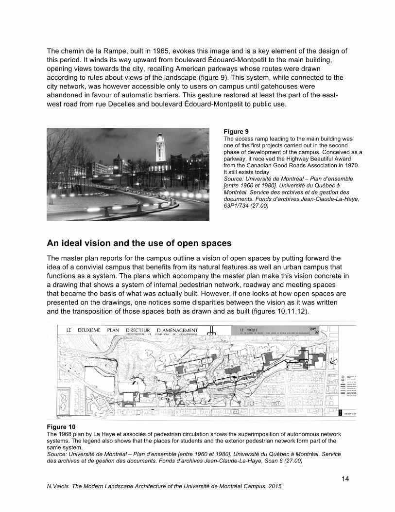
The chemin de la Rampe, built in 1965, evokes this image and is a key element of the design of this period. It winds its way upward from boulevard Édouard-Montpetit to the main building, opening views towards the city, recalling American parkways whose routes were drawn according to rules about views of the landscape (figure 9). This system, while connected to the city network, was however accessible only to users on campus until gatehouses were abandoned in favour of automatic barriers. This gesture restored at least the part of the east-west road from rue Decelles and boulevard Édouard-Montpetit to public use.
Figure 9 The access ramp leading to the main building was one of the first projects carried out in the second phase of development of the campus. Conceived as a parkway, it received the Highway Beautiful Award from the Canadian Good Roads Association in 1970. It still exists today Source: Université de Montréal – Plan d’ensemble [entre 1960 et 1980]. Université du Québec à Montréal. Service des archives et de gestion des documents. Fonds d’archives Jean-Claude-La-Haye, 63P1/734 (27.00)
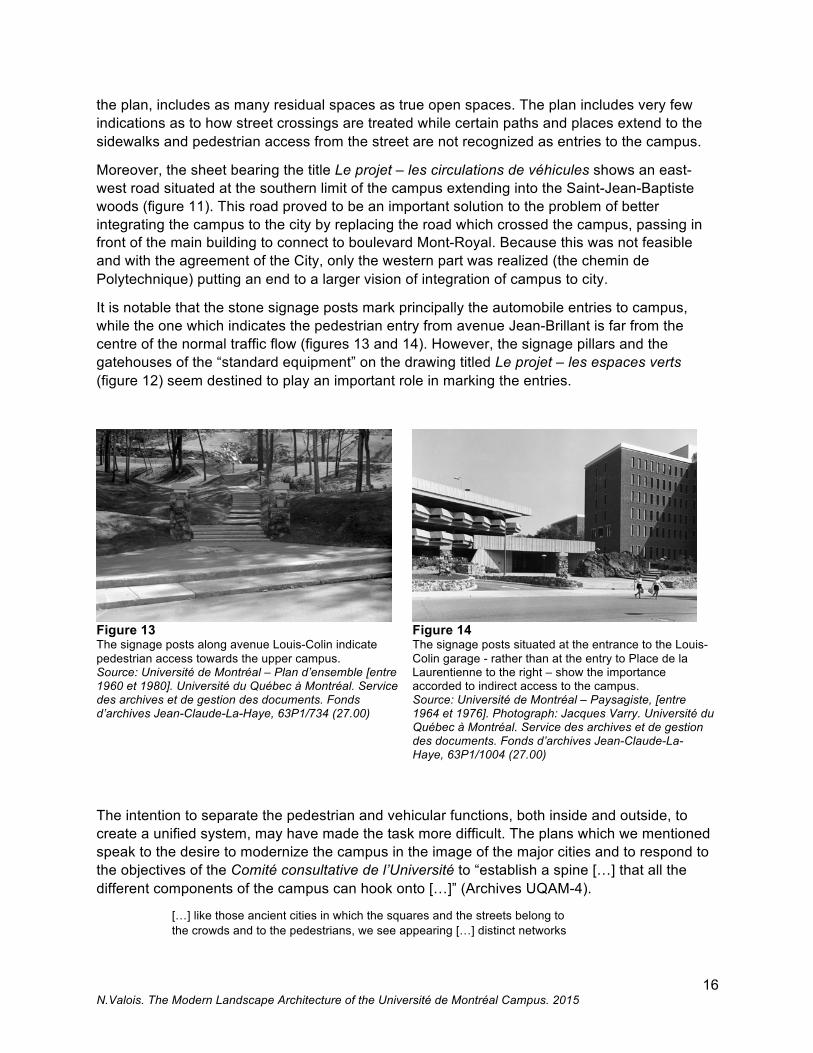
An ideal vision and the use of open spaces The master plan reports for the campus outline a vision of open spaces by putting forward the idea of a convivial campus that benefits from its natural features as well an urban campus that functions as a system. The plans which accompany the master plan make this vision concrete in a drawing that shows a system of internal pedestrian network, roadway and meeting spaces that became the basis of what was actually built. However, if one looks at how open spaces are presented on the drawings, one notices some disparities between the vision as it was written and the transposition of those spaces both as drawn and as built (figures 10,11,12).
Figure 10 The 1968 plan by La Haye et associés of pedestrian circulation shows the superimposition of autonomous network systems. The legend also shows that the places for students and the exterior pedestrian network form part of the same system. Source: Université de Montréal – Plan d’ensemble [entre 1960 et 1980]. Université du Québec à Montréal. Service des archives et de gestion des documents. Fonds d’archives Jean-Claude-La-Haye, Scan 6 (27.00)

15 N.Valois. The Modern Landscape Architecture of the Université de Montréal Campus. 2015
Figure 11 The 1968 plan by La Haye et associés of vehicular circulation shows a very studied organization of roadways for vehicle traffic. Source: Université de Montréal – Plan d’ensemble [entre 1960 et 1980]. Université du Québec à Montréal. Service des archives et de gestion des documents. Fonds d’archives Jean-Claude-La-Haye, Scan 3 (27.00)
Figure 12 The 1968 plan by La Haye et associés of green spaces shows that a large area was to be landscaped. The furniture proposed is shown here in the strip underneath the plan, allowing us to date its design. There are still many examples of this furniture to be found on the campus. Source: Université de Montréal – Plan d’ensemble [entre 1960 et 1980]. Université du Québec à Montréal. Service des archives et de gestion des documents. Fonds d’archives Jean-Claude-La-Haye, Scan 4 (27.00)
The plan titled Le projet – les circulations de piétons illustrates very well the concept of open spaces, however the accent is on a system.16 The campus access as shown is without any hierarchy via the underground network rather than from the street. In effect, according to the arrows on the plan, access to the campus is from three pavilions (HEC, Jean-Brillant and J.-A. De Sève), two garages (Louis-Colin and the Stade d’hiver) and via the moving ramp. Moreover, the system of “students’ square and exterior pedestrian network”, represented in pale grey on
16 The drawing referred to is sheet 20A/32. An earlier drawing, 20/32 was produced but on this one, access, the moving ramp,and the topography do not appear.
16 N.Valois. The Modern Landscape Architecture of the Université de Montréal Campus. 2015
the plan, includes as many residual spaces as true open spaces. The plan includes very few indications as to how street crossings are treated while certain paths and places extend to the sidewalks and pedestrian access from the street are not recognized as entries to the campus.
Moreover, the sheet bearing the title Le projet – les circulations de véhicules shows an east-west road situated at the southern limit of the campus extending into the Saint-Jean-Baptiste woods (figure 11). This road proved to be an important solution to the problem of better integrating the campus to the city by replacing the road which crossed the campus, passing in front of the main building to connect to boulevard Mont-Royal. Because this was not feasible and with the agreement of the City, only the western part was realized (the chemin de Polytechnique) putting an end to a larger vision of integration of campus to city.
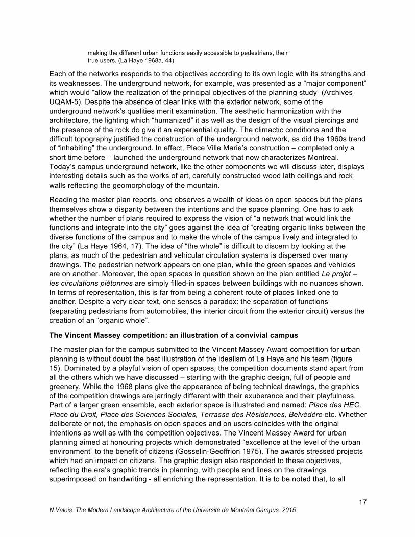
It is notable that the stone signage posts mark principally the automobile entries to campus, while the one which indicates the pedestrian entry from avenue Jean-Brillant is far from the centre of the normal traffic flow (figures 13 and 14). However, the signage pillars and the gatehouses of the “standard equipment” on the drawing titled Le projet – les espaces verts (figure 12) seem destined to play an important role in marking the entries.
Figure 13 The signage posts along avenue Louis-Colin indicate pedestrian access towards the upper campus. Source: Université de Montréal – Plan d’ensemble [entre 1960 et 1980]. Université du Québec à Montréal. Service des archives et de gestion des documents. Fonds d’archives Jean-Claude-La-Haye, 63P1/734 (27.00)
Figure 14 The signage posts situated at the entrance to the Louis-Colin garage - rather than at the entry to Place de la Laurentienne to the right – show the importance accorded to indirect access to the campus. Source: Université de Montréal – Paysagiste, [entre 1964 et 1976]. Photograph: Jacques Varry. Université du Québec à Montréal. Service des archives et de gestion des documents. Fonds d’archives Jean-Claude-La-Haye, 63P1/1004 (27.00)
The intention to separate the pedestrian and vehicular functions, both inside and outside, to create a unified system, may have made the task more difficult. The plans which we mentioned speak to the desire to modernize the campus in the image of the major cities and to respond to the objectives of the Comité consultative de l’Université to “establish a spine […] that all the different components of the campus can hook onto […]” (Archives UQAM-4).
[…] like those ancient cities in which the squares and the streets belong to the crowds and to the pedestrians, we see appearing […] distinct networks
17 N.Valois. The Modern Landscape Architecture of the Université de Montréal Campus. 2015
making the different urban functions easily accessible to pedestrians, their true users. (La Haye 1968a, 44)
Each of the networks responds to the objectives according to its own logic with its strengths and its weaknesses. The underground network, for example, was presented as a “major component” which would “allow the realization of the principal objectives of the planning study” (Archives UQAM-5). Despite the absence of clear links with the exterior network, some of the underground network’s qualities merit examination. The aesthetic harmonization with the architecture, the lighting which “humanized” it as well as the design of the visual piercings and the presence of the rock do give it an experiential quality. The climactic conditions and the difficult topography justified the construction of the underground network, as did the 1960s trend of “inhabiting” the underground. In effect, Place Ville Marie’s construction – completed only a short time before – launched the underground network that now characterizes Montreal. Today’s campus underground network, like the other components we will discuss later, displays interesting details such as the works of art, carefully constructed wood lath ceilings and rock walls reflecting the geomorphology of the mountain.
Reading the master plan reports, one observes a wealth of ideas on open spaces but the plans themselves show a disparity between the intentions and the space planning. One has to ask whether the number of plans required to express the vision of “a network that would link the functions and integrate into the city” goes against the idea of “creating organic links between the diverse functions of the campus and to make the whole of the campus lively and integrated to the city” (La Haye 1964, 17). The idea of “the whole” is difficult to discern by looking at the plans, as much of the pedestrian and vehicular circulation systems is dispersed over many drawings. The pedestrian network appears on one plan, while the green spaces and vehicles are on another. Moreover, the open spaces in question shown on the plan entitled Le projet – les circulations piétonnes are simply filled-in spaces between buildings with no nuances shown. In terms of representation, this is far from being a coherent route of places linked one to another. Despite a very clear text, one senses a paradox: the separation of functions (separating pedestrians from automobiles, the interior circuit from the exterior circuit) versus the creation of an “organic whole”.
The Vincent Massey competition: an illustration of a convivial campus
The master plan for the campus submitted to the Vincent Massey Award competition for urban planning is without doubt the best illustration of the idealism of La Haye and his team (figure 15). Dominated by a playful vision of open spaces, the competition documents stand apart from all the others which we have discussed – starting with the graphic design, full of people and greenery. While the 1968 plans give the appearance of being technical drawings, the graphics of the competition drawings are jarringly different with their exuberance and their playfulness. Part of a larger green ensemble, each exterior space is illustrated and named: Place des HEC, Place du Droit, Place des Sciences Sociales, Terrasse des Résidences, Belvédère etc. Whether deliberate or not, the emphasis on open spaces and on users coincides with the original intentions as well as with the competition objectives. The Vincent Massey Award for urban planning aimed at honouring projects which demonstrated “excellence at the level of the urban environment” to the benefit of citizens (Gosselin-Geoffrion 1975). The awards stressed projects which had an impact on citizens. The graphic design also responded to these objectives, reflecting the era’s graphic trends in planning, with people and lines on the drawings superimposed on handwriting - all enriching the representation. It is to be noted that, to all

18 N.Valois. The Modern Landscape Architecture of the Université de Montréal Campus. 2015
appearances, the Vincent Massey Award for urban design was only awarded twice, once in 1971 and again in 1975.17 The master plan for the campus did not win the award but the competition submission is significant because it demonstrates a form of idealisation of the campus that was perhaps retained by the designers. One could speculate that this competition, set outside of contractual constraints, allowed the designers to put forward an ideal of the Université de Montréal campus in a period when great social importance was attached to the user in public space.
Figure 15 On this site plan, one can see the names given to public spaces. Source: Université de Montréal – Plan d’accompagnement de la candidature de Jean-Claude La Haye et Associés pour l’attribution du prix Vincent-Massey pour l’aménagement urbain [entre 1963 et 1971]. Université du Québec à Montréal. Service des archives et de gestion des documents. Fonds d’archives Jean-Claude-La-Haye, 63P1/742 (27.00)
The current state of the spaces
The implication of La Haye et associés in the expansion of the campus went beyond planning as the firm would go on to design a number of the open spaces – many still in use today – and was involved in the work as a whole. The result is an aesthetic and urban unity, certain characteristics of which (textured concrete, for example) appear elsewhere in the city. La Haye wanted to control many aspects of the work: “the [proposed] site plans would not create insoluble problems for the architects who would eventually be given the task of drawing up the architectural plans” (Archives UQAM-6). The acceptance of recommendations for construction was assured by a committee, the Comité consultative d’architecture de l’Université de Montréal, of which Jean-Claude La Haye was a member. The exterior work was overseen by his firm as a series of independent mandates which allowed him to carry out his vision.18
17 Amongst the projects recognized in 1975 were the Jardins Prince-Arthur in Montreal, the Promenade des Gouverneurs in Quebec and Campbell Square in Scarborough. 18 The firm was effectively responsible for most of the work carried out at this period. The site plans for open spaces which were consulted for this article are in the archives of the Direction des immeubles de l’Université de Montréal.

19 N.Valois. The Modern Landscape Architecture of the Université de Montréal Campus. 2015
Amongst many different projects, it is worth emphasizing the roof and areas surrounding the Louis-Colin garage, the social sciences buildings, the sports pavilion, the residences and Place de la Laurentienne. He collaborated with the engineering firms responsible for the roadways, the lighting and other aspects as well as participating in the design of the urban furniture, lighting and signage. This significant implication in every stage of the project was possible due to professional collaborations such as those with the architect Jean Ouellet, landscape architects Douglas Harper and Serge Coitoux, engineers Lorrain, Tourigny, Dubuc and Gérin-Lajoie and the firm E.R. Chagnon Ltée.19 It is a direct consequence of the convictions of Jean-Claude La Haye, for whom the planning of the ensemble of the campus preceded and accompanied architectural and landscape architecture projects on the campus.
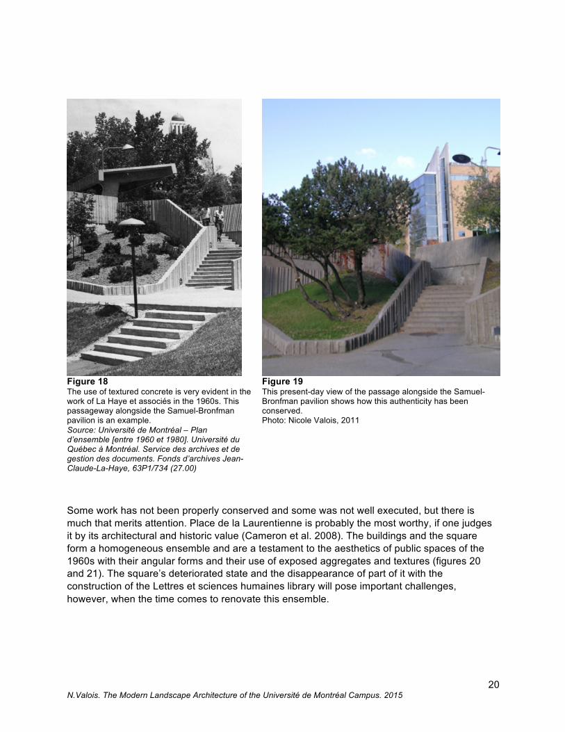
The contributions of professionals from different disciplines, however, produced a largely homogeneous aesthetic. The built forms in landscape architecture (the low walls, the concrete surfaces and the retaining walls) are all similarly assembled and textured: textured concrete, exposed aggregate concrete, raw concrete etc. As in other Montreal projects of the era, the aesthetic properties of concrete in architecture were enhanced and experimentation was very evident in exterior spaces. A list of the more remarkable uses includes the areas around the Maximilien-Caron pavilion and the space between the stadium and the Centre d’éducation physique et des sports de l’Université de Montréal (Cepsum), well conserved and recently renovated in the spirit of the original (figures 16 and 17). The use of wood and textured concrete, the use of angular forms and the articulation of the stairway on the slope – all are typical of the period. One could say the same of the low walls made up of timbers, identical to those found around the Jean-Brillant and Lionel-Groulx pavilions. In addition, the repeating motif of the hexagon appears at times in tree wells, at times in pavers in many different places such as the space in front of the Thérèse-Casgrain pavilion and Place de la Laurentienne, just as it does elsewhere in Montreal. These examples of the use of materials and forms are representative of the practice of landscape architecture of this period (figures 18 and 19).
Figure 16 The areas to the south of the Maximilien-Caron pavilion have conserved their authenticity, evident here in the concrete benches, the low walls, and the slabs of exposed aggregate concrete. Photo: Denis Farley, 2010.
Figure 17 The passage between the Cepsum and the Stade d’hiver has retained the initial spirit of La Haye et associé’s work. Photo: Denis Farley 2010.
19 Douglas Harper was one of the founders of the École d’architecture de paysage at Université de Montréal.
20 N.Valois. The Modern Landscape Architecture of the Université de Montréal Campus. 2015
Figure 18 The use of textured concrete is very evident in the work of La Haye et associés in the 1960s. This passageway alongside the Samuel-Bronfman pavilion is an example. Source: Université de Montréal – Plan d’ensemble [entre 1960 et 1980]. Université du Québec à Montréal. Service des archives et de gestion des documents. Fonds d’archives Jean-Claude-La-Haye, 63P1/734 (27.00)
Figure 19 This present-day view of the passage alongside the Samuel-Bronfman pavilion shows how this authenticity has been conserved. Photo: Nicole Valois, 2011
Some work has not been properly conserved and some was not well executed, but there is much that merits attention. Place de la Laurentienne is probably the most worthy, if one judges it by its architectural and historic value (Cameron et al. 2008). The buildings and the square form a homogeneous ensemble and are a testament to the aesthetics of public spaces of the 1960s with their angular forms and their use of exposed aggregates and textures (figures 20 and 21). The square’s deteriorated state and the disappearance of part of it with the construction of the Lettres et sciences humaines library will pose important challenges, however, when the time comes to renovate this ensemble.

21 N.Valois. The Modern Landscape Architecture of the Université de Montréal Campus. 2015
Figure 20 Place de la Laurentienne is one of the most significant works from this period. It represents well the principle of a gathering place for the university community, strongly tied to the architectural composition of the buildings around it. Source: Université de Montréal – Paysagiste [entre 1964 et 1971]. Photographie : Jacques Varry. Université du Québec à Montréal. Service des archives et de gestion des documents. Fonds d’archives Jean-Claude-La-Haye, 63P1/1008 (27.40)
Figure 21 Present-day Place de la Laurentienne whose appearance remains unchanged. Photo Nicole Valois, 2011
Among the other interesting details, it is worth considering the “standard equipment”, part of which is shown in detail on the drawing entitled Le projet - les espaces verts. The gatehouses, the lighting, the flower beds, the benches, the garbage cans, the signage posts are all part of the aesthetics of this period and part of a vison of the ensemble of the La Haye team. The attention paid to the furniture and furnishings, combined with the indications as to which spaces to develop, reflect once more the multidisciplinary approach so dear to Jean-Claude La Haye.
Unfortunately, some of the other landscaped areas of this period are in very poor condition. Problems generated by subsequent construction and material deterioration due to neglect – because much of this work is built into steeply-sloped areas subject to erosion – mean that some areas are in a critical state and for some, demolition seems inevitable. The time has come to evaluate what merits being conserved versus what merits being restored, replaced or corrected by looking at the state of the places while considering their significance as testament of a savoir-faire in planning and landscape design which was born in Quebec in the 1960s.
22 N.Valois. The Modern Landscape Architecture of the Université de Montréal Campus. 2015
Conclusion This period of time when the campus moved towards modernity and the first landscape architecture projects truly took form was an important one in the history of the campus and its neighbourhood and for the planning professions. It must be remembered that the Université de Montréal was one of the first institutions to establish itself on the north flanks of the mountain in such a definitive fashion. The tower of the main building, a reference point in the city, marked its territory. The presence of the campus affected the development of the city just as the impetus to modernize was affecting Montreal. Projects in the 1960s included roadways, paths and squares whose aesthetic features expressed this move to modernism as did the spirit of the network of open spaces, seen as a way of unifying both the physical spaces and the people who use them.
The long term planning of the campus by the La Haye firm was part of an emerging practice in planning techniques that helped create many campuses in North America. The intensity of this movement had the effect of positioning the campus as a typology in landscape architecture, part of the corpus of the history of modern architecture in North America (Treib 2003). The Université de Montréal certainly belongs to this typology as do other Canadian campuses such as Université Laval, University of Waterloo and University of Guelph.
The first landscape projects on the campus of Université de Montréal appeared at exactly the moment when landscape architecture and urban planning were establishing themselves in Quebec and when the practice of both began to be taught at the Faculté de l’aménagement. The contribution of many disciplines, requiring a planning process that pulls them all together as the case of the campus shows, is entirely within the collaborative spirit of the Faculté de l’aménagement. As an individual, La Haye was a founding member of this movement, both in teaching and in practice. The master plan for the campus which he oversaw was a planning tool which forged links between the physical components of a place so as to create a great, singular and functional space – right down to the slightest detail. That this important part of the campus was developed during this highly prolific period by a designer who was a pioneer in urban design, who was engaged in the recognition of the profession and the development of Quebec, should be emphasised.
The other side of the coin is the legacy of a campus strongly shaped by the importance of the car, typical for the period. Some of the work contradicts the vision of great ease of movement advocated by the master plans, so much so that it is difficult to walk everywhere safely. Continuous transformation and the lack of maintenance are also very real problems which the University must address in the spirit of enhancing the campus’ built heritage and maintaining the principles that define the character of the site.
A campus is often compared to a microcosm of the city, evolving at the whim of changes in society and in which the passage of time refers to stylistic and functional trends, as well as to maintenance priorities and financial means. Despite the very evident aging of the exterior work of this prosperous period of the campus (without discussing the buildings) the idea of revamping them in a context of under-funding might seem to be a low priority, particularly when a new campus will soon provide an expansion to the existing one. Nevertheless, the university will undertake major redevelopment of the area around the main building in the years to come.20
20 It would appear that this project is, as of now, at the preliminary stage, the University having launched a call for proposals to professionals for feasibility studies in spring 2012.
23 N.Valois. The Modern Landscape Architecture of the Université de Montréal Campus. 2015
The conservation of the significant elements from this period whose planned and systemic vision is a first in the University’s history, could be part of the renewal process – all the more important considering how few examples of this period exist in Montreal and how poorly documented they are. The projects that the City of Montreal is collaborating in, such as the Parc du Troisième sommet and the Chemin de ceinture, do not seem to include this consideration for the moment. However, there is room to hope that the increased public access will allow the campus to be more closely tied to the city. In summary, the projects both current and planned offer the possibility to create a true campus and to bring its image up to date, an image created at the impetus of La Haye et associés and based on a network of open spaces in the extraordinary natural context that is the mountain.
Bibliography
Archives UQAM - 1. Service des archives et de gestion des documents, fonds d'archives Jean-Claude-La-Haye, 63P1/728. "L’Université aujourd’hui et demain". Brochure produced by the Université de Montréal as part of the fiftieth anniversary campaign. Montreal, April 1967. Archives UQAM - 2. Service des archives et de gestion des documents, fonds d'archives Jean-Claude-La-Haye, 63P1/719. Letter from Jean-Claude La Haye to Monsignor Irénée Lussier. Montreal, dated January 4,1960. Archives UQAM - 3. Service des archives et de gestion des documents, fonds d'archives Jean-Claude-La-Haye, 63P1/719. Trudel, Jacques. "Service d'urbanisme, AMUR, Université de Montréal, une nouvelle analyse", Montreal, February 1967. Archives UQAM - 4. Service des archives et de gestion des documents, fonds d'archives Jean-Claude-La-Haye, 63P1/719, Dimakopoulos, Dimitri et al. "Formulation des conditions préalables à une politique d’ensemble de développement". Montreal, 1966. Archives UQAM - 5. Service des archives et de gestion des documents, fonds d'archives Jean-Claude-La-Haye, 63P1/719, Réseau piétonnier intérieur. Bound document; date and author unknown. Montreal. Archives UQAM - 6. Service des archives et de gestion des documents, fonds d'archives Jean-Claude-La-Haye, 63P1/719. Letter from Jean-Claude La Haye to André Casaubon of the Université de Montréal. Montréal, January 12,1963. Bizier, Hélène-Andrée. 1993. L'Université de Montréal : la quête du savoir. Montreal: Libre expression. Boisvert, André. 2003. "Conversations avec les pionniers et pionnières de l'urbanisme au Québec." Urbanité [2]3: 7-12. Cameron, Christina, Claudine Déom, and Nicole Valois 2008. L'étude des valeurs patrimoniales du campus principal de l'Université de Montréal. Montreal: Canada Research Chair on Built Heritage.
24 N.Valois. The Modern Landscape Architecture of the Université de Montréal Campus. 2015
Cameron, Christina, Claudine Déom, and Nicole Valois. 2010. Le patrimoine architectural et paysager de l’Université de Montréal. Montreal: Presses de l’Université de Montréal. Cormier, Lise. 1990. "Des parcs aux espaces verts." Continuité [1]: 52-55. Dober, Richard P. 1963. Campus Planning. New York: Reinhold Publishing Corporation. Fife, Ed, Pleasance Crawford, and Ina Elias. 2012. Landscape architecture. The Canadian Encyclopedia. Historica Foundation. http://www.thecanadianencyclopedia.com/articles/fr/architecture-paysagere. Garcia, Karine and Sylvain Garcia. 2006. Campus de l’Université de Montréal et secteur adjacent : Étude typo-morphologique. Montreal: Bureau du mont Royal de la Ville de Montréal. Gosselin-Geoffrion, Hélène. 1975. "Prix Vincent Massey pour l'aménagement urbain." Architecture Concept [30] 330. Gournay, Isabelle. 1990. Ernest Cormier et l’Université de Montréal. Montreal: Centre Canadien d'Architecture. Landry, Jean. 1992. "Le système des espaces libres de la ville de Montréal." in Remiggi, Frank W. and Gilles Sénécal eds. Montréal tableaux d'un espace en transition. Montréal: Association canadienne-française pour l'avancement des sciences. Les Cahiers scientifiques 76. La Haye, Jean-Claude. 1964. Rapport d'accompagnement du plan général d'aménagement de l'Université de Montréal. Montreal: Université de Montréal. La Haye, Jean-Claude. 1968a. Université de Montréal: le deuxième plan directeur d'aménagement. Montreal: Université de Montréal.
La Haye, Jean-Claude. 1968b. Rapport de la Commission provinciale d'urbanisme. Quebec: Gouvernement du Québec.
Marsan, Jean-Claude. 1974. Montréal en évolution: historique du développement de l'architecture et de l'environnement montréalais. Montreal: Fides.
Marsan, Jean-Claude. 2009. "L'avenir du campus de l'Université de Montréal." Forum [13] 2: 4-7.
Ouellet, Jean et al. 1995. Plan directeur : campus de l'Université de Montréal. Montreal: Université de Montréal.
Paine, Cecelia, ed. 1998. Fifty years of landscape architecture: the Canadian Society of Landscape Architects, 1934-1984: proceedings of the 1984 50th jubilee Congress. Guelph: University of Guelph.
Québec, Ministère de l'Éducation. 1965-1966. Rapport de la Commission royale d'enquête sur l'enseignement dans la province de Québec. Quebec: Les publications du Québec.
Tellier-Cohen, Lorraine. 2003. "Rencontre avec Jean-Claude La Haye." Urbanité [2]3: 40-43.
Treib, Marc. 2003. "Open spaces and landscapes: Some thoughts on their definition and preservation." in R. Van Oers & S. Haraguchi eds. World heritage paper 5- Identification and Documentation of Modern Heritage. Paris: UNESCO World Heritage Center [5]:135-137.
25 N.Valois. The Modern Landscape Architecture of the Université de Montréal Campus. 2015
Trudel, Jacques. 2011. "Le développement de l'Université de Montréal : un rendez-vous manqué avec l'urbanisme?" Urbanité, Hiver: 49-50.
Turner, Paul Venable. 1984. Campus: An American Planning Tradition. Cambridge: Architectural History Foundation / MIT Press.
Ville de Montréal. 1944. Plan directeur: urbanisation de Montréal. Montreal: Service d'urbanisme.
Ville de Montréal. 1955. Espaces libres: plan directeur de Montréal. Montreal: Service d'urbanisme, Division du plan directeur.