Embed Size (px)
Citation preview
T he St. Lawrence Seaway, in its broadestsense, is a deep waterway extending some3,700 km (2,340 miles) from the Atlantic
Ocean to the head of the Great Lakes, at theheart of North America. Strictly speaking, how-ever, within the meaning of the legislation whichprovided for the construction and maintenance
THE MONTREAL/LAKE ONTARIOSECTION OF THE SEAWAY
of the deep waterway, the St. Lawrence Seawayproper extends from Montreal to Lake Erie.
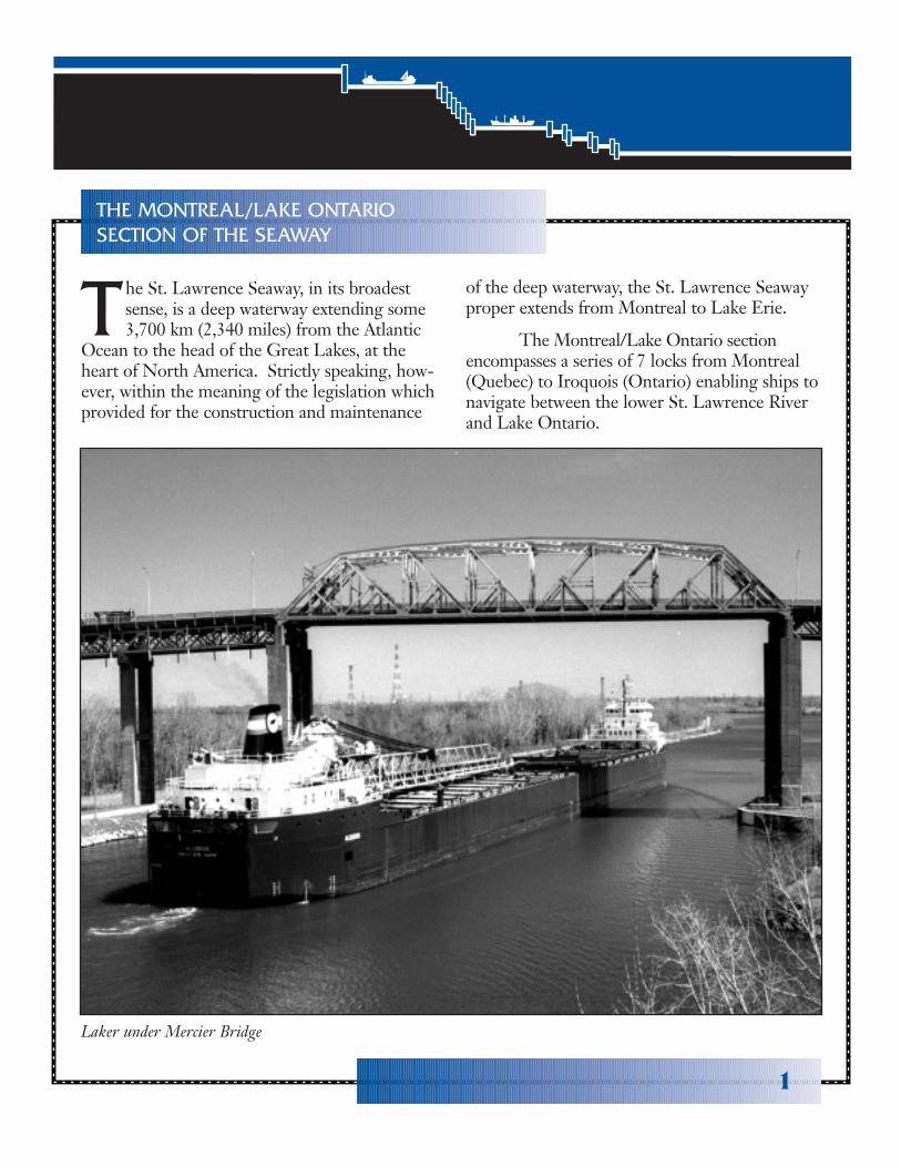
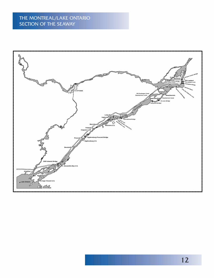
The Montreal/Lake Ontario sectionencompasses a series of 7 locks from Montreal(Quebec) to Iroquois (Ontario) enabling ships tonavigate between the lower St. Lawrence Riverand Lake Ontario.
Laker under Mercier Bridge
1
2
HISTORY
T he opening of the Seaway, in April of 1959,marked the full realization of a 400 year-olddream. In the early part of the 16th century,
Jacques Cartier, the French explorer, was turnedback by the rushing waters of the Lachine Rapids,just west of what is now Montreal, and thus deniedhis dream of finding the Northwest Passage and theroute to the East. At various times during the inter-vening 300 years, canals have been dug and locksbuilt around the natural barriers to navigation in theSt. Lawrence River. This activity was spurred on bythe desire to make use of the economical transportroute which the waters of the Great Lakes Basinoffered for the movement of goods in and out ofthis area of the continent.
The first efforts to open an inland navigationroute were pioneered by Dollier de Casson, Superiorof the Sulpician Seminary in Montreal as early as1680. Notwithstanding the opposition of his supe-riors and the apathy of local settlers engaged in theirstruggle for survival, this man of vision and tremen-dous energy finally succeeded, after twenty years, insigning a contract for the construction of a canal tolink Lake St. Louis and Montreal. At Casson'sdeath, in 1701, his 1.5 m (5 feet) deep canal was1.6 km (1 mile) long and could not be completedduring the French Regime because of lack of fundsalthough sporadic work continued until 1733. The“Casson Canal” was not completed until 1824.Thenceforth known as the Lachine Canal, it hadseven locks.
Between the years 1779 and 1783, four smallcanals were built by Royal Army Engineers on thenorth shore of the river to carry small vessels fromLake St. Louis to Lake St. Francis. These canalshad a depth of 0.76m (2 1/2 feet) and a total of fivelocks, each 1.8 m (6 feet) wide, the first ever built onthe St. Lawrence River and perhaps in NorthAmerica.
The building of the Erie Canal, in theUnited States, early in the 19th century, providedthe incentive for the construction of additional anddeeper canals and locks along the St. Lawrence.The American waterway, which offered a fast,uninterrupted link between the growing industrialheartland of North America and the Atlantic Oceanthrough New York posed a serious threat toCanadian shipping and, in particular, to the develop-ment of the City of Montreal as a major port.Renewed activity resulted in the opening of canals atCornwall in 1843 and at Beauharnois in 1845; animproved Lachine Canal was also completed in1848. In the Western section of the Seaway, thefirst Welland Canal had opened to navigation in1833 and was completed in 1848.
All in all, by the middle of the 19th century, acontinuous water route linking Lake Erie to the seawas available to vessels of less than 2.4 m (8 feet)draught. However, the economic growth and com-mercial development foreseen by the canal diggersdid not materialize immediately. While dedicatedmen dug canals and built locks, another group ofequally dedicated pioneers were also hard at workbuilding a railroad. The viability of water trans-portation largely depends on the movement of alarge volume of goods over long distances. If theembryonic seaway of 1850 could provide distance,its depth and lock dimensions precluded the ship-ment of heavy bulk cargoes aboard large vessels.Further hampered by the constrictions imposed bycold weather which often reduced the shipping sea-son to a mere seven months in those days, thefledgling waterway offered poor competition to thegrowing number of locomotives steadily movingmen and goods through fog and snow. If inlandwater transportation was to compete, it had tomodernize...and it did.
Between 1850 and 1904 both the Lachine andWelland Canals were deepened to 4.3 m (14 feet).The Soulanges Canal, built to replace theBeauharnois Canal, was completed in the early1900s. Also 4.3 m (14 feet) deep, this section was22.5 km (14 miles) long and contained five locks,each 13.7 m (45 feet) wide and 85.3 m (280 feet)long. A new canal was also constructed atCornwall. Miles away, at Sault Ste. Marie,Americans and Canadians were hard at work ontheir respective sides of the border building thecanals and locks that would link Lake Superior andLake Huron. Finally, by 1904, all the canals andlocks between Montreal and Lake Erie had thesame regulating depth of 4.3 m (14 feet) althoughsome of them - Sault Ste. Marie, for example - weresomewhat deeper.
The growth of the waterway throughout theyears had closely followed the evolution of the
Great Lakes and St. Lawrence River fleets - fromthe fur traders' canoes to small sailing vessels toschooners and, finally, steamers of larger and largersize. In 1932, Canada completed the WellandCanal, 43.5 km (27 miles) in length with a governingdepth of 7.5 m (25 feet). This canal and its eightlocks overcame the difference in level of 99.4 m(326 feet) between Lake Ontario and Lake Erie.The construction of the Welland Canal marked thefirst step in the completion of the Seaway as weknow it today. Although a great many improve-ments have been made since then to increase theefficiency of both equipment and operations on thecanal, the number and size of the locks have notbeen altered. Several factors - in addition to theenormous sums involved - prevented the simultaneouscompletion of both the Welland Canal and theMontreal/Lake Ontario section of the Seaway.
3
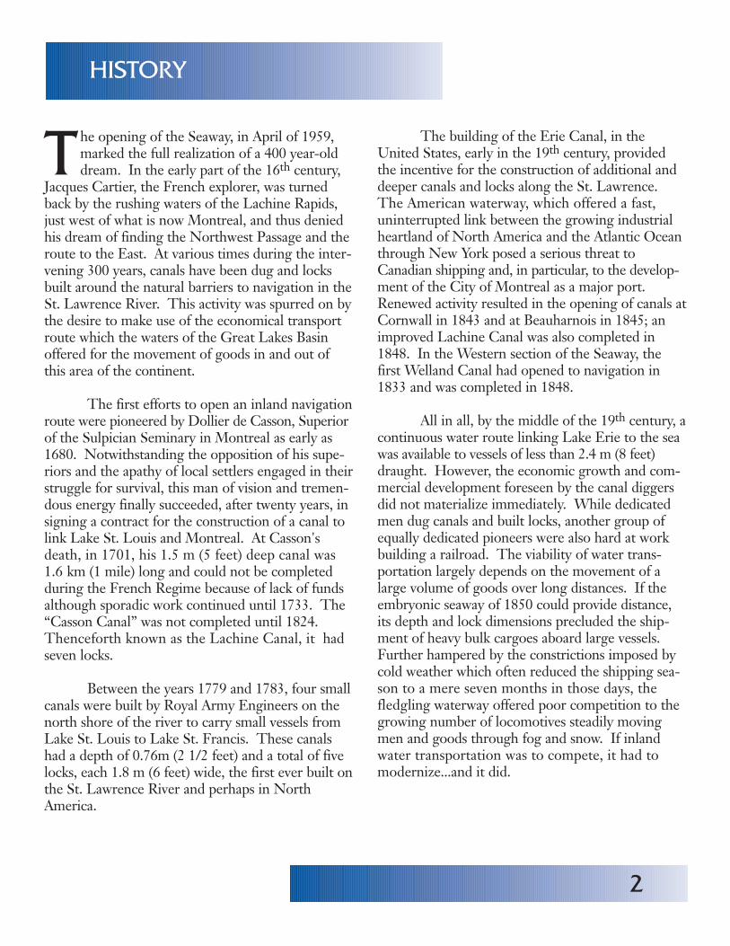
Laker entering Lock 3 downbound in the Montreal/Lake Ontario Section.
4
T he St. Lawrence River flows mainly within theCanadian borders and although its waterswere made available to the commerce of the
United States by several early treaties, it was notuntil 1871, with the Treaty of Washington, that theexact boundary line was established and rules ofnavigation formulated. This is why most of the ear-lier steps leading to a deep water route between theGreat Lakes and Montreal originated in Canada.However, the rapid industrial expansion and popula-tion growth that marked the continental interiorduring the second half of the 19th century resultedin drastically increased shipping requirements, espe-cially for the movement of wheat and iron ore.Public interest in the construction of a deeperwaterway on the St. Lawrence River was soon evi-dent on both sides of the border. In 1895, the twogovernments appointed a Deep WaterwaysCommission to study the project and, two yearslater, the Commission reported in favor of it.
The Commission's report was followed by aseries of engineering studies and, in 1909, a treatyestablished the International Joint Commission, abody that held considerably more power than itspredecessor. The advent of World War 1 inter-rupted international negotiations as well as canalimprovement work on the St. Lawrence/GreatLakes system. However, the war years provided anumber of factors that contributed to a strongermovement to build the Seaway. New industrieswere created, the Panama Canal opened to naviga-tion, rail transportation could no longer meet allrequirements, foreign trade was steadily growingand the need to generate more electric power wasever increasing.
Nevertheless, government efforts in Canadaand in the United States, and the keen interest mani-fested by industries located in the Great Lakes-St.Lawrence River area during the following 35 yearswere strongly opposed by influential rail and other
private industrial sectors in the United States. As aresult, the Great Lakes-St. Lawrence DeepWaterway Treaty, signed by both countries in 1932to provide the joint development of resources in theinterest of both navigation and power generationwas rejected by the United States Senate. After fur-ther studies and urged on by the power needs createdby war production, Canada and the United Statessigned the Great-Lakes-St. Lawrence BasinAgreement in 1941 with the same object in view.This Agreement, also submitted by the UnitedStates congress to its Senate for approval, had notbeen ratified by 1949.
Two years later, the Canadian Governmentlet it be known that Canada was prepared to pro-ceed with an “all-Canadian” seaway as far west asLake Erie, once the means had been found to havethe power works constructed concurrently in theInternational Rapids Section of the St. LawrenceRiver. By December of 1951, the St. LawrenceSeaway Authority Act and the International RapidsPower Development Act were approved by theCanadian Parliament, the first authorizingthe construction of navigation works on theCanadian side of the river from Montreal to LakeOntario as well as in the Welland Canal, the secondauthorizing the Hydro-Electric Power Commissionof Ontario (HEPCO) to join a United States powergenerating entity in constructing the necessarypower works in the International Rapids Section ofthe St. Lawence River.
In 1952, in order to get the power projectunderway, the Canadian and United States govern-ments submitted joint applications to the Inter-national Joint Commission for the proposed powerdevelopment, on the understanding that the Cana-dian Government would undertake to construct,more or less concurrently, and to operate all the worksnecessary to ensure uninterrupted 8.2 m (27 feet)navigation between Montreal and Lake Erie.
CANADA-U.S.NEGOTIATIONS
5
Approval of this proposal was given by the Inter-national Joint Commission in an Order of Approvaldated October 29, 1952.
In 1953, the U.S. Federal Power Commissiongranted a 50-year license to the Power Authority ofthe State of New York (PASNY) for the developmentof the United States half of this power project.Because the Order granting this license to PASNYwas contested in U.S. courts, it was not until June of1954 that PASNY had clear authority to joinHEPCO in making a start on these works.
In the meantime, the United States Congresshad enacted the Wiley-Dondero Bill (P.S. 83-358)which authorized and directed the Saint LawrenceSeaway Development Corporation to construct, onUnited States territory, all the 8.2 m (27 feet) naviga-tion facilities required to get shipping around thenavigational barriers in the International RapidsSection. The situation required close consultationbetween the Canadian and American governments inorder to avoid a duplication of locks and canals. Anumber of compromises and accommodations wereeventually worked out and embodied in a series ofOfficial Notes according to which the United Statesagreed to build a canal and two locks on the United
States territory to bypass the Barnhart Island-Cornwall generating dam at the foot of the LongSault Rapids and, in addition, to do some essentialdredging elsewhere, while Canada agreed to build alock and canal around the Iroquois Control Dam,some 48.3 km (30 miles) upstream and, in addition,to complete to a common standard all the necessarynavigation facilities in Canadian territory, namelybetween Montreal and Cornwall and in theWelland Canal.
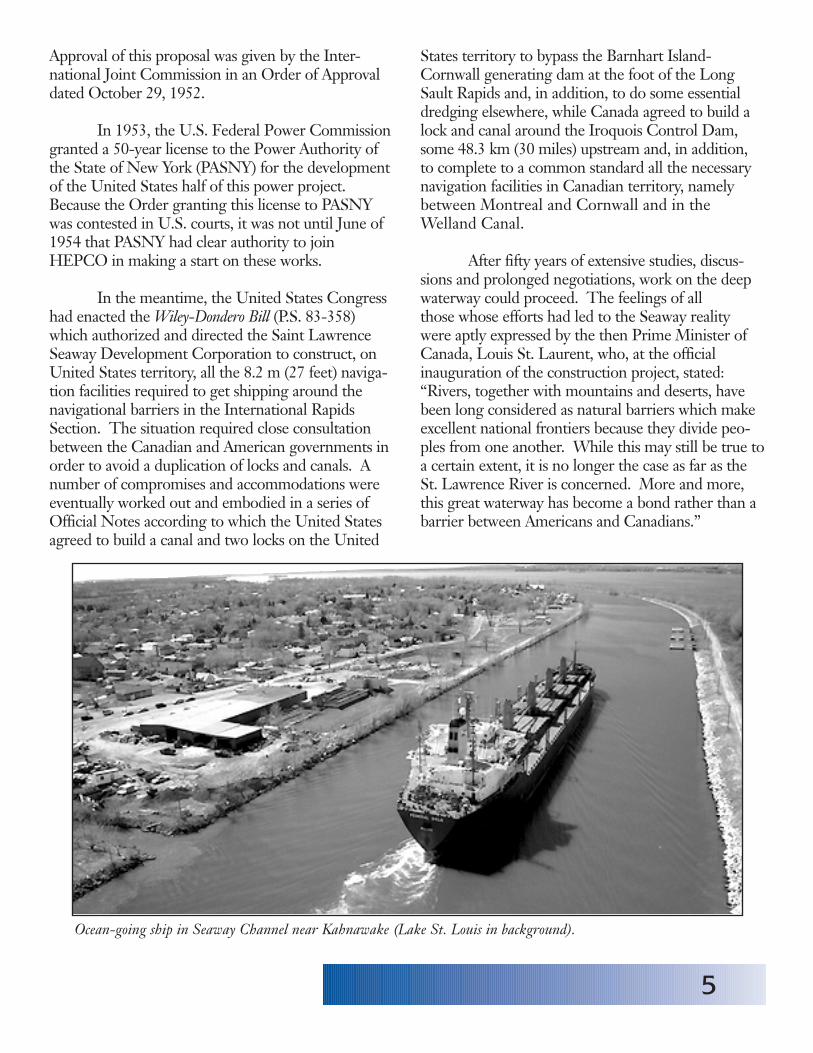
After fifty years of extensive studies, discus-sions and prolonged negotiations, work on the deepwaterway could proceed. The feelings of allthose whose efforts had led to the Seaway realitywere aptly expressed by the then Prime Minister ofCanada, Louis St. Laurent, who, at the officialinauguration of the construction project, stated:“Rivers, together with mountains and deserts, havebeen long considered as natural barriers which makeexcellent national frontiers because they divide peo-ples from one another. While this may still be true toa certain extent, it is no longer the case as far as theSt. Lawrence River is concerned. More and more,this great waterway has become a bond rather than abarrier between Americans and Canadians.”
Ocean-going ship in Seaway Channel near Kahnawake (Lake St. Louis in background).

6
T he first sod on the St. Lawrence PowerProject was turned on August 10, 1954.Work on the Seaway began in September of
the same year. The construction schedule for theentire power and Seaway project was in great partdetermined by both the Hydro-Electric PowerCommission of Ontario and the Power Authority ofthe State of New York who were planning to startjoint operation in 1958.
In order to allow a 36.6 m (120 feet) clearanceto the vessels, the structure of four of the Montrealarea bridges had to be modified drastically withoutinterrupting the heavy vehicular and rail traffic toand from the city. The digging of new channels andextensive dredging to existing ones brought unfore-seen difficulties - excavators uncovered rock forma-tions that played havoc with standard equipmentand necessitated the creation of new methods andthe use of stronger machinery. The power develop-ment, which called for the flooding of wide areas,required the expropriation of some 260 km2 (100 squaremiles) of land and the resettlement of entire com-munities. In all, some 6,500 people were moved tonew homes while some 550 dwellings were trans-ported to awaiting foundations in the newly createdtowns of Long Sault, Ingleside and Iroquois. In theWelland Canal, rock dredging during the winter
months brought the 7.6 m (25 feet) deep channel tothe 8.2 m (27 feet) governing depth of the Seaway.
All of the seven locks of the Montreal/LakeOntario section of the Seaway (St. Lambert, CôteSte. Catherine, Lower and Upper Beauharnois,Bertrand H. Snell, Dwight D. Eisenhower andIroquois) as well as those of the Welland Canal, havebeen built to the following standard dimensions:
Seaway channels and canals were built tominimum widths of 61 m (200 feet) when providedwith two embankments, 91.4 m (300 feet) when thereis only one embankment, and 137.2 m (450 feet) inopen reaches. Depth throughout is 8.2 m (27 feet).
By May 1958, the Iroquois Lock was inregular use. The Snell and Eisenhower Locks, builtby the Americans at Massena, New York, becameoperative on July 4 and on that same day, first powercame from the international Moses Saunders gene-rating station.
On April 25, 1959, the icebreaker“D'IBERVILLE” began the first through transit ofthe St. Lawrence Seaway which was officiallyopened by Her Majesty Queen Elizabeth II and thePresident Dwight D. Eisenhower of the UnitedStates on June 26 of that year. Today, the waterwayremains a fine example of the spirit of co-operationthat can exist between two nations and its successfuloperation is a tribute to the ingenuity, capability andperseverance of all those who had a hand in itsrealization.
CONSTRUCTION
Usable length 233.5 m (766 feet)
Usable width 24.4 m (80 feet)
Depth (over sills) 9.1 m (30 feet)

Starting in Montreal, ships travelling to des-tinations in the Great Lakes will first transit the 7 locksin the Montreal/Lake Ontario section of theSeaway, beginning with the St. Lambert Lock.
Almost directly across Montreal harbour liesthe protecting dyke of the channel giving access tothe Seaway. This channel begins just east of theJacques Cartier Bridge (during Seaway construction,this bridge was literally “jacked up” some 15.2 m(50 feet) to provide the required clearance), passesbeneath the bridge and extends for 4.8 km (3 miles)before reaching the first lock of the Seaway, the St.Lambert Lock, located at the southern end of theVictoria Bridge. An ingenious diversion system thatincludes a lift span at each end of the lock allows theheavy rail and road traffic to proceed uninterruptedto and from the bridge.
The St. Lambert Lock lifts the ship some4.5 m (15 feet) from the level of the Montreal har-
The Côte Ste. Catherine Lock lifts shipsfrom the level of the Laprairie Basin some 9.1 m(30 feet) to reach Lake St. Louis. It allows naviga-tion to bypass the swift Lachine Rapids. Its locationwas carefully chosen so that it would not interferewith any future utilization of the rapids for powerdevelopment. Beyond this second lock, the channelruns 12.1 km (7.5 miles) before reaching Lake St.Louis.
At one point along this channel tower thepiers which give the Honoré Mercier highwaybridge the necessary clearance for the large shipsusing the Seaway. Further upstream is the CanadianPacific Railway bridge which had two lift spansinstalled for the same purpose. These mobile spanscan be raised or lowered in less than two minutes.
THE SEAWAY TRANSIT
St. Lambert Lock
Côte Ste. Catherine Lock
Having entered Lake St. Louis, ships sail onfor 19.3 km (12 miles) through dredged channelsbefore reaching the Beauharnois Locks, at the westend of the lake. These locks bypass the Beauharnoispower plant (owned by Hydro-Quebec, the generat-ing plant has a capacity of 1,656,860 kW) and lifts theship 12.5 m (41 feet ) in order to reach the level ofthe Beauharnois canal. This 20.9 km (13 mile) canalbrings vessels to Lake St. Francis where they mayproceed westward for some 48.3 km (30 miles)along dredged channels to the head of the lake.
The Beauharnois Lock
7
Ship entering downbound at St. Lambert Lock.
bour to that of the Laprairie Basin through whichthe channel sweeps in a great arc, 13.7 km (8.5 miles)long, between its protecting embankments to thesecond lock.
8
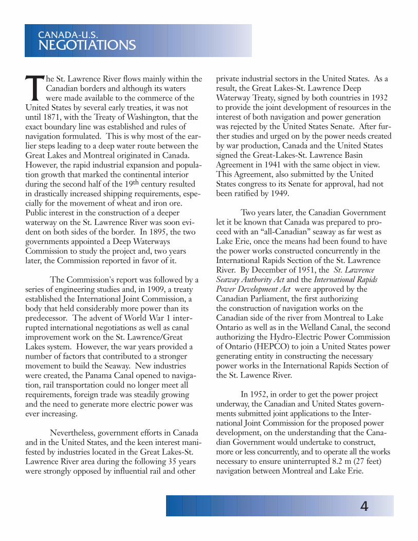
Ships leave Lake St. Francis at its southwestcorner and soon cross the International Boundary,opposite St. Regis, Quebec. Shortly after enteringthe International Section of the Seaway, ships sailunder the Seaway International Bridge linkingCornwall, Ontario and Massena, New York. Builtas part of the overall Seaway project, this toll bridgeis administered jointly by The Federal BridgeCorporation Limited and The Saint LawrenceSeaway Development Corporation.
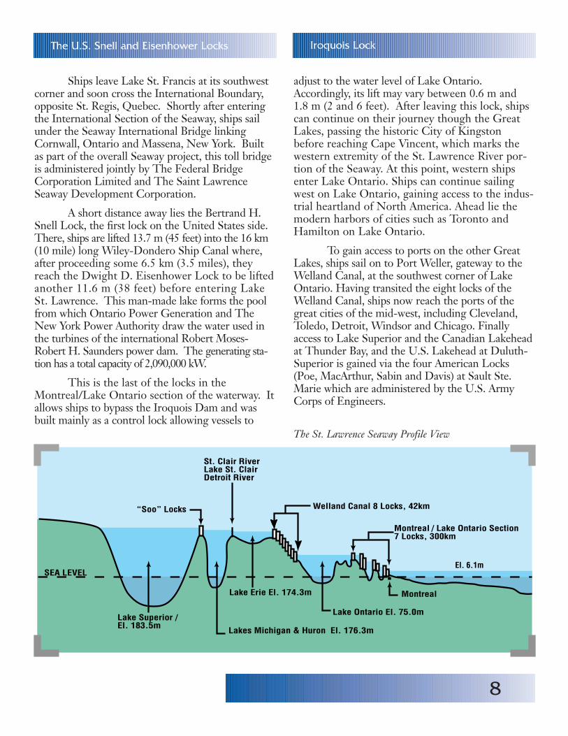
A short distance away lies the Bertrand H.Snell Lock, the first lock on the United States side.There, ships are lifted 13.7 m (45 feet) into the 16 km(10 mile) long Wiley-Dondero Ship Canal where,after proceeding some 6.5 km (3.5 miles), theyreach the Dwight D. Eisenhower Lock to be liftedanother 11.6 m (38 feet) before entering LakeSt. Lawrence. This man-made lake forms the poolfrom which Ontario Power Generation and TheNew York Power Authority draw the water used inthe turbines of the international Robert Moses-Robert H. Saunders power dam. The generating sta-tion has a total capacity of 2,090,000 kW.
This is the last of the locks in theMontreal/Lake Ontario section of the waterway. Itallows ships to bypass the Iroquois Dam and wasbuilt mainly as a control lock allowing vessels to
The U.S. Snell and Eisenhower Locks
adjust to the water level of Lake Ontario.Accordingly, its lift may vary between 0.6 m and1.8 m (2 and 6 feet). After leaving this lock, shipscan continue on their journey though the GreatLakes, passing the historic City of Kingstonbefore reaching Cape Vincent, which marks thewestern extremity of the St. Lawrence River por-tion of the Seaway. At this point, western shipsenter Lake Ontario. Ships can continue sailingwest on Lake Ontario, gaining access to the indus-trial heartland of North America. Ahead lie themodern harbors of cities such as Toronto andHamilton on Lake Ontario.
To gain access to ports on the other GreatLakes, ships sail on to Port Weller, gateway to theWelland Canal, at the southwest corner of LakeOntario. Having transited the eight locks of theWelland Canal, ships now reach the ports of thegreat cities of the mid-west, including Cleveland,Toledo, Detroit, Windsor and Chicago. Finallyaccess to Lake Superior and the Canadian Lakeheadat Thunder Bay, and the U.S. Lakehead at Duluth-Superior is gained via the four American Locks(Poe, MacArthur, Sabin and Davis) at Sault Ste.Marie which are administered by the U.S. ArmyCorps of Engineers.
Iroquois Lock
“Soo” Locks Welland Canal 8 Locks, 42km
Montreal / Lake Ontario Section7 Locks, 300km
El. 6.1m
Montreal
Lake Ontario El. 75.0m
Lake Erie El. 174.3m
Lakes Michigan & Huron El. 176.3m
Lake Superior / El. 183.5m
SEA LEVEL
St. Clair RiverLake St. ClairDetroit River
�
The St. Lawrence Seaway Profile View
9
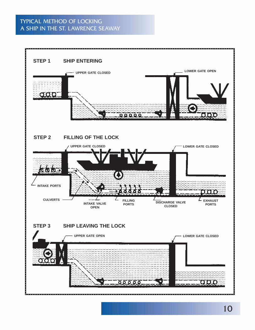
S hips remain under their own power at alltimes and are each secured in the lock chamberby a crew of St. Lawrence Seaway linesmen.
Once a vessel is safely moored, huge steel gatesclose behind it and valves are put into operation tofill or empty the lock by gravity flow. About 91 mil-lion litres (20 million gallons) of water are required
The navigation season on the waterway nowextends from late March to late December. Sincethe Seaway opened in 1959, new technologiesagainst ice formation in locks and canals have beenimplemented and some 25 days have been added tothe shipping season.
Between the opening of the Seaway in 1959and 1983, the Seaway carried 1 billion tonnes ofcargo. The rational utilization of ships which maycarry one commodity upbound (such as iron ore)and a different commodity downbound (such asgrain) makes the Seaway a competitive mode oftransportation for a wide variety of bulk productsand project cargoes. Today, handling over 4,000 shiptransits per year, the Seaway carries well over40,000,000 tonnes of cargo during a typical navi-gation season.
LOCK PROCEDURE
SHIPS AND TRAFFIC
T he locks of the Seaway can accommodate ves-sels 225.5 m (740 feet) long, 23.8 m (78 feet)wide and loaded to a draft not exceeding 8.08 m
(26 ft. 6 in.). The large lakers which make up theinland commercial fleet bring iron ore from theQuebec Labrador mining centres to the steel millslocated in the Great Lakes region. These same ves-sels are used to carry grain to ports along the lowerSt. Lawrence for transshipment aboard ocean ves-sels destined for European and other world ports.Other major commodities shipped through theSeaway include corn, barley, soybeans and othergrains, coal, salt, stone and various mine products,fuel oil, scrap iron and steel, newsprint and a greatvariety of manufactured products.
The Seaway opened the North Americanheartland to international shipping and vesselsfrom all over the world now make their way to St.Lawrence and Great Lakes ports carrying the largequantities of finished products, manufactured ironand steel and general cargo imported by Canadaand the United States. Return voyages can include amyriad of cargoes from the inland industrial centres.
and the time needed to fill a lock is approximately9 minutes. As the new level is reached, the forwardgates are opened and, at a sign from the lockcrew, ashort blast of the ship whistle signals “cast off” andthe vessel proceeds out of the lock. Some 32 largevessels can go through a lock on a very busy day.
10
TYPICAL METHOD OF LOCKINGA SHIP IN THE ST. LAWRENCE SEAWAY
STEP 1 SHIP ENTERING
UPPER GATE CLOSED LOWER GATE OPEN
STEP 2 FILLING OF THE LOCK
UPPER GATE CLOSED LOWER GATE CLOSED
INTAKE PORTS
CULVERTSINTAKE VALVE
OPEN
FILLINGPORTS
DISCHARGE VALVECLOSED
EXHAUSTPORTS
STEP 3 SHIP LEAVING THE LOCK
UPPER GATE OPEN LOWER GATE CLOSED
11
T he area affected by the Seaway is larger thanall of western Europe and contains nearly athird of the combined populations of Canada
and the United States. The waterway has createdthousands of jobs in related industries. Goods of allkinds are shipped over long distances at a reasonablecost by ships which remain the most energy-effi-cient mode of transportation.
Although world market conditions mayresult in tonnage fluctuations from year to year onthe Seaway, the future viability of the waterway isensured by the fact that it is first and foremost abulk-cargo route strategically located along theborder of two countries that are world leaders inboth agriculture and mineral resources.
Information ServicesThe St. Lawrence Seaway Management Corporation202 Pitt StreetCornwall, Ontario K6J 3P7CANADA
E-mail: [email protected] page: http://www.greatlakes-seaway.com
March 2003
A VITAL TRADE ROUTE
12
Alexandria Bay U.S.�
Cape Vincent U.S.
Kingston
Ogdensburg-Prescott Bridge
Ogdensburg U.S.
Massena U.S.
Lake St-Francois
St-Louis Bridge
Valleyfield Bridge/
Beauharnois
Beauharnois Canal
Mercier & CPR Bridge
Côte Ste-Catherine Lock
St-LambertSt-Lambert Lock
Champlain Brid geLaprairie Basin
Jacques Cartier Bridge �
�
Snell L ock
International Bridge
Eisenhower Lock
Wiley Dondero Canal (U.S.)Iroquois Lock
Morrisburg
Iroquois ��
Long Sault Cornwall
Ingleside
Prescott
1000 Islands Bridge
Brockville
OTTAWA
Lake Ontario
Lake St-Louis
Montreal
Valleyfield
�
Old Lachine Canal
Beauharnois LocksOld Soulanges Canal
Victoria Bridge
THE MONTREAL/LAKE ONTARIOSECTION OF THE SEAWAY