Embed Size (px)
Citation preview

1
The Mormon Geography Problem -- Chapter and Verse by Robert A. Pate, Ph.D.
1.0 Introduction: State of Affairs
Since publication of the Book of Mormon in 1830, readers have questioned where it all happened. A lot of exciting fluff on Book of Mormon Geography is being discovered, but substance is still lacking. The real solution appears no closer. Other than focusing on Mesoamerica, nothing really substantial has changed in the last 25 years. We have been held hostage by ideas that are old, that are based on misinterpretation, and that have not produced results. It is disgusting to have the world reject the Book of Mormon for lack of physical evidence, while academics bicker.
The Book of Mormon is actually very simple and quite clear in its geographic descriptions and detail. The solution should be as crisp as a mathematical proof. It has been complicated by imposing unrealistic constraints – constraints not founded in chapter and verse references in the Book of Mormon. Critics tend not to use chapter and verse, but prefer more academic methods of intimidation.
Let’s propose some ground rules for this engagement. Bring all the knowledge of the world to bear upon this problem, but use Mormon’s words to support or refute proposed models. If a model cannot stand up to chapter and verse scrutiny, it is not worth further pursuit. If there is not an appropriate archaeological footprint in space and time commensurate with Mormon’s descriptions, then a proposed site fails Mormon’s chapter and verse tests based on lack of supporting archaeological testimony. Of equal importance are the historical names. These historical names have and continue to be identified. It is that simple. Let’s get all the assumptions or interpretations on the table and sort them out for merit.
The solution is threefold: 1) Mormon chapter and verse compatibility, 2) appropriate archaeological footprint in space and time, and 3) historical name identification. This is how Biblical cities have been and are being identified.
2.0 Mistaken Assumptions Preventing Progress
What are the mistaken assumptions that have been preventing progress? The leading geographical models were reviewed and it appears that there are four obstacles that pitch the models in different directions.
1) Sidon River flowing into the north sea (Index). 2) Narrow neck of land being an isthmus. 3) Mulek’s entrance into the land Northward. 4) East Borders by the seashore being an ocean (Alma 51:25, 26).
Getting deeper into the models, there are two additional problems:

2
5) The model developers appear to ignore or rationalize Alma 22:27, Sidon running from the east to the west.
6) They also ignore that the land Nephi-1 remained a credible threat after Nephi fled.
There is yet another problem that all readers of the Book of Mormon must deal with.
7) The confounding of directions.
The skill most useful in finding all the cities is reading, not digging. Expanding briefly, these are the problems:
1) Sidon River: The Index in the 1981 edition of the Book of Mormon states that the Sidon River “runs north to the sea.” This was not in previous editions, but it remains in all post 1981 printed versions. It has now been removed from the internet version of the Triple Combination, but it is still in the free copies distributed by the missionaries. Somehow an opinion was introduced into the Index that has no textual justification.
This has been a stumbling block for the past 32 years; but the concept started earlier, prompting model developers to mistakenly place Zarahemla on the north slope of Mesoamerica.
2) Narrow Neck of Land: The narrow-neck-of-land is not an isthmus. There are other interpretations more consistent with the Book of Mormon and the Mesoamerican topography. As someone has stated, “There is nothing more deceptive than an obvious fact.” Hauck has rightly come to the conclusion that we must look elsewhere for a credible interpretation for the “narrow neck of land.”
3) Into the Land Northward: The fact that the Lord did bring Lehi into the land south, and Mulek into the land north, has absolutely no relevance to the direction from which they each entered (Helaman 6:10). The need for Mulek to arrive on the north slope was probably precipitated by problem one above.
4) East Borders by the Seashore: (Alma 51:25, 26) This one passage has been misunderstood because it has been interpreted to mean every sea is an ocean (the Atlantic Ocean). That is not even consistent with English; but in Hebrew, even the Nile River is a sea (along with the Sea of Galilee and the Dead Sea).
5) River Sidon, Running from the East towards the West: (Alma 22:27) This verse has been ignored or misunderstood. It clearly states that the River Sidon runs from the east to the west. Again, the misinterpretation of this verse was probably precipitated by the “runs north to the sea” intrusion into the Index mentioned above. To justify a north sea exit, model developers have ignored the antecedent (river Sidon), just one comma away, and gone back to the “narrow strip of wilderness”, forty-nine words and six commas away, to find an antecedent.
6) Land Nephi-1 Remained a Viable Threat: Reviewing the leading models, it became apparent that implicit in the models was the misunderstanding that the first land of Nephi (Nephi-1, the land of their first inheritance) disappeared after Nephi and his followers fled eastward many days and founded a second land of Nephi. It did not disappear. It is clearly mentioned in Alma 22:28. This was the land of Nephi from where the many wars emanated.

3
This is the land of Nephi where Lamoni’s father lived. This is the land of Nephi where Amalickiah killed the king and married the queen.
The land of Nephi-1 did remain viable and was a credible threat to the Nephites. This is a major problem with the credibility of the models because, if Nephi-2 was the source of the Nephite problems, all the wars would have to have been fought from a distance of 21 days travel. This is too much separation distance to be logistically or tactically credible.
All the land between Nephi-1 and Nephi-2 (Lehi-Nephi) appears to have been Lamanite land. Archaeological evidence shows this in-between land was only sparsely populated. To this day it is very sparsely populated.
7) Confounding Directions: The Hebrew reference frame is based on the north-south Mediterranean coastline and/or the eastern sun rise. Left is north, forward is inland to the east (sunrise), right is south, and rearward is west, back out to sea, or just seaward. The Quiché Maya also use ritual north as left and ritual south as right. Scholars have long known that Mormon’s northward and southward entailed some angular rotation to understand – the only question was how much. The actual situation is worse. The serpentine coastline of Mesoamerica confounds the directions – the uniqueness is lost, no fixed angle transformation will correct it. The only recommendation is recognize it and deal with it. The orientation is dictated by the coastline. When northward ceases to be true north switch to left or right as needed and continue on up the coast. Fortunately it is a continuous mapping. They knew the true cardinal directions; but we have what Mormon and Joseph gave us. And, what they gave us requires a directional shift.
Most Damaging Assumption: The single most damaging assumption was that the Sidon River ran north to the sea. This prompted the need for other misinterpretations causing several of the other problems. The narrow neck of land as the Isthmus of Tehuantepec comes in as a close second for damage induced.
The concluding indictment is the complete lack of realism in the city placements as they relate to the wars. What this would demand of a native in sandals and a breechcloth is not practical. Some soldiers, hunters, farmers, or anyone who walks the land with any understanding of realism should have been consulted.
Most disturbing is the fact that this is the level of understanding. The model developers are leaving too many clues in the book. This is not an option – these clues are requirements necessary to verify when the puzzle is solved. This is a Crime Scene Investigation. The objective is to find the cities based on evidence – not guess and attempt to justify. Guessing is so “destructive to the logical faculty.” “It is a capital mistake to theorize before one has data. Insensibly one begins to twist facts to suit theories, instead of theories to suit facts.” (Sherlock Holmes, Arthur Conan Doyle)
The performance of the leading models will be measured against the Book of Mormon, chapter and verse, and a healthy dose of realism.
3.0 Stalled Out
The model development has stalled – not in volume, but in substance. Lewis E. Hills in 1917 developed a Mesoamerican map based on the Usumacinta-Sidon correlation. M. Wells Jakeman

4
later continued the Mesoamerican approach, but “never found unambiguous geographic detail in the text, so he never finished his map” (Norman 2008, 17). Later students had no such compunction. Shifting the emphasis from the Usumacinta to the Grijalva River drainage does not fix any of the textual problems.
The current models are 25 years old -- or are they 97 years old since Lewis E. Hills? Because of strong personalities defending their turf, nothing constructive is being accomplished. Whole academic and professional careers have been based on some misinterpretations – they will not change their minds now -- the books are in print – the objectivity is gone.
Some healthy confrontation and exchange is needed to change the old guard and find which interpretations and assumptions are causing the failure. Academic pride is a powerful motivator. History has proven time and again that the old guard will not relinquish its strangle hold until the general public convinces them with sufficient clarity that their position is untenable.
The proposed models for Book of Mormon geography are many and varied. Positions and personalities of its proponents, not correctness, determine visibility. Models range from the Great Lakes, the Heartland, Mesoamerica, to the Chilean Andes. Only Mesoamerica has the necessary credentials to be considered a credible place for the solution to Mormon’s puzzle. Read the Book of Mormon with real intent -- the clues are so many that any indiscriminant placement of cities can be exposed using Mormon’s descriptions.
The models that dominate the conferences are the Grijalva and the Usumacinta -- two postulated models are in each drainage. These four models will be examined relative to Mormon’s descriptions and the Nephite wars.
It is the author’s objective to help present to the world, credible and verified data supporting the Book of Mormon as real geography and real history. That takes a lot of help from many disciplines. As we enter the Millennium, it is time to dispel the critics and give them no leg to stand on; thus permitting the world to take a more objective look at the Book of Mormon.
4.0 Approach
SuggestedReadingApproach
The present article is not a casual read; and, to facilitate understanding, one needs a map and the Book of Mormon, in hand or on the screen. An excellent zoom-able map can be downloaded free from the website, MormonTopics.com. This map is needed to understand the author’s postulations and to see the simplicity of what the Book of Mormon actually states.
Discovery Approach
Following the Book of Mormon explicitly, using a simple pattern recognition approach for relevant data and historical names, the author was permitted to locate virtually all of the lands and cities mentioned in the Book of Mormon. The early results were published in 2002 under the title, Mapping the Book of Mormon, A Comprehensive Geography of Nephite America. Research continued and the most up-to-date and complete description of the geography, entitled Mormon Footprint in Mesoamerica, can be downloaded free at MormonTopics.com.

5
After the first few early discoveries, the rest came much more easily. As Ted Dee Stoddard has now stated, “the land has a right to dictate geography.” He also states, “Once we have identified the overall location of the New World lands of the Book of Mormon, we should then let the land itself help us with the geography of the Book of Mormon.” (Stoddard 2010, 5) It definitely does; and so it did. The topography dictated where to look for the next habitable location. With local and ancient histories, dictionaries, maps, and the Book of Mormon in hand, each city was found, in order following along the roads using current topographical maps and archaeological maps.
Having discovered the true places named in the Book of Mormon, straight out of the local and native histories; the hot buttons became obvious. The leading models were reviewed, examining similarities, differences, and divergences from the descriptions provided so well by Mormon. Any places of disagreement can invariably be traced to questionable interpretation of the Book of Mormon as written from Mormon’s perspective. We all are capable of reading the English language, but it is Mormon’s perspective that is required to eliminate possible ambiguities which have resulted from interpretations based on our modern global perspective.
This process made clear the problems that were listed in section 2.0. These problems will now be treated in much greater detail. The order selected is to promote logical understanding and avoid repetition.
5.0 Into the Land North
If one is going to milk the Book of Mormon for relevant information, then take it all, don’t be selective taking only the parts that support one’s preconceived notions.
Helaman 6:10 states: : Now the land south was called Lehi and the land north was called Mulek, which was after the son of Zedekiah; for the Lord did bring Mulek into the land north, and Lehi into the land south.
There is a land named North Dakota. It can be entered from the north (Canada), from the west (Montana), from the east (Minnesota), or even from the south (South Dakota). The fact that it was named North Dakota does not mean that it can be entered only from the north.
Mormon makes it just this clear. The land south was called Lehi and the land north was called Mulek. The fact that the Lord did bring Lehi into the land South Dakota, and Mulek into the land North Dakota, has absolutely no relevance to the direction from which they each entered. That is plain English. Look elsewhere for the direction of entry.
6.0 Seas and Seashores
What are seas and seashores in Old Testament Hebrew? In Lehi’s Hebrew (New American Standard Old Testament Hebrew Lexicon), we find the word yam {pronounced as yawm} meaning “sea”, as in: “sea (in general), Mediterranean Sea, Red Sea, Dead Sea, Sea of Galilee, mighty river (as in Nile), the sea (as in the great basin in the temple court), seaward, west, and westward.” It would appear that almost any body of water could be called a “sea” in old Hebrew. Of particular interest is that a “mighty river” such as the Nile is simply called a “sea”. Could a “mighty river” divide the land? Absolutely -- many states, departments, and countries of the world today are divided in part by significant rivers.
6
Another word, chowph {pronounced as khofe}, means “seashore, coast, or shore.” It would
appear this word could represent the “shore” of any ocean, sea, lake, or reservoir. There is yet another word saphah {pronounced as saw-faw’} which means “lip, edge, shore, bank, or brink (of a cup, sea, river, etc.).” This appears to be the “edge” of any water body, be it a cup, sea, river, stream, or ocean.
That gives a much older possible meaning to Alma 51:26 -- “And thus he went on, taking possession of many cities, the city of Nephihah, and the city of Lehi, and the city of Morianton, and the city of Omner, and the city of Gid, and the city of Mulek, all of which were on the east borders by the seashore.”
Who knows what Mormon’s Hebrew was like? We just know that they changed it some, and that the roots went back to Lehi’s knowledge base at the time Lehi left Jerusalem. We will take advantage of these known definitions to postulate how we may understand Mormon’s use of the words “sea” and “seashore”, and even “seaward” and “westward.” Also, the words “ocean” and “lake” are not found in either the Book of Mormon, or the Old Testament.
7.0 Proximity to West Sea
West Sea – What is the West Sea?
The west sea is the Pacific Ocean. There is nothing ambiguous about it and all credible parties are of the same opinion. But, let us examine some of the “statements-of-fact” evidence from the Book of Mormon to understand what we can about the West Sea, the relational proximity of the major lands, and the relative position and flow direction of the Sidon River. We will array the statements of fact and see what pattern appears from the referenced linkages that will be observed. No contradictions are allowed. Unresolved ambiguities are allowed, but every effort should be made to follow Ockham’s razor – “among competing hypotheses, the hypothesis with the fewest assumptions should be selected.” When extracting clues and evidence from the Book of Mormon, we will select the simplest, most realistic, interpretation without multiplying undocumented constraints.
The water feature that divided the land northward (Desolation) from the land Southward (Bountiful/Zarahemla) opens to the west sea. The extent of Hagoth’s sailing in: number of ships, time for round trips, and implied distance of travel, as well as possibly being lost at sea (drowned in the depths of the sea, Alma 63:8 ) indicate that the west sea was very large. The distant land northward appears to be significantly beyond the limited land northward called Desolation. The only credible West Sea would appear to be the Pacific Ocean.
From the book of Ether we have:
19 And it came to pass that Lib also did that which was good in the sight of the Lord. And in the days of Lib the poisonous serpents were destroyed. Wherefore they did go into the land southward, to hunt food for the people of the land, for the land was covered with animals of the forest. And Lib also himself became a great hunter. 20 And they built a great city by the narrow neck of land, by the place where the sea divides the land.

7
21 And they did preserve the land southward for a wilderness, to get game. And the whole face of the land northward was covered with inhabitants. (Ether 10:19-21)
Lib built a great city on the northward side (Desolation) by the narrow neck of land and the
southward side, a wilderness, he preserved for hunting. This is where the sea (some water feature) divides the land northward from the land southward and some passable connective structure (narrow neck passage) connects the land northward to the land southward. The land southward became the land Bountiful to the Nephites. How far can one pack a dead deer in the tropical heat and expect to eat it? The city Lib must have been very close to the land/wilderness called Bountiful.
Sea Divides the Land
Some correctly say the Isthmus of Tehuantepec is not where the sea divides the land, but where the land divides the sea. Remove a section of the Isthmus, so the Gulf of Mexico communicates with the Pacific Ocean, and then, one would have the place where the sea divides the land. It is the land that should be divided, not the sea. Continuity is the issue – what is being cut, and what is doing the cutting. That is what the words mean in English. There is no ambiguity unless one chooses to introduce it by ignoring what it actually means in English.
What does Mormon’s water feature divide? It divides the land northward, Desolation, from the land southward, Bountiful (Ether 10:21, Alma 22:31). What does this water feature between these two lands look like? Mathematically it can always be approximated as a straight line (see the Mean Value Theorem from Calculus). Mormon calls it a “line” running from the “east” end to the “west sea”. The “west sea” is the Pacific Ocean – no credible model states anything different about the west sea. The “east” end of the line is the place where the land Desolation and the land Bountiful no longer share a common boundary – be it a wilderness, a mountain, a sea, an ocean, or a third country. This line appears to be the one and only place where the two lands share a common boundary.
The length of this dividing line formed by the water feature is “only the distance of a day and a half’s journey for a Nephite” (Alma 22:32) – a common Nephite, not a marathoner. To be reasonable, let’s call it 30 miles for just any average un-qualified Nephite. To assume anything greater requires arm waving and assumes our modern understanding of people who have the luxury of running just for the heck of it. In the back country, one almost never sees a native running and rarely sees a native walking empty-handed; they are almost always packing a load, a large load. Besides, 30 miles is the exact distance today of the perfectly straight road from the Pacific Ocean to the base of the Sierra Madre Mountains near Retalhuleu, Guatemala – Retalhuleu, means “boundary land” in Quiché Maya. That would be where the sea divides the land. The town of Retalhuleu, Guatemala, was formed by the Spaniards putting together two smaller villages mentioned in the Annals of the Cakchiquels as Teyocuman [Teancum] and Zakijuyú [“white earth”, Desolation] (Recinos 1953, 69).
What is a water feature where the sea divides the land that looks like a line? The Kakchiquel language defines “river”, raqän ya’, as “long water” – could that be the needed water feature?

8
To understand what Mormon meant we have to see things from his perspective – we have to get into his head. His personal Hebrew dictionary would be an excellent place to start. Remember that the old Hebrew word for sea, yam, includes a “mighty river” as one of the meanings and specifically mentions the Nile River as an example. Mormon’s description, and his linguist roots based in Old Testament Hebrew, give license, to un-shackle ourselves from “isthmus” being the only credible explanation – a shackle that has kept the Mormon lands hidden since Martin Harris mortgaged his farm to pay for the publication of the Book of Mormon.
The most credible description of where the “sea divides the land” northward from the land Bountiful would thus be a large river with a tidal estuary. Because of the fertility in such regions, about 60-percent of the world’s population lives along estuaries and the coasts.
In Alma 63:5, we read about Hagoth, who “went forth and built him an exceedingly large ship, on the borders of the land Bountiful, by the land Desolation, and launched it forth into the west sea, by the narrow neck which led into the land northward.” Helaman 3:10 mentions shipping timber into the land northward and then in verse 14 indicates that said shipping probably involved ships, as opposed to shipping by overland carriers.
This places the narrow neck and the entire interfacial boundary between the land Desolation and the land Bountiful within about 30 miles of the Pacific Ocean. Examine the Mesoamerican Pacific Coast and one finds that there is one, and only one, place where the coastal plane and piedmont exceeds 30 miles in width – that being the southwest coast of Guatemala.
If one does not like the 30 mile limit, then adjust it to what one is willing to walk (not run) in a day and a half (not a day and a night and a day). It is not “traveling” if one is dead when he gets there. But, it must open to the west sea. It was only the distance of a day and a half's journey for a Nephite, on the line Bountiful and the land Desolation, from the east to the west sea (Alma 22:32).
This water feature (interface line between Desolation and Bountiful) on the west sea was where Hagoth launched his ship (Alma 63:5). As this water feature was the only place where the lands Desolation and Bountiful share a common boundary, this would also be the Mulekites “place of their first landing” (Alma 22:30-33). After stating that this was “the place of their first landing” in verse 30, Mormon states in verse 31 that they (the Mulekites) “came from there up into the south wilderness (Bountiful).” South wilderness was its name, not the direction from which it was entered. And, then in verse 32 he drops them back down to the west sea when he gives the description of the line which divides Bountiful from the land Desolation as beginning at some point in the east and extending a day and a half’s journey (about 30 miles) to the west sea. This west sea connection is reaffirmed in verse 33 where it states that the Nephites had inhabited the land Bountiful from the east [boundary?] to the west sea. The land Bountiful must border the west sea (Pacific Ocean).
The Grijalva and Usumacinta models do not have a west sea – period. They do not have an interfacial dividing line between the lands Bountiful and Desolation that runs from the east [end] one day and one half’s journey to the west sea – period.

9
What they do have is a convoluted mess with the City Bountiful on the Atlantic Ocean and the Land Bountiful some 300 to 600 miles away on the Pacific Ocean or the Gulf of Mexico.
Again, any indiscriminant placement of cities can be exposed using Mormon’s descriptions.
It is very clear that the Mulekites landed on the west seashore. There is no justification for models which place the Mulekites “first” and only “landing place” on the Gulf of Mexico or the Gulf of Honduras. There is simply no first level evidence supporting such models in the Book of Mormon. Those who promulgate such claims use extensive arm waving and many pages to justify their deficient assumptions. Until the author and translator (Mormon and Joseph) surface again, the final word when defending or refuting any geography model can and should be chapter and verse from the Book of Mormon – that is the box this puzzle came in. In model descriptions, the heft of a book is an indicator of the deficiencies with the model. If it cannot be articulated concisely, it is not understood by the writer. This is not Tax Code.
No credible models question the west sea landing for Lehi and the west sea departure for Hagoth, nor do they challenge the west sea as being the Pacific Ocean. And, it is clear the Mulekites also landed from the west sea. The model developers are trapped. Alma 22:30-33 leaves them no wiggle room. These four simple verses destroy the models. The models are not anchored in any residual historical place names. Without any correct anchors, place names can be scattered with impunity. Mormon is the only arbiter.
The model developers do not know where the cities are and they know they don’t know – none-the-less, they will guess. And, as stated, guessing is so destructive to the logical faculty, theorizing before one has data one begins to twist facts to suit theories, instead of theories to suit facts.
Subject the postulated city selections to the Nephite wars and the models fall apart for lack of realism and compatibility with chapter and verse from the Book of Mormon.
Without the correct landing point, the lands Desolation, Bountiful, and Zarahemla fade back into the jungle. In the wrong drainage, the Sidon River is lost. There is no model. Stray opinions and academic novelties obscure what the Book of Mormon is saying.
We must go back to the Book of Mormon. As John E. Clark said, “The Book of Mormon must be the final and most important arbiter in deciding the correctness of a given geography; otherwise we will be forever hostage to the shifting sands of expert opinion” (Clark, 1989, 20-70). We have been there and done that. For the past 25 years we have been held hostage by the incorrect assumptions -- more chutzpah than objectivity.
And, it is back to the Book of Mormon to try to find which of their interpretations and assumptions are not correct. Bring the Mulekites on shore from the west sea, as the book says. Find where the coastal plain and piedmont is thirty miles wide (about a day and a half’s journey) from the east [wilderness] to the west sea [Pacific Ocean]. Find a Garden of Eden on the west coast where a civilization of appropriate size and time has left its archaeological footprint. There is but one such site and it is the Cotzumalhuapa Culture on the south coast of Guatemala, extending from Cara Sucia, El Salvador on the south to near the Mexican border on the north.

10
The Izapa remnants, just up the road about 50 miles, look almost identical in time frame, carving style, and architecture to the Cotzumalhuapa Culture (Parson 1969).
One will find a people who love the marimba, who are beautiful weavers, who have left more high level ancient writings than any other of the peoples in all of North and South America combined, who say their ancestors sailed from a place near Babylonia, a people that have two modern Mormon missionaries in their historical mural in their National Museum of Archeology and Ethnology, a people who have Teancum (Tecum) as their national hero.
Their legends of Tecum Uman (the grandson of Tecum) are based on Captain Moroni’s dear friend, Teancum, not the Spanish conquest. Their legends match better Mormon’s account, not that of Pedro de Alvarado.
What is the Narrow Pass?
The oldest and only reference to a “narrow neck of land” is in Ether 10:20, when Lib built his great city on the Desolation side (land northward) and reserved the land southward for hunting. In Alma 22:32, Mormon inserts a comment and calls it a “small neck of land.” From then on, three times, it is called just the “narrow pass” (Alma 50:34, 52:9, Mormon 3:5) and once called the “narrow passage” (Mormon 2:29). It appears to be the connective tissue between the land northward and the land southward.
The place where the “sea divides the land” (Ether 10:20) forms the dividing “line between the land Bountiful and the land Desolation” (3 Nephi 3:23). The length of that “line” is the “distance of a day and a half’s journey for a Nephite, on the line Bountiful and the land Desolation, from the east to the west sea (Alma 22:32).” The west end of the watery division line is the “west sea” and the east end was probably where the habitable piedmont transitions into the un-inhabitable steep mountains of the north wilderness above Bountiful (Alma 22:29) – the Sierra Madre mountain range.
But what is the connective narrow pass. Mormon diminutively does state the length of the line Bountiful/Desolation is only a day and a half’s journey, but the narrow passage does appear to be much narrower yet than the 30 miles. How narrow is it and what is its span?
Moroni sent orders to Teancum to “fortify the land Bountiful, and secure the narrow pass
which led into the land northward, lest the Lamanites should obtain that point” (Alma 52:9). Here the narrow pass is called a “point” – the Isthmus of Tehuantepec is not a point.
Mormon caused his people to gather at the land Desolation, to a city which was in the borders, by the narrow pass which led into the land southward (Mormon 3:5). That city would probably be Lib’s. Across the water might then be fortress Mulek. And, could it be possible that the “narrow pass” might be nothing more than a bridge across the river?
The Annals of the Cakchiquels indicates that, indeed, it is nothing more than a floating
wooden bridge made of trees lashed together – the river is too wide and too mean to permit a free-span wooden bridge. A narrow wooden bridge was still in place when Pedro de Alvarado attacked the Quiché in 1524 AD. He had a very difficult time crossing. He called it “rio mal

11
paso” in his letter to Cortés (Recinos 1952, 64-66, and Guatemala Army 1963, 162). Much blood was spilled, men and a horse lost, as the Quiché fiercely defended the crossing.
The ancient place name in The Annals of the Cakchiquels is Mukulicya. Recinos translates it
as “hidden water” (Recinos 1953, 60fn). Christenson’s Quiché dictionary would render it as “covered water.” Recinos’ translation states, “They went down to Mukulicya and Molomic-chée” (Recinos 1953, 60). This translation with the capitalization and the coordinating conjunction “and” would indicate two distinct place names. The original handwritten Cakchiquel text is comma-punctuated with commas separating elements of lists. The original text (copy provided by Elder Ted E. Brewerton) does not have a comma or coordinating conjunction -- only mukulicya molomic chée. Recinos, in a footnote states that molomic-chée means “trees together.” Going with Christenson’s “covered water” and Recinos’ “trees together” we have a “wooden bridge.” The word “bridge” does not appear anywhere in the Book of Mormon or the Bible. This location name in the Book of Mormon was translated by Joseph Smith Jr. as the fortress city Mulek. Today this village, adjacent to the Samalá River crossing, is called by the Spanish name Santa Cruz Muluá – Muluá being short for Mukulicya, just as Mulek could be short for Mukulicya. The fortress is still visible in a cow pasture just north of the present bridge across the Samalá River.
There is no doubt that F. Richard Hauck has identified what could be called, a narrow neck of land, in his model. It is about 10 to 15 miles wide, and 200 miles long, bounded on the west by the Pacific Ocean and on the east by the quite inhospitable Sierra Madre Mountains. It does coincide with the land Desolation and Moron in the Pate model.
Testimony of the Snakes Recall in the days of Heth (Ether 9: 29-34), there was a great drought and a plague of
serpents. Their flocks fled before the serpents from the land northward into the land southward (Bountiful/Zarahemla). The people followed the serpents and ate the dead beasts. The beasts crossed the river into the land southward. The serpents did not, their way was hedged up by the river and the people’s way southward to retrieve their flocks was hedged up by the serpents that would not cross the Samalá River.
A trivial matter, but even the rattlesnakes knew that the sea divided the land; an isthmus did
not. Model developers cannot ignore anything Mormon wrote – it might bite them in the tail. West Sea Landing
Now let’s bring Mulek ashore. Most of the models have Mulek leaving the Mediterranean Sea, crossing the Atlantic Ocean, and going ashore on the south coast of the Gulf of Mexico. We have established that Mulek had a Pacific Coast landing. Additional evidence might be found in Omni 1:16, which stated that they came out from Jerusalem at the time that Zedekiah, king of Judah, was carried away captive into Babylon. They journeyed in the wilderness, and were brought by the hand of the Lord across the great waters, into the land where Mosiah discovered them; and they had dwelt there from that time forth.

12
Note they “journeyed in the wilderness”, which would not have been necessary if they set sail from the Mediterranean, which is but 30 miles on a well-traveled road from Jerusalem. They possibly chartered a Phoenician ship down in the Gulf of Aqaba. It is doubtful they traveled clear through the Arabian Desert as did Lehi. Such a path would have caused more trauma and probably would have warranted more documentation.
The Mulekites (people of Zarahemla) landed on the Desolation side. They probably did not
find bones because the Jaredites possibly had not yet been destroyed. The “bones” they “spoke of” mentioned in Alma 22:30 are documented first in Omni 1:22 (some time between 279 BC and 130 BC). The dry bones were still observable in the year 121 BC (Mosiah 8:8, 21:26, 21:27). It is difficult to think that bones would remain for about 470 years in that climate unless protected in some manner. Meaning, the Jaredites possibly still lived in the area for a few hundred years after Lehi and Mulek arrived. There do exist deserts, such as the one south of Lima, Perú, so dry that bones can last quite indefinitely – but not in Guatemala. These bones were of an appropriate age to be confused with the people of Zarahemla. Bones 470 years old would not.
The author rides horses extensively in the mountains of Utah, Idaho, and Wyoming and takes
note of every skeleton found. Deer bones are completely gone within about three years. Big cow bones appear to last no more than about 10 years without protection from the elements and rodents.
The Mulekites landed somewhere in the land Desolation near where it bordered on the land
Bountiful. They came from there, the place of their first landing, up into the south wilderness which they called Bountiful and settled a city and land named Zarahemla where they dwelt from that time forth. The land Bountiful was a wilderness filled with all manner of wild animals (Omni 1:15-16 and Alma 22:30-31).
First, a definition for “wilderness” is needed. In Joseph Smith’s English (Noah Webster’s 1828), “wilderness” is: “A desert; a tract of land or region uncultivated and uninhabited by human beings, whether a forest or a wide barren plain. In the United States, it is applied only to a forest. In Scripture, it is applied frequently to the deserts of Arabia. The Israelites wandered in the wilderness forty years.”
The word “mountainous” is not mentioned in that definition. Some Book of Mormon scholars restrict this definition to be just “mountainous regions”, there is no justification for this – there is much more: deserts, sandy coastal plains, mangrove swamps, and more. Also, the Book of Mormon makes it clear that some wilderness was habitable such as the east wilderness where Moroni kicked out the Lamanites (Alma 50:7-9), but we also know that there are some wildernesses in the area that are quite uninhabitable, like much of the Sierra Madre range, because of steepness.
As the settlers of the United States moved west into the total wilderness, they found that there are two types of wilderness, the type that with work can be converted into arable land, and the type that cannot be converted into crop land for any one of many reasons: rocks, steepness, dryness, wetness, bad chemistry, incompatible temperatures, and such. Everyone who has experienced the Pacific Coast knows that moving inland the salt water shoreline transitions into

13
sandy shoreline, coastal plane, piedmont, and then steep mountains. This applies from Alaska to Tierra del Fuego. There are a few exceptions like the fjords of Alaska that go from the water’s edge straight to cliffs or like the coastal desert of Baja California that goes straight from saltwater to jack rabbit habitat.
No doubt the Mulekites were selective about their landing spot – not going ashore where it did not look pleasing. They may have gone ashore in Desolation to chat with the locals. After landing in the land Desolation, they then went into the south wilderness called Bountiful – possibly sent by the locals. To be a land Bountiful, it would look beautiful from the get-go. There is great variety found moving from the coast through the piedmont to the mountains. This diversity gives a great variety of plant and animal life, i.e., food.
The maps of archaeological ruins show heavy populations on both the coastal plain and the
piedmont, but the mountain population centers are located in arable mountain valleys only. There are some Eagle’s Nest type fortresses also.
This greater land Bountiful included the land of Zarahemla just as the greater land Zarahemla
included the land Bountiful. Divisions and separations came with time. This land Bountiful extended from the rugged Sierra Madre Mountains to the west sea, just as did the land Desolation; and the Nephites inhabited the land all the way to the west sea, it being only a day and a half’s journey (Alma 22:30-33).
Arriving on the west coast at a land Bountiful, there is no documented need for the Mulekites
to cross the Sierra Madre Mountains to enter the central depression of Chiapas. One would have to ask, after completing about a year long voyage, why go over such an intimidating mountain range when a Garden of Eden (preserved uninhabited by Lib) was just across the river?
If they traveled more than a day and a half inland from the west sea (Pacific Ocean), they
would be outside of Mormon’s envelope for the land Bountiful. The Grijalva and Usumacinta basins are way beyond this constraint that Mormon left in print.
8.0 Relationships
Proximity of Desolation, Bountiful, and Zarahemla to the West Sea
What is the proximity of Desolation, Bountiful, Un-Named land, Zarahemla, Antionum, and Nephi-1 (land of their first inheritance) to the West Sea? The answer leaves the leading model authorities without a leg to stand on.
The fortress city Mulek appears to be positioned to protect the crossing at the narrow neck passage. Remember the battle where Moroni’s army was positioned the night before just west of Mulek, and Teancum’s army lured Jacob’s army out of the fortress, down by the seashore northward (narrow neck), and then headed rapidly toward Bountiful to meet Lehi’s army. Moroni’s army took the fortress Mulek and then followed Jacob’s Lamanite army toward Teancum’s army which was headed to Bountiful. Lehi’s army came from Bountiful to join the goings on. (Alma 52:19-40) The total marching and fighting (including Moroni’s night march)

14
took less than about 24 hours. That places the city Bountiful within about 15 miles from fortress Mulek and the “seashore northward” (Samalá River).
It has been established that the land Desolation and the land Bountiful both share a common boundary; both are positioned on the west sea (Pacific Ocean), and are divided by a river and estuary. Zarahemla, being a city/land in the greater land Bountiful would by default also be bounded by the west sea.
This is where the models really break down. Coriantumr (a descendant of Zarahemla) was sent by the Lamanite king Tubaloth (a Zoramite) to attack the Zarahemla heartland. Leaving Nephi-1, he probably came up the Pacific coastal route through Antionum (a Zoramite land) directly to the city Zarahemla in the most capital parts of the land. Not finding resistance, he went on “towards the city Bountiful, determined to cut his way through with the sword, that he might obtain the north parts of the land (Helaman 1:23).”
The battle plan of Coriantumr was to cut through to obtain the north parts of the land. The “lands northward” always refers to the lands north of the land Bountiful, across where the sea divides the land, and across the narrow neck. Since the objective was the north parts of the land and he had to pass from the land of Nephi, through Zarahemla, through Bountiful, to the city Desolation before getting to the north parts of the land; these cities must have been aligned such that his route required it.
This is not the case with the Grijalva and Usumacinta models. Using their positions for the land Nephi (usually Guatemala City), and their positions for Zarahemla (Grijalva or Usumacinta drainages), and their positions for Bountiful; Coriantumr could have avoided it all by going up the Pacific Coast route, tracing Pedro de Alvarado’s route to the Isthmus of Tehuantepec, and had all of their lands northward without a battle. That lone battle mission is just one example of how poorly the models utilize the many clues Mormon put into print so that we might know that Lehi’s people were real people, with a real geography, and real history.
Coriantumr was headed to city Bountiful and beyond to the lands northward. Tubaloth’s father Ammoron, and uncle Amalickiah, had failed to break through years earlier. They got to fortress Mulek (just 15 miles beyond city Bountiful) using the south, east, and north wilderness route.
Coriantumr took the direct route. He would have followed Carretera 2 (the Pacific coastal route) out of western El Salvador into Esquintla (Pan-Atacat, Antionum) and on to Zarahemla (Zakmalá, Cotzumalguapa) and then beyond to Nephi-3 (Nahualate) and Bountiful (Cana-Lakam). Then at Mulek (Mukulic) he would have crossed the bridge into the land northward to city Desolation (Zakijuyú, “white earth”) and city Teancum (Teyocuman).
The basic Book of Mormon geography is actually simple in the extreme. It is just the land Bountiful/Zarahemla completely surrounded by fortress cities on all sides but the west sea.
Lest anyone think there was a plethora of names from which to select a toponym match, be assured that was not the case. To this day, villages are very sparse in the old Book of Mormon “wilderness” areas. While traversing the road maps in the mountains around the Cotzumalguapa area, very often the next village found for Mormon’s map was the only village or ruins in the

15
whole area; and yet the phonetics or meaning of the place names matched very well. The uniqueness of the sequential pattern in such a sparsely populated area adds greatly to the credibility of the find.
9.0 East Sea/Seashore Trap (Alma 51:26)
One Grijalva model has Bountiful on the Gulf of Mexico, a 200 mile jaunt north of Zarahemla. All of the north wilderness fortress cities are in one little cluster on the Gulf Coast where they can’t protect anything. The coastal route would bypass everything and go straight to Bountiful. Why bother with Zarahemla if the determination was to cut through to the north parts of the land (Helaman 1:23)?
The other Grijalva model is worse, softened only by the lack of specificity in the model. The city Bountiful (Helaman 1:23) is on the Caribbean coast, 400 miles northeast of Zarahemla through possibly the most impassable jungle on this earth. And the land Bountiful is on the north coast of the Isthmus of Tehuantepec. Coriantumr’s objective was the north parts of the land so he would have to loop back straight west across the whole Yucatán Peninsula, an additional 600 miles to do the job.
One Usumacinta model does no favors by putting the city Bountiful on the Gulf of Honduras and the Land Bountiful a disjoint 300 miles away to the west on the Pacific Coast. The other Usumacinta model gets caught in the same “east seashore” trap (Alma 51:25-28) but has the land Bountiful on the Caribbean and the city Bountiful 600 disjoint miles away on the Isthmus of Tehuantepec.
These models are not commensurate with a surgical attack straight to the heart and then on to Bountiful and the land northward. Their total attack distances are comparable to the Pioneer Trek to the Salt Lake Valley – to say nothing of their trip back home.
These criticisms are not based on comparison with the Pate Pattern Recognition model, but just a self-consistency examination of each model relative to the realities of troop movement and war. The deficiencies of these models derive from the “north sea” landing interpretation and that the “east seashore” is an appendage of the Atlantic Ocean rather than just an inland sea or river.
Un-named Land – Nephi-3
Note the three lands mentioned as bordering on the wilderness by the west sea:
Now, the more idle part of the Lamanites lived in the wilderness, and dwelt in tents; and they were spread through the wilderness on the west, in the land of Nephi; yea, and also on the west of the land of Zarahemla, in the borders by the seashore, and on the west in the land of Nephi, in the place of their fathers' first inheritance, and thus bordering along by the seashore. (Alma 22:28)
Three lands are mentioned in order: Nephi-3, Zarahemla, and Nephi-1 (in the place of our
father’s first inheritance). In each case there was a wilderness on the west bordering along the seashore. This wilderness was not a mountain range, but a sandy coastal plain near the Pacific shore.

16
Some of the Pacific coastal plain along Mesoamerica can be characterized as a hot, sandy, and quite unwelcoming land. The rivers coming down from the mountains, crossing the piedmont, bring life to the coastal desert plain as they pass to the ocean. The increased vegetation in the coastal region is quite limited to the course and mouth of the rivers. Now irrigation is greatly changing the look of the land. The Jaredites came from a land where irrigation has been practiced for at least four millennia. The drier coastal area was most closely related to the Jaredites’ homeland.
And the land which was appointed was the land of Zarahemla, and the land which was between the land Zarahemla and the land Bountiful, yea, to the line which was between the land Bountiful and the land Desolation. (3 Nephi 3:23)
It is very clear that there is an un-named land between Zarahemla and Bountiful. It is also mentioned in Helaman 4:5. Why the confidence that this un-named land is Nephi-3? Because it shows up as such (Nahua or Nahualate) in the exact required position on the current maps of Guatemala. And besides, it is named as such in Alma 22:28 and possibly in Alma 2:24.
Some would say that this listing of cities is just an example of chiastic verse. So it is, but chiastic verse is to add light and emphasis, not just feeble imbecilic mumblings. This interpretation adds understanding to Alma 53:6.
Now we have four lands lined up in a row from “southward” to “northward” respectively: Zarahemla, an un-named land (Nephi-3), Bountiful, and Desolation.
Now the Zoramites had gathered themselves together in a land which they called Antionum, which was east of the land of Zarahemla, which lay nearly bordering upon the seashore, which was south of the land of Jershon, which also bordered upon the wilderness south, which wilderness was full of the Lamanites. (Alma 31:3)
Thus Antionum can be added to the list, as it also appears to border on the west seashore. The Zoramite land, Antionum, was immediately adjacent to Zarahemla and also bordering on the seashore. Based on Alma’s missionary trip, it extended to the land of Nephi-1 (also on the west sea), to the Lamanite city Siron (Cara Sucia), where Alma’s son Corianton got messed up with the harlot Isabel (Alma 39:3).
The geography of the Book of Mormon is getting very simple in the extreme. Don’t add complexity that is not documented or warranted. From what has been stated, it is apparent that Desolation, Bountiful, Nephi-3, Zarahemla, Antionum, Siron, and Nephi-1 all were bordered on the west by the West Sea (Pacific Ocean) with the more idle part of the Lamanites infiltrating up along the coastal wilderness (not mountains) where they could live in tents and enjoy the coconut, banana, and seafood lifestyle. Clothes would be quite un-necessary for these, the more idle part of the Lamanites.
Anyone familiar with the area knows that the higher mountainous lands are cold. The people must grow corn and they must weave clothing to survive. In short, they must be industrious. The more idle part of the Lamanites lived where they could be lazy. That was the coastal plain wilderness not the mountain wilderness.

17
The point being, all seven of these lands in respective order from north to south were bordered on the west by the West Sea. And, what is the general north/south direction of this line of lands? It follows the Pacific Coast line which is in general a bit more westerly than northwest. Part of the coastline in southern Guatemala runs straight east/west. Therein lies the confusion – the northward directions are skewed to the west. This assumption or conclusion is required for the Book of Mormon evidence to make sense. For example, this permits “northward” in general to run with the coastline while “north” is reserved for “true north.” All uses of the “northward” (on the left hand) and “southward” (on the right hand) were reviewed and without exception they appeared to apply to the skewed reference frame (adjective forms). North and south were mostly used as nouns and applied to the true cardinal directions, but occasionally they also were used as adjectives. Again, the adjective uses appeared to be mostly in the skewed reference frame. The use of “left hand” for north, and “right hand” for south, comes from old Hebrew and is also found in Quiché Mayan.
Note the lack of the directions “east” and “west” in the following verse when the people of Lachoneus returned from Bountiful, Zarahemla, and the un-named land which was between them (3 Nephi 3:23), to their homes:
2 And it came to pass that they had not eaten up all their provisions; therefore they did take with them all that they had not devoured, of all their grain of every kind, and their gold, and their silver, and all their precious things, and they did return to their own lands and their possessions, both on the north and on the south, both on the land northward [left] and on the land southward [right] (3 Nephi 6:2).
May it be suggested that these cities were aligned in a principally easterly/westerly
orientation and, when the people scattered to their homes, they scattered principally to the north and the south (on the left and on the right) from the skewed east/west line of fortified cities (Bountiful, Nephi-3, and Zarahemla – 3 Nephi 3:23).
Subject the Grijalva and Usumacinta models to the narrative about starving out the
Gadianton robbers. The major cities are so spread out that they do not fit Mormon’s description.
Alma 22:27 Everyone knows that from Seward Peninsula to Tierra del Fuego all rivers west of the
Continental Divide flow to the Pacific Ocean – the great West Sea to Mormon. If a river named Sidon flows past Zarahemla, it must flow from the mountains, past Zarahemla, to the West Sea (the Pacific Ocean) – it is not over the Sierra Madre Mountains east of the Continental Divide.
Possibly no passage has been more scrutinized than Alma 22:27. The possible reason it has
been so scrutinized is because it is not saying what the model developers want it to say. They want a Sidon River to run north to the sea and it says “the river Sidon, ran from the east towards the west.” Going through the grammar of Alma 22:27, what was the antecedent of running? Was it the “river Sidon” just one comma away, or was it the “narrow strip of wilderness” 49 words and six commas away?

18
The first lines were annoyingly repetitive and it was recognized that chiastic verse was at work, or play. To better understand this verse it should be displayed in chiastic form.
Now note how the land of Nephi-1 was divided from Zarahemla.
And it came to pass that the king sent a proclamation throughout all the land, amongst all his people
who were in all his land, who were in all the regions round about, which was bordering even to the sea, on the east and on the west, and which was divided from the land of Zarahemla by a narrow strip of wilderness, which ran from the sea east even to the sea west, and round about on the borders of the seashore, and the borders of the wilderness
which was on the north by the land of Zarahemla, through the borders of Manti,
by the head of the river Sidon, running from the east towards the west and thus were the Lamanites and the Nephites divided.
The first five lines make it excruciatingly clear that the proclamation was to all his people in all his land. The next line makes it clear that his (Lamoni’s father’s) land extended from a sea on the east to the sea on the west. The final eight lines describe in great detail how the Lamanite lands on the south were divided from the Nephite lands on the north.
Casting it into the format above made it very clear that the “narrow strip of wilderness which ran from the sea east to the sea west” was in harmony with the “narrow strip of water (river Sidon) also running from the east towards the west.” The borders of the seashore east was the borders of Manti.
This verse is not drawing an envelope around any land; it is just describing the interfacial boundary line in three different ways: 1) sea east to sea west, 2) narrow strip of wilderness from sea east to sea west, and 3) Sidon river running from sea east to sea west.
The starting point for this division line was in the wilderness north of the land Zarahemla by the seashore (mountain lake, Amatitlán) and the river Sidon ran from this eastern mountain lake to the west sea. This east seashore was the northeast corner of the Nephite land. To the east was the east wilderness. It was also called the south wilderness.
This east/south wilderness was habitable. The Lamanites moved in. “Moroni caused that his
armies should go forth into the east wilderness; yea, and they went forth and drove all the Lamanites who were in the east wilderness into their own lands, which were south of the land of Zarahemla.” (Alma 50:7)

19
This east wilderness was passable by troops (Alma 43:22). Recall that; “Zoram and his sons
crossed over the river Sidon, with their armies, and marched away beyond the borders of Manti into the south wilderness, which was on the east side of the river Sidon.” (Alma 16:7)
The question was answered – yes the river Sidon does run from the east to the west sea; and yes, that would be the Pacific Ocean. The Sidon River appears to parallel the wilderness that separated the two nations.
This east wilderness is east of Zarahemla and yet north of Nephi-1 where Lamoni’s father lived. The skewed directions are becoming very apparent. The directions are following the Pacific coastline between El Salvador and Guatemala.
Manti at the head of this Sidon River becomes a pivotal point. It is in the general area by a sea at a location where the east wilderness joins the north wilderness, north of Zarahemla and Bountiful. Remember that Desolation is northward up the coast of the west sea (Pacific Ocean) and there is a wilderness probably true north of Zarahemla (Sierra Madre Mountains) which joins the east wilderness near an east sea at Manti. This particular east sea must be an inland sea since Manti is at the head of a Sidon River. And, it must be west of the continental divide since it drains to the west sea.
Melek was north of Jershon. Both were east of Zarahemla but Melek was on the west side of this Sidon River and the east/south wilderness was on the east side (Alma 8:3 and 16:7). Moroni drove the Lamanites out of the east wilderness and caused people from Zarahemla to occupy this area (Alma 50:9). The Nephite armies were placed in the east wilderness between the land of Jershon and the land of Nephi-1 to protect the Anti-Nephi-Lehies (Alma 27:23). These new fortress cities were Judea, Cumeni, and Antiparah. The existing city Manti was included and later Zeezrom appears to have been added in the region.
The proximity of Jershon to Nephi-1 can be seen when Amalickiah’s guard slew the Lamanite king (Alma 47:24). The king’s guards fled toward Zarahemla and joined the people of Ammon in Jershon (Alma 47:29). Part of the Lamanite army hastily entered the chase (no supplies) but the king’s guards made good their escape. The posse returned and “on the morrow” they entered the city Nephi-1 to see the Queen (Alma 47:30-34). It would appear that the chase took just one day.
The “east wilderness” also possibly is called or at least joins the “south wilderness” (Alma 31:3). It is apparent that the north wilderness was mountainous (Sierra Madre Mountains) and the east sea, just an inland mountain lake. This river named Sidon runs to the West Sea, indicating that probably all of the land of Zarahemla drains to the West Sea, which has been identified by many as the Pacific Ocean.
Only the true Book of Mormon geography model has a chance to unravel this puzzle which is complicated by what we would consider to be compromising directional shifts. Model developers who scatter city names with impunity across continents would do well to concentrate more on reading the Book of Mormon. Mormon left no loose ends. And yet again, any indiscriminant placement of cities can be exposed using Mormon’s descriptions.

20
The seven cities, Desolation, Bountiful, Nephi-3, Zarahemla, Antionum, Siron, and Nephi-1, are all in a row parallel to the Pacific Coast line but at the piedmont elevation, where it is much more comfortable than the coast. If one would like to find the most probable location for the row of seven of the most productive cities in “the most capital parts of the land” (Helaman 1:27) in Mesoamerica, go to GOOGLE Map and search the Mesoamerican, Pacific coastal plain and piedmont. Searching the coastline from north to south, Mexico is rather bleak with life only at mouths of rivers. One does not find a very pleasing area, with adequate expanse, until reaching southern Mexico near the Guatemala border and on into the western El Salvador region.
The immigrants would have disembarked the boat where the coastal plane and lush piedmont were most pleasing. This is where the greatest concentration of appropriately dated ruins is found. The row of volcanoes just 40 miles from the Pacific Coast is 10,000 to 14,000 feet high. Those mountains weren’t called a wilderness for nothing – passes are very limited. Expansion in all directions was inevitable, but the concentration of ruins tells the story. The southwest coast of Guatemala was the greatest center of the civilization – not the Chiapas Depression, not anywhere in the Grijalva River drainage, and not anywhere in the Usumacinta River drainage.
Sidon River
Other than possibly Ripliancum (Ether 15:18), only one river name is mentioned -- that being the Sidon River. Cutting to the chase, it appears that there must be two distinct Sidon Rivers. All the evidence is straight from the Book of Mormon.
The first mention of a River Sidon is in the battles with Amlici (Alma 2:14-38) – there is no mention of Manti. We have seen from the previous quotations that Manti, at the head of the River Sidon, is near an inland east sea where the east wilderness joins the north wilderness in the mountains directly north of Zarahemla and Bountiful. This Manti Sidon River does not really begin at Manti:
6 And it came to pass that Alma inquired of the Lord concerning the matter. And Alma returned and said unto them: Behold, the Lamanites will cross the river Sidon in the south wilderness, away up beyond the borders of the land of Manti. And behold there shall ye meet them, on the east of the river Sidon, and there the Lord will deliver unto thee thy brethren who have been taken captive by the Lamanites. 7 And it came to pass that Zoram and his sons crossed over the river Sidon, with their armies, and marched away beyond the borders of Manti into the south wilderness, which was on the east side of the river Sidon. (Alma 16:6-7)
We have this River Sidon extending “away up beyond the borders of the land Manti.” Here again we have the south wilderness being east of the Sidon River and the south wilderness appearing to be coincident with the east wilderness – more evidence of the skewed north/south bearing.
In the Amlici battles a different Sidon River is mentioned. We will call the Amlici Sidon River, Sidon-1, because it is mentioned first and we will call the Manti Sidon River, Sidon-2.

21
16 Now Alma, being the chief judge and the governor of the people of Nephi, therefore he went up with his people, yea, with his captains, and chief captains, yea, at the head of his armies, against the Amlicites to battle.
17 And they began to slay the Amlicites upon the hill east of Sidon. And the Amlicites did contend with the Nephites with great strength, insomuch that many of the Nephites did fall before the Amlicites.
19 And it came to pass that the Nephites did pursue the Amlicites all that day, and did slay them with much slaughter, insomuch that there were slain of the Amlicites twelve thousand five hundred thirty and two souls; and there were slain of the Nephites six thousand five hundred sixty and two souls.
20 And it came to pass that when Alma could pursue the Amlicites no longer he caused that his people should pitch their tents in the valley of Gideon, the valley being called after that Gideon who was slain by the hand of Nehor with the sword; and in this valley the Nephites did pitch their tents for the night.
21 And Alma sent spies to follow the remnant of the Amlicites, that he might know of their plans and their plots, whereby he might guard himself against them, that he might preserve his people from being destroyed.
23 And it came to pass that on the morrow they returned into the camp of the Nephites in great haste, being greatly astonished, and struck with much fear, saying:
24 Behold, we followed the camp of the Amlicites, and to our great astonishment, in the land of Minon, above the land of Zarahemla, in the course of the land of Nephi, we saw a numerous host of the Lamanites; and behold, the Amlicites have joined them;
25 And they are upon our brethren in that land; and they are fleeing before them with their flocks, and their wives, and their children, towards our city; and except we make haste they obtain possession of our city, and our fathers, and our wives, and our children be slain.
26 And it came to pass that the people of Nephi took their tents, and departed out of the valley of Gideon towards their city, which was the city of Zarahemla.
27 And behold, as they were crossing the river Sidon, the Lamanites and the Amlicites, being as numerous almost, as it were, as the sands of the sea, came upon them to destroy them.
34 And thus he cleared the ground, or rather the bank, which was on the west of the river Sidon, throwing the bodies of the Lamanites who had been slain into the waters of Sidon, that thereby his people might have room to cross and contend with the Lamanites and the Amlicites on the west side of the river Sidon.
35 And it came to pass that when they had all crossed the river Sidon that the Lamanites and the Amlicites began to flee before them, notwithstanding they were so numerous that they could not be numbered.
36 And they fled before the Nephites towards the wilderness which was west and north, away beyond the borders of the land; and the Nephites did pursue them with their might, and did slay them.
37 Yea, they were met on every hand, and slain and driven, until they were scattered on the west, and on the north, until they had reached the wilderness, which was called Hermounts; and it was that part of the wilderness which was infested by wild and ravenous beasts. (Alma 2:16 - 38)

22
Amlici approached from the east, around the hill Amnihu (Hunahpu) which was east of the River Sidon-1 (Zacayán), but west of the Sidon River-2 (Michatoya). Amlici’s army fled up the valley of Gideon (Alotenango).
On another note from a different time in Alma’s life and travels we have the following:
AND now it came to pass that as Alma was journeying from the land of Gideon southward, away to the land of Manti, behold, to his astonishment, he met with the sons of Mosiah journeying towards the land of Zarahemla. (Alma 17:1)
Manti was “southward and away from Gideon” and therefore Gideon was northwest of Manti. Thus, Gideon was west of Sidon-2 but was still east of Sidon-1. The Nephite army pitched tents in the valley of Gideon for the night. In the morning the Nephite spies returned and reported that Amlici’s army continued up the valley of Gideon and over toward the west into a different drainage, to the land of Minon, which was above (true north of) Zarahemla. Note that some details have been filled in based on what we have learned about the relational position of these lands.
The Nephite army dropped back down the Valley of Gideon and rapidly headed westward to the city of Zarahemla. As the Nephite army was crossing the Sidon-1 River going from east to west, they were engaged by the Amlicite and Lamanite armies who were already on the west side of the River Sidon-1. After the bodies were thrown into Sidon-1 River, the Nephite army was all able to cross to the west side. Amlici’s army and the Lamanite army then fled northward and westward into the wilderness of Hermounts. The Sidon-1 River is immediately adjacent to the east side of the city Zarahemla, while the Sidon-2 River is much further east -- east of the lands Antionum, Jershon, Melek, and runs parallel to the east/south wilderness from the highlands through Manti to the West Sea (Pacific Ocean).
Two Sidon Rivers
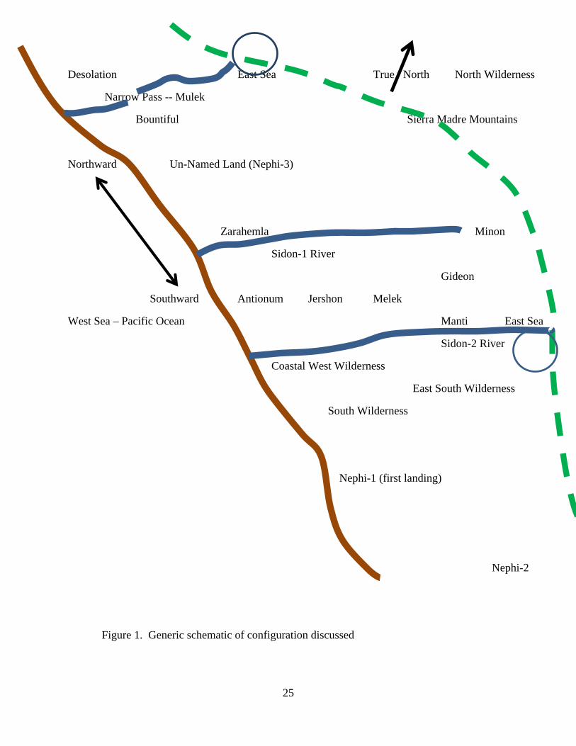
It may be disappointing to learn that there are two Sidon Rivers – the river of Amlici’s battles and the river at Manti. This was not the expected outcome for the last ten years of additional research, but it does provide understanding to what would otherwise be a contradiction. The Manti Sidon-2 river was adjacent to the east/south wilderness. The Amlici Sidon-1 river was immediately adjacent to city Zarahemla – nowhere near the east/south wilderness. The only assumption introduced was the west by northwest orientation following the Pacific coastline in Mesoamerica. As Ted Dee Stoddard states, “the land has the right to dictate the geography” (Stoddard 2010, 5). This was the only required assumption to bring the apparent chaos into understanding. See Figure 1 for a schematic map based on the evidences reported above taken directly from the Book of Mormon. For a very detailed map and a free e-book entitled Mormon Footprint in Mesoamerica see the website MormonTopics.com.
All uses of the name Sidon were examined. Mormon knew there were two Sidon Rivers and at the beginning of every Sidon River series, he provides a tell, letting the readers know which Sidon River is being referenced in the series. This is usually done only once at the beginning of the series. Sidon-1 River is mentioned in Alma 2, 3, 4, 6, 56, and Mormon 1:10. Sidon-2 River is mentioned in Alma 8, 16, 22, 43, 44, 49, and 50.

23
No apologies, Mormon did it and he told us. The other model developers have not yet developed their models with sufficient fidelity and resolution to even recognize and understand that there is a problem.
So what does Sidon mean? One form has to do with “fishing”, with Bethsaida meaning “house of fishing”, and another, Poseidon, being the Greek god of the sea. There is another Hebrew word much closer which is zeydown (pronounced as zay-dohn') meaning “churning, raging, and turbulent.” This description could apply to all of the rivers as they approach and pass through the piedmont toward the Pacific Ocean. Even permitting the ambiguity in the name Sidon, it does appear that it is used only to identify two rivers – one with Manti at the headwaters and bordering on the southeast wilderness and the other running just east of Zarahemla. The two would be respectively, the Michatoya and the Pantaleón (Zacayán).
Dr. Oswaldo Chinchilla Mazariegos informed the author that from Cortés y Larraz's late eighteenth-century Descripción Geográfico-Moral de la Diócesis de Goathemala 1768-1770, it appears that the Pantaleón River was called the Zacayán, which is still the name of a diversion that brings water from the river to Los Tarros and El Baúl (Chinchilla 2012 personal communication).
Zacayán is very close phonetically to Sidon. This generic name “zaydohn” meaning “churning, raging, and turbulent”, used as an adjective not a proper name, could apply to many rivers and easily resolve the problem.
10.0 Conclusions:
Translations and Assumptions:
The seven problems that have prevented other model developers from converging to the correct solution have been identified and solved by direct, literal, English translations from the Book of Mormon with some realism and help from Old Testament Hebrew. The solution to each problem is as follows:
1) The Manti Sidon River flows from an eastward inland sea to the west sea (Pacific Ocean). The name Sidon (zay-dohn'), meaning raging turbulent river, was applied to two different rivers – one in the Amlici story and the other with Manti at the headwaters.
2) Narrow neck of land is nothing more than a bridge across the river that divides the land northward from the land southward.
3) Jaredites, Mulekites, and Lehites all entered Mesoamerica from the Pacific Ocean side.
4) From Hebrew, inland lakes and rivers qualify as east borders by the seashore (Alma 51:25, 26).
5) Alma 22:27 states that the East Wilderness and the Sidon River run parallel to each other from the East Inland Sea to the West Sea (Pacific Ocean).
6) The land of Nephi-1 (the land of their first inheritance), where Lehi’s family landed on the Pacific side, remained a viable center of the Lamanite Kingdom and a credible threat long after Nephi and his followers fled.

24
7) The Hebrew directional reference system is used following the Guatemala coastline.
The Isthmus of Tehuantepec (or any isthmus) has long been thought to be the single greatest trap, focusing model developers on an incorrect feature. Mighty rivers, such as the old Hebrew “Nile sea”, are quite capable of dividing lands and fit better as the place where the sea forms a line dividing lands Desolation and Bountiful.
Further study would indicate that possibly the more damaging problem has been the Index entry with the Sidon River running north to the sea – a problem introduced by someone inserting a personal opinion into the Index of Mormon’s book.
The power of these understandings completely destroys the current leading academic guesses for Book of Mormon lands and city placements. The author has met and chatted with all of the leading model developers and many of the other model developers. Their objectivity is lost. They are not yet willing to take the first step of a twelve step program. Until their objectivity returns, they won’t even understand English.
The verses they cannot wrap their minds around are Alma 22:27-34. When questioned about these eight verses they immediately jump back into the self-justification mode. They won’t look objectively. They immediately start drawing this wilderness or that wilderness as weapons. The truth is that wildernesses are a dime a dozen in Mesoamerica. At times the Lamanites occupied the south wilderness, the east wilderness, and the north wilderness. And the more idle Lamanites worked their way up the west Pacific coastal wilderness. There is nothing sufficiently unique about wildernesses to build a model around.
When the cities and lands are found, compatibility requires: 1) Mormon’s chapter and verse, 2) the known archaeological footprint, and 3) the historical name identification. The wildernesses just fall into place and it becomes very clear why Mormon described them as he did.
25
Desolation East Sea True North North Wilderness
Narrow Pass -- Mulek
Bountiful Sierra Madre Mountains
Northward Un-Named Land (Nephi-3)
Zarahemla Minon
Sidon-1 River
Gideon
Southward Antionum Jershon Melek
West Sea – Pacific Ocean Manti East Sea
Sidon-2 River
Coastal West Wilderness
East South Wilderness
South Wilderness
Nephi-1 (first landing)
Nephi-2
Figure 1. Generic schematic of configuration discussed

26
References:
Allen, Joseph L. 1989. Exploring the Lands of the Book of Mormon. Provo, Utah. Brigham Young University.
Allen, Joseph L. 2008. Exploring the Lands of the Book of Mormon, Second Edition. American Fork, Utah: Book of Mormon Tours and Research Institute.
Campbell, R. Joe. 1997. Florentine Codex Vocabulary. Available http://www.umt.edu/history/NAHUATL/florent.txt, INTERNET.
Chinchilla Mazariegos, Oswaldo. 1998. Pipiles y Cakchiqueles en Cotzumalguapa: La Evidencia Ethnohistórico y Arqueológica. Anales de la Academia de Geografía e Historia de Guatemala LXXII 1998. Guatemala City, Guatemala.
Christenson, Allen J. 2000. Popol Vuh, The Mythic Sections – Tales of First Beginnings from the Ancient K’iche’-Maya. Translated and edited by Allen J. Christenson. Provo, Utah: The Foundation for Ancient Research and Mormon Studies (FARMS), Brigham Young University.
----. 1979. K’iche’ Dictionary. Unpublished manuscript, shared electronically in private communication. Affiliation, The Foundation for Ancient Research and Mormon Studies (FARMS), Brigham Young University, Provo, Utah. Available at FAMSI on INTERNET.
Clark, John E. 1989. A Key for Evaluating Nephite Geographies. Provo, Utah: FARMS Review of Books 1, no. 1:20-70, Brigham Young University.
Cortés y Larraz, Pedro. Descripción Geográfico-Moral de la Diócesis de Goathemala 1768 – 1770. Consejo Superior de Investigaciones Científicas: Madrid, Spain, 2001.
Dibble, Charles E., Arthur J. O. Anderson (translators). 1961. Florentine Codex, General History of the Things of New Spain. Book 10 – The People, by Bernardino Sahagún. Monographs of The School of American Research and The Museum of New Mexico, Number 14, Part XI. Santa Fe, New Mexico: The School of American Research and the University of Utah.
Ejercito 1963. La Muerte de Tecun Uman: Estudio Critico de la Conquista del Altiplano Occidental de la Republica. Editorial del Ejercito 1961: Guatemala City, Guatemala C. A.
Goetz, Delia. 1953. Title of the Lords of Totonicapán. Translated from the Quiche’ text into Spanish by Dionisio José Chonay, English version by Delia Goetz. Norman, Oklahoma: University of Oklahoma Press, 1st ed 1953, fourth printing 1974.
Halloran, John A. Sumerian Lexicon Version 3.0, Internet.
Hauck, F. Richard. 1988. Deciphering the Geography of the Book of Mormon. Salt Lake City, Utah: Deseret Book Company.
Mapa Arqueológíca de la República de Guatemala, 1991. Guatemala City, Guatemala C.A.: Instituto Geografico Militar.
Norman, V. Garth. 2008. Book of Mormon – Mesoamerican Geography: History Study Map. American Fork, Utah: ARCON Inc. with Ancient American Foundation.

27
Parsons, Lee A. 1969. Bilbao, Guatemala, Vol. 1 and 2. Milwaukee Wisconson: Milwaukee Public Museum Press.
Pate, Robert A. 2002. Mapping the Book of Mormon: A Comprehensive Geography of Nephite America. Logan, Utah: Alma Jacob Pate Family.
Pate, Robert A. 2009. Mormon Names in Maya Stone. Logan, Utah: Alma Jacob Pate Family.
Pate, Robert A. 2012. Mormon Key to Maya Code. Logan, Utah: Alma Jacob Pate Family.
Pate, Robert A. 2012. Mormon Footprint in Mesoamerica. Logan, Utah: Alma Jacob Pate Family.
Recinos, Adrian. 1952. Pedro de Alvarado, Conquistador de México y Guatemala. México, D. F. Fondo de Cultura Económica.
Recinos, Adrian. 1953. The Annals of The Cakchiquels. Translated from the Cakchiquel Maya by Adrian Recinos and Delia Goetz. First edition, fourth printing, 1974. Norman, Oklahoma: University of Oklahoma Press.
Sorenson, John L. 1985. An Ancient American Setting for the Book of Mormon. Provo, Utah: Foundation for Ancient Research and Mormon Studies, Salt Lake City, Utah: Deseret Book Company.
Sorenson, John L. 2013. Mormon’s Codex: An Ancient American Book. Provo, Utah: Foundation for Ancient Research and Mormon Studies, Brigham Young University.
Sorenson, John L. 2000. Mormon’s Map. Provo, Utah: Foundation for Ancient Research and Mormon Studies, Brigham Young University.
Stoddard, Ted Dee. 2010. Critical Criteria for Identifying the New World Lands of the Book of Mormon: Implications for the Heartland Model and the Mesoamerican Model. BMAF.com.
The Annals of the Cakchiquels. September 5, 1601. Photocopy of the original Cakchiquel Maya document. Received from Ted E. Brewerton.
The Book of Mormon: An account written by the hand of Mormon upon plates taken from the plates of Nephi. Translated by Joseph Smith, Jun. First English edition published 1830. Salt Lake City, Utah: The Church of Jesus Christ of Latter-Day Saints, 1981.
Van Akkeren, Ruud. 2005. Getting Acquainted with the Pipils from the Pacific Coast of Guatemala: An Ethno-Historic Study of Indigenous Documents and of the General Archives of Central America. En XVIII Simposio de Investigaciones Arqueológicas en Guatemala, 2004 (editado por J.P. Laporte, B. Arroyo y H. Mejia). Museo Nacional de Arquelogía y Etnología, Guatemala.