Embed Size (px)
Citation preview

i
THE NAKAUVADRA COMMUNITY
BASED REFORESTATION PROJECT
Project Design Document
Climate, Community & Biodiversity Standards
Second Edition
September, 2013
Conservation International

ii
ACKNOWLEDGMENTS
Conservation International (CI) would like to thank all of our partners and stakeholders who have
supported the project from its inception and continue to work in collaboration to ensure that
deliverables provide a win-win situation for all concerned. CI acknowledges the vital financial
support of the FIJI Water Company and the FIJI Water Foundation, without which we would not
have been able to carry out this project.
We thank the Provincial Office of Ra, with leadership and support from the Roko Tui Ra of the Ra
Provincial Office whose wisdom and foresight has provided innumerable assistance to the project.
We acknowledge the support of the following chiefs whose ―mana‖ and blessings have allowed the
project to become active in their jurisdiction; the Taukei Vunivau, Taukei Nabukelevu, Tui Vatu and
Tui Navitilevu. We thank all the community members who have been active contributors to the
planning and development of project activities. We also acknowledge the support of the Church, in
particular, the Tokaimalo Methodist Circuit and the Navunibitu Catholic Mission for their guidance
and blessing.
The Commissioner Western and his team of government Officers in Rakiraki town have also
provided policy guidance and programmatic support to ensure that the project is aligned to the
overall Government development strategy for the Province of Ra. In particular we extend our
sincere appreciation to the Conservator of Forest and the West Divisional Forestry Officer for
providing a full time forestry officer on secondment to the project. We also thank the immense input
and guidance we have received from the Department of Agriculture, Extension Division, Rakiraki,
and the assistance of the Landuse Section who provided valuable support in the elaboration of the
Landuse Plans that were developed for the project.
We also acknowledge the assistance of the University of the South Pacific/ Institute of Applied
Science who provided the lead role in coordinating the Rapid Assessment Program (RAP) survey in
the Nakauvadra Range in 2008. We thank the National Trust of Fiji for assisting with the production
of maps and other materials, too many to name.
We also recognize the advice and contribution of the iTaukei Lands Trust Board at the early stages
of the project through the identification of the Province of Ra as a viable reforestation area and
potential project site.
Finally, CI would like to thank the many people who supported the development of this PDD:
CI-Fiji: Susana Tuisese, Isaac Rounds, Vilikesa Masibalavu, Nemani Vuniwaqa
CI-
Headquarters:
Natasha Calderwood, Fabiano Godoy, Agustin Silvani, Curan Bonham, Mario
Chacon, Adam Schoenberg
CI-Japan: Aya Uraguchi

iii
CONTENTS
Acronyms ....................................................................................................................................... iv
Introduction ..................................................................................................................................... 1 I. General Section: .......................................................................................................................... 2 G1 Original Conditions at Project Area ............................................................................................ 2 G2 Baseline Projections ................................................................................................................. 29 G3 Project Design & Goals ............................................................................................................ 39 G4 Management Capacity and Best Practices .............................................................................. 68 G5 Legal Status and Property Rights ............................................................................................. 78 II. Climate Section ........................................................................................................................ 82 CL1 Net Positive Climate Impacts .................................................................................................. 82 CL2 Offsite Climate Impacts (―Leakage‖) ....................................................................................... 90
CL3 Climate Impact Monitoring ...................................................................................................... 91
III. Community Section ................................................................................................................. 97 CM1 Net Positive Community Impacts ........................................................................................... 97
CM2 Offsite Stakeholder Impacts................................................................................................. 103
CM3 Community Impact Monitoring ............................................................................................. 105
IV. Biodiversity Section ............................................................................................................. 110
B1 Net Positive Biodiversity Impacts ............................................................................................ 110 B2 Offsite Biodiversity Impacts ..................................................................................................... 114 B3 Biodiversity Impact Monitoring ................................................................................................ 115 V. Gold Level Section ................................................................................................................. 119 GL1. Exceptional Biodiversity Benefits ........................................................................................ 119 References .................................................................................................................................. 120 List of Figures ............................................................................................................................. 123 List of Tables .............................................................................................................................. 125 List of Appendices ..................................................................................................................... 126

iv
ACRONYMS
AFOLU
A/R
ALTA
CA
CBD
CCBS
CDM
Agriculture, Forestry and Other Land Use
Aforestation / Reforestation
Agricultural Landlord and Tenant Act
Community Agreement
Convention on Biological Diversity
The Climate, Community and Biodiversity Standards
Clean Development Mechanism
CI
CITES
CTTT
DoF
FPC
GIZ
HCV
ILO
Conservation International
Convention on the International Trade of Endangered Species
Carbon Trading Technical Team
Department of Forests
Fiji Pine Comission
German Technical Cooperation
High Conservation Value
International Labor Organization
IPCC
IUCN
KBA
NBSAP
NLC
NLTB
Intergovernmental Panel on Climate Change
International Union for the Conservation of Nature
Key Biodiversity Area
National Biodiversity Strategy Action Plan
Native Land Commission
Native Land Trust Board
NGO
NTF
PAC
PDD
PLA
RAP
RNL
SPRIG
UNFCCC
USP
VCS
WAF
YMST
Non Governmental Organization
National Trust of Fiji
Protected Area Committee
Project Design Document
Participatory Learning Approach
Rapid Assessment Program
Register of Native Lands
South Pacific Regional Initiative on Forest Genetic Resources
United Framework Convention on Climate Change
University of the South Pacific
Verified Carbon Standard
Water Authority of Fiji
Yaubula Management Committee
1
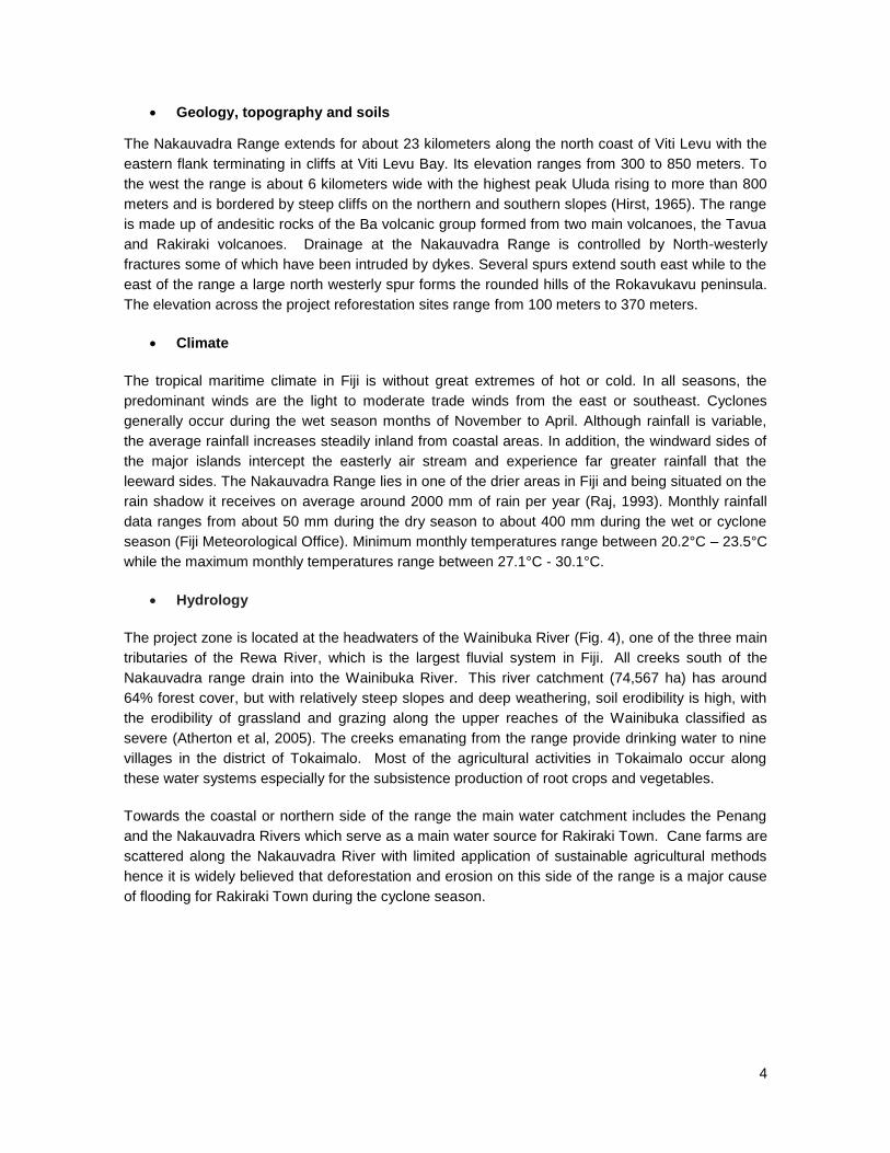
INTRODUCTION
The Nakauvadra Community Based Reforestation Project in Fiji has been developed by
Conservation International (CI), and funded through the support of FIJI Water. The project is
located on the northern tip of Viti Levu in the Province of Ra. It is comprised of 1,135 ha of
reforestation plots along the Southern and Northern slopes of the Nakauvadra Range, a 11,387 ha
forest refuge that has been designated as a Key Biodiversity Area (KBA) and is earmarked as a
priority site in Fiji‘s proposed protected area network.
The project‘s main objective is to develop a multiple benefit, community based reforestation project
that:
Reforests an area of 1,135 ha which results in the sequestration of at least 280,000 tCO2
over the 30 year project lifespan, validated and verified to the Climate, Community and
Biodiversity Standards (CCBS);
Increases forest cover around the Nakauvadra Range to expand critical habitat for
endangered and endemic species living there, and enhances forest connectivity with other
adjacent forest blocks;
Enables local landowners to benefit from job creation, increased revenue, and the
enhancement of livelihoods in both the short and long term.
The project incorporates a community-based reforestation model, planting hardwood timber species
on 28% of the total area which can be sustainably harvested upon reaching maturity to provide for
long term income generation for the landowning communities. Reforestation of the remaining 72%
of the project site will be using native and endemic species, to reforest areas on the steeper slopes
of the Nakauvadra Range which will expand forest habitat and create a ‗green wall‘ around the
more pristine upland and cloud forest ecosystems that are found in the rugged and higher elevation
areas of the Range. The reforestation sites have been strategically identified to ensure the creation
of new forest patches that are envisaged in the long term to help establish a conservation corridor
between the Nakauvadra Range and nearby Wabu/Tomaniivi Range, 4kms away on the south
western flanks of Nakauvadra.
As part of the livelihoods component of the project, CI has worked extensively with communities
and farmers in the project zone to provide training and support in the development of new livelihood
enterprises and sustainable agricultural practices, and has included the distribution of thousands of
seedlings to encourage crop diversification, with fruit plants and traditional root crops to benefit
families and improve food security.

2
GENERAL SECTION
G.1 ORIGINAL CONDITIONS IN THE PROJECT AREA
General Information
G.1.1 The location of the Project and basic physical parameters.
The Republic of Fiji consists of approximately 300 islands located roughly 3,000 km east of
Australia in the Pacific Ocean. The two largest islands, Viti Levu (10,544 km²) and Vanua Levu
(5,535 km²) comprise 88% of the total land area. The Nakauvadra Community Based Reforestation
Project is located on the northern tip of Viti Levu in the Province of Ra. It is comprised of 1,135 ha
of reforestation sites scattered along the Southern and Northern slopes of the Nakauvadra Range,
a 11,387 ha forest refuge that has been designated as a Key Biodiversity Area (KBA) and is
earmarked as a priority site in Fiji‘s proposed protected area network. The project‘s reforestation
sites have been strategically chosen to help establish a buffer area around the Nakauvadra Range
and to promote the development of a conservation corridor with adjacent forest blocks, the closest
being the Tomaniivi/Wabu Forest Reserve (4 kms to the south).
The Nakauvadra Range is divided amongst approximately 75 traditional landowning units (mataqali)
that are based in three districts (tikinas): Tokaimalo, Naroko and Naiyalayala. The reforestation
plots are all found within these districts, with a few additional sites located in the neighboring district
of Rakiraki (Fig. 3).
Figure 1: The Nakauvadra Range

3
Figure 2: Project location on the northern tip of Viti Levu.
Figure 3: Map showing the geographical location of the Nakauvadra Range and district boundaries.
4
Geology, topography and soils
The Nakauvadra Range extends for about 23 kilometers along the north coast of Viti Levu with the
eastern flank terminating in cliffs at Viti Levu Bay. Its elevation ranges from 300 to 850 meters. To
the west the range is about 6 kilometers wide with the highest peak Uluda rising to more than 800
meters and is bordered by steep cliffs on the northern and southern slopes (Hirst, 1965). The range
is made up of andesitic rocks of the Ba volcanic group formed from two main volcanoes, the Tavua
and Rakiraki volcanoes. Drainage at the Nakauvadra Range is controlled by North-westerly
fractures some of which have been intruded by dykes. Several spurs extend south east while to the
east of the range a large north westerly spur forms the rounded hills of the Rokavukavu peninsula.
The elevation across the project reforestation sites range from 100 meters to 370 meters.
Climate
The tropical maritime climate in Fiji is without great extremes of hot or cold. In all seasons, the
predominant winds are the light to moderate trade winds from the east or southeast. Cyclones
generally occur during the wet season months of November to April. Although rainfall is variable,
the average rainfall increases steadily inland from coastal areas. In addition, the windward sides of
the major islands intercept the easterly air stream and experience far greater rainfall that the
leeward sides. The Nakauvadra Range lies in one of the drier areas in Fiji and being situated on the
rain shadow it receives on average around 2000 mm of rain per year (Raj, 1993). Monthly rainfall
data ranges from about 50 mm during the dry season to about 400 mm during the wet or cyclone
season (Fiji Meteorological Office). Minimum monthly temperatures range between 20.2°C – 23.5°C
while the maximum monthly temperatures range between 27.1°C - 30.1°C.
Hydrology
The project zone is located at the headwaters of the Wainibuka River (Fig. 4), one of the three main
tributaries of the Rewa River, which is the largest fluvial system in Fiji. All creeks south of the
Nakauvadra range drain into the Wainibuka River. This river catchment (74,567 ha) has around
64% forest cover, but with relatively steep slopes and deep weathering, soil erodibility is high, with
the erodibility of grassland and grazing along the upper reaches of the Wainibuka classified as
severe (Atherton et al, 2005). The creeks emanating from the range provide drinking water to nine
villages in the district of Tokaimalo. Most of the agricultural activities in Tokaimalo occur along
these water systems especially for the subsistence production of root crops and vegetables.
Towards the coastal or northern side of the range the main water catchment includes the Penang
and the Nakauvadra Rivers which serve as a main water source for Rakiraki Town. Cane farms are
scattered along the Nakauvadra River with limited application of sustainable agricultural methods
hence it is widely believed that deforestation and erosion on this side of the range is a major cause
of flooding for Rakiraki Town during the cyclone season.

5
Figure 4: Hydrology map of the headwaters of the Wainibuka River.
G.1.2 Types and condition of vegetation within the project area.
The range of mountains comprising Nakauvadra are comprised of a mix of disturbed vegetation,
such as grasslands, pine plantations, and agroforests on the relatively flat and accessible land near
villages. Native lowland forest, upland forest and cloud forest occur in the higher elevation areas of
the Range (Fig. 6).
The project reforestation areas are located on the degraded talasiga grasslands that cover the
lower elevations and slopes of the Nakauvadra range as shown in Figure 5. The term talasiga (―sun
burnt land‖ in Fijian) is the term applied to the fire-modified and fire-degraded grasslands and fern
lands that cover much of the dry side of the larger Fijian islands (Parham 1972, Smith 1979).
Reestablishment of native tree species in these areas has not been able to occur due to a
combination of occasional fires and poor soil fertility. Talasiga covers about a third of the area of the
two main Fijian islands, Viti Levu and Vanua Levu, mostly in the poorer eroded dry zones on the
western sides of these islands. The lower elevation fringes of the Nakauvadra range are covered
with talasiga vegetation especially along the slopes and ridges (between 50 – 300 meters m.a.s.l);
lowland forest lies between 350 – 700 m.a.s.l, with the upper elevations (700 – 850 m.a.s.l) being
covered with upland and cloud forest.
The flora is dominated by hardy fire-resistant ferns and alien herbaceous species, mostly grasses.
Mueller-Dombois and Fosberg (1998) divided this plant community into several associations, based
upon which fern or grass species dominate. The two dominant grass species are typically
Sporobolus indicus and Dichantium caricosum with an occasional patch of the Pennisetum

6
polystachyon. Approximately 50 other species are also found but none of them with any abundance
approaching that of the two above-mentioned grasses. Creek valleys may have vegetation including
the commonly introduced Albizia saman, Albizia lebbeck and Mangifera indica, and the native
Elattostachys falcata, Alstonia vitiensis, Glochidion seemannii, Alphitonia spp. and Mussaenda
raiateensis.
Areas around the project sites are also heavily colonized in patches by the introduced invasive
species Piper aduncum. In Fiji, Piper aduncum is an aggressive exotic species found from sea level
to 400 metres, mostly along roadsides and in thickets, but also sometimes in secondary forest or on
forested ridges and rarely intact rain forest (Smith, 1981).
Figure 5: Typical grassland vegetation in the project area.
Figure 6: Vegetation map within the districts of Tokaimalo, Naiyalayala, Rakiraki and Naroko.

7
G.1.3 Boundaries of the project area and the project zone.
The total project area encompasses 1,135 ha. This currently includes 51 individual reforestation
sites spread across the districts of Tokaimalo, Naiyalayala, Naroko and Rakiraki. We anticipate an
additional 8 plots of various sizes to be established by June 2014 to complete the project area.
These areas have already been identified through consultations between the respective landowners
and the project team, and their spatial locations have been identified in Fig 7. Once the
reforestation activities are about the begin, the exact reforestation boundaries where the planting
will take place will be recorded by GPS and included in the project monitoring plan.
The boundaries of each reforestation site are also cross checked against the native lands registry to
confirm ownership. Extensive consultation with community landowners to determine the appropriate
location for the reforestation areas, based on a balanced consideration of conservation and
community development objectives, has been central to the project.
The project zone boundary (Fig. 7) includes the districts of Tokaimalo, Naiyalayala, and Naroko as
these are the districts within which the Nakauvadra Range lies. As part of the project design
process, participatory land use consultations and plans have also been carried out at a district-wide
level. Three of the reforestation sites, totaling 56 ha, are located in the district of Rakiraki,
immediately adjacent to Naiyalayala. Because of the small reforestation area this represents, the
project zone boundary therefore incorporates the land owned by the mataqali in this area but does
not include the full district within the project zone.
Figure 7: Map showing the boundary of the project zone and the reforestation areas.

8
Climate Information
G1.4 Current carbon stocks within the project area.
The carbon stock calculations were developed in accordance with the approved Clean
Development Mechanism Methodology, AR-ACM0003 Version 01.0.0: A/R Large-scale
Methodology: Afforestation and reforestation of lands except wetlands. The project meets the
following applicability conditions of the methodology:
(a) The land subject to the project activity does not fall into wetland category;
The land subject to the project lies on slopes in one of the drier areas in Fiji and is not covered or
saturated by water and not categorized as wetland.
(b) Soil disturbance attributable to the A/R CDM project activity does not exceed 10% of area in
each of the following types of land, when these lands are included within the project boundary:
(i) Land containing organic soils as defined in “Annex A: Glossary” of the IPCC GPG LULUCF
2003;
The FAO digital soil map of the world version 3.6 classified soil of the project region as Eutic
Cambisols (FAO, 20031). Average organic carbon contents in topsoil (0-30 cm) and subsoil
(30-100 cm) in Eutic Cambisols were calculated as 1.07% and 0.57%, respectively (FAO,
2003). Since the soil is never saturated with water for more than a few days, the minimum
organic carbon content with which a soil is considered to be organic is 20% (IPCC GPG
LULUCF, 2003). The land subject to the project does not contain organic soils.
(ii) Land which, in the baseline, is subjected to land-use and management practices and
receives inputs listed in annexes 1 and 2 to this methodology;
The project region is categorized as Tropical dry forest. Some areas of land have been used
for sugarcane cultivation in the past and the others are abandoned / set aside after being used
for grazing. Therefore, no land inside the project boundary is subjected to land-use and
management practices and receives inputs listed in annexes 1 and 2 of AR-ACM0003.
(c) The pools selected for accounting of carbon stock changes in the project activity are the same
as the pools for accounting of carbon stock changes in the baseline.
Above- and below ground pools have been selected for accounting carbon stock changes both in
the project scenario and in the baseline.
A field survey was conducted within the project boundary to estimate the existing carbon stock of
woody perennials and grassland (Annex 1). This field data was collected in accordance with peer
reviewed field measurement processes and is in accordance with the general guidance for
estimating baselines in grasslands published by the IPCC (IPCC, 2006). Default values suggested
1 http://www.fao.org/geonetwork/srv/en/metadata.show?id=14116

9
by the IPCC were not considered appropriate due to the grassland vegetation having siginificant
areas of Piper anduncum. This field measuring approach leads to a conservative baseline
estimation which is also in accordance with IPCC good practice guidance (IPCC, 2006). This study
found that the carbon stock in the living biomass of woody perennials and the belowground biomass
of grasslands was 83.7 tCO2-e / ha at the upper limit of the 95% confidence interval.
Community Information2
G1.5 Description of communities located in the project zone.
Fiji has four administrative divisions divided into 14 i-Taukei Indigenous Provinces that provide
administrative support to resource allocation and development among the indigenous Fijian
population by the iTaukei Affairs Board. Each Province is governed by provincial council and
headed by the Executive Head called the Roko Tui. Central government agencies in each Province
coordinate policy programs with the Roko Tui hence the 14 i-Taukei Provinces align administrative
programs and policy to the Government Administrative Division. A sub unit of the Province is the
tikina or district. The most basic administrative unit in modern Fijian community is the village (koro),
led by a village headman.
Historical, cultural and religious characteristics
As described in G1.3, the project zone is located in the Province of Ra, which has a population of
24,512 people according to the latest 2007 census3, and where more than 50% of the population is
living below the poverty line (World Bank, 2011). The zone covers 26 villages in the tikinas
(districts) of Tokaimalo, Naiyalayala, Naroko and Rakiraki. These communities are considered to be
descendants of indigenous Fijians believed to have arrived in Fiji from western Melanesia
approximately 3,500 years ago. The Nakauvadra Range itself which spans across the middle of
these districts is very prominent in iTaukei cultural history and identity. Certain oral historical
accounts relate the arrival of the first group of iTaukei (indigenous Fijian) to this area. A popular
legend has it that the first iTaukei landed at Vuda point near Lautoka in a canoe called the
‗Kaunitoni‘ led by one ‗Lutunasobasoba‘. From there the people moved inland and settled at
Nakauvadra. Many iTaukei also believe that Nakauvadra is the home of ‗Degei‘, a supreme and
legendary being.
Historical and archival evidence also indicate the existence of an ancient and populous civilization
that existed along the Nakauvadra mountain range. These communities were engaged in
subsistence gardening using terracing in some areas. From here, some people began to migrate
and settle in other parts of the Fijian islands. Today many iTaukei still trace their ancestral links to
Nakauvadra where most traditional and social relationships relating to notions of ‗mataqali‘, or
‗tauvu‘ originated. These existing relationships seem to support the myths relating to Nakauvadra
as being the area that indigenous Fijians first settled. Consequently, the Nakauvadra Range is still
regarded by most Fijians to be a sacred (root) place.
2 The socio-economic information provided in this section is largely based on the results of the socio-economic
surveys and landuse planning workshops carried out in the project zone. The reports and data will be made available to the validation body. 3 http://www.statsfiji.gov.fj/Key%20Stats/Population/1.8Rural%20pop%202007.pdf

10
Traditional Fijian society is based on communal principles derived from village life. People in
villages share the obligations and rewards of community life and are still led by a hereditary chief.
They work together in the preparation of feasts and in the making of gifts for presentation on
various occasions, and they all help in communal activities such as the building of homes and
maintenance of pathways and shared agricultural lands. This serves to act as a caretaking system
that allows no-one to go hungry or uncared and provides a communal sense of identity and
belonging. However, this can also be restrictive for the individual and serve to hamper
entrepreneurial spirit and competition in the marketplace.
Traditional relationships and respect for leadership lines of authority is still strong in the tikinas
where the project is located. Each village has a chief but there are also paramount chiefs who
reside in one village and have traditional leadership authority over other villages under the same
landowning area. Tikina Tokaimalo has two paramount chiefs. The two chiefly mataqali are Kaka at
Nailawa village and Dreketi at Nayaulevu village. The paramount chief of Kaka is known as ‗Taukei
Nabukelevu‘ and he traditionally governs three villages, namely Nailawa, Mataveikai and Balabala.
The other eight villages come under the traditional leadership of chief ‗Taukei Vunivau‘. Tikina
Naiyalayala has only one paramount chief known as ‗Tui Vatu‘ and he resides at Drauniivi village.
Tikina Naroko does not have a distinct paramount chief but the villages have their own assigned
chiefs.
Religion plays a very important part in the life of Fijians, and largely runs along ethnic lines. In the
project zone, a total of seven Christian denominations exist, with the Methodist Church having the
largest congregation (over 50%), followed by the Catholic Church. In villages, the church and
ministers are highly respected and hold a great deal of influence within the social fabric of the
community.
Villages
There are 26 villages located within the project zone (Fig. 8). Not all the villages are landowners
within the Nakauvadra Range so reforestation agreements and activities are only being carried out
in conjunction with those villages that have property rights for the areas that have been identified as
being priority sites for reforestation. Nabalabala, Vunisea, Nayaulevu, Naraviravi, Naivutu,
Navuniyaumunu, Navavai, Narauyaba and Maniyava in Tokaimalo; Vatukacevaceva, Rewasa,
Drana, Narara and Nanokonoko in Naroko; Naseyani and Nananu in Naiyalayala; and
Vatusekiyasawa in Rakiraki. The remaining villages are included within the livelihoods component
of the project, and are involved in the development of model farms and other livelihood
diversification initiatives such as the planting of traditional varieties of root crops, fruit trees,
sandalwood and pandanus, bee keeping and aquaculture. These communities include Nailawa and
Namataveikai in Tokaimalo; Draunivau, Vaidoko and Naboutolu in Naroko and Togovere, Drauniivi,
Rabulu and Narauyaba No II in Naiyalayala.

11
Figure 8: Location of communities in project zone.
Demography
There are nearly 30,000 people living in the Province of Ra, of which an estimated 5,000 people
reside in the town of Rakiraki. In order to collect the community baseline information and assess
development needs at a local level which would guide project design and implementation, three
socio-economic surveys and participatory landuse workshops were carried out in the districts of
Tokaimalo, Naroko and Naiyalayala. A total of 396 households (representing 1,937 persons) were
surveyed in villages across the project zone. According to the 2007 population census, the
population in Ra between the ages of 1-24 is 49%; 25-49 years, 27% of the total. This was also
evident during the socio-economic survey in which the ratio of men and women in the villages was
also estimated to be roughly half.
Education
Fiji has a good system of education compared with most of its neighbors and is a center for learning
in the South Pacific. Enrollment is nearly 100% for primary-school children (World Bank, 2009), and
tuition for grades one to eight is free. In most rural schools, classes are taught in the pupil's native
tongue and in English for the first few years until students have an understanding of the English
language to make it the medium of instruction. Thus nearly everyone - except some of the older
generation - speaks English.
Within the project zone, most villagers have attained primary level education. In the districts of
Naroko and Naiyalayala approximately 40% of the population has attended secondary school, with

12
many students attending schools in the Rakiraki area. The level of education within Tikina
Tokaimalo is lower, with a high school dropout rate of approximately 60% after primary school. The
only primary school in Tokaimalo provides boarding facilities for its young student population
ranging from the age of 5 – 13 years. While no studies have been carried out to understand the
reason behind the high level of high-school drop in Tokaimalo, the fact that there is no secondary
school in the district, coupled with poor transportation links and rough terrain to reach the nearest
school in Rakiraki district, would suggest that this acts as a major disincentive for students to stay
in school.
Health
Health centers are located in all the tikinas. Minor illnesses and injuries are treated in the health
centers while serious cases such as births and emergencies are transferred to the Rakiraki
Hospital. There are village nurses in every village who are appointed and trained by the Ministry of
Health to attend to minor cases.
Livelihood systems
Agriculture (especially farming) is the dominant source of livelihood, with the forest as source of
supplemental income and food. There is a clear distinction between the actual landuse and the
potential land uses that are determined in accordance to land classification and fertility maps
produced by the Ministry of Agriculture. The discrepancy is not uncommon as there is no legislation
that ensures that land is used specifically in accordance to its landuse classification and potential.
Commercial agricultural production (sugarcane belt) generally sweeps the coastal foreshore to the
lower slopes of the Nakauvadra Range while subsistence farming occurs predominantly from the
midslopes to higher terrain.
Unlike many other countries beyond the South Pacific region, land tenure in Fiji is almost
exclusively under communal ownership. Of the total land area, 7% is Crown Land, 10% is held as
freehold and the iTaukei landowning units (native land) hold 83%4. Given the small portion of state
and freehold land and the need for land to engage in agricultural production, native land, which is
inalienable, was opened up for agricultural expansion through leasing arrangements. Such land
were leased out to tenants under the provision of the 1880 Native Land Ordinance, then through the
Native Land Trust Board and the Native Land Trust Act of 1940, and later under the Agricultural
Land Ordinance of 1966 and the Agricultural Landlord and Tenant Act (ALTA) of 1976 (Naidu,
2002).
As a result, sugarcane farming is the key agricultural activity in the Province of Ra but only covers a
small proportion of the land in the project zone due to the limited availability of arable land (see
G2.1). Most of this sugarcane area is not cultivated by the native landowners themselves but leased
to tenant farmers planting sugar either on a semi commercial or commercial scale. The majority of
this population is Indo-fijian who live in homes built on their leased lands. Some of these tenants
have been living in the area for more than 40 years. Very close relationships with the iTaukei
landowners have developed during the years when their grandparents settled there. Sugar cane is
a labor intensive crop and during peak activity seasons such as harvesting, it is the landowners
themselves who provide the tenant farmers with manual labor to harvest their cane.
4 See the Department of Town and Country Planning website:
http://www.townplanning.gov.fj/index.php/planning/planning-issues/land-tenure

13
The majority of native landowner farmers in the project zone are subsistence farmers, planting a
range of crops and vegetables and some rearing livestock. The choice of crops is limited by soil
fertility, topography and climatic conditions. Vegetables are normally planted next to homes and
mostly on alluvial flats for easy access to water and transportation. The most common vegetables
planted include cabbage, beans, carrot, okra, eggplant, chilies, bele, rourou, and maize. Other
traditional crops such as banana, cassava, sweet potato and yams are planted for subsistence use,
and social or religious obligations.
Shifting cultivation is widely practiced as farmers move to new land after two to three cropping
sequences. The planting cycle generally involves vegetables, dalo or cassava followed by a fallow
period, or dalo, cassava then fallow. Slash and burn agriculture is still widely practiced even
though the area is vulnerable to fire due to the extensive coverage of grasslands. Most farmers
also own dairy cows, cattle, poultry and pigs to provide an alternative source of income and diet to
their families. All three districts have rivers and creeks flowing through them which provide the
community with a source of food and income (fish and prawns).
As subsistence farming is the main livelihood for the majority of the iTaukei landowners in the
project zone, annual household income is low. Data from the socio-economic surveys conducted
estimated that 70% of the households surveyed are living on less than FJD$ 5,000 a year (US$
2800), (Table 1).
Table 1: Annual household incomes in project zone.
Household (HH) Income per year
F$ Tikina Tokaimalo Tikina Naroko Tikina Naiyalayala Total Project Zone
No HH % No HH % No HH % No HH %
>25,000 2 1 1 1 6 4 9 2
>15,000 3 2 5 5 9 6 17 4
>10,000 8 6 10 9 13 9 31 8
>5,000 22 16 18 17 22 16 62 16
<5,000 109 75 73 68 96 65 278 70
total 144 100 107 100 146 100 397 100
In general, nearly all the local communities living around the Nakauvadra Range make use of the
forest and the services it provides to meet some of their livelihood needs. Villagers fish for prawns
and eels in almost all the rivers and creeks which flow out from the Range, mainly for subsistence
consumption, with extra catch being sold at local markets at a reasonable price. Forested areas on
the lower to mid slopes contain many seasonal native and introduced fruit trees, including pawpaw,
banana, oranges, kavika (Malay apple), mango, ivi (Tahitian chestnut) and coconut. Villagers
harvest and collect these for personal consumption and to sell at local markets. Pig hunting is
practiced in nearly all the villages but is not as common a practice as it was historically due to the
increased accessibility of shops for meat and other household needs. Hunting is mainly carried out
by a few individuals who dare to travel long distances into the Nakauvadra Range forest. Pigs that
are caught supplement the family meal, are sold for meat or used in traditional ceremonial
functions.
Forests are also a source of fuelwood or construction timber. Fuelwood is sourced from the fringes
of forest near villages while construction timber is harvested from pine woodlots that are scattered
around the periphery of the Nakauvadra Range. It is also worth noting that the upper Nakauvadra

14
Range is considered to be Fiji‘s most sacred traditional site and in mythology was Fiji‘s ―Olympus‖ –
the symbolic home of Fiji‘s ancestral Gods. As a result, taboo over logging or clearing of the upper
Nakauvadra Range is a traditional norm among the communities that live in its vicinity.
G1.6 Description of current land use and customary and legal property rights including
community property in the project zone.
Following the completion of the socio-economic surveys, landuse planning workshops were held in
each district. The objective of this was to identify all available resources and land use practices in
each tikina, evaluate resource development pathways and integrate conservation goals and
development needs. Further elaboration on this consultation process is provided in section G3.8. In
addition to the participation of local communities, representatives of the Department of Agriculture
(Extension and Land use Section), Department of Forest (Extension and Forestry Training School,
Ministry of Cooperatives) and the Ra Provincial Council and University of the South Pacific, Institute
of Applied Science (USP/IAS) also took part. The full analysis and conclusions of these workshops
are presented in the Tikina Landuse Plans. A summary is provided below.
Historical land use
The programme of direct government investment in agricultural development through the 1970s and
80s has impacted land use change and forest cover in the project zone. The government policy to
reduce a dependence on imported food and to achieve its objective to close the economic gap
between urban and rural people, led to a series of major loan and grant funded projects to increase
production in rice, beef, dairy and feed grains (Foraete, 2001). While the program was well funded
and supported through the provision of project managers, extension staff and in some cases import
tariffs and licenses, farmers and others in the private sector were unable to meet planning targets.
There were several reasons for this: targets were set too high; government service provision was
generally inefficient; the incorrect assumption was made that Fijian semi-subsistence farmers would
quickly acquire the attitude of commercial farmers during projects; and political upheavals occurred
in 1987 (Foraete, 2001).
Tikina Tokaimalo is an example of this, as it was once the site of a commercial beef scheme. The
Uluisaivou cattle scheme intended to build up a herd of 1000 cattle from New Zealand and was
begun in the early 1970‘s, funded by the New Zealand government. The Project failed miserably
after 20 years due to a number of factors including mismanagement and theft of the cattle stocks.
Sugar cane production was also very dominant within the three districts from around 1960 to 1980.
This was then followed by a steady decline in production (Oxfam, 2005) mainly due to the
introduction of other economically important crops such as vegetables and pulses, the high costs of
transportation to the mills, soil erosion and land degradation.
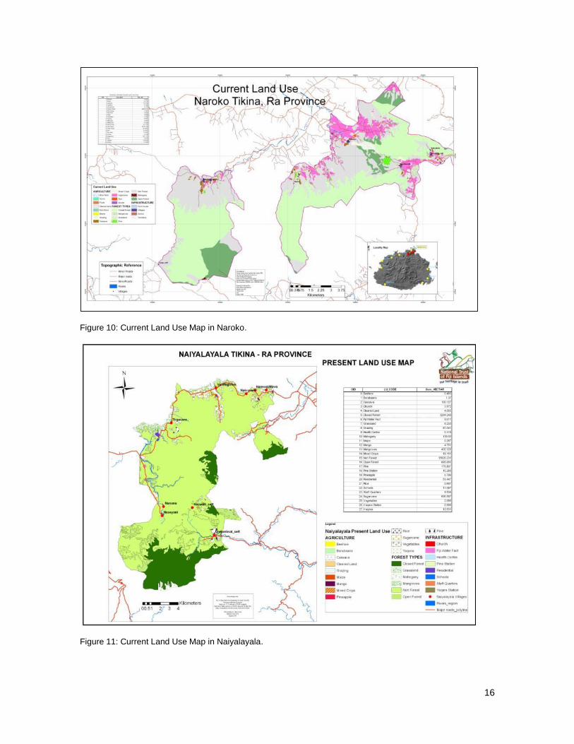
Current land use
In terms of land area Naiyalayala covers the largest area (20,117ha) while the other two districts
each cover a little over 10,000ha. Based on the results of the Land Use Planning workshops, all
three districts were found to have very limited arable land, with Naiyalayala having the highest
percentage at 17%, Naroko 13% and Tokaimalo 9%. This analysis was based on soil maps / land

15
classification zones identified by the Ministry of Agriculture5 (see G2.1). A summary of the land use
allocation is provided below.
Tikina Tokaimalo: Out of the total land area 50% is still forested (closed and open forest). Only
about 4% of the total area is used for agriculture, mainly for small scale mixed cropping. Pine and
mahogany plantations still remain (pine 10% of the area, mahogany 1%) although the Fiji Pine
Commission has indicated that they will not harvest the remaining trees (pers. comm.). A further
35% of the land is abandoned grassland, some of which will be used for the project reforestation
activities.
Tikina Naroko: 58% of the land is forested. Agriculture occupies about 9.5% of which more than 7%
is mainly under sugar cane. The Penang Sugar Mill is located in Naroko and is one of the reasons
why sugar cane is more predominant compared to other agricultural commodities. Pine and
mahogany plantations occupy less than 1% of the area. About 32% of the area is vacant land.
Tikina Naiyalayala: Out of the total land area, 72% is vacant grasslands and 21% forest.
Agriculture utilizes only 4%. Pine and mahogany cover less than 1% of the area. Although
Naiyalayala has the most arable land, climatic conditions limit its productivity. The seasonal long
dry spells limit the choice of crops available to plant.
Maps outlining the current land uses in each district are presented below, and further information
can be found in the Land Use Plans.
Figure 9: Current Land Use Map in Tokaimalo.
5 http://gallery.agriculture.org.fj/pdf/Land%20Use%20Capability%20Guideline.pdf
16
Figure 10: Current Land Use Map in Naroko.
Figure 11: Current Land Use Map in Naiyalayala.

17
Property rights
Eighty-three percent (83%) of land in Fiji is is classified as Native Lands. Lands under this
customary land tenure system work on the principle of communal ownership of a land parcel that
has already been topographically surveyed, charted on Native Land Commission (NLC) Maps, and
registered in the Register of Native Lands (RNL) (Ministry of Lands and Mineral Resources, 2010).
Under this system land and communal land owners are registered, with no individual titles being
issued. Ownership of land is therefore vested in the mataqali or tribal group. These lands can only
be leased and cannot be purchased outright. Fijian citizens of other ethnicities can only
legitimately make use of these resources if the ethnic Fijian owners give permission to do so. The
iTaikei Land Trust Board (iTLTB) was set up in 1940 to act on behalf of landowning mataqali to
secure, protect and manage land ownership rights and facilitate commercial transaction for its use.
The advantages of the customary tenure system for the taukei is that it has firstly, prevented
outright land sales and land speculation, and thus has ensured that they have not become a
landless people in their own land. Secondly, it has helped the taukei to maintain their land-based
customs and traditions, which are based fundamentally on the maintenance of family and kinship
ties, and ultimately on the basic principles of sharingand caring.
The project reforestation sites are all on native land owned by different mataqali. Community
Agreements (CA) have been signed with each landowning unit. The CA provides guidance and
understanding on the roles and responsibilities of each party during the project lifetime. According
to the agreement, each mataqali gives full consent to Conservation International to carry out the
reforestation project on their behalf and grants access to their land for such purposes.
As property rights are very clearly delineated, and each mataqali‘s land has been surveyed and
independentely verified and registered in the RNL, there are no ongoing or unresolved disputes
over land tenure in the project zone.
Box 1 below outlines the traditional Fijian social and governance structure, and a glossary of the
main terms used.
Box 1: Fijian Social Units and Glossary of Frequently Used Terms
Confederation, State Matanitu
Federation Vanua Vanua
Tribe Yavusa Yavusa Yavusa Yavusa
Clan Mataqali Mataqali Mataqali Mataqali
Extended Family Tokatoka Tokatoka Tokatoka Tokatoka Tokatoka

18
Matanitu: A traditional Fijian confederation of Vanua.
Vanua: A traditional Fijian political unit, usually consisting of a few villages under a single chief, usually with a distinctive language and culture
Yavusa: The largest kinship group consisting of people descended from a single vu – an ancestor god.
Mataqali: Fijian kin group, officially a subdivision of a yavusa and designated as the landowning unit.
Tokatoka: Subdivision of a mataqali, the basic landworking unit, often comprising a group of several brothers living the same village in separate households.
Tikina: Subdivision of a province – a Fiji Government administrative unit.
Native Land: Land above high-water mark, not being freehold nor owned by the State in accordance with the provisions of the Crown Lands Act. It comprises approximately 83% of the total landmass in Fiji.
Reserve Land: Native land set aside and proclaimed as such under the provisions of the Native Land Trust Act. Reserve Land cannot be leased. De-reservation can occur provided there is ‗good cause‘ and with the consent of the landowners.
Freehold Land: Land owned privately and exclusively by the title holder who may dispose of it in any manner he wishes.
State Land: State Land comprises Schedule A, Schedule B, State Freehold, State Fore- shore and State Land without Title. Schedule A and Schedule B land are held by the State in trust for indigenous landowners.
Biodiversity Information
G1.7 Description of current biodiversity within the project zone.
In November 2008, CI Fiji, together with the South Pacific Regional Herbarium, the University of the
South Pacific, the National Trust of Fiji, the Fiji Department of Forests, the National Trust of Fiji,
Wetlands International Oceania and the Fiji Museum carried out a Rapid Assessment Program
(RAP) survey6 in the Nakauvadra Range (Fig. 12). The survey was undertaken as part of the
process to facilitate conservation initiatives within the Yaqara and Nakauvadra watersheds, and to
provide an ecological baseline assessment of this important forest ecosystem. The information
regarding biodiversity within the project zone is therefore largely based on the results of this work. A
summary of the main results and findings are given below. The full report is attached as Appendix
2.
A RAP is a biological inventory method used to quickly assess the biodiversity of areas using
criteria such as: species richness, species endemism, rare or threatened species and habitat
condition. One of the key goals of this RAP was to collect baseline data on the diversity of the
terrestrial flora and fauna in the Nakauvadra Range, to identify potential threats to biodiversity and
suggest conservation recommendations.
In total the RAP survey documented 520 confirmed species, including a number of rare and
endangered species .The discovery of the endangered Fiji Ground frog (Platymantis vitianus) which
6 CI‘s Rapid Assessment Program (RAP) is an innovative biological inventory program designed to use
scientific information to catalyze conservation action. Since 1990, RAP‘s teams of expert and host-country scientists have conducted 60 terrestrial, freshwater aquatic (AquaRAP), and marine biodiversity surveys and have contributed to building local scientific capacity in 26 countries. Biological information from previous RAP surveys has resulted in the protection of millions of hectares of tropical forest, including the declaration of protected areas in Bolivia, Peru, Ecuador, and Brazil.

19
was thought to have been extirpated 20 years ago from mainland Fiji (including Viti Levu) was a
highlight of the survey. Three of Viti Levu‘s globally threatened (IUCN, 2012) bird species were
recorded, the Fiji long-legged warbler (Trichocichla rufa), the Black-faced shrikebill (Clytorhynchus
nigrogularis) and the Friendly ground dove (Gallicolumba stairii) along with two rare and endemic
stick insects Nisyrus spinulosus and Phasmotaenia inermis. Two plant species of particular interest
found were Degeneria roseiflora (Viti Levu endemic, rare) and Neoalsomitra integrifoliola (rare in
Fiji). New records and range extensions were made for a number of species in all taxa. These
results suggest that due to its moderate to high biodiversity and relative isolation, the Nakauvadra
Range should be targeted for conservation action (Morrison and Nawadra. (ed.), 2008).
Figure 12: The Nakauvadra Range RAP team.
Table 2 provides a summary of the number of different species recorded during the survey.
Table 2: Summary of Nakauvadra RAP survey results.
Category Number of species
Total Endemic Native Introduced
Plants 418 138 200 80
Amphibians and reptiles 11 4 5 2
Birds 34 13 17 4
Mammals 9 0 3 6
Terrestrial gastropods 5 - - 1
Freshwater macroinvertebrates
35 - - -
Freshwater fish 8 0 6 2 ‗-‗ represents unknown number of species in the category
Flora
A total of 418 plant taxa (including eight undetermined angiosperm species) were recorded, of
which 338 were native and 80 were alien species. The 338 native taxa recorded included 75
ferns and their allies, five gymnosperms and 258 angiosperms, and can be divided into two
20
groups: (i) indigenous species (200 species), and (ii) endemic species (138 species). This
equates to an endemicity of 41% of the native flora and 34% for the entire flora. Two species of
particular interest were Degeneria roseiflora (rare on Viti Levu) and Neoalsomitra integrifoliola
(rare in Fiji). N. integrifoliola has only been collected once by Horne in 1878 from Bua, Vanua
Levu. This species currently has an eastern distributional limit of New Guinea, the Bismarck
Archipelago and Queensland (Smith 1981). This disjunct range is extraordinary. For it to be
found in the Nakauvadra Range (only the second recording for Fiji in the past 100 years) not
only reaffirms its existence and confirms its range extension in Fiji but augurs well for the
―unusual‖ flora of the Nakauvadra Range.
The alien species were divided into two groups: those that were aboriginal introductions (22
species) and modern introductions (58 species). The four aboriginal introductions that have
become naturalized include Cordyline fruticosa, Syzygium malaccense, Artocarpus altilis and
Aleurites molucana. Similarly the exotic weeds Sporobolus diander, Pennisetum polystachyon,
Panicum maximum and Derris malaccensis have become naturalized.
As already described, talasiga vegetation covers the lower slopes of the Nakauvadra Range,
extending out into the dry zones of the west and northern parts of Viti Levu. However, the
majority (about 65%) of the Nakauvadra Range itself is covered by lowland rainforest, which
can be observed from as low as 200 m to roughly 500 m.a.s.l. The occurrence of plants such as
Aleurites molucana (candlenut), Artocarpus altilis (breadfruit), Syzygium malaccense (Malay
apple), Vietchia joannis, Bischofia javanica, Cananga odorata, Citrus spp., Codiaeum
variegatum and Dioscorea nummularia and D. alata in the area indicate centuries of human
influence and habitation. In other areas, further away from the ‗traditional highways‘ used as
access routes, stands of primary forest are still to be found, including the tree species Agathis
vitiensis. This is the giant of the forest, and while not usual, having a number of these trees
growing close to each other with an average dbh of 100 cm, is now a rarity in Fiji.
Vegetation types at an elevation above 500 metres are a mix of upland and/or cloud forest.
Some common tree species associated with cloud forest inclue Podocarpus affinis and
Syzygium c.f. effusum (primary indicator species for cloud forest systems especially the latter
with its distinctive drip tips). Other common tree species include Vietchia vitiensis, Fagraea
beteroana, Podocarpus neriifolius, Spiraeanthemum sp., Alstonia montana, Metrosideros
collina, Cyathea alata, Scaevola floribunda and Freycinetia urvilleana. Tree trunks and
branches are covered with epiphytic mosses, lichens, orchids, Lycopodium and ferns. Various
Selaginella spp., sprawling and/or scandent ferns like Pteris spp., Gleichenia spp., and
Elastostema australe dominate the ground cover.
Fauna
Herpetofauna and Insects
A total of 11 frog and reptile species were documented representing approximately 33% of Fiji‘s
terrestrial herpetofauna. This included three frog species, four skinks and four geckoes. In
addition, skin sheds from the snake Candoia bibroni were also observed. Four of the species
are endemic to Fiji (Platymantis vitianus, P. vitiensis, Emoia concolor and E. parkeri). With the
exception of the introduced cane toad (Bufo marinus), and the mourning gecko (Lepidodactylus
lugubris), the remaining species are native to Fiji and the Pacific. The survey also documented

21
the only known extant population of P. vitianus (Fijian ground frog) on Viti Levu. This frog
species was thought to have been extirpated from Viti Levu in the last 20 years and as such this
result highlights the conservation significance of the Nakauvadra Range for herpetofauna
biodiversity.
The entomological survey was the first on record to be conducted in the Nakauvadra
Range.The highlight was the discovery of two stick insects known to be endemic and very rare
in the Fiji islands, with virtually nothing known about either species: Nisyrus spinulosus and
Phasmotaenia inermis. The only specimen of N.spinulosus to have been previously collected
from which original descriptions were made in 1877 is housed in the Natural History Museum in
Stockholm. The shy and docile scorpion, Liocheles australasiae was also encountered. This is
one of four scorpions recorded for Fiji and also a first for the Nakauvadra Range. These three
species were found within the lowland forested area.
Figure 13: The Fijian ground frog (Platymantis vitianus); and the rare stick insect Nisyrus spinulosus.
Birds
A total of 34 bird species were recorded during the RAP, primarily in forest habitats but
including peripheral open habitats. Thirteen species of these are Fijian endemic species, four
are introduced species and the remainder native. Three of Viti Levu‘s globally threatened
species were recorded – the Long Legged Warbler (Endangered; auditory record only); the
Black-faced Shrikebill and the Friendly Ground-Dove (Vulnerable).
No Masked Shining Parrots, Polynesian Starlings or Fan-tailed Cuckoos were observed during
this survey, however, with the exception of the Fan-tailed Cuckoo, they had previously been
observed in the Nakauvadra Range by Masibalavu (2004). It was surprising not to find the
Masked Shining Parrot during the survey and it is clearly a very rare bird in the Nakauvadra
Range as Masibalavu only saw two individuals in 2004.
Mammals
There are fifteen species of mammals native to Fiji, of which six are terrestrial (bats belonging
to the order Chiroptera). There are fourteen non-native species of mammals present in Fiji, all
of which are terrestrial and have been introduced to Fiji in the last 3000 years since the arrival
of humans (Pernetta and Watling 1978). The RAP survey focussed on the native bat species

22
present in the Nakauvadra Range. To date there has been no record of terrestrial mammal
research conducted in the Nakauvadra Range area. Only three species of bats were recorded:
Pteropus tonganus, P. samoensis and Emballonura semicaudata. The latter two species are
listed in the IUCN Red List as Near Threatened and Endangered respectively. Fiji‘s native bats
are poorly studied, yet this group is of high conservation importance as they play an essential
role as seed dispersers, pollinators of flowers and in controlling nocturnal insect populations in
rainforest and other terrestrial ecosystems (Manueli 2001, Palmeirim et al. 2007).
Freshwater fish
Eight species of fish from five different families were collected or observed during the RAP,
from sampling taken along the Vunilaci and Vuniqesa river systems which flow along the edges
of the Nakauvadra Range into the Wainibuka River. Two species were collected from the family
Gobiidae (Awaous guamnesis and Sicyopterus zosterophorum) that were found to dominate the
mid and the upper catchments of the Nakauvadra Range.
Also collected were three species of freshwater eels from the family Anguillidae (Anguilla
marmorata, A. obscura and A. megastoma). The freshwater moray, Gymnothorax polyuranodon
(Family Muraenidae), was also observed. No introduced exotic species in the mid and upper
catchments were recorded, however the lower catchments of the river system were heavily
populated by the introduced Mozambique Tilapia Oreochromis mossambicus (Family Cichlidae)
and the mosquitofish, Gambusia affinis (Family Poeciliidae).
Threats to biodiversity
The forests in the Nakauvadra Range are one of the last remaining intact forest systems on the
drier side of Viti Levu. These forests are currently not protected by any environmental
legislation in Fiji. As the forests in the area are comparatively pristine and isolated due to their
relative current inaccessibility, they provide potential security for a number of endemic taxa and
habitats in Fiji. For example, the Nakauvadra Range contains the only known population of the
endangered Fiji ground frog, Platymantis vitianus. In addition, given the importance of the
creeks and rivers which orginiate in the Range, forests in these upper reaches of the
Nakauvadra, Penang and the Wainibuka catchments, are critical to maintaining water quality
and acting as a repository for potable water for local communities and the town of Rakiraki.
The main threat to the Nakauvadra Range are the negative impacts of regular (seasonal)
burning of vegetation on valleys, slopes and ridges next to villages and farming communities
along the base of the Range, which over the decades has seen the steady upward receding of
the fire-line. This has resulted in the complete transformation of the native vegetation to talasiga
grassland. This grassland is a major pathway for alien plants into the more intact forest of the
mountain range. Eighty alien species have been recorded in the talasiga vegetation type
including invasive plant species like Spathodea campanulata, Albizia lebbeck, A. saman and
Leucaena leucocephala.
The birds of the Nakauvadra Range are similar in composition and approximate abundance,
and hence conservation significance, to other large forest blocks on Viti Levu. The size of the
Nakauvadra Range forest and its isolation from other forest blocks however, makes it
vulnerable to extirpation of species which are poor dispersers over non-forest habitats and have

23
large home ranges such as the Masked Shining Parrot and the Giant Forest Honeyeater. This
appears not to have happened as yet but any further erosion of forest size or quality will
increase the likelihood of this happening.
G1.8 Evaluation of High Conservation Values (HCVs) in the project zone.
G1.8.1 Globally, regionally or nationally significant concentrations of biodiversity values.
a. Protected Areas
The Nakauvadra Range is located in an area classified as a Key Biodiversity Area (KBA)
and is also listed in the 2007 Fiji National Biodiversity Strategy Action Plan (NBSAP) as a
site of National Significance in line with Artile 6 of the Convention of Biological Diversity
(CBD). This document has a prelimenary register of marine, terrestrial and wetland sites of
national significance. Most of these sites have never been formalised for protection and
management although the list has been used to evaluate the impact of proposed
development projects.
The National Protected Area Committee (PAC) is a subcommittee of the National
Environment Council under the Environment Management Act of 2005. PAC is mandated
to provide policy advice to the government on issues relating to Protected Areas in Fiji. A
2009 study of priority forests for protection strongly indicated that the Nakauvadra Range as
a key biodiversity area in Fiji should be protected (Olson et.al 2009). The PAC has
accepted this paper and its recommendations for priority zones to be conserved.
b. Threatened Species
Between the 17 - 28 November, 2008 CI Fiji together with partners conducted a biodiversity
RAP of the Nakauvadra Range. The RAP survey recorded a total of 15 globally threatened
species as identified by the IUCN Red List 2012 (Table 3). This includes eight species of
plants of which one is listed as Least Concern (LC) (Astronidium robustum), three are listed
as Near Threatened (NT) (Astronidium tomentosum, Degeneria roseiflora, Fagraea
gracilipes), three Vulnerable (VU) (Cycas seemannii, Pandanus cf. joskei, Podocarpus
affinis) and one Critically Endangered (CR) species (Geniostoma cf. clavigerum). Two
species of amphibians are listed as Near Threatened (Platymantis vitiensis) and
Endangered (Platymantis vitianus). Three species of birds recorded include two Vulnerable
species (Clytorhynchus nigrogularis, Gallicolumba stairii) and one Endangered species
(Trichocichla rufa). Two species of bats are listed, one as Near Threatened (Pteropus
samoensis), and one Endangered species (Emballonura semicaudata). The Fiji copper
headed skink (Emoia parkeri), whilst not globally threatened, is listed as endangered under
Fiji‘s list of 50 endangered species (NatureFiji-MareqetiViti, 2008).
Two species of bat are listed in Appendix I of the Convention on the International Trade on
Endangered Species (CITES-2012). These are Pteropus tonganus and Pteropus
samoensis.

24
Table 3: List of threatened species.
Species Common name IUCN
Plants
Cycas seemannii Roro VU
Geniostoma cf. clavigerum Buibuita CR
Pandanus cf. joskei Draudreka/Misimisi VU
Amphibians
Platymantis vitianus Fiji Ground Frog EN
Birds
Clytorhynchus nigrogularis Black-faced Shrikebill VU
Trichocichla rufa Fiji Long-legged Warbler EN
Mammals
Emballonura semicaudata Pacific sheath-tailed bat EN
c. Endemic Species
A total of 155 endemic species of fauna and flora were recorded from the project zone.
This included 138 species of plants, four species of herpetofauna, two insects and 14
species of birds. The endemic bird and herpetofauna species are identified in Table 4
below. The list of endemic plant species can be referenced in the RAP report (Annex 2).
Of the four species of herpetofauna documented, the discovery of the endemic ground frog,
P. vitianus, (listed as Endangered (EN) under IUCN criteria), is the first record on Viti Levu
in over 20 years. Naturalists working in Fiji over the past 20 years had widely accepted that
the species had beenconsumed to extinction by the introduced mongoose and humans on
Vanua Levu and Viti Levu (Watling and Pernetta 1979, Ryan 2000, Morley et al. 2004,
Morrison et al. 2004, Morrison 2005). Local herpetologists have in the past five years
searched for surviving populations of the ground frogs in likely frog habitats on both Vanua
Levu and Viti Levu. Whilst surveys on Vanua Levu had proved successful with discoveries
of ground frog populations, the Viti Levu surveys into the Savura, Sovi Basin, Wabu and
Tomaniivi Forest reserves suggested that these frogs had indeed perished on Viti Levu.
The discovery of this species in the Nakauvadra Range, and its absence from other less
disturbed sites previously surveyed within Viti Levu (e.g.,Wabu Forest Reserve, Sovi
Basin), suggests that in addition to being able to co-exist with cane toads, mongoose and
tree frogs, P. vitianus can also survive in habitats that have been historically modified or
significantly impacted by humans (mainly early Fiji settlers). This presence of the Fiji
Ground Frog highlights the conservation significance of the Nakauvadra Range for
herpetofauna biodiversity.

25
Table 4: List of endemic species.
Species Common name Level of endemicity
Amphibians
Platymantis vitianus Fiji Ground Frog Fiji endemic
Platymantis vitiensis Fiji Tree Frog Fiji endemic
Reptiles
Emoia concolor Fiji Green Tree Skink Fiji endemic
Emoia parkeri Fiji Copper headed Skink Fiji endemic
Insects
Nisyrus spinulosus Stick insect ‗ucikau‘ Fiji endemic
Phasmotaenia inermis Stick insect Fiji endemic
Birds
Accipter ruftitorques Fiji Goshawk Fiji endemic
Artamus mentalis Fiji Woodswallow Fiji endemic
Chrysoenas luteovirens Golden Dove Fiji endemic
Clytorhynchus nigrogularis Black-faced Shrikebill Fiji endemic
Ducula latrans Barking Pigeon Fiji endemic
Erythrura pealii Fiji Parrotfinch Fiji endemic
Gymnomyza viridis Giant Forest Honey-eater Fiji endemic
Mayrornis lessoni Slaty Monarch Fiji endemic
Myiagra azureocapilla Blue-crested Broadbill Fiji endemic
Myzomela jugularis Orange-breasted
Myzomela
Fiji endemic
Phigys solitarius Collared Lory Fiji endemic
Vitia ruficapilla Fiji Bushwarbler Fiji endemic
Zosterops explorator Fiji White-eye Fiji endemic
Source: Morrison and Nawadra (ed), 2009
d. Areas that support significant concentrations of a species during any time in their
lifecycle.
The discovery of the Fijian ground frog in the Nakauvadra Range has elevated the
importance of this forest ecosystem as critical to the survival of this endemic frog species.

26
This species was thought to have been extirpated from Viti Levu until its discovery in 2008
during the CI RAP. Eighteen individuals were recorded during the survey.
G1.8.2 Globally, regionally or nationally significant large landscape-level areas where viable
populations of most if not all naturally occurring species exist in natural patterns of
distribution and abundance
No HCVs were identified within this category.
G1.8.3 Threatened or rare ecosystems
No HCVs were identified within this category.
G1.8.4 Areas that provide critical ecosystem services (hydrolocial services, erosion control,
fire control)
To carry out the analysis to identify key areas that provide critical ecosystem services in the project
zone, the methodology to identify High Conservation Value forests, in particular HCV4, was
followed: http://www.hcvnetwork.org/resources/global-hcv-toolkits. Specifically, a series of questions
linked to ecosystem use were asked during the land use planning workshops carried out in 2009 in
the districts of Tokaimalo, Naroko and Naiyalayala. The meeting and workshops were held at two
levels. The traditional system dictates that it is essential to achieve the buy-in, support and
feedback from Chiefs and elders of the village at the offset. Hence, meetings were held with the
chiefly hierarchy first, before workshops were then organized among the communities. This same
methodology was used to identify Areas that are fundamental to meeting the basic needs of
communities (HCV5).
During the community workshops four specific themes were discussed: village environment
(physical & social aspects), forestry, biodiversity and agriculture. For each theme key problems and
challenges were identified and a ‗root cause analysis‘ was carried out. This was then linked back to
earlier years using a historical profile to identify what went wrong, when did it happen and why?
From these discussions, watershed services provided by the Nakuvadra Range was identified as a
key ecosystem service.
For the districts within the project zone water is sourced through piped water, dammed from
streams that drain from the Nakauvadra Range. The main water source for the eleven villages in
the district of Tokaimalo, with a population of about 600 people, is through constructed water pipes
from dams. Water for Rakiraki Town, the commercial center within the province with an estimated
population of around 5,000 people, is sourced from the main Water Authority of Fiji (WAF) Dam
located at the base of the Nakauvadra Range. The villages of Rewasa and Drana within the District
of Naroko currently obtain their water from WAF supply network.
Commercial water supply for the greater Rakiraki Town area and domestic water supply for those
villages that do not connect to the WAF network is a critical ecosystem service. These communities
depend on these small streams and springs especially during drought periods. However, the water
catchment areas are predominantly covered in talasiga grassland. Feedback from the villagers
gained during the participatory landuse planning workshops indicate that the waterways dry up
quickly during dry weather except for the small creeks and springs that support scattered forests
along its bank. Collective resolution after the workshops indicated a need to undertake
reforestation at Narara and Vatukacevaceva villages in particular in order to improve village water

27
sources which are nearly all situated on grasslands including that of the WAF dam. The project
activities have been specifically designed whereby reforestation sites are located in critical areas
such as water catchments, and backed up by awareness raising activities on fire prevention.
G1.8.5 Areas that are fundamental for meeting the basic needs of local communities (e.g. for
essential food, fuel, fodder, medicines or building materials without readily available
alternatives)
No HCVs were identified within this category.
G1.8.6 Areas that are critical for the traditional cultural identity of communities (e.g., areas of
cultural, ecological, economic or religious significance identified in collaboration with the
communities)
The Nakauvadra Range is renowned locally as a significant cultural site with many links to
legendary tales of Fiji‘s colorful past. Having being dubbed the ―highway‖ for many of Fiji‘s
ancestors across Viti Levu in the days when modern forms of transportation were unheard of, the
Nakauvadra Range is rich in evidence of settlements and historical events that have been
reinforced by oral traditions passed down by elders and scripted accounts from the Vola Vivigi or
―blue book‖ containing descriptions of historical events that took place along the range. Nakauvadra
is very prominent in Fijian cultural history. Certain oral historical accounts relate the first arrival of
the Fijian indigenous people to this area. A popular legend widely known to most Fijians states that
the first Fijians landed at Vuda point near Lautoka in a canoe called the ‗Kaunitoni‘ led by
‗Lutunasobasoba‘. From there the people moved inland and settled at Nakauvadra. It is also
believed Nakauvadra is the home of ‗Degei‘, a supreme being of early Fijian legends (Gifford,
1951).
As part of RAP survey conducted in 2008, an annotated field map of significant cultural sites was
constructed by the Fiji Museum-Archaeology Department to identify and map sites of historical and
cultural importance in the Nakauvadra Range. The resulting maps generally depicted resting spots
or stop-over points and shelters found high up in the forest and close to mountain peaks. The
collection of oral histories and general knowledge about the Nakauvadra Range was also gathered
from the people of Vunisea village.

28
G.2 BASELINE PROJECTIONS
G2.1 Describe the most likely land-use scenario in the absence of the project following IPCC
2006 GL for AFOLU or a more robust and detailed methodology, describing the range of
potential landuse scenarios and the associated drivers of GHG emissions and justifying why
the land-use scenario selected is most likely.
The project proponent has carried out the baseline scenario and additionality analysis using the
step-wise approach adapted from the ‗Combined tool to identify the baseline scenario and
demonstrate additionality in A/R CDM activities‘ (Version 01). The tool has been adapted by
following a streamlined approach. The project included only the analysis of alternative land use
scenarios, the identification of barriers and the barrier analysis, and excluded the investment
analysis. As no carbon credits are being generated by the project it was felt that this modification to
the tool was justified. Considering currently implemented land-use practices, economic and social
conditions in the project zone, and information gathered through the landuse planning workshops,
in the absence of the project (baseline scenario), the most likely land use in the project area
(reforestation sites) is the continuation of the land use to remain as fallow as degraded talasiga
grasslands. Aerial photographs (1978, 1994 and 2007) also show that the area is historically non-
forested. Agricultural development for sugarcane and beef production occurred during the late
1970s but was unsuccessful in the long term, as described in section G1.6. Succession to forests
has been unable to occur naturally driven by continuous disturbances such as fire and the poor
quality of the soil which affects its ability to regenerate. The project proponent first identified
credible alternative land use scenarios.
The project activity sites are on native lands owned by the mataqali which is a Fijian kin group and
designated as the landowning unit. Under the iTaukei Affairs Act and the iTaukei Land Trust Act, all
members of the mataqali hold the rights in respect to land ownership and have to be consulted
before any proposed land use change activities take place on their land. Only land use changes
agreed to by 60% of mataqali members are allowable (as determined by the Board of the iTaukei
Lands Trust).
Participatory land use planning was carried out with the participation of all major stakeholders at the
beginning of the project as described in Section G1.6 and G3.8. This process served to identify the
specific sites for reforestation which historically have either been used as marginal agricultural lands
or have been abandoned. Under non-agricultural activities, pine plantation forestry was introduced
in the project zone in the late 1960s and 70s by Fiji Pine Limited through the leasing of lands from
the mataqalis. Both current and proposed landuse maps for Tokaimalo, Naroko and Naiyalayala
districts are presented in the Tikina Landuse Reports.
The following alternative scenarios were therefore identified:
Continuation of the pre-project land use (abandoned and or cropland); and
Pine plantation
Sugarcane farming was not identified as a likely alternative scenario, although it is an important
economic activity in the Province of Ra. Tenant farmers can lease native land for agricultural
purposes for a total of 30 years in accordance to the Agricultural Landlord and Tenant Act (ALTA) of
1976. The sugarcane belt runs along the edges of the project zone. 90% of the land under the
29
project zone lies under Land Use Capability (LUC)7 classes V-VIII
8. These classes state that land is
not suitable for arable cropping and hence for cane cultivation (Ministry of Lands and Mineral
Resources, 2010). In fact many areas that used to be under sugarcane production now lie idle and
many leases have not been renewed. The livelihoods component of the project is targeting some of
these areas to develop alternative land crops such as pineapple, ginger and bee-keeping.
As a second step, the project proponent then identified barriers that would prevent the
implementation of at least one of the alternative land use scenarios described above.
Economic barriers were identified which prevent the establishment of pine plantations. In the
1960s and 70‘s pine plantations were established by the Government of Fiji through the Department
of Forest Extension Scheme. Pine plantations were established in the project zone by the then Fiji
Pine Commission (FPC) which was heavily subsidized by the New Zealand Government
Development Aid, and supported by the professional and technical assistance from the School of
Forestry, University of Canterbury, Christchurch, New Zealand (Whyte, 1988). In 1991, FPC was
incorporated into Fiji Pine Limited (FPL) in order to privatize the forest assets and transfer
ownership back to the landowners.
FPL leases mataqali land for up to 50 years. Once native lands are leased, management rights are
assigned to the lease holder as defined in the Native Land Trust Act Cap134. FPL planted the pine
trees (Pinus caribea Mor. Var. hondurensis and Pinus elliotti Engel), and the landowners benefited
from the relationship through annual land lease fees, employment opportunities, and other
infrastructure benefits such as expanded road networks. Much of the softwood and hardwood
plantations in Fiji are grown on such native leased land. Native leased lands are, however, often
problematic, with long-term forestry leases often challenged by customary landowners. Land tenure
is, therefore, often considered to be an impediment to industrial plantation development and
commercial development (Leslie, 2010).
The project zone has an extensive area planted under pine plantations in small groves of not more
than 10ha. These trees were planted in the late 1970‘s and are now mature for harvesting for pulp.
However, high transportation costs from the project site to the mill (a subsidy of FPL) in Lautoka is
deemed uneconomical resulting in many patches of mature pine trees being abandoned on leased
native lands9. This has left the landowners in a limbo as they have no right to access, clear or use
the leased lands. In a few cases, the FPL lease has expired and the company has not renewed its
land lease. However the landowners have no capital to harvest the pine trees themselves. A few
clans have invited loggers to assess their pine lots but loggers have declared the exercise too
expensive and pulled out of the negotiation. Technological and knowledge barriers also prevent
pine plantation establishment in the project area. The local villagers are subsistence farmers of
traditional food crops (i.e. cassava, dalo) and do not have the skills or equipment to build and
propagate pine seedlings for replanting which need rhizomes in potting soils. Landowners also
7 The LUC classification system in Fiji is a systematic arrangement of different kinds of land according to
properties that determine its capacity for sustained production. This classification is to assess, classify and map land according to its capability to support a range of crops on a sustainable basis. The evaluation is based on the degree of limitation imposed on the land by a variety of physical factors which include erosion, soils, wetness and climate. 8 Land Use Capability classification maps for each district are presented in the Land Use Plans.
9 In communications with Fiji Pine, mill gate prices for sawlogs were given as FJD$ 69 per metric ton while
logging costs are around FJD$ 35 / ton and cartage costs $28 / ton for plantations located more than 100km away from the mill.

30
have no experience or knowledge in establishing or replanting areas of forest by themselves.
Hence there are three main barriers (economic, technological and knowledge) preventing the
implementation of the most likely land use alternative.
As a third step, a common practice analysis was carried out. As described above, the
establishment of commercial pine plantations was described as a possible alternative land use
scenario. However, the establishment of pine plantations differs from the proposed project activities
in several aspects. Reforestation with native species is not an activity that has ever been carried out
at scale in Fiji to date. In addition, the project activities are not being carried out with commercial
intentions in mind, but rather for the benefit of conservation and community livelihoods. Unlike a
commercial pine operation in which land is leased from native landowners, under the project
scenario, reforestation activities will be carried out by the landowners themselves on their own land.
As outlined in the barriers analysis, without the support of the project proponent, community-based
reforestation of any kind would be highly unlikely to occur, for either conservation or commercial
purposes. Based upon the barrier and common practice analysis, continuation of the pre-project
land use (abandoned and or cropland) was therefore identified as the alternative land use scenario.
G2.2 Document that project benefits would not have occurred in the absence of the project,
explaining how existing laws or regulations would likely affect land use and justifying that
the benefits being claimed by the project are truly ‘additional’ and would be unlikely to occur
without the project.
As presented in G2.1, the project proponent has carried out an additionality analysis using the step-
wise approach adapted from the ‗Combined tool to identify the baseline scenario and demonstrate
additionality in A/R CDM activities‘ (Version 01). Results of this analysis demonstrated that due to
economic, institutional and knowledge barriers, it would be unlikely that landowners would be able
to carry out reforestation activities by themselves.
According to the Native Lands Trust Board, 83% of the land in Fiji is held under customary title by
indigenous Fijians on a communal basis by land-owning clans known as mataqali. Use of land and
resources by members of the mataqali are determined, or strongly influenced, by the authority of
traditional leaders. Local decision-making processes, informed by traditional ecological knowledge,
have played a central role in resource management for centuries (Clarke and Gillespie, 2009).
However, Fiji does not currently have any statutory mechanisms which require conservation,
reforestation or land use management plans to be carried out on native land. The summary below
provides an overview of key legislative provisions on property rights, land use, forestry and land
conservation.
Native Lands Act, Cap 133
The Native Lands Act provides for the continued occupation and use of native lands by indigenous
Fijians.
Section 3 of the Act provides that:
Native lands shall be held by native Fijians according to native custom as evidenced by usage
and tradition. Subject to the provisions [of the Native Lands Act]such lands may be cultivated,

31
allotted and dealt with by native Fijians as amongst themselves according to their native
customs and subject to any regulations made by the Fijian Affairs Board10
.
This statutory recognition of communal ownership of lands provides a basis for community level
decision making about the use and conservation of natural resources on native land.
Native Land Trust Act, Cap 134
Under the Native Land Trust Act, all native land is administered by the Native Land Trust Board
(NLTB). The NLTB may grant leases or licenses over portions of native land, such as the leases
that have been granted to Fiji Pine. The regulations and conditions on leasing agreements do, in a
number of cases support positive conservation outcomes such as not felling trees within 24 feet
from the bank of a river or applying soil erosion checks as may be required, but they do not
mandate any specific conservation or reforestation practices.
Forest Decree
The Forest Decree 1992 aims to regulate the extraction of timber, the taking of non-timber forest
products, establishing a licensing regime and providing for the establishment of forest reserves. It
does not prohibit or restrict the exercise of the following rights on native land, provided the land has
not been declared to be a forest reserve:
‗the exercise of any rights established by native custom to hunt, fish, or collect fruits and
vegetables growing wild‘; or
‗the cutting or removal by any native in accordance with native custom of forest produce which
may be necessary for the permanent abode of himself and his family, for the construction of
temporary huts on any land lawfully occupied by him, for the upkeep of any his fishing stakes
and landing places, for the construction and upkeep of any work for the common benefit of the
native inhabitants of his village or for firewood to be consumed for domestic purposes‘11
.
Land Conservation and Improvement Act
The Land Conservation and Improvement Act establishes a Land Conservation Board whose
functions are to exercise general supervision over land and water resources, recommend
conservation legislature, and to make conservation orders. Conservation orders may be issued
where it is deemed expedient for the conservation or improvements of land or water resources. This
may include prohibiting or restricting the control of grazing, clearing of land, cultivation of crops of
the lighting of fires12
. No conservation orders have been issued for areas within the project zone in
Ra.
Based upon the barriers analysis and the lack of legislative regulations mandating reforestation and
sustainable land use management on native lands, the project activities, and hence benefits, can be
said to be additional.
G2.3 Calculate the estimated carbon stock changes associated with the ‘without project’
reference scenario described above. This requires estimation of carbon stocks for each of
the land-use classes of concern and a definition of the carbon pools included, among the
10
Native Lands Act, Cap 134, s.3. 11
Forest Decree 1992, s.21(1). 12
Land Conservation and Improvement Act, s5-7.

32
classes defined in the IPCC 2006 GL for AFOLU.19 The timeframe for this analysis can be
either the project lifetime (see G3) or the project GHG accounting period, whichever is more
appropriate. Estimate the net change in the emissions of non-CO2 GHG emissions such as
CH4 and N2O in the ‘without project’ scenario. Non-CO2 gases must be included if they are
likely to account for more than 5% (in terms of CO2-equivalent) of the project’s overall GHG
impact over each monitoring period.
The carbon stock changes associated with the baseline scenario described in section G2.1 have
been calculated using the ‗Estimation of carbon stocks and change in carbon stocks of trees and
shrubs in A/R CDM project activities (version 02.1.0) in accordance with the CDM Methodology ‗AR-
ACM0003: Afforestation and reforestation of lands except welands‘ (Version 01.0.0). Above-ground
and below-ground biomass carbon pools were selected for accounting of carbon stock changes for
the baseline and the project scenarios, while dead wood, litter and soil organic carbon pools were
not. AR-ACM0003 provides the option of not accounting for carbon stock changes in these pools.
As presented in G2.1, the land in the project areas currently in grassland will continue to remain as
grassland. Carbon stock changes in pre-project tree and shrub biomass in the baseline and those in
planted tree biomass as well as in pre-project shrub biomass in the project scenario were identified
and selected.
The baseline net GHG removals by sinks is therefore calculated as follows:
tBSLSHRUBtBSLTREEtBSL CCC ,_,_, (1)
where:
tBSLC ,
Baseline net GHG removals by sinks in year t; t CO2-e
tBSLTREEC ,_
Change in carbon stock in baseline tree biomass within the project
boundary in year t, as estimated in the tool ―Estimation of carbon stocks and
change in carbon stocks of trees and shrubs in A/R CDM project activities‖;
t CO2-e
tBSLSHRUBC ,_
Change in carbon stock in baseline shrub biomass within the project
boundary, in year t, as estimated in the tool ―Estimation of carbon stocks
and change in carbon stocks of trees and shrubs in A/R CDM project
activities‖; t CO2-e
As defined above, tBSLTREEC ,_ and tBSLSHRUBC ,_
were estimated by applying the tool ―Estimation of carbon stocks and change in carbon stocks of trees and shrubs in A/R CDM project activities‖ (Version 02.1.0).
Stratification
For those areas where the shrub crown cover was less than 5%, the shrub biomass was considered negligible according to the tool, para 45.

33
For the baseline net GHG removals by sinks, the project sites were stratified based on pre-project woody vegetation cover. For those areas where trees existed and/or the shrub crown cover was more than 5%, sub-stratification was made based on geographical units, that is, parcels (Table 5).
A total of 202 ha out of 1,135 ha areas had trees and/or shrubs, and the remaining 933 ha areas did not. These 202 ha areas were selected in the early stage of the project, and then the project proponent decided to choose areas without woody vegetation.
Table 5: List of strata of 2009 – 2014 reforestation sites.
Strata Parcel Area (ha)
Swoody_veg With trees and/or more than 5% crown cover of shrubs
Nakorokarua 5.1
Kadragi 100.6
Dreketi 39.2
Natavurani 23
Navatuvoka 13.2
Busali 21.2
Sno woody_veg No trees and less than 5% crown cover of shrubs
-- 933
Total 1135
Crown cover of trees and shrubs
The crown covers of trees and shrubs were measured for every parcel with trees and/or shrubs using ocular method; crown width ranges were determined 1 – 5 m, 5 – 10 m and 10 – 15 m, and numbers of trees or shrubs in a parcel were counted. A crown area for each crown width range was calculated by applying maximum crown width, for example, 5 m for the 1 – 5 m crown width range. Crown cover of trees was determined for each stratum as follows:
iBSL
w
wiBSLTREEwBSLTREE
iBSLTREE A
NCA
CC,
,,_,_
,_
(2)
where:
iBSLTREECC ,_ Crown cover of trees in the baseline, in baseline stratum i, expressed as a
fraction
wBSLTREECA ,_ Crown area of a tree with crown width range w
wiBSLTREEN ,,_ Number of trees in the baseline in baseline stratum i with crown width range
w
iBSLA , Area of baseline stratum i
Similarly, crown cover of shrubs, iSHRUBCC , , was determined by applying equation (2).
Table 6 shows a summary of the calculation. The results of the measurements are available in Appendix 1.
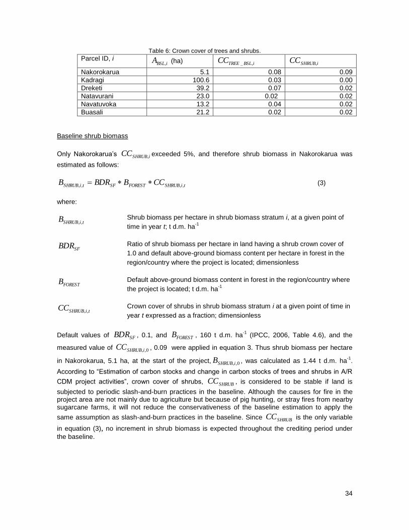
34
Table 6: Crown cover of trees and shrubs.
Parcel ID, i iBSLA , (ha) iBSLTREECC ,_ iSHRUBCC ,
Nakorokarua 5.1 0.08 0.09
Kadragi 100.6 0.03 0.00
Dreketi 39.2 0.07 0.02
Natavurani 23.0 0.02 0.02
Navatuvoka 13.2 0.04 0.02
Buasali 21.2 0.02 0.02
Baseline shrub biomass
Only Nakorokarua‘s iSHRUBCC , exceeded 5%, and therefore shrub biomass in Nakorokarua was
estimated as follows:
tiSHRUBFORESTSFtiSHRUB CCBBDRB ,,,, (3)
where:
tiSHRUBB ,, Shrub biomass per hectare in shrub biomass stratum i, at a given point of
time in year t; t d.m. ha-1
SFBDR Ratio of shrub biomass per hectare in land having a shrub crown cover of
1.0 and default above-ground biomass content per hectare in forest in the
region/country where the project is located; dimensionless
FORESTB Default above-ground biomass content in forest in the region/country where
the project is located; t d.m. ha-1
tiSHRUBCC ,, Crown cover of shrubs in shrub biomass stratum i at a given point of time in
year t expressed as a fraction; dimensionless
Default values of SFBDR , 0.1, and FORESTB , 160 t d.m. ha-1
(IPCC, 2006, Table 4.6), and the
measured value of 0,,iSHRUBCC , 0.09 were applied in equation 3. Thus shrub biomass per hectare
in Nakorokarua, 5.1 ha, at the start of the project, 0,,iSHRUBB , was calculated as 1.44 t d.m. ha-1
.
According to ―Estimation of carbon stocks and change in carbon stocks of trees and shrubs in A/R
CDM project activities‖, crown cover of shrubs, SHRUBCC , is considered to be stable if land is
subjected to periodic slash-and-burn practices in the baseline. Although the causes for fire in the project area are not mainly due to agriculture but because of pig hunting, or stray fires from nearby sugarcane farms, it will not reduce the conservativeness of the baseline estimation to apply the
same assumption as slash-and-burn practices in the baseline. Since SHRUBCC is the only variable
in equation (3), no increment in shrub biomass is expected throughout the crediting period under
the baseline.

35
Baseline tree biomass
The ―default method‖ of ―Estimation of carbon stocks and change in carbon stocks of trees and
shrubs in A/R CDM project activities‖ was applied to estimate the baseline tree biomass.
Considering that the mean tree crown cover in the baseline was 0.8% and less than 20% of the
10% threshold crown cover defined by the Fijian national authorities, the baseline tree biomass
tBSLTREEC ,_ was calculated as follows:
(4)
Where:
tBSLTREEC ,_ Average annual change in carbon stock in tree biomass in the baseline; t
CO2-e
BSLTREECF _ Carbon fraction of tree biomass in the baseline; t C (t.d.m.)-1
FORESTB Default average annual increment of above-ground biomass in forest in the
region/country where the project is located; t.d.m. ha-1
yr-1
BSLTREER _ Root-shoot ratio for the trees in the baseline; dimensionless
Default values were applied for BSLTREECF _ , FORESTB and BSLTREER _ (Table 7), and measured
values for iBSLTREECC ,_ and iBSLA , (Table 6). Stand age was assumed as 1-year at the start of the
project for conservativeness. The results were summarized in Table 8.
Table 7: Default parameters for calculation of average annual change in carbon stock in tree biomass in the baseline.
Value Source
BSLTREECF _ 0.50 Estimation of carbon stocks and change in carbon stocks of trees and shrubs in A/R CDM project activities, version 02.1.0, para 43.
FORESTB 7 t.d.m ha-1
yr-1
for the year 1 – 20 2 t.d.m ha
-1 yr
-1 for the year 21 –
2006 IPCC Guidelines for National Greenhouse Gas Inventories, Table 4.9. Tropical dry forest, Asia (insular)
BSLTREER _ 0.25 Estimation of carbon stocks and change in carbon stocks of trees and shrubs in A/R CDM project activities, para 43.
iBSLiBSLTREEBSLTREEFORESTBSLTREEtBSLTREE ACCRBCFC ,,___,_ 1
12
44

36
Baseline net GHG removals by sinks
Baseline net GHG removals by sinks were calculated by the sum between the baseline tree
biomass and shrub biomass shown in Table 8. The total carbon stock change associated with the
‗without project‘ reference scenario over the 30 year project lifetime is therefore estimated to
increase by 16,232 tCO2-e.
Table 8: Change in carbon stock in baseline
Year Project
Year
Change in carbon stock in baseline, t CO2-e
Tree biomass,
tBSLTREEC ,_
Shrub biomass,
tBSLSHRUBC ,_
Net GHG removals
by sinks, tBSLC ,
2009 0 701 0 701
2010 1 701 0 701
2011 2 701 0 701
2012 3 701 0 701
2013 4 701 0 701
2014 5 701 0 701
2015 6 701 0 701
2016 7 701 0 701
2017 8 701 0 701
2018 9 701 0 701
2019 10 701 0 701
2020 11 701 0 701
2021 12 701 0 701
2022 13 701 0 701
2023 14 701 0 701
2024 15 701 0 701
2025 16 701 0 701
2026 17 701 0 701
2027 18 701 0 701
2028 19 701 0 701
2029 20 200 0 200
2030 21 200 0 200
2031 22 200 0 200
2032 23 200 0 200
2033 24 200 0 200
2034 25 200 0 200
2035 26 200 0 200
2036 27 200 0 200
2037 28 200 0 200
2038 29 200 0 200
2039 30 200 0 200

37
G2.4 Describe how the ‘without project’ reference scenario would affect communities in the
project zone, including the impact of likely changes in water, soil and other locally important
ecosystem services.
As shown by the results of the socioeconomic surveys13
and the landuse plans conducted in the
project zone, most people are living at the subsistence level and qualify as a low income
communities (earning below FJD$ 5,000/annum). Since the grasslands are not being used for any
productive purposes and the financial, institutional and technological barriers identified in section
G2.1 prevent the land from either being converted to other land uses, or regenerating naturally,
then it is unlikely that any new creation of jobs or income generation related to these alternative
land uses would be realized. It is unlikely that the communities living in the project zone would have
the capacity to alter their socioeconomic position or to build capacity in alternative land uses in the
absence of the project.
The Landuse Plans for Tikina Tokaimalo, Naiyalayala and Naroko identified the root causes
underlying the problems and constraints linked to biodiversity conservation, village development,
agriculture and forestry. Such constraints can be considered as the prevailing conditions in the
―without project‖ scenario. These include unsustainable landuse practices, the lack of agricultural
planting materials (plant seeds, cuttings and root stock for crops), the lack of agricultural knowledge
about new crops or cropping systems, soil erosion, fires, logging and deforestation, solid waste and
water pollution from agricultural chemicals. The livelihoods component of the project will work to
help address those issues linked to improving landuse practices, especially small scale community-
based agriculture.
Without the project, unsustainable agricultural practices and the focus on planting limited crop
varieties will continue. The cultivation of limited crop varieties poses increased risks from pests and
disease which directly impacts the food security of marginalized communities. In addition, the
current vegetation is already low quality grassland and as such has poor soils and provides very
little benefit to water quality. Organic matter in the top soil has eroded due to repeated burning and
exposure to sunlight and rain. Soil erosion is therefore prevalent in most village lands due to
topographical features and erosivity of rainfall experienced in the area. This has resulted in the loss
of topsoil, decrease in fertility and yield and contributed to shallowness of rivers and streams.
G2.5 Describe how the ‘without project’ reference scenario would affect biodiversity in the
project zone (e.g., habitat availability, landscape connectivity and threatened species).
Without the project, biodiversity in the region is likely to continue to be at risk from mosaic forest
fragmentation and encroachment of exotic species into the area bordering the Nakauvadra Range.
Historical land use trends have led to the loss of native forest around the Range, which is now
completely surrounded by talasiga grasslands, restricting the size of available habitat for many
species living there. This has resulted in the gradual disappearance of species of fauna (bats and
birds in particular) that would otherwise be able to assist with natural forest regeneration through
seed dispersal. The loss of the natural source of seeds will impede natural reforestation and it is
highly unlikely that natural succession at any scale would occur in the Nakauvadra Range.
Continuous exposure to fires increases the threat of encroachment of exotic species into the higher
elevation, pristine areas of the Nakauvadra Range. Fragmented landscapes may still sustain
original species assemblages, but they are expected to suffer species loss with time. This can
13
A template of the questionnaire used for the household surveys is attached in Annex 3.
38
already be evidenced by the fact that no Masked Shining Parrots or Polynesian Starlings were
documented during the 2008 RAP, but had previously been seen in 2004, suggesting that the forest
habitat is no longer large enough to support their feeding and breeding needs. Disturbed sites are
also prone to negative impact of invasion by non-native, invasive species of plants and animals,
which also lead to loss of native biotic community. The RAP survey, for example, recorded 80 alien
species in the talasiga grasslands including invasive plants species like Spathodea campanulata,
Albizia lebbeck, A. saman and Leucaena leucocephala.
The project help provides a ‗green wall‘ that will expand the forest habitat of the Nakauvadra Range
by providing connectivity between fragmented and isolated ―forest islands‖. The eventual
reforestation of the sites will also serve to bring in new genetic sources for pollen and seed
production hence enhancing the genetic diversity of existing isolated and remnant forest stands.

39
G.3 PROJECT DESIGN AND GOALS
G.3.1 Summary of the project’s major climate, community and biodiversity objectives.
The overall goal is to establish a community based, multiple benefit forest carbon project that
demonstrates the viability of forests as multi-use ecosystems – for biodiversity conservation,
watershed management, carbon sequestration, soil erosion prevention, and the provision of other
key goods and services for the benefit of local people.
The project‘s objectives are to:
Increase biomass and carbon sequestration in project areas by reforesting 1,135 ha of
degraded grasslands;
Enhance biodiversity conservation by increasing forest cover around the Nakauvadra
Range, thereby expanding habitat for important species living there and improving
connectivity with other nearby forest blocks;
Improve economic conditions of local communities by generating income and job
opportunities; and
Support the development of livelihood diversification initiatives with local communities.
G3.2 Description of project activities with expected climate, community and biodiversity
impacts and their relevance to achieving the project’s objectives.
The Project will achieve net GHG removals by planting trees in grassland areas surrounding the
Nakauvadra Range. Major activities under the reforestation component include:
Community engagement
Community outreach, consultations and awareness raising activities to ascertain level of
interest and commitment in developing the project in the targeted districts;
Participatory Land Use Planning and site selection - participatory land use planning was
carried out by CI and the Department of Land Resources Planning and Development of the
Ministry of Agriculture in the districts of Tokaimalo, Naiyalayala and Naroko. Physical and
socio-economic conditions were analyzed, and development pathways were discussed
amongst the stakeholders. The project sites were selected based on a discussion which
aimed to balance environmental and community development needs and objectives.
Formulation and adoption of Community Agreements (CA) with each land owner which
outlines the responsibilities and commitments of all parties. Landowners on each
agreement are verified against the ―Vola ni Kawa Bula‖, the Register of Native Landowners,
and confirmed by the Ra Provincial Office.
Selection of reforestation plots
The reforestation sites are strategically selected to create a corridor between the Wabu/Tomaniivi
Nature Reserve and the Nakauvadra Range. Landowning units and communities in target areas

40
are identified from the Lands Registery maps, and awareness meetings are carried out in which CI
introduces the project, and asks that the mataqali take time to discuss amongst themselves if they
would be interested in participating in the reforestation work. Following a response from the
landowners, CI field staff then carry out technical scoping visits to the area to ensure they meet key
criteria in terms of accessibility for seedling transportation, workers access points, ease of acess for
harvesting in later years (if teak is to be planted there), terrain and slope conditions, as well as to
confirm that current forest cover does not exceed 10%.
A GPS survey of the proposed boundary to estimate the area and the number of seedlings
required is then undertaken. The GPS data is sent to the Suva office and overlayed on Native
Land Commission maps to confirm land ownership. If the land ownership verfication is correct and
the area deemed suitable for planting, a formal meeting is then scheduled to explain the terms of
the community agreement with the landowners. If the area is unsuitable, a community meeting will
also take place to explain the reasons for rejecting the proposition of the landowners. A step by step
guide and flow diagram describing the process to identify the reforestation sites before planting
begins can be found in the Operations, Health and Safety Manual (Appendix 5).
Preparation of the Community Agreements
Once an area has been agreed upon for inclusion in the project, a copy of the draft Community
Agreement is left with head of the clan (Turaga ni Mataqali) for review and to ensure that at least
75% of the clan are in agreement with the terms. The CA contains the name of the landowning
unit, the area to be planted, conditions of the agreement as well as the signatures of at least 75% of
the members of the mataqali.
Nursery Establishment
During the pilot phase of the project, one of the problems encountered was the lack of good quality
native seedlings. In addition, existing institutional nurseries often lacked the capacity to supply the
quantity of seedlings required, or specialized in propagating only one particular species (Future
Forests Fiji-Teak, Department of Forests-Mahogany). Therefore, most seedlings used in the pilot
phase were from bare-root or wildings sources. To address this, three community and five
independent nurseries were constructed in villages throughout the project zone, and community
members trained in seedling propagation and nursery management by the Department of Forests
(DoF), Research Division. The DoF also provided seeds through their own established source trees
and gave them to community nurseries for propagation. This has ensured that only quality seeds
have been sourced, following DoF quality control systems.
In terms of infrastructure the project initially procured and supplied all the nursery materials and
technical assistance to build the first community nurseries. In 2011, the Extension Division of the
Department of Forest complemented this activity and supplied two full sets of nursery materials as
well as providing on-site and hands-on community capacity building on all aspects of nursery
management.

41
Figure 14: Community nursery at Nabalabala village (left), and native seed collection (right).
Species Selection
Species selected for planting (Table 9) consist of native (covering 72% of the project area) and
hardwood timber species (28%). Hardwood timber species consist predominantly of teak (Tectona
grandis) and to a smaller extent, mahogany (Swietenia Macrophylla). Teak was selected because of
its ability to coppice as well as being a valuable hardwood which can fetch high market prices. Once
the timber species reach maturity at 20 years, the communities will have the option to harvest both
species. Training will be provided on sustainable harvesting techniques and coppice practices to
allow for the repropagation of the teak species.
Based on discussions with local experts and early feasibility analysis, suitable native species were
identified and assigned based on their ability to survive and grow in the conditions of the project
site. The native species were also selected on their ability to encourage natural succession to help
achieve the long term biodiversity and climate goals of the project.
Table 9: Species used for reforestation.
Species Local name Family
Native species
Retrophyllum vitiensis Dakua salusalu Podocarpaceae
Intsia bijuga Vesi Fabaceae
Bischofia javanica Koka Euphorbiaceae
Gyrocarpus americanus Wiriwiri Gyrocarpaceae
Intsia bijuga Vesi Fabaceae
Elattostachys falcata Marasa Sapindaceae
Barringtonia edulis Vutu Kana Lecythidiaceae
Palaquium porphyreum Bauvudi Sapotaceae
Pometia pinnata Dawa Sapindaceae
Inocarpus fagifer Ivi Fabaceae
Cinnamomum spp. Macou Lauraceae
Gymnostoma vitiensis Velau Casuarinaceae
Casuarina equisetifolia Nokonoko Casuarinaceae
Dacrydium nidulum Yaka Podocarpaceae
Gonystylus punctatus Mavota Thymelaeceae
Santalum yasi Yasi Santalaceae
Parinari insularum Sa Chrysobalanaceae
Eleocarpus spp. Kabi Elaeocarpaceae
Calophyllum inophyllum Dilo Clusiaceae
Serianthes melanesica Vaivai ni veikau Mimosaceae

42
Agathis macrophylla Dakua makadre Araucariaceae
Myristica spp. Kaudamu Myristicaceae
Calophyllum spp. Damanu Clusiaceae
Endospermum macrophyllum Kauvula Euphorbiaceae
Cananga odorata Makosoi Annonaceae
Dillenia biflora Kuluva Dilleniaceae
Podocarpus neriifolius Kuasi Podocarpaceae
Pagiantha thurstonii Tadalo Apocynaceae
Hardwood timber species
Tectona grandis Teak Verbenaceae
Switenia macrophylla Honduran mahogany Meliaceae
Planting Development
A total of 1,135ha are being reforested with a mix of native species and teak. The composition of
planted seedlings was 25% native species and 75% non-native species in 2009; 50% native
species and 50% non-native species in 2010 to 2012; and 100% native species in 2013 and 2014.
Since project inception (up to the end of March 2013), a total of 851.56 ha have been planted
(Table 10), representing 197,646 seedlings planted. Teak seedlings are planted along mid-slope as
they are more suited to the harsh environment and on plots that are entirely comprised of mission
grass (Pennisetum polystachyum). Native seedlings are planted at the bottom of the ridge, near
waterways and remnant forest patches. From pilot plots we have found out they tend to do well in
sheltered or less extreme environments.
Table 10: Reforestation schedule / year.
YEAR DISTRICT AREA
PLANTED TOTAL
AREA/YR
2009
Tokaimalo 107
Naroko 1.23 108.23
2010
Tokaimalo 100.63
Naroko 4.00 104.63
2011
Tokaimalo 110.84
Naroko 41.37
Naiyalayala 57.05 209.25
2012
Naroko 103.30
Tokaimalo 5.15
Rakiraki 40.00 148.45
2013
Naiyalayala 50
Tokaimalo 150
Naroko 65
Rakiraki 16 281
2014*
Tokaimalo 200
Rakiraki 43.4
Naroko 40 283.4
TOTAL 1,135
* The 2014 compositon of areas by district will be finalized closer to planting

43
Planting activities include site demarcation where each plot boundary is marked out by GPS. Once
boundaries are established, communities are contracted and trained to undertake line polling,
weeding, line cutting and planting operations. CI teams supervise all planting work, ensuring quality
control from the nursery to the field. As part of CI-Fiji Program capacity building program, all the line
polling in 2010 was conducted by the first year Forestry Training School students from Colo-I-Suva
on a month-long field exercise.
After the polling lines have been marked out, weeding is carried out, usually two people to a line,
each weeding one meter on either side of the line. To prevent soil erosion, avoid GHG emissions
and protect existing carbon stocks, site burning and overall tillage is not employed during the site
preparation. Only a narrow strip (2m wide) is cleared and any existing tree vegetation is not
removed.
Spot planting is employed and small holes are dug (with a diameter and depth of 20 cm) along the
slash belt with a spacing of 6 m × 6m for all species. The 6 x 6m planting layout was chosen as
many of the native species will have large crown requirements (Intsia bijuga, Calophyllum spp.
Agathis macrophylla) and will need the space to grow. With the teak species, the project will not be
carrying out any thining in the years prior to harvesting and so a wider spacing was considered
appropriate. Future Forests Fiji spaces seedlings at 5 x 5m when one thining is expected over a
period of 25 years. To ensure high survival rates and good growth in the early stages, planting
commences at the beginning of the wet season in November and continues until March/April of the
following year. Survival assessments will be carried out every two years until 2018. If the survival
rate is below 80% replating of species will take place.
Maintenance of planting sites
Regular maintenance (weeding) of the reforestation sites is required for at least the first four years
after seedlings are planted so that they have the opportunity to grow unhindered beyond the height
of the grasses. All the planting and maintenance activities involve local communities through the
issuance of paid contracts to carry out the work. This provides job creation and income generation
for communities, as well as fostering a sense of ownership and pride for the project.
Figure 15: Carrying out the line polling (left), and transporting seedlings to reforestation sites (right).

44
Hardwood species harvesting
Beginning in 2029, the teak and mahogany species will be ready for harvesting. A rotation length of
20 years was chosen after consultation with Future Forest Fiji, a local company that invests in
plantation teak. Training and support for communities on how to sustainably harvest these species,
and ensure their natural propagation post-harvesting will be provided. CI will work with the
Department of Forests and the Forestry Training Centre at Coloisuva to coordinate and implement
these trainings as well as to provide guidance on how to carry out the harvesting plans that are
required for all commercial timber harvesting activities as legislated under the Forest Decree 1992.
After the first five years of planting, survival assessments will determine the extent and stocking rate
of merchantable timber volume, however, the exact volume of harvestable timber will only be
determined at year 20. Landowners will be required to secure their own logging contractor if they
are not in a position to undertake logging themselves. In such a case, the landowners will need to
secure a logging license from the iTaukei Lands Trust Board and the Department of Forest for the
commercial extraction of the tree crop. Once prior approval is obtained, the landowners and the
logging contractor will develop a harvesting plan which will be aligned to the National Code of
Logging Practice. The harvesting plan will be submitted by the Logging Contractor and the
resource owners to the Department of Forests for field varification and approval before logging can
commence.
The Departemnt of Forests continually improves harvesting procedures and processes in an effort
to efficiently monitor and reduce environmental impacts of logging opeations. The Fiji Forest
Harvesting Code of Practice (FFHCOP) outlines in detail all the requirments for licensing
procedures, pre-operational inspections, preharvest inventories, harvesting plans and others.
Project communities will need to obtain a license to log the forest and will be required to follow
guidelines of the FFHCOP. Landowners will have to request a logging license from the Department
of Forests, who will then hold a field verification before calling for a harvesting plan (HP). Once the
Harvesting Plan is approved, a Logging Right Licence (LRL) is issued by the Department of
Forests. Usually, landowners would seek a logging contractor and negotiate log price at landing.
Landowners with woodlots would than enter into an agreement with the logging contractor who will
have skilled and accredited staff in all aspects of the logging operation. Should the landowners
decide to log and sell on their own, they will need to undergo training and be accredited before they
can commence operations. Skills training in chainsaw operaiton, harvesting plan documentation
and other activities are currently available free of charge at the Department of Forests - Forestry
Training Centre. CI‘s role in this activity will be to guide and support the communities in receiving
the training they need and to secure the relevant licenses for harvesting, but it will be up to the
communities themselves to decide if and how they will want to pursue the harvesting of the tree
species on their land.
Conservation awareness building
Throughout the project lifetime, CI will seek to promote the active participation of local communities
for long term forest maintenance of the project site through conservation awareness building. Major
activities include holding workshops and village meetings to increase community understanding on
the important benefits that forests can provide – from improved watershed to enhanced agroforestry
livelihood activities. Evidence of the positive impacts this can have can be demonstrated by the fact
that following one of the awareness campaigns, communities in Tokaimalo decided to place a self-
enforced ban on the use of duva in the main creeks, a natural poison that is used to stun and kill
fish, but over the years has had a serious effect on the prawn populations.

45
Fire prevention awareness campaigns are also a key component. Since 2009, CI has carried out
annual awareness and information meetings in conjunction with the Methodist Church, the Fire
Authority and Divisional Police Force. This has already had an impact in reducing the number of
wildfires and getting communities actively engaged in fire prevention measures.
Agricultural livelihoods development
The strategy for the agricultural livelihoods component is to work with local communities in
improving their current land use practices and to diversify livelihood opportunities to which will
provide greater food security and increased income streams. The approaches to be used are as
follows:
Model Farms
The project has set up two model farms (at Vaidoko and Nabalabala) in collaboration with the
Department of Agriculture to demonstrate sustainable agriculture practices, good farming
techniques on hilly sites, and to provide a wider gene pool for traditional crop varieties and field trial
new commodities. In addition there are 29 individual interventions with farms that are located in the
project zone. The farm lots range from 1-2.5 has and have been planted with coconut, pineapple,
pawpaw, taro, yam, ginger, kava and sandalwood, with contour plantings of vetiver grass to prevent
soil erosion in steeper parts of the farm. Acacia woodlots were also planted to assist with firewood
needs. Bee hives and pandanus have also been provided to some farms. In addition to this, a major
coconut tree and pineapple planting exercise was carried out. Coconut trees are known in the
Pacific as the ―tree of life‖ and have multiple uses from the leaves as thatch and weaving, nuts for
food, drink and cooking, roots to make traps and dyes, and the trunks as building materials. The
coconut trees and pineapple were initially planted in the firebreaks of the reforestation sites with the
intention for it to serve as an incentive for fire prevention. The coconut tree is also the totem for the
Tokaimalo people and is considered sacred – another good deterrent against wildfires. The project
has supplied coconut seedlings in response to popular demand.
Alternative livelihoods
Bee-keeping
o A total of 35 bee hives have been distributed to communities. The main reasons for
developing bee-keeping in the area are that a) communities are already engaged in this
activity, and b) to promote the presence of bees to help with the pollination of trees to
sustain the forest health of the Nakauvadra forest. So far, production levels of 20 litres
of honey per quarter among bee keepers are being recorded.
Fish ponds
o A total of 6 fish ponds were set up by the project following feedback from several
villages that this would provide a valuable source of protein and additional income
source from the sale of fish at local markets.

46
Crop diversification
o Ginger is a new crop recommended by the Ministry of Agriculture for Ra Province.
Three model farms were used by the project to plant ginger in 2011, each were given
about 300kg worth of seeds and training on how to plant and harvest the crop. In 2012,
a total of eight farmers are now planting ginger covering a total area of 13 acres. The
ginger was first harvested after nine months yielding a total of 3.4 tons of mature
ginger.
Eco-tourism
o In the village of Narara in Naroko, the project helped build a simple community center
where most of the welcome ceremonies are held, and planted flowering trees along the
main path to attract birds. Currently bird watching in not an activity in the local area but
the project is hoping to be able to promote this in the future as forest cover increases.
This will also motivate the community to assist with the monitoring of bird populations in
the area.
Sandalwood
o Another component of the livelihoods diversification component of the project is the
provision of sandalwood sandalwood (Santalum yasi) seedlings to communities, and
training on their propagation and nursery care. Sandalwood is traded for its oil and
fetches a very high price in the local market. Since 1996, the Forestry department in
Fiji have been developing techniques on methods of growing yasi to re-establish their
populations, and supplying seedlings to communities interested in growing and selling
yasi as a source of income. Given the current demand and attractive market price
(FJD$80-100 per kilogram), communities in the project zone are very keen to plant yasi
as they provide additional opportunities to raise young seedlings for sale. CI is
therefore distributing sandalwood seedlings to local villages and providing training on
how to propagate them in the community nurseries.
Development of local markets for nursery seedlings
o Following the establishment of the community nurseries to assist with the supply of
seedlings for the reforestation activities, CI has continued to support the ongoing
implementation of these community-owned enterprises. Since 2012, CI has purchased
all seedlings from the established community nurseries, creating a new commodity line
for forest products in the area. The establishment of the community nurseries has
therefore directly contributed to the provision of socio-economic benefits of local people
as well as meeting the biodiversity goals of the project in providing robust and quality
native seedlings for reforestation. CI is also working with these communities to secure
other local buyers for the seedlings that are being grown, including the Dept of Forests,
other NGOs as well as communities interested in buying sandalwood seedlings for
themselves.

47
Reintroduction of traditional crop varieties
Most farmers are currently planting export-oriented crop varieties which mean that the traditional
landraces are being left out. The project is trying to reintroduce these varieties to the community so
they and the nation of Fiji can maintain a wide genetic base. Varieties of three different crops have
been reintroduced into the community through the model farms. These are sweet potato, (6
varieties), cassava (10 varieties) and yam (12 varieties). Fiji has a total of 10 varieties of sweet
potato, 25 varieties of cassava and 84 varieties of yam.
Sustainable Land Management
As shown by the land classification maps much of the land in the project zone is hilly and unsuitable
for agriculture. To help communities understand how to improve land management practices under
these conditions and to control soil erosion, the project is carrying out a number of different
activities. This includes hedgerow planting using pineapple and vetiver grass across slopes. In
addition, the model farms were aligned to specific components of the land-use plans, with the first
crops being harvested in 2012. CI has been assisting demonstration farmers to secure access to
local markets and planning for a second rotation of crops. We have thus far recorded harvests of
1,500 tons of pineapple that have been sold at the local market.
In parallel with these field activities, the project is working in collaboration with the Research
Division of the Ministry of Agriculture to re-introduce traditional varieties of some important root
crops such as taro, cassava, yam and sweet potato. There is evidence of genetic erosion
happening in Fiji as most farmers are planting market oriented varieties at the loss of traditional
varieties (Masibalavu et al, 2002). It is very important that Fiji maintains a wide genetic base of
various crops, both to provide a wider selection of crops, and to enhance farmers‘ resilience to
climate change. One model farm in Tokaimalo has planted 30 varieties of taro, 7 varieties of sweet
potato, 30 varieties of yams and 20 varieties of cassava.
Figure 16: Beekeeping (left), and native sweet potato varieties planted at Vaidoko model farm (right).

48
G3.3 Provide a map identifying the project location and boundaries of the project area(s),
where the project activities will occur, of the project zone and of additional surrounding
locations that are predicted to be impacted by project activities (e.g. through leakage).
The maps in section G1 provide the project geographical location and boundaries of the project
zone. Figure 17 shows the location of reforestation sites stratified by planting year. Figures 18-21
show the location of each reforestation area within the four districts planted in 2009 - 2013. Planting
sites for 2014 have not yet been marked on the maps although the spatial location of the areas and
the respective landowning unit for each are known, and these areas have been identified in Figure
7 (G1). Table 11 provides information on the size of each reforestation site, the year of planting,
and the name of the mataqali who owns the land.
Figure 17: Reforestation sites in project zone stratified by planting year (2009-2013).

49
Figure 18: Reforestation sites in Tokaimalo district.
Figure 19: Reforestation sites in Naroko district.

50
Figure 20: Reforestation sites in Naiyalayala district.
Figure 21: Reforestation sites in Rakiraki district.

51
Figure 22: Location of livelihood activities in project zone.
Table 11: Reforestation sites 2009 – 2014.
Mataqali / Landowner Village Area planted
Year District Parcel Name
Dreketi Nayaulevu 38.0 2009 Tokaimalo P1-09
Narokomia Navuniyaumunu 13.0 2009 Tokaimalo P2-09
Natabuqau Navuniyaumunu 27.0 2009 Tokaimalo P3-09
Nayabo Navuniyaumunu 19.0 2009 Tokaimalo P4-09
Nayabo Navuniyaumunu 10.0 2009 Tokaimalo P5-09
Naikasarua (Matarisiga)
Vatukacevaceva 1.2 2010 Naroko P12-10
Kadragi Naqeganivatu (Yavusa) 100.6 2010 Tokaimalo P6-10
Navatuvula Kasia Drana 4.0 2010 Naroko P10-10
Navatunimaravu(NFS) Rewasa 1.0 2011 Naroko P8-10
Naveisama Narara 2.5 2011 Naroko P9-10
Navalecava Vatukacevaceva 2.2 2011 Naroko P13-10
Dawadiga (Druidrui) Naseyani 10.6 2011 Naiyalayala P14-10
Navalevatu Vatukacevaceva 1.9 2011 Naroko P15-10
Naikasarua (Yav Vatukaloko)
Nananu 23.0 2011 Naiyalayala P16-11
Nailoiloa Narara 1.0 2011 Naroko P17-10
Voki Navavai 11.0 2011 Tokaimalo P18-11

52
Narokomia Naraviravi 11.8 2011 Tokaimalo P19-11
Navuanirewa Naivutu 15.8 2011 Tokaimalo P20-11
Natavurani Navuniyaumunu 23.9 2011 Tokaimalo P21-11
Navatuvoka Vunisea 13.7 2011 Tokaimalo P22-11
Navatuvula/Kasia Drana 10.0 2011 Naroko P23-11
Nakereiwasa Rewasa 10.7 2011 Naroko P24-11
Navutocia Nayaulevu 15.4 2011 Tokaimalo P25-11
Buasali Nabalabala 19.2 2011 Tokaimalo P26-11
Leleyawa Vatukacevaceva 12.0 2011 Naroko P27-11
Nakorosarogo Nananu 9.9 2011 Naiyalayala P28-11
Yavusa Vatuk (SSB) Nananu 13.5 2011 Naiyalayala P29-11
Nakereiwasa Rewasa 5.0 2012 Naroko P7-12
Nailoiloa Narara 6.9 2012 Naroko P30-12
Nakorokarua Vatukacevaceva 5.2 2012 Tokaimalo P31-12
Leleyawa Vatukacevaceva 15.0 2012 Naroko P32-12
Navalevatu Vatukacevaceva 20.0 2012 Naroko P33-12
Toga Nokonoko 10.1 2012 Naroko P34-12
Nakereiwasa Rewasa 11.5 2012 Naroko P35-12
Nakereiwasa Rewasa 5.5 2012 Naroko P36-12
Nakereiwasa (Navuarewa)
Rewasa 9.3 2012 Naroko P37-12
Navalecava Vatukacevaceva 20.0 2012 Naroko P38-12
Dewala Vatusekiyasawa 26.0 2012 Rakiraki P39-12
Wailevu Vatusekiyasawa 14.0 2012 Rakiraki P40-12
Leleyawa Vatukacevaceva 5 2013 Naroko P41-13
Navalevatu Vatukacevaceva 5 2013 Naroko P42-13
Naikasarua Vatukacevaceva 35 2013 Naroko P43-13
Navalecava Vatukacevaceva 5 2013 Naroko P44-13
Navatuvulakasia Drana 5 2013 Naroko P45-13
Naveisama Narara 5 2013 Naroko P46-13
Nakereiwase Rewasa 5 2013 Naroko P47-13
Wailevu Vatukacevaceva 8 2013 Rakiraki P48-13
Dewala Vatusekiyasawa 8 2013 Rakiraki P49-13
Voki Navavai (Nayawe) 100 2013 Tokaimalo P51-13
Naqeganivatu (Yavusa) Tokaimalo 50 2013 Tokaimalo P52-13
Navatulevu Nananu 50 2013 Naiyalayala P53-13
Narokomia Naraviravi 30 2014 Tokaimalo P54-14
Navuanirewa Naivutu 20 2014 Tokaimalo P55-14
Voki Navavai (Nayawe) 50 2014 Tokaimalo P56-14
Naqeganivatu (Yavusa Tokaimalo 100 2014 Tokaimalo P57-14
Navalevatu Vatukacevaceva 20 2014 Naroko P58-14

53
Navalecava Vatukacevaceva 20 2014 Naroko P59-14
Wailevu Vatukacevaceva 23.4 2014 Rakiraki P60-14
Dewala Vatusekiyasawa 20 2014 Rakikraki P61-14
G3.4 Define the project lifetime and GHG accounting period and explain and justify any
differences between them. Define an implementation schedule, indicating key dates and
milestones in the project’s development.
The project start date is April 1st 2009 when the first consultations with the Tokaimalo District
Council and landowning units began. The first trees were planted in November 2009. A project
lifetime of 30 years was selected, with the project ending in 2039. Although the project will not be
generating carbon credits, an ‗accounting‘ period of 30 years was also selected for the monitoring of
the carbon sequestration benefits that will be generated. Given that the first trees were not planted
until the end of 2009, accounting for the removals by sinks of the planted trees begins in 2010.
The project will be implemented in three phases:
Phase 1: a one year pilot phase (2009) on an initial 108 ha to test the feasibility of the project and
assess interest of local communities, whilst building the necessary technical and management
capacity skills that will be required for long-term implementation;
Phase 2: a five year reforestation phase (2010 – 2014) during which an additional 1,027 ha for
planting will be identified and reforested with a mix of native and non-native species. All
reforestation activities will be conducted with full participation of local communities. During this
time, the livelihoods diversification activities and training will also be implemented with participating
farmers and villages.
Phase 3: this will comprise the remainder of the project lifetime (2015 – 2039) during which ongoing
monitoring activities will take place. Maintenance of the reforestation areas and fire prevention
measures will be implemented. In 2029, training and support for communities on how to sustainably
harvest the mahogany and teak trees, and ensure their natural propagation post-harvesting will be
provided. Twenty years after the date of planting, the teak and mahogany species will also be ready
for harvesting. CI will not lead the elaboration of harvesting plans and activities on behalf of the
communities, but will work to support the process together with the Department of Forests and the
Forestry Training School.
A project implementation schedule outlining key activities is presented in Table 12 below.

54
Table 12: Project implementation schedule (2009 – 2039).
Phase
1
1. Reforestation Establishment & Maintenance
Feasibility selection of project reforestation sites X X X X X
Establishment of project nurseries X X X
Planting of native seedlings in reforestation sites X X X X X X
Planting of non native seedlings in reforestation sites X X X X
Establishment of fire breaks X X X X X
Maintenance of reforestation areas X X X X X X X X X
2. Community Engagement
Presentation of RAP report and project concept consultation with District
Councils X
Project consultations with district mataqali X X
Land Use Planning workshops at district level X X
Elaboration and signing of Community Agreements X X X X X X
Fire awareness campaigns X X X X X
3. Livelihoods Enhancement
Development of improved livelihood enterprise opportunities (bee
keeping, pandanus etc) X X X
Capacity training on sustainable agriculture practices and crop
diversification X X X
Establishment, training and provision of planting materials to model farms
(pineapple, ginger, yams etc) X X X
Provision of sandalwood seedlings X X X X X
Community sandalwood harvesting X X X X X X
Capacity training on havesting practices, regulations & repropagation of
teak X
20-year sustainable harvesting rotation of hardwood timber species
begins. Community led but technical assistance and support provided by
CI X X X X
4. PDD preparation, CCB validation and verificationBaseline carbon stock field assessment X
Elaboration of socio-economic surveys at district level X X
CCB PDD preparation X X X
Project climate, community & biodiversity monitoring X X X X X X X X X X X X X X X X X X X X X
CCB validation X
CCB verification X X X X X
2017 20232024-
20272018
2019-
2022Project Activities and Milestones
Phase 2 Phase 3
2009 2010 2011 2012 2013 2014 2015 20162036-
20392033 2034 20352028 2029 2030 2031 2032

55
G3.5 Identify likely natural and human-induced risks to the expected climate, community and
biodiversity benefits during the project lifetime and outline measures adopted to mitigate
these risks.
Loss of ongoing community support for the project
Since most people prioritise short term benefits, the inadequate provision of benefits in the
longer term could lead to the loss of support or abandonment of the project by communities.
Mitigation: The project has secured community agreements with all the landowning units
involved in the project which outlines the responsibilities and benefits to be accrued by each
partner. Through this, CI has ensured that landowners are consulted through each step of the
project development process. Project implementation meetings with all participating
communities will be held at least once a year to reaffirm the agreements and the committments
of all partners. In addition, the project has been designed so that immediate financial benefits
accrue to participating communities through the reforestation and maintenance activities, with
the option to harvest the hardwood species upon reaching maturity in year 20. To complement
this, livelihoods diversification activities are being carried out across the project area, engaging
with communities at village level and focusing on income generation through the provision of
materials to set up microeconomic enterprises such as honey (provision of beehives), ginger,
pandanus leaves, pineapple, coconut and other fruit tres, and sandalwood. It is expected that
these initiatives will become financially sustainable in the long term, and also leverage the
replication of similar enterprises in other neighbouring villages.
Lack of knowledge
The lack of knowledge and understanding about the long-term direct and indirect benefits could
lead to non-cooperation. The communities will need to understand the benefits of increasing
forest cover and the associated long term impacts on the continued provision of key ecosystem
services.
Mitigation: Clear and direct communication with community members presenting the project
benefits and addressing any potential challenges will be an on-going process. To promote the
active participation of comunities for the long term maintenance and protection of the
reforestation sties, information, capacity building and awareness raising activities will be
undertaken. Key messages to be conveyed is not only that well maintained forests can provide
improved watershed protection and clean water in the creeks emanating from the Range, but
also contribute to enhancing livelihoods through the provision of forest products (fruits and
seeds), with their own families and clan members as direct beneficiaries.
Limited community capacity
The communities involved in the project do not have the capacity to undertake the reforestation
and ongoing maintenance and fire preventation activities to ensure the long term success of the
project.
Mitigation: CI will provide training and capacity building to each community involved in the
project on all the reforestation activities including seedling collection, nursery establishment,
planting and maintenance. These skills will also allow communities to set up their own
independent nurseries, such as for the collection and sale of sandalwood seedlings which are
highly sought after in the local area. In addition, the Department of Forests, a key partner to the

56
project is working with CI to offer long term support, such as the provision of training on the
sustainable harvesting of the teak, and the incorporation of community nurseries into their own
annual program for capacity building delivery.
Unclear understanding of the terms of the Community Agreements and key project
milestones and activities
As each Community Agreement has been signed by a minimum of 75% of the mataqali
involved, there are many community members participating in the project. Although CI has
carried out an extensive stakeholder engagement and consultation process it is not always
possible to guarantee that every community member has attended all the village meetings and
discussions. It is important however to ensure that there is a good understanding about the
terms of the Community Agreements by all involved, including key dates and project objectives
and activities, such as the harvesting of the non-native species. A good understanding of the
above will be necesseary , not just during the early development of the project but also in the
years to come as younger members of the community grow up to take on a leadership role in
their villages.
Mitigation: In addition to the consultation processes carried out during the reforestation site
selection and as part of the engagement and awareness building with communities about the
terms of the Community Agreements, the project team will carry out a further round of
community engagement with all the mataqali during the final stages of the planting process. CI
will meet with each mataqali to distribute copies of the signed Community Agreements. A
general translation of the agreement in the Fijian language will also be distributed to all
community members so that all households involved will have at least one copy. This leaflet is
attached as part of the Operations, Health and Safety Manual. During this meeting, in which all
community members will be invited to attend, including women and youth, a focus will be
placed on encouraging a participatory learning environment. The session will discuss in detail
the terms of the CA and in particular clarify again what species can be harvested 20 years after
planting and the current requirement for harvesting operations. The Department of Forests will
be invited to join the meeting to provide further information on harvesting requirements. Given
that the CI Field Officer is also a Forestry Officer on secondment to the project he will be tasked
to provide responses to all questions pertaining to harvesting operations in the event that the
Department of Forests is unable to attend all the meetings.
To ensure that the communities involved in the project continue to have a collective
understanding about the project, especially as younger members of the villages grow up, CI will
continue to hold regular community meetings in which key project messages and objectives will
be communicated. Active discussions and QandA about the project will be encouraged to
ensure that support of the project is maintained and any issues that might arise can be quickly
and efficiently addressed.
The whole community does not take ownership of the project
The reforestation sites are owned by different mataqali but not all members of a particular
community will be involved in the reforestation agreements, which could cause resentment and
a lack of ownership for the project within the community as a whole.
Mitigation: The livelihood diversification activities are strategically organized at a community
level regardless of landowning status to ensure that benefits are shared among community
members, thus ensuring broad support for the project. This includes the planting of pineapple,

57
coconut and other fruit trees, the provision of sandalwood seedlings, and the establishment of
beehives and fish ponds. CI is also engaging with community members at multiple levels,
including the traditional chiefs, youth and women‘s groups, to ensure that all concerns and
voices can be heard.
Inability of communities to effectively continue with the livelihood activities
initiaitved by the project
In years 1- 5 of the project, CI will work with local communities to establish new alternative
livelihood initiatives and improved agricultural practices. CI‘s direct involvement in providing
ongoing technical support and capacity building will phase out in year six as these activities
become self-sustaining. There is a risk however that communities will not yet feel able to carry
out the proposed activities independently by that date.
Mitigation: CI will maintain a constant presence in the project zone throughout the 30-year
project lifetime, and is currently in the process of fund-raising for additional resources to build
up agricultural livelihood interventions in adjacent areas. Moreover, during important village
meetings throughout the project lifetime, CI staff will make the most of the opportunity to
reiterate key elements pertaining to sustainable livelihoods and cropping cycles. Manuals and
brochures produced by CI on sustainable land management and agriculture, and those
available from the National Food and Nutrition Department will be re-distributed at these
discussions. These will serve as a guide than can be used by local farmers and other
community members to carry out the livelihood activities by themselves. CI also has close links
with the Department of Agriculture and will work to ensure that any concerns or challenges
faced by communities are brought to the attention of the relevant authorities so that additional
technical expertise can be provided.
As a longer term strategy, financial literacy trainings will also be provided for communities to
help them strengthen their understanding about budget management and savings plans. This
will help community members feel better prepared to plan for the future and to make informed
decisions linked to the income they will make from the livelihood and reforestation project
activities.
Grassland fires
Historically, grassland fires in the project zone have occured on an annual basis, largely due to
pig hunting, careless behavior, and stray fires from sugarcane burning. This could put the
reforestation sites at risk, especially in the early years when the young trees are still
establishing themselves.
Mitigation: The project applies several fire prevention measures. Trees are planted in mixed
arrangements to help contain fires. Fire breaks have been established around the reforestation
sites following guidelines developed by Fiji Pine. In the fire breaks, fire-retardant plants such as
pineapples, coconuts and citrus trees have been planted. Planting fruit crops in the firebreaks
means that communities will take a more active interest in monitoring for fires near the
reforestation sites, whilst also providing additional food security and income generation. In
addition, strategically utilizing traditional links with nature such as planting totem trees (the
coconut) which are prohibited from being burnt, means the project is better able to protect
reforestation sites from fire. In years that are particularly dry (eg summer of 2011), community
fire wardens have also been trained and hired to patrol the project areas on a daily basis and to

58
report any fire instances directly to the CI field office and Fire Authority. Fire wardens lodge
quarterly reports to the Evironment Officer in the Provincial Council for presentation at Tikina
and Provincial Council meetings.
Annual fire prevention and educational campaigns at village and tikina meetings have been
held in partnership with the district committee and Methodist church, which is an important
institution in the project zone. The National Fire Authority and Police Department of Rakiraki
were also invited to attend to inform communities on the legal implications of starting fires in
accordance with the 2009 Crimes Decree (arson clause). Key messages highlighting the
threats of fire to human wellbeing, and the negative impacts on soil erosion and run off into
streams have also been disseminated at District and Provincial Council Meetings. Since these
campaigns, there has been a visible reduction in the occurrence of fire in Tokaimalo and
Naroko, although the challenge remains to safeguard reforestation sites that are adjacent to
sugar cane plantations which are burnt during harvesting. Efforts are therefore underway to
carry out further fire awareness campaigns and propose other preventative methods (such as
establishing firebreaks around sugar cane plantations) with farmers, the Fiji sugar Cooperation
and the iTaukei Lands Trust Board.
Cyclones
Fiji is affected by seasonal cyclones during the months of November to April, and can cause
landslides and the toppling over of trees, or the snapping of young seedlings. However, even
when Cyclone Yasi hit Fiji in February 2011, with the highest intensity category 5, a study by
Future Forest determined that although the cyclone passed almost directly through the middle
of their teak plantations, the main damage was to leaves and branches and less than 15% of
the total teak estate was affected (Future Forests Fiji, 2011).
Mitigation: Following cyclones, ‗prop up‘ activities in the reforestation sites take place. If an area
of young seedlings has been particulary badly damaged, then a survival count will be
conducted to determine what level of replanting needs to take place.
Mining
In Fiji, the subsurface rights of all land, native or otherwise, belongs to the national government.
Although there are no mining operations taking place within the project zone, and the risk of
mining or exploration activities occurring in the future is low, in the event that the national
government were to initiate mining activities which would impact the reforestation areas during
the project lifetime, CI would work to the best of their efforts to support the landowners to
secure a compensation plan which would allow for the reforestation of other similar sites
outside of the affected areas.
G3.6 Demonstrate that the project design includes specific measures to ensure the
maintenance or enhancement of the high conservation value attributes identified in G1
consistent with the precautionary principle.
HCVs have been identified under the following categories from the project zone:
Globally, regionally or nationally significant concentration of biodiverisity values
The project recognizes the importance of expanding the critical forest habitat around the
Nakauvadra Range which is home to important endemic and endangered plant and animal species.

59
The project design includes planting of indigenous species of trees to reforest grassland areas on
the lower and mid slopes of the Range. The restored forests will improve forest habitat connectivity
with other forest blocks, which will result in facilitating the movement and dispersal of species of
fauna and flora. In particular, sites selected for reforestation are expected to form a corridor that
joins the Nakauvadra Range to the neighbouring Wabu/Tomaniivi Range mountain range over the
30 year project period.
Areas that provide critical ecosystem services
The Nakauvadra Range is critical for the provision of clean water services to a large number of
communities that rely on the many creeks and streams that originate at the top of this majestic
mountain range. The role the project activities play is groundwater recharging. Landscape in which
degraded, grassland areas are restored to forest should contribute to maintaining and enhancing
this ecosystem service. Also, many patches of forest remain on steep slopes along creeks. They
serve as riparian buffer that reduces soil flowing into the river system. By expanding forest cover in
these areas, the project will help to further enhance the provision of environmental services for
water.
Areas that are critical for the traditional cultural identity of communities
The Nakauvadra Range is considered a sacred place by most Fijians, the home of ‗Degei‘, a
supreme and legendary being. Evidence of ancient settlements and ‗resting‘ spots are found in the
upper reaches of the Range. The studies carried out by the Fiji Museum during the RAP served to
highlight the cultural significance of these sites and to collect oral histories about the Range from
local communities. Project activities do not restrict the movement or access of local people to these
areas. CI will continue to work with the Government of Fiji and local landowners to try and establish
the Nakauvadra Range as a Protected Area which would provide resources and support to further
safeguard the historical and cultural values of the range.
G3.7 Describe the measures that will be taken to maintain and enhance the climate,
community and biodiversity benefits beyond the project lifetime.
Extensive consultation and capacity building in collaboration with communities has resulted in the
project being strongly supported and driven by local people. Landowners and farmers alike are
starting to increase their understanding of the benefits of expanding forest cover and the value it
has for surrounding agricultural land and the provision of water and soil ecosystem services in the
long term. The project focuses on reforestation efforts whilst ensuring that target beneficiaries will
have sustainable alternative livelihoods and a greater sense for conservation stewardship which
helps mitigate fire risks and improve land use practices which help ensure the permanence of the
restored forest in the future.
The project implementation plan will be reviewed annually by the CI-Fiji team (see G4.1) for higher
performance and delivery of benefits to meet community and biodiversity objectives throughout the
project lifetime. All stakeholders are expected to contribute positively to project improvement
through the constant and regular exchange of ideas on challenges and aspirations of different
entities. Stakeholders include the participating 26 villages, the Tikina Councils of Tokaimalo,
Naiyalayala, Naroko and Rakiraki, Ra Provincial Council, the Department of Forest, the Department
of Agriculture; the Provincial Administrator of Ra; the Western Commissioner Office, the West
Divisional Forestry Officer, and the Ra Fire Department.

60
The project also engages in further measures to ensure sustainability; they include conservation
awareness raising campaigns with communities, educational visits and the cross fertilization of
ideas with national and local government agencies. The Government of Fiji and a number of
regional organizations are conducting a series of training and seminars on climate change
adaptation and mitigation throughout Fiji. The objective of these trainings and seminars is to
enhance the understanding of local partners working on climate change related issues. CI has
provided resource personnel for these when requested and will continue to participate in
conferences, trainings and workshops on climate change to share lessons learned and experiences
in developing multiple benefit forest carbon projects.
The project has also facilitated cross learning visits of other local communities through educational
visits to the project site to share their experiences and lessons learnt, and to promote the work of
the project in different parts of Viti Levu. Government officials, including the Prime Minster, have
visited the site. The project is therefore gaining a solid reputation as being a demonstrable example
of community based partnership for rural development and conservation.
Benefits for biodiversity in the long term are also being supplemented by CI‘s work in collaboration
with the Department of Forest to extend the Wabu/Tomaniivi Nature Reserve, as well as ongoing
work on the formal protection of the Nakauvadra Range. The Sovi Basin Protected Area and the
Wabu/Tomaniivi Nature Reserve are located along a ridge that runs through the middle of Viti Levu
towards the South West of the project site, with the Nakauvadra Range in the North Eastern aspect.
The project zone is located in the valley between the two ridges, introducing native tree species that
are expected in time to attract biodiversity to the current talasiga grassland. It is anticipated that
wildlife such as birds and small mammals will in turn help with seed dispersal to further promote
forest regeneration, thus maintaining and enhancing climate and biodiversity benefits beyond the
project lifetime.
Finally, CI is working with the Research Division of the Department of Forest to collect valuable data
on the health status of the reforestation plots. This is a critical component in assessing the success
of these reforestation sites, and provides important data towards the establishment of baseline
carbon sequestration rates. The carbon plots established in the project area are the first native
species sites ever established in Fiji, and as such information on their health and growth rates is an
important contribution to this dataset which will help other research and project initiatives in the
future. In late 2012, an annual forest health assessment was conducted by the Research Division of
the Department of Forest (DoF) together with staff from the South Pacific Regional Herbarium-
University of the South Pacific (USP) and CI-Fiji. This was the second forest health assessment
which complemented the first survey done by CI, USP, and DoF in February 2011. A team from CI‘s
Rakiraki office and community representatives were also trained on how to establish sample plots
and conduct forest health assessments. A total of 81 sample plots were established and results
from the forest health assessments are currently being analysed. CI has now transitioned this work
entirely over to the DoF, who will continue carrying out regular forest health checks in the future.
G3.8 Document and defend how communities and other stakeholders potentially affected by
the project activities have been identified and have been involved in project design through
effective consultation, particularly with a view to optimizing community and stakeholder
benefits, respecting local customs and values and maintaining high conservation values.
Project developers must document stakeholder dialogues and indicate if and how the
project proposal was revised based on such input. A plan must be developed to continue

61
communication and consultation between project managers and all community groups
about the project and its impacts to facilitate adaptive management throughout the life of the
project.
Definition and identification of communities and other stakeholders The main group of stakeholders in the project are the iTaukei mataqali, the local landowning units
who own the land on which the reforestation is taking place. They are the key beneficiaries of the
project. In order to select those mataqali that the project will directly work with in establishing
Community Agreements and carrying out reforestation activities on their land, CI first carried out a
spatial analysis based on the location of land units within the boundaries of the Nakauvadra Range.
The Native Land Commission maps were overlaid on the project zone map to identify mataqalis
who own lands in areas identified as being suitable for tree planting and strategically positioned to
meet the biodiversity objectives of the project.
Awareness-raising and outreach activities then began with the provincial administrators and key
community decision makers, including members of the Provincial Office of Ra (end of 2008). These
meetings were carried out in accordance with the established government and traditional protocols
as outlined in G5.2. Presentations on the objectives, planned activities, community roles and
expected benefits of the project were made, following which the Provincial Office gave their
blessing for the project discussions to proceed at a local level. The Provincial Office then lined up
meetings with the Tikina Councils and the individual villages where each mataqali resides. Project
staff were invited to these meetings in which the project objectives and activities were presented.
On occasion, follow up meetings with separate mataqalis were held to ensure that all mataqali
members had had the opportunity to participate and engage with CI staff. Presentations were also
given in the villages of Narauyaba, Vunitivi, and Nananu to present to the landowning communities
the preliminary findings of the RAP. The idea was to share with the communities the key results of
the surveys and to also build their awareness of and pride in their forests. In addition, a special
presentation about the findings and proposed conservation priorities was made in Rakiraki Town to
the Provincial Administrator, the Roko Tui Ra, and the heads of government departments (early
2010).
Following this initial outreach process, project staff continued their engagement with mataqalis
interested in participating in the project to set up Community Agreements in which the rights and
responsibilities of each party is defined. Once the mataqali has signed Community Agreements,
planting dates are set and the mataqali organizes their planting crew, which include community
members within the villages who may not be landowners themselves. All planting and maintenance
work as detailed in G3.2 are contracted to the mataqali members.
The second group of stakeholders are members of the community who are not direct beneficiaries
of the reforestation component of the project because they are not part of the landowning units who
have signed Community Agreements. This group of stakeholders has therefore been targeted to
benefit from the alternative livelihoods component of the project. Village based meetings and
workshops were held with these communities to identify the current farming practices and
aspirations of the community members. Interventions can then be identified and activities planned.
Model farms, for example, were set up on the basis of these discussions to demonstrate
sustainable agricultural practices, provide a gene pool for traditional crop varieties, and field trial
new commodities such as ginger, pineapple, bee farming and pandanus farms. In some
communities, individual farmers who have been successfully producing at subsistence level have
been recommended by the Extension Officers of the Department of Agriculture. These farmers are

62
the drivers of sustainable agricultural interventions and continue to be solid examples showcasing
the livelihoods benefits of the project.
Other important stakeholders include those at organizational level. These entities are primarily the
mandated institutions which have jurisdiction over the project site. Since they also benefit from the
project‘s outcomes, they help provide facilitation and support to the project. These institutions are
the Provincial Office of Ra and the Department of Forest. Further information on these stakeholders
and their role in the project can be found in G4.2 and G5.2.
Local stakeholder participation in project design and planning Three socio-economic surveys in the districts of Tokaimalo, Naroko and Naiyalayala were
conducted in 2009 and 2010, and helped inform the development of the community baseline.
Results from the socio-economic surveys were then incorporated into the Integrated Participatory
Landuse and Development Plans for Tokaimalo, Naiyalayala and Naroko which were developed
later in the year. The objectives of the Land use Plans were:
To develop a tikina-based land use plan;
To assess development needs in communities;
To integrate conservation goals and development needs;
To identify all existing available natural resources;
To evaluate sustainable resource development pathways.
The land-use planning was carried out in two phases. The first phase involved land-use mapping, in
which CI created a geographic information system (GIS) that holds topographic information,
mapping layers, and attribute data in digital format and allows for multi-variable analysis and
interpretation. The second phase involved carrying out 3-day participatory land-use planning
workshops. This was done in conjunction with government agencies, landowners, and the
communities in each district. The workshops included representatives of the village women and
youth groups, and used group discussions, mind mapping exercises and root-cause analysis to
identify important development and conservation issues/challenges, and strategies and actions to
address them. The land-use plans classified all land according to its capabilities and indicated
suitable land-use and income generating activities for each classification. Information collected from
the land use planning workshops and the subsequent community consultation processes led
directly to the selection and development of the agricultural livelihood interventions that are now
producing ginger, honey and pineapple in the different villages across the project zone.
The following is the chronology of major events with regards to project planning and development
through which stakeholders participated and provided inputs:
o September 2008. CI presented to the Chiefs of the Province of Ra at the Provincial
Council Meeting outlining the project vision and objectives. The Chiefs recommended
that work should proceed initially in Tikina Tokaimalo to support the development
strategies of the Provincial Council which focus on developing the least advanced
region in the province.
o January – April 2009. Consultations and feasibility assessments were conducted with
local partners, including the University of the South Pacific, Department of Forests and
the Ra Provincial Council resulting in the selection of the project reforestation sites in
Tokaimalo.
o April 2009. Socio-economic survey carried out in Tokaimalo.

63
o May 2009. Socio-economic survey carried out in Naroko.
o May – June 2009. Consultations with the Tokaimalo District Council and landowning
units to secure land use consent and conditions for involvement in project
implementation. Agreed that reforestation planting and maintenance contracts would
be implemented by the community.
o July – August 2009. Formulation of the PIN document and submission to the
Department of Environment for approval. PDD development began including detailed
planning for the project areas in Tokaimalo, finalization of project boundaries (satellite
image analysis and ground validation) and the field work for carbon stock baseline
assessments.
o September 2009. Approval of the PIN document by the Department of Environment
after consultation with its Carbon Trading Technical Team (CTTT). The CTTT is made
up of relevant Government Departments, Statutory Organizations and Universities.
o September 2009. Land Use Planning workshop carried out with all communities in
Tokaimalo.
o November 2009. Land Use Planning workshop carried out with all communities in
Naroko.
o December 2009. Reforestation activities begin in Tokaimalo and Naroko utilizing
community teams and technical support and capacity building provided by CI and the
Department of Forests.
o May – June 2010. Consultations with the Naiyalayala landowning units to secure land
use consent and conditions for involvement in project implementation. Signing of
Community Agreements.
o Sept 2010. Socio-economic survey carried out in Naiyalayala.
o May 2011. Land Use Planning workshop carried out with all communities in
Naiyalayala.
o November 2011. Reforestation activities begin in Naiyalayala and continue in
Tokaimalo and Naroko.
o November 2012. Community Agreements with Rakiraki mataqali signed and
reforestation activities begin.
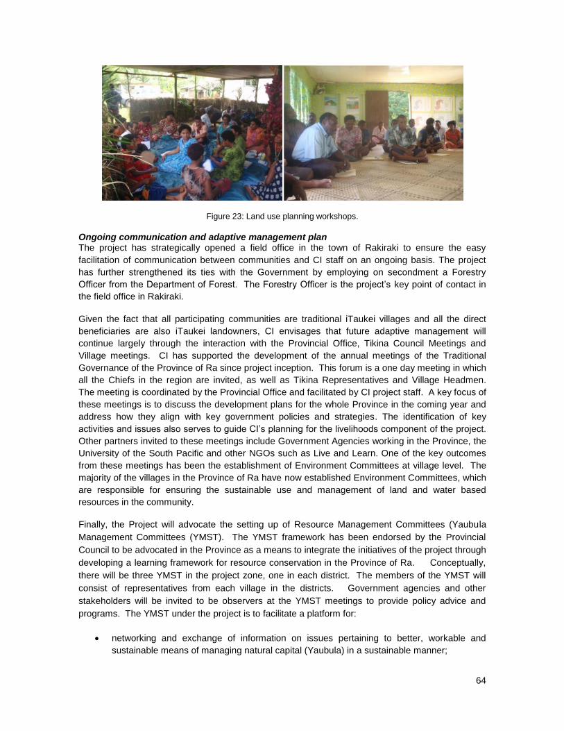
64
Figure 23: Land use planning workshops.
Ongoing communication and adaptive management plan The project has strategically opened a field office in the town of Rakiraki to ensure the easy
facilitation of communication between communities and CI staff on an ongoing basis. The project
has further strengthened its ties with the Government by employing on secondment a Forestry
Officer from the Department of Forest. The Forestry Officer is the project‘s key point of contact in
the field office in Rakiraki.
Given the fact that all participating communities are traditional iTaukei villages and all the direct
beneficiaries are also iTaukei landowners, CI envisages that future adaptive management will
continue largely through the interaction with the Provincial Office, Tikina Council Meetings and
Village meetings. CI has supported the development of the annual meetings of the Traditional
Governance of the Province of Ra since project inception. This forum is a one day meeting in which
all the Chiefs in the region are invited, as well as Tikina Representatives and Village Headmen.
The meeting is coordinated by the Provincial Office and facilitated by CI project staff. A key focus of
these meetings is to discuss the development plans for the whole Province in the coming year and
address how they align with key government policies and strategies. The identification of key
activities and issues also serves to guide CI‘s planning for the livelihoods component of the project.
Other partners invited to these meetings include Government Agencies working in the Province, the
University of the South Pacific and other NGOs such as Live and Learn. One of the key outcomes
from these meetings has been the establishment of Environment Committees at village level. The
majority of the villages in the Province of Ra have now established Environment Committees, which
are responsible for ensuring the sustainable use and management of land and water based
resources in the community.
Finally, the Project will advocate the setting up of Resource Management Committees (Yaubula
Management Committees (YMST). The YMST framework has been endorsed by the Provincial
Council to be advocated in the Province as a means to integrate the initiatives of the project through
developing a learning framework for resource conservation in the Province of Ra. Conceptually,
there will be three YMST in the project zone, one in each district. The members of the YMST will
consist of representatives from each village in the districts. Government agencies and other
stakeholders will be invited to be observers at the YMST meetings to provide policy advice and
programs. The YMST under the project is to facilitate a platform for:
networking and exchange of information on issues pertaining to better, workable and
sustainable means of managing natural capital (Yaubula) in a sustainable manner;

65
managing the affirmation of traditional knowledge and incorporating new scientific
knowledge and information gathered through the project and other means;
building a network of young leaders and future advocates for conservation.
Roles and responsibilities of the YMST would involve:
ensuring rehabilitation of natural resources;
enhancing livelihood and sources of income for communities;
ensuring a safe place to raise family / food security;
identifying common resources, threat s and management issues; and
facilitating the development and implementation of the project‘s Community Monitoring
Plan.
The YMST will therefore serve as a key platform through which ongoing communication and
consultation between the project and community groups can be undertaken.
G3.9 Describe what specific steps have been taken, and communications methods used, to
publicize the CCBA public comment period to communities and other stakeholders and to
facilitate their submission of comments to CCBA. Project proponents must play an active
role in distributing key project documents to affected communities and stakeholders and
hold widely publicized information meetings in relevant local or regional languages.
The project plan and this PDD are the results of inputs generated from series of discussion-
consultation-meetings with all the local stakeholders that include local communities and institutions
where the project is located. The Project is working closely with the Provincial Office and attends all
meetings at all levels of the Provincial Administration. These include the Provincial Council
Meeting, and Tikina and Village meetings. Project Staff attend Provincial Meetings twice a year and
Tikina Meetings every quarter. Village meetings are more regular. Project Staff take these
opportunities to update participants on project progress and milestones. Therefore, stakeholders
are already generally familiar with the project plan.
Upon publication of the PDD on the CCBA website, CI Fiji will notify each of the communities
involved in the project by organizing a series of village meetings. An information brochure
summarizing the key messages of the PDD and the public comment process will be distributed, and
a copy of the PDD will be made available in each village. Instructions will be given on how to submit
comments online. CI‘s Field Officer will also leave comment boxes in the main villages in each
district so that comments can be collected from those without internet access, English capability, or
any other reason that make it difficult for them to submit comments online. In addition to the village
comment boxes, there will be three main points for the collection of public comments. These
include the CI Head office in Suva, the CI Rakiraki field office in Ra, and the Provincial Office in
Rakiraki Town.
In addition, it is possible that the annual Traditional Governance meeting will take place during the
public comment period. This would serve as a platform to inform all the Chiefs of Ra about the PDD,
and key project documents would be widely distributed. The Provincial Office has already agreed to
facilitate the collection of comments in this forum. Any comments collected will be given to CI Fiji
who will then forward them to the CCBA Secretariat.
Letters will also be written to all of CI‘s partners in the Civil Society sector, Government Agencies,
and the REDD+ Steering Committee informing them about the publication of the PDD and to invite

66
them to respond to the public comment period. An information brochure detailing the process to
follow will be attached to the letter. Organizations with offices or representatives stationed in Suva
and Rakiraki will be contacted.
G3.10 Formalize a clear process for handling unresolved conflicts and grievances that arise
during project planning and implementation. The project design must include a process for
hearing, responding to and resolving community and other stakeholder grievances within a
reasonable time period. This grievance process must be publicized to communities and
other stakeholders and must be managed by a third party or mediator to prevent any conflict
of interest. Project management must attempt to resolve all reasonable grievances raised,
and provide a written response to grievances within 30 days. Grievances and project
responses must be documented.
The project utilizes the conflict resolution procedure outlined in Appendix 4. This process has been
communicated to all participating communities as well as other key project stakeholders. In the
formative period of the project when activities were only focused in Tokaimalo, conflict resolution
was carried out with the assistance of the Methodist church pastor, as a third party mediator. All
conflicts or perceived issues were channeled to the Pastor through verbal communications who
would then inform project staff and set a meeting date to address the grievance. The meeting would
be chaired by the Pastor. Both parties would be invited to present their case and the Pastor would
make a decision on how best to resolve the issue.
As the project grew in scope to include additional districts, the conflict resolution process was fine
tuned and re-communicated to community members. The main purpose of the conflict resolution
procedure is to promote an optimal working environment that ensures equal opportunities and win-
win scenarios for project stakeholders and partners, as well as to uphold the rule of law in Fiji.
As a general rule, the rights of all parties will be upheld and respected where all members of the
communities and partner organizations connected in any way to the Project is given the right to
raise grievance and assisted to work toward an amicable resolution. The aggrieved or communities
who lodge a complaint shall not be prejudiced in any future work relating to the Project as fair
hearing and trial will be upheld at all times. The Project will not seek the opinion of outside parties
on internal issues nor allow influence of outside parties to the proceedings or resolutions. The
Project will also ensure that private spaces are made available to facilitate fair trial and amicable
solution. Issues raised through grievance or conflict will be resolved in the shorted possible time
and kept confidential.
There are two types of conflict identified by the project. These include grievances against (1)
Project staff, and (2) Project operations and activities. The procedure for conflict resolution for the
two types of anticipated grievances are different.
In the case of grievances against Project staff, any internal grievance will be dealt with in
accordance to Section 14: Conflict resolution and formal complaints policy of the CI Standard
Operating Procedure. All grievances against any CI Fiji member of staff shall submit their grievance
to the Country Program Director/ Manager. Upon receipt of the grievance, the Program
Director/Manager shall immediately investigate the matter following the procedures outlined in the
Operations Manual.
In the case of grievances relating to operational issues and project activities such as weeding, line
cutting, polling, seedling supplies, planting and other related issues, the procedures differ from the

67
above. If the grievance is a minor issue or concern then community members are encouraged to
speak directly to any nearest project staff who many be able to immediately provide a satisfactory
resolution to the issue. If the conflict is beyond the capacity of the field staff to resolve, the
aggrieved person shall submit a written letter outlining the issue. The letter shall be submitted to
the Ra Field Office or Head Office in Suva whichever is more convenient. The receiving officer
shall note in the ‗Conflict Register‘ the name of the aggrieved, the nature of the grievance, and the
background of the situation. A notice will be journalized in the register and copied to the Provincial
Office within 5 working days. The field officer will be given the first opportunity to resolve the issue
through thorough investigation and communication with the aggrieved party. Resolution should be
reached within five working days and a report tabled to the Program Director/Manager and copied
to the Provincial Officer. Should an amicable solution be difficult to attain, the said report will
provide a recommendation for the date of a hearing. The report should also clearly articulate all
background information on the case and the result of the meeting held between the Project Officer
and the aggrieved party. The Provincial Office will be the project arbitrator in these cases and its
decision final. Parties that wish to contest the decision made by the project arbitrator may take the
case to the court of law.
In practice however, most community conflicts and grievances will be handled in a more causual
manner. Project staff members are on site, hence very accessible to community members and other
partners if there are grievances that may arise.
Members of the community are also free to take grievances directly to other Government agencies
such as the Provincial Administration, Department of Indigenous Affairs and the Police, if they are
not satisfied with the existing conflict resolution process.
G3.11 Demonstrate that financial mechanisms adopted, including projected revenues from
emissions reductions and other sources, are likely to provide an adequate flow of funds for
project implementation and to achieve the anticipated climate, community and biodiversity
benefits.
The grant fund from Fiji Water is adequate to support the development and implementation of
activities to meet all planned targets and deliverables linked with the project objectives (through
2039). There will be no revenue generated from emissions removals as the project is not creating
tradeable carbon credits. Project grant documentation to demonstrate the financial sustainability of
the project will be made available to the validation body.

68
G4 MANAGEMENT CAPACITY AND BEST PRACTICES
G4.1 Identify a single project proponent which is responsible for the project’s design and
implementation. If multiple organizations or individuals are involved in the project’s
development and implementation the governance structure, roles and responsibilities of
each of the organizations or individuals involved must also be described.
The project proponent of the Nakauvadra Forest Carbon Project is Conservation International
Foundation (CI) through its Fiji office (CI-Fiji). CI-Fiji has overall responsibility for the implementation
of the project. CI is a global, non-governmental organization (NGO) based in Washington D.C.
(USA), with offices in more than 30 countries and more than 1000 partners around the world. CI‘s
mission is to help societies adopt a more sustainable approach to development—one that considers
and values nature at every turn.
CI has had a presence in Fiji for over 10 years, opening an office in 2003 in Suva on the main
island of Viti Levu to work with the National Trust of Fiji (NTF) towards strengthening the Natural
Heritage Unit and establishing the Sovi Basin (a Key Biodiversity Area and the only remaining large
tract of indigenous forest in Fiji) as a Protected Area. Since 2009, CI‘s work in Fiji has expanded to
reforestation, sustainable land use and the promotion of alternative livelihoods through the
identification of a network of protected areas on Viti Levu. Other key in-country partners include the
University of the South Pacific, members of the Fiji Locally Managed Marine Areas (FLMMA), the
Department of Environment and the Department of Fisheries and Forests.
CI Fiji is led by a Programme Director who oversees the management of all CI Fiji operations
supported by three core operational staff who provide financial, administrative, and Information
Technology (IT) support to the program. There are four technical project staff, including a Forest
Ecologist, a Sustainable Production/Livelihoods Manager, and a Biodiversity and Ecosystems Field
Officer who is based in the field office in Rakiraki which was set up as the implementation base for
the reforestation project. Details are outlined below in Figure 23.
Figure 24: CI Fiji staff organogram.

69
G4.2 Document key technical skills that will be required to implement the project
successfully, including community engagement, biodiversity assessment and carbon
measurement and monitoring skills. Document the management team’s expertise and prior
experience implementing land management projects at the scale of this project. If relevant
experience is lacking, the proponents must either demonstrate how other organizations will
be partnered with to support the project or have a recruitment strategy to fill the gaps.
CI Fiji will be responsible for the overall implementation of the project, whilst receiving any needed
technical assistance from CI-Headquarters and other CI offices. Together, CI staff cover all the
necessary skills needed to implement the project, starting from community mobilization, site
delineation/surveying, species-site suitability assessment, to seedling production until reforestation
establishment, maintenance, and project monitoring and impact assessment. On occasion, where
required, consultants, government agencies or other NGOs will be contracted or partnered with to
assist with any of the project activities, monitoring or documentation needs (such as providing
training to communities on the sustainable harvesting of the harwood species in year 20 of the
project).
As described above, CI has had a presence in Fiji for over 10 years and has experience in
protected area establishment and management, and community livelihoods and agro-forestry
projects and activities. It also has significant expertise on sustainable land use management and
the setting up of trust funds such as the Sovi Basin Trust Fund. CI Fiji is also the only NGO working
with rural communities in the Province of Ra on the demonstration of integrated agriculture and
forest resource management initiatives that ensure the protection and restoration of watershed
areas while diversifying revenue sources and creating healthy sustainable economies at the
grassroots level.
Technical support on the PDD development and carbon accounting and measurement is provided
by CI-Headquarters and CI-Japan. CI has extensive experience in the development and
implementation of REDD-plus (including A/R) projects and is building a diverse global portfolio of
site-level initiatives, with five projects already validated under the Verified Carbon Standard (VCS)
and/or the Climate, Community and Biodiversity Standards (CCBS) in Peru, China, the Philippines
and Brazil, and several more ongoing in Madagascar and the DRC. At the national level, CI advises
numerous countries on REDD-plus policy and UNFCCC negotiations, as well as on REDD-
Readiness and Measuring, Monitoring, Reporting and Verification (MRV) issues and is testing the
development of nested approaches to REDD-plus in order to link its ground activities with national
REDD-plus frameworks. Finally, CI has conducted extensive capacity building efforts on REDD-plus
that have involved more than 1,300 stakeholders, including government officials, representatives
from NGOs, indigenous leaders, rural communities, the corporate sector, and academia.
The Department of Forests is a key partner to the project, and provides technical advice and
assistance in forestry related activities. This includes the provision of community training courses
(nursery set up, seedling propagation, planting techniques), carrying out quality control on the
preparation and implementation of reforestation activities, and doing forest health checks. They will
also work with CI to provide capacity building on the sustainable harvesting of the hardwood
species in year 20 of the project. A Forestry Officer has been seconded by the Department of
Forest to assist the project from 2008 – 2015. This indicates the strong support from the
Department of Forest for the work that the project is doing in the Province of Ra.
In addition to the technical expertise provided by the Department of Forests, CI has the required
technical expertise required to develop and implement the reforestation components of the project.
70
The project team includes two Foresters: Susana W Tuisese, CI Fiji Country Director is a graduate
of the Australian National University with 17 years of experience working in the Department of
Forests and five years in the private forestry sector before joining CI. Nemani Vuniwaqa, CI Field
Officer, holds a Certificate in Forestry from the Forestry Training Centre, Fiji with 10 years field
experience. He is on secondment from the Department of Forests to assist CI with field
implementation of the project. Nemani has been working on the project since 2009. In addition, the
CI team carries over 30 years of experience in Forestry with emphasis in the field of community
forestry, establishment of plantations (mahogany and pine), as well as planning, monitoring and
evaluation of harvesting operations for plantation forest (mahogany and pine) and native forest.
In terms of project management, CI will adopt the project cycle commonly known as the PDCA
cycle; an acronym that reflects the need to plan (P), implement planned actions (D), and regularly
monitor (C). Small corrections can then immediately be identified and implemented. Large
corrections are considered and incorporated into the plans for the next step (the ―A‖ or Action
phase). The A phase becomes the P phase for the next stage, and the cycle repeats. The PDCA is
the project‘s formal practice of adaptive management. It allows flexibility to accommodate
unforeseen issues during the course of the project implementation, while maintaining coordinated,
well-structured decision making and documentation.
G4.3 Include a plan to provide orientation and training for the project’s employees and
relevant people from the communities with an objective of building locally useful skills and
knowledge to increase local participation in project implementation. These capacity building
efforts should target a wide range of people in the communities, including minority and
underrepresented groups. Identify how training will be passed on to new workers when there
is staff turnover, so that local capacity will not be lost.
CI Fiji, in conjunction with the Department of Forests, has delivered a number of hands-on training
to the mataqali as part of the project‘s objectives to ensure full participation and involvement of local
communities in the development and implementation of the reforestation components of the project.
Among the capacity building plan being pursued are trainings on seedling collection, line polling and
planting, nursery establishment and management, forest health monitoring, and sustainable
harvesting practices.
At the commencement of the project in 2009, seedlings for native species were difficult to secure.
CI therefore initiated capacity building among local communities to propagate native species.
Initially a nursery was established on site at the Tokaimalo District Methodist Church headquarters
and at the CI‘s office Rakiraki, and further capacity building was undertaken to train community
members on how to establish and maintain the nurseries. As a demonstration that the trainings
were effectively transferred to the local communities, 3 additional community nurseries were
subsequently set up in Tokaimalo, and 4 individual nurseries in Naroko. The project is currentl
sourcing most of the native tree species from these trained community members through their own
independently managed nurseries. Purchasing the seedlings rasied by the community encourages
them to learn more about raising various species of tree. This is a good incentive as the knowledge
gained can still be used by them even after the project lifetime as there is growing demand from
other communities and organizations to carry out reforestation activities in support of the national
tree planting campaigns by the Department of Forest. Members of the local communities were
trained on seed collection and nursery techniques by the Department of Forest to ensure quality
control and production of superior seedlings.
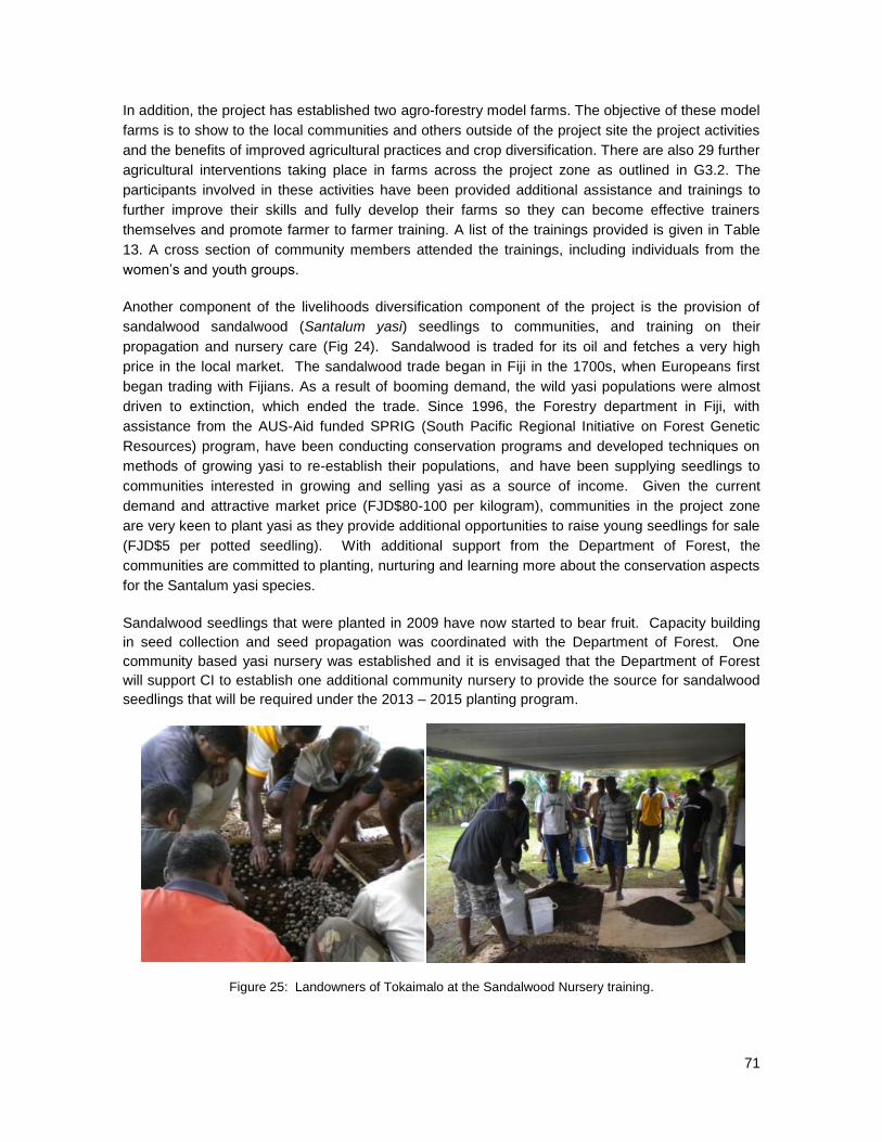
71
In addition, the project has established two agro-forestry model farms. The objective of these model
farms is to show to the local communities and others outside of the project site the project activities
and the benefits of improved agricultural practices and crop diversification. There are also 29 further
agricultural interventions taking place in farms across the project zone as outlined in G3.2. The
participants involved in these activities have been provided additional assistance and trainings to
further improve their skills and fully develop their farms so they can become effective trainers
themselves and promote farmer to farmer training. A list of the trainings provided is given in Table
13. A cross section of community members attended the trainings, including individuals from the
women‘s and youth groups.
Another component of the livelihoods diversification component of the project is the provision of
sandalwood sandalwood (Santalum yasi) seedlings to communities, and training on their
propagation and nursery care (Fig 24). Sandalwood is traded for its oil and fetches a very high
price in the local market. The sandalwood trade began in Fiji in the 1700s, when Europeans first
began trading with Fijians. As a result of booming demand, the wild yasi populations were almost
driven to extinction, which ended the trade. Since 1996, the Forestry department in Fiji, with
assistance from the AUS-Aid funded SPRIG (South Pacific Regional Initiative on Forest Genetic
Resources) program, have been conducting conservation programs and developed techniques on
methods of growing yasi to re-establish their populations, and have been supplying seedlings to
communities interested in growing and selling yasi as a source of income. Given the current
demand and attractive market price (FJD$80-100 per kilogram), communities in the project zone
are very keen to plant yasi as they provide additional opportunities to raise young seedlings for sale
(FJD$5 per potted seedling). With additional support from the Department of Forest, the
communities are committed to planting, nurturing and learning more about the conservation aspects
for the Santalum yasi species.
Sandalwood seedlings that were planted in 2009 have now started to bear fruit. Capacity building
in seed collection and seed propagation was coordinated with the Department of Forest. One
community based yasi nursery was established and it is envisaged that the Department of Forest
will support CI to establish one additional community nursery to provide the source for sandalwood
seedlings that will be required under the 2013 – 2015 planting program.
Figure 25: Landowners of Tokaimalo at the Sandalwood Nursery training.

72
Table 13: List of trainings conducted and planned.
Name of training Training objective Main topics
Trainings targeted for communities
Tree identification & Seed Collection
To ensure that communities can correctly identify native tree species and are aware of the best flowering and fruiting seasons to collect viable seeds for germination
Tree identification using leaf, bark,
flowers and seeds
Tree flowering seasons
Seed collection and predation
Basic Seed Storage
Polling and Planting
To be competent with the use of compass, line bearing
Compass reading
Setting base line to aid planting
Setting up Line bearing
Weeding techniques
Mensuration techniques to
determine the total number of
seedlings needed
Planting techniques
Nursery establishment &
Management
To ensure that communities are able to establish and manage a successful nursery by themselves
Requirements to consider before
constructing nurseries
Different sizes of nurseries
Techniques on constructing simple
community nurseries
Weed and pest management
Forest Health Monitoring
To assist Project Officer in the collation of information to assess Forest Health
Measuring parameters and
technique of measurement
Tree Health Assent data entry
Plot selection
Timber harvesting
Awareness Training
To ensure that communities understand the Laws and Regulations governing Forest and Timber Harvesting; and the practical operations involved
Rules and regulations related to
forest and harvesting
o Code of Logging Practice
o Health and Safety
o Environment Impact Assessment
o Methods of Timber Harvesting
Training on Operating
o Tree Selection and mensuration
o Log Production and
transportation logistics
o Sawmill or portable mill operation
o Health and Safety
Business Management Training
o Financial Literacy
o Log Production costing and price
determination

73
o Business Management
Managing Teak for healthy
regrowth
To assist communities to appreciate and understand the biological aspects of teak
Biology of Teak
o Growth Rate
o Optimum growth requirements
o Stand Management Regime
Fire awareness and
monitoring
To increase community awareness on wild fire risks and to assist field staff with the monitoring of fires in project area
Laws pertaining to Fires
Types of Fires (controlled and
unplanned)
Fire Mitigation & Prevention
Fire First Aid
Fire Warden Roles & Data
Collection
Sustainable Land
Management
To increase community awareness on the importance of soils resource and its management
Importance of soils
Soil Fertility and plant growth
Land use capability
Soil Erosion & Degradation
Land management technologies
Root Crop Production To assist communities in methods to improve crop productivity.
Ginger production
Taro production
Cassava Production
Sweet Potato Production
Training on Traditional
Crop Varieties
To ensure that communities understand the various crop varieties in Fiji and the importance of conserving them.
Different crop varieties
Indigenous knowledge of traditional
varieties
Advantages of conserving genetic
diversity
Bee Keeping
To encourage community interest in bee keeping and to improve knowledge on productivity. This training was mainly targeted at women
Basic hive components
Handling bees
Bee colony
Selection and rearing of queen
bees
Harvesting and Marketing
Financial Literacy Training
To help community members manage their personal finances and gain understanding about the options available for savings and budget management
Budgets
Financial management
Basic accounting principles
Savings plans
Biodiversity monitoring To assist CI staff in conducting biodiversity monitoring
Basic bird identification training
(Bird diversity in Fiji, bird calls)
Basic plant taxonomy training

74
(bark slash, leaves, flowers
identification)
Trainings targeted for Project Field Supervisors and Assistants
Project Management
Training
To assist project Staff to effectively manage projects, both in a technical and supervisory capacity
Project vision/goals/activities
Time Management
Team Management
Planning & Target setting
Forest Technical Skills
o Polling & Planting
o Base Line Setting
Communication Skills
Monitoring and Evaluation
Report writing
Basic Map and GPS
reading
To enable project staff to be proficient and efficient in using maps and GPS
Map Reading
o Different types of maps
o Scales & Legends
o Field Demonstration and
Application
G4.4 Show that people from the communities will be given an equal opportunity to fill all
employment positions (including management) if the job requirements are met. Project
proponents must explain how employees will be selected for positions and where relevant,
must indicate how local community members, including women and other potentially
underrepresented groups, will be given a fair chance to fill positions for which they can be
trained.
Since CI is the lead implementer, the system of hiring is thus based on CI hiring policy. As an
institution, CI has an established policy on hiring that subscribes to the universally accepted norms
for human resources development. Worthy to emphasize is its adherence to providing equal
opportunity for everyone who is qualified irrespective of gender, religion or nationality. This is also
being maintained as the hiring policy in the project.
Employment through the project falls under three major categories. These include skilled and
specialized technical officers, technical field assistants and contract workers. The hiring process
follows two different approaches:
For the specialized and technical positions, job description forms are created and submitted for
approval by Human Resources within CI. The position is advertised internally, one the CI website,
and published in a local newspaper for at least 10 working days. The selection process includes a
review of the submitted applications and an interview. The panel‘s recommendation is sent to the
Executive Director for approval before the candidate is hired.
For the technical field assistant positions which are based out of the Rakiraki field office, community
members from the project sites are strongly encouraged to apply. Working in these capacities
requires some minimum qualifications like being able to read and write as well as the ability to work

75
in the field for long hours. The project hires local staff with the assistance of village chiefs or good-
standing people in the community such as the Mata-ni-Tikina (District Representative) who confirm
and endorse that such applicants have the willingness, capacity and interest to meet the job
requirements. At the same time, each candidate is assessed while on three months probation
before they are confirmed into the position. Under this category of positions, all of those hired come
from the communities in the project sites or have maternal links to the project zone and are
provided with all the necessary training they need prior to, and during, their employment with CI.
Traditionally a person with maternal links to a community has the same privileges as community
members.
Contracts are assigned for all field implementation activities such as seedling provision, polling and
line cutting, planting, weeding and maintenance work. These activities have been assigned
specifically to the target beneficiaries of the project (the landowning mataqali) as per the terms
provided under the Community Agreements. Landowning mataqali‘s that sign Community
Agreements under the project are guaranteed full involvement with all field aspects of the project.
Because of the hard, manual nature of the reforestation and maintenance activities, men are more
disposed to carry out this work. However, women have participated in managing community
nurseries that supply seedlings to the project. The women‘s groups in villages have also been hired
to provide the catering during workshops and training events.
Figure 26: Women of Vatukacevaceva Village sorting seedlings to be planted from the nursery.
In addition to the above, the project is also considering taking on international internship for
students doing Forestry or Natural Resource management. The students will assist the to assess
growth rates of the range of native tree species that have been planted in the reforestation zone in
northeast Fiji, in relation to their substrate, location, aspect, slope, altitude, which would allow the
reforestation program team to better understand how to be most successful in terms of maintaining
low tree seedling mortality and high tree growth rates across a range of different sites. The findings
from this study would influence the way the program would conduct the remainder of their
reforestation program, and could also be used to develop a simple monitoring system that could be
used to assess and indicate project success over the next decade or more.
G4.5 Submit a list of all relevant laws and regulations covering worker’s rights in the host
country. Describe how the project will inform workers about their rights. Provide assurance

76
that the project meets or exceeds all applicable laws and/or regulations covering worker
rights and, where relevant, demonstrate how compliance is achieved.
Fiji is a member of the International Labor Organization (ILO) and party to 33 international labor
conventions of which 30 are still in force14
. Fiji‘s labor laws cover employment relations; national
training; health and safety at work; industrial associations; minimum wages and workers
compensation as listed below.
Employment Relations Promulgation 2007
Employment Relations (Administration) Regulation 2008
Fiji National Training Act (Cap 93)
Health and Safety at Work Act 1996
Health and Safety at Work Amendment Act 2003
Health and Safety at Work (Administration) Regulation 1997
Health and Safety at Work (Training) Regulation 1997
Health and Safety at Work (General Workplace Conditions) Regulation 2003
Health and Safety at Work (control of Hazardous substance) Regulation 2006
Wages Regulation (Sawmill and Logging Industry) Order 2012
Workmen’s Compensation Act (Capt 94)
The Fiji Government has also adopted the following codes of conduct and policies specifically related to the above labor laws:
Code of Good Faith for Collective bargaining 2008
2008 National Policy on Sexual Harassment in the Workplace
Code of Ethics for Mediators 2008
Employment Relations (Employment Agencies) Regulation 2008
National Code of Practice for HIV/AIDS in the workplace 2008
The project complies with all national labor laws in the country. The project supports the
Employment Relations Promulgation by adopting minimum labor standards that are fair to workers
and employers; eliminating discrimination based on gender, race and other factors. The project
uses its own Conflict Resolution Procedure that supports the principles enshrined in the Act;
advocating the establishment of mediation services and consultation between labor and
management in the workplace.
The Fiji National Training Act supports the creation of the Fiji National Training Council which
provides training of persons and mandates the payment of levies connected with training. The
project pays levies to the Fiji Training Productivity Authority.
The project complies with the Health and Safety Act through the adoption of a simple ―workplace
health and safety manual‖. The manual outlines safety requirements for all work environments that
will be encountered in the project and requires all new workers to sign off after induction to indicate
their understanding of how tools, machinery and their own personal care work together to make the
workplace a healthy and safe working environment.
Although the project does not fall directly under any industrial labor category identified under the
wages regulation, the project complies with its closest groupings under the Wages Regulation
contained in the Wages Regulation (Sawmill and Logging Industry) Order 2012 and can be
14
See http://webfusion.ilo.org/public/applis/appl-byCtry.cfm?lang=EN&CTYCHOICE=2080

77
classified under other Field Work. Under this category, the project is providing compensation well
above the minimum wages listed under the law.
During the induction of new employees, CI outlines their rights as employees and also highlights the
role of CI as the employer. Two manuals are discussed and signed off during these inductions. All
workers and community contractors are given inductions and training to discuss the following
manuals: Conflict Resolution Manual (Annex 4), and Operations, Health and Safety Manual (Annex
5).
G4.6 Comprehensively assess situations and occupations that pose a substantial risk to
worker safety. A plan must be in place to inform workers of risks and to explain how to
minimize such risks. Where worker safety cannot be guaranteed, project proponents must
show how the risks will be minimized using best work practices.
Some field activities linked with the reforestation components of the project may pose potential risks
for project staff as well as the contracted community laborers who are directly involved as field
workers. The weeding and tree planting in particular is physically demanding and workers are at risk
of getting injured through the use of cutting/pointed tools and muscle/ligament strains. Depending
on the terrain and experience of the person participating in the activity, up to 100 tree seedlings
may be planted by a person in a day. Muscular aches and pains can be common at the beginning
of the planting season and community workers are advised to pace out their work, carrying and
planting fewer trees at the start of the planting period and to progressively build up from there. The
project recognizes the risks involved and inducts all new tree planters through the Operations,
Health and Safety Manual (see Appendix 5) to ensure that each person understands the risks
involved and takes measures to avoid them. The manual outlines the early signs of injury; the do‘s
and don‘ts of such ailments, first aiding, the care and maintenance of tools and the techniques that
should be adopted to avoid injuries.
G4.7 Document the financial health of the implementing organization(s) to demonstrate that
financial resources budgeted will be adequate to implement the project.
Conservation International is a nonprofit organization headquartered in the Washington D.C.
metropolitan area. It was founded in 1987 and stands upon a strong financial footing. CI strives to
exercise the highest level of stewardship over donor contributions and has consistently earned the
highest ratings from charity watchdog groups such as Charity Navigator and the American Institute
of Philanthropy. CI‘s financial statements are audited and certified annually by a respectable firm in
the auditing industry.
Funding for this project is provided as a grant from Fiji Water LLC. Fund allocation is sufficient to
ensure that project activities are carried out over the intended project period. The financial
monitoring and reporting system agreed to between CI and Fiji Water allows flexibility for adapted
financial management.

78
G5. LEGAL STATUS AND PROPERTY RIGHTS
G5.1 Submit a list of all relevant national and local laws and regulations in the host country
and all applicable international treaties and agreements. Provide assurance that the project
will comply with these and, where relevant, demonstrate how compliance is achieved.
Many of Fiji‘s laws were elaborated in the early 1950‘s. Some of the laws have remained in use
while others have been reviewed to reflect policy changes aimed at improving governance of the
people, the land, and its resources. In recent years many Decrees have been declared (252 since
2006) addressing all aspects of national governance15
.
Laws directly or indirectly related to the project are as follows:
Laws that relate to Tenure and Jurisdiction
State Lands Act (Cap 132)
iTaukei Land Act (Cap 133)
iTaukie Lands Trust Act (cap 134)
iTaukei Affairs Act (Cap 120 Rev 2006)
Laws that relate to Planning
Town Planning Act (Cap 139) Land Act (Cap 140)
Roads Act (Cap 175)
Water Supply Act (Cap 144)
Sewage Act (Cap 128)
Traffic Regulations 1974
Public Health Act (Cap 111)
Laws relating to Resources Conservation and Development
Environment Management Act 2005
Agricultural Land and Tenant Act (Cap 270)
Irrigation Act (Cap 144)
Drainage Act (Cap 143)
Land Conservation and Improvement Act (Cap 141)
Plant Quarantine Act (Cap 156)
Pesticide Act (Cap 157)
Forest Act (Cap 150) – repealed and replaced by the Presidential Decree No 31 of 1992
Forest Decree 1992
Laws relating to Conservation and Biodiveristy
Forest Act (Cap 150) – does not address Protected Areas although defines Forest and
Nature Reserves in specific terms.
15
A list of all the decrees approved in the Republic of Fiji Islands can be viewed at:
http://www.fiji.gov.fj/index.php?option=com_docman&task=cat_view&gid=59&Itemid=158 and
http://www.paclii.org/fj/indices/legis/Fiji%20-%20Decrees_2012.html

79
Rivers and Streams Act (Cap 136)
Birds and Game Protection Act (Cap 170)
Fiji is a signatory to a number of conventions as listed below which are relevant to project
implementation. These include the following:
Convention on Biological Diversity (CBD)
UN Framework Convention on Climate Change (UNFCCC)
Waigai Convention (bans the importation of hazardous chemicals and radioactive
substances)
International Convention on the Elimination of all Forms of Racial Discrimination (CERD)
International Convention on the Elimination of all forms of Discriminaton against Women
(CEDAW)
The project will comply will all these laws and regulations. The project is implemented in close
coordination and communication with national government agencies (the Department of Forest) and
local government (Provincial Office of Ra). In addition, CI liaises very closely with the Department of
Agriculture, the University of the South Pacific (Institute of Applied Science) as well as the National
Trust of Fiji. The compliance is assured by this project arrangement.
G5.2 Document that the project has approval from the appropriate authorities, including the
established formal and/or traditional authorities customarily required by the communities.
The project gained approval from the Provincial Office of Ra to implement the project activities
following a traditional presentation to the Provincial Council in 2009. The Provincial Council
consists of all the iTaukei Chiefs in the Province of Ra and has an important influence over
community-level decision making processes. The Council is mandated under the iTaukei Affairs
Act and can make any bylaws with regards to the health, welfare and good governance of the
people, subject to the approval of the iTaukei Affairs Board.
The Department of Forest has fully supported the Project from the very beginning through the
provision of a Forestry Officer on secondment to assist the project with the implementation of its
field activities. The Forestry Officer has been the Project‘s key point person in the field providing
liaison with community members, landowning units, government agencies operating out of Rakiraki
town and the Provincial Office. Strong support has been substantiated through two renewal
extensions of the period of engagement for the Forestry Officer. Strong technical support is also
provided by the Department of Forest as evident through the participation of key Divisions within the
DoP. The Extension Services have provided extensive work on building community capacity to raise
and propagate seedlings of native species while the Research Division has focused on the
propagation and distribution of sandalwood seedlings.
In addition to the above, the REDD+ Policy framework falls under the ambit of the Department of
Forest. The German Technical Cooperation (GIZ) is currently assisting the Department of Forest
on the implementation of Fiji‘s REDD+ policy which is currently at the Readiness phase. CI gave
detailed presentations about the project to the Steering Committee in 2012 and has received
acknowledgement that it is being considered a pilot AFOLU project in terms of its methodological
approach and objectives. The focal point of the UNFCCC in Fiji is the Ministry of Foreign Affairs.
While there is no direct linkage between the project and Fiji‘s climate change policy, the project has
been asked to report on its activities and progress on an annual basis, which CI will certainly
comply with.

80
G.5.3 Demonstrate with documented consultations and agreements that the project will not
encroach uninvited on private property, community property, or government property and
has obtained the free, prior, and informed consent of those whose rights will be affected by
the project.
The project reforestation sites are located on land owned by the native mataqalis who hold the
customary rights to occupy and use these lands. CI and each of the participating mataqalis have
signed a Community Agreement that provides guidance and understanding on the roles and
responsibilities of each party during the project lifetime. According to the agreement, each mataqali
gives full consent to Conservation International to carry out the reforestation project on their behalf
and thereby grants access to their land for such purposes. Copies of the signed Community
Agreements will be made available to the validator.
A summary of the process followed to reach the point where Community Agreements were signed
is as follows:
Following approval by the Ra Provincial Council to work in the province, the project then began
engagement at the district level with the Mata ni Tikina (District representative) first in Tokaimalo
(2009) then Naroko (2010) and finally Naiyalayala in late 2010. Project goals and objectives
including planned activities were presented at the Tikina meetings. Once the Tikina endorsed the
project, engagement was extended down to the village level. It was during the Village Meetings
that CI was able to identify interested landowners with vacant land to be used for the project‘s
reforestation program. Once the planting began, news about the project quickly spread and other
interested mataqali came directly to the CI Rakiraki Field Office to inform staff that they too were
interested in participating in the project.
CI then approached each individual mataqali and requested a mataqali meeting. In the mataqali
meeting procedures and project objectives are discussed. A field visit to each potential
reforestation site is then carried out to check its suitability. Suitability factors include location,
accessibility, vegetation cover, etc. Once the site has been assessed and considered suitable for
reforestation, the Community Agreements are signed by all parties and dates set to begin the
wedding, line polling and planting.
G5.4 Demonstrate that the project does not require the involuntary relocation of people or of
the activities important for the livelihoods and culture of the communities.
The proposed project reforestation activities take place only on uninhabited grasslands owned
by the native landowning units (mataqali), and therefore does not involve the relocation of any
individuals or communities. Each mataqali has consented to the use of the land for the project
period as detailed in the Community Agreements. The reforestation areas were also strategically
chosen in discussion with the landowners to identify sites which are not used for any other purpose
and therefore do not require the relocation of any activities important for their livelihoods or cultural
practices.
G5.5 Identify any illegal activities that could affect the project’s climate, community or
biodiversity impacts (e.g., logging) taking place in the project zone and describe how the
project will help to reduce these activities so that project benefits are not derived from illegal
activities.
81
The project proponent does not expect any illegal activities to be a threat to the project‘s expected
climate, community and biodiversity benefits. CI has spent has spent siginifcant time working with
all the villages in the project zone to ensure a thorough understanding of the benefits of the project
in the short and long term, and has achieved the buy-in and support from all of the communities
involved. In addition, due to the customary ownership and native land titling, illegal activities by non
landowning units from outside the project zone would not occur as any unsanctioned activities
would be actively enforced by both the landowners and government departments such as the
Native Land Trust Board responsible for the rights of its members.
G5.6 Demonstrate that the project proponents have clear, uncontested title to the carbon
rights, or provide legal documentation demonstrating that the project is undertaken on
behalf of the carbon owners with their full consent.
The project reforestation sites are located on land owned by the native mataqalis who hold the
customary rights to occupy and use these lands. CI and each of the participating mataqalis have
signed a Community Agreement that provides guidance and understanding on the roles and
responsibilities of each party during the project lifetime. According to the agreement, each mataqali
gives full consent to Conservation International to carry out the reforestation project on their behalf
and thereby grants access to their land for such purposes. CI will also have the ability to claim that
the project will generate carbon sequestration and that these climate benefits will be validated and
verified to the CCB Standards. Copies of the signed Community Agreements will be made available
to the validator.

82
CLIMATE SECTION
CL1. NET POSITIVE CLIMATE IMPACTS
CL1.1 Estimate the net change in carbon stocks due to the project activities using the
methods of calculation, formulae and default values of the IPCC 2006 GL for AFOLU or using
a more robust and detailed methodology. The net change is equal to carbon stock changes
with the project minus carbon stock changes without the project (the latter having been
estimated in G2). This estimate must be based on clearly defined and defendable
assumptions about how project activities will alter GHG emissions or carbon stocks over the
duration of the project or the project GHG accounting period.
The net change in carbon stocks due to the project activities were developed in accordance with the
latest version of the Clean Development Mechanism Methodology, AR-ACM0003 Version 01.0.0:
Afforestation and reforestation of lands except wetlands. All the equations in this section were
compiled from the tool ‗Estimation of carbon stocks and change in carbon stocks of trees and
shrubs in A/R CDM project activities (Version 02.1.0).
The actual net GHG removals by sinks were calculated as follows:
tEtPtACTUAL GHGCC ,,, (5)
where:
tACTUALC , Actual net GHG removals by sinks, in year t; t CO2-e
tPC , Change in the carbon stocks in project, occurring in the selected carbon
pools, in year t; t CO2-e
tEGHG , Increase in non-CO2 GHG emissions within the project boundary as a result
of the implementation of the project activity, in year t, as calculated in the
tool ―Estimation of non-CO2 GHG emissions resulting from burning of
biomass attributable to an A/R CDM project activity‖; t CO2-e
The project did not and will not use fire for site preparation and/or for site management, and
therefore, tEGHG , is considered to be zero throughout the crediting period.
As described in G2.3, dead wood, litter and SOC pools were not selected, and, therefore, the
change in the carbon stocks in project was summarized as follows:
tPROJSHRUBtOJTREEtP CCC ,_,Pr_, (6)
where:

83
tPROJTREEC ,_ Change in carbon stock in tree biomass in project in year t, as estimated in
the tool ―Estimation of carbon stocks and change in carbon stocks of trees
and shrubsin A/R CDM project activities‖; t CO2-e
tPROJSHRUBC ,_ Change in carbon stock in shrub biomass in project in year t, as estimated
in the tool ―Estimation of carbon stocks and change in carbon stocks of
trees and shrubsin A/R CDM project activities‖; t CO2-e
Stratification
The project boundary was stratified based on the following planting plan
Table 14: Ex-ante stratification.
Strata Planting year Species ratio, native trees : non native trees
Area (ha)
S2009 2009 0.25 : 0.75 108.9
S2010 2010 0.5 : 0.5 104.63
S2011 2011 0.5 : 0.5 209.25
S2012 2012 0.5 : 0.5 148.45
S2013 2013 1.0 : 0.0 281
S2014 2014 1.0 : 0.0 283.44
Change in carbon stock in tree biomass
Change in carbon stock in tree biomass was estimated for each stratum. . Default growth data for
natural forests in tropical dry forests in Asia (insular) was used for native tree species, as no specific
growth data was available (Table 4.9, IPCC, 2006). Similarly, no regional growth data was available
for non native tree species, i.e., teak, and default information for continental Asia was used. As a
conservative choice, above-ground biomass growth of ‗Asia other‘ plantations in tropical dry forest
was applied (Table 4.10, IPCC, 2006). For root-shoot ratio, R, the following allometric equation was
applied:
AR ln*9256.0085.1exp (7)
where A is above ground biomass.
Table 15: Parameters used for ex ante estimation of change in carbon stock in tree biomass.
Parameter Value Source
Above-ground biomass growth of native species
7 t.d.m ha-1
yr-1
for the year 1 – 20 2 t.d.m ha
-1 yr
-1 for the year 21
–
2006 IPCC Guidelines for National Greenhouse Gas Inventories, Table 4.9. Tropical dry forest, Asia (insular)
Above-ground biomass growth of non native species
7 t.d.m ha-1
yr-1
2006 IPCC Guidelines for National Greenhouse Gas Inventories, Table 4.10. Tropical dry forest, Asia other
Carbon fraction of tree biomass,
0.5 t C t.d.m.-1
A/R methodology tool ―Estimation of carbon stocks and change in carbon

84
CFTREE stocks of trees and shrubsin A/R CDM project activities‖, version 02.1.0, para 25
Total tree biomass and carbon stock in tree biomass within the project boundary was estimated as
follows by applying the parameters shown in Table 15:
i
tiTREEitTREE bAB ,,, (8)
where:
tTREEB , Total tree biomass within the project boundary in year t; t.d.m.
iA Area of stratum i; ha
tiTREEb ,, Tree biomass per hectare in stratum i in year t; t.d.m. ha-1
TREEtTREEtTREE CFBC ,,12
44 (9)
where:
tTREEC , Carbon stock in tree biomass within the project boundary at a given
point of time in year t; t CO2-e
TREECF Carbon fraction of tree biomass; tC t.d.m.-1
Change in carbon stock in shrub biomass
As described in G2.3, during the selection of the project area for S2011, S2012 S2013 and S2014 areas
without woody vegetation were chosen. For S2009 and S2010, field surveys were conducted to
estimate crown cover of trees and shrubs and revealed only one parcel, Nakorokarua, had more
than 5% of crown cover, which is a threshold whether shrub biomass is considered negligible
according to ―Estimation of carbon stocks and change in carbon stocks of trees and shrubs in A/R
CDM project activities‖.
In the ex ante estimation, we considered that all shrubs in the Nakorokarua parcel would disappear
in the 15-year period due to canopy closure. Fifteen years was chosen to avoid underestimation of
carbon emissions at given times, in relation to the ex ante estimation of planted tree growth which
will slow down after 20 years.

85
Biomass and carbon stock in shrub biomass were calculated as follows by applying the parameters
shown in Table 16:
tiSHRUBFORESTSFtiSHRUB CCBBDRB ,,,,
where:
tiSHRUBB ,, Shrub biomass per hectare in shrub biomass stratum i, at a given point of
time in year t; t d.m. ha-1
SFBDR Ratio of shrub biomass per hectare in land having a shrub crown cover of
1.0 and default above-ground biomass content per hectare in forest in the
region/country where the project is located; dimensionless
FORESTB Default above-ground biomass content in forest in the region/country where
the project is located; t d.m. ha-1
tiSHRUBCC ,, Crown cover of shrubs in shrub biomass stratum i at a given point of time in
year t expressed as a fraction; dimensionless
tiSHRUB
i
tiSHRUBSStSHRUB BARCFC ,,,,, 112
44
where:
tSHRUBC , Carbon stock in shrub biomass within the project boundary at a given
point of time in year t; t CO2-e
SCF Carbon fraction of shrub biomass; tC t.d.m.-1
SR Root-shoot ratio for shrubs; dimensionless
tiSHRUBA ,, Area of shrub biomass stratum i at a given point of time in year t; ha
Table 16: Parameters used for ex ante estimation of change in carbon stock in shrub biomass.
Parameter Value Source
Ratio of shrub biomass per hectare in land having a shrub crown cover of 1.0 and default above-ground biomass content per hectare in forest in the region/country where the project is located, BDRSF
0.1 A/R methodology tool ―Estimation of carbon stocks and change in carbon stocks of trees and shrubsin A/R CDM project activities‖, para 49
Default above-ground biomass content in forest in
160 t.d.m. ha-1
2006 IPCC Guidelines for National Greenhouse Gas Inventories, Table

86
the region/country where the project is located, BFOREST
4.7. Tropical dry forest, Asia (insular)
Crown cover of shrubs in shrub stratum Nakorokarua when trees were planted, CCSHRUB
0.09 (9%) Measured
Carbon fraction of shrub biomass, CFS
0.5 A/R methodology tool ―Estimation of carbon stocks and change in carbon stocks of trees and shrubs in A/R CDM project activities‖, para 44
Root-shoot ratio for shrubs, RS
0.4 2006 IPCC Guidelines for National Greenhouse Gas Inventories, Table 4.4 Tropical shrubland
Area of shrub biomass, ASHRUB
5.1 ha Measured
GHG removals
The tables below show the actual net GHG removals by the reforestation of native species planted
under the project scenario (Table 17) and non native species (Table 18) planted under the project
scenario, which includes the assumption that the teak and mahogany will be harvested starting in
year 20 (2029) of the project.
To assure transparency of the results, intermediate tables and evidenc of the parameters used, as
well as the methods and tools can be provided upon request.
Table 17: Summary of the actual net GHG removals by sinks for native species planted.
Year The Project annual emissions and/or removals, t CO2-e year-1
Tree biomass,
△CTREE_PROJ,,t
Shrub biomass,
△CSHURUB_PROJ,,t
Baseline
tBSLC ,
Actual net GHG
removals by
sinks, △CACTUAL,t
2009 0 0 660 -660
2010 427 0 660 -233
2011 1,221 0 660 562
2012 2,794 -1 660 2,133
2013 3,887 -1 660 3,226
2014 8,059 -78 660 7,321
2015 12,217 -156 660 11,402
2016 12,163 -156 660 11,348
2017 12,127 -156 660 11,311
2018 12,100 -156 660 11,284
2019 12,078 -156 660 11,263
2020 12,061 -156 660 11,245
2021 12,045 -156 660 11,230
2022 12,032 -156 660 11,216
2023 12,020 -156 660 11,205
2024 12,010 -156 660 11,194
2025 12,000 -156 660 11,185
2026 11,992 -156 660 11,176
2027 11,984 -155 660 11,169
2028 11,976 -155 660 11,162
2029 11,969 -78 189 11,703

87
2030 11,682 0 189 11,493
2031 11,133 0 189 10,945
2032 10,043 0 189 9,854
2033 9,269 0 189 9,081
2034 6,352 0 189 6,164
2035 3,412 0 189 3,224
2036 3,412 0 189 3,223
2037 3,411 0 189 3,223
2038 3,411 0 189 3,222
2039 3,410 0 189 3,222
Table 18: Summary of the actual net GHG removals by sinks for non native species planted.
Year The Project annual emissions and/or removals, t CO2-e year-1
Tree biomass,
△CTREE_PROJ,,t
Shrub biomass,
△CSHURUB_PROJ,,t
Baseline
tBSLC ,
Actual net GHG
removals by
sinks, △CACTUAL,t
2009 0 0 42 -42
2010 1,261 0 42 1,220
2011 2,034 0 42 1,992
2012 3,593 -1 42 3,551
2013 4,682 -1 42 4,639
2014 4,661 -1 42 4,619
2015 4,647 -1 42 4,604
2016 4,637 -1 42 4,594
2017 4,628 -1 42 4,585
2018 4,621 -1 42 4,578
2019 4,615 -1 42 4,572
2020 4,609 -1 42 4,567
2021 4,605 -1 42 4,562
2022 4,600 -1 42 4,558
2023 4,597 -1 42 4,554
2024 4,593 -1 42 4,550
2025 4,590 -1 42 4,547
2026 4,587 -1 42 4,544
2027 4,584 0 42 4,543
2028 4,581 0 42 4,540
2029 -19,250 0 12 -19,262
2030 -10,801 0 12 -10,812
2031 -26,304 0 12 -26,316
2032 -17,482 0 12 -17,494
2033 4,682 0 12 4,670
2034 4,661 0 12 4,649
2035 4,647 0 12 4,635
2036 4,637 0 12 4,625
2037 4,628 0 12 4,616
2038 4,621 0 12 4,609
2039 4,615 0 12 4,603

88
Summary of GHG emissions and removals
The net GHG emission removals achieved over the 30 year project lifetime are calculated by
subtracting the baseline carbon removals from the ex-ante ‗with-project‘ removals and emissions
(Table 19). The project is expected to generate 283,489 tCO2e in net emissions removals over a
1,135ha project area.
Table 19: Summary of the ex ante estimate of net GHG removals by sinks generated by the project.
Year Project Year
Baseline GHG removals by sinks (tCO2e)
Project GHG removals for non native species (tCO2e)
Project GHG removals for native species (tCO2e)
Cumulative project GHG removals for native & non native species (tCO2e)
Cumulative net GHG removals (tCO2e)
2009 0 701 0 0 0 -701
2010 1 701 1,261 427 1,688 285
2011 2 701 2,034 1,221 4,943 2,839
2012 3 701 3,592 2,792 11,328 8,522
2013 4 701 4,681 3,886 19,894 16,387
2014 5 701 4,660 7,980 32,534 28,326
2015 6 701 4,646 12,062 49,242 44,332
2016 7 701 4,635 12,007 65,885 60,274
2017 8 701 4,627 11,971 82,483 76,170
2018 9 701 4,620 11,944 99,046 92,033
2019 10 701 4,613 11,923 115,583 107,867
2020 11 701 4,608 11,905 132,096 123,679
2021 12 701 4,603 11,890 148,588 139,470
2022 13 701 4,599 11,876 165,064 155,245
2023 14 701 4,595 11,865 181,524 171,003
2024 15 701 4,592 11,854 197,970 186,747
2025 16 701 4,589 11,845 214,403 202,479
2026 17 701 4,586 11,836 230,824 218,199
2027 18 701 4,584 11,829 247,237 233,911
2028 19 701 4,581 11,822 263,641 249,613
2029 20 200 -19,250 11,892 256,282 242,054
2030 21 200 -10,801 11,682 257,163 242,735
2031 22 200 -26,304 11,133 241,993 227,364
2032 23 200 -17,482 10,043 234,553 219,724
2033 24 200 4,682 9,269 248,504 233,475
2034 25 200 4,661 6,352 259,518 244,288
2035 26 200 4,647 3,412 267,577 252,147
2036 27 200 4,637 3,412 275,625 259,994
2037 28 200 4,628 3,411 283,665 267,833
2038 29 200 4,621 3,411 291,696 275,664
2039 30 200 4,615 3,410 299,721 283,489
Total 16,232 39,360 260,361

89
CL1.2. Estimate the net change in the emissions of non-CO2 GHG emissions such as CH4
and N2O in the with and without project scenarios if those gases are likely to account for
more than a 5% increase or decrease (in terms of CO2-equivalent) of the project’s overall
GHG emissions reductions or removals over each monitoring period.
Non-CO2 GHGs are not likely to account for more than 5% of the project‘s overall GHG impact as
the project will not resort to burning biomass during site preparation, and will not use synthetic
fertilizers. Furthermore, as per the CDM Executive Board decision in September 2008 (CDM EB 42,
Paragraph 35)16
, ʺThe Board clarified the guidance on accounting GHG emissions in A/R CDM
project activities from the following sources: (i) fertilizer application, (ii) removal of herbaceous
vegetation, and (iii) transportation; and agreed that emissions from these sources may be
considered as insignificant and hence can be neglected in A/R baseline and monitoring
methodologies and tools.‖
CL1.3. Estimate any other GHG emissions resulting from project activities. Emissions
sources include, but are not limited to, emissions from biomass burning during site
preparation, emissions from fossil fuel combustion, direct emissions from the use of
synthetic fertilizers, and emissions from the decomposition of N-fixing species.
The site preparation method adopted for the project does not involve biomass burning. Herbaceous
vegetation will be cleared before planting seedlings and during periodic maintenance. The cleared
vegetation will be left on site. All labor for the planting and maintenance activities are from local
villages, hence the transportation need is minimal. Transportation of the seedlings from the
nurseries is carried out by vehicle or horseback depending on access availability. However, as per
the CDM Executive Board decision cited in CL1.2, emissions from vehicle transport do not need to
be considered.
CL1.4. Demonstrate that the net climate impact of the project is positive. The net climate
impact of the project is the net change in carbon stocks plus net change in non-CO2 GHGs
where appropriate minus any other GHG emissions resulting from project activities minus
any likely project-related unmitigated negative offsite climate impacts (see CL2.3).
The net change presented in Table 19 represents the project‘s net total climate impact of the
project, and it is positive. The total amount of the project‘s net carbon benefit over 30 years is
283,489 tCO2e.
CL1.5. Specify how double counting of GHG emissions reductions or removals will be
avoided, particularly for offsets sold on the voluntary market and generated in a country with
an emissions cap.
The project will not be generating GHG removals which can be sold or retired. The project is
carrying out CCB validation and verification in order to demonstrate the net positive climate impacts
achieved by the project.
16
http://cdm.unfccc.int/EB/044/eb44rep.pdf
90
CL2. OFFSITE CLIMATE IMPACTS (‘LEAKAGE’)
CL2.1 Determine the types of leakage that are expected and estimate potential offsite
increases in GHGs (increases in emissions or decreases in sequestration) due to project
activities. Where relevant, define and justify where leakage is most likely to take place.
A common significant leakage source in the case of A/R projects is the displacement of agricultural
activities or the displacement of grazing animals. The project mitigated such leakage risks by
purposely selecting abandoned or marginal areas for the reforestation activities based on the
landuse plans developed through participatory land use planning processes with communities as
described in Section G1.6 and G3.8. Cropping activities, domesticated grazing and roaming
animals are therefore not displaced as a result of the project activities.
CL2.2 Document how any leakage will be mitigated and estimate the extent to which such
impacts will be reduced by these mitigation activities.
As detailed above, the project does not expect any leakage to occur. Sistematic monitoring of the
activities of project participants will take place. Any activity leading to GHG emissions due to the
project activities, and characterized as leakage will be measured and discounted from the GHG
benefits generated by the project.
CL2.3 Subtract any likely project-related unmitigated negative offsite climate impacts from
the climate benefits being claimed by the project and demonstrate that this has been
included in the evaluation of net climate impact of the project (as calculated in CL1.4).
The activities carried out by the project to reforest the abandoned grasslands as well as activities to
improve the well-being of local communities and provide alternative livelihood is expected to
generate minimum negative climate impact. Therefore the likely project-related unmitigated
negative offsite impacts are negligable.
CL2.4 Non-CO2 gases must be included if they are likely to account for more than a 5%
increase or decrease (in terms of CO2-equivalent) of the net change calculations (above) of
the project’s overall off-site GHG emissions reductions or removals over each monitoring
period.
Offsite non-CO2 emissions as a result of project activities will be negligable.

91
CL3. CLIMATE IMPACT MONITORING
CL3.1 Develop an initial plan for selecting carbon pools and non-CO2 GHGs to be monitored,
and determine the frequency of monitoring. Potential pools include aboveground biomass,
litter, dead wood, belowground biomass, wood products, soil carbon and peat. Pools to
monitor must include any pools expected to decrease as a result of project activities,
including those in the region outside the project boundaries resulting from all types of
leakage identified in CL2. A plan must be in place to continue leakage monitoring for at least
five years after all activity displacement or other leakage causing activity has taken place.
Individual GHG sources may be considered ‘insignificant’ and do not have to be accounted
for if together such omitted decreases in carbon pools and increases in GHG emissions
amount to less than 5% of the total CO2-equivalent benefits generated by the project.39 Non-
CO2 gases must be included if they are likely to account for more than 5% (in terms of CO2-
equivalent) of the project’s overall GHG impact over each monitoring period. Direct field
measurements using scientifically robust sampling must be used to measure more
significant elements of the project’s carbon stocks. Other data must be suitable to the
project site and specific forest type.
Parameters to be monitored:
Data Unit / Parameter: Ai
Data unit: ha
Description: Area of stratum i
Source of data: Field measurement and satellite imagery
Description of measurement
methods and procedures to be
applied:
The boundaries of the project sites were
measured using GPS and overlaid on a map
before validation. Any changes in stand area
and/or planting year will be recorded.
Frequency of monitoring/recording: Every five years
Value applied: S2009: 108.23 ha
S2010: 104.63 ha
S2011: 209.25 ha
S2012: 148.45 ha
S2013: 281 ha
S2014: 283.4 ha
Monitoring equipment: GPS receiver and GIS software
QA/QC procedures to be applied: Training for measurement members before
measurements.
Calculation method: NA
Any comment: NA

92
Data Unit / Parameter: Ap,i
Data unit: ha
Description: Area of sample p in stratum i
Source of data: Field measurement
Description of measurement
methods and procedures to be
applied:
See details in PDD text below
Frequency of monitoring/recording: Every five years
Value applied: NA
Monitoring equipment: Measuring tape
QA/QC procedures to be applied: Sound measuring tapes to be used.
Calculation method: Ap,I = pi * (radius of a sample plot)^2
Any comment: If the slope is smaller than 10%, radius is 8.92 m
and area is 0.025 ha.
Data Unit / Parameter: CCSHRUB,I,t
Data unit: Dimensionless
Description: Crown cover of shrubs in shrub biomass stratum i,
i.e., the parcel in Nakorokaura at a given point of
time in year t.
Source of data: Field measurement
Description of measurement
methods and procedures to be
applied:
Ocular method, see details provided in PDD text
Frequency of monitoring/recording: Every five years
Value applied: 0.09 was applied for year 1, and the value was
considered to decrease constantly to be zero in
15 years.
Monitoring equipment: NA
QA/QC procedures to be applied:
Calculation method: CCSHRUB,i,t = (∑CASHRUB,i,t x NSHRUB,i,w)/Ai
CASHRUB,I,t = pi * (CW/2)^2
where:
CASHRUB,i,t: Crown area
NSHRUB,i,w: Number of shrubs
Ai: Area (ha)
CW: Crown width
Any comment:

93
Data Unit / Parameter: DBH
Data unit: cm
Description: Diameter at breast height (1.3 m)
Source of data: Field measurement in sampling plots
Description of measurement
methods and procedures to be
applied:
See details in PDD text below
Frequency of monitoring/recording: Every five years
Value applied: NA
Monitoring equipment: Measurement tapes
QA/QC procedures to be applied: Training for measurement members before
measurements.
Calculation method: NA
Any comment: All trees with DBH > 5 cm within the plot
Data Unit / Parameter: H
Data unit: M
Description: Height of tree
Source of data: Field measurement in sampling plots
Description of measurement
methods and procedures to be
applied:
See details in PDD text below
Frequency of monitoring/recording: Every five years
Value applied: NA
Monitoring equipment: Measurement pole and/or a combination of a
laser rangefinder and a clinometer
QA/QC procedures to be applied: Training for measurement members before
measurements.
Calculation method: NA
Any comment: All trees with DBH > 5 cm within the plot
The two key steps in designing a monitoring system are to:
1. Establish the required size and number of plots required
2. Document the process for collecting the required tree parameters

94
Size and Number of Plots
The number and size of permanent sampling plots was determined using the Winrock sample size
calculator. This tools estimate the number of permanent sample plots needed for monitoring
changes in carbon pools at a desired precision level.
In accordance with the methodology, a target precision level of ±10% at 90% confidence level for
estimation of tree biomass was set.
As outlined in G1.4 an initial field study was undertaken in the region to gauge the expected carbon
stock and provide an indication of potential variation. The outcomes of the field data collection was
factored into the Winrock sample size calculator and a total number of permanent plots the 1,135
ha project area was estimated to be 28 (rounded) plots to achieve a 90% confidence interval.
The plot design was based on the Guide to Monitoring Carbon Storage (Winrock) with the optimum
size of the plot determined to be 0.025 ha or a circular plot with radius of 8.92m (Fig. 26). All trees
with a DBH > 5cm within this plot must be measured and recorded.
Figure 26: Monitoring Plot Design
It will be necessary to mark or map the trees to measure the growth of individuals at each time
interval so that growth of survivors, mortality, and ingrowth of new trees can be tracked. Changes in
carbon stocks for each planted tree are then estimated and summed per plot. Statistical analyses
are performed on net carbon accumulation per plot, including ingrowth and losses due to mortality.
Procedure for marking and measuring permanent plots
1. Navigate to plot center coordinates provided from database, map or map table.
2. Establish plot center by setting a plot center post (preferably PVC pipe painted with fluorescent
paint and marked with the plot number).
3. If the slope is greater than 10%, use a clinometer, Abney hand level or relaskop to determine
slope. Correct for slope using the following formula:
Ls = L / cos S
where:
Ls The corrected plot radius, m

95
L The plot radius = 17.84 m
S The slope angle in degrees
Cos The cosine decimal
Note plot dimension corrections on the field sheet.
4. The crew chief begins by measuring the distance to the plot edge, flagging the beginning point
and directing a technician to begin taking dbh measurements. Each tree should be marked
with bright, durable paint at 1.3 m. The top edge of the painted mark should be at 1.3 m.
Figure 27 shows the proper placement of the dbh tape.
5. Starting at north and moving clockwise around the plot, record on the field sheet the total
height, DBH, species and status (i.e. living or dead) of all woody stems > 5.0 cm DBH that fall
within the plot. Tree height is the vertical distance between a standing tree‘s apical bud and
ground level.
6. The technician should read out the measurement, which the crew chief should record and
check visually.
7. For borderline trees, if more than half the stem falls within the plot, the tree is in; if more than
half the stem falls outside the plot, the tree is out. If the plot boundary coincides exactly with
the center point of the tree, flip a coin. If heads, the tree is in; if tails, the tree is out.
8. When all of the trees in the plot have been measured, the crew chief must check to see that all
of the trees have been measured and painted.
Figure 27: Proper use of a diameter tape from Winrock, 199717
17
A guide to monitoring carbon storage in forestry and agroforestry projects, Winrock, 1997
Available at: http://www.winrock.org/ecosystems/files/carbon.pdf

96
Shrub monitoring
In the parcel in Nakorokaura, 5.1 ha, in which the shrub biomass was judged to be significant in ex
ante calculation, crown cover of shrubs will be measured by ocular method at every CCB
verification. Numbers of shrubs in the parcel will be counted at every crown width range: 1 – 5 m, 5
– 10 m, and 10 – 15 m; a crown area for each crown width range will be calculated by applying
maximum crown width, for example, 5 m in the range of 1 – 5 m; and crown cover of shrubs will be
determined.
Record keeping system
All electronic and paper records are kept centrally by Conservation International Fiji at their Suva
office.
Organizational structure, responsibilities and competencies
Conservation International: Train measurement team and check data quality.
Department of Forest: Support the measurement. Include the project sampling plots into their
institutional sampling plots.
The University of the South Pacific (USP): Support the measurement through collaborations with
the project in their regular classes of the Forestry course.
Local communities: Provide measurement crews.
CL3.2 Commit to developing a full monitoring plan within six months of the project start date
or within twelve months of validation against the Standards and to disseminate this plan and
the results of monitoring, ensuring that they are made publicly available to the communities
and other stakeholders.
The development of a full monitoring plan is currently underway. Once complete, the plan will be
distributed to each village in the project zone, to the Provincial Office, the Department of Forests,
the Department of the Environment, the National Trust of Fiji, and the University of the South
Pacific. The plan will also be disseminated on the CCBA website.

97
COMMUNITY SECTION
CM1. NET POSITIVE COMMUNITY IMPACTS
CM1.1 Use appropriate methodologies to estimate the impacts on communities, including all
constituent socio-economic or cultural groups such as indigenous peoples (defined in G1),
resulting from planned project activities. A credible estimate of impacts must include
changes in community well-being due to project activities and an evaluation of the impacts
by the affected groups. This estimate must be based on clearly defined and defendable
assumptions about how project activities will alter social and economic well-being, including
potential impacts of changes in natural resources and ecosystem services identified as
important by the communities (including water and soil resources), over the duration of the
project. The ‘with project’ scenario must then be compared with the ‘without project’
scenario of social and economic well-being in the absence of the project (completed in G2).
The difference (i.e., the community benefit) must be positive for all community groups.
The Nakauvadra project was set up to develop a multiple benefit community-based project that will
ultimately enable local communities to benefit from job creation and improved livelihoods, whilst
expanding forest cover on abandoned grasslands. Targeted beneficiaries were identified as the
iTaukei communities living in the districts of Tokaimalo, Naiyalyala and Naroko as described in
G3.8.
The main forum through which the ‗with‘ and ‗without‘ project scenarios and its implication were
discussed was the landuse planning workshops that were held in the districts of Tokaimalo, Naroko
and Naiyalayala in 2009 and 2011. In addition, socio-economic surveys were implemented to
collect information of living standards. Information from both documents defined the socio-economic
baseline conditions of local communities within these jurisdictions. They were also the main guide
to develop alternative livelihood interventions that that will help provide additional sources of
revenue and increased food security.
The major tool used during the workshops was the Participatory Learning Approach (PLA), and
much of the workshop was organized into a series of lectures and break-out group exercises in
order to enable all workshop participants to fully contribute to the process.
The exercises carried out during the workshops were adapted from the Open Standards for the
Practice of Conservation18
, developed by the Conservation Measures Partnership to support the
design, management and monitoring phases of conservation projects.
The main steps of the Open Standards are (Figure 28):
Conceptualize what the project is trying to achieve within its geographic location.
Plan both Actions and Monitoring.
Implement both Actions and Monitoring.
Analyze the data to evaluate the effectiveness of the activities. Use the results to Adapt
the project to maximize impact.
Capture and Share the results with key external and internal audiences to promote
Learning.
18
http://www.conservationmeasures.org/initiatives/standards-for-project-management

98
Figure 29: Diagram of the main steps of the Open Standards for the Practice of Conservation.
The workshops focused on four specific areas: village environment (physical & social aspects),
forestry, biodiversity & agriculture and had several sessions.
The first session was on problem identification & prioritizing. The purpose of this session was for
participants to list the types of problems that exist within their community and villages and to
prioritize these accordingly in terms of issues needing immediate solutions and those that will take
time to resolve. The second session carried out a root cause analysis of the issues identified in
session 1. The final session was on land use mapping. Participants were given copies of the current
land use maps of each district and asked to make proposals for new land use activities which would
take into account the problems/identified solutions discussed in the earlier sessions.
Figure 30: Communities taking part in Participatory Learning Approach exercises.
As a result of the discussions, key issues linked to community development and existing socio-
economic constraints were identified, including unsustainable land use practices, the lack of
agricultural planting material, the lack of agricultural knowledge, stray animals, erosion,

99
deforestation, fire and solid waste. Project interventions to address some of these issues were then
assessed. Not all issues (eg stray animals and solid waste) could be addressed by the project
activities due to the scope of work. The following are the key expected impacts of the project on
community well-being throughout the project lifetime. In addition to the income directly provided by
the reforestation activities, the support provided by the project on the development of alternative
livelihoods and improved farming practices will help to instigate better land use management on
existing cropland areas and promote the additional planting of fruit, fuelwood and sandalwood trees
near villages. This will all contribute to increasing the positive climate and community benefits
generated by the project.
1. Increased household and communal income. The project will directly increase
household and communal income for the mataqali involved in the reforestation component
of the project by:
Providing direct payments for the planting and regular maintenance activities carried
out during the first 9 years of the project (6 years planting & maintenance; 3 years
maintenance). Each mataqali with a signed Conservation Agreement will be issued
with contracts to undertake the work on their land. The mataqali members will
decide how to structure the work force of laborers but in most instances, all
households belonging to the mataqali will be given the opportunity to participate in
the planting and maintenance work. Fiji‘s cultural heritage is a collectivist society,
and wages and work load are usually shared. Laborers will receive a wage for their
time, but in many cases, the contract payments will also contribute towards the
communal fund which will help pay for community projects such as churches, water
supply systems, village electrification schemes, school supplies, and reconstruction
in case of natural disasters. These contract payments will therefore also provide the
basis for capital improvements in the villages.
Planting hardwood species (teak and mahogany) on 28% of the total project area to
give communities the option to harvest the timber starting in year 20 of the project.
Mahogany is an established market in Fiji and at mill gate has a price ranging from
FJD$ 70 – 305 (US $40 -170) per cubic metre depending on log grade quality19
.
Teak plantations at scale have yet to be harvested in Fiji but based on average
Asian market prices, teak logs sell at around US $149 – 282 (FJD$ 263 – 498) per
cubic metre depending on the quality and size of the logs (FAO, 2012). Considering
the declining global supply from natural teak forests, the long-term prospects for
plantation-grown teak are promising, and demand is therfore likely to increase.The
project has planted over 68,000 teak and 19,000 mahogany species so this
represents a very valuable source of income in the later years of the project.
Capacity building and training on sustainable harvesting and coppice practices will
also be provided.
2. Provision of salaried jobs. The project has hired 4 technical field assistants who are
based out of the CI Rakiraki office. The positions have been filled by members of the
community and they are responsible for assisting with all the reforestation and field-based
activities, and engaging with community members. The skills, knowledge and experience
that is gained as a technical assistant will better qualify those professionals on forestry
19
http://www.fijitimes.com/story.aspx?id=171974

100
sector and community-based enterprise initiatives. Seasonal jobs for community fire
wardens have also been created. By setting up the nurseries and through the reforestation
and livelihood activities, the project also indirectly generates jobs for local people who are
working as manual labor or in the development of microenterprises like bee-keeping or
pandanus mat weaving.
3. Development of alternative livelihoods and new enterprise opportunities. As
described in G3.2, the project is carrying out a number of livelihood diversification initiatives
which will result in increased revenue and improved food security for local communities.
The following is a summary of the livelihood activities and impacts achieved to date:
Sandal wood is a valuable commodity in Fiji and is currently being sold in the local
market at a price ranging from FJD $85 – $10020
(US $48 – 56) per kilo. While
currently no oil is being distilled from yasi in Tonga or Fiji at a commercial level, the
heartwood is exported to markets in Taiwan, Japan, China and a lesser amount to
the United States. Santalum yasi attains harvestable size in about 20-25 years and
under good conditions can produce yields of 15 - 30 kilos of heartwood (Thomson,
2006). The project has already planted 430 sandalwood seedlings with communities,
and will expect to plant several thousand more in 2013 - 2015. The potential income
from sandalwood harvesting in the later years of the project is therefore significant.
Beekeeping is currently practiced at a small-scale level by some communities in the
project zone. CI has provided an additional 35 bee hives and conducted training with
local communities in order to promote increased honey production levels. The honey
is currently being sold in local markets and also at hotels serving the tourist industry
along the coast in Rakiraki. Estimated production levels are 40 litres of honey
produced per hive each month. It sells at FJD$8 a litre.
Pandanus plants (1,300 plants) have been planted with community women‘s groups.
Weaving mats out of pandanus leaves is an art that has been passed down through
many generations in Fiji and has significant cultural value. Production of the mats
has traditionally been a woman‘s role so this activity specifically targets income-
generating opportunities for the women, as well as promoting the maintenance of
traditional customs.
New enterprise opportunities for aquaculture have been developed through the
establishment of 6 fish ponds. The fish harvested from the ponds provide an
additional protein source for community members and brings in income through the
sale of fish at local markets.
In Narara, the project helped build a simple community center to welcome tourists
visiting the village. Community members give tours of the nearby forest and allow
tourists to swim in the natural heart-shaped pool, which is a local attraction.
The establishment of project nurseries and the provision of training on good nursery
management has meant that since 2012, CI has purchased all native seedlings from
the community nurseries. This has provided a steady income stream and has also
20
http://www.fijitimes.com/story.aspx?id=172410

101
created a new commodity line for forest products in the area that are in high
demand, including sandalwood and fruit trees.
4. Increased crop diversification practices with iTaukei farmers. Most farmers in the
project zone limit their planting to export-orientated crops or lack the knowledge to diversify
their agricultural production to other commodities. The project is working with a number of
individuals to reintroduce traditional and resistant varieties of cassava, yam and sweet
potato. Pineapple and coconuts are also being planted, both to help reduce soil erosion and
diversity farmers‘ incomes. To date, CI has established 24,000 pineapple heads. Each
head will produce one pineapple fruit a year. Each pineapple plant will mature at year 5 at
which time they will be uprooted and replanted with fresh plants. After five years, suckers
or young pineapple plants will come out and can be used as planting material for a new
plot. The average sale price is FJD$0.50 per fruit.
For ginger, three farms were provided with 300kg worth of seed and training on how to plant
and harvest the crop. Yield level in Fiji is assumed to be 20-25tons per ha for green ginger
and 25-30tons per ha for mature ginger. Green ginger is in high demand with prices for
green ginger at FJD$850/ton (unwashed ginger) and FJD$900/ton for washed ginger.
Green ginger is harvested 5 months from planting and mature ginger 10 months after
planting.
5. Establishment and amplification of improved agricultural practices. The project has
set up two model farms (at Vaidoko and Nabalabala) in collaboration with the Department
of Agriculture to demonstrate sustainable agriculture practices, crop diversification with
traditional varieties and good farming techniques on hilly sites. This includes hedgerow
planting using pineapple and vetiver grasses across slopes to prevent erosion. It is hoped
that through improved productivity levels and exchange visits from farmers in neighboring
farms, that these techniques and practices will be replicated to other areas in the project
zone.
6. Increased participation of women in income-earning opportunities. Although the
reforestation activities are predominantly carried out by men given the hard manual nature
of the work involved, the project has specifically targeted women to increase their
participation in income-generating activities such as bee keeping, nursery management,
fruit tree planting and pandanus farming (Fig. 30).
7. Improved community awareness about the importance of environmental
management and ecosystem sustainability. Through the project activities, awareness
raising campaigns and capacity building efforts, the project will achieve a change in
perception and understanding about the importance of environmental management and
ecosystem sustainability, including the role that forests play in improving watersheds,
reducing soil erosion and enhancing livelihood activities. It is hoped that project will
engender a sense of pride and ownership about the crucial role that the Nakauvadra forests
play in maintaining key ecosystem flows in the project zone and beyond, and will also
reinforce community appreciation of traditional totem trees. Evidence of the positive impacts
this can have can be demonstrated by the fact that following one of the awareness
campaigns, communities in Tokaimalo decided to place a self-enforced ban on the use of
duva in the main creeks, a natural poison that is used to stun and kill fish, but over the
years has had a serious impact on reducing prawn populations. Another key impact will be

102
reducing the incidence of grassland fires caused by carelessness, and ‗spill over‘ from
neighboring sugarcane farms. The project is carrying out fire awareness and educational
campaigns with local communities and surveillance patrols with fire wardens, and will
continue its efforts to propose preventative methods for fire with the sugarcane farmers.
Figure 31: The women of Vatukacevaceva village (left); pandanus fields planted by the women‘s
group in Rewasa village (right).
The socio-economic benefits provided by the project are all highly additional as they would not have
occurred under the baseline scenario in which the existing livelihood and agricultural practices
would be unlikely to generate any significant increases in income or new livelihood alternatives. As
described in G1.5 and G2.4, average household income for iTaukei communities in the project zone
is less than FJD$ 5,000, with subsistence farming the dominant means of livelihood. However, with
limited access to credit, quality planting materials and little technical knowledge on how to manage
land sustainably, current socio-economic conditions will likely prevail. Without the project, the focus
on planting limited crop varieties will continue, posing increased risks from pests, disease and
climatic events which then increase the risk of food insecurity of marginalized communities. Project
activities are therefore foreseen to have a net positive impact on the social and economic conditions
of local communities in the project zone.
CM1.2 Demonstrate that no High Conservation Values identified in G1.8.4-6 will be negatively
affected by the project.
Watershed services (water supply and quality) will not be negatively affected by the project. Rather,
the project will help restore the forest cover and improve the water-holding capacity of the project
zone which serves as a catchment area for the domestic and agricultural water supply to local
communities and the town of Rakiraki. Project activities are undertaken purposively to improve the
forest cover to help minimize soil erosion and threats from fire.
The significance of the upper reaches of the Nakauvadra Range as a site of cultural and historical
importance for local people will not be negatively affected by the project as the project does not
restrict access to these areas by local communities. In fact, the project has helped spread
awareness about the significance of the Range through the archaeological surveys carried out
during the RAP.

103
CM2. OFFSITE STAKEHOLDER IMPACTS
CM2.1 Identify any potential negative offsite stakeholder impacts that the project activities
are likely to cause.
The project is not expected to generate any negative offsite community impacts. It is, however,
likely that communities living in adjacent districts will wish to become involved in the project once
the environmental and social benefits start being realized. Periodic progress reports of the project
are currently given at meetings of the Provincial Council, Tikina and Division Government Heads.
Strong support for the project outside its direct area of influence has already been noted as
neighboring villages adjacent to the project zone are requesting to be involved.
The only potential negative stakeholder impact envisaged is the fact that the project will not directly
benefit the sugar cane growing Indo-Fijian communities within the vicinity of the project zone. Indo-
Fijian communities in the project zone are not landowners but tenant farmers on leased native,
iTaukei lands, and therefore are not direct beneficiaries of the project. However, it is expected that
the ripple effect of the broader environmental benefits of the reforestation work will positively impact
all stakeholders through the provision of sustainable ecosystem services that have economical,
social and environmental benefits for all communities in the Province of Ra.
CM2.2 Describe how the project plans to mitigate these negative offsite social and economic
impacts.
There are no negative offsite economic or social impacts. The project does not restrict access to
any areas in the project zone, and the reforestation and livelihoods activities have been strategically
designed to ensure that all iTaukei communities and villages are able to participate and benefit from
project interventions. In order to work towards the further inclusion of the sugarcane growers and
tenant farmers into the long term strategy of the project, CI is currently working with partner
organizations to expand the scope of future interventions to include tenant farmers in the sugarcane
belt within the Province of Rakiraki. In this respect, CI is liaising with the Fiji Sugar Cooperation
through the support of the Coral Triangle Initiative Project under the Department of Environment to
work with sugar cane farmers outside the current project boundary, focusing on reforestation and
sustainable landuse practices.
In order to respond to growing demands to expand the work of the project to other districts, CI was
asked by the Provincial Council to assist with putting together a project proposal for submission to
the UNDP/Global Environmental Fund – Small Grants Program (UNDP/SGP) to undertake similar
work in Tikina Bureivanua within the Province of Ra. A project proposal was submitted in
December 2012 and the Ra Provincial Council is currently working to finalize this funding
opportunity with UNDP/SGP. The project will focus on sustainable land management through the
production of a Landuse Plan for the Tikina Bureivanua, an inland territory to the south east of the
Nakauvadra Project site.
CM2.3 Demonstrate that the project is not likely to result in net negative impacts on the well-
being of other stakeholder groups.
Although the sugarcane farmers are not the direct beneficiaies of the project, they will not be
negatively affected by the project activities as the reforestation will not impede access to their own
leased lands nor limit their current economic activities. CI will continue its efforts to include these

104
stakeholders in long term holistic conservation and development planning in the region. The project
will therefore not result in net negative impacts on the well-being of other stakeholder groups.

105
CM3. COMMUNITY IMPACT MONITORING
CM3.1 Develop an initial plan for selecting community variables to be monitored and the
frequency of monitoring and reporting to ensure that monitoring variables are directly linked
to the project’s community development objectives and to anticipated impacts (positive and
negative).
The main objective of the project is to develop an integrated multiple benefit forest carbon project
that will benefit the communities in both the short and long term. Project activities are guided by
community aspirations through the use of socio-economic surveys and landuse plans at Tikina
level. Project activities are therefore directly linked to community development objectives. The full
project monitoring plan is currently being developed. An initial list of community indicators to be
monitored over time are listed in the table below. CI will be responsible for carrying out the
community monitoring, including the collection of data and elaboration of stakeholder interviews.
The Ra Provincial Office will serve to assist in facilitating the community interviews according to
traditional procedures
Table 20: Community indicators and methods.
No Indicator Unit of
Measurement Impact Methods Frequency
1 Planting and maintenance contracts
Number of planting and maintenance contracts issued
Increased household and communal income
CI project records
Annually, until 2018
2
Income from planting and maintenance contracts
Total income disbursed to mataqalis for completion of contract work
CI project records
Annually, until 2018
3 Community infrastructure and services
List of improvements / investments to community infrastructure & services paid for by the planting contracts
Community interviews
Annually, until 2018
4 Household infrastructure and assets
List of improvements to HH infrastructure and investment in social or physical assets paid for by the planting contracts
Community interviews
Annually, until 2018
5 Sustainable forestry: timber production
Cubic meters of sustainably harvested wood per year
Community survey, harvest data
Annually once timber begins to be harvested in year 20
6 Income from sustainable forestry
Sale price of harvested timber per cubic meter
Community interviews, harvest data
Annually once timber begins to be harvested in year 20
7 Employees: Local
Number of full-time, part-time, temporary jobs held by members of the local community
Provision of jobs
CI project records
Annually

106
8
Workshops, training & capacity building events
Number of workshops and trainings held with communities on livelihood activities
Development of alternative livelihoods and new enterprise opportunities
CI project records
Annually
9 Livelihood inputs distributed
Number / quantity of livelihood inputs distributed to communities, eg number of sandalwood seedlings, quantity of ginger planting materials, number of bee hives etc
CI project records
Annually
10a
Community nurseries
Number of community nurseries established
CI project records
Annually
10b
Number of community nurseries that continue in operation beyond the project reforestation activities
Direct observation
Annually, starting in 2014
11a
Amplification of livelihood activities
Number of respondents who have amplified or increased livelihood / enterprise activities as a result of the initial support provided by the project
Community interviews
Annually until 2018, then every 3 years
11b
Quantity change in area of crop planted or number of livelihood outputs produced as a result of amplification eg: size of pineapple plantation, number of beehives owned
Community interviews
Annually until 2018, then every 3 years
12 Farms / individuals engaged
Number of farms or individuals engaged in the project crop diversification activities eg: planting of ginger, cassava, pineapple
Increased crop diversification practices
CI project records
Annually
13 Yield: focal crop
Average volume of product produced per hectare dedicated to focal crop production. (kg/ha)
Farmer interviews
Seasonally
14 Total cultivated land area: focal crop
Change in area of cultivated land under focal crop planted as a result of initial project support
Farmer interviews
Every 3 years
15a Traditional landraces of root crop
Area of land cultivated with traditional varieties of yam, cassava and sweet potato as a
Farmer interviews
Annually until 2018, then every 3 years

107
result of project assistance
15b Number of different varieties of root crop planted in farms
Farmer interviews
Annually until 2018, then every 3 years
16
New farmers applying sustainable practices
Number of new farmers who are applying sustainable management practices promoted by the project
Establishment and amplification of improved agricultural practices
Farmer interviews
Annually until 2018, then every 3 years
17 Soil fertility
% of farmers who participated in project agricultural activities who perceive that soil fertility has improved as a result of sustainable land use practices
Farmer interviews
Every 3 years
18 Land use planning at district level
Comparison of hectares of overlap in land use categories between district land use plans developed at project start vs current land use at future date
Land use mapping + district level workshops
Once at year 15 of project
19 Livelihood participants: women
Number of women participating in different livelihood activities generated by the project
Increased participation of women in income-generating opportunities
Community survey
Annually
20 Model farms Number of visits to model farms by other stakeholders
Improved community awareness about the importance of environmental management and ecosystem sustainability
Model farm log book
Annually
21 Fire occurrence in project zone
Number of grassland fires that are reported or witnessed in the project zone
1) Project records
2) Police and Fire Dept records
3) Village reports
Annually
22 Food security and nutrition
Number of respondents who believe they have improved food security and nutrition due to alternative livelihoods, crop diversification and increased yield production as a result of project activities (compared with previous reporting period)
Household interviews
Annually until 2018, then every 3 years
23
Resource Management Committees (YMST)
Number of YMSTs established in project zone
CI project records
Annually

108
24a Community perceptions about water quality and flow in rivers and creeks
Number of respondents who perceive improvements in water quality from rivers and creeks
Community interviews
Every 3 years
24b
Number of respondents who perceive improvements in water flow from rivers and creeks
Community interviews
Every 3 years
CM3.2 Develop an initial plan for how they will assess the effectiveness of measures used to
maintain or enhance High Conservation Values related to community well-being (G1.8.4-6)
present in the project zone.
The watershed value of the project zone (specifically, the Nakauvadra Range) is considered as the
ecosystem service contributing to the well-being of communities. Although it will be difficult to
ascertain direct causal impact of the reforestation activities on the enhancement of the broader
watersheds in the project zone, the project has identified a number of monitoring indicators that can
be used to relate the reforestation activities to changes or improvements of the watershed functions
of the project site which affects especially the quality and quantity of the water for the domestic and
farming use of the local communities. Monitoring will be focused in the south western part of
Tokaimalo along the Volivoli creek which is where many of the reforestation sites are located. It is
also expected that in due time, as forest cover increases in the area and protects the watershed,
additional ecosystem services for communities, such as minimization of soil erosion will be
enhanced.
To assess the effectiveness of measures to maintain and enhance the watershed values in the
project zone, a baseline against which to monitor change will first be established. This will be
carried out using data collected in accordance with the below indicators starting in 2014. This will
serve as an appropriate baseline to track change from an early-project scenario (reforestation
activities just completed and seedlings established), to a post-project scenario in which the trees
have matured and are helping to enhace watershed functions in the project zone.
Table 21: Watershed monitoring and assessment indicators.
Indicator Monitoring Set-up Location Monitoring Frequency
Rainfall Auto recording from Rakiraki weather station
Rakiraki weather station;
data accessed from Nadi
Weather Station website
Monthly rainfall data
Stream discharge
Marked water level indicators and measurement of stream velocity in two creeks/rivers
Indicators along Volivoli
creek and Wainbuka
River near Raviravi
village, Tokaimalo
Every extreme
storm/cyclone during
wet season
Surface soil erosion
Two experimental adjacent troughs, one set up at the base of a
Nayaulevu village
(reforestation site);
Vunisea village
Every quarter

109
reforestation site, the other one grassland. Sediments will be collected while run-off passes through to calculate soil loss
(grassland site),
Tokaimalo
In terms of assessing the effectiveness of measures to maintain the cultural and religious values
associated with the Nakauvadra Range, CI has already succeeded in identifying and mapping the
key archaeological sites through the RAP survey. These were incorporated into the national register
of archaeological sites maintained by the Fiji Museum. CI will continue to work with the Fiji
government and landowning communities to establish the Nakauvadra Range as a protected area.
The management plan for this will incorporate protocols for the conservation of these
archaeological sites; it would not restrict access to the sites by local communities.
CM3.3. Commit to developing a full monitoring plan within six months of the project start
date or within twelve months of validation against the Standards and to disseminate this
plan and the results of monitoring, ensuring that they are made publicly available on the
internet and are communicated to the communities and other stakeholders.
The Project is currently developing a full monitoring plan which will be completed by the summer of
2013. The plan will be distributed to each village in the project zone, to the Provincial Office, all the
Heads of Government Departments stationed in Rakiraki town, key partner organisations such as
the Department of Forest, the Department of the Environment, the National Trust of Fiji and the
University of the South Pacific (Institute of Applied Science). The plan will also be disseminated on
the CCBA website.

110
BIODIVERSITY SECTION
B1. NET POSITIVE BIODIVERSITY IMPACTS
B1.1 Use appropriate methodologies to estimate changes in biodiversity as a result of the
project in the project zone and in the project lifetime. This estimate must be based on clearly
defined and defendable assumptions. The ‘with project’ scenario should then be compared
with the baseline ‘without project’ biodiversity scenario completed in G2. The difference (i.e.,
the net biodiversity benefit) must be positive.
The 2008 Rapid Biodiversity Assessment found that most of the vegetation in the lowland areas of
the Nakauvadra Range is disturbed, and consists mainly of talasiga grasslands. Along the creek
valleys, several introduced invasive species such as Albizia saman, A. lebbeck and Magnifera
indica are found. The regular incidence of wildfires in the grasslands is also resulting in the burning
of forest margins which over time, further promotes the conversion of native forest into grasslands.
The presence of several endemic and globally threatened plant and animal species, including the
critically threatened Fijian Ground Frog, is an indication that the Nakauvadra forests support
important biodiversity.
As with the community impacts assessment, the same methods were used to identify the
biodiversity baseline scenario and potential project impacts. Discussions during the Land use
Planning workshops focused on identifying the problems, constraints and solutions linked to
biodiversity and the maintenance of ecosystem services. Participants were also shown a slideshow
of the RAP survey and the endangered species found there in order to place into context the
biodiversity objectives of the project and anticipated impacts.
The following outlines the main biodiversity impacts that the project aims to achieve:
1. Expansion of forest habitat. The project will reforest 1,135 ha of grasslands with
predominantly native species, focusing on areas that are adjacent to existing forest
remnants or on upland slopes that have been previously degraded by fire and are at risk of
further opening up the Nakauvadra Range forest to invasive species. Over time, it is
expected that the expansion of forest habitat will provide connectivity with other nearby
forest blocks, like the Tomaniivi/Wabu reserve, thereby contributing to the ‗ridge to reef‘
network of conservation corridors on Viti Levu, and facilitating the greater movement and
dispersal of species.
2. Enhancement of populations of endangered and endemic species in the Nakauvadra
Range forest. There are a number of rare, endangered and endemic species found in the
Nakauvadra Range. By expanding forest cover and the area of habitat available for these
species to feed and breed, the fauna and flora diversity and abundance within the project
zone is expected to increase, especially for birds which have larger home ranges. The
reforestation component also includes a number of endemic tree species.
3. Reduction in incidences of wild fires and uncontrolled burning of grasslands in
project zone. Grassland fires result in the burning of native forests and contribute to soil
erosion and watershed deterioration. The project is working to reduce the incidence of fires
by carrying out fire awareness and educational campaigns with local communities and
surveillance patrols with fire wardens. By mitigating fire risks, natural forest regeneration in
the vicinity will also be encouraged as new seedlings will be able to establish themselves.

111
4. Improved community awareness about the importance and value of biodiversity and
ecosystem services. Through the project activities, awareness raising campaigns and
capacity building efforts, the project will achieve a change in perception and understanding
about the importance and value of biodiversity, and the direct impact it has on human well
being. It is hoped that project will engender a sense of pride and ownership about the
crucial role that the Nakauvadra forests play in maintaining key ecosystem flows in the
project zone and beyond.
Project activities to enhance and reforest the habitat surrounding the Nakauvadra Range is
therefore foreseen to have a net positive impact on both the flora and fauna diversity of the area.
Monitoring will have to be undertaken to document changes in the species composition within the
project sites. This will also provide valuable insight on the rates of colonization of species when
changes in habitat do occur. It is therefore important to identify permanent plots for plants and
survey and transect sites for birds that will be regularly monitored to be able to determine the actual
impacts of the project on biodiversity.
B1.2 Demonstrate that no High Conservation Values identified in G1.8.1-3 will be negatively
affected by the project.
The project is designed to enhance and expand the forest habitat around the Nakauvadra Range,
and help promote connectivity with other nearby forest blocks including the Tomaniivi/Wabu Forest.
The native tree species that are being used for reforestation are species that are already found
within the existing lowland and upland forests of the range. Several of these are endemic as
highlighted in the table below. The expansion of native forest cover will also provide additional
habitat area for the endemic and endangered species that live in the Range. Therefore the project
will only have a positive impact on the biodiversity found in the project zone.
B1.3 Identify all species to be used by the project and show that no known invasive species
will be introduced into any area affected by the project and that the population of any
invasive species will not increase as a result of the project.
No invasive species will be used. The only non-native species to be planted (Tectona grandis and
Switenia macrophylla) have been present in the area for more than 70 years and are considered
non-invasive in Fiji (FAO, 2002). All other species are indigenous and are identified in Table 22
below.
Table 22: List of native species used by the project.
Species Local name Family
(E) = endemic
Retrophyllum vitiensis Dakua salusalu Podocarpaceae
Intsia bijuga Vesi Fabaceae
Bischofia javanica Koka Euphorbiaceae
Gyrocarpus americanus Wiriwiri Gyrocarpaceae
Intsia bijuga Vesi Fabaceae
Elattostachys falcata Marasa Sapindaceae
Barringtonia edulis Vutu Kana Lecythidiaceae
Palaquium porphyreum (E) Bauvudi Sapotaceae
Pometia pinnata Dawa Sapindaceae
Inocarpus fagifer Ivi Fabaceae
Cinnamomum spp. Macou Lauraceae

112
Gymnostoma vitiensis (E) Velau Casuarinaceae
Casuarina equisetifolia Nokonoko Casuarinaceae
Dacrydium nidulum Yaka Podocarpaceae
Gonystylus punctatus (E) Mavota Thymelaeceae
Santalum yasi Yasi Santalaceae
Parinari insularum Sa Chrysobalanaceae
Eleocarpus spp. Kabi Elaeocarpaceae
Calophyllum inophyllum Dilo Clusiaceae
Serianthes melanesica Vaivai ni veikau Mimosaceae
Agathis macrophylla Dakua makadre Araucariaceae
Myristica spp. Kaudamu Myristicaceae
Calophyllum spp. Damanu Clusiaceae
Endospermum macrophyllum (E) Kauvula Euphorbiaceae
Cananga odorata Makosoi Annonaceae
Dillenia biflora Kuluva Dilleniaceae
Podocarpus neriifolius Kuasi Podocarpaceae
Pagiantha thurstonii (E) Tadalo Apocynaceae
As part of the livelihoods component of the project, sandalwood seedlings are being distributed to
communities, and training provided on their propagation. Sandalwood (Santalum yasi) is naturally
found in Fiji and other Pacific islands (Thomson, 2006). During the early nineteenth century, the
sandalwood trade in Fiji heavily depleted their stocks and the species survives only as small relict
populations (FAO, 2002). The sandalwood will be grown in small plantings around villages and in
firebreaks, with the expectation that communities will be able to harvest the valued heartwood and
continue to sustainably manage the propagation of the species.
In addition to the native tree species being planted in the reforestation sites, several species of fruit
trees are being planted in the firebreaks. The fruit trees are all species that are commonly grown by
local communities and will serve to bring in additional revenue for families. Several of the species
can also be grafted with productive scions and sold to diversify household income further. Since
project inception 8,250 seedlings have been planted (Table 23).
Table 23: List of fruit species planted in firebreaks to end of 2012.
Species Name
Districts
Naroko Naiyalayala Tokaimalo
Cocos nucifera coconut 1600 200 900 Ananus comosus pineapple 2000 1000 1100 Citrus spp citrus 780 100 220 Artocarpus heterophyllus jackfruit 5 0 0 Spondias dulcis wi 10 0 0 Aleurites moluccna lauci 15 0 0 Annona muricata soursop 10 50 0 Syzygium malaccense kavika 60 50 10 Dracontomelon vitiense tarawau 50 50 10 Terminalia catappa tavola 30 0 0
TOTAL 4,560 1,450 2,240

113
B1.4 Describe possible adverse effects of non-native species used by the project on the
region’s environment, including impacts on native species and disease introduction or
facilitation. Project proponents must justify any use of non-native species over native
species.
During the design and consultation phase of the project, teak and mahogany were identified as
being key hardwood species prized by communities for their timber value. Physical conditions of Fiji
were also examined and concluded to be especially favorable for teak plantations (Ugalde, 2010).
Their inclusion in the reforestation component of the project gives the landowning units the option to
harvest these trees upon reaching maturity later on in the project lifecycle. However, the use of
these species is not expected to have any adverse effect on the region‘s environment. By
completion of the reforestation activities, 86,500 hardwood species will have been planted
compared with the estimated 228,000 native species planted. Both teak and mahogany are planted
widely in Fiji and have become integrated into the local natural landscape. In the project area, the
teak and mahogany seedlings are mainly planted at some distance from the edges of the existing
native forest areas, and along mid-slopes as they are more suited to exposed environments. Native
species will be planted on land that is closer to remnant forest patches and near waterways (Fig
31). The seedlings used in the pilot phase of the project were also sourced from the Fiji Hardwood
Cooperation Forestry Plantations in Nadarivatu, Ba Province, and from the Ministry of Forestry so
the introduction of diseased or low quality stock was kept to a minimum.
B1.5 Guarantee that no GMOs will be used to generate GHG emissions reductions or
removals.
No GMOs will be used by the project to generate GHG emissions reductions or removals. All
seedlings used for the project reforestation activities have been from wildings or raised in local
nurseries from seeds collected from parent plants or quality stock from the Department of Forest.
Figure 32: Reforestation with teak (left); and native seedlings (right).

114
B2. OFFISTE BIODIVERSITY IMPACTS
B2.1 Identify potential negative offsite biodiversity impacts that the project is likely to cause.
There are no anticipated negative biodiversity impacts outside of the project zone. The project will
work to expand forest cover around the Nakauvadra Range which will help promote connectivity
with other forest blocks located outside the project zone, including the Tomaniivi-Wabu forest
reserve to the south west of the project (see Fig 2). However, one potential negative impact of the
project within the project zone arises from the collection of wildings and seeds from forests located
on the lower slopes of the Nakauvadra Range. This was especially the case in the first year of the
project when it was difficult to source the number of native seedlings required for the reforestation
activities. The project therefore worked with local communities and the Department of Forest to
raise the planting materials needed from wildings and seeds collected from nearby forests.
If not done properly by the community collectors, the negative effect of collecting wildings would
result in reducing available in situ reproductions that may hinder or delay the capacity of these
forest sources to naturally regenerate themselves.
B2.2 Document how the project plans to mitigate these negative offsite biodiversity impacts.
In order to mitigate the potential negative impact of wilding collection, CI Fiji and the Department of
Forest has trained and guided local communities-collectors that expressed interest in raising
wildings of native species on the proper collection methods, identification of areas and species that
may be collected in secondary forest within the project zone that were observed to have abundant
wildings. A training guide in Fijian was also produced.
B2.3 Evaluate likely unmitigated negative offsite biodiversity impacts against the
biodiversity benefits of the project within the project boundaries. Justify and demonstrate
that the net effect of the project on biodiversity is positive.
With the project activity to reforest over 314,000 tree species on land that would have remained as
fire-prone grasslands, and with plans to mitigate the potential negative impacts from wilding
collection, the project is seen to generate net positive impacts to biodiversity.

115
B3. BIODIVERSITY IMPACT MONITORING
B3.1 Develop an initial plan for selecting biodiversity variables to be monitored and the
frequency of monitoring and reporting to ensure that monitoring variables are directly linked
to the project’s biodiversity objectives and to anticipated impacts (positive and negative).
Fauna, flora and habitat indicators will be used to monitor the project‘s anticipated biodiversity
impacts (positive or negative). The monitoring will be led by CI Fiji, the Department of Forests,
University of the South Pacific and local community members. Monitoring indicators for biodiversity
are shown below (Table 24).
Fauna monitoring will be focused on birds and herpetofauna as they are good indicators of forest or
habitat health. Birds can be easily detected and community members can be easily trained to
conduct bird monitoring. Using point-count method, transects will be placed in reforestation areas
making sure to include remnant forest patches within reforestation sites and the adjacent
Nakauvadra forest. Bird surveys will be conducted twice a year during wet and dry season and
preferably on fine weather days from first light (about 6 am) until about 10 am, the period of peak
activity and maximum detectability. For herpetofauna, monitoring will primarily focus on the Fijian
Ground Frog as the project zone is the only place on Viti Levu where they are found. Fixed stream
transects will be used to survey for frogs by using marked permanent transects and re-survey
techniques. This will also be carried out twice a year, in the dry and wet season. This will be used
to monitor for any presence or absence and abundance of Fijian Ground Frogs within project zone.
For plants, long-term monitoring plots will be set up, the total number of permanent plots is still yet
to be determined and will be finalized once planting finishes. The plots will be monitored annually
to detect any floristic changes within the project zone. Data collected will include tree volume,
species, and stocking of trees over 5cm in DBH. Braun-Blanquet relevé method will be used
to monitor for ground cover.
Habitat condition will be monitored using fixed- point photography. This will monitor major changes
in the vegetation of the area by taking photos in several locations at a fixed point at the onset of the
project and every six months thereafter. The monitoring frequency will be reduced to once a year
after significant changes are not observed bi-annually. Forest cover change will also be monitored
using remote sensing and GIS technology. Land-cover maps will be produced every five years to
monitor changes in habitat boundaries.
Through the reforestation project it is expected that over time forested areas will be increased as
forest patches will be connected through corridors. This will increase the number and richness
ofboth plant and animal species relative to the current condition in the project area. As an indicator
to assess if the increase in forest cover in the Nakauvadra Range is improving connectivity with the
nearby Tomaniivi/Wabu forest reserve, monitoring for the Masked Shining Parrot (NT) will be
carried out. Currently, there is a good population of these bird species living in the Tomaniivi forest
block, a designated Important Bird Area (Birdlife International, 2013). During the Nakauvadra RAP
survey, no individuals were recorded although they were documented in 2004. If populations of the
parrot are found to return to the Nakauvadra forests, this will be a good indication of the improved
biodiversity connectivity between the two forest blocks.

116
Table 24: Biodiversity indicators and methods.
No Indicator Unit of
Measurement Impact Methods Frequency
1 Land reforested
Hectares of land that have been reforested
Expansion of forest habitat
Project planting records
Annually
2 Trees planted
Number of trees planted, disaggregated by native and non-native
Project planting records
Annually
3 Tree survival rate
% of tree survival per planting year
Survival assessment
Every two years until 2018
4 Increase in forest cover
Rate of change in forest cover (%) and (ha)
1) Remote sensing analysis
2) Fixed point photography of reforestation sites
1) Every 5 years for remote sensing
2) Annually for photography
5
IUCN Red List Threatened Species Impacted
The number of species ―potentially‖ inhabiting the project area that are classified as Vulnerable, Endangered, or Critically Endangered by the IUCN Red List Authorities
Enhancement of populations of endangered and endemic species in the Nakauvadra Range forest
IUCN Red List website
Annually
6 Frequency of species (birds)
The number of times that the selected indicator species were observed
1) Point count transects
2) Opportunistic sightings
3) Community interviews
Bi-annually (dry and wet season)
7 Abundance of species (birds)
The number of individuals observed for selected indicator species
Transects Bi-annually (dry and wet season)
8 Frequency of species (frogs)
The number of times that the selected indicator species were observed
1) Point count transects
2) Opportunistic sightings
Bi-annually (dry and wet season)
9 Abundance of species (frogs)
The number of individuals observed for selected indicator species
Transects Bi-annually (dry and wet season)
10 Endemic tree species planted
Number of endemic tree species planted in
Project planting records
Annually

117
project site
11 Fire occurence in project zone
Number of grassland fires that are reported or witnessed in the project zone
Reduction in incidences of wild fires and uncontrolled burning of grasslands in project zone
4) Project records 5) Police and Fire
Dept records 6) Village reports
Annually
12 Environmental Awareness
Number of environmental education or awareness events conducted with local people
Improved community awareness about the importance and value of biodiversity and ecosystem services
Project records Annually
13
Communities implementing local policies crafted for natural resource management / conservation
Number of voluntary community policies to enforce bans related to natural resource use eg: use of duva in creeks, no lighting of fires
Interviews with communities
Annually
14a
Community perception about the role of the Nakauvadra Range forests in maintaining key ecosystem flows and the links with human well-being
Number of respondents who perceive that the Nakauvadra Range forests have contributed to human well-being in the reporting period
Interviews with communities
Every 3 years
14b
Ranking of the 5 top benefits the Nakauvadra Range forests provide to local people
Interviews with communities
Every 3 years
B3.2 Develop an initial plan for assessing the effectiveness of measures used to maintain or
enhance High Conservation Values related to globally, regionally or nationally significant
biodiversity (G1.8.1-3) present in the project zone.
Monitoring and assessment of threatened flora and fauna will be conducted annually to quantify and
monitor the trend or number of threatened and endemic species documented within the project
zone. The same monitoring methods as described in B3.1 will be used for HCVs as well. Two
species will be targeted for monitoring: the Fiji ground frog and the Fiji Long-legged Warbler. These
species of frog and bird have been reported through the RAP survey, and the project has
designated these species as the priority species for monitoring.

118
B3.3 Commit to developing a full monitoring plan within six months of the project start date
or within twelve months of validation against the Standards and to disseminate this plan and
the results of monitoring, ensuring that they are made publicly available on the internet and
are communicated to the communities and other stakeholders.
A full monitoring plan is currently being developed by CI Fiji, with assistance from the Department of
Forests and the University of the South Pacific. Once complete, the plan will be distributed to each
village in the project zone, to the Provincial Office, all the Heads of Government Departments
stationed in Rakiraki town, the Department of Forest, the Department of the Environment, the
National Trust of Fiji and the University of the South Pacific.

119
GOLD LEVEL SECTION
GL3. EXCEPTIONAL BIODIVERSITY BENEFITS
GL3.1 Vulnerability
GL3.1.1 Critically Endangered (CR) and Endangered (EN) species - presence of at least a
single individual.
Between the 17 - 28 November, 2008 CI Fiji together with partners conducted a biodiversity RAP of
the Nakauvadra Range. The Nakauvadra Range is located in an area classified as a Key
Biodiversity Area (KBA) and is also listed in the 2007 Fiji National Biodiversity Strategy Action Plan
(NBSAP) as a site of National Significance in line with Article 6 of the Convention of Biological
Diversity (CBD).
The RAP survey recorded a total of 15 globally threatened species as identified by the IUCN Red
List 2012. Of these, four are species listed as being either Critically Endangered (CR) or
Endangered (E) (Table 25). The discovery of the Fiji Ground frog (Platymantis vitianus) which was
thought to have been extirpated 20 years ago from mainland Fiji (including Viti Levu) was a
particularly important discovery. Eighteen individuals were recorded during the survey. A description
of the methods used and the results of each of the species surveys can be found in the RAP report
(Morrison and Nawadra, 2009). For ease of reference the number of individuals recorded during the
survey are given in the table below.
Table 25: List of Critically Endangered and Endangered species.
Species Common name IUCN Nºof
individuals recorded
Plants
Geniostoma cf. clavigerum CR 1
Amphibians
Platymantis vitianus Fiji Ground Frog EN 18
Birds
Trichocichla rufa Fiji Long-legged Warbler EN 1
Mammals
Emballonura semicaudata Pacific sheath-tailed bat EN 3

120
REFERENCES
Atherton, J., D. Olson, L. Farley L. and I. Qauqau. 2005. Fiji watersheds at risk: watershed
assessment for healthy reefs and fisheries. Wildlife Conservation Society, Suva, Fiji.
BirdLife International. 2013. Important Bird Areas factsheet: Greater Tomaniivi.
< http://www.birdlife.org>
CITES. 2012. Appendices I, II and III. Valid from September 2012.
<http://www.cites.org/eng/app/2012/E-2012-09-25.pdf>
Clarke, P. and C.T Gillespie. 2009. Legal Mechanisms for the Establishment and Management of
Terrestrial Protected Areas in Fiji. IUCN – The World Conservation Union.
Department of Agriculture, Land Use Planning Section. Land Use capability classification system. A
Fiji Guideline for the classification of land for agriculture.
IUCN. 2012. The IUCN Red List of Threatened Species. Version 2012.2.
<http://www.iucnredlist.org>
IPCC (Intergovernmental Panel on Climate Change). 2003. Good Practice Guidance on Land Use,
LandUse Change and Forestry. IPCC, Geneva, Switzerland. Available at http://www.ipcc-
nggip.iges.or.jp
IPCC (Intergovernmental Panel on Climate Change). 2006. Draft 2006 IPCC Guidelines for
NationalGreenhouse Gas Inventories. Volume 4. Agriculture, Forestry, and Other Land Use.
Available athttp://www.ipcc-nggip.iges.or.jp
FAO. 2002. Hardwood Programmes in Fiji, Solomon Islands and Papua New Guinea. Forest
Plantations Working Papers. Rome.
FAO. 2012. Teak Resources and Market Assessment 2010. Planted Forests and Trees Working
Paper Series.Rome.
Foraete, HM. 2001. Food Security strategies for the Republic of Fiji. CGPRT Centre, Working Paper
55, May 2001.
Future Forests Fiji. 2011. Prospectus 2011.
Gifford, E. W. 1951. Fijian Mythology, Legends, and Archaeology. In: Fischel, W. J. (ed.) Semitic
and Oriental Studies. University of California Publications in Semitic Philology, Vol. XI. University of
California Press, Los Angeles.
Leslie, A. and O. Tuinivanua. 2010. Asia Pacific Forestry Sector Outlook Study II. Fiji Forestry.
Working Paper No. APFSOS II/ WP/ 2009/ 20. FAO.
Manueli, I. 2001 (February 10). Bats in danger of extinction. The Fiji Times, p.3.
Masibalavu.V.; Hunter. D.; Taylor. M.; Mathur. P. 2002. Survery to determine genetic erosion of taro
landraces in Fiji. Submitted to Journal of South Pacific Agriculure. USP/IRETA.
Masibalavu, V. 2004. Birds of the Nakauvadra Range. Report 27, Birdlife International IBA
Programme. Suva.

121
Ministry of Lands and Mineral Resources, Department of Lands and Surveys. 2010. Land Tenure
Systems in Fiji. <http://www.lands.gov.fj/downloads/landtenuresystems.pdf>
Morrison, C. 2005. Distribution and Diversity of Fiji‘s Terrestrial Herpetofauna: Implications for
Forest Conservation. Pac. Sci. 59(4): 481-489.
Morrison, C., A. Naikatini, N. Thomas, I. Rounds, B. Thaman, and J. Niukula. 2004. Rediscovery of
an Endangered Frog Platymantis vitianus, on Mainland Fiji: Implications for Conservation and
Management. Pac. Con. Biol. 10: 237 – 240.
Morrison, C. and Nawadra, S. (ed.). 2009. A rapid biodiversity assessment of the Nakauvadra
Highlands, Ra Province, Fiji. RAP Bulletin of Biological Assessment 57. Conservation International,
Arlington, VA, USA.
Mueller-Dombois, D. and R. Fosberg. 1998. Vegetation of the Tropical Pacific Islands. Springer-
Verlag, New York.
Naidu.V.; and Reddy. M. 2002. ALTA and Expiring Land Leases. Fijian farmers‘ perception of their
future. Ford Foundation. Center of Development Studies. School of Social and Economic
Development. University of the South Pacific (USP) and Pacific Migration Research Network
(PacMRN).
Olson. D.; Farley. L.; Patrick. A.; Waltling. D.; Tuiwawa. M.; Masibalavu.V.; Lenoa. L.; Bogiva. A.;
Qauqau.I.; Atherton. J.; Caginitoba. A.; Tokota. M.; Prasad. S.; Naisilisili. W.; Raikabuka. A.;
Mailautoka. K.; Morley. C.; Allnutt. T.. 2009. Priority Forest for Conservation in Fiji: landscapes,
hotspots and ecological process. Fauna & Floral International. Oryx, 55-70.
Oxfam. 2005. The Fijian Sugar Industry, Oxfam Briefing Paper.
Palmeirim, J. M., A. Champion, A. Naikatini, J. Niukula, M. Tuiwawa, M. Fisher, M. Yabaki-Gounder,
S. Thorsteinsdottir, S. Qalovaki, S., and T. Dunn. 2007. Distribution, status and conservation of the
bats of the Fiji Islands. Oryx 41(4): 509- 519.
Parham, JW. 1972. Plants of the Fiji Islands. Government Printer, Suva, Fiji.
Pernetta, J. C. and D. Watling. 1978. The introduced vertebrates and native vertebrates of Fiji. Pac.
Sci. 32(3): 223-244.
Raj, R. 1993. Extreme rainfall in Fiji and its socio-economic implications, paper presented at the
Western Pacific Workshop on Seasonal to Inter-Annual Climate Variability. Bureau of Meteorology,
Melbourne, Australia.
Ryan, P. 2000. Fiji‘s Natural Heritage. Exisle Publishing Limited. Auckland.
Sharma, S. 1999. The Control and Protection of Native Lands in Fiji. Working Paper 6 of Volume 3
1999. Journal of South Pacific Law.
Smith, A.C. 1979. Flora Vitiensis Nova - A new flora of Fiji (Spermatophytes only). Vol. 1. Pacific
Tropical Botanical Garden, Lawai, Kauai, Hawaii.
Smith, Albert C. 1981. Flora Vitiensis nova: a new flora of Fiji. National Tropical Botanical Garden,
Lawai, Kauai, Hawaii. Volume 2.

122
Thomson, L. 2006. Santalum austrocaledonicum and S. yasi (sandalwood). Species Profiles for
Pacific Island Agroforestry. Permanent Agriculture Resources, Hawaii.
Ugalde, L. 2010. Review of Future Forests Fiji LTD teak timber inventory projections.
Whyte.A.G.D. 1988. Development of the Fiji Pine Commission. An account of the emergence of a
major new industry in a developing country. N.Z. Journal of Forestry.
World Bank. 2011. Republic of Fiji - Poverty Trends, Profiles and Small Area Estimation (Poverty
Maps) in Republic of Fiji (2003-2009).

123
LIST OF FIGURES
Figure 1: The Nakauvadra Range
Figure 2: Project location on the northern tip of Viti Levu.
Figure 3: Map showing the geographical location of the Nakauvadra Range and district boundaries.
Figure 4: Hydrology map of the headwaters of the Wainibuka River.
Figure 5: Typical grassland vegetation in the project area.
Figure 6: Vegetation map within the districts of Tokaimalo, Naiyalayala, Rakiraki and Naroko.
Figure 7: Map showing the boundary of the project zone.
Figure 8: Location of communities in project zone.
Figure 9: Current Land Use Map in Tokaimalo.
Figure 10: Current Land Use Map in Naroko.
Figure 11: Current Land Use Map in Naiyalayala.
Figure 12: The Nakauvadra Range RAP team.
Figure 13: The Fijian ground frog (Platymantis vitianus); and the rare stick insect Nisyrus
spinulosus
Figure 14: Community nursery at Nabalabala village (left), and native seed collection (right).
Figure 15: Carrying out the line polling (left), and transporting seedlings to reforestation sites (right).
Figure 16: Beekeeping (left), and native sweet potato varieties planted at Vaidoko model farm.
Figure 17: Reforestation sites in project zone stratified by planting year (2009-2012).
Figure 18: Reforestation sites in Tokaimalo district.
Figure 19: Reforestation sites in Naroko district.
Figure 20: Reforestation sites in Naiyalayala district.
Figure 21: Reforestation sites in Rakiraki district.
Figure 22: Location of livelihood activities in project zone.
Figure 23: Land use planning workshops.
Figure 24: CI Fiji staff organogram.
Figure 25: Landowners of Tokaimalo at the Sandalwood Nursery training.
Figure 26: Women of Vatukacevaceva Village sorting seedlings to be planted from the nursery.

124
Figure 27: Monitoring Plot Design
Figure 28: Proper use of a diameter tape from Winrock, 1997
Figure 29: Diagram of the main steps of the Open Standards for the Practice of Conservation.
Figure 30: Communities taking part in Participatory Learning Approach exercises.
Figure 31: The women of Vatukacevaceva village (left); pandanus fields planted by the women‘s
group in Rewasa village (right).
Figure 32: Reforestation with teak (left); and native seedlings (right).

125
LIST OF TABLES
Table 1: Annual household incomes in project zone.
Table 2: Summary of Nakauvadra RAP survey results
Table 3: List of threatened species.
Table 4: List of endemic species.
Table 5: List of strata of 2009 – 2014 reforestation sites
Table 6: Crown cover of trees and shrubs.
Table 7: Default parameters for calculation of average annual change in carbon stock in tree
biomass in the baseline.
Table 8: Change in carbon stock in baseline
Table 9: Species used for reforestation.
Table 10: Reforestation schedule / year.
Table 11: Reforestation sites 2009 – 2014.
Table 12: Project implementation schedule (2009 – 2039).
Table 13: List of trainings conducted and planned.
Table 14: Ex-ante stratification.
Table 15: Parameters used for ex ante estimation of change in carbon stock in tree biomass.
Table 16: Parameters used for ex ante estimation of change in carbon stock in shrub biomass.
Table 17: Summary of the actual net GHG removals by sinks for native species planted.
Table 18: Summary of the actual net GHG removals by sinks for non native species planted.
Table 19: Summary of the ex ante estimate of net GHG removals by sinks generated by the project.
Table 20: Community indicators and methods.
Table 21: Watershed monitoring and assessment indicators.
Table 22: List of native species used by the project.
Table 23: List of fruit species planted in firebreaks to end of 2012.
Table 24: Biodiversity indicators and methods.
Table 25: List of Critically Endangered and Endangered species.

126
LIST OF APPENDICES
Appendix 1: Baseline Carbon Stocks of Talasiga Grasslands, Viti Levu. Appendix 2: A Rapid Biodiversity Assessment of the Nakauvadra Range, Ra Province, Fiji. Appendix 3: Socio-economic Questionnaire Template. Appendix 4: Conflict Resolution Manual. Appendix 5: Operations, Health and Safety Manual.


![Bottle Reforestation[1]](https://img.pdfslide.net/doc/110x75/577d39321a28ab3a6b994460/bottle-reforestation1.jpg)