Embed Size (px)
Citation preview
TNC’s Ohio ILF Mitigation Prospectus September 28, 2012
0
The Nature Conservancy with
support from the Ohio Water
Development Authority
9/28/2012
The Nature Conservancy’s Ohio Stream and Wetland In-Lieu-Fee Mitigation Program Prospectus
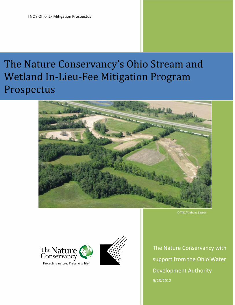
© TNC/Anthony Sasson
TNC’s Ohio ILF Mitigation Prospectus September 28, 2012
1
Table of Contents
Objectives..................................................................................................................................................... 2
Need .............................................................................................................................................................. 2
Establishment and Operation .................................................................................................................... 4
Sponsor Qualifications ................................................................................................................................ 4
Technical Feasibility ................................................................................................................................... 5
Proposed Service Areas .............................................................................................................................. 6
In-Lieu-Fee Program Accounts ................................................................................................................. 8
Program Accounting Procedures ............................................................................................................ 10
Compensation Planning Framework ...................................................................................................... 10
Mitigation Project Establishment and Operation ................................................................................. 11
a. Credit Need and Availability .......................................................................................................... 11
b. Project Identification and Selection ................................................................................................ 12
c. Site Development Plans .................................................................................................................. 12
Ownership Arrangements and Long-Term Management .................................................................... 13
a. Protection of Mitigation Sites ......................................................................................................... 13
b. Closure of Mitigation Project Sites ................................................................................................ 14
c. Long-term Ownership and Management ........................................................................................ 14
d. Contingencies .................................................................................................................................. 15
e. Programmatic Personnel ................................................................................................................. 16
Table 1: Eligible Mitigation Service Areas for Wetland Impacts ........................................................... 7
Table 2: Eligible Mitigation Service Areas for Stream Impacts ............................................................ 8
Exhibit A: ILF Program Contacts and Acknowledgements
Exhibit B: Compensation Planning Framework
TNC’s Ohio ILF Mitigation Prospectus September 28, 2012
2
Objectives
The purpose of establishing The Nature Conservancy’s Ohio Stream and Wetland ILF Program
is to provide an additional mechanism for compensatory mitigation for unavoidable and
minimized impacts to aquatic resources that helps to maximize the benefit to the aquatic
environment and the public interest. This mitigation may be pursuant to impacts authorized by
the Clean Water Act (33 U.S.C. § 1251 et seq.) and/or Sections 9 and 10 of the Rivers and
Harbors Act of 1899 and/or the Ohio Revised Code (ORRC Chapter 611 – Isolated Wetlands)
and/or Ohio Administrative Code (OAC 3745-1). The overall goal of this and other stream and
wetland mitigation programs in the state of Ohio is to achieve no net loss of existing wetland
acreage or stream footage, or associated functions. As the sponsor of this program, TNC and
implementation partners will use a watershed approach to accomplish mitigation projects in Ohio
efficiently and at beneficial economies of scale to provide for a significant net gain of stream
and/or wetland resource functions and values where possible.
This document represents the Program Prospectus, the first step toward developing a watershed-
based in-lieu-fee (ILF) stream and wetland mitigation program for Ohio. This and future
documents will be used to develop and document guidelines, responsibilities and standards for
the establishment, use, operation and maintenance of an in-lieu-fee stream and wetland
mitigation program that brings it into compliance with one or more of the laws referenced above,
governing compensatory mitigation for activities authorized by permits issued by the Department
of the Army (DA) and/or Ohio EPA. The Ohio Stream and Wetland ILF Program proposed in
this Program Prospectus is referred to herein as the “Program” for convenience.
Need
The intent of this Program is that it will be used for compensatory mitigation for unavoidable1
impacts to waters of the United States and State Waters that result from activities authorized
under Section 404 and/or 401 of the Clean Water Act, the Ohio Revised Code (ORRC Chapter
611 – Isolated Wetlands) and/or Ohio Administrative Code (OAC 3745-1) and/or Section 10 of
the Rivers and Harbors Act (33 U.S.C. § 403). More specifically, the Program may be utilized to
provide compensatory mitigation for impacts permitted by the Corps or Ohio EPA involving: (a)
Corps General Permits; (b) Ohio EPA General Permits; (c) Corps and Ohio EPA Individual
Permits and unauthorized activities impacting less than three (3) acres of waters (including
wetlands) other than streams and/or less than two thousand (2,000) linear feet of streams; and (d)
in other cases if agreed upon by the Corps, Ohio EPA and TNC.
In the early 1700s, Ohio’s environment was described by early settlers as a predominantly
forested landscape with scattered openings, clean streams and numerous wetlands with lush
vegetation and abundant wildlife. The Natural Vegetation Map of Ohio at the time of the earliest
land surveys (Gordon, 1966), shows large and widely distributed areas comprised of elm-ash
1 Avoidance of impacts on water resources is the most desired outcome of any permitted activity.
TNC’s Ohio ILF Mitigation Prospectus September 28, 2012
3
swamp forests, prairie, freshwater marshes and fens, sphagnum peat bogs and bottomland
hardwood forest wetlands in Ohio (ODNR and OEPA, 1999).
Urban development, farming, mining and logging have had a significant impact on Ohio’s
wetlands and streams. It has been estimated that nearly 90 percent of Ohio’s original wetlands
have disappeared. From the 1780s to the 1980s, Ohio’s wetland areas declined from about
5,000,000 acres to about 483,000 acres (Dahl, 1990). The water flow in many streams was
impeded or altered by dams or diversions, and ditches were installed to drain the land more
quickly. As development continues, there is an ongoing need to retain the streams and wetlands
that still exit in Ohio, and to mitigate or offset any losses. References and additional information
on trends and needs are provided in Appendix B of this document.
In 2008, the Department of the Army (DA) and U.S. Environmental Protection agency published
the Federal Rule on Compensatory Mitigation: Mitigation for Losses of Aquatic Resources; Final
Rule (33 CFR Parts 325 and 332) dated April 10, 2008. This rule was established to improve
upon historical mitigation approaches, and changes were based on observations of strengths and
weakness of mitigation activities leading up to that date. Among other things, the rule suggests
the need for a watershed-based approach to mitigation, and expresses a preference for various
types of mitigation in the following order: 1) mitigation bank credits; 2) in-lieu-fee program
credits; and 3) permittee-responsible mitigation.
While there are numerous mitigation banks located throughout the State of Ohio, portions of the
state are not currently covered. Furthermore, there are currently very few stream mitigation
banks in the state and no in-lieu-fee programs for either wetlands or streams have yet been
established. A permittee-responsible approach is the only option where neither banks nor in-lieu-
fee programs exist.
Compared to permittee-responsible approaches, ILF projects have a number of potential benefits.
In particular they can be used to target larger, more ecologically valuable, parcels that have been
prioritized through a watershed-based approach. The consistent approach and structure of an ILF
program enables improved and more scientific site selection, mitigation plan development,
implementation, and financial assurances that translate into a reduction in uncertainty for project
success (33 CFR Part 332). Through this approach, the Program will consider watershed scale
features including habitat diversity, habitat connectivity, hydrologic connectivity and
compatibility with local land uses.
It is the intent of the sponsor that the standards of specific compensatory mitigation sites or
projects authorized under the Program will be selected and designed using a watershed-based
approach to mitigation based on those established for mitigation banks. Wherever possible and
appropriate, equivalent templates and policies will be used for the Program as are used for
mitigation banks. The Program sponsor will endeavor to use the best available science and
guidance from public and private partners in the design and operation of the Program, including
the document titled Guidelines for Wetland Mitigation Banking in Ohio, dated March 2011 or
later.
TNC’s Ohio ILF Mitigation Prospectus September 28, 2012
4
Establishment and Operation
The Nature Conservancy intends to establish itself as a qualified in-lieu-fee mitigation sponsor
for USACE and Ohio EPA authorizations in Ohio. This Program Prospectus sets the general
framework under which TNC-sponsored mitigation sites would be identified, funded, operated,
maintained and managed, but the selection of particular projects and project partners for
mitigation will occur on an ongoing basis as ILF mitigation needs are realized. The appropriate
DA representatives of the Interagency Review Team (IRT) will be responsible for approving the
program and projects contained within it, and will advise The Nature Conservancy on the
establishment and management of the ILF Program. The Ohio Water Development Authority
(OWDA) will receive and manage deposits into Accounts established specifically for this
Program.
As the program sponsor, The Nature Conservancy may decide to reject payments for impacts
greater than three (3) acres of wetlands, greater than two thousand (2,000) linear feet of streams,
or payment from impacts to particularly sensitive, important, or irreplaceable natural resources.
In determining whether to accept a payment for any impact described in the preceding sentence,
The Nature Conservancy may consider various factors in its discretion, including but not limited
to: (a) the effect of the impact(s) on TNC’s conservation priorities, (b) the ability of the project
proponent to mitigate for the impacts in the appropriate watershed, and (c) compliance with
Conservancy policies and procedures.
The Nature Conservancy will work with representatives of the IRT to identify the most
appropriate projects available for mitigation based on the impacts to be mitigated, and the
watershed-based approach to project selection. The mitigation projects will be selected based on
IRT review of proposals brought forward by TNC in collaboration with non-governmental
organizations (NGOs), governmental entities, and others. TNC may implement some projects,
but is unlikely to be the lead implementing organization in large portions of the state. Regardless
of who is the proposed implementing organization, the appropriate USACE district engineer will
make the final decision to approve projects.
Sponsor Qualifications
The Nature Conservancy is a tax-exempt 501(c)(3) organization managed from its worldwide
office in Arlington, Virginia. Founded in 1951, The Nature Conservancy now works in all 50
United States and in more than 30 countries. The organization has protected more than 119
million acres of land and 5,000 miles of rivers around the world — and operates more than 100
marine conservation projects globally. The Nature Conservancy is supported by more than 1
million members and employs about 3,200 staff worldwide, over 700 of whom are scientists. The
Nature Conservancy has been named a "Top-Rated Charity" by the American Institute of
Philanthropy and the organization‘s strong performance is recognized by Charity Navigator as
exceeding or meeting industry standards.
The mission of The Nature Conservancy is to conserve the lands and waters on which all life
depends. At global, national, regional and state scales, the organization employs a scientific,
systematic analysis to identify places large enough and rich enough in plant and animal species
to ensure meaningful conservation results. At each place, the Conservancy employs a range of
TNC’s Ohio ILF Mitigation Prospectus September 28, 2012
5
strategies tailored to local circumstances and communities, including: buying land and interests
in land; helping landowners, private and public, manage their properties; facilitating public-
private partnerships; and collaborating with likeminded partners to seek pragmatic, cost-effective
solutions to the most pressing conservation threats at the largest scale.
To achieve the Conservancy‘s place-based mission, the worldwide Board of Directors has
established chapters of The Nature Conservancy at the state and country level. Each state and
country program is run by a director who manages the program‘s annual plan and budget in
support of the Conservancy‘s mission and goals.
In 1950, the Ecologist Union met in Columbus and changed its name to The Nature
Conservancy. In 1958, the Ohio Chapter of The Nature Conservancy was incorporated by a
small group of scientists and nature lovers. The Chapter’s first land purchase, Lynx Prairie in
Adams County, was made in 1959. Since then, the Ohio Chapter has gone on to help conserve
over 55,000 acres of land in Ohio. Of these, almost 20,000 acres are owned and managed by The
Nature Conservancy. The other 35,000 acres are now owned and managed by other natural
resource management agencies, most prevalently the Ohio Department of Natural Resources,
United States Forest Service, County Park Systems, and partner land trusts. Through this work,
TNC has experience related to high quality wetland and stream corridor acquisition, restoration
and stewardship. The Nature Conservancy also has direct experience with stream and wetland
mitigation. The most significant single example of stream restoration accomplished by TNC and
partners in Ohio is probably the 7,000+ linear feet of stream rehabilitation at the Darby
Headwaters Preserve in Logan County.
As of summer 2012, the Ohio Chapter consisted of 46 paid positions (34 long-term and 12 short-
term staff).The Ohio Chapter is advised and assisted by a volunteer Board of Trustees which
provides guidance on strategic issues, assists in setting goals and, most importantly, subjects the
chapter's work to additional critical thinking.
The Nature Conservancy has developed robust databases and procedures to track and manage all
aspects of the compensatory mitigation process in other states. The Ohio Chapter is drawing
upon these resources, particularly those from Virginia and Maine, in developing the Ohio
Program. The tracking systems range from tracking of permitted impacts, through the
competitive proposal process to the award and monitoring of compensation projects. The
Conservancy also has experience managing regional Funds for the collection of impact fees,
award of grants for compensation projects, facilitating the competitive grant process, program
marketing and outreach, supporting prospective applicants, management of proposal review,
development of Project Agreements for mitigation fund awards, and transactional due diligence
on all projects.
Technical Feasibility
The Nature Conservancy and state agencies have undertaken various assessments of habitat
quality and opportunities for restoration throughout the state. These include identification of the
most ecologically intact streams and wetlands (e.g. TNC ecoregional portfolio sites, Ohio EPA
stream quality classifications), and highest priority opportunities for conservation and restoration
(Division of Forestry FRAS Priority areas, Division of Wildlife Focus Areas, and Ohio EPA
TMDL locations). These and other assessments provide science-based indications of important
TNC’s Ohio ILF Mitigation Prospectus September 28, 2012
6
places to conserve and restore, offering a solid foundation from which to move forward under a
watershed approach.
The intention of TNC is to facilitate projects that will deliver high quality stream and wetland
mitigation credits throughout Ohio. Ohio has an array of agencies and organizations equipped to
conserve and restore lands, who, in partnership with The Nature Conservancy, are positioned to
deliver high quality stream and wetland mitigation and to manage lands throughout the state.
These likely partners include, most predominantly, the Ohio Department of Natural Resources,
Metro Parks, and other conservation NGOs. Additionally, there are numerous private consultants
with extensive experience restoring both streams and wetlands, and monitoring the effectiveness
of mitigation. By seeking proposals, and evaluating them against scientific and other objective
criteria, the program will identify the most effective partners to work with, and efficiently deploy
stream and wetland mitigation funding through both TNC and partners.
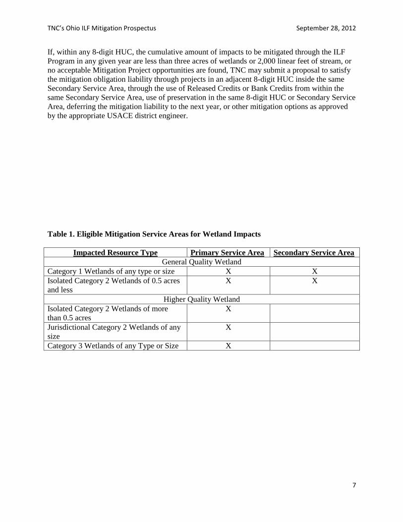
Proposed Service Areas
The proposed areas in which this Program is authorized to provide compensatory mitigation
required by Corps and Ohio EPA permits (“Service Areas”) are the whole or partial watersheds
or geographic areas defined as Primary and Secondary Service Areas. Primary Service Areas are
the Fourth Level (8-digit) hydrologic unit codes (“HUCs”) watersheds, which serve to focus
mitigation for impacts to higher quality wetlands and streams. In addition to the Primary Service
Areas, Secondary Service Areas are defined as Ecological Drainage Units (EDUs), which
consider watershed boundaries and ecological similarities and are being used by federally led-
Landscape Conservation Cooperatives and others. Some modifications to the EDUs were made
to correspond to DA district boundaries. These larger service areas serve to focus mitigation for
smaller impacts to lower quality aquatic resources in a way that maximizes the aquatic and larger
ecological benefit of the mitigation. These Service Areas are further described and illustrated in
the Compensation Planning Framework in Exhibit B.
Specifically, where there are impacts to Category 1 wetlands of any size, or 0.5 acres and less of
impacts to isolated Category 2 wetlands, mitigation may be implemented within the Primary
Service Area or the larger Secondary Service Area (EDU) within which the impact was located.
In all cases, each Secondary Service Area is located wholly within, and is smaller than, the
USACE District. These Secondary Service Areas are appropriate in this context because their
definition is based on ecological and watershed factors, or a watershed-based approach. They
also keep the mitigation closer to impacts than is suggested by the Guidelines for Wetland
Mitigation Banking in Ohio. For all other wetland impacts, the 8-digit HUC (Primary Service
Area) where the impact is located will be the service area. These include impacts to Category 3
Wetlands, impacts of any size to jurisdictional Category 2 wetlands, or greater than 0.5 acres of
impact to isolated Category 2 wetlands (Table 1).
For streams, a parallel approach will be taken where the impacts to designated limited resource
water, limited warmwater habitat, modified warmwater habitat, Class I and Class II primary
headwater habitat, and general warmwater habitat may be implemented within the Primary
Service Area or the larger Secondary Service Area (EDU) within which the impact was located.
All other stream impacts will be mitigated within the Primary Service Area (8-digit HUC) where
the impact occurred (Table 2).
TNC’s Ohio ILF Mitigation Prospectus September 28, 2012
7
If, within any 8-digit HUC, the cumulative amount of impacts to be mitigated through the ILF
Program in any given year are less than three acres of wetlands or 2,000 linear feet of stream, or
no acceptable Mitigation Project opportunities are found, TNC may submit a proposal to satisfy
the mitigation obligation liability through projects in an adjacent 8-digit HUC inside the same
Secondary Service Area, through the use of Released Credits or Bank Credits from within the
same Secondary Service Area, use of preservation in the same 8-digit HUC or Secondary Service
Area, deferring the mitigation liability to the next year, or other mitigation options as approved
by the appropriate USACE district engineer.
Table 1. Eligible Mitigation Service Areas for Wetland Impacts
Impacted Resource Type Primary Service Area Secondary Service Area
General Quality Wetland
Category 1 Wetlands of any type or size X X
Isolated Category 2 Wetlands of 0.5 acres
and less
X X
Higher Quality Wetland
Isolated Category 2 Wetlands of more
than 0.5 acres
X
Jurisdictional Category 2 Wetlands of any
size
X
Category 3 Wetlands of any Type or Size X
TNC’s Ohio ILF Mitigation Prospectus September 28, 2012
8
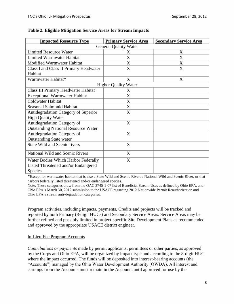
Table 2. Eligible Mitigation Service Areas for Stream Impacts
Impacted Resource Type Primary Service Area Secondary Service Area
General Quality Water
Limited Resource Water X X
Limited Warmwater Habitat X X
Modified Warmwater Habitat X X
Class I and Class II Primary Headwater
Habitat
X X
Warmwater Habitat* X X
Higher Quality Water
Class III Primary Headwater Habitat X
Exceptional Warmwater Habitat X
Coldwater Habitat X
Seasonal Salmonid Habitat X
Antidegradation Category of Superior
High Quality Water
X
Antidegradation Category of
Outstanding National Resource Water
X
Antidegradation Category of
Outstanding State water
X
State Wild and Scenic rivers X
National Wild and Scenic Rivers X
Water Bodies Which Harbor Federally
Listed Threatened and/or Endangered
Species
X
*Except for warmwater habitat that is also a State Wild and Scenic River, a National Wild and Scenic River, or that
harbors federally listed threatened and/or endangered species.
Note: These categories draw from the OAC 3745-1-07 list of Beneficial Stream Uses as defined by Ohio EPA, and
Ohio EPA’s March 30, 2012 submission to the USACE regarding 2012 Nationwide Permit Reauthorization and
Ohio EPA’s stream anti-degradation categories.
Program activities, including impacts, payments, Credits and projects will be tracked and
reported by both Primary (8-digit HUCs) and Secondary Service Areas. Service Areas may be
further refined and possibly limited in project-specific Site Development Plans as recommended
and approved by the appropriate USACE district engineer.
In-Lieu-Fee Program Accounts
Contributions or payments made by permit applicants, permittees or other parties, as approved
by the Corps and Ohio EPA, will be organized by impact type and according to the 8-digit HUC
where the impact occurred. The funds will be deposited into interest-bearing accounts (the
“Accounts”) managed by the Ohio Water Development Authority (OWDA). All interest and
earnings from the Accounts must remain in the Accounts until approved for use by the
TNC’s Ohio ILF Mitigation Prospectus September 28, 2012
9
appropriate USACE district engineer. Monies from the Accounts shall be used to pay for
selection, design, acquisition, implementation, monitoring, administration, management and
protection of Mitigation Projects approved by the appropriate USACE district engineer. Funds
expended may be charged to specific or multiple Mitigation Projects. Funds may be approved
and expended for the benefit of multiple watersheds or for the Program itself. In any event, all
funds expended reflect, and therefore help establish, the minimum cost of Credits in each
watershed.
The OWDA shall hold any funds collected pursuant to this Agreement in the Accounts, which
shall be interest-bearing accounts in a federally-insured financial institution to maximize the
safety and preservation of the principal funds in the Accounts. Funds will be invested by OWDA
based on investment guidelines approved by the Corps and Ohio EPA. OWDA shall account for
the funds so held in accordance with generally accepted accounting principles, and the Accounts
shall be subject to audit by the Corps and Ohio EPA from time to time, as determined by the
Corps and Ohio EPA, at the expense of the party requesting such audit. Notwithstanding the
foregoing, OWDA is audited annually by the State of Ohio. The funds held and disbursed for
the ILF program will be part of this annual audit. Interest and any other earnings produced by the
Program, and proceeds from the sale of Mitigation Site lands, shall remain in the Accounts until
approved for use by the appropriate USACE district engineer.
Those approved funds received by the Program in excess of the amount needed for mitigation or
restoration projects shall remain with the Program, and shall be disbursed in accordance with this
Agreement for other Mitigation Projects or other uses approved by the USACE district engineer.
The Nature Conservancy shall ask OWDA to set aside contingency funds from the Accounts
sufficient to guarantee the success of each Mitigation Site undertaken in accordance with Corps
and Ohio EPA regulations, including remediation of catastrophic events and long-term
management of each Mitigation Site.
The Accounts may only be used, upon approval by the appropriate USACE district engineer, for
selection, design, acquisition, implementation, monitoring, management and protection of
compensatory Mitigation Projects, and other related uses, including administration of the
Program. Requests to expend funds for the Long-Term Maintenance and Management of a
Mitigation Project must be accompanied by a description of needs, annual cost estimates for
these needs and a discussion of inflationary adjustments and other contingencies, as appropriate.
The Nature Conservancy shall receive an administrative fee amounting to 7.5% of the funds
when the funds are deposited. In addition, the OWDA will receive an administrative fee
amounting to 0.35% of the funds from the funds deposited. The fees will come from the
deposited funds, and are deemed to represent and reimburse reasonable overhead and related
administrative costs of administering the Program and Program Accounts to accomplish the
Mitigation Projects described herein.
The district engineers shall have oversight of the Accounts. Complete budgets for Mitigation
Projects must be approved by the appropriate USACE district engineer. The OWDA shall
submit to the appropriate representatives of the IRT an Annual Report by March 31 of each year.
The Annual Report shall include detailed summaries of Account deposits and disbursements
made for each Mitigation Project over the previous calendar year (January 1-December 31). Any
TNC’s Ohio ILF Mitigation Prospectus September 28, 2012
10
increase from the total approved budget for a Mitigation Plan will require the district engineer’s
approval before additional funds may be disbursed. The Corps and Ohio EPA may review
Account records with 14 days written notice. When so requested by a district engineer, the
OWDA and TNC shall provide all books, accounts, reports, files, and other records relating to
the Accounts.
Program Accounting Procedures
TNC shall establish and maintain a system for tracking Credits in relation to Projects, the debit
or sale of Credits and financial transactions in relation to Credits between TNC and permittees.
The adopted system shall be approved by the appropriate USACE district engineers. Credit
production (the generation of an amount of Credits based on Projects), Credit transactions
(purchase by permittees and debit by TNC of Credits) and financial transactions (the exchange of
money in relation to Credits) shall be tracked both on a programmatic basis (i.e., the number of
available Credits for the entire program that is across all of the service areas), within each basin,
and separately for each individual compensatory Mitigation Project undertaken by the Program.
Credits will be tracked by credit type, mitigation site, and 8-digit HUC.
The sale, conveyance, or transfer of Credits includes all natural services, functions and values
associated with the natural resources (e.g. wetlands, streams) from which Credits were derived.
Credits may be used to compensate for environmental impacts under other programs (civil
works, Superfund Program removal and remedial actions, supplemental environmental projects
for state and federal enforcement actions, etc.), but Credits may not simultaneously serve as
mitigation for more than one activity; e.g., a Credit may be used to offset impacts under any
Federal , State, or local program related to wetlands and streams, however that credit may only
be counted against permitted impacts one time. If funds from entities other than permittees are
accepted for projects, those funds will be kept in separate accounts.
Compensation Planning Framework
The purpose of compensatory mitigation is to offset unavoidable impacts to waters of the U.S.
and State Waters, including wetlands and streams. Therefore, priority is given to mitigation that
replaces lost functions and values of waters, wetlands and streams, as determined by the IRT
Chairs. No Credits will be approved unless and until the appropriate USACE district engineer
determines that the mitigation does constitute compensatory mitigation for lost functions and
values relevant to permitted impacts to waters, wetlands and streams.
Based on precedents set in other states, in particular Virginia, TNC’s Conservation by Design
approach results in a watershed-based compensatory mitigation. TNC agrees to employ the
Conservation by Design approach or other approved watershed management plan in the
administration of the Program and compensatory mitigation. A Compensation Planning
Framework based on this approach is incorporated as a part of this Program Prospectus as
Exhibit B.
TNC’s Ohio ILF Mitigation Prospectus September 28, 2012
11
Mitigation Project Establishment and Operation
a. Credit Need and Availability
The primary emphasis of the Program is on aquatic resource restoration and protection.
The use of this Program for compensatory mitigation shall occur only after the relevant permitted
activity has complied with Corps, Ohio EPA, and/or ODNR regulations and policies regarding
avoidance and minimization of impacts or as stated in the “Objectives” in this document, or
otherwise herein. TNC and its partners shall play no role in the Corps’ or Ohio EPA’s decision
to approve or deny a permit or whether mitigation is a necessary condition of any such permit.
The Corps and Ohio EPA will determine the number of Credits required to compensate for
permitted impacts utilizing accepted procedures used in Ohio for evaluating compensatory
mitigation credits. TNC will determine the fee amount needed to provide mitigation credit and
provide this information to the Ohio Water Development Authority (OWDA), which will
manage the ILF Program Accounts. The OWDA, pursuant to the terms of this Agreement, will
act as a recipient of mitigation funds that are required of permittees and other parties as identified
by the Corps and/or Ohio EPA. When a payment is provided to OWDA for mitigation Credits,
OWDA shall record the payment and TNC will record the associated Credits on the Credit
Ledger for that Service Area and 8-digit HUC.
The Program will have two types of credits available for purchase by permittees, Advance
Credits and Released Credits. Advance Credits are in-lieu-fee credits sold in advance of
mitigation sites generating released credits. Released Credits are for mitigation projects already
implemented, and upon meeting success monitoring and approved by the appropriate district
engineer. These credits are equivalent to mitigation bank credits and may be sold to satisfy
mitigation requirements.
Credits will be requested by applicants as follows:
Applicant contacts TNC for credit availability and requests number and type of credits
required.
Applicant completes and submits a Credit Availability Voucher, which provides
information on the impacts that will require mitigation, information on providing the
Credit availability, the type of Credit (Advance or Released), and the pre-set cost per unit
of Credit in a particular service area and/or 8-digit HUC. The Credit Availability
Voucher shall contain identifying information regarding the impact site and other
information deemed necessary by the Corps, Ohio EPA, OWDA and TNC.
If credits are available in the appropriate service area, TNC will issue a Letter of Credit
Availability with a specific deadline for payment.
Applicant submits Letter of Credit Availability with their permit documents to the
regulatory agencies.
When the applicant is ready to purchase the mitigation credits (before the deadline has
passed), the applicant / permit manager must complete a Payment Voucher. This will
reflect any changes since the initial request and the final mitigation requirements of the
permit.
TNC’s Ohio ILF Mitigation Prospectus September 28, 2012
12
Applicant returns the payment voucher to OWDA and TNC, and the actual payment to
OWDA.
TNC issues acknowledgement of payment to OWDA and assumes liability for impacts
and mitigation requirements.
Credits may be provided in the form of advance or released credits. The approach for setting
credit prices will be elaborated in the Program Instrument, and will consider those being used in
other ILF Programs, as well as prices charged by mitigation banks.
b. Project Identification and Selection
To offset impacts to aquatic resources that resulted in payments into the Accounts, TNC shall
solicit and submit proposals for funding approval in accordance with this Agreement. It is
anticipated that project proposals will come from established mitigation banking corporations,
conservation NGOs including TNC, and state and local governmental agencies. Mitigation
Project proposals will be based on the Compensation Planning Framework (See Exhibit B and
must include/address the 12 elements of mitigation plans at 33 CFR §332.4(c)(2)-(14)). Each
plan and associated funding requires approval by the IRT Chairs (appropriate district engineers),
in consultation with the IRT members (33 CFR §332.8(j); 33 CFR §332.8(i)).
The Ohio EPA has expressed to TNC that where the permittee requiring mitigation is the Ohio
Department of Transportation (ODOT), mitigation should be accomplished, when possible, at
project sites that are priorities for ODNR. Where ODOT is the permittee, TNC will request
proposals from ODNR for Mitigation Projects that meet the criteria described in the
Comprehensive Planning Framework (Exihibit B) for all projects in this program. TNC will
review and evaluate proposals based on these and potentially additional criteria, and if no
projects are proposed, or if proposed projects do not adequately meet criteria, will seek
additional proposals from ODNR or others.
As outlined in the 2008 rule, the IRT shall meet on a regular basis with TNC to review proposed
Mitigation Projects and to discuss relevant issues with Program procedures. The IRT Chairs,
after seeking comments from the IRT members, shall allow for public comment on the proposed
projects and may suggest revisions. The Corps district engineer where the impact and mitigation
project occur will ultimately approve or deny specific Mitigation Project proposals for
restoration, creation, enhancement, buffering, preservation of aquatic resources and their
adjacent uplands, or the purchase of credits from an approved mitigation bank. Such approval or
denial will be based on factors including site suitability, long-term sustainability, impacts to
aquatic resources mitigated via the Program, the ratio of restoration to impacts of Program
projects in particular watersheds, maximum return on expended funds, benefits to rare and
endangered natural resources, and an acceptable Mitigation Plan.
c. Site Development Plans
Following general approval by the district engineer of a proposed Mitigation Site, TNC or
identified project proponents shall submit for approval a Site Development Plan, which will be
prepared by the project proponent or TNC. Site Development Plans should include, if
TNC’s Ohio ILF Mitigation Prospectus September 28, 2012
13
applicable, a description of the proposed project and site specific plan including location,
baseline conditions, Credit composition, assessment methodology, schedule of Credit
availability, a site-specific Service Area, a schedule for conducting the project, monitoring,
maintenance and reporting provisions, provisions for protection and management in perpetuity
with appropriate real estate arrangements and performance standards for determining ecological
success of Mitigation Projects. The Site Development Plan should also include an Adaptive
Management (AM) component to identify factors which may cause the site to not perform as
proposed, and a management strategy or contingency plan for corrective action, including the
party or parties responsible for implementing adaptive management measures.
In keeping with the Guidelines for Wetland Mitigation Banking in Ohio, ILF stream and wetland
mitigation sites will contain features that make each site conducive to the development or
restoration of high quality streams and wetlands that:
replace the desired type of wetlands or streams (typically the same as what is being lost)
provide multiple functions
are appropriate for the landscape
are compatible with surrounding land use
can be managed in a relatively easy and sustainable manner
are ecologically of the highest quality achievable and compatible with current and
historic site conditions
Site Development Plans shall also include specific provisions addressing Mitigation Project
default and other provisions as recommended by the IRT including but not limited to, Force
Majeure, Eminent Domain and transfer of Mitigation Site ownership (taking into account
restrictions imposed by Section 170(h) of the Internal Revenue Code and the regulations
promulgated thereunder, as appropriate).
Site Development Plans may request funding approval for costs associated with accomplishment
of Mitigation Projects including, but not limited to, labor, land acquisition, appraisals, project
design, project management, restoration, creation, monitoring, stewardship, legal, closing,
equipment and materials necessary to accomplish mitigation, and monitoring.
In the event TNC and/or its partners determine that modifications must be made to a Site
Development Plan to ensure successful establishment of a Mitigation Project, TNC and/or the
project proponent shall submit a written request for such modification, including a timeframe for
any actions associated with the request, to the district engineer for approval.
Ownership Arrangements and Long-Term Management
a. Protection of Mitigation Sites
When monies from the Program are used for Mitigation Projects, the land associated with
that Mitigation Site must be protected by a recorded document that preserves the land in
perpetuity with the protection “running with the land.” Land protection documents must be
TNC’s Ohio ILF Mitigation Prospectus September 28, 2012
14
approved by the Corps and Ohio EPA and must be recorded in the appropriate real property
records depository for the locality where such project is located. In appropriate circumstances,
and upon approval by the appropriate district engineer, portions of land not used for mitigation
may be exempted from, and conveyed separately free and clear of, such easement or
restriction(s). No Credits will be sold, debited or released until the Corps and Ohio EPA have
acknowledged that they have received proof that appropriate land protection documents are
recorded. TNC may engage in Mitigation Projects on land in which TNC, public agencies, or
other non-profits own fee simple rights provided that appropriate protection mechanisms are
approved by the district engineer, in accordance with Section 332.7(a) of the Final Rule.
b. Closure of Mitigation Project Sites
Upon satisfaction of the Success Criteria and performance standards, as determined by
the district engineer, but not sooner than the end of the 5-year monitoring period, the district
engineer shall issue written confirmation to TNC, and thereafter any remaining contingency
funds in excess of that needed for use in long-term management of the Mitigation Project Site
shall be used on other mitigation project activities within the same service area. Approved
Preservation projects may request closure once Success Criteria have been met.
Prior to closure of a Mitigation Project Site that has been approved subsequent to the Effective
Date of this Program, the district engineer may perform a final compliance inspection to evaluate
whether all success criteria have been achieved. The district engineer shall provide written
confirmation promptly upon their determination, in consultation with TNC, that:
(1) All applicable Success Criteria have been achieved;
(2) All Released Credits for that Mitigation Project Site have been debited;
(3) TNC has reviewed and revised, if necessary, the Long-Term Management and
Maintenance Plan, and the revised Long-Term Management and Maintenance Plan has
been approved by the district engineer;
(4) TNC has prepared and submitted to the district engineer a GIS shapefile or similar
exhibit depicting the location and extent of the Mitigation Project;
(5) TNC has ensured that a capable Long-Term Steward is in place; and
(6) The Mitigation Project has complied with the terms of this Agreement and the
mitigation plan.
Then the Mitigation Project Site will close, and the period of Long-term Stewardship and
Preservation will commence.
d. Long-term Ownership and Management
A Long-Term Management and Maintenance Plan for each Mitigation Project shall contain
specific objectives that address the long-term management requirements of the site. TNC, a
TNC’s Ohio ILF Mitigation Prospectus September 28, 2012
15
partner, or subsequent Long-Term Steward, shall provide the appropriate district engineer with
60 days advance notice before any actions are taken to modify the Long-Term Management and
Maintenance Plan. The Long-Term Management and Maintenance Plan may only be amended
or modified with the written approval of all signatory parties. The Long-Term Steward shall
document that it is achieving each objective or standard by submitting status reports to the IRT
on a schedule approved by the IRT chair. As part of the Long-Term Management and
Maintenance Plan, the Long-Term Steward will allow the IRT access to the site. A primary goal
of the Mitigation Project is to create or restore a self-sustaining natural aquatic system that
achieves the intended level of aquatic ecosystem functionality with minimal human intervention,
including long-term site maintenance.
The Long-Term Management and Maintenance Plan shall include, at a minimum, provisions for:
(1) Periodic patrols of the site for signs of trespass and vandalism. Maintenance will
include reasonable actions to deter trespass and repair vandalized features.
(2) Monitoring the condition of structural elements and facilities of the site such as
signage, fencing, roads, in-stream structures and trails. The Long-Term Plan will include
provisions to maintain and repair these improvements as necessary to achieve the objectives
of the Mitigation Project and comply with the provisions of the real estate instrument
providing protection to the site. Improvements such as access roads, berms or water control
structures that are no longer needed to facilitate or protect the ecological function of the site
may be removed or abandoned if consistent with the terms and conditions of the recorded
Protection Document.
The Long-Term Steward may modify the Long-Term Management and Maintenance Plan,
subject to review and written approval by the district engineer and TNC.
Once long term management responsibilities have been established with the Long-Term Steward,
as evidenced by the signature of TNC and the Long-Term Steward on the Long-Term
Management and Maintenance Plan, said party is thereby responsible for meeting any and all
long-term management responsibilities outlined in the project-specific Long-Term Management
and Maintenance Plan, this Program and any other applicable project requirements approved by
the district engineer. TNC is responsible for developing a Long-Term Management and
Maintenance Plan for each Mitigation Project. Each Long-Term Management and Maintenance
Plan will specify all anticipated management activities and the necessary capacity to accomplish
those activities. OWDA shall report annually on beginning and ending balances, including
deposits and withdrawals from accounts established to provide funds for long-term management
of Mitigation Projects.
e. Contingencies
If the district engineer determines that the in-lieu fee program is not meeting performance
standards or complying with the terms of the instrument, appropriate action will be taken. Such
actions may include, but are not limited to, suspending credit sales, adaptive management,
TNC’s Ohio ILF Mitigation Prospectus September 28, 2012
16
decreasing available credits, utilizing financial assurances, and terminating the Program
Instrument.
f. Programmatic Personnel
Funds to be allocated to cover labor costs for TNC personnel for multiple projects and/or
fixed periods of time require written consent of the district engineer. TNC shall track the time of
any such personnel, and only labor (duties and tasks) directly related to accomplishing Program
activities shall be charged. These costs shall be included in the cost of Credits in each
watershed. TNC may decide when to hire outside contractors, parties or consultants to
accomplish Mitigation Projects and remediation via the normal approval process for mitigation
proposals as stated herein. Primary considerations in all Mitigation Project proposals and
approval decisions shall be: 1) the benefit to the waters of Ohio; 2) compliance with federal and
state regulations; and 3) the most cost-effective approach to accomplishment of Mitigation
Projects. All funds shall be used solely for the delivery and accomplishment of compensatory
mitigation as described herein and no Program funds may be expended except as provided for in
this Agreement. Administrative fees do not require approval for expenditure.
TNC’s Ohio ILF Mitigation Prospectus September 28, 2012
17
Exhibit A: ILF Program Contacts
Josh Knights
Director
The Nature Conservancy in Ohio
6375 Riverside Drive, Suite 100
Dublin, Ohio 43017
Phone: (614)717-2770 xtn 126
Email: [email protected]
Bill Stanley
Assistant State Director/Director of Conservation
The Nature Conservancy in Ohio
6375 Riverside Drive, Suite 100
Dublin, Ohio 43017
Phone: (614)339-8107
Email: [email protected]
Marleen Kromer
Associate Director of Conservation
The Nature Conservancy in Ohio
6375 Riverside Drive, Suite 100
Dublin, Ohio 43017
Phone: (614)717-2770 xtn 118
Email: [email protected]
Acknowledgements
This Program Prospectus was developed by Bill Stanley, Marleen Kromer, August Froehlich,
and Anthony Sasson of The Nature Conservancy in Ohio. We would like to acknowledge the
important input and information and examples provided by TNC Ohio and regional legal staff,
The Nature Conservancy in Virginia, and The Nature Conservancy in Maine. Ken Heigel of the
Ohio Water Development Authority (OWDA) provided substantive suggestions related to
account management for the proposed program. We also benefitted from the advice of the
Interagency Review Team, TNC trustees, various conservation partners and others with
mitigation banking experience in Ohio. The OWDA also provided critical financial support for
developing the Program Prospectus.
TNC’s Ohio ILF Mitigation Prospectus September 28, 2012
18
Exhibit B: Compensation Planning Framework
TNC’s Ohio ILF Mitigation Prospectus September 28, 2012
1
COMPENSATION PLANNING FRAMEWORK:
A WATERSHED APPROACH TO COMPENSATION PLANNING FOR
THE NATURE CONSERVANCY’S OHIO STREAM AND WETLAND IN-
LIEU FEE MITIGATION PROGRAM
SEPTEMBER 2012
TNC’s Ohio ILF Mitigation Prospectus September 28, 2012
2
TABLE OF CONTENTS PAGE
Part I. Background and The Nature Conservancy’s CONSERVATION BY DESIGN…………………………….4
Element 1. The geographic service area(s), including a watershed-based rationale for the
delineation of each service area……………………………………………………………………………………7
Element 2. A description of the threats to aquatic resources in the service area(s), including
how the in-lieu fee program will help offset impacts resulting from those threats………………………………..8
Element 3. An analysis of historic aquatic resource loss in the service area(s)……………………………..........11
Element 4. An analysis of current aquatic resource conditions in the service area(s),
supported by an appropriate level of field documentation………………………………………………….…..…13
Element 5. A statement of aquatic resource goals and objectives for each service area,
including a description of the general amounts, types and locations of aquatic resources the
program will seek to provide……………………………………………………………………………….……...15
Element 6. A prioritization strategy for selecting and implementing compensatory mitigation
activities……………………………………………………………………………………………………………17
Element 7. An explanation of how any preservation objectives identified in Element 5 and
addressed in the prioritization strategy in Element 6 satisfy the criteria for use of preservation…………………..20
Element 8. A description of any public and private stakeholder involvement in plan
Development and implementation, including coordination with federal, state, tribal and
local aquatic resource management and regulatory authorities………………………………………………….…21
Element 9. A description of the long-term protection and management strategies for
activities conducted by the in-lieu fee program sponsor……………………………………………………….…...22
Element 10. A strategy for periodic evaluation and reporting on the progress of the
program in achieving the goals and objectives above, including a process for revising
the planning framework as necessary……………………………………………………………………………....23
Conclusion………………………………………………………………………………………………………….24
Part II. Overview of Conservation Priorities in Primary and Secondary Service Areas……….…….………….…25
Western Lake Erie….…………….…………………………………………………………...……………...…….28
Southern Lake Erie…………………………………………………………………………………………………30
Great Miami/Little Miami...……………................................................................................ ..................................32
Scioto Basin.……………........................................................................................................... ...............................34
Unglaciated Ohio River Tributaries – West………………......................................................................................36
Unglaciated Ohio River Tributaries – East……………….......................................................................................38
Southern Allegheny Plateau……………….…………………………………………………………………….…40
Figure. 1. U.S. EPA Ecoregions..........……………….………………………………………………………….…42
Figure. 2. HUC-8 and Ecological Drainage Unit Boundaries ………………………………..……………………43
Figure. 3. Service Areas and U.S. Army Corps of Engineers Districts..……………..…………………………….44
References................................................................................................................... ...............................................45
TNC’s Ohio ILF Mitigation Prospectus September 28, 2012
3
COMPENSATION PLANNING FRAMEWORK
A WATERSHED APPROACH TO COMPENSATION PLANNING
BACKGROUND
The Nature Conservancy’s Ohio Stream and Wetland In-Lieu Fee Mitigation Program (TNC-
Ohio ILF Program) is a statewide compensatory mitigation program administered by The Nature
Conservancy (TNC). Funds designated for management and implementation of approved
projects in the TNC-Ohio ILF Program will be received and disbursed by the Ohio Water
Development Authority (OWDA). The Ohio EPA (OEPA) and the United States Army Corps of
Engineers (ACOE) are the regulatory agencies that will oversee the establishment and operation
of the in-lieu fee program. The TNC-Ohio ILF Program provides an alternative option for a
permit applicant to address compensatory mitigation requirements associated with Section 404
and 401/Ohio Water Quality Certifications issued by the ACOE and the OEPA, respectively.
In 2008, the US EPA created a new rule to regulate in-lieu fee mitigation programs such as the
proposed TNC-Ohio ILF Program which requires that a “compensation planning framework” be
used for selecting and permitting mitigation projects funded through an in-lieu fee mitigation
program. The rule states the following: “The approved instrument for an in-lieu fee program
must include a compensation planning framework that will be used to select, secure, and
implement aquatic resource restoration, establishment, enhancement, and/or preservation
activities. The compensation planning framework must support a watershed approach to
compensatory mitigation.”
The required compensation framework must include the following ten elements:
1. The geographic service area(s), including a watershed-based rationale for the
delineation of each service area;
2. A description of the threats to aquatic resources in the service area(s), including how
the in-lieu fee program will help offset impacts resulting from those threats;
3. An analysis of historic aquatic resource loss in the service area(s);
4. An analysis of current aquatic resource conditions in the service area(s), supported by
an appropriate level of field documentation;
5. A statement of aquatic resource goals and objectives for each service area, including a
description of the general amounts, types and locations of aquatic resources the
program will seek to provide;
6. A prioritization strategy for selecting and implementing compensatory mitigation
activities;
7. An explanation of how any preservation objectives identified in element 5 and
addressed in the prioritization strategy in element 6 satisfy the criteria for use of
preservation;
8. A description of any public and private stakeholder involvement in plan development
and implementation, including coordination with federal, state, tribal and local
aquatic resource management and regulatory authorities;
9. A description of the long-term protection and management strategies for activities
conducted by the in-lieu fee program sponsor;
TNC’s Ohio ILF Mitigation Prospectus September 28, 2012
4
10. A strategy for periodic evaluation and reporting on the progress of the program in
achieving the goals and objectives above, including a process for revising the
planning framework as necessary.
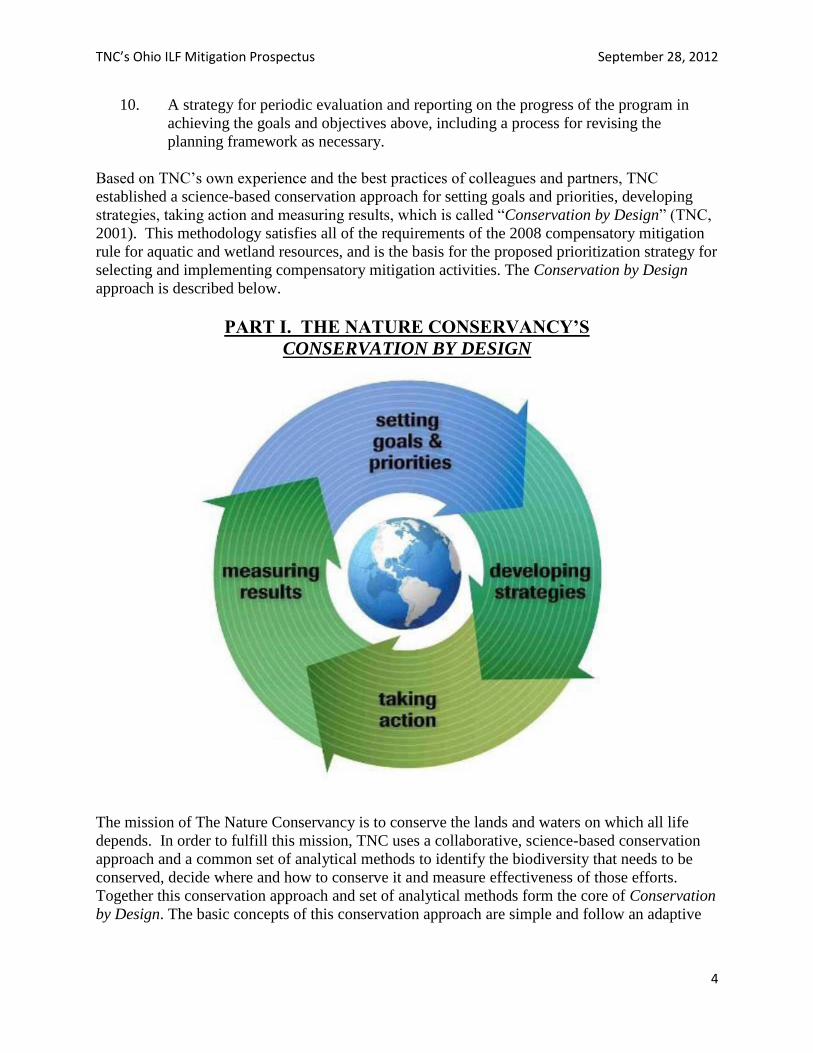
Based on TNC’s own experience and the best practices of colleagues and partners, TNC
established a science-based conservation approach for setting goals and priorities, developing
strategies, taking action and measuring results, which is called “Conservation by Design” (TNC,
2001). This methodology satisfies all of the requirements of the 2008 compensatory mitigation
rule for aquatic and wetland resources, and is the basis for the proposed prioritization strategy for
selecting and implementing compensatory mitigation activities. The Conservation by Design
approach is described below.
PART I. THE NATURE CONSERVANCY’S
CONSERVATION BY DESIGN
The mission of The Nature Conservancy is to conserve the lands and waters on which all life
depends. In order to fulfill this mission, TNC uses a collaborative, science-based conservation
approach and a common set of analytical methods to identify the biodiversity that needs to be
conserved, decide where and how to conserve it and measure effectiveness of those efforts.
Together this conservation approach and set of analytical methods form the core of Conservation
by Design. The basic concepts of this conservation approach are simple and follow an adaptive
TNC’s Ohio ILF Mitigation Prospectus September 28, 2012
5
management framework of setting goals and priorities, developing strategies, taking action and
measuring results.
Setting Goals and Priorities. Conservation goals describe the results we want to achieve for
biodiversity. Based on the best available scientific information, TNC sets long-term goals for the
abundance and geographic distribution of species and ecological systems necessary to ensure
their long-term survival. To make the most effective progress toward these goals, TNC
establishes priorities in places with high biodiversity that are most in need of conservation action
or promise the greatest conservation return on investment.
Priority places are identified through ecoregional assessments. An ecoregion is a large area of
land or water that contains a geographically distinct assemblage of ecosystems and natural
communities, and is differentiated by climate, geology, physiography, hydrology, soils, and
vegetation. TNC works with partners to assess ecoregions using data on the distribution and
status of biodiversity, habitat condition, current and future threats and the socio-political
conditions that influence conservation success within those ecoregions.
These data allow us to set long-term conservation goals for conservation targets — ecosystems,
natural communities and imperiled or declining species representative of an ecoregion, and to
establish ecoregional priorities for resource allocation — specific landscapes, threats to
biodiversity and strategic opportunities that affect one or more ecoregions and demand
immediate attention. Ecoregional data also provide a baseline against which we can measure
progress toward long-term conservation goals for representative ecosystems and species within
an ecoregion.
Developing Strategies. TNC works with others to transform ecoregional priorities into
conservation strategies through Conservation Action Planning. This method is used to design and
manage conservation projects that advance conservation at any scale — from efforts to conserve
species and ecosystems in a single watershed or landscape, to efforts to reform regional or
national policies. As with ecoregional assessments, Conservation Action Planning is driven by
data on the distribution and status of biodiversity, current and future threats, and the socio-
political conditions within the project area. These data are used to develop strategies of sufficient
scope and scale to abate threats, maintain or restore biodiversity and strengthen capacity to
ensure long-term results. The data also provide a baseline for evaluating effectiveness of
strategies and progress in achieving project goals, and for modifying strategies to changing
circumstances as needed.
Taking Action. The Nature Conservancy is committed to place-based results by taking action
locally, regionally and globally, as called for by conservation strategies developed with partners.
The strategies are varied, but typically include investing in science to inform decision-making;
protecting and managing land and water; forging strategic alliances with a variety of groups from
all sectors; creating and maintaining supportive public policies, practices and incentives;
strengthening the institutional capacity of governments and non-governmental organizations to
achieve conservation results; developing and demonstrating innovative conservation approaches;
building an ethic and support for biodiversity conservation; and, generating private and public
funding.
TNC’s Ohio ILF Mitigation Prospectus September 28, 2012
6
Measuring Results. TNC measures effectiveness by answering two questions: “How is the
biodiversity doing?” and “Are the strategic actions having the intended impact?” The first
question evaluates the status of species and ecosystems. The second question more specifically
evaluates the effectiveness of conservation strategies and actions. Tracking progress toward
goals and evaluating the effectiveness of strategies and actions provide the feedback needed to
adjust the goals, priorities and strategies.
TNC’s Ohio ILF Mitigation Prospectus September 28, 2012
7
Element 1. The geographic service area(s), including a watershed-based
rationale for the delineation of each service area.
As described above, The Nature Conservancy uses ecoregions (terrestrial and freshwater) to
stratify biological diversity and select geographic priorities. TNC uses terrestrial ecoregions,
based on U.S. Forest Service descriptions (Bailey, 1995), for identifying and prioritizing
representative and rare forested and wetland ecosystems, other natural communities and species.
Freshwater ecoregions based on Abell et al. (2000) and Maxwell et al. (1995) encompass one or
more similar freshwater systems that contain distinct assemblages of natural freshwater
communities and aquatic species. TNC’s ecoregion designations also correspond closely with
the ecoregions based on work supported by the US EPA (Omernik, 1995; Omernik and Bailey,
1997); therefore, in an effort to be consistent, this document follows the EPA’s ecoregion
boundaries when referencing ecoregions in the remainder of this prospectus. As defined by the
US EPA, Ohio contains portions of the Eastern Corn Belt Plains, Huron/Erie Lake Plains,
Erie/Ontario Drift and Lake Plain, Western Allegheny Plateau, and Interior Plateau ecoregions
(Figure 1).
Within each freshwater ecoregion, The Nature Conservancy has developed further stratification
levels called ecological drainage units (EDUs) (Figure 2). EDUs delineate areas within a
freshwater ecoregion that correspond roughly with large watersheds ranging from 3,000–10,000
square miles. EDUs are likely to have a distinct set of freshwater fish assemblages and habitats
associated with them. They are defined by aggregating the watersheds of major tributaries (8-
digit HUCs) that share a common zoogeographic history, as well as local physiographic and
climatic characteristics. EDUs can be used as a tool for characterizing the ecology of
watersheds and have been used by various state and federal agencies (e.g. in Texas, Iowa, and
Missouri and federally led-Landscape Conservation Cooperatives) as the descriptive geographic
boundaries for conservation planning purposes. EDUs are, therefore, an appropriate designation
to use in a statewide in-lieu fee mitigation program and satisfy the 2008 rule requirement to
delineate watershed based geographic service areas.
The proposed Service Areas in which the TNC-Ohio ILF Program would be authorized to
provide compensatory mitigation required by Corps and Ohio EPA permits are whole or partial
watersheds or geographic areas defined by TNC as Primary and Secondary Service Areas.
Service Areas may be further refined and possibly limited in project-specific Site Development
Plans as recommended and approved by the appropriate USACE district engineer.
Primary Service Areas are defined by the Fourth Level (8-digit) hydrologic unit code (“HUC”)
watersheds, where mitigation would take place for impacts to higher quality wetlands and
streams.
Secondary Service Areas are defined by the larger Ecological Drainage Units (EDUs), which
consider watershed boundaries and ecological similarities. The Secondary Service Areas are
similar in geographic boundaries to 6-digit HUCs, although some modifications were made to
group watersheds ecologically and to correspond to US ACE district boundaries (Figure 3).
These larger service areas would serve to focus mitigation for smaller impacts to lower quality
aquatic resources in a way that maximizes the aquatic and larger ecological benefit of the
mitigation.
TNC’s Ohio ILF Mitigation Prospectus September 28, 2012
8
Element 2. A description of the threats to aquatic resources in the service
area(s), including how the in-lieu fee program will help offset impacts resulting
from those threats.
Threats to aquatic resources, or any ecosystem chosen as a priority for conservation, are defined
as past, current, or future human activities that directly cause degradation, impairment, or
destruction of the species and habitat associated with the ecosystem, or the natural processes that
support the ecosystem. Threats are identified and prioritized in the planning process so that
impacts from the threat can be avoided or mitigated. Drawing on TNC‘s statewide ecoregional
assessments the highest ranked threats to Ohio’s aquatic resources are described below.
Habitat Loss and Fragmentation. Residential, commercial, and industrial development with its
associated infrastructure, such as roads and utilities, is the most significant cause of habitat loss
and fragmentation. In addition to the loss of wetlands, floodplains, and coastal areas, land
development also contributes to the hardening and erosion of shorelines, and changes to the
hydrological connection of wetlands and streams with their surrounding landscape. While
conversion of land to agriculture has also contributed significantly to wetland fragmentation and
degradation, loss of wetland or stream habitat is more often the result of permanent structures
such as buildings and roads. Floodplain modifications to allow development close to streams
generally results in destruction of riparian forest and other floodplain habitat that can radically
alter meandering flow or other physical characteristics of a stream. The placement of roads can
cause multiple impacts to aquatic resources by altering hydrological connections through
accelerated water flow and sediment transport, disrupting wildlife corridors, and providing
pathways for the establishment of invasive species.
Altered Hydrology. Urban and rural development along with many other land-based activities
can affect natural hydrology by altering surface flow and hydrological connections that can
degrade aquatic resources. Removal of vegetation, channelization of streams, excessive water
withdrawals from streams and wetlands, draining and filling of wetlands, sand and gravel
removal, and dams of various sizes are examples of activities that can change the natural
hydrology.
Degradation of aquatic resources can result from contaminated runoff flowing directly from
impervious surfaces such as parking lots into streams and wetlands. Dams and structures at road
crossings can create barriers for species that require stream migration to successfully complete
their reproductive cycle or other critical life stages. These alterations can cause changes in water
flow patterns, flood storage capacity, substrate composition, temperature, and water quality
which are all important factors for healthy streams and wetlands. Cumulative impacts from
altered hydrology within a watershed can be especially damaging when certain disturbance
thresholds are reached.
Nutrient Enrichment and Sedimentation. Elevated nutrients in streams can lead to excessive
algal growth, decreased light penetration, low concentrations of dissolved oxygen, and loss of
desirable flora and fauna either through displacement or mortality (e.g. fish kills). Harmful algal
blooms (HABs), toxin-producing algae that form during the summer, are increasingly
problematic in Lake Erie and some inland waterways like Grand Lake St. Marys. Triggered
TNC’s Ohio ILF Mitigation Prospectus September 28, 2012
9
primarily by excess phosphorus, HABs adversely impact aquatic life and human health as well as
recreation opportunities, fishing, and property values.
In recent years, severe outbreaks of blue-green algae in western Lake Erie and Grand Lake St.
Marys have become a huge public health concern. For extended periods of time public access to
beaches and lake waters has been restricted or banned over concern about the algae’s toxic
effects on humans and pets. Although, the problem is most often associated with agricultural
watersheds, nutrients (primarily phosphorus and nitrogen) that contribute to HABs originate
from a variety of sources. Major sources of phosphorus and other non-point source pollution
include animal wastes, human wastes (commonly from failing septic systems or inadequate
wastewater treatment), fertilizers, pesticides, and herbicides. Municipal wastes and fertilizers are
also significant nutrient sources from urban areas.
Sedimentation is a natural occurrence in healthy stream systems, but it is also a common source
of pollution in Ohio streams. Floodplains with intact riparian forests and wetlands provide
natural filters and buffer areas from the damaging effects of excessive sedimentation. When
these habitats are modified or destroyed, the negative impacts of nutrient and sediment pollution
greatly increase. Excessive sedimentation can result when people fail to use best management
practices in agriculture, forestry or construction activities, creating harmful stream conditions
with devastating consequences, especially on fish and mussel populations.
Invasive Species. Introduced non-native species, either deliberate or accidental, that become
well established in streams and wetlands can pose a serious threat to the survival of Ohio’s native
species. Zebra mussel and purple loosestrife are two familiar examples of non-native invasive
species that have had a negative impact on Ohio’s wetlands and waters. The common reed
Phragmites australis is one example of a widespread plant invader of wetlands throughout Ohio.
Disturbed or modified wetlands can accelerate the establishment of this species which can
quickly displace native wetland plants and ultimately create a monoculture and highly degraded
wetland of little benefit to wildlife.
Not all introduced species become invasive, but those that do can readily displace native species
through competition for food and habitat, predation on native species (e.g. round goby on native
fish eggs), and by transmitting diseases, thereby causing serious ecological and economic harm.
Once established, it can become difficult or nearly impossible, to eradicate or control some
invaders. Many destructive insects, fungal diseases, and other aquatic invaders are introduced
through international trade routes or spread by infected plants sold in the commercial plant
industry. This is the reality of the expanding global economy. New methods of early detection
and rapid response will need to be developed to prevent future introductions from causing
devastating consequences.
Climate Change. Naturally occurring changes in climate are not necessarily problematic, but the
rapid change we are seeing today is a concern driven almost completely by increased greenhouse
gas emissions from human sources—driving cars, heating buildings, cutting and burning trees,
and generating electricity from fossil fuels. In Ohio, records show that spring is arriving earlier,
summers are growing hotter, winters are becoming warmer, ice on Lake Erie is forming later and
melting earlier, and severe weather is more frequent (Williamson et al, 2008). Climate change is
TNC’s Ohio ILF Mitigation Prospectus September 28, 2012
10
likely to exacerbate loss and degradation of aquatic ecosystems and the services they provide.
Some of the changes that are occurring, or that scientists believe will occur (Chou and
Schroeder, 2012; Groves et al, 2010) are discussed below.
Changes in amount and timing of precipitation and an increase in severe weather could increase
costly flooding. Reduced summer precipitation and a loss of ice cover in winter will drive down
water levels in Lake Erie. Decreased snow cover and winter precipitation will result in less
available moisture in the spring, threatening freshwater wetlands, streams, and floodplains which
depend on this seasonal inundation. Increased flooding will impair the ability of wetlands and
floodplains to absorb excess water, resulting in altered stream hydrology and increased water
pollution from excessive nutrient and sediment runoff.
In some watersheds, changes in temperature and water availability will likely cause isolation of
nearby wetlands and a loss of habitat for wetland dependent fish and amphibians. The cold
water streams in Ohio would be especially vulnerable. Warmer temperatures will cause some
aquatic species to disappear or migrate. Coldwater species are likely to decline, while species
that can adapt to the warmer water temperatures and are more tolerant of other stressors like
invasive species and nutrient enrichment, will increase in numbers. Some species will have
difficulty adapting without habitat corridors to migrate within.
Severe rainfall events and warmer temperatures anticipated with climate change are expected to
exacerbate harmful algal blooms. Early season warming also will drive both an increase in
magnitude and duration of harmful algal blooms. In areas of the state with combined sewer
systems, heavy seasonal precipitation is likely to increase the number of overflow events which
will increase the flow of untreated sewage and other pollutants into our waterways.
The TNC-Ohio ILF Program will offset the threats described above by focusing projects on areas
where improvements can be achieved. The program will concentrate on developing effective
mitigation projects in priority conservation areas identified within each service area that will
compensate for the resources being impacted within the service area. As mitigation needs
develop in each service area we will consult local watershed management plans and assessments
to inform the site location and design of proposed mitigation projects. We can also develop
projects that will promote adaptation and resilience to climate change and other stresses by
conserving larger, more diverse areas, creating connecting corridors, and by restoring hydrology
and reducing invasive species and other threats. This approach could provide benefits to the
people that depend on these systems for water quality, flood control, recreation, building
materials and good health. Healthy ecosystems offer some of the most cost-effective and
powerful protection from the consequences of climate change and other impacts on Ohio’s
aquatic resources.
TNC’s Ohio ILF Mitigation Prospectus September 28, 2012
11
Element 3. An analysis of historic aquatic resource loss in the service area(s).
In the early 1700s, Ohio’s environment was described by early settlers as a predominantly
forested landscape with scattered openings, clean streams and numerous wetlands with lush
vegetation and abundant wildlife. The Natural Vegetation Map of Ohio at the time of the earliest
land surveys (Gordon, 1966), shows large and widely distributed areas comprised of elm-ash
swamp forests, prairie, freshwater marshes and fens, sphagnum peat bogs and bottomland
hardwood forest wetlands in Ohio (ODNR and OEPA, 1999). It has been estimated that nearly
90 percent of Ohio’s original wetlands have disappeared. From the 1780s to the 1980s, Ohio’s
wetland areas declined from about 5,000,000 acres to about 483,000 acres (Dahl, 1990).
Wetlands are typically located in low-lying areas that are covered or saturated by water during at
least part of each year resulting in specialized soil types and water-dependent plants. Ohio’s
wetlands are found across the state and include such diverse communities as marshes, swamps,
wet meadows, vernal pools, bogs and fens. Ohio’s original wetlands were very large. Over
time, most of Ohio’s wetlands have been drained and filled to make way for farms, roads, houses
and other development. Today, the scale is much different—wetlands that are considered to be
large today would actually be very small in comparison to original wetlands. Approximately 63
percent of Ohio’s wetland losses (2,850,000 acres of 4,500,000 acres) occurred through
alteration of the Great Black Swamp in northwest Ohio.
During the past 200 years human activities have also resulted in dramatic changes to the
physical, chemical and biological characteristics of Ohio’s streams. As cities were built, forests
were cleared, wetlands were drained, and the quality of streams also declined. Industries such as
mining and logging have had a significant impact on Ohio’s wetlands and streams. The water
flow in many streams was impeded or altered by dams or diversions, and ditches were installed
to drain the land more quickly. Many streams were heavily polluted as there was limited or no
sewage treatment and rivers were used to dispose of human and industrial waste.
Stream and wetland degradation continued unabated for the most part until the 1960s and 1970s
when state and federal laws were passed in an effort to reverse the degradation, and protect the
remaining freshwater resources that were still in good condition. In addition, watershed groups
and concerned citizens organized across the state to protect and restore streams and wetlands
(Sanders, ed. and Zimmerman, 2002). As a result, Ohio has benefited from improvements in
water quality and there is a higher value placed on maintaining healthy aquatic resources.
Historical documentation of the loss or alteration of Ohio’s streams and wetlands is based on
comparisons between early descriptions of the landscape by European settlers and the landscape
that exists today. Prior to the Clean Water Act of 1972, there were no systematic methods in
place to classify or quantify the diversity of streams and wetlands that were lost over time, nor
was there enough concern over wetland loss to demand such an accounting. While the passage
of the Clean Water Act and its regulatory authority provided an opportunity to document the type
and location of wetlands and streams that were being impacted, we are not aware of any
comprehensive database with that information for Ohio. As more specific mitigation needs arise
for each service area in the TNC-Ohio ILF Program, we will make every attempt to locate that

TNC’s Ohio ILF Mitigation Prospectus September 28, 2012
12
type of detailed information within a service area in order to develop projects that will maintain
or add to the diversity of wetland types that have been historically lost within that watershed.
TNC’s Ohio ILF Mitigation Prospectus September 28, 2012
13
Element 4. An analysis of current aquatic resource conditions in the service
area(s), supported by an appropriate level of field documentation.
The US Fish & Wildlife 2011 report, Status and Trends of Wetlands in the Conterminus United
States 2004-2009, indicates that while there have been some gains in wetland conservation in
recent years across the country, cumulative effects of losses and reductions in wetland extent
may limit opportunities for wetland reestablishment and watershed rehabilitation. While the
report doesn’t provide a report for each state, it would be reasonable to assume that in a state like
Ohio where 90% of its original wetlands have been lost, the national trends apply. The report
concludes that because wetland abundance and distribution affect biodiversity, mitigation could
improve ecological processes if wetland type and geospatial interspersion were taken into
consideration. The report does not address wetland condition or quality but states that the U.S.
Environmental Protection Agency (EPA), in collaboration with other state and federal agencies
will conduct the first-ever National Wetland Condition Assessment (NWCA) to be completed by
2013. The NWCA will characterize wetland condition nationwide for different wetland types and
with the status and trends report will provide national information on wetland quantity and
quality.
The Ohio EPA recently released its draft Ohio 2012 Integrated Report on water quality,
http://www.epa.ohio.gov/dsw/tmdl/2012IntReport/index.aspx . This report summarizes
information about the current condition of Ohio’s aquatic resources, recent monitoring data, and
considerations for future monitoring and assessments. Ohio’s rich water resources support a
diverse and strong economy based in manufacturing, agriculture, and recreation, as well as the
emerging energy industry associated with oil and gas production in the region of Utica shale
deposits. With Lake Erie to the north and the Ohio River to the south, and many miles of
streams and rivers that drain the land between them, there is an abundance of water to meet the
daily needs for maintaining a high quality of life for Ohio residents.
The Ohio EPA is recognized as a nationwide leader for the methods it has developed to assess
water quality. In particular, in addition to considering chemical pollution, Ohio EPA assesses
biological integrity and habitat, and uses the combined measures to assess the progress with
which the state’s waters are meeting goals outlined in the Clean Water Act. These assessments
allow for an understanding of current conditions and the identification of specific needs for
improving water quality. The 2012 Integrated Report outlines recent monitoring results that
indicate, while some Ohio waterways are impaired and not in full attainment of the water quality
goals, water quality continues to improve statewide.
Ohio’s large rivers (those that drain more than 500 square miles) show the most improvement
with 89% of the large rivers meeting water quality standards today compared to 62% in the
1990s. Overall, smaller watersheds show increases in water quality, although at lower levels
than large rivers. In general, lower water quality is typically associated with smaller drainage
areas or streams. The report also states that most water quality impairments are related to
modifications in the landscape that result from various land use practices. The report goes on to
recommend that, in addition to managing land use more effectively, restoring and protecting
natural stream function is critical to improving Ohio’s surface water quality and will require a
collaborative effort. This suggests that the TNC-Ohio ILF Program could be an effective
TNC’s Ohio ILF Mitigation Prospectus September 28, 2012
14
mechanism for improving water quality in impaired watersheds. Additional information can be
found on the Ohio EPA’s Division of Surface Water web site http://www.epa.ohio.gov/dsw and
related links.
TNC’s Ohio ILF Mitigation Prospectus September 28, 2012
15
Element 5. A statement of aquatic resource goals and objectives for each service
area, including a description of the general amounts, types and locations of
aquatic resources the program will seek to provide.
In keeping with the Guidelines for Wetland Mitigation Banking in Ohio, ILF stream and wetland
mitigation sites will contain features that make each site conducive to the development or
restoration of high quality streams and wetlands that:
replace the desired type of wetlands (typically the same as what is being lost)
provide multiple functions
are appropriate for the landscape
are compatible with surrounding land use
can be managed in a relatively easy and sustainable manner
are ecologically of the highest quality achievable and compatible with current and
historic site conditions
In determining appropriate sites for mitigation, priority will be placed on locating projects within
the Service Areas following the implementation guidelines in Tables 1 & 2, and, ideally, in close
proximity to high quality wetlands and streams identified through The Nature Conservancy’s
ecoregional assessments. These areas were identified based on the presence of rare or native
species and natural communities, the landscape context for long term viability, and overall
natural condition. Where mitigation projects can preserve, enhance or restore additional wetland
acreage or stream segments within or adjacent to these areas, preference may be given for those
projects, assuming that they contain the features stated in the list above.
Goals and objectives for aquatic resources in this program will be primarily determined by the
impacts that will need to be mitigated in each service area and replacing those resources
accordingly. In addition, an objective for wetland resources will be to mitigate for the same
wetland type and size in an effort to achieve no net wetland loss, or to gain wetland acreage, and
to restore some of the wetland diversity that Ohio has lost over time.
Goals and objectives for streams in each service area will also be determined using the
completed TMDL (Total Maximum Daily Load) implementation plans for guidance. The
objective of the TMDL process is to systematically identify impaired or threatened waterbodies
and the pollutant(s) causing the impairment and ultimately establish a scientifically based
strategy – a TMDL – for correcting the impairment or eliminating the threat and restoring the
waterbody.
Through the TMDL process the Ohio EPA establishes restoration targets that will result in
attainment of water quality standards for Ohio watersheds, and develops strategies to achieve
those targets. A restoration target is a quantitative or qualitative determination of the changes
needed to reduce a stress in an aquatic system to meet and/or maintain water quality standards.
Actions identified in the TMDL implementation plan will be incorporated into the TNC-Ohio
ILF Program as appropriate to meet mitigation requirements for each project. All types of
mitigation - restoration, establishment, enhancement, and/or preservation - will be offered as
appropriate in all watersheds to meet mitigation requirements.
TNC’s Ohio ILF Mitigation Prospectus September 28, 2012
16
The TMDL process provides a road map for the specific implementation of a watershed-based
delivery of Ohio EPA resources aimed at eliminating impairments to Ohio waters. Additional
information on the TMDL plans, assessment unit summaries, and stream mitigation protocol can
be accessed at the Ohio EPA web sites below.
http://www.epa.ohio.gov/portals/35/tmdl/FinalTMDLReport.pdf
http://www.epa.ohio.gov/dsw/tmdl/index.aspx
http://www.epa.ohio.gov/dsw/tmdl/2012IntReport/2012IRAssessmentSummaries.aspx
http://epa.ohio.gov/portals/35/rules/DraftStreamMitigationProtocol_presentation_Anderson_050
311.pdf
(Ohio’s draft stream mitigation protocols will be used until a final version has been approved.)
TNC’s Ohio ILF Mitigation Prospectus September 28, 2012
17
Element 6. A prioritization strategy for selecting and implementing
compensatory mitigation activities.
The proposed Service Areas in which the TNC-Ohio ILF Program would be authorized to
provide compensatory mitigation required by Corps and Ohio EPA permits are whole or partial
watersheds or geographic areas defined by TNC as Primary and Secondary Service Areas.
Service Areas may be further refined and possibly limited in project-specific Site Development
Plans as recommended and approved by the appropriate USACE district engineer. These Service
Areas, with emphasis on the larger Secondary Service Areas, are further described and illustrated
below in Part II of the Draft Compensation Planning Framework.
Primary Service Areas are defined by the Fourth Level (8-digit) hydrologic unit code (“HUC”)
watersheds, where mitigation would take place for impacts to higher quality wetlands and
streams.
Secondary Service Areas are defined by the larger Ecological Drainage Units (EDUs), which
consider watershed boundaries and ecological similarities. The Secondary Service Areas are
similar in geographic boundaries to 6-digit HUCs, although some modifications were made to
group watersheds ecologically and to correspond to US ACE district boundaries (Figure 3).
These larger service areas would serve to focus mitigation for smaller impacts to lower quality
aquatic resources in a way that maximizes the aquatic and larger ecological benefit of the
mitigation.
Specifically, where there are impacts to Category 1 wetlands of any size, or 0.5 acres and less of
impacts to isolated Category 2 wetlands, mitigation may be implemented within the Primary
Service Area or the larger Secondary Service Area (EDU) within which the impact was located.
In all cases, each Secondary Service Area is located wholly within, and is smaller than, the
USACE District. These Secondary Service Areas are suggested as an alternative because their
definition is based on ecological and watershed factors, or a watershed-based approach. They
also keep the mitigation closer to the impacts than is suggested by the Guidelines for Wetland
Mitigation Banking in Ohio. For all other wetland impacts, the 8-digit HUC (Primary Service
Area) where the impact is located will be the service area. These include impacts to Category 3
Wetlands, impacts of any size to jurisdictional Category 2 wetlands, or greater than 0.5 acres of
impact to isolated Category 2 wetlands (Table 1).
For streams, a parallel approach will be taken where the impacts to designated limited resource
water, limited warmwater habitat, modified warmwater habitat, class I and class II primary
headwater habitat, and general warmwater habitat may be implemented within the Primary
Service Area or the larger Secondary Service Area (EDU) within which the impact was located.
All other stream impacts will be mitigated within the Primary Service Area (8-digit HUC) where
the impact occurred (Table 2).
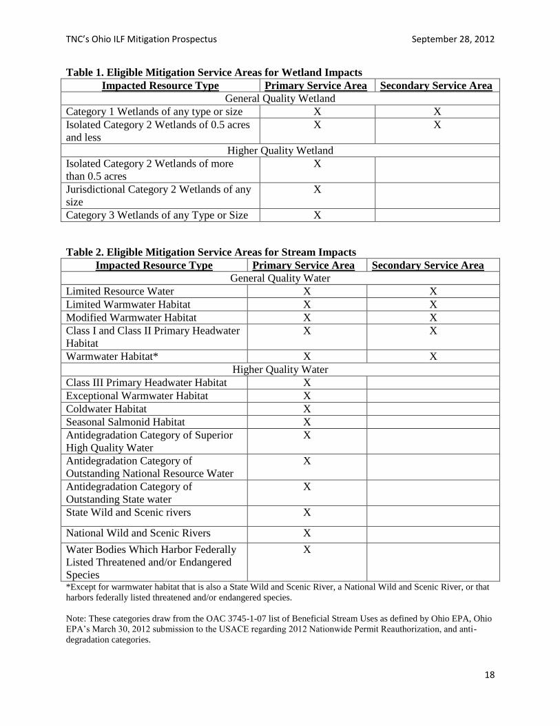
TNC’s Ohio ILF Mitigation Prospectus September 28, 2012
18
Table 1. Eligible Mitigation Service Areas for Wetland Impacts
Impacted Resource Type Primary Service Area Secondary Service Area
General Quality Wetland
Category 1 Wetlands of any type or size X X
Isolated Category 2 Wetlands of 0.5 acres
and less
X X
Higher Quality Wetland
Isolated Category 2 Wetlands of more
than 0.5 acres
X
Jurisdictional Category 2 Wetlands of any
size
X
Category 3 Wetlands of any Type or Size X
Table 2. Eligible Mitigation Service Areas for Stream Impacts
Impacted Resource Type Primary Service Area Secondary Service Area
General Quality Water
Limited Resource Water X X
Limited Warmwater Habitat X X
Modified Warmwater Habitat X X
Class I and Class II Primary Headwater
Habitat
X X
Warmwater Habitat* X X
Higher Quality Water
Class III Primary Headwater Habitat X
Exceptional Warmwater Habitat X
Coldwater Habitat X
Seasonal Salmonid Habitat X
Antidegradation Category of Superior
High Quality Water
X
Antidegradation Category of
Outstanding National Resource Water
X
Antidegradation Category of
Outstanding State water
X
State Wild and Scenic rivers X
National Wild and Scenic Rivers X
Water Bodies Which Harbor Federally
Listed Threatened and/or Endangered
Species
X
*Except for warmwater habitat that is also a State Wild and Scenic River, a National Wild and Scenic River, or that
harbors federally listed threatened and/or endangered species.
Note: These categories draw from the OAC 3745-1-07 list of Beneficial Stream Uses as defined by Ohio EPA, Ohio
EPA’s March 30, 2012 submission to the USACE regarding 2012 Nationwide Permit Reauthorization, and anti-
degradation categories.
TNC’s Ohio ILF Mitigation Prospectus September 28, 2012
19
If, within any 8-digit HUC, the cumulative amount of impacts to be mitigated through the ILF
Program in any given year are less than three acres of wetlands or 2,000 linear feet of stream, or
no acceptable Mitigation Project opportunities are found, TNC may submit a proposal to satisfy
the mitigation obligation liability through projects in an adjacent 8-digit HUC inside the same
Secondary Service Area, through the use of Released Credits or Bank Credits from within the
same Secondary Service Area, use of preservation in the same 8-digit HUC or Secondary Service
Area, deferring the mitigation liability to the next year, or other mitigation options as approved
by the appropriate USACE district engineer.
OTHER PRIORITY SETTING FACTORS TO BE CONSIDERED
Distribution & Abundance: Capture multiple occurrences of each aquatic system within each
Service Area to ensure representative conservation of biodiversity and habitat types by using all
available options to meet mitigation requirements.
Design: Create a network of hydrologically connected aquatic systems to ensure representative
and functional conservation areas within the service area and across the state.
Landscape context factors: Maximize potential for success for each mitigation option by
considering the surrounding land use patterns, local ecological processes and environmental
regimes that establish and maintain the aquatic system (e.g. hydrologic flow, seasonal
hydroperiods, presence of invasive species, climate regimes).
Connectivity: Include such factors as species having access to habitats/resources needed for life
cycle completion, proximity to other protected ecological communities and systems, and the
ability of aquatic species to adapt to environmental change through dispersal, migration, or re-
colonization.
By consolidating the mitigation requirements of multiple small projects in selective situations,
TNC will be able to use the TNC-Ohio ILF Program to implement large-scale watershed efforts
that restore, enhance, and protect water quality and ecosystem functionality.
TNC’s Ohio ILF Mitigation Prospectus September 28, 2012
20
Element 7. An explanation of how any preservation objectives identified in
Element 5 and addressed in the prioritization strategy in Element 6 satisfy the
criteria for use of preservation. The 2008 rule (73 FR 19670, Apr. 10, 2008) requires that goal setting for and prioritization of
aquatic resources as required by Elements 5 and 6 above also satisfy the criteria for use of
preservation. In the rule, preservation may be used to provide compensatory mitigation for
activities when the following criteria [§332.3(h)] are met:
(i) The resources to be preserved provide important physical, chemical, or biological functions
for the watershed;
(ii) The resources to be preserved contribute significantly to the ecological sustainability of the
watershed. In determining the contribution of those resources to the ecological sustainability of
the watershed, the district engineer must use appropriate quantitative assessment tools, where
available;
(iii) Preservation is determined by the district engineer to be appropriate and practicable;
(iv) The resources are under threat of destruction or adverse modifications; and
(v) The preserved site will be permanently protected through an appropriate real estate or other
legal instrument (e.g., easement, title transfer to state resource agency or land trust).
Where preservation is used to provide compensatory mitigation, to the extent appropriate and
practicable the preservation shall be done in conjunction with aquatic resource restoration,
establishment, and/or enhancement activities. This requirement may be waived by the district
engineer where preservation has been identified as a high priority using a watershed approach
described in paragraph (c) of this section (§332.3), but compensation ratios shall be higher.
TNC’s approach to setting goals for preservation and the criteria used for selecting and
prioritizing aquatic systems and occurrences of species and communities is designed with the
explicit purpose of capturing critical environmental gradients (changes in abiotic factors or biotic
interactions over space and time that are linked to connectivity and natural disturbance),
ecological processes, and genetic diversity to ensure the persistence and sustainability of viable
biological diversity, ecological systems and functional landscapes in the Service Area.
Conservation actions at those sites are designed to abate threats and maintain and restore the
viability, function and sustainability of the aquatic systems and diversity with the intent of
providing permanent protection of the resource. The design principles discussed in this document
are wholly consistent with the criteria articulated in the 2008 rule.
TNC’s Ohio ILF Mitigation Prospectus September 28, 2012
21
Element 8. A description of any public and private stakeholder involvement in
plan development and implementation, including coordination with federal,
state, tribal and local aquatic resource management and regulatory authorities.
TNC works closely with public and private partners and experts to develop a conservation vision
and set priorities through ecoregional assessments and to design and implement effective
conservation strategies at multiple scales to conserve biological diversity. We depend on a wide
diversity of partners from state and federal agencies, non-governmental organizations, industry,
and academic institutions to inform and influence our work while supporting the alliances
necessary to achieve meaningful conservation results.
For example, the proposed TNC-Ohio ILF Program is an exemplary partnership involving the
Ohio Environmental Protection Agency, Ohio Department of Natural Resources, Ohio
Department of Transportation, US Army Corps of Engineers, US Fish & Wildlife Service, and
The Nature Conservancy by which multiple conservation objectives are accomplished through
collaborative action.
Moreover, we have involved partners in our conservation action planning efforts in Ohio in
which we identify conservation targets, threats to targets, develop measurable conservation
objectives and design conservation actions to abate threats and restore viability to targets.
Relying on the expertise of agency and academic scientists is crucial to the scientific integrity of
establishing our conservation priorities.
During the course of developing this prospectus, TNC met with the Interagency Review Team to
discuss this proposed approach to an Ohio In-Lieu Fee stream and wetland program and to invite
preliminary feedback. In addition, TNC conducted a WebEx presentation for conservation
partners for the specific purpose of getting perspective and comments from stakeholders on the
draft prospectus for this Ohio Stream and Wetland In-Lieu Fee Program. Partner support and
engagement in implementing mitigation projects through this program will be critical to its
success.
TNC will request mitigation project proposals from qualified partners, such as public agencies or
conservation NGOs that meet the criteria of the TNC-Ohio ILF Program. In practice, it is
anticipated that a significant portion of the lands included in this program will be owned and
managed by other organizations, with TNC in the role of seeking proposals, selecting those to be
considered by the IRT, and playing a support role to the lead organization for the specific
project.
TNC’s Ohio ILF Mitigation Prospectus September 28, 2012
22
Element 9. A description of the long-term protection and management strategies
for activities conducted by the in-lieu fee program sponsor.
The Nature Conservancy implements a variety of restoration and conservation strategies at
multiple scales across the state and region to conserve biological diversity in priority
conservation areas. Strategies are developed with partners and designed to abate a range of
threats at the scales at which they occur including global climate change, habitat loss and
fragmentation, invasive species, nutrient and sediment runoff, and altered hydrological regimes
of streams and wetlands. Stewardship strategies include wetland and stream restoration, the use
of prescribed fire, invasive species control, and rare species recovery efforts. In general,
strategies are designed to achieve clearly articulated, measurable conservation objectives.
As the sponsor of the Ohio Stream and Wetland In-Lieu Fee Program, TNC will evaluate
proposed projects based on the qualifications of the project applicant to successfully secure and
implement the long term protection and restoration goals of the project. Project requirements
will include a long term management and monitoring plan that will provide quantitative results
for evaluating whether the project meets the mitigation goals and the standards developed by the
US Army Corps of Engineers and Ohio Environmental Protection Agency.
Legal mechanisms will be established for long term protection and management of the mitigation
site. Potential long term site managers include public agencies, land trusts, park districts,
watershed groups and other conservation entities with the capacity to follow through on the long
term protection, monitoring, and management of the mitigation site. Long term protection
mechanisms could include conservation easements or restrictive covenants held by a third party,
deed restrictions, or other legal mechanisms to ensure land protection and fulfillment of the
mitigation requirements.
TNC’s Ohio ILF Mitigation Prospectus September 28, 2012
23
Element 10. A strategy for periodic evaluation and reporting on the progress of
the program in achieving the goals and objectives above, including a process for
revising the planning framework as necessary.
The business of TNC is to implement conservation strategies that are intended to maintain or
restore biodiversity and ecosystem processes for the long term. To be successful, it is necessary
to know whether the trends in the viability and integrity of biodiversity, the status of threats, and
the ecological management of conservation lands and waters are heading in a positive direction,
holding steady, or declining. Moreover, it is essential to know whether our strategies are having
the intended outcomes and fulfilling measurable conservation objectives. A major component of
Conservation by Design is measuring results and making changes as necessary to achieve those
results. This is the cornerstone of all good adaptive management. TNC’s organizational
commitment to measuring results is a high priority.
A great deal of monitoring work is already being done by state agencies and academic
institutions in Ohio’s wetlands, streams, and other aquatic habitats and waterways. Examples
include Ohio EPA’s water quality assessment and biological monitoring methodology (e.g.
ORAM, FQAI, VIBI, AmphIBI, QHEI) and ODNR’s stream monitoring and rare species
assessments. TNC strategically uses and tracks this type of data to better inform conservation
strategies now and into the future.
In addition, TNC seeks to measure whether individual strategies and associated actions taken
within a conservation project are having their intended effect on abating threats and restoring
ecological targets. These measures of strategy effectiveness are used to evaluate progress in
achieving desired outcomes and results that stem from implementing strategies, by tracking
progress toward measurable objectives. This approach will be required of all mitigation projects
submitted for consideration to the IRT through the TNC-Ohio ILF Program.
TNC will submit an annual report on its TNC-Ohio ILF Mitigation Program to the IRT providing
an opportunity to assess the program and recommend changes to improve implementation and
ecological outcomes of the mitigation projects and overall administration of the program.
TNC’s Ohio ILF Mitigation Prospectus September 28, 2012
24
CONCLUSION
The Nature Conservancy will utilize the locations identified on the following pages (Part II) as
priority areas for siting mitigation projects. As necessary, secondary locations may be identified
when mitigation needs exist and projects cannot be implemented within the first priority
locations, or where additional information suggests a more suitable site location.
This section of the prospectus addresses the ways in which TNC’s Conservation by Design
approach including ecoregional assessments and conservation action plans satisfy the elements
required by the compensation planning framework rule required for in-lieu fee mitigation
programs.
Conservation by Design provides an integrated approach that can be used in a comprehensive
statewide mitigation program to establish conservation goals and priorities, guide actions, and
direct resources to gain the greatest ecological results from mitigation projects. It is an adaptive
approach that can operate at multiple scales, from local to global, and has been successfully
employed in diverse geographic and cultural settings. It is a highly effective method “to select,
secure, and implement aquatic resource restoration, establishment, enhancement, and/or
preservation activities” as required by the 2008 rule for compensatory mitigation.
Many of the concepts and methods of Conservation by Design have been incorporated into the
Open Standards for the Practice of Conservation Version 2.0 developed by the Conservation
Measures Partnership which is a partnership of conservation non-governmental organizations,
including The Nature Conservancy, that seek better ways to design, manage, and measure the
impacts of their conservation actions. The Open Standards represent the collective experience of
its members in conservation project design, management, and monitoring and, as such, provides
the steps and general guidance necessary for the successful implementation of conservation
projects, including mitigation.
The Open Standards for the Practice of Conservation can be found at
http://www.conservationmeasures.org/CMP/
Moreover, the methods and tools associated with Conservation by Design are available to the
public through TNC’s Conservation by Design Gateway website at
http://www.conservationgateway.org/
The Conservation by Design Gateway is a workspace for the global conservation community to
find and share guidance, tools and resources supporting Conservation by Design or the process
of setting goals, developing strategies, implementation and measuring results for biodiversity
conservation. Industry, state agencies and other non-profit conservation groups can use and adapt
this approach to satisfy mitigation requirements, resulting in more strategic project selection
and success in conserving Ohio’s aquatic resources.
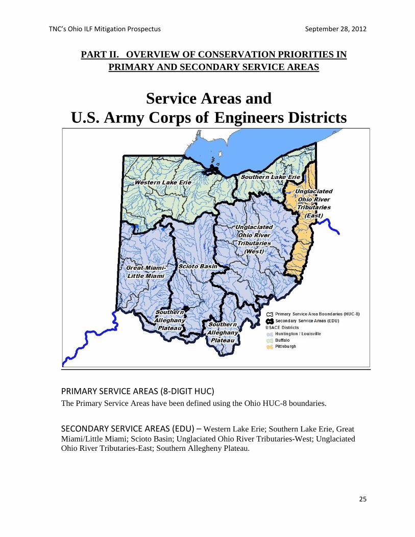
TNC’s Ohio ILF Mitigation Prospectus September 28, 2012
25
PART II. OVERVIEW OF CONSERVATION PRIORITIES IN
PRIMARY AND SECONDARY SERVICE AREAS
PRIMARY SERVICE AREAS (8-DIGIT HUC) The Primary Service Areas have been defined using the Ohio HUC-8 boundaries.
SECONDARY SERVICE AREAS (EDU) – Western Lake Erie; Southern Lake Erie, Great
Miami/Little Miami; Scioto Basin; Unglaciated Ohio River Tributaries-West; Unglaciated
Ohio River Tributaries-East; Southern Allegheny Plateau.
Service Areas and
U.S. Army Corps of Engineers Districts
TNC’s Ohio ILF Mitigation Prospectus September 28, 2012
26
The Secondary Service Areas (EDUs) have been defined by incorporating the Ohio
ecoregion boundaries and descriptions as defined by Omernik (1987, 1995) with Ecological
Drainage Unit boundaries described below. More complete descriptions of the ecoregion
characteristics can be found on the poster-sized map, Ecoregions of Indiana and Ohio
(Woods et al, 1998).
Ecoregions are areas with similar ecosystems and patterns of biotic and abiotic features such
as geology, physiography, vegetation, soils, wildlife, hydrology, and climate. They can be
used as a spatial framework for developing plans, assessments, management, and monitoring.
They are relevant for taking an integrated approach to ecosystem management and natural
resource conservation.
Ecological Drainage Units (EDUs) are groups of watersheds (8-digit hydrologic unit codes
[HUCs] as defined by USGS) that share ecological and biological characteristics. EDUs
typically contain sets of aquatic system types with similar patterns of drainage density,
gradient, hydrologic characteristics, and connectivity. EDUs provide a stratification scheme
to identify environmental gradients. EDUs are also useful as a framework for planning that
allows for evaluation of patterns of aquatic community diversity and for setting conservation
goals.
Highlighted on the maps below are general locations identified as conservation priority sites
within each service area. TNC establishes conservation priorities in places with high
biodiversity that are most in need of conservation action or promise the greatest conservation
return on investment. Conservation priority sites are identified by TNC and its conservation
partners through ecoregional assessments using data on the distribution and status of
biodiversity, habitat condition, current and future threats and the socio-political conditions that
influence conservation success within those ecoregions.
These data allow us to set long-term conservation goals for conservation targets — ecosystems,
natural communities and imperiled or declining species representative of an ecoregion, and to
establish protocol for resource allocation. While some targets may be in excellent natural
condition at a given site with a high probability of long term viability, others may benefit from
restoration or by having additional buffer lands from the surrounding landscape brought into
conservation ownership. These situations offer great potential for future mitigation project sites.
Examples of aquatic resources identified as conservation priority sites within service areas:
1. Category 3 wetlands;
2. Streams with aquatic life use designation of exceptional warmwater habitat, cold water
habitat, seasonal salmonid or any equivalent designation and/or performance;
3. Streams with antidegradation category of superior high quality water, outstanding
national resource water or outstanding state water;
4. State wild and scenic rivers;
5. National wild and scenic rivers;
6. General high quality waters which harbor federal and/or state listed threatened and/or
endangered mussel species;
7. Class III primary headwater habitat streams.
TNC’s Ohio ILF Mitigation Prospectus September 28, 2012
27
All of the conservation priority sites identified in this prospectus signify The Nature
Conservancy’s attempt to identify the best examples of aquatic biodiversity across Ohio.
These sites should serve as a starting point for selecting areas where mitigation projects
through an Ohio In-Lieu Fee Mitigation Program might be most appropriately located to
achieve maximum success in meeting the mitigation requirements. The plan presents a
framework for thinking about conservation and restoration of aquatic systems, particularly in
a landscape with heavily fragmented and disconnected aquatic systems.
TNC’s Ohio ILF Mitigation Prospectus September 28, 2012
28
WESTERN LAKE ERIE
A. DESCRIPTION
Ecoregions: Huron-Erie Lake Plains (57 a, b, c, d); Eastern Corn Belt Plains (55a);
Erie-Ontario Drift and Lake Plain (61a)
The Huron-Erie Lake Plains ecoregion is a broad, fertile, flat plain with relict sand dunes,
beach ridges and end moraines. Originally, soil drainage was poor and wetland forests
dominated. Much of the area has been cleared and drained for agriculture and urban land
uses. Stream habitat and quality have been degraded by this activity. Oak savanna is
commonly found, but restricted to the sandy dunes and beach ridges.
The Eastern Corn Belt Plains section is rolling till plain with local end moraines. It was
originally more forested with beech and elm-ash forests. Much of it has been drained for
agriculture and its low gradient streams are not extremely rich in fish communities.
A small portion of the Erie/Ontario Drift and Lake Plain occurs in the eastern end of this
service area. Fairly level lacustrine deposits with beach ridges and swales are found here.
Land use is agriculture, industrial and urban development. The area’s proximity to the lake
moderates its weather, extending the growing season but also increasing winter snowfall.
Major stream systems include the Maumee River with its many tributaries and the Sandusky
River. All streams in this service area flow into western Lake Erie.
B. CONSERVATION PRIORITY SITES
WETLANDS
1. Blakeslee Virginia Mallow
2. Dietrich Woods
3. DuPont Marsh
4. Erie Marsh
5. Goll Woods
6. Killdeer Plains
7. Marblehead
8. Marie DeLarme Creek Woods
9. Mentor Marsh and Mentor
Headlands
10. Oak Openings
11. Resthaven Wildlife Area
12. Sheldon's Marsh
13. Springville Marsh
14. State Line Woods/Mud Lake Bog
15. Western Lake Erie Islands and Reefs
16. Western Lake Erie Marshes/Cedar
Point National Wildlife Refuge
STREAMS
1. Blanchard River
2. Huron River
3. Lower Vermillion River
4. Maumee River
5. Old Woman Creek
6. Portage River
7. Sandusky Bay
8. Sandusky River
9. St. Mary’s River Wetlands
10. Upper Auglaize River
11. Upper St. Joseph River
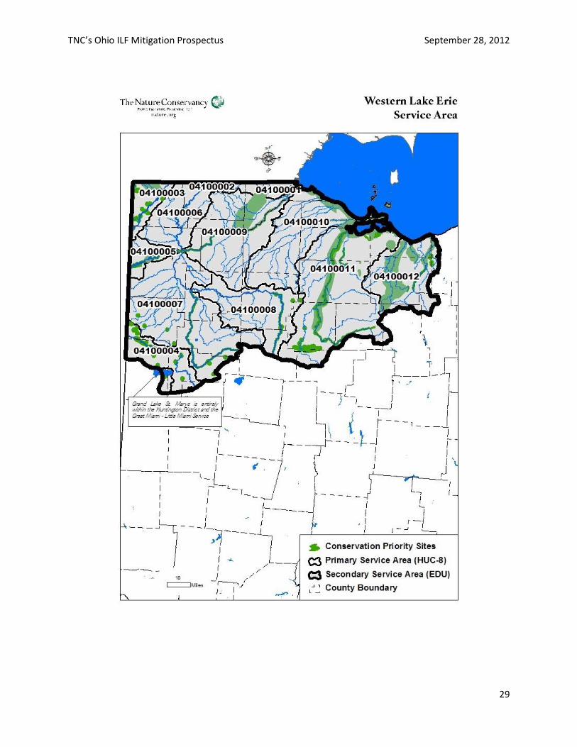
TNC’s Ohio ILF Mitigation Prospectus September 28, 2012
29
TNC’s Ohio ILF Mitigation Prospectus September 28, 2012
30
SOUTHERN LAKE ERIE
A. DESCRIPTION
Ecoregions: Erie-Ontario Drift and Lake Plain (61a, b, c, d, e)
This region contains lacustrine deposits with rolling to level terrain. Glacial wetlands, lakes,
and streams predominate and soil is less fertile than in other areas of glaciation. Urban
development and industry is widespread in the western portion, while agriculture is more
widespread in the east. Agriculture tends toward fruit and vegetables, dairy, and commercial
nurseries. The growing season is extended due to lake effect in the north, but that effect
diminishes further south. Lake effect winter snow increases precipitation and moisture levels
in the eastern end.
Beach ridges and swale habitat are found close to the lake in the Lake Plain region. Moving
inland, poor drainage leads to low-gradient streams, swampy wetlands and woodlands.
Glacial wetlands or peatlands, such as sphagnum bogs, fens, and kettlehole lakes are
common in the Summit Interlobate Area.
Major river systems include the Cuyahoga River and the Grand River. All streams and rivers
flow into Lake Erie.
B. CONSERVATION PRIORITY SITES
WETLANDS
1. Chagrin River Valley
2. Lower Cuyahoga Valley
3. Summit Kames
4. Tinkers Creek Wetlands
5. Perry Nuclear Plant-Lakeshore
Metropark
STREAMS
1. Arcola Creek
2. Conneaut Creek
3. East Branch Black River
4. Grand River
5. Upper Cuyahoga River
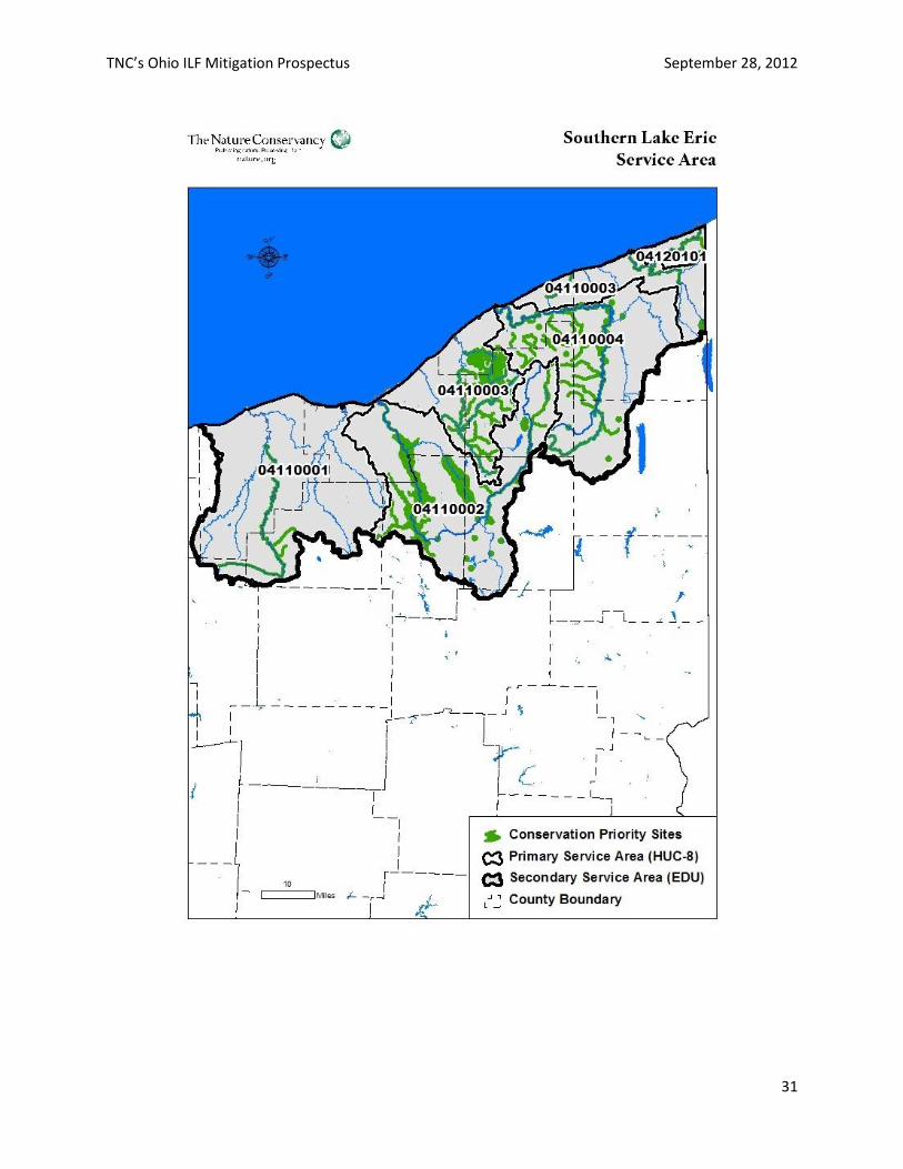
TNC’s Ohio ILF Mitigation Prospectus September 28, 2012
31
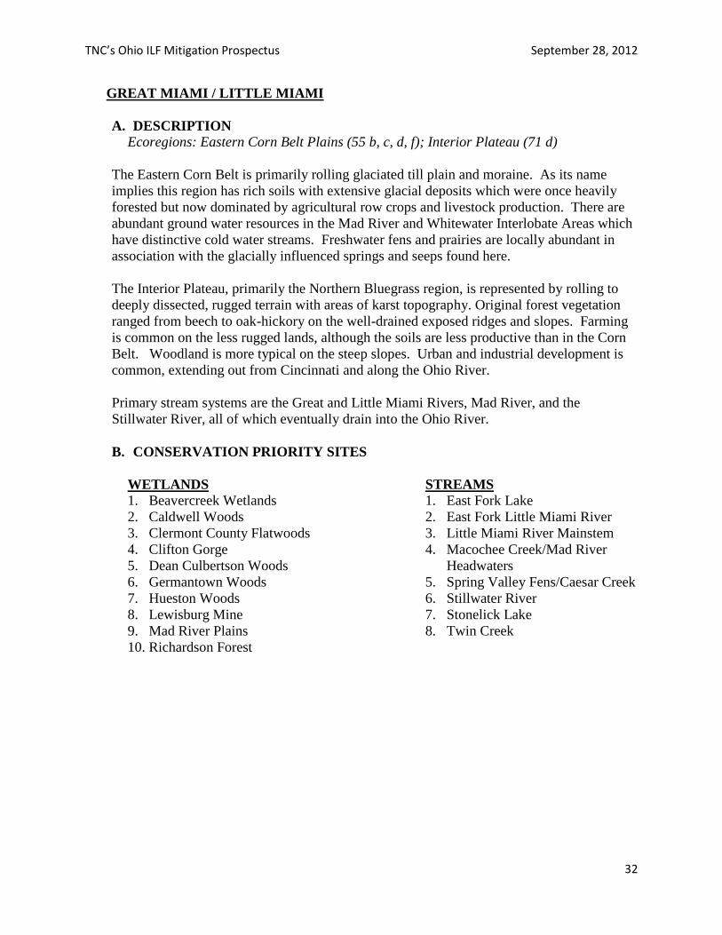
TNC’s Ohio ILF Mitigation Prospectus September 28, 2012
32
GREAT MIAMI / LITTLE MIAMI
A. DESCRIPTION
Ecoregions: Eastern Corn Belt Plains (55 b, c, d, f); Interior Plateau (71 d)
The Eastern Corn Belt is primarily rolling glaciated till plain and moraine. As its name
implies this region has rich soils with extensive glacial deposits which were once heavily
forested but now dominated by agricultural row crops and livestock production. There are
abundant ground water resources in the Mad River and Whitewater Interlobate Areas which
have distinctive cold water streams. Freshwater fens and prairies are locally abundant in
association with the glacially influenced springs and seeps found here.
The Interior Plateau, primarily the Northern Bluegrass region, is represented by rolling to
deeply dissected, rugged terrain with areas of karst topography. Original forest vegetation
ranged from beech to oak-hickory on the well-drained exposed ridges and slopes. Farming
is common on the less rugged lands, although the soils are less productive than in the Corn
Belt. Woodland is more typical on the steep slopes. Urban and industrial development is
common, extending out from Cincinnati and along the Ohio River.
Primary stream systems are the Great and Little Miami Rivers, Mad River, and the
Stillwater River, all of which eventually drain into the Ohio River.
B. CONSERVATION PRIORITY SITES
WETLANDS
1. Beavercreek Wetlands
2. Caldwell Woods
3. Clermont County Flatwoods
4. Clifton Gorge
5. Dean Culbertson Woods
6. Germantown Woods
7. Hueston Woods
8. Lewisburg Mine
9. Mad River Plains
10. Richardson Forest
STREAMS
1. East Fork Lake
2. East Fork Little Miami River
3. Little Miami River Mainstem
4. Macochee Creek/Mad River
Headwaters
5. Spring Valley Fens/Caesar Creek
6. Stillwater River
7. Stonelick Lake
8. Twin Creek
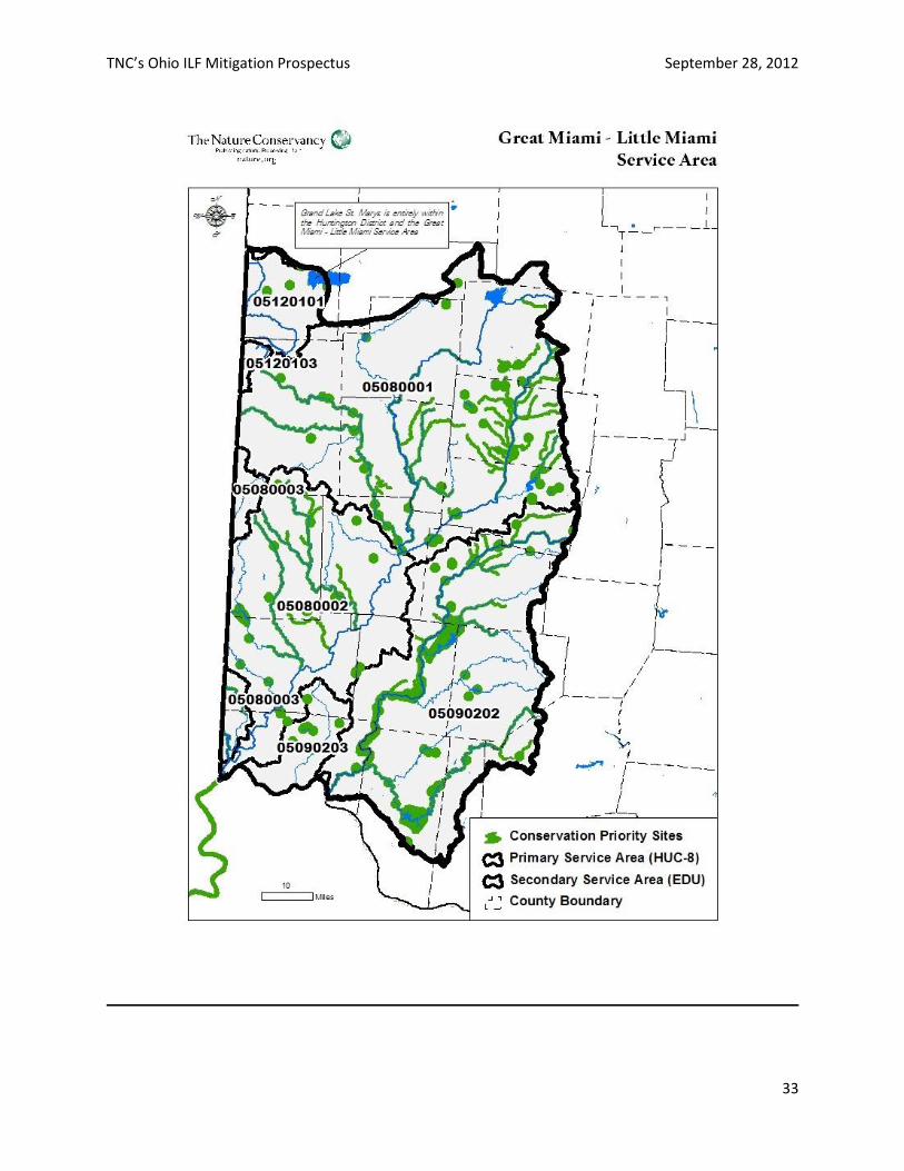
TNC’s Ohio ILF Mitigation Prospectus September 28, 2012
33
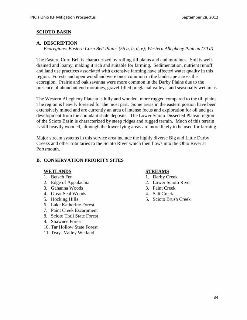
TNC’s Ohio ILF Mitigation Prospectus September 28, 2012
34
SCIOTO BASIN
A. DESCRIPTION
Ecoregions: Eastern Corn Belt Plains (55 a, b, d, e); Western Allegheny Plateau (70 d)
The Eastern Corn Belt is characterized by rolling till plains and end moraines. Soil is well-
drained and loamy, making it rich and suitable for farming. Sedimentation, nutrient runoff,
and land use practices associated with extensive farming have affected water quality in this
region. Forests and open woodland were once common in the landscape across the
ecoregion. Prairie and oak savanna were more common in the Darby Plains due to the
presence of abundant end moraines, gravel-filled preglacial valleys, and seasonally wet areas.
The Western Allegheny Plateau is hilly and wooded, more rugged compared to the till plains.
The region is heavily forested for the most part. Some areas in the eastern portion have been
extensively mined and are currently an area of intense focus and exploration for oil and gas
development from the abundant shale deposits. The Lower Scioto Dissected Plateau region
of the Scioto Basin is characterized by steep ridges and rugged terrain. Much of this terrain
is still heavily wooded, although the lower lying areas are more likely to be used for farming.
Major stream systems in this service area include the highly diverse Big and Little Darby
Creeks and other tributaries to the Scioto River which then flows into the Ohio River at
Portsmouth.
B. CONSERVATION PRIORITY SITES
WETLANDS
1. Betsch Fen
2. Edge of Appalachia
3. Gahanna Woods
4. Great Seal Woods
5. Hocking Hills
6. Lake Katherine Forest
7. Paint Creek Escarpment
8. Scioto Trail State Forest
9. Shawnee Forest
10. Tar Hollow State Forest
11. Teays Valley Wetland
STREAMS
1. Darby Creek
2. Lower Scioto River
3. Paint Creek
4. Salt Creek
5. Scioto Brush Creek
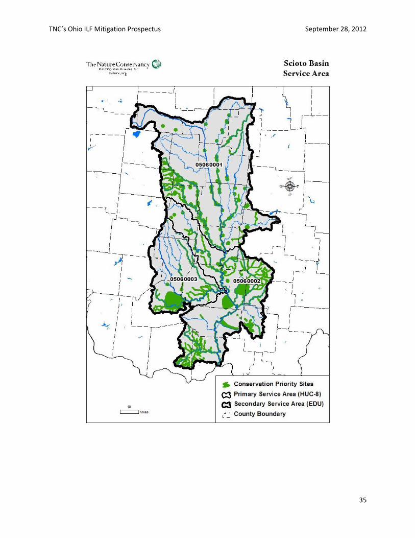
TNC’s Ohio ILF Mitigation Prospectus September 28, 2012
35
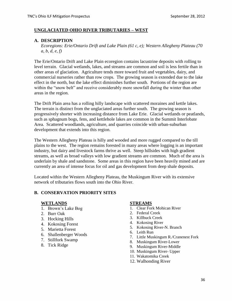
TNC’s Ohio ILF Mitigation Prospectus September 28, 2012
36
UNGLACIATED OHIO RIVER TRIBUTARIES – WEST
A. DESCRIPTION
Ecoregions: Erie/Ontario Drift and Lake Plain (61 c, e); Western Allegheny Plateau (70
a, b, d, e, f)
The Erie/Ontario Drift and Lake Plain ecoregion contains lacustrine deposits with rolling to
level terrain. Glacial wetlands, lakes, and streams are common and soil is less fertile than in
other areas of glaciation. Agriculture tends more toward fruit and vegetables, dairy, and
commercial nurseries rather than row crops. The growing season is extended due to the lake
effect in the north, but the lake effect diminishes further south. Portions of the region are
within the “snow belt” and receive considerably more snowfall during the winter than other
areas in the region.
The Drift Plain area has a rolling hilly landscape with scattered moraines and kettle lakes.
The terrain is distinct from the unglaciated areas further south. The growing season is
progressively shorter with increasing distance from Lake Erie. Glacial wetlands or peatlands,
such as sphagnum bogs, fens, and kettlehole lakes are common in the Summit Interlobate
Area. Scattered woodlands, agriculture, and quarries coincide with urban-suburban
development that extends into this region.
The Western Allegheny Plateau is hilly and wooded and more rugged compared to the till
plains to the west. The region remains forested in many areas where logging is an important
industry, but dairy and livestock farms thrive as well. Steep hillsides with high gradient
streams, as well as broad valleys with low gradient streams are common. Much of the area is
underlain by shale and sandstone. Some areas in this region have been heavily mined and are
currently an area of intense focus for oil and gas development from deep shale deposits.
Located within the Western Allegheny Plateau, the Muskingum River with its extensive
network of tributaries flows south into the Ohio River.
B. CONSERVATION PRIORITY SITES
WETLANDS
1. Brown’s Lake Bog
2. Burr Oak
3. Hocking Hills
4. Kokosing Forest
5. Marietta Forest
6. Shallenberger Woods
7. Stillfork Swamp
8. Tick Ridge
STREAMS 1. Clear Fork Mohican River
2. Federal Creek
3. Killbuck Creek
4. Kokosing River
5. Kokosing River-N. Branch
6. Leith Run
7. Little Muskingum R./Cranenest Fork
8. Muskingum River-Lower
9. Muskingum River-Middle
10. Muskingum River- Upper
11. Wakatomika Creek
12. Walhonding River
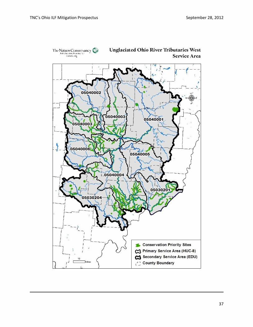
TNC’s Ohio ILF Mitigation Prospectus September 28, 2012
37

TNC’s Ohio ILF Mitigation Prospectus September 28, 2012
38
UNGLACIATED OHIO RIVER TRIBUTARIES – EAST
A. DESCRIPTION
Ecoregions: Western Allegheny Plateau (70 a, b, c)
The Western Allegheny Plateau is hilly and wooded and more rugged compared to the till plains
to the west. The region remains forested in many areas where logging is an important industry,
but dairy and livestock farms thrive as well. Steep hillsides with high gradient streams, as well
as broad valleys with low gradient streams are common. Much of the area is underlain by shale
and sandstone. Some areas in this region have been heavily mined and are currently an area of
intense focus for oil and gas development from deep shale deposits.
The Pittsburgh Low Plateau section is largely unglaciated with rounded, forested hills and
narrow valleys. Streams in this area are predominantly high gradient with rocky substrates. Less
coal mining occurred in this area than in other parts of the ecoregion.
Two notable tributaries to the Ohio River, Little Beaver Creek and Captina Creek, flow through
this service area.
B. CONSERVATION PRIORITY SITES
WETLANDS
1. Little Beaver Creek Forest
2. Mahoning Kames
3. Pennline Bog
STREAMS
1. Captina Creek
2. Little Beaver Creek
3. Mahoning River
4. Pymatuning Creek
TNC’s Ohio ILF Mitigation Prospectus September 28, 2012
39
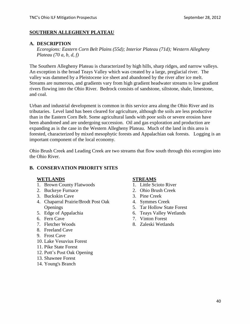
TNC’s Ohio ILF Mitigation Prospectus September 28, 2012
40
SOUTHERN ALLEGHENY PLATEAU
A. DESCRIPTION Ecoregions: Eastern Corn Belt Plains (55d); Interior Plateau (71d); Western Allegheny
Plateau (70 a, b, d, f)
The Southern Allegheny Plateau is characterized by high hills, sharp ridges, and narrow valleys.
An exception is the broad Teays Valley which was created by a large, preglacial river. The
valley was dammed by a Pleistocene ice sheet and abandoned by the river after ice melt.
Streams are numerous, and gradients vary from high gradient headwater streams to low gradient
rivers flowing into the Ohio River. Bedrock consists of sandstone, siltstone, shale, limestone,
and coal.
Urban and industrial development is common in this service area along the Ohio River and its
tributaries. Level land has been cleared for agriculture, although the soils are less productive
than in the Eastern Corn Belt. Some agricultural lands with poor soils or severe erosion have
been abandoned and are undergoing succession. Oil and gas exploration and production are
expanding as is the case in the Western Allegheny Plateau. Much of the land in this area is
forested, characterized by mixed mesophytic forests and Appalachian oak forests. Logging is an
important component of the local economy.
Ohio Brush Creek and Leading Creek are two streams that flow south through this ecoregion into
the Ohio River.
B. CONSERVATION PRIORITY SITES
WETLANDS
1. Brown County Flatwoods
2. Buckeye Furnace
3. Buckskin Cave
4. Chaparral Prairie/Brodt Post Oak
Openings
5. Edge of Appalachia
6. Fern Cave
7. Fletcher Woods
8. Freeland Cave
9. Frost Cave
10. Lake Vesuvius Forest
11. Pike State Forest
12. Pott’s Post Oak Opening
13. Shawnee Forest
14. Young's Branch
STREAMS
1. Little Scioto River
2. Ohio Brush Creek
3. Pine Creek
4. Symmes Creek
5. Tar Hollow State Forest
6. Teays Valley Wetlands
7. Vinton Forest
8. Zaleski Wetlands
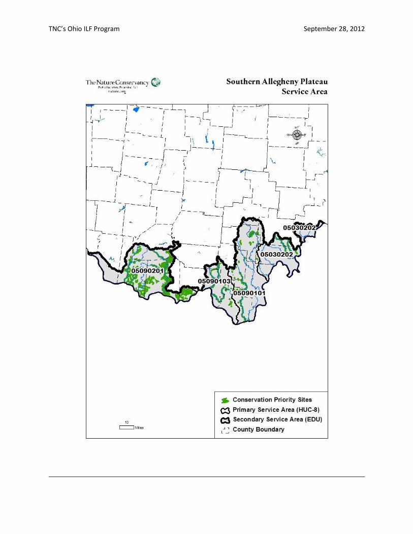
TNC’s Ohio ILF Program September 28, 2012
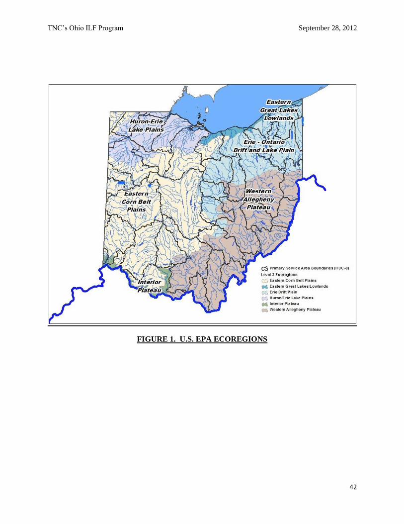
TNC’s Ohio ILF Program September 28, 2012
42
FIGURE 1. U.S. EPA ECOREGIONS
TNC’s Ohio ILF Program September 28, 2012
43
FIGURE 2. HUC-8 and ECOLOGICAL DRAINAGE UNIT BOUNDARIES
TNC’s Ohio ILF Program September 28, 2012
44
FIGURE 3. SERVICE AREAS AND U.S. ARMY CORPS OF ENGINEERS DISTRICTS
TNC’s Ohio ILF Program September 28, 2012
45
REFERENCES
Abell, R.A., Olson, D.M., E. Dinerstein, P.T. Hurley et al. (WWF) 2000. Freshwater ecoregions
of North America. A Conservation Assessment. Washington, D.C. Island Press. 368 pp.
Bailey, R.G. 1995. Description of the ecoregions of the United States. Second edition.
Washington, D.C., U.S. Forest Service, Miscellaneous Publication No. 1391.
Braig, Eugene C., J. Conroy, F. Lichtkoppler, W. Lynch, L. Merchant-Masonbrink. 2010.
Harmful Algal Blooms in Ohio Waters; Ohio Sea Grant Fact Sheets.
Chou, Ben and Jenna Schroeder. 2012. Ready or Not: An Evaluation of State Climate and Water
Preparedness Planning. Natural Resources Defense Council. ISSUE BRIEF. IB12-03-A. 10 pp.
Dahl, T.E. 1990. Wetlands losses in the United States, 1780s to 1980s. Department of the
Interior; U.S. Fish and Wildlife Service, Washington, D.C. 21 pp.
Dahl, T.E. 2011. Status and Trends of Wetlands in the Conterminous United States 2004 to
2009. Department of the Interior; U.S. Fish and Wildlife Service, Washington, D.C. 112 pp.
Gordon, Robert B. 1966. Natural vegetation map of Ohio at the time of the earliest land surveys.
Ohio Biological Survey. Columbus.
Groves, Craig, Mark Anderson, Carolyn Enquist, Evan Girvetz, Trevor Sandwith, Loring
Schwarz, Rebecca Shaw. Climate Change and Conservation: A Primer for Assessing Impacts
and Advancing Ecosystem‐based Adaptation in The Nature Conservancy. March 2010. 59 pp.
Maine Natural Resource Conservation Program. 2011. State of Maine – In Lieu Fee Program
Instrument. Maine Department of Environmental Protection. Augusta, Maine. 82 pp.
Maxwell, J.R., Edwards, C.J., et al. 1995. “A hierarchical framework of aquatic ecological
units in North America (Nearctic Zone)”. St. Paul, MN. North Central Forest Experiment
Station, USDA Forest Service.
Ohio Department of Natural Resources and Ohio Environmental Protection Agency. 1999. Ohio
Wetland Restoration and Mitigation Strategy Blueprint, Final Product to the US Environmental
Protection Agency, Region V; Wetland Grant Program Federal Grant No. CD985853-01-0.
Omernik, James M. 1987. Ecoregions of the conterminous United States (map supplement,
scale 1:7,500,000): Annals of the Association of American Geographers, v. 77, no. 1; p. 118-
125.
Omernik, James M. 1995. Chapter 5. Ecoregions: A Spatial Framework for Environmental
Management. in Biological assessment and criteria: tools for water resource planning and
decision making. Wayne S. Davis and Thomas P. Simon, editors. CRC Press, Inc., pp. 49-65.
TNC’s Ohio ILF Program September 28, 2012
46
Omernik, James M. and Robert G. Bailey. 1997. Distinguishing between watersheds and
ecoregions. Journal of the American Water Resources Association. VOL.33, NO.5: 935-949.
Sanders, Randall E., ed., and R.J. Zimmerman. 2002 (third printing). A Guide to Ohio Streams.
Ohio Chapter of the American Fisheries Society. Columbus, Ohio.
The Nature Conservancy. 2001. Conservation by Design – A Framework for Mission Success.
Arlington, Virginia. 12 pp.
The Nature Conservancy. 2009. The Nature Conservancy’s Watershed Approach to
Compensation Planning for The Virginia Aquatic Restoration Trust Fund. The Nature
Conservancy in Virginia, Charlottesville, Virginia. 90 pp.
Williamson, Sean, Soyesh Lakhey, Daria Karetnikov, Matthias Ruth, Kim Ross, Daraius Irani.
2008. Economic Impacts of Climate Change on Ohio. A Review and Assessment Conducted by
The Center for Integrative Environmental Research University of Maryland. 20 pp.
Woods, Alan J. (Dynamac Corporation), James M. Omernik (USEPA), C. Scott Brockman
(ODNR - Division of Geological Survey), Timothy D. Gerber (ODNR - Division of Soil and
Water Conservation), William D. Hosteter (NRCS), and Sandra H. Azevedo (OAO Corporation).
1998. Ecoregions of Indiana and Ohio (Map with descriptions). This project was partially
supported by funds from the USEPA - Office of Research and Development - Regional Applied
Research Effort (RARE) program.