Embed Size (px)
Citation preview
2009 Volume 49, Number 1 Library of Congress No. ISSN-0077-8346
The New Hampshire Archeologist
The New Hampshire ArcheologistVolume 49, Number 1, 2009
David R. Starbuck, Editor
© 2009 by The New Hampshire Archeological Society
i
The New Hampshire Archeologist is a publication of the New Hampshire Archeological Society and is distributed as a benefit of mem-bership. The Society does not assume responsibility for the statements of contributors and expects that permission to reproduce mate-rial from published articles or books has been secured in advance by the contributing authors. Copyright is held by the author(s) ofeach article. No part of this journal may be reproduced in any form without permission from its author.
ii
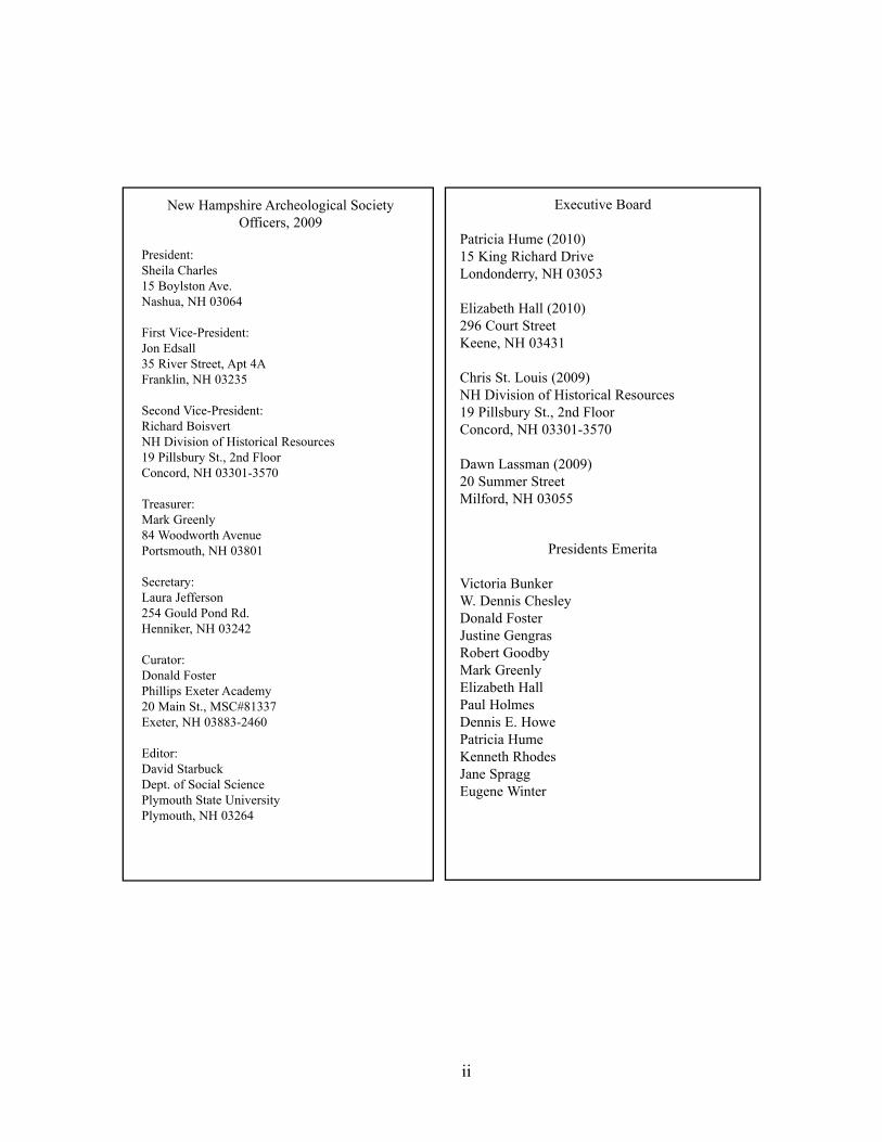
New Hampshire Archeological SocietyOfficers, 2009
President:Sheila Charles15 Boylston Ave.Nashua, NH 03064
First Vice-President: Jon Edsall35 River Street, Apt 4AFranklin, NH 03235
Second Vice-President:Richard Boisvert NH Division of Historical Resources19 Pillsbury St., 2nd FloorConcord, NH 03301-3570
Treasurer: Mark Greenly 84 Woodworth AvenuePortsmouth, NH 03801
Secretary: Laura Jefferson 254 Gould Pond Rd.Henniker, NH 03242
Curator: Donald Foster Phillips Exeter Academy20 Main St., MSC#81337Exeter, NH 03883-2460
Editor: David Starbuck Dept. of Social SciencePlymouth State UniversityPlymouth, NH 03264
Executive Board
Patricia Hume (2010)15 King Richard DriveLondonderry, NH 03053
Elizabeth Hall (2010)296 Court StreetKeene, NH 03431
Chris St. Louis (2009)NH Division of Historical Resources19 Pillsbury St., 2nd FloorConcord, NH 03301-3570
Dawn Lassman (2009)20 Summer StreetMilford, NH 03055
Presidents Emerita
Victoria BunkerW. Dennis ChesleyDonald FosterJustine GengrasRobert GoodbyMark GreenlyElizabeth HallPaul HolmesDennis E. HowePatricia HumeKenneth RhodesJane SpraggEugene Winter
PrefaceThis volume of The New Hampshire Archeologist presents the rich diversity of NewHampshire’s past, all the way from the Paleoindian period up until 1942, when aDouglas B-18A Bolo Bomber crashed on a New Hampshire mountain. Archeologistsworking in New Hampshire do not lack for fascinating research topics, and every sitehas the potential to challenge, excite and inform.
“The Bomber Crash of 1942” is unlike any other article that has been published withinthe pages of this journal. Excellent articles by Victoria Bunker have often appeared inThe New Hampshire Archeologist, but always describing much earlier time periods andNew Hampshire’s Native peoples. This time Bunker is reporting on one of NewHampshire’s most fabled sites of the 20th century, the site of a plane crash on MountWaternomee in the White Mountain National Forest. The crash debris has been viewedby a great many visitors since 1942, and the National Forest is to be commended forauthorizing and funding the research and field documentation conducted by Bunker andher colleagues. World War II archeology is a topic of tremendous importance andinterest, and we are extremely fortunate to have the opportunity to present the story ofthe bomber crash site in our journal. With each passing day, we have fewer and fewer ofour heroes who served in World War II, and this article helps to honor and thank the veterans who served our country in that war.
The second article in this bulletin, by Richard A. Boisvert and Stephen G. Pollock, is astudy of Mount Jasper rhyolite, an important lithic resource that was quarried for nearly12,000 years. Other lithic materials were used throughout New Hampshire, but only atMount Jasper do we have an actual mine shaft (an “adit”). The authors have skillfullycovered past archeological work at the site, along with the distribution pattern of MountJasper rhyolite, and they show how it may be distinguished from Jefferson rhyolite.
Our final article, by David Starbuck, is a brief discussion of the archeological work thatwas required by law at Canterbury Shaker Village when an outdoor stone staircase wasremoved and then restored in 2009. Such compliance work is invariably required when-ever cultural resources are threatened within the museum village, and of special interestis a soapstone gravestone (“Betsey Mace”) that was discovered buried alongside thestaircase.
David R. StarbuckPlymouth State University
iii

iv
Front Cover Illustration
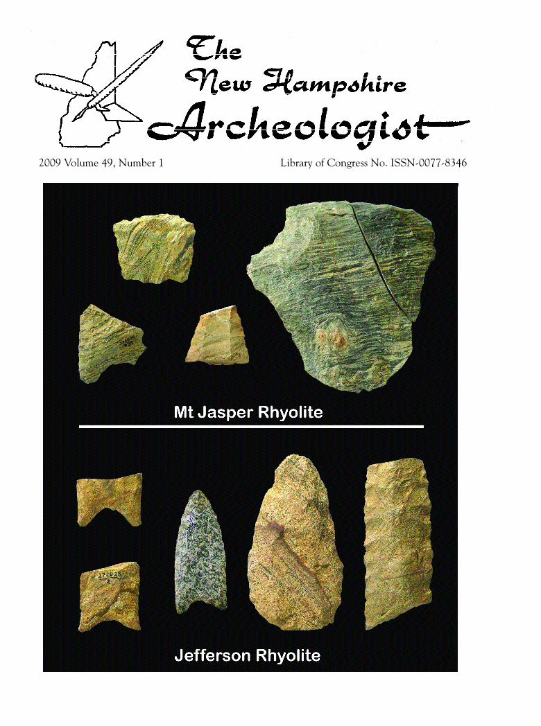
Flaked tools of Mt. Jasper rhyolite and Jefferson rhyolite recovered from New Hampshire archeological sites. See the article by Richard A. Boisvert and Stephen G. Pollock on page 37.
v
ContentsPreface
David R. Starbuck, Editor iii
The Bomber Crash of 1942Victoria Bunker, PhD 1
Archeology and Geology of the Mount Jasper Lithic Source
Richard A. Boisvert, New Hampshire Division of Historical ResourcesandStephen G. Pollock, Department of Geosciences, University of Southern Maine, Gorham 37
The Restoration of a Staircase at Canterbury Shaker VillageDavid R. Starbuck, Plymouth State University 49
Introduction
Spherulitic rhyolites from both Jefferson andBerlin, NH, have been utilized for stone toolsof the Paleoindian period. The nature of thematerials from both of these sources hasrecently been reported upon by Pollock,Hamilton and Boisvert (2008a, 2008b). Thepurpose of this article is to discuss spheruliticrhyolite at Berlin, New Hampshire. T h i ssource is an approximate 0.75 to 1.3 meter-wide dike which crops out on Mount Jasper,near the city of Berlin. We believe theJ e fferson source was used during thePaleoindian period and was probably limited tobetween 11,500 and 9500 BP. Artifacts attrib-uted to having originated in Jefferson are asso-ciated with the early Paleoindian period inNew England, and are less common or absentin Late Paleoindian sites. The Mount Jaspersource is the better known and most historical-ly well documented of these two NewHampshire lithic sources. It is this sourcewhich we suggest has had the longest period ofusage by Native Americans, spanning a timewhich probably exceeded 11,500 years.Current evidence suggests that Mount Jasperwas predominantly used between 6000 and7000 BP. One possible reason for the exten-sive and long-term exploitation of MountJasper is that it is situated on a main thorough-
fare between the Androscoggin andConnecticut River drainages.
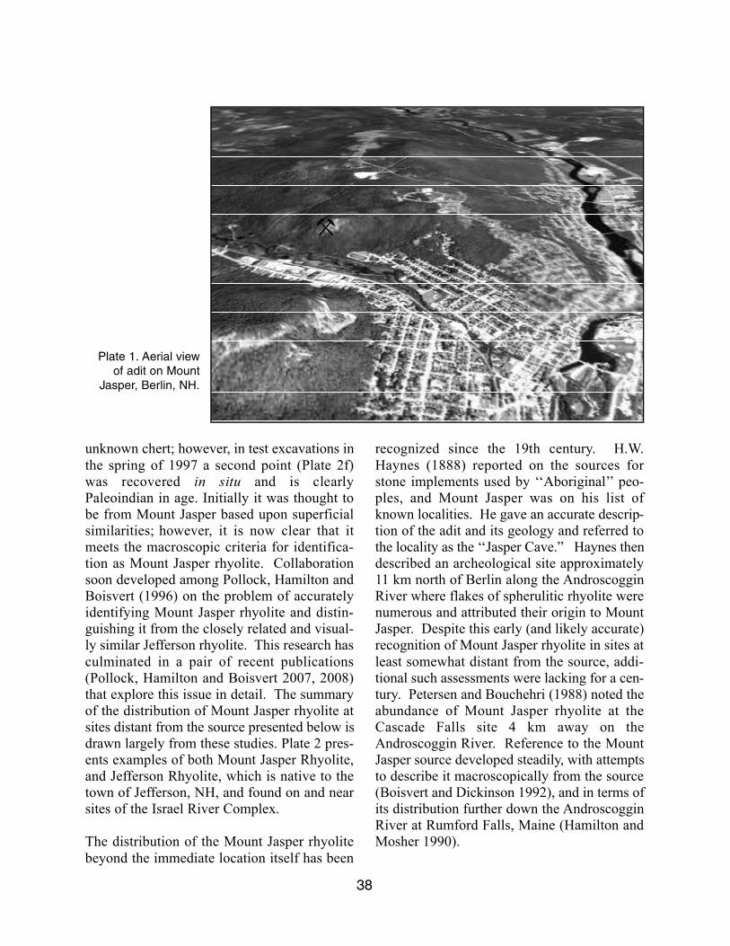
Mount Jasper is located on the northwest edgeof the city of Berlin, NH (Plate 1). It is a steep,forested low mountain that reaches 1584 ft inelevation. It is a familiar landmark in the com-munity, and well-traveled trails lead the casualvisitor to the prehistoric mine that sits justbelow the summit, facing southwest over theDead River 500 ft below. A swarm of approx-imately 9 rhyolite dikes (Billings and Fowler-Billings 1975) lace the bedrock over most ofthe mountainside. These dikes consist of vitre-ous, spherulitic, flow-banded rhyolite whosedistinctive red and green colors undoubtedlyprompted the local residents to name themountain Mount Jasper. This material is flint-like in its physical characteristics and was usedby Native American tool makers to fashionprojectile points, knives, scrapers and otherchipped stone implements. Since this stonewas not only high quality but also rare, it wasa significant source of raw material for toolmanufacture over a long span of time.
Interest in Mount Jasper as a lithic source waspiqued in 1996 with the recovery of the base ofa Paleoindian fluted point at the Jefferson I Sitein Jefferson, NH (Boisvert 1998; Bouras andBock 1997). This specimen was made from an
37
Archeology and Geology of the Mount Jasper Lithic Source
Richard A. Boisvert, New Hampshire Division of Historical Resourcesand
Stephen G. Pollock, Department of Geosciences, University of Southern Maine, Gorham
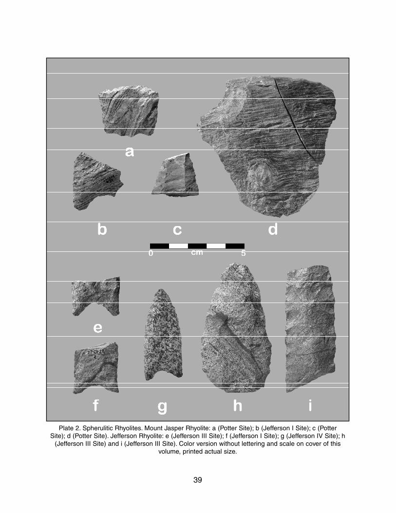
unknown chert; however, in test excavations inthe spring of 1997 a second point (Plate 2f)was recovered in situ and is clearlyPaleoindian in age. Initially it was thought tobe from Mount Jasper based upon superficialsimilarities; however, it is now clear that itmeets the macroscopic criteria for identifica-tion as Mount Jasper rhyolite. Collaborationsoon developed among Pollock, Hamilton andBoisvert (1996) on the problem of accuratelyidentifying Mount Jasper rhyolite and distin-guishing it from the closely related and visual-ly similar Jefferson rhyolite. This research hasculminated in a pair of recent publications(Pollock, Hamilton and Boisvert 2007, 2008)that explore this issue in detail. The summaryof the distribution of Mount Jasper rhyolite atsites distant from the source presented below isdrawn largely from these studies. Plate 2 pres-ents examples of both Mount Jasper Rhyolite,and Jefferson Rhyolite, which is native to thetown of Jefferson, NH, and found on and nearsites of the Israel River Complex.
The distribution of the Mount Jasper rhyolitebeyond the immediate location itself has been
recognized since the 19th century. H.W.Haynes (1888) reported on the sources forstone implements used by ‘‘Aboriginal’’ peo-ples, and Mount Jasper was on his list ofknown localities. He gave an accurate descrip-tion of the adit and its geology and referred tothe locality as the ‘‘Jasper Cave.” Haynes thendescribed an archeological site approximately11 km north of Berlin along the AndroscogginRiver where flakes of spherulitic rhyolite werenumerous and attributed their origin to MountJasper. Despite this early (and likely accurate)recognition of Mount Jasper rhyolite in sites atleast somewhat distant from the source, addi-tional such assessments were lacking for a cen-tury. Petersen and Bouchehri (1988) noted theabundance of Mount Jasper rhyolite at theCascade Falls site 4 km away on theAndroscoggin River. Reference to the MountJasper source developed steadily, with attemptsto describe it macroscopically from the source(Boisvert and Dickinson 1992), and in terms ofits distribution further down the AndroscogginRiver at Rumford Falls, Maine (Hamilton andMosher 1990).
38
Plate 1. Aerial view
of adit on Mount
Jasper, Berlin, NH.
39
Plate 2. Spherulitic Rhyolites. Mount Jasper Rhyolite: a (Potter Site); b (Jefferson I Site); c (Potter
Site); d (Potter Site). Jefferson Rhyolite: e (Jefferson III Site); f (Jefferson I Site); g (Jefferson IV Site); h
(Jefferson III Site) and i (Jefferson III Site). Color version without lettering and scale on cover of this
volume, printed actual size.
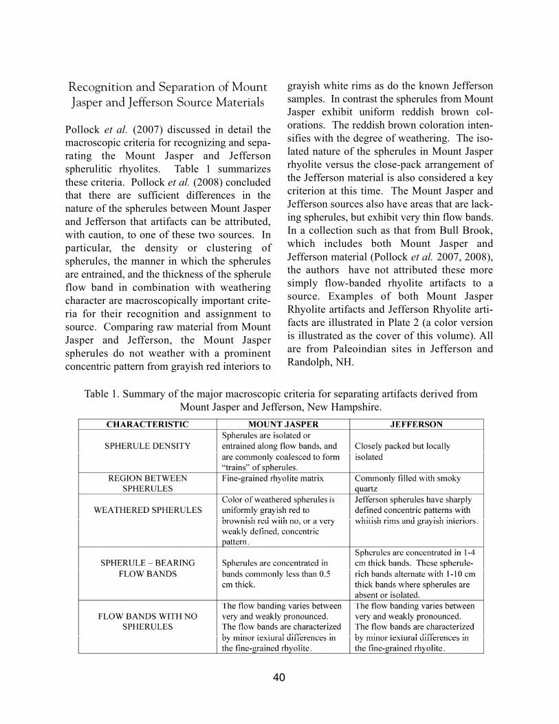
Recognition and Separation of MountJasper and Jefferson Source Materials
Pollock et al. (2007) discussed in detail themacroscopic criteria for recognizing and sepa-rating the Mount Jasper and Jeff e r s o nspherulitic rhyolites. Table 1 summarizesthese criteria. Pollock et al. (2008) concludedthat there are sufficient differences in thenature of the spherules between Mount Jasperand Jefferson that artifacts can be attributed,with caution, to one of these two sources. Inp a r t i c u l a r, the density or clustering ofspherules, the manner in which the spherulesare entrained, and the thickness of the spheruleflow band in combination with weatheringcharacter are macroscopically important crite-ria for their recognition and assignment tosource. Comparing raw material from MountJasper and Jefferson, the Mount Jasperspherules do not weather with a prominentconcentric pattern from grayish red interiors to
grayish white rims as do the known Jeffersonsamples. In contrast the spherules from MountJasper exhibit uniform reddish brown col-orations. The reddish brown coloration inten-sifies with the degree of weathering. The iso-lated nature of the spherules in Mount Jasperrhyolite versus the close-pack arrangement ofthe Jefferson material is also considered a keycriterion at this time. The Mount Jasper andJefferson sources also have areas that are lack-ing spherules, but exhibit very thin flow bands.In a collection such as that from Bull Brook,which includes both Mount Jasper andJefferson material (Pollock et al. 2007, 2008),the authors have not attributed these moresimply flow-banded rhyolite artifacts to asource. Examples of both Mount JasperRhyolite artifacts and Jefferson Rhyolite arti-facts are illustrated in Plate 2 (a color versionis illustrated as the cover of this volume). Allare from Paleoindian sites in Jefferson andRandolph, NH.
40
Table 1. Summary of the major macroscopic criteria for separating artifacts derived fromMount Jasper and Jefferson, New Hampshire.
Dike Geochemistry
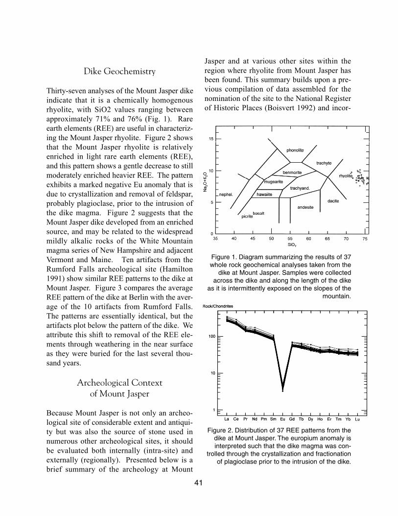
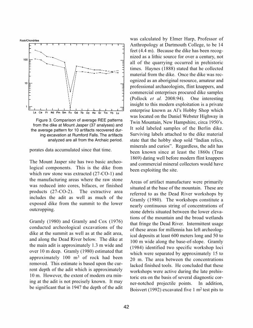
Thirty-seven analyses of the Mount Jasper dikeindicate that it is a chemically homogenousrhyolite, with SiO2 values ranging betweenapproximately 71% and 76% (Fig. 1). Rareearth elements (REE) are useful in characteriz-ing the Mount Jasper rhyolite. Figure 2 showsthat the Mount Jasper rhyolite is relativelyenriched in light rare earth elements (REE),and this pattern shows a gentle decrease to stillmoderately enriched heavier REE. The patternexhibits a marked negative Eu anomaly that isdue to crystallization and removal of feldspar,probably plagioclase, prior to the intrusion ofthe dike magma. Figure 2 suggests that theMount Jasper dike developed from an enrichedsource, and may be related to the widespreadmildly alkalic rocks of the White Mountainmagma series of New Hampshire and adjacentVermont and Maine. Ten artifacts from theRumford Falls archeological site (Hamilton1991) show similar REE patterns to the dike atMount Jasper. Figure 3 compares the averageREE pattern of the dike at Berlin with the aver-age of the 10 artifacts from Rumford Falls.The patterns are essentially identical, but theartifacts plot below the pattern of the dike. Weattribute this shift to removal of the REE ele-ments through weathering in the near surfaceas they were buried for the last several thou-sand years.
Archeological Context of Mount Jasper
Because Mount Jasper is not only an archeo-logical site of considerable extent and antiqui-ty but was also the source of stone used innumerous other archeological sites, it shouldbe evaluated both internally (intra-site) andexternally (regionally). Presented below is abrief summary of the archeology at Mount
Jasper and at various other sites within theregion where rhyolite from Mount Jasper hasbeen found. This summary builds upon a pre-vious compilation of data assembled for thenomination of the site to the National Registerof Historic Places (Boisvert 1992) and incor-
41
Figure 1. Diagram summarizing the results of 37
whole rock geochemical analyses taken from the
dike at Mount Jasper. Samples were collected
across the dike and along the length of the dike
as it is intermittently exposed on the slopes of the
mountain.
Figure 2. Distribution of 37 REE patterns from the
dike at Mount Jasper. The europium anomaly is
interpreted such that the dike magma was con-
trolled through the crystallization and fractionation
of plagioclase prior to the intrusion of the dike.
porates data accumulated since that time.
The Mount Jasper site has two basic archeo-logical components. This is the dike fromwhich raw stone was extracted (27-CO-1) andthe manufacturing areas where the raw stonewas reduced into cores, bifaces, or finishedproducts (27-CO-2). The extractive areaincludes the adit as well as much of theexposed dike from the summit to the loweroutcropping.
Gramly (1980) and Gramly and Cox (1976)conducted archeological excavations of thedike at the summit as well as at the adit area,and along the Dead River below. The dike atthe main adit is approximately 1.3 m wide andover 10 m deep. Gramly (1980) estimated thatapproximately 100 m3 of rock had beenremoved. This estimate is based upon the cur-rent depth of the adit which is approximately10 m. However, the extent of modern era min-ing at the adit is not precisely known. It maybe significant that in 1947 the depth of the adit
was calculated by Elmer Harp, Professor ofAnthropology at Dartmouth College, to be 14feet (4.4 m). Because the dike has been recog-nized as a lithic source for over a century, notall of the quarrying occurred in prehistorictimes. Haynes (1888) stated that he collectedmaterial from the dike. Once the dike was rec-ognized as an aboriginal resource, amateur andprofessional archaeologists, flint knappers, andcommercial enterprises procured dike samples(Pollock et al. 2008:94). One interestinginsight to this modern exploitation is a privateenterprise known as Al’s Hobby Shop whichwas located on the Daniel Webster Highway inTwin Mountain, New Hampshire, circa 1950’s.It sold labeled samples of the Berlin dike.Surviving labels attached to the dike materialstate that the hobby shop sold “Indian relics,minerals and curios”. Regardless, the adit hasbeen known since at least the 1860s (True1869) dating well before modern flint knappersand commercial mineral collectors would havebeen exploiting the site.
Areas of artifact manufacture were primarilysituated at the base of the mountain. These arereferred to as the Dead River workshops byGramly (1980). The workshops constitute anearly continuous string of concentrations ofstone debris situated between the lower eleva-tions of the mountain and the broad wetlandsthat fringe the Dead River. Intermittent usageof these areas for millennia has left archeolog-ical deposits at least 600 meters long and 50 to100 m wide along the base-of-slope. Gramly(1984) identified two specific workshop lociwhich were separated by approximately 15 to20 m. The area between the concentrationslacked finished tools. He concluded that theseworkshops were active during the late prehis-toric era on the basis of several diagnostic cor-n e r-notched projectile points. In addition,Boisvert (1992) excavated five 1 m2 test pits to
42
Figure 3. Comparison of average REE patterns
from the dike at Mount Jasper (37 analyses) and
the average pattern for 10 artifacts recovered dur-
ing excavation at Rumford Falls. The artifacts
analyzed are all from the Archaic period.
the north of Gramly’s excavations. These testpits recovered an array of manufacturingdebris in substantially lower density thanfound by Gramly.
Additional workshop areas were located on thesummit, and on available flat locations on theslopes. The summit workshop area was con-strained to a much smaller area and likely didnot exceed more than 100 m in diameter.Excavations on the summit of Mount Jasperencompassed 56 m2 (Gramly 1980, 1984).Manufacturing debris as well as quarried dikewaste was mixed together in soil immediatelyoverlying and adjacent to the rhyolite dike,which at this location is currently under soilcover.
Mount Jasper was a special purpose site usedover the full length of the prehistoric era rang-ing from Paleoindian (10,500 - 8,000 BC)through Archaic (8,000 – 1,000 BC) into theWoodland/Ceramic (1,000 BC – AD 1500)periods. Gramly identified both Archaic andWoodland period usage at Mount Jasper.Using the presence of projectile points discard-ed at the workshops he identified the summitas being associated with the Archaic. Althoughhe did not more specifically categorize thepoint styles, examination of the sample illus-trated (Gramly 1984:20, Fig. 2.15) indicatesSusquehanna Tradition points and MiddleArchaic Neville points (Boisvert 1992:159).The Woodland period usage was representedby recovery of corner-notched points, includ-ing the Jack's Reef variety. The diagnosticpoints were uniformly made of non-MountJasper material and were evidently worn orbroken specimens that were presumablyreplaced by points manufactured on site. Also,it is worth noting that among the artifacts col-lected by Gramly which are on display at theBerlin Public Library are triangular end scrap-
ers and gravers made of exotic MunsungunChert. These artifacts are diagnosticPaleoindian tool types and potentially repre-sent domestic activities by Paleoindians atMount Jasper. A formal assessment of theseartifacts, including confirmation of theirprovenience from Mount Jasper, has not beenmade, but they strongly suggest direct evi-dence for Paleoindian occupation of MountJasper.
The distribution of Mount Jasper Rhyolite onPaleoindian sites has been of particular inter-est, especially with the significant increase ininvestigations at these sites since 1996 (Fig. 4).Considerable research effort has been devotedto identifying lithic sources for materials foundon Paleoindian sites continent wide, largely todocument the geographic extent of variousgroups and to reconstruct movements and pat-terns of acquisition and exchange among them.In the Northeast this topic has been exploredby Boisvert (1999, 2000, 2004), Bradley(1998), Burke (2006), Letendre (2007), andPelletier and Robinson (2005) among others.In fact, virtually every analysis of Paleoindiansites and artifact assemblages in the Northeasthas placed significant emphasis on the kinds ofraw material used in so far as it is possible tomake such identifications accurately.
Distribution of Mount Jasper material has beendocumented in the Michaud and Lamoreausites in the Androscoggin drainage near thepresent cities of Lewiston and Auburn, Maine,as well as the Spiller Farm and Neal Garrisonsites in southwestern Maine (Pollock et al.2008:106-107). To the west the rhyolite hasbeen found in the Champlain Valley area at theMazza and Arbor Garden sites near Burlington,VT, and to the northeast at the Cliche-Rancourtsite near Lac Megantic in southeastern Quebec(Pollock et al. 2008:103). Interestingly,
43
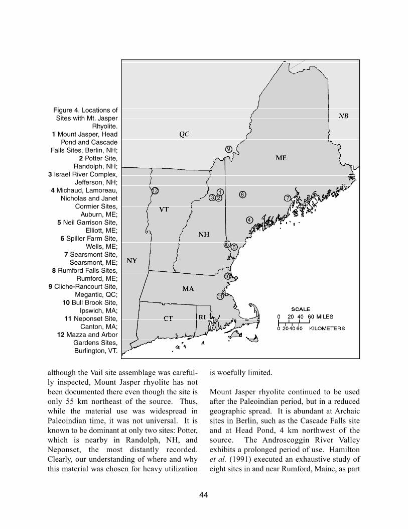
although the Vail site assemblage was careful-ly inspected, Mount Jasper rhyolite has notbeen documented there even though the site isonly 55 km northeast of the source. Thus,while the material use was widespread inPaleoindian time, it was not universal. It isknown to be dominant at only two sites: Potter,which is nearby in Randolph, NH, andNeponset, the most distantly recorded.Clearly, our understanding of where and whythis material was chosen for heavy utilization
is woefully limited.
Mount Jasper rhyolite continued to be usedafter the Paleoindian period, but in a reducedgeographic spread. It is abundant at Archaicsites in Berlin, such as the Cascade Falls siteand at Head Pond, 4 km northwest of thesource. The Androscoggin River Va l l e yexhibits a prolonged period of use. Hamiltonet al. (1991) executed an exhaustive study ofeight sites in and near Rumford, Maine, as part
44
Figure 4. Locations of
Sites with Mt. Jasper
Rhyolite.
1 Mount Jasper, Head
Pond and Cascade
Falls Sites, Berlin, NH;
2 Potter Site,
Randolph, NH;
3 Israel River Complex,
Jefferson, NH;
4 Michaud, Lamoreau,
Nicholas and Janet
Cormier Sites,
Auburn, ME;
5 Neil Garrison Site,
Elliott, ME;
6 Spiller Farm Site,
Wells, ME;
7 Searsmont Site,
Searsmont, ME;
8 Rumford Falls Sites,
Rumford, ME;
9 Cliche-Rancourt Site,
Megantic, QC;
10 Bull Brook Site,
Ipswich, MA;
11 Neponset Site,
Canton, MA;
12 Mazza and Arbor
Gardens Sites,
Burlington, VT.
of a study for the relicensing of a dam forhydropower production. A distinct pattern ofusage was identified, applying to both largeand small sites. The rhyolite shows a modestabundance in the Early Archaic, rising sharplyin the Middle Archaic, then eventually declin-ing through the Late Archaic (Pollock et al.2008:110, Fig. 11) and virtually dropping outof use by the end of the Woodland period. LateWoodland points made from Mount Jasper rhy-olite are lacking at the Rumford sites.Elsewhere in New Hampshire, systematicanalyses of raw material types from Archaicand Woodland sites have not been conducted,but the use of any spherulitic rhyolite beyondthe limited confines of the A n d r o s c o g g i nValley is rare. There appears to be an overallslow but steady contraction in the range of usefor Mount Jasper rhyolite over time. The mostlikely explanation may be that the accessiblehigher-quality material was exhausted by mil-lennia of mining and that more abundant alter-natives from other sources were relied uponincreasingly. Forest cover over the dikes andlate 20th century mining by rock collectors andhobbyists further limits our ability to resolvethis question. It is apparent that the MountJasper source was no longer important, if notaltogether abandoned, by the end of the prehis-toric era.
Summary
Use of the Mount Jasper rhyolite has a longhistory extending back at least eleven and ahalf millennia. It was an important, though notdominant, source of tool stone during thePaleoindian period and was carried at least asfar as 250 km. With the onset of the Holoceneand shift to the Archaic lifestyles, MountJasper rhyolite became the most importantmaterial within a smaller geographic area,seemingly focused on the Androscoggin River
Valley. Even here, its importance eventuallywaned over time and sputtered out in the LateWoodland. Still, it must be recognized that thisvery limited resource as known and used fornearly 12,000 years, and recognition of thislithic, inform our understanding of prehistoricsettlement and technological patterns over thatspan of time. The Mount Jasper site itself isalso highly significant as a rare and possiblyunique example of mining by NativeAmericans to acquire material for theirchipped stone tools. Stones were quarried atother locations, but only at Mount Jasper do wehave an actual mine shaft or adit. Recentinvestigations into the mineralogical identityof the material has allowed us to distinguish itfrom seemingly identical rhyolites as well aspositively identify it at ever increasing num-bers of sites scattered across the Northeast.While the source may have been depleted foruse by prehistoric peoples, the information tobe gained from its study is by no meansexhausted.
Postscript
The summer of 2009 will be remembered byNew Englanders as one of the wettest onrecord. Almost daily rain storms saturated thesoil. This weather contributed to a rather dra-matic event on the evening of July 9 or earlymorning of July 10. At approximately 10 AMa party of about 20 participants in the annualNH State Conservation and RescueArchaeology Program (SCRAP) field schoolarrived at the adit to view the Mount Jasperrhyolite at the source. Upon arrival they foundthat an enormous boulder (Plate 3) had slippedfree from the top of the mountain and careeneddown the slope, bouncing off one tree and flat-tening others, finally coming to rest against atree immediately in front of the adit. Carefulinspection of the path of the boulder indicatedthat the fall occurred after the most recent rain,
45
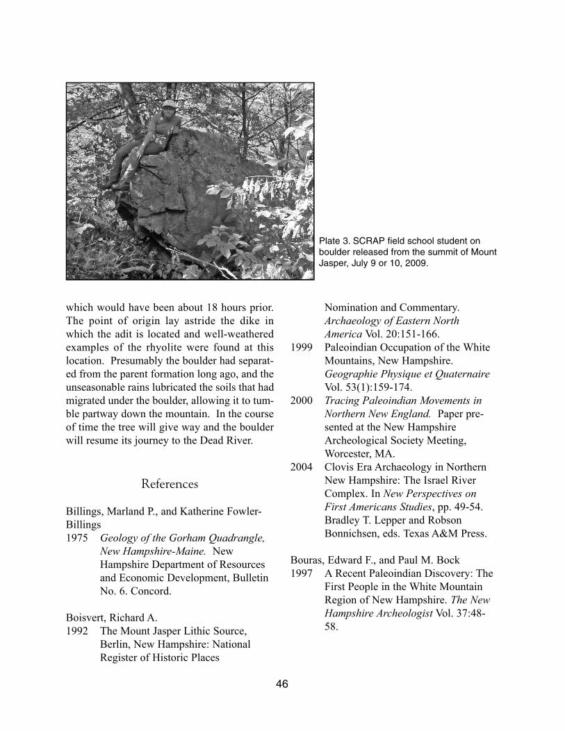
which would have been about 18 hours prior.The point of origin lay astride the dike inwhich the adit is located and well-weatheredexamples of the rhyolite were found at thislocation. Presumably the boulder had separat-ed from the parent formation long ago, and theunseasonable rains lubricated the soils that hadmigrated under the boulder, allowing it to tum-ble partway down the mountain. In the courseof time the tree will give way and the boulderwill resume its journey to the Dead River.
References
Billings, Marland P., and Katherine Fowler-Billings1975 Geology of the Gorham Quadrangle,
New Hampshire-Maine. New Hampshire Department of Resources and Economic Development, Bulletin No. 6. Concord.
Boisvert, Richard A.1992 The Mount Jasper Lithic Source,
Berlin, New Hampshire: National Register of Historic Places
Nomination and Commentary.Archaeology of Eastern North America Vol. 20:151-166.
1999 Paleoindian Occupation of the White Mountains, New Hampshire. Geographie Physique et QuaternaireVol. 53(1):159-174.
2000 Tracing Paleoindian Movements in Northern New England. Paper pre-sented at the New Hampshire Archeological Society Meeting, Worcester, MA.
2004 Clovis Era Archaeology in Northern New Hampshire: The Israel River Complex. In New Perspectives on First Americans Studies, pp. 49-54. Bradley T. Lepper and Robson Bonnichsen, eds. Texas A&M Press.
Bouras, Edward F., and Paul M. Bock1997 A Recent Paleoindian Discovery: The
First People in the White Mountain Region of New Hampshire. The New Hampshire Archeologist Vol. 37:48-58.
46
Plate 3. SCRAP field school student on
boulder released from the summit of Mount
Jasper, July 9 or 10, 2009.
Bradley, James W.1998 Origins and ancestors - investigating
New England's Paleo Indians: RobertS. Peabody Museum, Phillips Academy, Andover, MA.
Burke, Adrian L.2006 Paleoindian ranges in northeastern
North America based on lithic raw materials sourcing. In Notions de ter-ritoire et de mobilité. Exemples de l’Europe et des premières nations en Amérique du Nord avant le contact européen. C. Bressy, A. Burke, P.Chalard, and H. Martin, dir., ERAUL116 (Actes du Xe congrès annuel de l'Association Européenne des Archéologues, Lyon, 2004): Liège, Études et Recherches Archéologiques de l'Université de Liège, pp. 77-88.
Carty, Fred M., and Arthur Spiess1992 The Neponset Paleoindian site in
Massachusetts. Archaeology of Eastern North America Vol. 20:19-37.
Bunker, Victoria, and Jane Potter1999 Early Occupation in the Far Upper
Connecticut River Valley. The New Hampshire Archeologist Vol. 39:70-81.
Bunker, Victoria, Edna Feighner, and JanePotter 1997 Technical Report Archeological
Resources Phase I-B PreliminaryArcheological Assessment and Phase II Intensive Survey, Portland Natural Gas Transmission System Northern New Hampshire Revision Route M.P.0.0-68.6, FERC Docket No. CP 96-249-003. Unpublished report on file atthe NH Division of Historical Resources, Concord, NH.
Gramly, R. Michael1980 Raw Material Source Areas and
‘Curated Tool Assemblages.’American Antiquity Vol. 45:823-833.
1984 Mount Jasper: A Direct-Access Lithic Source Area in the White Mountains of New Hampshire. In Prehistoric Quarries and Lithic Production, edit-ed by J.E. Ericson, and B.A. Purdy,pp. 11-27. Cambridge University,Cambridge, England.
Gramly, R. Michael, and Steven L. Cox1976 A Prehistoric Quarry-Workshop at
Mount Jasper, Berlin, New Hampshire. Man in the Northeast Vol.11:71-74.
Haynes, H.W.1888 Localities of Quarries Worked by
Indians for their Stone Implements. Proceedings of the Boston Society of Natural History Vol. 23:333-336.
Hamilton, Nathan D., and John Mosher2000 Rumford Falls: A Holocene Cultural
Sequence in Northwestern Maine. Unpublished report to the Rumford Falls Power Company.
Hamilton, Nathan D., John Mosher, Celia A.Thayer, and J.C. Theberge1991 Archaeological Phase II testing of the
Rumford Falls Project, OxfordCounty, Maine. Historic Preservation Commission, Augusta, Maine. Document 2620.
Letendre, Miriam2007 Le reseau des cherts au Meganticois.
In Entre lacs et montagnes au Meganticois: 12000 ans d’historie Amerindienne, Claude Chapdelaine, ed. Paleo-Québec Vol. 32:271-308.
47
Pelletier, B.G., and Brian S. Robinson2005 Tundra, Ice, and a Pleistocene Cape
on the Gulf of Maine: A Case of Paleoindian Transhumance. Archaeology of Eastern North America Vol. 33:163-176.
Petersen, James B., and D. D. Boushehri1988 Archaeological Phase II survey and
testing of the Cascade Project (FERC No. 2327), Coos County, New Hampshire. Unpublished report on file at the NH Division of Historical Resources, Concord, NH.
Pollock, Stephen G., Nathan D. Hamilton, andRichard A. Boisvert1996 The Mount Jasper Lithic Source,
Berlin, New Hampshire. pp. 245-253.Guidebook to Field Trips in Northern New Hampshire and Adjacent Regionsof Maine and Vermont. New England Intercollegiate Geological Conference,88th Annual Meeting.
2007 Archaeological Geology of Two Flow-banded Spherulitic Rhyolites in New England, USA: Their History,Exploitation and Criteria for Recognition. Journal of Archaeological Science Vol. 35:688-703.
2008 Prehistoric Utilization of Spherulitic and Flow Banded Rhyolites from Northern New Hampshire. Archaeology of Eastern North America Vol. 36:91-118.
48