Embed Size (px)
Citation preview
WGNE-28 5 Nov 2012 1
William. M. Lapenta Acting Director
Environmental Modeling Center
NOAA/NWS/NCEP
Geoff DiMego , John Derber , Yuejian Zhu , Hendrik Tolman , Vijay Tallapragada,
Shrinivas Moorthi , Mike Ek , Mark Iredell , Suru Saha
NCEP
The NOAA Operational Numerical
Guidance System
WGNE-28 5 Nov 2012
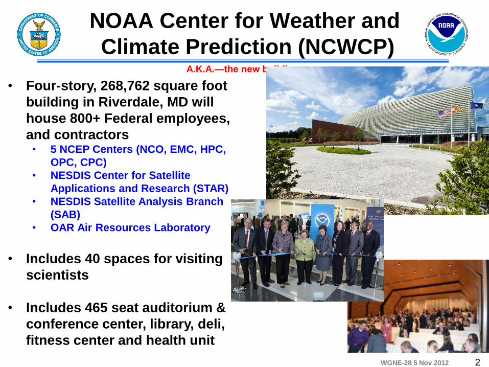
NOAA Center for Weather and
Climate Prediction (NCWCP)
2
A.K.A.—the new building….
• Four-story, 268,762 square foot
building in Riverdale, MD will
house 800+ Federal employees,
and contractors • 5 NCEP Centers (NCO, EMC, HPC,
OPC, CPC)
• NESDIS Center for Satellite
Applications and Research (STAR)
• NESDIS Satellite Analysis Branch
(SAB)
• OAR Air Resources Laboratory
• Includes 40 spaces for visiting
scientists
• Includes 465 seat auditorium &
conference center, library, deli,
fitness center and health unit
WGNE-28 5 Nov 2012
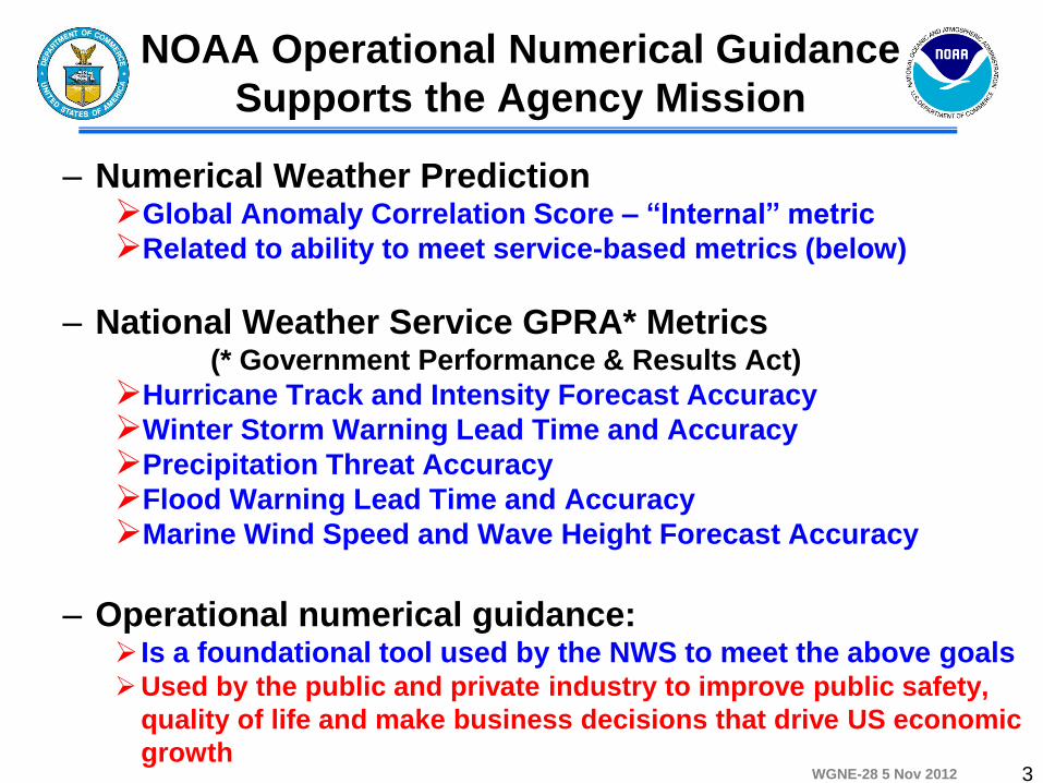
NOAA Operational Numerical Guidance
Supports the Agency Mission
– Numerical Weather Prediction
Global Anomaly Correlation Score – “Internal” metric
Related to ability to meet service-based metrics (below)
– National Weather Service GPRA* Metrics (* Government Performance & Results Act)
Hurricane Track and Intensity Forecast Accuracy
Winter Storm Warning Lead Time and Accuracy
Precipitation Threat Accuracy
Flood Warning Lead Time and Accuracy
Marine Wind Speed and Wave Height Forecast Accuracy
– Operational numerical guidance: Is a foundational tool used by the NWS to meet the above goals Used by the public and private industry to improve public safety,
quality of life and make business decisions that drive US economic
growth
3
WGNE-28 5 Nov 2012
Forecast
Uncertainty
Minutes
Hours
Days
1 Week
2 Week
Months
Seasons
Years
Seamless Suite of NOAA Operational
Numerical Guidance Systems
Fo
rec
as
t L
ea
d T
ime
Warnings & Alert
Coordination
Watches
Forecasts
Threats
Assessments
Guidance
Outlook
Benefits
•North American Ensemble Forecast System
•Climate Forecast System
•Short-Range Ensemble Forecast
•Global Forecast System
•North American Mesoscale
•Rapid Refresh
•Dispersion (smoke)
•Global Ensemble Forecast System
• Regional Hurricane • (HWRF & GFDL)
• Waves • Global Ocean
• Space Weather
Spanning Weather and Climate
• Tsunami
• Whole Atmosphere
• Wave Ensemble
• Bays
• Storm Surge
•Global Dust
•Fire Wx
4
WGNE-28 5 Nov 2012
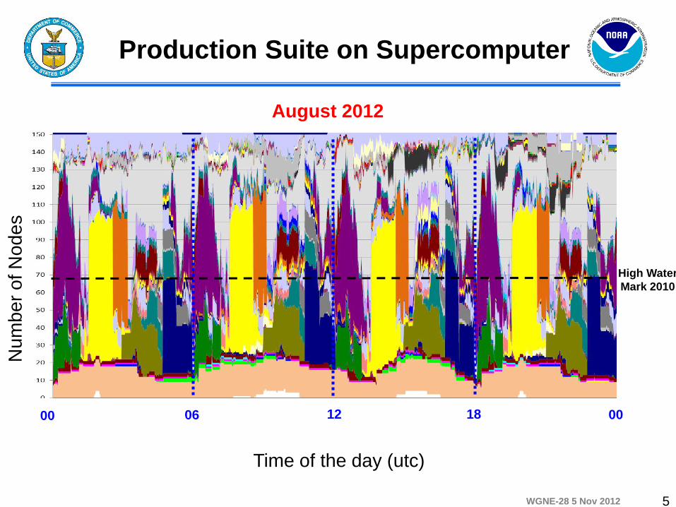
Nu
mb
er
of N
od
es
High Water
Mark 2010
August 2012
Time of the day (utc)
00 06 12 18 00
Production Suite on Supercomputer
5
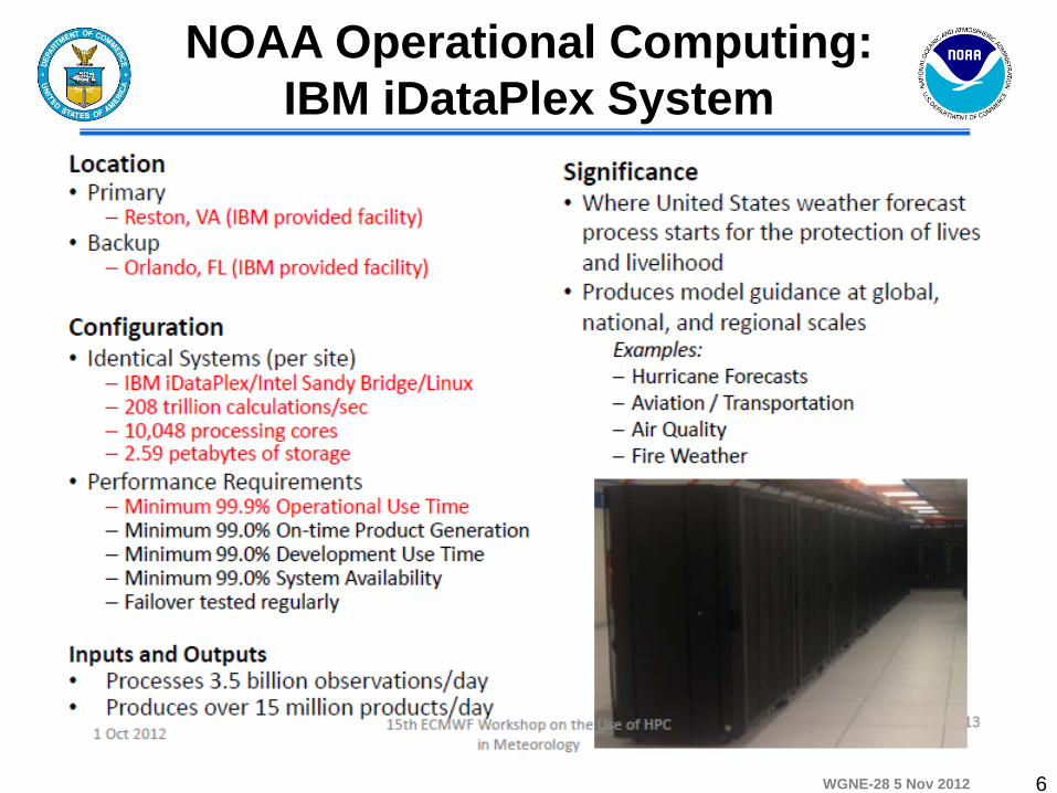
WGNE-28 5 Nov 2012 6
NOAA Operational Computing:
IBM iDataPlex System
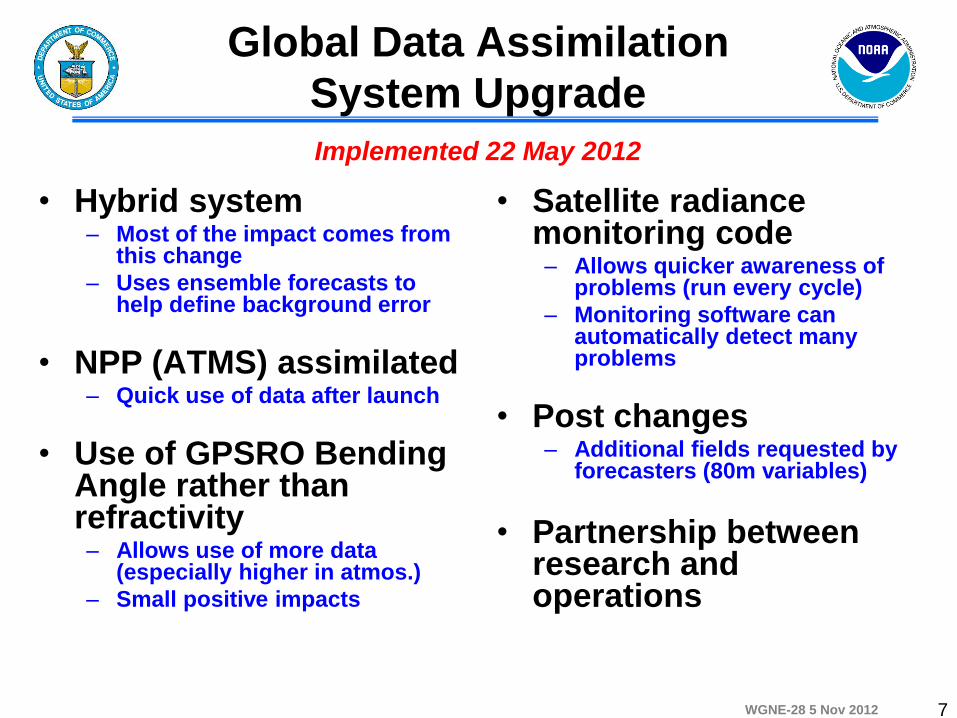
WGNE-28 5 Nov 2012
Global Data Assimilation
System Upgrade
• Hybrid system – Most of the impact comes from
this change
– Uses ensemble forecasts to help define background error
• NPP (ATMS) assimilated – Quick use of data after launch
• Use of GPSRO Bending Angle rather than refractivity – Allows use of more data
(especially higher in atmos.)
– Small positive impacts
• Satellite radiance monitoring code – Allows quicker awareness of
problems (run every cycle)
– Monitoring software can automatically detect many problems
• Post changes – Additional fields requested by
forecasters (80m variables)
• Partnership between research and operations
7
Implemented 22 May 2012
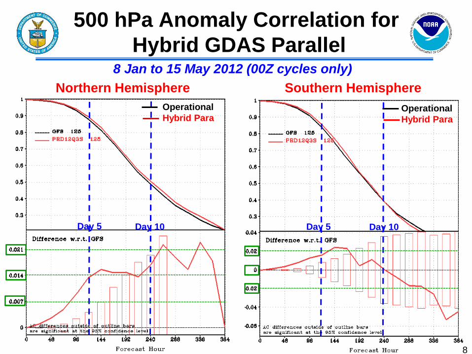
WGNE-28 5 Nov 2012
500 hPa Anomaly Correlation for
Hybrid GDAS Parallel
8
Northern Hemisphere Southern Hemisphere
8 Jan to 15 May 2012 (00Z cycles only)
Operational
Hybrid Para
Operational
Hybrid Para
Day 5 Day 5 Day 10 Day 10
WGNE-28 5 Nov 2012 9
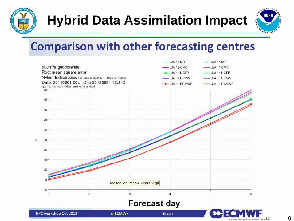
Hybrid Data Assimilation Impact
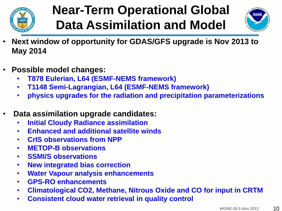
WGNE-28 5 Nov 2012 10
Near-Term Operational Global
Data Assimilation and Model
• Next window of opportunity for GDAS/GFS upgrade is Nov 2013 to
May 2014
• Possible model changes: • T878 Eulerian, L64 (ESMF-NEMS framework)
• T1148 Semi-Lagrangian, L64 (ESMF-NEMS framework)
• physics upgrades for the radiation and precipitation parameterizations
• Data assimilation upgrade candidates: • Initial Cloudy Radiance assimilation
• Enhanced and additional satellite winds
• CrIS observations from NPP
• METOP-B observations
• SSMI/S observations
• New integrated bias correction
• Water Vapour analysis enhancements
• GPS-RO enhancements
• Climatological CO2, Methane, Nitrous Oxide and CO for input in CRTM
• Consistent cloud water retrieval in quality control
WGNE-28 5 Nov 2012 11
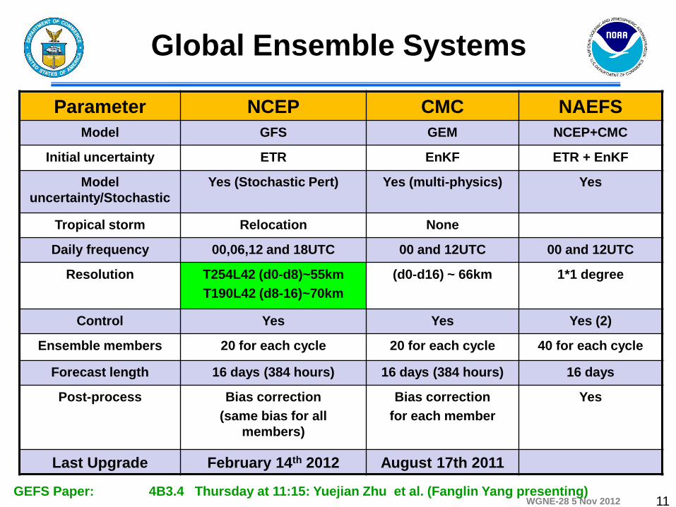
Parameter NCEP CMC NAEFS
Model GFS GEM NCEP+CMC
Initial uncertainty ETR EnKF ETR + EnKF
Model
uncertainty/Stochastic
Yes (Stochastic Pert) Yes (multi-physics) Yes
Tropical storm Relocation None
Daily frequency 00,06,12 and 18UTC 00 and 12UTC 00 and 12UTC
Resolution T254L42 (d0-d8)~55km
T190L42 (d8-16)~70km
(d0-d16) ~ 66km 1*1 degree
Control Yes Yes Yes (2)
Ensemble members 20 for each cycle 20 for each cycle 40 for each cycle
Forecast length 16 days (384 hours) 16 days (384 hours) 16 days
Post-process Bias correction
(same bias for all
members)
Bias correction
for each member
Yes
Last Upgrade February 14th 2012 August 17th 2011
Global Ensemble Systems
GEFS Paper: 4B3.4 Thursday at 11:15: Yuejian Zhu et al. (Fanglin Yang presenting)
WGNE-28 5 Nov 2012 12
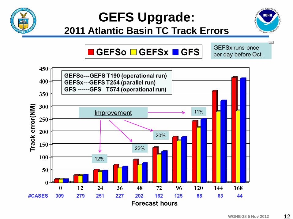
GEFS Upgrade: 2011 Atlantic Basin TC Track Errors
WGNE-28 5 Nov 2012
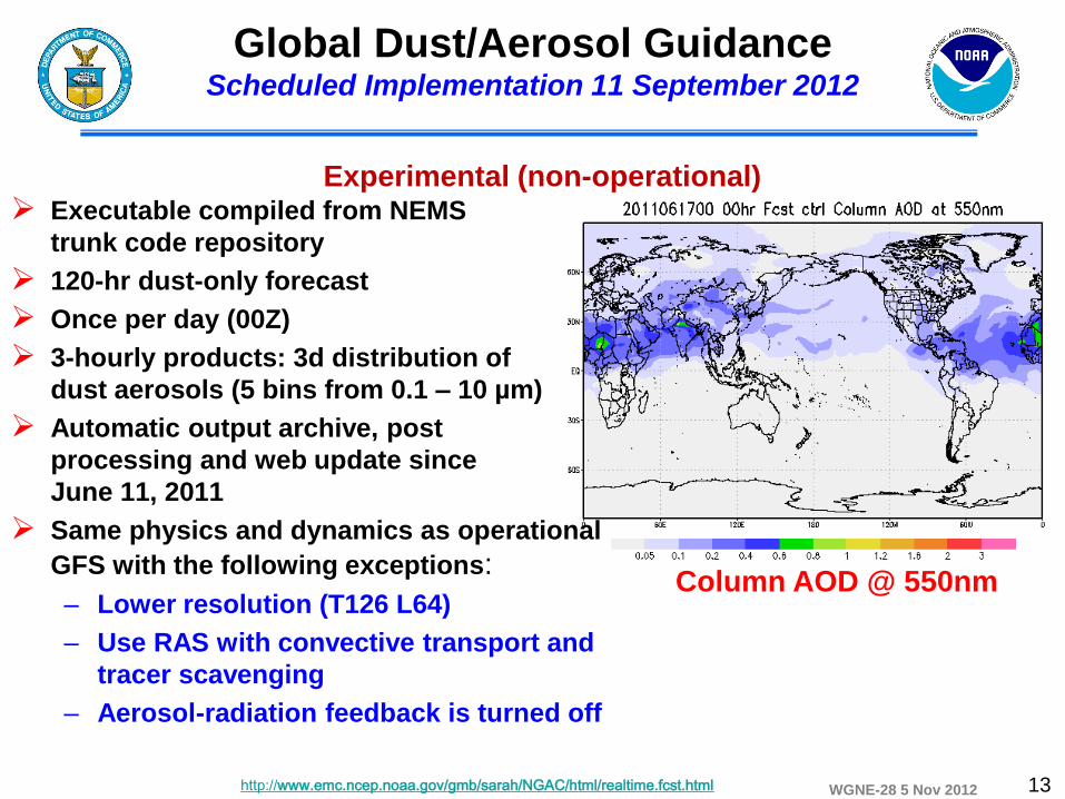
Executable compiled from NEMS
trunk code repository
120-hr dust-only forecast
Once per day (00Z)
3-hourly products: 3d distribution of
dust aerosols (5 bins from 0.1 – 10 µm)
Automatic output archive, post
processing and web update since
June 11, 2011
Same physics and dynamics as operational
GFS with the following exceptions:
– Lower resolution (T126 L64)
– Use RAS with convective transport and
tracer scavenging
– Aerosol-radiation feedback is turned off
Global Dust/Aerosol Guidance Scheduled Implementation 11 September 2012
Experimental (non-operational)
http://www.emc.ncep.noaa.gov/gmb/sarah/NGAC/html/realtime.fcst.html
Column AOD @ 550nm
13
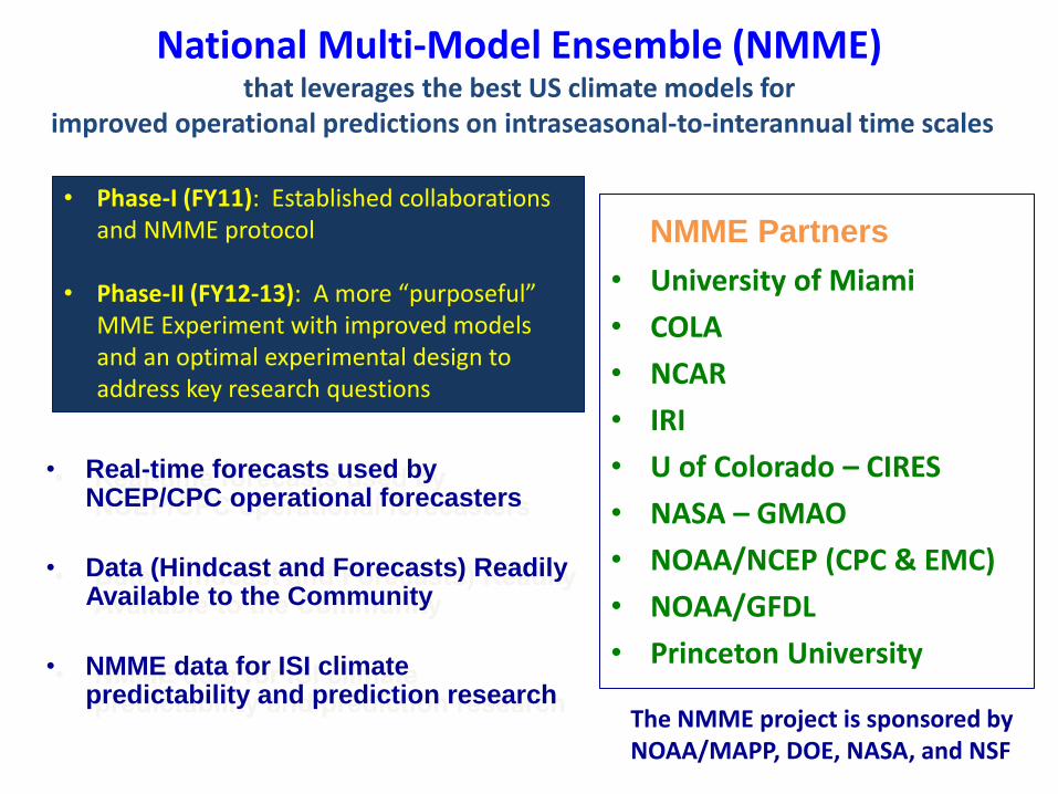
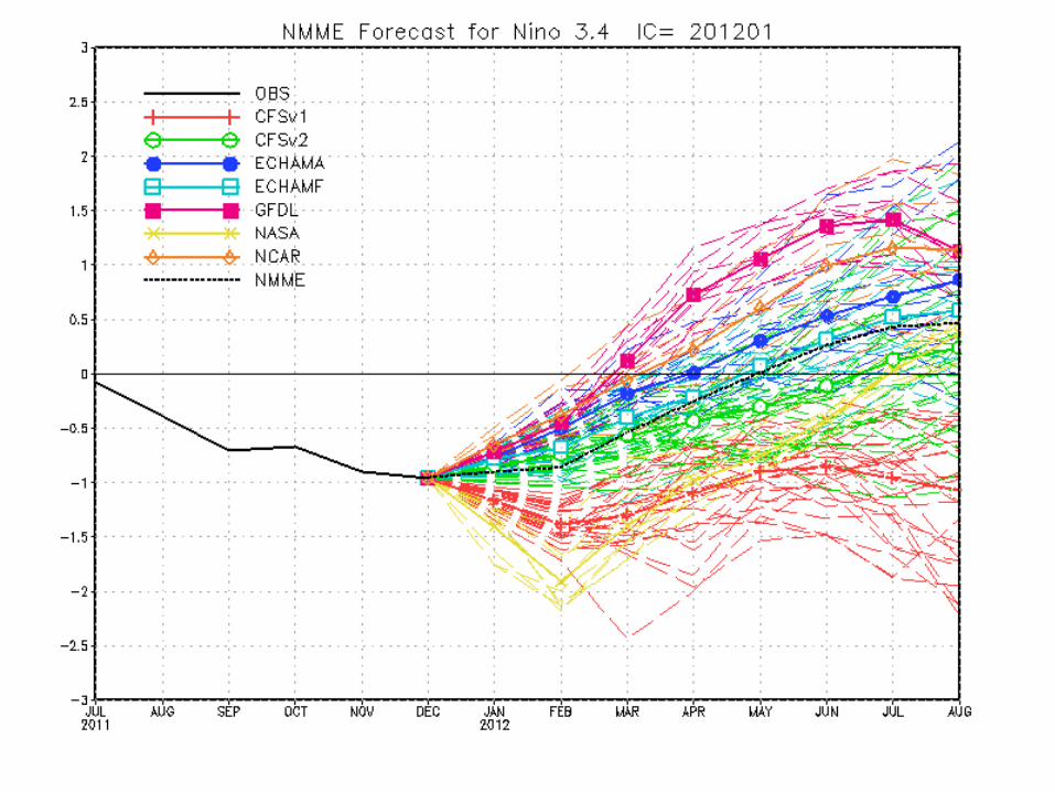
National Multi-Model Ensemble (NMME) that leverages the best US climate models for
improved operational predictions on intraseasonal-to-interannual time scales
• Real-time forecasts used by NCEP/CPC operational forecasters
• Data (Hindcast and Forecasts) Readily Available to the Community
• NMME data for ISI climate predictability and prediction research
• Phase-I (FY11): Established collaborations and NMME protocol
• Phase-II (FY12-13): A more “purposeful”
MME Experiment with improved models and an optimal experimental design to address key research questions
NMME Partners
• University of Miami
• COLA
• NCAR
• IRI
• U of Colorado – CIRES
• NASA – GMAO
• NOAA/NCEP (CPC & EMC)
• NOAA/GFDL
• Princeton University
The NMME project is sponsored by NOAA/MAPP, DOE, NASA, and NSF
15
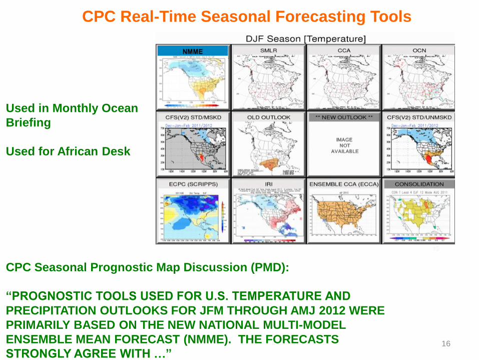
CPC Seasonal Prognostic Map Discussion (PMD):
“PROGNOSTIC TOOLS USED FOR U.S. TEMPERATURE AND
PRECIPITATION OUTLOOKS FOR JFM THROUGH AMJ 2012 WERE
PRIMARILY BASED ON THE NEW NATIONAL MULTI-MODEL
ENSEMBLE MEAN FORECAST (NMME). THE FORECASTS
STRONGLY AGREE WITH …” 16
CPC Real-Time Seasonal Forecasting Tools
Used in Monthly Ocean
Briefing
Used for African Desk
WGNE-28 5 Nov 2012
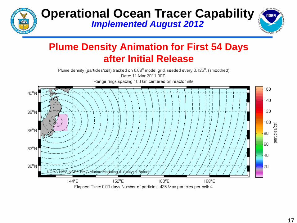
Plume Density Animation for First 54 Days
after Initial Release
17
Operational Ocean Tracer Capability Implemented August 2012
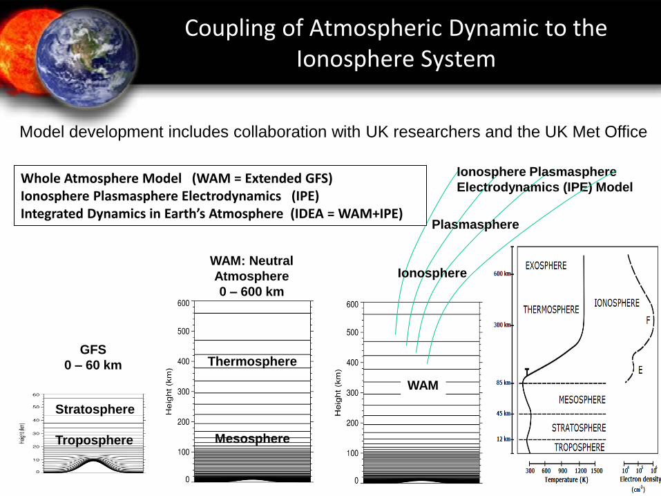
Ionosphere
Plasmasphere
Thermosphere
Mesosphere
GFS
0 – 60 km
WAM: Neutral
Atmosphere
0 – 600 km
Ionosphere Plasmasphere
Electrodynamics (IPE) Model Whole Atmosphere Model (WAM = Extended GFS) Ionosphere Plasmasphere Electrodynamics (IPE) Integrated Dynamics in Earth’s Atmosphere (IDEA = WAM+IPE)
WAM
Stratosphere
Troposphere
Coupling of Atmospheric Dynamic to the Ionosphere System
Model development includes collaboration with UK researchers and the UK Met Office
WGNE-28 5 Nov 2012
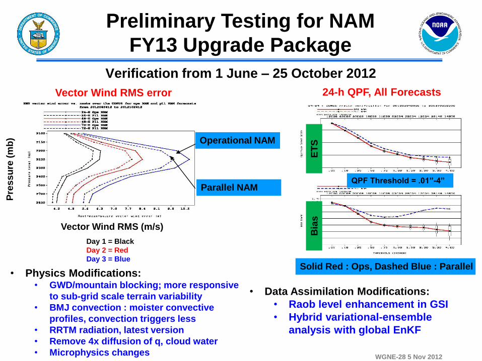
Verification from 1 June – 25 October 2012
24-h QPF, All Forecasts
Operational NAM
Pre
ss
ure
(m
b)
ET
S
Vector Wind RMS (m/s)
Day 1 = Black
Day 2 = Red
Day 3 = Blue
• Physics Modifications: • GWD/mountain blocking; more responsive
to sub-grid scale terrain variability
• BMJ convection : moister convective
profiles, convection triggers less
• RRTM radiation, latest version
• Remove 4x diffusion of q, cloud water
• Microphysics changes
Preliminary Testing for NAM
FY13 Upgrade Package
• Data Assimilation Modifications:
• Raob level enhancement in GSI
• Hybrid variational-ensemble
analysis with global EnKF
Parallel NAM
Bia
s
QPF Threshold = .01”-4”
Solid Red : Ops, Dashed Blue : Parallel
Vector Wind RMS error
WGNE-28 5 Nov 2012
Model Evaluation Group (MEG)
20
• Project designed to focus attention on product quality on a daily
basis with feedback into the model development cycle
• Inspired by monitoring activities at ECMWF, Met Office, GMAO
• Evaluates daily performance of EMC forecast/analysis systems from
a synoptic perspective and adds verification:
• Conduct weekly EMC map discussion of model performance
• Project benefits: – Improves situational awareness and enhances communication
– Provides critical feedback to modelers and branch chiefs
– Provides streamlined feedback to outside users with model concerns
– Can potentially serve as a point-of-contact for all model concerns
outside of EMC
WGNE-28 5 Nov 2012
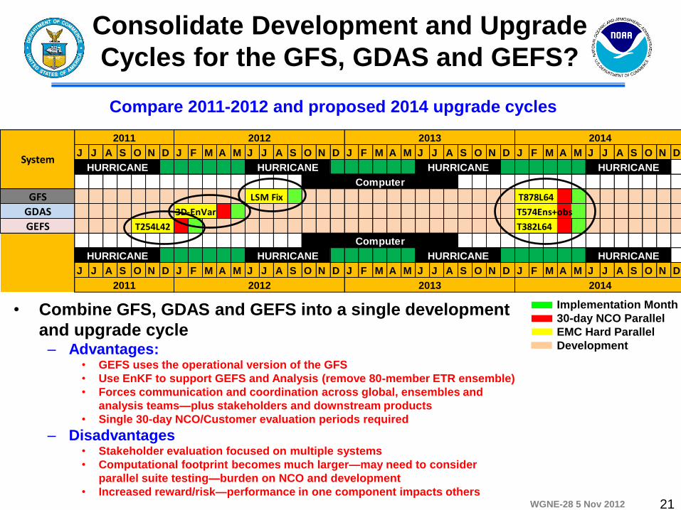
Consolidate Development and Upgrade
Cycles for the GFS, GDAS and GEFS?
Compare 2011-2012 and proposed 2014 upgrade cycles
Implementation Month
30-day NCO Parallel
EMC Hard Parallel
Development
• Combine GFS, GDAS and GEFS into a single development
and upgrade cycle – Advantages:
• GEFS uses the operational version of the GFS
• Use EnKF to support GEFS and Analysis (remove 80-member ETR ensemble)
• Forces communication and coordination across global, ensembles and
analysis teams—plus stakeholders and downstream products
• Single 30-day NCO/Customer evaluation periods required
– Disadvantages • Stakeholder evaluation focused on multiple systems
• Computational footprint becomes much larger—may need to consider
parallel suite testing—burden on NCO and development
• Increased reward/risk—performance in one component impacts others
J J A S O N D J F M A M J J A S O N D J F M A M J J A S O N D J F M A M J J A S O N D
GFS
GDAS T574Ens+obs
GEFS T382L64
J J A S O N D J F M A M J J A S O N D J F M A M J J A S O N D J F M A M J J A S O N D
HURRICANE
2011 2012 2013 2014
T254L42
Computer
HURRICANE HURRICANE HURRICANE
LSM Fix T878L64
3D-EnVar
2014
HURRICANE HURRICANE HURRICANE HURRICANESystem
2011 2012 2013
Computer
21