Embed Size (px)
Citation preview

Peter DuDley
ArchAeologyofthe
Moors, Downs heAthsAnD
oFwest cornwAll
the
Historic Environment Service Cornwall County Council

The Archaeology of the Moors, Downs and Heaths of West Cornwall2
This booklet is a general introduction to the landscape history and archaeology of the rough ground of west Cornwall. By rough ground we mean the downs, moors, bogs, marshes and heaths.
It includes a guide to the common archaeological site types found on rough ground and is intended as an accessible introduction to the development of the west Cornish landscape, including the historic uses of its rough ground, the interpretation of many of its place-names and the understanding of its vivid folk tales.
The booklet also highlights some archaeological sites to visit in west Cornwall and includes a brief description summarising the main characteristics of each type of site. The sites have been selected for their ease of public access and the availability of further information. To help locate the sites and find the best way to get to them we recommend the reader use an OS 1:25,000 Explorer map.
Material for the booklet has been drawn from Goon, Hal, Cliff and Croft; west Cornwall’s rough ground, a detailed study of the history and archaeology of west Cornwall’s downs, moors and crofts. The report and this booklet have been written for the west Cornwall HEATH project, which aims to encourage the re-introduction of rough grazing and to raise awareness of the importance of heathland.
© Cornwall County Council 2008
No part of this document may be reproduced, stored in a retrieval system, or transmitted in any form or by any means without the prior permission of the publisher.
The Archaeology of the Moors, Downs and Heaths of West Cornwall 3
4 Introduction
8 West Cornwall’s rough ground - the story
16 Rough ground resources
19 Archaeological sites
35 Place-names
37 Folklore
40 Further reading
41 Websites
42 Acknowledgements
Contents
The Archaeology of the Moors, Downs and Heaths of West Cornwall4
Their character has been formed, and maintained, by
thousands of years of human activity
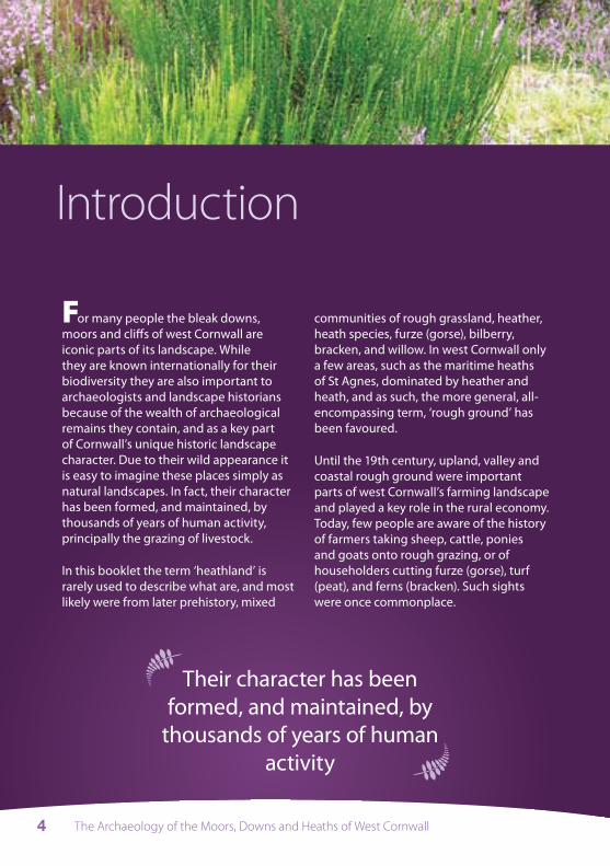
For many people the bleak downs, moors and cliffs of west Cornwall are iconic parts of its landscape. While they are known internationally for their biodiversity they are also important to archaeologists and landscape historians because of the wealth of archaeological remains they contain, and as a key part of Cornwall’s unique historic landscape character. Due to their wild appearance it is easy to imagine these places simply as natural landscapes. In fact, their character has been formed, and maintained, by thousands of years of human activity, principally the grazing of livestock.
In this booklet the term ‘heathland’ is rarely used to describe what are, and most likely were from later prehistory, mixed
communities of rough grassland, heather, heath species, furze (gorse), bilberry, bracken, and willow. In west Cornwall only a few areas, such as the maritime heaths of St Agnes, dominated by heather and heath, and as such, the more general, all- encompassing term, ‘rough ground’ has been favoured.
Until the 19th century, upland, valley and coastal rough ground were important parts of west Cornwall’s farming landscape and played a key role in the rural economy. Today, few people are aware of the history of farmers taking sheep, cattle, ponies and goats onto rough grazing, or of householders cutting furze (gorse), turf (peat), and ferns (bracken). Such sights were once commonplace.
Introduction

The Archaeology of the Moors, Downs and Heaths of West Cornwall 5
Plants commonly found in west Cornwall’s rough ground (clockwise from top left) – Purple-moor grass, Heather (Ling or Calluna Vulgaris), Bell heather (Erica cinerea), Cornish furze or Western Gorse, French furze or European Gorse (not in flower), Bracken (traditionally known as ‘ferns’ in west Cornwall) and Willow (© Cornwall County Council).

The Archaeology of the Moors, Downs and Heaths of West Cornwall6
Archaeological evidence suggests that from later prehistory (c1500BC -) at least, the use of the rough ground was an important part of Cornish farming practice, with areas of moors and downs shared and divided between the inhabitants of farm hamlets, who had rights in ‘common’ to the resources of the rough ground.
As a product of thousands of years of land use the downs and moors that survive today are fragments of a more ancient landscape, an archaeological artefact and direct link to our past. Due to less intensive land use the archaeological sites and features found upon them are often well-preserved, and for many of the sites, they still survive in the landscape context in which they were created.
The extent of west Cornwall’s rough ground, however, has been greatly diminished in the past 200 years through enclosure and improvement. In the late medieval period approximately 43% of west Cornwall was rough ground but today it is only 11%. The larger areas of downs and moors are found principally on the Lizard and in West Penwith. It is here, in these often striking and beautiful places, where the survival of archaeological features is still most
complete, that the historic importance of the rough ground in west Cornwall’s landscape is clearest.
By reading this booklet we hope to enable the reader to look at the landscape with a new perspective; to better understand its history, gain a greater appreciation of its historic character and understand the importance of grazing in creating west Cornwall’s rough ground.
Importantly, for archaeologists grazing helps to keep archaeological sites visible (free from smothering scrub), and from a landscape history perspective, it is a welcome continuation of a long established farming practice.
For the future, sustainable management is the key to maintaining the biodiversity of west Cornwall’s rough ground and the visibility and survival of its remarkable archaeological resource. This requires a better understanding of the history of the rough ground, and an acknowledgement that it is a semi-natural habitat created by more than 3,000 years of rough grazing. This booklet is aimed at extending awareness of this facinating story and its physical legacy of landscape and monuments.
The Archaeology of the Moors, Downs and Heaths of West Cornwall 7
How archaeologists study the landscapeThe layout of the landscape can be read by its different historic characteristics; for example identified archaeological sites and features, the layout of field systems, the pattern of settlements, and the vegetation. A fuller understanding, however, also requires supplementary layers of information to be studied:
Historic maps and documents can provide detail regarding past ownership, land use and value, resources and rights to them. They also record historic place-names, the understanding of which can indicate past places of importance.
Archaeologists also rely on a variety of survey techniques to identify individual features and fossilised historic landscapes. Features are easily visible from the air, as crop marks and earthworks (banks and ditches), and can be plotted accurately
onto maps. On the ground, geophysical survey techniques can accurately identify and plot buried features. For archaeological features visible on the ground measured surveys are used to map, record and interpret the landscape. Where necessary, and when possible, archaeological excavation is used to gain a more detailed understanding of a site’s past use and chronological development.
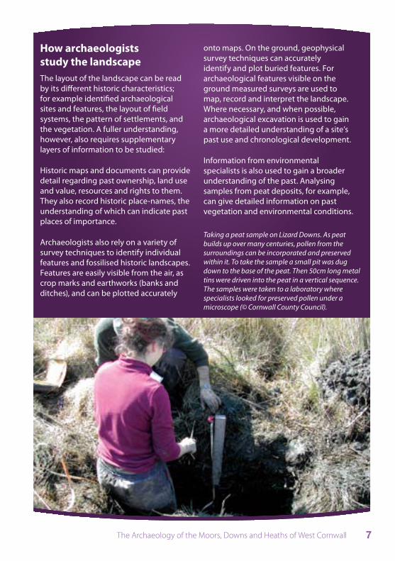
Information from environmental specialists is also used to gain a broader understanding of the past. Analysing samples from peat deposits, for example, can give detailed information on past vegetation and environmental conditions.
Taking a peat sample on Lizard Downs. As peat builds up over many centuries, pollen from the surroundings can be incorporated and preserved within it. To take the sample a small pit was dug down to the base of the peat. Then 50cm long metal tins were driven into the peat in a vertical sequence. The samples were taken to a laboratory where specialists looked for preserved pollen under a microscope (© Cornwall County Council).
The Archaeology of the Moors, Downs and Heaths of West Cornwall8
The story of west Cornwall’s rough ground
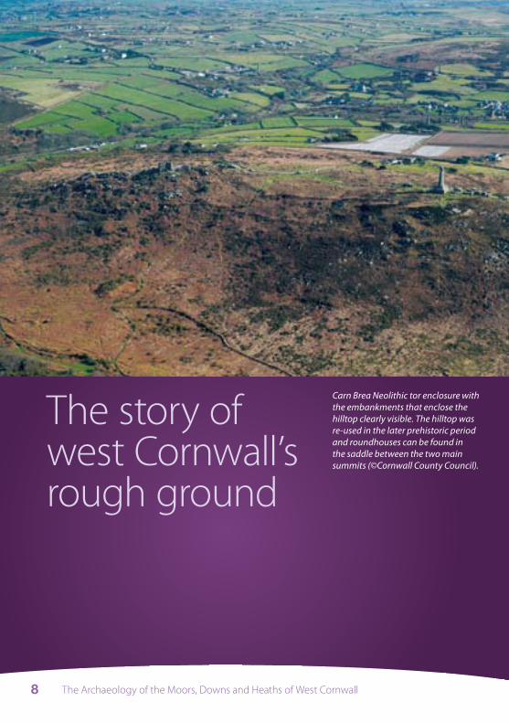
Carn Brea Neolithic tor enclosure with the embankments that enclose the hilltop clearly visible. The hilltop was re-used in the later prehistoric period and roundhouses can be found in the saddle between the two main summits (©Cornwall County Council).
The Archaeology of the Moors, Downs and Heaths of West Cornwall 9
have included ritual, ceremony, feasting, and catching up with family and friends.
One of the functions of such gatherings might well have been to establish, organise and control access to shared resources such as the open areas of rough ground used by the herds and flocks of the increasingly domesticated animals. These meetings may have also been used to resolve disputes over such resources. Similarly meetings and rituals may have also taken place at the roughly contemporary quoits and entrance graves.
The need for meeting or gathering places continued throughout later prehistoric times. In the later Neolithic period the tor enclosures appear to have been replaced by more modest hilltop enclosures such as those on Bartinney Hill and Godolphin Hill, and by stone circles and standing stones which continued in use into the Early Bronze Age (c2500BC to c1500BC).
These structures are thought to have been created in an increasingly open landscape, possibly already rough ground, cleared by people grazing increasing numbers of livestock.
In this period cairns and barrows were also built, often on prominent and significant locations, in some cases incorporating natural rock outcrops and carns. There is great variety in the size and design of these features which were not always used for the burial of remains. Most large cairns and barrows are now found in the higher parts of the landscape, and although barrows and cairns are more likely to survive in rough ground and
The early use of rough ground – c8,000BC to c1500BC
The end of the last Ice Age, around 8000 BC, saw dramatic changes in sea levels as the ice sheets melted. Cornwall shrank in area, river valleys flooded to become estuaries, and the tundra flora was, in most places, replaced by oak and hazel woodlands.
People in the Mesolithic period (c8,000BC to c4,000BC) obtained their food by gathering and hunting. They moved around the landscape following seasonal resources, exploiting plants and animals as they became available.
It is possible that during the Mesolithic period people began to create clearances in the forests to open up rough grazing for hoofed animals like deer and the primitive cattle that they hunted, and to encourage the growth of some of the plants they used.
There has been a recent revision of thinking about the transition from the Mesolithic to the early Neolithic period in Britain (the Neolithic lasted between c4000BC to c2500BC). The emphasis is now on the continuation of a nomadic hunting and gathering lifestyle and only a gradual change to more permanent settlement and organised farming.
In the early Neolithic period (around 3500BC) tor enclosures were built on the more prominent hills, such as Carn Brea, Trencrom and Carn Galva. These may have been important meeting places for large communities, where trading goods was just one of a range of activities that would
(Further details on the archaeological sites and features underlined in the text can be found later in the booklet.)
The Archaeology of the Moors, Downs and Heaths of West Cornwall10
upland areas, it seems that they were placed here intentionally, with rituals and ceremonies taking place in high places or on open ground.
Rough ground as part of a farmed landscape (c1500BC to cAD410) It is from the Middle Bronze Age (c1500BC to c1000BC) onwards that we have the first secure evidence of permanent settlements and the large-scale division of the landscape for farming. The distinctive blocks of settled farmland and rough ground, which were to become such a feature of Cornwall for the next 3000 years, were first established at this time.
At Leskernick and Craddock Moor on Bodmin Moor lanes lead out from the groups of roundhouses (sometimes known as ‘hut circles’) and between fields to the undivided open rough ground beyond. This land may have been used as a form of common, where neighbouring settlements grazed their animals.
The earliest fields were small and curvilinear, irregularly arranged with one field added onto another. Lynchets (the scarps created by the movement downhill of soil during cultivation) and stone clearance heaps, together with the stock-proof scale and design of the boundaries of these fields, suggest that they were used for arable farming.
During the Late Bronze Age (c1000 to c700BC) and Early Iron Age (c700 to c400BC), field systems grew in extent and became more organised in a regular pattern. These systems were more carefully fitted into the topography than the Early Bronze Age fields had been. Importantly, in some areas the fields were located within ribbons of land that also incorporated areas of upland and coastal rough ground, notably in the West Penwith coastland from St Ives through Towednack, Zennor, Morvah and St Just and in the parish of St Keverne, on the Lizard.
Pollen evidence for first millennium BC vegetation in west Cornwall is still sketchy, but does indicate that the uplands were
The earliest fields were small and curvilinear, irregularly
arranged with one field added onto another

The Archaeology of the Moors, Downs and Heaths of West Cornwall 11
probably open at this period. Pollen analysis of soil samples excavated at Foage and at Carn Euny, West Penwith suggest that there had been some clearance of oak and hazel woodland and the establishment of pasture before the roundhouses and field systems were built.
So, from at least the Late Bronze Age, Cornwall had a mixed farming regime based on arable cultivation and the use of open rough ground for grazing a variety of livestock (cattle, horses, goats and sheep).
From about 400 BC enclosed settlements, or rounds, were built throughout Cornwall. These sites have been interpreted by archaeologists as farming hamlets, the centres of small estates. Their distribution appears to have largely fitted into the existing pattern of enclosed field systems, avoiding the harsher, more exposed areas of the coastal and upland rough ground and the damp, low-lying areas of valley rough ground.
Goats grazing on Porkellis Moor, Wendron. Goats were once much more commonly found across Cornwall, especially on small holdings (© Cornwall County Council).
One function of Iron Age hillforts and cliff castles may have been as the meeting places for the regional authority needed to manage competing demands on the large areas of rough ground. This authority need not be seen as an elite with power over lower levels of society, but perhaps as an association of representatives of local farming hamlets.
It is generally accepted that there was fairly minimal Roman influence on Cornish rural society during the Romano-British period (cAD50 to cAD410), certainly when compared with regions further east in southern England. There was therefore greater continuity of rural development from the later prehistoric to the early medieval period. While most, but not all, hillforts and cliff castles were abandoned in the Romano-British period (those remaining probably continuing to be the focus of community organisation and administration), large numbers of rounds continued to be built.
The Archaeology of the Moors, Downs and Heaths of West Cornwall12
Like the contemporary rounds the open settlements of the period, the famous courtyard house hamlets of West Penwith are found within extensive field systems.
As archaeologists and landscape historians continue their work on the development of the Cornish landscape, it becomes increasingly clear that its principal components and its basic shape were already established by the early first millennium BC, and possibly as early as the Middle Bronze Age, around 1500 BC. Increasing archaeological investigation in lowland Cornwall (through aerial photography, geophysical surveys and excavation) is continually confirming that the medieval agricultural heartland of Cornwall has later prehistoric origins. Likewise, the bulk of the remaining landscape was either woodland (largely in the steep-sided valleys) or open rough ground (effectively the uplands and the coastal strip).
It is likely that virtually all of the commons that still survive in Cornwall have been open areas, shared between numerous farming hamlets since at least the Late Bronze Age. As such, Cornwall can be seen as a remarkably intact ancient landscape, in which the commons, upland and coastal rough ground, have always played a crucial role.
Early Medieval period (c410 to 1066)Place-names from this period suggest that transhumance, the movement of animals to summer grazings on rough ground some distance from the settlements to which they belonged, was practised. This is based partly upon our understanding of Cornish havos and hendre place-names. Havos is a compound of the elements haf- ‘summer’ and bod- ‘dwelling’, and has been interpreted by Oliver Padel to mean either pasture land or a hut built on such land.
Hendre is derived from a compound of hen-, meaning ‘old’, and tre-, meaning ‘farmstead’. The hendre place-name also occurs in Wales where, as in Cornwall, the meaning of the name has shifted from ‘ancient farmstead’ to ‘winter farmstead’.
When considering who might have moved seasonally to the havos structures, archaeologists in Cornwall have relied upon later documentary evidence from elsewhere in Britain and Ireland. Only part of the household spent the summer with the stock, usually teenage girls and young unmarried women who were not specialist herders, but part of a family unit practising a mixed farming economy, the rest of the family staying with the permanent settlement to sow, tend and harvest the arable crops and to make hay. The girls would normally leave around May Day and return at Halloween.
Transhumance was important as it made full use of the upland rough ground for grazing. The seasonal movement of livestock away from the fields allowed the land close to the permanent settlement to

The Archaeology of the Moors, Downs and Heaths of West Cornwall 13
be more easily used for hay and for arable crops. In the winter the animals, when returned to the hendre, would manure the fields as they grazed them.
Together with the hendre and havos place-names, the tre- and bod- place-name elements are also useful to understand the early medieval Cornish landscape. Tre- means ‘farming estate’, perhaps closest in scale and nature to the townlands associated with the hamlets of western and northern Britain. These settlements date mainly from the 6th to the 10th centuries AD.
Many of the townlands associated with the tre- and bod- settlements persisted as land units into the 19th and 20th centuries. Their layout is often still reflected in the boundaries of modern farms and land holdings.
Bosigran, Zennor, West Penwith. The field system surrounding the medieval bod- settlement has its origins in the later prehistoric period. Today, as in the medieval period and most probably later prehistory, the field system is surrounded by the coastal rough ground of the cliff slopes and the upland rough ground covering the slopes and summit of Carn Galva (© Cornwall County Council).
Later Medieval period (1066 to c1540)The Domesday Book of 1086 recorded an abundance of rough ground in west Cornwall, indicating that it was a fundamental part of the convertible husbandry and mixed agricultural system.
Under convertible husbandry the ‘in-ground’, or the ‘improved’ fields close to the hamlet, was never permanently under either arable or pasture, but was worked in a rotation based upon a long ley period. The land would have been cropped for two or three years, occasionally more, with ley grasses sown with the last crop, and the ground then used as grass (for hay, pasture, etc) for between four to nine years, although the lengths of leys were variable.

The Archaeology of the Moors, Downs and Heaths of West Cornwall14
The movement of stock to rough ground during the summer and autumn was also a necessary part of the system, as it enabled the fields to be used for arable crops and haymaking. In the winter, following the harvest, livestock returned from the rough ground to replenish the fields with manure. (The rough ground would by then have little vegetation and would be exposed to the winter elements.)
The rough ground was shared and divided between the tenants of farming hamlets, who had rights in ‘common’ to graze their animals and to collect furze (gorse) and turf (peat) for fuel, ferns (bracken) as bedding for livestock, and rushes and heather for thatching. Quarrels, leases and payments were settled in the courts and sessions held by the manors (head farms owned by the lord) and hundreds, the main administrative regional sub-units in Cornwall until the 19th century.
From the later medieval period many large areas of unenclosed rough ground began to be subdivided by walls and hedges as land was increasingly ‘privatised’ to certain farms and individuals. Crofts or small parcels of rough ground also started to be enclosed and by the 17th century these were found on most west Cornish holdings, used mostly by individuals rather than ‘in common’.
6 The declining extent of rough ground in west Cornwall - the late medieval period (top), c1880 (middle) and 2005 (bottom). (© Cornwall County Council).
The Archaeology of the Moors, Downs and Heaths of West Cornwall 15
Post-medieval period (c1540 to present)The present landscape is very different from that of the late medieval period. In the 16th century rough ground covered more than 40% of west Cornwall. Now, through enclosure and improvement, only about 11% of the late medieval rough ground survives, mainly in West Penwith and the Lizard, but also in smaller patches around St Agnes and on Carnmenellis.
From the late 18th century onwards there were major changes to the value of rough ground: the ideals of the ‘agricultural revolution’ were incompatible with the traditional convertible or ley husbandry; the rapidly rising population required housing through smallholdings; growing markets meant that existing farms expanded and new farms were created; and technology enabled increasingly large areas of the rough ground to be improved with greater ease. The main loss of rough ground was not through Parliamentary
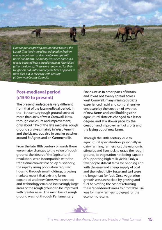
Exmoor ponies grazing on Goonhilly Downs, the Lizard. This hardy breed has adapted to feed on coarse vegetation and to be able to cope with harsh conditions. Goonhilly was once home to a locally adapted horse breed known as ‘Gunhillies’ (after the downs). These were renowned for their toughness but unfortunately the breed appears to have died out in the early 19th century (© Cornwall County Council).
Enclosure as in other parts of Britain and it was not evenly spread across west Cornwall: many mining districts experienced rapid and comprehensive enclosure by the creation of swathes of new farms and smallholdings; the agricultural districts changed to a lesser degree, and at a slower pace, by the creation and improvement of crofts and the laying out of new farms.
Through the 20th century, due to agricultural specialisation, principally in dairy farming, farmers lost the economic stimulus and livestock to graze the rough ground, its vegetation not being capable of supporting high milk yields. Only a few people still cut ferns for bedding and with the easy and cheap supply of coal and then electricity, furze and turf were no longer cut for fuel. Once vegetation growth was unchecked by grazing and fuel harvesting the cost of returning these ‘abandoned’ areas to profitable use was for many farmers too great for the economic return.
The Archaeology of the Moors, Downs and Heaths of West Cornwall16
Furze (gorse), heath, ferns (bracken), rushes, and willow, the characteristic vegetation of west Cornwall’s downs, moors, cliff and commons, were once important resources harvested from the rough ground. These areas were once also important for their moorstone (boulders) and rock outcrops quarried for building stone. They might also be temporarily cultivated when economic conditions were right.
Rough ground resources
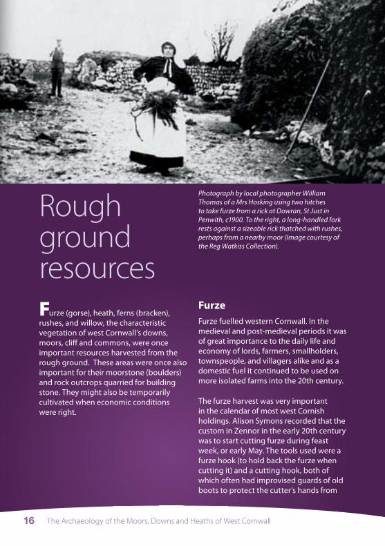
Photograph by local photographer William Thomas of a Mrs Hosking using two hitches to take furze from a rick at Dowran, St Just in Penwith, c1900. To the right, a long-handled fork rests against a sizeable rick thatched with rushes, perhaps from a nearby moor (Image courtesy of the Reg Watkiss Collection).
FurzeFurze fuelled western Cornwall. In the medieval and post-medieval periods it was of great importance to the daily life and economy of lords, farmers, smallholders, townspeople, and villagers alike and as a domestic fuel it continued to be used on more isolated farms into the 20th century.
The furze harvest was very important in the calendar of most west Cornish holdings. Alison Symons recorded that the custom in Zennor in the early 20th century was to start cutting furze during feast week, or early May. The tools used were a furze hook (to hold back the furze when cutting it) and a cutting hook, both of which often had improvised guards of old boots to protect the cutter’s hands from

The Archaeology of the Moors, Downs and Heaths of West Cornwall 17
the spines. Faggots or bundles of furze were tied together and then transported to, and ricked (stored) in, the townplace or mowhay (next to the farmhouse). Ricks were built with a ‘turfy pike’, a long- handled fork, and the furze was pulled out with an iron ‘furze hitch’.
Turf Turbary, or the right to cut turf (the term peat is not used vernacularly in Cornwall) was also important for many holdings in western Cornwall. Turf was a major domestic fuel source, especially on the granite uplands of West Penwith and Carnmenellis and the extensive poorly-drained downs of the Lizard. In medieval Cornwall, charcoal made from turves was a valuable fuel source for tin smelting.
James Stevens’s diary indicates that in the late 19th century a turf cutter in Zennor expected to cut five hundred turves a day. The turf was cut using a piggal (a
broad and heavy bladed mattock) or with a spade and allowed to dry before being carted to the townplace and ricked near the furze rick. Stevens recorded cutting turf in May – August, including ‘turning and pooking’ (stacking in temporary ricks). The turves would have been allowed to dry during the summer, sometimes on stands or platforms, and when time allowed brought to the turf rick near to the house.
HeatherIn west Cornwall very few historical references to the use of heathers have been recorded, and even then, its use was often only mentioned indirectly. When used as a fuel, heather was either cut together with furze, or as the top of skimmed turf. It could be used to make besoms (brooms) and for thatching the cottages of the poor. No references have been found to making heather rope, but with the fishing, shipping and mining industries all using hemp on a large scale, it is probable that heathers would have only been used on a very local scale from an early date, perhaps just for tying down thatching or for tying up faggots of furze.
FernsThe term ‘ferns’ covers both bracken and fern plants, but in Cornwall the term traditionally meant bracken. The harvesting of ferns - ‘ferny-scat’ - was once part of the annual round on many farms. Its uses included thatching ricks of furze, roofing minor buildings, and probably most importantly, bedding for livestock and thus as a matrix for manure.
The rectangular or sub-circular turf stands are clearly visible from the air. The best place to spot surviving turf stands is on the downland of the Lizard where they were once known as ‘robins’. (© Cornwall County Council).

The Archaeology of the Moors, Downs and Heaths of West Cornwall18
for rab (the dialect term in west Cornwall for degraded granite) were also dug for infilling and road making, or for cob construction. Certain specific clays and earths were dug to sweeten the soil and in the 18th to 20th centuries china clay was extracted.
Temporary cultivationOn many of the moors, downs and cliffs groups of narrow ‘outfield’ strips defined by low stone and earth banks can be found. These features date to the later medieval and early post-medieval periods (13th century to early 18th century) and are the remains of temporary cultivation of the rough ground when economic conditions were favourable.
A temporary stock-proof boundary would have been created to surround the strips and in some systems there are small stone clearance heaps, usually on grounders, the large earthfast boulders. In some areas there are traces of narrow ridge and furrow, made either with a light plough or a spade (as lazy beds). On the Lizard Downs a number of patches of ridge and furrow are likely to be the remains of outfield strips, but as there is less stone in the area the dividing banks are less visible.
Most of the outfields found in Devon and Cornwall were not integral parts of a farming hamlet’s field system, as they were in many other parts of upland Britain. Instead it seems that they were created, and perhaps occasionally reused, in a speculative way, when local markets for grain and other produce promised a good return for the effort. Consequently they might not have been used for more often than five or six years at a time every fifty or sixty years.
At Tremedda, Zennor, Alison Symons recorded that the bracken harvest was the last harvest of the year and took place in late September to October in a suitable croft with few rocks and furze. Ferns were cut with a scythe, allowed to dry for a few days, then gathered in small pooks (temporary stacks) and carried to the townplace to be ricked (stored).
Rushes and willowsThe wetter low-lying parts of the rough ground, known in Cornwall as moors, marshes, and occasionally as morasses, also provided rushes for thatching. On 27th July, 1877 James Stevens, ‘cut rushes and thatched fern rick’, and on 25th September of that year he also, ‘cut rushes and thatched the fern rick behind the cart house, thatched cows [sic] crow’. Corn and hay ricks were also thatched with rushes.
Willows and osier beds were coppiced and cut for basketry (including lobster and crab pots), and for making items such as hurdles and temporary fences.
Stone and rockIn prehistory many of the stone-built monuments, houses, and field boundaries used the stone directly to hand, either gathered from the surface, nearby rock faces and cliffs, or dug from small pits close by. Small-scale extraction continues today, with small rab pits and quarries often still dug, albeit now by mechanical means, by farmers for infilling or to provide hedging material.
From at least the medieval period west Cornwall’s rough ground, its carns, cliffs, and clitter, was an important source of quarried and split stone for building. Pits
The Archaeology of the Moors, Downs and Heaths of West Cornwall 19
Hilltop enclosures
A number of hills in west Cornwall have the remains of early prehistoric enclosures at their summits. All are in rough ground and appear to have been originally approached by crossing rough ground, possibly after passing through more or less dense woodland. These enclosures can be divided into early Neolithic tor enclosures and late Neolithic or early Bronze Age ritual enclosures.
Recommended tor enclosures to visit - Carn Brea, Redruth; Trencrom, Lelant;
Recommended hilltop enclosures to visit - Bartinney Down, St Just in Penwith; Godolphin Hill, Breage
Archaeological sites
Neolithic chambered tombs - quoits and entrance gravesChambered tombs vary in form and can be subdivided into two broad types; quoits (Cornish dialect term) and entrance graves.
The quoits with their colossal stones (uprights and the capstones they hoist into the sky) are visually impressive. Their design is often simple with a ‘stone box’ of large stones resting on the surface creating a simple chamber (as at Chun and Mulfra). More complex ‘portal dolmens’ (for example, Zennor) have antechambers. Evidence from Chun, Zennor and Lanyon suggests most were once partially covered by circular or oval stone mounds or cairns. A fourth millennium BC date is generally accepted for them.
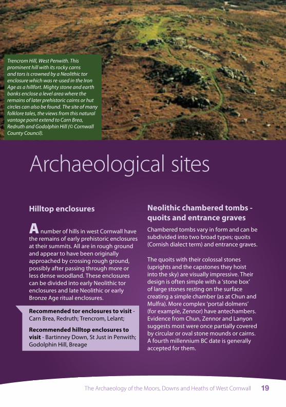
Trencrom Hill, West Penwith. This prominent hill with its rocky carns and tors is crowned by a Neolithic tor enclosure which was re-used in the Iron Age as a hillfort. Mighty stone and earth banks enclose a level area where the remains of later prehistoric cairns or hut circles can also be found. The site of many folklore tales, the views from this natural vantage point extend to Carn Brea, Redruth and Godolphin Hill (© Cornwall County Council).

The Archaeology of the Moors, Downs and Heaths of West Cornwall20
Mulfra Quoit, West Penwith (© Cornwall County Council).
The Archaeology of the Moors, Downs and Heaths of West Cornwall 21
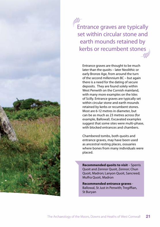
Entrance graves are thought to be much later than the quoits – later Neolithic or early Bronze Age, from around the turn of the second millennium BC – but again there is a need for the dating of secure deposits. They are found solely within West Penwith on the Cornish mainland, with many more examples on the Isles of Scilly. Entrance graves are typically set within circular stone and earth mounds retained by kerbs or recumbent stones. Most are 6-12 metres in diameter, but can be as much as 23 metres across (for example, Ballowal). Excavated examples suggest that some sites were multi-phase, with blocked entrances and chambers.
Chambered tombs, both quoits and entrance graves, may have been used as ancestral resting places, ossuaries where bones from many individuals were placed.
Entrance graves are typically set within circular stone and earth mounds retained by kerbs or recumbent stones
Recommended quoits to visit – Sperris Quoit and Zennor Quoit, Zennor; Chun Quoit, Madron; Lanyon Quoit, Sancreed; Mulfra Quoit, Madron
Recommended entrance graves - Ballowal, St Just in Penwith; Tregiffian, St Buryan
The Archaeology of the Moors, Downs and Heaths of West Cornwall22
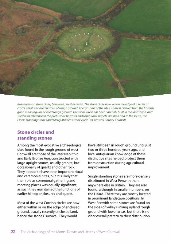
Stone circles and standing stonesAmong the most evocative archaeological sites found in the rough ground of west Cornwall are those of the later Neolithic and Early Bronze Age, constructed with large upright stones, usually granite, but occasionally of quartz and other rock. They appear to have been important ritual and ceremonial sites, but it is likely that their role as communal gathering and meeting places was equally significant; as such they maintained the functions of earlier hilltop enclosures and quoits.
Most of the west Cornish circles are now either within or on the edge of enclosed ground, usually recently enclosed land, hence the stones’ survival. They would
Boscawen-un stone circle, Sancreed, West Penwith. The stone circle now lies on the edge of a series of crofts, small enclosed parcels of rough ground. The ‘un’ part of the site’s name is derived from the Cornish goon meaning unenclosed rough ground. The stone circle has been carefully built in the landscape, and sited with reference to the prehistoric barrows and tombs on Chapel Carn Brea and to the south, the Pipers standing stones and Merry Maidens stone circle (© Cornwall County Council).
have still been in rough ground until just two or three hundred years ago, and local antiquarian knowledge of these distinctive sites helped protect them from destruction during agricultural improvement.
Single standing stones are more densely distributed in West Penwith than anywhere else in Britain. They are also found, although in smaller numbers, on the Lizard. There they are mostly located in prominent landscape positions. In West Penwith some stones are found on the sides of valleys linking upland rough ground with lower areas, but there is no clear overall pattern to their distribution.
The Archaeology of the Moors, Downs and Heaths of West Cornwall 23
In a few instances they were associated with burials but in most cases it is likely they were a means of marking – or making – important points in the landscape.
Recommended stone circles to visit Merry Maidens, St Buryan; Boscawen Un, Sancreed; Tregeseal, St Just in Penwith; Nine Maidens, near Carn Galva, Zennor
Recommended standing stones to visit Dry Tree, Goonhilly Downs; Boswens, St Just in Penwith
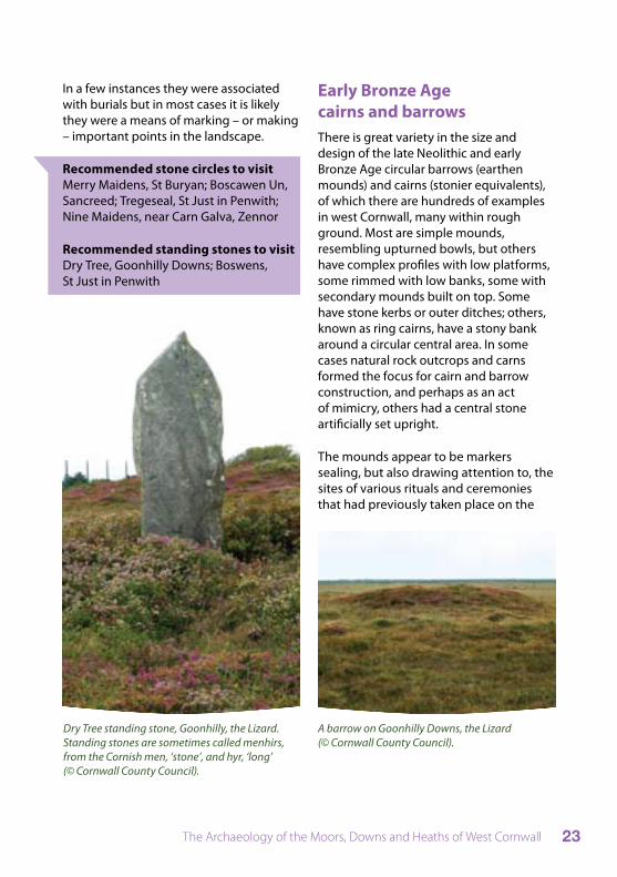
Dry Tree standing stone, Goonhilly, the Lizard. Standing stones are sometimes called menhirs, from the Cornish men, ‘stone’, and hyr, ‘long’ (© Cornwall County Council).
Early Bronze Age cairns and barrows There is great variety in the size and design of the late Neolithic and early Bronze Age circular barrows (earthen mounds) and cairns (stonier equivalents), of which there are hundreds of examples in west Cornwall, many within rough ground. Most are simple mounds, resembling upturned bowls, but others have complex profiles with low platforms, some rimmed with low banks, some with secondary mounds built on top. Some have stone kerbs or outer ditches; others, known as ring cairns, have a stony bank around a circular central area. In some cases natural rock outcrops and carns formed the focus for cairn and barrow construction, and perhaps as an act of mimicry, others had a central stone artificially set upright.
The mounds appear to be markers sealing, but also drawing attention to, the sites of various rituals and ceremonies that had previously taken place on the
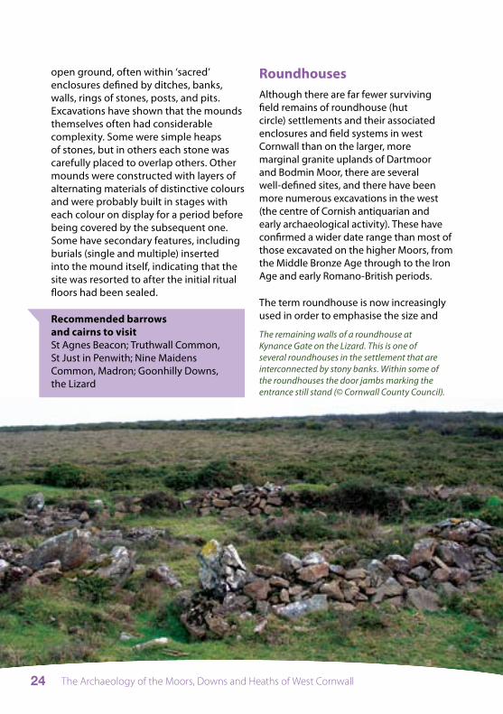
A barrow on Goonhilly Downs, the Lizard (© Cornwall County Council).
The Archaeology of the Moors, Downs and Heaths of West Cornwall24
The remaining walls of a roundhouse at Kynance Gate on the Lizard. This is one of several roundhouses in the settlement that are interconnected by stony banks. Within some of the roundhouses the door jambs marking the entrance still stand (© Cornwall County Council).
open ground, often within ‘sacred’ enclosures defined by ditches, banks, walls, rings of stones, posts, and pits. Excavations have shown that the mounds themselves often had considerable complexity. Some were simple heaps of stones, but in others each stone was carefully placed to overlap others. Other mounds were constructed with layers of alternating materials of distinctive colours and were probably built in stages with each colour on display for a period before being covered by the subsequent one. Some have secondary features, including burials (single and multiple) inserted into the mound itself, indicating that the site was resorted to after the initial ritual floors had been sealed.
Recommended barrows and cairns to visit St Agnes Beacon; Truthwall Common, St Just in Penwith; Nine Maidens Common, Madron; Goonhilly Downs, the Lizard
Roundhouses Although there are far fewer surviving field remains of roundhouse (hut circle) settlements and their associated enclosures and field systems in west Cornwall than on the larger, more marginal granite uplands of Dartmoor and Bodmin Moor, there are several well-defined sites, and there have been more numerous excavations in the west (the centre of Cornish antiquarian and early archaeological activity). These have confirmed a wider date range than most of those excavated on the higher Moors, from the Middle Bronze Age through to the Iron Age and early Romano-British periods.
The term roundhouse is now increasingly used in order to emphasise the size and

The Archaeology of the Moors, Downs and Heaths of West Cornwall 25
sophistication of these structures, aspects a little lost in their former label, ‘hut circle’, coined by the Ordnance Survey to describe the field remains of stone walled roundhouses.
Roundhouses generally vary from 5 to 10 metres in internal diameter, the internal faces of the approximately one metre wide walls, often formed by upright or orthostatic stones, usually being more easily visible than any outer face.
They often occur in small groups and many are associated with field systems. These were the farming settlements of the later prehistoric period.
Recommended roundhouse settlements to visit Bodrifty, Newmill, Madron; Carn Brea, Redruth; Kynance Gate, near Kynance Cove, the Lizard
HillfortsHillforts are enclosures defined by one or more lines of substantial bank or wall, often with external ditches, set high on hills, usually at their summits, apparently for defensive advantage. They are widespread throughout Western Europe and are generally of Iron Age date, though some are now known from the later Bronze Age.
There is considerable variation among the hillforts of west Cornwall. Some, like Trencrom and Lescudjack, are univallate (having a single rampart) and irregular in plan, the defensive line winding around an irregularly shaped hill. Several other west Cornish hillforts have two or three concentric neatly circular lines of ramparts (for example, Chun Castle and Castle-an-Dinas). The large irregular hillfort at Carn Brea absorbed and extended the early Neolithic tor enclosure, creating at least seven distinct and different sized compartments, two at the hill’s eastern and central summits, one on the saddle between the two and the others on the high northern, southern and eastern slopes.
Recommended hillforts to visit Carn Brea, Redruth; Castle Pencaire, Tregonning Hill, Breage; Trencrom, Lelant; Castle an Dinas, Ludgvan; Chun Castle, Morvah; Caer Bran, Sancreed
Castle-an-Dinas, West Penwith. The two concentric banks and ditches enclose the rounded hilltop of one of the most prominent hills in West Penwith. Views from the hillfort extend across Mounts Bay to Castle Pencaire, Tregonning Hill, to the Lizard and westwards towards Land’s End. Roger’s Tower, a late 18th century folly, has been built on the southern side of this impressive site (© Cornwall County Council).
The Archaeology of the Moors, Downs and Heaths of West Cornwall26
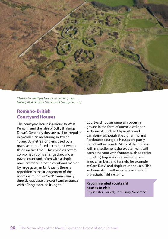
Chysauster courtyard house settlement, near Gulval, West Penwith (© Cornwall County Council).
Romano-British Courtyard HousesThe courtyard house is unique to West Penwith and the Isles of Scilly (Halangy Down). Generally they are oval or irregular in overall plan measuring between 15 and 35 metres long enclosed by a massive stone-faced earth bank two to three metres thick. This encloses several con-joined rooms arranged around a paved courtyard, often with a single main entrance into the courtyard marked by large gate jambs. Usually there is repetition in the arrangement of the rooms: a ‘round’ or ‘oval’ room usually directly opposite the courtyard entrance with a ‘long room’ to its right.
Courtyard houses generally occur in groups in the form of unenclosed open settlements such as Chysauster and Carn Euny, although at Goldherring and Porthmeor courtyard houses are partly found within rounds. Many of the houses within a settlement share outer walls with each other and with features such as earlier (Iron Age) fogous (subterranean stone-lined chambers and tunnels, for example at Carn Euny) and single roundhouses. The settlements sit within extensive areas of prehistoric field systems.
Recommended courtyard houses to visit Chysauster, Gulval; Carn Euny, Sancreed
The Archaeology of the Moors, Downs and Heaths of West Cornwall 27
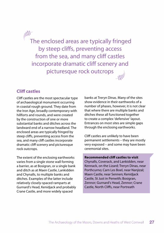
Cliff castles Cliff castles are the most spectacular type of archaeological monument occurring in coastal rough ground. They date from the Iron Age, broadly contemporary with hillforts and rounds, and were created by the construction of one or more substantial banks and ditches across the landward end of a narrow headland. The enclosed areas are typically fringed by steep cliffs, preventing access from the sea, and many cliff castles incorporate dramatic cliff scenery and picturesque rock outcrops.
The extent of the enclosing earthworks varies from a single stone wall forming a barrier, as at Bosigran, or a single bank and ditch as at Maen Castle, Lankidden and Chynalls, to multiple banks and ditches. Examples of the latter include relatively closely-spaced ramparts at Gurnard’s Head, Kenidjack and probably Crane Castle, and more widely spaced
banks at Treryn Dinas. Many of the sites show evidence in their earthworks of a number of phases, however, it is not clear that where there are multiple banks and ditches these all functioned together to create a complex ‘defensive’ layout. Entrances on most sites are simple gaps through the enclosing earthworks.
Cliff castles are unlikely to have been permanent settlements – they are mostly very exposed – and some may have been ceremonial sites.
Recommended cliff castles to visit Chynalls, Coverack, and Lankidden, near Kennack, on the Lizard; Treryn Dinas, near Porthcurno; Carn Les Boel, near Nanjizal; Maen Castle, near Sennen; Kenidjack Castle, St Just in Penwith; Bosigran, Zennor; Gurnard’s Head, Zennor; Crane Castle, North Cliffs, near Portreath
The enclosed areas are typically fringed by steep cliffs, preventing access
from the sea, and many cliff castles incorporate dramatic cliff scenery and
picturesque rock outcrops
The Archaeology of the Moors, Downs and Heaths of West Cornwall28
The Archaeology of the Moors, Downs and Heaths of West Cornwall 29
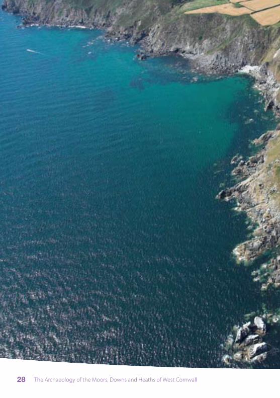
Lankidden cliff castle between Kennack Sands and Black Head, the Lizard. The single rampart and ditch (to the north) cut across the neck of the narrow headland (© Cornwall County Council).

The Archaeology of the Moors, Downs and Heaths of West Cornwall30
Iron Age and Romano-British roundsSmall enclosures with a single encircling bank and ditch, are traditionally known in Cornwall as ‘rounds’. Rounds usually have a simple entrance, generally on the downhill side, and they are typically located on hill slopes rather than hilltops; their defences are usually on a smaller scale than those of hillforts. They can be oval or rectilinear in shape and it has been suggested that the rounds were the homes of farming communities of higher status than those who lived in the open settlements.
Over much of West Penwith the later prehistoric field systems associated with rounds and contemporary open settlements are fossilised within modern field patterns. Only 20% of rounds recorded are found within what was rough ground in the medieval period. Most rounds lie within Anciently Enclosed Land, the underlying pattern of which is based on medieval field patterns, itself overlying prehistoric farmland. Analysis of Cornish settlement patterns has shown a close correspondence between rounds and early medieval settlements associated with Cornish tre- and bod- place-names.
Rounds were principally agricultural settlements of groups of households, not dissimilar to the farming hamlets of the medieval Cornish landscape, although some may also have been associated with other specialised activities such as iron smelting. It is likely then that, as in the medieval period, each round would have been associated with an immediately adjacent subdivided field system and had access to communal resources such as shared use of rough ground.
Recommended sites to visit Round to the east of Castle Pencaire, Tregonning Hill, Breage
Turf cutting Archaeological evidence of turf cutting is most plentiful on the Lizard where, in the areas of peaty soil, there are extensive roughly rectilinear patches of ground distinctly lower than that around them. These are the cuttings where the turf iron, a form of narrow spade with a side feather, was used to slice the deep peat out in vertically cut blocks. Elsewhere the shallower turf of the less boggy ground was skimmed off with different tools (the breast plough, the biddax and the piggal), leaving much less easily detected cuttings. The former presence of turf cutting here, however, is often betrayed by the scatters of small platforms or stands where cut turf was stored before being carted home.
Rectangular examples are typically around 6 by 4 metres, being the plan of a small rectangular rick which would have been
A turf stand or ‘robin’ on Goonhilly Downs, the Lizard. There is a central platform where the turves were once stacked surrounded by a shallow ditch (greener vegetation) and an outer low bank (© Cornwall County Council).

The Archaeology of the Moors, Downs and Heaths of West Cornwall 31
thatched with rushes weighed down with long heavy turfs. The stands would not survive archaeologically if the builders had not then dug a drainage ditch, usually 60cm wide and 40cm deep, around them, the standing rick obliging them to throw the spoil outwards, so creating an external bank.
Turf cutting on the Lizard appears to have ended by the beginning of the 20th century. In the 19th century Polsue recorded that the stands were known in the area as ‘robins’.
There are fewer recorded remains of turf cutting in other parts of west Cornwall, although in West Penwith isolated turf
stands have been recorded at Noon Veor and Bosporthennis, Zennor.
Recommended sites to visit many turf stands are to be found scattered across Lizard and Goonhilly Downs
Streamworking Streamworks exploited dislocated tin ore detached by weathering and erosion from the parent lode.
The mechanics of streamworking are complicated and involve sophisticated water management throughout the extractive process. Initially, the overburden was removed to reveal the ore
The earthwork banks at Bartinney, West Penwith show that the ground has been heavily worked for tin. The streamwork may date to at least the medieval period (© Cornwall County Council).

The Archaeology of the Moors, Downs and Heaths of West Cornwall32
levels, and once reached, water was used to separate the dense cassiterite or tin ore from its lighter gravel and clay matrix. This involved altering the volume of water and/or gradient of the work area, known as the tye. The waste material included large rocks, gravels and mixed clays and once a tye had been exhausted, and the work area had progressed uphill, waste was often deposited into the previous tye. The varying shape, size and layout of the waste heaps are diagnostic of the different ways that the streamworks were worked.
Streamworks can vary in character but they generally include parallel waste heaps, hollows and pits, leats (drainage ditches that follow contours), and reservoirs necessary for the management of water resources.
Streaming was an important source of tin from the medieval period through to the eighteenth century, after which its importance declined into the nineteenth century with the development of deep hard-rock mining technology.
Recommended streamworking areas to visit Porkellis Moor, near Helston; Bartinney Downs, St Just in Penwith
MiningMining involves the retrieval of metal ores (in west Cornwall principally of tin, copper and lead but also manganese, wolfram, and silver) from lodes within the bedrock.
Among the earliest forms of mining in Cornwall are lode-back pits, shallow shafts and pits, sometimes interconnected by tunnels and galleries underground, dug above the water-table and usually in lines following a lode.
Openworks can also be early. Here the lode was quarried away from the surface as an open cast mine, often as narrow and elongated gullies known in Cornwall as ‘coffens’. Although some openworks are among the earliest surviving mines, the technique was still being used into the latter part of the 19th and early 20th centuries.
Shaft mining may have been developed by the 14th century, but its extensive use and the depth to which shafts were sunk increased with the technological developments of the 18th and 19th centuries. Generally, however, the same methods applied through the periods: vertical shafts would first be sunk from the surface down to the lode. Horizontal levels would be dug to assess the extent of the lode and adits to provide ventilation, drainage and easier access for the removal of waste and ore. The ore would be further mined by the opening of stopes (galleries cut above and below levels) with exploratory cross-cuts and vertical shafts dug to assess the lode and search for other workable lodes.
Pumps to aid drainage were necessary as mines worked further below the water table. Documentary evidence indicates a variety of forms of drainage by the 17th century. Many required a power source, usually water or muscle, the latter through
The Archaeology of the Moors, Downs and Heaths of West Cornwall 33
whims or lifting engines driven by animals or people; circular whim platforms are common features on mine sites. Whims were also used to raise ore and waste from shafts. Eventually steam, and especially the beam engine, developed from the early 18th century and through the 19th and 20th centuries, provided most of the power for hauling, draining and on-site dressing or processing of the ore. Some smaller and remote mines continued to use water and horse power into the 19th and early 20th centuries.
The dressing or processing of ores was a complex procedure: following crushing by stamps the metal was washed through a series of tanks, tables and buddles to allow for sedimentation through differences in specific gravity (a principle similar to that employed in tin streaming). Vast amounts of waste material of crushed rock and slimes would be carted or trammed away from the processing sites and shafts to form the waste heaps which are such a characteristic of mines.
Mine sites are found both in areas of rough ground and improved ground. In the rough ground the remains tend to be more intact and in better condition than those in improved ground.
Recommended mining landscapes to visit Trevellas Valley and Wheal Coates, St Agnes; Poldice Valley (Devoran-Portreath cycle route); Botallack and Geevor, St Just in Penwith; Rinsey and Trewavas Head, near Porthleven.
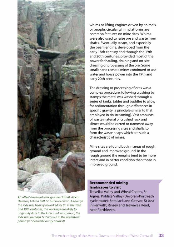
A ‘coffen’ driven into the granite cliffs at Wheal Hermon, Letcha Cliff, St Just in Penwith. Although the lode was heavily reworked for tin in the 18th and 19th centuries, the workings are likely to originally date to the later medieval period; the lode was perhaps first worked in the prehistoric period (© Cornwall County Council).
The Archaeology of the Moors, Downs and Heaths of West Cornwall34
Quarrying and stone-splittingMany areas of rough ground are littered with moorstone and weathered outcrops. In granite areas particularly this material was widely exploited, split and shaped for a variety of uses, including building stone, gate posts and paving.
From the mid 19th century there was a greater demand for the precisely shaped stone obtained from large scale quarrying. This was often exported from west Cornwall to pave large urban centres such as London, and for the construction of monuments, buildings, and structures such as lighthouses, breakwaters and quays. The granite hills above Penryn developed as an important dimension stone quarrying area in the mid 19th century. Other rocks in west Cornwall, such as the talc deposits and serpentine of the Lizard, also became exportable commodities, but were exploited on a much more limited scale than the granite.
China clay was also exploited in west Cornwall, its use for porcelain manufacture first patented by the Plymouth chemist William Cookworthy in the late 1760s. With the loss of the patent in 1775 china clay became widely used by porcelain manufacturers and many pits and quarries were opened up. China clay had to be dried in kilns and these often survive as ruined buildings close to the abandoned flooded pits and towering waste heaps.
Recommended granite dimension stone quarries to visit Lamorna, near St Buryan; Polkanuggo, Longdowns, near Penryn; Trenoweth, Mabe, near Penryn.
Recommended china clay works to visit Bostraze and Leswidden, St Just; Baker’s Pit, Nancledra
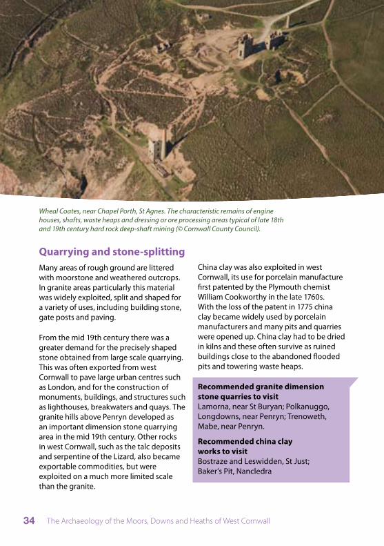
Wheal Coates, near Chapel Porth, St Agnes. The characteristic remains of engine houses, shafts, waste heaps and dressing or ore processing areas typical of late 18th and 19th century hard rock deep-shaft mining (© Cornwall County Council).
The Archaeology of the Moors, Downs and Heaths of West Cornwall 35
Place-names
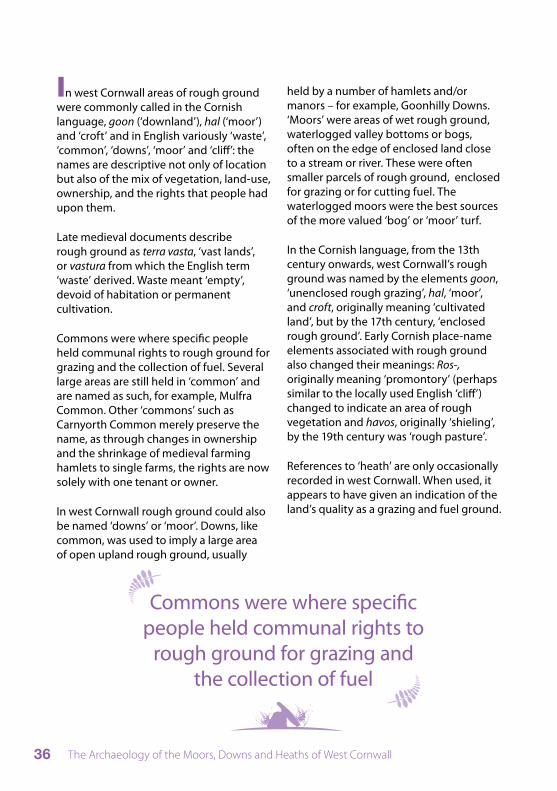
Cornish and English place-names associated with rough ground. Some, such as Goonhilly, are still large areas of rough ground, whilst others, for example Farms Common, are remembered only in name as they have been enclosed and improved or built upon (© Cornwall County Council).
The Archaeology of the Moors, Downs and Heaths of West Cornwall36
In west Cornwall areas of rough ground were commonly called in the Cornish language, goon (‘downland’), hal (‘moor’) and ‘croft’ and in English variously ‘waste’, ‘common’, ‘downs’, ‘moor’ and ‘cliff’: the names are descriptive not only of location but also of the mix of vegetation, land-use, ownership, and the rights that people had upon them.
Late medieval documents describe rough ground as terra vasta, ‘vast lands’, or vastura from which the English term ‘waste’ derived. Waste meant ‘empty’, devoid of habitation or permanent cultivation.
Commons were where specific people held communal rights to rough ground for grazing and the collection of fuel. Several large areas are still held in ‘common’ and are named as such, for example, Mulfra Common. Other ‘commons’ such as Carnyorth Common merely preserve the name, as through changes in ownership and the shrinkage of medieval farming hamlets to single farms, the rights are now solely with one tenant or owner.
In west Cornwall rough ground could also be named ‘downs’ or ‘moor’. Downs, like common, was used to imply a large area of open upland rough ground, usually
held by a number of hamlets and/or manors – for example, Goonhilly Downs. ‘Moors’ were areas of wet rough ground, waterlogged valley bottoms or bogs, often on the edge of enclosed land close to a stream or river. These were often smaller parcels of rough ground, enclosed for grazing or for cutting fuel. The waterlogged moors were the best sources of the more valued ‘bog’ or ‘moor’ turf.
In the Cornish language, from the 13th century onwards, west Cornwall’s rough ground was named by the elements goon, ‘unenclosed rough grazing’, hal, ‘moor’, and croft, originally meaning ‘cultivated land’, but by the 17th century, ‘enclosed rough ground’. Early Cornish place-name elements associated with rough ground also changed their meanings: Ros-, originally meaning ‘promontory’ (perhaps similar to the locally used English ‘cliff’) changed to indicate an area of rough vegetation and havos, originally ‘shieling’, by the 19th century was ‘rough pasture’.
References to ‘heath’ are only occasionally recorded in west Cornwall. When used, it appears to have given an indication of the land’s quality as a grazing and fuel ground.
Commons were where specific people held communal rights to
rough ground for grazing and the collection of fuel
The Archaeology of the Moors, Downs and Heaths of West Cornwall 37
Folklore
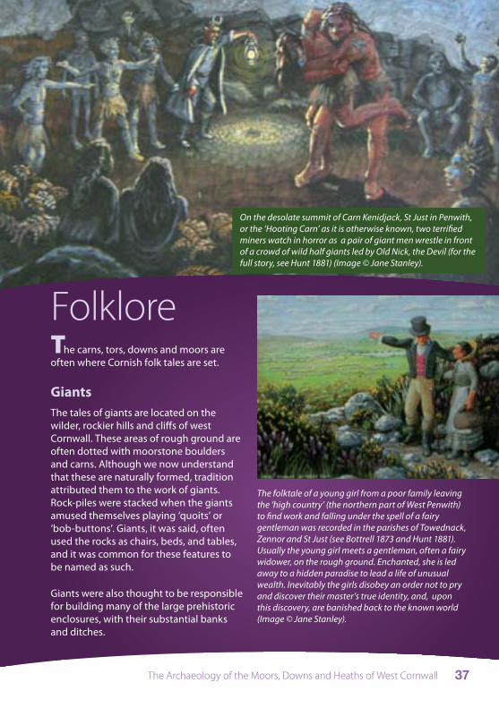
On the desolate summit of Carn Kenidjack, St Just in Penwith, or the ‘Hooting Carn’ as it is otherwise known, two terrified miners watch in horror as a pair of giant men wrestle in front of a crowd of wild half giants led by Old Nick, the Devil (for the full story, see Hunt 1881) (Image © Jane Stanley).
The carns, tors, downs and moors are often where Cornish folk tales are set.
GiantsThe tales of giants are located on the wilder, rockier hills and cliffs of west Cornwall. These areas of rough ground are often dotted with moorstone boulders and carns. Although we now understand that these are naturally formed, tradition attributed them to the work of giants. Rock-piles were stacked when the giants amused themselves playing ‘quoits’ or ‘bob-buttons’. Giants, it was said, often used the rocks as chairs, beds, and tables, and it was common for these features to be named as such.
Giants were also thought to be responsible for building many of the large prehistoric enclosures, with their substantial banks and ditches.
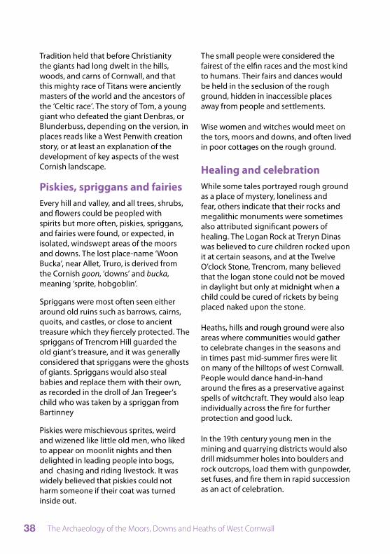
The folktale of a young girl from a poor family leaving the ‘high country’ (the northern part of West Penwith) to find work and falling under the spell of a fairy gentleman was recorded in the parishes of Towednack, Zennor and St Just (see Bottrell 1873 and Hunt 1881). Usually the young girl meets a gentleman, often a fairy widower, on the rough ground. Enchanted, she is led away to a hidden paradise to lead a life of unusual wealth. Inevitably the girls disobey an order not to pry and discover their master’s true identity, and, upon this discovery, are banished back to the known world (Image © Jane Stanley).
The Archaeology of the Moors, Downs and Heaths of West Cornwall38
Tradition held that before Christianity the giants had long dwelt in the hills, woods, and carns of Cornwall, and that this mighty race of Titans were anciently masters of the world and the ancestors of the ‘Celtic race’. The story of Tom, a young giant who defeated the giant Denbras, or Blunderbuss, depending on the version, in places reads like a West Penwith creation story, or at least an explanation of the development of key aspects of the west Cornish landscape.
Piskies, spriggans and fairiesEvery hill and valley, and all trees, shrubs, and flowers could be peopled with spirits but more often, piskies, spriggans, and fairies were found, or expected, in isolated, windswept areas of the moors and downs. The lost place-name ‘Woon Bucka’, near Allet, Truro, is derived from the Cornish goon, ‘downs’ and bucka, meaning ‘sprite, hobgoblin’.
Spriggans were most often seen either around old ruins such as barrows, cairns, quoits, and castles, or close to ancient treasure which they fiercely protected. The spriggans of Trencrom Hill guarded the old giant’s treasure, and it was generally considered that spriggans were the ghosts of giants. Spriggans would also steal babies and replace them with their own, as recorded in the droll of Jan Tregeer’s child who was taken by a spriggan from Bartinney
Piskies were mischievous sprites, weird and wizened like little old men, who liked to appear on moonlit nights and then delighted in leading people into bogs, and chasing and riding livestock. It was widely believed that piskies could not harm someone if their coat was turned inside out.
The small people were considered the fairest of the elfin races and the most kind to humans. Their fairs and dances would be held in the seclusion of the rough ground, hidden in inaccessible places away from people and settlements.
Wise women and witches would meet on the tors, moors and downs, and often lived in poor cottages on the rough ground.
Healing and celebrationWhile some tales portrayed rough ground as a place of mystery, loneliness and fear, others indicate that their rocks and megalithic monuments were sometimes also attributed significant powers of healing. The Logan Rock at Treryn Dinas was believed to cure children rocked upon it at certain seasons, and at the Twelve O’clock Stone, Trencrom, many believed that the logan stone could not be moved in daylight but only at midnight when a child could be cured of rickets by being placed naked upon the stone.
Heaths, hills and rough ground were also areas where communities would gather to celebrate changes in the seasons and in times past mid-summer fires were lit on many of the hilltops of west Cornwall. People would dance hand-in-hand around the fires as a preservative against spells of witchcraft. They would also leap individually across the fire for further protection and good luck.
In the 19th century young men in the mining and quarrying districts would also drill midsummer holes into boulders and rock outcrops, load them with gunpowder, set fuses, and fire them in rapid succession as an act of celebration.

The Archaeology of the Moors, Downs and Heaths of West Cornwall 39
Bottrell (1870) recorded the folktale of Uncle Billy discovering Bobby Griglans whilst cutting furze for fuel in a croft at Trevega, Zennor. Bobby Griglans was one of the small people and promised to take Uncle Billy up to Rosewall Hill to show him where treasure was buried and the location of good tin lodes. Unfortunately for Uncle Billy, Bobby was re-discovered by his parents and spirited away before he could reveal these secrets. Griglans is west Cornish dialect for ‘heath’. (Image © Jane Stanley).
DeclineAs the 19th century progressed the power of long-held superstitions gradually diminished. Many people, particularly in the mining districts, eagerly adopted Methodism, which frowned upon superstition.
Nineteenth-century technology also allowed the wild rough ground to be more easily tamed; the bogs to which the piskies led people were drained; the works of the giants were drilled and split by explosives; the barren and forbidding black country of heath, furze, and rough grass converted to homely green pastures.
Pressure for available resources increased as the population swelled. Readily available stone was needed as never before. Rocks and features such as the Twelve O’Clock Stone on Cuckoo Hill, Nancledra, were split and quarried as an easy source of stone. By then it seems that for many the economic value of stone far outweighed the risks of superstition and the loss to people of any healing powers.
The Archaeology of the Moors, Downs and Heaths of West Cornwall40
More detailed work on west Cornwall’s rough ground, its history, archaeology and the management of the historic environment.
P Dudley, forthcoming. Goon, hal, cliff and croft: the story of west Cornwall’s rough ground, Cornwall County Council Historic Environment Service
G Kirkham, forthcoming. Managing the historic environment on the rough ground of west Cornwall, Cornwall County Council Historic Environment Service
Accounts of farming in west Cornwall
P A S Pool (ed), 1978. A Cornish farmer’s diary: selections from the diary of James Stevens of Zennor and Sancreed (1847-1918), reprint of 1977 first edition, Penzance, P A S Pool, Hayle
J Rowe, 1996. Changing times and fortunes: a Cornish farmer’s life 1828-1904, Cornish Hillside Publications, St Austell
A Symons, 1992. Tremedda days: a view of Zennor, 1900-1944, Tabb House, Padstow
Archaeology
J Barnatt, 1982. Prehistoric Cornwall: the ceremonial monuments, Turnstone Press, Wellingborough
N Johnson and P Rose, 1990. Cornwall’s archaeological heritage, Twelveheads Press, Truro
C Weatherhill, 1981. Belerion. Ancient sites of Land’s End, Alison Hodge, Penzance
C Weatherhill, 1997. Cornovia. Ancient sites of Cornwall and Scilly, Cornwall Books, Tiverton
Mining and quarrying
S Gerrard, 2000. The early British tin industry, Tempus, Stroud
J R Smith, 1992. Cornwall’s china clay heritage, Twelveheads Press, Truro
P Stanier, 1999. South West granite: a history of the granite industry in Cornwall and Devon, Cornish Hillside Publications, St Austell
Further reading

The Archaeology of the Moors, Downs and Heaths of West Cornwall 41
Cornish place-names
O J Padel, 1985. Cornish place-name elements, English Place Name Society, Nottingham
O J Padel, 1988. A popular dictionary of Cornish place-names, Alison Hodge, Penzance
Newspaper extracts
RM Barton, 1970. Life in Cornwall in the early nineteenth century; being extracts from the West Briton newspaper in the quarter century from 1810 to 1835, D Bradford Barton, Truro
RM Barton, 1971. Life in Cornwall in the mid nineteenth century [1836 to 1854], D Bradford Barton, Truro
RM Barton, 1972. Life in Cornwall in the late nineteenth century [1855 to 1875], D Bradford Barton, Truro
RM Barton, 1974. Life in Cornwall at the end of the nineteenth century [1876 to 1899], D Bradford Barton, Truro
Folklore
W Bottrell, 1870 and 1873. Traditions and Hearthside Stories of West Cornwall, 1996 facsimile reprint, Llanerch, Felinfach
W Bottrell, 1880. Stories and Folklore of West Cornwall, 1996 facsimile reprint, Llanerch, Felinfach
R Hunt, 1881. Popular romances of the west of England, 3rd edition, 1993 facsimile reprint as The Drolls, Traditions, and Superstitions of Old Cornwall, Llanerch, Felinfach
Historic Cornwall http://www.historic-cornwall.org.uk/
Cornwall Archaeological Society http://www.cornisharchaeology.org.uk/
The Heath Project http://www.theheathproject.org.uk/
Websites

The Archaeology of the Moors, Downs and Heaths of West Cornwall42
Acknowledgements
This booklet is also based upon the work of Peter Herring, Oliver Padel, Vanessa Straker and Graeme Kirkham, who contributed to Peter Dudley’s forthcoming more detailed work on the subject, Goon, hal, cliff and croft (Historic Environment Service, Cornwall County Council). Preparation of that study was funded by English Heritage.
The photographs and images were mainly taken by Peter Dudley, but additional images were kindly provided by Sean Taylor, James Gossip and Ann Preston-Jones. The paintings of the folklore tales are the work of Jane Stanley.
This booklet is supported by the HEATH (Heathland, Environment, Agriculture, Tourism, Heritage) project a joint partnership initiative between organisations in Holland, France, Wales, and Cornwall and funded through Interreg and the Heritage Lottery Fund.
The project recognises that heathland is a valuable resource and can be protected through the reintroduction of management practices that once created it. By actively managing heathland, its biological, archaeological, cultural landscape and recreational value can be maintained.
The Archaeology of the Moors, Downs and Heaths of West Cornwall 43

© Cornwall County Council 2008Design: Interactive & Design Services
December 2008 10426Printed on environmetally friendly paper
from sustainable forests.
Historic Environment Service Cornwall County Council